joint public notice - wa
TRANSCRIPT

Joint Public Notice Application for a Department of the Army Permit and
a Washington Department of Ecology Water Quality
Certification and/or Coastal Zone Management
Consistency Concurrence
US Army Corpsof EngineersSeattle District
US Army Corps of Engineers
Regulatory Branch
Post Office Box 3755
Seattle, WA 98124-3755
Telephone: (206) 316-3360
ATTN: Rory Lee,
Project Manager
WA Department of Ecology
SEA Program
Post Office Box 47600
Olympia, WA 98504-7600
Telephone: (360) 407-6076
ATTN: SEA Program,
Federal Permit Coordinator
Public Notice Date: October 28, 2019
Expiration Date: November 26, 2019
Reference No.: NWS-2018-1001
Name: DC Thompson (Bank
Stabilization)
Interested parties are hereby notified that the U.S. Army Corps of Engineers (Corps) and the Washington
Department of Ecology (Ecology) have received an application to perform work in waters of the U.S. as described
below and shown on the enclosed drawings dated September 27, 2019.
The Corps will review the work in accordance with Section 404 of the Clean Water Act (CWA) and Section 10 of
the Rivers and Harbors Act. Ecology will review the work pursuant to Section 401 of the CWA, with applicable
provisions of State water pollution control laws and the Coastal Zone Management Act.
APPLICANT: The Boeing Company
The Boeing Company, Shared Services Group
ATTN: Martin Probst
P.O. Box 3707, MC 46-208
Seattle, Washington 98124-2207
Telephone: (206) 852-4985
AGENT: Golder Associates Inc.
ATTN: Scott Stoneman
18300 Northeast Union Hill Road, Suite 200
Redmond, Washington 98052
Telephone: (206) 316-5663
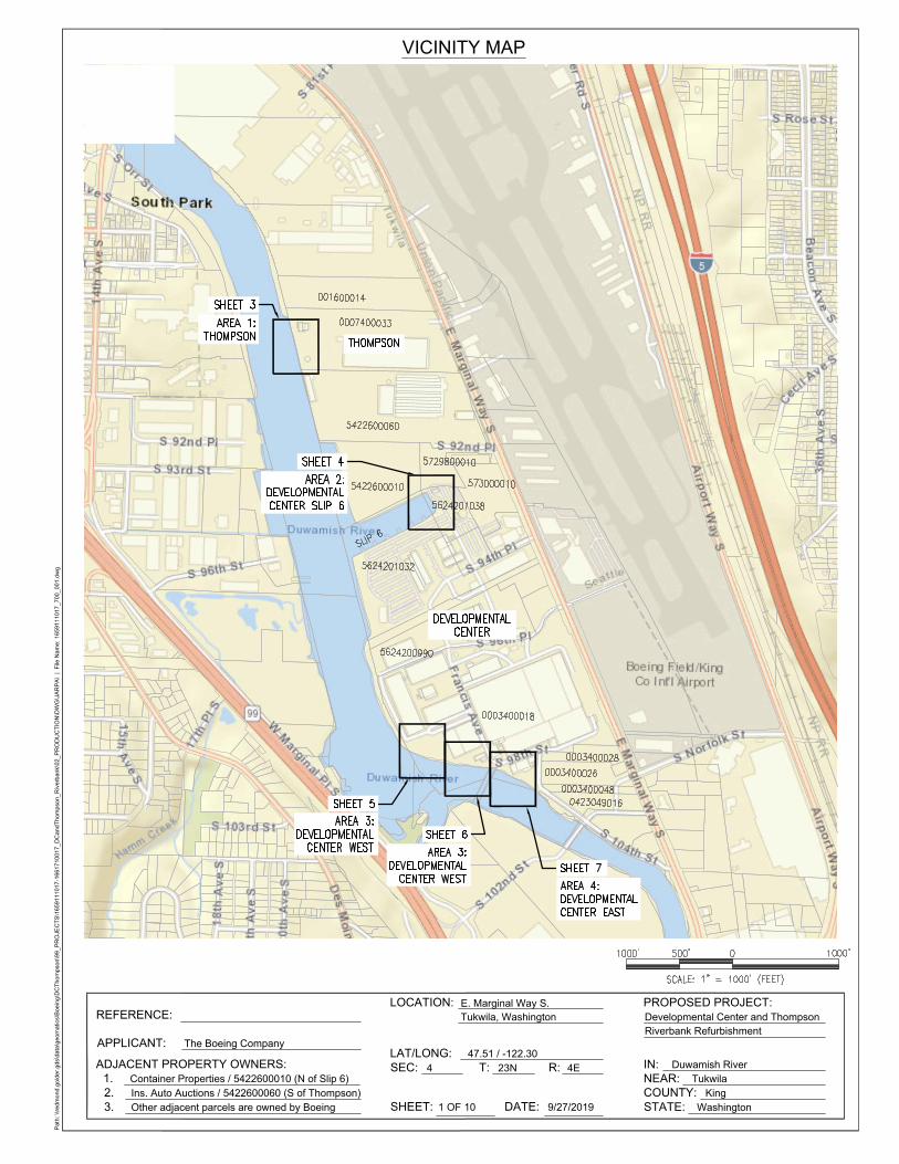
LOCATION: In the Duwamish River at 9725 East Marginal Way South (Development Center) and
8701 East Marginal Way South (Thompson Site) at Tukwila, Washington.
WORK: The Boeing Company proposes bank stabilization improvements at their industrial facility. Bank
stabilization improvements below the ordinary high water mark (OHWM) include replacement of 340 linear feet of
timber pile bulkhead with riprap, installation of anchored logs, repairs to seven timber pile dikes and placement of
900 linear feet of new riprap. Additional work would include removal of two track piers, concrete slab, and repairs
to existing outfalls.
PURPOSE: The purpose of this project is to protect Boeing’s existing infrastructure.
NWS-2018-1001, DC Thompson (Bank Stabilization)
2
ADDITIONAL INFORMATION: The proposed project would result in 44,190 square feet of permanent impacts
to the Duwamish River. The DC Thompson Bank Stabilization improvements can be divided into four construction
segments: Area 1 (Thompson Site), Area 2 (Developmental Center Slip 6), Area 3 (Developmental Center West)
and Area 4 (Developmental Center East).
Area 1 (Thompson Site): The Site consists of approximately 340 linear feet of riverbank with fine-grained
low-sloping intertidal beach that abuts an eroding and degrading timber pile wall. Work below the OHWM would
include removal of the existing timber pile wall, extension of stormwater outfall, re-grading the riverbank at a 2:1
slope and placement of riprap. Riprap would be installed to replace the timber pile wall and keyed into the river
bed (approximately for toe of pile wall + 3.0 feet) and extended to the OHWM (+10.9 feet). Log structures and a
natural sediment mix would be incorporated into the riprap slope. Additional work above the OHWM would
include, installation of a sheet pile wall and maintenance to existing parking area. The proposed construction
would result in 3,160 square feet of permanent impacts (620 cubic yards excavation and 310 cubic yards of fill) to
the Duwamish River.
Area 2 (Developmental Center Slip 6): The site is at the head of Slip 6, located on the north end of the DC
property. A 30-foot long section of bank has eroded and resulted in an over-steepened bank. Work would consist
of placement of riprap at a 2:1 slope to the mean lower low water (-2.5 feet), extending to the OHMW (+10.9 feet).
Log structures and a natural sediment mix would be incorporated into the riprap slope. Additional work landward
of the OHWM would include vegetated coir lifts with incorporated willow stakes. The proposed construction
would result in 1,190 square feet of permanent impacts (110 cubic yards of fill) to the Duwamish River.
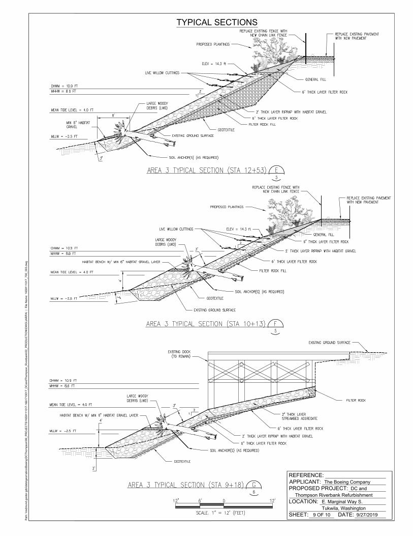
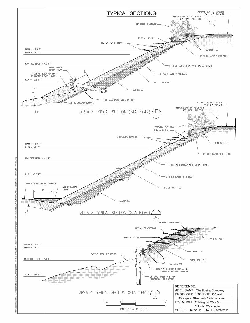
Area 3 (Developmental Center West): The site is a 900-foot long reach on the right bank of the Lower
Duwamish Waterway starting immediately downstream of the Oxbow Bridge. Work below the OHWM would
include repairing four timber pile dikes (approximately 17 individual piles), placement of riprap at a 2:1 slope,
extension of seven stormwater outfalls and removal of two pile supported range track docks, concrete slabs, and
rubble. Piles would be removed and installed by vibratory hammer. Placement of riprap (900 linear feet) would
occur from mean lower low water (-2.5 feet), extending to the OHMW (+10.9 feet). Log structures and a natural
sediment mix would be incorporated into the riprap slope. Extension of the seven stormwater outfalls would be
dependent on the riprap placement. Additional work above the OHWM would include establishment of vegetation
strip (between parking area and riprap) and maintenance to the existing parking area. The proposed construction
would result in 36,000 square feet of permanent impacts (110 cubic yards of excavation and 6,300 cubic yards of
fill) to the Duwamish River.
Area 4 (Developmental Center East): Area 4 is a 210-foot long reach on the right bank of the Lower Duwamish
Waterway starting immediately upstream of the Oxbow Bridge to the 102nd Street Bridge. The bank is generally
composed of a fine-grained intertidal bench scattered with irregular angular rock and concrete rubble. Work below
the OHWM would consist of repairing three timber pile dikes (approximately 11 individual piles), placement of
riprap at a 2:1 slope, concrete removal and installation of anchored logs and placement of sediment mix within
riprap. Piles would be removed and installed by vibratory hammer. Placement of riprap (210 linear feet) would
occur from approximately mean higher high water (MHHW) (+8.6 feet), extending to the OHMW (+10.9 feet).
Log structures and a natural sediment mix would be incorporated into the riprap slope. Additional work above the
OHWM would include installation of vegetation choirs, planted with willow stakes. The proposed construction
would result in 2,940 square feet of permanent impacts (50 cubic yards of excavation and 1,100 cubic yards of fill)
to the Duwamish River.
Work would be accomplished from both onshore and from a barge. Onshore construction would include the use of
excavators for excavation and placement of material, dump trucks for hauling material on and off site, and front
loaders for movement of material from stockpiles to excavators. Stockpiled materials would be located in
designated upland areas with appropriate erosion control measures. Barge construction would include the use of a
barge mounted clam-shell bucket for excavation and placement of material. Work would be accomplished in the
NWS-2018-1001, DC Thompson (Bank Stabilization)
3
dry during low tides. If work cannot be accomplished during low tides a turbidity curtain would be deployed
around the work areas. All material (e.g., creosote treated piling, rubble, and sediment) would be disposed on in an
approved upland disposal facility.
The location of the ordinary high water mark shown on the project drawings have not yet been verified by the U.S.
Army Corps of Engineers (Corps). If the Corps determines the boundaries of the wetland/waters are substantially
inaccurate a new public notice may be published.
MITIGATION: The applicant has proposed to perform on-site permittee-responsible mitigation.
ENDANGERED SPECIES: The Endangered Species Act (ESA) requires federal agencies to consult with the
National Marine Fisheries Service (NMFS) and/or U.S. Fish and Wildlife Service (USFWS) pursuant to Section 7
of the ESA on all actions that may affect a species listed (or proposed for listing) under the ESA as threatened or
endangered or any designated critical habitat. After receipt of comments from this public notice, the U.S. Army
Corps of Engineers will evaluate the potential impacts to proposed and/or listed species and their designated critical
habitat.
ESSENTIAL FISH HABITAT: The Magnuson-Stevens Fishery Conservation and Management Act, as amended
by the Sustainable Fisheries Act of 1996, requires all Federal agencies to consult with the NMFS on all actions, or
proposed actions, permitted, funded, or undertaken by the agency, that may adversely affect Essential Fish Habitat
(EFH). The proposed action would impact EFH in the project area.
If the U.S. Army Corps of Engineers (Corps) determines that the proposed action may adversely affect EFH for
federally managed fisheries in Washington waters, the Corps will initiate EFH consultation with the NMFS. The
Corps’ final determination relative to project impacts and the need for mitigation measures is subject to review by
and coordination with the NMFS.
CULTURAL RESOURCES: The Corps invites responses to this public notice from Native American Tribes or
Tribal governments; Federal, State, and local agencies; historical and archeological societies; and other parties
likely to have knowledge of or concerns regarding historic properties and sites of religious and cultural significance
at or near the project area. After receipt of comments from this public notice, the Corps will evaluate potential
impacts and consult with the State Historic Preservation Officer and Native American Tribes in accordance with
Section 106 of the National Historic Preservation Act, as appropriate.
PUBLIC HEARING: Any person may request, in writing, within the comment period specified in this notice, that
a public hearing be held to consider this application. Requests for public hearings shall state, with particularity, the
reasons for holding a public hearing.
EVALUATION – CORPS: The decision whether to issue a permit will be based on an evaluation of the probable
impacts, including cumulative impacts, of the proposed activity on the public interest. That decision will reflect the
national concern for both protection and utilization of important resources. The benefits, which reasonably may be
expected to accrue from the proposal, must be balanced against its reasonably foreseeable detriments. All factors
which may be relevant to the proposal will be considered, including the cumulative effects thereof; among those are
conservation, economics, aesthetics, general environmental concerns, wetlands, historic properties, fish and wildlife
values, flood hazards, floodplain values, land use, navigation, shoreline erosion and accretion, recreation, water
supply and conservation, water quality, energy needs, safety, food and fiber production, mineral needs,
considerations of property ownership, and, in general, the needs and welfare of the people.
The Corps is soliciting comments from the public; Native American Nations or Tribal governments; Federal, State,
and local agencies and officials; and other interested parties in order to consider and evaluate the impacts of this
activity. Any comments received will be considered by the Corps to determine whether to issue, modify, condition

NWS-2018-1001, DC Thompson (Bank Stabilization)
4
or deny a permit for the work. To make this decision, comments are used to assess impacts on endangered species,
historic properties, water quality, general environmental effects, and the other public interest factors listed above.
Comments are used in the preparation of an Environmental Assessment and/or an Environmental Impact Statement
pursuant to the National Environmental Policy Act. Comments are also used to determine the need for a public
hearing and to determine the overall public interest of the activity.
The described discharge will be evaluated for compliance with guidelines promulgated by the Environmental
Protection Agency under authority of Section 404(b)(1) of the CWA. These guidelines require an alternatives
analysis for any proposed discharge of dredged or fill material into waters of the United States.
SOURCE OF FILL MATERIAL: The applicant has not yet identified the source of the fill material. Should a
permit be issued, the Corps will evaluate the fill material source prior to the start of construction.
EVALUATION – ECOLOGY: Ecology is soliciting comments from the public; Federal, Native American Nations
or Tribal governments, State, and local agencies and officials; and other interested parties in order to consider and
evaluate the impacts of this activity. Ecology will be considering all comments to determine whether to certify or
deny certification for the proposed project.
ADDITIONAL EVALUATION: This proposal is the subject of Shorelines Substantial Development Permit No.
L19-0103, being processed by the City of Tukwila.
COMMENT AND REVIEW PERIOD: Conventional mail or e-mail comments on this public notice will be
accepted and made part of the record and will be considered in determining whether authorizing the work would
not be contrary to the public interest. In order to be accepted, e-mail comments must originate from the author’s
e-mail account and must include on the subject line of the e-mail message the applicant’s name and reference
number as shown below. Either conventional mail or e-mail comments must include the permit applicant’s name
and reference number, as shown below, and the commenter’s name, address, and phone number. All comments
whether conventional mail or e-mail must reach this office, no later than the expiration date of this public notice to
ensure consideration.
CORPS COMMENTS: Conventional mail comments should be sent to: U.S. Army Corps of Engineers,
Regulatory Branch, Attention: Rory Lee, P.O. Box 3755, Seattle, Washington 98124-3755. All comments
received will become part of the administrative record and are subject to public release under the Freedom of
Information Act including any personally identifiable information such as names, phone numbers, and addresses.
All e-mail comments should be sent to: [email protected]
ECOLOGY COMMENTS: Any person desiring to present views on the project pertaining to a request for water
quality certification under Section 401 of the CWA and/or Coastal Zone Management consistency concurrence,
may do so by submitting written comments to the following address: Washington State Department of Ecology,
Attention: Federal Permit Coordinator, Post Office Box 47600, Olympia, Washington 98504-7600, or e-mail to:
To ensure proper consideration of all comments, responders must include the following name and reference number
in the text of their comments: DC Thompson (Bank Stabilization); NWS-2018-1001
Encl: Figures (10)
Path: \\redm
ond.golder.gds\data\geom
atics\B
oeing\D
CT
hom
pson\99_P
RO
JE
CT
S\1659111017-1661710017_D
CandT
hom
pson_R
iverbank\02_P
RO
DU
CT
IO
N\D
WG
\JA
RP
A\ | F
ile N
am
e: 1659111017_700_001.dw
g
VICINITY MAP
APPLICANT:
ADJACENT PROPERTY OWNERS:
1.
2.
The Boeing Company
Container Properties / 5422600010 (N of Slip 6)
Ins. Auto Auctions / 5422600060 (S of Thompson)
LOCATION:
Tukwila, Washington
LAT/LONG:
SEC:
SHEET:
E. Marginal Way S.
47.51 / -122.30
4 T: 23N R: 4E
1 OF 10 DATE: 9/27/2019
PROPOSED PROJECT:
Developmental Center and Thompson
Tukwila
COUNTY:
STATE:
King
Washington
NEAR:
Duwamish RiverIN:
Riverbank Refurbishment
3. Other adjacent parcels are owned by Boeing
REFERENCE:

Path: \\redm
ond.golder.gds\data\geom
atics\B
oeing\D
CT
hom
pson\99_P
RO
JE
CT
S\1659111017-1661710017_D
CandT
hom
pson_R
iverbank\02_P
RO
DU
CT
IO
N\D
WG
\JA
RP
A\ | F
ile N
am
e: 1659111017_700_001.dw
g
LEGEND AND NOTES
SF SF
> > >
/
/
/
/
/
/
/
/
/
/
/
APPLICANT:
PROPOSED PROJECT:
Thompson Riverbank Refurbishment
LOCATION:
SHEET:
The Boeing Company
E. Marginal Way S.
DATE:2 OF 10 9/27/2019
Tukwila, Washington
DC and
REFERENCE:

/
/
/
/
/
/
/
Path: \\redm
ond.golder.gds\data\geom
atics\B
oeing\D
CT
hom
pson\99_P
RO
JE
CT
S\1659111017-1661710017_D
CandT
hom
pson_R
iverbank\02_P
RO
DU
CT
IO
N\D
WG
\JA
RP
A\ | F
ile N
am
e: 1659111017_700_002.dw
g
PLAN VIEW - AREA 1: THOMPSON
APPLICANT:
PROPOSED PROJECT:
Thompson Riverbank Refurbishment
LOCATION:
SHEET:
The Boeing Company
E. Marginal Way S.
DATE:3 OF 10 9/27/2019
Tukwila, Washington
DC and
REFERENCE:

/
/
/
/
/
/
/
Path: \\redm
ond.golder.gds\data\geom
atics\B
oeing\D
CT
hom
pson\99_P
RO
JE
CT
S\1659111017-1661710017_D
CandT
hom
pson_R
iverbank\02_P
RO
DU
CT
IO
N\D
WG
\JA
RP
A\ | F
ile N
am
e: 1659111017_700_002.dw
g
PLAN VIEW - AREA 2: DEVELOPMENTAL CENTER SLIP 6
APPLICANT:
PROPOSED PROJECT:
Thompson Riverbank Refurbishment
LOCATION:
SHEET:
The Boeing Company
E. Marginal Way S.
DATE:4 OF 10 9/27/2019
Tukwila, Washington
DC and
REFERENCE:

/
/
/
/
/
/
/
/
/
/
/
/
/
/
/
/
/
/
/
/
/
/
/
/
/
/
/
/
/
/
/
/
/
/
/
/
/
/
/
/
/
/
/
/
/
Path: \\redm
ond.golder.gds\data\geom
atics\B
oeing\D
CT
hom
pson\99_P
RO
JE
CT
S\1659111017-1661710017_D
CandT
hom
pson_R
iverbank\02_P
RO
DU
CT
IO
N\D
WG
\JA
RP
A\ | F
ile N
am
e: 1659111017_700_002.dw
g
PLAN VIEW - AREA 3: DEVELOPMENTAL CENTER WEST (1 OF 2)
APPLICANT:
PROPOSED PROJECT:
Thompson Riverbank Refurbishment
LOCATION:
SHEET:
The Boeing Company
E. Marginal Way S.
DATE:5 OF 10 9/27/2019
Tukwila, Washington
DC and
REFERENCE:

/
/
/
/
/
/
/
/
/
/
/
/
/
/
/
/
/
/
/
/
/
/
/
/
/
/
/
/
/
/
/
/
/
/
/
/
/
/
/
/
/
/
/
/
/
/
/
/
/
/
/
/
/
/
/
/
/
/
/
/
/
/
/
Path: \\redm
ond.golder.gds\data\geom
atics\B
oeing\D
CT
hom
pson\99_P
RO
JE
CT
S\1659111017-1661710017_D
CandT
hom
pson_R
iverbank\02_P
RO
DU
CT
IO
N\D
WG
\JA
RP
A\ | F
ile N
am
e: 1659111017_700_002.dw
g
PLAN VIEW - AREA 3: DEVELOPMENTAL CENTER WEST (2 OF 2)
APPLICANT:
PROPOSED PROJECT:
Thompson Riverbank Refurbishment
LOCATION:
SHEET:
The Boeing Company
E. Marginal Way S.
DATE:6 OF 10 9/27/2019
Tukwila, Washington
DC and
REFERENCE:

Path: \\redm
ond.golder.gds\data\geom
atics\B
oeing\D
CT
hom
pson\99_P
RO
JE
CT
S\1659111017-1661710017_D
CandT
hom
pson_R
iverbank\02_P
RO
DU
CT
IO
N\D
WG
\JA
RP
A\ | F
ile N
am
e: 1659111017_700_002.dw
g
PLAN VIEW - AREA 4: DEVELOPMENTAL CENTER EAST
APPLICANT:
PROPOSED PROJECT:
Thompson Riverbank Refurbishment
LOCATION:
SHEET:
The Boeing Company
E. Marginal Way S.
DATE:7 OF 10 9/27/2019
Tukwila, Washington
DC and
REFERENCE:

Path: \\redm
ond.golder.gds\data\geom
atics\B
oeing\D
CT
hom
pson\99_P
RO
JE
CT
S\1659111017-1661710017_D
CandT
hom
pson_R
iverbank\02_P
RO
DU
CT
IO
N\D
WG
\JA
RP
A\ | F
ile N
am
e: 1659111017_700_003.dw
g
TYPICAL SECTIONS
APPLICANT:
PROPOSED PROJECT:
Thompson Riverbank Refurbishment
LOCATION:
SHEET:
The Boeing Company
E. Marginal Way S.
DATE:8 OF 10 9/27/2019
Tukwila, Washington
DC and
REFERENCE:
Path: \\redm
ond.golder.gds\data\geom
atics\B
oeing\D
CT
hom
pson\99_P
RO
JE
CT
S\1659111017-1661710017_D
CandT
hom
pson_R
iverbank\02_P
RO
DU
CT
IO
N\D
WG
\JA
RP
A\ | F
ile N
am
e: 1659111017_700_003.dw
g
TYPICAL SECTIONS
APPLICANT:
PROPOSED PROJECT:
Thompson Riverbank Refurbishment
LOCATION:
SHEET:
The Boeing Company
E. Marginal Way S.
DATE:9 OF 10 9/27/2019
Tukwila, Washington
DC and
REFERENCE:
Path: \\redm
ond.golder.gds\data\geom
atics\B
oeing\D
CT
hom
pson\99_P
RO
JE
CT
S\1659111017-1661710017_D
CandT
hom
pson_R
iverbank\02_P
RO
DU
CT
IO
N\D
WG
\JA
RP
A\ | F
ile N
am
e: 1659111017_700_003.dw
g
TYPICAL SECTIONS
APPLICANT:
PROPOSED PROJECT:
Thompson Riverbank Refurbishment
LOCATION:
SHEET:
The Boeing Company
E. Marginal Way S.
DATE:10 OF 10 9/27/2019
Tukwila, Washington
DC and
REFERENCE: