joint application for permit - department of state
TRANSCRIPT


JOINT APPLICATION FORMFor Permits for activities activities affecting streams, waterways, waterbodies, wetlands, coastal areas, sources of water,and endangered and threatened species.
You must separately apply for and obtain Permits from each involved agency before starting work. Please read all instructions.
1. Applications To:N S Department of Environmental Conservation Check here to confirm you sent this form to NYSDEC.
Check all permits that apply: Dams and Impound-ment Structures
401 Water Quality Certification
Freshwater Wetlands
Tidal Wetlands
Wild, Scenic and Recreational Rivers
Coastal Erosion Management
Water Withdrawal
Long Island Well
Incidental Take of Endangered / Threatened Species
Stream Disturbance
Excavation and Fill in Navigable Waters
Docks, Moorings or Platforms
US Army Corps of Engineers Check here to confirm you sent this form to USACE.Check all permits that apply: Section 404 Clean Water Act Section 10 Rivers and Harbors ActIs the project Federally funded? Yes No
If yes, name of Federal Agency: General Permit Type(s), if known:Preconstruction Notification: Yes No
NY Office of General Services Check here to confirm you sent this form to NYSOGS.Check all permits that apply:
State Owned Lands Under WaterUtility Easement (pipelines, conduits, cables, etc.) Docks, Moorings or Platforms
NY Department of State Check here to confirm you sent this form to NYSDOS.Check if this applies: Coastal Consistency Concurrence
2. Name of Applicant Taxpayer ID (if applicant is NOT an individual)
Mailing Address Post Office / City State Zip
Telephone EmailApplicant Must be (check all that apply): Owner Operator Lessee
3. Name of Property Owner (if different than Applicant)
Mailing Address Post Office / City State Zip
Telephone Email
For Agency Use Only Agency Application Number:
JOINT APPLICATION FORM 0 / Page 1 of 4
✔
✔
✔
✔
✔
✔
✔
✔
✔
✔
✔
✔
Mr. Craig Bitner
806 Dean Avenue Bronx NY 10465
(917) 559-3046 [email protected]✔

JOINT APPLICATION FORM – Continued. Submit this completed page as part of your Application.
4. Name of Contact / Agent
Mailing Address Post Office / City State Zip
Telephone Email
5. Project / Facility Name Property Tax Map Section / Block / Lot Number:
Project Street Address, if applicable Post Office / City State ZipNY
Provide directions and distances to roads, intersections, bridges and bodies of water
Town Village City County Stream/Waterbody Name
Project Location Coordinates: Enter Latitude and Longitude in degrees, minutes, seconds:Latitude: • ' " Longitude: • ' "
6. Project Description: Provide the following information about your project. Continue each response and provideany additional information on other pages. Attach plans on separate pages.
a. Purpose of the proposed project:
b. Description of current site conditions:
c. Proposed site changes:
d. Type of structures and fill materials to be installed, and quantity of materials to be used (e.g., square feet ofcoverage, cubic yards of fill material, structures below ordinary/mean high water, etc.):
e. Area of excavation or dredging, volume of material to be removed, location of dredged material placement:
f. Is tree cutting or clearing proposed? Yes If Yes, explain below. No Timing of the proposed cutting or clearing (month/year):Number of trees to be cut: Acreage of trees to be cleared:
JOINT APPLICATION FORM 0 / Page 2 of 4
Mr. John Hilts
Post Office Box 47 Rowayton CT 06853-0047
475-441-1244 [email protected]
Bitner Boat Dock Borough: 2 Block: 5479 Lot: 100
806 Dean Avenue Bronx 10465
Near Intersection of Dean Avenue and Philip Avenue . Site is at rear of property on Eastchester Bay in Long Island Sound.
✔
New York Bronx Eastchester Bay in Long Island Sound
40° 49' 56" N 73° 48' 54' W
Private seasonal access to recreational boating.
The site contains sand extending to the low water line. An area of historical stone fill is located at the northern property boundary. The subtidal area consists of mud and sand bottom. There are several piers and docks at the adjacent properties.
Construct a seasonal boat dock for use by the applicant.
4' by 163' piling-supported timber pier with a 6' wide by 16' long pierhead with two piling-mounted boat-hoisting davits; 42" by 40' aluminum ramp; 8' by 25' timber floating dock; four timber float anchor pilings. Total area of proposed structures is approximately 1,008 square feet, approximately 952 square feet below Mean High Water.
N/A
✔
N/AN/A N/A

JOINT APPLICATION FORM – Continued. Submit this completed page as part of your Application.
g. Work methods and type of equipment to be used:
h. Describe the planned sequence of activities:
i. Pollution control methods and other actions proposed to mitigate environmental impacts:
j. Erosion and silt control methods that will be used to prevent water quality impacts:
k. Alternatives considered to avoid regulated areas. If no feasible alternatives exist, explain how the project willminimize impacts:
l. Proposed use: Private Public Commercial
m. Proposed Start Date: Estimated Completion Date:
n. Has work begun on project? Yes If Yes, explain below. No
o. Will project occupy Federal, State, or Municipal Land? Yes If Yes, explain below. No
p. List any previous DEC USACE Permit / Application numbers for activities at this location:
q. Will this project require additional Federal, State, or Local s, including zoning changes?
Yes If Yes, list below. No
JOINT APPLICATION FORM 0 / Page 3 of 4
Pile-driving, hoisting of prefabricated pier, ramp and floating dock, installation of float anchor pilings utilizing barge-borne derrick crane with vibratory or impact hammer and work boat mobilizing to the site by the adjacent waterway.
Piling locations staked by workers on the upland; pilings driven using either vibratory or impact hammer; piling caps and bracing installed by workers on the upland or off work floats; prefabricated pier hoisted by derrick onto caps and connected; floating dock and ramp installed using derrick.
Pile-driving performed using vibratory hammer for initial installation and impact hammer for final setting to minimize turbidity.
Barge will access site at high tides and will withdraw to deeper waters at low tides to prevent grounding.
The project footprint is entirely within a regulated area, and cannot be avoided. The measures noted above will minimize impacts.
✔
Spring 2021 Spring 2021✔
✔
New York State Lands Underwater.
None.
✔
New York State Department of State Coastal Consistency Concurrence; City of New York Permit


ENVIRONMENTAL QUESTIONNAIRE
This is intended to supplement ENG Form 4345, Application for Department of theArmy Permit, or the Joint Application for Permit used in the State of New York.Please provide complete answers to all questions below which are relevant to yourproject. Any answers may be continued on separate sheet(s) of paper to be attachedto this form.
PRIVACY ACT STATEMENT
The purpose of this form is to provide the Corps of Engineers with basic informationregarding your project. This information will be used to facilitate evaluation of yourpermit application and for public dissemination as required by regulation. Failureto provide complete information may result in your application being declaredincomplete for processing, thereby delaying processing of your application.
GENERAL--APPLICABLE TO ALL PROJECTS
1. Explain the need for, and purpose of, the proposed work.
2. Provide the names and addresses of property owners adjacent to your work site(if not shown on the application form or project drawings).
(Please note that depending upon the nature and extent of your project, you may berequested to provide the names and addresses of additional property ownersproximate to your project site to ensure proper coordination.)
3. Photographs of the project site should be submitted. For projects in tidal areas,photographs of the waterway vicinity should be taken at low tide. Using a separatecopy of your plan view, indicate the location and direction of each photograph aswell as the date and time at which the photograph was taken. Provide a sufficientnumber of photographs so as to provide a clear understanding of conditions on andproximate to your project site.
4. Provide a copy of any environmental impact statement, or any otherenvironmental report which was prepared for your project.
MR. CRAIG BITNER 806 DEAN AVENUE, BRONX, NY 10465
PLEASE REFER TO LAST AND ATTACHED SHEETS FOR ALL APPLICABLE RESPONSES.
1. Indicate the estimated volume of material to be dredged and the depth (belowmean low water) to which dredging would occur. Would there be overdepthdredging?
2. You can apply for a ten-year permit for maintenance dredging. If you wish toapply for a ten-year permit, please provide the number of additional dredging eventsduring the ten-year life of the permit and the amount of material to be removedduring future events.
3. Indicate of your drawings the dewatering area (if applicable) and disposal site forthe dredged material (except landfill sites). Submit a sufficient number ofphotographs of the dewatering and disposal sites as applicable so as to provide aclear indication of existing conditions. For ten-year maintenance dredging permits,indicate the dewatering/disposal sites for future dredging events, if known.
4. Describe the method of dredging (i.e. clamshell, dragline, etc.) and the expectedduration of dredging.
5. Indicate the physical nature of the material to be dredged (i.e. sand, silt, clay, etc.)and provide estimated percentages of the various constituents if available. Forbeach nourishment projects, grain size analysis data is required.
MR. CRAIG BITNER 806 DEAN AVENUE, BRONX, NY 10465
5. Provide a thorough discussion of alternatives to your proposal. This discussion should include, but not necessarily be limited to, the "no action" alternative and alternative(s) resulting in less disturbance to waters of the United States. For filling projects in waters of the United States, including wetlands, your alternatives discussion should demonstrate that there are no practicable alternatives to your proposed filling and that your project meets with current mitigation policy (i.e. avoidance, minimization and compensation).
DREDGING PROJECTS
Answer the following if your project involves dredging.
6. Describe the method of dredged material containment (i.e. hay bales,embankment, bulkhead, etc.) and whether return flow from the dewatering/disposalsite would reenter any waterway. Also indicate if there would be any barge overflow.
MOORING FACILITIES
Answer the following if your project includes the construction or rehabilitation ofrecreational mooring facilities.
1. It is generally recommended that any fixed piers and walk ramps be limited to fourfeet in width, and that floats be limited to eight feet in width and rest at least two feetabove the waterway bottom at mean low water. Terminal floats at private, non-commercial facilities should be limited to 20 feet in length. If you do not believe yourproposal can meet with these recommendations, please provide the reason(s).
2. Using your plan view, show to scale the location(s), position(s) and size(s)(including length, beam and draft) of vessel(s) to be moored at the proposed facility,including those of transient vessel(s) if known.
3. For commercial mooring sites such as marinas, indicate the capacity of the facilityand indicate on the plan view the location(s) of any proposed fueling and/or sewagepumpout facilities. If pumpout facilities are not planned, please discuss the rationalebelow and indicate the distance to the nearest available pumpout station.
4. Indicate on your plan view the distance to adjacent marine structures, if any areproximate and show the locations and dimensions of such structures.
MR. CRAIG BITNER 806 DEAN AVENUE, BRONX, NY 10465

5. Discuss the need for wave protection at the proposed facility. Please be advisedthat if a permit is issued, you would be required to recognize that the mooring facilitymay be subject to wave action from wakes of passing vessels, whose operationswould not be required to be modified. Issuance of a permit would not relieve you ofensuring the integrity of the authorized structure(s) and the United States would notbe held responsible for damages to the structure(s) and vessel(s) moored theretofrom wakes from passing vessels.
BULKHEADING/BANK STABILIZATION/FILLING ACTIVITIES
Answer the following if your project includes construction of bulkheading (alsoretaining walls and seawalls) with backfill, filling of waters/wetlands, or any otherbank stabilization fills such as riprap, revetments, gabions, etc.
1. Indicate the total volume of fill (including backfill behind a structure such as abulkhead) as well as the volume of fill to be placed into waters of the United States.The amount of fill in waters of the United States can be determined by calculating theamount of fill to be placed below the plane of spring high tide in tidal areas andbelow ordinary high water in non-tidal areas.
2. Indicate the source(s) and type(s) of fill material.
3. Indicate the method of fill placement (i.e. by hand, bulldozer, crane, etc.). Wouldany temporary fills be required in waterways or wetlands to provide access forconstruction equipment? If so, please indicate the area of such waters and/orwetlands to be filled, and show on the plan and sectional views.
MR. CRAIG BITNER 806 DEAN AVENUE, BRONX, NY 10465

MR. CRAIG BITNER 806 DEAN AVENUE, BRONX, NY 10465
The foregoing requests basic information on the most common types of projects requiring Department of the Army permits. It is intended to obviate or reduce theneed for requesting additional information; however, additional information may be requested above and beyond what is requested in this form.
Please feel free to add any additional information regarding your project which youbelieve may facilitate our review.GENERAL:
1. The proposed work is the construction of a 4' by 163' piling-supported timber pier with a 6' wide by 16' longpierhead with two piling-mounted boat-hoisting davits; 42" by 40' aluminum ramp; 8' by 25' timber floating dock; andfour timber float anchor pilings.
The work is needed to provide the applicant with seasonal access to recreational boating. The purpose is to provide this access without repeated crossings of the intertidal area.
2. The adjacent property owners are as follows:
Bay Beach and Boat Club, Inc Trinity Danish Young People Society
3268 Philip Avenue, Bronx, NY 10465808 Dean Avenue, Bronx, NY 10465
3. Please refer to sheet 2 of 4 of the application plan drawings for photograph locations.
4. No environmental impact statement or environmental report has been prepared.
5. There are three potential alternatives to the proposed activity:
A. The first alternative is No Action. This option would require the applicant to repeatedly transit on grade tothe water. This option precludes the ability to access the site by powerboat without grounding the powerboat.
B. The second alternative is the construction of a fixed pier extending farther beyond the Mean Low Water line, witha boat hoist at the waterward terminus. This option would not allow for launching and landing small watercraft.Also, this option would create a greater fixed encroachment into the waterway, with a greater visual impact.
C. The third alternative is the use of anchors to anchor the proposed floating dock. This option would create agreater impact on the subtidal area as a result of the chains sweeping.
The proposed activity will minimize adverse impacts to the littoral zone through utilization of low-impact driven timber pilings to support the pier.
Seasonal removal of the ramp and floating dock will minimize permanent structural encroachments into the littoral zone. This will also minimize the potential for damages to the facility resulting from storm activity during the winter months.
Continued on other side
MR. CRAIG BITNER 806 DEAN AVENUE, BRONX, NY 10465
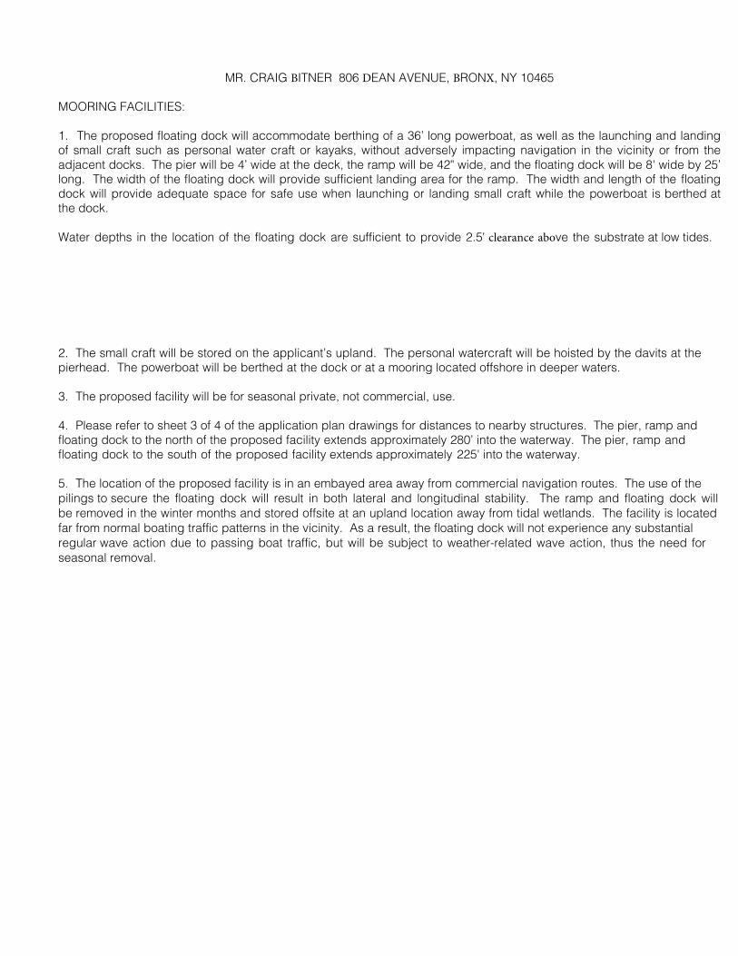
MOORING FACILITIES:
1. The proposed floating dock will accommodate berthing of a 36’ long powerboat, as well as the launching and landingof small craft such as personal water craft or kayaks, without adversely impacting navigation in the vicinity or from theadjacent docks. The pier will be 4’ wide at the deck, the ramp will be 42" wide, and the floating dock will be 8' wide by 25’long. The width of the floating dock will provide sufficient landing area for the ramp. The width and length of the floatingdock will provide adequate space for safe use when launching or landing small craft while the powerboat is berthed atthe dock.
Water depths in the location of the floating dock are sufficient to provide 2.5' clearance above the substrate at low tides.
2. The small craft will be stored on the applicant’s upland. The personal watercraft will be hoisted by the davits at the pierhead. The powerboat will be berthed at the dock or at a mooring located offshore in deeper waters.
3. The proposed facility will be for seasonal private, not commercial, use.
4. Please refer to sheet 3 of 4 of the application plan drawings for distances to nearby structures. The pier, ramp and floating dock to the north of the proposed facility extends approximately 280’ into the waterway. The pier, ramp and floating dock to the south of the proposed facility extends approximately 225' into the waterway.
5. The location of the proposed facility is in an embayed area away from commercial navigation routes. The use of the pilings to secure the floating dock will result in both lateral and longitudinal stability. The ramp and floating dock will be removed in the winter months and stored offsite at an upland location away from tidal wetlands. The facility is located far from normal boating traffic patterns in the vicinity. As a result, the floating dock will not experience any substantial regular wave action due to passing boat traffic, but will be subject to weather-related wave action, thus the need for seasonal removal.
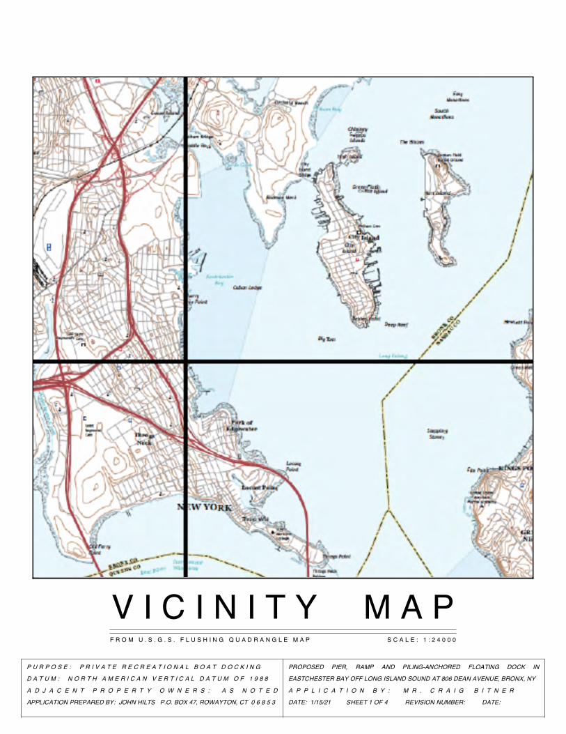
V I C I N I T Y M A PF R O M U . S . G . S . F L U S H I N G Q U A D R A N G L E M A P S C A L E : 1 : 2 4 0 0 0
P U R P O S E : P R I V A T E R E C R E A T I O N A L B O A T D O C K I N G
D A T U M : N O R T H A M E R I C A N V E R T I C A L D A T U M O F 1 9 8 8
A D J A C E N T P R O P E R T Y O W N E R S : A S N O T E D
APPLICATION PREPARED BY: JOHN HILTS P.O. BOX 47, ROWAYTON, CT 0 6 8 5 3
PROPOSED PIER, RAMP AND PILING-ANCHORED FLOATING DOCK IN
EASTCHESTER BAY OFF LONG ISLAND SOUND AT 806 DEAN AVENUE, BRONX, NY
A P P L I C A T I O N B Y : M R . C R A I G B I T N E R
DATE: 1/15/21 SHEET 1 OF 4 REVISION NUMBER: DATE:

PROPOSED PIER, RAMP AND PILING-ANCHORED FLOATING DOCK IN
EASTCHESTER BAY OFF LONG ISLAND SOUND AT 806 DEAN AVENUE, BRONX, NY
A P P L I C A T I O N B Y : M R . C R A I G B I T N E R
DATE: 1/15/21 SHEET 2 OF 4 REVISION NUMBER: DATE:
PROPERTY LINE
©2021 JOHN HILTS. ALL RIGHTS RESERVED.
NYSDEC LITTORAL ZONE
NOTES:
1. PREPARED FROM A SURVEY DATED
SEPTEMBER 14, 2020 BY HYRDO DATA,
INC., A SURVEY DATED NOVEMBER 26,
1969 BY JOHN PITZ, L.S., AND A SITE VISIT
ON OCTOBER 14, 2020.
2. ALL DRAWINGS ARE INTENDED FOR
REGULATORY REVIEW ONLY.
P U R P O S E : P R I V A T E R E C R E A T I O N A L B O A T D O C K I N G
D A T U M : N O R T H A M E R I C A N V E R T I C A L D A T U M O F 1 9 8 8
A D J A C E N T P R O P E R T Y O W N E R S : A S N O T E D
APPLICATION PREPARED BY: JOHN HILTS P.O. BOX 47, ROWAYTON, CT 0 6 8 5 3
NYSDEC COASTAL SHOALS, BARS AND MUDFLATS
MEAN LOW WATER (EL. -3.9')
PROPERTY LINE
MEAN HIGH WATER (EL. +3.4')
MUD AND SAND
MASONRY WALL
0' 50'50'
E X I S T I N G G E N E R A L P L A N V I E WS C A L E : 1 " = 5 0 '
-6
-5
-3
-5
-4
-1-2
-10
-7
-8
-9
-8-7
-6
-5
-5
-10
-10
-7
1
1
0
-1
5
-1 -3
24
1
5
243
1
2
6
-2
-10
63
-3
-4-4
0-1 -2
-9
-9
-6
1
-2 -3
23
-4
43
-8
0
5 0
2
4
6
53
ET
S
Y
HB
D
BA
C E
F
OO
L
RETSEB
A
ROCKS
TIMBER PLATFORM
TIMBER PIER
TIMBER PLATFORM
TIMBER PIER
TIMBER PILINGS
TIMBER PILINGS
MASONRY WALL
MEAN HIGHER HIGH WATER (EL. +3.8')PHILIP AVENUE
DEAN AVENUE
PROP. N/F OF
TRINITY DANISH YPS
808 DEAN AVENUE
PROP. N/F OF BAY BEACH
& BOAT CLUB, INC.
3268 PHILIP AVENUE
MUD AND SAND
SAND
SAND
SAND
PROPERTY OF
CRAIG BITNER
806 DEAN AVENUE
SAND
SAND
MUD AND SAND
-11
-11
APPARENT PROPERTY LINE
APPARENT PROPERTY LINE
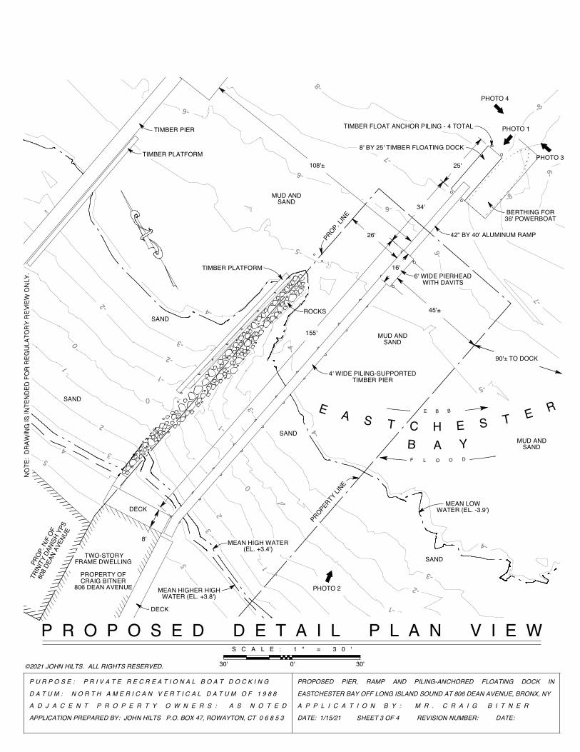
PHOTO 1
BERTHING FOR 36' POWERBOAT
42" BY 40' ALUMINUM RAMP26'
34'
25'
©2021 JOHN HILTS. ALL RIGHTS RESERVED.
16'
TIMBER FLOAT ANCHOR PILING - 4 TOTAL
8' BY 25' TIMBER FLOATING DOCK
45'±
6' WIDE PIERHEAD WITH DAVITS
PHOTO 4
PROPERTY LINE
8'
PHOTO 2
2
NO
TE:
DRAW
ING
IS IN
TEND
ED F
OR
REG
ULAT
ORY
REV
IEW
ON
LY.
4' WIDE PILING-SUPPORTED TIMBER PIER
108'±
155'
90'± TO DOCK
PROPOSED PIER, RAMP AND PILING-ANCHORED FLOATING DOCK IN
EASTCHESTER BAY OFF LONG ISLAND SOUND AT 806 DEAN AVENUE, BRONX, NY
A P P L I C A T I O N B Y : M R . C R A I G B I T N E R
DATE: 1/15/21 SHEET 3 OF 4 REVISION NUMBER: DATE:
-8
P U R P O S E : P R I V A T E R E C R E A T I O N A L B O A T D O C K I N G
D A T U M : N O R T H A M E R I C A N V E R T I C A L D A T U M O F 1 9 8 8
A D J A C E N T P R O P E R T Y O W N E R S : A S N O T E D
APPLICATION PREPARED BY: JOHN HILTS P.O. BOX 47, ROWAYTON, CT 0 6 8 5 3
PROP. LIN
E
MEAN HIGH WATER (EL. +3.4')
MUD AND SAND
PHOTO 3
-3
-5
-4
-1
-7
0
5
-9-6
23
4
-8
ETS
YHB
D
B AC
E
F O OL
RETSEBA
ROCKS
TIMBER PLATFORM
TIMBER PIER
TIMBER PLATFORM
MEAN HIGHER HIGH WATER (EL. +3.8')
PRO
P. N
/F O
F
TRIN
ITY
DANI
SH Y
PS
808
DEAN
AVE
NUE
SAND
SAND
SAND TWO-STORY FRAME DWELLING
PROPERTY OFCRAIG BITNER
806 DEAN AVENUE
MUD AND SAND
MEAN LOW WATER (EL. -3.9')
MUD AND SAND
SAND
53
10
0
1
-1
-2
-3
-2
-4
-4
-5
-6
-6
-6
-7
-8
-4
-3
-2
-1
P R O P O S E D D E T A I L P L A N V I E W S C A L E : 1 " = 3 0 '
30'30' 0'
DECK
DECK

©20
21 J
OH
N H
ILTS
. AL
L R
IGH
TS R
ESER
VED
.
NOTE: DRAWING IS INTENDED FOR REGULATORY REVIEW ONLY.
P U R P O S E : P R I V A T E R E C R E A T I O N A L B O A T D O C K I N G
D A T U M : N O R T H A M E R I C A N V E R T I C A L D A T U M O F 1 9 8 8
A D J A C E N T P R O P E R T Y O W N E R S : A S N O T E D
APPLICATION PREPARED BY: JOHN HILTS P.O. BOX 47, ROWAYTON, CT 0 6 8 5 3
PROPOSED PIER, RAMP AND PILING-ANCHORED FLOATING DOCK IN
EASTCHESTER BAY OFF LONG ISLAND SOUND AT 806 DEAN AVENUE, BRONX, NY
A P P L I C A T I O N B Y : M R . C R A I G B I T N E R
DATE: 1/15/21 SHEET 4 OF 4 REVISION NUMBER: DATE:
4" X 12" STRINGERS
1" ¯ MACHINE BOLTS WITH DOCK WASHERS
2" X 6" DECKING
M.H.W. EL. +3.4'
22"
48"
10" - 12" ¯ CLASS B TIMBER PILINGS
6" WIDE TOP RAIL
M.H.H.W. EL. +3.8'
4" X 4" POSTS
DECK EL. +14.1'
3" X 10" PILING CAPS
S.S. CABLES
42"
3" X 10" BRACING
PROPOSED PIER SECTION
0' 5'
S C A L E : 1 " = 5 '
5'
M.L.W.M.
H.W.
M.H.H.W.
MUD AND SAND
34'
4' WIDE PIER
FRAME
DWELLING
ON PIERS
42" W
IDE ALU
MINUM RAMP
40'
25'
8'
155'
6' WIDE PIERHEAD W
ITH DAVITS
PORCH BEYOND
TIMBER FLO
AT ANCHOR
PILING - 4
TOTAL
8' TIM
BER FLOATING DOCK
P R O P O
S E D E L
E V A T I O N
0'
30'
30'
S C A
L E
:
1 "
=
3
0 '
DAVIT - 2 TOTAL
10" - 12" ¯ CLASS B TIMBER PILINGS
10" - 12" ¯ CLASS B TIMBER BATTER
PILINGS - 2 TOTAL
P R O P O S E D PIERHEAD SECTION
S C A L E : 1 " = 5 '
WIRE WRAP
S.S. CABLES
3" X 10" BRACING
6" WIDE TOP RAIL
3" X 10" PILING CAPS
4" X 4" POSTS
2" X 6" DECKING
4" X 12" STRINGERS
1" ¯ MACHINE BOLTS WITH DOCK WASHERS
M.H.W. EL. +3.4'
M.H.H.W. EL. +3.8'
DECK EL. +12.1'

NEW YORK STATE DEPARTMENT OF ENVIRONMENTAL CONSERVATION AND U.S. ARMY CORPS OF ENGINEERS JOINT APPLICATION FOR PERMIT
ADDITIONAL INFORMATION A.iii SITE PHOTOGRAPHS
MR. CRAIG BITNER 806 DEAN AVENUE, BRONX, NY 10465
1. 10/14/20 1550 hrs.
2. 10/14/20 1545 hrs.

NEW YORK STATE DEPARTMENT OF ENVIRONMENTAL CONSERVATION AND U.S. ARMY CORPS OF ENGINEERS JOINT APPLICATION FOR PERMIT
ADDITIONAL INFORMATION A.iii SITE PHOTOGRAPHS
MR. CRAIG BITNER 806 DEAN AVENUE, BRONX, NY 10465
3. 10/14/20 1550 hrs.
4. 10/14/20 1550 hrs.

Page 1 of 3
Short Environmental Assessment FormPart 1 - Project Information
Instructions for Completing
Part 1 – Project Information. The applicant or project sponsor is responsible for the completion of Part 1. Responses become part of the application for approval or funding, are subject to public review, and may be subject to further verification. Complete Part 1 based on information currently available. If additional research or investigation would be needed to fully respond to any item, please answer asthoroughly as possible based on current information.
Complete all items in Part 1. You may also provide any additional information which you believe will be needed by or useful to the lead agency; attach additional pages as necessary to supplement any item.
Part 1 – Project and Sponsor Information
Name of Action or Project:
Project Location (describe, and attach a location map):
Brief Description of Proposed Action:
Name of Applicant or Sponsor: Telephone:
E-Mail:Address:
City/PO: State: Zip Code:
1. Does the proposed action only involve the legislative adoption of a plan, local law, ordinance,administrative rule, or regulation?
If Yes, attach a narrative description of the intent of the proposed action and the environmental resources that may be affected in the municipality and proceed to Part 2. If no, continue to question 2.
NO YES
2. Does the proposed action require a permit, approval or funding from any other government Agency?If Yes, list agency(s) name and permit or approval:
NO YES
3. a. Total acreage of the site of the proposed action? __________ acresb. Total acreage to be physically disturbed? __________ acresc. Total acreage (project site and any contiguous properties) owned
or controlled by the applicant or project sponsor? __________ acres
Check all land uses that occur on, adjoining near the proposed actio
Rural (non-agriculture) ndustrial Commercial Residential (suburban)
Forest Agriculture
Parkland
Mr. Craig Bitner 806 Dean Avenue, Bronx, NY 10465
Bitner Boat Dock
806 Dean Avenue, Bronx, NY 10465 in Eastchester Bay
Construct a 4' by 163' piling-supported timber pier with a 6' wide by 16' long pierhead with two piling-mounted boat-hoisting davits; 42" by 40' aluminumramp; 8' by 25' timber floating dock; four timber float anchor pilings. Private seasonal access to recreational boating.
Mr. Craig Bitner
(917) 559-3046
806 Dean Avenue
Bronx NY 10465
✔
NYSDEC Permit; NYS DOS Coastal Consistency; USACOE Permit✔
0.0750.023
0.075
✔
✔

Page 2 of 3
5. Is the proposed action,
a. A permitted use under the zoning regulations?
b. Consistent with the adopted comprehensive plan?
NO YES N/A
6. Is the proposed action consistent with the predominant character of the existing built or natural landscape?NO YES
7. Is the site of the proposed action located in, or does it adjoin, a state listed Critical Environmental Area?
If Yes, identify: ________________________________________________________________________________
NO YES
a. Will the proposed action result in a substantial increase in traffic above present levels?
Are public transportation services available at or near the site of the proposed action?
Are any pedestrian accommodations or bicycle routes available on or near site of the proposedaction?
NO YES
9. Does the proposed action meet or exceed the state energy code requirements?
If the proposed action will exceed requirements, describe design features and technologies:
_____________________________________________________________________________________________
_____________________________________________________________________________________________
NO YES
10. Will the proposed action connect to an existing public/private water supply?
If No, describe method for providing potable : _________________________________________
_____________________________________________________________________________________________
NO YES
11. Will the proposed action connect to existing wastewater utilities?
If No, describe method for providing wastewater treatment: ______________________________________
_____________________________________________________________________________________________
NO YES
NO YES
. Does any portion of the site of the proposed action, or lands adjoining the proposed action, containwetlands or other waterbodies regulated by a federal, state or local agency?
Would the proposed action physically alter, or encroach into, any existing wetland or waterbody?
If Yes, identify the wetland or waterbody and extent of alterations in square feet or acres: _____________________
_____________________________________________________________________________________________
_____________________________________________________________________________________________
NO YES
✔
✔
✔
✔
✔
✔
✔
✔
✔Proposed action is an accessory use to residential dwelling and does not require potable water.
✔Proposed action is an accessory use to residential dwelling and does not require wastewater treatment.
✔
✔
✔
✔
Eastchester Bay in Long Island Sound; total area of proposed structures is approximately 1,008 square feet, approximately 952
square feet below Mean High Water.


EEAF Mapper Summary Report Saturday, January 23, 2021 3:51 PM
Disclaimer: The EAF Mapper is a screening tool intended to assist project sponsors and reviewing agencies in preparing an environmental assessment form (EAF). Not all questions asked in the EAF are answered by the EAF Mapper. Additional information on any EAF question can be obtained by consulting the EAF Workbooks. Although the EAF Mapper provides the most up-to-date digital data available to DEC, you may also need to contact local or other data sources in order to obtain data not provided by the Mapper. Digital data is not a substitute for agency determinations.
Part 1 / Question 7 [Critical Environmental Area]
No
Part 1 / Question 12a [National or State Register of Historic Places or State Eligible Sites]
No
Part 1 / Question 12b [Archeological Sites] YesPart 1 / Question 13a [Wetlands or Other Regulated Waterbodies]
Yes - Digital mapping information on local and federal wetlands and waterbodies is known to be incomplete. Refer to EAF Workbook.
Part 1 / Question 15 [Threatened or Endangered Animal]
No
Part 1 / Question 16 [100 Year Flood Plain] YesPart 1 / Question 20 [Remediation Site] No
1Short Environmental Assessment Form - EAF Mapper Summary Report

NEW YORK STATE DEPARTMENT OF STATE COASTAL MANAGEMENT PROGRAM
Federal Consistency Assessment Form
An applicant, seeking a permit, license, waiver, certification or similar type of approval from a federal agency which is subject to the New York State Coastal Management Program (CMP), shall complete this assessment form for any proposed activity that will occur within and/or directly affect the State's Coastal Area. This form is intended to assist an applicant in certifying that the proposed activity is consistent with New York State's CMP as required by U.S. Department of Commerce regulations (15 CFR 930.57). It should be completed at the time when the federal application is prepared. The Department of State will use the completed form and accompanying information in its review of the applicant's certification of consistency.
A. APPLICANT (please print)
1. Name: _____________________________________________________________________________________2. Address: ___________________________________________________________________________________3. Telephone: Area Code ( ) __________________________________________________________________
B. PROPOSED ACTIVITY:
1. Brief description of activity:
__________________________________________________________________________________________________________________________________________________________________________________________________________________________________________________________________
2. Purpose of activity:
____________________________________________________________________________________________________________________________________________________________________________
3. Location of activity:
______________________ __________________________ __________________________ County City, Town, or Village Street or Site Description
4. Type of federal permit/license required: ______________________________________________________
5. Federal application number, if known: _______________________________________________________
6. If a state permit/license was issued or is required for the proposed activity, identify the state agency andprovide the application or permit number, if known:
______________________________________________________________________________________
Mr. Craig Bitner806 Dean Avenue, Bronx, NY 10465917-559-3046
Construct a 4' by 163' piling-supported timber pier with a 6' wide by 16' longpierhead with two piling-mounted boat-hoisting davits; 42" by 40' aluminumramp; 8' by 25' timber floating dock; and four timber float anchor pilings.
Seasonal access to recreational boating.
Bronx City of New York
USACOE Permit
806 Dean Avenue
TBD
NYS Department of Environmental Conservation

C. COASTAL ASSESSMENT Check either "YES" or "NO" for each of these questions. The numbers following each question refer to the policies described in the CMP document (see footnote on page 2) which may be affected by the proposed activity.
1. Will the proposed activity result in any of the following: YES/NO
a. Large physical change to a site within the coastal area which will require the preparation of an environmental impact statement? (11, 22, 25, 32, 37, 38, 41, 43) __ __
b. Physical alteration of more than two acres of land along the shoreline, land under water or coastal waters? (2, 11, 12, 20, 28, 35, 44) __ __
c. Revitalization/redevelopment of a deteriorated or underutilized waterfront site? (1) __ __ d. Reduction of existing or potential public access to or along coastal waters? (19, 20) __ __
e. Adverse effect upon the commercial or recreational use of coastal fish resources? (9,10) __ __ f. Siting of a facility essential to the exploration, development and production of energy
resources in coastal waters or on the Outer Continental Shelf? (29) __ __ g. Siting of a facility essential to the generation or transmission of energy? (27) __ __
h. Mining, excavation, or dredging activities, or the placement of dredged or fill material in coastal waters? (15, 35) __ __
i. Discharge of toxics, hazardous substances or other pollutants into coastal waters? (8, 15, 35) __ __ j. Draining of stormwater runoff or sewer overflows into coastal waters? (33) __ __ k. Transport, storage, treatment, or disposal of solid wastes or hazardous materials? (36, 39) __ __
l. Adverse effect upon land or water uses within the State's small harbors? (4) __ __
2. Will the proposed activity affect or be located in, on, or adjacent to any of the following: YES/NO
a. State designated freshwater or tidal wetland? (44) __ __ b. Federally designated flood and/or state designated erosion hazard area? (11, 12, 17) __ __ c. State designated significant fish and/or wildlife habitat? (7) __ __ d. State designated significant scenic resource or area? (24) __ __ e. State designated important agricultural lands? (26) __ __ f. Beach, dune or Barrier Island? (12) __ __ g. Major ports of Albany, Buffalo, Ogdensburg, Oswego or New York? (3) __ __
h. State, county, or local park? (19, 20) __ __ i. Historic resource listed on the National or State Register of Historic Places? (23) __ __
3. Will the proposed activity require any of the following: YES/NO
a. Waterfront site? (2, 21, 22) __ __ b. Provision of new public services or infrastructure in undeveloped or sparsely populated
sections of the coastal area? (5) __ __ c. Construction or reconstruction of a flood or erosion control structure? (13, 14, 16) __ __ d. State water quality permit or certification? (30, 38, 40) __ __ e. State air quality permit or certification? (41, 43) __ __
4. Will the proposed activity occur within and/or affect an area covered by a State-approved local waterfront revitalization program, or State-approved regional coastal management program? __ __ (see policies in program document*)
✔
✔
✔
✔
✔
✔
✔
✔
✔
✔
✔
✔
✔
✔
✔
✔
✔
✔
✔
✔
✔
✔
✔
✔
✔
✔
✔


NEW YORK STATE DEPARTMENT OF STATE COASTAL MANAGEMENT PROGRAM
FEDERAL CONSISTENCY ASSESSMENT FORM
MR. CRAIG BITNER 806 DEAN AVENUE, BRONX, NY 10465
C: COASTAL ASSESSMENT: 2.a. (44) The proposed activities will serve to avoid undue impacts to the intertidal and inshore subtidal area by eliminating the need for repeated crossings to access the waterway adjacent to the site. The activities will not adversely impact the designated wetland in the future. The facility cannot be sited away from tidal wetlands as the entire waterfront is designated as such. 2.b. (11,12,17) The majority of the proposed work is located waterward of the upland property, and poses no hazard to life or property. The work will not adversely alter the coastal features in the vicinity. No alteration in existing natural features will occur that might increase the potential for damage due to flooding. 3.a. (2, 21, 22) The proposed work will support a water-dependent use of the site. The nature of the shorefront (an extensive sand beach along the waterfront giving way to shallow areas) precludes a non-structural means of accessing the adjacent waterway without risk of injury and damage to vessels. 3.d. (30, 38, 40) No discharges into the adjacent waterway will result as part of the proposed work or the use associated with the proposed structure. 4. The proposed work has been designed and will be carried out so that it complies with the Local Waterfront Revitalization Program for the City of New York. A separate filing for a determination of consistency will take place concurrently with the processing of State and Federal authorizations.

NOAA Fisheries Greater Atlantic Regional Fisheries Office Essential Fish Habitat (EFH) Assessment & Fish and Wildlife Coordination
Act (FWCA) Worksheet This worksheet is your essential fish habitat (EFH) assessment. It provides us with the information necessary to assess the effects of your action on EFH
NOAA trust resources under theFish and Wildlife Coordination Act (FWCA). Consultation is not required if:
1. there is no adverse effect on EFH or NOAA trust resources (see page 10 for more info).2. no EFH is designated and no trust resources may be present at the project site.
InstructionsFederal agencies or their non-federal designated lead agency should email the completedworksheet and necessary attachments to [email protected]. Include the public notice (if applicable) or project application and project plans showing:
location map of the project site with area of impact.existing and proposed conditions.all waters of the U.S. on the project site with mean low water (MLW), mean high water(MHW), high tide line (HTL), and water depths clearly marked.sensitive habitats mapped, including special aquatic sites (submerged aquatic vegetation,saltmarsh, mudflats, riffles and pools, coral reefs, and sanctuaries and refuges), hardbottom or natural rocky habitat areas, and shellfish beds.site photographs, if available.
We will provide our EFH conservation recommendations and recommendations under the FWCA, as appropriate, within 30 days of receipt of a complete EFH assessment (60 days if an expanded consultation is necessary). Please submit complete information to minimize delays in completing the consultation.
This worksheet provides us with the information required1 in an EFH assessment: 1. A description of the proposed action.2. An analysis of the potential adverse effects on EFH and the federally managed species.3. The federal agency’s conclusions regarding the effects of the action on EFH.4. Proposed mitigation, if applicable.
Your analysis should focus on impacts that reduce the quality and/or quantity of the habitat or result in conversion to a different habitat type for all life stages of species with designated EFH within the action area.
Use the information on the HCD website and NOAA’s EFH Mapper to complete this worksheet. If you have questions, please contact the appropriate HCD staff member to assist you.
1 The EFH consultation process is guided by the requirements of our EFH regulation at 50 CFR 600.905.
1

EFH ASSESSMENT WORKSHEET
General Project Information
Date Submitted:
Project/Application Number:
Project Name:
Project Sponsor/Applicant:
Federal Action Agency (if state agency acting as delegated):
Fast-41 or One Federal Decision Project: Yes No
Action Agency Contact Name:
Contact Phone: Contact Email:
Latitude: Longitude:
Address, City/Town, State:
Body of Water:
Project Purpose:
Project Description:
Anticipated Duration of In-Water Work or Start/End Dates:
2
Bitner Boat Dock
Mr. Craig Bitner
73° 48' 54"W40° 49' 56"N
80 Dean Avenue, Bronx, NY
Eastchester Bay in Long Island Sound
Private seasonal recreational boating access
4' by 163' piling-supported timber pier with a 6' wide by 16' long pierhead with twopiling-mounted boat-hoisting davits; 42" by 40' aluminum ramp; 8' by 25' timberfloating dock; four timber float anchor pilings. Total area of proposed structures isapproximately 1,008 square feet, approximately 952 square feet below Mean HighWater.
Spring 2021; approximately 2 weeks

Habitat Description
EFH includes the biological, chemical, and physical components of the habitat. This includes the substrate and associated biological resources (e.g., benthic organisms, submerged aquatic vegetation, shellfish beds, salt marsh wetlands), the water column, and prey species.
Is the project in designated EFH2? Yes No
Is the project in designated HAPC2? Yes No
Is this coordination under FWCA only? Yes No
Total area of impact to EFH (indicate sq ft or acres):
Total area of impact to HAPC (indicate sq ft or acres):
Current water depths: Salinity: Water temperature range:
Sediment characteristics3:
What habitat types are in or adjacent to the project area and will they be permanently impacted? Select all that apply. Indicate if impacts will be temporary, if site will be restored, or if permanent conversion of habitat will occur. A project may occur in overlapping habitat types.
Habitat Type Total impact (sq ft/acres)
Impacts are temporary
Restored to pre-existing conditions
Permanent conversion of all or part of habitat
Marine
Estuarine
Riverine (tidal)
Riverine (non-tidal)
Intertidal
Subtidal
Water column
Salt marsh/ Wetland (tidal)
Wetland (non-tidal)
2 Use the tables on pages 7-9 to list species with designated EFH or the type of designated HAPC present. 3 The level of detail is dependent on your project – e.g., a grain size analysis may be necessary for dredging.
3
✔
✔
952 square feet
0 square feet
0' - 4' 27-32 ppt 32° - 80°
mud, sand
✔ 10 sq. ft. no pilings✔ 18 sq. ft. no pilings

Habitat Type Total impact (sq ft/acres)
Impacts are temporary
Restored to pre-existing conditions
Permanent conversion of all or part of habitat
Rocky/hard bottom4:
Sand
Shellfish beds or oyster reefs
Mudflats
Submerged aquatic vegetation (SAV)5,macroalgae, epifauna
Diadromous fish (migratory or spawning habitat)
Indicate type(s) of rocky/hard bottom habitat (pebble, cobble, boulder, bedrock outcrop/ledge) and species of SAV:
Project Effects
Select all that apply
Project Type/Category
Hatchery or Aquaculture
Agriculture
Forestry
Military (e.g., acoustic testing, training exercises)
Mining (e.g., sand, gravel)
Restoration or fish/wildlife enhancement (e.g., fish passage, wetlands, beach renourishment, mitigation bank/ILF creation)
4 Indicate type(s). The type(s) of rocky habitat will help you determine if the area is cod HAPC. 5 Indicate species. Provide a copy of the SAV report and survey conducted at the site, if applicable.
4
✔ 28 sq. ft. no pilings
Area of historical rock fill along northern property boundary.

Select all that apply
Project Type/Category
Infrastructure/transportation (e.g., culvert construction, bridge repair, highway, port)
Energy development/use
Water quality (e.g., TMDL, wastewater, sediment remediation)
Dredging/excavation and disposal
Piers, ramps, floats, and other structures
Bank/shoreline stabilization (e.g., living shoreline, groin, breakwater, bulkhead)
Survey (e.g., geotechnical, geophysical, habitat, fisheries)
Other
Select all that apply
Potential Stressors Caused by the Activity
Select all that apply and if temporary or permanent
Habitat alterations caused by the activity
Underwater noise Temp Perm
Water quality/turbidity/ contaminant release
Water depth change
Vessel traffic/barge grounding
Tidal flow change
Impingement/entrainment6 Fill
Prevent fish passage/spawning
Habitat type conversion
Benthic community disturbance
Other:
Impacts to prey species Other:
6 Entrainment is the voluntary or involuntary movement of aquatic organisms from a water body into a surface diversion or through, under, or around screens and results in the loss of the organisms from the population. Impingement is the involuntary contact and entrapment of aquatic organisms on the surface of intake screens caused when the approach velocity exceeds the swimming capability of the organism.
5
✔
✔
✔

Details: project impacts and mitigation
The level of detail that you provide should be commensurate with the magnitude of impacts associated with the proposed project. Attach supplemental information if necessary.
Describe how the project would impact each of the habitat types selected above. Include temporary and permanent impact descriptions and direct and indirect impacts.
What specific measures will be used to avoid impacts, including project design, turbidity controls, acoustic controls, and time of year restrictions? If impacts cannot be avoided, why not?
What specific measures will be used to minimize impacts?
Is compensatory mitigation proposed? Yes No
If no, why not? If yes, describe plans for mitigation and how this will offset impacts to EFH. Include a conceptual compensatory mitigation and monitoring plan, if applicable.
6
Impacts to all habitats will be limited to the two week period of construction activities.
Pilings can be driven when piling locations are either not under water or at low tides.
Open-piling design; seasonal floating dock removal.
✔
Impacts are minor. Pilings will provide hard surface for shellfish recruitment.

Federal Action Agency’s EFH determination (select one)
There is no adverse effect7 on EFH or EFH is not designated at the project site.
EFH Consultation is not required. This is a FWCA-only request.
The adverse effect7 on EFH is not substantial. This means that the adverse effects are no more than minimal, temporary, or can be alleviated with minor project modifications or conservation recommendations.
This is a request for an abbreviated EFH consultation.
The adverse effect7 on EFH is substantial.
This is a request for an expanded EFH consultation. We will provide more detailed information, including an alternatives analysis and NEPA document, if applicable.
EFH and HAPC designations8
Use the EFH mapper to determine if EFH may be present in the project area and enter all species and lifestages that have designated EFH. Optionally, you may review the EFH text descriptions linked to each species in the EFH mapper and use them to determine if the described habitat is present. We recommend this for larger projects to help you determine what your impacts are.
Species EFH is designated/mapped for:
Habitat present based on text description (optional)
EFH: eggs
EFH: larvae
EFH: juvenile
EFH: adults/ spawning adults
7 An adverse effect is any impact that reduces the quality and/or quantity of EFH. Adverse effects may include direct or indirect physical, chemical, or biological alterations of the waters or substrate and loss of, or injury to, benthic organisms, prey species and their habitat, and other ecosystem components. Adverse effects to EFH may result from actions occurring within EFH or outside of EFH and may include site-specific or habitat-wide impacts, including individual, cumulative, or synergistic consequences of actions.8 Within the Greater Atlantic Region, EFH has been designated by the New England, Mid-Atlantic, and South Atlantic Fisheries Management Councils and NOAA Fisheries.
7
Winter Flounder ✔ ✔ ✔ ✔
Little Skate ✔ ✔
Atlantic Herring ✔ ✔
Pollock ✔ ✔

Species EFH is designated/mapped for:
Habitat present based on text description (optional)
EFH: eggs
EFH: larvae
EFH: juvenile
EFH: adults/ spawning adults
8
Red Hake ✔ ✔ ✔ ✔
Windowpane Flounder ✔ ✔ ✔ ✔
Winter Skate ✔ ✔
Scup ✔ ✔ ✔ ✔
Longfin Inshore Squid ✔ ✔ ✔
Atlantic Mackerel ✔ ✔ ✔ ✔
Bluefish ✔ ✔
Atlantic Butterfish ✔ ✔ ✔
Summer Flounder ✔ ✔
Black Sea Bass ✔
Sand Tiger Shark ✔

HAPCs
Select all that are in your action area.
Summer flounder: SAV9 Alvin & Atlantis Canyons
Sandbar shark Baltimore Canyon
Sand Tiger Shark (Delaware Bay) Bear Seamount
Sand Tiger Shark (Plymouth-Duxbury-Kingston Bay)
Heezen Canyon
Inshore 20m Juvenile Cod Hudson Canyon
Great South Channel Juvenile Cod Hydrographer Canyon
Northern Edge Juvenile Cod Jeffreys & Stellwagen
Lydonia Canyon Lydonia, Gilbert & Oceanographer Canyons
Norfolk Canyon (Mid-Atlantic) Norfolk Canyon (New England)
Oceanographer Canyon Retriever Seamount
Veatch Canyon (Mid-Atlantic) Toms, Middle Toms & Hendrickson Canyons
Veatch Canyon (New England) Washington Canyon
Cashes Ledge Wilmington Canyon
9 Summer flounder HAPC is defined as all native species of macroalgae, seagrasses, and freshwater and tidal macrophytes in any size bed, as well as loose aggregations, within adult and juvenile summer flounder EFH. In locations where native species have been eliminated from an area, then exotic species are included. Use local information to determine the locations of HAPC.
9

More information
The Magnuson-Stevens Fishery Conservation and Management Act (MSA) mandates that federal agencies conduct an essential fish habitat (EFH) consultation with NOAA Fisheries on any actions they authorize, fund, or undertake that may adversely affect EFH. An adverse effect is any impact that reduces the quality and/or quantity of EFH. Adverse effects may include direct or indirect physical, chemical, or biological alterations of the waters or substrate and loss of, or injury to, benthic organisms, prey species and their habitat, and other ecosystem components. Adverse effects to EFH may result from actions occurring within EFH or outside of EFH and may include site-specific or habitat-wide impacts, including individual, cumulative, or synergistic consequences of actions.
We designed this worksheet to help you to prepare EFH assessments. It is important to remember that an adverse effect determination is a trigger to consult with us. It does not mean that a projectcannot proceed as proposed, or that project modifications are necessary. It means that the effects of the proposed action on EFH must be evaluated to determine if there are ways to avoid, minimize, or offset adverse effects.
This worksheet should be used as your EFH assessment or as a guide to develop your EFH assessment. At a minimum, you should include all the information required to complete this worksheet in your EFH assessment. The level of detail that you provide should be commensurate with the magnitude of impacts associated with the proposed project. If your answers in the worksheet and supplemental information you attach do not fully evaluate the adverse effects to EFH, we may request additional information to complete the consultation.
You may need to prepare an expanded EFH assessment for more complex projects to fully characterize the effects of the project and the avoidance and minimization of impacts to EFH. While the EFH assessment worksheet may be used for larger projects, the format may not be sufficient to incorporate the extent of detail required, and a separate EFH assessment may be developed. However, regardless of format, you should include an analysis as outlined in this worksheet for an expanded EFH assessment, along with any additional necessary information. This additional information includes:
the results of on-site inspections to evaluate the habitat and site-specific effects.the views of recognized experts on the habitat or the species that may be affected.a review of pertinent literature and related information.an analysis of alternatives that could avoid or minimize the adverse effects on EFH.
Please contact our Greater Atlantic Regional Fisheries Office, Protected Resources Division regarding potential impacts to marine mammals or threatened and endangered species.
10

Useful Links National Wetland Inventory Maps https://www.fws.gov/wetlands/ EPA’s National Estuary Program (NEP) https://www.epa.gov/nep/local-estuary-programs Northeast Regional Ocean Council (NROC) Data Portal https://www.northeastoceandata.org/ Mid-Atlantic Regional Council on the Ocean (MARCO) Data Portal http://portal.midatlanticocean.org/
Resources by State
Maine Maine Office of GIS Data Catalog https://geolibrary-maine.opendata.arcgis.com/datasets#data Town shellfish information including shellfish conservation area maps https://www.maine.gov/dmr/shellfish-sanitation -management/programs/municipal/ordinances/towninfo.html State of Maine Shellfish Sanitation and Management https://www.maine.gov/dmr/shellfish-sanitation-management/index.html Eelgrass maps https://www.maine.gov/dmr/science-research/species/eelgrass/index.html Casco Bay Estuary Partnership https://www.cascobayestuary.org/ Maine GIS Stream Habitat Viewer https://www.arcgis.com/home/item.html?id=5869c2d20f0b4c3a9742bdd8abef42cb
New Hampshire NH’s Statewide GIS Clearinghouse, NH GRANIT http://www.granit.unh.edu/ NH Coastal Viewer http://www.granit.unh.edu/nhcoastalviewer/ State of NH Shellfish Program https://www.des.nh.gov/organization/divisions/water/wmb/shellfish/
Massachusetts MA Shellfish Sanitation and Management Program https://www.mass.gov/shellfish-sanitation-and-management MassGIS Data, Including Eelgrass Maps http://maps.massgis.state.ma.us/map_ol/oliver.php MA DMF Recommended TOY Restrictions Document https://www.mass.gov/files/documents/2016/08/ry/tr-47.pdf Massachusetts Bays National Estuary Program https://www.mass.gov/orgs/massachusetts-bays-national-estuary-program Buzzards Bay National Estuary Program http://buzzardsbay.org/ Massachusetts Division of Marine Fisheries
11

https://www.mass.gov/orgs/division-of-marine-fisheries Massachusetts Office of Coastal Zone Management https://www.mass.gov/orgs/massachusetts-office-of-coastal-zone-management
Rhode Island RI Shellfish and Aquaculture http://www.dem.ri.gov/programs/fish-wildlife/marine-fisheries/shellfish-aquaculture.php RI Shellfish Management Plan http://www.shellfishri.com/ Eelgrass Maps http://edc.maps.arcgis.com/apps/View/index.html?appid=db52bb689c1e44259c06e11fd24895f8 RI GIS Data http://ridemgis.maps.arcgis.com/apps/webappviewer/index.html?id=87e104c8adb449eb9f905e5f 18020de5 Narragansett Bay Estuary Program http://nbep.org/ Rhode Island Division of Marine Fisheries http://www.dem.ri.gov/programs/fish-wildlife/marine-fisheries/index.php Rhode Island Coastal Resources Management Council http://www.crmc.ri.gov/
Connecticut CT Bureau of Aquaculture https://www.ct.gov/doag/cwp/view.asp?a=3768&q=451508&doagNav= CT GIS Resources https://www.ct.gov/deep/cwp/view.asp?a=2698&q=323342&deepNav_GID=1707 Natural Shellfish Beds in CT https://cteco.uconn.edu/viewer/index.html?viewer=aquaculture Eelgrass Maps https://www.fws.gov/northeast/ecologicalservices/pdf/wetlands/2012_CT_Eelgrass_Final_Repor t_11_26_2013.pdf Long Island Sound Study http://longislandsoundstudy.net/ CT GIS Resources http://cteco.maps.arcgis.com/home/index.html CT DEEP Office of Long Island Sound Programs and Fisheries https://www.ct.gov/deep/site/default.asp CT River Watershed Council https://www.ctriver.org/
New York Eelgrass Report http://www.dec.ny.gov/docs/fish_marine_pdf/finalseagrassreport.pdf Peconic Estuary Program https://www.peconicestuary.org/ NY/NJ Harbor Estuary https://www.hudsonriver.org/estuary-program
12
New York GIS Clearinghouse https://gis.ny.gov/
New Jersey Submerged Aquatic Vegetation Mapping http://www.crssa.rutgers.edu/projects/sav/ Barnegat Bay Partnership https://www.barnegatbaypartnership.org/ NJ GeoWeb https://www.nj.gov/dep/gis/geowebsplash.htm NJ DEP Shellfish Maps https://www.nj.gov/dep/landuse/shellfish.html
Pennsylvania Delaware River Management Plan https://www.fishandboat.com/Fish/Fisheries/DelawareRiver/Documents/delaware_river_plan_ex ec_draft.pdf PA DEP Coastal Resources Management Program https://www.dep.pa.gov/Business/Water/Compacts%20and%20Commissions/Coastal%20Resour ces%20Management%20Program/Pages/default.aspx PA DEP GIS Mapping Tools https://www.dep.pa.gov/DataandTools/Pages/GIS.aspx
Delaware Partnership for the Delaware Estuary http://www.delawareestuary.org/ Center for Delaware Inland Bays http://www.inlandbays.org/ Delaware FirstMap http://delaware.maps.arcgis.com/home/index.html
Maryland Submerged Aquatic Vegetation Mapping http://web.vims.edu/bio/sav/ MERLIN http://dnrweb.dnr.state.md.us/MERLIN/ Maryland Coastal Bays Program https://mdcoastalbays.org/
Virginia Submerged Aquatic Vegetation mapping http://www.mrc.virginia.gov/regulations/Guidance_for_SAV_beds_and_restoration_final_appro ved_by_Commission_7-22-17.pdf VDGIF Time of Year Restrictions (TOYR) and Other Guidance https://www.dgif.virginia.gov/wp-content/uploads/VDGIF-Time-of-Year-Restrictions-Table.pdf
13

EFH Data Notice: Essential Fish Habitat (EFH) is defined by textual descriptions contained in the fisherymanagement plans developed by the regional Fishery Management Councils. In most cases mapping datacan not fully represent the complexity of the habitats that make up EFH. This report should be used forgeneral interest queries only and should not be interpreted as a definitive evaluation of EFH at this location.A location-specific evaluation of EFH for any official purposes must be performed by a regional expert.Please refer to the following links for the appropriate regional resources.
Greater Atlantic Regional OfficeAtlantic Highly Migratory Species Management Division
Query Results
Degrees, Minutes, Seconds: Latitude = 40º51'2" N, Longitude = 74º12'10" WDecimal Degrees: Latitude = 40.85, Longitude = -73.80
The query location intersects with spatial data representing EFH and/or HAPCs for the followingspecies/management units.
*** W A R N I N G ***
Please note under "Life Stage(s) Found at Location" the category "ALL" indicates that all life stages of thatspecies share the same map and are designated at the queried location.
EFH
ShowLink DataCaveats
Species/ManagementUnit
Lifestage(s)Found atLocation
ManagementCouncil FMP
Winter FlounderEggs
JuvenileLarvae/Adult
New England
Amendment14 to theNortheast
MultispeciesFMP
Little Skate JuvenileAdult New England
Amendment2 to the
NortheastSkate
ComplexFMP
Atlantic Herring JuvenileAdult New England
Amendment3 to theAtlantic
Herring FMP
title https://www.habitat.noaa.gov/protection/efh/efhmapper/index.html
1 of 3 1/23/21, 6:15 PM

ShowLink DataCaveats
Species/ManagementUnit
Lifestage(s)Found atLocation
ManagementCouncil FMP
Pollock AdultJuvenile New England
Amendment14 to theNortheast
MultispeciesFMP
Red HakeAdult
Eggs/Larvae/Juvenile
New England
Amendment14 to theNortheast
MultispeciesFMP
Windowpane Flounder
AdultLarvaeEggs
Juvenile
New England
Amendment14 to theNortheast
MultispeciesFMP
Winter Skate AdultJuvenile New England
Amendment2 to the
NortheastSkate
ComplexFMP
Sand Tiger Shark Neonate/Juvenile Secretarial
Amendment10 to the
2006ConsolidatedHMS FMP:
EFH
Scup
LarvaeEggs
JuvenileAdult
Mid-Atlantic
SummerFlounder,
Scup, BlackSea Bass
Longfin Inshore SquidJuvenile
AdultEggs
Mid-Atlantic
AtlanticMackerel,Squid,&
ButterfishAmendment
11
Atlantic Mackerel
EggsLarvaeJuvenile
Adult
Mid-Atlantic
AtlanticMackerel,Squid,&
ButterfishAmendment
11
title https://www.habitat.noaa.gov/protection/efh/efhmapper/index.html
2 of 3 1/23/21, 6:15 PM

ShowLink DataCaveats
Species/ManagementUnit
Lifestage(s)Found atLocation
ManagementCouncil FMP
Bluefish AdultJuvenile Mid-Atlantic Bluefish
Atlantic Butterfish
EggsLarvaeAdult
Juvenile
Mid-Atlantic
AtlanticMackerel,Squid,&
ButterfishAmendment
11
Summer Flounder JuvenileAdult Mid-Atlantic
SummerFlounder,
Scup, BlackSea Bass
Black Sea Bass Juvenile Mid-Atlantic
SummerFlounder,
Scup, BlackSea Bass
HAPCsShowLinkData Caveats HAPC Name Management Council
Summer Flounder (Mid Atlantic) MAFMC
EFH Areas Protected from FishingNo EFH Areas Protected from Fishing (EFHA) were identified at the report location.
Spatial data does not currently exist for all the managed species in this area. Thefollowing is a list of species or management units for which there is no spatialdata.**For links to all EFH text descriptions see the complete data inventory: opendata inventory -->Mid-Atlantic Council HAPCs,No spatial data for summer flounder SAV HAPC.
title https://www.habitat.noaa.gov/protection/efh/efhmapper/index.html
3 of 3 1/23/21, 6:15 PM