john s. & karen s. waller june 13, 2018 (previously d ... 13, 2018 · john s. & karen s....
TRANSCRIPT

John S. & Karen S. Waller Agenda Item D1
Page 1
Applicants & Property Owners John S. & Karen S. Waller Public Hearing June 13, 2018 (Previously deferred by Planning Commission, December 13, 2017 & May 9, 2018)
City Council Election District Princess Anne
Request Conditional Rezoning (AG-1 & AG-2 Agricultural to Conditional R-10 Residential) Staff Recommendation Approval Staff Planner Jimmy McNamara Location 2313 Treesong Trail GPIN 2414756758 Site Size 10.5 acres AICUZ Less than 65 dB DNL Watershed Southern Rivers Existing Land Use and Zoning District Single-family dwelling, undeveloped & wooded / AG-1 & 2 Agricultural Surrounding Land Uses and Zoning Districts North Wooded parcel / P-1 Preservation & R-15 Residential South Painters Lane Single-family dwellings / R-15 Residential East Single-family dwelling, wooded / AG-2 Agricultural West Treesong Trail Single-family dwellings / R-15 Residential
Agenda Item D1
John S. & Karen S. Waller Agenda Item D1
Page 2
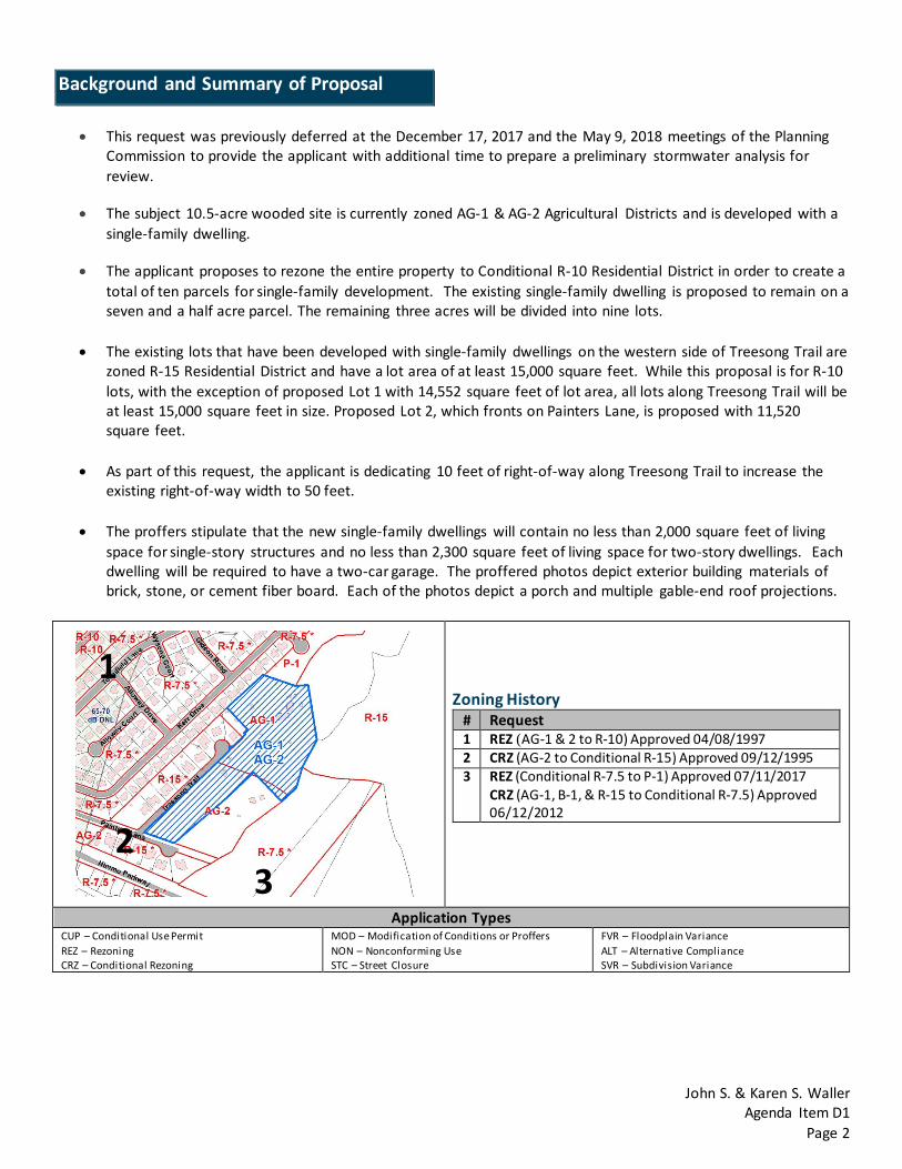
• This request was previously deferred at the December 17, 2017 and the May 9, 2018 meetings of the Planning
Commission to provide the applicant with additional time to prepare a preliminary stormwater analysis for review.
• The subject 10.5-acre wooded site is currently zoned AG-1 & AG-2 Agricultural Districts and is developed with a single-family dwelling.
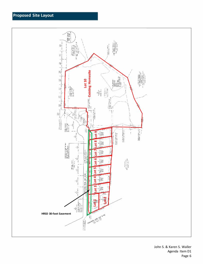
• The applicant proposes to rezone the entire property to Conditional R-10 Residential District in order to create a total of ten parcels for single-family development. The existing single-family dwelling is proposed to remain on a seven and a half acre parcel. The remaining three acres will be divided into nine lots.
• The existing lots that have been developed with single-family dwellings on the western side of Treesong Trail are zoned R-15 Residential District and have a lot area of at least 15,000 square feet. While this proposal is for R-10 lots, with the exception of proposed Lot 1 with 14,552 square feet of lot area, all lots along Treesong Trail will be at least 15,000 square feet in size. Proposed Lot 2, which fronts on Painters Lane, is proposed with 11,520 square feet.
• As part of this request, the applicant is dedicating 10 feet of right-of-way along Treesong Trail to increase the
existing right-of-way width to 50 feet.
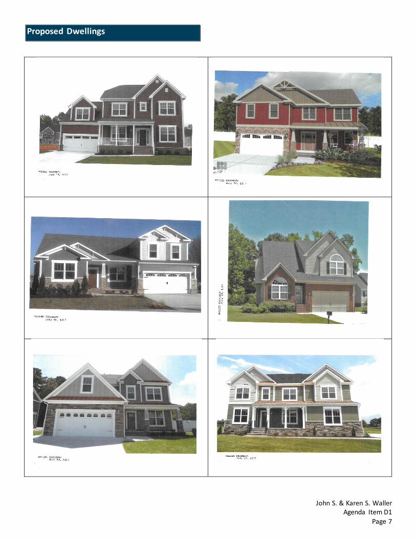
• The proffers stipulate that the new single-family dwellings will contain no less than 2,000 square feet of living space for single-story structures and no less than 2,300 square feet of living space for two-story dwellings. Each dwelling will be required to have a two-car garage. The proffered photos depict exterior building materials of brick, stone, or cement fiber board. Each of the photos depict a porch and multiple gable-end roof projections.
Zoning History # Request 1 REZ (AG-1 & 2 to R-10) Approved 04/08/1997 2 CRZ (AG-2 to Conditional R-15) Approved 09/12/1995 3 REZ (Conditional R-7.5 to P-1) Approved 07/11/2017
CRZ (AG-1, B-1, & R-15 to Conditional R-7.5) Approved 06/12/2012
Application Types CUP – Conditional Use Permit REZ – Rezoning CRZ – Conditional Rezoning
MOD – Modification of Conditions or Proffers NON – Nonconforming Use STC – Street Closure
FVR – Floodplain Variance ALT – Alternative Compliance SVR – Subdivision Variance
Background and Summary of Proposal
1
2 3
John S. & Karen S. Waller Agenda Item D1
Page 3
Residential developments in the surrounding area have been constructed with densities between 2.25 to 3.50 units to the acre. This request for a total of 10 units on 10.50 acres equates to a density of less than one unit per acre (0.95 unit per acre). As the proposed density is less than that of the surrounding areas, it is Staff’s opinion that the proposed density is compatible with the intensity of nearby neighborhoods, and therefore is consistent with the Comprehensive Plan. Additionally, as previously mentioned, eight of the nine lots proposed along Treesong Trail have a minimum area of at least 15,000 square feet, which is consistent with the existing lots along the west side of Treesong Trail. The proposed dwellings are consistent in size and scale with the existing dwellings of the surrounding area. The proffers also provide assurance that high quality building materials will be used on the exteriors of the dwellings. As recommended by the Comprehensive Plan, the applicant has submitted a preliminary drainage study to the Development Services Center (DSC) outlining the proposed stormwater strategy for the subject site. As a result of the review, the DSC concurs that the proposed conceptual stormwater strategy has the potential to successfully comply with the stormwater requirements of this site. However, this review is not a formal approval of the submitted stormwater plan. More details will be required and a formal review will take place during review of the construction plan through the DSC. It is Staff’s opinion that the proposed development of the site is a reasonable request in regards to compatibility with the surrounding neighborhood in terms of density, architecture and layout. Therefore, Staff recommends approval of this request.
The following are proffers submitted by the applicant as part of a Conditional Zoning Agreement (CZA). The applicant, consistent with Section 107(h) of the City Zoning Ordinance, has voluntarily submitted these proffers in an attempt to “offset identified problems to the extent that the proposed rezoning is acceptable,” (§107(h)(1)). Should this application be approved, the proffers will be recorded at the Circuit Court and serve as conditions restricting the use of the property as proposed with this change of zoning. Proffer 1: When the Property is developed it shall be subdivided into no more than nine (9) new residential building lots, plus the Grantors’ existing homesite, designated 10, 7.174 AC. substantially as depicted on the “PRELIMINARY SUBDIVISION OF PROPERTY OF JOHN S. WALLER JR. D.B. 2898 P. 990 VIRGINIA BEACH, VIRGINIA”, dated July 21, 2017, and prepared by Gallup Surveyors & Engineering, Ltd. (“Subdivision Plan”), which has been exhibited to the Virginia Beach City Council and is on file with the Virginia Beach Department of Planning. Proffer 2: When the Property is developed, each of the nine (9) new single family residential dwellings to be constructed shall contain no less than 2,000 square feet of enclosed living area, excluding garage for one-story and no less than 2,000 square feet of enclosed living area for dwellings in excess of one-story. Each home shall have a garage for a minimum of two (2) vehicles and the primary exterior building materials on each home will be brick, stone, cement fiber (“hardie plank”) or a combination of those materials. Neither the size nor architectural features of the existing homestead or any future replacement of that home on the Grantor’s homesite (10) are regulated hereunder.
Evaluation and Recommendation
Proffers
John S. & Karen S. Waller Agenda Item D1
Page 4
Proffer 3:
When the Property is developed, the nine (9) new residential dwellings shall have the quality exterior design and architectural features substantially as depicted on the Pictorial Exhibits entitled “WALLER PROPERTY” dated July 28, 2017, which have been exhibited to the Virginia Beach City Council and are on file with the Virginia Beach Department of Planning. Proffer 4: Further conditions may be required by the Grantee during subdivision review and administration of applicable City Codes by all cognizant City agencies and departments to meet all applicable City Code requirements. Staff comments: The proposed proffers provide confidence that the site will be developed with a compatible layout and density compared to the surrounding areas, and the dwellings will be constructed with high quality materials and attractive in nature. Further conditions may be required during the administration of applicable City Ordinances and Standards. Any site plan submitted with this application may require revision during detailed site plan review to meet all applicable City Codes and Standards. All applicable permits required by the City Code, including those administered by the Department of Planning / Development Services Center and Department of Planning / Permits and Inspections Division, and the issuance of a Certificate of Occupancy, are required before any uses allowed by this Use Permit are valid. The applicant is encouraged to contact and work with the Crime Prevention Office within the Police Department for crime prevention techniques and Crime Prevention Through Environmental Design (CPTED) concepts and strategies as they pertain to this site.
The Comprehensive Plan identifies this site as being located within the Suburban Area. The general planning principles for the Suburban Area focus on creating and maintaining great neighborhoods through stability and sustainability; protecting and enhancing open spaces and places of cultural and historical significance; and creating and maintaining a transportation system that provides connectivity and mobility. Achieving these goals requires that all land use activities either maintain or enhance the existing neighborhood through compatibility with surroundings, quality and attractiveness of site and buildings, improved mobility, environmental responsibility, livability, and effective buffering with respect to type, size, intensity and relationship to the surrounding uses.
The site is located in the Southern Rivers Watershed. Drainage in the Southern Rivers watershed is highly impacted by the presence of high ground water, poorly draining soils, and high water surface elevations in downstream receiving waters. A portion of the site is impacted by the Floodplain Subject to Special Restrictions (FSSR). Most of this area is located in the rear of the site. No structures are proposed in this area. Other than the timber from the existing woods, there do not appear to be any other significant cultural or natural resources associated with the site.
Comprehensive Plan Recommendations
Natural and Cultural Resources Impacts
John S. & Karen S. Waller Agenda Item D1
Page 5
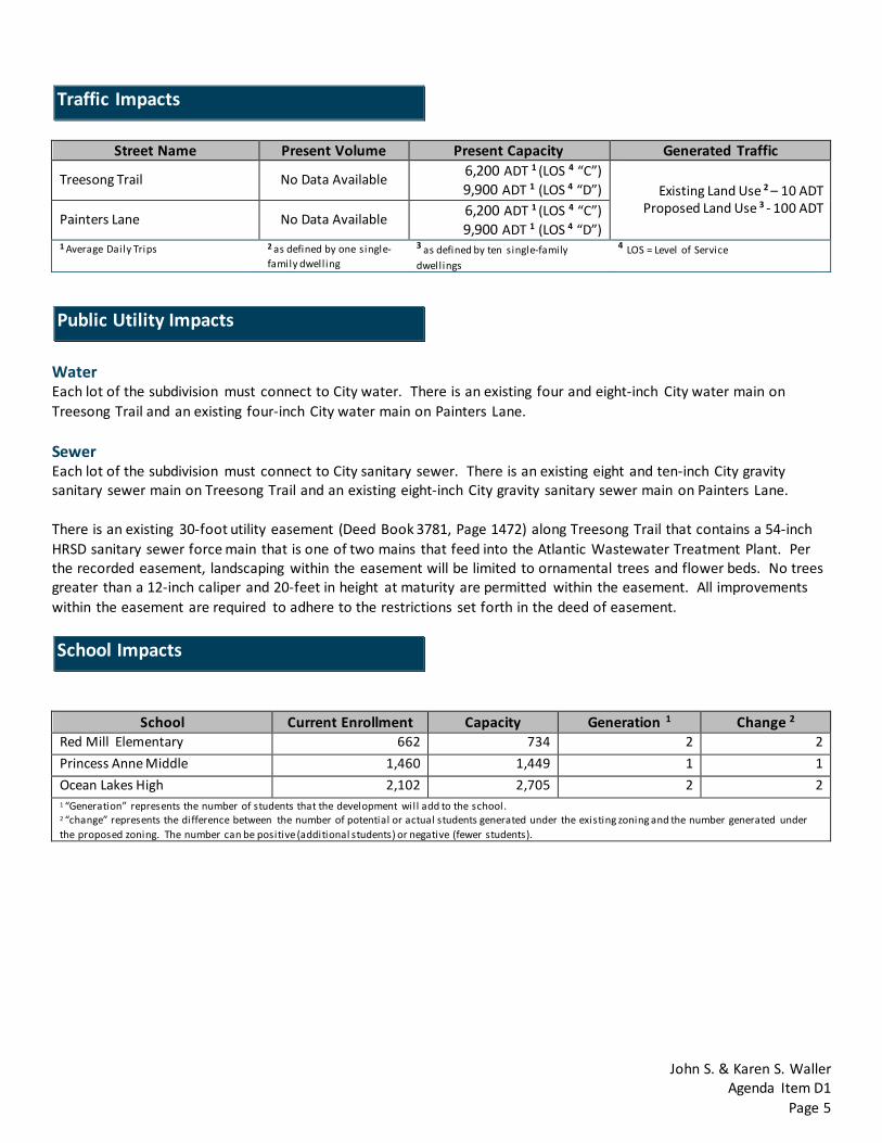
Street Name Present Volume Present Capacity Generated Traffic
Treesong Trail No Data Available 6,200 ADT 1 (LOS 4 “C”) 9,900 ADT 1 (LOS 4 “D”) Existing Land Use 2 – 10 ADT
Proposed Land Use 3 - 100 ADT Painters Lane No Data Available 6,200 ADT 1 (LOS 4 “C”)
9,900 ADT 1 (LOS 4 “D”) 1 Average Daily Trips 2 as defined by one single-
family dwelling
3 as defined by ten single-family dwellings
4 LOS = Level of Service
Water Each lot of the subdivision must connect to City water. There is an existing four and eight-inch City water main on Treesong Trail and an existing four-inch City water main on Painters Lane. Sewer Each lot of the subdivision must connect to City sanitary sewer. There is an existing eight and ten-inch City gravity sanitary sewer main on Treesong Trail and an existing eight-inch City gravity sanitary sewer main on Painters Lane. There is an existing 30-foot utility easement (Deed Book 3781, Page 1472) along Treesong Trail that contains a 54-inch HRSD sanitary sewer force main that is one of two mains that feed into the Atlantic Wastewater Treatment Plant. Per the recorded easement, landscaping within the easement will be limited to ornamental trees and flower beds. No trees greater than a 12-inch caliper and 20-feet in height at maturity are permitted within the easement. All improvements within the easement are required to adhere to the restrictions set forth in the deed of easement.
School Current Enrollment Capacity Generation 1 Change 2
Red Mill Elementary 662 734 2 2 Princess Anne Middle 1,460 1,449 1 1 Ocean Lakes High 2,102 2,705 2 2 1 “Generation” represents the number of students that the development will add to the school. 2 “change” represents the difference between the number of potential or actual students generated under the existing zoning and the number generated under the proposed zoning. The number can be positive (additional students) or negative (fewer students).
Traffic Impacts
Public Utility Impacts
School Impacts
John S. & Karen S. Waller Agenda Item D1
Page 6
Proposed Site Layout
Lot 1
Lot 2
Lot 3
Lot
4 L
ot 5
Lot
6 L
ot 7
Lot
8 L
ot 9
Lot 1
0 Ex
istin
g Ho
mes
ite
HRSD 30-foot Easement
John S. & Karen S. Waller Agenda Item D1
Page 7
Proposed Dwellings

John S. & Karen S. Waller Agenda Item D1
Page 8
Site Photos

John S. & Karen S. Waller Agenda Item D1
Page 9
Disclosure Statement

John S. & Karen S. Waller Agenda Item D1
Page 10
Disclosure Statement
John S. & Karen S. Waller Agenda Item D1
Page 11
Disclosure Statement

John S. & Karen S. Waller Agenda Item D1
Page 12
Disclosure Statement
X
X
Waller Construction Company Inc.
John S. & Karen S. Waller Agenda Item D1
Page 13
Disclosure Statement