jericho research forest recreational trail mapping and...
TRANSCRIPT
Jericho Research Forest
Recreational Trail Mapping and Assessment
Prepared for the University of Vermont Natural Areas
By the Land Stewardship Program (LANDS), July 2014

Table of Contents
Executive Summary………………………………………………………………………….. 1
About LANDS……………………………………………………………………………….. 1
Acknowledgements…………………………………………………………………………... 2
Introduction…………………………………………………………………………………... 2
Goals and Objectives………………………………………………………………………… 3
Site Description……………………………………………………………………………….3
Trail Assessment Protocol…………………………………………………………………….3
Recommendations……………………………………………………………………………. 4
Conclusion…………………………………………………………………………………… 6
Work Cited…………………………………………………………………………………… 7
Appendix A: Trail Condition Form………………………………………………………… 8
Appendix B: Maps………………………………………………………………………….. 11
1
Executive Summary
This report was prepared in July 2014 by the UVM/SCA LANDS Crew. It presents a map
of recreational trails as well as information on the conditions of trail segments connected to the
VAST trail within Jericho Research Forest (JRF). This project was conducted in preparation for
a specific upcoming recreation event, and also to assess trails for long-term recreational use. The
upcoming event is a horseback “poker ride” planned by the Green Mountain Hounds, in which
up to 30 horses will be riding on JRF trails. The ride has the potential to impact the trail heavily,
so it was essential to plan a suitable route, and to assess the condition of the trails before and
after the ride. LANDS developed a protocol for assessing the trails that can be used throughout
JRF to streamline future maintenance and monitoring of the trail network.
In order to recommend a trail system for the equine riders to use, the LANDS interns
designed a protocol and data sheet for feature classification and trail assessment (Appendix A),
then used the protocol to survey the proposed trails. Features such as erosion, invasive species
patches, woody debris, trail widening or narrowing, and significant changes in slope were
recorded and analyzed to determine which trails would be best suited to support the horse riders.
The crew determined that the existing trail would need to be rerouted to prevent the usage of a
trail segment in poor condition. Several reroute options were proposed and surveyed, and will be
presented to staff at Jericho who will choose the best option for the poker ride.
For long-term management and monitoring of the trail system, student groups as well as
volunteers from surrounding areas should be encouraged to participate in trail clean-up days and
monitor for significant changes to trail features, such as what may occur after a significant
weather event or simply from use over time. With the Trail Condition Form created by LANDS,
the process for collecting these data will be streamlined and easy to compare over time. LANDS
also hopes that the monitoring protocol will enable the many different groups who visit JRF to
communicate significant changes they notice during their time in the forest.
About LANDS
The field of conservation is rapidly evolving to meet the growing demands of society.
New ideas and strategies are changing how we conserve and steward the land; The Land
Stewardship Program (LANDS) is one of these new ideas. During the Great Depression, the
Conservation Corps model was pioneered as a means to promote stewardship in the nation and
provide jobs for the unemployed. The idea has since been reinvented 116 times by local and state
corps across the United States. However, the general theme is the same: young people learning
and growing through service. LANDS is an innovative College Conservation Corps designed to
train tomorrow’s conservationist practitioners and leaders, and is a pilot partnership between the
University of Vermont and the Student Conservation Association in its eighth year of successful
programming.
Thanks to college level education and prior experience in environmental science fields,
LANDS interns are able to take on projects that are more technical than the work traditionally
done by conservation crews. LANDS interns draft management plans, map areas of interest
using GPS and GIS, inventory resources, survey for non-native species, survey soils, calculate

2
carbon stocks, and even find time to build trails. Municipalities, land trusts, state agencies,
university researchers, national forests and parks, and volunteer-managed conservation
organizations all benefit from LANDS’s high quality, affordable services. LANDS interns are
advanced undergraduates and recent graduates with natural resource experience from all over the
world, and they bring a wide range of skills and interests to the program. LANDS is a unique
service-learning model that addresses an ever-expanding list of conservation needs, while
training young adults as future environmental leaders.
Acknowledgements
LANDS would like to thank the Rubenstein School of Environment and Natural
Resources (RSENR) at the University of Vermont and the Student Conservation Association
(SCA) for establishing and supporting this internship program. In addition, we acknowledge the
Aiken Center at UVM for providing us with their valuable resources and work facility. We
greatly appreciate the knowledge and preparation from Liz Thompson, Steve Libby, Alicia
Daniel, Gary Hawley, and Matt Hollingsworth during our training.
In addition, we would like to recognize Glenna Hartman and Ralph Tursini of the
Rubenstein School for helping to organize our office space on the property, offering up their
knowledge of the area, and providing us with a variety of equipment that was invaluable for our
trail assessment.
Introduction
Green Mountain Hounds, a local 501(c)(3) non-profit that conducts fox hunts and other
horseback events around Vermont, recently inquired about using the Jericho Research Forest
trails for a day. Their inquiry spurred JRF management to evaluate the condition of the trails and
identify necessary repair projects for both short-term and long-term recreational use. The Green
Mountain Hounds requested use of the VAST (Vermont Association of Snow Travelers) trail, a
statewide snowmobile trail that runs through part of JRF. There are numerous other trails
running throughout the forest, some large and well-cleared, and others heavily overgrown or
blocked by debris. Most trails in the forest are mapped, though some are either not mapped or
incorrectly mapped. Few of the trails are clearly marked, though signposts are placed at some
junctions marking the VAST trail. The many foot trails are often used by locals, and JRF
management is interested in maintaining their accessibility and promoting their use.
Recreational trail use presents ecological and social impacts and includes activities such
as jogging, mountain biking, hiking, and horseback riding. Natural environments may be stressed
by trampling, habitat disturbance, erosion and nitrification (Lynn and Brown 2003, Pickering et
al. 2010). The National Recreational Trails Advisory Committee reported social conflicts among
trail users and the need to promote trail sharing activities as well as future research to understand
these issues (Moore 1994). The LANDS crew conducted recreation trail condition inventories as
well as created protocol to streamline future assessments. In addition, LANDS proposed a route
for the Green Mountain Hounds to be used during their event that is in good condition and
accessible by horse.
3
Goals and Objectives
Project goal: Evaluate current trail condition and impacts of trail use at Jericho Research Forest,
specifically along a route proposed by the Green Mountain Hounds, which includes a VAST trail
and adjacent trail segments.
Objectives:
• Develop user-friendly data sheet and protocol for trail assessment.
• Test and revise data sheet and protocol.
• Assess current conditions to identify major priorities for management along trails.
• Identify vulnerable areas within trails.
• Analyze data and interpret assessment results to estimate trail use impacts
• Propose and map a route for the horse riding event with potential for future event re-
use.
• Propose management strategies for current and future trail conditions and impacts of
use.
Site Description
The Jericho Research Forest is located on 478 acres of former agricultural land between
the Winooski River Valley and the foothills of the Green Mountains in the southwestern corner
of the town of Jericho, Vermont. Acquired by the University of Vermont in 1941, it is managed
by the Rubenstein School of Environment and Natural Resources. The site is utilized extensively
for practical projects, ecological research and education (Rubenstein School, 2014).
The topography is both rugged and diverse, with steep slopes, sandy terraces, and
bedrock outcrops. The elevation is 505 feet, the average aspect is 269° (SW) and the average
slope is 18°. The surficial geology is a diversity of glacial till, lake bottom sediments, recent
alluvium, and deltaic sands. The forest types include northern hardwoods, rich northern
hardwoods, white pine-red maple, red oak-northern hardwoods, hemlock forests, and pine
plantations (Rubenstein School, 2014).
Trail Assessment Protocol
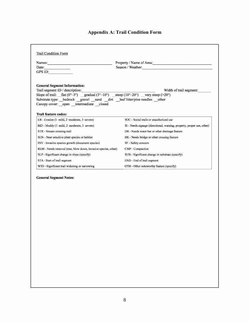
There are two methods that we have developed for recording information about trails, and
they each require different equipment and training levels to accommodate different types of
volunteers. The first method will require a GPS unit, clinometer, the Trail Condition Form, and
preferably a camera. The second method involves the use of a smartphone and the ability to
access the 4G connection that is available throughout the Jericho Research Forest on a variety of
networks.
The Trail Condition Form (TCF; Appendix A) is designed to be used by a wide range of
data collectors using any combination of equipment. The top section of the Trail Condition Form
collects general information about the project and the data collectors. The next section collects
information about the specific section of trail that will be assessed in the form. Some trail
segments may have pre-assigned names, or it may be necessary to describe the segment and its
4
location in order to specify the exact range that is being assessed. The data fields for this section
are the trail dimensions, slope, substrate type, and canopy cover. Segment length, width, and
slope may be exactly measured or estimated depending on the available gear. Substrate type may
clearly fall into one of the categories, or may be a mix of substances and surface types. All
values in this section can potentially vary throughout the trail segment, in which case an average
value should be estimated. Notably drastic changes can also be noted as trail features.
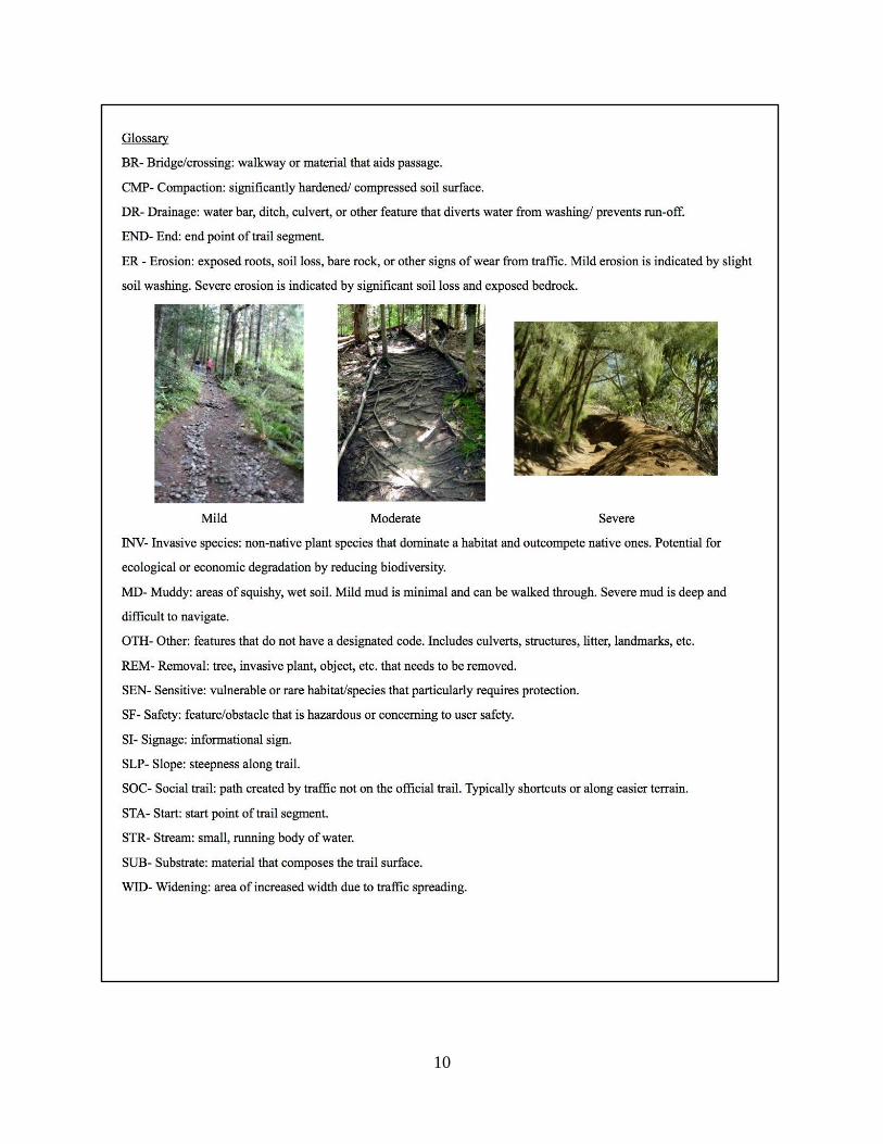
The trail feature codes provide a shorthand method of recording common points of
interest for trail management. A glossary of terms is attached to the form that describes each
feature code and explains how to evaluate degrees of severity. The “trail features” section
provides a column to enter trail feature codes and a column to record notes on the condition or
location of the feature. Data on GPS waypoints and coordinates or information about a
photograph of the feature may be entered in the indicated columns.
If GPS units are unavailable or there are a lack of ‘TCF’s for the assessors, a convenient
way to collect the data with a large group of volunteers, perhaps in a ‘bio-blitz’ type format,
involves the use of a smartphone with the following applications: “Flickr” (for compiling and
sharing photos), “Turbo GPS” (for collecting location data), and “Clinometer” (for measuring
slope). These virtual applications replace the need for volunteers to borrow equipment to bring
out onto the trail. Individuals or groups will need to take note of the fields required by the
assessment. At appropriate features, data should be collected off of “Turbo GPS” and
“Clinometer” and added to the caption section of an already taken photo of the area all within the
“Flickr” application. This information should then be shared with the Jericho Trail Assessment
“Flickr” account, which can easily be created, and the gathered information may then be
uploaded directly if the account information is given out to volunteers.
In addition to collecting these data via the Trail Condition Form and GPS units, another
form of trail update communication can be implemented in the kiosk that is to be installed near
the Orr center, at the entrance near the main access trail. This kiosk can include a trail register
that includes a space for notes on trail condition and any critical issues groups may come across
while on the trail. This communication between user groups as well as the JRF staff can aid in
assessing trail issues and getting them resolved in a timely manner.
Recommendations
Based on our trail assessment and general observations, we have developed
recommendations for trail management in JRF. Two categories of recommendations were
developed: re-route options for the upcoming horseback ride (Appendix B, Map 1) and
recommendations for future management.
Segment two is the only major segment of trail along the predetermined route that needs
major work, including brush/tree removal and improved drainage to alleviate erosion and
muddiness. Due to the current impassability of this segment, we suggest multiple options for re-
routing (Table 1). We stress that these are only short-term options to be used for the horseback
ride. They are not necessarily permanent trail options. While some of the possibilities utilize
other trails on the property, the linking to other public areas, such as the Mobbs forest, are not as
fluid as the more straight-forward option which uses segment two.

5
Table 1: Summary of reroute options and trail work needs
Option Action Work
Time Work Needed Pros Cons
1. Tarbox Road to
Segment B6
Reroute 2-3 days • Minimal downed tree removal
• Needs signage
• Gradual slope
• Wide
• Clear
• Use of Tarbox Rd
2. Tarbox Rd to Y1 Reroute 2-3 days • Minimal downed tree removal
• Install/repair drainage
• Needs signage
• Beautiful walk
• Wide
• Clear
• Erosion
• Steep areas
• Use of Tarbox Rd
3. Boundary Trail Reroute 1-2 weeks • Minimal downed tree removal
• Boulder reroute
• Needs signage
• Gradual slope
• Mostly open
• Avoids Tarbox Rd
• Boulder
obstruction
• Narrow
4. Off-Property Trail Reroute 1-2 weeks • Minimal downed tree removal
• Needs signage
• Cleared
• Flat
• Avoids Tarbox Rd
• Permission from
property owner
5. Segment Y10 Repair ~1 month • Significant tree and brush
removal
• Install drainage
• Needs signage
• Follows existing
trail
• Needs substantial
work
Recommendations for Future Management
A major project for future trail work could be repairing segment two, which is currently
impassible due to many downed trees and muddy conditions. Opening the segment would
facilitate increased recreational use in the long-term, as it allows for easy connection to the
adjacent Mobbs Forest. Another potential project for aiding increased recreational use could
include mapping and assessing the other trails on the property. With the limited time frame of
our project, we were only able to consider the route for the horseback ride. While this route
contains many of the larger and more heavily used trails, it would be helpful to have a full
register of the trails on the property. Inventorying these trails could aid in decision-making about
opening trails for horseback riding or mountain biking. The monitoring of all trails should follow
up assessments especially after large events such as the horseback ride to ensure that the research
forest maintains the standards set forth by FSC certifications. A full inventory and assessment
and ongoing monitoring may not be feasible for JRF staff alone, and we recommend the use of
resources such as LANDS, volunteer groups, and students from nearby universities.
Volunteer groups and individuals from nearby communities could come to UVM’s
Jericho Research Forest to assist in trail assessment, monitoring and maintenance. Volunteers
could come from many user groups, such as student groups (UVM Outing Club, VSTEP, other
local colleges and school districts, etc.) community groups (Trail Hounds, Green Mountain
Club,) and more. These groups could contribute based on their background and ability to
6
access to appropriate technologies.
We recommend that volunteer groups make use of the Trail Condition Form we
developed, or otherwise simply document major trail features. Such volunteer assessments could
include reporting damage after storm events such as flooding, downed trees and dangerous trail
conditions. Other options for volunteers include invasive species monitoring and management, as
well as trail maintenance. With the spread of many invasives around the area, including new
outbreaks on the property such as Japanese stilt grass, monitoring and control measures are
critically needed. Seasonal trail clean-up may also be a helpful volunteer activity.
Conclusion
The Jericho Research Forest is a research area with many opportunities for recreational
use. We assessed a large section of the VAST trail as well as other trails which fell within our
route for the horseback ride. We found most areas to be suitable for a variety of activities and
require only minor maintenance. Segment two was impassible as it contained major hazards and
needed substantial repair. The time constraints of this project did not allow for us to extend our
assessments beyond the horseback route, but our work presents a starting point for future
maintenance and monitoring.
The assessment of additional trails that fall within the property boundary is a step that
should be taken. From our limited experience on these trails we found some difficulties in
navigating them, mainly due to the presence of many unmapped trails. The trails that are mapped
should represent a priority for any future assessments, but the unmapped trails should be kept in
mind when planning any future work. These trails could first be mapped and then assessed along
with the currently mapped trails or at a later date.
The protocol that LANDS developed relating to trail maintenance and monitoring can assist
all future users of JRF in communicating any issues they come across while on the trail. The
Trail Condition Form can also aid students and volunteers who assist in trail monitoring and
clean up. The LANDS team hopes that this will streamline JRF’s usage and communication, as
well as help maintain the trail conditions throughout all seasons of use.
7
Work Cited
Jordan, Marilyn. 2000. Ecological Impacts of Recreational Use of Trails: A Literature Review.
The Nature Conservancy. Available at:
http://www.parks.ca.gov/pages/795/files/ecologicalimpactsrecreationalusers.pdf
Lynn, Natasha A. and Robert D. Brown. 2003. Effects of recreational use of impacts on hiking
experiences in natural areas. Landscape and Urban Planning 64: 77-87.
Moore, Roger L. 1994. Conflicts on multiple-use trails: synthesis of the literature and state of the
practice. Federal Highway Administration Recreational Trails Program. Available at:
https://www.fhwa.dot.gov/environment/recreational_trails/publications/
conflicts_on_multiple_use_trails/
Pickering, Catherine M., Wendy Hill, David Newsome, and Yu-Fai Leung. 2010. Comparing
hiking, mountain biking and horse riding impacts on vegetation and soils in Australia
and the United States of America. Journal of Environmental Management 91: 551-562.
Rubenstein School of Environment and Natural Resources. (2014). Forest Field Sites: Jericho
Research Forest. Retrieved from http://www.uvm.edu/rsenr/forestry/sites/jericho.php.
8
Appendix A: Trail Condition Form

9
10

11
Appendix B: Maps