jefferson county, colorado, planning and zoning department
TRANSCRIPT
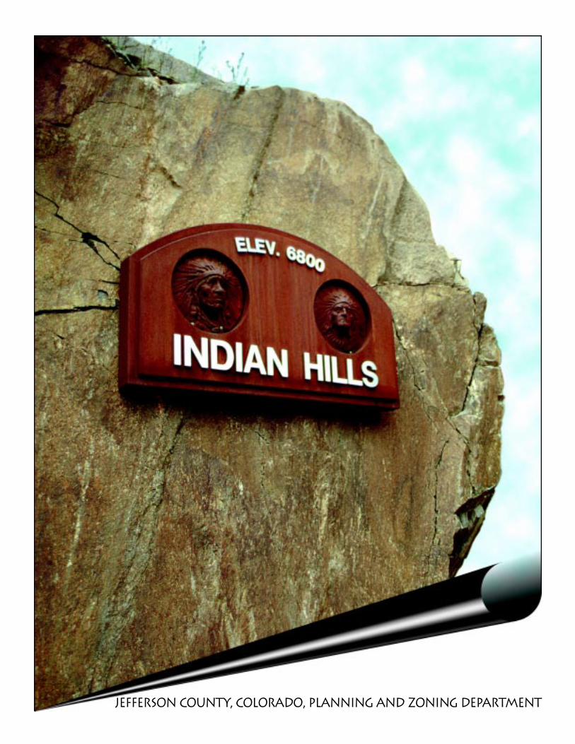
Jefferson County, Colorado, Planning And Zoning Department
COLORADO
JEFF
ERSON COUNTY
FOUNDED
1861
Jefferson County Board of County CommissionersJohn P. Stone
Michelle LawrencePatricia B. Holloway
Jefferson County Planning CommissionWallace Pulliam, Chairman
Paul Rosasco, Vice ChairmanAlan Fox
Felicity HannayJan Rousselot
Jim ColeLewis Stieghorst
Joe Siccardi, Associate MemberDon Parker, Associate Member
Indian Hills Community Plan Advisory GroupGary JenretteBette Taggart
Jim GroutBret Bruce
Debbie DoyleRosemary Aitken
With citizen input from:
Tris WoolenKirk Conner
Ken HampdenCheryl Touryan
Colorado Center for Community DevelopmentNana Lea
Carolyn LinnRobert Lunnis
Produced by the Jefferson County Planning Department100 Jefferson County Parkway, Suite 3550, Golden Colorado 80419-3550
http://co.jefferson.co.us/dpt/planning/planning.html
Richard Turner, Director
December 1997
In a 1958 letter appearing in the Canyon Courier’s first issue,In a 1958 letter appearing in the Canyon Courier’s first issue,In a 1958 letter appearing in the Canyon Courier’s first issue,In a 1958 letter appearing in the Canyon Courier’s first issue,In a 1958 letter appearing in the Canyon Courier’s first issue,
which was at that time published in Indian Hills, a citizen wrote:which was at that time published in Indian Hills, a citizen wrote:which was at that time published in Indian Hills, a citizen wrote:which was at that time published in Indian Hills, a citizen wrote:which was at that time published in Indian Hills, a citizen wrote:
“Dear Editor: Why not We and Us instead of You and They? The communities in“Dear Editor: Why not We and Us instead of You and They? The communities in“Dear Editor: Why not We and Us instead of You and They? The communities in“Dear Editor: Why not We and Us instead of You and They? The communities in“Dear Editor: Why not We and Us instead of You and They? The communities inwhich we live, our mountain area, are our responsibility. We enjoy the privilege ofwhich we live, our mountain area, are our responsibility. We enjoy the privilege ofwhich we live, our mountain area, are our responsibility. We enjoy the privilege ofwhich we live, our mountain area, are our responsibility. We enjoy the privilege ofwhich we live, our mountain area, are our responsibility. We enjoy the privilege ofmountain living. We chose to live here of our own free will. When we discuss ideasmountain living. We chose to live here of our own free will. When we discuss ideasmountain living. We chose to live here of our own free will. When we discuss ideasmountain living. We chose to live here of our own free will. When we discuss ideasmountain living. We chose to live here of our own free will. When we discuss ideas
for the present and future of our communities let us not sayfor the present and future of our communities let us not sayfor the present and future of our communities let us not sayfor the present and future of our communities let us not sayfor the present and future of our communities let us not say‘Why don’t they do that?’ Let’s say ‘Why don’t We do this?’‘Why don’t they do that?’ Let’s say ‘Why don’t We do this?’‘Why don’t they do that?’ Let’s say ‘Why don’t We do this?’‘Why don’t they do that?’ Let’s say ‘Why don’t We do this?’‘Why don’t they do that?’ Let’s say ‘Why don’t We do this?’
After all, who are They? We are They, and They are Us!”After all, who are They? We are They, and They are Us!”After all, who are They? We are They, and They are Us!”After all, who are They? We are They, and They are Us!”After all, who are They? We are They, and They are Us!”It is to the “We” and the “Us” that we dedicate this report.It is to the “We” and the “Us” that we dedicate this report.It is to the “We” and the “Us” that we dedicate this report.It is to the “We” and the “Us” that we dedicate this report.It is to the “We” and the “Us” that we dedicate this report.
This article was excerpted from the 1975 “Indian Hills Environmental Resource Inventory.” A thought that holds true today.
4 Acknowledgments 5 Introduction8 Water & Sanitation
12 Roads & Transportation14 Residenti al Development16 Commercial Development17 Open Space & Recreation19 Visual Resources20 Wildlife21 Hazards23 Historic24 Mountain Site Design Criteria28 Glossary29 Appendix34 Community Plan Maps
Circled policy numbers identify policies which can be applied in the land use review processes ( ).
Other recommendations address concerns which cannot be resolved through the land use review process and requireimplementation by the Planning & Zoning Department, other governmental entities, and/or the community.
Please see the Mountain Site Design Criteria section of this document for related policies in addition to thoseidentified for each issue. The maps which have been adopted as integral to the Plan appear at the end of the
document and should be used during land development review processes.
Indian Hills community Plan
1.
4 Indian hills
AcknowledgmentsBeginning in June 1989, the Indian Hills Improve-
ment Association worked with the Colorado Center
for Community Development and a project team
formed by the Jefferson County Planning Depart-
ment to draft a community plan to serve as a guide
for future development.
Members of the project team included Russell Clark,Planner; Bill Roberts, Planner; Kevin Nichols, FormerComprehensive Planning Coordinator; and JanetBell, Acting Comprehensive Planning Coordinator.Doyle Harrison was responsible for the documentproduction. Special appreciation goes to PhyllisScheneman, Comprehensive Planning Administra-tive Specialist.
Other County departments which contributed to thedevelopment of this Plan include Highways andTransportation, Health and Environmental Services,and the County Attorney’s office. Without this inter-departmental cooperation it would not have beenpossible to produce this Plan. Individuals withinthese departments who deserve recognition: ClaireLevy, County Attorney’s Office; Jean Montoya, High-ways and Transportation; and Mindi Ramig,Jefferson County Department of Health & Environ-ment . A high level of support was given by theJefferson County Board of County Commissioners,Jefferson County Planning Commission, and Rich-ard Turner, Planning Director.
The following public agencies, commissions andorganizations were referral entities providing infor-mation at the inception and throughout the process,and later reviewed the Plan prior to the public hear-ings. The cooperation of these groups was an impor-tant aspect of the Indian Hills planning effort.
Town of MorrisonColorado State Forest ServiceColorado Department of HealthColorado Department of TransportationHistorical Society of ColoradoJefferson County Historical CommissionColorado Board of Land CommissionersColorado Department of Natural ResourcesColorado Division of Water ResourcesColorado Division of WildlifeJefferson Economic CouncilJefferson County Fire CouncilJefferson County Department of Health & Environ-
mentJefferson County Department of Highways & Trans-
portationJefferson County Open Space DepartmentJefferson County Sheriff’s DepartmentJefferson County R-1 School DistrictJefferson Soil Conservation DistrictPublic Service Company of ColoradoDenver Mountain ParksEvergreen Recreation & Park DistrictIndian Hills Improvement AssociationIndian Hills Fire DistrictIndian Hills Water District
Newspaper coverage by The Canyon Courier pro-vided information to community residents and otherinterested parties throughout the planning process.The project benefited from the cooperation of theParmalee Elementary School and Indian Hills Com-munity Center for providing public meeting loca-tions.
Thanks are due to the many concerned residents ofthe Indian Hills area who took time to attend thepublic meetings and hearings, and who completedsurveys, wrote letters and testified. Their commentsand information strengthened this Plan.
Acknowledgments
5Indian hills
IntroductionWhat It Is
The intent of a community plan is to state, on paper,
the vision of a community and to provide guidance
for the future. In accordance with the State statutes,
the recommendations in this plan are not manda-
tory; however, they do carry the weight of the
community’s desires for the quality, type, amount,and location of future development. The land usegoals and recommendations presented in this planwill be considered when evaluating rezoning appli-cations. This plan represents the best judgment ofthe community at this time. It does not profess toforesee and provide for all future natural andmanmade changes. For this reason, the plan shouldbe updated periodically to assess these changes andtheir effect on the plan’s recommendations.
How It Was DoneA community plan was needed by Indian Hills forseveral reasons. First of all, it is one of only a fewunincorporated areas in Jefferson County without acommunity plan. Furthermore, concerns aboutchanges within the Indian Hills community war-ranted a cohesive community plan.
Over the last five years, numerous meetings haveoccurred (at least a half dozen), with the involvementof Jefferson County staff at several of them. Some ofthese meetings were attended by as many as 200participants, including County commissioners andnumerous associated agencies. At all of these meet-ings, it became apparent that there was a lack of di-rection and organized vision for the community. Af-ter discussing the matter with the County, it was sug-gested that a community plan should be the first stepin creating a direction. The Plan’s development pro-cess followed several steps. First, the communityobtained County support. The second step was toestablish the community’s desires for this Plan. Todo this, professional support was enlisted to obtaincommunity input. A survey was conducted initiallyto analyze concerns of the community. This surveywas individually distributed by residents at the In-dian Hills post office. Of the 212 surveys distributed,128 surveys were returned, either by mail or in adrop-box at the post office. The surveys returnedrepresented a response rate of 60% of the distributed
survey and 21% of the approximately 600 residentsof the community. Surveys done in 1974 and againin 1996 exhibit concerns by the Indian Hills citizensthat are strikingly similar, even though they are sepa-rated by over 20 years. (See Appendix for survey re-sults.) Next, a community-wide meeting wasplanned. Announcements for this February 1996meeting were posted at several prominent commu-nity locations as well as advertised in local columnsand event columns in local newspapers which gen-erated a favorable attendance at this communitymeeting. Survey results were presented and dis-cussed at length. Also, generated at this meeting werefurther input and fine-tuning of specific issues. Itbecame obvious at the meeting that several issuesremained constant concerns. Community volun-teers formed committees that began meeting on abiweekly basis, to voice the concerns of the commu-nity and to write the plan. These meetings were opento all members of the community and active partici-pation was solicited in the local newspaper, The Can-yon Courier. Also, during this time period significantcontributions of time and financial resources wereasked of the residents of Indian Hills. The residentsagain responded favorably and development of theIndian Hills Community Plan ensued.
Relationship to Other JeffersonCounty PlansOther plans that apply to the unincorporated areaof the County that should be reviewed in conjunc-tion with this Plan are:
The Mineral Extraction Policy Plan which identifiesmineral deposits by quality and type, and providesguidelines for mineral extraction operations. Thesedeposits are not shown on the Development PatternMaps that accompany this Plan. Only those areaswhere zoning for mineral extraction exists are iden-tified.
introduction
6 Indian hills
The Sanitary LandfillPlan which providesguidelines for the lo-cation and operationof sanitary landfillswithin the County.
The Telecommunica-tions Plan which iden-tifies the conditionsfor siting telecommu-nication facilitieswithin the County.
The Major Thorough-fare Plan which wasdrafted by theCounty’s Highwaysand Transportation
Department and shows existing and proposed road-ways and improvements. A county wide transpor-tation plan will be available in 1998.
The Jefferson County Open Space Plan which wasdeveloped by the Open Space Program and showsthe location of existing parks and open space, andsome of the areas targeted for future open space ac-quisition.
These plans are used in concert with theGeneral Land Use Plan, where appli-cable, and the Community Plans. Whereconflicts occur among the plans, theCommunity Plans and Special Planstake precedence over the General LandUse Plan. When a land use addressed bya Special Plan occurs in a CommunityPlan area, the recommendations of bothplans will be given equal weight andconflicts will be resolved case by case.
HistoryThe first inhabitants of Indian Hills, theUte, Arapaho and Cheyenne Indiantribes, shared the area with early furtrappers. It is believed that the Arapaho
and Cheyenne Indian tribes sought thearea as a summer campground and used thewooded hills to replenish their supply of tentpoles. A fur trapper, a French-Canadian knownas Andre, is referred to as the region’s “first set-
tler.” He is said to have found gold in a gulch westof Dix Saddle, a high point at the western edge of
Parmalee Gulch. Eventually the land passed from theUtes to the Federal Government in a series of trea-ties completed in March 1880. The settlement ofDenver, along with the westward expansion of ournation, helped to facilitate the movement of heartysettlers, pioneers, and gold seekers into the nearbymountains. Many of the wagon routes and trails usedthen are roads that are driven upon today.
The activities of these pioneers included farming,ranching and lumbering. The soil depth is shallowin most areas of the valley and unfit for most agri-cultural activity. Subsequently, the lumber industryconstituted the majority of the commercial liveli-hoods of the area. Grand towering pines werechopped down and hauled off to Morrison, wherethe posts fetched a fancy top dollar and were soldfor railroad ties and fence posts.
Remnants of these early times can still be found inthe area today. The date of 1859 is chipped into oneof the rocks in the old fireplace of the General GeorgeParmalee house. General Parmalee, for whom thegulch is named, received his original patent for landfrom the U.S. Government. It is on this grant of landthat the first known cabin was built. The ParmaleeHouse became the focal point for many events ofcontinuing importance to the community. It was alsoa starting point for the post office, water district andfire district.
Another early landowner in the area was the DenverPacific Railway and Telegraph Company. Recordeddeeds of the area show transactions involving thecompany as early as 1869. No land is presently ownedby the railroad, but it still may retain the coal andiron mining rights to some areas within the gulch.
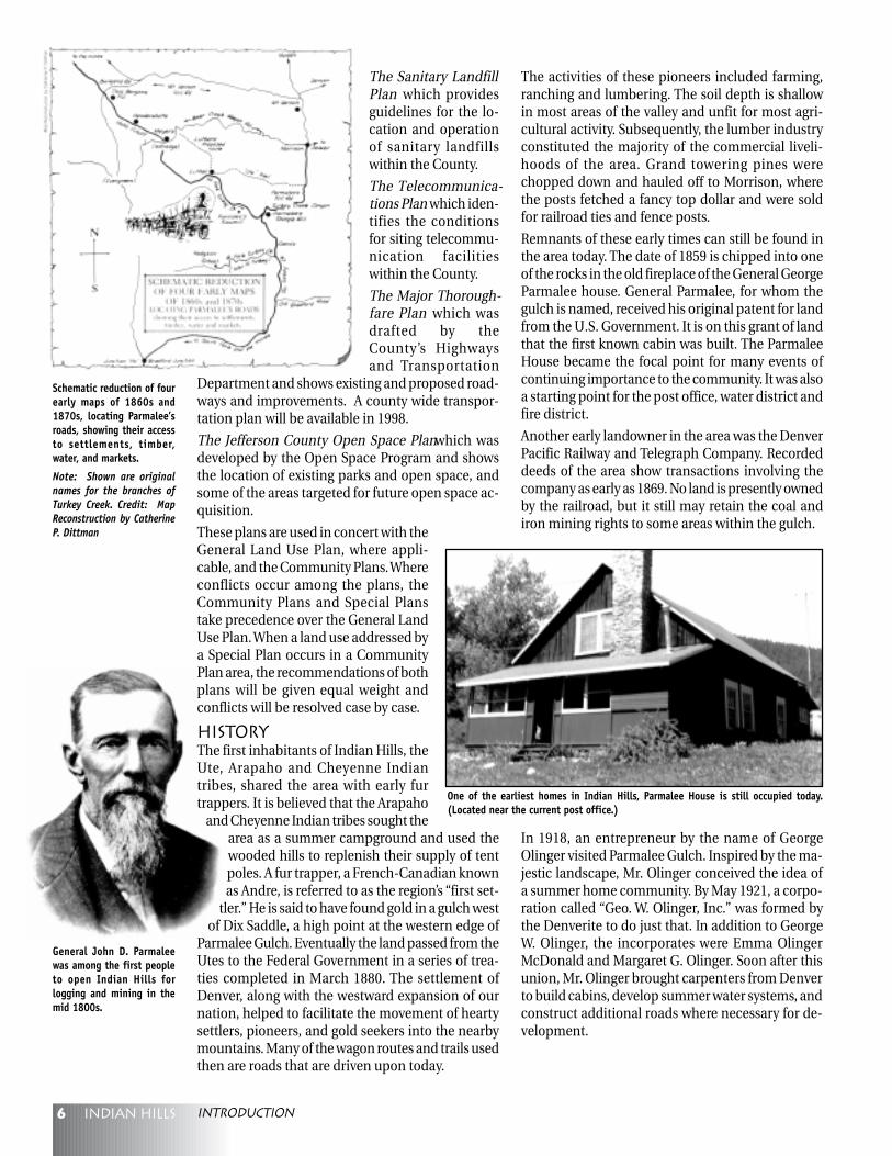
General John D. Parmaleewas among the first peopleto open Indian Hills forlogging and mining in themid 1800s.
Schematic reduction of fourearly maps of 1860s and1870s, locating Parmalee’sroads, showing their accessto settlements, timber,water, and markets.
Note: Shown are originalnames for the branches ofTurkey Creek. Credit: MapReconstruction by CatherineP. Dittman
One of the earliest homes in Indian Hills, Parmalee House is still occupied today.(Located near the current post office.)
introduction
In 1918, an entrepreneur by the name of GeorgeOlinger visited Parmalee Gulch. Inspired by the ma-jestic landscape, Mr. Olinger conceived the idea ofa summer home community. By May 1921, a corpo-ration called “Geo. W. Olinger, Inc.” was formed bythe Denverite to do just that. In addition to GeorgeW. Olinger, the incorporates were Emma OlingerMcDonald and Margaret G. Olinger. Soon after thisunion, Mr. Olinger brought carpenters from Denverto build cabins, develop summer water systems, andconstruct additional roads where necessary for de-velopment.
7Indian hills
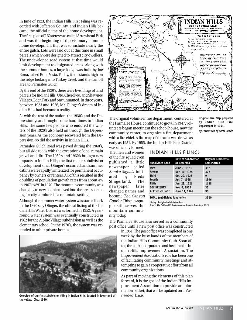
The original volunteer fire department, centered atthe Parmalee House, continued to grow. In 1947, vol-unteers began meeting at the school house, now thecommunity center, to organize a fire departmentwith a fire chief. A fire map of the area was drawn asearly as 1951. By 1955, the Indian Hills Fire Districtwas officially formed.The men and womenof the fire squad evenpublished a littlenewspaper calledSmoke Signals, initi-ated by FredaSlingerland. Thenewspaper laterchanged names andbecame The CanyonCourier. This newspa-per still serves themountain commu-nity today.
The Parmalee House also served as a communitypost office until a new post office was constructed
in 1951. The post office was completed in oneweek by the busy hands of the members ofthe Indian Hills Community Club. Soon af-ter, the club incorporated and became the In-dian Hills Improvement Association. TheImprovement Association’s role has been oneof facilitating community meetings and at-tempting to gain a cooperative effort from allcommunity organizations.
As part of moving the elements of this planforward, it is the goal of the Indian Hills Im-provement Association to provide an infor-mation packet, that will be updated on an ‘as-needed’ basis.
In June of 1923, the Indian Hills First Filing was re-corded with Jefferson County, and Indian Hills be-came the official name of the home development.The first plan of 160 acres was called Arrowhead Parkand was the beginning of the visionary summerhome development that was to include nearly theentire gulch. Lots were laid out at this time in smallparcels which were designed to attract city dwellers.The undeveloped road system at that time wouldlimit development to designated areas. Along withthe summer homes, a large lodge was built by JoeBona, called Bona Vista. Today, it still stands high onthe ridge looking into Turkey Creek and the turnoffarea to Parmalee Gulch.
By the end of the 1920’s, there were five filings of landparcels for Indian Hills: Ute, Cherokee, and ShawneeVillages, Eden Park and one unnamed. In three years,between 1923 and 1926, Mr. Olinger’s dream of In-dian Hills had become a reality.
As with the rest of the nation, the 1930’s and the De-pression years brought some hard times to IndianHills. The same few people who endured the win-ters of the 1920’s also held on through the Depres-sion years. As the economy recovered from the De-pression, so did the activity in Indian Hills.
Parmalee Gulch Road was paved during the 1960’s,but all side roads with the exception of one, remaingravel and dirt. The 1950’s and 1960’s brought newimpacts to Indian Hills; the first major subdivisiondevelopment since Olinger’s occurred, and summercabins were rapidly winterized for permanent occu-pancy by owners or renters. All of this resulted in thedoubling of population growth rates from about 4%in 1967 to 8% in 1970. The mountain community waschanging as new people moved into the area, search-ing for city comforts in a mountain setting.
Although the summer water system was started backin the 1920’s by Olinger, the official listing of the In-dian Hills Water District was formed in 1952. A year-round water system was eventually constructed in1962 for the Alpine Village subdivision as well as theelementary school. In the 1970’s, the system was ex-tended to other private homes.
Original Fire Map preparedby Indian Hills FireDepartment in 1951.
By Permission of Carol Gnadt
Overview of the first subdivision filing in Indian Hills, located in lower end ofthe valley. Circa 1920.
Indian Hills FilingsDate of Subdivision Original Residential
Subdivided Land as Recorded Lots Platted
First June 7, 1923 392Second Dec. 10, 1924 372Third Oct. 29, 1923 9Fourth Apr. 7, 1925 1396Fifth Jan. 23, 1926 1148COY HEIGHTS Nov. 8, 1955 33ALPINE VILLAGE June 11, 1962 90
TOTAL (subdivided land only) 3340Listing of original subdivision data.Source: The Indian Hills Environmental Resource Inventory, 1975
introduction
8 Indian hills
A viable water supply is essential for current resi-
dents and all future development in Indian Hills.
Water quality and quantity are critical elements that
should be considered when development is pro-
posed for the area. Many current residents obtain
their water from individual domestic and residen-
tial wells, and in fact, the Indian Hills Water District,which currently provides the only available alterna-tive source of water, has a very limited number oftaps remaining. These taps are available only on anindividual hardship basis. Future development willalmost certainly rely on further demand from a lim-ited ground water resource. Sewage is treated pri-marily through individual septic tank leach field sys-tems or, in isolated cases, individual waste treatmentsystems. Proper sewage management is necessaryto protect ground water quality and avoid contami-nation of wells and surface water. The surface waterresources of the Indian Hills drainage have intrinsicvalue as wildlife habitat, a ground water rechargesource, and aesthetic attraction. Water quality poli-cies should address not only chemical quality, butsediment transport which can be affected by soil ero-sion due to poorly planned development.Land development can affect the supply, demandand quality of water within the Indian Hills drain-age area and therefore, must be managed. IndianHills was platted in the early 1920’s for summer cab-ins using extremely small lots and very high density.This platting design is inappropriate for today’smountain building standards. In 1996, approxi-mately half of the residents in the community wereserved by the Indian Hills Water District. The otherhalf depended on individual wells. Barring the ac-quisition of new water rights, future developmentwill further stress the ground water supply in thebasin. Areas of the Indian Hills drainage system cur-rently experience ground water supply problems. Areduction of water quality is analogous with a reduc-tion in the volume of the viable resource. Impropertreatment or disposal of household waste water canresult in ground water and surface water contami-nation. A significant portion of Indian Hills has al-ready been designated as a “Septic Prohibition Area”(see Appendix) due to elevated nitrate concentration
in ground water. Because of these interrelations, theimpacts of existing and future development on thewater resources of the area should be studied andmanaged to ensure safe and adequate supplies.
The keeping of livestock and domestic animals, suchas horses, is an important part of the rural lifestylein Indian Hills. While the community wishes to re-tain the keeping of animals, the impact of animalson water quality must also be considered in areaswith a demonstrated water quality problem, orwhere water quality is threatened.
Regulations regarding housing density, developmentin recharge areas, consumptive use, waste manage-ment systems, well/septic setbacks, and the properkeeping of livestock may be needed to protect theintegrity of the water supply. Information detailingsupply, demand and potential contaminant sourcesshould be gathered and compiled. Special attentionshould be paid to particularly sensitive areas such asrecharge areas or areas with steep slopes, poor soilprofiles, or primary drainageways or gullies, etc. Sur-face water and ground water should be consideredseparately and as an integrated resource. High qual-ity surface water is necessary for biological diversity.Wildlife is valuable to Indian Hills residents. Thecommunity’s water supplies must be protected fromsignificant depletion and contamination. Two-hun-dred foot minimums must be maintained on all well-septic/leach field separations, unless a gray wateradvance treatment system to reduce nitrogen outputis installed, or geologic justification for a reductionin distance as per County Environmental Health Ser-vices regulations is provided. In such cases, a 100-foot minimum separation may be utilized. However,the community feels that 200 foot minimum well-septic/leach field separations should be applied toall treatment systems, including advanced treatmentsystems.
Water & Sanitation
Water & Sanitation
9Indian hills
The vast majority of Indian Hills lots are either com-pletely within the septic prohibition area or releasewaste water that flows into a prohibition area. Pro-hibition refers to a Jefferson County restriction onnew septic systems. The resolution of the Board ofHealth currently states that if a proposed develop-ment is in the prohibition area, no new septic sys-tems may be installed. (Advanced treatment systemsare required for all sites uphill of the prohibition area.)
Goals1. Ensure that water resources are not depleted, bybalancing the physical supply of water and waterdemand.
2. Maintain or improve water quality as new devel-opment occurs.
3. Identify existing water contamination sourcesand mitigate or eliminate them.
4. Manage existing surface waters to provide forground water recharge and maintain important eco-systems and aesthetic values.
PoliciesA Balance of Supply andDemandNew or existing development should not be allowedto deplete the existing ground water supply beyondthe ability of the local area to adequately rechargeitself. Industrial development or commercial devel-opment with large consumptive use of water or sub-stantial waste generation should not be allowed.
A. Residential1. All development on rezoned land, supplied byindividual wells, should have a maximum density of1 dwelling unit for each 10-acre parcel, unless theconditions of #2 (below) are met.
2. Where individual wells are to be used, lot sizesmay be reduced to a minimum of 5 acres, if the ap-plicant can provide both:
• A satisfactory hydrologic study which includes ademonstration that there is an adequate water sup-ply for the needs of future residents; and
• A demonstration that there will be no adverseimpacts, such as depletive effects or well-to-well in-terference, on neighboring water users, or that anysuch adverse impacts will be adequately mitigated.
Individual lots may be as small as 1 acre providedthe overall gross density of a project is at least 1 du/5 acres. This “clustering” could allow for a higherdensity while still requiring adherence to the Waterand Sanitation chapter of this Plan.
B. Commercial1. Only commercial installations with consumptivewater use, equal to or less than a residential equiva-lent, should be encouraged. Please see “ Water &Sanitation - Daily Water Usage Estimates” in the Ap-pendix.
2. Water conservation should be a considerationwhen approving commercial uses.
Water Quality Management1. New development, including proposals to re-plat, should incorporate the following concepts:
a) maximization of the distance between wells andleach fields;
b) utilization of community wells; and
c) clustering of individual sewage disposal systemsto maximize well-to-leach field distance.
2. Community input should be more strongly con-sidered when variances are considered.
Water Quality ProtectionA. Residential1.1.1.1.1. When an area has been identified by the CountyWhen an area has been identified by the CountyWhen an area has been identified by the CountyWhen an area has been identified by the CountyWhen an area has been identified by the Countyor the Colorado Department of Health as having aor the Colorado Department of Health as having aor the Colorado Department of Health as having aor the Colorado Department of Health as having aor the Colorado Department of Health as having awater quality problem, i.e., the “septic prohibitionwater quality problem, i.e., the “septic prohibitionwater quality problem, i.e., the “septic prohibitionwater quality problem, i.e., the “septic prohibitionwater quality problem, i.e., the “septic prohibitionarea,” no changes in the prohibition by Board ofarea,” no changes in the prohibition by Board ofarea,” no changes in the prohibition by Board ofarea,” no changes in the prohibition by Board ofarea,” no changes in the prohibition by Board ofHealth Resolution should be approved unless it canHealth Resolution should be approved unless it canHealth Resolution should be approved unless it canHealth Resolution should be approved unless it canHealth Resolution should be approved unless it canbe documented that the result will not aggravate thebe documented that the result will not aggravate thebe documented that the result will not aggravate thebe documented that the result will not aggravate thebe documented that the result will not aggravate thewater quality problem (see Septic & Firearm Prohi-water quality problem (see Septic & Firearm Prohi-water quality problem (see Septic & Firearm Prohi-water quality problem (see Septic & Firearm Prohi-water quality problem (see Septic & Firearm Prohi-bition map and appendix for ISDS prohibitionbition map and appendix for ISDS prohibitionbition map and appendix for ISDS prohibitionbition map and appendix for ISDS prohibitionbition map and appendix for ISDS prohibitionarea).area).area).area).area).
2. New water and sanitation districts should not beformed for the sole purpose of developing existingplatted lots that do not qualify for a well and septicsystem based upon the size of the lot(s). Such an in-crease in density would not be in conformance withthe community’s wishes.
3. New public water and sanitation districts in oraffecting Indian Hills should be formed only underthe following conditions:
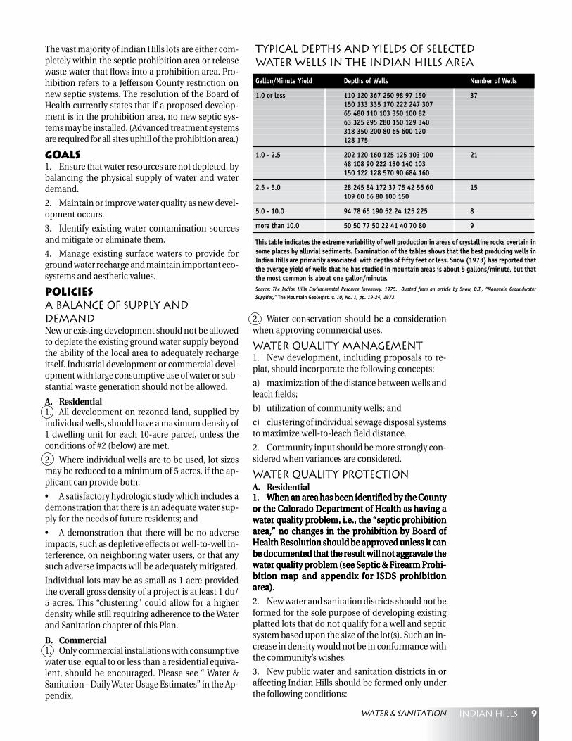
Typical Depths and Yields of SelectedWater Wells in the Indian Hills Area
Gallon/Minute Yield Depths of Wells Number of Wells
1.0 or less 110 120 367 250 98 97 150 37150 133 335 170 222 247 30765 480 110 103 350 100 8263 325 295 280 150 129 340318 350 200 80 65 600 120128 175
1.0 - 2.5 202 120 160 125 125 103 100 2148 108 90 222 130 140 103150 122 128 570 90 684 160
2.5 - 5.0 28 245 84 172 37 75 42 56 60 15109 60 66 80 100 150
5.0 - 10.0 94 78 65 190 52 24 125 225 8
more than 10.0 50 50 77 50 22 41 40 70 80 9
This table indicates the extreme variability of well production in areas of crystalline rocks overlain insome places by alluvial sediments. Examination of the tables shows that the best producing wells inIndian Hills are primarily associated with depths of fifty feet or less. Snow (1973) has reported thatthe average yield of wells that he has studied in mountain areas is about 5 gallons/minute, but thatthe most common is about one gallon/minute.Source: The Indian Hills Environmental Resource Inventory, 1975. Quoted from an article by Snow, D.T., “Mountain GroundwaterSupplies,” The Mountain Geologist, v. 10, No. 1, pp. 19-24, 1973.
Water & Sanitation
10 Indian hills
a. Where there is hydrologic evidence that neigh-boring water users or natural environments will notbe adversely affected by reduction of local recharge.
b. The boundaries of the new district are deter-mined to encompass an area with water qualityproblems in need of mitigation.
c. The new district will facilitate meeting the Moun-tain Site Design Criteria, e.g., the clustering of hous-ing units which might be required if individual wellsand septic systems were necessary.
d. The planned level of development of the Districtcan be shown to be consistent with the other poli-cies of this Plan, especially the Roads and Transpor-tation and Development sections.
4. Within the prohibition area, residents may in-crease the size of their septic system, provided a seg-regated or advanced treatment system is used. Suchan increase/improvement in the septic system willnot be allowed to facilitate the upgrading of a dwell-ing from a summer use only to a full time residence.
5. In areas that are stated as flowing into the prohi-bition area, new septic systems must be one of thefollowing: closed vault, a segregated system using acomposting toilet or vault and a greywater field, oran advanced treatment system. Such systems mayhave reduced distance requirements to wells.
NOTE: See Roads and Transportation, Open Space &Recreation, and development sections.
B. Commercial1. Disposal of commercial waste is to be done insuch a manner as to prevent endangerment of thewater supply, posing a safety hazard, harming theenvironment, or by its existence, reducing the valueof surrounding property.
2. Prohibit any waste disposal by or through deepwell injections.
Surface Water Management1. Regular sampling of surface water at the mouthof Parmalee Gulch should be performed by the BearCreek Watershed Association, or the JeffersonCounty Department of Health and Environment, tomonitor overall surface water quality in the drain-age basin.
2. Indication of a reduction in surface water qual-ity in the basin should initiate an investigation ofsources or reasons for this reduction and efforts tomitigate the problem should be implemented.
Implementation1. The County should encourage alternatives to thestandard soil absorption systems to treat sewage ef-fluent.
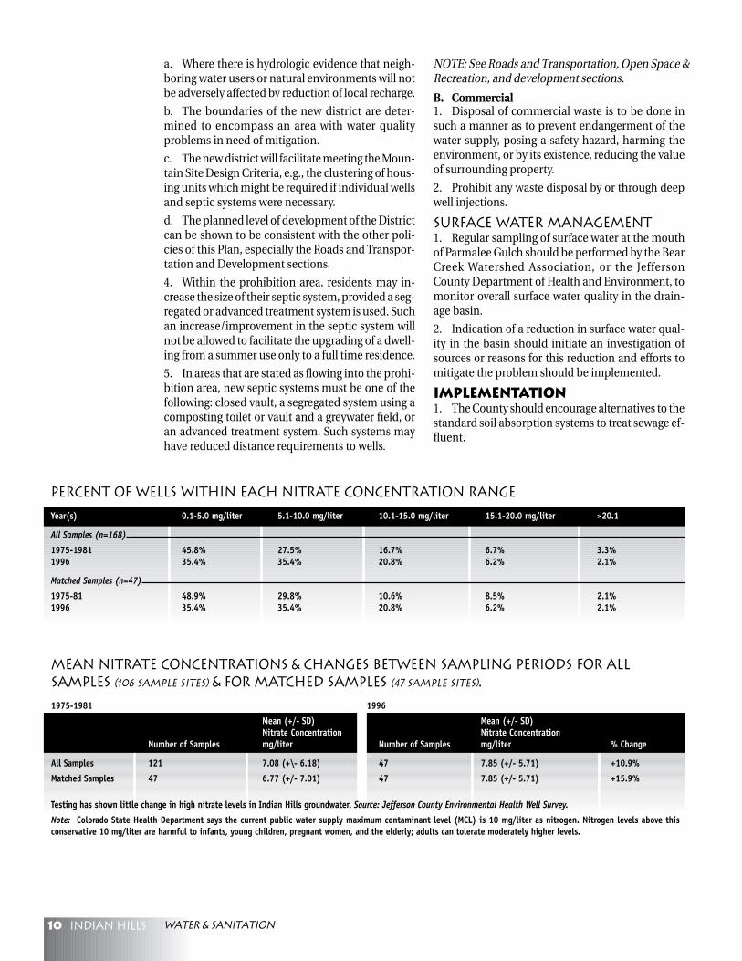
Mean Nitrate Concentrations & Changes Between Sampling Periods for AllSamples (106 sample sites) & for Matched Samples (47 sample sites).
1975-1981 1996
Mean (+/- SD) Mean (+/- SD)Nitrate Concentration Nitrate Concentration
Number of Samples mg/liter Number of Samples mg/liter % Change
All Samples 121 7.08 (+\- 6.18) 47 7.85 (+/- 5.71) +10.9%
Matched Samples 47 6.77 (+/- 7.01) 47 7.85 (+/- 5.71) +15.9%
Testing has shown little change in high nitrate levels in Indian Hills groundwater. Source: Jefferson County Environmental Health Well Survey.
Note: Colorado State Health Department says the current public water supply maximum contaminant level (MCL) is 10 mg/liter as nitrogen. Nitrogen levels above thisconservative 10 mg/liter are harmful to infants, young children, pregnant women, and the elderly; adults can tolerate moderately higher levels.
Percent of Wells Within Each Nitrate Concentration Range
Year(s) 0.1-5.0 mg/liter 5.1-10.0 mg/liter 10.1-15.0 mg/liter 15.1-20.0 mg/liter >20.1
All Samples (n=168)
1975-1981 45.8% 27.5% 16.7% 6.7% 3.3%1996 35.4% 35.4% 20.8% 6.2% 2.1%
Matched Samples (n=47)
1975-81 48.9% 29.8% 10.6% 8.5% 2.1%1996 35.4% 35.4% 20.8% 6.2% 2.1%
Water & Sanitation
11Indian hills
2. The Indian Hills Improvement Associationshould continue to receive the agenda for Board ofHealth Variances and Reviews. This agenda shouldbe posted in a public place such as the post office,or Community Center by the Indian Hills Improve-ment Association. This agenda shows the cases go-ing before the Board of Health for such things as:
a. Septic installations on reduced lot sizes
b. Types of septic system installed
c. Reduction from 200' minimum wellhead to sep-tic/leach field
d. Upgrades to larger septic systems
3. Ground-water and surface-water quality in theSeptic Prohibition Area and the surrounding areashould be monitored by the Bear Creek WatershedAssociation or the Jefferson County Department ofHealth and Environment. The size of the Septic Pro-hibition Area should only be reduced once sufficientseasonal water quality data indicates definite posi-tive trends in the quality of the resource.
4. An expanded study of ground water quantity andquality should be completed by the State and Countyfor as much of the study area as possible. It shouldinclude random investigation of septic systems forfailure and random sampling of well water for fecalcoliform, nitrate and phosphorous contamination.The community should participate in this study.
5. Once specific sources of contamination are iden-tified, the appropriate County or State program tomitigate the contamination should be executed..
6. The appropriate State agencies should be en-couraged to strictly enforce the conditions placed onwell permits and water augmentation plans. Thecommunity should work with the State to registerall wells.
7. The criteria for hydrologic studies as describedin Policy 1-A.2 should be developed by County staffto ensure that study information is adequate toevaluate whether Plan objectives are met.
8. The County should consider animal densitiesand the protection of riparian zones from horses andother large domestic animals when rewriting theZoning Resolution. The importance of keeping ani-mals to the area’s rural lifestyle should also be con-sidered in any regulations.
9. A wellhead protection plan assembled with theassistance of the State should be devised for the In-dian Hills drainage basin. A more comprehensiveand enforceable plan than currently exists should bedeveloped with the County. The Plan should addressfailing septic systems in the drainage areas, and beimplemented with community cooperation.
10. The Indian Hills community will establish a pub-lic awareness program for reporting septic problemsand other related issues.
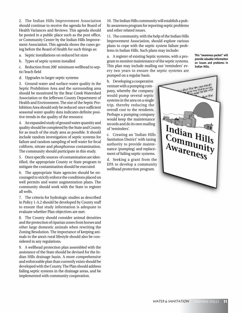
11. The community, with the help of the Indian HillsImprovement Association, should explore variousplans to cope with the septic system failure prob-lems in Indian Hills. Such plans may include:
a. A register of existing Septic systems, with a pro-gram to monitor maintenance of the septic systems.This plan may include mailing out ‘reminders’ ev-ery two years to ensure the septic systems arepumped on a regular basis.
b. Developing a cooperativeventure with a pumping com-pany, whereby the companywould pump several septicsystems in the area on a singletrip, thereby reducing theoverall cost to the residents.Perhaps a pumping companywould keep the maintenancerecords and do its own mailingof ‘reminders’.
c. Creating an ‘Indian HillsSanitation District’ with taxingauthority to provide mainte-nance (pumping) and replace-ment of failing septic systems.
d. Seeking a grant from theEPA to develop a communitywellhead protection program.
This “awareness packet” willprovide valuable informaitonon issues and problems inIndian Hills.
Water & Sanitation
12 Indian hills
Maintaining the mountain community character of
Indian Hills is a primary concern of residents.
While the existing limited road network in the In-
dian Hills community serves the present needs of
residents and commuters, traffic from future devel-
opment, including build out of existing zoning on
some segments, could exceed acceptable levels ofservice on the roads.Without proper planning, the topography of the areacould significantly constrain expansion of existingroads. In addition, the financial cost would be pro-hibitive and the visual impact unacceptable to thecommunity. The competing needs of local residentsand travelers should be resolved in a way that pre-serves the visual amenities and open lands charac-teristic of the Indian Hills mountain community.
Goals1. Preserve, maintain and enhance the natural en-vironment and open space character of the IndianHills area as a living resource, making sure that de-velopment harmonizes with, supports and does notdegrade its natural character.
2. Safeguard scenic corridors and the mountaincommunity character.
3. Provide a safe, efficient transportation systemthat satisfies the demands of through traffic and lo-cal residents.
4. Improve safety along Parmalee Gulch.
5. Balance development with adequate transpor-tation systems.
6. Adopt a schedule of improvements and identifythe funding sources to ensure that needed infra-structure is available to support future development.
7. Coordinate planning and design of road im-provements with the community, appropriate agen-cies and special districts.
8. Use maintenance techniques which improve airquality and safety, and reduce damage to vegetation.
Policies1. Transportation improvements should be madein a way that strengthens the area’s sense of moun-tain community.
2. Keep existing unpaved roads to reduce trafficspeeds and to maintain the rural character of thearea, unless paving or other dust control measuresare warranted according to the Colorado Air QualityControl Commission regulations, or paving isneeded for an overriding maintenance reason.
3. Parmalee Gulch Road should remain a collectorroad in its current two-lane alignment. Roadwaysafety and capacity improvements that are madeshould be sensitive to the need to preserve the ruralcommunity image.
4. Traffic access points should be safe and shouldnot result in the proliferation of driveways on the pri-mary access roads.
5. Traffic patterns of any new development shouldbe integrated with existing traffic movement.
6. Developers should bear the responsibility forproviding road improvements needed to accommo-date the traffic generated by new projects.
7. Ensure the continued safety of school childrenusing the crossing at Parmalee Gulch.
8. Work toward establishing bicycle, equestrian andpedestrian routes through Indian Hills.
9. Changes to existing roads should consider emer-gency equipment, local access and traffic concerns.
10. The Indian Hills community, and school, water,and fire districts, should be included in the planningand implementation of transportation improve-ments from the beginning of the process.
11. Physical roadway improvements should be madein ways that are safe and sensitive to the commu-nity and which protect the visual amenities along theroadway corridors.
Roads & Transportation
Roads & Transportation
13Indian hills
12. Road improvements should not be made whenthe public costs for the improvements would exceedthe potential public benefits derived.
13. The County should continue to consider roadcapacity and transportation standards when mak-ing land use decisions.
14. The community supports waivers to the LandDevelopment Regulation which would allow roadconstruction that is more sensitive to the environ-ment, as long as the fire district’s objectives for ac-cess, maintenance and safety can be met.
15. The County should continue to provide publicaccess to existing documentation showing the loca-tion and extent of county maintained roads.
16. The County should continue to evaluate its saltand sanding program to minimize the damage totrees and other forms of vegetation caused by thesalt and to minimize the fugitive dust air pollutioncaused by the sand.
17. A “multi-use” trail along Parmalee Gulch Roadshould be constructed, where possible.
Implementation1. Jefferson County and the community of IndianHills should actively participate together in all trans-portation planning programs that would affect thecommunity.
2. The County has installed reflective delineatorson the poles and object marker signs at the base ofthe poles along Parmalee Gulch. Long-term solu-tions include having the community work with theutility companies and the County to relocate thepoles away from the road, or to bury the utilities un-derground.
3. The existing school crossing at Parmalee Gulchdoes not currently meet the necessary criteria for apedestrian signal. Consistent speeding and percent-age of use by pre-teen children should be consid-ered when evaluating this location. Should condi-tions change in the future and meet the criteria setforth by the County, a flashing beacon, pedestriansignal, or other solution, should be installed.
4. Developers of new projects should provide stud-ies that demonstrate how the road system can beimproved to accommodate their project. They
should bear the responsibility for providing improve-ments necessitated by their development, in propor-tion to the traffic impacts of their project on thecommunity’s road system.
5. Road improvements should not be made whenthe terrain would require extensive engineering thatwould degrade the physical environment or greatlydisturb the visual impact of the neighborhood. Fu-ture improvements on Parmalee Gulch, especially inthe south section from Kiowa to Natishi, should takeinto consideration the need for enhancement of oneside to accommodate pedestrian, equestrian andbicycle traffic, providing a safer separation fromfaster moving vehicles.
6. The community should work with the County,Fire District, Park District, and Parmalee ElementarySchool to pursue the installation of a safety featureat the Fire Department/Park/ School area that wouldbe of benefit to Fire Department, School and Parkusers.
7. Speed limits should be enforced.
8. The Indian Hills community will pursue educa-tional efforts regarding traffic safety.
9. The community should work with the Countyand affected residents to evaluate the need for pav-ing the main roads to Mt. Falcon Park in order to re-duce dust.
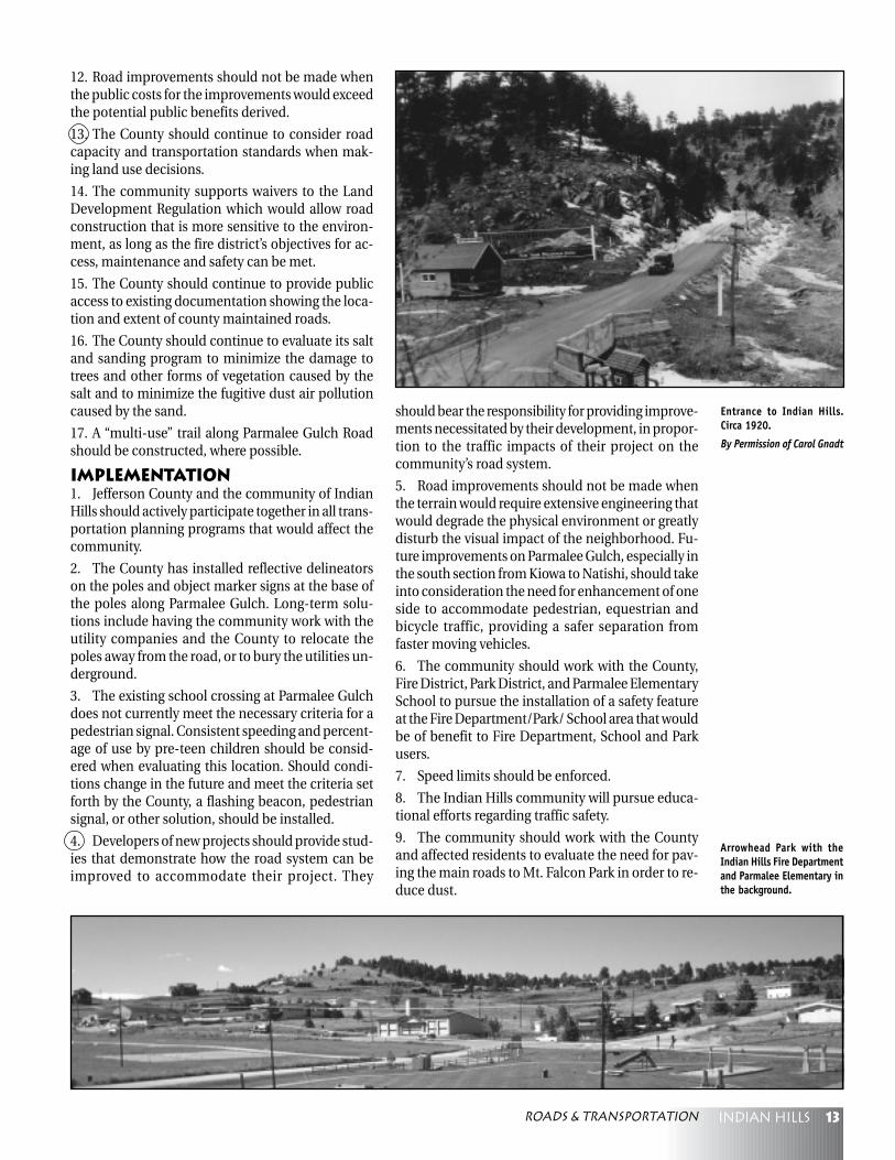
Entrance to Indian Hills.Circa 1920.
By Permission of Carol Gnadt
Arrowhead Park with theIndian Hills Fire Departmentand Parmalee Elementary inthe background.
Roads & Transportation
14 Indian hills
Maintaining the mountain community character of
Indian Hills is a primary concern of residents. New
development, both commercial and residential,
needs to be well planned and designed in order to
meet the unique and sometimes restrictive environ-
ment of the mountains. An issue of particular con-
cern is platting. Many of the areas in Indian Hillswere platted in the 1920’s and 1930’s. These plats cre-ated individual lots, many of which are as small as50’ x 50’ in size. As individual lots, they do not meetcurrent buildable standards for septic/leach fieldsor setbacks. The consequences of continuing to al-low building on these old plats in the mountains arethe obvious continued degradation of water sup-plies, and overcrowding of County and communityroads. Features that make Indian Hills unique are itsopen space, visual resources, historic sites, ruralcharacter and abundance of wildlife. New develop-ment in Indian Hills needs to take all of these char-acteristics into consideration in order to plan wiselyfor the future.
Goals1. Let the unique resources and constraints of theIndian Hills area be the guide for residential devel-opment.
2. Ensure that residential development is in bal-ance with a proven source of appropriate, safe, andtimely water and sanitation, public services, trans-portation, schools, etc.
3. Ensure that future residential development re-spects the unique mountain ecosystem and natural
environment, and enhances the quality of life, par-ticularly the “open” nature enjoyed by the residentsin Indian Hills.
4. Existing vegetation should be preserved when-ever possible. Disturbed areas should be immedi-ately stabilized using techniques such as revegeta-tion with topsoil and a variety of naturalized plants,berming, boulder placement, landscaping, rockwalls, etc. Grading and erosion control permit regu-lations should be followed prior to disturbance ofthe land.
5. Clear cutting of trees should not be allowed ex-cept as required by fire mitigation programs andother mandatory building regulations.
6. Visually protect prominent features and steepslopes from disruption by development.
7. Permit and accommodate well planned and wellexecuted lower density development that is en-hanced by open space.
8. New construction and exterior remodelingshould be consistent with the historical and ruralcharacter of the area. New development should bedesigned to harmonize with and complement thecharacter of the area in terms of mass, scale, designand materials.
9. Development should be integrated, through itslocation and design, with the existing natural char-acteristics of the site, i.e., color, line, texture andform.
Policies1. All new development should be able to be ad-equately served by the Indian Hills Fire ProtectionDistrict. In areas where access is poor and the safetyof residents is compromised, downzoning to limitadditional development should be an option.
2. When resource areas, i.e., wildlife range, visualresources, historical sites, etc., overlap on a site, an
Residential Development
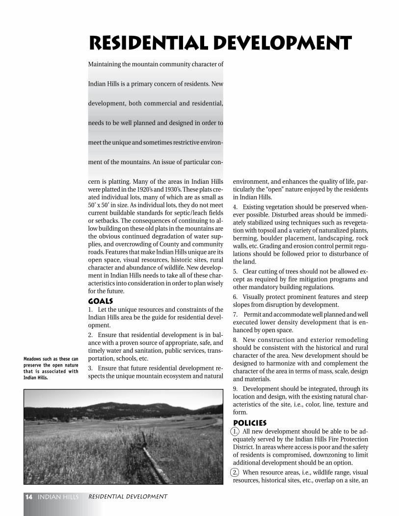
Meadows such as these canpreserve the open naturethat is associated withIndian Hills.
residential Development

15Indian hills
evaluation of the resources should balance the com-peting values of those resources to achieve the in-tent of this Plan.
3. When a property is rezoned, lot sizes should bebased on conformance with the recommendationsof the other sections of this Plan and compatibilitywith surrounding land uses.
4. New development should take into consider-ation the possible impact upon the wildlife. See Wild-life Section for details.
Implementation1. Much of the existing zoning and plats do not con-form to this Plan’s policies. To achieve long-range so-lutions, the community and County should worktogether with landowners to ensure conformancewith these policies, using such methods as
1 Acre(40,000 sf.)
2 Acre(80,000 sf.)
Building Envelope39% of Lot Area
Building Envelope39% of Lot Area
200'
200'
400'
200'
3 Acre(120,000 sf.)
Building Envelope60% of Lot Area
600'
200'
Reduced BuildingEnvelope
Reduced BuildingEnvelope
Top of RidgeStream/Wetlands Stream/Wetlands
Reduced BuildingEnvelope
SteepSlope
50'
50'
50'
40' 40'40'
30'
30'
30'
30'
30'
30'
downzoning, open spaceacquisition, densitytransfers, conservationeasements, tax incen-tives, etc.
2. The residents shouldestablish a communityimprovement programto revitalize areas withinIndian Hills whereneeded.
3. The communityshould promote aware-ness of programs to helphomeowners renovateolder homes.
Building envelopes,conventional and creative.
Credit: Preserving RuralCharacter, by Fred Heyer,American PlanningAssociation.
In the past, high densitydevelopment in themountains was allowed.
Indian Hills Filing 4, a typical Indian Hills subdivision filing.
Residential development
16 Indian hills
The Indian Hills area has limited and restricted ser-
vices. Residents and workers have minimal access
to shopping and services. The area provides some
local employment opportunities; however, the ma-
jority of the residents work in the metropolitan area.
Goals1. Maintain the area’s residential and open spacecharacter.
2. Ensure that commercial activities are compat-ible with surrounding land uses in terms of visualappearance, traffic generation, water and sewer re-quirements, noise and air quality impact.
3. Existing commercially zoned areas in neighbor-hood centers should be enhanced by limiting or up-grading the design specifications to conform to themountain character of the area. See Mountain SiteDesign Criteria.
4. Existing commercial square footage in IndianHills should target local residents and tourists. The
c o m m e r c i a l l yzoned areas alongParmalee GulchRoad may be espe-cially appropriatefor small scale craftand antique shopsor restaurants, andstrip developmentshould not be al-lowed.
Policies1. Due to the pre-dominantly resi-dential characterof Indian Hills, ad-ditional commer-cial, office or in-dustrial zoningsshould be stronglydiscouraged, andlimited in scope.This is to maximizecompatibility withsurrounding landuses, and encour-
age use of the areas currently zoned for commercial,office, or industrial uses.
2. Development should front on Parmalee GulchRoad.
3. Commercial activities should be tailored for theconvenience of local residents as well as provide lim-ited employment opportunities. Uses allowed onParmalee Gulch Road could include convenience,retail and cottage industries, e.g., artist studios, craftshops, etc., to serve the need for convenience shop-ping and services for nearby residents, tourists andvisitors.
4. Due to limited road access and tight mountainroads, development that would increase truck useor greatly increase traffic would not be acceptable,i.e., storage, processing or large manufacturing.
5. Development of existing commercial propertyfor commercial use should take into account roadaccess and impact as addressed in the Roads andTransportation section of this Plan.
6. Proposals of new development should incorpo-rate architectural detailing appropriate to the IndianHills setting. See Mountain Site Design Criteria.
7. Landscaping, painting and regular maintenanceshould be utilized to improve the appearance of ex-isting commercial and public sites. All lightingshould be downcast and should not be allowed toreflect off-site.
8. Commercial buildings should be consistent withthe rustic/historical flavor of Indian Hills.
9. New development should take into consider-ation the possible impact upon the wildlife. See Wild-life Section for details.
Implementation1. Develop community support for small scalebusinesses that support community needs.
Commercial Development
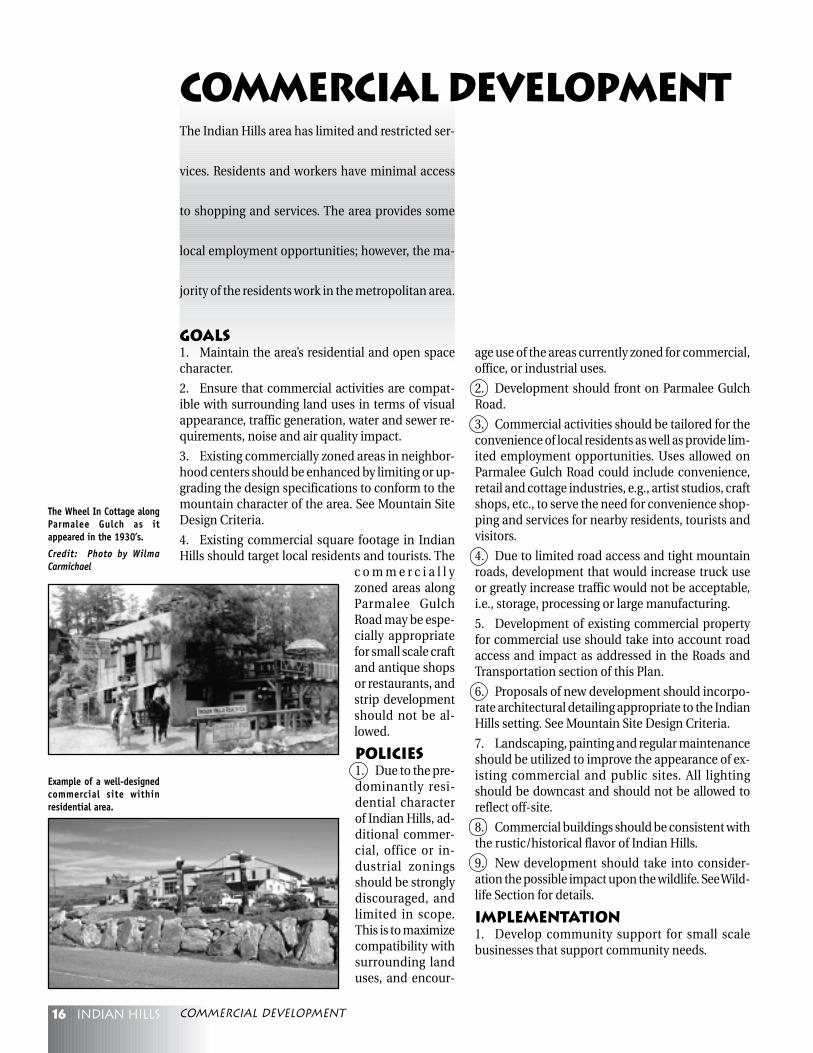
The Wheel In Cottage alongParmalee Gulch as itappeared in the 1930’s.
Credit: Photo by WilmaCarmichael
Example of a well-designedcommercial site withinresidential area.
commercial Development

17Indian hills
Parmalee Gulch valley and the surrounding forested
hills were home first to the wildlife and the Native
Americans who passed through, then to pioneer
farmers and ranchers who settled in the valley, then
to summer residents who built cabins on the hills,
and now to more than one thousand year-round resi-
dents who value the foothills mountain environmentand want to preserve it. Most of the homes are con-centrated in three square miles along the valley andare surrounded by more than fifteen square miles ofpublic and private open space, from Mount Falconwest to Bear Mountain and from Lone Peak north toBear Creek.
Goals1. Preserve, maintain and enhance the naturalmountain environment and character of the com-munity, making sure that development harmonizeswith and does not degrade the natural character ofthe area.
2. Protect significant natural features and impor-tant wildlife habitats and corridors.
3. Provide a diversity of recreational, trail and otheroutdoor opportunities, both passive and active, de-veloped and undeveloped.
4. As part of an open space strategy, preserve his-toric landscapes and structures of the early inhabit-ants.
Policies1. The acquisition of additional public open spaceshould be encouraged as it becomes available, es-pecially in the northeast (Mt. Falcon-Little Park) andsouthwest (Giant Gulch-Geneva Glen) regions.
2. Public/private joint projects should be encour-aged in order to protect private open space and wild-life habitats.
3. Tools such as transfer of development rights andtrail and conservation easements should be encour-aged as ways of protecting open space.
4. Developers should be encouraged to contributeto open space in ways that augment existing openspace.
5. Areas of historical significance should be pre-served for future generations.
6. Residents should be educated about mountainliving issues such as:
• The potential for wildfire is minimized by re-moval of dead trees, abstention from fireworks, andproper use of outdoor fires and barbecues;
• Trash which attracts wildlife should be kept in-doors or in animal-proof containers to prevent ani-mals from becoming nuisances that have to be re-moved; and
• Dogs that roam at-large pose a threat to localwildlife.
7. Passive recreational needs should be met withtrails, bike and horse paths and undeveloped openspace.
8. Active recreational needs are currently being metby facilities at Parmalee Elementary School, theCommunity Center and Arrowhead Park; futureneeds should be sensitive to preserving the naturalenvironment.
Open Space & Recreation
Walker Castle ruins at Mt.Falcon.
Credit: Indian Hills, thePeople, the Place and theTimes by Brush-Dittman
Open space & recreation
18 Indian hills
Implementation1. New rezonings of par-cels of 5 acres or moreshould be encouraged topreserve existing openspace and habitat.
2. Connections should bemade between Mt. Falcon,Little Park, Lair O’ the Bear,Corwina, O’Fallon, andPence Park, and trail corri-dors should be developedwhich will augment theCounty trail network.
3. Jefferson County OpenSpace should be encour-aged to expand public ar-eas by acquiring adjacentland that surrounds the val-ley, provides wildlife habi-tat, and buffers Indian Hillsfrom neighboring commu-nities.
4. An interconnected trailsystem in the area shouldbe investigated and en-couraged.
5. Riparian zones, espe-cially Parmalee Gulch,should not be damaged
while pursuing improvements such as roads or bikepaths or while developing commercial or private in-terests.
6. Tax incentives should be encouraged to preservethe natural landscape: e.g., conservation easements,zoning for active ranching or agriculture, a ForestManagement Plan to groom forests to remove firehazards, etc.
7. Applications should be made for funding to aidin acquisition of Open Space.
8. Bike and horse paths should be developed wherenecessary to connect to existing roads and trails.Motorized vehicles should be prohibited on suchtrails.
9. Evergreen Park and Recreation District andParmalee Elementary School should be encouragedto aid in the expansion of the existing park systemin Indian Hills for active recreation (playing fields,picnic areas, etc.).
10. Churches, large private landholders, and campsin the area should be encouraged to preserve theirwildland and to donate some of their property forrecreation (e.g., trail easements), considering thebenefits of maintenance and/or insurance reductionon that property.
Indian Hills residents enjoythe benefits of mountainliving, open space, parks andtrails.
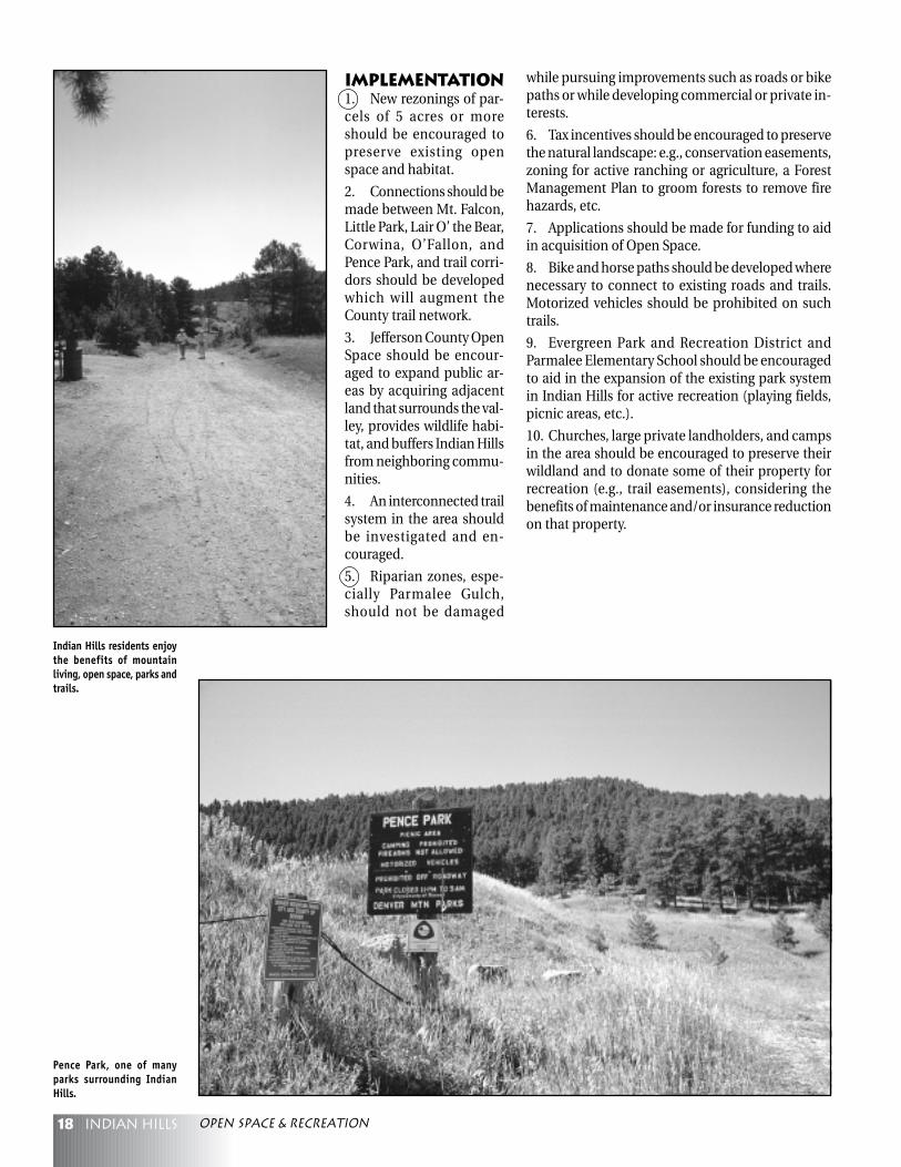
Pence Park, one of manyparks surrounding IndianHills.
Open space & recreation

19Indian hills
People choose to live in Indian Hills because of the
natural foothills environment, with its open mead-
ows and rolling forest vistas. Preservation of such
“viewsheds” is important in maintaining the rural
mountain character of the community. Develop-
ment should harmonize with and not degrade thenatural and historic landscape of the area. Visual re-sources in Indian Hills include meadows, hills,gulches, peaks, ridges, vistas, forests, vegetation, rockoutcroppings, and historic structures.
Goals1. Natural and historic viewscapes should be pre-served.
2. Visual disruption should be minimized by maxi-mizing the natural visual screening capabilities of thelandscape.
3. Development should complement the area’s vi-sual resources.
4. The views from the Parmalee Gulch corridor,from Mt. Falcon on the east to Bear Mountain on thewest and from Lone Peak on the south to the upperend of the valley and down to Bear Creek, should beprotected.
Policies1. When making road, site, and building designchoices, special consideration should be given to thevisual impact on the area.
2. Landscapes suitable for Open Space protectionshould be acquired or privately preserved.
3. When development is proposed, appropriateMountain Site Design Criteria should be followed toensure compatibility with the natural landscape.
4. Development on peaks and ridges should notprotrude into the skyline; the silhouette effect ofstructures on hillsides should not be allowed.
5. Minimize scarring and erosion due to construc-tion of new roads.
6. New buildings in the forest should be screenedby trees as much as possible, ensuring wildfire regu-lations are met; new buildings in open areas shouldbe located so as to be compatible with the naturaland historic environment (see Mountain Site DesignCriteria); new buildings along Parmalee Gulch Roadshould not damage its natural riparian character.
7. Maximum use should be made of a site’s capac-ity to screen development from view; areas with in-adequate natural screening should be enhancedwith appropriate plantings.
8. Natural vegetation should be preserved; dis-turbed areas should be revegetated with nativeplantings.
9. Lighting should be kept to a minimum and itsimpact minimized by downcast design, shielding,and timers. See also Mountain Site Design Criteria.
10. Billboards should not be allowed.
11. If new buildings domi-nate the landscape, measuresshould be taken to ensure ar-chitectural quality and har-mony with the natural andhistoric environment.
Implementation1. The community shoulddetermine the visuallyprominent areas, as well aswildlife considerations, anduse this information to par-tially guide its open spacepreservation efforts.
2. The community, with thehelp of the Indian Hills Improvement Association,should explore the possibility of creating an “IndianHills Clean-Up Day.” Such an event could featuremultiple trash bins placed around the communityfor the residents to discard accumulated branches,trash and other rubbish.
Visual Resources
This picture of the GiantGulch area, taken in the1920’s, still looks much thesame today.
By Permission of Carol Gnadt
Crown Line
Structures shall not belocated on top of the ridge
Where required, structuresshall be located below theridge top and below thecrown line of mature trees.
visual resources
20 Indian hills
One of the factors attracting people to Indian Hills
is the presence of wildlife; protecting that wildlife is
important in maintaining the natural mountain
character of the community. Care must be taken to
ensure that wildlife will not be disturbed by human
activity. In accordance with County regulations, dogs
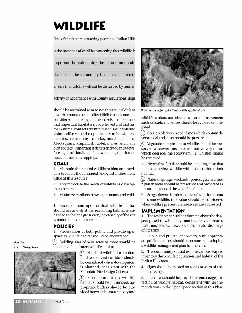
should be restrained so as to not threaten wildlife ordisturb mountain tranquility. Wildlife needs must beconsidered in making land use decisions to ensurethat important habitat is not destroyed and that hu-man-animal conflicts are minimized. Residents andvisitors alike value the opportunity to be with elk,deer, fox, raccoon, coyote, turkey, bear, lion, bobcat,Abert squirrel, chipmunk, rabbit, snakes, and manybird species. Important habitats include meadows,forests, shrub lands, gulches, wetlands, riparian ar-eas, and rock outcroppings.
Goals1. Maintain the natural wildlife habitat and corri-dors to ensure the continued biological and aestheticvalue of this resource.
2. Accommodate the needs of wildlife as develop-ment occurs.
3. Minimize conflicts between humans and wild-life.
4. Encroachment upon critical wildlife habitatshould occur only if the remaining habitat is en-hanced so that the gross carrying capacity of the siteis maintained or enhanced.
Policies1. Preservation of both public and private openspace as wildlife habitat should be encouraged.
2. Building sites of 5-10 acres or more should beencouraged to protect wildlife habitat.
3. Needs of wildlife for habitat,food, water, and corridors shouldbe considered when developmentis planned, consistent with theMountain Site Design Criteria.
4. Encroachment on wildlifehabitat should be minimized; ap-propriate buffers should be pro-vided between human activity and
wildlife habitats, and obstacles to animal movementsuch as roads and fences should be avoided or miti-gated.
5. Corridors between open lands which contain di-verse food and cover should be preserved.
6. Vegetation important to wildlife should be pre-served wherever possible; nonnative vegetationwhich degrades the ecosystem (i.e., Thistle) shouldbe removed.
7. Networks of trails should be encouraged so thatpeople can view wildlife without disturbing theirhabitat.
8. Natural springs, wetlands, ponds, gulches, andriparian areas should be preserved and protected asimportant parts of the wildlife habitat.
9. Snags, downed timber, and shrubs are importantfor some wildlife; this value should be consideredwhen wildfire prevention measures are addressed.
Implementation1. The residents should be educated about the dan-gers posed to wildlife by roaming pets, unsecuredtrash, unsafe fires, fireworks, and unlawful dischargeof firearms.
2. Public and private landowners, with appropri-ate public agencies, should cooperate in developinga wildlife management plan for the area.
3. The community should explore various ways toinventory the wildlife population and habitat of theIndian Hills area.
4. Signs should be posted on roads to warn of ani-mal crossings.
5. Incentives should be provided to encourage pro-tection of wildlife habitat, consistent with recom-mendations in the Open Space section of this Plan.
Wildlife
Grey Fox
Credit: Sherry Acree
Wildlife is a major part of Indian Hills quality of life.
wildlife
21Indian hills
The intent of the policies in this section is to identify
hazards in the Indian Hills area which should be
mitigated or eliminated prior to development and
to identify the governmental entities with the author-
ity to safeguard people, property and the environ-
ment from injury or damage caused by hazardous
conditions and events which are natural or triggeredby human activities.
Goals1. Protect life and property from the adverse im-pacts of natural and manmade hazards.
2. Ensure that land use activities do not aggravategeologic hazards, and ensure that grading and exca-vation do not accelerate erosion.
3. Ensure that land use activities do not increasethe risk of wildfire.
4. Ensure that air and water intended for humanconsumption meet the applicable federal and stateair and water quality standards for radioactivity.
5. Ensure nitrate contamination will not be a haz-ard to present and future residents. (See the Waterand Sanitation section for additional information).
PoliciesA. Geologic Hazards1. Development activities should be designed toensure adequate slope stability, and should result ina natural appearance of the slope which blends inwith the surrounding landscape.
2. In an area of either high or moderate slope fail-ure hazard, each site should be reviewed and the ap-propriate site development and design guidelinesfollowed.
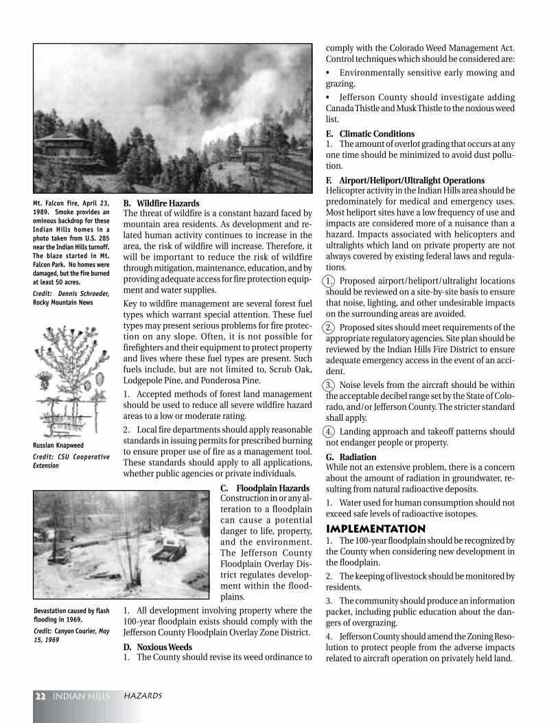
3. Hazards created by development should beevaluated during development review. Such hazardsmight include the disruption of soil and rocks causedby road cuts or the extension of utility lines, changesin drainage patterns, and soil erosion that results indamage to property lower on a slope. Existing struc-tures and the natural environment should be pro-tected.
4. Drainage on unstable slopes should be designedto improve slope stability.
5. Final landforms which result from developmentactivities should be stable and revegetated with na-tive drought-resistant species to control erosion andimprove stability.
6. Existing structures in the area around a proposedproject should be protected from adverse impactscaused by the project. Existing potential hazardsshould not be aggravated by development activity.These adverse impacts include, but are not limitedto:
a. Disturbance of existing vegetation, which canlead to accelerated erosion and sedimentation.
b. Aggravation or acceleration of existing potentialhazards.
Hazards
Removal of vegetation andearthmoving during construction
Soil Erosion
Sediments in streams
Deterioration ofaesthetic values
Reduction in flood capacityof stream channels
The removal of vegetationand earthmoving can haveimmediate effects on waterquality and aesthetics.
Source: Indian HillsEnvironmental ResourcesInventory, 1975
Hazards
22 Indian hills
B. Wildfire HazardsThe threat of wildfire is a constant hazard faced bymountain area residents. As development and re-lated human activity continues to increase in thearea, the risk of wildfire will increase. Therefore, itwill be important to reduce the risk of wildfirethrough mitigation, maintenance, education, and byproviding adequate access for fire protection equip-ment and water supplies.
Key to wildfire management are several forest fueltypes which warrant special attention. These fueltypes may present serious problems for fire protec-tion on any slope. Often, it is not possible forfirefighters and their equipment to protect propertyand lives where these fuel types are present. Suchfuels include, but are not limited to, Scrub Oak,Lodgepole Pine, and Ponderosa Pine.
1. Accepted methods of forest land managementshould be used to reduce all severe wildfire hazardareas to a low or moderate rating.
2. Local fire departments should apply reasonablestandards in issuing permits for prescribed burningto ensure proper use of fire as a management tool.These standards should apply to all applications,whether public agencies or private individuals.
C. Floodplain HazardsConstruction in or any al-teration to a floodplaincan cause a potentialdanger to life, property,and the environment.The Jefferson CountyFloodplain Overlay Dis-trict regulates develop-ment within the flood-plains.
1. All development involving property where the100-year floodplain exists should comply with theJefferson County Floodplain Overlay Zone District.
D. Noxious Weeds1. The County should revise its weed ordinance to
comply with the Colorado Weed Management Act.Control techniques which should be considered are:
• Environmentally sensitive early mowing andgrazing.
• Jefferson County should investigate addingCanada Thistle and Musk Thistle to the noxious weedlist.
E. Climatic Conditions1. The amount of overlot grading that occurs at anyone time should be minimized to avoid dust pollu-tion.
F. Airport/Heliport/Ultralight OperationsHelicopter activity in the Indian Hills area should bepredominately for medical and emergency uses.Most heliport sites have a low frequency of use andimpacts are considered more of a nuisance than ahazard. Impacts associated with helicopters andultralights which land on private property are notalways covered by existing federal laws and regula-tions.
1. Proposed airport/heliport/ultralight locationsshould be reviewed on a site-by-site basis to ensurethat noise, lighting, and other undesirable impactson the surrounding areas are avoided.
2. Proposed sites should meet requirements of theappropriate regulatory agencies. Site plan should bereviewed by the Indian Hills Fire District to ensureadequate emergency access in the event of an acci-dent.
3. Noise levels from the aircraft should be withinthe acceptable decibel range set by the State of Colo-rado, and/or Jefferson County. The stricter standardshall apply.
4. Landing approach and takeoff patterns shouldnot endanger people or property.
G. RadiationWhile not an extensive problem, there is a concernabout the amount of radiation in groundwater, re-sulting from natural radioactive deposits.
1. Water used for human consumption should notexceed safe levels of radioactive isotopes.
Implementation1. The 100-year floodplain should be recognized bythe County when considering new development inthe floodplain.
2. The keeping of livestock should be monitored byresidents.
3. The community should produce an informationpacket, including public education about the dan-gers of overgrazing.
4. Jefferson County should amend the Zoning Reso-lution to protect people from the adverse impactsrelated to aircraft operation on privately held land.
Russian Knapweed
Credit: CSU CooperativeExtension
Devastation caused by flashflooding in 1969.
Credit: Canyon Courier, May15, 1969
Mt. Falcon fire, April 23,1989. Smoke provides anominous backdrop for theseIndian Hills homes in aphoto taken from U.S. 285near the Indian Hills turnoff.The blaze started in Mt.Falcon Park. No homes weredamaged, but the fire burnedat least 50 acres.
Credit: Dennis Schroeder,Rocky Mountain News
hazards

23Indian hills
The uniqueness of today’s Indian Hills is very much
a product of its past. Without a preservative and cus-
todial approach taken with such uncommon re-
sources and artifacts, the community stands to lose
that which is essential to its character. Further em-
phasizing Indian Hills’ significant history, contrib-
uting detail beyond the introduction to this Plan, andas reference material for decision making, a sizablebook by Brush and Dittman, “Indian Hills: The Place,The Time, The People” is available. Because of its sig-nificance, the history of Indian Hills is an integralpart of everyday life in the community and shouldtherefore be incorporated into all aspects of decisionmaking.
Goals1. Promote and preserve the history of Indian Hillsand all of the local sites, including, but not limitedto, archaeological and the built environment, tied tothat history. Through the continued preservation ofthe community’s historical significance to the region,the community should promote concern and aware-ness for its surroundings.
Policies1. The Jefferson County Historical Society and themembers of the Indian Hills community should worktogether to help identify and preserve local sites ofhistorical significance.
2. The preservation of historical sites should be anintegral factor in the consideration of future devel-opment in Indian Hills.
3. The community center in Indian Hills should beconsidered a focal point of local historical educationas well as a place for community gatherings.
Implementation1. The community should define and develop a list-ing of historical sites and their current owner(s).
2. Work together with the Jefferson County Histori-cal Society to identify and register any sites of his-torical significance in Indian Hills.
3. The community should provide support to theowners of sites with historical significance by pro-viding information on registry, availability of any fi-nancial assistance and/or by any other means.
4. P r o t e c tthe historicGiant Gulcharea by pro-viding a bufferzone betweenIndian Hillsand devel-oped propertyin the StanleyPark and LonePeak areas.Other historicsites thatshould be protected include, but are not limited to,the Parmalee House, the former Trading Post (Ho-Cha-Nee-Stea or Chiefs Inn) and the Indian HillsCommunity Center.
5. The preservation of the Indian Pueblos and thesurrounding meadows should be encouraged.
6. Preservation could possibly be accomplishedwith the aid of the Jefferson County Historical Soci-ety, Jefferson County Open Space, State lottery pro-ceeds, the Evergreen Park and Recreation District,the Colorado Historical Society, or the joint venturesof any of the above.
Historic
The Na-Te-So Pueblo wasbuilt as an attraction forDenver’s gentry. The name,Na-Te-So, stems from thenames of the three NativeAmerican tribes who builtthe Pueblo in the 1920s, theNavajo, the Tesuque, and theSan Ildefonso.
By Permission of Carol Gnadt
First school in Indian Hills.Circa 1896.
historic
24 Indian hills
The purpose of these criteria is to assist and encour-
age landowners and their designers in creating high
quality development which respects the environ-
ment and to encourage creative and flexible ap-
proaches to site design. By using the criteria listed
below, it is anticipated that more sensitive develop-
ment will occur. Developers who comply with thesecriteria should be awarded increased density. Thedensity gained under excellent design can rangefrom the number of units allowed for standard de-sign up to the maximum number of units under ex-cellent design, depending upon the degree of excel-lence achieved.The dramatic beauty of the surrounding naturallandscape is a major asset in the mountains. Scenicareas of high quality elements of the natural land-scape need to be maintained or enhanced, whileunattractive areas should be rehabilitated or en-hanced. All development should be integrated,through location and design, with the existing natu-ral character. Visual quality of an area is the impres-sion created by the landforms, vegetation, color, ad-jacent scenery, scarcity of uniqueness, and culturalmodifications within the view of a site. Generally, themore visual variety in a landscape, the more aestheti-cally pleasing. Variety without harmony, however, isunattractive, particularly in terms of alterations (cul-tural modifications) made without care.
The views seen from major transportation corridorscan have a great impact in the mountain areas. Thelarge numbers of viewers make these corridors veryimportant in establishing a positive image to visi-tors and residents alike.
Wildlife and unique vegetation are aesthetic, eco-nomic and environmental assets to Jefferson County.They contribute to the physical and psychologicalwell-being of the residents and are a major part ofthe quality of life in the County. They contribute tothe County’s economy by providing and enhancingrecreational activities, such as hunting, fishing,camping, hiking, etc. They are valuable indicators ofenvironmental quality because they are sensitive tochange, especially environmental deterioration.
The relationship between vegetation, animals, andhuman activities needs to be respected and con-sciously protected. During the initial development,site preparation and construction stages of projects,the potential for adverse impact on plants andchanges in unique plant-life and wildlife patterns aremost likely to occur. The adverse impacts are oftenfar-reaching and complex.
The varying characteristics of individual sites willdetermine which of the following criteria may beapplicable. In some cases, all of the criteria may beapplicable, while in others only some may apply.
Key ElementsA. Views1. Maximize views of significant features on and offsite as amenities of site design.
2.2.2.2.2. Structures should be placed to avoid obscuringStructures should be placed to avoid obscuringStructures should be placed to avoid obscuringStructures should be placed to avoid obscuringStructures should be placed to avoid obscuringsignificant public viewssignificant public viewssignificant public viewssignificant public viewssignificant public views.
B. Treeless Areas1.1.1.1.1. Naturally occurring wet meadows are scarce andNaturally occurring wet meadows are scarce andNaturally occurring wet meadows are scarce andNaturally occurring wet meadows are scarce andNaturally occurring wet meadows are scarce andshould not be disturbedshould not be disturbedshould not be disturbedshould not be disturbedshould not be disturbed
2. In areas where very little natural buffering occurs,e.g., treeless clearings, place site development into the
Mountain Site Design Criteria
Early rodeo days in IndianHills. Circa 1925.
By Permission of Carol Gnadt
Mountain site design critera
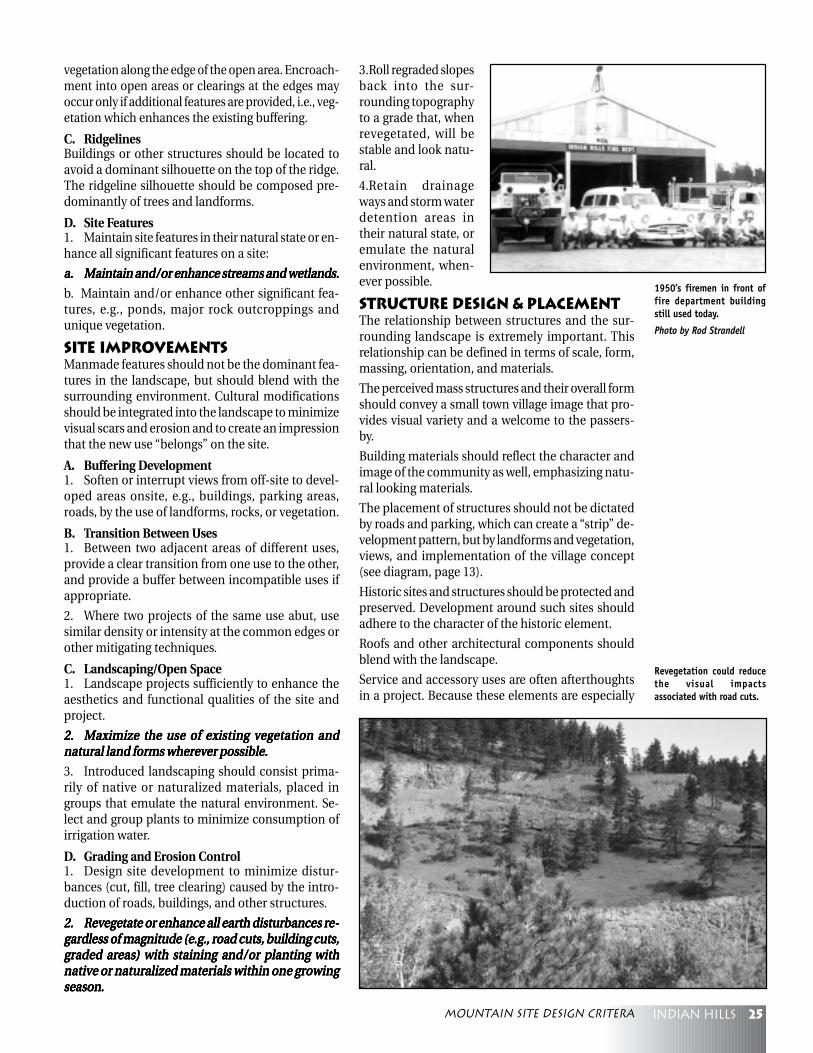
25Indian hills
vegetation along the edge of the open area. Encroach-ment into open areas or clearings at the edges mayoccur only if additional features are provided, i.e., veg-etation which enhances the existing buffering.
C. RidgelinesBuildings or other structures should be located toavoid a dominant silhouette on the top of the ridge.The ridgeline silhouette should be composed pre-dominantly of trees and landforms.
D. Site Features1. Maintain site features in their natural state or en-hance all significant features on a site:
a.a.a.a.a. Maintain and/or enhance streams and wetlands.Maintain and/or enhance streams and wetlands.Maintain and/or enhance streams and wetlands.Maintain and/or enhance streams and wetlands.Maintain and/or enhance streams and wetlands.
b. Maintain and/or enhance other significant fea-tures, e.g., ponds, major rock outcroppings andunique vegetation.
Site ImprovementsManmade features should not be the dominant fea-tures in the landscape, but should blend with thesurrounding environment. Cultural modificationsshould be integrated into the landscape to minimizevisual scars and erosion and to create an impressionthat the new use “belongs” on the site.
A. Buffering Development1. Soften or interrupt views from off-site to devel-oped areas onsite, e.g., buildings, parking areas,roads, by the use of landforms, rocks, or vegetation.
B. Transition Between Uses1. Between two adjacent areas of different uses,provide a clear transition from one use to the other,and provide a buffer between incompatible uses ifappropriate.
2. Where two projects of the same use abut, usesimilar density or intensity at the common edges orother mitigating techniques.
C. Landscaping/Open Space1. Landscape projects sufficiently to enhance theaesthetics and functional qualities of the site andproject.
2.2.2.2.2. Maximize the use of existing vegetation andMaximize the use of existing vegetation andMaximize the use of existing vegetation andMaximize the use of existing vegetation andMaximize the use of existing vegetation andnatural land forms wherever possible.natural land forms wherever possible.natural land forms wherever possible.natural land forms wherever possible.natural land forms wherever possible.
3. Introduced landscaping should consist prima-rily of native or naturalized materials, placed ingroups that emulate the natural environment. Se-lect and group plants to minimize consumption ofirrigation water.
D. Grading and Erosion Control1. Design site development to minimize distur-bances (cut, fill, tree clearing) caused by the intro-duction of roads, buildings, and other structures.
2.2.2.2.2. Revegetate or enhance all earth disturbances re-Revegetate or enhance all earth disturbances re-Revegetate or enhance all earth disturbances re-Revegetate or enhance all earth disturbances re-Revegetate or enhance all earth disturbances re-gardless of magnitude (e.g., road cuts, building cuts,gardless of magnitude (e.g., road cuts, building cuts,gardless of magnitude (e.g., road cuts, building cuts,gardless of magnitude (e.g., road cuts, building cuts,gardless of magnitude (e.g., road cuts, building cuts,graded areas) with staining and/or planting withgraded areas) with staining and/or planting withgraded areas) with staining and/or planting withgraded areas) with staining and/or planting withgraded areas) with staining and/or planting withnative or naturalized materials within one growingnative or naturalized materials within one growingnative or naturalized materials within one growingnative or naturalized materials within one growingnative or naturalized materials within one growingseason.season.season.season.season.
3.Roll regraded slopesback into the sur-rounding topographyto a grade that, whenrevegetated, will bestable and look natu-ral.
4.Retain drainageways and storm waterdetention areas intheir natural state, oremulate the naturalenvironment, when-ever possible.
Structure Design & PlacementThe relationship between structures and the sur-rounding landscape is extremely important. Thisrelationship can be defined in terms of scale, form,massing, orientation, and materials.
The perceived mass structures and their overall formshould convey a small town village image that pro-vides visual variety and a welcome to the passers-by.
Building materials should reflect the character andimage of the community as well, emphasizing natu-ral looking materials.
The placement of structures should not be dictatedby roads and parking, which can create a “strip” de-velopment pattern, but by landforms and vegetation,views, and implementation of the village concept(see diagram, page 13).
Historic sites and structures should be protected andpreserved. Development around such sites shouldadhere to the character of the historic element.
Roofs and other architectural components shouldblend with the landscape.
Service and accessory uses are often afterthoughtsin a project. Because these elements are especially
1950’s firemen in front offire department buildingstill used today.
Photo by Rod Strandell
Revegetation could reducethe visual impactsassociated with road cuts.
Mountain site design critera
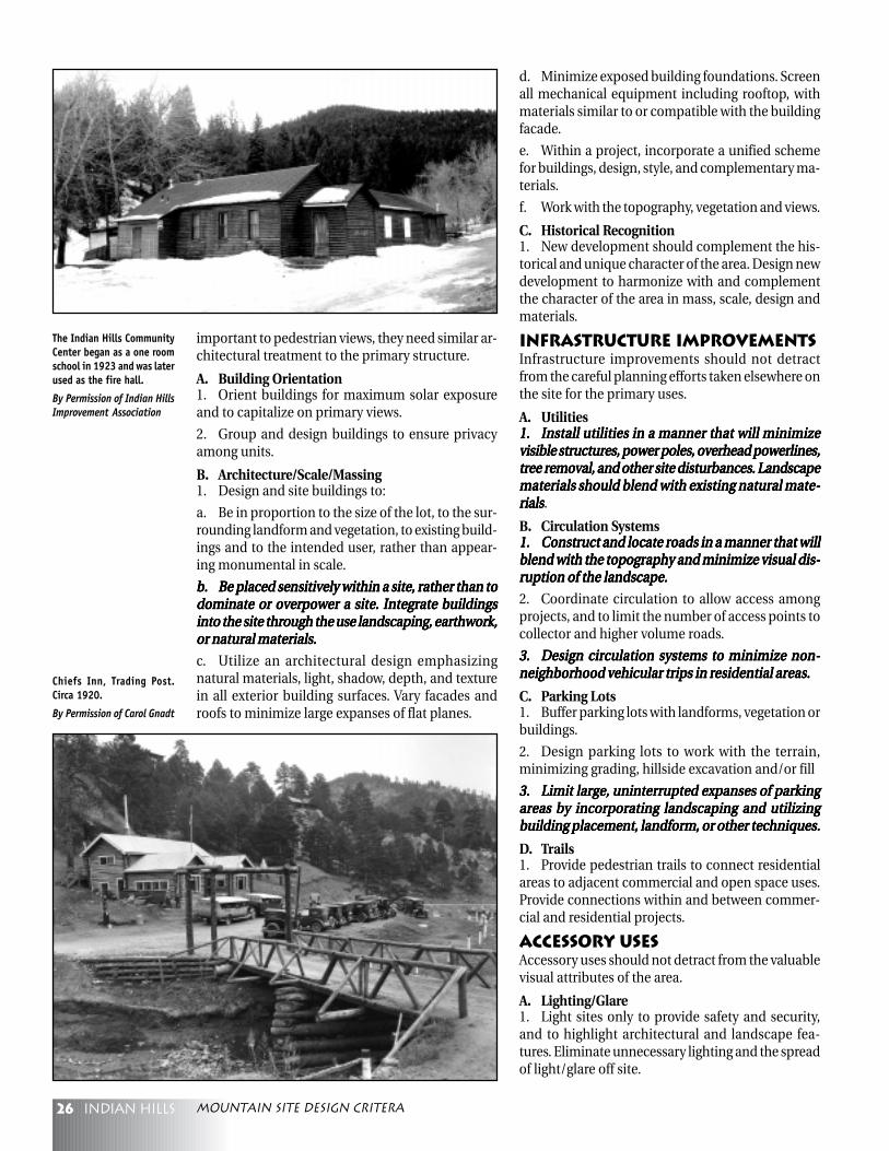
26 Indian hills
important to pedestrian views, they need similar ar-chitectural treatment to the primary structure.
A. Building Orientation1. Orient buildings for maximum solar exposureand to capitalize on primary views.
2. Group and design buildings to ensure privacyamong units.
B. Architecture/Scale/Massing1. Design and site buildings to:
a. Be in proportion to the size of the lot, to the sur-rounding landform and vegetation, to existing build-ings and to the intended user, rather than appear-ing monumental in scale.
b.b.b.b.b. Be placed sensitively within a site, rather than toBe placed sensitively within a site, rather than toBe placed sensitively within a site, rather than toBe placed sensitively within a site, rather than toBe placed sensitively within a site, rather than todominate or overpower a site. Integrate buildingsdominate or overpower a site. Integrate buildingsdominate or overpower a site. Integrate buildingsdominate or overpower a site. Integrate buildingsdominate or overpower a site. Integrate buildingsinto the site through the use landscaping, earthwork,into the site through the use landscaping, earthwork,into the site through the use landscaping, earthwork,into the site through the use landscaping, earthwork,into the site through the use landscaping, earthwork,or natural materials.or natural materials.or natural materials.or natural materials.or natural materials.
c. Utilize an architectural design emphasizingnatural materials, light, shadow, depth, and texturein all exterior building surfaces. Vary facades androofs to minimize large expanses of flat planes.
d. Minimize exposed building foundations. Screenall mechanical equipment including rooftop, withmaterials similar to or compatible with the buildingfacade.
e. Within a project, incorporate a unified schemefor buildings, design, style, and complementary ma-terials.
f. Work with the topography, vegetation and views.
C. Historical Recognition1. New development should complement the his-torical and unique character of the area. Design newdevelopment to harmonize with and complementthe character of the area in mass, scale, design andmaterials.
Infrastructure ImprovementsInfrastructure improvements should not detractfrom the careful planning efforts taken elsewhere onthe site for the primary uses.
A. Utilities1.1.1.1.1. Install utilities in a manner that will minimizeInstall utilities in a manner that will minimizeInstall utilities in a manner that will minimizeInstall utilities in a manner that will minimizeInstall utilities in a manner that will minimizevisible structures, power poles, overhead powerlines,visible structures, power poles, overhead powerlines,visible structures, power poles, overhead powerlines,visible structures, power poles, overhead powerlines,visible structures, power poles, overhead powerlines,tree removal, and other site disturbances. Landscapetree removal, and other site disturbances. Landscapetree removal, and other site disturbances. Landscapetree removal, and other site disturbances. Landscapetree removal, and other site disturbances. Landscapematerials should blend with existing natural mate-materials should blend with existing natural mate-materials should blend with existing natural mate-materials should blend with existing natural mate-materials should blend with existing natural mate-rialsrialsrialsrialsrials.
B. Circulation Systems1.1.1.1.1. Construct and locate roads in a manner that willConstruct and locate roads in a manner that willConstruct and locate roads in a manner that willConstruct and locate roads in a manner that willConstruct and locate roads in a manner that willblend with the topography and minimize visual dis-blend with the topography and minimize visual dis-blend with the topography and minimize visual dis-blend with the topography and minimize visual dis-blend with the topography and minimize visual dis-ruption of the landscape.ruption of the landscape.ruption of the landscape.ruption of the landscape.ruption of the landscape.
2. Coordinate circulation to allow access amongprojects, and to limit the number of access points tocollector and higher volume roads.
3.3.3.3.3. Design circulation systems to minimize non-Design circulation systems to minimize non-Design circulation systems to minimize non-Design circulation systems to minimize non-Design circulation systems to minimize non-neighborhood vehicular trips in residential areas.neighborhood vehicular trips in residential areas.neighborhood vehicular trips in residential areas.neighborhood vehicular trips in residential areas.neighborhood vehicular trips in residential areas.
C. Parking Lots1. Buffer parking lots with landforms, vegetation orbuildings.
2. Design parking lots to work with the terrain,minimizing grading, hillside excavation and/or fill
3.3.3.3.3. Limit large, uninterrupted expanses of parkingLimit large, uninterrupted expanses of parkingLimit large, uninterrupted expanses of parkingLimit large, uninterrupted expanses of parkingLimit large, uninterrupted expanses of parkingareas by incorporating landscaping and utilizingareas by incorporating landscaping and utilizingareas by incorporating landscaping and utilizingareas by incorporating landscaping and utilizingareas by incorporating landscaping and utilizingbuilding placement, landform, or other techniques.building placement, landform, or other techniques.building placement, landform, or other techniques.building placement, landform, or other techniques.building placement, landform, or other techniques.
D. Trails1. Provide pedestrian trails to connect residentialareas to adjacent commercial and open space uses.Provide connections within and between commer-cial and residential projects.
Accessory UsesAccessory uses should not detract from the valuablevisual attributes of the area.
A. Lighting/Glare1. Light sites only to provide safety and security,and to highlight architectural and landscape fea-tures. Eliminate unnecessary lighting and the spreadof light/glare off site.
Chiefs Inn, Trading Post.Circa 1920.
By Permission of Carol Gnadt
The Indian Hills CommunityCenter began as a one roomschool in 1923 and was laterused as the fire hall.
By Permission of Indian HillsImprovement Association
Mountain site design critera

27Indian hills
B. Signs1.1.1.1.1. Design signs to be of a scale and character thatDesign signs to be of a scale and character thatDesign signs to be of a scale and character thatDesign signs to be of a scale and character thatDesign signs to be of a scale and character thatare compatible with the development and surround-are compatible with the development and surround-are compatible with the development and surround-are compatible with the development and surround-are compatible with the development and surround-ing environment, emphasizing natural materials.ing environment, emphasizing natural materials.ing environment, emphasizing natural materials.ing environment, emphasizing natural materials.ing environment, emphasizing natural materials.
2. Use only wall mounted, under canopy, or monu-ment style signs. Integrate monument signs into thelandscape with vegetation, or into the architectureof the buildings.
C. Fences and Walls1. Avoid perimeter fences except as needed for live-stock.
2. Use privacy (opaque) fences only to provide pri-vate areas immediately around buildings or for noiseattenuation.
3. Use fences and walls constructed with naturalmaterials, e.g., wood or stone.
D. Exterior Storage1.1.1.1.1. Screen exterior storage, loading, and service ar-Screen exterior storage, loading, and service ar-Screen exterior storage, loading, and service ar-Screen exterior storage, loading, and service ar-Screen exterior storage, loading, and service ar-eas from public view.eas from public view.eas from public view.eas from public view.eas from public view.
E. Accessory Facilities1. Screen satellite dishes from off-site view, or se-lect design and color that will blend with the sur-rounding environment.
2. Screen propane tanks and trash containers fromadjacent off-site views.
Wildlife Accommodation1. Encroach upon critical wildlife habitat only if theremaining habitat is enhanced so that the gross car-rying capacity of the site is maintained or enhanced.
2. Maintain wildlife movement corridors in a size,location, and character that will encourage their con-tinued use.
3.3.3.3.3. Preserve or enhance ecosystems adjacent to orPreserve or enhance ecosystems adjacent to orPreserve or enhance ecosystems adjacent to orPreserve or enhance ecosystems adjacent to orPreserve or enhance ecosystems adjacent to orwithin streams, wetlands, bodies of water, and otherwithin streams, wetlands, bodies of water, and otherwithin streams, wetlands, bodies of water, and otherwithin streams, wetlands, bodies of water, and otherwithin streams, wetlands, bodies of water, and otherriparian habitats.riparian habitats.riparian habitats.riparian habitats.riparian habitats.
Early picture of “Bona Vista”.By Permission of Carol GnadtNonresidential
A. Nonresidential Style DevelopmentNonresidential style development within view frompublic places and more heavily populated residen-tial areas should have a higher level of compliancewith these criteria except when the development isscreened from view.
1.1.1.1.1. All “bold and italicized “ criterion in the Moun-All “bold and italicized “ criterion in the Moun-All “bold and italicized “ criterion in the Moun-All “bold and italicized “ criterion in the Moun-All “bold and italicized “ criterion in the Moun-tain Site Design Criteria should be applied to non-tain Site Design Criteria should be applied to non-tain Site Design Criteria should be applied to non-tain Site Design Criteria should be applied to non-tain Site Design Criteria should be applied to non-residential site design.residential site design.residential site design.residential site design.residential site design.
2. Nonresidential developments should emphasizeclusters of smaller buildings or be designed to havethat appearance.
3.3.3.3.3. Avoid developments that are strictly road-ori-Avoid developments that are strictly road-ori-Avoid developments that are strictly road-ori-Avoid developments that are strictly road-ori-Avoid developments that are strictly road-ori-ented, strip-style design.ented, strip-style design.ented, strip-style design.ented, strip-style design.ented, strip-style design.
4. Provide pedestrian amenities such as plazas andstreet furniture.
5. Provide a buffer to adjacent residential develop-ment of sufficient design to en-sure sensory impacts do notexceed residential levels. Thesize and density of the buffercan vary depending on thequality of the site design, basedon the design’s ability to miti-gate sensory impacts, i.e.,higher quality site design canearn a reduction in the size anddensity of the buffer.
6. Use pitched roofs or a de-sign solution that prevents theappearance of large areas of flatroofs.
Foss Chapel
Mountain site design critera
28 Indian hills
GlossaryCriticalCriticalCriticalCriticalCritical: The use of the word critical in this Plan does not connoteregulatory category as it does when used by agencies responsible forwildlife populations.
DecibelDecibelDecibelDecibelDecibel: A unit for expressing the relative intensity of sounds on ascale from zero for the average least perceptible sound, to about 130for the average pain level.
Floodplain HazardsFloodplain HazardsFloodplain HazardsFloodplain HazardsFloodplain Hazards: Floodplains are the area covered by water whena flood occurs. Usually, the floodplain is considered to be the landthat would be inundated by a 100-year storm, hence the term 100-year floodplain. A 100-year floodplain is an area which has a 1 per-cent chance of being flooded every year.
Geologic HazardsGeologic HazardsGeologic HazardsGeologic HazardsGeologic Hazards: The natural and man-made conditions whichthreaten public health, safety, or property such as landslide, rockfall,mudflow, creep and Slope Failure Complex.
• Landslide: A mass movement where there is a distinct surfacerupture or zone of weakness which separates the slide material frommore stable underlying material.
• Rockfall: Rapid freefalling, bounding, sliding, or rolling of largemasses of rock or individual rocks.
• Slope Failure Complex: A geologic hazard which means a combi-nation of one or more of the following geologic hazards: landslide,rockfall, mudflow, creep.
• Subsidence: The surface collapse of ground over undergroundmines. Areas of previous mining often contain hazardous conditionssuch as steep or vertical rock faces of dangerous heights, open orpoorly sealed passageways into areas of previous underground ac-tivities, or underground rooms or passageways which constitute apotential location for subsidence. This condition can be very haz-ardous to public safety and structures built in subsidence-prone ar-eas.
Historic SitesHistoric SitesHistoric SitesHistoric SitesHistoric Sites: The location of a significant event, a prehistoric or his-toric occupation or activity, or a building or structure, whether stand-ing, ruined, or vanished, where the location itself possesses historic,cultural or archaeological value. (National Register Bulletin 16)
LandscapingLandscapingLandscapingLandscapingLandscaping: Anything done external to or outside of a building.
Planned DevelopmentPlanned DevelopmentPlanned DevelopmentPlanned DevelopmentPlanned Development: A Jefferson County zone district. The pur-pose of the Planned Development (PD) zone is to provide a meansfor the achievement of public and private goals not otherwise pro-vided for or inadequately represented in the Zoning Resolution, whileensuring that the intent of the Resolution is fulfilled.
These goals are:
1. Promote the efficient and innovative use of land and public ser-vices.
2. Achieve compatibility and preclude land use conflicts through in-novative or comprehensive design.
3. Promote integrated building groups or use complexes with conti-nuity of design and development and to promote housing of diversetypes.
4. Provide necessary commercial, recreational, educational and em-ployment facilities conveniently located to housing.
5. Conserve and promote the efficient use of common open space.
6. Encourage preservation of a site’s natural characteristics and eco-logical functions by providing a procedure to relate type, design andlayout of development to that particular site.
In pursuit of this purpose, the PD zone is a comprehensive proce-dure which grants applicants significant flexibility and discretion, butalso requires that significant additional documentation be submit-ted. The reason for this documentation is to enable public review toassess effectively the ability of a proposal’s design to fulfill the intentof the traditional Zoning Resolution and achieve these public goals.
Prescriptive RightsPrescriptive RightsPrescriptive RightsPrescriptive RightsPrescriptive Rights: Roads over private land are declared to be a pub-lic highway when they have been used adversely, i.e., by the public,without interruption or objection on the part of the owners of suchlands for twenty consecutive years. (Colorado State Statute: Trans-portation, Part 2, 43-2-201, County and Other Public Highways)
Recreation, ActiveRecreation, ActiveRecreation, ActiveRecreation, ActiveRecreation, Active: Recreation which requires some constructed fa-cilities such as soccer, softball and football fields, and organized ac-tivities.
Recreation, PassiveRecreation, PassiveRecreation, PassiveRecreation, PassiveRecreation, Passive: Recreation which utilizes existing natural re-sources, and has a minimal impact. Examples: hiking, horsebackriding, cross country skiing, bird watching, kite flying, and bicycling.
Strip DevelopmentStrip DevelopmentStrip DevelopmentStrip DevelopmentStrip Development: The characteristics of strip development are:
1. Building placement and design which cuts off both physical andvisual access between projects;
2. An absence of coordination with adjacent projects;
3.Lack of direct vehicular and pedestrian access between onsite park-ing and adjacent existing and future parking areas greater than 10spaces in size;
4. Lack of common facilities between projects, both parking and ma-jor circulation;
5. Absence of compatible site and building design which exhibits acoordinated pattern or theme;
6. Lack of coordinated landscaping and drainage plans;
7. Lack of setbacks, building shapes, forms, and heights;
8. Absence of cohesive, easily understood sign systems which fosterintegration through size, number and treatment;
9. Multiple curb cuts and access points; and
10. Structures and parking areas that are not buffered from roads tominimize visual impact.
Wildfire HazardsWildfire HazardsWildfire HazardsWildfire HazardsWildfire Hazards: The hazard presented by the uncontrollable burn-ing of trees, bush and grass. The magnitude of this hazard is affectedby vegetation density, slope, atmospheric conditions, and the pres-ence of special terrain conditions such as saddles, gullies, or fire chim-neys which cause a draft much like a fireplace flue. This hazard israted as low, moderate, and high, and is defined as follows:
• Low: A wildfire in these areas can be controlled by available firefighting personnel and equipment. Little to no property damage isexpected, and there is not a threat to human life. They are typified bylight fuel loads on slopes less than 30%.
• Moderate: A wildfire in these areas can be difficult to control byavailable fire fighting personnel and equipment. There is the poten-tial for destruction of property, and human life is threatened. Theyare typified by moderate fuel loads on slopes less than 30%.
• High: A wildfire in these areas is generally uncontrollable by avail-able fire fighting equipment and personnel. Protection of propertyor lives cannot be provided. They are typified by heavy fuel loads, orareas with moderate or heavy fuel loads on steep slopes, greater than30%, or the presence of special terrain conditions mentioned above.
Maps of wildfire hazards have been produced by the Colorado StateForest Service and the Jefferson County Planning Department.
Glossary
29Indian hills
Appendix
appendix
Firearm RestrictionsPertinent portions taken from: Colorado Revised Statutes, Gov-ernment-County, Article 15, Regulation Under Police Power, Part3: Unincorporated Areas-Discharge of Firearms Prohibited andResolutions; Board of County Commissioners; Jefferson County,Colorado. Journal of the Commissioners of Jefferson County, Colo-rado, May 31, 1966.
30-15-301. Definition.30-15-301. Definition.30-15-301. Definition.30-15-301. Definition.30-15-301. Definition. As used in this part 3, unless the contextotherwise requires: (1) “Firearm” or “firearms” means any pistol,revolver, rifle, or other weapon of any description from whichany shot, projectile, or bullet may be discharged.
Source:Source:Source:Source:Source: L.66,p.4. § 1;C.R.S. 1963, § 36-32-1
30-15-302. Board of county commissioners to designate area.30-15-302. Board of county commissioners to designate area.30-15-302. Board of county commissioners to designate area.30-15-302. Board of county commissioners to designate area.30-15-302. Board of county commissioners to designate area.(1) The board of county commissioners of any county in this statemay designate, by resolution, areas in the unincorporated terri-tory of such county in which it is unlawful for any person to dis-charge any firearms, except a duly authorized law enforcementofficer acting in the line of duty, but nothing in this subsection(1) shall prevent the discharge of any firearm in shooting galler-ies or in any private grounds or residence under circumstanceswhen such firearm can be discharged in such a manner as not toendanger persons or property and also in such a manner as toprevent the projectile from any such firearm from traversing anygrounds or space outside the limits of such shooting gallery,grounds, or residence.
(2) No area shall be so designated under authority of subsection(1) of this section unless it has an average population density ofnot less than one hundred persons per square mile in the areadesignated, and, before making any such designation, the boardof county commissioners shall hold a public hearing thereon atwhich any interested person shall have an opportunity to beheard. The provisions of article 3 of title 33, C.R.S., concerningthe state’s liability for damages done to property by wild animalsprotected by the game laws of the state shall not apply to anyarea designated by a board of county commissioners under au-thority of this part 3.
(3) Nothing in this section shall be construed to restrict or other-wise affect any person’s constitutional right to bear arms or hisright to the defense of his person, his family, or his property.
Source:Source:Source:Source:Source: L.66.p.4. § 1;C.R.S. 1963, § 36-22-2
30-15-303. Violation - penalty.30-15-303. Violation - penalty.30-15-303. Violation - penalty.30-15-303. Violation - penalty.30-15-303. Violation - penalty. Any person violating any provi-sion of this part 3 is guilty of a misdemeanor and, upon convic-tion thereof, shall be punished by a fine of not more than onehundred dollars.
Source:Source:Source:Source:Source: L.66.p.4. § 1;C.R.S. 1963, § 36-22-3
30-15-304. Jurisdiction - enforcement.30-15-304. Jurisdiction - enforcement.30-15-304. Jurisdiction - enforcement.30-15-304. Jurisdiction - enforcement.30-15-304. Jurisdiction - enforcement. County courts, in theirrespective counties, have jurisdiction in prosecutions of viola-tions of this part 3. It is the duty of the sheriff and his undersheriffsand deputies, in their respective counties, to enforce the provi-sions of this part 3.
Source:Source:Source:Source:Source: L.66.p.4. § 1;C.R.S. 1963, § 36-22-4
Resolutions; Board of County Commissioners; Jefferson County,Colorado. Journal of the Commissioners of Jefferson County, Colo-rado, May 31, 1966.
Resolution 1966A-October 24, 1966 (in part)
“2. That the areas in the unincorporated territory of JeffersonCounty in which it shall be unlawful to discharge any firearmsexcept as permitted by C.R.S., 1963, as amended, 36-22-2, are asfollow:
All of Township 4 South, Range 69 West of the 6th P.M.; Sections13 through 36, inclusive of Township 3 South, Range 69 West ofthe 6th P.M.; Sections 13, 14, 15, 16, 21, 22, 23, 24, 25, 26, 27, 28,33, 34, 35 and 36 of Township 3 South, Range 70 West; Sections 1through 18, inclusive , and Sections 22, 23, 24, 25, 26, 27, 34, 35and 36 of Township 4 South, Range 70 West of the 6th P.M.; Sec-tions 1, 2, 3, 4, 5, 6, 9, 10, 11, 12, 13, 14, 15, 16 and 17 of Township4 South, Range 71 West of the 6th P.M.; and Section 10 of Town-ship 5 South, Range 71 West of the 6th P.M., all in Jefferson CountyColorado, excepting, however, all of the above described landlocated within the boundaries of all incorporated cities or towns.”
Journal of the Commissioners of Jefferson County, Colorado,January 17, 1967 (#388) (in part)
“NOW, THEREFORE, BE IT RESOLVED that the resolutionadopted by the Board October 24, 1966, entitled “Firearms Regu-lations”, be and hereby is amended to include Tract 5, known asthe Indian Hills Area, said Tract 5 being described as follows:
Sections 6, 7, 8, 16, 17, and 18, all in Township 5 South, Range 70West, Jefferson County, Colorado, EXCEPT any portion thereofwhich may be within the boundaries of any incorporated city ortown.”
Journal of the Commissioners of Jefferson County, Colorado,October 21, 1968 (in part)
“2. That the areas in the unincorporated territory of JeffersonCounty, Colorado, in which it shall be unlawful to discharge anyfirearms, except as permitted by Colorado Revised Statutes, 1963,as amended, 36-22-2, is as follows:
Tract 5 (I ndian Hills)
Sections 6, 7, 8, 16, 17, and 18, all in Township 5 South, Range 70West, Jefferson County, Colorado”
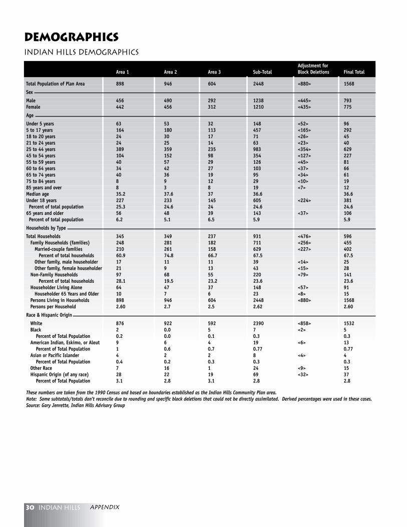
30 Indian hills appendix
Indian Hills Demographics
Adjustment forArea 1 Area 2 Area 3 Sub-Total Block Deletions Final Total
Total Population of Plan Area 898 946 604 2448 <880> 1568
Sex
Male 456 490 292 1238 <445> 793Female 442 456 312 1210 <435> 775
Age
Under 5 years 63 53 32 148 <52> 965 to 17 years 164 180 113 457 <165> 29218 to 20 years 24 30 17 71 <26> 4521 to 24 years 24 25 14 63 <23> 4025 to 44 years 389 359 235 983 <354> 62945 to 54 years 104 152 98 354 <127> 22755 to 59 years 40 57 29 126 <45> 8160 to 64 years 34 42 27 103 <37> 6665 to 74 years 40 36 19 95 <34> 6175 to 84 years 8 9 12 29 <10> 1985 years and over 8 3 8 19 <7> 12Median age 35.2 37.6 37 36.6 36.6Under 18 years 227 233 145 605 <224> 381 Percent of total population 25.3 24.6 24 24.6 24.665 years and older 56 48 39 143 <37> 106 Percent of total population 6.2 5.1 6.5 5.9 5.9
Households by Type
Total Households 345 349 237 931 <476> 596 Family Households (families) 248 281 182 711 <256> 455 Married-couple families 210 261 158 629 <227> 402 Percent of total households 60.9 74.8 66.7 67.5 67.5 Other family, male householder 17 11 11 39 <14> 25 Other family, female householder 21 9 13 43 <15> 28 Non-Family Households 97 68 55 220 <79> 141 Percent of total households 28.1 19.5 23.2 23.6 23.6 Householder Living Alone 64 47 37 148 <57> 91 Householder 65 Years and Older 10 7 6 23 <8> 15 Persons Living in Households 898 946 604 2448 <880> 1568 Persons per Household 2.60 2.7 2.5 2.62 2.60
Race & Hispanic Origin
White 876 922 592 2390 <858> 1532 Black 2 0.0 5 7 <2> 5 Percent of Total Population 0.2 0.0 0.1 0.3 0.3 American Indian, Eskimo, or Aleut 9 6 4 19 <6> 13 Percent of Total Population 1 0.6 0.7 0.77 0.77 Asian or Pacific Islander 4 2 2 8 <4> 4 Percent of Total Population 0.4 0.2 0.3 0.3 0.3 Other Race 7 16 1 24 <9> 15 Hispanic Origin (of any race) 28 22 19 69 <32> 37 Percent of Total Population 3.1 2.8 3.1 2.8 2.8
These numbers are taken from the 1990 Census and based on boundaries established as the Indian Hills Community Plan area.Note: Some subtotals/totals don’t reconcile due to rounding and specific block deletions that could not be directly assimilated. Derived percentages were used in these cases.Source: Gary Jenrette, Indian Hills Advisory Group
Demographics
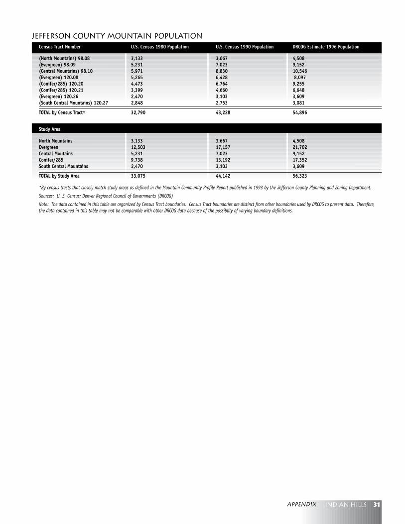
31Indian hillsappendix
Jefferson county Mountain PopulationCensus Tract Number U.S. Census 1980 Population U.S. Census 1990 Population DRCOG Estimate 1996 Population
(North Mountains) 98.08 3,133 3,667 4,508(Evergreen) 98.09 5,231 7,023 9,152(Central Mountains) 98.10 5,971 8,830 10,546(Evergreen) 120.08 5,265 6,428 8,097(Conifer/285) 120.20 4,473 6,764 9,255(Conifer/285) 120.21 3,399 4,660 6,648(Evergreen) 120.26 2,470 3,103 3,609(South Central Mountains) 120.27 2,848 2,753 3,081
TOTAL by Census Tract* 32,790 43,228 54,896
Study Area
North Mountains 3,133 3,667 4,508Evergreen 12,503 17,157 21,702Central Moutains 5,231 7,023 9,152Conifer/285 9,738 13,192 17,352South Central Mountains 2,470 3,103 3,609
TOTAL by Study Area 33,075 44,142 56,323
*By census tracts that closely match study areas as defined in the Mountain Community Profile Report published in 1993 by the Jefferson County Planning and Zoning Department.
Sources: U. S. Census; Denver Regional Council of Governments (DRCOG)
Note: The data contained in this table are organized by Census Tract boundaries. Census Tract boundaries are distinct from other boundaries used by DRCOG to present data. Therefore,the data contained in this table may not be comparable with other DRCOG data because of the possiblity of varying boundary definitions.
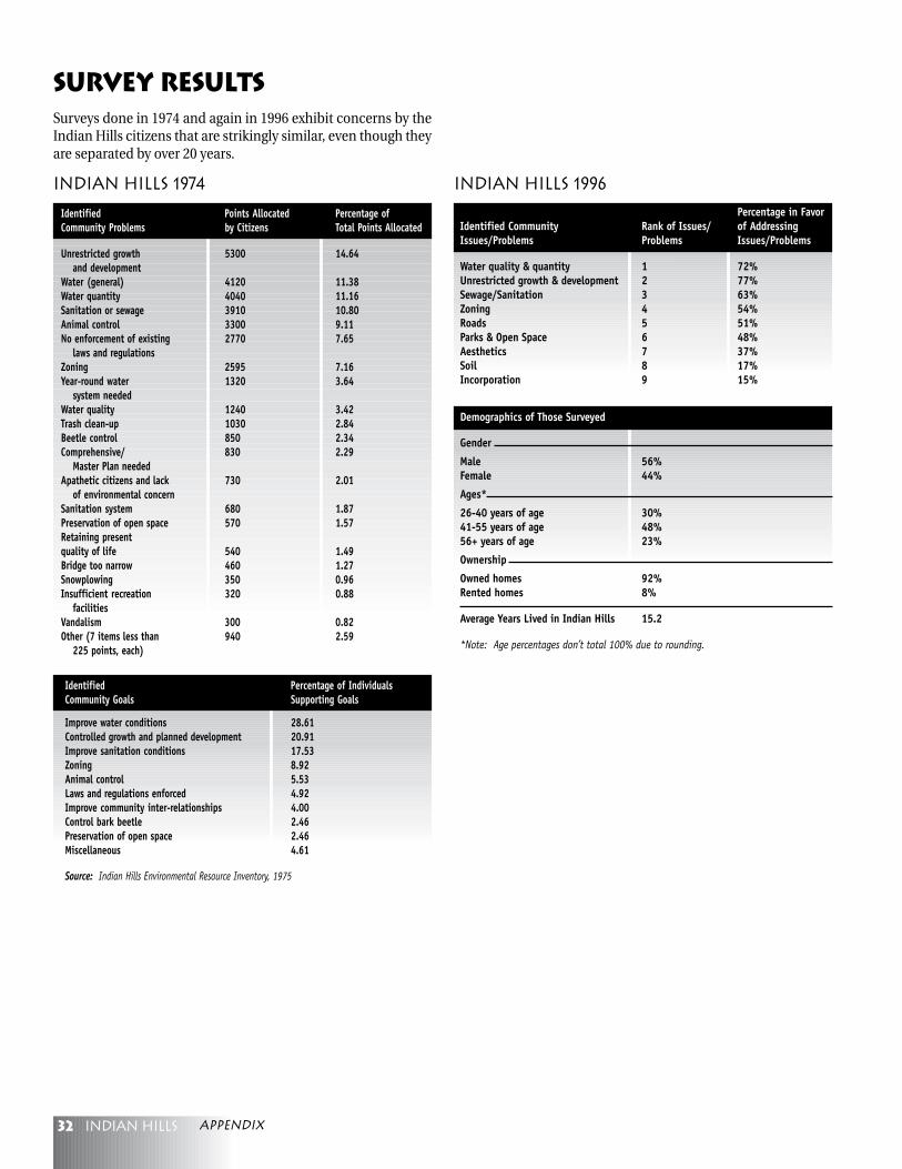
32 Indian hills
Identified Points Allocated Percentage ofCommunity Problems by Citizens Total Points Allocated
Unrestricted growth 5300 14.64and development
Water (general) 4120 11.38Water quantity 4040 11.16Sanitation or sewage 3910 10.80Animal control 3300 9.11No enforcement of existing 2770 7.65
laws and regulationsZoning 2595 7.16Year-round water 1320 3.64
system neededWater quality 1240 3.42Trash clean-up 1030 2.84Beetle control 850 2.34Comprehensive/ 830 2.29
Master Plan neededApathetic citizens and lack 730 2.01
of environmental concernSanitation system 680 1.87Preservation of open space 570 1.57Retaining presentquality of life 540 1.49Bridge too narrow 460 1.27Snowplowing 350 0.96Insufficient recreation 320 0.88
facilitiesVandalism 300 0.82Other (7 items less than 940 2.59
225 points, each)
Indian Hills 1974
Identified Percentage of IndividualsCommunity Goals Supporting Goals
Improve water conditions 28.61Controlled growth and planned development 20.91Improve sanitation conditions 17.53Zoning 8.92Animal control 5.53Laws and regulations enforced 4.92Improve community inter-relationships 4.00Control bark beetle 2.46Preservation of open space 2.46Miscellaneous 4.61
Source: Indian Hills Environmental Resource Inventory, 1975
Indian Hills 1996
Percentage in FavorIdentified Community Rank of Issues/ of AddressingIssues/Problems Problems Issues/Problems
Water quality & quantity 1 72%Unrestricted growth & development 2 77%Sewage/Sanitation 3 63%Zoning 4 54%Roads 5 51%Parks & Open Space 6 48%Aesthetics 7 37%Soil 8 17%Incorporation 9 15%
Demographics of Those Surveyed
Gender
Male 56%Female 44%
Ages*
26-40 years of age 30%41-55 years of age 48%56+ years of age 23%
Ownership
Owned homes 92%Rented homes 8%
Average Years Lived in Indian Hills 15.2
*Note: Age percentages don’t total 100% due to rounding.
Survey ResultsSurveys done in 1974 and again in 1996 exhibit concerns by theIndian Hills citizens that are strikingly similar, even though theyare separated by over 20 years.
appendix
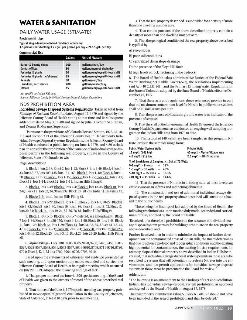
33Indian hills
Daily Water Usage EstimatesResidential UseTypical single-family-detached residence occupancy3.5 persons per dwelling X 75 gal. per person per day = 262.5 gal. per day
Commercial UseGallons Unit of Measure
Barber & beauty shops 100 gallons/chair/dayDental offices 50 gallons/nonwet chair/dayFactories & plants 20 gallons/employee/8-hour shiftFactories & plants (w/showers) 35 gallons/employee/8-hour shiftKennels 30 gallons/run/dayLaundries, self service 400 gallons/washer/dayOffices 15 gallons/employee/8-hour shift
Not specific to Indian Hills areaSource: Jefferson County Individual Sewage Disposal System Regulations
Water & Sanitation
ISDS Prohibition AreaIndividual Sewage Disposal Systems RegulationsIndividual Sewage Disposal Systems RegulationsIndividual Sewage Disposal Systems RegulationsIndividual Sewage Disposal Systems RegulationsIndividual Sewage Disposal Systems Regulations: Taken in total fromFindings of Fact and Resolution dated August 17, 1979 and signed by theJefferson County Board of Health sitting at that time and its subsequentaddendum dated May 30, 1980 and signed by Julia H. Schott, Sanitarian,and Dennis B. Murano, Supervisor.
“Pursuant to the provisions of Colorado Revised Statute, 1973, 25-10-110 and Section 3.21 of the Jefferson County Health Department’s Indi-vidual Sewage Disposal Systems Regulations, the Jefferson County Boardof Health conducted a public hearing on June 4, 1979, and 4:30 o’clockp.m. to consider the prohibition of the issuance of individual sewage dis-posal permits in the following real property, situate in the County ofJefferson, State of Colorado, to wit:
(legal description)
1. Block 1 lots 2-18; Block 2 lots 1-23; Block 3 lots 1-49; Block 4 lots 1-33, lots 43-87, lots 109-135, lots 151-163; Block 5 lots 1-48; Block 6 lots 1-78; Block 7 all lots; Block 8 lots 1-15; Block 9 lots 1-25; Block 10 lots 1-19;Block 11 lots 1-14; Block 12 lots 1-11, Indian Hills Filing #1.
2. Block 1 lots 1-49; Block 5 lots 1-4; Block 8 lots 18-35; Block 10 lots2-6; Block 11 lots 32, 34, 36 and 37; Block 13 all lots, Indian Hills Filing #2.
3. Blocks 1-9 total, Indian Hills Filing #3.
4. Block 1 lots 1-22; Block 2 lots 1-51; Block 3 lots 1-7, 20-22; Block 8lots 1-83; Block 9 lots 1-30; Block 10 lots 1-98; Block 11 lots 18-52; Block 12lots 20-54; Block 14 lots 19-24, 52-56, 76-81, Indian Hills Filing #4.
5. Block 1 lots 1-15; Block 6 lots 1-7 (deleted, see amendment); Block7 lots 1-34; Block 8 lots 36-150; Block 9 lots 1-90; Block 10 lots 1-43; Block11 lots 1-25; Block 12 lots 1-39; Block 14 lots 31, 33, 35, 37, 39, 41, 43, 45,47, 49; Block 15 lots 14-23; Block 18 lots 1-14; Block 20 lots 38-67; Block 23lots 1-6, 46-52; Block 25 lots 1-3, 13; Block 26 lots 25-29, Indian Hills Filing#5.
6. Alpine Village - Lots 8801, 8803, 8805, 9420, 9430, 9440, 9450, 9501-9527, 9529-9537, 9539, 9541, 9543-9547, 9601-9610, 9709, 9711-9716, 9720,9721; Track J, K, L, M lots 9702, 9704, 9706, 9708, 9710.
Based upon the statements of witnesses and evidence presented atsuch meeting, and upon motion duly made, seconded and carried, theJefferson County Board of Health at its regular meeting which occurredon July 20, 1979, adopted the following findings of fact:
1. That proper notice of the June 4, 1979 special meeting of the Boardof Health was given to the owners of record of the above described realproperty.
2. That notice of the June 4, 1979 special meeting was properly pub-lished in newspapers of general circulation in the County of Jefferson,State of Colorado, at least 10 days prior to said meeting.
3. That the real property described is subdivided for a density of morethan one dwelling unit per acre.
4. That certain portions of the above described property contain adensity of more than one dwelling unit per acre.
5. That the geological condition of the real property above describedis typified by:
A) steep slopes
B) poor soil conditions
C) centralized down slope drainage
D) the presence of the Floyd Hill fault
E) high levels of rock fracturing in the bedrock
6. The Board of Health takes administrative Notice of the Federal SafeWater Drinking Act (Public Law 93-523), the regulations implementingsaid Act (40 C.I.R. 141), and the Primary Drinking Water Regulations forthe State of Colorado adopted by the State Board of Health, effective De-cember 15, 1977.
7. That these acts and regulations above referenced provide in partthat the maximum contaminant level for Nitrate in public water systemsshall be 10 milligrams per liter.
8. That the presence of Nitrates in ground water is an indicator of thepresence of sewage.
9. That the staff of the Environmental Health Division of the JeffersonCounty Health Department has conducted an ongoing well sampling pro-gram in the Indian Hills area from 1970 to date.
10. That a total of 140 wells have been sampled in this program. Ni-trate levels in the samples range from:
Public Water System Wells Private Wells15 mg/1 (#6) high 40 mg/1 - Alpine Village area4.6 mg/1 (#1) low 2.6 mg/1 - 5th Filing area
% of Breakdown of Samples = Out of 75 Wells0-1 mg/1 = 9 wells = 12%1-5 mg/1 = 30 wells = 40%5-10 mg/1 = 25 wells = 33.3%>10 mg/1 = 11 wells = 14.6%
11. That the presence of Nitrates in drinking water at these levels cancause cyanosis in infants and methemoglobinemia.
12. The construction and use of additional individual sewage dis-posal systems in the real property above described will constitute a haz-ard to the public health.
These being the findings of fact adopted by the Board of Health, thefollowing resolution was upon motion duly made, seconded and carried,unanimously adopted by the Board of Health:
‘Resolved, that there be a prohibition on the issuance of individual sew-age disposal system permits for building sites situate on the real propertyabove described; and
Further Resolved, that in order to minimize the impact of further devel-opment on the contaminated areas of Indian Hills, the Board determinesthat due to adverse geologic and topographic conditions and the existinghigh potential for contamination, the existing lot size requirements forareas up slope of the real property above described in Indian Hills be in-creased, that individual sewage disposal system permits in those areas berestricted to systems that will potentially not release Nitrates into the en-vironment, and that permit applications for individual sewage disposalsystems in those areas be presented to the Board for review.’”
Addendum:
“The following is an amendment to the Findings of Fact and Resolution,Indian Hills individual sewage disposal system prohibition, as approvedand signed by the Board of Health on August 17, 1979.
The real property identified as Filing 5, Block 6, Lots 1-7 should not havebeen included in the area of prohibition and shall be deleted.”
appendix
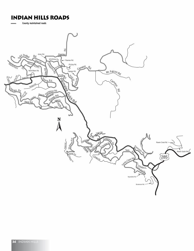
34 Indian hills
Parmalee
Gulch Rd.Inca Rd.
Cameyo Rd.Mt. Falcon Rd.
Comanche
Rd.
Azte
cRd
.
San Isabel Rd.
Navajo Rd.
Weiss hor n Dr.
Matterhorn Dr.
Iso l e ta Rd.
Kiowa Rd.Nampeyo Rd.
Seminole Rd.
Sa
nta Clara Rd.
Giant Gulch
Rd.
Shaw
nee
Rd. Cheyenne Rd.
Taos Rd.
285
CameyoRd
Pawnee
Rd.
Picutis
Papago Rd.
Oh-Kay Rd.
Pawnee Rd.Shoshone Rd.
Oh-Kay Rd.
Picutis Rd.
Rd.
Aztec Rd.
Nam
beR
d.
Moqui Rd.
Mont Blanc Rd.
Supai Rd.
Tong
ueR
d.
Pim
a Rd
.
Tesque Rd.
Isoleta
Rd.
Maricopa Rd.Otowi Rd.
Inca Rd.
Hopi Rd.
Inyo
Rd.
Navajo Rd.
Anahinas Rd.
Sioux Rd.
Ute Rd.
Natsihi Rd.Chiquita R
d.
Adah
i Rd.
Salugi Rd.Shawnee Rd.
Nissaki Rd. Taos
Rd.Osage Rd.
Cherokee Rd.
S.Al
gonq
uin
Rd
Brookmont Rd.
Wyandotte Rd.
Hiawatha Tr.Santa Clara Rd.
Raven Gulch Rd.
Raven Crest Rd.
Indian Hills RoadsCounty maintained roads
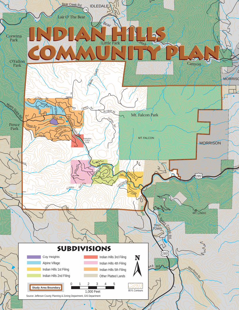
35Indian hills
Parmalee
Gulch Rd.Inca Rd.
Cameyo RdMt. Falcon Rd.
ComancheRd.
Azte
cRd
.
San Isabel Rd.
Myers Gulch Rd.
Navajo Rd.
Weiss hor n Dr.
Matterhorn
Dr. Isole ta Rd.
Kiowa Rd.Nampeyo Rd.
Sem
inole Rd.
Sa
nta Clara Rd.
Giant Gulch
Rd.
Shaw
nee
Rd. Cheyenne Rd.
Taos Rd.
S. Turkey Cre ekR
d.
N. Turkey Creek Rd.
Bear Creek Rd. IDLEDALE
MORRISON
MORRISO
285
285
HighDr.
Stanley Park Rd.
Lone Peak Dr.
Meadow
Dr.
CameyoRd
Pawnee
Rd.
West Ranch Rd.
Star
light
Dr.
High Dr.
GiantGulch Rd.
Lair O' The Bear
Mt. Falcon Park
MT. LINDO
MT. FALCON
PencePark
O'FallonPark
ParmaleeGulchPark
Dev
ils
G
ulch
GIANT GU
LCH
TINYTOWN
Bear
Creek
Canyon
Little Park
CorwinaPark
74
Indian HillsCommunity PlanIndian HillsCommunity PlanIndian HillsCommunity Plan
0
1,000 Feet
1 2 3 4 5
SubdivisionsCoy Heights
Alpine Village
Indian Hills 1st Filing
Indian Hills 2nd Filing
Indian Hills 3rd Filing
Indian Hills 4th Filing
Indian Hills 5th Filing
Other Platted Lands
Source: Jefferson County Planning & Zoning Department, GIS Department
Study Area Boundary80 ft. Contours

Parmalee
Gulch Rd.Inca Rd.
Cameyo RdMt. Falcon Rd.
ComancheRd.
Azte
cRd
.
San Isabel Rd.
Myers Gulch Rd.
Navajo Rd.
Weiss hor n Dr.
Matterhorn
Dr. Isole ta Rd.
Kiowa Rd.Nampeyo Rd.
Sem
inole Rd.
Sa
nta Clara Rd.
Giant Gulch
Rd.
Shaw
nee
Rd. Cheyenne Rd.
Taos Rd.
S. Turkey Cre ekR
d.
N. Turkey Creek Rd.
Bear Creek Rd. IDLEDALE
MORRISON
MORRISO
285
285
HighDr.
Stanley Park Rd.
Lone Peak Dr.
Meadow
Dr.
CameyoRd
Pawnee
Rd.
West Ranch Rd.
Star
light
Dr.
High Dr.
GiantGulch Rd.
Lair O' The Bear
Mt. Falcon Park
MT. LINDO
MT. FALCON
PencePark
O'FallonPark
ParmaleeGulchPark
Dev
ils
G
ulch
GIANT GU
LCH
TINYTOWN
Bear
Creek
Canyon
Little Park
CorwinaPark
74
Indian HillsCommunity PlanIndian HillsCommunity PlanIndian HillsCommunity Plan
324
8 71
56
911
12
1314
1519
18
16
10
17
0
1,000 Feet
1 2 3 4 5
Trails & History1 Indian Head Sign2 Parmalee (Marsh) House3 Chief's Inn Trading Post4 Geneva Glen Camp5 Bona Vista6 Indian House7 Octagon House8 Community Center9 Stone Crest (Messiah Mountain)
10 Mt. Falcon - Walker Ruins
11 Tennbrook Lodge (Tennant)12 Shadow Wild (Shermack)13 Wheel Inn (Trading Post)14 St. Anne's of the Hills Camp15 Point of Rocks (Mountain View)16 Falcon Wing Press17 Foss Park Chapel18 NaTeSa Pueblo19 Monte Del Ouray Artist Colony (Casa Del
Sol, Valhalla, Artist Adobe)
Existing Trails
Proposed Trails from plan
Historic Indian-Stagecoach Trail
Historic Places Trails
Source: Jefferson County Planning & Zoning Department, GIS Department, Indian Hills Improvement Association
Study Area Boundary80 ft. Contours

N
Parmalee
Gulch Rd.Inca Rd.
Cameyo RdMt. Falcon Rd.
ComancheRd.
Azte
cRd
.
San Isabel Rd.
Myers Gulch Rd.
Navajo Rd.
Weiss hor n Dr.
Matterhorn
Dr. Isole ta Rd.
Kiowa Rd.Nampeyo Rd.
Sem
inole Rd.
Sa
nta Clara Rd.
Giant Gulch
Rd.
Shaw
nee
Rd. Cheyenne Rd.
Taos Rd.
S. Turkey Cre ekR
d.
N. Turkey Creek Rd.
Bear Creek Rd. IDLEDALE
MORRISON
MORRISO
285
285
HighDr.
Stanley Park Rd.
Lone Peak Dr.
Meadow
Dr.
CameyoRd
Pawnee
Rd.
West Ranch Rd.
Star
light
Dr.
High Dr.
GiantGulch Rd.
Lair O' The Bear
Mt. Falcon Park
MT. LINDO
MT. FALCON
PencePark
O'FallonPark
ParmaleeGulchPark
Dev
ils
G
ulch
GIANT GU
LCH
TINYTOWN
Bear
Creek
Canyon
Little Park
CorwinaPark
74
Indian HillsCommunity PlanIndian HillsCommunity PlanIndian HillsCommunity Plan
0
1,000 Feet
1 2 3 4 5
Commercial AreasCommercially Zoned Areas
Source: Jefferson County Planning & Zoning Department, GIS Department
Study Area Boundary
80 ft. Contours
These areas are zoned for commercial use but may be vacant
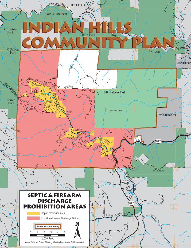
31
36
36
3131
31 32
32 32
32
10
3 2349
58
4567 8 9
97 8 8 9
4
7
12
3333 343455
6112
7
33
35
34
61
33
34
34
623
1813 17 1516
2220 2124 19
2728293025
33 343236 31
10
10
1515
15
1616
1610
17 17
17
1818
18
13
24 19 19
19 20
20 20
21
2121
22
22 22
2828
28
27 27
2729
29 29
30
30 302531 32 33 34
25 3030 29 2829
28 27 27 2635
11
1114
1423
2326
2635
Parmalee
Gulch Rd.Inca Rd.
Cameyo RdMt. Falcon Rd.
ComancheRd.
Azte
cRd
.
San Isabel Rd.
Myers Gulch Rd.
Navajo Rd.
Weiss hor n Dr.
Matterhorn
Dr. Isole ta Rd.
Kiowa Rd.Nampeyo Rd.
Sem
inole Rd.
Sa
nta Clara Rd.
Giant Gulch
Rd.
Shaw
nee
Rd. Cheyenne Rd.
Taos Rd.
S. Turkey Cre ekR
d.
N. Turkey Creek Rd.
Bear Creek Rd. IDLEDALE
MORRISON
MORRISO
285
285
HighDr.
Stanley Park Rd.
Lone Peak Dr.
Meadow
Dr.
CameyoRd
Pawnee
Rd.
West Ranch Rd.
Star
light
Dr.
High Dr.
GiantGulch Rd.
Lair O' The Bear
Mt. Falcon Park
MT. LINDO
MT. FALCON
PencePark
O'FallonPark
ParmaleeGulchPark
Dev
ils
G
ulch
GIANT GU
LCH
TINYTOWN
Bear
Creek
Canyon
Little Park
CorwinaPark
74
Indian HillsCommunity PlanIndian HillsCommunity PlanIndian HillsCommunity Plan
0
1,000 Feet
1 2 3 4 5
Septic & FirearmDischarge
Prohibition AreasSeptic Prohibition Area
Forbidden Firearm Discharge District
Source: Jefferson County Planning & Zoning Department, GIS Department
Study Area Boundary

It was moved by Commissioner FOX that the following Resolution be adopted:
BEFORE THE PLANNING COMMISSION
COUNTY OF JEFFERSON
STATE OF COLORADO
RESOLUTIONRESOLUTIONRESOLUTIONRESOLUTIONRESOLUTION
IN THE MATTER OF:
CP97-2CP97-2CP97-2CP97-2CP97-2, Adoption of the Updated Indian Hills Community Plan
The Jefferson County Planning Commission hereby APPROVES the adoption of theIndian Hills Community Plan.
Commissioner ROUSSELOT seconded the adoption of the foregoing Resolution.The Resolution was adopted by unanimous vote of the Planning Commission ofthe County of Jefferson, State of Colorado.
I, LISA J. VERNON, Executive Secretary of the Jefferson County Planning Commis-sion do hereby certify that the foregoing is a true copy of a Resolution duly adoptedby the Jefferson County Planning Commission at a regular hearing held in JeffersonCounty, Colorado, on December 3, 1997.
_____________________________________________
Lisa J. Vernon,
Executive Secretary
N
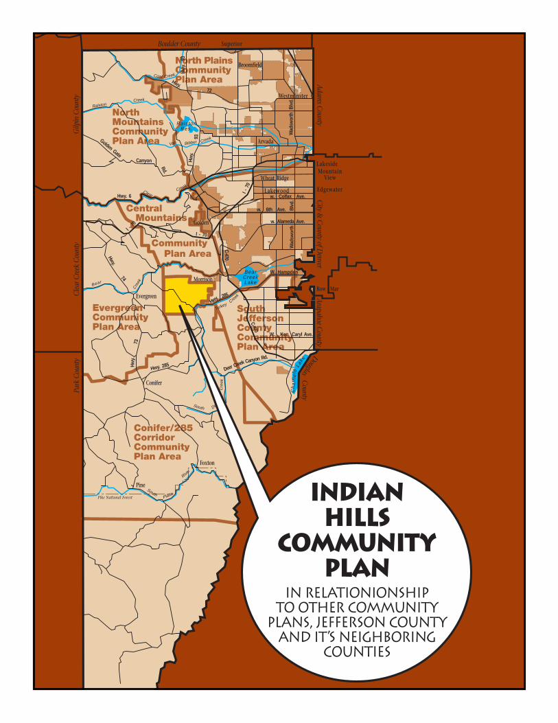
NorthMountainsCommunityPlan Area
Central Mountains
Community Plan Area
North PlainsCommunityPlan Area
SouthJeffersonCountyCommunityPlan Area
Conifer/285CorridorCommunityPlan Area
EvergreenCommunityPlan Area
Broomfield
Westminster
Arvada
Wheat Ridge
Lakewood
Golden
Morrison
Evergreen
Conifer
Foxton
Pike National Forest
River
PlatteSouth
Pine
DeerSouth
Cre
ek
Deer Creek Canyon Rd.
W.
C-470Creek
Turkey
Park
Cou
nty
Cle
ar C
reek
Cou
nty
Gilp
in C
ount
y
Boulder County
Adam
s County
City &
County of D
enverDouglas
Arapahoe C
ounty
County
Edgewater
LakesideMountain
View
Superior
Creek
Bear
Hwy.
Hwy. 285
285C
ha
t fie
ld
BearCreekLake
Lake
Ken Caryl Ave.
W. Hampden
C-470
Hwy.
73
Hwy.
74
Hwy. 6Clear
Creek
I - 70
I - 70
Golden GateCanyon
Rd.
Van CreekBibber
Ra ls tonRes.
Hwy.
93
Hwy.
93
CreekCoalHwy.
72
Wad
swor
thBl
vd.
Wad
swor
thBl
vd.
w. 6th Ave.
w. Colfax Ave.
w. Alameda Ave.
I - 7
0
Creek
Ralston
Bow Mar
IndianHills
CommunityPlan
in relationionshipto other community
plans, Jefferson Countyand it s neighboring
counties
,