jcsda and the ncep environmental modeling center · 2009-02-09 · jcsda and the ncep environmental...
TRANSCRIPT

1
JCSDA and the NCEP Environmental
Modeling Center
Stephen J. LordDirector
NCEP Environmental Modeling Center

2
Overview
• EMC Organization
• JCSDA and NCEP/EMC Activity Summary
• Summary

3
EMC Mission
In response to operational requirements:• Maintain
– the scientific correctness and integrity of operational forecast systems– modify current operational system to adapt to ever-present external changes
• Enhance numerical forecasts– Test and improve NCEP’s numerical forecast systems via
• Scientific upgrades• Tuning• Additional observations
• Transition and Develop operational numerical forecast systems– transform & integrate
• Code• Algorithms• Techniques from research status to operational status on NCEP computers

4
Air Quality
WRF NMM/ARWWorkstation WRF
WRF: ARW, NMMETA, RSM GFS, Canadian Global Model
Satellites99.9%
Regional NAMWRF NMM
North American Ensemble Forecast System
Hurricane GFDLHWRF
GlobalForecastSystem
Dispersion
ARL/HYSPLIT
Forecast
Severe Weather
Rapid Updatefor Aviation
ClimateCFS
1.7B Obs/Day
Short-RangeEnsemble Forecast
NOAA’s Integrated Model Suite
MOM3
NOAH Land Surface Model
Coupled
Global DataAssimilation
OceansHYCOM
WaveWatch III
NAM/CMAQ

5
JCSDA-NCEP/EMC Activity Summary
• Relevant JCSDA-EMC development and implementations
• Note: EMC Data Assimilation and NESDIS-JCSDA personnel are co-located

6
NCEP-JCSDA Instrument and RadiativeTransfer Development Projects 2007-09
• New observations implemented operationally at NCEP– 1 May 2007
• COSMIC• AIRS (all FOV)
– 29 May 2007• METOP AMSU, HSB, HIRS• GOES 1x1 FOV sounder radiances
– December 2007• JMA high density winds• SBUV-8
– September 2008• Windsat
– To be implemented February 2009• IASI
• Observations under development (CRTM, tested with NCEP systems)– OMI, GOME, MLS– ASCAT– AMSR-E– SSM/IS– CHAMP– AIRS (water vapor)– CrIS, ATMS
• New analysis variables (NCEP)– Constituent gas assimilation– Aerosols
• Improved radiative transfer (CRTM, tested with NCEP systems)– Surface emissivity models (MW & IR)– Cloud absorption & reflection
• Data sets tested at NCEP (albedo, vegetation, land type)– Unified land surface treatment (data assimilation, model)
METOPadvanced
instruments
NPP, NPOESSadvanced
instruments
7
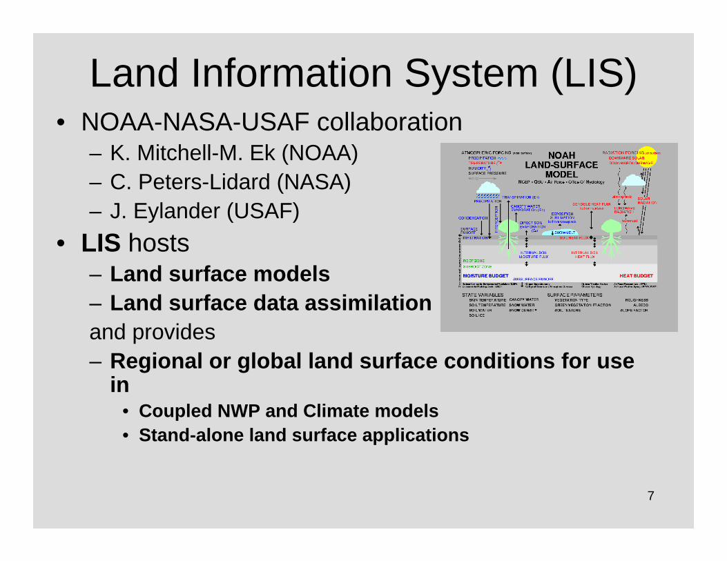
Land Information System (LIS)• NOAA-NASA-USAF collaboration
– K. Mitchell-M. Ek (NOAA)– C. Peters-Lidard (NASA)– J. Eylander (USAF)
• LIS hosts – Land surface models– Land surface data assimilationand provides– Regional or global land surface conditions for use
in • Coupled NWP and Climate models• Stand-alone land surface applications

8
JCSDA sponsoredLand Surface Improvements for NCEP LSM
• Reformulation of surface roughness length for heat in GFS PBL reduces daytime LST cold bias over desert and arid regions in the warm season.
• Results in larger amounts of satellite data accepted in the data assimilation over land in the GSI/CRTM.

9
JCSDA sponsored SST development for NCEP
Diurnal SST variabilityImproves tropical wind forecasts
Xu Li
So far, impact on tropical temperature forecasts is negative

10
NCEP Ocean Data Assimilation development involving
JCSDA sponsored work• Investigate advanced ODA techniques
– Improved observation representativeness errors (with Bob Miller, OSU-JCSDA)
– Associated Ocean Data Assimilation activities• Experimental Ensemble Data Assimilation system (with
GFDL)• Reduced Kalman filtering (with JPL)
• JASON-2 data flow (with NAVOCEANO)• Wave data assimilation proposed• Future work with GMAO, NRL
– HYCOM for real-time forecasting (NRL)– MOM4 for seasonal climate (GMAO)

11
Offline NCEP Global Aerosol Modeling System
Ho-Chun Huang, Dongchul Kim, Youhua Tang, Sarah Lu, Pius Lee, Marina Tsidulko, Caterina Tassone, Jeff McQueen,
Shrinivas Moorthi, Mark Iredell, Geoff DiMego, Paula Davidson1, Mian Chen2, Arlindo daSilva2 and Thomas Diehl2
NOAA/NWS/NCEP/EMC 1NOAA/ARL 2NASA/GSFC
JCSDA &NASA ROSES
• NCEP GFS• NASA GOCART (NASA Goddard Global
Ozone Chemistry Aerosol Radiation and Transport Model)
• Applications(1) dust modeling(2) aerosol modeling

12
PM2.5 Regional Forecast Comparison for surface stations over Texas

13
Other JCSDA-related Development impacting NCEP
• Ozone operational implementations at NCEP– SBUV version 8 and quality control (Nov.
2007,Sept. 2008)– In progress
• GOME-2• OMI• MLS and HIRDLS
• Cloudy radiances (CRTM) tested with NCEP GFS

14
CRTM Development(with NESDIS)
• EMC supporting public server for community code access to– CRTM– NCEP model and data assimilation code
• CRTM driver for offline development and testing• IASI longwave temperature channels• Upper tropospheric moisture• Spectral response functions for SSM/IS• Adoption of standard IGBP land classification (add
tundra)• Satellite footprint codes (Gayno) fundamental for
NPOESS

15
GFS Diagnostic Activities(with NRL, GMAO)
• “Dropouts Team”– Reallocated effort from EMC,
NCO (4 FTE)– Defined “dropout”– Diagnosed cases
• Runs from ECMWF IC (“ECM”) improve results often
• Impacts of satellite data show case-dependent impacts
– Diagnosed deficiencies• Sat wind QC• Bias correction and thinning of
A/C data• Diurnal bias correction• Potentially important impact of
humidity through satellite data• Negative moisture in background
model field• Augmented and correct
observations data base information
• Stimulated many new projects to correct deficiencies
Southern Hemisphere 5-day Anomaly Correlation Scores (Dropout Cases)
0.40
0.50
0.60
0.70
0.80
0.90
1.00
2008011100 2008011212 2008020300 2008030312 2008031800 2008031812 2008042512 2008042600 2008052200 2008062512
Initialization Date
GFSECMWFECM
ECMWF ops“ECM IC”NCEP ops
Cases
SH 500 hPa AC
Dropouts

16
The Gridpoint Statistical Interpolation (GSI) System
• Capabilities– Currently 3d-var– Future
• 4d-var for global, regional and hurricane applications with Situation-Dependent Background Errors (SDBE)
Or• Major component of Ensemble Data Assimilation (EnsDA)Or• Hybrid system
• Operational for– Global Forecast System (GFS) – North American Model (NAM)– Real-Time Mesoscale Analysis (RTMA)
• Major focus of NCEP/EMC and NASA/GSFC/GMAO collaborative atmospheric analysis development– GMAO 4d-var code delivered to NCEP Jan 2009

17
EMC-GMAO-STAR Code Managementfor Atmospheric Data Assimilation
Time
GMAO
EMC
* * EMC, GMAO System changeRepository change
+ Repository Merger (new tag)
* * * * * * * *
* * * * * * *
Repository
1 3Accepted changes
2
GSI & CRTM supported
Process: similar to ECMWF & Météo-Francewho have annual code mergers
Goal is for more frequent mergers (3 months)
Protocols1 – EMC, GMAO take (agreed-upon) merged
code from repository to begin work2 – EMC, GMAO incorporate developments into
repository3 – Code mergers, repository changes and
timing are NCEP’s decision
+ +
3 months

18
Summary• Satellite development projects in progress
– ASCAT– SSM/IS– GOME-2– OMI– CHAMP and add’l GPSRO– CrIS and ATMS– Cloudy radiances– Aerosols
• JCSDA sponsored development contributes to NCEP forecast skill increases
• Strong partnership in core data assimilation activities with NASA/GMAO– Potential for increased activities with AFWA and NCAR– Potential research model available with top at 600 km in 2 years
• Increased interaction with AFWA through Visiting Scientists at JCSDA
• Evaluation plan for EnsDA in progress

19
ThanksQuestions?

20
Resource Gaps (1)Current Computing Capabilities
2012 – 3X3X2XExpected computing increase in 2011
3X6.5X5XSustained performance relative to previous ops
170 TB350 TB1800 TBDisk per cluster
460832958192P6 compute processors (ops)
NCEPMet Office(Also ECMWF)
ECMWF
All systems installed within 6 months of 1/2009

21
Resource Gaps (2)Normalized Computing Capabilities
Normalized 2010 Estimated Cycles per Unit Mission
0.00
1.00
2.00
3.00
4.00
5.00
6.00
7.00
NCEP UKM ET ECM WF CM C J M A
Computing cycles (TFlop) normalized by Mission and by NCEP capability

22
Resource Gaps (3)Scientific Personnel (Meteorology)
183
9
24
19
14
7
11
5
36
8
33
24
UK Met Office (global and regional)
base
88.5 (0.5 + 8)Atmospheric dispersion and composition
6.45Maintainance of operational system (implementations)
44 (3 + 1)Postprocessing
85.591.5 (56.5 + 35)Total
6 (WRF, ESMF, NEMS)8 (7 + 1)Software infrastructure
6.86 (5 + 1)Evaluation and diagnostics
815 (10 + 5)Ensemble forecasting
0.50Convective scale NWP
6.311 (8 + 3)Model physical parameterizations
6 (NAM & GFS)4Model dynamics
17.5 [2.5 + 15 (11, 4)]18 (5 + 13)Improve use of satellite data
1712 (9 + 3)Processing, Quality Control and Data Assimilation
NCEP/EMC, JCSDA(global and regional)
base + contract combined
ECMWF (global only)
(base + contract)
Function
Major deficiencies “Resources under management” (Managed elsewhere)

23
Next generation NOAA Production Suite

24
• Increasing emphasis on multi-model ensemble approaches that build on the NCEP model suite – SREF– NAEFS– Climate Forecast System
• Entering the NPOESS era– More rapid access to
hyperspectral data– GPS soundings– Higher resolution surface
radiance data• All models run within ESMF
– Models run concurrently – Coupled– Spanning all scales– NUOPC/Unified approach
• Operational Earth System model – more explicit hydro, climate and ecosystems applications
Forces for Change
Model Region 1
Model Region 2
Global/Regional Model Domain
ESMF-based System

25
Analysis--------------
Ocean-------------
Wind Waves--------------
LSM--------------
AQ & Air Chem--------------Ens. Gen.--------------Ecosystem--------------
Etc
Physics(1,2,3)
ESMF Utilities(clock, error handling, etc)
Bias CorrectorPost processor & Product Generator
VerificationResolution change
1-11-21-32-12-22-3
ESMF Superstructure(component definitions, “mpi” communications, etc)
Multi-component ensemble+
Stochastic forcing
Coupler1Coupler2Coupler3Coupler4Coupler5Coupler6Coupler7
Etc.
Dynamics(1,2)
Application Driver
National Environmental Modeling System (NEMS)(uses standard ESMF compliant software)
* Earth System Modeling Framework (NCAR/CISL, NASA/GMAO, Navy (NRL), NCEP/EMC), NOAA/GFDL2, 3 etc: NCEP supported thru NUOPC, NASA, NCAR or NOAA institutional commitments
Components are: Dynamics (spectral, FV, NMM, FIM, ARW, FISL, COAMPS…)/Physics (GFS, NRL, NCAR, GMAO, ESRL…)
Atmospheric Model

26
NCEP Production SuiteWeather, Ocean & Climate Forecast Systems
Version 3.0 April 9, 2004
0
20
40
60
80
100
0:00 0:30 1:00 1:30 2:00 2:30 3:00 3:30 4:00 4:30 5:00 5:30 6:00
6 Hour Cycle: Four Times/Day
Perc
ent U
sed
RUCFIREWXWAVESHUR/HRWGFSfcstGFSanalGFSensETAfcstETAanalSREFAir QualityOCEANMonthlySeasonal
GD
AS
GFS anal
NA
M anal
CFS
RTOFS
SREF NAM
AQ
GFSHUR
RD
AS
Current (2007)
GENS/NAEFS
Current
NCEP Production SuiteWeather, Ocean, Land & Climate Forecast Systems

27
CFSMFS
NCEP Production SuiteWeather, Ocean & Climate Forecast Systems
Version 3.0 April 9, 2004
0
20
40
60
80
100
0:00 0:30 1:00 1:30 2:00 2:30 3:00 3:30 4:00 4:30 5:00 5:30 6:00
6 Hour Cycle: Four Times/Day
Perc
ent U
sed
RUCFIREWXWAVESHUR/HRWGFSfcstGFSanalGFSensETAfcstETAanalSREFAir QualityOCEANMonthlySeasonal
CFS & MFS
GENS/NAEFSGFS
Regional
Rap Refresh
GlobalHUR
SREF
Reforecast
Hydro / NIDIS/FF
Hydro
NAM
GDAS
RDAS
RTOFS RTOFSAQ
NCEP Production SuiteWeather, Ocean, Land & Climate Forecast Systems
AQ
Next Generation PrototypePhase 4
WAV

28
ESMFEarth System Modeling Framework

29
NCEP’s Hurricane Forecast Guidance
• GFS – T382/64L – 3-D var– Vortex relocation– State of the science physics
• GFDL– Movable nested – Air-sea coupled– Inner nest
• 9 km/42L– Specialized vortex initialization, – Upgraded with some GFS physics (2003, 2004)
• HWRF added to GFDL in 2007– Same physics as GFDL– Upgrade to improve intensity, June 2008

30
Real Time Ocean Forecasting• Wave Modeling
– Global and Regional– Unified model approach– NOAA Wavewatch III
• Basin-scale Ocean Model• Sea Surface Temperature & Winds
– NCEP Ocean Prediction Center support• Gulfstream analysis & forecast
• Real-time Sea Ice products– Alaska Region support (fishing)

31
ClimateForecastSystem(CFS)
Ocean ModelMOMv3
quasi-global1ox1o (1/3o in tropics)
40 levels
Atmospheric ModelGFS (2003)
T6264 levels
Seasonal to Interannual Prediction at NCEP
GODAS3DVAR
XBTTAO etc
ArgoSalinity (syn.)
(TOPEX/Jason-1)
Reanalysis-23DVART62L28
update of theNCEP-NCAR R1
D. Behringer

32
Overview
• Evolutionary combination of the global SSI analysis system and the regional ETA 3DVAR– Major code re-design– New features
• Uses a grid space definition of the background errors – Allows use of situation dependent background
errors
• Final testing for Global Forecast System (GFS)

33
GSI analysis system• Code re-designed for community use
– F90/95 structures and utilities– Improved efficiency
• Re-designed data distribution• Some OpenMP
– Better documentation– Improved portability
• Less dependency on IBM• Currently 32 registered groups/users
– NCEP providing only minimal support for external groups due to lack of resources
• Major focus of NCEP and NASA/GSFC/GMAO atmospheric analysis development– To date they have provided the most updates

34
GSI analysis system
• Incorporated new features– Variational QC available– Spatial derivatives – allows:
• non-local operators• improved definition of balance operators• dynamical balance constraints• simplified 4DVAR
– Improved control over observational errors– Improved moisture analysis variable – Diagnostic files for background and each outer
iteration

35
GSI analysis system
• Incorporated new features (cont.)– Strong and weak dynamical constraints– Adjoint and TL of GSI (GMAO)– Additional observational data
• Precipitable water• Radar radial winds (w or w/o superobs)• GPS RO (COSMIC, CHAMP)• Additional satellite radiances

36
GSI analysis system
• Incorporated new features (cont.)– Situation dependent background error available
for some modes of operation (RTMA)– Available for use in all WRF dynamical cores– New version of Community Radiative Transfer
Model (CRTM) – Improved memory usage and documentation
• Multi-organizational code management
37
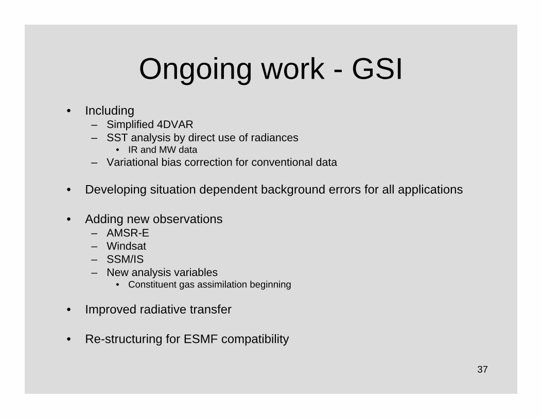
Ongoing work - GSI• Including
– Simplified 4DVAR– SST analysis by direct use of radiances
• IR and MW data– Variational bias correction for conventional data
• Developing situation dependent background errors for all applications
• Adding new observations– AMSR-E– Windsat– SSM/IS – New analysis variables
• Constituent gas assimilation beginning
• Improved radiative transfer
• Re-structuring for ESMF compatibility

38
Ongoing work – Simplified 4DVAR
• Adiabatic time derivatives– Filtered to retain “slow” modes– Used to extrapolate state to obs times– Captures obs time changes due to slow
modes• No additional cost since calculations
already included in constraint term

39
Summary• GSI analysis system
– One possibility for NCEP’s next-generation data assimilation system
– Evolutionary path– Many new features have not yet been exercised
• Variational QC• New CRTM
– New observations capability– Used by community
• Global• WRF

40
From Bias correction (NCEP, CMC)Dual-resolution (NCEP only)Down-scaling (NCEP, CMC)Combination of NCEP and CMC
NAEFS final products
NCEP/GEFS raw forecast
8+ days gain

41
Weather Research and Forecast (WRF) Modeling System
Promote closer ties between research and operationsDevelop an advanced mesoscale forecast and assimilation system
Concept:
Design for 1-10 km horizontal gridsPortable and efficient on parallel computersWell suited for a broad range of applicationsCommunity model with direct path to operationsCollaborators: NCEP/EMC, NCAR, AFWA, Navy, NOAA/ESRL, U. Okla.

42
Observed Composite Reflectivity
Courtesy Kain, Weiss & Bright
NMM4 ARW4
Circles denote locations of rotating updrafts where updraft helicity is at least 50 m2s-2
Spring Program 2007
43
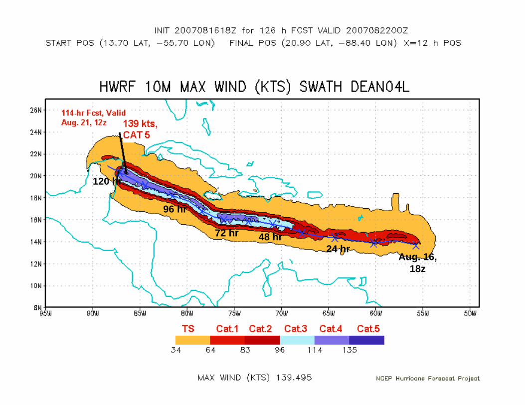
Aug. 16, 18z
24 hr48 hr72 hr
96 hr
120 hr

44
LIS Capabilities
• Flexible choice of 7 different land models– Includes Noah LSM used operationally by NCEP and AFWA– Includes NASA Catchment model used by GMAO
• Flexible domain and grid choice– Global: such as NCEP global model Gaussian grid– Regional: including very high resolution (~.1-1 km)
• Data Assimilation– Based on Kalman Filter approaches
• High performance parallel computing– Scales efficiently across multiple CPUs
• Interoperable and portable– Executes on several computational platforms– NCEP and AFWA computers included
• Being coupled to NWP & CRTM radiative transfer models– Coupling to WRF model has been demonstrated– Coupling to NCEP global GFS model is under development– Coupling to JCSDA CRTM radiative transfer model is nearing completion
• Next-gen AFWA AGRMET model will utilize LIS with Noah• NCEP’s Global Land Data Assimilation utilizes LIS

45
Collaborative Software Development• GSI intended for both operations and research applications
– Community-based code with multi-agency users• Code Management
– Minimize redundant development– Establish code development standards and procedures
• Principal Code Manager (EMC)• Associate Code Manager (partners)• Criteria for accepting code updates • Code managed by subversion repository
– Establish areas of responsibility and milestones among partners– Technical oversight group, representatives from
• EMC• GMAO• GSD (Boulder)• AFWA
• Example: EMC-GMAO collaboration– Same code for operations (EMC) and research (GMAO)– Bi-weekly progress at group meetings– GMAO: 4d-var infrastructure– EMC+JCSDA: adding capabilities for new satellite data– Quarterly code mergers

46
Summary• Focused on Multi-disciplinary Environmental
Forecasting (atmosphere, ocean, land surface, cryosphere)
• Increased community involvement (R2O, O2R)• Strong partnerships in core data assimilation
activities with NASA/GMAO– Potential for increased activities with NCAR (July
meeting)– Potential research model available with top at 600
km in 2 years• Preparing for future with next-generation
Production Schedule and ensemble-basedproducts