january 27, 2020
TRANSCRIPT
January 27, 2020 Mr. Ron Bales Manager, Environmental Policy Office Indiana Department of Transportation (INDOT) Environmental Services Division 100 North Senate Avenue, Room N642 Indianapolis, Indiana 46204 Re: Finding of No Significant Impact (FONSI) Request
Des. Numbers 1601072, 1901655, and 1901657 US 36 Added Travel Lanes Project Avon, Hendricks and Marion Counties, Indiana
Dear Mr. Bales, We are requesting the review of the attached information packet for preparation of the FONSI for the US 36 Added Travel Lanes Project (Des. Numbers 1601072, 1901655, and 1901657). This is pursuant to 40 CFR, Part 1500.4(q) and paragraph 5 of the Department of Transportation (DOT) Order 5610.1C for implementation of the National Environmental Policy Act (NEPA) of 1969. The attached information packet includes the following documents:
A. Approved Environmental Assessment (EA) (text only, supporting graphics omitted) B. Certification of Public Involvement C. Responses to Public Hearing Comments D. Section 106 Information (text only, supporting graphics omitted) E. Project Commitments
On August 12, 2019, the Environmental Assessment (EA) was released for public involvement by the Federal Highway Administration (FHWA) (Attachment A, page A-1). The public hearing was held on September 19, 2019. Certification of Public Involvement was received by INDOT on October 9, 2019 (Attachment B, page B-1). During the public hearing comment period, which commenced on September 4, 2019 and concluded on October 7, 2019, six comments were received from the public and the U.S. Environmental Protection Agency (USEPA). The concerns associated with the proposed project generally included safety (lack of pedestrian bridge over US 36 to connect pedestrian trails, construction activities occurring near areas where children congregate, and wider roads causing more dangerous conditions), management of stormwater during future heavy rain events, noise impacts for adjacent properties due to increased traffic, and reduced air quality due to diesel emissions from construction equipment. Other general concerns included improving traffic light timing and lack of additional travel lanes near the project area. For a detailed listing of the comments received and the responses to them, refer to Attachment C, pages C-1 to C-4.
Page 2
Cultural Resources INDOT Cultural Resources Office (CRO), acting on behalf of FHWA, issued a No Adverse Effect finding on March 18, 2019. On April 12, 2019, the State Historic Preservation Officer (SHPO) concurred with the No Adverse Effect finding. No consulting parties commented on the finding or the supporting documentation (Attachment D, pages D-1 to D-17). In accordance with 36 CFR 800.2(d), 800.3(e), and 800.6(a)(4), the views of the public were sought regarding the No Adverse Effect finding. A public notice was advertised in the Indianapolis Star on March 21, 2019. The notice stated the documentation supporting the No Adverse Effect finding was available for review at the office of RQAW, and electronically on INDOT’s Section 106 document posting website, IN SCOPE. Public comments were accepted for 30 days which concluded on April 20, 2019. No public comments were received. The Section 106 process is complete and the responsibilities of INDOT, acting on behalf of FHWA under Section 106, are fulfilled. Environmental Commitments There are 11 commitments listed as Firm and 26 commitments listed as For Further Consideration in the EA (Attachment E, pages E-1 to E-3). Two additional commitments have been incorporated since the EA was released for public involvement:
1. Construction vehicles and equipment, including staging areas and construction routes, will avoid the Coronado KinderCare Daycare located approximately 340 feet northeast of the project area.
2. Idling of construction vehicles will not exceed five minutes.
Changes to the project design have not occurred since the EA was released for public involvement. Upon the satisfactory review of this FONSI request information packet, we ask that INDOT forward the attached information to the FHWA and request they prepare the necessary FONSI to complete the NEPA process. If you have any questions regarding this matter, please contact Jaime Byerly at 317-588-1798 or at [email protected]. Thank you in advance. Sincerely,
Jaime Byerly NEPA Specialist RQAW Attachments:
A. Approved Environmental Assessment (text only) (pages 1 to 44) B. Certification of Public Involvement (pages 1 to 50) C. Responses to Public Hearing Comments (pages 1 to 4) D. Section 106 Information (text only) (pages 1 to 17) E. Project Commitments (pages 1 to 3)

Attachment A Approved Environmental Assessment (EA)
(text only)

Des. Numbers 1601072, 1901655 & 1901657 Approved Environmental Assessment A-1

Indiana Department of Transportation
County Hendricks and Marion
Route US 36/Rockville Road
Des. No. 1601072, 1901655, 1901657
This is page 2 of 44 Project name: US 36/Rockville Road Added Travel Lanes Project Date:
August 5, 2019
Form Version: June 2013
Attachment 2
Part I - PUBLIC INVOLVEMENT
Every Federal action requires some level of public involvement, providing for early and continuous opportunities throughout the project development process. The level of public involvement should be commensurate with the proposed action.
Yes No Does the project have a historic bridge processed under the Historic Bridges PA*? X
If No, then:
Opportunity for a Public Hearing Required? X
*A public hearing is required for all historic bridges processed under the Historic Bridges Programmatic Agreement between INDOT, FHWA, SHPO, and the ACHP. Discuss what public involvement activities (legal notices, letters to affected property owners and residents (i.e. notice of entry), meetings, special purpose meetings, newspaper articles, etc.) have occurred for this project.
Remarks: The project has included several public involvement efforts. These efforts include Notice of Entry for Survey or Investigation letters, a Section 106 legal notice, a public information meeting, and a Community Advisory Committee (CAC) meeting. A public hearing will also be held prior to the issuance of the Finding of No Significant Impact (FONSI). The public involvement activities to date are summarized below. Notice of Entry for Survey or Investigation Letters Notice of Entry letters were mailed to potentially affected property owners near the project area on September 20, 2018 notifying them about the project and that individuals responsible for land surveying and field activities may be seen in the area (Appendix F, pages F‐1 to F‐3). Section 106 Public Notice To meet the public involvement requirements of Section 106, FHWA’s finding of No Adverse Effect, a notice was advertised in the Indianapolis Star on March 21, 2019. The public comment period closed 30 days later on April 20, 2019. No public comments were received. The text of the public notice and the affidavit of publication appear in Appendix C, pages C‐78 to C‐80. Public Information Meeting Invitation letters were mailed to nearby property owners on September 11, 2018 (Appendix F, pages F‐4 to F‐7). A public information meeting was held on October 2, 2018 at the Avon Town Hall located at 6570 East US 36 in Avon. The doors opened at 5:30 pm and the presentation began at 6:00 pm. A sign‐in sheet was offered, and the public was provided an informational handout upon signing in (Appendix F, pages F‐8 to F‐12). The project was introduced to the public, and the purpose and need, preliminary design plans, project schedule, maintenance of traffic, and environmental process were described (Appendix F, pages F‐13 to F‐22). Meeting participants were asked to discuss their concerns and provide written comments on the project. Oral comments/questions were received and generally pertained to maintenance of traffic during construction and the construction time frame. Generally, written comments/questions pertained to sequencing of traffic lights, use of U‐turns at intersections, installing frontage roads along US 36, and “personalizing” US 36 within the project area (Appendix F, pages F‐23 to F‐28). During the meeting, interested CAC volunteers were asked to sign up and provide contact details for upcoming meeting(s) (Appendix F, page F‐29). CAC Meeting The CAC is comprised of a small group of volunteers representing a broad segment of the population within an affected community. The CAC provides opportunities for citizens and other interested groups to participate in current transportation planning efforts such as the preliminary design, environmental studies, maintenance
Des. Numbers 1601072, 1901655 & 1901657 Approved Environmental Assessment A-2
Indiana Department of Transportation
County Hendricks and Marion
Route US 36/Rockville Road
Des. No. 1601072, 1901655, 1901657
This is page 3 of 44 Project name: US 36/Rockville Road Added Travel Lanes Project Date:
August 5, 2019
Form Version: June 2013
Attachment 2
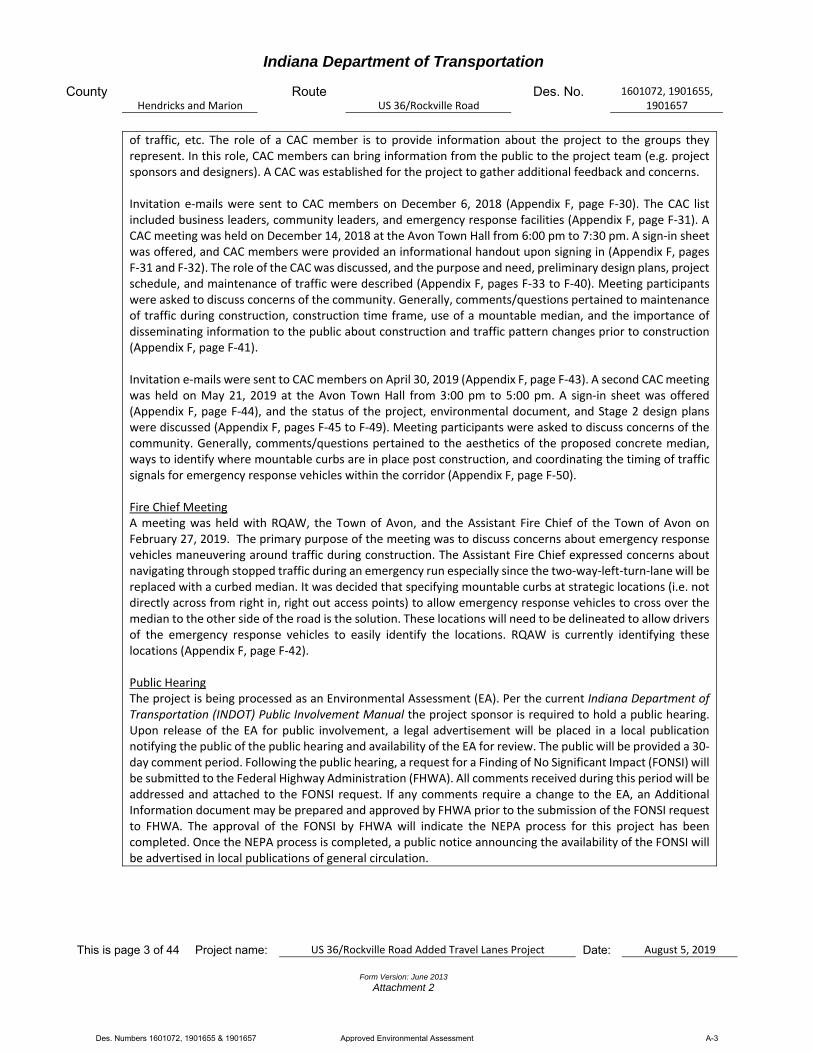
of traffic, etc. The role of a CAC member is to provide information about the project to the groups they represent. In this role, CAC members can bring information from the public to the project team (e.g. project sponsors and designers). A CAC was established for the project to gather additional feedback and concerns. Invitation e‐mails were sent to CAC members on December 6, 2018 (Appendix F, page F‐30). The CAC list included business leaders, community leaders, and emergency response facilities (Appendix F, page F‐31). A CAC meeting was held on December 14, 2018 at the Avon Town Hall from 6:00 pm to 7:30 pm. A sign‐in sheet was offered, and CAC members were provided an informational handout upon signing in (Appendix F, pages F‐31 and F‐32). The role of the CAC was discussed, and the purpose and need, preliminary design plans, project schedule, and maintenance of traffic were described (Appendix F, pages F‐33 to F‐40). Meeting participants were asked to discuss concerns of the community. Generally, comments/questions pertained to maintenance of traffic during construction, construction time frame, use of a mountable median, and the importance of disseminating information to the public about construction and traffic pattern changes prior to construction (Appendix F, page F‐41). Invitation e‐mails were sent to CAC members on April 30, 2019 (Appendix F, page F‐43). A second CAC meeting was held on May 21, 2019 at the Avon Town Hall from 3:00 pm to 5:00 pm. A sign‐in sheet was offered (Appendix F, page F‐44), and the status of the project, environmental document, and Stage 2 design plans were discussed (Appendix F, pages F‐45 to F‐49). Meeting participants were asked to discuss concerns of the community. Generally, comments/questions pertained to the aesthetics of the proposed concrete median, ways to identify where mountable curbs are in place post construction, and coordinating the timing of traffic signals for emergency response vehicles within the corridor (Appendix F, page F‐50). Fire Chief Meeting A meeting was held with RQAW, the Town of Avon, and the Assistant Fire Chief of the Town of Avon on February 27, 2019. The primary purpose of the meeting was to discuss concerns about emergency response vehicles maneuvering around traffic during construction. The Assistant Fire Chief expressed concerns about navigating through stopped traffic during an emergency run especially since the two‐way‐left‐turn‐lane will be replaced with a curbed median. It was decided that specifying mountable curbs at strategic locations (i.e. not directly across from right in, right out access points) to allow emergency response vehicles to cross over the median to the other side of the road is the solution. These locations will need to be delineated to allow drivers of the emergency response vehicles to easily identify the locations. RQAW is currently identifying these locations (Appendix F, page F‐42). Public Hearing The project is being processed as an Environmental Assessment (EA). Per the current Indiana Department of Transportation (INDOT) Public Involvement Manual the project sponsor is required to hold a public hearing. Upon release of the EA for public involvement, a legal advertisement will be placed in a local publication notifying the public of the public hearing and availability of the EA for review. The public will be provided a 30‐day comment period. Following the public hearing, a request for a Finding of No Significant Impact (FONSI) will be submitted to the Federal Highway Administration (FHWA). All comments received during this period will be addressed and attached to the FONSI request. If any comments require a change to the EA, an Additional Information document may be prepared and approved by FHWA prior to the submission of the FONSI request to FHWA. The approval of the FONSI by FHWA will indicate the NEPA process for this project has been completed. Once the NEPA process is completed, a public notice announcing the availability of the FONSI will be advertised in local publications of general circulation.
Des. Numbers 1601072, 1901655 & 1901657 Approved Environmental Assessment A-3
Indiana Department of Transportation
County Hendricks and Marion
Route US 36/Rockville Road
Des. No. 1601072, 1901655, 1901657
This is page 4 of 44 Project name: US 36/Rockville Road Added Travel Lanes Project Date:
August 5, 2019
Form Version: June 2013
Attachment 2
Public Controversy on Environmental Grounds Yes No Will the project involve substantial controversy concerning community and/or natural resource impacts? X
Remarks: Currently, there is no substantial public controversy concerning impacts to the or to natural resources.
Part II - General Project Identification, Description, and Design Information
Sponsor of the Project: Indiana Department of Transportation INDOT District: Crawfordsville
Local Name of the Facility: US 36 (Rockville Road)
Funding Source (mark all that apply): Federal X State X Local Other*
*If other is selected, please identify the funding source:
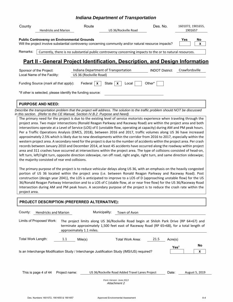
PURPOSE AND NEED:
Describe the transportation problem that the project will address. The solution to the traffic problem should NOT be discussed in this section. (Refer to the CE Manual, Section IV.B.2. Purpose and Need)
The primary need for the project is due to the existing level of service motorists experience when traveling through the project area. Two major intersections (Ronald Reagan Parkway and Raceway Road) are within the project area and both intersections operate at a Level of Service (LOS) of E (unstable flow, operating at capacity) during AM and PM peak hours. Per a Traffic Operations Analysis (EMCS, 2018), between 2016 and 2017, traffic volumes along US 36 have increased approximately 2.5% which is likely due to new developments within the corridor from 2016 to 2017, especially within the western project area. A secondary need for the project is due to the number of accidents within the project area. Per crash records between January 2010 and December 2014, at least 45 accidents have occurred along the roadway within project area and 311 crashes have occurred at intersections within the project area. The type of collisions consisted of head‐on, left turn, left/right turn, opposite direction sideswipe, ran off road, right angle, right turn, and same direction sideswipe; the majority consisted of rear end collisions. The primary purpose of the project is to reduce vehicular delays along US 36, with an emphasis on the heavily congested portion of US 36 located within the project area (i.e. between Ronald Reagan Parkway and Raceway Road). Post construction (design year 2041), the LOS is anticipated to improve to a LOS of D (approaching unstable flow) for the US 36/Ronald Reagan Parkway Intersection and to a LOS of C (stable flow, at or near free flow) for the US 36/Raceway Road Intersection during AM and PM peak hours. A secondary purpose of the project is to reduce the crash rate within the project area.
PROJECT DESCRIPTION (PREFERRED ALTERNATIVE):
County: Hendricks and Marion Municipality: Town of Avon
Limits of Proposed Work: The project limits along US 36/Rockville Road begin at Shiloh Park Drive (RP 64+67) and
terminate approximately 1,500 feet east of Raceway Road (RP 65+68), for a total length of approximately 1.1 miles.
Total Work Length: 1.1 Mile(s) Total Work Area: 21.5 Acre(s)
Yes1
No
Is an Interchange Modification Study / Interchange Justification Study (IMS/IJS) required? X
Des. Numbers 1601072, 1901655 & 1901657 Approved Environmental Assessment A-4
Indiana Department of Transportation
County Hendricks and Marion
Route US 36/Rockville Road
Des. No. 1601072, 1901655, 1901657
This is page 5 of 44 Project name: US 36/Rockville Road Added Travel Lanes Project Date:
August 5, 2019
Form Version: June 2013
Attachment 2
If yes, when did the FHWA grant a conditional approval for this project? Date: 1If an IMS or IJS is required; a copy of the approved CE/EA document must be submitted to the FHWA with a request for final approval of the IMS/IJS.
In the remarks box below, describe existing conditions, provide in detail the scope of work for the project, including the preferred alternative. Include a discussion of logical termini. Discuss any major issues for the project and how the project will improve safety or roadway deficiencies if these are issues.
The Federal Highway Administration (FHWA) and the INDOT Crawfordsville District propose to proceed with an added travel lanes project located on US 36, known locally as Rockville Road, through the Town of Avon in Hendricks and Marion counties, Indiana. The project limits on US 36 extend east from Shiloh Park Drive (RP 64+67) to approximately 1,500 feet east of Raceway Road (65+68), for a total length of approximately 1.1 miles. The termini for the project are logical because this portion of US 36 (i.e. between Ronald Reagan Parkway and Raceway Road) is, overall, a heavily congested portion of the US 36 corridor. Project limits extend approximately 1,500 feet east of Raceway Road to fully incorporate the proposed left‐turn‐lane for both east and westbound traffic at the US 36/Raceway Road Intersection. The project is within Washington Township (Hendricks County), Wayne Township (Marion County), Clermont U.S. Geological Survey (USGS) Quadrangle, Township 15 North, Range 2 East, and Sections 4, 5, 8 and 9. The project area is in a developed area surrounded by residential and commercial properties (Appendix A, pages A‐1 to A‐5). Existing Conditions: US 36 is functionally classified as a Principal Arterial. US 36, within the project area (i.e. between Ronald Reagan Parkway and Raceway Road), is a heavily congested portion of the overall US 36 corridor. Within the project area, US 36 generally consists of two 12‐foot wide travel lanes, one 16‐foot wide two‐way center left‐turn lane and up to 11‐foot wide paved shoulders for east and westbound directions. A discontinuous 12‐foot wide right‐turn lane is present at the intersection approaches within project area. Existing drainage within the project area is adequate. Existing roadway drainage is handled via a combination of open ditches, driveway/approach pipe culverts (generally 15 to 30 inches in diameter) and an enclosed drainage system consisting of roadway inlets and yard catch basins. Within the project area, the existing right‐of way width along US 36 varies from approximately 75 to 135 from the roadway centerline. Existing 10‐foot wide trails are located north of US 36, both east and west of Ronald Reagan Parkway; both trails are part of the Ronald Reagan Parkway Corridor (Appendix A, pages A‐3 to A‐5). Preferred Alternative: The preferred alternative will involve milling, resurfacing and widening the existing US 36 roadway (Des. Number 1601072). The proposed cross section will consist of one continuous 11‐foot wide travel lane and two continuous 12‐foot wide travel lanes with a discontinuous 11‐foot wide right‐turn‐lane bordered by curb and gutter with a 2‐foot offset for east and westbound directions. An 11‐foot wide left‐turn‐lane will be provided at each signalized intersection for east and westbound directions. The existing curb ramps in the northeast and northwest quadrants of the US 36/Ronald Reagan Parkway Intersection will be replaced to meet Americans with Disabilities (ADA) requirements. The portion of roadway between the curb ramps will be striped to indicate a trail crossing. An at‐grade pedestrian crossing, and median pedestrian refuge will be installed at the US 36 and Ronald Reagan Parkway Intersection to connect the existing trail located north of US 36, along the west side of Ronald Reagan Parkway, to the proposed trail located south of US 36, along the west side of Ronald Reagan Parkway (Des. Number 1601121). Des. Number 1601121 will be constructed by the Town of Avon prior to this added travel lanes project (Des. Number 1601072); therefore, coordination between both designers has been occurring during design of both projects. Des. Number 1601121 will terminate just south of the added travel lanes project; the added travel lanes project will fill in this gap by constructing the remainder of the trail to provide connectivity of the trail along both sides of US 36. Four curb ramps will be constructed (two in the median pedestrian refuge, one north of the median pedestrian refuge, and one south of the median pedestrian refuge). The portion of roadway between these four curb ramps will be striped to indicate a trail crossing. There is no existing curb ramp in the southeast quadrant of the US 36/Ronald Reagan Parkway Intersection. This project will not include installation of a new curb ramp at this location as there are no pedestrian facilities in this quadrant. Per coordination with the Town of Avon
Des. Numbers 1601072, 1901655 & 1901657 Approved Environmental Assessment A-5

Indiana Department of Transportation
County Hendricks and Marion
Route US 36/Rockville Road
Des. No. 1601072, 1901655, 1901657
This is page 6 of 44 Project name: US 36/Rockville Road Added Travel Lanes Project Date:
August 5, 2019
Form Version: June 2013
Attachment 2
Assistant Fire Chief, mountable curbs (i.e. rolling curbs) will be installed at strategic locations to allow emergency response vehicles to cross over the median to the other side of the road. RQAW is currently identifying these locations and these locations will be incorporated into the final design plans. Existing traffic signals will also be replaced (Des. Number 1901655). The existing horizontal alignment of US 36 will remain unchanged. The profile grade will match the existing profile grade. Because of the widened roadway, drainage will be addressed. Where needed, existing driveway/approach drainage pipe culverts will be replaced, some structures will have a larger diameter. Curb turnouts with ditches and driveway/approach pipe culverts are proposed to handle drainage between Shiloh Park Drive and Raceway Road. Between Raceway Road and the east end of the project, an enclosed drainage system is proposed to match the existing drainage system; some inlets may be moved farther from the road in this section. Work to the existing 36‐inch diameter corrugated metal pipe (CMP) east of the US 36/Ronald Reagan Parkway Intersection (identified as Structures 26 and 27 on current plan sheets) will involve extending the length of the pipe approximately 11 feet north of US 36 and approximately 17 feet south of US 36. Work to Structure CV 036‐032‐64.80 that conveys Avon Creek under US 36 will involve extending the length of the pipe approximately 10 feet north of US 36 and approximately 22 feet south of US 36 (Des. Number 1901657) (Appendix A, pages A‐45 to A‐49). Within the project area, an additional travel lane will be added in each direction (eastbound and westbound) which will reduce delays along the corridor. Within the project area, left turn lanes will be extended the length of the through lane queue to allow for left turning vehicles to move out of the through lane into the left turn lane. Within the project area, a raised median will be constructed to prevent vehicles from turning left across traffic. Per an Interactive Highway Safety Design Model (IHSDM) analysis, the inclusion of an additional through travel lane in each direction and the addition of a raised median is predicted to reduce the crash within the project area by 45%. The maximum depth of excavation will be up to approximately eight feet below ground surface (bgs). Approximately 0.20 acre of permanent right‐of‐way and 0.45 acre of temporary right‐of‐way will be required for the project. No residences or businesses will be relocated. Construction will be phased, and two lanes of traffic will always be maintained in each direction. Access to all properties will be maintained during construction (Appendix A, pages A‐22 to A‐44). Refer to the Maintenance of Traffic (MOT) During Construction section of this document for further details on the proposed MOT. The estimated project cost is $9,414,000 (fiscal year [FY] 2021). The project is currently scheduled to let in early 2021 with construction anticipated to begin in the spring of 2021. This project demonstrates independent utility because it is a “stand alone” project; it is not an interdependent part of a larger action and it does not require prior or simultaneous actions to be taken for this project to proceed. The project has been designed to specifically reduce vehicular delays and crash rates within the project area. The project can be constructed regardless if any other projects are currently or will be planned in the area. Post construction, traffic is not expected to back up west of the project area. Per coordination with the project designer, an entire traffic analysis and simulation was developed to determine the optimum location to eliminate the third westbound lane. The preferred alternative satisfies the purpose and need of the project by reducing vehicular delays along US 36, with an emphasis on the heavily congested portion of US 36 located within the project area (i.e. between Ronald Reagan Parkway and Raceway Road) via improving the LOS at both intersections and reducing the crash rate within the project area and at both intersections.
Des. Numbers 1601072, 1901655 & 1901657 Approved Environmental Assessment A-6

Indiana Department of Transportation
County Hendricks and Marion
Route US 36/Rockville Road
Des. No. 1601072, 1901655, 1901657
This is page 7 of 44 Project name: US 36/Rockville Road Added Travel Lanes Project Date:
August 5, 2019
Form Version: June 2013
Attachment 2
OTHER ALTERNATIVES CONSIDERED:
Describe all discarded alternatives, including the Do-Nothing Alternative and an explanation of why each discarded alternative was not selected.
Do Nothing Alternative: This alternative would not involve any improvements to the existing roadway. This alternative would require no additional permanent or temporary right‐of‐way, not involve any cost, and would not result in any impacts to the surrounding environment. The Do Nothing Alternative would not reduce vehicular delays or crash rates within the project area. This alternative does not meet the purpose and need of the project and was therefore dismissed from further consideration. Added Travel Lanes from CR 900 East to 1,500 feet east of Raceway Road with Dual Left Turn Lanes at Ronald Reagan Parkway and Raceway Road: This alternative would involve adding travel lanes from CR 900 East and to 1,500 feet east of Raceway Road. Dual left turn lanes would be added at Ronald Regan Parkway and Raceway Road. This alternative would address the purpose and need of the project via reducing vehicular delays at the Ronald Reagan Parkway and Raceway Road intersections; however, this alternative would involve greater wetland impacts at the Ronald Regan Parkway intersection and result in higher costs that exceed the programmed budget. There would not be any other increased impacts over the preferred alternative. In addition, the traffic operation analysis report demonstrates that the US 36/Ronald Reagan Parkway and US 36/Raceway Road intersections would continue to operate at an acceptable LOS of D (approaching unstable flow) with a single left turn lane along the US 36 eastbound and westbound approaches through 2041. Therefore, this alternative was not selected. No other alternatives were considered.
The Do Nothing Alternative is not feasible, prudent or practicable because (Mark all that apply): It would not correct existing capacity deficiencies; X
It would not correct existing safety hazards; X
It would not correct the existing roadway geometric deficiencies;
It would not correct existing deteriorated conditions and maintenance problems; or
It would result in serious impacts to the motoring public and general welfare of the economy.
Other (Describe)
ROADWAY CHARACTER:
US 36/Rockville Road
Functional Classification: Urban Principal Arterial
Current ADT: 44,398 VPD (2021) Design Year ADT: 48,838 VPD (2041) Design Hour Volume (DHV): 4,900 Truck Percentage (%) 4
Designed Speed (mph): 45 Legal Speed (mph): 45
Existing Proposed
Number of Lanes: 3‐5 8‐10
Type of Lanes:
Two 12‐foot wide travel lanes One 16‐foot wide center two‐way left turn lane Two 12‐foot wide right turn lanes (various locations)
Four 12‐foot wide travel lanes Two 11‐foot wide travel lanes Two 11‐foot wide center left turn lanes Two 11‐foot wide right turn lanes (various locations)
Pavement Width: 40‐64 ft. 92‐114 ft. Shoulder Width: 11 ft. N/A ft.
Des. Numbers 1601072, 1901655 & 1901657 Approved Environmental Assessment A-7

Indiana Department of Transportation
County Hendricks and Marion
Route US 36/Rockville Road
Des. No. 1601072, 1901655, 1901657
This is page 8 of 44 Project name: US 36/Rockville Road Added Travel Lanes Project Date:
August 5, 2019
Form Version: June 2013
Attachment 2
Median Width: 4 ft. 7 ft. Sidewalk Width: 0 ft. 0 ft.
Setting: X Urban Suburban Rural Topography: X Level Rolling Hilly
This project will not require any work to Ronald Reagan Parkway or Raceway Road. As such, some of the below design data is not available (N/A). Ronald Reagan Parkway
Functional Classification: Principal Arterial
Current ADT: N/A VPD (20xx) Design Year ADT: N/A VPD (20xx) Design Hour Volume (DHV): N/A Truck Percentage (%) N/A
Designed Speed (mph): N/A Legal Speed (mph): 45
Existing Proposed
Number of Lanes: 7 Same as existing (N/A)
Type of Lanes: Four 12‐foot wide travel lanes Two 12‐foot wide left turn lanes One 12‐foot wide right turn lane
N/A
Pavement Width: 72 ft. N/A ft. Shoulder Width: 0 ft. N/A ft. Median Width: 0 ft. N/A ft. Sidewalk Width: 0 ft. N/A ft.
Setting: X Urban Suburban Rural Topography: X Level Rolling Hilly
Raceway Road
Functional Classification: Minor Arterial
Current ADT: N/A VPD (20xx) Design Year ADT: N/A VPD (20xx) Design Hour Volume (DHV): N/A Truck Percentage (%) N/A
Designed Speed (mph): N/A Legal Speed (mph): 40
Existing Proposed
Number of Lanes: 5 Same as existing (N/A)
Type of Lanes: Three 12‐foot wide travel lanes One 12‐foot wide way left turn lane One 12‐foot wide right turn lane
N/A
Pavement Width: 60 ft. N/A ft. Shoulder Width: 0 ft. N/A ft. Median Width: 0 ft. N/A ft. Sidewalk Width: 0 ft. N/A ft.
Setting: X Urban Suburban Rural Topography: X Level Rolling Hilly
Des. Numbers 1601072, 1901655 & 1901657 Approved Environmental Assessment A-8

Indiana Department of Transportation
County Hendricks and Marion
Route US 36/Rockville Road
Des. No. 1601072, 1901655, 1901657
This is page 9 of 44 Project name: US 36/Rockville Road Added Travel Lanes Project Date:
August 5, 2019
Form Version: June 2013
Attachment 2
DESIGN CRITERIA FOR BRIDGES:
Structure/NBI Number(s):
N/A Sufficiency
Rating:
N/A
(Rating, Source of Information)
Existing Proposed Bridge Type: 192‐inch concrete arch top
box culvert N/A
Number of Spans: 1 1
Weight Restrictions: N/A ton N/A ton Height Restrictions: N/A ft. N/A ft. Curb to Curb Width: N/A ft. N/A ft. Outside to Outside Width: N/A ft. N/A ft. Shoulder Width: N/A ft. N/A ft. Length of Channel Work: N/A ft.
Describe bridges and structures; provide specific location information for small structures.
Remarks:
No bridges are located within the project area. A 192‐inch concrete arch top box culvert (unknown structure number and not given a structure number on current plan sheets) transports Avon Creek under Shiloh Crossing Drive, north of US 36 and west of the US 36/Ronald Reagan Parkway Intersection. This structure is located within the construction limits; however, it will not be modified per this project (Appendix A, page A‐46). Work will be restricted to Shiloh Crossing Drive and will not impact Avon Creek.
Yes No N/A Will the structure be rehabilitated or replaced as part of the project? X
If the proposed action has multiple bridges or small structures, this section should be filled out for each structure.
Structure/NBI Number(s):
CV 036‐032‐64.80 Sufficiency
Rating:
Condition Rating 7 (INDOT Culvert Inspection Report, dated December 24, 2015) (Appendix
H, page H‐7)
(Rating, Source of Information)
Existing Proposed Bridge Type: 108‐inch diameter CMP 108‐inch diameter CMP
Number of Spans: 1 1
Weight Restrictions: N/A ton N/A ton Height Restrictions: N/A ft. N/A ft. Curb to Curb Width: N/A ft. N/A ft. Outside to Outside Width: N/A ft. N/A ft. Shoulder Width: N/A ft. N/A ft. Length of Channel Work: 32 ft.
Describe bridges and structures; provide specific location information for small structures.
Des. Numbers 1601072, 1901655 & 1901657 Approved Environmental Assessment A-9
Indiana Department of Transportation
County Hendricks and Marion
Route US 36/Rockville Road
Des. No. 1601072, 1901655, 1901657
This is page 10 of 44 Project name: US 36/Rockville Road Added Travel Lanes Project Date:
August 5, 2019
Form Version: June 2013
Attachment 2
Remarks:
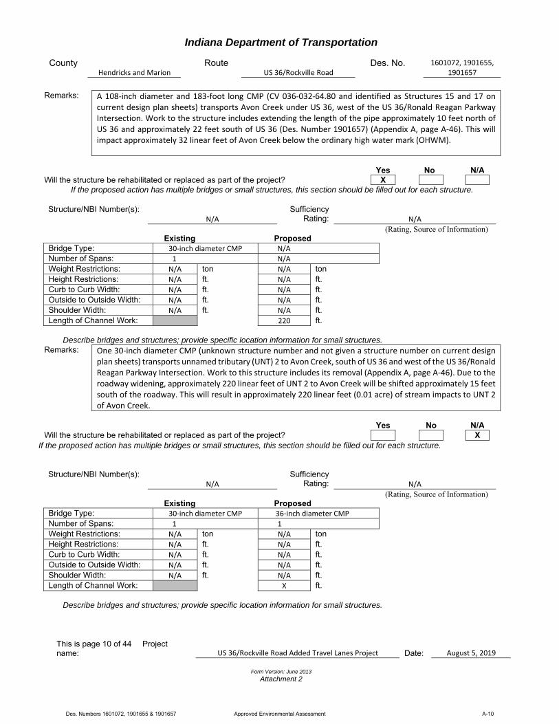
A 108‐inch diameter and 183‐foot long CMP (CV 036‐032‐64.80 and identified as Structures 15 and 17 on current design plan sheets) transports Avon Creek under US 36, west of the US 36/Ronald Reagan Parkway Intersection. Work to the structure includes extending the length of the pipe approximately 10 feet north of US 36 and approximately 22 feet south of US 36 (Des. Number 1901657) (Appendix A, page A‐46). This will impact approximately 32 linear feet of Avon Creek below the ordinary high water mark (OHWM).
Yes No N/A Will the structure be rehabilitated or replaced as part of the project? X
If the proposed action has multiple bridges or small structures, this section should be filled out for each structure.
Structure/NBI Number(s):
N/A
Sufficiency
Rating:
N/A
(Rating, Source of Information) Existing Proposed
Bridge Type: 30‐inch diameter CMP N/A
Number of Spans: 1 N/A
Weight Restrictions: N/A ton N/A ton Height Restrictions: N/A ft. N/A ft. Curb to Curb Width: N/A ft. N/A ft. Outside to Outside Width: N/A ft. N/A ft. Shoulder Width: N/A ft. N/A ft. Length of Channel Work: 220 ft.
Describe bridges and structures; provide specific location information for small structures.
Remarks:
One 30‐inch diameter CMP (unknown structure number and not given a structure number on current design plan sheets) transports unnamed tributary (UNT) 2 to Avon Creek, south of US 36 and west of the US 36/Ronald Reagan Parkway Intersection. Work to this structure includes its removal (Appendix A, page A‐46). Due to the roadway widening, approximately 220 linear feet of UNT 2 to Avon Creek will be shifted approximately 15 feet south of the roadway. This will result in approximately 220 linear feet (0.01 acre) of stream impacts to UNT 2 of Avon Creek.
Yes No N/A Will the structure be rehabilitated or replaced as part of the project? X
If the proposed action has multiple bridges or small structures, this section should be filled out for each structure.
Structure/NBI Number(s):
N/A
Sufficiency
Rating:
N/A
(Rating, Source of Information) Existing Proposed
Bridge Type: 30‐inch diameter CMP 36‐inch diameter CMP
Number of Spans: 1 1
Weight Restrictions: N/A ton N/A ton Height Restrictions: N/A ft. N/A ft. Curb to Curb Width: N/A ft. N/A ft. Outside to Outside Width: N/A ft. N/A ft. Shoulder Width: N/A ft. N/A ft. Length of Channel Work: X ft.
Describe bridges and structures; provide specific location information for small structures.
Des. Numbers 1601072, 1901655 & 1901657 Approved Environmental Assessment A-10
Indiana Department of Transportation
County Hendricks and Marion
Route US 36/Rockville Road
Des. No. 1601072, 1901655, 1901657
This is page 11 of 44 Project name: US 36/Rockville Road Added Travel Lanes Project Date:
August 5, 2019
Form Version: June 2013
Attachment 2
Remarks:
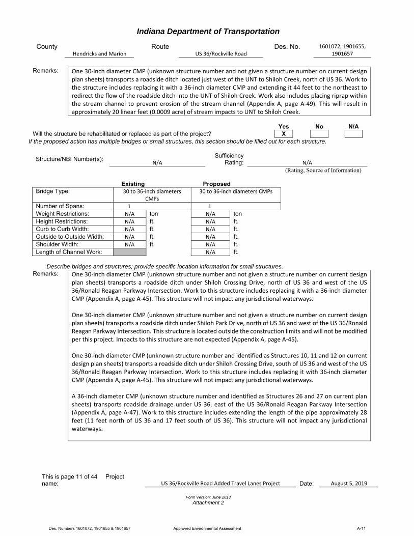
One 30‐inch diameter CMP (unknown structure number and not given a structure number on current design plan sheets) transports a roadside ditch located just west of the UNT to Shiloh Creek, north of US 36. Work to the structure includes replacing it with a 36‐inch diameter CMP and extending it 44 feet to the northeast to redirect the flow of the roadside ditch into the UNT of Shiloh Creek. Work also includes placing riprap within the stream channel to prevent erosion of the stream channel (Appendix A, page A‐49). This will result in approximately 20 linear feet (0.0009 acre) of stream impacts to UNT to Shiloh Creek.
Yes No N/A Will the structure be rehabilitated or replaced as part of the project? X
If the proposed action has multiple bridges or small structures, this section should be filled out for each structure.
Structure/NBI Number(s):
N/A Sufficiency
Rating:
N/A
(Rating, Source of Information)
Existing Proposed Bridge Type: 30 to 36‐inch diameters
CMPs 30 to 36‐inch diameters CMPs
Number of Spans: 1 1
Weight Restrictions: N/A ton N/A ton Height Restrictions: N/A ft. N/A ft. Curb to Curb Width: N/A ft. N/A ft. Outside to Outside Width: N/A ft. N/A ft. Shoulder Width: N/A ft. N/A ft. Length of Channel Work: N/A ft.
Describe bridges and structures; provide specific location information for small structures.
Remarks:
One 30‐inch diameter CMP (unknown structure number and not given a structure number on current design plan sheets) transports a roadside ditch under Shiloh Crossing Drive, north of US 36 and west of the US 36/Ronald Reagan Parkway Intersection. Work to this structure includes replacing it with a 36‐inch diameter CMP (Appendix A, page A‐45). This structure will not impact any jurisdictional waterways. One 30‐inch diameter CMP (unknown structure number and not given a structure number on current design plan sheets) transports a roadside ditch under Shiloh Park Drive, north of US 36 and west of the US 36/Ronald Reagan Parkway Intersection. This structure is located outside the construction limits and will not be modified per this project. Impacts to this structure are not expected (Appendix A, page A‐45). One 30‐inch diameter CMP (unknown structure number and identified as Structures 10, 11 and 12 on current design plan sheets) transports a roadside ditch under Shiloh Crossing Drive, south of US 36 and west of the US 36/Ronald Reagan Parkway Intersection. Work to this structure includes replacing it with 36‐inch diameter CMP (Appendix A, page A‐45). This structure will not impact any jurisdictional waterways. A 36‐inch diameter CMP (unknown structure number and identified as Structures 26 and 27 on current plan sheets) transports roadside drainage under US 36, east of the US 36/Ronald Reagan Parkway Intersection (Appendix A, page A‐47). Work to this structure includes extending the length of the pipe approximately 28 feet (11 feet north of US 36 and 17 feet south of US 36). This structure will not impact any jurisdictional waterways.
Des. Numbers 1601072, 1901655 & 1901657 Approved Environmental Assessment A-11
Indiana Department of Transportation
County Hendricks and Marion
Route US 36/Rockville Road
Des. No. 1601072, 1901655, 1901657
This is page 12 of 44 Project name: US 36/Rockville Road Added Travel Lanes Project Date:
August 5, 2019
Form Version: June 2013
Attachment 2
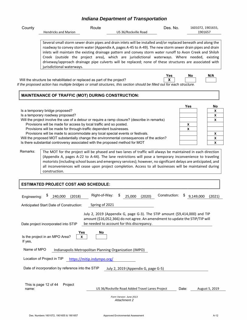
Several small storm sewer drain pipes and drain inlets will be installed and/or replaced beneath and along the roadway to convey storm water (Appendix A, pages A‐45 to A‐49). The new storm sewer drain pipes and drain inlets will maintain the existing drainage pattern and convey storm water runoff to Avon Creek and Shiloh Creek (outside the project area), which are jurisdictional waterways. Where needed, existing driveway/approach drainage pipe culverts will be replaced; none of these structures are associated with jurisdictional waterways.
Yes No N/A Will the structure be rehabilitated or replaced as part of the project? X
If the proposed action has multiple bridges or small structures, this section should be filled out for each structure.
MAINTENANCE OF TRAFFIC (MOT) DURING CONSTRUCTION:
Yes No Is a temporary bridge proposed? X
Is a temporary roadway proposed? X
Will the project involve the use of a detour or require a ramp closure? (describe in remarks) X
Provisions will be made for access by local traffic and so posted. X
Provisions will be made for through-traffic dependent businesses. X
Provisions will be made to accommodate any local special events or festivals. X
Will the proposed MOT substantially change the environmental consequences of the action? X
Is there substantial controversy associated with the proposed method for MOT X
Remarks: The MOT for the project will be phased and two lanes of traffic will always be maintained in each direction
(Appendix A, pages A‐22 to A‐44). The lane restrictions will pose a temporary inconvenience to traveling motorists (including school buses and emergency services); however, no significant delays are anticipated, and all inconveniences will cease upon project completion. Access to all businesses will be maintained during construction.
ESTIMATED PROJECT COST AND SCHEDULE:
Engineering:
$
240,000
(2018)
Right-of-Way:
$
25,000 (2020)
Construction:
$
9,149,000
(2021)
Anticipated Start Date of Construction: Spring of 2021
Date project incorporated into STIP
July 2, 2019 (Appendix G, page G‐3). The STIP amount ($9,414,000) and TIP amount ($16,052,366) do not agree. An amendment to update the STIP/TIP will be needed to account for this discrepancy.
Yes No
Is the project in an MPO Area? X If yes,
Name of MPO Indianapolis Metropolitan Planning Organization (IMPO)
Location of Project in TIP https://mitip.indympo.org/
Date of incorporation by reference into the STIP July 2, 2019 (Appendix G, page G‐5)
Des. Numbers 1601072, 1901655 & 1901657 Approved Environmental Assessment A-12

Indiana Department of Transportation
County Hendricks and Marion
Route US 36/Rockville Road
Des. No. 1601072, 1901655, 1901657
This is page 13 of 44 Project name: US 36/Rockville Road Added Travel Lanes Project Date:
August 5, 2019
Form Version: June 2013
Attachment 2
RIGHT OF WAY:
Amount (acres)
Land Use Impacts Permanent Temporary
Residential 0 0
Commercial 0.20 0.45
Agricultural 0 0
Forest 0 0
Wetlands 0 0
Other: 0 0
TOTAL 0.20 0.45
Describe both Permanent and Temporary right-of-way and describe their current use. Typical and Maximum right-of-way widths (existing and proposed) should also be discussed. Any advance acquisition or reacquisition, either known or suspected, and there impacts on the environmental analysis should be discussed.
Remarks: The current existing right‐of‐way along US 36 varies from approximately 75 to 135 feet from the roadway centerline; the proposed right‐of‐way along US 36 will vary from approximately 70 to 100 feet from the roadway centerline. The current existing right‐of‐way along Ronald Reagan Parkway varies from approximately 110 to 200 feet from the roadway centerline; the proposed right‐of‐way along Ronald Reagan Parkway will remain the same. The current existing right‐of‐way along Raceway Road varies from approximately 25 to 80 feet from the roadway centerline; the proposed right‐of‐way along Raceway Road will remain the same. The project will require approximately 0.20 acre of permanent right‐of‐way from commercial land; this right‐of‐way consists of maintained lawn. The commercial land is along US 36, primarily near the US 36/Ronald Reagan Parkway Intersection and the US 36/Raceway Road Intersection. The project will require approximately 0.45 acre of temporary right‐of‐way from commercial land for driveway reconstruction and grading. The commercial land is along US 36, primarily between and near the US 36/Ronald Reagan Parkway Intersection and the US 36/Raceway Road Intersection (Appendix A, pages A‐3 to A‐5). Please note that the early coordination letter stated approximately 0.25 acre of permanent right‐of‐way and 0.75 acre of temporary right‐of‐way would be needed (Appendix B, pages B‐1 to B‐4). Since that time, design has been refined and right‐of‐way amounts have decreased. If the scope of work or permanent or temporary right‐of‐way amounts change, the INDOT Environmental Services Division and the INDOT District Environmental Section will be contacted immediately.
Des. Numbers 1601072, 1901655 & 1901657 Approved Environmental Assessment A-13

Indiana Department of Transportation
County Hendricks and Marion
Route US 36/Rockville Road
Des. No. 1601072, 1901655, 1901657
This is page 14 of 44 Project name: US 36/Rockville Road Added Travel Lanes Project Date:
August 5, 2019
Form Version: June 2013
Attachment 2
Part III – Identification and Evaluation of Impacts of the Proposed Action
SECTION A – ECOLOGICAL RESOURCES
Presence Impacts Yes No Streams, Rivers, Watercourses & Jurisdictional Ditches X X Federal Wild and Scenic Rivers State Natural, Scenic or Recreational Rivers Nationwide Rivers Inventory (NRI) listed Outstanding Rivers List for Indiana Navigable Waterways
Remarks: Per a desktop review, a field visit conducted on May 25, 2018 and April 3, 2019 by RQAW (Appendix A, pages
A‐6 to A‐15), an aerial photograph of the project area (Appendix A, pages A‐3 to A‐5), USGS topographic map (Appendix A, page A‐2), and the water resources map in the Red Flag Investigation (RFI) report (Appendix D, page D‐8), there are four stream segments located within 0.5 mile of the project area. A Waters of the U.S. Determination Report was completed for the project by RQAW on May 1, 2019 (Appendix E, pages E‐1 to E‐42). It was determined five streams, Avon Creek, UNTs 1 and 2 to Avon Creek, Shiloh Creek, and UNT to Shiloh Creek, are located within or adjacent to the project area. Shiloh Creek is not described in the Waters of the U.S. Determination Report but is located approximately 90 feet east of the construction limits. As such, Shiloh Creek is included in this section. The U.S. Army Corps of Engineers (USACE) makes all determinations regarding jurisdiction. Per the field visit, and as described in the Waters of the U.S. Determination Report, 13 roadside ditches were identified within the project area (Appendix A, pages A‐3 to A‐5). The ditches are along the north and south sides of US 36 and convey stormwater drainage from the existing roadway to Avon Creek, UNT 1 to Avon Creek, and UNT 2 to Avon Creek. The roadside ditches did not exhibit OHWM characteristics, a defined bed and bank, and are not captured streams. Therefore, the roadside ditches are not likely to be considered jurisdictional (i.e. a Waters of the United States). Avon Creek is an intermittent stream that flows in a northwest to southeast direction under US 36 (Appendix A, page A‐4). The predominant substrate consisted of gravel and sand; crayfish were also observed within the stream. The upstream drainage area is approximately 1.03 square miles (Appendix E, page E‐14). The stream exhibited a defined bed and bank, had OHWM characteristics of 6.83 feet in width and 0.66 feet in depth, and empties into the East Fork of White Lick Creek which flows into the White River, a Traditionally Navigable Waterway (TNW). Based on these criteria, this stream is likely to be considered jurisdictional (i.e. a Waters of the United States). Avon Creek is not listed as a Federal Wild and Scenic River; State Natural, Scenic and Recreational River; or as an Indiana Department of Natural Resources (IDNR) Outstanding River. A 108‐inch diameter and 183‐foot long CMP (CV 036‐032‐64.80 and identified as Structures 15 and 17 on current design plan sheets) transports Avon Creek under US 36, west of the US 36/Ronald Reagan Parkway Intersection. Work to the structure includes extending the length of the pipe approximately 10 feet north of US 36 and approximately 22 feet south of US 36 (Des. Number 1601657) (Appendix A, page A‐46). This will impact approximately 32 linear feet (0.005 acre) of Avon Creek below the OHWM.
Des. Numbers 1601072, 1901655 & 1901657 Approved Environmental Assessment A-14
Indiana Department of Transportation
County Hendricks and Marion
Route US 36/Rockville Road
Des. No. 1601072, 1901655, 1901657
This is page 15 of 44 Project name: US 36/Rockville Road Added Travel Lanes Project Date:
August 5, 2019
Form Version: June 2013
Attachment 2
Avon Creek is impaired with Escherichia coli (E. coli). Workers who will be in or near water with E. coli should take care to wear appropriate personal protective equipment (PPE), observe proper hygiene procedures, including regular hand washing, and limit personal exposure. UNT 1 to Avon Creek flows in a northeast to southwest direction on the north side of US 36 (Appendix A, page A‐4). The predominant substrate consisted of gravel and sand. The upstream drainage area is less than 0.1 square mile. The stream exhibited a defined bed and bank, had OHWM characteristics of 3.5 feet in width and 0.25 feet in depth, and empties into Avon Creek. Based on these criteria, this stream is likely to be considered jurisdictional (i.e. a Waters of the United States). UNT 1 to Avon Creek is not listed as a Federal Wild and Scenic River; State Natural, Scenic and Recreational River; or as an IDNR Outstanding River. Due to the roadway widening, approximately 625 linear feet of UNT 1 to Avon Creek will be shifted approximately 10 feet north of the roadway. This will result in approximately 625 linear feet (0.05 acre) of stream impacts to UNT 1. UNT 2 to Avon Creek flows in a northwest to southeast direction on the south side of US 36; it begins at the concrete channel of a roadside ditch (Appendix A, page A‐4). UNT 2 to Avon Creek is also impaired with E. coli. The predominant substrate consisted of silt. The upstream drainage area is less than 0.1 square mile. The stream exhibited a defined bed and bank, had OHWM characteristics of 2.08 feet in width and 0.17 feet in depth, and empties into Avon Creek. Based on these criteria, this stream is likely to be considered jurisdictional (i.e. a Waters of the United States). UNT 2 to Avon Creek is not listed as a Federal Wild and Scenic River; State Natural, Scenic and Recreational River; or as an IDNR Outstanding River. One 30‐inch diameter CMP (unknown structure number and not given a structure number on current design plan sheets) transports UNT 2 to Avon Creek, south of US 36 and west of the US 36/Ronald Reagan Parkway Intersection. Work to this structure includes its removal (Appendix A, page A‐46). Due to the roadway widening, approximately 220 linear feet of UNT 2 to Avon Creek will be shifted approximately 15 feet south of the roadway. This will result in approximately 220 linear feet (0.01 acre) of stream impacts to UNT 2 of Avon Creek. Shiloh Creek flows in a northwest to south direction under US 36 (Appendix A, page A‐5). The predominant substrate consisted of silt and sand. Shiloh Creek is impaired with E. coli and impaired biotic communities (IBC). The upstream drainage area is approximately 0.65 square mile (Appendix E, page E‐44). The stream exhibited a defined bed and bank, had OHWM characteristics of 7.25 feet in width and 1.16 feet in depth, and empties into the East Fork of White Lick Creek which flows into the White River, a TNW. Based on these criteria, this stream is likely to be considered jurisdictional (i.e. a Waters of the United States). Shiloh Creek is not listed as a Federal Wild and Scenic River; State Natural, Scenic and Recreational River; or as an IDNR Outstanding River. The stream is approximately 90 feet east of the construction limits and will not be impacted. Because this stream is outside the project area, structure information is not available per the designer. UNT to Shiloh Creek flows in a southwest to northeast direction on the north side of US 36; it begins where a roadside ditch ends (Appendix A, page A‐5). The predominant substrate consisted of silt and sand. The upstream drainage area is less than 0.1 square mile. The stream exhibited a defined bed and bank, had OHWM characteristics of 2.33 feet in width and 0.92 feet in depth, and empties into Shiloh Creek. Based on these criteria, this stream is likely to be considered jurisdictional (i.e. a Waters of the United States). UNT to Shiloh Creek is not listed as a Federal Wild and Scenic River; State Natural, Scenic and Recreational River; or
Des. Numbers 1601072, 1901655 & 1901657 Approved Environmental Assessment A-15

Indiana Department of Transportation
County Hendricks and Marion
Route US 36/Rockville Road
Des. No. 1601072, 1901655, 1901657
This is page 16 of 44 Project name: US 36/Rockville Road Added Travel Lanes Project Date:
August 5, 2019
Form Version: June 2013
Attachment 2
as an IDNR Outstanding River. An existing 30‐inch diameter CMP (unknown structure number and identified as Structure 72 on current design plans) transports a roadside ditch located just west of the UNT to Shiloh Creek on the north side of US 36. Work to the structure includes replacing it with a 36‐inch diameter CMP and extending it 44 feet to the northeast to redirect the flow of the roadside ditch into the UNT of Shiloh Creek. Work also includes placing riprap within the stream channel to prevent erosion of the stream channel (Appendix A, page A‐49). This will impact up to approximately 20 linear feet (0.0009 acre) of UNT to Shiloh Creek below the OHWM. The project will impact approximately 897 linear feet (0.07 acre) of streams. Mitigation will likely be needed due to these stream impacts. Mitigation will be determined during permitting. If possible, the IDNR In‐Lieu Fee Program will be utilized for stream mitigation. A USACE Section 404 Permit and Indiana Department of Environmental Management (IDEM) Section 401 Water Quality Certification will be required due to these stream impacts. Early coordination letters were sent to the USACE, IDNR Division of Fish and Wildlife, and IDEM on January 28, 2019 (Appendix B, pages B‐1 to B‐4). The USACE did not respond to the early coordination letter. The automatic generated response letter from IDEM was received that same day (Appendix B, pages B‐5 to B‐13). The IDEM automatic response letter included recommendations pertaining to streams. Recommendations regarding streams include restricting channel disturbance. The IDNR Division of Fish and Wildlife responded to early coordination efforts on February 28, 2019 with recommendations to avoid or minimize impacts to streams and terrestrial habitat (Appendix B, pages B‐15 and B‐16). Recommendations regarding streams generally include implementing erosion and sediment control measures, not working within the stream channel from April 1 through June 30, and placement of riprap. The U.S. Fish and Wildlife Service (USFWS) was not consulted during early coordination because the project meets the criteria for programmatic coordination under the U.S. Fish and Wildlife Service Interim Policy for the Review of Highway Transportation Projects in Indiana dated May 29, 2013. Applicable recommendations include measures similar to the IDNR recommendations. All applicable agency recommendations are included in the Environmental Commitments section of this Categorical Exclusion (CE) document.
Presence Impacts Other Surface Waters Yes No Reservoirs Lakes Farm Ponds Detention Basins X X Storm Water Management Facilities Other:
Remarks: Per a desktop review, a field visit conducted on May 25, 2018 and April 3, 2019 by RQAW (Appendix A, pages A‐6 to A‐15), an aerial photograph of the project area (Appendix A, pages A‐3 to A‐5), USGS topographic map (Appendix A, page A‐2), and the water resources map in the RFI report (Appendix D, page D‐8), there are 19 ponds or lakes (detention basins) located within 0.5 mile of the project area. Of the 19 ponds or lakes, 17 ponds or lakes are unmapped but are shown in the aerial. The nearest surface water is mapped adjacent to the project area; however, per the aerial and field visit, the surface water is not present. Therefore, impacts to other surface waters are not expected. A Waters of the U.S. Determination Report was completed for the
Des. Numbers 1601072, 1901655 & 1901657 Approved Environmental Assessment A-16
Indiana Department of Transportation
County Hendricks and Marion
Route US 36/Rockville Road
Des. No. 1601072, 1901655, 1901657
This is page 17 of 44 Project name: US 36/Rockville Road Added Travel Lanes Project Date:
August 5, 2019
Form Version: June 2013
Attachment 2
project by RQAW on May 1, 2019 (Appendix E, pages E‐1 to E‐42). The USACE makes all determinations regarding jurisdiction. Early coordination letters were sent to the USACE, IDNR Division of Fish and Wildlife, and the IDEM on January 28, 2019 (Appendix B, pages B‐1 to B‐4). The USACE did not respond to the early coordination letter. The automatic generated response letter from IDEM was received that same day (Appendix B, pages B‐5 to B‐13). The IDEM automatic response letter did not include any recommendations pertaining to other surface waters. The IDNR Division of Fish and Wildlife responded to early coordination efforts on February 28, 2019 with recommendations to avoid or minimize impacts to streams and terrestrial habitat only (Appendix B, pages B‐15 and B‐16).
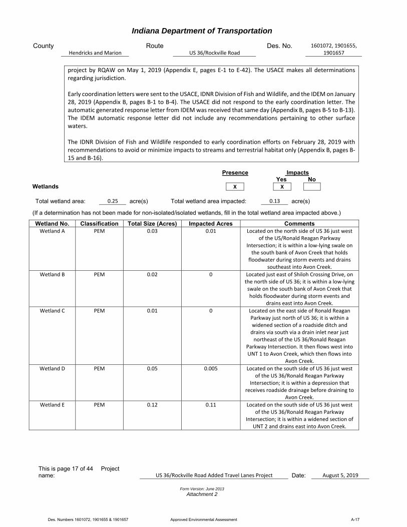
Presence Impacts Yes No Wetlands X X Total wetland area: 0.25 acre(s) Total wetland area impacted: 0.13 acre(s)
(If a determination has not been made for non-isolated/isolated wetlands, fill in the total wetland area impacted above.)
Wetland No. Classification Total Size (Acres) Impacted Acres Comments Wetland A PEM 0.03 0.01 Located on the north side of US 36 just west
of the US/Ronald Reagan Parkway Intersection; it is within a low‐lying swale on the south bank of Avon Creek that holds
floodwater during storm events and drains southeast into Avon Creek.
Wetland B PEM 0.02 0 Located just east of Shiloh Crossing Drive, on the north side of US 36; it is within a low‐lying swale on the south bank of Avon Creek that holds floodwater during storm events and
drains east into Avon Creek.
Wetland C PEM 0.01 0 Located on the east side of Ronald Reagan Parkway just north of US 36; it is within a widened section of a roadside ditch and drains via south via a drain inlet near just northeast of the US 36/Ronald Reagan
Parkway Intersection. It then flows west into UNT 1 to Avon Creek, which then flows into
Avon Creek.
Wetland D PEM 0.05 0.005 Located on the south side of US 36 just west of the US 36/Ronald Reagan Parkway
Intersection; it is within a depression that receives roadside drainage before draining to
Avon Creek.
Wetland E PEM 0.12 0.11 Located on the south side of US 36 just west of the US 36/Ronald Reagan Parkway
Intersection; it is within a widened section of UNT 2 and drains east into Avon Creek.
Des. Numbers 1601072, 1901655 & 1901657 Approved Environmental Assessment A-17
Indiana Department of Transportation
County Hendricks and Marion
Route US 36/Rockville Road
Des. No. 1601072, 1901655, 1901657
This is page 18 of 44 Project name: US 36/Rockville Road Added Travel Lanes Project Date:
August 5, 2019
Form Version: June 2013
Attachment 2
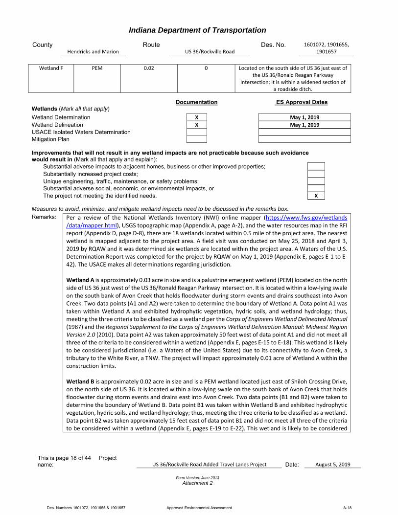
Wetland F PEM 0.02 0 Located on the south side of US 36 just east of the US 36/Ronald Reagan Parkway
Intersection; it is within a widened section of a roadside ditch.
Documentation ES Approval Dates Wetlands (Mark all that apply)
Wetland Determination X May 1, 2019
Wetland Delineation X May 1, 2019
USACE Isolated Waters Determination Mitigation Plan Improvements that will not result in any wetland impacts are not practicable because such avoidance would result in (Mark all that apply and explain):
Substantial adverse impacts to adjacent homes, business or other improved properties;
Substantially increased project costs;
Unique engineering, traffic, maintenance, or safety problems; Substantial adverse social, economic, or environmental impacts, or The project not meeting the identified needs. X
Measures to avoid, minimize, and mitigate wetland impacts need to be discussed in the remarks box.
Remarks: Per a review of the National Wetlands Inventory (NWI) online mapper (https://www.fws.gov/wetlands /data/mapper.html), USGS topographic map (Appendix A, page A‐2), and the water resources map in the RFI report (Appendix D, page D‐8), there are 18 wetlands located within 0.5 mile of the project area. The nearest wetland is mapped adjacent to the project area. A field visit was conducted on May 25, 2018 and April 3, 2019 by RQAW and it was determined six wetlands are located within the project area. A Waters of the U.S. Determination Report was completed for the project by RQAW on May 1, 2019 (Appendix E, pages E‐1 to E‐42). The USACE makes all determinations regarding jurisdiction. Wetland A is approximately 0.03 acre in size and is a palustrine emergent wetland (PEM) located on the north side of US 36 just west of the US 36/Ronald Reagan Parkway Intersection. It is located within a low‐lying swale on the south bank of Avon Creek that holds floodwater during storm events and drains southeast into Avon Creek. Two data points (A1 and A2) were taken to determine the boundary of Wetland A. Data point A1 was taken within Wetland A and exhibited hydrophytic vegetation, hydric soils, and wetland hydrology; thus, meeting the three criteria to be classified as a wetland per the Corps of Engineers Wetland Delineated Manual (1987) and the Regional Supplement to the Corps of Engineers Wetland Delineation Manual: Midwest Region Version 2.0 (2010). Data point A2 was taken approximately 50 feet west of data point A1 and did not meet all three of the criteria to be considered within a wetland (Appendix E, pages E‐15 to E‐18). This wetland is likely to be considered jurisdictional (i.e. a Waters of the United States) due to its connectivity to Avon Creek, a tributary to the White River, a TNW. The project will impact approximately 0.01 acre of Wetland A within the construction limits. Wetland B is approximately 0.02 acre in size and is a PEM wetland located just east of Shiloh Crossing Drive, on the north side of US 36. It is located within a low‐lying swale on the south bank of Avon Creek that holds floodwater during storm events and drains east into Avon Creek. Two data points (B1 and B2) were taken to determine the boundary of Wetland B. Data point B1 was taken within Wetland B and exhibited hydrophytic vegetation, hydric soils, and wetland hydrology; thus, meeting the three criteria to be classified as a wetland. Data point B2 was taken approximately 15 feet east of data point B1 and did not meet all three of the criteria to be considered within a wetland (Appendix E, pages E‐19 to E‐22). This wetland is likely to be considered
Des. Numbers 1601072, 1901655 & 1901657 Approved Environmental Assessment A-18

Indiana Department of Transportation
County Hendricks and Marion
Route US 36/Rockville Road
Des. No. 1601072, 1901655, 1901657
This is page 19 of 44 Project name: US 36/Rockville Road Added Travel Lanes Project Date:
August 5, 2019
Form Version: June 2013
Attachment 2
jurisdictional (i.e. a Waters of the United States) due to its connectivity to Avon Creek, a tributary to the White River, a TNW. Construction limits are approximately 7 feet outside the boundary of Wetland B; therefore, the project will not impact Wetland B. Wetland C is approximately 0.01 acre in size and is a PEM wetland located on the east side of Ronald Reagan Parkway just north of US 36. It is located within a widened section of a roadside ditch and drains south via a drain inlet near just northeast of the US 36/Ronald Reagan Parkway Intersection. It then flows west into UNT 1 to Avon Creek, which then flows into Avon Creek. Two data points (C1 and C2) were taken to determine the boundary of Wetland C. Data point C1 was taken within Wetland C and exhibited hydrophytic vegetation, hydric soils, and wetland hydrology; thus, meeting the three criteria to be classified as a wetland. Data point C2 was taken approximately 10 feet east of data point C1 and did not meet all three of the criteria to be considered within a wetland (Appendix E, pages E‐23 to E‐26). This wetland is likely to be considered jurisdictional (i.e. a Waters of the United States) due to its connectivity to Avon Creek, a tributary to the White River, a TNW. Construction limits are approximately 3 feet outside the boundary of Wetland C; therefore, the project will not impact Wetland C. Wetland D is approximately 0.05 acre in size and is a PEM wetland located on the south side of US 36 just west of the US 36/Ronald Reagan Parkway Intersection. It is located within a depression that receives roadside drainage before draining to Avon Creek. Two data points (D1 and D2) were taken to determine the boundary of Wetland D. Data point D1 was taken within Wetland D and exhibited hydrophytic vegetation, hydric soils, and wetland hydrology; thus, meeting the three criteria to be classified as a wetland. Data point D2 was taken approximately 20 feet west of data point D1 and did not meet all three of the criteria to be considered within a wetland (Appendix E, pages E‐27 to E‐30). This wetland is likely to be considered jurisdictional (i.e. a Waters of the United States) due to its connectivity to Avon Creek, a tributary to the White River, a TNW. Construction limits are approximately 3 feet outside the boundary of Wetland D; however, Wetland D will be impacted by construction activities associated with Des. Number 1601121 prior to this added travel lanes project (Des. Number 1601072). Des. Number 1601121 will involve constructing a segment of the Ronald Reagan Parkway Trail south of US 36, along the west side of Ronald Reagan Parkway. That trail will terminate just south of this added travel lanes project which will fill in this gap by constructing the remainder of the trail to provide connectivity of the trail along both sides of US 36. Des. Number 1601121 will impact approximately 0.005 acre of Wetland D within the construction limits. Mitigation associated with Des. Number 1601121 will be incorporated into this added travel lanes project (Des. Number 1601072). Wetland E is approximately 0.12 acre in size and is a PEM wetland located on the south side of US 36 just west of the US 36/Ronald Reagan Parkway Intersection. It is located within a widened section of UNT 2 and drains east into Avon Creek. Two data points (E1 and E2) were taken to determine the boundary of Wetland E. Data point E1 was taken within Wetland E and exhibited hydrophytic vegetation, hydric soils, and wetland hydrology; thus, meeting the three criteria to be classified as a wetland. Data point E2 was taken approximately 10 feet southeast of data point E1 and did not meet all three of the criteria to be considered within a wetland (Appendix E, pages E‐31 to E‐34). This wetland is likely to be considered jurisdictional (i.e. a Waters of the United States) due to its connectivity to Avon Creek, a tributary to the White River, a TNW. The project will impact approximately 0.11 acre of Wetland E within the construction limits. Wetland F is approximately 0.02 acre in size and is a PEM wetland located on the south side of US 36 just east of the US 36/Ronald Reagan Parkway Intersection. It is located within a widened section of a roadside
Des. Numbers 1601072, 1901655 & 1901657 Approved Environmental Assessment A-19

Indiana Department of Transportation
County Hendricks and Marion
Route US 36/Rockville Road
Des. No. 1601072, 1901655, 1901657
This is page 20 of 44 Project name: US 36/Rockville Road Added Travel Lanes Project Date:
August 5, 2019
Form Version: June 2013
Attachment 2
ditch. Two data points (F1 and F2) were taken to determine the boundary of Wetland F. Data point F1 was taken within Wetland F and exhibited hydrophytic vegetation, hydric soils, and wetland hydrology; thus, meeting the three criteria to be classified as a wetland. Data point F2 was taken approximately 20 feet north of data point F1 and did not meet all three of the criteria to be considered within a wetland (Appendix E, pages E‐35 to E‐38). This wetland is likely to be considered jurisdictional (i.e. a Waters of the United States) due to its connectivity to Avon Creek, a tributary to the White River, a TNW. Construction limits are approximately 60 feet outside the boundary of Wetland F; therefore, the project will not impact Wetland F. Please note that coordination has been ongoing with the project designer to ensure wetland impacts are avoided and minimized as much as possible. Avoidance alternatives would not be practicable because the project would not meet the purpose and need. Wetland boundaries will be identified as “Wetland—Do Not Disturb Outside Construction Limits” on the final design plans. Wetland boundaries will be identified in the field prior to construction to avoid indirect impacts. INDOT recommends orange fencing and signs to separate construction activities from all wetlands. The project will impact approximately 0.13 acre of wetlands. Mitigation will likely be needed due to these wetland impacts. Mitigation will be determined during permitting. If possible, the IDNR In‐Lieu Fee Program will be utilized for wetland mitigation. A USACE Section 404 Permit and IDEM Section 401 Water Quality Certification will be required due to these wetland impacts. Early coordination letters were sent to the USACE, IDNR Division of Fish and Wildlife, and IDEM on January 28, 2019 (Appendix B, pages B‐1 to B‐4). The USACE did not respond to the early coordination letter. The automatic generated response letter from IDEM was received that same day (Appendix B, pages B‐5 to B‐13). The IDEM automatic response letter did not include any recommendations pertaining to wetlands. The IDNR Division of Fish and Wildlife responded to early coordination efforts on February 28, 2019 with recommendations to avoid or minimize impacts to streams and terrestrial habitat only (Appendix B, pages B‐15 and B‐16). Per the U.S. Fish and Wildlife Service Interim Policy for the Review of Highway Transportation Projects in Indiana dated May 29, 2013, the project meets the criteria for programmatic coordination. The Interim Policy does not provide any recommendations pertaining to wetlands.
Remarks: Per a desktop review, a field visit conducted on May 25, 2018 and April 3, 2019 by RQAW (Appendix A, pages A‐6 to A‐15), an aerial photograph of the project area (Appendix A, pages A‐3 to A‐5), and USGS topographic map (Appendix A, page A‐2), adjacent land use consists of commercial properties in a heavily developed area. The commercial properties are associated with maintained lawns. Dominant vegetation included tall fescue (Schedonorus arundinaceus), Canada thistle (Cirsium arvense), white clover (Trifolium repens), and great ragweed (Ambrosia trifida). Although no animals were observed, it is assumed that certain common animals are likely present within the project area (e.g. squirrels, raccoons, birds, etc.).
Presence Impacts Yes No Terrestrial Habitat X X Unique or High Quality Habitat Use the remarks box to identify each type of habitat and the acres impacted (i.e. forested, grassland, farmland, lawn, etc).
Des. Numbers 1601072, 1901655 & 1901657 Approved Environmental Assessment A-20
Indiana Department of Transportation
County Hendricks and Marion
Route US 36/Rockville Road
Des. No. 1601072, 1901655, 1901657
This is page 21 of 44 Project name: US 36/Rockville Road Added Travel Lanes Project Date:
August 5, 2019
Form Version: June 2013
Attachment 2
The project will require approximately 0.20 acre of permanent right‐of‐way from commercial land consisting of maintained lawn and approximately 0.12 acre of wetlands. Trees greater than three inches in diameter‐at‐breast‐height (dbh) are within the project area; however, trees will not be cleared. Mitigation is not anticipated because trees will not be impacted. Early coordination letters were sent to the USACE, IDNR Division of Fish and Wildlife, and IDEM on January 28, 2019 (Appendix B, pages B‐1 to B‐4). The USACE did not respond to the early coordination letter. The automatic generated response letter from IDEM was received that same day (Appendix C, pages B‐5 to B‐13). The IDEM automatic response letter included recommendations pertaining to terrestrial habitat. These measures generally include revegetating disturbed areas. The IDNR Division of Fish and Wildlife responded to early coordination efforts on February 28, 2019 with recommendations to avoid or minimize impacts to streams and terrestrial habitat (Appendix B, pages B‐15 and B‐16). Recommendations regarding terrestrial habitat include revegetating disturbed areas and minimizing tree and brush clearing. Per the U.S. Fish and Wildlife Service Interim Policy for the Review of Highway Transportation Projects in Indiana dated May 29, 2013, the project meets the criteria for programmatic coordination. Recommendations from the Interim Policy include restricting clearing outside the construction zone boundaries. All applicable agency recommendations are included in the Environmental Commitments section of this CE document.
If there are high incidences of animal movements observed in the project area, or if bridges and other areas appear to be the sole corridor for animal movement, consideration of utilizing wildlife crossings should be taken.
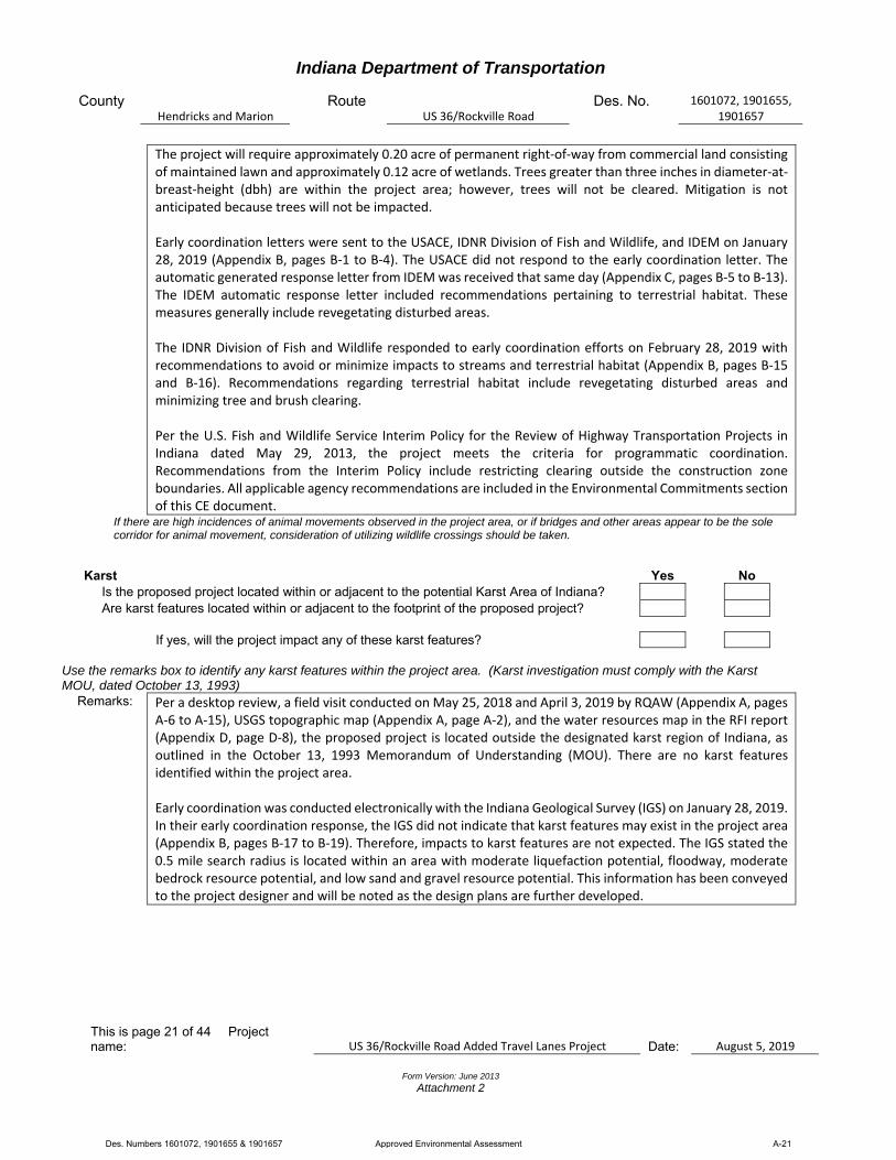
Karst Yes No Is the proposed project located within or adjacent to the potential Karst Area of Indiana?
Are karst features located within or adjacent to the footprint of the proposed project?
If yes, will the project impact any of these karst features?
Use the remarks box to identify any karst features within the project area. (Karst investigation must comply with the Karst MOU, dated October 13, 1993)
Remarks: Per a desktop review, a field visit conducted on May 25, 2018 and April 3, 2019 by RQAW (Appendix A, pages A‐6 to A‐15), USGS topographic map (Appendix A, page A‐2), and the water resources map in the RFI report (Appendix D, page D‐8), the proposed project is located outside the designated karst region of Indiana, as outlined in the October 13, 1993 Memorandum of Understanding (MOU). There are no karst features identified within the project area. Early coordination was conducted electronically with the Indiana Geological Survey (IGS) on January 28, 2019. In their early coordination response, the IGS did not indicate that karst features may exist in the project area (Appendix B, pages B‐17 to B‐19). Therefore, impacts to karst features are not expected. The IGS stated the 0.5 mile search radius is located within an area with moderate liquefaction potential, floodway, moderate bedrock resource potential, and low sand and gravel resource potential. This information has been conveyed to the project designer and will be noted as the design plans are further developed.
Des. Numbers 1601072, 1901655 & 1901657 Approved Environmental Assessment A-21

Indiana Department of Transportation
County Hendricks and Marion
Route US 36/Rockville Road
Des. No. 1601072, 1901655, 1901657
This is page 22 of 44 Project name: US 36/Rockville Road Added Travel Lanes Project Date:
August 5, 2019
Form Version: June 2013
Attachment 2
Presence Impacts
Threatened or Endangered Species Yes No Within the known range of any federal species X X Any critical habitat identified within project area Federal species found in project area (based upon informal consultation) State species found in project area (based upon consultation with IDNR) Yes No Is Section 7 formal consultation required for this action? X
Remarks: Per a desktop review and the RFI report completed by RQAW on February 15, 2019 (Appendix D, pages D‐1
to D‐15), the IDNR Endangered, Threatened and Rare (ETR) Species List has been checked (Appendix D, pages D‐12 to D‐15). The highlighted species on the list reflect the federal and state identified ETR species located within Hendricks and Marion counties. Per the IDNR Division of Fish and Wildlife early coordination response letter dated February 28, 2019, the Natural Heritage Program’s database has been checked, and to date, no plant or animal species listed as state or federally threatened, endangered, or rare have been reported to occur in the project vicinity (Appendix B, pages B‐15 and B‐16). Hendricks and Marion counties are within the range of the federally endangered Indiana bat (Myotis sodalis) and the federally threatened northern long‐eared bat (Myotis septentrionalis). On March 15, 2019, RQAW submitted project information through the USFWS Information for Planning and Consultation (IPaC) website (https://ecos.fws.gov/ipac/). An official species list was generated; no additional species were found within the project area (Appendix B, pages B‐31 to B‐36). The project qualifies for the Range‐wide Programmatic Informal Consultation for the Indiana bat and northern long‐eared bat, dated May 2016 (revised February 2018), between FHWA, Federal Railroad Administration, Federal Transit Administration, and the USFWS. On March 15, 2019, RQAW submitted project information through the USFWS IPaC website. Per the USFWS IPaC website, a Concurrence Verification Letter, dated March 15, 2019, determined the project May Affect, Not Likely to Adversely Affect the Indiana bat and northern long‐eared bat (Appendix B, pages B‐37 to B‐47). The INDOT Crawfordsville District reviewed and verified the effect finding on March 15, 2019 and requested USFWS review of the finding on March 15, 2019 (Appendix B, page B‐29). No response was received from the USFWS within the 14‐day review period; therefore, it was concluded the USFWS concurs with the finding. See Avoidance and Minimization Measures (AMMs) in the Environmental Commitments section of this document. On March 15, 2019, RQAW reviewed the USFWS Range Map for the rusty patched bumble bee (Bombus affinis) (https://www.fws.gov/midwest/endangered/insects/rpbb/rpbbmap.html). The project area is outside a High Potential Zone for rusty patched bumble bee habitat. The RFI report was approved on February 15, 2019 and INDOT confirmed the project area is outside a High Potential Zone for the rusty patched bumble bee (Appendix D, page D‐5). This precludes the need for further consultation on this project under Section 7 of the Endangered Species Act of 1973, as amended. If new information on endangered species at the site becomes available, or if project plans are changed, the USFWS will be contacted for consultation.
Des. Numbers 1601072, 1901655 & 1901657 Approved Environmental Assessment A-22
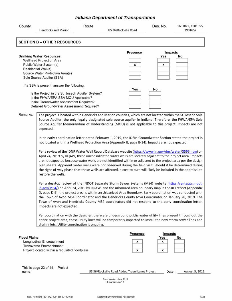
Indiana Department of Transportation
County Hendricks and Marion
Route US 36/Rockville Road
Des. No. 1601072, 1901655, 1901657
This is page 23 of 44 Project name: US 36/Rockville Road Added Travel Lanes Project Date:
August 5, 2019
Form Version: June 2013
Attachment 2
SECTION B – OTHER RESOURCES
Presence Impacts Drinking Water Resources Yes No Wellhead Protection Area Public Water System(s) X X Residential Well(s) Source Water Protection Area(s) Sole Source Aquifer (SSA) If a SSA is present, answer the following: Yes No Is the Project in the St. Joseph Aquifer System?
Is the FHWA/EPA SSA MOU Applicable?
Initial Groundwater Assessment Required?
Detailed Groundwater Assessment Required?
Remarks: The project is located within Hendricks and Marion counties, which are not located within the St. Joseph Sole
Source Aquifer, the only legally designated sole source aquifer in Indiana. Therefore, the FHWA/EPA Sole Source Aquifer Memorandum of Understanding (MOU) is not applicable to this project. Impacts are not expected. In an early coordination letter dated February 1, 2019, the IDEM Groundwater Section stated the project is not located within a Wellhead Protection Area (Appendix B, page B‐14). Impacts are not expected. Per a review of the IDNR Water Well Record Database website (https://www.in.gov/dnr/water/3595.htm) on April 24, 2019 by RQAW, three unconsolidated water wells are located adjacent to the project area. Impacts are not expected because water wells are not identified within or adjacent to the project area per the design plan sheets. Apparent water wells were not observed during the field visit. Should it be determined during the right‐of‐way phase that these wells are affected, a cost to cure will likely be included in the appraisal to restore the wells. Per a desktop review of the INDOT Separate Storm Sewer Systems (MS4) website (https://entapps.indot. in.gov/MS4/) on April 24, 2019 by RQAW, and the urbanized area boundary map in the RFI report (Appendix D, page D‐9), the project area is within an Urbanized Area Boundary. Early coordination was conducted with the Town of Avon MS4 Coordinator and the Hendricks County MS4 Coordinator on January 28, 2019. The Town of Avon and Hendricks County MS4 coordinators did not respond to the early coordination letter. Impacts are not expected. Per coordination with the designer, there are underground public water utility lines present throughout the entire project area; these utility lines will be temporarily impacted to install the new storm sewer lines and drain inlets. Utility coordination is ongoing.
Presence Impacts Flood Plains Yes No Longitudinal Encroachment X X Transverse Encroachment
Project located within a regulated floodplain X X
Des. Numbers 1601072, 1901655 & 1901657 Approved Environmental Assessment A-23

Indiana Department of Transportation
County Hendricks and Marion
Route US 36/Rockville Road
Des. No. 1601072, 1901655, 1901657
This is page 24 of 44 Project name: US 36/Rockville Road Added Travel Lanes Project Date:
August 5, 2019
Form Version: June 2013
Attachment 2
Homes located in floodplain within 1000’ up/downstream from project X X
Discuss impacts according to classification system described in the “Procedural Manual for Preparing Environmental Studies”. Remarks: Per review of the IDNR Indiana Floodway Information Portal website (https://dnrmaps.dnr.in.gov
/appsphp/fdms/) on April 24, 2019 by RQAW, and the water resources map in the RFI report (Appendix D, page D‐8), the project area is located within a regulatory floodplain as determined by approved IDNR floodplain maps. The project qualifies as a Category 3 per the current INDOT Categorical Exclusion Manual. Category 3 – The modifications to drainage structures included in this project will result in an insubstantial change in their capacity to carry flood water. This change could cause a minimal increase in flood heights and flood limits. These minimal increases will not result in any substantial adverse impacts on the natural and beneficial floodplain values; they will not result in substantial change in flood risks or damage; and they do not have substantial potential for interruption or termination of emergency service or emergency routes; therefore, it has been determined that this encroachment is not substantial. An early coordination letter was sent to the Local Floodplain Administrator on January 28, 2019 (Appendix B, pages B‐1 to B‐4). The Local Floodplain Administrator did not respond to the early coordination letter.
Presence Impacts Farmland Yes No Agricultural Lands Prime Farmland (per NRCS)
Total Points (from Section VII of CPA-106/AD-1006* N/A
*If 160 or greater, see CE Manual for guidance.
See CE Manual for guidance to determine which NRCS form is appropriate for your project. Remarks: Per a field visit conducted on May 25, 2018 and April 3, 2019 by RQAW (Appendix A, pages A‐6 to A‐15), an
aerial photograph of the project area (Appendix A, pages A‐3 to A‐5), and early coordination with the Natural Resources Conservation Service (NRCS) (Appendix B, page B‐20), the project will not cause a conversion of prime farmland. As such, there is no land that meets the definition of farmland under the Farmland Protection Policy Act (FPPA) within or adjacent to the project area and the requirements of the FPPA do not apply. Impacts are not expected.
SECTION C – CULTURAL RESOURCES
Category Type INDOT Approval Dates N/A Minor Projects PA Clearance X
Results of Research
Eligible and/or Listed Resource Present
Archaeology NRHP Buildings/Site(s) X NRHP District(s) NRHP Bridge(s)
Project Effect
No Historic Properties Affected No Adverse Effect X Adverse Effect
Des. Numbers 1601072, 1901655 & 1901657 Approved Environmental Assessment A-24
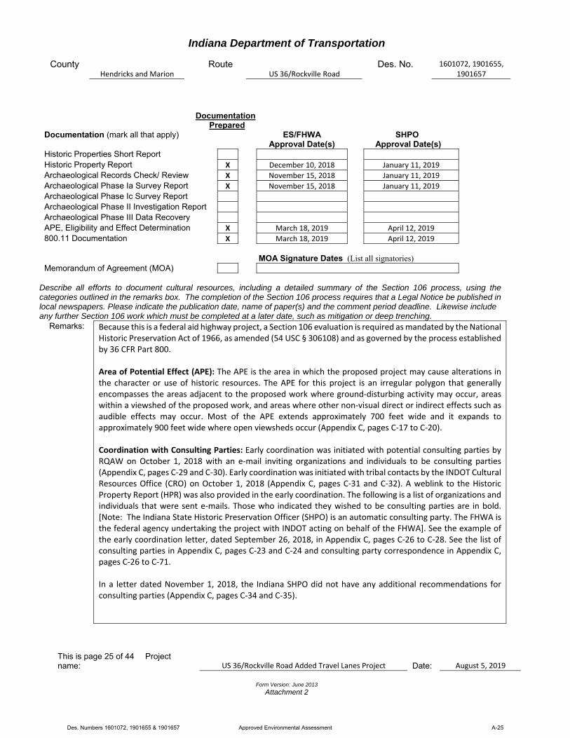
Indiana Department of Transportation
County Hendricks and Marion
Route US 36/Rockville Road
Des. No. 1601072, 1901655, 1901657
This is page 25 of 44 Project name: US 36/Rockville Road Added Travel Lanes Project Date:
August 5, 2019
Form Version: June 2013
Attachment 2
Documentation Prepared Documentation (mark all that apply)
ES/FHWA
Approval Date(s) SHPO
Approval Date(s) Historic Properties Short Report
Historic Property Report X December 10, 2018 January 11, 2019
Archaeological Records Check/ Review X November 15, 2018 January 11, 2019
Archaeological Phase Ia Survey Report X November 15, 2018 January 11, 2019
Archaeological Phase Ic Survey Report
Archaeological Phase II Investigation Report
Archaeological Phase III Data Recovery
APE, Eligibility and Effect Determination X March 18, 2019 April 12, 2019
800.11 Documentation X March 18, 2019 April 12, 2019
MOA Signature Dates (List all signatories) Memorandum of Agreement (MOA)
Describe all efforts to document cultural resources, including a detailed summary of the Section 106 process, using the categories outlined in the remarks box. The completion of the Section 106 process requires that a Legal Notice be published in local newspapers. Please indicate the publication date, name of paper(s) and the comment period deadline. Likewise include any further Section 106 work which must be completed at a later date, such as mitigation or deep trenching.
Remarks: Because this is a federal aid highway project, a Section 106 evaluation is required as mandated by the National Historic Preservation Act of 1966, as amended (54 USC § 306108) and as governed by the process established by 36 CFR Part 800. Area of Potential Effect (APE): The APE is the area in which the proposed project may cause alterations in the character or use of historic resources. The APE for this project is an irregular polygon that generally encompasses the areas adjacent to the proposed work where ground‐disturbing activity may occur, areas within a viewshed of the proposed work, and areas where other non‐visual direct or indirect effects such as audible effects may occur. Most of the APE extends approximately 700 feet wide and it expands to approximately 900 feet wide where open viewsheds occur (Appendix C, pages C‐17 to C‐20). Coordination with Consulting Parties: Early coordination was initiated with potential consulting parties by RQAW on October 1, 2018 with an e‐mail inviting organizations and individuals to be consulting parties (Appendix C, pages C‐29 and C‐30). Early coordination was initiated with tribal contacts by the INDOT Cultural Resources Office (CRO) on October 1, 2018 (Appendix C, pages C‐31 and C‐32). A weblink to the Historic Property Report (HPR) was also provided in the early coordination. The following is a list of organizations and individuals that were sent e‐mails. Those who indicated they wished to be consulting parties are in bold. [Note: The Indiana State Historic Preservation Officer (SHPO) is an automatic consulting party. The FHWA is the federal agency undertaking the project with INDOT acting on behalf of the FHWA]. See the example of the early coordination letter, dated September 26, 2018, in Appendix C, pages C‐26 to C‐28. See the list of consulting parties in Appendix C, pages C‐23 and C‐24 and consulting party correspondence in Appendix C, pages C‐26 to C‐71. In a letter dated November 1, 2018, the Indiana SHPO did not have any additional recommendations for consulting parties (Appendix C, pages C‐34 and C‐35).
Des. Numbers 1601072, 1901655 & 1901657 Approved Environmental Assessment A-25
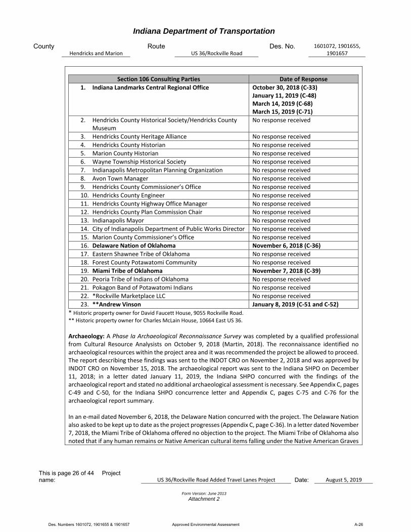
Indiana Department of Transportation
County Hendricks and Marion
Route US 36/Rockville Road
Des. No. 1601072, 1901655, 1901657
This is page 26 of 44 Project name: US 36/Rockville Road Added Travel Lanes Project Date:
August 5, 2019
Form Version: June 2013
Attachment 2
Section 106 Consulting Parties Date of Response
1. Indiana Landmarks Central Regional Office October 30, 2018 (C‐33) January 11, 2019 (C‐48) March 14, 2019 (C‐68) March 15, 2019 (C‐71)
2. Hendricks County Historical Society/Hendricks County Museum
No response received
3. Hendricks County Heritage Alliance No response received
4. Hendricks County Historian No response received
5. Marion County Historian No response received
6. Wayne Township Historical Society No response received
7. Indianapolis Metropolitan Planning Organization No response received
8. Avon Town Manager No response received
9. Hendricks County Commissioner’s Office No response received
10. Hendricks County Engineer No response received
11. Hendricks County Highway Office Manager No response received
12. Hendricks County Plan Commission Chair No response received
13. Indianapolis Mayor No response received
14. City of Indianapolis Department of Public Works Director No response received
15. Marion County Commissioner’s Office No response received
16. Delaware Nation of Oklahoma November 6, 2018 (C‐36)
17. Eastern Shawnee Tribe of Oklahoma No response received
18. Forest County Potawatomi Community No response received
19. Miami Tribe of Oklahoma November 7, 2018 (C‐39)
20. Peoria Tribe of Indians of Oklahoma No response received
21. Pokagon Band of Potawatomi Indians No response received
22. *Rockville Marketplace LLC No response received
23. **Andrew Vinson January 8, 2019 (C‐51 and C‐52)
* Historic property owner for David Faucett House, 9055 Rockville Road. ** Historic property owner for Charles McLain House, 10664 East US 36.
Archaeology: A Phase Ia Archaeological Reconnaissance Survey was completed by a qualified professional from Cultural Resource Analysists on October 9, 2018 (Martin, 2018). The reconnaissance identified no archaeological resources within the project area and it was recommended the project be allowed to proceed. The report describing these findings was sent to the INDOT CRO on November 2, 2018 and was approved by INDOT CRO on November 15, 2018. The archaeological report was sent to the Indiana SHPO on December 11, 2018; in a letter dated January 11, 2019, the Indiana SHPO concurred with the findings of the archaeological report and stated no additional archaeological assessment is necessary. See Appendix C, pages C‐49 and C‐50, for the Indiana SHPO concurrence letter and Appendix C, pages C‐75 and C‐76 for the archaeological report summary. In an e‐mail dated November 6, 2018, the Delaware Nation concurred with the project. The Delaware Nation also asked to be kept up to date as the project progresses (Appendix C, page C‐36). In a letter dated November 7, 2018, the Miami Tribe of Oklahoma offered no objection to the project. The Miami Tribe of Oklahoma also noted that if any human remains or Native American cultural items falling under the Native American Graves
Des. Numbers 1601072, 1901655 & 1901657 Approved Environmental Assessment A-26
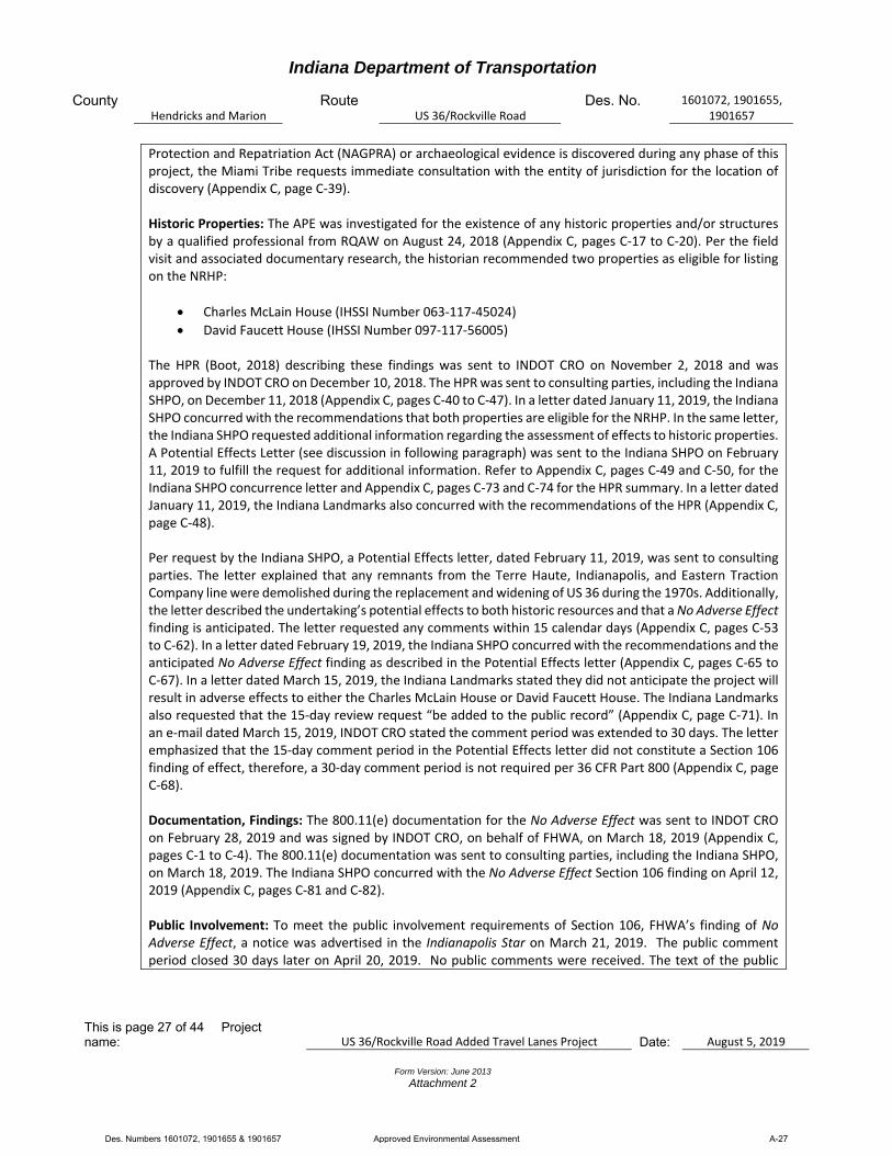
Indiana Department of Transportation
County Hendricks and Marion
Route US 36/Rockville Road
Des. No. 1601072, 1901655, 1901657
This is page 27 of 44 Project name: US 36/Rockville Road Added Travel Lanes Project Date:
August 5, 2019
Form Version: June 2013
Attachment 2
Protection and Repatriation Act (NAGPRA) or archaeological evidence is discovered during any phase of this project, the Miami Tribe requests immediate consultation with the entity of jurisdiction for the location of discovery (Appendix C, page C‐39). Historic Properties: The APE was investigated for the existence of any historic properties and/or structures by a qualified professional from RQAW on August 24, 2018 (Appendix C, pages C‐17 to C‐20). Per the field visit and associated documentary research, the historian recommended two properties as eligible for listing on the NRHP:
Charles McLain House (IHSSI Number 063‐117‐45024)
David Faucett House (IHSSI Number 097‐117‐56005)
The HPR (Boot, 2018) describing these findings was sent to INDOT CRO on November 2, 2018 and was approved by INDOT CRO on December 10, 2018. The HPR was sent to consulting parties, including the Indiana SHPO, on December 11, 2018 (Appendix C, pages C‐40 to C‐47). In a letter dated January 11, 2019, the Indiana SHPO concurred with the recommendations that both properties are eligible for the NRHP. In the same letter, the Indiana SHPO requested additional information regarding the assessment of effects to historic properties. A Potential Effects Letter (see discussion in following paragraph) was sent to the Indiana SHPO on February 11, 2019 to fulfill the request for additional information. Refer to Appendix C, pages C‐49 and C‐50, for the Indiana SHPO concurrence letter and Appendix C, pages C‐73 and C‐74 for the HPR summary. In a letter dated January 11, 2019, the Indiana Landmarks also concurred with the recommendations of the HPR (Appendix C, page C‐48). Per request by the Indiana SHPO, a Potential Effects letter, dated February 11, 2019, was sent to consulting parties. The letter explained that any remnants from the Terre Haute, Indianapolis, and Eastern Traction Company line were demolished during the replacement and widening of US 36 during the 1970s. Additionally, the letter described the undertaking’s potential effects to both historic resources and that a No Adverse Effect finding is anticipated. The letter requested any comments within 15 calendar days (Appendix C, pages C‐53 to C‐62). In a letter dated February 19, 2019, the Indiana SHPO concurred with the recommendations and the anticipated No Adverse Effect finding as described in the Potential Effects letter (Appendix C, pages C‐65 to C‐67). In a letter dated March 15, 2019, the Indiana Landmarks stated they did not anticipate the project will result in adverse effects to either the Charles McLain House or David Faucett House. The Indiana Landmarks also requested that the 15‐day review request “be added to the public record” (Appendix C, page C‐71). In an e‐mail dated March 15, 2019, INDOT CRO stated the comment period was extended to 30 days. The letter emphasized that the 15‐day comment period in the Potential Effects letter did not constitute a Section 106 finding of effect, therefore, a 30‐day comment period is not required per 36 CFR Part 800 (Appendix C, page C‐68). Documentation, Findings: The 800.11(e) documentation for the No Adverse Effect was sent to INDOT CRO on February 28, 2019 and was signed by INDOT CRO, on behalf of FHWA, on March 18, 2019 (Appendix C, pages C‐1 to C‐4). The 800.11(e) documentation was sent to consulting parties, including the Indiana SHPO, on March 18, 2019. The Indiana SHPO concurred with the No Adverse Effect Section 106 finding on April 12, 2019 (Appendix C, pages C‐81 and C‐82). Public Involvement: To meet the public involvement requirements of Section 106, FHWA’s finding of No Adverse Effect, a notice was advertised in the Indianapolis Star on March 21, 2019. The public comment period closed 30 days later on April 20, 2019. No public comments were received. The text of the public
Des. Numbers 1601072, 1901655 & 1901657 Approved Environmental Assessment A-27
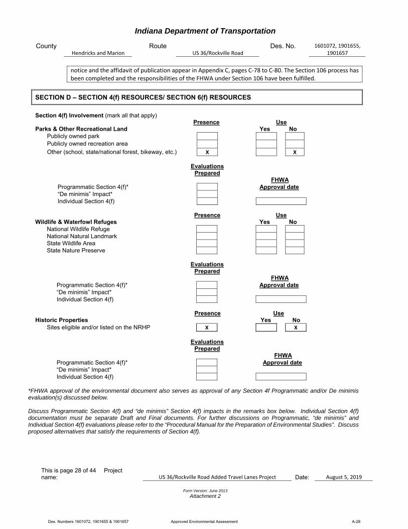
Indiana Department of Transportation
County Hendricks and Marion
Route US 36/Rockville Road
Des. No. 1601072, 1901655, 1901657
This is page 28 of 44 Project name: US 36/Rockville Road Added Travel Lanes Project Date:
August 5, 2019
Form Version: June 2013
Attachment 2
notice and the affidavit of publication appear in Appendix C, pages C‐78 to C‐80. The Section 106 process has been completed and the responsibilities of the FHWA under Section 106 have been fulfilled.
SECTION D – SECTION 4(f) RESOURCES/ SECTION 6(f) RESOURCES
Section 4(f) Involvement (mark all that apply) Presence Use Parks & Other Recreational Land Yes No Publicly owned park Publicly owned recreation area
Other (school, state/national forest, bikeway, etc.) X X Evaluations
Prepared
FHWA Programmatic Section 4(f)* Approval date “De minimis” Impact* Individual Section 4(f)
Presence Use Wildlife & Waterfowl Refuges Yes No National Wildlife Refuge National Natural Landmark State Wildlife Area State Nature Preserve Evaluations
Prepared
FHWA Programmatic Section 4(f)* Approval date “De minimis” Impact* Individual Section 4(f)
Presence Use Historic Properties Yes No Sites eligible and/or listed on the NRHP X X Evaluations
Prepared
FHWA Programmatic Section 4(f)* Approval date “De minimis” Impact* Individual Section 4(f)
*FHWA approval of the environmental document also serves as approval of any Section 4f Programmatic and/or De minimis evaluation(s) discussed below. Discuss Programmatic Section 4(f) and “de minimis” Section 4(f) impacts in the remarks box below. Individual Section 4(f) documentation must be separate Draft and Final documents. For further discussions on Programmatic, “de minimis” and Individual Section 4(f) evaluations please refer to the “Procedural Manual for the Preparation of Environmental Studies”. Discuss proposed alternatives that satisfy the requirements of Section 4(f).
Des. Numbers 1601072, 1901655 & 1901657 Approved Environmental Assessment A-28

Indiana Department of Transportation
County Hendricks and Marion
Route US 36/Rockville Road
Des. No. 1601072, 1901655, 1901657
This is page 29 of 44 Project name: US 36/Rockville Road Added Travel Lanes Project Date:
August 5, 2019
Form Version: June 2013
Attachment 2
Remarks: Section 4(f) of the U.S. Department of Transportation Act of 1966 prohibits the use of certain public and historic lands for federally transportation facilities unless there is no feasible and prudent alternative. The law applies to significant publicly owned parks, recreational areas, wildlife/waterfowl refuges, and NRHP eligible or listed historic properties regardless of ownership. Lands subject to this law are considered Section 4(f) resources. Per a desktop review, a field visit conducted on May 25, 2018 and April 3, 2019 by RQAW (Appendix A, pages A‐6 to A‐15), an aerial photograph of the project area (Appendix A, pages A‐3 to A‐5), the infrastructure map in the RFI report (Appendix D, page D‐7), and the APE maps (Appendix C, pages C‐17 to C‐20), there are five Section 4(f) resources located within 0.5 mile of the project area:
Ronald Reagan Parkway Trail (three recreational trail segments), two recreational trail segments are open on the north side of US 36 at the US 36/Ronald Reagan Parkway Intersection, and one recreational trail segment is currently under development on the south side of US 36 at the US 36/Ronald Reagan Parkway Intersection (Des. Number 1601121).
Charles McLain House (IHSSI Number 063‐117‐45024), historic resource recommended eligible for the NRHP, adjacent to the project area.
David Faucett House (IHSSI Number 097‐117‐56005), historic resource recommended eligible for the NRHP, adjacent to the project area.
Note that Steeplechase Apartments, and associated recreational facilities, is mapped approximately 0.15 mile north of project area and the Avon Recreation Center is mapped approximately 0.27 mile southwest of project area. However, both properties are privately‐owned and are not Section 4(f) properties. No temporary or permanent right‐of‐way will be needed from either property. No use is expected. Ronald Reagan Parkway Trail: These publicly owned trail segments are at the US 36/Ronald Reagan Parkway Intersection. Two segments are currently open on the north side of US 36, one along the west side of Ronald Reagan Parkway and one along the east side of Ronald Reagan Parkway. One recreational trail segment is currently under development on the south side of US 36, on the west side of Ronald Reagan Parkway (Des. Number 1601121). The trail segment currently under construction will terminate south of this added travel lanes project; the full trail (i.e. across US 36) will not be open prior to or during construction of this added travel lanes project. Permanent or temporary right‐of‐way will not be needed in the northeast, northwest, or southwest quadrant for construction of the project. An at‐grade pedestrian crossing, and median pedestrian refuge will be installed to connect the existing trail located north of US 36, along the west side of Ronald Reagan Parkway, to the proposed trail located south of US 36, along the west side of Ronald Reagan Parkway (Des. Number 1601121). Des. Number 1601121 will be constructed by the Town of Avon prior to this added travel lanes project (Des. Number 1601072). Des. Number 1601121 will terminate just south of the added travel lanes project; the added travel lanes project will fill in this gap by constructing the remainder of the trail to provide connectivity of the trail along both sides of US 36 (note: during construction of this added travel lanes project, a “Trail Ends Here” sign will be posted where the southern trail segment terminates). The existing curb ramps in the northeast and northwest quadrants of the US 36/Ronald Reagan Parkway Intersection will be replaced to meet ADA requirements. The portion of roadway between the curb ramps will be striped to indicate a trail crossing. Four curb ramps will be constructed (two in the median pedestrian refuge, one north of the median pedestrian refuge, and one south of the median pedestrian refuge). The portion of roadway between these four curb ramps will be striped to indicate a trail crossing. All curb ramps will meet ADA requirements. There would not be any
Des. Numbers 1601072, 1901655 & 1901657 Approved Environmental Assessment A-29
Indiana Department of Transportation
County Hendricks and Marion
Route US 36/Rockville Road
Des. No. 1601072, 1901655, 1901657
This is page 30 of 44 Project name: US 36/Rockville Road Added Travel Lanes Project Date:
August 5, 2019
Form Version: June 2013
Attachment 2
temporary occupancy or use of the existing trails located north of US 36 or the proposed trail located south of US 36 during construction. The existing or proposed trails would not need to be moved or require a detour
during construction because both existing trails north of US 36 currently terminate at US 36. The proposed trail south of US 36 will terminate several feet south of US 36 and this gap will be filled in as part of the added travel lanes project; as such, that proposed trail will also terminate south of US 36. The project will not use this resource by taking permanent or temporary right‐of‐way and will not alter the environment is such a way as to constitute use of this resource. Impacts are not expected. In an e‐mail dated January 17, 2019, INDOT Environmental Services Division concurred there would not be a Section 4(f) use of the trails. INDOT Environmental Services Division also recommended coordination with the *parks department to make sure they are aware of the project. Lastly, INDOT Environmental Services Division stated if the scope of work changes, the project will need to be reassessed to determine if Section 4(f) temporary occupancy may need to be evaluated (Appendix H, page H‐2). During the early coordination phase of the project, the Hendricks County Planning and Building Commission (*managing entity of the Ronald Reagan Parkway Trail) was consulted on January 28, 2019 (Appendix B, pages B‐1 to B‐4). The Hendricks County Planning and Building Commission did not respond to early coordination letter. Charles McLain House (IHSSI Number 063‐117‐45024): The house is located on the north side of US 36 and east of Ronald Reagan Parkway (Appendix C, page C‐19). The house is recommended eligible for the NRHP under Criterion C because it is a good example of a circa 1904 Free Classic Queen Ann style house with original architectural features in Washington Township, Hendricks County. Impacts adjacent to the historic resource boundary will include roadway widening and reconstruction, driveway reconstruction, and limited sidewalk reconstruction to tie the existing sidewalk into the new driveway. No permanent right‐of‐way will be needed from the property; however, approximately 0.02 acre of temporary right‐of‐way will be needed from the property for driveway and adjacent sidewalk reconstruction. The existing roadway, driveway, parking lot, and sidewalk are modern concrete construction. The historic resource boundary goes to the back (north edge) of the existing sidewalk. The anticipated construction limits will not extend into the historic resource boundary. Construction in this area will widen the US 36 pavement by approximately 17 feet to add a travel lane, reconstruct and extend the existing right turn lane, and install a curb and gutter. The added travel lane near the property is anticipated to provide only a 10% increase in capacity from 2021 to 2041. The property’s setting has been drastically altered by development over recent decades from the expansion of US 36 and the property’s own conversion to commercial use (i.e. parking lot and sidewalk construction). The minimal introduction of visual and audible elements to the property’s setting will not constitute a significant alteration to historic features that contribute to the Charles McLain House historic significance because of the already transformed, suburban landscape. Although permanent work is proposed near the Charles McLain House property, it is anticipated that there will be no adverse effect to the house or carriage house because no contributing historic features will be impacted directly. Therefore, the alterations adjacent to the historic resource boundary and its setting are not anticipated to reduce the significance or impact any of the characteristics that qualify the Charles McLain House for the NRHP in a manner that would diminish the integrity of the property’s location, design, setting, materials, workmanship, feeling, or association. As a result, the project is anticipated to have No Adverse Effect to the Charles McLain House.
Des. Numbers 1601072, 1901655 & 1901657 Approved Environmental Assessment A-30
Indiana Department of Transportation
County Hendricks and Marion
Route US 36/Rockville Road
Des. No. 1601072, 1901655, 1901657
This is page 31 of 44 Project name: US 36/Rockville Road Added Travel Lanes Project Date:
August 5, 2019
Form Version: June 2013
Attachment 2
The project will temporarily occupy land from the Charles McLain House, a Section 4(f) historic property. The temporary occupancy will not constitute a Section 4(f) use because all of the conditions listed in 23 CFR 774.13(d) are satisfied:
1. Duration must be temporary, i.e., less than the time needed for construction of the project, and there should be no change in ownership of the land;
2. Scope of the work must be minor, i.e., both the nature and the magnitude of the changes to the Section 4(f) property are minimal;
3. There are no anticipated permanent adverse physical impacts, nor will there be interference with the protected activities, features, or attributes of the property, on either a temporary or permanent basis;
4. The land being used must be fully restored, i.e., the property must be returned to a condition which is at least as good as that which existed prior to the project; and
5. There must be documented agreement of the official(s) with jurisdiction over the Section 4(f) resource regarding the above conditions.
INDOT CRO determined the appropriate Section 106 finding is No Adverse Effect; the temporary occupancy will not constitute a Section 4(f) use for the Charles McLain House because all of the conditions listed in 23 CFR 774.13(d) are satisfied (Appendix C, pages C‐1 to C‐77). The Indiana SHPO concurred with the No Adverse Effect Section 106 finding in a letter dated April 12, 2019 (Appendix C, pages C‐81 and C‐82). David Faucett House (IHSSI Number 097‐117‐56005): The house is located on the south side of US 36 and east of Ronald Reagan Parkway (Appendix C, page C‐20). The house is recommended eligible for the NRHP under Criterion C because it is a good example of a circa 1846 I‐house with Greek Revival architectural features in Wayne Township, Marion County. Impacts adjacent to the historic resource boundary will be will be strictly visual and limited to the existing right‐of‐way. Permanent or temporary right‐of‐way will not be needed from the property. In terms of the property’s setting, the east end of new construction will occur approximately 99 feet northwest of the historic property boundary; while the east end of the incidental construction, consisting of pavement milling to transition the new construction to the existing pavement, will occur approximately 35 feet northwest of the historic property boundary. No work will occur within the historic boundary or immediately adjacent to the frontage. The property has been drastically altered by development over recent decades from the expansion of US 36. The project’s minimal introduction of visual and audible elements to the property’s setting will not constitute a significant alteration from this already transformed, suburban landscape. Thus, the alterations near the historic property boundary and neighboring visible changes, will have no direct impact on the property other than a viewshed change approximately 99 feet away for pavement replacement and the addition of a curb and gutter. This minor viewshed alteration is not anticipated to reduce the significance or impact any of the characteristics that qualify the property for the NRHP in a manner that would diminish the integrity of the property’s location, design, setting, materials, workmanship, feeling, or association. As a result, the project is anticipated to have No Adverse Effect to the David Faucett House. INDOT CRO determined the appropriate Section 106 finding is No Adverse Effect; therefore, no Section 4(f) evaluation is required for the David Faucett House (Appendix C, pages C‐1 to C‐77). The Indiana SHPO
Des. Numbers 1601072, 1901655 & 1901657 Approved Environmental Assessment A-31

Indiana Department of Transportation
County Hendricks and Marion
Route US 36/Rockville Road
Des. No. 1601072, 1901655, 1901657
This is page 32 of 44 Project name: US 36/Rockville Road Added Travel Lanes Project Date:
August 5, 2019
Form Version: June 2013
Attachment 2
concurred with the No Adverse Effect Section 106 finding in a letter dated April 12, 2019 (Appendix C, pages C‐81 and C‐82). Impacts to Section 4(f) resources are not anticipated as a result of this project. All contributing items to these historic properties will be marked as “do not disturb” on the final design plans.
Section 6(f) Involvement Presence Use Yes No Section 6(f) Property
Discuss proposed alternatives that satisfy the requirements of Section 6(f). Discuss any Section 6(f) involvement.
Remarks: The U.S. Land and Water Conservation Fund Act of 1965 established the Land and Water Conservation Fund (LWCF), which was created to preserve, develop and assure accessibility to outdoor recreation resources. Section 6(f) of this Act prohibits conversion of lands purchased with LWCF monies to a non‐recreation use. Per the LWCF website (https://www.lwcfcoalition.com/tools) accessed on March 14, 2019 by RQAW, there are 24 LWCF properties within Hendricks and Marion counties (Appendix H, page H‐1). None of these properties are located within or adjacent to the project area. In addition, an early coordination letter was sent to the National Park Service on January 28, 2019 (Appendix B, pages B‐1 to B‐4). The National Park Service did not respond to the early coordination letter. Impacts are not expected.
SECTION E – Air Quality
Air Quality
Conformity Status of the Project Yes No Is the project in an air quality non-attainment or maintenance area? X
If YES, then: Is the project in the most current MPO TIP? X Is the project exempt from conformity? X If the project is NOT exempt from conformity, then: Is the project in the Transportation Plan (TP)? X Is a hot spot analysis required (CO/PM)? X Level of MSAT Analysis required?
Level 1a Level 1b Level 2 X Level 3 Level 4 Level 5
Remarks: The project is included in the FY 2018 to 2021 and FY 2020 to 2023 Indianapolis Metropolitan Planning Organization Transportation Improvement Program (IMPO TIP) and FY 2018 to 2021 and FY 2020 to 2024 INDOT Statewide Transportation Improvement Program (INDOT STIP) (Appendix G, pages G‐1 to G‐5). Note the STIP amount ($9,414,000) and TIP amount ($16,052,366) do not agree. An amendment to update the STIP/TIP will be needed to account for this discrepancy. The project is in Hendricks and Marion counties which are currently in a maintenance area for 8‐hour ozone per the IDEM Office of Air Quality website (https://www.in.gov/idem/airquality/files/nonattainment county list.pdf), accessed on April 25, 2019 by RQAW. It is in a maintenance area under the 1997 Ozone and 8‐hour standard that was revoked in 2015 and is being evaluated for conformity due to the February 16, 2018, South Coast Air Quality Management District V. Environmental Protection Agency (EPA), et. al. Decision. The project
Des. Numbers 1601072, 1901655 & 1901657 Approved Environmental Assessment A-32
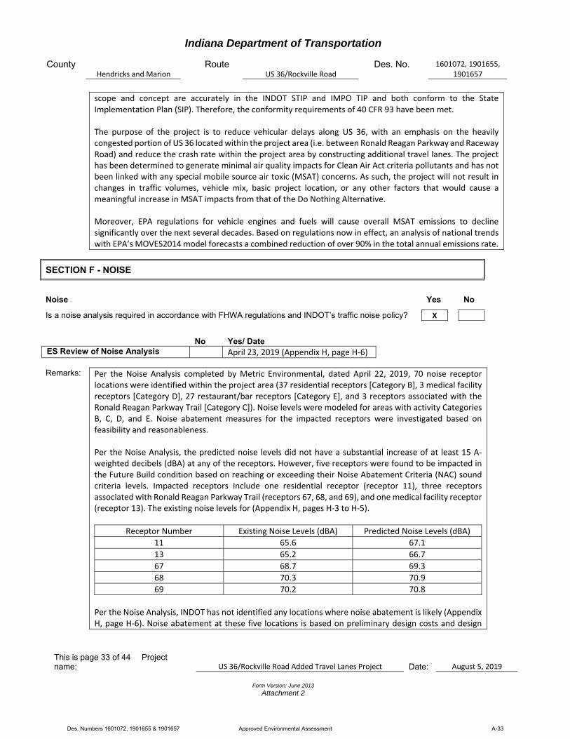
Indiana Department of Transportation
County Hendricks and Marion
Route US 36/Rockville Road
Des. No. 1601072, 1901655, 1901657
This is page 33 of 44 Project name: US 36/Rockville Road Added Travel Lanes Project Date:
August 5, 2019
Form Version: June 2013
Attachment 2
scope and concept are accurately in the INDOT STIP and IMPO TIP and both conform to the State Implementation Plan (SIP). Therefore, the conformity requirements of 40 CFR 93 have been met. The purpose of the project is to reduce vehicular delays along US 36, with an emphasis on the heavily congested portion of US 36 located within the project area (i.e. between Ronald Reagan Parkway and Raceway Road) and reduce the crash rate within the project area by constructing additional travel lanes. The project has been determined to generate minimal air quality impacts for Clean Air Act criteria pollutants and has not been linked with any special mobile source air toxic (MSAT) concerns. As such, the project will not result in changes in traffic volumes, vehicle mix, basic project location, or any other factors that would cause a meaningful increase in MSAT impacts from that of the Do Nothing Alternative. Moreover, EPA regulations for vehicle engines and fuels will cause overall MSAT emissions to decline significantly over the next several decades. Based on regulations now in effect, an analysis of national trends with EPA’s MOVES2014 model forecasts a combined reduction of over 90% in the total annual emissions rate.
SECTION F - NOISE
Noise Yes No
Is a noise analysis required in accordance with FHWA regulations and INDOT’s traffic noise policy? X
Remarks: Per the Noise Analysis completed by Metric Environmental, dated April 22, 2019, 70 noise receptor locations were identified within the project area (37 residential receptors [Category B], 3 medical facility receptors [Category D], 27 restaurant/bar receptors [Category E], and 3 receptors associated with the Ronald Reagan Parkway Trail [Category C]). Noise levels were modeled for areas with activity Categories B, C, D, and E. Noise abatement measures for the impacted receptors were investigated based on feasibility and reasonableness. Per the Noise Analysis, the predicted noise levels did not have a substantial increase of at least 15 A‐weighted decibels (dBA) at any of the receptors. However, five receptors were found to be impacted in the Future Build condition based on reaching or exceeding their Noise Abatement Criteria (NAC) sound criteria levels. Impacted receptors include one residential receptor (receptor 11), three receptors associated with Ronald Reagan Parkway Trail (receptors 67, 68, and 69), and one medical facility receptor (receptor 13). The existing noise levels for (Appendix H, pages H‐3 to H‐5).
Receptor Number Existing Noise Levels (dBA) Predicted Noise Levels (dBA)
11 65.6 67.1
13 65.2 66.7
67 68.7 69.3
68 70.3 70.9
69 70.2 70.8
Per the Noise Analysis, INDOT has not identified any locations where noise abatement is likely (Appendix H, page H‐6). Noise abatement at these five locations is based on preliminary design costs and design
No Yes/ Date ES Review of Noise Analysis April 23, 2019 (Appendix H, page H‐6)
Des. Numbers 1601072, 1901655 & 1901657 Approved Environmental Assessment A-33

Indiana Department of Transportation
County Hendricks and Marion
Route US 36/Rockville Road
Des. No. 1601072, 1901655, 1901657
This is page 34 of 44 Project name: US 36/Rockville Road Added Travel Lanes Project Date:
August 5, 2019
Form Version: June 2013
Attachment 2
criteria. Noise abatement has been not been found to be feasible and reasonable. This is due to engineering feasibility restrictions (e.g. length of restrictions from drives and located off US 36, roadside ditches along the north side of US 36, and safety and line of sight considerations that would prevent the installation of noise barrier walls that can effectively provide noise abatement to the impacted receptors. Additionally, noise barriers along Ronald Reagan Parkway to abate noise impacts to the Ronald Reagan Parkway Trail receptors are not feasible because the project is a state‐funded project along a state highway and Ronald Reagan Parkway is a local roadway outside the project limits or managed by a project sponsor. Therefore, abatement measures for impacted receptors within the project area are not feasible. A reevaluation of the noise analysis will occur during final design. If during final design it has been determined that conditions have changed such that noise abatement is feasible and reasonable, the abatement measures might be provided. The final decision on the installation of any abatement measure(s) will be made upon the completion of the project’s final design and the public involvement processes.
SECTION G – COMMUNITY IMPACTS
Regional, Community & Neighborhood Factors Yes No Will the proposed action comply with the local/regional development patterns for the area? X
Will the proposed action result in substantial impacts to community cohesion? X
Will the proposed action result in substantial impacts to local tax base or property values? X
Will construction activities impact community events (festivals, fairs, etc.)? X
Does the community have an approved transition plan? X
If No, are steps being made to advance the community’s transition plan?
Does the project comply with the transition plan? (explain in the remarks box) X
Remarks: The project will comply with the local/regional development patterns for the area. The project is not
anticipated to result in substantial impacts to community cohesion, because it will not change access to properties within the area or divide existing communities. The proposed project is not expected to impact the surrounding community or cause economic impacts to the surrounding area. Therefore, the project will have minimal or no negative impacts to the community or local economy. There are several businesses within the project area. Per the Fairs and Festivals website (www.fairsand festivals.net), accessed on April 15, 2019 by RQAW, 15 fairs/festivals are currently scheduled within 10 miles of zip code 46123. These or any future fairs/festivals that may be planned are unlikely to be impacted by the project since fair or festival goers can utilize US 36 during construction. Per the Hendricks County, Indiana government website (https://www.co.hendricks.in.us/egov/documents/ 1495197073_66107.pdf), Hendricks County has an Implementation and Transition Plan, dated December 2011. Per coordination with the Department of Public Works‐City of Indianapolis Office of Disability Affairs on April 30, 2019, Marion County has an approved Americans with Disabilities Act (ADA) Transition Plan. The Indianapolis Department of Public Works‐City of Indianapolis Office of Disability then coordinated with The Fehribach Group to determine the approval date of the plan. It was determined that the ADA voluntary compliance and implementation of all the ADA requirements within Marion County fall under the City of Indianapolis Office of Disability Affairs. The most recent plan was implemented in September 2016. The project will comply with the ADA Transition Plans by providing ADA compliant curb ramps and a median pedestrian refuge. The existing curb ramps in the northeast and northwest quadrants of the US 36/Ronald
Des. Numbers 1601072, 1901655 & 1901657 Approved Environmental Assessment A-34

Indiana Department of Transportation
County Hendricks and Marion
Route US 36/Rockville Road
Des. No. 1601072, 1901655, 1901657
This is page 35 of 44 Project name: US 36/Rockville Road Added Travel Lanes Project Date:
August 5, 2019
Form Version: June 2013
Attachment 2
Reagan Parkway Intersection will be replaced to meet ADA requirements. An at‐grade pedestrian crossing and median pedestrian refuge will be installed at the US 36 and Ronald Reagan Parkway Intersection to connect the existing trail located north of US 36, along the west side of Ronald Reagan Parkway, to the proposed trail located south of US 36, along the west side of Ronald Reagan Parkway (Des. Number 1601121). Four curb ramps will be constructed (two in the median pedestrian refuge, one north of the median pedestrian refuge, and one south of the median pedestrian refuge). There is no existing curb ramp in the southeast quadrant of the US 36/Ronald Reagan Parkway Intersection. This project will not include installation of a new curb ramp at this location as there are no pedestrian facilities in this quadrant. The project is also in compliance with INDOT’s Draft ADA Transition Plan, dated June 1, 2018 (https://www.in.gov/indot/files/2018%20Transition% 20Plan %20Draft.pdf).
Indirect and Cumulative Impacts Yes No Will the proposed action result in substantial indirect or cumulative impacts? X
Remarks: Indirect impacts are effects caused by the action (project) and later in time, or farther removed in distance,
but are still reasonably foreseeable. Indirect effects may include growth inducing effects and other effects related to induced changes in the pattern of land use, population density, or growth rate. Cumulative impacts affect the environment which result from the incremental impact of the action when added to other past, present, and reasonably foreseeable future actions regardless of what agency (Federal or non‐Federal) or person undertakes such actions. Due to the scope of the project and limited impacts, it is not expected to result in any substantial indirect or cumulative impacts. The improvement of the roadway will allow more efficient travel for vehicles along US 36. However, the improved efficiency for vehicles is not expected to increase development in the area beyond what is already planned. The project will add capacity to the existing roadway network; however, it will not provide additional access to any currently undeveloped area. Post construction, traffic is not expected to back up west of the project area. Per coordination with the project designer, an entire traffic analysis and simulation was developed to determine the optimum location to eliminate the third westbound lane.
Public Facilities & Services Yes No Will the proposed action result in substantial impacts on health and educational facilities, public and private utilities, emergency services, religious institutions, airports, public transportation or pedestrian and bicycle facilities? Discuss how the maintenance of traffic will affect public facilities and services.
X
Remarks: Per a desktop review, a field visit conducted on May 25, 2018 and April 3, 2019 by RQAW (Appendix A, pages
A‐6 to A‐15), an aerial photograph of the project area (Appendix A, pages A‐3 to A‐5), and the infrastructure map in the RFI report (Appendix D, page D‐7), there are seven public facilities (one church, two recreational facilities, three trail segments, and one airport) located within 0.5 mile of the project area. There does not appear to be any schools (educational facilities), hospitals or police stations (emergency services), or public transportation stations located within the 0.5 mile search radius. The Washington Township Avon Fire Department Station Number 2 is located approximately 0.46 mile north of the US 36/Ronald Reagan Parkway Intersection. Impacts are not expected. The Rainbow Acres Church of God is mapped adjacent to the project area; however, per the field visit, the church is not located within or adjacent to the project area. Per coordination with the designer, there are underground public water utility lines present throughout the entire project area; these utility lines will be temporarily impacted to install the new storm sewer lines and drain inlets. Utility coordination is ongoing. Three trail segments associated with the Ronald Reagan Parkway Trail (two segments are open on the north side of US 36 at the US 36/Ronald Reagan Parkway Intersection, and one segment is currently under
Des. Numbers 1601072, 1901655 & 1901657 Approved Environmental Assessment A-35
Indiana Department of Transportation
County Hendricks and Marion
Route US 36/Rockville Road
Des. No. 1601072, 1901655, 1901657
This is page 36 of 44 Project name: US 36/Rockville Road Added Travel Lanes Project Date:
August 5, 2019
Form Version: June 2013
Attachment 2
development on the south side of US 36 at the US 36/Ronald Reagan Parkway Intersection) are adjacent to the project area. Refer to the Section 4(f) Involvement section of this document for further details on the trail segments. The project will allow reduced vehicular delays along US 36, with an emphasis on the heavily congested portion of US 36 located within the project area (i.e. between Ronald Reagan Parkway and Raceway Road) and reduce the crash rate within the project area. Per the RFI report, one public airport, Speedway Public Airport, is located within 3.8 miles (20,000 feet) of the project area (Appendix D, page D‐2). An early coordination was sent to the INDOT Office of Aviation on January 28, 2019 (Appendix B, page B‐1 to B‐4). Per the INDOT Office of Aviation early coordination response letter, dated February 4, 2019, an Indiana Tall Structure Permit would not be required unless the project involves the construction of a temporary (e.g., crane) or permanent structure that penetrates a 100:1 slope from the nearest point of the Indianapolis International Airport runways (Appendix B, page B‐22). An Indiana Tall Structure Permit will not be required. Per the Hendricks County Engineer early coordination response e‐mail, dated February 13, 2019, Hendricks County does not foresee any adverse effects to county facilities due to the project. The e‐mail also indicated that all drainage structures not located under US 36 and that are 36 inches or greater in diameter or span length are under County jurisdiction. Any proposed modifications to such structures would need to be reviewed during the design process by the Henricks County Engineer (Appendix B, page B‐23). Per the Marion County Surveyor’s Office early coordination response e‐mail, dated February 4, 2019, Marion County has one monument located within the right‐of‐way limits at the county line (i.e. at Raceway Road). If the monument is disturbed, it will need to be replaced under the supervision of the Marion County Surveyor’s Office per IC 8‐23‐9‐24. The Marion County Surveyor’s Office indicated it can provide a cast iron Harrison monument to replace the current Harrison monument if it is desired. The Marion County Surveyor’s Office would like to be present if/when the corner is excavated (Appendix B, pages B‐24 to B‐26). A meeting was held with RQAW, the Town of Avon, and the Assistant Fire Chief of the Town of Avon on February 27, 2019. It was decided that specifying mountable curbs at strategic locations (i.e. not directly across from right in, right out access points) to allow emergency response vehicles to cross over the median to the other side of the road is the solution. These locations will need to be delineated to allow drivers of the emergency response vehicles to easily identify the locations. RQAW is currently identifying these locations (Appendix F, page F‐42). Early coordination letters were also sent to the U.S. Department of Housing and Urban Development, Indianapolis Metropolitan Planning Organization, Hendricks County Planning and Building Commission, Rainbow Acres Church of God, Hendricks County Council Members, Marion County Council members, Hendricks County Commissioner members, Marion County Commissioner members, Hendricks Highway Supervisor, Hendricks County Surveyor, Marion County Department of Public Works, Town of Avon Council members, and Town of Avon Public Works on January 28, 2019 (Appendix B, pages B‐1 to B‐4). These organizations did not respond to the early coordination letter. It is the responsibility of the project sponsor to notify school corporations and emergency services at least two weeks prior to any construction that would block or limits access.
Environmental Justice (EJ) (Presidential EO 12898) Yes No During the development of the project were EJ issues identified? X
Does the project require an EJ analysis? X
Des. Numbers 1601072, 1901655 & 1901657 Approved Environmental Assessment A-36

Indiana Department of Transportation
County Hendricks and Marion
Route US 36/Rockville Road
Des. No. 1601072, 1901655, 1901657
This is page 37 of 44 Project name: US 36/Rockville Road Added Travel Lanes Project Date:
August 5, 2019
Form Version: June 2013
Attachment 2
If YES, then:
Are any EJ populations located within the project area? X
Will the project result in adversely high or disproportionate impacts to EJ populations? X
Remarks: Under FHWA Order 6640.23A, FHWA and INDOT, as a recipient of funding from FHWA, are responsible to ensure that their programs, policies, and activities do not have a disproportionately high and adverse effect on minority or low‐income populations. Per the current INDOT Environmental Justice NEPA Documentation Process, an Environmental Justice (EJ) Analysis is required for all EA and Environmental Impact Statement (EIS) level documents. Potential EJ impacts are detected by locating minority populations and low‐income populations relative to a reference population to determine if populations of EJ concern exists and whether there could be disproportionately high and adverse impacts to them. The reference population may be a county, city, or town and is called the community of comparison (COC). In this project, the COC is Washington Township (Hendricks County) and Wayne Township (Marion County). The community that overlaps the project limits is called the affected community (AC). In this project, the ACs are Census Tract 2106.04, Census Tract 2106.06 (Washington Township), and Census Tract 3401.01 (Wayne Township). An AC has a population of concern for EJ if the population is more than 50% low‐income or minority or if the low‐income or minority population is 125% of the COC. American Community Survey 5‐year estimates data (2013 through 2017) was obtained from the U.S. Census Bureau website (https://factfinder.census.gov/faces/ nav/jsf/pages/searchresults.xhtml?refresh=t) on June 4, 2019 by RQAW. The data collected for low‐income and minority populations within the ACs are summarized in the table below.
Table: Low‐income and Minority Data (American Community Survey, 2013 through 2017)
COC: Washington Township (Hendricks
County) + Wayne Township (Marion
County)
AC 1 (Census Tract 2106.04)
AC 2 (Census Tract 2106.06)
AC 3 (Census Tract 3401.01)
Percent Low‐income
20.5% 2.9% 8.9% 9.9%
125% of COC 25.7% AC ≥ 125% of COC AC ≥ 125% of COC AC ≥ 125% of COC
EJ Population of Concern No No No
Percent Minority 45.9% 24.8% 30.3% 18.1%
125% of COC 57.4% AC ≥ 125% of COC AC ≥ 125% of COC AC ≥ 125% of COC
EJ Population of Concern No No No
AC 1 has a percent low‐income of 2.9% which is below 50% and is below the 125% COC threshold (25.7%). AC 2 has a percent low‐income of 8.9% which is below 50% and is below the 125% COC threshold (25.7%). AC 3 has a percent low‐income of 9.9% which is below 50% and is below the 125% COC threshold (25.7%). Therefore, there are no low‐income populations of EJ concern. AC 1 has a percent minority of 24.8% which is below 50% and is below the 125% COC threshold (57.4%). AC 2 has a percent minority of 30.3% which is below 50% and is below the 125% COC threshold (57.4%). AC 3
Des. Numbers 1601072, 1901655 & 1901657 Approved Environmental Assessment A-37
Indiana Department of Transportation
County Hendricks and Marion
Route US 36/Rockville Road
Des. No. 1601072, 1901655, 1901657
This is page 38 of 44 Project name: US 36/Rockville Road Added Travel Lanes Project Date:
August 5, 2019
Form Version: June 2013
Attachment 2
has a percent minority of 18.1% which is below 50% and is below the 125% COC threshold (57.4%). Therefore, there are no minority populations of EJ concern. The census data sheets, map, and calculations can be found in Appendix H, pages H‐8 to H‐13. No further EJ analysis is warranted.
Relocation of People, Businesses or Farms Yes No Will the proposed action result in the relocation of people, businesses or farms? X
Is a Business Information Survey (BIS) required? X
Is a Conceptual Stage Relocation Study (CSRS) required? X
Has utility relocation coordination been initiated for this project? X Number of relocations: Residences: 0 Businesses: 0 Farms: 0 Other: 0
If a BIS or CSRS is required, discuss the results in the remarks box.
Remarks: No relocations of people, businesses, or farms will take place because of this project. Utility coordination has been initiated for the project. Several utilities are present within the project area (electric, water, telephone, gas, cable, etc.), some of which will be impacted for relocation. Per coordination with the designer, there are underground public water utility lines present throughout the entire project area; these utility lines will be temporarily impacted to install the new storm sewer lines and drain inlets. Utility coordination is ongoing.
SECTION H – HAZARDOUS MATERIALS & REGULATED SUBSTANCES
Documentation Hazardous Materials & Regulated Substances (Mark all that apply) Red Flag Investigation X Phase I Environmental Site Assessment (Phase I ESA) Phase II Environmental Site Assessment (Phase II ESA) Design/Specifications for Remediation required?
No Yes/ Date ES Review of Investigations February 15, 2019
Include a summary of findings for each investigation.
Remarks: Per a review of geographic information system (GIS) and available public records, a RFI report was completed on February 15, 2019 by RQAW (Appendix D, pages D‐1 to D‐15). Ten hazardous material concerns (one state cleanup site, three leaking underground storage tanks [LUSTs], five National Pollutant Discharge Elimination (NPDES) facilities, and one NPDES pipe location are located within 0.5‐mile of the project area. The state cleanup site, two LUSTs, one NPDES facility are mapped within or adjacent to the project area. INDOT Site Assessment and Management approved the Red Flag Investigation on February 15, 2019. Avon Creek, UNT 2 to Avon Creek, and Shiloh Creek (outside the project area) are impaired with E. coli. Workers who will be in or near water with E. coli should take care to wear appropriate PPE, observe proper hygiene procedures, including regular hand washing, and limit personal exposure. Per the RFI, one state cleanup site, Coach and Horses Restaurant, 9251 Rockville Road, Agency Interest ID 21024, is located within 0.5 mile of the project area. The state cleanup site is located within the project area. No impacts are expected because a No Further Action for this site was issued on July 20, 2004. Per the IDEM Virtual File Cabinet (VFC), residual petroleum impacts were left in place and extend under Rockville Road. If excavation occurs in this area, proper handling, removal, and disposal of soil and/or groundwater will be necessary.
Des. Numbers 1601072, 1901655 & 1901657 Approved Environmental Assessment A-38

Indiana Department of Transportation
County Hendricks and Marion
Route US 36/Rockville Road
Des. No. 1601072, 1901655, 1901657
This is page 39 of 44 Project name: US 36/Rockville Road Added Travel Lanes Project Date:
August 5, 2019
Form Version: June 2013
Attachment 2
Per the RFI, three leaking underground storage tank (LUST) sites, are located within 0.5 mile of the project area. The nearest LUST site, Speedway/Sm #6125, 10908 East US 36, Facility ID 6682, is mapped within the project area. No impacts are expected because a No Further Action for this site was issued on March 7, 2007. Per the IDEM VFC, residual chemicals of concern (CoCs) remain on‐site and do not appear to extend to the project area. No impact is expected. One LUST site, Autobahn Inc., 8921 East 116th Street, Agency Interest ID 21603, is mapped adjacent to the project area. However, per the IDEM VFC, the LUST icon is misplaced; it is in Fishers, Indiana. There is a Meijer Gas Station there now and it does not appear they have a release. No impacts are expected. One LUST site, Eldron Byrd Property, 8751 Rockville Road, Agency Interest ID 20889, is mapped approximately 0.29 mile east of the project area. No impacts are expected due to the distance from the project area. Per the RFI, five National Pollutant Discharge Elimination System (NPDES) facilities are located within 0.5 mile of the project area. The nearest NPDES facility, LA‐Z‐Boy Home Furnishings and Décor, Rockville Road and Raceway Road, Permit Number INR 10K783, is located adjacent to the project area. Information was not found in the IDEM VFC; however, no impacts are expected. Per the RFI, one NPDES pipe location is located within 0.5 mile of the project area. The NPDES pipe location is located approximately 0.24 mile south of the project area. No impacts are expected due to the distance from the project area. In addition, no additional hazardous material concerns were observed within or adjacent to the project area during a field visit conducted on May 25, 2018 and April 3, 2019 by RQAW (Appendix D, pages D‐16 and D‐17). Further investigation for hazardous material concerns is not required at this time.
SECTION I – PERMITS CHECKLIST
Permits (mark all that apply)
Likely Required
Army Corps of Engineers (404/Section10 Permit) Individual Permit (IP) Nationwide Permit (NWP) Regional General Permit (RGP) X Pre-Construction Notification (PCN) Other Wetland Mitigation required Stream Mitigation required IDEM Section 401 WQC X Isolated Wetlands determination Rule 5 X Other Wetland Mitigation required X Stream Mitigation required X IDNR Construction in a Floodway X Navigable Waterway Permit
Des. Numbers 1601072, 1901655 & 1901657 Approved Environmental Assessment A-39

Indiana Department of Transportation
County Hendricks and Marion
Route US 36/Rockville Road
Des. No. 1601072, 1901655, 1901657
This is page 40 of 44 Project name: US 36/Rockville Road Added Travel Lanes Project Date:
August 5, 2019
Form Version: June 2013
Attachment 2
Lake Preservation Permit Other Mitigation Required US Coast Guard Section 9 Bridge Permit Others (Please discuss in the remarks box below)
Remarks: A USACE Section 404 Permit and IDEM Section 401 Water Quality Certification will be required due to stream
and wetland impacts. The total area of land disturbance is approximately 21.50 acres. Because the project will result in one acre or more of land disturbance, an IDEM Rule 5 Notice of Intent will be required. An IDNR Construction in a Floodway will be needed. The project will impact approximately 897 linear feet (0.07 acre) of streams. The project will impact approximately 0.13 acre of wetlands. Mitigation will be determined during permitting. If possible, the IDNR In‐Lieu Fee Program will be utilized for mitigation. Per the IDNR Division of Fish and Wildlife early coordination response letter, dated February 28, 2019, the project will require formal approval for construction in a floodway under the Flood Control Act, IC 14‐28‐1, for any proposal to construct, excavate, or fill in or on the floodway of a stream or other flowing waterbody which has a drainage area greater than one square mile (Appendix B, pages B‐15 and B‐16). Because Avon Creek has an upstream drainage area of approximately 1.03 square miles (Appendix E, page E‐14), an IDNR Construction in a Floodway Permit will be required. Per the INDOT Office of Aviation early coordination response letter, dated February 4, 2019, an Indiana Tall Structure Permit would not be required unless the project involves the construction of a temporary (e.g., crane) or permanent structure that penetrates a 100:1 slope from the nearest point of the Indianapolis International Airport runways (Appendix B, page B‐22). An Indiana Tall Structure Permit will not be required. It is the responsibility of the project sponsor to identify and obtain all required permits.
SECTION J- ENVIRONMENTAL COMMITMENTS
The following information should be provided below: List all commitments, name of agency/organization requesting the commitment(s) and indicating which are firm and which are for further consideration. The commitments should be numbered.
Remarks: Firm: 1. If the scope of work or permanent or temporary right‐of‐way amounts change, the INDOT
Environmental Services Division and the INDOT District Environmental Section will be contacted immediately. (INDOT Environmental Services Division)
2. A state cleanup site, Coach and Horses Restaurant, 9251 Rockville Road, Agency Interest ID 21024, is located within the project area. If excavation occurs in this area, proper handling, removal, and disposal of soil and/or groundwater will be necessary. (INDOT Environmental Services Division)
3. Avon Creek and UNT 2 to Avon Creek are impaired with E. coli. Workers who will be in or near water with E. coli should take care to wear appropriate PPE, observe proper hygiene procedures, including regular hand washing, and limit personal exposure. (INDOT Environmental Services Division)
4. Wetland boundaries will be identified as “Wetland—Do Not Disturb Outside Construction Limits” on the final design plans. Wetland boundaries will be identified in the field prior to construction to avoid indirect impacts. INDOT recommends orange fencing and signs to separate construction activities from all wetlands. (INDOT Environmental Services Division)
Des. Numbers 1601072, 1901655 & 1901657 Approved Environmental Assessment A-40
Indiana Department of Transportation
County Hendricks and Marion
Route US 36/Rockville Road
Des. No. 1601072, 1901655, 1901657
This is page 41 of 44 Project name: US 36/Rockville Road Added Travel Lanes Project Date:
August 5, 2019
Form Version: June 2013
Attachment 2
5. It is the responsibility of the project sponsor to notify school corporations and emergency services at least two weeks prior to any construction that would block or limits access. (INDOT Environmental Services Division)
6. Mountable curbs will be installed at strategic locations to allow emergency response vehicles to cross over the median to the other side of the road. RQAW is currently identifying these locations and these locations will be incorporated into the final design plans. (Town of Avon)
7. All drainage structures not located under US 36 and are 36 inches or greater in diameter or span length are under County jurisdiction. Any proposed modifications to such structures would need to be reviewed during the design process by the Henricks County Engineer. (Hendricks County Engineer)
8. Marion County has one monument located within the right‐of‐way limits at the US 36/Raceway Road Intersection. If the monument is disturbed, it will need to be replaced under the supervision of the Marion County Surveyor’s Office per IC 8‐23‐9‐24. The Marion County Surveyor’s Office indicated it can provide a cast iron Harrison monument to replace the current Harrison monument if it is desired. The Marion County Surveyor’s Office would like to be present if/when the corner is excavated (Marion County Surveyor’s Office).
9. If any prehistoric or historic archaeological artifacts or human remains are uncovered during construction, demolition, or earthmoving activities, state law (Indiana Code 14‐21‐1‐27 and ‐29) requires the discovery be reported to the IDNR Division of Historic Preservation and Archaeology within two business days. In this event, please call 317‐232‐1646. (Indiana SHPO)
10. General AMM 1: Ensure all operators, employees, and contractors working in areas of known or presumed bat habitat are aware of all FHWA/FRA/FTA (Transportation Agencies) environmental commitments, including all applicable AMMs. (USFWS)
11. Lighting AMM 1: Direct temporary lighting away from suitable habitat during the active season. (USFWS)
For Further Consideration:
1. Appropriate structures and techniques should be utilized both during the construction phase, and after completion of the project, to minimize the impacts associated with storm water runoff. (IDEM)
2. The use of appropriate planning and site development and appropriate storm water quality measures are recommended to prevent soil from leaving the construction site during active land disturbance and for post construction water quality concerns. (IDEM)
3. Vegetative wastes should be taken to a registered yard waste composting facility or be chipped or shredded with composting on site (you must register with IDEM if more than 2,000 pounds is to be composted); contact 317‐232‐0066. (IDEM)
4. The physical disturbance of the stream and riparian vegetation, especially large trees overhanging any affected water bodies should be limited to only that which is absolutely necessary to complete the project. (IDEM)
5. Reasonable precautions must be taken to minimize fugitive dust emissions from construction and demolition activities. For example, wetting the area with water, constructing wind barriers, or treating dusty areas with chemical stabilizers (such as calcium chloride or several other commercial products). Dirt tracked onto paved roads from unpaved areas should be minimized. (IDEM)
6. Ensure that asphalt paving plants are permitted and operate properly. The use of cutback asphalt, or asphalt emulsion containing more than 7% oil distillate, is prohibited during the months April through October. (IDEM)
Des. Numbers 1601072, 1901655 & 1901657 Approved Environmental Assessment A-41
Indiana Department of Transportation
County Hendricks and Marion
Route US 36/Rockville Road
Des. No. 1601072, 1901655, 1901657
This is page 42 of 44 Project name: US 36/Rockville Road Added Travel Lanes Project Date:
August 5, 2019
Form Version: June 2013
Attachment 2
7. If the site is found to contain any areas used to dispose of solid or hazardous waste, you need to contact the Office of Land Quality (OLQ)at 317‐308‐3103. (IDEM)
8. All solid wastes generated by the project, or removed from the project site, need to be taken to a properly permitted solid waste processing or disposal facility. For more information, visit http://www.in.gov/idem/4998.htm. (IDEM)
9. If any contaminated soils are discovered during this project, they may be subject to disposal as hazardous waste. Please contact the OLQ at 317‐308‐3103 to obtain information on proper disposal procedures. (IDEM)
10. Revegetate all bare and disturbed areas that will not be mowed and maintained with a mixture of grasses, sedges, and wildflowers native to central Indiana and specifically for stream bank/floodway stabilization purposes as soon as possible upon completion; turf‐type grasses (including low endophyte, friendly endophyte, and endophyte free tall fescue but excluding all other varieties of tall fescue) may be used in regularly mowed areas only. (IDNR Division of Fish and Wildlife)
11. Minimize and contain within the project limits inchannel disturbance and the clearing of trees and brush. (IDNR Division of Fish and Wildlife)
12. Do not work in the waterway from April 1 through June 30 within the prior written approval of the IDNR Division of Fish and Wildlife. (IDNR Division of Fish and Wildlife)
13. Do not construct any temporary runarounds, access bridges, causeways, cofferdams, diversions, or pumparounds. (IDNR Division of Fish and Wildlife)
14. Use minimum average 6‐inch graded riprap stone extended below the normal water level to provide habitat for aquatic organisms in the voids. (IDNR Division of Fish and Wildlife)
15. Do not use broken concrete as riprap. (IDNR Division of Fish and Wildlife) 16. Underlay the riprap with a bedding layer of well graded aggregate or a geotextile to prevent piping
of soil underneath the riprap. (IDNR Division of Fish and Wildlife) 17. Do not deposit or allow demolition/construction materials or debris to fall or otherwise enter the
waterway. (IDNR Division of Fish and Wildlife) 18. Appropriately designed measures for controlling erosion and sediment must be implemented to
prevent sediment from entering the stream or leaving the construction site; maintain these measures until construction is complete and all disturbed areas area stabilized. (IDNR Division of Fish and Wildlife)
19. Seed and protect all disturbed streambanks and slopes not protected by other methods that are 3:1 or steeper with erosion control blankets that are heavy‐duty, biodegradable, and net free or that use loose‐woven/Leno‐woven netting to minimize the entrapment and snaring of small‐bodied wildlife such as snakes and turtles (follow manufacturer’s recommendations for selection and installation); seed and apply mulch on all other disturbed areas. (IDNR Division of Fish and Wildlife)
20. Do not clear trees or understory vegetation outside the construction zone boundaries. (This restriction is not related to the “tree clearing” restriction for potential Indiana bat habitat). (USFWS Standard Recommendation)
21. Restrict below low‐water work in streams to placement of culverts, piers, pilings and/or footings, shaping of the spill slopes around the bridge abutments, and placement of riprap. (USFWS Standard Recommendation)
22. Restrict channel work and vegetation clearing to the minimum necessary for installation of the stream crossing structure. (USFWS Standard Recommendation)
23. Minimize the extent of hard armor (riprap) in bank stabilization by using bioengineering techniques whenever possible. If riprap is utilized for bank stabilization, extend it below low‐water elevation to provide aquatic habitat. (USFWS Standard Recommendation)
24. Implement temporary erosion and sediment erosion control methods within areas of disturbed soils.
Des. Numbers 1601072, 1901655 & 1901657 Approved Environmental Assessment A-42

Indiana Department of Transportation
County Hendricks and Marion
Route US 36/Rockville Road
Des. No. 1601072, 1901655, 1901657
This is page 43 of 44 Project name: US 36/Rockville Road Added Travel Lanes Project Date:
August 5, 2019
Form Version: June 2013
Attachment 2
All disturbed soil areas upon project completion will be vegetated following INDOT’s Standard Specification. (USFWS Standard Recommendation)
25. Avoid all work within the inundated part of the stream channel (in perennial streams and larger intermittent streams) during the fish spawning season (April 1 through June 30), except for work within sealed structures such as caissons or cofferdams that were installed prior to the spawning season. No equipment shall be operated below Ordinary High Water Mark during this time unless the machinery is within the caissons or on the cofferdams. (USFWS Standard Recommendation)
26. Evaluate wildlife crossings under bridge/culverts projects in appropriate situations. Suitable crossings include flat areas below bridge abutments with suitable ground cover, high water shelves in culverts, amphibian tunnels and diversion fencing. (USFWS Standard Recommendation)
SECTION K- EARLY COORDINATION
Please list the date coordination was sent and all agencies that were contacted as a part of the development of this Environmental Study. Also, include the date of their response or indicate that no response was received. INDOT and FHWA are automatically considered early coordination participants and should only be listed if a response is received.
Remarks: Early coordination letters were sent to agencies on January 28, 2019 (Appendix B, pages B‐1 to B‐4). If a response was not received, it was assumed the agency did not feel the project would result in substantial impacts. See responding agency correspondences in Appendix B, pages B‐5 through B‐53. The below agencies/individuals were contacted during early coordination. After early coordination was initiated, slight changes in the project design and construction limits occurred that resulted in impacts to an additional stream. A letter describing these changes was sent to the USACE, IDNR Division of Fish and Wildlife, IDEM, Marion County Surveyor’s Office, and the Hendricks County Surveyor’s Office on June 27, 2019 (Appendix B, pages B‐48 to B‐50).
Agency Date of Response(s)
1. Natural Resources Conservation Service (electronic coordination) February 13, 2019
2. IDNR Division of Fish and Wildlife (electronic coordination) February 28, 2019
3. IDEM Groundwater Section (electronic coordination) February 1, 2019
4. INDOT Office of Aviation (electronic coordination) February 4, 2019
5. INDOT Office of Public Involvement (electronic coordination) January 29, 2019
6. U.S. Department of Housing and Urban Development (electronic coordination) No response received
7. Indiana Geological Survey (electronic submission) January 28, 2019
8. IDEM (electronic submission) January 28, 2019 June 27, 2019
9. National Park Service, Midwest Regional Office No response received
10. Indianapolis Metropolitan Planning Organization No response received
11. U.S. Army Corps of Engineers, Louisville District (electronic coordination)
No response received
12. Hendricks County MS4 Coordinator No response received
13. Hendricks County Council Members No response received
14. Hendricks County Board of Commissioners No response received
15. Hendricks County Engineer February 13, 2019
16. Hendricks County Highway Supervisor No response received
17. Hendricks County Surveyor No response received
Des. Numbers 1601072, 1901655 & 1901657 Approved Environmental Assessment A-43

Indiana Department of Transportation
County Hendricks and Marion
Route US 36/Rockville Road
Des. No. 1601072, 1901655, 1901657
This is page 44 of 44 Project name: US 36/Rockville Road Added Travel Lanes Project Date: August 5, 2019
Form Version: June 2013
Attachment 2
18. Marion County Council Members No response received
19. Marion County Board of Commissioners No response received
20. Marion County Department of Public Works No response received
21. Marion County Surveyor February 4, 2019
22. Town of Avon Council No response received
23. Town of Avon Public Works No response received
24. Hendricks County Planning and Building Commission No response received
25. Rainbow Acres Church of God No response received
26. Town of Avon MS4 Coordinator No response received
27. U.S. Fish and Wildlife Service (IPaC electronic coordination) March 15, 2019
Des. Numbers 1601072, 1901655 & 1901657 Approved Environmental Assessment A-44

Attachment B Certification of Public Involvement

Des. Numbers 1601072, 1901655 & 1901657 Certification of Public Involvement B-1
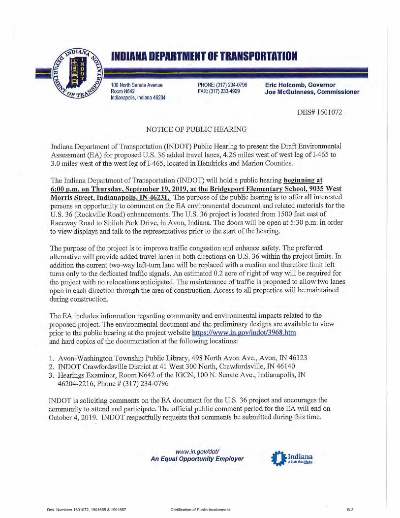
Des. Numbers 1601072, 1901655 & 1901657 Certification of Public Involvement B-2
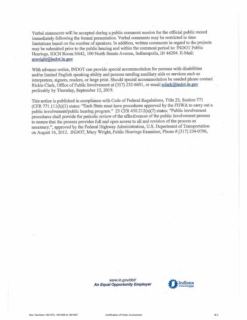
Des. Numbers 1601072, 1901655 & 1901657 Certification of Public Involvement B-3

Des. Numbers 1601072, 1901655 & 1901657 Certification of Public Involvement B-4

Des. Numbers 1601072, 1901655 & 1901657 Certification of Public Involvement B-5

Des. Numbers 1601072, 1901655 & 1901657 Certification of Public Involvement B-6
Des. Numbers 1601072, 1901655 & 1901657 Certification of Public Involvement B-7

Des. Numbers 1601072, 1901655 & 1901657 Certification of Public Involvement B-8

Des. Numbers 1601072, 1901655 & 1901657 Certification of Public Involvement B-9
Des. Numbers 1601072, 1901655 & 1901657 Certification of Public Involvement B-10
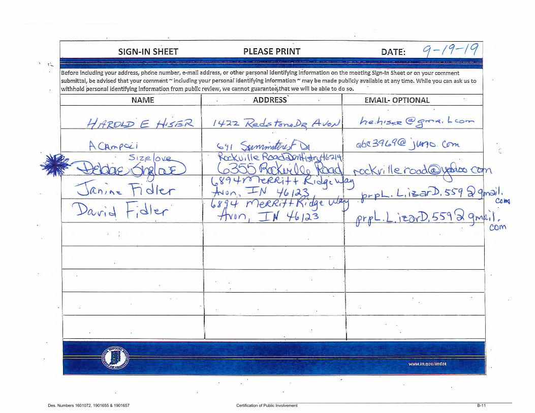
Des. Numbers 1601072, 1901655 & 1901657 Certification of Public Involvement B-11

Des. Numbers 1601072, 1901655 & 1901657 Certification of Public Involvement B-12
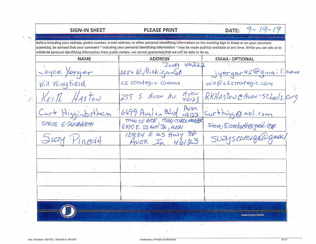
Des. Numbers 1601072, 1901655 & 1901657 Certification of Public Involvement B-13
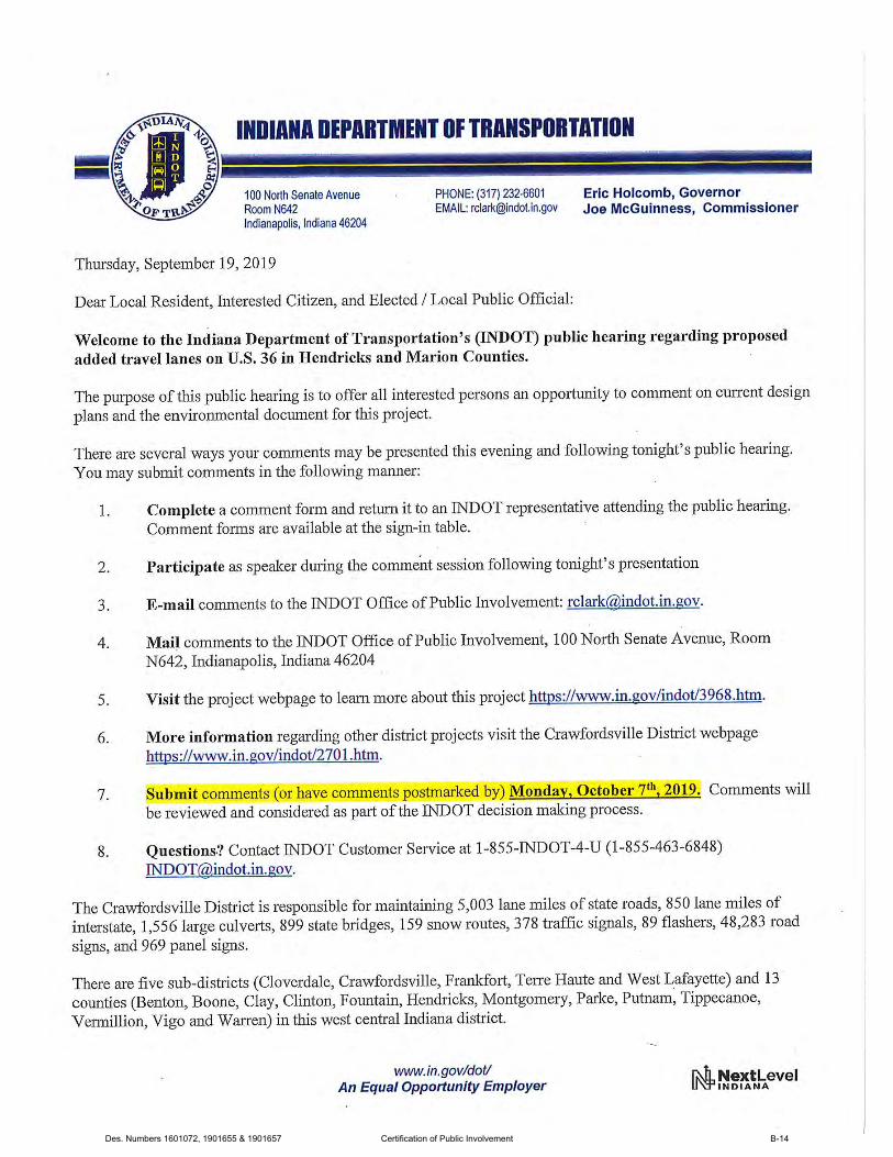
Des. Numbers 1601072, 1901655 & 1901657 Certification of Public Involvement B-14

Des. Numbers 1601072, 1901655 & 1901657 Certification of Public Involvement B-15

Des. Numbers 1601072, 1901655 & 1901657 Certification of Public Involvement B-16

Des. Numbers 1601072, 1901655 & 1901657 Certification of Public Involvement B-17

Des. Numbers 1601072, 1901655 & 1901657 Certification of Public Involvement B-18
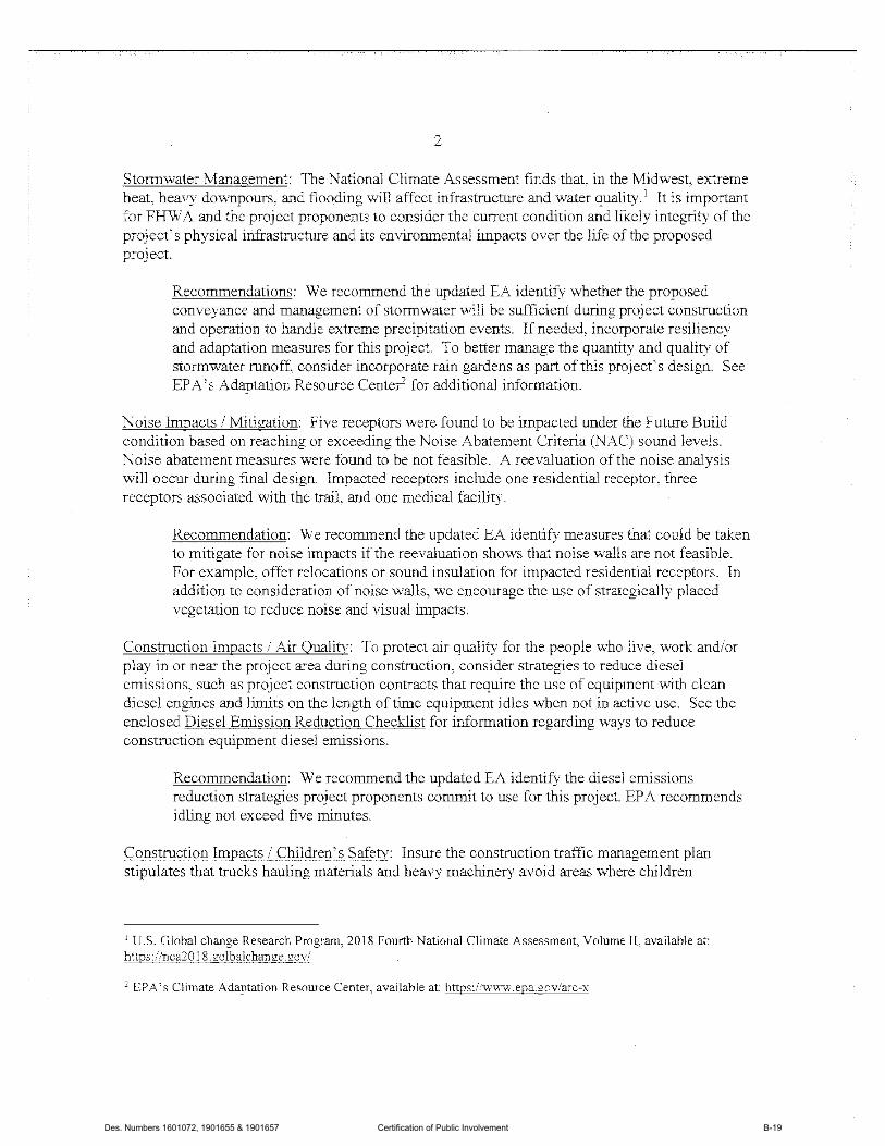
Des. Numbers 1601072, 1901655 & 1901657 Certification of Public Involvement B-19
Des. Numbers 1601072, 1901655 & 1901657 Certification of Public Involvement B-20
Des. Numbers 1601072, 1901655 & 1901657 Certification of Public Involvement B-21

Des. Numbers 1601072, 1901655 & 1901657 Certification of Public Involvement B-22
Des. Numbers 1601072, 1901655 & 1901657 Certification of Public Involvement B-23
Des. Numbers 1601072, 1901655 & 1901657 Certification of Public Involvement B-24
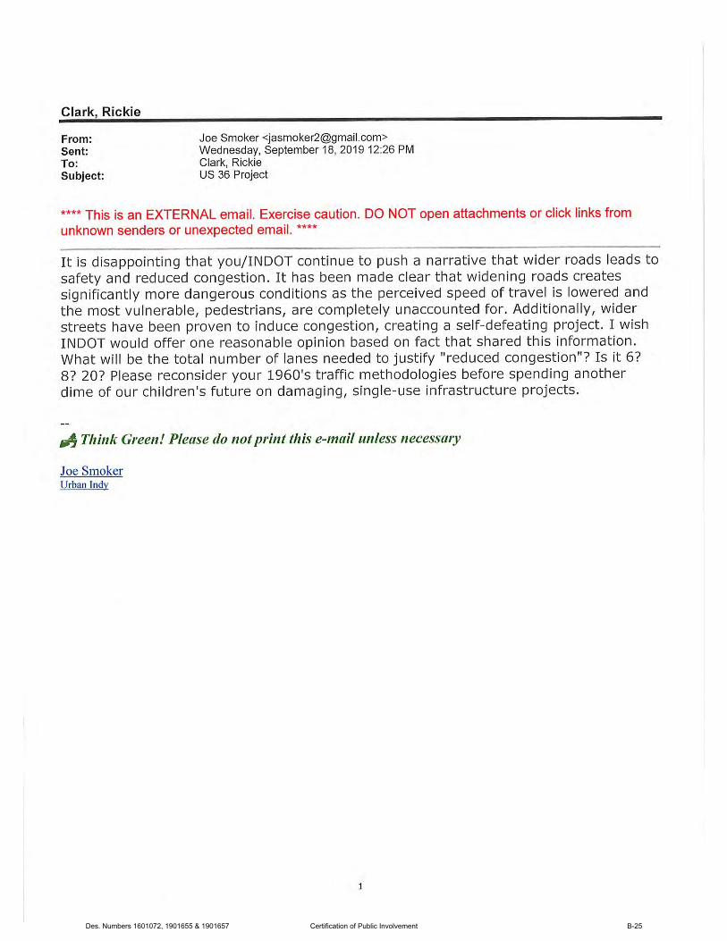
Des. Numbers 1601072, 1901655 & 1901657 Certification of Public Involvement B-25
Des. Numbers 1601072, 1901655 & 1901657 Certification of Public Involvement B-26
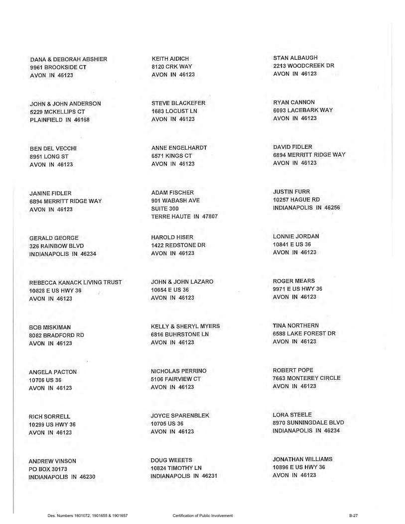
Des. Numbers 1601072, 1901655 & 1901657 Certification of Public Involvement B-27

Des. Numbers 1601072, 1901655 & 1901657 Certification of Public Involvement B-28
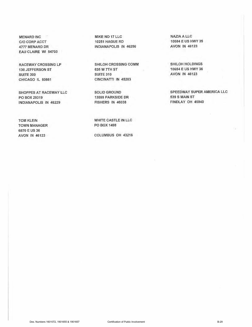
Des. Numbers 1601072, 1901655 & 1901657 Certification of Public Involvement B-29
Des. Numbers 1601072, 1901655 & 1901657 Certification of Public Involvement B-30
Des. Numbers 1601072, 1901655 & 1901657 Certification of Public Involvement B-31

Des. Numbers 1601072, 1901655 & 1901657 Certification of Public Involvement B-32
Des. Numbers 1601072, 1901655 & 1901657 Certification of Public Involvement B-33
Des. Numbers 1601072, 1901655 & 1901657 Certification of Public Involvement B-34
Des. Numbers 1601072, 1901655 & 1901657 Certification of Public Involvement B-35
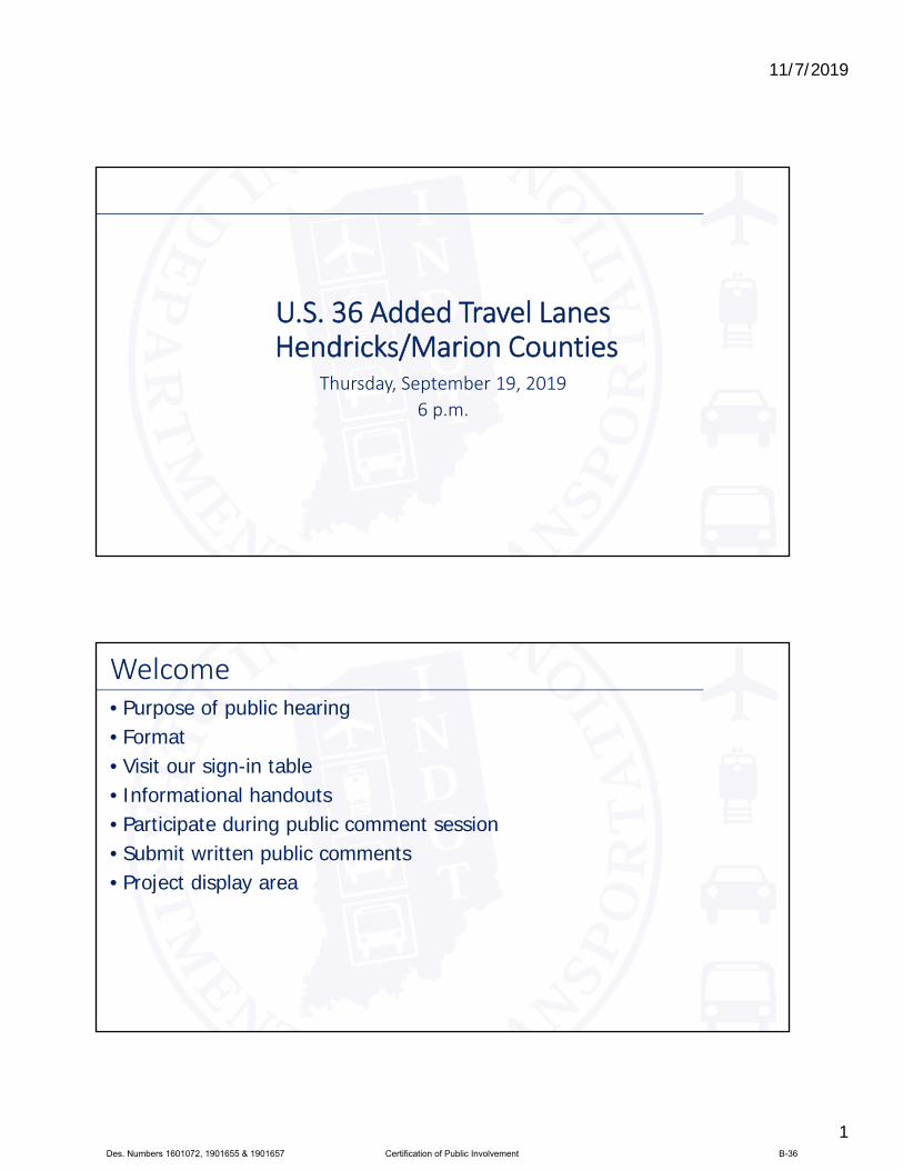
11/7/2019
1
U.S. 36 Added Travel Lanes Hendricks/Marion Counties
Thursday, September 19, 2019
6 p.m.
Welcome • Purpose of public hearing• Format• Visit our sign-in table• Informational handouts • Participate during public comment session• Submit written public comments • Project display area
Des. Numbers 1601072, 1901655 & 1901657 Certification of Public Involvement B-36
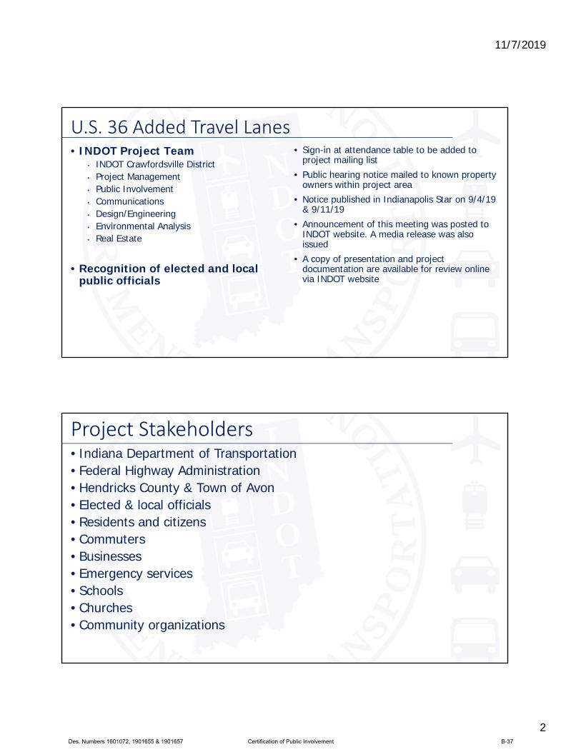
11/7/2019
2
• INDOT Project Team• INDOT Crawfordsville District • Project Management • Public Involvement • Communications • Design/Engineering• Environmental Analysis• Real Estate
• Recognition of elected and local public officials
• Sign-in at attendance table to be added to project mailing list
• Public hearing notice mailed to known property owners within project area
• Notice published in Indianapolis Star on 9/4/19 & 9/11/19
• Announcement of this meeting was posted to INDOT website. A media release was also issued
• A copy of presentation and project documentation are available for review online via INDOT website
U.S. 36 Added Travel Lanes
Project Stakeholders • Indiana Department of Transportation• Federal Highway Administration • Hendricks County & Town of Avon• Elected & local officials• Residents and citizens• Commuters• Businesses • Emergency services• Schools• Churches • Community organizations
Des. Numbers 1601072, 1901655 & 1901657 Certification of Public Involvement B-37

11/7/2019
3
Project Development
Project SelectionEarly Coordination
Purpose & NeedDevelop alternatives
Preliminary design phase
Environmental Analysis
PUBLIC INVOLVEMENT
Design Environmental
Additional public involvement
Project Decision
Real Estate
Project Letting
Construction
Communicate project decision 2019/2020
Public hearing during
environmental analysis phase
2019
Public Involvement:
Environmental Consideration National Environmental Policy Act (NEPA)• Requires INDOT to analyze and evaluate the impacts of a proposed project to the natural and socio-
economic environments• NEPA is a decision-making process
• Purpose and Need• Develop & Screen Alternatives• Preferred Alternative – determine a course of action
• Impacts are analyzed, evaluated and described in an environmental document• What are the impacts this project might have on the community?• How can impacts be avoided?• Can impacts be minimized?• Mitigation for impacts?
• Draft environmental document(s) released for public involvement August 2019
• Available for review via public repositories and online
Des. Numbers 1601072, 1901655 & 1901657 Certification of Public Involvement B-38
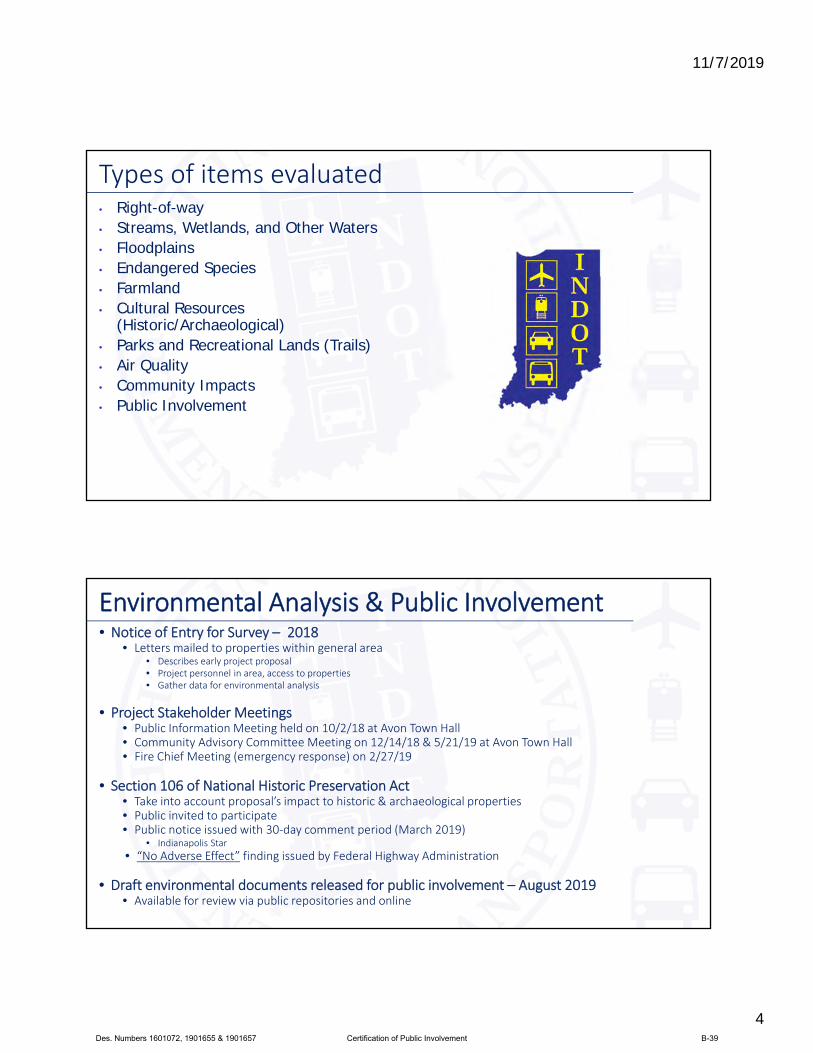
11/7/2019
4
• Right-of-way• Streams, Wetlands, and Other Waters• Floodplains• Endangered Species• Farmland• Cultural Resources
(Historic/Archaeological) • Parks and Recreational Lands (Trails)• Air Quality• Community Impacts• Public Involvement
Types of items evaluated
Environmental Analysis & Public Involvement • Notice of Entry for Survey – 2018
• Letters mailed to properties within general area• Describes early project proposal• Project personnel in area, access to properties • Gather data for environmental analysis
• Project Stakeholder Meetings • Public Information Meeting held on 10/2/18 at Avon Town Hall• Community Advisory Committee Meeting on 12/14/18 & 5/21/19 at Avon Town Hall• Fire Chief Meeting (emergency response) on 2/27/19
• Section 106 of National Historic Preservation Act • Take into account proposal’s impact to historic & archaeological properties • Public invited to participate • Public notice issued with 30‐day comment period (March 2019)
• Indianapolis Star
• “No Adverse Effect” finding issued by Federal Highway Administration
• Draft environmental documents released for public involvement – August 2019• Available for review via public repositories and online
Des. Numbers 1601072, 1901655 & 1901657 Certification of Public Involvement B-39

11/7/2019
5
• INDOT Crawfordsville District Office41 West 300 North, Crawfordsville, IN 47933• http://www.in.gov/indot/2701.htm
• Planning, Project Development/Delivery, Construction, Maintenance for West Central Indiana
• Avon‐Washington Township Public Library498 North Avon Avenue, Avon, IN 46123
• INDOT Office of Public Involvement100 North Senate Avenue, Room N642, Indianapolis, IN 46204• Phone: (317) 232‐6601
• Project Webpage: https://www.in.gov/indot/3968.htm
Transportation Services Call Center
Provides citizen and business customers witha single point‐of‐contact to request transportation services, obtain information, or provide feedbackthrough multiple channels of communications.
855‐463‐6848 • INDOT4U.com • [email protected]
Project Resources
• 123
U.S. 36 Added Travel Lanes – Project LimitsLocation
Begin Project
End Project
Des. Numbers 1601072, 1901655 & 1901657 Certification of Public Involvement B-40
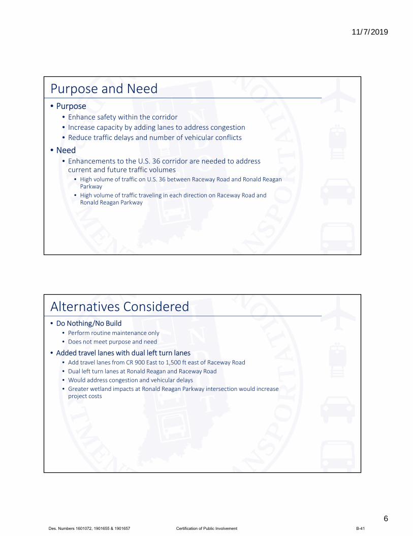
11/7/2019
6
• Purpose• Enhance safety within the corridor
• Increase capacity by adding lanes to address congestion
• Reduce traffic delays and number of vehicular conflicts
• Need• Enhancements to the U.S. 36 corridor are needed to address current and future traffic volumes
• High volume of traffic on U.S. 36 between Raceway Road and Ronald Reagan Parkway
• High volume of traffic traveling in each direction on Raceway Road and Ronald Reagan Parkway
Purpose and Need
• Do Nothing/No Build• Perform routine maintenance only
• Does not meet purpose and need
• Added travel lanes with dual left turn lanes • Add travel lanes from CR 900 East to 1,500 ft east of Raceway Road
• Dual left turn lanes at Ronald Reagan and Raceway Road
• Would address congestion and vehicular delays
• Greater wetland impacts at Ronald Reagan Parkway intersection would increase project costs
Alternatives Considered
Des. Numbers 1601072, 1901655 & 1901657 Certification of Public Involvement B-41
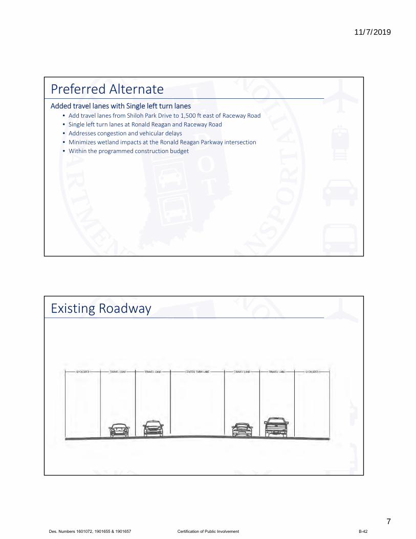
11/7/2019
7
Added travel lanes with Single left turn lanes • Add travel lanes from Shiloh Park Drive to 1,500 ft east of Raceway Road
• Single left turn lanes at Ronald Reagan and Raceway Road
• Addresses congestion and vehicular delays
• Minimizes wetland impacts at the Ronald Reagan Parkway intersection
• Within the programmed construction budget
Preferred Alternate
Existing Roadway
Des. Numbers 1601072, 1901655 & 1901657 Certification of Public Involvement B-42

11/7/2019
8
• Proposed Roadway ConfigurationPreferred Alternative ‐ Proposed Improvements
• Proposed Intersection ApproachPreferred Alternative ‐ Proposed Improvements
Des. Numbers 1601072, 1901655 & 1901657 Certification of Public Involvement B-43
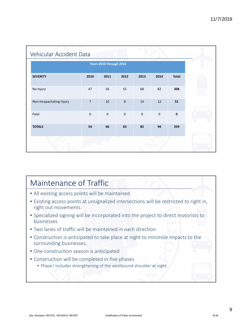
11/7/2019
9
Vehicular Accident Data
Years 2010 through 2014
SEVERITY 2010 2011 2012 2013 2014 Total
No Injury 47 56 55 68 82 308
Non‐Incapacitating Injury 7 10 8 14 12 51
Fatal 0 0 0 0 0 0
TOTALS 54 66 63 82 94 359
• All existing access points will be maintained.
• Existing access points at unsignalized intersections will be restricted to right in, right out movements.
• Specialized signing will be incorporated into the project to direct motorists to businesses
• Two lanes of traffic will be maintained in each direction
• Construction is anticipated to take place at night to minimize impacts to the surrounding businesses.
• One construction season is anticipated• Construction will be completed in five phases
• Phase I includes strengthening of the westbound shoulder at night.
Maintenance of Traffic
Des. Numbers 1601072, 1901655 & 1901657 Certification of Public Involvement B-44

11/7/2019
10
Construction Phase II
Area of Construction Completed Construction
Maintenance of Traffic – Phase II • Shift traffic to the north side of US 36 and widen eastbound US 36.
Maintenance of Traffic‐ Phase III III
Area of Construction Completed Construction
• Shift traffic to the south side of US 36 and widen westbound US 36.
Des. Numbers 1601072, 1901655 & 1901657 Certification of Public Involvement B-45
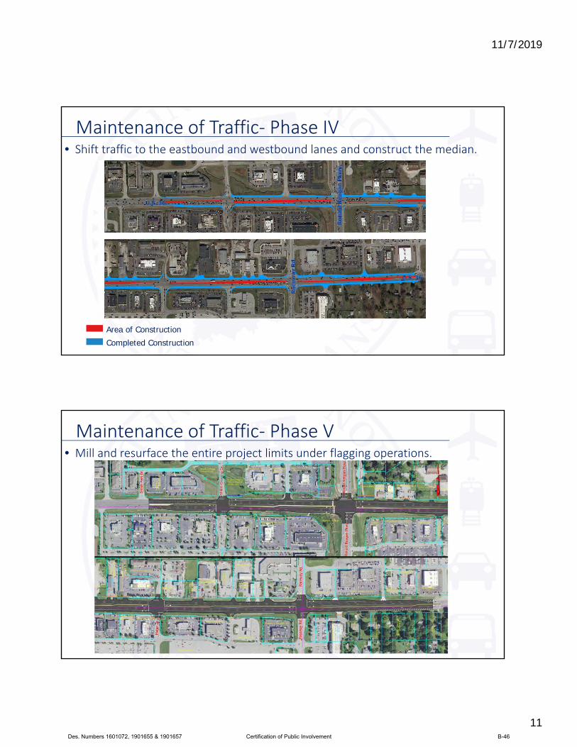
11/7/2019
11
Construction Phase IV
Area of Construction Completed Construction
Maintenance of Traffic‐ Phase IV• Shift traffic to the eastbound and westbound lanes and construct the median.
Construction Phase IVMaintenance of Traffic‐ Phase V• Mill and resurface the entire project limits under flagging operations.
Des. Numbers 1601072, 1901655 & 1901657 Certification of Public Involvement B-46

11/7/2019
12
Real Estate
• Uniform Act of 1970• All federal, state and local
governments must comply• Requires an offer for just
compensation
• Acquisition Process• Appraisals• Review Appraisals• Negotiations
• Right-of-way (ROW)• Permanent
• Permanent ROW is land, once purchased by INDOT from the legal land owner, becomes ROW owned by INDOT
• Approximately 0.2 acre proposed
• Temporary • Temporary ROW is land required during
the construction of a project and is used for the purposes of construction‐related activity
• INDOT pays legal land owner a fee for land use during construction
• Approximately 0.5 acre proposed
Real Estate Acquisition Process
Des. Numbers 1601072, 1901655 & 1901657 Certification of Public Involvement B-47
11/7/2019
13
• Preliminary design, evaluate community and environmental impact – 2018/2019
• Public Hearing – 2019• Complete environmental analysis Phase – 2019
• Real estate acquisition activities – 2020• Appraising
• Negotiations/buying• Utilities coordination
• Construction – 2021
Project Schedule
Submit Public Comments • Submit public comments using the options described in first page ofinformation packet:
• Public Comment Form
• Via e‐mail
• Participate during public comment session following formal presentation
• INDOT respectfully requests that comments be submitted by Monday, October 7, 2019
• All comments submitted will become included in an official public hearings transcript and made part of the public record
• Comments will be reviewed, evaluated and considered during the INDOTdecision‐making process
Des. Numbers 1601072, 1901655 & 1901657 Certification of Public Involvement B-48
11/7/2019
14
Next Steps • Public and project stakeholder input
• Submit comments via options described on page 1 of information packet
• INDOT review and evaluation• All comments given full consideration during decision‐making process
• Finalize/approve environmental document, complete project design
• Communicate a decision• INDOT will notify project stakeholders of decision
• Work through local media, social media outlets, paid legal notice
• Make project documents accessible via repositories
• Questions? Contact Public Involvement Team
Thank You • Please visit with INDOT project team following the presentation
and public comment session
• Project Open House• Project maps, displays, INDOT project team and informal Q & A• INDOT Crawfordsville District page http://www.in.gov/indot/2701.htm• U.S. 36 Added Travel Lanes web page https://www.in.gov/indot/3968.htm
Des. Numbers 1601072, 1901655 & 1901657 Certification of Public Involvement B-49
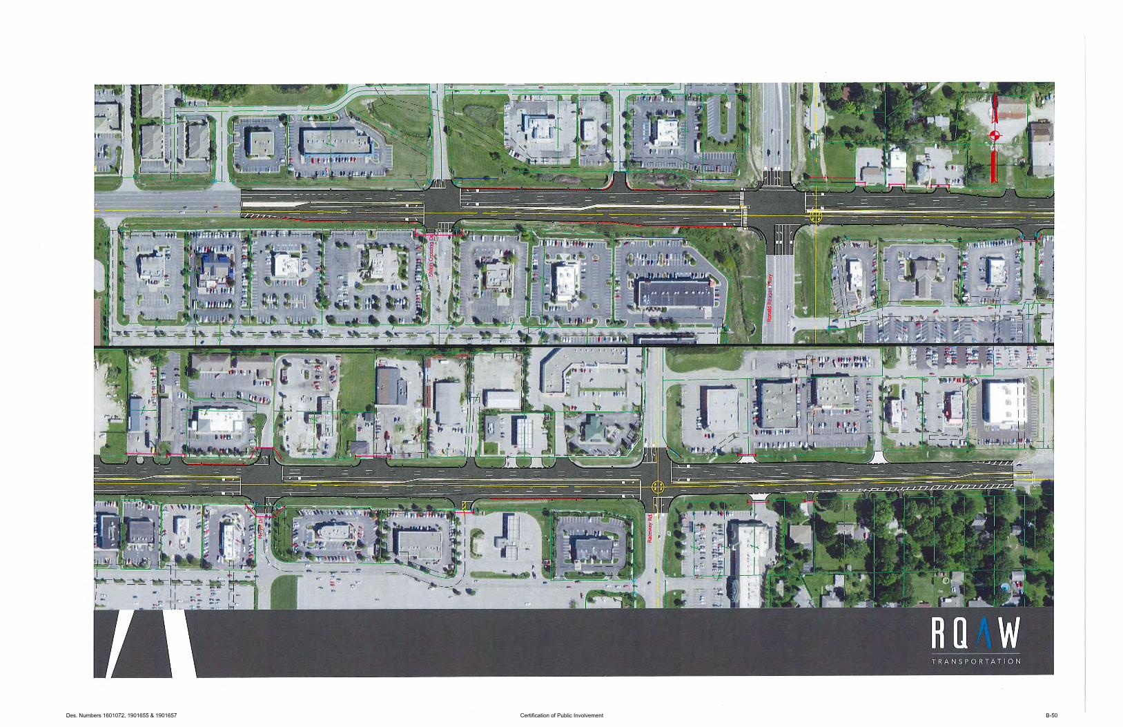
Des. Numbers 1601072, 1901655 & 1901657 Certification of Public Involvement B-50
Attachment C Responses to Public Hearing Comments

Comment Number Commenter Comment Response
1
Kenneth A. Westlake Deputy Director Office of Multimedia Programs Office of the Regional Administrator Environmental Protection Agency (EPA) Region 5 (written comments)
Pedestrian/Bicycle Trail Crossing of US 36: Given the existing amount of vehicle traffic and proposed addition of travel lanes on US 36, it is not clear why a ped/bike bridge across US 36 to connect the trail isn't proposed as part of this project. A ped/bike bridge would seem to offer an increased level of safety over the currently proposed at‐grade crossing. We recommend the updated EA consider including a ped/bike bridge across US 36 to connect the existing trail segments or explain why such a bridge isn't proposed as part of the project.
Per previous discussions with the Town of Avon, a ped/bike bridge across US 36 is not part of the project scope due to cost. It is estimated the bridge would cost in excess of $1,000,000. Construction of a bridge crossing US 36 at this location may occur in the future under a different project. An at‐grade pedestrian crossing, median pedestrian refuge, ADA compliant curb ramps, signals, and pedestrian crosswalks will be included to facilitate trail users crossing US 36.
EPA written comments, continued
Stormwater Management: The National Committee Assessment finds that, in the Midwest, extreme heat, heavy downpours, and flooding will affect infrastructure and water quality. It is important for FHWA and the project proponents to consider the current condition and likely integrity of the project's physical infrastructure and its environmental impacts over the life of the proposed project. We recommend the updated EA identify whether the proposed conveyance and management of stormwater will be sufficient during the project construction and operation to handle extreme precipitation events. If needed, incorporate resiliency and adaptation measures for this project. to better manage the quantity and quality of stormwater runoff, consider incorporating rain gardens as part of this project's design. See EPA's Adaptation Resource Center for additional information.
The project will require an IDNR Construction in a Floodway Permit and an IDEM Rule 5 Notice of Intent Permit. Sediment and erosion control measures will be implemented to avoid and minimize impacts to wetlands and streams. Per results from a hydraulics analysis, stormwater management is adequately designed to handle these types of precipitation events.
EPA written comments, continued
Noise Impacts/Mitigation: Five receptors were found to be impacted under the Future Build condition based on reaching or exceeding the Noise Abatement Criteria (NAC) sound levels. Noise abatement measures were found to be not feasible. A reevaluation of the noise analysis will occur during final design. Impacted receptors include one residential receptor, three receptors associated with the trail, and one medical facility. We recommend the updated EA identify measures that could be taken to mitigate for noise impacts if the reevaluation shows that noise walls are not feasible. For example, offer relocations or sound insulation for impacted residential receptors. In addition to consideration of noise walls, we encourage the use of strategically placed vegetation to reduce noise and visual impacts.
Noise was evaluated pursuant to 23 CFR 772. Per the noise study, noise abatement was found to not be feasible and reasonable due to engineering feasibility restrictions and the noise analysis will be reevaluated during final design. States cannot use Federal‐aid funds to provide noise insulation unless the impacts are identified as Noise Abatement Category (NAC) D. Residential receptors fall into NAC B. Acquisition of land as a buffer is a possibility for Federal‐aid projects, but is not possible in this instance because the area is already developed. Vegetation, unless it is sufficiently thick and tall (100 feet minimum thickness with 20 foot height), does not provide a noise reduction. Vegetative screening, if decided in final design, will be between the project sponsor and the municipality if it is outside existing right‐of‐way. This would be considered landscaping and does not constitute noise abatement.
EPA written comments, continued
Construction/Air Quality: To protect air quality for the people who live, work and/or play in or near the project area during construction, consider strategies to reduce diesel emissions, such as project construction contracts that require the use of equipment with clean diesel engines and limits on the length of time equipment idles when not in active use. See the enclosed Diesel Emission Reduction Checklist for information regarding ways to reduce construction equipment diesel emissions. We recommend the updated EA identify the diesel emissions reduction strategies project proponents commit to use for this project. EPA recommends idling not exceed five minutes.
The INDOT Standard Specifications section 107.08 contains regulations regarding dust and air pollution during construction. Pay items are normally included with projects on an as‐needed basis dependent on scope of work for dust control and erosion prevention. The Diesel Emission Reduction Checklist was reviewed. Idling of construction vehicles will not exceed five minutes. This was added as a project commitment.
EPA written comments, continued
Construction/Children's Safety: Ensure the construction traffic management plan stipulates that trucks hauling materials and heavy machinery avoid areas where children congregate, when possible. Aim to reroute construction traffic away from schools, daycare facilities, and parks. Use crossing guards when such areas cannot be avoided.
There are no schools or parks located adjacent to the project area. The Coronado KinderCare Daycare is approximately 340 feet northeast of the construction limits. The daycare's playground is situated approximately 110 feet north of US 36. Access to the daycare is off of Coronado Road. Construction vehicles and equipment will avoid this area. This was added as a project commitment.
Comment Number Commenter Comment Response
EPA written comments, continued
Construction‐Reclamation: To help pollinator species thrive, if feasible, use pollinator promoting plants and/or seed mixtures for reclamation of disturbed areas associated with project construction.
The project area is within a highly developed urban area surrounded by residential and commercial properties. A standard plant seed mix consistent with an urban environment will be used. The seed mix will match or blend with the surrounding vegetation while also allowing for its survival.
2 Steve Eisenbarth (verbal comment)
I'm on the Avon town council. I'm basically here on behalf of the town to say we are very much appreciative of INDOT both the Crawfordsville District and central office are good communicators and we sincerely appreciate on behalf of the town. I just want to make sure that you know that we value you very much as a partner. That's one thing. And this project is definitely a need to us.
Thank you for your input and comment.
Eisenbarth verbal comments, continued
I know some of the public ‐ we are going to have people that are going to say well it's going to be hard with the maintenance of traffic. And I do understand that. You know ‐ no one likes access management, in the traffic world. Everyone knows that as a median or a pork chop, or a right in right out all the negatives you may think of, you know, but if bottom line ‐ lives are at stake, and it is the right thing to do.
Thank you for your input and comment.
Eisenbarth verbal comments, continued
And so I commend INDOT for not going through that phase of do nothing. They went through the phase of the diligent path and they came up with a very plausible and a good use of the frontage to have a through lane, two turn lanes, and then have a median area and nice queuing available for the left turn lanes. So I just want to say that again I also say as a councilman, but not for the town per say, that we do appreciate.
Thank you for your input and comment.
Eisenbarth verbal comments, continued
And this whole area has received this explosive growth ‐ and not to go all negative on it but like you know, the traffic counts, actual traffic counts on July, I think it was either the second or third week of July, is an off season midweek, that they had over 48,000 ADT they call it, average daily traffic. And over the years it has always been 40,000 but now we are up to 48,000 and that's the area on US 36 by directional, both directions and that's between Ronald Reagan and Raceway. So it's in this area that's being addressed so we sincerely appreciate it because of the capacity that's grown in this area.
Thank you for your input and comment.
Eisenbarth verbal comments, continued
The other thing is the town, what we are doing, is we are looking to try and provide what we are call leader roads. Areas where you can not have to be forced on to Rockville Road. Now this is (inaudible} way on Kingston if you know that area if you go to the west of this project and on the south side (inaudible} around the railroad tracks and behind the car dealerships if you will, there are access roads and we are looking to see what we can do to continue to provide access roads to alleviate some of the stress that's going on Rockville Road. So that is a long term plan on the town that we are working on and will continue to do that.
Thank you for your input and comment.
Eisenbarth verbal comments, continued
One thing that just might be helpful for to put and post on be it on Facebook or to have links ‐ would be any traffic modeling that would show the progression going through the corridor with the (inaudible) and having it showing it like for (inaudible) and actually for us the noon Saturday feed that's a big thorn in our side. So showing the progression of how that's improved. This whole area had been, it has not been neglected, it has been worked on, Dr. Darcey (SP) from Purdue, many of us in the traffic world know him. He's had graduate students that's go through and done very (inaudible) on the corridor to get the progression of the (inaudible} between the traffic signals. We know, we've maxed out the efficiency between the traffic signals.
Thank you for your input and comment.

Comment Number Commenter Comment Response
Eisenbarth verbal comments, continued
And without going on and on I'd just like to say I appreciate that and I think that's probably. We're grateful that ‐ I fully support eliminating the (inaudible) left turn lane. We essentially call then suicide lanes. We shouldn't say that in other words you have opposing vehicles that are trying to squeeze in to make a left turn. Now when you have a median that's being constructed 2021. That will eliminate that confusion by drivers to know when do they merge in and to make a left turn to (inaudible). Now they are going to more organized locations of trafficking. Enough said. But thank you so much. Appreciate it.
Thank you for your input and comment.
3 Ann Engelhardt, verbal comment
I'm with Avon Community Schools and I just want to share that we appreciate all of the input and opportunity to have input into this process. They invited us into very early on (inaudible) a year almost since we started. But we want to be collaborated with INDOT and work with you to help provide best roads Avon can have and even going into Indianapolis. So thank you for the opportunity for us to have input.
Thank you for your input and comment.
4 Mumtaz Ali, written comment
Hello, I was reading on your website that "Written comments may be submitted prior to the public hearing" therefore here are my suggestions: US‐36/Rockville road is nightmare not just between Ronald Reagan and Raceway, it s started right from where you get on it from I‐465 (or even from Mickley ave) up to Dan Jones.
INDOT anticipates programming another future project on US 36 to address some of these concerns.
Ali written comments, continued Lanes should be added to all US‐36/Rockville Rd between Mickley Ave to the Dan Jones. INDOT anticipates programming another future project on US 36 to address some of these concerns.
Ali written comments, continued If possible at all. Over‐passes should be built where it crosses Ronald Reagan; Raceway and Girls school road (They have helped in Fishers a great degree).
Thank you for your input and comment. This is outside the scope of this project. INDOT is currently studying the traffic growth in the area to determine when grade separations will be warranted.
Ali written comments, continuedTraffic lights timing should be improved. It is very common that as soon as you start after a green light you will get next red light regardless how close that is. It can be particularly seen on the bridge over I‐465. During peak hours priority should be given to the US‐36 Traffic.
Improved traffic signal coordination will be incorporated into this project.
Ali written comments, continued Buses should be added with just few stops where public can park their vehicles and get on the buses to go downtown Indianapolis and Carmel etc.
Thank you for your input and comment. This is outside the scope of this project. However, all public comments have been provided to the Town of Avon for consideration of future planning initiatives.
Ali written comments, continued Added Lanes on N200 and N300 (North & South) with roundabouts can reduce dependency on US‐36.Thank you for your input and comment. This is outside the scope of this project. However, all public comments have been provided to the Town of Avon for consideration of future planning initiatives.
5 [email protected], written comment
In light of the serious fatality that just happened 2 weeks ago on us 36 and county road 625 all I can say it is about time INDOT takes notice of the west side. When you are done on Avon how about checking out Danville old 36 to new 36. Thanks for all your help. Good luck.
Thank you for your input and comment. All public comments have been provided to the Town of Avon for consideration of future planning initiatives.
6 Joe Smoker, written comment
It is disappointing that you/INDOT continue to push a narrative that wider roads leads to safety and reduced congestion. It has been made clear that widening roads creates significantly more dangerous conditions as the perceived speed of travel is lowered and the most vulnerable, pedestrians, are completely unaccounted for. Additionally, wider streets have been proven to induce congestion, creating a self‐defeating project. I wish INDOT would offer one reasonable opinion based on fact that shared this information. What will be the total number of lanes needed to justify "reduced congestion"? Is it 6? 8? 20? Please reconsider your 1960's traffic methodologies before spending another dime of our children's future on damaging, single‐use infrastructure projects.
During the engineering assessment phase of this project, traffic counts were obtained and these counts were projected based on future plans for development in the community. A traffic model and simulation was developed to determine the number of needed lanes to provide adequate level of service in the design year. The proposed design is based on this analysis. This project will provide for pedestrian connectivity across US 36 at Ronald Reagan Parkway. Pedestrian facilities along US 36 are not included in this project as they do not address the purpose and need of the project and the addition of these facilities will create greater impacts to the environment and the community.
Attachment D Section 106 Information
(text only)
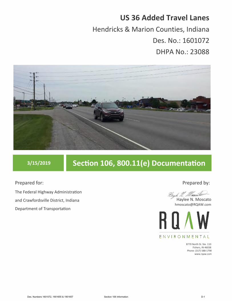
US 36 Added Travel Lanes Hendricks & Marion Counties, Indiana
Des. No.: 1601072 DHPA No.: 23088
3/15/2019 Sec�on 106, 800.11(e) Documenta�on
Prepared for:
The Federal Highway Administra�on
and Crawfordsville District, Indiana
Department of Transporta�on
Prepared by:
Haylee N. Moscato [email protected]
8770 North St. Ste. 110 Fishers, IN 46038
Phone: (317) 588-1798 www.rqaw.com
Des. Numbers 1601072, 1901655 & 1901657 Section 106 Information D-1

FEDERAL HIGHWAY ADMINISTRATION’S SECTION 4(F) COMPLIANCE REQUIREMENTS (for historic properties) AND
SECTION 106 FINDINGS AND DETERMINATIONS AREA OF POTENTIAL EFFECTS ELIGIBILITY DETERMINATIONS
EFFECT FINDING US 36 Added Travel Lanes
Hendricks & Marion County, Indiana Des. No.: 1601072 DHPA No.: 23088
AREA OF POTENTIAL EFFECTS (Pursuant to 36 CFR Section 800.1(a)(1))
The Area of Potential Effects (APE) for this project is an irregular polygon that generally encompasses those areas adjacent to the proposed work where ground-disturbing activity may occur, areas within a viewshed of the proposed work, and areas where other non-visual direct or indirect effects such as audible effects may occur. Most of the APE extends approximately 700 feet wide and it expands to approximately 900 feet wide where open viewsheds occur. Please see Appendix A for maps of the APE.
ELIGIBILITY DETERMINATIONS (Pursuant to 36 CFR 800.4(c)(2))
As a result of identification and evaluation efforts for this project, two properties are identified as listed in, eligible for, or potentially eligible for the National Register of Historic Places (NRHP) within the APE for this undertaking.
Charles McLain House (Indiana Historic Sites and Structures Inventory (IHSSI) # 063-117-45024)
The Charles McLain House was rated “Notable” in the Hendricks County Interim Report (1989). The Charles McLain House is located at 10664 East US 36 in Avon, Hendricks County, Indiana and is a two-and-one-half story Free Classic Queen Ann style house. The Charles McLain House is eligible for the NRHP under Criterion C because it is a good example (although with alterations) of a circa 1904 Free Classic Queen Ann style house with original architectural features in Washington Township, Hendricks County.
David Faucett House (IHSSI # 097-117-56005)
The David Faucett House was rated “Notable” in the Wayne Township, Marion County Interim Report (1993). The David Faucett House is located at 9055 Rockville Road (US 36) in Marion County, Indiana and is two-story I-house. The David Faucett House is eligible for the NRHP under Criterion A for its association with the early development of Wayne Township, Marion County and Washington Township, Hendricks County; and under Criterion C because it is a good example (although with alterations) of a circa 1846 I-house with Greek Revival architectural features in Wayne Township, Marion County.
Des. Numbers 1601072, 1901655 & 1901657 Section 106 Information D-2
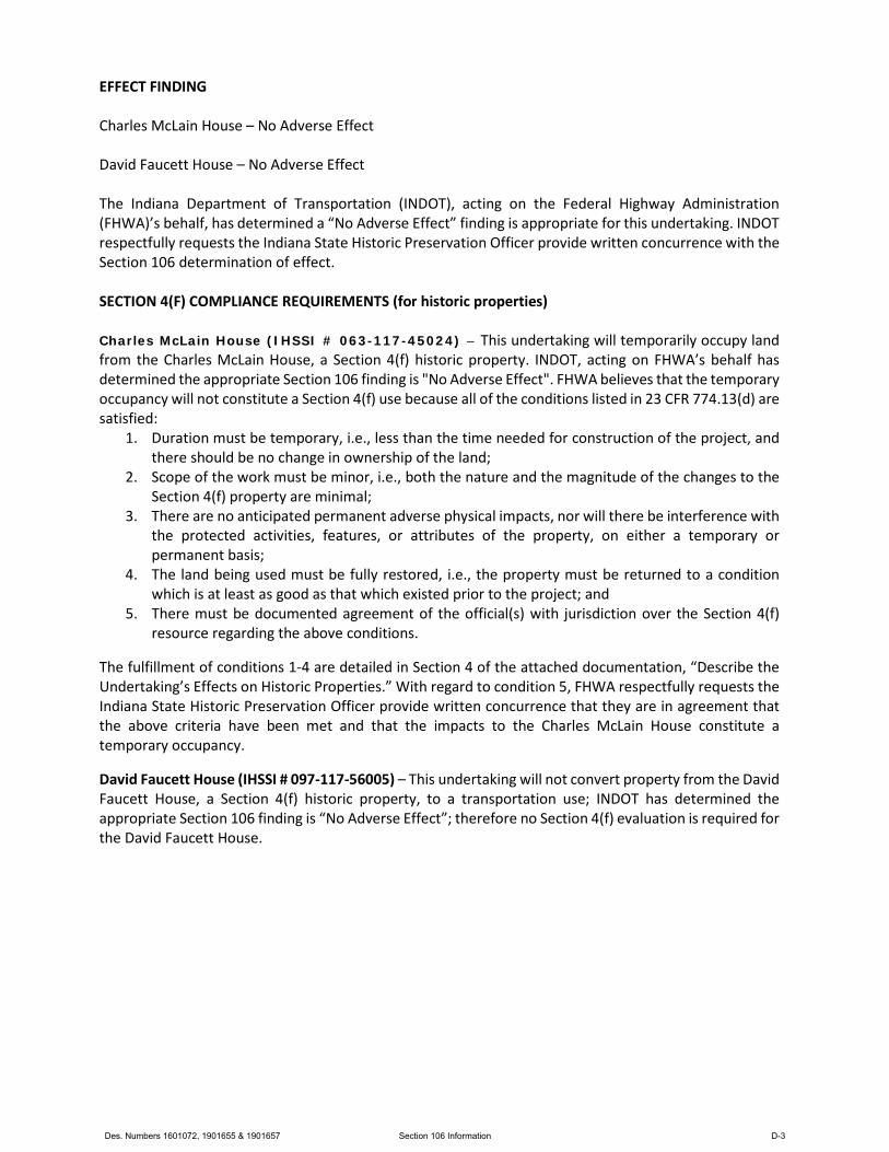
EFFECT FINDING Charles McLain House – No Adverse Effect David Faucett House – No Adverse Effect The Indiana Department of Transportation (INDOT), acting on the Federal Highway Administration (FHWA)’s behalf, has determined a “No Adverse Effect” finding is appropriate for this undertaking. INDOT respectfully requests the Indiana State Historic Preservation Officer provide written concurrence with the Section 106 determination of effect. SECTION 4(F) COMPLIANCE REQUIREMENTS (for historic properties) Charles McLain House (IHSSI # 063-117-45024) – This undertaking will temporarily occupy land from the Charles McLain House, a Section 4(f) historic property. INDOT, acting on FHWA’s behalf has determined the appropriate Section 106 finding is "No Adverse Effect". FHWA believes that the temporary occupancy will not constitute a Section 4(f) use because all of the conditions listed in 23 CFR 774.13(d) are satisfied:
1. Duration must be temporary, i.e., less than the time needed for construction of the project, and there should be no change in ownership of the land;
2. Scope of the work must be minor, i.e., both the nature and the magnitude of the changes to the Section 4(f) property are minimal;
3. There are no anticipated permanent adverse physical impacts, nor will there be interference with the protected activities, features, or attributes of the property, on either a temporary or permanent basis;
4. The land being used must be fully restored, i.e., the property must be returned to a condition which is at least as good as that which existed prior to the project; and
5. There must be documented agreement of the official(s) with jurisdiction over the Section 4(f) resource regarding the above conditions.
The fulfillment of conditions 1-4 are detailed in Section 4 of the attached documentation, “Describe the Undertaking’s Effects on Historic Properties.” With regard to condition 5, FHWA respectfully requests the Indiana State Historic Preservation Officer provide written concurrence that they are in agreement that the above criteria have been met and that the impacts to the Charles McLain House constitute a temporary occupancy.
David Faucett House (IHSSI # 097-117-56005) – This undertaking will not convert property from the David Faucett House, a Section 4(f) historic property, to a transportation use; INDOT has determined the appropriate Section 106 finding is “No Adverse Effect”; therefore no Section 4(f) evaluation is required for the David Faucett House.
Des. Numbers 1601072, 1901655 & 1901657 Section 106 Information D-3
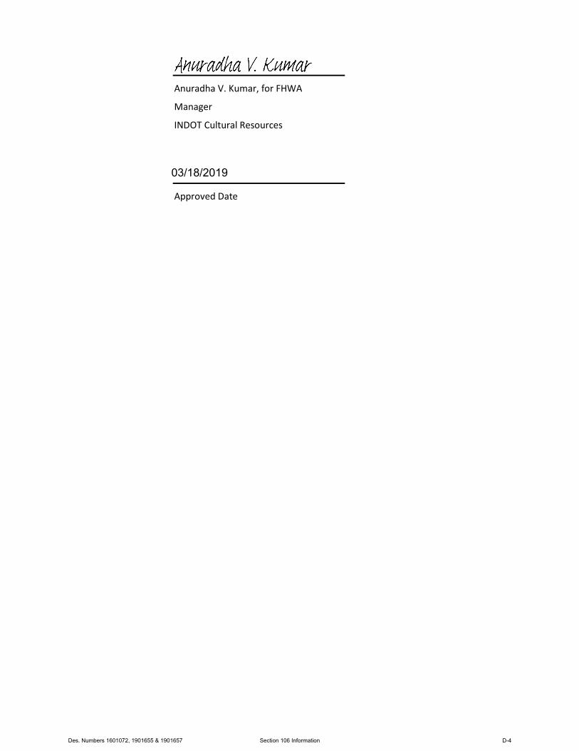
Anuradha V. Kumar, for FHWA
Manager
INDOT Cultural Resources
Approved Date
03/18/2019
Des. Numbers 1601072, 1901655 & 1901657 Section 106 Information D-4

FEDERAL HIGHWAY ADMINISTRATION DOCUMENTATION OF SECTION 106 FINDING OF
NO ADVERSE EFFECT SUBMITTED TO THE STATE HISTORIC PRESERVATION OFFICER
PURSUANT TO 36 CFR SECTION 800.5(c)
US 36 Added Travel Lanes Hendricks & Marion County, Indiana
Des. No.: 1601072 DHPA No.: 23088
1. DESCRIPTION OF THE UNDERTAKING
The Indiana Department of Transportation (INDOT) with funding from the Federal Highway Administration (FHWA) intend to proceed with the US 36 Added Travel Lanes project in Avon, Hendricks County and Indianapolis, Marion County, Indiana. Section 106 of the National Historic Preservation Act requires Federal agencies to take into account the effects of their undertakings on historic properties. The federal involvement in the project is funding received from the FHWA.
The proposed undertaking is on US 36 (Rockville Road) beginning at Shiloh Park Drive in Avon, Hendricks County and continuing east to approximately 0.28 mile (1,500 feet) east of Raceway Road in Indianapolis, Marion County, Indiana. It is within Washington Township, Hendricks County, and Wayne Township, Marion County, Clermont USGS Topographic Quadrangle, in Sections 4, 5, 8 and 9, Township 15 North, Range 2 East. Adjacent land use consists of residential and commercial. Please see project graphics in Appendices A, B, and F.
The need for this project is due to the inadequate level of service motorists experience when traveling through the corridor. The primary purpose this project is to reduce delays on US 36 with a focus on the heavily congested portion between Ronald Reagan Parkway and Raceway Road.
The preferred alternative will involve work to the existing roadway to provide added travel lanes in both directions on US 36. The current typical cross section consists of two 12-foot wide travel lanes, a 16-foot wide two-way-left-turn-lane, and up to an 11-foot shoulder in each direction. A discontinuous 12-foot wide right-turn lane is present within portions of the project area. The proposed typical cross section in each direction will consist of three travel lanes (one 11-foot wide and two 12-foot wide) bordered by curb and gutter. An 11-foot wide left turn lane will be provided in both directions at signalized intersections and right turn lanes will be reconstructed. At the current design phase, the anticipated right-of-way is expected not to exceed approximately 0.3 acre of permanent and approximate 0.7 acre of temporary right-of-way. The project is anticipated to be let in 2021. Traffic is anticipated to be maintained through the area of construction with two lanes being maintained in each direction. No signed detours are anticipated. Access to residences and businesses along US 36 will be continuously maintained during construction. Please see maps of the project area in Appendix A and preliminary plans in Appendix F.
Per 36 CFR 800.9(a), the Area of Potential Effects (APE) is “the geographic area or areas within which an undertaking may directly or indirectly cause alterations in the character or use of historic properties. The APE is influenced by the scale and nature of an undertaking. . .” The APE encompasses the entire project
Des. Numbers 1601072, 1901655 & 1901657 Section 106 Information D-5
site, including all locations where the project may result in disturbance of the ground; all locations from which ground-disturbing elements of the project may be visible or audible; all locations where ground-disturbing activity may result in changes in traffic patterns, land use, or public access; and all areas where there may be direct or indirect effects due to the ground-disturbing elements of the project. The APE for this project is an irregular polygon. The APE boundaries were established using guidance in the INDOT Cultural Resources Manual. It narrows where views to the project are limited by structures and dense vegetation. The APE follows US 36 through the eastern portion of Avon in Washington Township in eastern Hendricks County to the western portion of Indianapolis in Wayne Township in western Marion County. The APE is along US 36 from 0.21 mile west of Shiloh Park Drive to 0.36 mile east of South Raceway Road. Most of the APE extends approximately 700 feet wide and it expands to approximately 900 feet wide where open viewsheds occur. Please see maps indicating the APE in Appendix A.
2. EFFORTS TO IDENTIFY HISTORIC PROPERTIES
The National Register of Historic Places (NRHP) and the Indiana Register of Historic Sites and Structures (State Register) were checked using the State Historic Architectural and Archaeological Research Database (SHAARD) and the Indiana Historic Buildings, Bridges, and Cemeteries Map (IHBBC). No resources are listed in the NRHP or State Register within the APE. The Indiana Historic Sites and Structures Inventory (IHSSI) Hendricks County Interim Report (1989) and Wayne Township, Marion County Interim Report (1993) data was examined and identified four previously surveyed properties within the APE.
The cemetery registry was also consulted using SHAARD and SHAARD GIS. No cemeteries were identified within the APE. The Indiana Historic Bridge Inventory Volume 2: Listing of Historic and Non‐Historic Bridges (February 2009) by Mead and Hunt was also reviewed. No bridges eligible for listing in the NRHP were identified within the APE.
Early coordination was initiated on October 1, 2018. The agencies/individuals/tribes listed below were sent an email with an early coordination letter inviting them to become Section 106 consulting parties. All consulting parties were invited to view the early coordination letter on IN SCOPE (INDOT’s online portal for public viewing Section 106 documents at https://erms.indot.in.gov/Section106Documents/). In addition, a hard copy of the early coordination letter was mailed to the Indiana State Historic Preservation Office (SHPO). The organizations identified in bold responded and agreed to be consulting parties.
1. Indiana State Historic Preservation Officer (automatic consulting party) 2. Indiana Landmarks, Central Regional Office 3. Hendricks County Historical Society/Hendricks County Museum 4. Hendricks County Heritage Alliance 5. Hendricks County Historian 6. Marion County Historian 7. Wayne Township Historical Society 8. Indianapolis Metropolitan Planning Organization 9. Avon Town Manager 10. Hendricks County Commissioner’s Office
Des. Numbers 1601072, 1901655 & 1901657 Section 106 Information D-6
11. Hendricks County Engineer 12. Hendricks County Highway Office Manager 13. Hendricks County Plan Commission Chair 14. Indianapolis Mayor 15. City of Indianapolis Department of Public Works Director 16. Marion County Commissioner’s Office 17. Delaware Nation of Oklahoma 18. Eastern Shawnee Tribe of Oklahoma 19. Forest County Potawatomi Community 20. Miami Tribe of Oklahoma 21. Peoria Tribe of Indians of Oklahoma 22. Pokagon Band of Potawatomi Indians
Indiana Landmarks, Central Regional Office accepted to be a consulting party in a letter dated October 30, 2018. The Delaware Nation of Oklahoma accepted to be a consulting party and concurred with the proposed plan at that time in an email dated November 6, 2018. The Miami Tribe of Oklahoma accepted to be a consulting party and offered no objection to the project at that time in a letter dated November 7, 2018. In a letter dated November 1, 2018, the Indiana SHPO recommended no other consulting parties. Please see responses in Appendix D.
A Historic Property Report (HPR by Moscato, December 11, 2018) was completed for this project. On August 24, 2018, the professional staff at RQAW Corporation performed a site inspection of the APE. The Qualified Professional architectural historian walked and drove through the project area within the APE and photographed all resources within the APE that will be 50 years of age or older at the proposed letting date (2021). As a result of this field survey and associated documentary research, the architectural historian recommended two properties as eligible for listing in the NRHP: the Charles McLain House (IHSSI # 063-117-45024) and the David Faucett House (IHSSI # 097-117-56005). Please see Appendix E for an excerpt from the HPR.
An archaeological report (Phase Ia Archaeological Reconnaissance by Martin, October 9, 2018) was completed for this project. The archaeological reconnaissance identified no archaeological resources in the project area and recommended that the project be allowed to proceed. Please see Appendix E for an excerpt from the archaeological report.
On December 11, 2018, a hard copy of a coordination letter, the HPR, and archaeological report were mailed to the Indiana SHPO while other consulting parties were informed that the coordination letter, HPR, and archaeology report (tribes only) could be viewed electronically by accessing IN SCOPE. INDOT’s Section 106 guidance recommends that owners of recommended historic resources be invited to become consulting parties. Therefore, the coordination letter and HPR were mailed to those property owners listed below on December 11, 2018 (the owner identified in bold responded and agreed to be a consulting party).
1. Rockville Marketplace LLC, Historic Property Owner for David Faucett House, 9055 Rockville Rd. 2. Andrew Vinson, Historic Property Owner for Charles McLain House, 10664 E. US 36
Des. Numbers 1601072, 1901655 & 1901657 Section 106 Information D-7
In a phone call on January 8, 2019, Mr. Andrew Vinson, Charles McLain House property owner, contacted INDOT to inquire about the coordination letter and HPR that he received. The conversation is noted in an email from Shaun Miller that day. Mr. Vinson was added to the list of consulting parties. In a letter dated January 11, 2019, Indiana Landmarks concurred with the recommendations in the HPR including: the APE, that the Charles McLain House and David Faucett House are eligible for the NRHP, and their proposed historic resource boundaries. Please see correspondence in Appendix D.
In a letter dated January 11, 2019, the Indiana SHPO concurred with the archaeology report stating, “we have not identified any currently known archaeological resources listed in or eligible for inclusion in the NRHP within the proposed project area.” Please see the letter in Appendix D.
In a letter dated January 11, 2019, the Indiana SHPO staff concurred with the recommendations in the HPR stating, “we agree that the only above-ground historic properties within the APE identified in the HPR are the Charles McLain House (Indiana Historic Sites and Structures Inventory [IHSSI] No. 063-117-45024) at 10664 East US 36 in Avon and the David Faucett House (HSSI No. 097-117-56005) at 9055 Rockville Road (US 36) in Indianapolis.” Please see the letter in Appendix D. In regard to the possibility of additional historic resources, the Indiana SHPO staff inquired on the confirmation or not of “any elements of the former right-of-way of the Terre Haute, Indianapolis & Eastern Traction Company remain visible on the north side of the existing US 36 pavement within the APE.”
In response to the Indiana SHPO staff’s inquiry an Effects Letter (by Boot, February 11, 2019) provided research documentation and explained that it is believed that any remnants from the Terre haute, Indianapolis, & Eastern Traction Company line were demolished during the replacement and widening of US 36 during the 1970s. Please see the Effects Letter in Appendix D for additional information.
No other consulting parties provided comments/questions with regard to the identification of historic properties. Please see Appendix D for correspondence.
Des. Numbers 1601072, 1901655 & 1901657 Section 106 Information D-8
DESCRIBE AFFECTED HISTORIC PROPERTIES
A. Charles McLain House (IHSSI # 063-117-45024) 10664 E. US 36.
The Charles McLain House is located on the north side of US 36 and east of N. Ronald ReaganParkway in the Avon, Indiana. The Charles McLain House is a good example of a Free Classic Queen Ann style house, circa 1904. The house possesses a fair amount of integrity with the originaloverall plan, some detailing, and stylistic features. However, some aluminum siding, roofreplacement, and replacement of the one-over-one windows has taken place. The period ofsignificance for the Charles McLain House is from circa 1904, when the original house and carriage house were constructed. The Charles McLain House is recommended eligible under Criterion Cbecause it is a good example (although with alterations) of a circa 1904 Free Classic Queen Annstyle house with original architectural features in Washington Township, Hendricks County. It isnot the work of a master but embodies distinctive characteristics of this type.
B. David Faucett House (IHSSI # 097-117-56005) 9055 Rockville Rd. (US 36).
The David Faucett House is located on the south side of Rockville Rd. (US 36) and east of N.Raceway Rd. in Wayne Township, Marion County, Indiana. The David Faucett House is a goodexample of a frame I-house, circa 1846. The house possesses a good amount of integrity with theoriginal massing, façade fenestration, and wood windows. The period of significance for the DavidFaucett House is from circa 1846, when the original house was constructed. The David FaucettHouse is recommended eligible under Criterion A for its association with the early developmentof Wayne township, Marion County and Washington township, Hendricks County. The DavidFaucett house may very well be one of the last, if not the last mid-19th century farmhouse inWayne Township. Also, the David Faucett House is recommended eligible under Criterion Cbecause it is a good example (although with alterations) of a circa 1846 I-house with Greek Revival architectural features in Wayne Township, Marion County. It is not the work of a master butembodies distinctive characteristics of this type.
3. DESCRIBE THE UNDERTAKING’S EFFECTS ON HISTORIC PROPERTIES
The two above-mentioned properties eligible for listing in the NRHP within the APE are located along US 36 (Rockville Road). The undertaking’s effects on historic properties is primarily visual within an already extensively built-up US highway corridor and suburban landscape. The visual effects are likely to include:
• Pavement replacement on the same alignment with maintaining 12-foot wide travel lanes. Thepavement may be milled and overlaid in some locations, depending on existing conditions orassociated excavation needs.
• Pavement widening with the addition of a travel through lane in each direction.• Installation of a curb and gutter along the roadway edge.
Des. Numbers 1601072, 1901655 & 1901657 Section 106 Information D-9
• Converting the two-way center turn lane to a dedicated left turn lane with small curb. The leftturn lanes will be in each direction at signaled intersections, but all other intersections will beaccessible only via right-in right-out.
• Reconstruction and lengthening of the existing right turn lanes.
Please see Appendix F for the Stage 1 Plans enclosed with the NRHP-eligible resources highlighted.
A. Charles McLain House (IHSSI # 063-117-45024) 10664 E. US 36.
Project impacts adjacent to the historic resource boundary will include roadway widening andreconstruction, driveway reconstruction, and limited sidewalk reconstruction to tie the existingsidewalk into the new driveway. No permanent right-of-way is anticipated from the CharlesMcLain House; however, approximately 0.02 acre of temporary right-of-way is needed fordriveway and adjacent sidewalk reconstruction. The existing roadway, driveway, parking lot, andsidewalk are modern concrete construction. The sidewalk, parking lot, and driveway wereinstalled circa 2013.1 The historic resource boundary goes to the back (north edge) of the existingsidewalk. The anticipated construction limits will not extend into the historic resource boundary.(please see the Photo Effects Diagram with the Effects Letter in Appendix D and the Stage 1 Plans,sheets 9 and 17 in Appendix F).
The proposed work in this area will widen the US 36 pavement by approximately 17 feet to add atravel lane, recreate and extend the existing right turn lane, and install a curb and gutter. Theadded travel lane near the Charles McLain House is anticipated to provide only a 10% increase incapacity from 2021 to 2041. The property’s setting has been drastically altered by developmentover recent decades from the expansion of US 36 and the property’s own conversion tocommercial use (i.e. parking lot and sidewalk construction). Additionally, note that the CharlesMcLain House significance is limited to architecture (Criterion C), so the resource’s integrity is lesssensitive to setting changes than resources that derive significance from Criterion A.
The project’s minimal introduction of visual and audible elements to the property’s setting willnot constitute a significant alteration to historic features that contribute to the Charles McLainHouse historic significance because of the already transformed, suburban landscape. Althoughpermanent work is proposed near the Charles McLain House property, it is anticipated that therewill be no adverse effect to the house or carriage house because no contributing historic featureswill be impacted directly. Therefore, the alterations adjacent to the historic resource boundaryand its setting are not anticipated to reduce the significance or impact any of the characteristicsthat qualify the Charles McLain House for the NRHP in a manner that would diminish the integrityof the property’s location, design, setting, materials, workmanship, feeling, or association. As aresult, the project is anticipated to have “No Adverse Effect” to the Charles McLain House.
1 Google, Google Earth (Google), accessed January 18, 2019, htps://www.google.com/earth/.
Des. Numbers 1601072, 1901655 & 1901657 Section 106 Information D-10
B. David Faucett House (IHSSI # 097-117-56005) 9055 Rockville Rd. (US 36).
Project impacts near the historic resource boundary of the David Faucett House will be strictly visual and limited to the existing right-of-way. Neither temporary nor permanent right-of-way will be required from the David Faucett House. In terms of the David Faucett House setting, the east end of new construction will occur approximately 99 feet northwest of the David Faucett House historic property boundary; while the east end of the incidental construction consisting of pavement milling to transition the new construction to the existing pavement will occur approximately 35 feet northwest of the David Faucett House boundary. No work will occur within the historic boundary nor immediately adjacent to the frontage of it (please see the Stage 1 Plans, sheets 12 and 21 in Appendix F). The David Faucett House’s setting has been drastically altered by development over recent decades from the expansion of US 36. The project’s minimal introduction of visual and audible elements to the property’s setting will not constitute a significant alteration from this already transformed, suburban landscape. Thus, the alterations near the historic resource boundary and neighboring visible changes (as described above) will have no direct impact on the David Faucett House other than a viewshed change approximately 99 feet away for pavement replacement and the addition of a curb and gutter. This minor viewshed alteration is not anticipated to reduce the significance or impact any of the characteristics that qualify the David Faucett House for the NRHP in a manner that would diminish the integrity of the property’s location, design, setting, materials, workmanship, feeling, or association. Therefore, the project is anticipated to have “No Adverse Effect” to the David Faucett House.
4. EXPLAIN APPLICATION OF CRITERIA OF ADVERSE EFFECT – INCLUDE CONDITIONS OR FUTURE ACTIONS TO AVOID, MINIMIZE OR MITIGATE ADVERSE EFFECTS
According to 36 CFR 800.5(a)(1) “An adverse effect is found when an undertaking may alter, directly or indirectly, any of the characteristics of a historic property that qualify the property for inclusion in the National Register in a manner that would diminish the integrity of the property’s location, design, setting, materials, workmanship, feeling or association.”
A. Charles McLain House (IHSSI # 063-117-45024) 10664 E. US 36.
According to 36 CFR 800.5(a)(1) the criteria of adverse effect do not apply.
Per 36 CFR 800.5(a)(2)(i), There will not be physical damage to any part of the property that contributes to its historic integrity. Physical impacts will be limited to 0.02 acre of previously altered (circa 2013) modern concrete driveway and sidewalk and will not alter the characteristics of the property that qualify it for inclusion in the National Register in a manner that diminishes the property’s integrity.
Per 36 CFR 800.5(a)2(ii): the “Alteration of a property, including restoration, rehabilitation, repair, maintenance, stabilization, hazardous material remediation and provision of handicapped access,
Des. Numbers 1601072, 1901655 & 1901657 Section 106 Information D-11
that is not consistent with the Secretary’s Standards for the Treatment of Historic Properties and/or other applicable guidelines” will not occur. The only alterations to the property will occur to the modern concrete driveway and sidewalk which will be replaced in-kind. The project will have no direct impact on the Charles McLain House or any historic features on the property.
Per 36 CFR 800.5(a)(2)(iii), the “Removal of the property from its historic location” will not occur. The project will not remove any portion of the Charles McLain House from its historic location.
Per 36 CFR 800.5(a)(2)(iv), due to the pavement widening, construction of a curb and gutter, and driveway and sidewalk replacement, a change of the character of the property’s use or of physical features within the property’s setting will occur; however, the changes will not alter the property’s setting in a way that diminishes the historic features that contribute to its historic significance. The Charles McLain House is significant under Criterion C for its original architectural features and Free Classic Queen Ann style. The property’s setting in this area along US 36 has been drastically altered by development over recent decades from the expansion of US 36 and the property’s own conversion to commercial use. Overall, the minor alterations as part of the US 36 pavement widening will not have a significant negative impact on the Charles McLain House’s setting and will not affect the property’s ability to convey historic significance. Thus, the impacts do not rise to the level of being an adverse effect.
Per 36 CFR 800.5(a)(2)(v), the “Introduction of visual, atmospheric or audible elements that diminish the integrity of the property’s significant historic features” will not occur. Although adding a travel lane, widening and replacing the pavement, and adding a curb and gutter will introduce visual elements and provide increased capacity for vehicular noise, the additions will not diminish the integrity of the property’s significant historic features. The added travel lane near the Charles McLain House is anticipated to provide only a 10% increase in capacity from 2021 to 2041 (please see the traffic data on sheet one of the preliminary plans in Appendix F). Therefore, in the area of the Charles McLain House, the marginal visual setting, atmospheric and audible changes will not rise to the level of being an adverse because they will not diminish the resource’s integrity or ability to portray historic significance.
Per 36 CFR 800.5(a)(2)(vi), the “Neglect of a property which causes its deterioration…” will not occur as a result of the project. The undertaking will not cause the deterioration of any aspect of the Charles McLain House.
Per 36 CFR 800.5(a)(2)(vii), the “Transfer, lease, or sale of property out of Federal ownership or control…” will not occur. Ownership of the resource will not change as a result of this project.
B. David Faucett House (IHSSI # 097-117-56005) 9055 Rockville Rd. (US 36).
According to 36 CFR 800.5(a)(1) the criteria of adverse effect do not apply.
Per 36 CFR 800.5(a)(2)(i), the “Physical destruction of or damage to all or part of the property” will not occur. The undertaking will not directly impact the David Faucett House. No right-of-way will be required from the property and no portion of the historic resource boundary is within the construction limits.
Des. Numbers 1601072, 1901655 & 1901657 Section 106 Information D-12
Per 36 CFR 800.5(a)(2)(ii), Per 36 CFR 800.5(a)2(ii): the “Alteration of a property, including restoration, rehabilitation, repair, maintenance, stabilization, hazardous material remediation and provision of handicapped access, that is not consistent with the Secretary’s Standards for the Treatment of Historic Properties and/or other applicable guidelines” will not occur. The project will have no direct impact on the David Faucett House.
Per 36 CFR 800.5(a)(2)(iii), the “Removal of the property from its historic location” will not occur. The project will not remove any portion of the David Faucett House from its historic location.
Per 36 CFR 800.5(a)(2)(iv), a “Change of the character of the property’s use or of physical features within the property’s setting that contribute to its historic significance” will not occur. The project will not cause a change of character to any of the David Faucett’s features. Although pavement and a curb and gutter will be added to US 36 (Rockville Road) up to approximately 99 feet from the David Faucett House historic boundary and pavement milled and overlaid up to approximately 35 feet from the historic boundary will occur; no historic features of the property will be disturbed. Therefore, the project will have no significant impact on the physical features of this property’s setting. Overall, the minor alterations as part of the US 36 pavement improvements will not have a significant negative impact on the David Faucett House’s setting and will not affect the property’s ability to convey historic significance. Thus, the impacts do not rise the level of being an adverse effect.
Per 36 CFR 800.5(a)(2)(v), the “Introduction of visual, atmospheric or audible elements that diminish the integrity of the property’s significant historic features” will not occur. Although widening and replacing the pavement and adding a curb and gutter northwest of the David Faucett House will introduce visual elements, the additions will not diminish the integrity of the property’s significant historic features. The vehicular capacity in the vicinity of the David Faucett House is not anticipated to increase because an added travel lane is not proposed in this location (i.e. the two travel lanes and a left turn lane will be reconstructed and tie into the existing pavement.) Therefore, in the area of the David Faucett House, the marginal visual setting, atmospheric and audible changes will not rise to the level of being an adverse because they will not diminish the resource’s integrity or ability to portray historic significance.
Per 36 CFR 800.5(a)(2)(vi), the “Neglect of a property which causes its deterioration…” will not occur as a result of the project. The undertaking will not cause the deterioration of any aspect of the David Faucett House.
Per 36 CFR 800.5(a)(2)(vii), the “Transfer, lease, or sale of property out of Federal ownership or control…” will not occur. Ownership of the resource will not change as a result of this project.
5. SUMMARY OF CONSULTING PARTIES AND PUBLIC VIEWS
On January 8, 2019, Mr. Andrew Vinson spoke with Shaun Miller of INDOT regarding the project and Section 106/NEPA. On January 15, 2019, Kyle Boot (RQAW Architectural Historian) followed up with Mr. Vinson who inquired about the proposed work near the Charles McLain property. The minor potential
Des. Numbers 1601072, 1901655 & 1901657 Section 106 Information D-13

impacts were explained to Mr. Vinson who provided no response regarding potential effects to the historic characteristics of the Charles McLain property. Please see correspondence in Appendix D.
In a letter dated January 11, 2019, the Indiana SHPO staff concurred with the HPR’s recommendations of the Charles McLain House and David Faucett House as eligible for listing in the NRHP; they also concurred with the archaeology report. In the same letter, the Indiana SHPO staff requested additional information regarding the proposed roadway design and right-of-way requirements. The letter requested “a fairly detailed plan of the widened roadway where it will pass adjacent to the Charles McClain House and adjacent to the David Faucett House… [and] where the permanent right-of-way, in particular, would be acquired in the vicinity of the historic properties, in order to enable evaluation of effects” to historic properties (see this correspondence in Appendix D).
On February 11, 2019, a hard copy of the Effects Letter was mailed to the Indiana SHPO while other consulting parties were informed that the Effects Letter could be viewed electronically by accessing IN SCOPE. The Effects Letter described the proposed alterations and anticipated right-of-way in the vicinity of the historic properties. It furthermore provided preliminary plans (with historic properties highlighted) demonstrating the widened roadway and anticipated right-of-way near historic properties. It should be noted that the Miami Tribe of Oklahoma was mistakenly omitted from the list in the effects letter that identified agencies/individuals/tribes who had agreed to serve as consulting parties for this project. However, the Miami Tribe of Oklahoma was included in the email distribution list for the effects letter. Please see the Effects Letter in Appendix D (note that some enclosures have been removed to avoid duplication.)
On February 19, 2019, the Indiana SHPO staff responded to the Effects Letter indicating appreciation for the information in it. In regard to the historic David Faucett House, the SHPO staff commented, “Given the existing, previously widened US 36 highway in front of that historic house, it does not seem likely that the currently proposed modifications, most of which end to the west of the property, would have an indirect adverse effect on the David Faucett House.” In regard to the Chalres McLain House, note that the SHPO staff identified a discrepancy in the parcel boundary/property line. The written descriptions and exhibits inconsistently described its location. Some identified it along the front edge of the existing sidewalk while others identified it along the back edge. However, the SHPO staff commented, “we are content to treat the back edge of the sidewalk as the historic property boundary, which is the usual way of delineating the boundary of an individual historic property in an urban area.” The SHPO staff further stated, “We anticipate that the widening will make a noticeable change to the setting of the house. As the [effects] letter also indicates, however, the house is considered to be eligible for inclusion in the NRHP only for its architecture, under NRHP Criterion C. Furthermore, given the already wide and busy US 36 in front of the house, we do not think that the integrity of any characteristic of the house that makes it significant will be demonstrably diminished.” Finally, in regard to the consulting party’s review period of the Effects Letter, the Indiana SHPO staff commented, “If a consulting party asks for additional time to comment, up to the usual 30 days, we ask that such a request be honored.” Please see the SHPO’s letter in Appendix D.
Des. Numbers 1601072, 1901655 & 1901657 Section 106 Information D-14
On March 15, 2019, Indiana Landmarks responded to the Effects Letter. The letter stated that, “we do not anticipate that the undertaking will result in adverse effects to the Charles McLain House (IHSSI# 063-117-45024) (eligible under Criterion C) or the David Faucett House (IHSSI# 097-117-56005), provided there are not changes to the footprint of the construction area for the project.” They also ask, “that INDOT’s specific reasons for requesting a 15-day comment period be added to the public record for this project.” Please see Appendix D for a copy of the correspondence. In response for the record, the INDOT project manager requested an expedited review to arrive at a Section 106 finding sooner to advance the overall project schedule. It is anticipated that procedures related to project planning and other services after the Section 106 and environmental phases may take longer than usual. It should be noted that 36 CFR 800 does not specify a comment period length for interim Section 106 documents, such as effects letters. As required by 36 CFR 800, consulting parties will be given 30 days to review and comment on the Section 106 finding and documentation for this project.
No additional comments/questions were received during Section 106 consultation. Please see Appendix D for all Section 106 correspondence.
A public notice of the FHWA finding of “No Adverse Effect” will be published in the Indianapolis Star. Additionally, the finding and supporting documentation will be posted on IN SCOPE. A 30-day comment period will be given, and this document will be updated to reflect any comments received.
APPENDICES
APPENDIX A: Project Area Maps APPENDIX B: General Photographs APPENDIX C: Consulting Parties List APPENDIX D: Consulting Parties Correspondence APPENDIX E: Historic Property Report and Archaeology Summaries APPENDIX F: Preliminary Plans
Des. Numbers 1601072, 1901655 & 1901657 Section 106 Information D-15

Des. Numbers 1601072, 1901655 & 1901657 Section 106 Information D-16
Des. Numbers 1601072, 1901655 & 1901657 Section 106 Information D-17
Attachment E Project Commitments
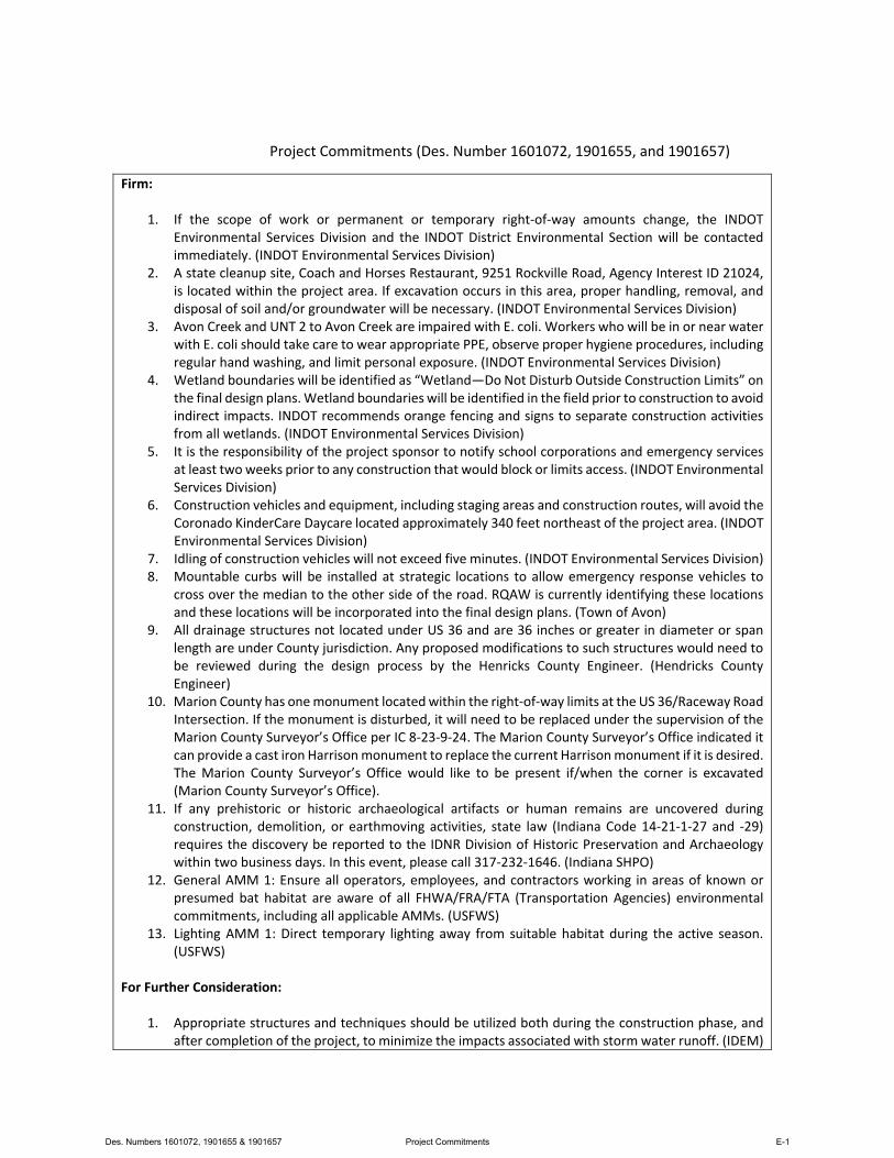
Project Commitments (Des. Number 1601072, 1901655, and 1901657)
Firm:
1. If the scope of work or permanent or temporary right‐of‐way amounts change, the INDOTEnvironmental Services Division and the INDOT District Environmental Section will be contactedimmediately. (INDOT Environmental Services Division)
2. A state cleanup site, Coach and Horses Restaurant, 9251 Rockville Road, Agency Interest ID 21024,is located within the project area. If excavation occurs in this area, proper handling, removal, anddisposal of soil and/or groundwater will be necessary. (INDOT Environmental Services Division)
3. Avon Creek and UNT 2 to Avon Creek are impaired with E. coli. Workers who will be in or near waterwith E. coli should take care to wear appropriate PPE, observe proper hygiene procedures, includingregular hand washing, and limit personal exposure. (INDOT Environmental Services Division)
4. Wetland boundaries will be identified as “Wetland—Do Not Disturb Outside Construction Limits” onthe final design plans. Wetland boundaries will be identified in the field prior to construction to avoidindirect impacts. INDOT recommends orange fencing and signs to separate construction activitiesfrom all wetlands. (INDOT Environmental Services Division)
5. It is the responsibility of the project sponsor to notify school corporations and emergency servicesat least two weeks prior to any construction that would block or limits access. (INDOT EnvironmentalServices Division)
6. Construction vehicles and equipment, including staging areas and construction routes, will avoid theCoronado KinderCare Daycare located approximately 340 feet northeast of the project area. (INDOTEnvironmental Services Division)
7. Idling of construction vehicles will not exceed five minutes. (INDOT Environmental Services Division)8. Mountable curbs will be installed at strategic locations to allow emergency response vehicles to
cross over the median to the other side of the road. RQAW is currently identifying these locationsand these locations will be incorporated into the final design plans. (Town of Avon)
9. All drainage structures not located under US 36 and are 36 inches or greater in diameter or spanlength are under County jurisdiction. Any proposed modifications to such structures would need tobe reviewed during the design process by the Henricks County Engineer. (Hendricks CountyEngineer)
10. Marion County has one monument located within the right‐of‐way limits at the US 36/Raceway RoadIntersection. If the monument is disturbed, it will need to be replaced under the supervision of theMarion County Surveyor’s Office per IC 8‐23‐9‐24. The Marion County Surveyor’s Office indicated itcan provide a cast iron Harrison monument to replace the current Harrison monument if it is desired.The Marion County Surveyor’s Office would like to be present if/when the corner is excavated(Marion County Surveyor’s Office).
11. If any prehistoric or historic archaeological artifacts or human remains are uncovered duringconstruction, demolition, or earthmoving activities, state law (Indiana Code 14‐21‐1‐27 and ‐29)requires the discovery be reported to the IDNR Division of Historic Preservation and Archaeologywithin two business days. In this event, please call 317‐232‐1646. (Indiana SHPO)
12. General AMM 1: Ensure all operators, employees, and contractors working in areas of known orpresumed bat habitat are aware of all FHWA/FRA/FTA (Transportation Agencies) environmentalcommitments, including all applicable AMMs. (USFWS)
13. Lighting AMM 1: Direct temporary lighting away from suitable habitat during the active season.(USFWS)
For Further Consideration:
1. Appropriate structures and techniques should be utilized both during the construction phase, andafter completion of the project, to minimize the impacts associated with storm water runoff. (IDEM)
Des. Numbers 1601072, 1901655 & 1901657 Project Commitments E-1
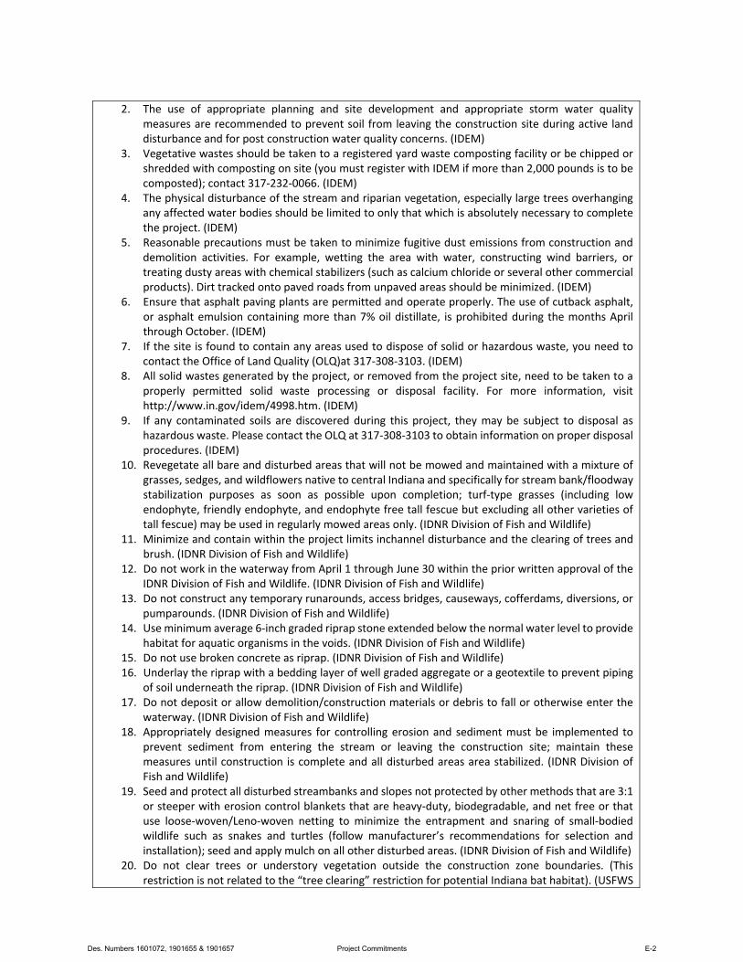
2. The use of appropriate planning and site development and appropriate storm water qualitymeasures are recommended to prevent soil from leaving the construction site during active landdisturbance and for post construction water quality concerns. (IDEM)
3. Vegetative wastes should be taken to a registered yard waste composting facility or be chipped orshredded with composting on site (you must register with IDEM if more than 2,000 pounds is to becomposted); contact 317‐232‐0066. (IDEM)
4. The physical disturbance of the stream and riparian vegetation, especially large trees overhangingany affected water bodies should be limited to only that which is absolutely necessary to completethe project. (IDEM)
5. Reasonable precautions must be taken to minimize fugitive dust emissions from construction anddemolition activities. For example, wetting the area with water, constructing wind barriers, ortreating dusty areas with chemical stabilizers (such as calcium chloride or several other commercialproducts). Dirt tracked onto paved roads from unpaved areas should be minimized. (IDEM)
6. Ensure that asphalt paving plants are permitted and operate properly. The use of cutback asphalt,or asphalt emulsion containing more than 7% oil distillate, is prohibited during the months Aprilthrough October. (IDEM)
7. If the site is found to contain any areas used to dispose of solid or hazardous waste, you need tocontact the Office of Land Quality (OLQ)at 317‐308‐3103. (IDEM)
8. All solid wastes generated by the project, or removed from the project site, need to be taken to aproperly permitted solid waste processing or disposal facility. For more information, visithttp://www.in.gov/idem/4998.htm. (IDEM)
9. If any contaminated soils are discovered during this project, they may be subject to disposal ashazardous waste. Please contact the OLQ at 317‐308‐3103 to obtain information on proper disposalprocedures. (IDEM)
10. Revegetate all bare and disturbed areas that will not be mowed and maintained with a mixture ofgrasses, sedges, and wildflowers native to central Indiana and specifically for stream bank/floodwaystabilization purposes as soon as possible upon completion; turf‐type grasses (including lowendophyte, friendly endophyte, and endophyte free tall fescue but excluding all other varieties oftall fescue) may be used in regularly mowed areas only. (IDNR Division of Fish and Wildlife)
11. Minimize and contain within the project limits inchannel disturbance and the clearing of trees andbrush. (IDNR Division of Fish and Wildlife)
12. Do not work in the waterway from April 1 through June 30 within the prior written approval of theIDNR Division of Fish and Wildlife. (IDNR Division of Fish and Wildlife)
13. Do not construct any temporary runarounds, access bridges, causeways, cofferdams, diversions, orpumparounds. (IDNR Division of Fish and Wildlife)
14. Use minimum average 6‐inch graded riprap stone extended below the normal water level to providehabitat for aquatic organisms in the voids. (IDNR Division of Fish and Wildlife)
15. Do not use broken concrete as riprap. (IDNR Division of Fish and Wildlife)16. Underlay the riprap with a bedding layer of well graded aggregate or a geotextile to prevent piping
of soil underneath the riprap. (IDNR Division of Fish and Wildlife)17. Do not deposit or allow demolition/construction materials or debris to fall or otherwise enter the
waterway. (IDNR Division of Fish and Wildlife)18. Appropriately designed measures for controlling erosion and sediment must be implemented to
prevent sediment from entering the stream or leaving the construction site; maintain thesemeasures until construction is complete and all disturbed areas area stabilized. (IDNR Division ofFish and Wildlife)
19. Seed and protect all disturbed streambanks and slopes not protected by other methods that are 3:1or steeper with erosion control blankets that are heavy‐duty, biodegradable, and net free or thatuse loose‐woven/Leno‐woven netting to minimize the entrapment and snaring of small‐bodiedwildlife such as snakes and turtles (follow manufacturer’s recommendations for selection andinstallation); seed and apply mulch on all other disturbed areas. (IDNR Division of Fish and Wildlife)
20. Do not clear trees or understory vegetation outside the construction zone boundaries. (Thisrestriction is not related to the “tree clearing” restriction for potential Indiana bat habitat). (USFWS
Des. Numbers 1601072, 1901655 & 1901657 Project Commitments E-2

Standard Recommendation) 21. Restrict below low‐water work in streams to placement of culverts, piers, pilings and/or footings,
shaping of the spill slopes around the bridge abutments, and placement of riprap. (USFWS StandardRecommendation)
22. Restrict channel work and vegetation clearing to the minimum necessary for installation of thestream crossing structure. (USFWS Standard Recommendation)
23. Minimize the extent of hard armor (riprap) in bank stabilization by using bioengineering techniqueswhenever possible. If riprap is utilized for bank stabilization, extend it below low‐water elevation toprovide aquatic habitat. (USFWS Standard Recommendation)
24. Implement temporary erosion and sediment erosion control methods within areas of disturbed soils.All disturbed soil areas upon project completion will be vegetated following INDOT’s StandardSpecification. (USFWS Standard Recommendation)
25. Avoid all work within the inundated part of the stream channel (in perennial streams and largerintermittent streams) during the fish spawning season (April 1 through June 30), except for workwithin sealed structures such as caissons or cofferdams that were installed prior to the spawningseason. No equipment shall be operated below Ordinary High Water Mark during this time unlessthe machinery is within the caissons or on the cofferdams. (USFWS Standard Recommendation)
26. Evaluate wildlife crossings under bridge/culverts projects in appropriate situations. Suitablecrossings include flat areas below bridge abutments with suitable ground cover, high water shelvesin culverts, amphibian tunnels and diversion fencing. (USFWS Standard Recommendation)
Des. Numbers 1601072, 1901655 & 1901657 Project Commitments E-3