james bay mining corp. (n.p.l.) - search … · 520e8ne0091 s2008ne0022a1 dona lake received jan...
TRANSCRIPT

520e8NE0091 S2008NE0022A1 DONA LAKE
RECEIVED
JAN 281972PROJECTS SECTION
010
Report on
MAGNETOMETER SURVEY onPart of Group 4
for
JAMES BAY MINING CORP. (N.P.L.)
Pickle Lake Project
Toronto,Ontario January 2?, 1972
Robert L. V. Ekstrom B.A.Sc,, P. Eng.

5aO*8NE8091 520eBNE0eaaAI DONA LAKE
TABLE OF CONTENTS
INTRODUCTION
PROPERTY, LOCATION tt ACCESS
LINECUTTING
GEOLOGICAL RECONNAISSANCE
REGIONAL ft LOCAL GEOLOGY
MAGNETOMETER SURVEY .
Method Results
CONCLUSIONS
BIBLIOGRAPHY
CERTIFICATE
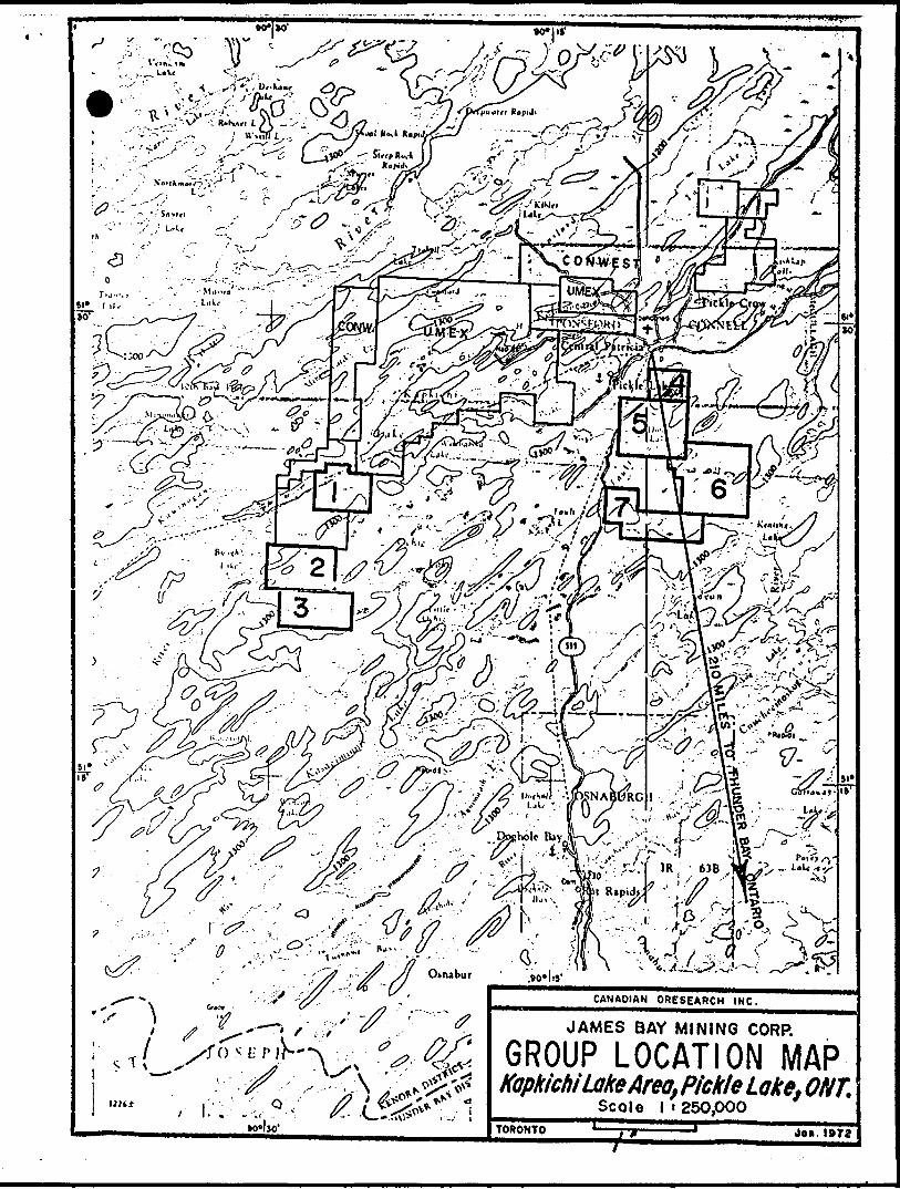
GROUP LOCATION MAP
CLAIM LOCATION MAP
MAGNETOMETER SURVEY PLAN * -Sheet l
010C
J

INTRODUCTION
On September 22, 1971, James Bay Mining Corp. (X.P.L.) (Sultt 250,
620 St. James Street West, Montreal 101, F* Q.) requested Canadian Oresearoh
Ine* (Suite 10, 85 King Street, East, Toronto, Ontario) to carry out lino
cutting, geophysical survey* and reconnaissance geology and prospecting
on their elains in the Fickle Lake Area, Patricia Mining Division,
Borthvestern Ontario*
Work in the area began on fofrQ, frf r flltf *** crews were removed for
the holiday -break on December 22nd*
PROPERTY. LOCATION, AND ACCESS
claims recorded in the name of Janes Bay Mining
Corp. (.N.P.L.) designated as Group 4* are located on claim sap M-2228,
approximately one idle south-east of Central Patricia, Ontario in the
Patricia Mining division. A location nap is included in the report* The
group lies approximately 210 miles WO0* of Thunder Bay,
The claim numbers are as follows i
Pa-286007 to 286016 incl. Pa-289544 to 289550 incl. Pa-289563 to 289565 incl. Pa-286155 to 286164 incl.
10 claims 7 claims 3 claims10 claims
Total 30 claims
Highway 599 from Savant Lake on the CD railway to Central
Patricia passes along the west side of the property and cuts through the
south-west and north-west corners of the property* Access is by road
vehicle and campsites exist along the highway adjacent to the claim group*The current survey covers only the southeastern
the group.

^
-2-
MHECUTTIMQ
i picket Une grid wu established with the base
commencing at the number four post of claim Pa-286011 and traversing-- - . -w.the property on a bearing of SA^K, A grid of lin** wa* out at 400*
interral* along the baseline and at right angles to it, Uneeutting
commenced on peVfrer -^\\ *j* was ecnpleted on Itevember 3rd. 1971
OKOLOGICAL RECONNAISSANCE
Reconnaissance geology and prospecting was carried out b/ the
author and three assistants at various times from October 22 to November
17, 1971* Bock types and mineralisation were noted and soae rock
trenching was done on a sulphide showing, AU of the picket lines and
much of the chaining was not completed at the time of the survey and it
was necessary to use claim lines and pacing for control in much of the
work.
RBBIONAL AND LOCAL GSQLOGY
The area is underlain by Keewatin volcanic rocks and sediments,
post Keewatin granit^ acid porphyry, aplite, rhyolite and felsite,
(possibly Algoman) and Keweenawan diabase and lamprophyre*
The oldest rocks, the Keewatin, are generally basic flows
(andesite to basalt) which have been altered and sheared* Interbedded are
iron formation, quartcite, greywacke and argillite. Minor bands of
rhyolite have been observed.
The rocks have been regionally folded and intruded by granite
which in the Pickle Lake area create a ring of volcanics with granite in

-3-
the centre with branching off-shoot* of volcanics extending to tht north
east and south-west. Much of this structure AM been interpreted fro*
the airbourne Magnetic nape*
Two gold nines (Central Patricia and Pickle Crow) were past
producers in the area. The gold bearing structures were composed of
quarts veins with heavy sulphide mineralization injected into tension
fracture cones in iron formation in the forner case and in quarts-
carbonate veins in later fractures in the latter* Details of the gold
vines can be found in Ontario Department of Mines fieports Vol. ZLU,
Part VI*1), and Vol. XLVU, Part Hl(2\
Chalcopyrite has been seen associated with the gold mineralisation
\Jt\J 4Q4 aorf recently, copper mineralization has been found by Uaex
associated with nickel along the north side of the volcanic "ring".
Group 4 has been found to be underlain by Keewatin flows and
fragmental sediments with some iron formation and granitic and lamprophyre
intrusives. Sulphides were observed in both volcanic and sedimentary
rocks. In general the volcanics occupy the south-western portion of the
property with granite and related rocks to the north-east with included
remnants of the volcanics. The rocks strike JM-SJS but minor dragfolds
and local changes in strike are coouaon. The rocks dip to the north-east.

MAGNETOMETER SURVEY
Method
The magnetometer survey was carried out using a McPhap M-700 Flux ^ate magnetometer. This unit has five; scale ranges from 1000 to
160,000 gammas, with a scale constant of 20 gammas per scale division
in the 1000 gamma range. Readings were taken at picketed stations at 100
foot intervals on the grid lines, with 50-foot readings where the magnetic gradient was found to be steep.
Results . ;
Magnetic anomalies were found at the ftoron end of Lines 56 to 76S, the west end of Lines 52 to 68S, and along Lines 52 and 56S.
The eastern anomaly is probably caused by a weak magnetite iron formation. The electromagnetic survey did not locate any conductors in this area.
The western anomalies are in the area in which tne E.M. survey located several conductors. The conductor axes do not fci coincide with the magnetic highs and it is suspected that the stronger magnetic anomalies are on weak magnetite iron formation and that the E.M. anomalies
are on related sulphide zones.
The anomalies along Lines 52 and 56S may be caused by small remnants of iron formation in the granites. Better interpretation will be
possible when the survey is completed to the north (grid).
The minus 1050 gamma reading observed at 2000W, L6US, is probably caused oy some piece of acrap ateel left on the property at some
earlier date and is of no interest.
CONCLUSIONS
The remainder of Group 4 should be surveyed with the
magnetometer in order to check the magnetics associated with E.M. anomaly
A-l and complete the checking on A-2. It is felt that a complete survey
will also be a valuable aid in interpreting the local rock structure.*
Respectfully submitted,
Robert L. V. Ekstrom, B.A.Se., P. Eng.

BIBLIOORA
W. S, Dyer, Otology of the Pashkokogan-Misehkow Area, Ontario Dept*of Mines, Annual Report Vol. XIII, Part VI, 1933, Pages 1-20j
:-*rf*
•0*1*0'•0*1 It
•v CANADIAN ORESEARCH INC.
JAMES BAY MINING CORP.
GROUP LOCATION MAPkapkichiLakeArea, Pickle Lake. ONT.^^ ^^cole l 1250,000 ^^^
Jo*. 1972TORONTO

File.
58008NE0e91 DONA LAKE S00
j TO BF. ATTACHED AS AN APPENDIX TO TECHNICAL REPORT JA W *i 0 IS/JJ 1 FACTS SHOWN HERE NEED NOT BE REPEATED IN REPORT pRft j TECHNICAL REPORT MUST CONTAIN INTERPRETATION, CONCLUSIONS ETC. SECTlSsi3
Typp nf Survpy. , ff A 9 j
Township or Arca ^IcuCL/LCJri;.im hn]rlpr(s), \Sc±r~7f^*^
A(|trinr of Rppnft. jF\60 t*
ArlHrps*:, f y^O/X^X SsCovering Dates of Survey ™
T^tal Mil^s "f l-in** *~"t /-^f'
SPECIAL PROVISIONS CREDITS REQUESTED
ENTER 40 days (includes line cutting) for first survey.
ENTER 20 days for each additional survey using same grid.
ri^&^^e*f/ -y-* 0 "X. f S f /)
jr f f
^ X ' M fi? JC-S^-4~^
c*r ~70t~6*i* ̂SrTr: /7 @to^t t s 2^— /*J * t- /-0 7 f
(linecutling to office) S S ^JL A 'J ^ 41 ) f ft **p VT O r t df b-miJfO jf J
DAYS,, . . , per claim Geophysical
-Elcctromagnetic ^-ess^ Magnptomptrrjr^ V^V .
-Rnrljnrrlrtrjr. L^ Vs^
-Hfh^r '
flpnlngiral
n^nrKprpiral,, , ,, , ,
AIRBORNE CREDITS (Special provision credits do not apply to airborne surveys)
Ma'irVt"m*'H*r\ . El(Vtr""Vpnptic , Rnrljr.rnptrir(enter days per claim)
OATH: ^ 7///'^- f
; PROJECTS SECTION
!Rf;. Gwil.f ft i Prrvions Survpys eS\ ^J-J
j y Checked byC idD GEOLOGICAL BRANCH
;** Approved by
' GEOLOGICAL BRANCHj
:i r. N ATI IR v-^^^y^--^,^^Author of Report
Qualifirations ^ ' \^ '
.-late
dal i*
Approved hy dat'
MINING CLAIMS TRAVERSED Liit numerically
(prefix) (number)
^ ,/y x y....^..^......^OT.^^.Vv^f.;..............
^
TOTAL CLAIMS ^ V , .

GEOPHYSICAL TECHNICAL DATA
GROUND SURVEYS Number of Stations Station interval -———Line spacing ,————-—-—.——— Profile scale or Contour intervals ,
Number of Readings.
MAGNETIC Instrument_Accuracy - Scale constant Diurnal correction Base station location
(•pecify for each type of survey)
G .i/-l ^ t-t t~Yt U i *tC, M /'•l S f* d G jj *- *^ *^ C
-..w,va 5
ELECTROMAGNETICInstrumentCoil configuration. Coil separation ——. Accuracy———— Method: O Fixed transmitter O Shoot back CD In line O Parallel lineFrequency
(ipecify V.L.F. lUtion)Parameters measuredGRAVITY
InstrumentScale constant.Corrections made.
Base station value and location.
Elevation accuracy.—.——--.—.——————. INDUCED PQ1.AR1ZAT1ON - RESISTIVITY
Instrument^^.,—..—^^—^—^———^-Time domainFrequencyPower
Frequency domain. Range ̂ -—— -——--
Electrode array.—. Electrode spacing. Type of electrode.

Canadian Ore s ear eh Inc.SUITE 10 . 85 KINO STREET EAST
TORONTO 210. ONTARIO
TELEPHONE: 363-3590
JL&600 7
S j 26 t * 0 *
2*6
28*

Connet- 7T*J/**C11 x? e ( 7~tv X
SS2 •JB/ poi
245o. i,
so•* fc^'r* 34J&M/* rs i S*"
Sux̂ l!W
w. SK
*99
[^ •yAFT\
'le/SL^tf/gl ia; ^/^
ra ^6381 Fb
"201V:. ^ Pa 16781
ffi^i^S^\ 6f ' 6s•^r^^w^^r?-i^&iJ^TIo t\ i y-*..' /^ R:688
Pu.^ -' *^ - 7 ' o ,2013^/ZOO^
"a l Pa /j hfc,It l*1^*! X l
'16 life/2694^^ i ^C. Vj
tm
^3.^ra.?93/)^
J*.v,cv*/^n?r ,-I/3M2J
ffl'^92 ®4©;
'2020!
ssffij-2024
^294588-
1C
a.
zseofi it
?0.i2469(;il78^icr.-^h^'9-7 -lT7~n"-; ^~~ - . ^/^m.o3,,94*02 ; M4fo , ; IMIO^ ; "7~ t7.:~-r-t"—J —-
lZ!i*'* 128..SV is
!?89S44| |IM5M |
K?- If
r?8S6oe - zfe'Joor 21(017l ft.
* 94 20*
n*w L"4" 5t-—fa -
..-... l **41i
26(019
o /t ne /X

"""^"^RB^^"•iV^y-lfr 1
MA? (5) IbEN/T/F/JEb
IH/M THE
SEQUENCE C X)

zo-t-oo
X
\
00
o ^w- r,* t^-9 1-
i' e /&C, c*) O O
9 #
e* *-* o u r
1 * r* &T t t
Ti*
cc ft p
(s z r* r t
ONTARIO r:;v, .r., ..T' r -* v i' "C
R E li E'i v E DAPr i 7 1972OF"fC5 OF THE
6. LOGIST
mfNZ Or-**lIL 7 l - -u"ia^"^Ao-viJ---^ OF
OKTARIO DEPARIW^RED tAKE
52008hE®a91 52006NE®822A1 DONA LAKE 200