jacob p. duginski megan l. morgan mmorgan@bdlaw
TRANSCRIPT

Jacob P. Duginski
456 Montgomery Street, Suite 1800
San Francisco, CA 94104-1251
+1.415.262.4018
Megan L. Morgan
201 North Charles Street, Suite 2210
Baltimore, MD 21201-4100
+1.410.230.1343
Austin, TX Baltimore, MD Boston, MA New York, NY San Francisco, CA Seattle, WA Washington, DC
October 26, 2021
Via E-Mail
Kathryn Roberts
Office of the General Counsel
P.O. Box 4940
Diamond Bar, CA 91765-0940
Re: Additional Study of Air Movement Report re South Coast AQMD v. Chiquita
Canyon, LLC (Case No. 6177-1), Modified Stipulated Order Condition 34(d)
Dear Ms. Roberts:
In accordance with Condition 34(d) of the October 5, 2021 Modified Stipulated Order for
Abatement in the above-referenced matter, on behalf of Chiquita Canyon, LLC, please find
enclosed with this letter the Additional Study of Air Movement Report prepared by SCS
Engineers and Blue Ridge Services Montana, Inc. for Chiquita Canyon, LLC. Please advise of
any questions you may have on the report.
Sincerely,
Jacob P. Duginski
Megan L. Morgan
Attorneys for Chiquita Canyon, LLC

Ms. Kathryn Roberts, Esq.
Deputy District Counsel II, South Coast AQMD
October 26, 2021
Page 2
Enclosure: October 26, 2021 Additional Study of Air Movement Report
cc: Mary Reichert ([email protected])
Larry Israel ([email protected])
Harry Moon ([email protected])

Additional Study of Air Movement
Report
Chiquita Canyon Landfill
29201 Henry Mayo Drive
Castaic, CA 91384
3900 Kilroy Airport Way, Suite 100
Long Beach, CA 90806
562-426-9544
01204123.21 | October 26, 2021

Additional Study of Air Movement www.scsengineers.com
i
Table of Contents
Section Page
Introduction and Background ....................................................................................................... 1
Fan Optimization ........................................................................................................................... 5
Purpose ..................................................................................................................................... 5
Methodology ............................................................................................................................. 5
General Site Conditions .............................................................................................. 6
Test Conditions ............................................................................................................ 6
Testing in Cell 6 ........................................................................................................... 6
Testing in the OC Zone ................................................................................................ 8
Smoke Test Conclusions .......................................................................................... 10
Revised CFD Modeling .......................................................................................................... 11
Extent of ORF and TBF Influence ............................................................................. 11
Optimizing Fan Configuration .................................................................................. 15
Effect of Topography on Fans .................................................................................. 17
Conclusions of CFD Modeling .................................................................................. 19
Additional Air Movement Study ...................................................................................................20
Methodology .......................................................................................................................... 20
Results ................................................................................................................................... 21
September 17, 2021 Smoke Tests ......................................................................... 21
September 23, 2021 Smoke Tests ......................................................................... 24
September 24, 2021 Smoke Tests ......................................................................... 27
September 25, 2021 Smoke Tests ......................................................................... 30
Smoke Test Meteorology ......................................................................................... 33
Analysis and Conclusions ...................................................................................................... 56
Conclusion 1 ............................................................................................................. 56
Conclusion 2 ............................................................................................................. 60
Conclusion 3 ............................................................................................................. 62
Conclusion 4 ............................................................................................................. 65
Overall Recommendations ..........................................................................................................67
BRS Recommendations ........................................................................................................ 67
SCS Recommendations ........................................................................................................ 68
References ..................................................................................................................................69
Attachment A: Smoke Test Wind Roses
Attachment B: Smoke Test Meteorology

Additional Study of Air Movement www.scsengineers.com
ii
Figures
Figure 1. CCLF Working Face Locations (August – October 2021) ................................................... 2
Figure 2. Fans Operating at the OC Zone Working Face .................................................................... 3
Figure 3. Fans Operating at the Cell 6 Working Face ......................................................................... 4
Figure 4. Cell 6 Test Area Layout ......................................................................................................... 7
Figure 5. Cell 6 Baseline Test Smoke Release Points and Observations ......................................... 7
Figure 6. Cell 6 Fan Effectiveness Test Smoke Release Points and Observations .......................... 8
Figure 7. OC Zone Test Area Layout .................................................................................................... 9
Figure 8. OC Zone Baseline Test Smoke Release Points and Observations ..................................... 9
Figure 9. OC Zone Fan Effectiveness Test Smoke Release Points and Observations .................. 10
Figure 10. Bernoulli Principle: Fan Air Column Influence .................................................................. 11
Figure 11. Plan View: Diagram of Typical Fan Air Column ................................................................. 12
Figure 12. Plan View: Extent of ORFs and TBFs with Air Velocity 5+ mph (2.24 m/s) .................... 12
Figure 13. Section View: Extent of ORFs and TBFs with Air Velocity 5+ mph (2.24 m/s) ............... 13
Figure 14. Velocities (mph) of TBFs and ORFs Along Their Centerlines ........................................... 14
Figure 15. Plan View: 2 ORFs and 1 TBF ............................................................................................ 16
Figure 16. Evaluation of ORF Horizontal Influence at 65-foot Spacing ............................................ 16
Figure 17. Slope-Caused Zones of Slower Air With Fans Only on Upper Lift .................................... 17
Figure 18. Working Face Velocities with ORFs and TBFs on Upper Lift ............................................ 18
Figure 19. Working Face Velocities with ORFs on Lower Lift and TBFs on Upper Lift ..................... 18
Figure 20. September 17, 2021 Smoke Test Release Points .......................................................... 22
Figure 21. September 17, 2021 Smoke Test #2 (Smoke Test 2 of 18) .......................................... 23
Figure 22. September 17, 2021 Smoke Test #3 (Smoke Test 3 of 18) .......................................... 23
Figure 23. September 23, 2021 Smoke Test Release Points .......................................................... 25
Figure 24. September 23, 2021 Smoke Test #3 (Smoke Test 7 of 18) .......................................... 26
Figure 25. September 23, 2021 Smoke Test #4 (Smoke Test 8 of 18) .......................................... 26
Figure 26. September 24, 2021 Smoke Test Release Points .......................................................... 28
Figure 27. September 24, 2021 Smoke Test #1 (Smoke Test 10 of 18) ........................................ 29
Figure 28. September 24, 2021 Smoke Test #4 (Smoke Test 13 of 18) ........................................ 29
Figure 29. September 25, 2021 Smoke Test Release Points .......................................................... 31
Figure 30. September 25, 2021 Smoke Test #2 (Smoke Test 15 of 18) ........................................ 32
Figure 31. September 25, 2021 Smoke Test #4 (Smoke Test 17 of 18) ........................................ 32
Figure 32. Local Terrain Elevations .................................................................................................... 33
Figure 33. September 17, 2021 Smoke Test #1 Winds (Smoke Test 1 of 18) ............................... 34
Figure 34. September 17, 2021 Smoke Test #2 Winds (Smoke Test 2 of 18) ............................... 35
Figure 35. September 17, 2021 Smoke Test #3 Winds (Smoke Test 3 of 18) ............................... 36
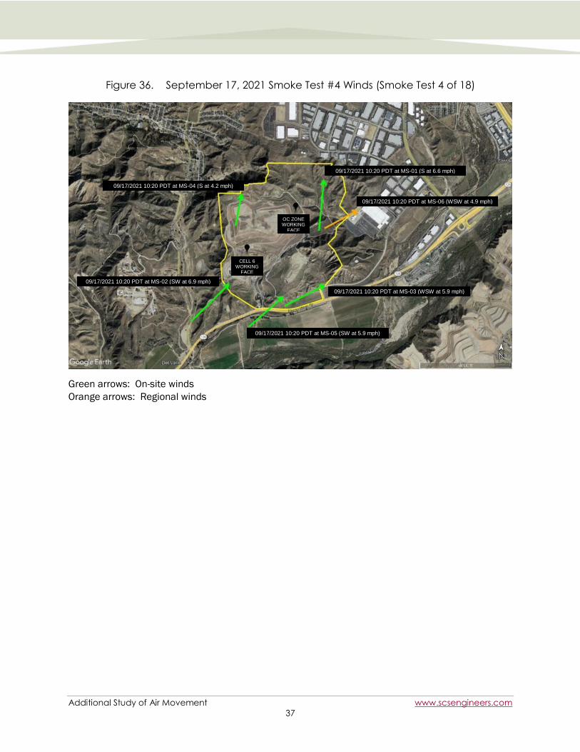
Figure 36. September 17, 2021 Smoke Test #4 Winds (Smoke Test 4 of 18) ............................... 37
Figure 37. September 23, 2021 Smoke Test #1 Winds (Smoke Test 5 of 18) ............................... 38
Figure 38. September 23, 2021 Smoke Test #2 Winds (Smoke Test 6 of 18) ............................... 39
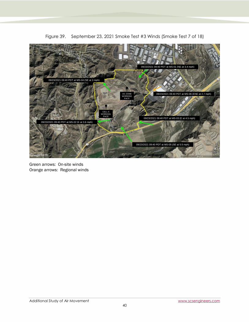
Figure 39. September 23, 2021 Smoke Test #3 Winds (Smoke Test 7 of 18) ............................... 40
Figure 40. September 23, 2021 Smoke Test #4 Winds (Smoke Test 8 of 18) ............................... 41

Additional Study of Air Movement www.scsengineers.com
iii
Figure 41. September 23, 2021 Smoke Test #5 Winds (Smoke Test 9 of 18) ............................... 42
Figure 42. September 24, 2021 Smoke Test #1 Winds (Smoke Test 10 of 18)............................. 43
Figure 43. September 24, 2021 Smoke Test #2 Winds (Smoke Test 11 of 18)............................. 44
Figure 44. September 24, 2021 Smoke Test #3 Winds (Smoke Test 12 of 18)............................. 45
Figure 45. September 24, 2021 Smoke Test #4 Winds (Smoke Test 13 of 18)............................. 46
Figure 46. September 25, 2021 Smoke Test #1 Winds (Smoke Test 14 of 18)............................. 47
Figure 47. September 25, 2021 Smoke Test #2 Winds (Smoke Test 15 of 18)............................. 48
Figure 48. September 25, 2021 Smoke Test #3 Winds (Smoke Test 16 of 18)............................. 49
Figure 49. September 25, 2021 Smoke Test #4 Winds (Smoke Test 17 of 18)............................. 50
Figure 50. September 25, 2021 Smoke Test #5 Winds (Smoke Test 18 of 18)............................. 51
Figure 51. Regional Winds (September 17, 2021 0800) ................................................................. 52
Figure 52. Regional Winds (September 17, 2021 1100) ................................................................. 52
Figure 53. Regional Winds (September 23, 2021 0800) ................................................................. 53
Figure 54. Regional Winds (September 23, 2021 1100) ................................................................. 53
Figure 55. Regional Winds (September 24, 2021 0800) ................................................................. 54
Figure 56. Regional Winds (September 24, 2021 1100) ................................................................. 54
Figure 57. Regional Winds (September 25, 2021 0800) ................................................................. 55
Figure 58. Regional Winds (September 25, 2021 1100) ................................................................. 55
Figure 59. Smoke Plumes at the OC Zone with and without Fan Influence ..................................... 57
Figure 60. Smoke Plumes at the OC Zone with and without Fan Influence ..................................... 58
Figure 61. Smoke Plumes at Cell 6 with and without Fan Influence ................................................ 59
Figure 62. Smoke Plume Mixing with Fans Operating at Cell 6 ........................................................ 60
Figure 63. Smoke Plume Mixing with Fans Operating at the OC Zone ............................................. 61
Figure 64. Cell 6 Smoke Plumes Not influenced by the Fans ........................................................... 62
Figure 65. Cell 6 Smoke Plumes Not Influenced by the Fans ........................................................... 63
Figure 66. Cell 6 Smoke Not Influenced by the Fans ........................................................................ 63
Figure 67. OC Zone Smoke Plumes Not Influenced by the Fans ...................................................... 64
Figure 68. Cell 6 Vertical Smoke Plume Mixing ................................................................................. 65
Figure 69. OC Zone Vertical Smoke Plume Mixing ............................................................................. 66
Tables
Table 1. Fan Centerline Spacing and Offset from Working Face Distances ................................. 19
Table 2. September 17, 2021 Smoke Test Releases .................................................................... 21
Table 3. September 23, 2021 Smoke Test Releases .................................................................... 24
Table 4. September 24, 2021 Smoke Test Releases .................................................................... 27
Table 5. September 25, 2021 Smoke Test Releases .................................................................... 30

Additional Study of Air Movement www.scsengineers.com
iv
Acronyms and Abbreviations
BRS Blue Ridge Services Montana, Inc.
CCL Chiquita Canyon, LLC
CCLF Chiquita Canyon Landfill
CFD Computational Fluid Dynamics
deg Degrees
E East
ENE East-Northeast
ESE East-Southeast
ft Feet
MET Meteorological
m/s Meters per second
Modified Order Stipulated Order of Abatement as Modified on October 5, 2021
mph Miles per hour
MS Monitoring Station
NE Northeast
NNE North-Northeast
NW Northwest
OC Odor Control
ORF Orchard Rite® Fan
PDT Pacific Daylight Time (Local Time)
SCAQMD South Coast Air Quality Management District
SCS SCS Engineers
S South
SE Southeast
SOP Standard Operating Procedures
SSE South-Southeast
SSW South-Southwest
SW Southwest
TBF Tow and Blow® Fan
WD Wind direction (direction from which the wind is blowing)
WS Wind speed
WSW West-Southwest

Additional Study of Air Movement www.scsengineers.com
1
INTRODUCTION AND BACKGROUND
Chiquita Canyon, LLC (CCL) and the South Coast Air Quality Management District (SCAQMD) entered
into a Modified Stipulated Order for Abatement on August 19, 2021, which required the preparation
of this report. The August Order was subsequently modified on October 5, 2021 (Modified Order),
and the Modified Order maintained the requirement to prepare this report.
Among other tasks, SCS Engineers (SCS) and Blue Ridge Services Montana, Inc. (BRS) were
contracted to undertake a study and provide a report to the SCAQMD in accordance with Condition
34d of the Modified Order as stated below:
34. d. Additional study of air movement to determine whether there are any preferential
pathways for air movement outside of the Landfill, to assess the effectiveness of the orchard
fans deployed pursuant to Condition 9, and to generate recommendations for fan
configuration, including, but not limited to, the number, size, and placement of such fans.
This study shall analyze areas that CCL uses for waste disposal, including the OC Zone, and
Cell 6. The study required by this Condition 32(d) shall be documented in a report prepared
for Respondent and submitted to South Coast AQMD (attn: Larry Israel, [email protected];
Harry Moon, [email protected]; Kathryn Roberts, [email protected]; Mary Reichert,
[email protected]) on or before October 26, 2021.
This report is a follow-up to previous technical studies and reports that provided tangible information
regarding air movement at the landfill such as:
Landfill Operations Assessment Report (February 2021 Report)[1]
Air Movement Study Report (June 2021 Report)[2]
Assessment of Feasibility Report – Vegetative Barrier and Air Flow Disruptor (July
2021 Report)[3]
The February 2021 Report hypothesized that low to moderate winds with a Southerly component
could potentially move over and through low spots or “saddles” in the Western ridgeline at the
Southwestern corner of the Chiquita Canyon Landfill (CCLF). The June 2021 Report investigated this
possible preferential pathway using a series of smoke releases and concluded that air parcels were
not leaving through the identified low points in the ridgeline. Instead, air parcels rose vertically from
the source areas and became entrained in the regional winds, which carried the air parcels over the
ridgeline.
The July 2021 Report assessed the feasibility of using vegetative barriers or other airflow disruptors
along the landfill perimeter to help control potential odors. Based on the conclusions in the June
2021 Report, it became clear that because of the vertical air parcel rise, vegetative or other
perimeter barriers would not be effective. Instead, the July 2021 Report concluded that additional
mixing of the air parcels along a cross-wind horizontal plane would be more effective than vegetative
barriers in reducing the potential for odors to impact the Val Verde community. Enhanced horizontal
mixing effectively dilutes odor concentrations before they leave the CCLF.
Following the July 2021 Report, and after CCL obtained permits from the SCAQMD (with U.S.
Environmental Protection Agency approval) for engines for the Orchard Rite® fans (orchard fans or
ORFs), the CCLF began operating orchard fans as airflow disruptors in August 2021 to increase the
horizontal mixing at the Odor Control (OC) Zone and Cell 6 working faces (see Figure 1). The purpose

Additional Study of Air Movement www.scsengineers.com
2
of this Additional Study of Air Movement was to assess whether the orchard fans improve horizontal
mixing of air parcels at the working face.
As summarized in Section 2 of this Additional Study of Air Movement Report (October 2021 Report),
BRS completed a series of smoke releases and additional Computational Fluid Dynamics (CFD)
modeling to optimize the placement and use of the ORFs as well as the existing Tow and Blow® fans
(tow and blow fans or TBFs). Figures 2 and 3 show photographs of the fans at the working face.
In order to assess the effectiveness of the ORFs and to evaluate whether there are other preferential
pathways for air parcel movement toward Val Verde, SCS completed a series of smoke releases at
the OC Zone and Cell 6 working faces during unfavorable wind conditions, which are thought to have
the potential to carry surface air from the point of release into the Val Verde community. The results
from these smoke releases are summarized in Section 3 of this October 2021 Report.
Figure 1. CCLF Working Face Locations (August – October 2021)

Additional Study of Air Movement www.scsengineers.com
3
Figure 2. Fans Operating at the OC Zone Working Face
Photo taken on 9/23/2021 West of Working Face with a viewing angle of Northeast.
Orchard
Fans

Additional Study of Air Movement www.scsengineers.com
4
Figure 3. Fans Operating at the Cell 6 Working Face
Photo taken on 9/17/2021 Northwest of Working Face with a viewing angle of Southeast.
Orchard and Tow
and Blow Fans
Fans

Additional Study of Air Movement www.scsengineers.com
5
FAN OPTIMIZATION
BRS performed the fan optimization portion of this study. BRS staff were onsite at CCLF August 30
through September 2, 2021. BRS performed smoke studies on August 31, September 1, and
September 2, 2021. The following section presents a summary of the testing conditions,
methodology, observations, data collected, updated modeling, and recommendations for fan
numbers and placements around the working face area.
PURPOSE
The objective of the fan optimization study was to assess the effectiveness of the three ORFs
currently deployed at CCLF, and to generate recommendations for fan configuration, including the
number, size, and placement of orchard fans. This analysis was conducted using drone- and ground-
based video collection of smoke movement, handheld anemometer (wind speed) data collection,
and observation of wind influence in and around the working face. The data and observations were
used to generate new CFD models, with software adjustments made to ensure the modeling
accurately represents field data. The prior CFD models focused on the air mixing potential of the
TBFs with some additional CFD modelling of the ORFs, but no field testing verification because the
ORFs had not been permitted at the time of that prior study. The new CFD models and the smoke
tests performed for this fan optimization study provided a more accurate understanding of the
influence of both types of fans on air parcels at the working face. The results of this study, as
detailed in Section 2.3, include updated recommendations for the number of fans, fan configuration,
and the maximum working face surface area that the current fans being used at CCLF can effectively
cover.
The CFD modeling performed for this study sought the most effective fan configuration that achieves
sustained air velocities at the working face of over 5 miles per hour (mph) (2.24 m/s) which
improves horizontal mixing. This threshold was established based on the February 2021 Report[1]
and related air movement study. Air velocities over this threshold result in adequate airflow
disruption causing air parcels to be dispersed near the working face and potential odors to be
mitigated.
METHODOLOGY
All testing was performed in the morning hours, typically between the hours of 6:00 am and 10:00
am, and always during unfavorable wind conditions, which were identified in the February 2021
Landfill Operations Assessment Report[1] and defined in the Modified Order as winds being between
0 and 5 mph with a Southerly component. Forecasts for each test day were checked the night
before to ensure that winds would be between 0 and 5 mph and would typically be from the South.
Prior to commencing each day’s testing, BRS staff met with CCLF staff to coordinate activities, to
ensure the safety of all personnel and that the study did not interfere with CCLF waste placement.
Smoke release locations were identified in each cell. Wind measurements and other weather
observations were taken prior to the start of each test period with random, additional wind
measurements taken during testing.

Additional Study of Air Movement www.scsengineers.com
6
A baseline test was performed by releasing smoke around the working face but outside of the
influence of the fans to establish a visual reference for natural smoke movement in the prevailing
wind (“Baseline” test). Testing then occurred near the working face within the zone of fan influence
(“Fan Effectiveness” test). This allowed us to visually determine the effectiveness of various fan
configurations by comparing to the Baseline test. Criteria for the Fan Effectiveness testing included:
Baseline: smoke placed as far from the fans as allowable by topography but not farther than
600 feet horizontally and 50 feet vertically from working face.
Fan Effectiveness: smoke placed on the edges of the exposed waste when operationally safe
to do so. If waste placement activities posed a safety risk, then the smoke device was
placed downwind of the working face as close to the exposed waste as possible.
A minimum of three smoke release points were utilized for both the Baseline and Fan
Effectiveness smoke tests.
For each smoke test, video footage was taken via drone- and ground-based cameras.
General Site Conditions
During the three days of testing, CCLF was operating two active working faces: one within Cell 6 and
the other in a sliver fill within the OC Zone (see Figure 1).
Test Conditions
The weather was overcast with high clouds all three days with moderate temperatures staying in the
mid-60’s for the duration of the testing. The humidity was slightly higher than normal, but no
precipitation occurred during testing. Though these weather conditions were atypical for the region
during the test period, they did not adversely impact the testing or conclusions about the
effectiveness of the fans.
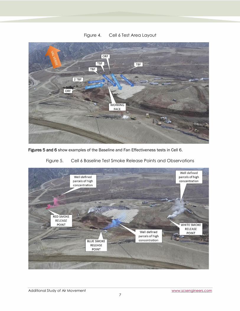
Testing in Cell 6
Operations were in the far Eastern side of Cell 6 with active waste disposal occurring at the
Northeast corner of the working face. Fans were located along the Northern and Western perimeters
of the working face as shown in Figure 4 and in accordance with Standard Operating Procedure
(SOP) 2.
Additional Study of Air Movement www.scsengineers.com
7
Figure 4. Cell 6 Test Area Layout
Figures 5 and 6 show examples of the Baseline and Fan Effectiveness tests in Cell 6.
Figure 5. Cell 6 Baseline Test Smoke Release Points and Observations

Additional Study of Air Movement www.scsengineers.com
8
Figure 6. Cell 6 Fan Effectiveness Test Smoke Release Points and Observations
Though testing on each day resulted in similar findings, it should be noted that based on
observations made on Day 1, minor changes to the fan locations and orientations were made for
testing on Days 2 and 3. These changes included moving a TBF on the upper deck and the ORF on
the lower deck closer to the working face and orienting the ORFs and TBFs on the upper deck in a
single line to ensure airflows were directed over the working face.
Testing in the OC Zone
Fill operations in the OC Zone were occurring on a sliver fill along the East slope of the landfill. Due
to the narrow lift and side slopes, only two fans were in use at the time of testing as shown in Figure
7: a TBF on a bench approximately 30 feet above the working face and an ORF on a bench at the
same elevation as the tipping area.
Wind conditions were measured in four locations around the working face and all velocities recorded
were within the 0 to 5 mph range though directions varied depending on location. This variability in
wind direction was likely the result of the complex topography around the fill area, which included
steep slopes that channel the airflow. Though the wind directions were not consistent, this did not
impact the testing or the observed results due to the velocities being within the range defined as
unfavorable winds given the primary purpose of this test was to evaluate the effectiveness of the
fans at accelerating wind speeds and subsequently improving horizontal mixing at the working face.
Figures 8 and 9 show the behavior of the smoke released in the Baseline and Fan Effectiveness
tests at the sliver fill in the OC Zone.

Additional Study of Air Movement www.scsengineers.com
9
Figure 7. OC Zone Test Area Layout
Figure 8. OC Zone Baseline Test Smoke Release Points and Observations

Additional Study of Air Movement www.scsengineers.com
10
Figure 9. OC Zone Fan Effectiveness Test Smoke Release Points and Observations
Direct observation and video review indicated that the ORF provided the greatest horizontal mixing of
smoke due, in part, to it being closest to the elevation of the working face. The TBF provided
minimal impact due, in part, to its location on a bench approximately 55 feet (vertically) above the
working face. While the single ORF provided accelerated air speeds and mixing, the reach of this
positive impact was limited to no more than 20 feet on either the left or right of its flow path. This
information was used to revise the CFD modeling as detailed in Section 2.3 of this report.
Smoke Test Conclusions
After three days of testing, it was evident that the ORFs achieved the greatest horizontal mixing and
diffusion of smoke when compared to the TBFs. This is because the ORFs produce a larger diameter
air column and create a larger zone of influence for mixing the air. This zone of influence is the
result of the Bernoulli Principle, where high velocity airflow creates a low-pressure zone pulling on
the surrounding air and accelerating it as it enters the primary flow path (see Figure 10). By
accelerating the air, a higher level of mixing occurs when compared to what is achieved by natural
wind speeds during unfavorable wind conditions.
This phenomenon occurs with both the ORFs and the TBFs, but because the effect is dependent on
airflow velocity and the size of the air column, the ORFs are more effective. Although both fans
create an initial velocity of approximately 50 mph (22.4 m/s), the ORFs mix at least 344% more air
than the TBFs.

Additional Study of Air Movement www.scsengineers.com
11
Figure 10. Bernoulli Principle: Fan Air Column Influence
Based on the field observations of the smoke studies, we were able to refine the CFD modeling used
in the development of SOP 2 and the July 2021 Report[3] and perform new modeling to optimize the
number, type, and placement of fans around the working face. The following section covers this
updated modeling.
REVISED CFD MODELING
The goal of the updated CFD modeling was to generate fan configurations that will mix the air at and
around the working face to above 5 mph (2.24 m/s), which is the minimum threshold for diffusing
any surface emissions into the surrounding air, resulting in reduced potential odor concentrations.
In order to do so, we used the original CFD modeling used to prepare SOP 2 and the July 2021
Report[3] and incorporated our observations from the fan optimization analysis (see Section 2.2).
Extent of ORF and TBF Influence
As with the prior CFD modeling, the revised CFD modeling looked at the ability for individual fan types
to accelerate air beyond the 5 mph (2.24 m/s) threshold and how far that ability reached. This
progressed to modeling multiple fans of the same type and then different configurations of both the
TBFs and ORFs. The first series of models used for the July 2021 Report and to develop SOP 2 were
based on a flat surface, whereas the final modeling for this October 2021 Report incorporated the
20-foot vertical lift, which is typical for the operating conditions at CCLF.
Figure 11 shows the concept of the fan air column and how far to each side the fan influences the
air.

Additional Study of Air Movement www.scsengineers.com
12
Figure 11. Plan View: Diagram of Typical Fan Air Column
Figure 12 shows CFD modeling results for the effect of a single TBF and a single ORF and the
maximum length and width of the fans’ zone of influence. It is important to note that the effective
range (shown in meters) of these two fan types differs considerably. The ORFs are clearly able to
influence air movement across a much larger range than the TBFs. Therefore, the ORFs are a much
more effective tool for reducing odor concentrations.
Figure 12. Plan View: Extent of ORFs and TBFs with Air Velocity 5+ mph (2.24 m/s)

Additional Study of Air Movement www.scsengineers.com
13
Figure 13 shows cross sections along each fan’s centerline and the air velocity within the column of
air mixed by a TBF and ORF. The cross sections were taken at 50 feet (15 meters), 130 feet (40
meters), and 295 feet (90 meters) from the fans. Here again, we see the difference between these
two types of fans. The TBFs provide some air movement that is important to fill the gaps between
the ORFs. However, the ORFs shoulder the responsibility of creating the airflow needed for odor
disruption.
Figure 13. Section View: Extent of ORFs and TBFs with Air Velocity 5+ mph (2.24 m/s)
Figure 14 shows the graphs detailing the fan velocities for both TBFs and ORFs along the centerline.
Data was measured in the model at both 3 feet and 20 feet above the ground for the ORFS, and 3
feet and 25 feet for the TBFs, to verify that the air velocity was consistently above the 5 mph
threshold for the entire working face.

Additional Study of Air Movement www.scsengineers.com
14
Figure 14. Velocities (mph) of TBFs and ORFs Along Their Centerlines

Additional Study of Air Movement www.scsengineers.com
15
By measuring the wind velocity in the CFD models at different elevations above ground level, we
determined the allowable offset distances for each fan type from the working face. To verify the
accuracy of the CFD modeling, these values were compared to field measured velocities, which
showed that the modeling was within 7% accuracy with the velocities measured in the field. Given
the variability of real-world conditions including terrain and other factors, this is an acceptable level
of variance.
Optimizing Fan Configuration
Once the zone of influence for each fan type (ORF and TBF) was determined, modeling was
performed to evaluate what combinations of fans would be most effective. Key parameters included
fan placement, spacing between fans, alignment, height, distance, and orientation relative to the
working face.
To ensure that the fans would mix air over the entire working face, a zone of 180 feet by 180 feet
was typically assessed as it is approximately 75% of the maximum working face surface area
permitted by CCL’s Conditional Use Permit (CUP). Zones of 150 feet squared (~52% of the maximum
working face surface area) were also modeled to reflect a smaller individual working face size.
First we considered whether any changes were necessary to previous instructions regarding the
TBFs. After performing the additional modeling in conjunction with the smoke testing, we identified
some needed changes to the original TBF offset distances and spacing specified in SOP 2. Those
changes include:
When TBFs are used without ORFs, they should be no less than 50 feet and no more than
100 feet from the working face.
The lateral spacing between the TBFs should be no less than 25 feet and no greater than 35
feet between the centerlines of the fans.

Additional Study of Air Movement www.scsengineers.com
16
Figure 15. Plan View: 2 ORFs and 1 TBF
Figure 16. Evaluation of ORF Horizontal Influence at 65-foot Spacing
Next, we considered whether any changes were needed with respect to our recommendations
regarding placement of ORFs. Our ORF modeling also indicated that when ORFs were placed 50 to
75 feet apart, the combined airflow of the ORFs was improved (Figure 16). This synergy, where the
combined effect is greater than the sum what would be expected for each of the individual fans, is
an important concept and is apparent in most cases where multiple fans are utilized.
In this example, when three ORFs were placed in a row with 50 to 75 feet spacing between them, the
combined airflow resulted in effective coverage of 180 feet by 180 feet (75% of the maximum
working face size permitted by CCL’s CUP), where the air velocity consistently exceeded 5 mph. By
having fans isolated or too far apart from other fans, the resulting zone of influence is dramatically
reduced as can be seen by comparing the single ORF fan shown in Figure 12 and the area of
influence shown above when multiple fans are used.
It is also important to note that ORFs work optimally when they are placed between 150 feet and
350 feet from the working face.

Additional Study of Air Movement www.scsengineers.com
17
Finally, we considered whether any changes were needed with respect to our prior recommendations
regarding use of the ORFs in combination with the TBFs. When using a combination of TBFs and
ORFs, we found that staggering them – based on their optimum distance from the working face –
provided the same synergistic effect described above. Figure 15, however, shows an example of
how using only two ORFs and one TBF does not provide adequate coverage for a working face that is
75% of the maximum size allowed by the CUP. The colored areas are where the fans have
accelerated the air in the model to beyond the 5 mph (2.24 m/s) threshold. By increasing the
number of fans to 3 ORFs and 5 TBFs, full coverage is achievable for a working face that is 75% of
the maximum size allowed by the CUP (Figure 19). The area influenced is dependent on the number
and type of fans. The more fans, the more area that can be covered.
Effect of Topography on Fans
After considering optimal fan placement on a flat plane, we incorporated topography into our
analysis. We were able to make two primary conclusions regarding the effect of topography on the
effectiveness of the ORFs and TBFs. First, we found that fans placed on the lift above the working
face, where the fans would blow over and down toward the working face, will not provide a wind
velocity of 5 mph or greater at the working face. Instead, as the fans blow over the edge, a small but
consistent eddy is created, where airflow stagnates at less than 5 mph as illustrated in Figure 17.
The variables that influence this effect include the height of the slope, the steepness of the slope,
and the velocity of the fan air column when it reaches the slope. Figure 18 shows what occurs when
fans are placed at a higher elevation and are configured to blow air over a downward slope.
Approximately 20% of the working face did not have airflows above the 5 mph (2.24 m/s) threshold.
Even with additional fans, this area of uninfluenced air remained due to the slope of the lift.
Figure 17. Slope-Caused Zones of Slower Air With Fans Only on Upper Lift
Second, our modeling showed that placing the more powerful ORFs on a lower lift deck so that they
blow up slope to the next higher lift and placing the less powerful TBFs on the upper lift is able to
provide full and effective coverage (airflow at or above 5 mph) across the entire working face.
In summary, the utilization of the different fan types across various topographies and cell
dimensions requires thoughtful application. There is no “one-size-fits-all,” but we have developed a
range of criteria that CCLF can employ to ensure that the TBFs and ORFs provide effective coverage
under different operating scenarios. One of those configurations is depicted in Figure 19.

Additional Study of Air Movement www.scsengineers.com
18
Figure 18. Working Face Velocities with ORFs and TBFs on Upper Lift
Slopes in the working face should be addressed by dividing the fans between the top of the working
face and the bottom, with the more powerful ORFs on the bottom blowing across the working face.
As Figure 19 shows, using this configuration, all of the working face surface air exceeds the 5 mph
(2.24 m/s) velocity threshold for a working face that is 75% of the maximum size allowed by the CUP.
An additional ORF – once permitted – on the lower deck will easily achieve full coverage for 100% of
the working face size allowed by the CUP.
Figure 19. Working Face Velocities with ORFs on Lower Lift and TBFs on Upper Lift

Additional Study of Air Movement www.scsengineers.com
19
Conclusions of CFD Modeling
After conducting a series of CFD modeling, and correlating much of it with field testing, we
determined the distances between the fans and from the working face at which the ORFs and TBFs
can provide an air velocity of 5 mph or greater. As shown in Table 1, those distances are:
Table 1. Fan Centerline Spacing and Offset from Working Face Distances
Fan Type Spacing Between
Similar Fan Type
Spacing Between
Different Fan Type
Distance from Working
Face
TBF 25-35 Feet 50 Feet 50-75 Feet
ORF 50-75 Feet 50 Feet 150-350 Feet
Based on these findings, a single fan should be available for every 50 feet of the downwind sides of
the working face, using either all ORFs or a combination of ORFs and TBFs. For example, if the
working face is 200 x 200 feet in size (91% of the maximum working face surface area), then the
total downwind length would be 400 feet, thus suggesting either 8 ORFs or a combination of ORFs
and TBFs (8 total). It is important to note that this is a rough guideline based on an ideal model.
Due to real-world constraints like topography, the number of fans needed may vary. For example,
while CCLF currently has the minimum number of fans required for effective mixing based on a
hypothetical working face size of 91% of the maximum allowed by the CUP, when topography was
added to the model (see Figure 19), we noted that CCLF has the minimum number of fans to cover a
working face size of 75% of the maximum allowed by the CUP. The addition of more ORFs will
ensure full coverage of the working face (100% of the maximum allowed by the CUP) even when
outside factors are taken into account, and will also allow for ORFs being shut down for
maintenance. With a total of 9 ORFs (the 3 CCLF has now plus the 6 for which applications are
pending), CCLF will have more than enough fans to provide effective mixing at 100% of the working
face size allowed by the CUP. Further, the exact placement of fans will be dependent on numerous
factors, including topography, space constraints, and operational and safety needs (i.e., we are not
recommending precisely one fan every 50 feet).

Additional Study of Air Movement www.scsengineers.com
20
ADDITIONAL AIR MOVEMENT STUDY
After BRS optimized the fan configuration, SCS performed the additional air movement portion of this
study to evaluate fan effectiveness and air parcel movement in both Cell 6 and the OC Zone.
Additional smoke releases were conducted on September 17, September 23, September 24, and
September 25, 2021 and were photographed from various ground-based vantage points in
conjunction with aerial drones flying at elevated vantage positions relative to each smoke plume.
This visual study provided documentation of how well the fans served to dilute surface releases and
provided insight on how air parcels are transported from the working faces and into the surrounding
area.
METHODOLOGY
Meteorological forecasting was first used to predict dates and times when conditions would be
suitable for testing. Winds conditions considered suitable for testing were based on the February
2021 Report[1], which identified certain conditions as correlating with verified odor complaints in the
community of Val Verde. These “unfavorable wind conditions” are reflected in Condition 3 of the
Modified Order, which identified winds with a Southerly component (including Southeast, Southwest,
and East-Southeast winds) with low to moderate wind speeds (0-5 mph) as “unfavorable wind
conditions” more likely to result in air movement off-site toward Val Verde. For this study, September
17, September 23, September 24, and September 25, 2021 were selected for testing based on a
review of meteorological forecasts by SCS’s meteorologist. During each day of testing, up to five
separate tests were conducted (i.e., two working faces with two to three tests per working face,
based on accessibility). For each test:
Smoke was released from two to three on-site locations at each working face for
approximately 15 minutes using three to five smoke candles per release point.
Release locations were selected based on field conditions (e.g., fan locations, tipping/
unloading areas, heavy equipment activity, topography, safety needs) so that airflow could be
observed from the working face (e.g., between the fans and the working face, along the sides
of the working face, and/or from the opposite side of the working face relative to the fan
locations).
Videos and photographs were taken from various vantage points using two drones, three Go-
Pro cameras, and two cell phones. Relevant example photographs are provided in this
report, including a description of the vantage point from where the photo was taken and the
direction the photographer is facing. These vantage points can be referenced to the maps of
smoke test release points.
Specific release points for each day of testing are detailed below.
A total of 18 tests were conducted over the four days selected, each with multiple release points.
Following the four days of testing, conclusions were made based on analysis of the imagery collected
and the corresponding meteorological data. In all, a total of about 750 gigabytes of smoke plume
movement imagery was collected with this study. Only portions of that imagery are presented in this
report due to size. The smoke test analysis that is part of this October 2021 Report was conducted
after the ORF placement and orientation had been optimized using the configurations as detailed in
Section 2.0. Note that because CCLF was using two different working faces, Cell 6 and the sliver fill
of the OC Zone, there were never three ORFs in use at one working face during the smoke testing.

Additional Study of Air Movement www.scsengineers.com
21
RESULTS
September 17, 2021 Smoke Tests
SCS conducted four smoke tests on September 17, 2021 as shown in Table 2 and Figure 20. See
Figures 21 to 22 for various example images recorded during these smoke tests.
Table 2. September 17, 2021 Smoke Test Releases
Date Test No. Start
Time
(PDT)
End
Time
(PDT)
Map ID Latitude
(deg)
Longitude
(deg)
Elevation
(ft)
9/17/2021 1 0815 0830 0917-1A 34.436809 -118.642405 1,267 *
0917-1B 34.435880 -118.641340 1,242
2 0845 0900 0917-2A 34.436809 -118.642405 1,265 *
0917-2B 34.436330 -118.641550 1,240
3 0935 0950 0917-3A 34.431573 -118.649362 1,241 *
0917-3B 34.431140 -118.649330 1,216
4 1008 1023 0917-4A 34.431573 -118.649362 1,241 *
0917-4B 34.431140 -118.649330 1,216
* Estimated

Additional Study of Air Movement www.scsengineers.com
22
Figure 20. September 17, 2021 Smoke Test Release Points
Yellow polygon = Landfill boundary
OC ZONE WORKING
FACE
CELL 6 WORKING
FACE
1A, 2A
2B
1B
3A, 4A
3B, 4B

Additional Study of Air Movement www.scsengineers.com
23
Figure 21. September 17, 2021 Smoke Test #2 (Smoke Test 2 of 18)
Photo taken South of Release Point 2B with a viewing angle of Northwest.
Figure 22. September 17, 2021 Smoke Test #3 (Smoke Test 3 of 18)
Photo taken Southwest of Release Point 3B with a viewing angle of North.
Release 2B
Release 3B
Release 3A

Additional Study of Air Movement www.scsengineers.com
24
September 23, 2021 Smoke Tests
SCS conducted five smoke tests on September 23, 2021 as shown in Table 3 and Figure 23. See
Figures 24 to 25 for various example images recorded during these smoke tests.
Table 3. September 23, 2021 Smoke Test Releases
Date Test No. Start
Time
(PDT)
End
Time
(PDT)
Map ID Latitude
(deg)
Longitude
(deg)
Elevation
(ft)
9/23/2021 1 0815 0830 0923-1A 34.436309 -118.642147 1,254
0923-1B 34.435870 -118.641670 1,229
2 0905 0920 0923-2A 34.436309 -118.642147 1,254
0923-2B 34.435870 -118.641670 1,229
0923-2C 34.435930 -118.642134 1,246
3 0930 0945 0923-3A 34.436309 -118.642147 1,254
0923-3B 34.435870 -118.641670 1,229
0923-3C 34.435930 -118.642134 1,246
4 1020 1035 0923-4A 34.431715 -118.648957 1,217
0923-4B 34.431600 -118.648390 1,215
0923-4C 34.431331 -118.648611 1,203
5 1100 1115 0923-5A 34.431715 -118.648957 1,217
0923-5B 34.431600 -118.648390 1,215
0923-5C 34.431331 -118.648611 1,203

Additional Study of Air Movement www.scsengineers.com
25
Figure 23. September 23, 2021 Smoke Test Release Points
Yellow polygon = Landfill boundary
OC ZONE WORKING
FACE
CELL 6 WORKING
FACE 4C, 5C
4B, 5B 4A, 5A
1B, 2B, 3B 2C, 3C
1A, 2A, 3A

Additional Study of Air Movement www.scsengineers.com
26
Figure 24. September 23, 2021 Smoke Test #3 (Smoke Test 7 of 18)
Photo taken Northwest of Release Point 3A with a viewing angle of Southeast.
Figure 25. September 23, 2021 Smoke Test #4 (Smoke Test 8 of 18)
Photo taken Northwest of Release Point 4A with a viewing angle of South-Southeast.
Release 4A
Release 4B
Release 4C
Release 3C Release 3A Release 3B

Additional Study of Air Movement www.scsengineers.com
27
September 24, 2021 Smoke Tests
SCS conducted four smoke tests on September 24, 2021 as shown in Table 4 and Figure 26. See
Figures 27 to 28 for various example images recorded during these smoke tests.
Table 4. September 24, 2021 Smoke Test Releases
Date Test No. Start
Time
(PDT)
End
Time
(PDT)
Map ID Latitude
(deg)
Longitude
(deg)
Elevation
(ft)
9/24/2021 1 0800 0815 0924-1A 34.436180 -118.642010 1,236
0924-1B 34.436250 -118.641670 1,227
0924-1C 34.435990 -118.642050 1,254
2 0840 0855 0924-2A 34.435700 -118.641980 1,248
0924-2B 34.436250 -118.641670 1,227
0924-2C 34.435990 -118.642050 1,254
3 0930 0945 0924-3A 34.431260 -118.648930 1,224
0924-3B 34.431340 -118.648360 1,210
0924-3C 34.430860 -118.648710 1,213
4 1005 1020 0924-4A 34.431260 -118.648930 1,224
0924-4B 34.431340 -118.648360 1,210
0924-4C 34.430860 -118.648710 1,213

Additional Study of Air Movement www.scsengineers.com
28
Figure 26. September 24, 2021 Smoke Test Release Points
Yellow polygon = Landfill boundary
OC ZONE WORKING
FACE
CELL 6 WORKING
FACE
3B, 4B
3C, 4C
3A, 4A
2A
1C, 2C
1A 1B, 2B

Additional Study of Air Movement www.scsengineers.com
29
Figure 27. September 24, 2021 Smoke Test #1 (Smoke Test 10 of 18)
Photo taken North of Release Point 1B with a viewing angle of Southwest.
Figure 28. September 24, 2021 Smoke Test #4 (Smoke Test 13 of 18)
Photo taken West of Release Point 4C with a viewing angle of Northwest.
Release 1B Release 1A
Release 1C
Release 4C
Release 4A Release 4B

Additional Study of Air Movement www.scsengineers.com
30
September 25, 2021 Smoke Tests
SCS conducted five smoke tests on September 25, 2021 as shown in Table 5 and Figure 29. See
Figures 30 to 31 for various example images recorded during these smoke tests.
Table 5. September 25, 2021 Smoke Test Releases
Date Test No. Start
Time
(PDT)
End
Time
(PDT)
Map ID Latitude
(deg)
Longitude
(deg)
Elevation
(ft)
9/25/2021 1 0720 0735 0925-1A 34.431290 -118.648620 1,207
0925-1B 34.431390 -118.648090 1,212
0925-1C 34.430930 -118.648290 1,204
2 0755 0810 0925-2A 34.430720 -118.648070 1,177
0925-2B 34.431390 -118.648090 1,212
0925-2C 34.430930 -118.648290 1,204
3 0830 0845 0925-3A 34.430720 -118.648070 1,177
0925-3B 34.431210 -118.647760 1,208
0925-3C 34.430930 -118.648290 1,204
4 0920 0935 0925-4A 34.436170 -118.641950 1,258
0925-4B 34.435910 -118.641500 1,253
0925-4C 34.435740 -118.642290 1,259
5 0955 1010 0925-5A 34.436170 -118.641950 1,258
0925-5B 34.435910 -118.641500 1,253
0925-5C 34.435740 -118.642290 1,259

Additional Study of Air Movement www.scsengineers.com
31
Figure 29. September 25, 2021 Smoke Test Release Points
Yellow polygon = Landfill boundary
OC ZONE WORKING
FACE
CELL 6 WORKING
FACE
1A
1C, 2C, 3C
2A, 3A
3B
1B, 2B
4C, 5C
4A, 5A
4B, 5B

Additional Study of Air Movement www.scsengineers.com
32
Figure 30. September 25, 2021 Smoke Test #2 (Smoke Test 15 of 18)
Photo taken West of Release Point 2C with a viewing angle of East-Southeast.
Figure 31. September 25, 2021 Smoke Test #4 (Smoke Test 17 of 18)
Photo taken Northwest of Release Point 4C with a viewing angle of East-Northeast.
Release 2C Release 2A
Release 4A Release 4B
Release 4C

Additional Study of Air Movement www.scsengineers.com
33
Smoke Test Meteorology
Meteorology varied by test day and, to some extent, by release point. This was consistent with what
was observed during the meteorological study completed as part of the February 2021 Report[1] as
well as conditions generally observed on-site during the testing period. Variations were due in part to
the complex terrain within and surrounding the CCLF as shown in Figure 32 as well as due to normal
changes in regional winds in the area. Figures 33 to 50 use proportionally scaled/rotated arrows to
illustrate how on-site and regional wind speed (WS) and wind direction (WD) varied during the smoke
tests at six meteorological (MET) monitoring stations (MS-01 to MS-06)[4]. The green arrows
represent on-site wind conditions while the orange arrows represent regional winds.
These figures demonstrate how on-site and regional winds can differ at the same time of day and
how this can affect air movement within the CCLF and off-site. Figures 51 to 58 illustrate how the
projected regional winds varied on each smoke test day[5]. See Attachment A (wind roses) and
Attachment B (table of wind conditions) for the 10-minute wind data measured at the six monitoring
stations.
Testing was focused on the unfavorable 0 to 5 mph winds from the South, Southeast, East-
Southeast (see Section 3.1 for details). These unfavorable wind conditions were primarily observed
in the morning hours until winds from the West developed in the afternoon. Testing also evaluated
other winds if they occurred during the testing period, although such winds have a minimal potential
to cause off-site impacts to the Northwest (in the direction of Val Verde) based on the conclusion of
February 2021 Report[1].
Figure 32. Local Terrain Elevations
Yellow polygon = Landfill boundary

Additional Study of Air Movement www.scsengineers.com
34
Figure 33. September 17, 2021 Smoke Test #1 Winds (Smoke Test 1 of 18)
Green arrows: On-site winds
Orange arrows: Regional winds
OC ZONE WORKING
FACE
CELL 6 WORKING
FACE
09/17/2021 08:30 PDT at MS-01 (SSE at 3.1 mph)
09/17/2021 08:30 PDT at MS-02 (ESE at 2.3 mph) 09/17/2021 08:30 PDT at MS-03 (SSW at 1.2 mph)
09/17/2021 08:30 PDT at MS-04 (SSW at 3 mph)
09/17/2021 08:30 PDT at MS-05 (SSE at 2.8 mph)
09/17/2021 08:30 PDT at MS-06 (ESE at 1.8 mph)

Additional Study of Air Movement www.scsengineers.com
35
Figure 34. September 17, 2021 Smoke Test #2 Winds (Smoke Test 2 of 18)
Green arrows: On-site winds
Orange arrows: Regional winds
OC ZONE WORKING
FACE
CELL 6 WORKING
FACE
09/17/2021 09:00 PDT at MS-01 (SSE at 3.1 mph)
09/17/2021 09:00 PDT at MS-02 (ESE at 2.3 mph)
09/17/2021 09:00 PDT at MS-03 (SW at 2 mph)
09/17/2021 09:00 PDT at MS-04 (SSW at 2.9 mph)
09/17/2021 09:00 PDT at MS-05 (SSE at 3.4 mph)
09/17/2021 09:00 PDT at MS-06 (ESE at 1.5 mph)

Additional Study of Air Movement www.scsengineers.com
36
Figure 35. September 17, 2021 Smoke Test #3 Winds (Smoke Test 3 of 18)
Green arrows: On-site winds
Orange arrows: Regional winds
OC ZONE WORKING
FACE
CELL 6 WORKING
FACE
09/17/2021 09:50 PDT at MS-01 (S at 5.6 mph)
09/17/2021 09:50 PDT at MS-02 (SW at 5.8 mph) 09/17/2021 09:50 PDT at MS-03 (WSW at 6.1 mph)
09/17/2021 09:50 PDT at MS-04 (SSW at 4 mph)
09/17/2021 09:50 PDT at MS-05 (SW at 5.5 mph)
09/17/2021 09:50 PDT at MS-06 (ENE at 1.9 mph)
Additional Study of Air Movement www.scsengineers.com
37
Figure 36. September 17, 2021 Smoke Test #4 Winds (Smoke Test 4 of 18)
Green arrows: On-site winds
Orange arrows: Regional winds
OC ZONE WORKING
FACE
CELL 6 WORKING
FACE
09/17/2021 10:20 PDT at MS-01 (S at 6.6 mph)
09/17/2021 10:20 PDT at MS-02 (SW at 6.9 mph)
09/17/2021 10:20 PDT at MS-03 (WSW at 5.9 mph)
09/17/2021 10:20 PDT at MS-04 (S at 4.2 mph)
09/17/2021 10:20 PDT at MS-05 (SW at 5.9 mph)
09/17/2021 10:20 PDT at MS-06 (WSW at 4.9 mph)

Additional Study of Air Movement www.scsengineers.com
38
Figure 37. September 23, 2021 Smoke Test #1 Winds (Smoke Test 5 of 18)
Green arrows: On-site winds
Orange arrows: Regional winds
OC ZONE WORKING
FACE
CELL 6 WORKING
FACE
09/23/2021 08:30 PDT at MS-01 (ENE at 2.5 mph)
09/23/2021 08:30 PDT at MS-02 (ENE at 3.5 mph)
09/23/2021 08:30 PDT at MS-03 (S at 1.2 mph)
09/23/2021 08:30 PDT at MS-04 (SE at 3.7 mph)
09/23/2021 08:30 PDT at MS-05 (SE at 2.9 mph)
09/23/2021 08:30 PDT at MS-06 (ESE at 1.9 mph)

Additional Study of Air Movement www.scsengineers.com
39
Figure 38. September 23, 2021 Smoke Test #2 Winds (Smoke Test 6 of 18)
Green arrows: On-site winds
Orange arrows: Regional winds
OC ZONE WORKING
FACE
CELL 6 WORKING
FACE
09/23/2021 09:20 PDT at MS-01 (E at 1.9 mph)
09/23/2021 09:20 PDT at MS-02 (ENE at 3.1 mph)
09/23/2021 09:20 PDT at MS-03 (ESE at 2.8 mph)
09/23/2021 09:20 PDT at MS-04 (SSE at 2.7 mph)
09/23/2021 09:20 PDT at MS-06 (E at 1.4 mph)
09/23/2021 09:20 PDT at MS-05 (SSE at 4.4 mph)
Additional Study of Air Movement www.scsengineers.com
40
Figure 39. September 23, 2021 Smoke Test #3 Winds (Smoke Test 7 of 18)
Green arrows: On-site winds
Orange arrows: Regional winds
OC ZONE WORKING
FACE
CELL 6 WORKING
FACE
09/23/2021 09:40 PDT at MS-01 (NE at 3.4 mph)
09/23/2021 09:40 PDT at MS-02 (E at 3.6 mph)
09/23/2021 09:40 PDT at MS-03 (E at 4.5 mph)
09/23/2021 09:40 PDT at MS-04 (SE at 3 mph)
09/23/2021 09:40 PDT at MS-05 (SE at 5.5 mph)
09/23/2021 09:40 PDT at MS-06 (ENE at 2.7 mph)

Additional Study of Air Movement www.scsengineers.com
41
Figure 40. September 23, 2021 Smoke Test #4 Winds (Smoke Test 8 of 18)
Green arrows: On-site winds
Orange arrows: Regional winds
OC ZONE WORKING
FACE
CELL 6 WORKING
FACE
09/23/2021 10:30 PDT at MS-01 (SE at 4 mph)
09/23/2021 10:30 PDT at MS-02 (ESE at 4.1 mph)
09/23/2021 10:30 PDT at MS-03 (ESE at 3.9 mph)
09/23/2021 10:30 PDT at MS-04 (SSE at 2.4 mph)
09/23/2021 10:30 PDT at MS-05 (SE at 5.9 mph)
09/23/2021 10:30 PDT at MS-06 (ESE at 1.8 mph)

Additional Study of Air Movement www.scsengineers.com
42
Figure 41. September 23, 2021 Smoke Test #5 Winds (Smoke Test 9 of 18)
Green arrows: On-site winds
Orange arrows: Regional winds
OC ZONE WORKING
FACE
CELL 6 WORKING
FACE
09/23/2021 11:10 PDT at MS-01 (SE at 3.3 mph)
09/23/2021 11:10 PDT at MS-02 (E at 4.3 mph)
09/23/2021 11:10 PDT at MS-03 (E at 3.5 mph)
09/23/2021 11:10 PDT at MS-04 (E at 3.2 mph)
09/23/2021 11:10 PDT at MS-05 (SE at 5 mph)
09/23/2021 11:10 PDT at MS-06 (E at 1.6 mph)

Additional Study of Air Movement www.scsengineers.com
43
Figure 42. September 24, 2021 Smoke Test #1 Winds (Smoke Test 10 of 18)
Green arrows: On-site winds
Orange arrows: Regional winds
OC ZONE WORKING
FACE
CELL 6 WORKING
FACE
09/24/2021 08:10 PDT at MS-01 (S at 1.6 mph)
09/24/2021 08:10 PDT at MS-02 (ENE at 2.5 mph) 09/24/2021 08:10 PDT at MS-03 (SW at 0.9 mph)
09/24/2021 08:10 PDT at MS-04 (SSE at 1.7 mph)
09/24/2021 08:10 PDT at MS-05 (ESE at 0.7 mph)
09/24/2021 08:10 PDT at MS-06 (ESE at 1 mph)

Additional Study of Air Movement www.scsengineers.com
44
Figure 43. September 24, 2021 Smoke Test #2 Winds (Smoke Test 11 of 18)
Green arrows: On-site winds
Orange arrows: Regional winds
OC ZONE WORKING
FACE
CELL 6 WORKING
FACE
09/24/2021 08:50 PDT at MS-01 (SSE at 2.2 mph)
09/24/2021 08:50 PDT at MS-02 (E at 2.4 mph)
09/24/2021 08:50 PDT at MS-03 (ESE at 3.3 mph)
09/24/2021 08:50 PDT at MS-04 (ESE at 2.4 mph)
09/24/2021 08:50 PDT at MS-05 (SSE at 4.9 mph)
09/24/2021 08:50 PDT at MS-06 (SE at 1.8 mph)

Additional Study of Air Movement www.scsengineers.com
45
Figure 44. September 24, 2021 Smoke Test #3 Winds (Smoke Test 12 of 18)
Green arrows: On-site winds
Orange arrows: Regional winds
OC ZONE WORKING
FACE
CELL 6 WORKING
FACE
09/24/2021 09:40 PDT at MS-01 (ENE at 2.3 mph)
09/24/2021 09:40 PDT at MS-02 (E at 3.5 mph) 09/24/2021 09:40 PDT at MS-03 (SE at 4.2 mph)
09/24/2021 09:40 PDT at MS-04 (SE at 2.9 mph)
09/24/2021 09:40 PDT at MS-05 (SSE at 5.1 mph)
09/24/2021 09:40 PDT at MS-06 (SE at 2.4 mph)

Additional Study of Air Movement www.scsengineers.com
46
Figure 45. September 24, 2021 Smoke Test #4 Winds (Smoke Test 13 of 18)
Green arrows: On-site winds
Orange arrows: Regional winds
OC ZONE WORKING
FACE
CELL 6 WORKING
FACE
09/24/2021 10:20 PDT at MS-01 (S at 3.5 mph)
09/24/2021 10:20 PDT at MS-02 (ESE at 1.7 mph) 09/24/2021 10:20 PDT at MS-03 (SE at 1.9 mph)
09/24/2021 10:20 PDT at MS-04 (S at 2.8 mph)
09/24/2021 10:20 PDT at MS-05 (SSE at 3.3 mph)
09/24/2021 10:20 PDT at MS-06 (E at 1.6 mph)

Additional Study of Air Movement www.scsengineers.com
47
Figure 46. September 25, 2021 Smoke Test #1 Winds (Smoke Test 14 of 18)
Green arrows: On-site winds
Orange arrows: Regional winds
OC ZONE WORKING
FACE
CELL 6 WORKING
FACE
09/25/2021 07:30 PDT at MS-01 (NNE at 1.8 mph)
09/25/2021 07:30 PDT at MS-02 (ENE at 3.1 mph) 09/25/2021 07:30 PDT at MS-03 (SSE at 0.8 mph)
09/25/2021 07:30 PDT at MS-04 (E at 1.5 mph)
09/25/2021 07:30 PDT at MS-05 (ESE at 0.7 mph)
09/25/2021 07:30 PDT at MS-06 (SW at 1.3 mph)

Additional Study of Air Movement www.scsengineers.com
48
Figure 47. September 25, 2021 Smoke Test #2 Winds (Smoke Test 15 of 18)
Green arrows: On-site winds
Orange arrows: Regional winds
OC ZONE WORKING
FACE
CELL 6 WORKING
FACE
09/25/2021 08:10 PDT at MS-01 (E at 1.7 mph)
09/25/2021 08:10 PDT at MS-02 (ENE at 3.2 mph)
09/25/2021 08:10 PDT at MS-03 (ENE at 2.8 mph)
09/25/2021 08:10 PDT at MS-04 (ENE at 1.8 mph)
09/25/2021 08:10 PDT at MS-05 (SE at 4.2 mph)
09/25/2021 08:10 PDT at MS-06 (E at 1.1 mph)

Additional Study of Air Movement www.scsengineers.com
49
Figure 48. September 25, 2021 Smoke Test #3 Winds (Smoke Test 16 of 18)
Green arrows: On-site winds
Orange arrows: Regional winds
OC ZONE WORKING
FACE
CELL 6 WORKING
FACE
09/25/2021 08:40 PDT at MS-01 (NE at 3.1 mph)
09/25/2021 08:40 PDT at MS-02 (E at 2.7 mph)
09/25/2021 08:40 PDT at MS-03 (ESE at 4.4 mph)
09/25/2021 08:40 PDT at MS-04 (ESE at 2.3 mph)
09/25/2021 08:40 PDT at MS-05 (SE at 6.1 mph)
09/25/2021 08:40 PDT at MS-06 (SE at 2.4 mph)

Additional Study of Air Movement www.scsengineers.com
50
Figure 49. September 25, 2021 Smoke Test #4 Winds (Smoke Test 17 of 18)
Green arrows: On-site winds
Orange arrows: Regional winds
OC ZONE WORKING
FACE
CELL 6 WORKING
FACE
09/25/2021 09:30 PDT at MS-01 (SSE at 3 mph)
09/25/2021 09:30 PDT at MS-02 (ESE at 2.8 mph) 09/25/2021 09:30 PDT at MS-03 (SSE at 2.5 mph)
09/25/2021 09:30 PDT at MS-04 (SSE at 2.3 mph)
09/25/2021 09:30 PDT at MS-05 (SSE at 4 mph)
09/25/2021 09:30 PDT at MS-06 (ESE at 1.4 mph)

Additional Study of Air Movement www.scsengineers.com
51
Figure 50. September 25, 2021 Smoke Test #5 Winds (Smoke Test 18 of 18)
Green arrows: On-site winds
Orange arrows: Regional winds
OC ZONE WORKING
FACE
CELL 6 WORKING
FACE
09/25/2021 10:10 PDT at MS-01 (ESE at 2 mph)
09/25/2021 10:10 PDT at MS-02 (ESE at 3 mph)
09/25/2021 10:10 PDT at MS-03 (ESE at 2.4 mph)
09/25/2021 10:10 PDT at MS-04 (SSE at 2.5 mph)
09/25/2021 10:10 PDT at MS-05 (SE at 4.2 mph)
09/25/2021 10:10 PDT at MS-06 (SE at 2.3 mph)

Additional Study of Air Movement www.scsengineers.com
52
Figure 51. Regional Winds (September 17, 2021 0800)
CCLF approximate location (wind 2 mph from the Southeast)
Figure 52. Regional Winds (September 17, 2021 1100)
CCLF approximate location (wind 5 mph from the West-Southwest)

Additional Study of Air Movement www.scsengineers.com
53
Figure 53. Regional Winds (September 23, 2021 0800)
CCLF approximate location (wind 2 mph from the East)
Figure 54. Regional Winds (September 23, 2021 1100)
CCLF approximate location (wind 1 mph from the Southwest)

Additional Study of Air Movement www.scsengineers.com
54
Figure 55. Regional Winds (September 24, 2021 0800)
CCLF approximate location (wind 2 mph from the North)
Figure 56. Regional Winds (September 24, 2021 1100)
CCLF approximate location (wind 11 mph from the West)

Additional Study of Air Movement www.scsengineers.com
55
Figure 57. Regional Winds (September 25, 2021 0800)
CCLF approximate location (wind 4 mph from the South-Southwest)
Figure 58. Regional Winds (September 25, 2021 1100)
CCLF approximate location (wind 5 mph from the West-Southwest)

Additional Study of Air Movement www.scsengineers.com
56
ANALYSIS AND CONCLUSIONS
Several conclusions can be drawn from the September 2021 series of smoke tests that were
conducted while the ORFs were operating at CCLF. In all cases, the ORFs were positioned in a line at
one end of the working face, blowing against the on-site winds, and positioned to blow over the
entirety of the working face (see Section 2.0 for more details). The ORFs were split between the two
working faces, such that no more than two ORFs were present at a given working face. These
conclusions are as follows:
1. Consistent with BRS’s findings, the ORFs are effective in dispersing localized surface
emissions as exemplified by the various smoke releases conducted in and around the
working faces at the OC Zone and Cell 6. We believe that the analysis of smoke plumes
provides a good representation of how odor plumes behave.
2. Consistent with BRS’s findings, field observations and smoke studies clearly revealed that
when the fans are oriented both downwind and crosswind (i.e., perpendicular) to the surface
wind, the smoke plumes are better dispersed.
3. The fans’ influence does not always reach the farthest aspect of the working faces, especially
when the working face extends into lower elevations such as in the sliver fill area of the OC
Zone. In such instances, additional fan capacity that covers the lower areas would be
beneficial.
4. In all cases, smoke plumes after dilution by the operating fans were observed to eventually
mix vertically and become entrained into the regional airflow, consistent with the conclusions
of the previous air movement study. No preferential pathways were identified for air
movement from the OC Zone and Cell 6 outside of the CCLF. The only difference noted
between the OC Zone and Cell 6 smoke tests is that smoke from the OC Zone tended to
move toward the Northwestern ridgeline while smoke from Cell 6 tended to move toward the
Western ridgeline, once entrained in the regional airflow.
The sections below provide expanded discussion of each of the above stated conclusions.
Conclusion 1
The orchard fans are effective in dispersing localized surface emissions.
From the hours of video imagery and personal observations, it is clear that the fans utilized at the
CCLF provide added dispersion of airborne pollutants from locally emitting sources. The use of
smoke plumes visually demonstrated this outcome from fan usage. While we do not have a
quantitative measurement of the amount of added dilution from fan usages, it appeared that from a
visual observation the concentration of the smoke was diluted by a factor of at least three through
use of the fans. This would imply that surface emissions would be reduced similarly.
Figures 59 to 61 are example images recorded by drones of smoke plumes generated at the OC
Zone and Cell 6. These images illustrate that the visual density of the smoke plume that is
influenced by fan operation is much lower than that of a smoke plume that is not influenced by fan
operation. Based on inspection of the videos from which these images were derived, it took at least
three times longer for the smoke plume not influenced by the fans to disperse to a point that it was
hardly discernable. Please note that smoke releases outside of the fan influence were used for
baseline conditions, and all smoke releases were identical in strength and duration.

Additional Study of Air Movement www.scsengineers.com
57
Figure 59. Smoke Plumes at the OC Zone with and without Fan Influence
Photo taken from above by drone with a viewing angle straight down.
Smoke Plume
Outside of Fan
Influence
Smoke Plume
within Fan
Influence
Orchard Fans

Additional Study of Air Movement www.scsengineers.com
58
Figure 60. Smoke Plumes at the OC Zone with and without Fan Influence
Photo taken from above by drone with a viewing angle of South-Southeast.
Smoke Plume
Outside of Fan
Influence
Smoke Plume
within Fan
Influence
Orchard Fans

Additional Study of Air Movement www.scsengineers.com
59
Figure 61. Smoke Plumes at Cell 6 with and without Fan Influence
Photo taken from above by drone with a viewing angle of North-Northwest.
Smoke Plume
Outside of Fan
Influence
Smoke Plume
within Fan
Influence
Orchard and Tow
and Blow Fans

Additional Study of Air Movement www.scsengineers.com
60
Conclusion 2
Smoke plumes are better dispersed when the fans are oriented both downwind and crosswind to the
on-site surface wind.
Our field observations and video evidence suggest that the fans are most effective when they are
directed such that their influence has a component that is perpendicular to the on-site surface wind
direction (e.g., crosswind) at the working face (see Section 3.2.5 for a summary of wind conditions
during the testing). This crosswind fan direction would be in addition to fans placed directly into or
downwind of the on-site surface wind direction.
This is consistent with BRS’s findings and conclusions, and this placement would serve to improve
horizontal mixing of any surface emissions coming from the working face, thus distributing the mass
of air parcels over a larger area. Pointing the fans directly into the wind does promote dilution of
emissions; however, this orientation tends to spread the plume both vertically and horizontally.
Since mixing is limited in the vertical direction due to atmospheric stability constraints, smoke plume
dilution with fans only placed directly against the wind direction has some limitations. Wherever
possible based on site conditions, fans should be oriented so that air movement is both directly
against (downwind) and crosswind of the surface wind flow, which would maximize both horizontal
and vertical mixing. See Figures 62 to 63 for examples images of the smoke plume mixing with the
fans operating.
Figure 62. Smoke Plume Mixing with Fans Operating at Cell 6
Photo taken from above by drone with a viewing angle of Southeast with winds from the South.
Orchard and Tow
and Blow Fans
Smoke Plume
Mixing

Additional Study of Air Movement www.scsengineers.com
61
Figure 63. Smoke Plume Mixing with Fans Operating at the OC Zone
Photo taken from above by drone with a viewing angle of South-Southeast with winds from the East.
Orchard Fan
Smoke Plume
Mixing

Additional Study of Air Movement www.scsengineers.com
62
Conclusion 3
The fans’ influence does not always reach the farthest aspect of the working faces.
The numerous smoke tests conducted revealed that the fans can have a limited zone of influence
under certain conditions. When used in the sliver fill area of the OC Zone, the fans were unable to
influence smoke plumes at the most distant extent of the working face. This was most evident when
parts of the working face were at a significantly lower elevation than the fans. The strength of the
on-site surface winds also had an influence on the zone of influence of the fans. Under higher winds,
the influence of the fans is diminished, especially when the winds are blowing directly at the fans.
However, these higher winds are generally not a concern for off-site odor impacts as they provide for
substantial mixing on their own and do not represent the unfavorable wind conditions that are of
concern for CCLF. Additional fan capacity, as well as crosswind orientation of the fans when feasible,
will allow fan influence to reach to the farthest area of the working face. See Figures 64 to 67 for
example images of smoke plumes not influenced by the fans, which were based on smoke releases
conducted outside of the fan influence to assess baseline conditions.
Figure 64. Cell 6 Smoke Plumes Not influenced by the Fans
Photo taken from above by drone with a viewing angle of South-Southwest.
Fans Directed to
the Southeast
Smoke Plume Not
Influenced by the
Fans

Additional Study of Air Movement www.scsengineers.com
63
Figure 65. Cell 6 Smoke Plumes Not Influenced by the Fans
Photo taken from above by drone with a viewing angle of Southeast.
Figure 66. Cell 6 Smoke Not Influenced by the Fans
Photo taken from above by drone with a viewing angle of Southwest.
Fan Locations
Smoke Plume Not
Influenced by the
Fans
Fans Directed to
the Southeast
Smoke Plume Not
Influenced by the
Fans
Smoke Plume
Influenced by the
Fans

Additional Study of Air Movement www.scsengineers.com
64
Figure 67. OC Zone Smoke Plumes Not Influenced by the Fans
Photo taken from above by drone with a viewing angle of West-Northwest.
Orchard Fan Smoke Plume Not
Influenced by the
Fans

Additional Study of Air Movement www.scsengineers.com
65
Conclusion 4
After being diluted by the fans, smoke plumes were observed to eventually mix vertically and become
entrained into the regional airflow.
In all tests that were conducted under this study, diluted smoke plumes eventually mixed vertically
and then were entrained into the regional airflow. This vertical mixing, as witnessed in all of the
previous testing conducted by SCS, is very robust. In general, once the diluted smoke plumes rose to
about 200 to 400 feet above ground level, the entrainment process into the regional winds was
evident. Smoke studies conducted earlier in May 2021 and documented in the June 2021 Air
Movement Study Report[2] revealed that the saddles (low points) in the Western ridgeline do not
drain airflow outside of the CCLF. We observed that the smoke plume rise continued above the
elevation of the saddles, and mixing occurred at a higher elevation above the level of the saddles.
We did not observe any smoke plumes leaving directly through the saddles during the May or
September 2021 smoke studies. See Figures 68 to 69 for example images of smoke plume vertical
mixing.
Based on this Additional Air Movement Study, no preferential pathways for air movement from the
OC Zone or Cell 6 and outside CCLF were identified. The smoke followed the previously identified
pathway of vertical air parcel rise within the cell, resulting in entrainment in the regional wind flow
above the landfill ridgelines. The only difference noted between the OC Zone and Cell 6 is that
smoke from the OC Zone tended to move toward the Northwestern ridgeline while smoke from Cell 6
tended to move toward the Western ridgeline, once entrained in the regional airflow.
Figure 68. Cell 6 Vertical Smoke Plume Mixing
Photo taken from above by drone with a viewing angle of Southeast.
Fan Locations
Smoke Plume
Vertical Mixing

Additional Study of Air Movement www.scsengineers.com
66
Figure 69. OC Zone Vertical Smoke Plume Mixing
Photo taken from above by drone with a viewing angle of Southeast.
Orchard Fan Smoke Plume
Vertical Mixing

Additional Study of Air Movement www.scsengineers.com
67
OVERALL RECOMMENDATIONS
BRS RECOMMENDATIONS
Based on the smoke study and CFD modeling, it is recommended that SOP 2’s Fans Section criteria
be revised and added to as follows, with items not listed here being left as originally approved.
Fan placement:
The fans should be placed downwind of the working face with their primary directional flow
blowing into and/or perpendicular to the wind and toward the working face.
When operationally feasible and safe, Tow & Blow® fans should be placed no closer than 50
feet and no farther than 75 feet from the edge of the working face.
When operationally feasible and safe, Orchard Rite® fans should be placed no closer than
150 feet and no farther than 350 feet from the edge of the working face.
When operationally feasible and safe, Orchard Rite® fans should be placed on the deck of
the lower lift so their airflow is blowing up the working face. Additional Orchard Rite® and
Tow & Blow® fans can be placed on the upper deck of the current lift with airflow directed
across the working face.
Horizontal spacing: The horizontal spacing in between the fan centerlines should be as follows:
Spacing between Tow & Blow® fans should be between 25 and 35 feet
Spacing between Orchard Rite® fans should be between 50 and 75 feet.
Spacing between Tow & Blow® fans and Orchard Rite® fans when utilized together is to be
approximately 50 feet.
Number of fans: The total number of fans utilized at the working face will be dependent on the size
of the working face, with approximately one fan for every 50 feet of distance along the downwind
perimeter of the working face. It is important to note that this is a rough guideline based on an ideal
model. The actual spacing and placement of the fans will be dependent on the fan type, topography,
and other operational considerations while adhering roughly to the distances specified in Table 1
(i.e., we are not recommending precisely one fan every 50 feet). CCLF currently has the minimum
number of fans to cover a working face size of 75% of the maximum allowed by the CUP. The
addition of more ORFs will ensure full coverage of the working face (100% of the maximum size
allowed by the CUP) even when outside factors are taken into account, and will also allow for ORFs
being shut down for maintenance. With a total of 9 ORFs (the 3 CCLF has now plus the 6 for which
applications are pending), CCLF will have more than enough fans to provide effective mixing at 100%
of the working face size allowed by the CUP.

Additional Study of Air Movement www.scsengineers.com
68
SCS RECOMMENDATIONS
Based on the results of the additional air movement study and the fan layouts during the testing (i.e.,
a maximum of two ORFs at each working face at any time with operations both in the OC Zone and
Cell 6), additional mixing would appear to be necessary to control surface emissions across the
entire working face and to ensure that the maximum mixing possible occurs before the air parcels
move vertically above the CCLF. This can be accomplished through the use of more than two ORFs
at a single working face.
To this end, SCS recommends that additional ORFs, in conjunction with the TBFs, litter fences, and
neutralizer application, be employed to better control potential odors. The ORFs should be oriented
so that they blow directly into the on-site surface winds from a downwind location, and whenever
feasible, at least one fan should blow crosswind to the on-site surface airflow. BRS’s
recommendations for the number and placement of fans should be implemented.
SCS has submitted, on behalf of CCLF, applications for engine permits for six additional ORFs. It is
unclear whether all six additional fans (for a total of nine fans) will be necessary; however, with these
additional fans on-site, CCLF will have adequate additional flexibility to optimize the placement and
orientation of the fans as well as to maximize the airflow and ground level mixing.

Additional Study of Air Movement www.scsengineers.com
69
REFERENCES
1. SCS Engineers and Blue Ridge Services Montana, Inc., “Landfill Operations Assessment Report”,
February 2021.
2. SCS Engineers, “Air Movement Study Report”, June 2021.
3. SCS Engineers and Blue Ridge Services Montana, Inc., “Assessment of Feasibility Report”, July
2021.
4. Chiquita Canyon Landfill, “Monitoring Station Wind Data for September 17, 23, 24, and 25,
2021”, September 2021.
5. InMeteo in collaboration with Marek Mojzík and Martin Prantl, “Ventusky Web Application”, HRRR
Model, https://www.ventusky.com/, September 2021.

Orchard Fan Air Movement Study www.scsengineers.com
A-1
ATTACHMENT A
SMOKE TEST WIND ROSES

WRPLOT View - Lakes Environmental Software
WIND ROSE PLOT:
CHIQUITA CANYON LANDFILL MONITORING STATION MS-01SMOKE TEST WIND ROSE (SEPT 17 & 23-25, 2021 0700-1200 PDT)
COMMENTS:
10 MINUTE DATA
COMPANY NAME:
CHIQUITA CANYON LANDFILL
MODELER:
SCS ENGINEERS
DATE:
10/5/2021
PROJECT NO.:
01204123.21
NORTH
SOUTH
WEST EAST
4.44%
8.88%
13.3%
17.8%
22.2%
WIND SPEED (m/s)
>= 5.00
4.00 - 5.00
3.00 - 4.00
2.00 - 3.00
1.00 - 2.00
0.50 - 1.00
Calms: 4.84%
CALM WINDS:
4.84%
AVG. WIND SPEED:
1.54 m/s
DISPLAY:
Wind SpeedDirection (blowing from)

WRPLOT View - Lakes Environmental Software
WIND ROSE PLOT:
CHIQUITA CANYON LANDFILL MONITORING STATION MS-02SMOKE TEST WIND ROSE (SEPT 17 & 23-25, 2021 0700-1200 PDT)
COMMENTS:
10 MINUTE DATA
COMPANY NAME:
CHIQUITA CANYON LANDFILL
MODELER:
SCS ENGINEERS
DATE:
10/5/2021
PROJECT NO.:
01204123.21
NORTH
SOUTH
WEST EAST
4.61%
9.22%
13.8%
18.4%
23.1%
WIND SPEED (m/s)
>= 5.00
4.00 - 5.00
3.00 - 4.00
2.00 - 3.00
1.00 - 2.00
0.50 - 1.00
Calms: 3.23%
CALM WINDS:
3.23%
AVG. WIND SPEED:
1.80 m/s
DISPLAY:
Wind SpeedDirection (blowing from)

WRPLOT View - Lakes Environmental Software
WIND ROSE PLOT:
CHIQUITA CANYON LANDFILL MONITORING STATION MS-03SMOKE TEST WIND ROSE (SEPT 17 & 23-25, 2021 0700-1200 PDT)
COMMENTS:
10 MINUTE DATA
COMPANY NAME:
CHIQUITA CANYON LANDFILL
MODELER:
SCS ENGINEERS
DATE:
10/5/2021
PROJECT NO.:
01204123.21
NORTH
SOUTH
WEST EAST
4.44%
8.88%
13.3%
17.8%
22.2%
WIND SPEED (m/s)
>= 5.00
4.00 - 5.00
3.00 - 4.00
2.00 - 3.00
1.00 - 2.00
0.50 - 1.00
Calms: 10.48%
CALM WINDS:
10.48%
AVG. WIND SPEED:
1.53 m/s
DISPLAY:
Wind SpeedDirection (blowing from)

WRPLOT View - Lakes Environmental Software
WIND ROSE PLOT:
CHIQUITA CANYON LANDFILL MONITORING STATION MS-04SMOKE TEST WIND ROSE (SEPT 17 & 23-25, 2021 0700-1200 PDT)
COMMENTS:
10 MINUTE DATA
COMPANY NAME:
CHIQUITA CANYON LANDFILL
MODELER:
SCS ENGINEERS
DATE:
10/5/2021
PROJECT NO.:
01204123.21
NORTH
SOUTH
WEST EAST
5.27%
10.5%
15.8%
21.1%
26.4%
WIND SPEED (m/s)
>= 5.00
4.00 - 5.00
3.00 - 4.00
2.00 - 3.00
1.00 - 2.00
0.50 - 1.00
Calms: 8.06%
CALM WINDS:
8.06%
AVG. WIND SPEED:
1.36 m/s
DISPLAY:
Wind SpeedDirection (blowing from)

WRPLOT View - Lakes Environmental Software
WIND ROSE PLOT:
CHIQUITA CANYON LANDFILL MONITORING STATION MS-05SMOKE TEST WIND ROSE (SEPT 17 & 23-25, 2021 0700-1200 PDT)
COMMENTS:
10 MINUTE DATA
COMPANY NAME:
CHIQUITA CANYON LANDFILL
MODELER:
SCS ENGINEERS
DATE:
10/5/2021
PROJECT NO.:
01204123.21
NORTH
SOUTH
WEST EAST
5.6%
11.2%
16.8%
22.4%
28%
WIND SPEED (m/s)
>= 5.00
4.00 - 5.00
3.00 - 4.00
2.00 - 3.00
1.00 - 2.00
0.50 - 1.00
Calms: 12.90%
CALM WINDS:
12.90%
AVG. WIND SPEED:
1.85 m/s
DISPLAY:
Wind SpeedDirection (blowing from)

WRPLOT View - Lakes Environmental Software
WIND ROSE PLOT:
CHIQUITA CANYON LANDFILL MONITORING STATION MS-06SMOKE TEST WIND ROSE (SEPT 17 & 23-25, 2021 0700-1200 PDT)
COMMENTS:
10 MINUTE DATA
COMPANY NAME:
CHIQUITA CANYON LANDFILL
MODELER:
SCS ENGINEERS
DATE:
10/5/2021
PROJECT NO.:
01204123.21
NORTH
SOUTH
WEST EAST
3.46%
6.92%
10.4%
13.8%
17.3%
WIND SPEED (m/s)
>= 5.00
4.00 - 5.00
3.00 - 4.00
2.00 - 3.00
1.00 - 2.00
0.50 - 1.00
Calms: 11.29%
CALM WINDS:
11.29%
AVG. WIND SPEED:
1.04 m/s
DISPLAY:
Wind SpeedDirection (blowing from)

Orchard Fan Air Movement Study www.scsengineers.com
B-1
ATTACHMENT B
SMOKE TEST METEOROLOGY

WRPLOT View - Lakes Environmental Software
WIND ROSE PLOT:
CHIQUITA CANYON LANDFILL MONITORING STATION MS-01SMOKE TEST WIND ROSE (SEPT 17 & 23-25, 2021 0700-1200 PDT)
COMMENTS:
10 MINUTE DATA
COMPANY NAME:
CHIQUITA CANYON LANDFILL
MODELER:
SCS ENGINEERS
DATE:
10/5/2021
PROJECT NO.:
01204123.21
NORTH
SOUTH
WEST EAST
4.44%
8.88%
13.3%
17.8%
22.2%
WIND SPEED (m/s)
>= 5.00
4.00 - 5.00
3.00 - 4.00
2.00 - 3.00
1.00 - 2.00
0.50 - 1.00
Calms: 4.84%
CALM WINDS:
4.84%
AVG. WIND SPEED:
1.54 m/s
DISPLAY:
Wind SpeedDirection (blowing from)

WRPLOT View - Lakes Environmental Software
WIND ROSE PLOT:
CHIQUITA CANYON LANDFILL MONITORING STATION MS-02SMOKE TEST WIND ROSE (SEPT 17 & 23-25, 2021 0700-1200 PDT)
COMMENTS:
10 MINUTE DATA
COMPANY NAME:
CHIQUITA CANYON LANDFILL
MODELER:
SCS ENGINEERS
DATE:
10/5/2021
PROJECT NO.:
01204123.21
NORTH
SOUTH
WEST EAST
4.61%
9.22%
13.8%
18.4%
23.1%
WIND SPEED (m/s)
>= 5.00
4.00 - 5.00
3.00 - 4.00
2.00 - 3.00
1.00 - 2.00
0.50 - 1.00
Calms: 3.23%
CALM WINDS:
3.23%
AVG. WIND SPEED:
1.80 m/s
DISPLAY:
Wind SpeedDirection (blowing from)

WRPLOT View - Lakes Environmental Software
WIND ROSE PLOT:
CHIQUITA CANYON LANDFILL MONITORING STATION MS-03SMOKE TEST WIND ROSE (SEPT 17 & 23-25, 2021 0700-1200 PDT)
COMMENTS:
10 MINUTE DATA
COMPANY NAME:
CHIQUITA CANYON LANDFILL
MODELER:
SCS ENGINEERS
DATE:
10/5/2021
PROJECT NO.:
01204123.21
NORTH
SOUTH
WEST EAST
4.44%
8.88%
13.3%
17.8%
22.2%
WIND SPEED (m/s)
>= 5.00
4.00 - 5.00
3.00 - 4.00
2.00 - 3.00
1.00 - 2.00
0.50 - 1.00
Calms: 10.48%
CALM WINDS:
10.48%
AVG. WIND SPEED:
1.53 m/s
DISPLAY:
Wind SpeedDirection (blowing from)

WRPLOT View - Lakes Environmental Software
WIND ROSE PLOT:
CHIQUITA CANYON LANDFILL MONITORING STATION MS-04SMOKE TEST WIND ROSE (SEPT 17 & 23-25, 2021 0700-1200 PDT)
COMMENTS:
10 MINUTE DATA
COMPANY NAME:
CHIQUITA CANYON LANDFILL
MODELER:
SCS ENGINEERS
DATE:
10/5/2021
PROJECT NO.:
01204123.21
NORTH
SOUTH
WEST EAST
5.27%
10.5%
15.8%
21.1%
26.4%
WIND SPEED (m/s)
>= 5.00
4.00 - 5.00
3.00 - 4.00
2.00 - 3.00
1.00 - 2.00
0.50 - 1.00
Calms: 8.06%
CALM WINDS:
8.06%
AVG. WIND SPEED:
1.36 m/s
DISPLAY:
Wind SpeedDirection (blowing from)

WRPLOT View - Lakes Environmental Software
WIND ROSE PLOT:
CHIQUITA CANYON LANDFILL MONITORING STATION MS-05SMOKE TEST WIND ROSE (SEPT 17 & 23-25, 2021 0700-1200 PDT)
COMMENTS:
10 MINUTE DATA
COMPANY NAME:
CHIQUITA CANYON LANDFILL
MODELER:
SCS ENGINEERS
DATE:
10/5/2021
PROJECT NO.:
01204123.21
NORTH
SOUTH
WEST EAST
5.6%
11.2%
16.8%
22.4%
28%
WIND SPEED (m/s)
>= 5.00
4.00 - 5.00
3.00 - 4.00
2.00 - 3.00
1.00 - 2.00
0.50 - 1.00
Calms: 12.90%
CALM WINDS:
12.90%
AVG. WIND SPEED:
1.85 m/s
DISPLAY:
Wind SpeedDirection (blowing from)

WRPLOT View - Lakes Environmental Software
WIND ROSE PLOT:
CHIQUITA CANYON LANDFILL MONITORING STATION MS-06SMOKE TEST WIND ROSE (SEPT 17 & 23-25, 2021 0700-1200 PDT)
COMMENTS:
10 MINUTE DATA
COMPANY NAME:
CHIQUITA CANYON LANDFILL
MODELER:
SCS ENGINEERS
DATE:
10/5/2021
PROJECT NO.:
01204123.21
NORTH
SOUTH
WEST EAST
3.46%
6.92%
10.4%
13.8%
17.3%
WIND SPEED (m/s)
>= 5.00
4.00 - 5.00
3.00 - 4.00
2.00 - 3.00
1.00 - 2.00
0.50 - 1.00
Calms: 11.29%
CALM WINDS:
11.29%
AVG. WIND SPEED:
1.04 m/s
DISPLAY:
Wind SpeedDirection (blowing from)

Chiquita Canyon Landfill Smoke Test Meteorology
ID Local Date Time Smoke Plume(PDT UTC‐7:00) Testing Period WS (m/s) WS (mph) WD (deg) WD (card) Temp (F) WS (m/s) WS (mph) WD (deg) WD (card) Temp (F) WS (m/s) WS (mph) WD (deg) WD (card) Temp (F) WS (m/s) WS (mph) WD (deg) WD (card) Temp (F) WS (m/s) WS (mph) WD (deg) WD (card) Temp (F) WS (m/s) WS (mph) WD (deg) WD (card) Temp (F)
1 9/17/2021 1:00 1.17 2.62 27.2 NNE 54.7 1.33 2.97 42.6 NE 54.3 0.46 1.03 359.1 N 52.1 1.48 3.31 17.9 NNE 57.2 0.30 0.67 63 ENE 53.1 0.65 1.45 276 W 52.72 9/17/2021 1:10 1.33 2.97 32.6 NNE 55 1.62 3.62 62 ENE 54.4 0.59 1.33 343.4 NNW 52 1.94 4.33 2.3 N 57.2 0.30 0.67 63 ENE 52.7 0.89 1.98 252.5 WSW 52.43 9/17/2021 1:20 1.43 3.19 31 NNE 55.5 1.92 4.3 59.6 ENE 54.8 0.72 1.6 354.3 N 52 1.33 2.97 20.1 NNE 57.4 0.72 1.6 71.3 ENE 52.9 0.54 1.2 258.2 WSW 52.24 9/17/2021 1:30 1.48 3.32 18.7 NNE 56 1.45 3.24 35.6 NE 55.1 0.34 0.77 63.8 ENE 51.6 0.63 1.4 20.4 NNE 57 0.57 1.27 89 E 52.6 0.53 1.18 263.2 W 51.95 9/17/2021 1:40 1.49 3.33 9.3 N 56.4 1.22 2.73 43.6 NE 55.3 0.80 1.8 341.5 NNW 51.3 1.42 3.18 21.4 NNE 56.9 0.33 0.73 23.7 NNE 52.5 0.54 1.21 269.7 W 52.46 9/17/2021 1:50 0.95 2.13 26.1 NNE 56.1 1.17 2.61 46.8 NE 55.3 0.76 1.7 345.3 NNW 51.4 1.12 2.51 72.9 ENE 56.8 0.79 1.77 71.5 ENE 52.4 0.38 0.85 277.6 W 52.57 9/17/2021 2:00 1.33 2.98 12.3 NNE 56.3 0.77 1.73 19.1 NNE 54.9 0.87 1.95 5.7 N 52.1 1.23 2.75 42.9 NE 56.8 1.07 2.39 56.3 ENE 52.5 0.50 1.11 264.8 W 52.18 9/17/2021 2:10 1.94 4.34 350.9 N 56.5 1.05 2.34 7.9 N 55.7 0.65 1.45 325.7 NW 52.3 1.90 4.25 359.4 N 56.6 0.47 1.05 21.1 NNE 52.8 0.51 1.15 267.7 W 52.39 9/17/2021 2:20 1.87 4.18 345.6 NNW 56.8 1.06 2.37 32.3 NNE 56.2 0.32 0.71 253.2 WSW 52 2.36 5.29 358.6 N 56.1 0.30 0.67 9 N 53 0.63 1.42 269.5 W 52.410 9/17/2021 2:30 1.63 3.64 345.8 NNW 56.8 0.68 1.53 32.2 NNE 56.1 0.32 0.71 259.8 W 51.1 2.23 4.98 359.6 N 56.2 0.28 0.62 65.3 ENE 52.5 0.43 0.96 250.8 WSW 52.111 9/17/2021 2:40 0.51 1.15 18.6 NNE 56.6 0.32 0.71 17.1 NNE 55.2 0.63 1.4 336.7 NNW 50.9 0.83 1.85 359.4 N 56.5 0.81 1.82 92.9 E 51.6 0.30 0.67 239 WSW 51.612 9/17/2021 2:50 0.30 0.67 18 NNE 55.6 0.47 1.06 227.2 SW 54.2 0.92 2.06 340.6 NNW 51.1 0.65 1.45 292.6 WNW 56.1 0.31 0.7 54.8 NE 51.3 0.39 0.88 253.5 WSW 52.213 9/17/2021 3:00 0.39 0.88 18 NNE 54.8 0.57 1.28 211.7 SSW 53.5 0.93 2.08 350.9 N 51.2 0.66 1.47 342.8 NNW 55.6 0.30 0.67 50.6 NE 51 0.63 1.41 255 WSW 51.714 9/17/2021 3:10 0.32 0.72 18 NNE 54.3 0.33 0.73 166.1 SSE 53 0.97 2.16 351 N 51.6 0.49 1.09 350.9 N 55 0.63 1.4 71.5 ENE 51.1 0.33 0.74 242.5 WSW 51.815 9/17/2021 3:20 0.44 0.99 11.3 NNE 53.9 0.42 0.95 56.2 NE 52.9 0.58 1.3 30 NNE 51.7 0.81 1.81 12.7 NNE 55 0.94 2.1 59.7 ENE 51.8 0.63 1.41 259.7 W 51.316 9/17/2021 3:30 0.60 1.34 15.3 NNE 53.7 0.34 0.76 324.5 NW 53.1 0.31 0.69 359.9 N 51 1.27 2.83 6.3 N 55.9 0.39 0.88 61.2 ENE 52 0.68 1.53 284.3 WNW 51.317 9/17/2021 3:40 0.59 1.33 21.1 NNE 53.3 0.40 0.89 295.2 WNW 53.3 0.36 0.8 328.9 NNW 50.3 1.57 3.52 357.7 N 56.5 0.41 0.92 76.6 ENE 51.6 0.51 1.13 259 W 50.718 9/17/2021 3:50 0.34 0.77 338.5 NNW 53.1 0.39 0.87 34.6 NE 52.8 0.64 1.44 339.3 NNW 50.1 0.84 1.87 6.1 N 56.4 0.25 0.57 45.6 NE 51.3 0.69 1.55 265 W 50.319 9/17/2021 4:00 0.24 0.54 10.3 N 52.8 0.62 1.38 19.5 NNE 52.6 0.96 2.15 347.4 NNW 50.3 0.40 0.9 6 N 55.4 0.68 1.53 321.9 NW 51.8 0.66 1.47 267 W 50.420 9/17/2021 4:10 1.01 2.27 57.2 ENE 53.6 1.56 3.48 44.2 NE 53.4 0.34 0.75 268.3 W 50.4 0.42 0.95 69.1 ENE 55 0.41 0.92 356.1 N 51.5 0.76 1.7 266.8 W 49.921 9/17/2021 4:20 1.38 3.08 25.1 NNE 53.8 1.65 3.69 45.2 NE 54.1 0.48 1.08 322.7 NW 50.2 0.76 1.71 24.4 NNE 54.6 1.12 2.5 55.9 NE 52.6 0.81 1.81 272.6 W 50.322 9/17/2021 4:30 1.12 2.5 48.9 NE 53.5 1.73 3.88 59.4 ENE 53.7 0.39 0.87 293 WNW 49.8 1.17 2.62 37.6 NE 56.1 1.22 2.72 60.8 ENE 52.7 0.65 1.45 256.3 WSW 50.123 9/17/2021 4:40 1.04 2.33 32.6 NNE 53.7 1.73 3.86 43.4 NE 53.6 0.44 0.98 329.7 NNW 49.6 0.81 1.81 4.1 N 55.4 0.84 1.87 66.1 ENE 53 0.70 1.56 269 W 50.124 9/17/2021 4:50 1.48 3.31 24.3 NNE 53.9 1.79 4 47.6 NE 54.1 0.65 1.46 327.2 NNW 49.4 1.07 2.39 0.4 N 55.3 1.04 2.33 61.4 ENE 52.9 0.78 1.75 267.4 W 50.325 9/17/2021 5:00 1.42 3.17 17.6 NNE 54.1 1.26 2.82 66.7 ENE 54.2 0.34 0.77 317.9 NW 49.6 1.27 2.84 12.5 NNE 56 0.49 1.1 64.5 ENE 53 0.66 1.47 259.5 W 50.326 9/17/2021 5:10 0.29 0.64 335.8 NNW 53.4 1.67 3.74 51.3 NE 53.8 0.79 1.77 342.8 NNW 49.4 1.13 2.53 41.4 NE 55.8 0.31 0.69 60.7 ENE 51.8 0.65 1.45 270.4 W 50.527 9/17/2021 5:20 1.48 3.32 12.6 NNE 53.9 1.69 3.79 56.1 NE 54.3 0.36 0.81 305.5 NW 49.4 1.44 3.22 12.8 NNE 55.5 0.31 0.69 91.8 E 51.7 0.64 1.43 273.1 W 50.128 9/17/2021 5:30 1.29 2.89 8.4 N 53.9 0.96 2.15 73.9 ENE 53.7 0.55 1.22 345 NNW 48.9 1.71 3.83 17.8 NNE 55.1 0.69 1.55 79 E 50.9 0.34 0.77 266.5 W 49.729 9/17/2021 5:40 1.24 2.77 26.4 NNE 53.8 0.33 0.74 103.4 ESE 52.7 0.70 1.56 345.2 NNW 48.9 1.39 3.11 27.3 NNE 55.2 0.72 1.62 48.6 NE 50.7 0.66 1.48 258 WSW 49.730 9/17/2021 5:50 1.35 3.02 43.8 NE 53.8 0.70 1.57 251.6 WSW 52.2 0.42 0.95 327.5 NNW 48.9 1.22 2.73 26.1 NNE 54.9 0.36 0.8 317.3 NW 50.3 0.50 1.11 252.6 WSW 49.631 9/17/2021 6:00 1.12 2.51 17.3 NNE 53.5 1.10 2.46 254.8 WSW 51.1 0.61 1.37 320.8 NW 48.9 1.05 2.35 32.4 NNE 54.7 1.40 3.14 315.6 NW 49.9 0.77 1.72 276.6 W 49.732 9/17/2021 6:10 0.46 1.04 19.3 NNE 52.8 1.27 2.84 231.6 SW 50.9 0.59 1.33 247.5 WSW 48.4 0.77 1.73 358.3 N 54.5 1.18 2.65 271.3 W 49.1 0.54 1.2 264.7 W 49.933 9/17/2021 6:20 0.49 1.09 88.5 E 52.3 1.19 2.66 220.6 SW 49.4 0.93 2.07 254.7 WSW 48 0.36 0.81 322.2 NW 53.6 1.61 3.61 259.7 W 47.7 0.61 1.36 257.4 WSW 49.634 9/17/2021 6:30 0.48 1.08 195 SSW 51.8 0.35 0.79 188.2 S 48.7 1.01 2.27 316.3 NW 47.4 0.38 0.86 231.5 SW 52.4 1.54 3.45 303.2 WNW 47.3 0.42 0.95 304.5 NW 49.635 9/17/2021 6:40 0.65 1.46 344.2 NNW 51.6 1.03 2.31 246.8 WSW 49 0.84 1.89 331.2 NNW 47.7 0.61 1.36 333.1 NNW 52 1.81 4.04 308.9 NW 47.5 0.75 1.67 292.8 WNW 49.736 9/17/2021 6:50 0.38 0.86 256.4 WSW 52.1 0.86 1.92 246.9 WSW 49.5 1.05 2.34 247.9 WSW 48.3 0.50 1.11 244.2 WSW 52.7 1.32 2.95 284.6 WNW 47.9 0.55 1.23 282.9 WNW 49.537 9/17/2021 7:00 0.16 0.36 167.1 SSE 51.2 0.31 0.7 292.9 WNW 49.8 1.31 2.94 254.3 WSW 47.8 0.56 1.26 226.6 SW 52.7 1.67 3.74 274.9 W 46.8 0.77 1.73 299.8 WNW 50.238 9/17/2021 7:10 0.37 0.83 345.6 NNW 51 0.25 0.55 318.5 NW 50.3 1.52 3.4 246.7 WSW 48.6 0.63 1.42 212.2 SSW 52.7 1.28 2.87 284.5 WNW 47.1 0.90 2.02 315.5 NW 5139 9/17/2021 7:20 0.45 1 340.1 NNW 52.3 0.26 0.59 238.7 WSW 50.7 1.59 3.55 238.8 WSW 48.8 0.35 0.79 184.6 S 53.7 0.98 2.2 281.2 W 47.7 0.34 0.77 279.4 W 52.340 9/17/2021 7:30 0.12 0.27 65.6 ENE 54 0.44 0.98 95.9 E 51.8 1.24 2.78 247.1 WSW 48.9 0.41 0.91 199 SSW 55.4 0.71 1.59 297.9 WNW 48.6 0.52 1.16 114.4 ESE 53.141 9/17/2021 7:40 0.70 1.57 100.5 E 55.4 0.60 1.34 73.7 ENE 52.7 0.82 1.84 228.7 SW 50.6 0.51 1.13 176.7 S 57.3 0.34 0.76 232.5 SW 50.7 0.80 1.8 109.8 ESE 52.642 9/17/2021 7:50 0.55 1.22 93 E 56.2 0.51 1.13 29.5 NNE 54.3 1.03 2.31 214.4 SW 51 0.65 1.46 179.5 S 58.5 0.54 1.21 286.8 WNW 52.2 0.45 1 94.8 E 53.343 9/17/2021 8:00 0.89 1.99 121.2 ESE 56.9 0.51 1.14 102.7 ESE 56.6 1.05 2.34 203 SSW 51.4 0.74 1.66 172.3 S 59.9 0.54 1.2 229.4 SW 53.1 0.51 1.15 111.4 ESE 55.244 9/17/2021 8:10 1.12 2.5 163.5 SSE 57.2 0.81 1.82 102.6 ESE 56.8 0.54 1.2 224.7 SW 53 1.00 2.24 179.5 S 60.3 0.93 2.07 202.6 SSW 53.8 0.85 1.9 129.7 SE 55.945 9/17/2021 8:20 9/17 Test #1 (0815‐0830 PDT) 1.20 2.69 145.7 SE 58.1 1.15 2.58 85.6 E 56.6 0.83 1.86 211.2 SSW 54.7 1.25 2.79 188.9 S 60.8 1.04 2.33 190.7 S 54.4 1.13 2.53 127.1 SE 55.946 9/17/2021 8:30 9/17 Test #1 (0815‐0830 PDT) 1.39 3.11 151.8 SSE 59 1.01 2.25 109 ESE 57.2 0.55 1.23 202.3 SSW 56.2 1.32 2.95 201.1 SSW 60.6 1.23 2.76 154.7 SSE 55.8 0.80 1.8 115.6 ESE 56.747 9/17/2021 8:40 1.27 2.85 161.2 SSE 59.8 0.66 1.47 118.6 ESE 59.2 0.79 1.77 199.7 SSW 58.1 1.14 2.56 199.4 SSW 61.1 1.38 3.08 182.6 S 56.8 0.70 1.56 104.4 ESE 58.648 9/17/2021 8:50 9/17 Test #2 (0845‐0900 PDT) 1.48 3.32 148.6 SSE 60.7 0.48 1.08 124.6 SE 60.6 0.73 1.63 196.2 SSW 59.3 1.43 3.19 199.8 SSW 61.8 1.36 3.05 171.6 S 58.2 0.76 1.71 86.3 E 59.649 9/17/2021 9:00 9/17 Test #2 (0845‐0900 PDT) 1.40 3.13 159.9 SSE 61.4 1.03 2.31 104.1 ESE 61.9 0.91 2.03 216.2 SW 60.6 1.29 2.88 196.8 SSW 62.2 1.52 3.41 157.2 SSE 59.1 0.67 1.49 106.8 ESE 61.150 9/17/2021 9:10 1.35 3.02 149.7 SSE 63.1 0.75 1.68 199.6 SSW 62.6 0.84 1.89 171.9 S 62.6 1.35 3.02 204 SSW 63.4 1.51 3.37 169.5 S 60.7 0.65 1.45 103.4 ESE 62.751 9/17/2021 9:20 1.44 3.22 178.7 S 63.8 1.32 2.95 209.9 SSW 62.1 1.00 2.24 196.8 SSW 63.4 1.56 3.49 195.9 SSW 64.4 1.69 3.78 199 SSW 61.4 0.64 1.44 80.5 E 64.252 9/17/2021 9:30 1.04 2.32 137.4 SE 65.7 2.22 4.97 221.6 SW 61.5 2.12 4.74 235.2 SW 63.7 1.58 3.53 187.5 S 65 2.25 5.03 222.6 SW 62.3 0.61 1.36 95 E 65.453 9/17/2021 9:40 9/17 Test #3 (0935‐0950 PDT) 1.33 2.98 168.1 SSE 67.5 2.50 5.6 220.1 SW 61.3 2.80 6.27 235.7 SW 62.4 1.71 3.83 189 S 65.6 2.40 5.37 222.7 SW 62.8 1.13 2.52 114.2 ESE 66.154 9/17/2021 9:50 9/17 Test #3 (0935‐0950 PDT) 2.49 5.58 190 S 66.8 2.58 5.77 222.5 SW 61.4 2.71 6.07 240 WSW 62.2 1.77 3.96 192.3 SSW 66.4 2.46 5.51 220 SW 62.5 0.86 1.93 58.8 ENE 67.255 9/17/2021 10:00 2.46 5.51 183 S 66.7 2.90 6.48 226 SW 61.9 2.77 6.2 245.7 WSW 62.8 1.77 3.97 203 SSW 66.6 2.54 5.68 225.2 SW 63.4 1.50 3.35 252 WSW 67.756 9/17/2021 10:10 9/17 Test #4 (1008‐1023 PDT) 3.17 7.08 183.4 S 66.7 2.95 6.61 225 SW 62.6 2.83 6.32 247.9 WSW 63.1 2.03 4.54 191.7 SSW 67.6 2.79 6.25 217 SW 63.5 2.10 4.7 231.3 SW 67.457 9/17/2021 10:20 9/17 Test #4 (1008‐1023 PDT) 2.95 6.59 185.7 S 66.3 3.10 6.94 225.5 SW 63.1 2.62 5.85 242.6 WSW 63.9 1.90 4.24 190.9 S 67.4 2.63 5.89 228.9 SW 64.6 2.21 4.94 241.7 WSW 67.258 9/17/2021 10:30 9/17 Test #4 (1008‐1023 PDT) 2.94 6.57 183.3 S 67.3 3.66 8.18 222 SW 64.1 2.91 6.52 243 WSW 64.8 2.03 4.55 179.3 S 69.6 3.07 6.87 213.6 SSW 64.8 2.33 5.22 223.3 SW 67.259 9/17/2021 10:40 3.07 6.87 190.4 S 67.8 3.30 7.38 225.8 SW 64.9 3.07 6.87 234 SW 65.3 2.28 5.1 185.1 S 69 3.17 7.1 209.5 SSW 65.5 1.86 4.15 230.1 SW 68.160 9/17/2021 10:50 3.36 7.51 195.8 SSW 68.3 3.28 7.34 226.2 SW 66.6 3.03 6.77 233.9 SW 66.7 2.18 4.87 187 S 70 3.25 7.27 219.3 SW 67.2 2.27 5.07 235.3 SW 69.861 9/17/2021 11:00 3.65 8.17 191 S 69.2 4.05 9.07 225.5 SW 67.4 3.42 7.66 228 SW 67.5 2.42 5.42 191.1 S 72.1 3.13 7.01 216.9 SW 69 2.75 6.15 246.1 WSW 70.162 9/17/2021 11:10 3.74 8.36 190.7 S 69.8 4.29 9.6 223.3 SW 67.9 3.30 7.39 230.9 SW 68.5 2.37 5.3 186.1 S 72.9 3.53 7.9 212.2 SSW 69.3 3.10 6.93 228 SW 70.163 9/17/2021 11:20 3.87 8.65 183.6 S 70.7 4.01 8.96 222.4 SW 68.9 3.46 7.74 228.1 SW 69.2 2.62 5.86 181.3 S 74.1 4.25 9.51 207.1 SSW 68.6 3.26 7.3 221.4 SW 7064 9/17/2021 11:30 3.77 8.44 182.4 S 71.5 4.19 9.38 226.4 SW 69.5 3.48 7.78 228.2 SW 70.2 2.80 6.27 180 S 74.9 3.87 8.66 207.7 SSW 69.4 2.54 5.69 217 SW 70.965 9/17/2021 11:40 4.12 9.21 184.8 S 72.8 4.42 9.89 222.8 SW 71 3.42 7.65 219.2 SW 71.4 3.08 6.89 188.2 S 75.8 3.74 8.36 214.7 SW 71.7 2.80 6.27 227.4 SW 71.866 9/17/2021 11:50 4.11 9.2 187.6 S 73.9 5.59 12.51 219.3 SW 72.2 3.68 8.23 229 SW 72.4 3.24 7.25 199.2 SSW 77.1 3.65 8.17 216.4 SW 73 2.63 5.89 237.3 WSW 72.567 9/17/2021 12:00 4.31 9.64 190.3 S 74.9 5.17 11.56 221.7 SW 73.4 3.73 8.35 226 SW 73.8 3.58 8 202.3 SSW 77.8 3.66 8.19 225.1 SW 75.3 3.16 7.07 242.7 WSW 73.968 9/17/2021 12:10 4.21 9.41 193.5 SSW 75.8 4.49 10.05 223.5 SW 74.8 3.71 8.31 222.6 SW 74.9 3.39 7.59 210.1 SSW 78.1 3.52 7.87 226 SW 76.7 2.86 6.39 241 WSW 74.969 9/17/2021 12:20 4.01 8.97 193.3 SSW 76.7 4.13 9.24 232.8 SW 75.8 3.23 7.23 227.7 SW 75.7 2.97 6.64 210.3 SSW 78.7 3.55 7.95 216.2 SW 77.1 3.10 6.93 246.2 WSW 75.870 9/17/2021 12:30 3.48 7.78 189.6 S 77.7 4.17 9.32 229.5 SW 76 3.23 7.23 228.6 SW 76.2 2.97 6.65 209.8 SSW 79.1 3.54 7.91 215.3 SW 77 2.40 5.36 233.9 SW 76.771 9/17/2021 12:40 3.87 8.66 184.9 S 78 4.43 9.92 223.4 SW 76.8 3.06 6.84 235.6 SW 76.9 3.08 6.88 209.6 SSW 79.5 3.42 7.64 212.8 SSW 77.9 2.53 5.66 233.1 SW 77.472 9/17/2021 12:50 3.32 7.43 189 S 78.2 4.84 10.83 220.4 SW 77 2.91 6.51 235.2 SW 78.3 2.53 5.67 201.8 SSW 80 3.35 7.5 218.1 SW 78.2 1.80 4.02 253.4 WSW 7873 9/17/2021 13:00 3.25 7.27 196.2 SSW 78.8 4.22 9.43 227.2 SW 77.9 3.08 6.88 230.2 SW 78.6 2.91 6.5 215.9 SW 80.4 3.26 7.3 222.2 SW 79.9 2.18 4.87 240.1 WSW 78.874 9/17/2021 13:10 3.49 7.8 184.9 S 79.5 4.06 9.09 232.3 SW 79.1 2.59 5.79 223.7 SW 79.2 2.52 5.64 214.2 SW 80.7 3.18 7.11 217.9 SW 79.8 1.69 3.77 253.4 WSW 78.975 9/17/2021 13:20 2.98 6.66 190.6 S 80.2 4.50 10.07 229.1 SW 79.2 2.80 6.26 228.4 SW 80.1 2.67 5.98 222.1 SW 81.4 2.50 5.6 244.6 WSW 81.5 1.64 3.67 235 SW 79.776 9/17/2021 13:30 3.11 6.95 192.8 SSW 80.6 4.31 9.64 233.4 SW 80.3 3.15 7.05 235.4 SW 81.2 2.83 6.32 212.1 SSW 82.3 3.06 6.85 234.3 SW 82.3 1.62 3.62 214.3 SW 80.477 9/17/2021 13:40 3.01 6.74 195.3 SSW 81.5 4.91 10.98 222.1 SW 80.1 2.87 6.41 245.5 WSW 81.6 2.44 5.46 223.6 SW 82.8 2.96 6.63 234.8 SW 82.9 2.11 4.73 250.1 WSW 81.178 9/17/2021 13:50 3.12 6.98 183.7 S 81.9 4.01 8.98 222.8 SW 81.3 2.04 4.56 244.8 WSW 81.7 1.76 3.94 219.4 SW 82.4 2.63 5.88 221.5 SW 82.8 2.39 5.34 248.5 WSW 81.879 9/17/2021 14:00 3.23 7.23 185.5 S 81.8 4.18 9.36 225.9 SW 81.4 2.17 4.85 245.2 WSW 82.7 2.50 5.59 223.3 SW 83.2 2.35 5.26 237.4 WSW 83.7 1.27 2.84 250.5 WSW 82.880 9/17/2021 14:10 2.08 4.66 194.4 SSW 82.9 4.23 9.46 233.5 SW 82.4 2.80 6.27 247.2 WSW 83 2.24 5.01 217.6 SW 83.5 2.95 6.6 230.8 SW 84.2 1.48 3.32 255.5 WSW 82.681 9/17/2021 14:20 3.19 7.13 200.7 SSW 83.3 3.75 8.38 227.4 SW 82.5 2.23 4.98 267.5 W 83.2 2.76 6.18 196.3 SSW 84.4 2.28 5.11 257.6 WSW 84.4 1.76 3.94 248.6 WSW 8382 9/17/2021 14:30 2.50 5.59 197 SSW 83.9 3.78 8.46 230.4 SW 82.9 2.23 4.99 245.9 WSW 83.9 2.61 5.83 201.5 SSW 85 2.62 5.87 226.8 SW 84.6 2.03 4.54 248.5 WSW 83.383 9/17/2021 14:40 2.03 4.55 194.5 SSW 83.8 3.87 8.66 220.9 SW 83.2 1.97 4.41 229.2 SW 84.4 2.59 5.8 211.2 SSW 84.2 2.87 6.42 212.6 SSW 83.9 1.33 2.97 239.7 WSW 8484 9/17/2021 14:50 2.83 6.32 197 SSW 83.9 3.25 7.26 241.1 WSW 83.3 1.96 4.39 263.2 W 84.4 2.51 5.62 206.9 SSW 84.6 2.05 4.58 234.7 SW 84.9 1.96 4.39 242.8 WSW 84.485 9/17/2021 15:00 2.56 5.73 194.8 SSW 84.3 3.96 8.85 222.8 SW 83.9 2.07 4.62 228 SW 85.2 1.71 3.83 227.9 SW 85 2.20 4.93 226.2 SW 85 1.40 3.13 203.5 SSW 84.386 9/17/2021 15:10 2.45 5.48 203.1 SSW 84.7 3.88 8.68 225.2 SW 84.3 2.41 5.4 231.3 SW 85 2.62 5.87 212.5 SSW 84.9 2.87 6.41 218.8 SW 85.2 1.53 3.43 193.2 SSW 8587 9/17/2021 15:20 3.10 6.94 189.6 S 84.9 2.80 6.27 233.2 SW 84.1 2.63 5.88 239.5 WSW 85.3 2.48 5.55 209.1 SSW 85.5 1.95 4.36 234.7 SW 85.2 2.08 4.66 263.8 W 85.488 9/17/2021 15:30 3.25 7.26 195.2 SSW 84.8 3.67 8.21 234.3 SW 84.6 1.65 3.69 246.8 WSW 85.2 2.55 5.71 217.3 SW 86.2 2.22 4.97 241.1 WSW 85.8 1.82 4.08 230 SW 84.8
MS‐06MS‐01 MS‐02 MS‐03 MS‐04 MS‐05
SCS Engineers Page 1 of 8 10/6/2021 11:13 AM

Chiquita Canyon Landfill Smoke Test Meteorology
ID Local Date Time Smoke Plume(PDT UTC‐7:00) Testing Period WS (m/s) WS (mph) WD (deg) WD (card) Temp (F) WS (m/s) WS (mph) WD (deg) WD (card) Temp (F) WS (m/s) WS (mph) WD (deg) WD (card) Temp (F) WS (m/s) WS (mph) WD (deg) WD (card) Temp (F) WS (m/s) WS (mph) WD (deg) WD (card) Temp (F) WS (m/s) WS (mph) WD (deg) WD (card) Temp (F)
MS‐06MS‐01 MS‐02 MS‐03 MS‐04 MS‐05
89 9/17/2021 15:40 2.31 5.17 197.3 SSW 84.9 3.80 8.51 233.1 SW 84.3 2.65 5.93 239.1 WSW 85.4 2.76 6.17 211.2 SSW 85.4 2.71 6.06 228.3 SW 86.1 2.13 4.76 237 WSW 85.190 9/17/2021 15:50 2.66 5.96 204.5 SSW 84.8 4.69 10.5 223.9 SW 83.9 2.33 5.22 256.5 WSW 85.2 2.57 5.75 219.5 SW 85.4 2.45 5.47 249.3 WSW 85.9 2.31 5.17 254.5 WSW 85.191 9/17/2021 16:00 3.27 7.31 194.9 SSW 84.7 3.53 7.9 237.2 WSW 83.8 2.56 5.73 239.5 WSW 85.5 2.77 6.2 207.9 SSW 85.1 2.67 5.97 246 WSW 85.1 2.41 5.38 236.4 WSW 85.392 9/17/2021 16:10 3.20 7.15 193.5 SSW 84 4.15 9.29 231.1 SW 83.8 3.52 7.87 224.8 SW 84.8 3.05 6.83 203.2 SSW 85.1 3.44 7.7 229.6 SW 84.9 2.54 5.69 254.9 WSW 84.793 9/17/2021 16:20 3.48 7.79 201.9 SSW 83.8 4.47 10.01 243 WSW 82.9 3.30 7.38 237.4 WSW 84.4 3.22 7.21 213.4 SSW 84.3 2.76 6.17 245.3 WSW 84.8 2.99 6.69 245.1 WSW 8494 9/17/2021 16:30 3.04 6.81 211.2 SSW 83.1 4.12 9.22 235.1 SW 82.5 3.29 7.37 239.7 WSW 83.7 3.61 8.08 214.2 SW 83.1 2.88 6.45 266.4 W 83.4 2.97 6.65 247.5 WSW 83.895 9/17/2021 16:40 2.90 6.48 221.1 SW 82.4 4.40 9.84 234.2 SW 82.2 3.38 7.57 225.9 SW 83.2 3.46 7.75 213.7 SSW 82 2.89 6.47 236.2 SW 83.1 3.10 6.94 245.7 WSW 82.996 9/17/2021 16:50 3.52 7.87 204.2 SSW 81.6 4.22 9.43 233.5 SW 81.2 3.62 8.1 225.3 SW 82 3.40 7.6 219.8 SW 81.2 3.36 7.52 237.5 WSW 82.1 3.17 7.08 243.4 WSW 82.297 9/17/2021 17:00 3.46 7.73 204.3 SSW 80.9 3.90 8.73 243.3 WSW 80.7 3.67 8.2 219.2 SW 80.8 2.98 6.67 219.3 SW 80.8 3.17 7.09 220.6 SW 80.8 3.17 7.1 240.3 WSW 81.898 9/17/2021 17:10 3.43 7.68 200.4 SSW 80.5 3.17 7.09 249.5 WSW 80.5 3.65 8.16 215.5 SW 79.9 2.96 6.62 210.1 SSW 80.7 2.66 5.95 220.1 SW 80 2.19 4.91 227 SW 8199 9/17/2021 17:20 3.22 7.21 200.5 SSW 79.6 3.13 7 241.5 WSW 79.6 3.59 8.04 228.6 SW 78.6 3.03 6.77 201.8 SSW 79.4 3.37 7.54 214.8 SW 78 2.33 5.22 222.2 SW 80.2100 9/17/2021 17:30 2.58 5.77 203 SSW 78.8 2.80 6.26 246.3 WSW 78.9 3.62 8.09 233.3 SW 77.2 1.95 4.37 207.5 SSW 78.6 3.04 6.81 220.2 SW 76.6 2.77 6.19 220.7 SW 78.8101 9/17/2021 17:40 2.45 5.49 206.4 SSW 78.2 3.25 7.28 222.4 SW 78.1 3.57 7.99 233.3 SW 76 2.36 5.27 203.7 SSW 78.2 3.12 6.97 221.2 SW 75.3 2.63 5.89 219.7 SW 77.9102 9/17/2021 17:50 3.62 8.09 198.1 SSW 76.6 3.02 6.76 227 SW 76.3 2.78 6.22 243.5 WSW 74.9 2.33 5.21 211.6 SSW 76.9 3.34 7.47 231.2 SW 73.7 3.21 7.19 214 SW 76.4103 9/17/2021 18:00 3.32 7.43 199.4 SSW 75.3 3.63 8.12 222.3 SW 74.5 2.25 5.04 251 WSW 73.4 2.11 4.73 210.5 SSW 75.7 3.33 7.46 232.1 SW 72.3 3.22 7.21 218.1 SW 75.4104 9/17/2021 18:10 3.80 8.51 193.9 SSW 73.4 3.46 7.73 223 SW 72.8 2.14 4.79 253.4 WSW 71.8 2.13 4.76 208.1 SSW 74.1 2.96 6.63 233 SW 71 3.56 7.97 222 SW 73.9105 9/17/2021 18:20 3.18 7.11 196.1 SSW 71.7 2.79 6.23 224.4 SW 71.8 2.11 4.73 257.9 WSW 70.6 1.87 4.19 205.6 SSW 72.8 2.41 5.4 235.5 SW 70.1 3.25 7.27 223.4 SW 73106 9/17/2021 18:30 3.34 7.48 196.9 SSW 70.3 2.76 6.17 223.8 SW 70.1 2.14 4.79 261.2 W 69.5 1.89 4.22 201.5 SSW 71.7 2.70 6.05 234.5 SW 68.8 3.37 7.54 227.2 SW 71.6107 9/17/2021 18:40 3.69 8.25 199.7 SSW 68.5 2.73 6.11 230.7 SW 67.9 2.14 4.79 253.7 WSW 68.3 1.95 4.36 192 SSW 70.4 2.59 5.79 231.3 SW 67 3.51 7.85 224.9 SW 69.8108 9/17/2021 18:50 3.40 7.61 204.9 SSW 66.9 2.28 5.1 238.8 WSW 66.3 2.35 5.26 253.5 WSW 66.7 1.56 3.5 199.6 SSW 68.3 2.78 6.21 235.2 SW 65.4 2.99 6.68 238.8 WSW 68.3109 9/17/2021 19:00 3.29 7.37 202 SSW 65.6 1.99 4.45 239.9 WSW 65.2 1.97 4.4 252 WSW 65.7 1.24 2.78 215.8 SW 66.9 2.77 6.19 237 WSW 64.4 2.74 6.14 234.4 SW 67110 9/17/2021 19:10 2.79 6.24 205 SSW 65.3 2.13 4.76 235.8 SW 64.4 1.82 4.07 253.7 WSW 64.9 1.15 2.57 236 SW 66 2.89 6.46 231.2 SW 63.5 3.41 7.63 232.9 SW 66.1111 9/17/2021 19:20 2.45 5.49 210.3 SSW 64.6 1.71 3.83 242.2 WSW 63.6 1.94 4.34 262.4 W 64 1.10 2.46 219.8 SW 65.1 2.50 5.6 244.7 WSW 62.7 1.90 4.26 257.7 WSW 65.4112 9/17/2021 19:30 2.14 4.79 202.5 SSW 64.2 2.22 4.96 226.4 SW 63.2 2.00 4.47 256 WSW 63.3 0.98 2.19 250.2 WSW 64.3 2.46 5.5 239.8 WSW 62.1 1.09 2.43 275.8 W 64.8113 9/17/2021 19:40 2.89 6.47 202.7 SSW 63.3 1.73 3.86 240.9 WSW 62.4 1.69 3.77 250.6 WSW 62.8 1.14 2.55 230.2 SW 63.6 2.79 6.23 232.7 SW 61.5 1.49 3.33 246.1 WSW 64.4114 9/17/2021 19:50 2.88 6.45 209.4 SSW 62.3 1.67 3.73 247.9 WSW 61.6 1.65 3.7 257.8 WSW 62.2 0.86 1.93 216 SW 62.8 2.84 6.35 232.2 SW 60.9 1.11 2.49 257.9 WSW 63.5115 9/17/2021 20:00 3.18 7.11 203 SSW 61.5 2.00 4.48 230.6 SW 61 1.58 3.53 262.6 W 61.7 0.90 2.02 233.8 SW 62 2.35 5.25 239.2 WSW 60.5 1.23 2.76 258.4 WSW 62.7116 9/17/2021 20:10 2.15 4.8 192.4 SSW 61.1 1.77 3.96 233 SW 60.4 1.40 3.14 264.6 W 61.2 0.82 1.83 263.5 W 61.4 2.36 5.28 236.3 WSW 59.8 1.03 2.3 260.3 W 62117 9/17/2021 20:20 0.87 1.95 185.3 S 60.2 1.67 3.73 235.1 SW 59.8 1.43 3.2 284.8 WNW 60.7 0.55 1.24 289.9 WNW 61 2.24 5.01 238.2 WSW 59.4 1.71 3.82 267.7 W 61.5118 9/17/2021 20:30 1.44 3.22 184.1 S 59.6 1.22 2.72 230.2 SW 59.2 1.56 3.49 281.5 WNW 60.4 0.61 1.37 271.2 W 60.5 2.12 4.74 238 WSW 58.9 1.94 4.33 275.3 W 60.8119 9/17/2021 20:40 1.06 2.37 171.3 S 59.5 1.87 4.19 222.3 SW 58.7 1.14 2.56 301.3 WNW 60 1.02 2.29 259.3 W 60.6 1.80 4.02 246.7 WSW 58.6 1.61 3.6 296.9 WNW 60.3120 9/17/2021 20:50 0.94 2.1 197.7 SSW 58.9 1.67 3.74 225.3 SW 58.4 1.14 2.55 315.4 NW 59.6 0.61 1.36 260.7 W 59.8 1.56 3.5 249.3 WSW 58.4 1.93 4.32 302 WNW 59.8121 9/17/2021 21:00 0.51 1.13 183.7 S 58.7 1.64 3.66 226.8 SW 57.9 1.06 2.37 313.2 NW 59.2 0.75 1.67 260.8 W 58.6 1.40 3.13 268.9 W 58.2 1.70 3.8 293.1 WNW 59.2122 9/17/2021 21:10 0.68 1.52 213.5 SSW 58.4 1.94 4.35 232.7 SW 57.6 1.16 2.6 314.9 NW 59.1 0.66 1.48 314.3 NW 58.4 1.55 3.47 280.3 W 57.9 1.76 3.93 293 WNW 59.1123 9/17/2021 21:20 0.46 1.04 266.6 W 58.3 1.26 2.82 229.9 SW 57.5 1.07 2.4 299.3 WNW 58.8 0.29 0.65 17.2 NNE 58.7 1.17 2.61 295.6 WNW 57.7 1.63 3.64 301.3 WNW 58.7124 9/17/2021 21:30 0.60 1.34 232.8 SW 58.4 1.25 2.79 230.4 SW 57.3 1.44 3.22 326.9 NNW 58.6 0.34 0.76 41.1 NE 58.7 1.14 2.56 277.3 W 57.4 1.44 3.23 298.2 WNW 58.7125 9/17/2021 21:40 0.46 1.02 268.2 W 58.3 0.47 1.05 227.7 SW 57.1 1.21 2.71 311.1 NW 58.3 0.51 1.14 5.1 N 58.7 1.11 2.48 286.3 WNW 57.1 1.63 3.65 305.3 NW 58.8126 9/17/2021 21:50 0.37 0.82 259.9 W 58 0.67 1.49 359 N 57.1 1.04 2.33 319.2 NW 58.3 0.50 1.12 354.8 N 59.3 0.95 2.13 269.4 W 57 1.26 2.81 318.5 NW 58.6127 9/17/2021 22:00 0.32 0.71 28 NNE 57.6 0.70 1.57 0.2 N 57.1 0.86 1.92 309.6 NW 58 0.82 1.83 345.5 NNW 59.6 0.93 2.07 288 WNW 56.9 1.08 2.42 305.3 NW 58.6128 9/17/2021 22:10 0.64 1.44 1 N 57.7 0.69 1.55 228.4 SW 57.5 0.72 1.61 290.8 WNW 57.5 0.47 1.05 308.5 NW 59.4 0.76 1.69 265.8 W 56.8 0.93 2.07 309.4 NW 58.7129 9/17/2021 22:20 0.64 1.44 339.5 NNW 58.2 0.67 1.5 233.1 SW 57.2 1.02 2.28 307.5 NW 57.6 0.66 1.48 354.3 N 60.2 1.13 2.52 300 WNW 56.8 0.88 1.97 295.3 WNW 58.2130 9/17/2021 22:30 0.16 0.35 346.6 NNW 59.2 0.39 0.88 165.5 SSE 57.2 0.93 2.09 289.9 WNW 57.3 0.30 0.66 357.6 N 60.2 1.06 2.38 251.7 WSW 56.6 0.44 0.98 277.3 W 58.2131 9/17/2021 22:40 0.38 0.84 184.9 S 58.7 0.77 1.72 54.8 NE 56.8 0.65 1.46 315 NW 57 0.61 1.36 63.4 ENE 60.2 0.53 1.18 242.1 WSW 56.1 0.46 1.02 282.3 WNW 57.9132 9/17/2021 22:50 0.17 0.39 272.5 W 58.4 1.23 2.76 14.4 NNE 56.7 0.80 1.78 351.4 N 56.7 0.70 1.56 29.4 NNE 59.7 0.60 1.35 324.3 NW 55.8 0.84 1.87 272.5 W 57.2133 9/17/2021 23:00 1.14 2.54 47.7 NE 58.8 0.79 1.77 49.4 NE 57.4 0.29 0.65 7.4 N 56.4 0.49 1.1 20 NNE 59.9 0.30 0.67 161.2 SSE 55.9 0.33 0.73 258.3 WSW 56.8134 9/17/2021 23:10 0.21 0.48 68.9 ENE 58.6 0.59 1.33 38.2 NE 57.1 0.24 0.53 14.8 NNE 55.6 0.40 0.89 30 NNE 59.5 0.30 0.67 163.3 SSE 56 0.27 0.61 267.6 W 57135 9/17/2021 23:20 0.91 2.03 358.7 N 58 0.68 1.53 30.9 NNE 57.2 0.88 1.97 318.1 NW 55.2 0.58 1.3 298.9 WNW 59.1 0.52 1.16 315.4 NW 56 0.97 2.17 281 W 56.3136 9/17/2021 23:30 1.42 3.17 11.1 N 58.5 0.25 0.55 25.6 NNE 57.4 0.30 0.66 204.6 SSW 55.5 0.51 1.14 344.2 NNW 59.1 1.16 2.6 315.2 NW 56.7 0.78 1.75 280.4 W 56.6137 9/17/2021 23:40 0.55 1.23 10.7 N 59.2 1.02 2.28 259.8 W 57.1 0.20 0.44 271.3 W 54.4 0.42 0.95 288.4 WNW 58.9 1.06 2.38 268.1 W 56.1 0.48 1.08 283.9 WNW 56.9138 9/17/2021 23:50 0.18 0.41 178.9 S 58.8 1.73 3.86 248.4 WSW 56.5 0.87 1.94 263.2 W 53.8 0.75 1.67 295.4 WNW 58.8 1.55 3.47 257.5 WSW 54.6 0.41 0.91 241.9 WSW 56.2139 9/18/2021 0:00 0.21 0.48 127.2 SE 57.6 1.12 2.5 224.1 SW 55.6 0.83 1.85 327.3 NNW 54.1 0.33 0.73 292.5 WNW 58.3 1.07 2.4 280.2 W 54.4 0.49 1.09 310.5 NW 56.4140 9/18/2021 0:10 0.59 1.33 183.8 S 56.9 1.34 2.99 216.5 SW 54.9 0.89 2 316.1 NW 54.6 0.25 0.56 354.3 N 57.2 0.71 1.58 282.8 WNW 54.1 0.87 1.95 306.8 NW 56.2141 9/18/2021 0:20 0.55 1.22 183 S 55.9 1.55 3.47 229.1 SW 54.4 1.44 3.22 334.6 NNW 55 0.29 0.65 224.3 SW 56.2 0.73 1.64 300.1 WNW 53.9 1.26 2.81 312.9 NW 56.2142 9/18/2021 0:30 0.61 1.36 178 S 55.1 1.28 2.87 235.2 SW 54.3 1.27 2.83 321.8 NW 55.2 0.49 1.1 338 NNW 55.5 0.97 2.16 275.7 W 54.1 1.39 3.12 300.5 WNW 55.7143 9/18/2021 0:40 0.23 0.51 129.5 SE 54.4 1.09 2.43 244.4 WSW 54.2 1.23 2.75 324.6 NW 55.4 0.84 1.89 323.5 NW 55.9 1.19 2.66 310 NW 54.2 1.31 2.93 310 NW 55.4144 9/18/2021 0:50 0.39 0.88 10.9 N 54.1 1.39 3.12 241.4 WSW 54.2 1.10 2.47 320.3 NW 55.2 0.25 0.56 325.9 NW 55.9 0.87 1.95 312.9 NW 54.1 1.01 2.27 305.7 NW 55
SCS Engineers Page 2 of 8 10/6/2021 11:13 AM

Chiquita Canyon Landfill Smoke Test Meteorology
ID Local Date Time Smoke Plume(PDT UTC‐7:00) Testing Period WS (m/s) WS (mph) WD (deg) WD (card) Temp (F) WS (m/s) WS (mph) WD (deg) WD (card) Temp (F) WS (m/s) WS (mph) WD (deg) WD (card) Temp (F) WS (m/s) WS (mph) WD (deg) WD (card) Temp (F) WS (m/s) WS (mph) WD (deg) WD (card) Temp (F) WS (m/s) WS (mph) WD (deg) WD (card) Temp (F)
MS‐06MS‐01 MS‐02 MS‐03 MS‐04 MS‐05
145 9/23/2021 1:00 0.51 1.14 282.1 WNW 69.3 0.42 0.94 73.5 ENE 70.2 0.37 0.82 17.6 NNE 66.6 0.39 0.87 316.6 NW 71.8 0.30 0.67 61.9 ENE 68.9 0.96 2.15 272 W 67.4146 9/23/2021 1:10 0.56 1.25 220.6 SW 69.8 0.59 1.31 118.3 ESE 69.8 0.94 2.11 351.4 N 66.6 0.37 0.82 310 NW 71.2 0.20 0.44 50.2 NE 68.7 1.10 2.45 302.4 WNW 68.1147 9/23/2021 1:20 0.29 0.64 305.6 NW 69.4 0.34 0.76 54.8 NE 70 1.38 3.08 347.5 NNW 67.5 0.48 1.08 313.6 NW 71.6 0.72 1.62 347.5 NNW 69.2 1.03 2.3 280.2 W 68.4148 9/23/2021 1:30 0.83 1.86 12.5 NNE 70.1 0.63 1.42 352.9 N 70.2 0.12 0.26 281 W 67 0.67 1.49 355.3 N 71.7 1.48 3.32 10.5 N 70.8 0.65 1.45 282.3 WNW 68.1149 9/23/2021 1:40 1.55 3.47 11.5 NNE 70.7 1.37 3.06 26.6 NNE 71.7 0.54 1.2 58.3 ENE 65.7 0.65 1.46 45.8 NE 71.9 1.37 3.07 24.5 NNE 71.6 0.70 1.56 237 WSW 68.1150 9/23/2021 1:50 1.88 4.21 13.5 NNE 71.5 1.86 4.15 21.8 NNE 72.3 0.40 0.9 299.5 WNW 65.4 1.29 2.89 35.4 NE 72.2 1.01 2.25 40.7 NE 69.6 0.75 1.68 257.3 WSW 67.8151 9/23/2021 2:00 2.43 5.44 1 N 71.6 1.47 3.28 38.1 NE 72.3 0.16 0.35 108.7 ESE 64.7 1.69 3.77 42.2 NE 72.7 1.02 2.29 95.5 E 68.6 0.40 0.89 225.4 SW 67.6152 9/23/2021 2:10 1.45 3.25 336.2 NNW 71.4 1.35 3.01 82.2 E 71.2 0.37 0.83 329.7 NNW 64.2 1.55 3.47 53.9 NE 72.7 1.72 3.84 98 E 66.6 0.16 0.36 244.8 WSW 68.1153 9/23/2021 2:20 1.36 3.05 11.1 N 71.1 0.54 1.2 92.7 E 68.8 0.80 1.78 329.8 NNW 65 0.98 2.19 32.7 NNE 72.1 1.47 3.28 61.2 ENE 68 0.46 1.03 315.5 NW 68.9154 9/23/2021 2:30 1.83 4.1 3.8 N 71.1 1.62 3.63 29.9 NNE 70.5 0.61 1.37 214.3 SW 65.9 1.52 3.39 39.1 NE 72 0.72 1.61 106.7 ESE 69.4 0.68 1.51 248.5 WSW 68.8155 9/23/2021 2:40 1.55 3.46 16.9 NNE 71.6 1.06 2.37 93.1 E 70.5 0.46 1.03 312.8 NW 65.5 1.57 3.51 34.5 NE 72.2 0.60 1.35 129 SE 67.5 0.29 0.64 234.8 SW 68.7156 9/23/2021 2:50 1.13 2.53 7.8 N 71.4 0.23 0.51 213.4 SSW 69.8 0.52 1.16 328.2 NNW 65.5 0.45 1 48.3 NE 72.2 0.46 1.03 94.8 E 67 0.42 0.94 258.7 WSW 68.4157 9/23/2021 3:00 0.39 0.88 343.7 NNW 70.8 0.59 1.33 113.6 ESE 69.5 1.05 2.35 345.3 NNW 66 0.49 1.09 32.5 NNE 71.2 0.63 1.42 53.4 NE 67.6 0.33 0.74 276.7 W 67.5158 9/23/2021 3:10 0.93 2.07 18.9 NNE 70 1.02 2.28 18.8 NNE 69.7 0.53 1.18 9.2 N 66.4 1.66 3.71 23.7 NNE 71.6 1.30 2.91 61.4 ENE 68.8 0.60 1.34 259.6 W 67159 9/23/2021 3:20 1.39 3.11 16 NNE 70.4 1.53 3.43 51.4 NE 70.3 0.36 0.81 77.7 ENE 66.1 2.57 5.74 356.9 N 71.2 1.06 2.38 74.6 ENE 68.8 0.47 1.06 247.3 WSW 66.1160 9/23/2021 3:30 1.63 3.65 345.6 NNW 71 0.85 1.9 52.7 NE 70.1 0.66 1.48 243.7 WSW 65 2.68 6 344.8 NNW 71 0.58 1.3 78.1 ENE 68.7 0.64 1.43 263.1 W 65.8161 9/23/2021 3:40 0.32 0.71 131.5 SE 70 0.70 1.57 169.3 S 68.9 0.47 1.06 306.4 NW 64.1 0.80 1.78 323.7 NW 71.1 0.39 0.88 107.2 ESE 67.2 0.31 0.7 271.8 W 65.5162 9/23/2021 3:50 0.35 0.78 203.2 SSW 68.6 0.29 0.65 77.4 ENE 68.2 0.90 2.02 324.6 NW 64.1 0.39 0.87 332.4 NNW 70.4 0.32 0.71 105.8 ESE 66.1 0.75 1.67 273.6 W 65.9163 9/23/2021 4:00 0.46 1.02 218.6 SW 68.5 0.63 1.42 148.5 SSE 67.5 0.60 1.35 301.5 WNW 64.4 1.31 2.92 1.1 N 71.1 0.49 1.1 126.8 SE 65.8 0.45 1 252.9 WSW 65.2164 9/23/2021 4:10 0.38 0.86 197.8 SSW 67.6 0.42 0.94 61.9 ENE 66.6 0.57 1.28 306 NW 63.7 0.19 0.43 291.9 WNW 70.2 0.30 0.67 84.9 E 65.3 0.62 1.38 278.5 W 65.2165 9/23/2021 4:20 0.69 1.55 269.4 W 67.6 0.42 0.94 210.1 SSW 66.1 0.49 1.09 286.4 WNW 63.8 0.42 0.95 325.1 NW 69 0.54 1.2 274.1 W 64.8 0.72 1.62 279.2 W 64.9166 9/23/2021 4:30 0.46 1.02 216.1 SW 67.3 0.57 1.27 225.8 SW 65.7 0.69 1.55 260.6 W 63 0.31 0.69 306.9 NW 68.6 1.24 2.78 281.6 WNW 63.3 0.89 1.98 290.9 WNW 65.2167 9/23/2021 4:40 0.48 1.07 242.1 WSW 66.9 0.74 1.66 263.6 W 65.6 0.48 1.08 274.8 W 63.2 0.51 1.13 307.1 NW 68.3 1.30 2.9 312.7 NW 63.1 0.96 2.15 277.1 W 65.3168 9/23/2021 4:50 0.48 1.08 263 W 67.2 0.75 1.67 252.3 WSW 66 0.28 0.62 130.9 SE 63.1 0.63 1.41 300.2 WNW 68.1 1.06 2.37 312.6 NW 64.5 0.56 1.25 289.1 WNW 65.1169 9/23/2021 5:00 0.70 1.56 265.5 W 67.2 0.43 0.97 249.7 WSW 66.3 0.63 1.41 117.6 ESE 62.6 0.63 1.41 326.2 NW 67.9 1.17 2.61 332.1 NNW 65.2 0.83 1.86 283 WNW 64.7170 9/23/2021 5:10 0.47 1.05 279.1 W 67.2 0.37 0.83 258 WSW 66.2 0.54 1.21 77.3 ENE 61.5 0.66 1.47 303.7 WNW 68.5 0.53 1.19 274.3 W 65.4 0.47 1.05 264.7 W 64.1171 9/23/2021 5:20 0.63 1.4 299.9 WNW 67.5 0.20 0.45 238.5 WSW 65.6 0.42 0.95 340.1 NNW 61 0.53 1.19 324.7 NW 68.4 1.40 3.14 254.4 WSW 63.1 0.65 1.46 271.6 W 63.9172 9/23/2021 5:30 0.05 0.11 0.7 N 67 0.56 1.26 171.8 S 63.9 0.31 0.69 354.5 N 61.3 0.57 1.27 304.2 NW 68.3 0.91 2.04 290.3 WNW 61.5 0.50 1.11 255.1 WSW 63.5173 9/23/2021 5:40 0.47 1.05 189.4 S 66.1 0.95 2.13 211 SSW 64 0.67 1.49 276.8 W 61.4 0.50 1.11 344.6 NNW 67.7 1.16 2.6 309.8 NW 62 0.56 1.26 288 WNW 63.3174 9/23/2021 5:50 0.45 1.01 189 S 65.5 0.59 1.32 211.5 SSW 63.7 0.85 1.91 255.4 WSW 60.7 0.45 1.01 342.9 NNW 67.4 1.04 2.33 312 NW 62.4 0.66 1.47 282 WNW 62.8175 9/23/2021 6:00 0.29 0.64 176.3 S 64.7 0.77 1.73 244.6 WSW 63.1 0.87 1.95 251.4 WSW 60.1 0.59 1.31 338.9 NNW 67.1 1.25 2.79 302.8 WNW 62.2 0.66 1.47 292.8 WNW 62.8176 9/23/2021 6:10 0.62 1.39 33.4 NNE 64.8 0.60 1.34 277.9 W 63 0.23 0.51 253.6 WSW 59.5 0.10 0.22 126.5 SE 67.1 1.25 2.8 309.3 NW 61 0.40 0.9 82.6 E 63177 9/23/2021 6:20 1.16 2.59 4.9 N 65 0.47 1.06 328.2 NNW 63.9 0.36 0.8 153 SSE 59.3 0.84 1.87 9.2 N 66.6 0.51 1.13 333.1 NNW 61.3 0.58 1.29 263.3 W 62178 9/23/2021 6:30 0.33 0.74 272.3 W 65.1 0.54 1.21 2.2 N 64.8 0.38 0.85 312.1 NW 58.8 1.99 4.46 3.7 N 67 0.26 0.58 39.8 NE 61 0.37 0.82 279.3 W 61.5179 9/23/2021 6:40 0.49 1.09 107.5 ESE 65.1 0.61 1.36 104.5 ESE 64.3 0.66 1.47 353.4 N 58.8 0.69 1.55 10.1 N 67.7 0.82 1.84 92.4 E 59.9 0.33 0.74 45.9 NE 61.8180 9/23/2021 6:50 0.59 1.33 155.8 SSE 64.4 1.16 2.6 63.2 ENE 61.6 1.26 2.81 351.2 N 58.8 0.40 0.89 284.1 WNW 67.5 0.54 1.2 76.4 ENE 59.9 0.36 0.81 123.5 ESE 61.7181 9/23/2021 7:00 0.31 0.69 93.2 E 63.7 0.72 1.61 113.3 ESE 61.8 0.82 1.83 352.2 N 60.1 0.45 1.01 246.8 WSW 67.2 0.30 0.66 55.7 NE 60.8 0.69 1.55 293.1 WNW 61.2182 9/23/2021 7:10 1.12 2.51 31.7 NNE 64.7 0.53 1.19 90.2 E 63.5 0.54 1.2 81.2 E 61.3 0.04 0.1 289.8 WNW 67.6 0.34 0.77 63.1 ENE 62.3 0.49 1.1 249.7 WSW 61.5183 9/23/2021 7:20 0.48 1.08 123.5 ESE 65.6 0.84 1.87 52.5 NE 65.1 0.71 1.59 135.7 SE 61.3 0.29 0.65 74.5 ENE 68.8 0.17 0.38 1.6 N 63.6 0.53 1.19 272.9 W 62.5184 9/23/2021 7:30 0.74 1.66 81.8 E 66.5 0.90 2.02 85.6 E 66.7 0.58 1.29 153.4 SSE 61.4 0.65 1.46 123.8 SE 69.8 0.59 1.33 98.5 E 63.6 0.17 0.37 152.9 SSE 64.3185 9/23/2021 7:40 0.56 1.25 121.5 ESE 68.2 1.10 2.45 53.8 NE 65.6 0.70 1.56 358.7 N 62.5 0.96 2.14 110.5 ESE 69.3 0.31 0.69 50.5 NE 63.8 0.30 0.67 131.6 SE 66.2186 9/23/2021 7:50 0.60 1.35 94.1 E 69.4 1.13 2.52 62.9 ENE 67.8 0.34 0.76 261.9 W 64.3 0.78 1.74 127.8 SE 69.9 0.11 0.25 236.2 SW 66.3 0.43 0.97 122.9 ESE 68187 9/23/2021 8:00 0.80 1.8 151.5 SSE 69.7 1.44 3.23 76.8 ENE 69 0.62 1.38 217.1 SW 66 1.29 2.88 124.6 SE 70.7 0.45 1.01 152.8 SSE 66.9 0.56 1.26 109.5 ESE 68.9188 9/23/2021 8:10 0.98 2.19 144.4 SE 70.2 1.08 2.41 66.8 ENE 69.7 0.54 1.21 357 N 68 1.32 2.95 141.8 SE 70.9 0.29 0.65 134.6 SE 68.7 0.34 0.77 109.1 ESE 70.4189 9/23/2021 8:20 9/23 Test #1 (0815‐0830 PDT) 0.68 1.53 80.9 E 71.6 0.80 1.78 64.5 ENE 71.6 0.33 0.73 87.6 E 70.4 0.87 1.94 157.8 SSE 71.6 0.49 1.09 171.6 S 70.6 0.34 0.76 110.2 ESE 72.4190 9/23/2021 8:30 9/23 Test #1 (0815‐0830 PDT) 1.13 2.52 67.9 ENE 72.6 1.56 3.5 59.1 ENE 72.2 0.55 1.22 175.9 S 71.9 1.67 3.73 127.1 SE 73.1 1.28 2.86 144.7 SE 70.3 0.83 1.85 123.7 ESE 72.1191 9/23/2021 8:40 0.99 2.22 43.3 NE 73.6 1.42 3.17 64.9 ENE 73.6 0.88 1.97 195.8 SSW 73.4 1.35 3.01 125 SE 74.7 1.96 4.39 147.7 SSE 71.2 0.64 1.44 115.5 ESE 72.5192 9/23/2021 8:50 0.92 2.06 135.3 SE 75.2 1.76 3.94 104.5 ESE 74.1 1.81 4.06 129.7 SE 74.5 1.26 2.81 130.8 SE 76.3 2.15 4.8 146.2 SE 72 0.61 1.37 105.8 ESE 74193 9/23/2021 9:00 1.68 3.75 155.4 SSE 74.9 1.42 3.17 93.8 E 74.7 1.31 2.93 128.9 SE 75.4 1.44 3.22 151.4 SSE 77.4 1.67 3.74 149.4 SSE 73.6 0.59 1.31 88.2 E 75.1194 9/23/2021 9:10 9/23 Test #2 (0905‐0920 PDT) 1.36 3.04 144.3 SE 76.1 1.10 2.47 76.8 ENE 76 1.13 2.52 96.6 E 77 1.14 2.55 161.7 SSE 77.6 1.79 4.01 141.5 SE 75.7 0.48 1.07 92.2 E 76.5195 9/23/2021 9:20 9/23 Test #2 (0905‐0920 PDT) 0.84 1.88 80.6 E 77.8 1.38 3.08 74.8 ENE 77.4 1.24 2.78 112.2 ESE 78.3 1.22 2.73 149.1 SSE 78.6 1.96 4.38 152.1 SSE 77 0.62 1.38 100.2 E 77.2196 9/23/2021 9:30 1.48 3.31 42.4 NE 78.2 1.20 2.68 78.1 ENE 78.7 1.71 3.82 127.7 SE 79 1.31 2.94 149.8 SSE 80 2.13 4.76 149.6 SSE 77.3 1.06 2.38 123.9 SE 78.3197 9/23/2021 9:40 9/23 Test #3 (0930‐0945 PDT) 1.53 3.42 45.6 NE 78.5 1.62 3.62 81.3 E 79.8 2.00 4.48 100.8 E 79.8 1.33 2.98 139.9 SE 81.3 2.46 5.51 143.9 SE 78.6 1.18 2.65 64.2 ENE 78.6198 9/23/2021 9:50 9/23 Test #3 (0930‐0945 PDT) 1.56 3.5 13.6 NNE 79.3 1.32 2.96 90.1 E 80.6 1.46 3.27 71.6 ENE 81.3 1.58 3.53 130.3 SE 82.1 2.61 5.84 141.3 SE 80.5 1.06 2.38 63.2 ENE 79.4199 9/23/2021 10:00 1.07 2.39 50.7 NE 80.5 1.61 3.6 108 ESE 82.1 1.93 4.32 97.5 E 82.6 1.74 3.89 124.5 SE 82.7 3.24 7.24 143.7 SE 81.6 0.99 2.21 77.3 ENE 80.9200 9/23/2021 10:10 1.42 3.17 145.5 SE 82 1.83 4.09 107.1 ESE 82.9 2.00 4.48 111.4 ESE 82.5 1.54 3.45 139.5 SE 83.3 2.92 6.53 149.6 SSE 81.3 0.68 1.53 64.5 ENE 81.8201 9/23/2021 10:20 1.75 3.92 154.4 SSE 82.8 1.49 3.33 110.5 ESE 83.7 1.84 4.11 121.1 ESE 83.4 1.28 2.86 130 SE 83.9 2.55 5.71 146.6 SSE 82.2 0.78 1.75 78.1 ENE 83202 9/23/2021 10:30 9/23 Test #4 (1020‐1035 PDT) 1.77 3.97 135.6 SE 83.2 1.84 4.12 110.2 ESE 84.1 1.75 3.91 123.4 ESE 84 1.08 2.42 156.7 SSE 84.4 2.63 5.89 145.7 SE 82.9 0.81 1.81 121.5 ESE 83.2203 9/23/2021 10:40 9/23 Test #4 (1020‐1035 PDT) 1.71 3.83 136.1 SE 83.4 1.40 3.13 101.5 ESE 84.5 2.00 4.48 111.1 ESE 84.6 0.57 1.27 119 ESE 85.2 2.46 5.51 145 SE 83.7 0.69 1.54 76.1 ENE 84.7204 9/23/2021 10:50 1.54 3.44 160.2 SSE 84.6 1.23 2.75 114.3 ESE 85.4 2.06 4.61 95.2 E 85.3 0.81 1.81 139 SE 85.8 2.35 5.25 144.2 SE 84.9 0.73 1.64 69.3 ENE 85205 9/23/2021 11:00 1.68 3.75 139.2 SE 85.4 1.56 3.5 111.9 ESE 86.5 1.52 3.4 96.6 E 85.5 0.67 1.49 142.9 SE 86.5 2.27 5.07 148.1 SSE 85.5 0.66 1.47 86.7 E 86206 9/23/2021 11:10 9/23 Test #5 (1100‐1115 PDT) 1.49 3.34 128.1 SE 85.9 1.91 4.28 100.1 E 86.6 1.57 3.51 89.4 E 86.7 1.43 3.19 98.6 E 86.3 2.23 4.98 139.4 SE 86 0.71 1.58 87.4 E 86.5207 9/23/2021 11:20 9/23 Test #5 (1100‐1115 PDT) 1.81 4.06 137.8 SE 86.6 0.79 1.76 156.4 SSE 87.8 1.79 4.01 88.1 E 86.9 1.28 2.87 101 E 86.3 2.32 5.2 134.8 SE 87.1 0.78 1.74 69.4 ENE 87.3208 9/23/2021 11:30 1.88 4.21 122 ESE 86.5 1.23 2.76 191.3 SSW 89 1.55 3.47 89.8 E 88.3 1.60 3.58 171.2 S 88.1 1.77 3.96 142.4 SE 87.6 0.98 2.2 71.9 ENE 88209 9/23/2021 11:40 1.82 4.07 116.6 ESE 86.8 1.97 4.41 205.3 SSW 89.2 0.56 1.25 147 SSE 89.3 1.39 3.12 188.5 S 88.8 1.95 4.36 162.5 SSE 87.8 1.43 3.19 79.4 E 87.3210 9/23/2021 11:50 1.74 3.9 123.3 ESE 87.3 1.51 3.38 206.4 SSW 88.7 1.53 3.43 121.3 ESE 89.6 1.36 3.05 158.3 SSE 90 1.88 4.2 180.5 S 88.4 1.22 2.73 114.4 ESE 88.4211 9/23/2021 12:00 1.81 4.05 128.3 SE 88.3 2.04 4.57 209.4 SSW 89.1 1.19 2.67 158.3 SSE 90.1 1.70 3.8 181.3 S 90.2 2.18 4.87 199.6 SSW 88.2 1.46 3.27 106.6 ESE 88.9212 9/23/2021 12:10 1.93 4.31 121.9 ESE 88.5 2.34 5.24 211.2 SSW 89 2.12 4.74 229.7 SW 89.7 1.38 3.09 152.3 SSE 90.3 2.59 5.79 211 SSW 88.5 1.23 2.76 98.5 E 89.9213 9/23/2021 12:20 2.34 5.24 136.3 SE 89.6 2.76 6.17 216.2 SW 89.1 1.86 4.17 222.9 SW 89.7 1.66 3.72 172.1 S 90.8 3.07 6.87 200.6 SSW 88.5 1.57 3.52 82.4 E 90.3214 9/23/2021 12:30 2.35 5.26 123.4 ESE 89.1 2.46 5.5 224 SW 89.3 2.44 5.46 223.2 SW 89.5 1.66 3.72 170.9 S 91.4 2.85 6.37 211 SSW 89.1 0.89 2 110.8 ESE 90.6215 9/23/2021 12:40 1.82 4.07 111.8 ESE 89.2 2.54 5.69 213.7 SSW 90 2.10 4.7 233.1 SW 90 1.52 3.41 191.3 SSW 91.4 2.53 5.67 222 SW 90.2 1.05 2.35 121.9 ESE 90.8216 9/23/2021 12:50 2.04 4.56 175.3 S 90.2 2.41 5.4 215.7 SW 90 2.24 5 223.3 SW 90.6 1.57 3.52 174.4 S 92.1 2.67 5.98 212.9 SSW 90.6 0.51 1.15 141.2 SE 91.5217 9/23/2021 13:00 2.06 4.6 173.8 S 91.4 2.79 6.23 226.8 SW 90.2 2.77 6.19 233.1 SW 90.6 1.91 4.27 178.4 S 92.3 3.40 7.6 204.3 SSW 89.5 1.06 2.38 79.5 E 91.3218 9/23/2021 13:10 2.36 5.27 189.3 S 92.2 3.52 7.88 222.9 SW 89.8 3.18 7.11 230.1 SW 90.5 1.77 3.95 215 SW 92.4 3.10 6.93 219.9 SW 90.8 1.84 4.12 174.8 S 91.6219 9/23/2021 13:20 2.49 5.58 198.1 SSW 91.7 3.65 8.17 223 SW 90.2 2.99 6.69 231.4 SW 90.9 1.60 3.57 217.6 SW 92.3 3.29 7.37 214.8 SW 91.3 1.73 3.86 175.9 S 91.7220 9/23/2021 13:30 2.36 5.29 197.5 SSW 92.4 4.18 9.35 223.6 SW 89.8 3.48 7.79 227 SW 90.7 2.24 5 211.8 SSW 92.8 3.03 6.78 222.3 SW 91.6 1.63 3.65 225.5 SW 92.3221 9/23/2021 13:40 2.97 6.65 194.7 SSW 91.6 3.63 8.12 222 SW 90 3.22 7.21 231 SW 90.7 2.28 5.09 201.3 SSW 92.7 3.24 7.24 218.5 SW 91.8 2.25 5.03 232.8 SW 91.5222 9/23/2021 13:50 3.76 8.4 183.2 S 90.6 3.97 8.88 227.8 SW 90.4 3.51 7.85 227.6 SW 90.5 2.88 6.45 207.3 SSW 92.3 3.74 8.36 211.5 SSW 89.8 2.54 5.69 230.2 SW 90.9223 9/23/2021 14:00 3.00 6.7 201.5 SSW 90.6 3.91 8.74 239.2 WSW 90.2 3.55 7.94 220.3 SW 90.2 3.35 7.49 213.6 SSW 91 2.99 6.69 232.4 SW 90.8 2.60 5.82 236.4 WSW 90.6224 9/23/2021 14:10 2.84 6.36 227 SW 90.5 4.16 9.31 235.9 SW 89.9 3.32 7.43 229.9 SW 90.2 3.15 7.05 205.1 SSW 90.7 3.00 6.71 266.7 W 90.2 3.25 7.28 243 WSW 90.9225 9/23/2021 14:20 2.89 6.47 221.9 SW 90 3.98 8.91 244 WSW 89.7 3.47 7.76 244 WSW 90.2 3.54 7.92 200.7 SSW 90 3.31 7.41 256.3 WSW 89.8 3.13 7.01 254.2 WSW 90.6226 9/23/2021 14:30 2.89 6.46 240.8 WSW 89 4.61 10.31 236.8 WSW 88.9 3.38 7.57 233.4 SW 89.5 2.85 6.37 201.8 SSW 89.1 3.05 6.82 251.8 WSW 89.6 2.94 6.58 270.7 W 90227 9/23/2021 14:40 3.59 8.04 231.6 SW 87.8 4.51 10.08 232.1 SW 88.2 3.28 7.33 233.9 SW 89.2 3.11 6.95 203.5 SSW 88.6 3.08 6.88 247.6 WSW 89.5 3.03 6.78 268.4 W 89.3228 9/23/2021 14:50 3.89 8.71 236.6 WSW 87.1 3.99 8.92 231.4 SW 88.1 3.89 8.71 238.9 WSW 88.6 2.98 6.66 204 SSW 88 3.24 7.24 259.7 W 88.5 3.22 7.2 260.4 W 88.6229 9/23/2021 15:00 3.59 8.04 225.2 SW 86.5 3.89 8.71 230.2 SW 87.7 3.55 7.93 233 SW 88 3.28 7.34 202.5 SSW 87.2 3.06 6.84 248.4 WSW 88.2 3.49 7.81 267.8 W 88230 9/23/2021 15:10 3.70 8.27 234.1 SW 86.2 4.74 10.61 232.8 SW 86.7 3.69 8.26 240 WSW 87.5 3.11 6.95 204.8 SSW 86.5 2.90 6.48 261.4 W 87.5 3.84 8.6 264.2 W 87.2231 9/23/2021 15:20 3.71 8.29 229.7 SW 85.7 4.38 9.79 237.8 WSW 86.2 3.89 8.7 243.4 WSW 87.2 3.23 7.23 203.1 SSW 86 3.53 7.89 274 W 86.4 3.86 8.63 260.9 W 86.8232 9/23/2021 15:30 3.56 7.96 224.7 SW 85.5 4.56 10.21 237.6 WSW 85.5 3.46 7.73 255.2 WSW 86.7 3.16 7.07 209.5 SSW 85.6 3.67 8.21 276.4 W 85.3 4.06 9.08 258.6 WSW 86.3
SCS Engineers Page 3 of 8 10/6/2021 11:13 AM

Chiquita Canyon Landfill Smoke Test Meteorology
ID Local Date Time Smoke Plume(PDT UTC‐7:00) Testing Period WS (m/s) WS (mph) WD (deg) WD (card) Temp (F) WS (m/s) WS (mph) WD (deg) WD (card) Temp (F) WS (m/s) WS (mph) WD (deg) WD (card) Temp (F) WS (m/s) WS (mph) WD (deg) WD (card) Temp (F) WS (m/s) WS (mph) WD (deg) WD (card) Temp (F) WS (m/s) WS (mph) WD (deg) WD (card) Temp (F)
MS‐06MS‐01 MS‐02 MS‐03 MS‐04 MS‐05
233 9/23/2021 15:40 3.71 8.3 228.9 SW 85 4.34 9.71 239.4 WSW 85.2 3.48 7.78 250.7 WSW 86.3 3.23 7.22 208.5 SSW 84.8 3.70 8.27 274.7 W 85 3.67 8.21 259.4 W 86.1234 9/23/2021 15:50 3.74 8.37 231.9 SW 84.5 4.09 9.16 235.4 SW 84.9 3.17 7.08 252.7 WSW 85.9 3.43 7.68 211.4 SSW 84.4 3.45 7.72 275.3 W 84.7 3.33 7.44 258.4 WSW 85.9235 9/23/2021 16:00 3.40 7.61 227.6 SW 84.1 4.00 8.95 231.8 SW 84.6 3.31 7.41 247.5 WSW 85.6 2.99 6.69 212.3 SSW 84.1 3.29 7.35 271 W 84.5 3.25 7.26 256.4 WSW 85.5236 9/23/2021 16:10 3.45 7.72 235.5 SW 83.9 4.01 8.96 238.9 WSW 84.3 3.05 6.83 256.7 WSW 85.1 3.31 7.4 219.3 SW 83.4 3.50 7.83 272.6 W 83.9 3.19 7.14 259.2 W 85.1237 9/23/2021 16:20 3.18 7.12 233.7 SW 83.5 4.18 9.35 236.5 WSW 83.9 2.93 6.55 247.8 WSW 84.9 2.80 6.26 214.1 SW 83.1 3.40 7.6 273.7 W 83.6 3.34 7.47 259.8 W 84.6238 9/23/2021 16:30 2.87 6.42 236.8 WSW 83.1 3.72 8.33 234.6 SW 83.4 2.84 6.36 248.8 WSW 84.5 2.75 6.15 212.4 SSW 82.8 3.02 6.75 272.1 W 83.1 2.79 6.24 257.9 WSW 84.4239 9/23/2021 16:40 2.70 6.04 229.6 SW 82.9 3.25 7.26 233.9 SW 83.3 2.54 5.68 247.2 WSW 84.4 2.02 4.52 205.7 SSW 82.6 2.94 6.57 274.7 W 83.2 2.68 5.99 275.3 W 84.1240 9/23/2021 16:50 2.62 5.85 216.1 SW 82.6 3.84 8.58 241.2 WSW 82.8 2.66 5.95 234.7 SW 83.4 2.01 4.5 216.3 SW 82.2 2.17 4.85 251.5 WSW 83 2.41 5.38 272 W 83.6241 9/23/2021 17:00 2.78 6.21 222.2 SW 82.3 4.44 9.93 252.4 WSW 81.8 2.49 5.56 248.4 WSW 81.7 2.41 5.4 207.2 SSW 81.9 2.16 4.84 255.5 WSW 81.4 2.67 5.97 262 W 83.3242 9/23/2021 17:10 2.79 6.25 226.8 SW 82 4.08 9.12 240.9 WSW 81.7 2.39 5.34 255.9 WSW 80.7 2.63 5.89 212.6 SSW 81.3 2.07 4.63 251.9 WSW 79.9 2.77 6.2 253.8 WSW 82.9243 9/23/2021 17:20 2.68 5.99 224.4 SW 81.7 3.08 6.89 226.4 SW 81.2 2.18 4.88 252.8 WSW 79.2 2.27 5.08 215.5 SW 81 2.37 5.3 239.7 WSW 78.6 2.45 5.49 244.7 WSW 82.6244 9/23/2021 17:30 2.57 5.75 204.2 SSW 81.3 2.73 6.1 228.6 SW 79.9 2.08 4.66 253.8 WSW 78.3 1.98 4.44 215.5 SW 80.6 2.52 5.64 244.2 WSW 77.3 2.48 5.54 228.1 SW 81.7245 9/23/2021 17:40 2.62 5.87 198.2 SSW 80 2.34 5.23 227.5 SW 78 2.03 4.55 254.4 WSW 77.5 2.09 4.68 213.8 SW 79.9 2.41 5.39 239.5 WSW 76.4 2.50 5.6 223.5 SW 80.3246 9/23/2021 17:50 2.11 4.73 193.7 SSW 78.7 1.56 3.48 237 WSW 77.3 1.40 3.13 257.4 WSW 76.5 1.69 3.79 224.4 SW 79.3 1.91 4.28 239.9 WSW 75.5 2.30 5.15 224 SW 79.1247 9/23/2021 18:00 1.31 2.94 215.5 SW 78 1.26 2.82 237.9 WSW 76.4 1.59 3.55 258.9 W 75.7 1.27 2.83 226.7 SW 78.6 2.17 4.86 230 SW 74.4 1.39 3.12 260.2 W 78.5248 9/23/2021 18:10 1.29 2.89 197.4 SSW 77.6 0.86 1.93 227.9 SW 74.6 1.66 3.72 268.3 W 74.8 1.31 2.93 244.5 WSW 78 2.51 5.61 228.1 SW 73.4 1.86 4.16 223.3 SW 77.7249 9/23/2021 18:20 2.46 5.5 195.7 SSW 75.3 1.45 3.24 229.3 SW 73.5 1.93 4.32 270.9 W 73.9 1.08 2.42 234.9 SW 77.3 2.68 6 233.6 SW 72.4 1.98 4.43 230.7 SW 75.8250 9/23/2021 18:30 1.71 3.83 193.5 SSW 73.9 1.22 2.72 229.6 SW 72.1 1.60 3.57 280.1 W 72.9 0.48 1.08 252.4 WSW 76 1.89 4.22 240.4 WSW 71.2 0.89 1.99 269.5 W 75.1251 9/23/2021 18:40 2.62 5.86 193.6 SSW 72.1 1.53 3.42 230.3 SW 71 1.75 3.91 284.8 WNW 72 0.62 1.39 252.4 WSW 74.6 2.33 5.22 243.4 WSW 70.4 1.10 2.46 249.1 WSW 73.9252 9/23/2021 18:50 2.23 4.98 190.1 S 70.9 1.98 4.43 233.6 SW 69.8 2.23 4.98 275.2 W 71.3 0.64 1.43 247.7 WSW 72.8 2.67 5.97 236.9 WSW 69.7 1.54 3.45 291.1 WNW 72.4253 9/23/2021 19:00 2.00 4.47 186.4 S 70.2 1.79 4.01 237.6 WSW 68.9 1.58 3.54 271.1 W 70.3 0.41 0.92 261.1 W 71.5 2.06 4.61 243.8 WSW 68.7 1.14 2.54 281.8 WNW 71254 9/23/2021 19:10 1.19 2.67 187.1 S 69.3 1.47 3.28 217.7 SW 68.3 1.49 3.33 283.5 WNW 69.4 0.82 1.83 267.1 W 71.5 1.62 3.63 248.3 WSW 67.7 1.35 3.01 287.7 WNW 70.3255 9/23/2021 19:20 0.68 1.53 133.4 SE 68.5 1.84 4.11 219.5 SW 67.6 1.14 2.54 290.1 WNW 68.7 0.49 1.1 265.2 W 71.5 1.27 2.84 260.4 W 67.1 1.50 3.35 291.8 WNW 69.5256 9/23/2021 19:30 0.80 1.8 178.2 S 68 1.81 4.06 225.7 SW 67.1 1.32 2.95 298.8 WNW 68.2 0.46 1.04 252.8 WSW 71.1 1.10 2.45 252.6 WSW 66.6 1.51 3.37 298.6 WNW 68.8257 9/23/2021 19:40 0.65 1.46 165.8 SSE 67.5 1.67 3.74 224 SW 66.7 1.41 3.15 318.2 NW 67.9 0.33 0.74 211.3 SSW 69.9 1.65 3.7 263.7 W 66.5 1.79 4.01 305.4 NW 68.3258 9/23/2021 19:50 0.34 0.75 239 WSW 67.4 1.48 3.32 221.8 SW 66.3 1.29 2.89 316.7 NW 67.7 0.39 0.88 355.9 N 68.9 1.57 3.51 276.6 W 66.3 1.73 3.88 296 WNW 67.8259 9/23/2021 20:00 0.28 0.62 153.1 SSE 67.1 0.97 2.16 218.7 SW 66 1.10 2.47 301.3 WNW 67.4 0.48 1.07 251.8 WSW 69.9 1.47 3.28 286.1 WNW 66 1.50 3.35 298 WNW 67.6260 9/23/2021 20:10 0.36 0.8 6.1 N 66.8 0.68 1.52 193.8 SSW 65.7 0.95 2.13 260.7 W 67.2 0.39 0.87 265.2 W 69.9 1.09 2.44 243.4 WSW 65.6 1.42 3.18 311.8 NW 67.7261 9/23/2021 20:20 0.63 1.42 147.4 SSE 66.8 0.82 1.83 90.6 E 65 0.83 1.85 281.7 WNW 66.5 0.36 0.8 116.8 ESE 69.3 1.29 2.89 240.8 WSW 64.8 1.18 2.65 321.4 NW 67.7262 9/23/2021 20:30 0.69 1.55 195.2 SSW 66.4 0.31 0.7 54.9 NE 64.4 1.13 2.53 308.1 NW 66 0.63 1.4 34.1 NE 68.3 1.12 2.51 286.2 WNW 64.3 1.44 3.23 312.4 NW 67.3263 9/23/2021 20:40 0.51 1.14 205.6 SSW 66 0.64 1.43 205.6 SSW 64.1 1.34 3 314 NW 65.8 0.30 0.66 41.6 NE 68.7 0.96 2.15 285 WNW 64.2 1.52 3.39 314.1 NW 67264 9/23/2021 20:50 0.50 1.12 169.9 S 66 0.46 1.03 235.1 SW 63.8 1.22 2.72 305.9 NW 65.6 0.23 0.52 66.7 ENE 67.1 1.09 2.44 287.8 WNW 64 1.53 3.42 317.4 NW 66.8265 9/23/2021 21:00 0.33 0.74 31.1 NNE 65.7 0.85 1.9 0.5 N 64.3 0.94 2.1 310 NW 65.9 0.72 1.62 0.5 N 67.4 1.29 2.89 344.4 NNW 64.1 1.39 3.12 313.1 NW 66.4266 9/23/2021 21:10 0.67 1.49 23.4 NNE 66.5 0.19 0.42 316.5 NW 64.8 0.95 2.12 311.9 NW 65.8 0.44 0.99 347.4 NNW 69 1.06 2.37 332.5 NNW 64.7 1.01 2.26 322.5 NW 66.6267 9/23/2021 21:20 0.52 1.16 320.6 NW 67.3 0.42 0.95 0.4 N 65.3 0.97 2.16 256.8 WSW 65.6 1.02 2.28 2.5 N 70.2 0.46 1.02 219.4 SW 65.1 0.65 1.46 295.9 WNW 66.7268 9/23/2021 21:30 0.25 0.56 204.6 SSW 67.3 0.61 1.36 49.1 NE 65.3 0.58 1.3 308.8 NW 64.8 0.26 0.58 323.8 NW 69.9 0.35 0.78 276.4 W 64.4 0.50 1.12 283.7 WNW 66.5269 9/23/2021 21:40 0.23 0.51 107.7 ESE 66.9 0.98 2.2 7.5 N 65.6 0.58 1.29 237.6 WSW 64.3 0.93 2.07 5.1 N 70.1 0.44 0.99 356.3 N 64.6 0.39 0.87 277.5 W 66.2270 9/23/2021 21:50 0.38 0.84 81.7 E 66.8 1.06 2.38 19.7 NNE 66.6 0.41 0.91 73.8 ENE 64 1.51 3.37 7.1 N 71 0.51 1.13 97 E 64.4 0.64 1.44 258.5 WSW 65.3271 9/23/2021 22:00 0.91 2.04 9.4 N 66.9 0.92 2.05 64.5 ENE 65.8 0.76 1.71 346.8 NNW 63.2 1.22 2.72 20.7 NNE 70.6 0.35 0.78 109 ESE 63.5 0.66 1.48 269.5 W 64.7272 9/23/2021 22:10 1.25 2.8 51.7 NE 66.9 0.66 1.47 71.9 ENE 64.6 1.11 2.48 353.1 N 62.9 0.92 2.06 11.4 NNE 70.7 0.28 0.63 95.7 E 63.5 0.40 0.89 262.2 W 64.2273 9/23/2021 22:20 1.25 2.8 24.4 NNE 66.9 1.17 2.62 32.3 NNE 64.7 0.68 1.52 2.8 N 63.2 1.65 3.7 6.3 N 70.4 0.29 0.64 79.3 E 63.9 0.63 1.41 264.9 W 63.8274 9/23/2021 22:30 1.12 2.5 25.2 NNE 67 0.85 1.9 45.9 NE 65.9 0.19 0.43 152.1 SSE 63 2.32 5.2 9.8 N 70.4 0.29 0.64 108.2 ESE 63.8 0.45 1 251.4 WSW 63.2275 9/23/2021 22:40 0.94 2.11 22.8 NNE 67 1.19 2.67 52.7 NE 66.1 0.43 0.97 7.9 N 62.1 2.29 5.13 9.3 N 70.3 0.28 0.63 40.2 NE 64.3 0.50 1.11 255.6 WSW 63.3276 9/23/2021 22:50 1.61 3.6 13.8 NNE 68.1 0.73 1.63 35.9 NE 66.7 0.17 0.39 278.9 W 61.8 2.31 5.17 7.3 N 70.5 0.16 0.36 300.9 WNW 64.2 0.94 2.11 277.8 W 63.2277 9/23/2021 23:00 1.98 4.44 8.7 N 68.9 0.23 0.51 105.1 ESE 66.5 1.11 2.48 357.3 N 61.6 2.17 4.86 10.9 N 70.7 0.30 0.67 122 ESE 63.4 0.87 1.95 277.2 W 63.8278 9/23/2021 23:10 0.50 1.12 9.5 N 69.5 0.41 0.92 132.5 SE 65.9 1.12 2.5 350.8 N 62.1 2.08 4.66 8.8 N 71 0.61 1.36 90.3 E 63.1 0.35 0.78 242.5 WSW 63.2279 9/23/2021 23:20 0.52 1.17 171 S 68.3 1.08 2.42 92.5 E 64.8 1.24 2.78 2.7 N 62.6 1.05 2.34 13.7 NNE 70.9 1.03 2.31 73.4 ENE 63.6 0.12 0.26 123.2 ESE 63.4280 9/23/2021 23:30 0.43 0.96 222.5 SW 66.6 1.22 2.72 54.9 NE 64.6 1.03 2.31 0.1 N 63.4 0.44 0.98 326 NW 69.8 1.01 2.27 85.7 E 64.5 0.21 0.48 24.1 NNE 63.8281 9/23/2021 23:40 0.38 0.85 219.7 SW 65.6 0.87 1.95 71.7 ENE 65.3 0.41 0.91 349.7 N 63.3 0.42 0.94 327.9 NNW 70 0.68 1.52 92.1 E 64.8 0.81 1.81 271.3 W 63.2282 9/23/2021 23:50 0.44 0.98 213 SSW 64.8 0.75 1.68 85 E 65.4 0.51 1.15 326.8 NNW 62.2 0.41 0.91 330.2 NNW 68.4 0.85 1.9 104.4 ESE 64.7 0.74 1.66 273.3 W 62.5283 9/24/2021 0:00 0.10 0.23 280.7 W 64.7 0.50 1.11 41.3 NE 65.4 1.06 2.36 347.7 NNW 62.2 0.35 0.79 288.5 WNW 67.3 0.38 0.85 82.3 E 64.2 0.81 1.82 282.7 WNW 62.4284 9/24/2021 0:10 0.99 2.21 344.3 NNW 65.5 0.53 1.18 316.2 NW 65.4 0.42 0.94 249 WSW 62.4 0.59 1.32 304.2 NW 66.9 0.94 2.11 326.7 NNW 64.5 0.78 1.75 273.7 W 62.7285 9/24/2021 0:20 1.64 3.67 23.5 NNE 66.8 0.75 1.68 31.6 NNE 64.8 0.62 1.39 137.9 SE 60.8 0.47 1.05 43.2 NE 66.9 0.81 1.81 303.6 WNW 63.5 0.16 0.36 306 NW 62.6286 9/24/2021 0:30 1.07 2.4 25 NNE 66.2 0.72 1.61 249 WSW 63.6 0.27 0.61 174.2 S 59.8 1.11 2.48 45.1 NE 67.1 1.66 3.72 255.3 WSW 61.1 0.90 2.02 255.7 WSW 62.4287 9/24/2021 0:40 0.45 1.01 26.6 NNE 65.1 0.30 0.66 218.8 SW 61.7 0.35 0.78 314.6 NW 59.3 0.49 1.09 67.2 ENE 67 1.60 3.57 275.5 W 59.1 0.71 1.59 281.8 WNW 62.4288 9/24/2021 0:50 0.54 1.21 16.1 NNE 64.7 1.11 2.48 211.9 SSW 60.4 0.50 1.11 297.6 WNW 58.9 0.50 1.12 35.5 NE 66.2 1.66 3.72 290.4 WNW 58.6 0.68 1.52 280 W 61.9
SCS Engineers Page 4 of 8 10/6/2021 11:13 AM

Chiquita Canyon Landfill Smoke Test Meteorology
ID Local Date Time Smoke Plume(PDT UTC‐7:00) Testing Period WS (m/s) WS (mph) WD (deg) WD (card) Temp (F) WS (m/s) WS (mph) WD (deg) WD (card) Temp (F) WS (m/s) WS (mph) WD (deg) WD (card) Temp (F) WS (m/s) WS (mph) WD (deg) WD (card) Temp (F) WS (m/s) WS (mph) WD (deg) WD (card) Temp (F) WS (m/s) WS (mph) WD (deg) WD (card) Temp (F)
MS‐06MS‐01 MS‐02 MS‐03 MS‐04 MS‐05
289 9/24/2021 1:00 1.49 3.34 34.6 NE 64.9 0.40 0.9 334.7 NNW 59.6 0.87 1.94 249.6 WSW 58.6 1.18 2.64 34.5 NE 66.4 1.55 3.46 300.3 WNW 57.7 0.45 1.01 262.6 W 61.3290 9/24/2021 1:10 1.93 4.31 9.2 N 65 0.90 2.01 260.3 W 60.7 0.56 1.25 218.5 SW 58.4 1.17 2.61 13.8 NNE 67.1 1.58 3.53 298.7 WNW 58.3 0.68 1.51 266.5 W 61.2291 9/24/2021 1:20 0.89 1.98 12.2 NNE 65.7 0.32 0.71 56.7 ENE 61.3 0.50 1.11 184 S 57.7 0.63 1.4 67 ENE 66 0.46 1.04 269.2 W 57.8 0.37 0.83 119.4 ESE 61.1292 9/24/2021 1:30 0.89 2 349.1 N 64.6 0.92 2.06 351.1 N 59.1 0.59 1.32 295.9 WNW 57 0.97 2.17 40.3 NE 66 1.64 3.67 315.4 NW 56.8 0.69 1.54 296.8 WNW 60.4293 9/24/2021 1:40 1.69 3.79 347.2 NNW 65.7 0.66 1.47 253.2 WSW 60.9 0.84 1.89 112.2 ESE 57.3 1.71 3.83 343 NNW 65.9 1.39 3.1 279.8 W 57.3 0.43 0.96 240.2 WSW 60.4294 9/24/2021 1:50 0.34 0.76 168 SSE 64.8 0.31 0.7 324.1 NW 59 0.14 0.32 88.9 E 57.2 1.20 2.69 51.5 NE 66 1.01 2.27 271.2 W 56.8 1.09 2.43 45.7 NE 59.5295 9/24/2021 2:00 0.44 0.99 244.4 WSW 63.4 0.57 1.27 258.4 WSW 58.5 1.10 2.47 345.1 NNW 56.9 0.38 0.86 339.6 NNW 66.3 1.58 3.53 310.1 NW 56.7 0.55 1.22 301 WNW 59.9296 9/24/2021 2:10 0.33 0.73 206.1 SSW 62.2 0.97 2.17 225 SW 58.8 0.31 0.7 218.9 SW 57.1 0.10 0.22 352.4 N 65.8 1.07 2.4 306.7 NW 57.4 0.41 0.92 254.4 WSW 59.5297 9/24/2021 2:20 0.69 1.55 285.4 WNW 61.6 0.88 1.96 243.1 WSW 58.9 0.49 1.09 279.5 W 56.6 0.30 0.67 331.8 NNW 64.9 1.67 3.74 311.9 NW 57.5 0.90 2.02 285.8 WNW 59.4298 9/24/2021 2:30 0.41 0.92 310.1 NW 62.1 1.29 2.88 252.4 WSW 58.8 0.72 1.61 323.9 NW 56 0.44 0.99 277.5 W 64.4 1.82 4.08 314.8 NW 58 0.54 1.2 257.4 WSW 59.1299 9/24/2021 2:40 0.46 1.04 328.4 NNW 61.8 1.51 3.38 255.9 WSW 60.3 0.46 1.02 303.1 WNW 56.8 0.37 0.83 271.2 W 63.4 2.23 4.99 325.1 NW 59 0.65 1.46 286.7 WNW 59.6300 9/24/2021 2:50 0.45 1 296.9 WNW 61.9 0.67 1.5 260.1 W 61.7 0.31 0.69 158.5 SSE 56.3 0.40 0.89 279.5 W 62.7 1.55 3.46 340.7 NNW 60.7 0.43 0.97 271.3 W 60301 9/24/2021 3:00 0.56 1.26 336.9 NNW 62.4 0.87 1.95 277.1 W 62.6 0.54 1.2 133.8 SE 55.5 0.43 0.96 308.2 NW 63.2 1.47 3.29 326.5 NNW 61.7 0.46 1.03 268 W 60.4302 9/24/2021 3:10 0.46 1.04 132 SE 63 0.16 0.36 75.7 ENE 63 0.80 1.79 36.5 NE 55.4 0.44 0.98 340.8 NNW 63.2 0.75 1.67 53.8 NE 60.7 0.48 1.07 121 ESE 60303 9/24/2021 3:20 0.32 0.71 108.1 ESE 62.3 0.54 1.21 33.9 NE 62.3 0.84 1.87 75.3 ENE 55.9 0.49 1.1 1.5 N 63.3 0.32 0.72 320.7 NW 59.9 0.42 0.93 75.8 ENE 58.4304 9/24/2021 3:30 0.35 0.79 185 S 61.6 0.83 1.86 13.4 NNE 62.8 1.15 2.57 2.2 N 56.6 0.44 0.98 346.5 NNW 63.2 1.00 2.23 77.4 ENE 59.3 0.25 0.55 25.4 NNE 58.2305 9/24/2021 3:40 0.51 1.13 181.2 S 60.4 0.86 1.93 75.8 ENE 62.5 0.28 0.62 225 SW 56.4 0.61 1.36 329.8 NNW 63.7 1.08 2.42 72.5 ENE 58.9 0.34 0.76 249 WSW 58306 9/24/2021 3:50 0.68 1.51 348.7 NNW 59.4 1.52 3.41 54.4 NE 60.9 0.51 1.13 272.1 W 55.5 0.62 1.38 0.6 N 63.9 0.42 0.94 15 NNE 59.3 0.93 2.08 289.6 WNW 57.8307 9/24/2021 4:00 1.10 2.47 24.1 NNE 60.2 1.15 2.58 47.7 NE 61.7 0.56 1.26 259.2 W 55.5 0.17 0.39 344.8 NNW 63.4 0.63 1.4 61.4 ENE 60 1.22 2.73 271.6 W 57308 9/24/2021 4:10 1.01 2.27 14.1 NNE 60.8 1.56 3.5 80 E 61.2 0.55 1.23 299.2 WNW 55.4 0.89 1.98 16.7 NNE 64 0.55 1.24 108.3 ESE 59.2 1.17 2.62 270.3 W 57.6309 9/24/2021 4:20 1.65 3.7 21.4 NNE 61.2 2.06 4.6 54.5 NE 61.7 0.57 1.28 332.4 NNW 55.5 1.57 3.52 7.4 N 65 1.36 3.04 81.9 E 57.5 0.97 2.18 249.5 WSW 58.2310 9/24/2021 4:30 1.61 3.6 10.2 N 61.9 2.09 4.67 47.4 NE 62.2 0.66 1.48 327.6 NNW 55.8 1.16 2.6 38 NE 65.4 0.74 1.66 83.9 E 57.1 0.76 1.71 272.8 W 58.2311 9/24/2021 4:40 1.81 4.05 22.6 NNE 62.5 1.78 3.98 61.3 ENE 62.6 0.51 1.13 269 W 56 1.60 3.59 13 NNE 64.9 0.38 0.84 87.2 E 57.8 0.48 1.08 277.6 W 59.2312 9/24/2021 4:50 1.63 3.64 27.4 NNE 62.7 1.77 3.97 74.4 ENE 62.2 0.61 1.36 248.2 WSW 56.1 1.50 3.35 10.2 N 64.9 0.54 1.21 75.3 ENE 57.7 0.76 1.7 255.7 WSW 58.8313 9/24/2021 5:00 1.44 3.22 28 NNE 62.7 2.26 5.05 55.9 NE 62.5 0.54 1.21 291.7 WNW 56.2 1.42 3.18 28.8 NNE 64.2 1.69 3.78 55.8 NE 60.2 0.42 0.93 252.4 WSW 58314 9/24/2021 5:10 1.53 3.42 5.9 N 63.2 2.19 4.89 52.8 NE 63.1 0.53 1.19 215.8 SW 56.2 2.10 4.69 10.5 N 64 1.35 3.03 67.4 ENE 62.3 0.93 2.08 269.7 W 58.9315 9/24/2021 5:20 1.43 3.19 10.3 N 63.8 1.84 4.11 63.3 ENE 63.2 0.46 1.04 262.8 W 55.9 2.11 4.72 12.6 NNE 64.6 0.94 2.11 112.4 ESE 59.3 0.20 0.44 1.9 N 59.3316 9/24/2021 5:30 1.41 3.15 12.2 NNE 64.1 0.68 1.51 57.1 ENE 62.7 0.68 1.52 302 WNW 55.8 1.56 3.5 31 NNE 64.8 1.07 2.39 75.5 ENE 58.9 0.19 0.43 48.6 NE 59.5317 9/24/2021 5:40 0.43 0.96 183.7 S 63 0.28 0.63 99.7 E 62 0.64 1.43 309 NW 55.8 1.49 3.33 17 NNE 64.4 0.96 2.14 88.1 E 59.3 0.25 0.55 229.3 SW 58.7318 9/24/2021 5:50 0.34 0.75 181 S 61.2 0.76 1.69 142.9 SE 61.4 0.68 1.52 348.1 NNW 55.8 1.31 2.94 13.9 NNE 64.9 1.15 2.58 86.4 E 58.8 0.56 1.26 264.1 W 58.3319 9/24/2021 6:00 0.03 0.06 82.2 E 59.9 0.77 1.72 26.1 NNE 61.4 0.86 1.93 339.9 NNW 56.5 1.20 2.68 353.2 N 64.3 0.81 1.82 8 N 59.5 0.69 1.55 264.1 W 57.9320 9/24/2021 6:10 0.48 1.08 43.4 NE 59.6 0.97 2.16 51.7 NE 61.9 0.41 0.92 257.2 WSW 56.9 0.97 2.18 14.6 NNE 63.9 0.65 1.45 74.9 ENE 60.4 0.43 0.97 257.6 WSW 57.1321 9/24/2021 6:20 0.53 1.18 218.8 SW 59.4 1.48 3.32 50.3 NE 61 0.56 1.25 278.9 W 56.3 0.46 1.02 334.6 NNW 63.5 0.49 1.09 46.5 NE 59.8 0.77 1.72 274.2 W 56.9322 9/24/2021 6:30 0.36 0.81 242 WSW 59.3 1.66 3.72 63.2 ENE 60.9 0.77 1.73 335.4 NNW 56.1 0.70 1.56 1.5 N 63 0.61 1.37 52.1 NE 59.7 0.60 1.34 263.8 W 56.7323 9/24/2021 6:40 0.68 1.52 278.2 W 59.5 1.39 3.12 82.8 E 61 0.39 0.88 262.7 W 56.3 1.18 2.65 347.5 NNW 64.2 0.55 1.24 94.3 E 60.1 0.88 1.97 272.8 W 56.3324 9/24/2021 6:50 0.40 0.9 300 WNW 59.2 1.11 2.48 76.2 ENE 61.1 0.59 1.33 328.4 NNW 56.2 1.03 2.3 344.1 NNW 64.5 0.31 0.69 105.5 ESE 59.3 0.56 1.25 278.9 W 57.4325 9/24/2021 7:00 0.43 0.96 249.4 WSW 59.1 1.10 2.46 67.6 ENE 60.6 0.81 1.81 334.9 NNW 56.5 0.47 1.05 2.7 N 63.8 0.56 1.26 77.2 ENE 58.5 0.72 1.62 266.1 W 57.1326 9/24/2021 7:10 0.46 1.02 265.4 W 59.6 1.51 3.38 50 NE 61 0.44 0.99 315.2 NW 57 0.13 0.3 288.5 WNW 63 0.20 0.44 9.3 N 59.3 0.75 1.67 271.9 W 57327 9/24/2021 7:20 0.53 1.18 268.8 W 60.2 1.74 3.9 53 NE 61.7 0.43 0.96 307.7 NW 57.6 0.34 0.75 207.8 SSW 62.3 0.23 0.51 267 W 60 0.78 1.75 270.8 W 58328 9/24/2021 7:30 0.54 1.21 274 W 60.8 1.25 2.79 53.7 NE 61.8 0.17 0.39 353 N 58.1 0.10 0.23 66.5 ENE 62.4 0.21 0.46 319.8 NW 59.8 0.59 1.32 284.8 WNW 59.2329 9/24/2021 7:40 0.47 1.05 351.1 N 61.8 1.22 2.74 54.8 NE 62.6 0.60 1.35 236.1 SW 58.8 0.29 0.64 61 ENE 63.2 0.21 0.46 312.5 NW 61.1 0.41 0.91 272.9 W 60.6330 9/24/2021 7:50 0.70 1.56 36.8 NE 63 1.23 2.76 58.7 ENE 63.3 0.37 0.83 226.2 SW 60.3 0.57 1.28 121 ESE 63.9 0.29 0.65 145.8 SE 61.4 0.40 0.9 235.2 SW 61.8331 9/24/2021 8:00 0.49 1.09 95.8 E 64 1.13 2.53 63.4 ENE 63.9 0.12 0.26 245.9 WSW 61.9 0.77 1.73 148.8 SSE 65 0.52 1.17 132 SE 61.8 0.31 0.69 170.2 S 63.3332 9/24/2021 8:10 9/24 Test #1 (0800‐0815 PDT) 0.71 1.59 173.9 S 64.3 1.13 2.52 66.6 ENE 64.1 0.39 0.87 229.4 SW 62.9 0.78 1.74 149.9 SSE 66 0.33 0.74 118.4 ESE 62.6 0.46 1.02 115.7 ESE 64333 9/24/2021 8:20 9/24 Test #1 (0800‐0815 PDT) 0.76 1.71 149.5 SSE 64.9 1.14 2.55 92.8 E 64.8 0.60 1.35 214.8 SW 64.4 0.99 2.21 134.1 SE 66.7 1.16 2.59 147.1 SSE 63.2 0.61 1.36 126.2 SE 64.6334 9/24/2021 8:30 1.07 2.4 175.6 S 65.7 1.29 2.88 98.2 E 65.2 0.46 1.02 87.5 E 65.7 0.93 2.08 137.3 SE 67.3 1.57 3.51 129.6 SE 63.6 0.72 1.62 131.7 SE 65335 9/24/2021 8:40 1.14 2.54 166.3 SSE 66.4 1.31 2.92 91.7 E 65.9 1.61 3.6 118.6 ESE 67 0.94 2.1 118 ESE 68.2 1.92 4.29 145.4 SE 64.9 0.92 2.06 130.8 SE 65.4336 9/24/2021 8:50 9/24 Test #2 (0840‐0855 PDT) 0.99 2.22 157.4 SSE 67.5 1.09 2.43 99.9 E 67.1 1.48 3.31 119.8 ESE 67.9 1.07 2.4 117.5 ESE 68.9 2.19 4.89 151.2 SSE 66 0.78 1.75 140.9 SE 66.3337 9/24/2021 9:00 9/24 Test #2 (0840‐0855 PDT) 0.86 1.93 91.6 E 69.2 0.95 2.12 107.1 ESE 68.6 1.49 3.33 145.3 SE 68.7 0.98 2.19 152.2 SSE 70.2 1.98 4.42 150 SSE 66.9 0.77 1.72 154.3 SSE 67.4338 9/24/2021 9:10 0.81 1.82 89.7 E 70.3 1.09 2.44 85.2 E 70 1.48 3.3 137.1 SE 69.9 1.17 2.61 153.4 SSE 71.9 1.97 4.41 150.8 SSE 68 0.48 1.08 144.5 SE 69.2339 9/24/2021 9:20 1.14 2.55 147.8 SSE 71.5 1.30 2.91 95.5 E 71.1 1.68 3.75 128.5 SE 71.5 0.93 2.07 168.7 SSE 73.3 1.87 4.18 144.1 SE 69 0.91 2.03 135.6 SE 70.3340 9/24/2021 9:30 0.82 1.83 69.2 ENE 72.4 1.36 3.04 89.2 E 72.1 1.73 3.86 144.9 SE 72.2 1.12 2.5 136.3 SE 74.8 2.07 4.62 146.5 SSE 70.6 1.06 2.37 126.7 SE 71.3341 9/24/2021 9:40 9/24 Test #3 (0930‐0945 PDT) 1.01 2.26 66 ENE 74 1.54 3.45 99.4 E 73.3 1.86 4.15 136.5 SE 73.6 1.31 2.94 139.8 SE 76.1 2.26 5.06 148.4 SSE 71.9 1.07 2.4 130.1 SE 72.7342 9/24/2021 9:50 9/24 Test #3 (0930‐0945 PDT) 1.62 3.63 180.6 S 75.3 1.21 2.71 118.5 ESE 74.6 1.67 3.74 131 SE 74.8 1.24 2.77 151.3 SSE 77 2.12 4.74 158.2 SSE 72.4 1.08 2.42 130.5 SE 73.5343 9/24/2021 10:00 1.66 3.72 153.5 SSE 75.8 1.47 3.28 112.5 ESE 75.8 1.55 3.46 124.9 SE 75.6 1.16 2.59 144.2 SE 77.8 2.15 4.8 154.1 SSE 73.6 0.76 1.71 83.1 E 74.7344 9/24/2021 10:10 9/24 Test #4 (1005‐1020 PDT) 1.40 3.14 171.2 S 77 1.31 2.93 112.4 ESE 76.6 1.21 2.7 156.5 SSE 76.4 1.35 3.03 170.4 S 79.1 1.81 4.06 150.4 SSE 75.1 0.63 1.4 94.7 E 76.8345 9/24/2021 10:20 9/24 Test #4 (1005‐1020 PDT) 1.56 3.49 182.3 S 78.1 0.75 1.68 115.5 ESE 79 0.87 1.94 145.3 SE 78.4 1.24 2.77 172.4 S 79.6 1.49 3.34 154.5 SSE 76.7 0.72 1.61 84.5 E 78.1346 9/24/2021 10:30 1.46 3.26 172 S 79.6 1.11 2.49 121.5 ESE 80.1 1.09 2.43 156.8 SSE 79.9 1.27 2.84 184.3 S 80.7 1.92 4.3 158.6 SSE 77.6 0.80 1.79 89.1 E 79.2347 9/24/2021 10:40 1.34 3 125.2 SE 80.3 1.05 2.35 122 ESE 81.6 0.80 1.79 157 SSE 81.1 1.40 3.14 176.1 S 81.9 1.72 3.85 159.1 SSE 78.8 1.11 2.49 48.2 NE 79.7348 9/24/2021 10:50 1.33 2.97 138.9 SE 81.2 1.28 2.87 209.3 SSW 81.9 0.84 1.88 196.7 SSW 82.2 1.23 2.76 149.9 SSE 82.8 1.31 2.92 167.8 SSE 80.6 1.14 2.56 53.4 NE 80.1349 9/24/2021 11:00 0.88 1.96 134.5 SE 81.7 1.43 3.2 219.6 SW 82.4 0.30 0.66 149.4 SSE 84.4 1.21 2.7 192.3 SSW 82.9 1.34 3 211.1 SSW 82.7 0.92 2.05 49.6 NE 81.4350 9/24/2021 11:10 1.51 3.38 174.7 S 83.4 2.14 4.79 217.6 SW 82.9 1.38 3.08 216.9 SW 83.8 1.43 3.2 178.3 S 84 1.86 4.15 215.8 SW 83.2 0.96 2.14 43.6 NE 82.5351 9/24/2021 11:20 1.94 4.33 168.2 SSE 84.5 3.33 7.44 225 SW 81.1 2.41 5.39 241 WSW 83.5 2.18 4.87 190.7 S 85.3 2.68 5.99 222.2 SW 83.5 0.43 0.96 20.6 NNE 83.8352 9/24/2021 11:30 3.14 7.02 192.8 SSW 84.8 4.05 9.07 224.3 SW 80.3 3.57 7.98 239.5 WSW 80.8 2.34 5.24 198.2 SSW 85.5 3.50 7.83 213.8 SW 81.4 2.24 5 241.7 WSW 84.5353 9/24/2021 11:40 3.65 8.16 190.1 S 83.3 4.58 10.25 224.1 SW 79.8 3.60 8.05 225.2 SW 80.2 2.41 5.39 191 S 86.1 3.64 8.15 217.3 SW 80.3 2.97 6.65 222.2 SW 83354 9/24/2021 11:50 3.94 8.81 186.6 S 83 4.64 10.39 223.3 SW 80.7 3.91 8.75 226.7 SW 80.1 2.49 5.58 184.1 S 86.6 4.08 9.12 212.6 SSW 80.3 3.40 7.61 218.8 SW 81.9355 9/24/2021 12:00 4.23 9.47 182 S 83.6 5.02 11.22 218.4 SW 82.7 4.01 8.96 227.3 SW 81.2 2.79 6.25 183.3 S 87.6 3.83 8.56 215.8 SW 81.7 3.61 8.07 224.7 SW 82.5356 9/24/2021 12:10 4.20 9.39 185.4 S 84.8 5.40 12.07 220.2 SW 84.2 3.84 8.59 224.1 SW 82.4 3.07 6.87 201.6 SSW 89.3 4.10 9.17 221 SW 83 3.42 7.65 214.6 SW 83357 9/24/2021 12:20 4.30 9.62 191.2 S 86.3 4.67 10.44 231.4 SW 85 3.65 8.17 230.4 SW 83.1 3.25 7.27 222.3 SW 87.9 4.01 8.98 217.8 SW 83.8 3.25 7.27 219.7 SW 83.6358 9/24/2021 12:30 4.30 9.63 189.2 S 87 4.29 9.59 241.3 WSW 85.7 3.73 8.34 222.7 SW 84.2 3.08 6.89 219.3 SW 88.3 3.91 8.74 215.7 SW 85.2 2.93 6.56 222.8 SW 84.7359 9/24/2021 12:40 4.35 9.73 197.8 SSW 87.5 5.00 11.19 242.2 WSW 85.5 3.80 8.49 225.5 SW 85.3 3.36 7.51 221.8 SW 87.7 3.80 8.51 225.3 SW 86.5 3.29 7.37 239 WSW 86.3360 9/24/2021 12:50 3.99 8.92 197.9 SSW 87.8 4.54 10.16 239.6 WSW 85.8 3.83 8.56 229.4 SW 86 3.17 7.1 212.4 SSW 88.3 3.05 6.83 235.6 SW 88.2 3.41 7.63 239.5 WSW 86.5361 9/24/2021 13:00 3.97 8.89 199.2 SSW 87.8 4.87 10.9 238.7 WSW 85.9 3.73 8.34 219.8 SW 86.2 3.06 6.84 218.6 SW 88.3 3.41 7.62 221.5 SW 87.9 2.87 6.41 239.3 WSW 87362 9/24/2021 13:10 3.91 8.75 194.4 SSW 88.2 3.71 8.29 237.4 WSW 86.6 3.67 8.22 219 SW 86.5 3.08 6.9 221.5 SW 87.7 3.56 7.97 218.1 SW 87.7 2.64 5.91 239 WSW 86.9363 9/24/2021 13:20 3.63 8.13 199.6 SSW 88.6 5.14 11.5 241.7 WSW 86.1 3.47 7.77 211.7 SSW 86.6 3.36 7.52 221.4 SW 88 3.94 8.82 213.1 SSW 87 2.11 4.73 218.8 SW 87.4364 9/24/2021 13:30 3.66 8.19 191 S 88 5.02 11.23 239.5 WSW 85.9 3.53 7.9 216.8 SW 87.2 3.46 7.75 215.2 SW 87.9 3.59 8.02 222 SW 88.1 1.83 4.1 206.7 SSW 87.8365 9/24/2021 13:40 3.33 7.46 196.1 SSW 88 4.70 10.52 238.4 WSW 85.8 3.51 7.86 218.6 SW 86.5 3.56 7.96 206.3 SSW 88.4 3.88 8.68 211 SSW 87.2 1.65 3.69 193.7 SSW 87.9366 9/24/2021 13:50 3.60 8.06 203.1 SSW 87.7 4.66 10.42 236.9 WSW 86 3.46 7.74 220.1 SW 86.2 3.80 8.5 209.7 SSW 88.3 3.32 7.42 221.1 SW 87.4 2.79 6.23 246.3 WSW 87.1367 9/24/2021 14:00 3.25 7.27 210 SSW 87.4 4.97 11.11 233.7 SW 85.8 3.63 8.13 224.8 SW 87 3.56 7.97 212.6 SSW 88.1 2.92 6.54 233.5 SW 88.5 2.46 5.5 244.7 WSW 86.9368 9/24/2021 14:10 3.43 7.67 215.9 SW 87.1 4.71 10.53 237.3 WSW 86 3.97 8.89 227 SW 86.6 3.76 8.41 215.4 SW 87.5 3.13 7.01 240.2 WSW 88.4 3.26 7.3 236 SW 86.9369 9/24/2021 14:20 3.00 6.7 229.7 SW 86.7 4.73 10.58 238.7 WSW 86 3.62 8.09 246 WSW 86.8 3.74 8.36 211.5 SSW 87.2 3.53 7.89 269.6 W 86.5 3.08 6.88 245.4 WSW 87370 9/24/2021 14:30 3.00 6.7 231.8 SW 86.9 4.59 10.27 244.5 WSW 86.4 3.78 8.46 238.4 WSW 86.7 3.41 7.62 202.1 SSW 86.8 3.56 7.96 268 W 86.6 3.26 7.29 248.9 WSW 86.9371 9/24/2021 14:40 3.05 6.83 238.2 WSW 86.1 4.36 9.76 240.5 WSW 86.1 3.20 7.16 243.4 WSW 86.9 3.21 7.18 207.5 SSW 86.4 3.86 8.63 275.5 W 85.5 3.36 7.51 243.2 WSW 87372 9/24/2021 14:50 3.23 7.23 235.5 SW 86.2 4.79 10.71 233.7 SW 85.7 3.55 7.94 246.3 WSW 87.2 3.15 7.04 201.7 SSW 86.6 3.44 7.69 270.7 W 85.9 3.70 8.28 234.2 SW 86.9373 9/24/2021 15:00 2.95 6.59 228.3 SW 86.1 4.50 10.06 247.3 WSW 86.2 3.58 8 248.9 WSW 86.6 3.12 6.98 204.8 SSW 86.6 3.61 8.08 274.5 W 85.9 2.97 6.64 262.2 W 87374 9/24/2021 15:10 2.67 5.97 235.4 SW 86 4.15 9.28 241.9 WSW 86.6 3.90 8.73 242.4 WSW 86.6 2.66 5.94 206.4 SSW 86.5 3.43 7.67 267.2 W 86 3.02 6.75 268.5 W 86.9375 9/24/2021 15:20 2.87 6.43 219.3 SW 86 4.57 10.23 243.5 WSW 85.8 3.65 8.16 233.5 SW 86.7 2.97 6.65 207.6 SSW 86.4 2.98 6.67 256.8 WSW 86.8 3.48 7.79 239.9 WSW 87.1376 9/24/2021 15:30 2.56 5.73 236.2 SW 85.9 4.59 10.26 244.5 WSW 85.4 3.82 8.54 234.8 SW 86.1 3.38 7.56 207.5 SSW 85.9 2.97 6.64 243.6 WSW 87.1 3.27 7.32 230 SW 86.3
SCS Engineers Page 5 of 8 10/6/2021 11:13 AM

Chiquita Canyon Landfill Smoke Test Meteorology
ID Local Date Time Smoke Plume(PDT UTC‐7:00) Testing Period WS (m/s) WS (mph) WD (deg) WD (card) Temp (F) WS (m/s) WS (mph) WD (deg) WD (card) Temp (F) WS (m/s) WS (mph) WD (deg) WD (card) Temp (F) WS (m/s) WS (mph) WD (deg) WD (card) Temp (F) WS (m/s) WS (mph) WD (deg) WD (card) Temp (F) WS (m/s) WS (mph) WD (deg) WD (card) Temp (F)
MS‐06MS‐01 MS‐02 MS‐03 MS‐04 MS‐05
377 9/24/2021 15:40 3.14 7.03 229.4 SW 85.8 4.37 9.77 243.6 WSW 85.2 3.68 8.24 233.9 SW 86 3.35 7.49 204.8 SSW 85.7 2.75 6.15 260.9 W 87 3.42 7.66 238.6 WSW 86.2378 9/24/2021 15:50 2.89 6.46 220.2 SW 85.6 4.69 10.49 236.5 WSW 85.1 3.59 8.03 242.9 WSW 86.1 3.10 6.94 211.6 SSW 85.8 3.07 6.87 264.9 W 86 3.57 7.98 243.1 WSW 85.8379 9/24/2021 16:00 2.90 6.48 223.6 SW 85.5 4.89 10.93 238.3 WSW 84.8 3.65 8.17 238.4 WSW 85.6 3.08 6.89 220.8 SW 85.1 3.18 7.12 247.4 WSW 85.9 3.47 7.77 237.5 WSW 85.9380 9/24/2021 16:10 3.73 8.34 203.2 SSW 85.1 4.14 9.27 243.4 WSW 84.9 3.89 8.71 238.4 WSW 85.2 3.63 8.13 213.1 SSW 85 3.04 6.81 265.8 W 85 3.30 7.38 240.8 WSW 85.4381 9/24/2021 16:20 2.81 6.28 213.9 SW 85 3.55 7.93 242.6 WSW 85 3.20 7.15 240.9 WSW 85.4 3.04 6.8 216.1 SW 84.9 2.74 6.13 265.5 W 85.4 2.93 6.56 247.3 WSW 85.3382 9/24/2021 16:30 2.86 6.39 228.8 SW 84.5 3.70 8.28 235 SW 85 2.62 5.85 259 W 85.9 2.57 5.75 210.3 SSW 84.4 3.08 6.88 277.1 W 84.8 2.68 5.99 255.3 WSW 85.5383 9/24/2021 16:40 2.29 5.13 211.7 SSW 84.4 3.00 6.72 233.3 SW 84.9 2.36 5.29 251 WSW 85.8 2.01 4.49 206.2 SSW 84.5 2.50 5.6 255.9 WSW 85 2.62 5.87 276.1 W 85.3384 9/24/2021 16:50 2.70 6.05 217.8 SW 84.5 3.18 7.12 232.7 SW 84.8 3.07 6.87 227.6 SW 84.9 2.10 4.7 220.1 SW 84.3 2.85 6.37 220.8 SW 84.6 2.53 5.67 233.9 SW 85385 9/24/2021 17:00 3.08 6.88 189 S 83.8 4.78 10.69 222.8 SW 83.8 3.06 6.85 222.4 SW 83.2 2.34 5.24 212.6 SSW 84.1 3.80 8.5 211.3 SSW 82 2.24 5.01 229.6 SW 84.2386 9/24/2021 17:10 3.42 7.65 192.1 SSW 83 3.83 8.57 231.7 SW 82.6 2.53 5.67 234.6 SW 82.6 3.25 7.28 197.8 SSW 83.7 2.84 6.36 223 SW 81.4 1.77 3.97 278.2 W 83.1387 9/24/2021 17:20 3.30 7.39 199.9 SSW 82 4.65 10.4 231.3 SW 82.2 1.78 3.98 253 WSW 82.4 3.62 8.09 212.3 SSW 82 3.27 7.31 238.5 WSW 81.9 2.22 4.96 242.4 WSW 82.5388 9/24/2021 17:30 3.22 7.2 212.3 SSW 81.9 4.60 10.28 231.1 SW 81.4 2.46 5.5 256.8 WSW 83.7 3.81 8.52 215.1 SW 80.6 3.01 6.73 231.8 SW 82.3 1.53 3.42 274.7 W 83.2389 9/24/2021 17:40 2.62 5.85 204.3 SSW 81 4.91 10.99 232.4 SW 80.6 2.36 5.28 273.4 W 82.6 2.35 5.25 215.9 SW 80 2.91 6.52 257.5 WSW 81.2 2.65 5.93 265 W 82390 9/24/2021 17:50 2.86 6.4 206.2 SSW 80.1 3.15 7.05 243.6 WSW 80 2.52 5.63 271.8 W 80.8 2.54 5.68 226.8 SW 79.3 3.31 7.4 269.9 W 79.8 3.16 7.07 242.9 WSW 81.1391 9/24/2021 18:00 2.40 5.36 224.1 SW 79.5 3.00 6.7 229.9 SW 79.4 2.17 4.86 254 WSW 80.2 2.18 4.88 232.1 SW 78.6 2.66 5.95 273.1 W 79.3 2.59 5.79 251.5 WSW 80.4392 9/24/2021 18:10 2.52 5.64 226 SW 79.3 2.59 5.79 228.1 SW 78.8 2.25 5.04 239.1 WSW 78.6 1.60 3.59 237.7 WSW 78.2 2.09 4.67 237.8 WSW 77.4 2.42 5.42 247.6 WSW 80393 9/24/2021 18:20 2.70 6.05 199.5 SSW 78.1 3.00 6.72 223.3 SW 75.4 2.41 5.38 239.7 WSW 75.2 1.46 3.27 192 SSW 77.7 2.61 5.84 210.6 SSW 73.8 2.60 5.81 226.7 SW 79394 9/24/2021 18:30 2.01 4.49 224.2 SW 74.2 1.78 3.98 233.7 SW 72.7 2.31 5.17 264.3 W 73.1 0.80 1.79 278.5 W 75.6 2.49 5.57 244.3 WSW 71.9 2.89 6.46 246.2 WSW 75.1395 9/24/2021 18:40 0.60 1.34 291.3 WNW 75.7 1.50 3.36 237.2 WSW 72.8 1.79 4 273.4 W 72.2 1.93 4.32 216.2 SW 76 2.71 6.07 237.5 WSW 71.3 1.90 4.25 241.7 WSW 74.2396 9/24/2021 18:50 0.46 1.02 179 S 76.4 1.84 4.12 231.3 SW 72.5 1.85 4.14 278 W 72 1.96 4.38 219.7 SW 75.9 2.66 5.95 248.8 WSW 71.2 1.88 4.21 252.4 WSW 74.4397 9/24/2021 19:00 1.04 2.33 214.9 SW 75.8 2.22 4.96 225.8 SW 73.3 2.26 5.05 262.8 W 71.6 0.89 2 187.6 S 75.1 2.66 5.96 236.6 WSW 70.5 1.99 4.46 228.9 SW 74.3398 9/24/2021 19:10 3.22 7.21 201.3 SSW 73.4 2.89 6.47 217.8 SW 70.7 2.14 4.78 251.7 WSW 70.9 1.20 2.68 161.6 SSE 72.8 2.88 6.45 218 SW 69.6 3.24 7.24 214.9 SW 72.9399 9/24/2021 19:20 3.80 8.5 199 SSW 69.7 3.07 6.87 221.7 SW 68.5 2.08 4.65 254.9 WSW 70.5 1.96 4.38 193 SSW 69.6 2.49 5.57 240.3 WSW 68.9 3.80 8.49 219.2 SW 71400 9/24/2021 19:30 2.69 6.02 222.5 SW 68.9 2.32 5.19 231.8 SW 67.8 1.64 3.67 268 W 69.5 0.65 1.45 216.1 SW 67.7 2.36 5.29 279.3 W 67.6 3.17 7.09 246.8 WSW 70.4401 9/24/2021 19:40 2.08 4.65 243.1 WSW 69.8 1.47 3.29 227 SW 67.7 1.77 3.96 244.8 WSW 68.2 0.45 1.01 253.5 WSW 68.8 1.74 3.9 245.8 WSW 66.5 2.19 4.91 268.1 W 69.9402 9/24/2021 19:50 0.89 1.99 224.1 SW 70.4 1.07 2.4 248 WSW 66.6 1.30 2.9 280.3 W 67 1.01 2.27 253.5 WSW 70.4 1.32 2.95 251.9 WSW 65.4 1.19 2.67 293.2 WNW 69.7403 9/24/2021 20:00 0.54 1.21 162.5 SSE 69.2 0.67 1.5 174.5 S 65.8 0.88 1.96 266.5 W 66.5 0.73 1.64 247.1 WSW 71.3 0.86 1.93 235 SW 65 0.95 2.12 302.2 WNW 68.8404 9/24/2021 20:10 0.42 0.94 4.3 N 67.4 1.22 2.73 61.9 ENE 65 1.36 3.04 334.5 NNW 66.2 0.70 1.56 358.8 N 70.4 0.84 1.87 265.5 W 64.9 1.17 2.61 331.7 NNW 67.8405 9/24/2021 20:20 1.40 3.14 0.8 N 68.1 0.52 1.16 341.2 NNW 65 1.22 2.72 289.9 WNW 66.1 1.88 4.21 351.3 N 70.8 1.34 3 281.8 WNW 64.7 1.15 2.58 283.1 WNW 67.3406 9/24/2021 20:30 0.35 0.79 159.9 SSE 69.2 0.71 1.59 125.1 SE 65.1 1.07 2.39 342.8 NNW 66.2 0.97 2.16 15.9 NNE 71.6 0.90 2.02 257.8 WSW 64.9 0.36 0.81 302.5 WNW 67.3407 9/24/2021 20:40 0.12 0.26 130.4 SE 67.6 1.52 3.41 249.3 WSW 65 1.25 2.8 316.9 NW 65.9 0.25 0.57 308.6 NW 70 1.72 3.85 310.2 NW 64.9 1.05 2.34 303 WNW 67.2408 9/24/2021 20:50 1.27 2.83 24.7 NNE 67.9 1.48 3.3 256 WSW 65.5 1.01 2.27 323.7 NW 65.9 1.70 3.81 3.9 N 70.8 1.98 4.43 314.2 NW 65 0.79 1.76 307.6 NW 66.5409 9/24/2021 21:00 0.41 0.92 170.9 S 68.3 0.90 2.02 191 S 66.1 0.40 0.9 276.6 W 66.1 0.71 1.59 49.6 NE 70.6 0.70 1.57 276.7 W 65.1 0.48 1.08 269.7 W 66.5410 9/24/2021 21:10 0.47 1.05 196.2 SSW 67.1 1.47 3.28 214.1 SW 65.8 0.44 0.99 293.5 WNW 65.7 0.64 1.44 249.6 WSW 68.6 0.76 1.71 281 W 65.1 0.51 1.14 280.7 W 66.5411 9/24/2021 21:20 0.57 1.27 274.8 W 66.8 1.08 2.42 242.5 WSW 65.3 0.93 2.09 318.5 NW 64.8 0.34 0.76 323.8 NW 67.5 1.52 3.41 319.3 NW 65 1.14 2.55 306.8 NW 66.1412 9/24/2021 21:30 0.46 1.03 305.3 NW 66.9 0.33 0.73 196.3 SSW 65.1 0.77 1.72 306.6 NW 65.4 0.16 0.35 41.3 NE 68 0.83 1.85 291.4 WNW 64.9 1.01 2.25 288.8 WNW 66.3413 9/24/2021 21:40 0.17 0.39 270.6 W 66.5 0.72 1.61 174 S 65.1 0.85 1.9 321.5 NW 64.9 0.22 0.49 334 NNW 67.9 0.71 1.59 297.9 WNW 64.6 0.83 1.85 286.4 WNW 66.2414 9/24/2021 21:50 0.53 1.19 321.7 NW 66.7 0.65 1.46 243.3 WSW 64.7 1.23 2.76 312.5 NW 65.4 0.37 0.83 1.9 N 68.1 1.62 3.63 315 NW 64.5 0.86 1.92 303.2 WNW 66415 9/24/2021 22:00 0.57 1.28 352.5 N 66.8 0.90 2.02 276.7 W 64.7 1.14 2.56 329.6 NNW 65.2 0.21 0.46 348.3 NNW 68.8 1.81 4.04 317.4 NW 64.8 0.75 1.68 290.9 WNW 66416 9/24/2021 22:10 0.57 1.27 353.3 N 67 0.26 0.58 197.8 SSW 65.8 0.23 0.52 123 ESE 64.7 0.18 0.4 168.7 SSE 68 1.10 2.46 308.7 NW 65.1 0.56 1.25 250.3 WSW 65.7417 9/24/2021 22:20 0.22 0.5 183.7 S 67.1 0.59 1.31 325.6 NW 66.2 1.01 2.27 344.5 NNW 63.6 0.54 1.2 357.3 N 67.6 1.69 3.79 337 NNW 65.8 0.98 2.19 303.5 WNW 65.2418 9/24/2021 22:30 0.92 2.06 304.7 NW 67.9 1.02 2.28 294.4 WNW 67.9 1.01 2.26 101.1 E 63.4 0.84 1.87 341.1 NNW 69.2 1.19 2.66 340.9 NNW 67 0.98 2.2 260.6 W 65.4419 9/24/2021 22:40 0.42 0.93 297 WNW 68.7 0.34 0.75 68.8 ENE 67.9 0.56 1.25 38.6 NE 62.9 0.76 1.69 24.7 NNE 69.2 1.01 2.27 84.2 E 65.1 0.40 0.89 66.9 ENE 65.3420 9/24/2021 22:50 0.40 0.89 206 SSW 67.5 0.76 1.71 52.3 NE 66.4 1.26 2.82 353.4 N 62.7 1.07 2.39 50.9 NE 70.4 0.67 1.5 74.6 ENE 63.7 0.25 0.57 24.7 NNE 64.2421 9/24/2021 23:00 0.26 0.59 179.9 S 66.2 1.17 2.62 57.6 ENE 65.4 1.47 3.29 353.6 N 63.2 0.90 2.02 55.4 NE 70.5 0.89 2 78.2 ENE 64.4 0.41 0.92 287.7 WNW 64.1422 9/24/2021 23:10 1.11 2.49 355.9 N 66.2 1.65 3.69 9.8 N 66.3 0.92 2.06 350.9 N 64.1 1.11 2.49 50.4 NE 70.1 1.35 3.02 14.4 NNE 66 0.93 2.09 276 W 63.4423 9/24/2021 23:20 2.38 5.32 359.1 N 67.7 1.51 3.38 35.4 NE 67.8 0.56 1.25 280.8 W 62.9 1.93 4.31 19.4 NNE 70.7 0.72 1.6 92.5 E 64.6 0.64 1.43 273.1 W 63.4424 9/24/2021 23:30 3.14 7.03 351 N 69 1.51 3.37 23 NNE 68.2 0.43 0.96 323.8 NW 61.9 3.02 6.76 354 N 69.4 0.39 0.87 60.2 ENE 64.8 0.43 0.97 304.2 NW 63.9425 9/24/2021 23:40 2.75 6.16 341.4 NNW 70 0.48 1.08 56.6 ENE 68.1 0.15 0.34 56.3 ENE 62.2 2.87 6.41 356.7 N 69 0.27 0.6 130.1 SE 63.4 0.63 1.41 244.5 WSW 64.1426 9/24/2021 23:50 2.04 4.57 337.7 NNW 70.1 0.60 1.34 114.5 ESE 67.5 0.32 0.72 260.1 W 62 1.57 3.52 1.3 N 69.9 0.89 2 111.7 ESE 63.4 0.59 1.31 120 ESE 64.7427 9/25/2021 0:00 0.30 0.68 171 S 69.1 0.81 1.82 105.9 ESE 66 0.97 2.16 343.5 NNW 61.6 0.80 1.79 321 NW 70.7 1.16 2.6 101.1 E 63.1 0.59 1.32 113.2 ESE 65.7428 9/25/2021 0:10 0.55 1.23 234.6 SW 67.5 1.18 2.65 99.2 E 64.4 1.09 2.43 345.9 NNW 62.1 0.14 0.31 208.4 SSW 70 1.39 3.11 106.1 ESE 63.6 0.24 0.54 199.9 SSW 65.1429 9/25/2021 0:20 0.48 1.08 236.2 SW 66 0.95 2.13 75.2 ENE 64.4 1.08 2.41 348.6 NNW 62.8 0.28 0.63 319.7 NW 67.4 0.37 0.83 101.5 ESE 64 0.68 1.53 292.9 WNW 64.3430 9/25/2021 0:30 0.66 1.48 220.5 SW 65 0.75 1.67 182.9 S 64.7 1.00 2.23 311.5 NW 63.4 0.36 0.81 247.8 WSW 66.1 0.48 1.07 330 NNW 63.7 1.06 2.37 296.3 WNW 64.2431 9/25/2021 0:40 0.89 1.99 267.2 W 65.2 1.27 2.83 280.5 W 65.2 1.09 2.44 319.3 NW 63.4 0.66 1.47 314.7 NW 66.4 2.31 5.16 339.1 NNW 64.2 1.18 2.65 303.4 WNW 64.2432 9/25/2021 0:50 0.75 1.68 10.1 N 65.5 1.22 2.74 285.2 WNW 65.9 0.28 0.62 105.6 ESE 63.2 0.74 1.65 281.8 WNW 67.6 1.78 3.98 336.1 NNW 65 1.08 2.42 290.4 WNW 64.3
SCS Engineers Page 6 of 8 10/6/2021 11:13 AM

Chiquita Canyon Landfill Smoke Test Meteorology
ID Local Date Time Smoke Plume(PDT UTC‐7:00) Testing Period WS (m/s) WS (mph) WD (deg) WD (card) Temp (F) WS (m/s) WS (mph) WD (deg) WD (card) Temp (F) WS (m/s) WS (mph) WD (deg) WD (card) Temp (F) WS (m/s) WS (mph) WD (deg) WD (card) Temp (F) WS (m/s) WS (mph) WD (deg) WD (card) Temp (F) WS (m/s) WS (mph) WD (deg) WD (card) Temp (F)
MS‐06MS‐01 MS‐02 MS‐03 MS‐04 MS‐05
433 9/25/2021 1:00 0.93 2.09 16.9 NNE 66 0.93 2.09 275.9 W 66.5 0.38 0.86 60.4 ENE 62.3 0.42 0.94 299.3 WNW 67.2 1.04 2.32 339.5 NNW 65.6 0.78 1.74 271.2 W 63.6434 9/25/2021 1:10 0.80 1.78 287.2 WNW 66.4 0.58 1.3 271.2 W 65.7 0.55 1.23 356.8 N 61.9 0.49 1.1 294.9 WNW 66.3 1.22 2.72 324.1 NW 65.2 0.59 1.33 274.6 W 63.5435 9/25/2021 1:20 0.70 1.57 275.1 W 66.9 0.63 1.42 259.6 W 65.9 0.55 1.24 28.3 NNE 61.8 0.63 1.42 319.4 NW 66.4 0.56 1.25 313.4 NW 65.6 0.75 1.67 278.4 W 63.2436 9/25/2021 1:30 0.20 0.44 8.1 N 66.6 1.20 2.68 231.2 SW 64.1 0.36 0.81 256.4 WSW 60.9 0.22 0.49 327.1 NNW 66.8 1.22 2.73 237.8 WSW 62.3 0.30 0.66 247.4 WSW 63437 9/25/2021 1:40 0.85 1.9 177.1 S 64.8 1.01 2.27 226.3 SW 61.3 1.18 2.65 291.9 WNW 60.6 0.46 1.02 265.9 W 65.6 1.56 3.5 282.3 WNW 59.9 0.70 1.57 292.5 WNW 62.5438 9/25/2021 1:50 0.32 0.71 65.8 ENE 63.5 0.92 2.05 216 SW 60.5 1.13 2.52 280.7 W 60.7 0.57 1.28 291.6 WNW 64.5 1.36 3.05 280.6 W 59.1 1.14 2.56 311.8 NW 62.5439 9/25/2021 2:00 0.44 0.99 70.7 ENE 62.3 0.22 0.5 176.3 S 59.4 1.20 2.69 278 W 60.1 0.40 0.89 278.3 W 63.7 1.42 3.18 266.1 W 58.3 1.30 2.91 325.8 NW 62.1440 9/25/2021 2:10 0.43 0.97 269.3 W 61.3 1.35 3.03 52.1 NE 58.5 1.04 2.33 308.1 NW 59.4 0.60 1.35 342.1 NNW 62.8 0.97 2.18 276.7 W 57.6 1.52 3.41 314.5 NW 61.5441 9/25/2021 2:20 0.44 0.99 266.2 W 61.2 1.15 2.57 30.9 NNE 57.9 1.52 3.39 318.1 NW 59.4 0.69 1.55 11.8 NNE 63.1 1.26 2.82 282.2 WNW 57.3 1.37 3.07 315.7 NW 61442 9/25/2021 2:30 0.49 1.09 291.4 WNW 61.3 1.51 3.38 35.6 NE 58.6 0.89 1.99 309 NW 59.4 0.76 1.69 21.1 NNE 64 0.47 1.05 341.1 NNW 57.5 0.90 2.01 313.8 NW 60.7443 9/25/2021 2:40 0.63 1.4 329.2 NNW 61.8 1.01 2.25 39.6 NE 59 0.67 1.5 276.9 W 59.1 0.93 2.08 19.1 NNE 64.4 0.47 1.05 278.5 W 58 0.54 1.2 267.7 W 60.5444 9/25/2021 2:50 0.19 0.43 187.9 S 62.5 0.90 2.01 194 SSW 59.1 0.55 1.23 260.9 W 58.7 0.73 1.64 4.2 N 64.8 0.61 1.36 276.7 W 58.4 0.63 1.4 279.7 W 60.6445 9/25/2021 3:00 0.29 0.64 128.8 SE 61.3 0.92 2.06 218.6 SW 58.7 1.08 2.41 317.9 NW 57.6 0.37 0.83 265.3 W 63.6 1.09 2.44 294.6 WNW 58 0.81 1.81 299.6 WNW 60.1446 9/25/2021 3:10 0.37 0.82 53.4 NE 60.4 0.37 0.82 223.5 SW 58.1 1.00 2.24 322.3 NW 58.3 0.55 1.22 324.8 NW 62.8 1.02 2.28 285.1 WNW 57.5 0.89 2 301.4 WNW 59.8447 9/25/2021 3:20 0.17 0.39 74.7 ENE 59.5 0.52 1.17 174.2 S 57.7 0.94 2.1 343.6 NNW 58.8 0.09 0.21 134.6 SE 61.8 0.39 0.87 262.8 W 57.3 1.27 2.84 323.7 NW 59.6448 9/25/2021 3:30 0.68 1.52 324.8 NW 59.3 0.63 1.4 307 NW 57.9 1.12 2.5 309.1 NW 58.4 0.36 0.8 15.6 NNE 60.9 1.51 3.38 321.7 NW 57.6 1.40 3.14 321.6 NW 59.8449 9/25/2021 3:40 0.83 1.85 14 NNE 60.5 0.42 0.94 236 SW 57.9 0.55 1.22 277.2 W 58.3 0.54 1.21 357.6 N 62.7 0.84 1.87 302.7 WNW 57.8 0.47 1.06 272 W 59.6450 9/25/2021 3:50 0.57 1.28 315.7 NW 60.8 0.28 0.62 294.6 WNW 58.4 0.32 0.72 324.2 NW 57.2 0.55 1.23 350.8 N 63.1 0.72 1.62 270.2 W 57.9 0.12 0.26 21.9 NNE 59.5451 9/25/2021 4:00 0.83 1.86 136 SE 60.4 0.72 1.62 66.2 ENE 58.4 0.76 1.71 349.2 N 56.7 0.42 0.93 21.5 NNE 63 0.46 1.03 288.3 WNW 57.8 0.27 0.6 137 SE 59.5452 9/25/2021 4:10 0.59 1.32 259.7 W 59.6 1.50 3.36 31.5 NNE 58.4 0.86 1.92 79.7 E 56.9 0.39 0.87 100.3 E 62 0.30 0.67 305 NW 58 0.67 1.5 278.7 W 58.7453 9/25/2021 4:20 0.65 1.46 315.5 NW 60.1 0.64 1.43 33.1 NNE 59.2 0.91 2.03 93.1 E 56.6 1.19 2.66 25.3 NNE 62.6 0.46 1.04 330.4 NNW 58.6 0.59 1.31 278 W 57.9454 9/25/2021 4:30 1.81 4.06 12.6 NNE 61.4 0.87 1.94 51 NE 59.9 0.85 1.91 24.1 NNE 56.7 1.85 4.14 12.8 NNE 63.2 1.31 2.94 75 ENE 57.6 0.20 0.45 269.5 W 57.6455 9/25/2021 4:40 0.35 0.79 108.6 ESE 60.9 1.48 3.31 91.1 E 59.3 0.91 2.03 357.1 N 56.4 1.49 3.33 20.8 NNE 63.6 1.60 3.58 83.7 E 56.9 0.38 0.84 150.6 SSE 57.9456 9/25/2021 4:50 0.65 1.45 21.6 NNE 59.7 1.21 2.7 52.2 NE 58.3 0.76 1.69 347.1 NNW 56.3 1.24 2.78 17.3 NNE 62.6 0.58 1.29 41.9 NE 57.2 0.36 0.8 261.2 W 58.1457 9/25/2021 5:00 0.52 1.16 70.1 ENE 59.8 1.05 2.35 56 NE 60.3 0.53 1.18 277.4 W 56.3 1.69 3.78 13.1 NNE 63.5 0.24 0.54 69.7 ENE 58 0.73 1.63 288.1 WNW 57.6458 9/25/2021 5:10 0.58 1.3 24 NNE 59.7 1.51 3.38 68.8 ENE 60 0.47 1.06 318.3 NW 56.2 0.72 1.6 22.2 NNE 63.6 0.96 2.14 77 ENE 58.7 0.50 1.12 267.4 W 57.3459 9/25/2021 5:20 1.06 2.37 14.6 NNE 60.4 1.10 2.45 61.5 ENE 60.2 0.48 1.07 243.3 WSW 56.4 1.28 2.87 7.9 N 63.3 0.70 1.56 79.3 E 59.2 0.46 1.02 264.5 W 57.1460 9/25/2021 5:30 1.56 3.5 5.4 N 61.5 0.68 1.53 51.5 NE 60.3 0.63 1.4 315.4 NW 55.9 2.41 5.4 3.9 N 63.5 0.34 0.77 328.7 NNW 59.1 0.76 1.69 273.2 W 56.9461 9/25/2021 5:40 0.05 0.11 113.4 ESE 61.5 0.99 2.22 85 E 60.2 0.65 1.46 327.3 NNW 55.8 2.35 5.26 358.7 N 63.6 0.55 1.22 92.9 E 57.8 0.29 0.64 250.3 WSW 56.9462 9/25/2021 5:50 0.49 1.1 168.2 SSE 60.6 0.39 0.87 118.2 ESE 59.7 0.52 1.16 312.8 NW 56.1 2.43 5.43 342.9 NNW 63.5 0.89 2 101.2 E 57.2 0.43 0.96 244.6 WSW 56.6463 9/25/2021 6:00 0.60 1.34 217.8 SW 59.9 1.56 3.48 90.9 E 58.2 1.11 2.48 2.2 N 56.2 0.67 1.5 269.1 W 63.3 1.17 2.62 87.7 E 57.2 0.44 0.98 270.8 W 56.7464 9/25/2021 6:10 0.57 1.27 281.2 W 59.3 0.86 1.93 65.6 ENE 57.9 0.97 2.17 4.9 N 56.4 0.46 1.04 305.8 NW 62 1.02 2.28 80.6 E 57.7 0.50 1.12 300.9 WNW 57.1465 9/25/2021 6:20 0.35 0.78 273.4 W 59.3 0.79 1.76 96.4 E 58.4 0.76 1.7 2.8 N 57.2 0.45 1.01 312.9 NW 61.4 0.93 2.07 83.1 E 58 0.75 1.68 276.1 W 56.9466 9/25/2021 6:30 0.42 0.95 283.2 WNW 59.2 0.52 1.17 84.4 E 58.8 0.17 0.39 290 WNW 56.9 0.46 1.02 304.9 NW 61.4 0.70 1.57 45.3 NE 58.4 0.76 1.7 285.4 WNW 57.3467 9/25/2021 6:40 0.48 1.08 24.3 NNE 59.7 0.31 0.69 69.7 ENE 59.1 0.31 0.69 227.6 SW 56.1 0.18 0.41 252.8 WSW 61.4 0.51 1.14 72 ENE 58.7 0.55 1.24 262 W 57.1468 9/25/2021 6:50 0.79 1.76 359.6 N 59.7 0.35 0.78 0.2 N 59.2 0.75 1.67 334.5 NNW 55.9 0.49 1.09 327.4 NNW 61 0.93 2.07 343.3 NNW 58.7 0.57 1.27 295.6 WNW 57.2469 9/25/2021 7:00 1.04 2.32 14.2 NNE 60.4 0.92 2.05 26.8 NNE 60.5 0.51 1.15 67.3 ENE 56.5 0.67 1.49 14.1 NNE 62 0.37 0.82 74.2 ENE 58.5 0.54 1.2 239.7 WSW 57.3470 9/25/2021 7:10 0.91 2.03 19.8 NNE 60.3 0.82 1.83 32.9 NNE 61 0.89 1.98 344.7 NNW 56.9 0.42 0.93 63.1 ENE 62 0.81 1.81 43 NE 57.8 0.40 0.9 275 W 58471 9/25/2021 7:20 1.12 2.5 27.3 NNE 60.8 0.92 2.05 49 NE 61.4 0.22 0.49 137.7 SE 57.8 0.56 1.26 59.9 ENE 62.9 0.49 1.09 312.9 NW 59 0.79 1.76 251.7 WSW 58.6472 9/25/2021 7:30 9/25 Test #1 (0720‐0735 PDT) 0.82 1.84 32.4 NNE 61.6 1.39 3.11 72.3 ENE 61.4 0.36 0.8 160.9 SSE 59.1 0.66 1.47 80.5 E 63 0.31 0.69 110.5 ESE 60.5 0.56 1.26 230.8 SW 60.1473 9/25/2021 7:40 9/25 Test #1 (0720‐0735 PDT) 0.84 1.87 45.1 NE 62.7 1.15 2.57 76.9 ENE 62 0.42 0.95 192.3 SSW 60.6 0.77 1.72 144.8 SE 64.4 0.37 0.83 157.7 SSE 61.3 0.27 0.6 169.8 S 62.2474 9/25/2021 7:50 0.81 1.82 140.7 SE 63.7 1.29 2.88 70.5 ENE 62.5 0.42 0.93 328.4 NNW 62.5 1.04 2.33 98.9 E 65.2 0.76 1.71 137.8 SE 62.6 0.70 1.56 131 SE 63.4475 9/25/2021 8:00 9/25 Test #2 (0755‐0810 PDT) 0.89 2 141.6 SE 63.5 1.66 3.71 102.6 ESE 62.8 2.04 4.56 100.6 E 63.2 1.52 3.4 98.4 E 64.4 1.82 4.08 132 SE 61.6 0.88 1.96 115.2 ESE 63476 9/25/2021 8:10 9/25 Test #2 (0755‐0810 PDT) 0.75 1.68 82.8 E 65 1.43 3.21 71.2 ENE 63.2 1.27 2.83 78.3 ENE 64.3 0.82 1.83 64.8 ENE 64.5 1.86 4.16 129.1 SE 63.7 0.48 1.07 98.2 E 63.8477 9/25/2021 8:20 1.14 2.56 44.6 NE 65.7 1.83 4.1 78.1 ENE 65.3 1.25 2.8 95.4 E 66.3 0.30 0.66 124.1 SE 66.7 2.17 4.86 145.1 SE 65.3 0.53 1.18 85.5 E 65.5478 9/25/2021 8:30 1.20 2.68 63.9 ENE 66.3 1.55 3.47 87.3 E 66.7 1.90 4.26 97.5 E 67 1.31 2.94 120.9 ESE 67.8 2.60 5.81 141.5 SE 66 0.76 1.7 116.4 ESE 66.2479 9/25/2021 8:40 9/25 Test #3 (0830‐0845 PDT) 1.39 3.1 43.1 NE 67.2 1.20 2.69 93.6 E 67.9 1.96 4.39 105.2 ESE 67.9 1.05 2.34 115.4 ESE 69.3 2.73 6.11 141.7 SE 66.4 1.07 2.39 139.7 SE 66.8480 9/25/2021 8:50 9/25 Test #3 (0830‐0845 PDT) 0.80 1.78 96.2 E 68.5 1.57 3.52 100 E 68.9 1.78 3.99 124 SE 69.2 1.48 3.3 146.5 SSE 70.4 2.55 5.7 146.6 SSE 67.7 0.84 1.87 131.5 SE 67.6481 9/25/2021 9:00 1.69 3.79 170.7 S 69.4 1.34 2.99 96.9 E 69.9 1.60 3.58 125.3 SE 69.8 1.14 2.56 152.7 SSE 71 2.35 5.26 151.3 SSE 68.3 0.44 0.99 114.1 ESE 69.4482 9/25/2021 9:10 1.32 2.96 144.7 SE 69.8 1.42 3.18 97.5 E 70.7 1.48 3.32 139.3 SE 71 1.18 2.63 148.3 SSE 72.2 2.05 4.58 150.7 SSE 69.3 0.32 0.71 102.5 ESE 71483 9/25/2021 9:20 1.38 3.09 155.7 SSE 71.9 1.39 3.1 103.1 ESE 71.7 1.70 3.8 141.2 SE 71.7 1.29 2.89 157.9 SSE 73.1 2.15 4.81 152.8 SSE 70 0.71 1.58 138.3 SE 71.2484 9/25/2021 9:30 9/25 Test #4 (0920‐0935 PDT) 1.33 2.98 147.9 SSE 72 1.27 2.83 110.6 ESE 72.8 1.11 2.48 155.7 SSE 72.2 1.03 2.3 148.2 SSE 73.4 1.77 3.95 152.3 SSE 70.1 0.63 1.42 104.6 ESE 71.7485 9/25/2021 9:40 9/25 Test #4 (0920‐0935 PDT) 0.44 0.98 117.4 ESE 74.4 1.22 2.74 95 E 73.7 0.84 1.88 147.2 SSE 73.4 1.06 2.38 161.2 SSE 74.8 1.40 3.14 149.8 SSE 72 0.65 1.45 115.6 ESE 73.7486 9/25/2021 9:50 1.00 2.24 122.2 ESE 75.9 1.08 2.42 104.6 ESE 75.2 1.05 2.34 163.6 SSE 74.6 1.25 2.79 166.4 SSE 75.9 1.88 4.21 154.2 SSE 73 0.91 2.04 116.1 ESE 74.8487 9/25/2021 10:00 9/25 Test #5 (0955‐1010 PDT) 0.88 1.97 118.6 ESE 75.3 0.76 1.69 160.4 SSE 75 0.68 1.51 148.9 SSE 74.7 1.24 2.77 196 SSW 75.6 1.13 2.53 151.3 SSE 73.6 0.78 1.74 75.6 ENE 74.3488 9/25/2021 10:10 9/25 Test #5 (0955‐1010 PDT) 0.89 1.98 121.4 ESE 76.4 1.35 3.01 102.4 ESE 75.8 1.09 2.44 120.8 ESE 76.2 1.11 2.49 168.7 SSE 76.6 1.86 4.17 142.1 SE 75.1 1.05 2.34 125.1 SE 75489 9/25/2021 10:20 1.78 3.98 163.2 SSE 77.4 1.22 2.73 80.1 E 77.6 1.09 2.43 152.2 SSE 77.7 1.25 2.8 177.4 S 78.9 2.13 4.77 151.2 SSE 76.3 0.70 1.56 83.7 E 76.6490 9/25/2021 10:30 0.91 2.04 155.7 SSE 79.3 0.99 2.22 118.3 ESE 79.4 1.10 2.45 180.9 S 79 1.31 2.94 159.8 SSE 79.9 2.06 4.61 156.3 SSE 77.4 0.77 1.72 94.7 E 78.3491 9/25/2021 10:40 1.66 3.72 156.1 SSE 80.2 1.37 3.07 195 SSW 80.3 1.25 2.79 176.8 S 80.1 1.45 3.24 171.2 S 81.5 2.07 4.64 163.2 SSE 78.9 0.95 2.13 116.8 ESE 79.5492 9/25/2021 10:50 1.81 4.04 157.8 SSE 80.7 1.82 4.08 209.7 SSW 80.7 0.99 2.22 205.5 SSW 81.7 1.85 4.13 207.8 SSW 82.5 1.86 4.17 195.8 SSW 80.3 0.81 1.81 54.7 NE 80.8493 9/25/2021 11:00 1.78 3.99 179 S 81.7 1.61 3.6 220.4 SW 82.1 1.69 3.77 212.8 SSW 81.5 1.67 3.74 216.9 SW 82.9 2.39 5.34 186.9 S 80.8 0.86 1.92 99.1 E 81.7494 9/25/2021 11:10 1.90 4.24 186.3 S 82.1 3.72 8.32 236.2 SW 82.7 2.49 5.56 191.9 SSW 82.1 2.47 5.52 206.1 SSW 84 4.11 9.2 204 SSW 81.8 1.06 2.36 145.1 SE 82.6495 9/25/2021 11:20 2.42 5.41 192.9 SSW 83.5 4.45 9.95 224.4 SW 82.5 3.24 7.25 222 SW 82.8 3.07 6.86 209.7 SSW 84.7 3.55 7.94 217.3 SW 83.4 1.49 3.33 193.3 SSW 83496 9/25/2021 11:30 3.99 8.93 197.6 SSW 83.9 5.08 11.37 227.8 SW 82.6 3.50 7.84 225.6 SW 82.7 3.46 7.73 214.7 SW 84.5 3.50 7.83 225.2 SW 84.6 2.71 6.07 238.3 WSW 83.2497 9/25/2021 11:40 3.81 8.52 199.7 SSW 84.1 4.98 11.13 246.3 WSW 82.5 3.76 8.4 228.8 SW 82.9 3.96 8.85 208.5 SSW 84.8 3.10 6.93 237.6 WSW 84.8 3.18 7.12 250.5 WSW 83.5498 9/25/2021 11:50 3.23 7.23 213.2 SSW 84.4 4.25 9.51 240.1 WSW 83.2 3.72 8.32 235.9 SW 83.7 3.70 8.27 213.7 SSW 84.8 3.01 6.74 253.6 WSW 85 3.88 8.67 250 WSW 83.7499 9/25/2021 12:00 2.94 6.57 220.3 SW 84.6 5.20 11.64 233 SW 83.3 3.63 8.13 236.1 SW 84.1 3.32 7.42 210.5 SSW 84.8 3.14 7.02 241.1 WSW 86 3.79 8.47 244.1 WSW 83.4500 9/25/2021 12:10 3.31 7.4 226 SW 83.7 4.53 10.13 237.9 WSW 83.6 3.67 8.22 241.6 WSW 84.4 3.76 8.42 200 SSW 85.6 3.29 7.35 241.7 WSW 86.2 3.73 8.34 243.8 WSW 84501 9/25/2021 12:20 3.23 7.23 216.4 SW 83.9 5.04 11.28 235.1 SW 83.2 3.70 8.28 255.2 WSW 84.4 3.44 7.7 217.2 SW 85 3.48 7.78 264.5 W 85.1 3.77 8.43 253 WSW 84502 9/25/2021 12:30 3.42 7.65 216.7 SW 84.1 5.45 12.2 238.9 WSW 82.8 3.95 8.84 244.4 WSW 84.8 4.01 8.98 215.5 SW 84.2 3.57 7.98 263.6 W 85 3.75 8.38 249.4 WSW 84.2503 9/25/2021 12:40 3.60 8.05 231.4 SW 83.7 5.15 11.52 236.4 WSW 83 4.30 9.61 242.6 WSW 84.5 3.83 8.57 214 SW 84.5 3.78 8.45 253.7 WSW 85.5 4.04 9.04 249.6 WSW 84.1504 9/25/2021 12:50 4.24 9.48 203.5 SSW 84.5 5.09 11.39 238.7 WSW 83.6 3.85 8.62 246.9 WSW 84.6 3.76 8.41 218.2 SW 84.5 3.54 7.92 261.3 W 85 4.03 9.02 247.3 WSW 84.4
SCS Engineers Page 7 of 8 10/6/2021 11:13 AM

Chiquita Canyon Landfill Smoke Test Meteorology
ID Local Date Time Smoke Plume(PDT UTC‐7:00) Testing Period WS (m/s) WS (mph) WD (deg) WD (card) Temp (F) WS (m/s) WS (mph) WD (deg) WD (card) Temp (F) WS (m/s) WS (mph) WD (deg) WD (card) Temp (F) WS (m/s) WS (mph) WD (deg) WD (card) Temp (F) WS (m/s) WS (mph) WD (deg) WD (card) Temp (F) WS (m/s) WS (mph) WD (deg) WD (card) Temp (F)
MS‐06MS‐01 MS‐02 MS‐03 MS‐04 MS‐05
505 9/25/2021 13:00 4.70 10.51 198.9 SSW 83.9 5.19 11.6 240.5 WSW 83.9 3.98 8.91 245.3 WSW 84.9 3.91 8.75 210.3 SSW 85.2 3.50 7.84 263.4 W 85.6 3.77 8.43 263.9 W 84.5506 9/25/2021 13:10 3.15 7.05 227.7 SW 83.9 5.15 11.53 236.9 WSW 84.4 4.06 9.08 248.9 WSW 84.9 3.55 7.94 218.1 SW 84.9 4.00 8.94 269.7 W 84.7 3.52 7.87 254 WSW 84.8507 9/25/2021 13:20 4.11 9.2 213.2 SSW 84.2 5.16 11.54 235.8 SW 84.1 4.39 9.82 246.3 WSW 84.9 4.12 9.22 211.1 SSW 85.6 3.92 8.77 264.5 W 85.1 4.06 9.09 250.5 WSW 84.8508 9/25/2021 13:30 3.32 7.42 219.3 SW 84.5 5.66 12.67 236.5 WSW 83.9 4.20 9.4 242.3 WSW 84.8 3.36 7.52 220.5 SW 85.1 3.92 8.76 268.7 W 85 4.18 9.35 242.2 WSW 84.9509 9/25/2021 13:40 3.95 8.84 218.8 SW 84.3 5.71 12.78 240.5 WSW 83.7 3.94 8.81 239.9 WSW 85.2 3.88 8.67 214.2 SW 85.1 3.84 8.6 266.3 W 85 3.96 8.85 250.7 WSW 84.6510 9/25/2021 13:50 4.14 9.26 207.9 SSW 84.1 5.32 11.9 232 SW 84 3.63 8.12 249 WSW 85.1 4.30 9.63 215.9 SW 84.7 3.97 8.89 275 W 84.3 3.87 8.65 261.1 W 84.8511 9/25/2021 14:00 3.15 7.04 215 SW 84.9 5.50 12.3 236.6 WSW 83.8 3.88 8.68 249.7 WSW 84.8 3.57 7.99 220.5 SW 84.5 3.66 8.19 270.4 W 84.7 3.80 8.49 261.4 W 84.4512 9/25/2021 14:10 3.47 7.77 215.5 SW 84.5 4.92 11 238.4 WSW 84.1 3.46 7.74 262.7 W 85.1 3.58 8.01 211.9 SSW 84.9 4.07 9.1 277.7 W 83.9 3.65 8.16 259 W 84.9513 9/25/2021 14:20 3.99 8.93 212.9 SSW 84 5.51 12.32 236.8 WSW 84.3 3.55 7.94 246.9 WSW 85.6 3.77 8.44 213.9 SW 85 4.16 9.31 276.4 W 84.1 3.60 8.05 253.4 WSW 84.8514 9/25/2021 14:30 3.81 8.52 214.5 SW 84 5.40 12.09 228.9 SW 84.4 3.87 8.65 241.3 WSW 85.2 3.85 8.62 212.9 SSW 85.2 3.59 8.04 258.4 WSW 85.1 3.55 7.94 253.6 WSW 84.7515 9/25/2021 14:40 3.72 8.32 239.3 WSW 83.9 5.19 11.6 238.4 WSW 84.2 3.61 8.07 252.5 WSW 85.3 3.74 8.37 213.3 SSW 84.9 3.83 8.56 272.8 W 84.6 3.78 8.45 242.6 WSW 84.6516 9/25/2021 14:50 3.24 7.24 230.1 SW 84.1 5.02 11.22 233.6 SW 84.6 3.12 6.98 261.4 W 85.5 3.81 8.52 220.1 SW 84.5 4.24 9.48 272.8 W 83.9 3.55 7.94 249.6 WSW 84.8517 9/25/2021 15:00 3.56 7.97 230.6 SW 83.5 5.39 12.05 237.3 WSW 83.7 3.97 8.88 248.3 WSW 85.1 3.88 8.68 213.4 SSW 85 3.52 7.88 265 W 85.2 3.69 8.25 255.3 WSW 84.9518 9/25/2021 15:10 3.83 8.56 221.6 SW 84 5.23 11.71 234 SW 84.2 3.45 7.72 250.8 WSW 85.6 3.60 8.06 216.1 SW 84.6 3.96 8.85 268.8 W 84.4 3.76 8.4 260.8 W 84.7519 9/25/2021 15:20 3.28 7.33 214.1 SW 84.5 5.12 11.46 239.6 WSW 83.8 3.98 8.91 249.2 WSW 85 3.93 8.78 220.3 SW 84.1 3.84 8.58 272.4 W 84.4 3.81 8.53 262.5 W 84.4520 9/25/2021 15:30 3.65 8.17 227.5 SW 83.9 4.81 10.76 233.1 SW 83.8 3.99 8.93 242.2 WSW 85 3.63 8.11 214.2 SW 84.2 3.30 7.38 258.5 WSW 85 3.85 8.62 247.2 WSW 84.6521 9/25/2021 15:40 3.72 8.33 221.3 SW 83.6 5.33 11.92 240.2 WSW 83.5 4.05 9.05 240.4 WSW 84.5 3.41 7.63 216.1 SW 83.9 3.23 7.23 268.2 W 84.5 3.57 7.98 248.8 WSW 84.5522 9/25/2021 15:50 2.95 6.61 236.2 SW 83.2 4.65 10.4 239 WSW 83.3 3.61 8.08 252.4 WSW 84.7 3.76 8.4 210.8 SSW 83.9 3.49 7.8 267.1 W 83.9 4.15 9.28 244.2 WSW 83.9523 9/25/2021 16:00 3.68 8.24 230.1 SW 83.2 5.18 11.59 243.2 WSW 83.1 3.73 8.34 247.8 WSW 84.4 3.76 8.41 214 SW 83.3 3.47 7.76 269 W 84.1 4.02 9 233.5 SW 83.7524 9/25/2021 16:10 3.44 7.69 213 SSW 83 4.98 11.13 239.4 WSW 83.1 3.79 8.47 249.2 WSW 84.2 2.91 6.52 217.7 SW 83.5 3.63 8.12 268.3 W 83.4 3.87 8.66 240.4 WSW 83.9525 9/25/2021 16:20 2.82 6.3 228.5 SW 83 4.52 10.1 244.4 WSW 82.9 3.55 7.93 253.1 WSW 84.1 3.10 6.94 210.7 SSW 83 3.70 8.28 274.4 W 82.9 4.31 9.64 237 WSW 83.6526 9/25/2021 16:30 3.65 8.17 241 WSW 82.4 4.31 9.64 239.1 WSW 82.5 3.64 8.15 248.4 WSW 83.6 3.37 7.54 209.5 SSW 82.8 3.35 7.5 267.6 W 83 3.63 8.12 237 WSW 83.3527 9/25/2021 16:40 2.98 6.67 236.8 WSW 82.1 4.34 9.7 242 WSW 82.4 3.59 8.04 237.2 WSW 83.3 3.23 7.22 210.1 SSW 82.5 2.94 6.57 260.2 W 82.9 3.90 8.72 242.7 WSW 83.1528 9/25/2021 16:50 3.22 7.21 232.8 SW 81.8 4.27 9.55 237.7 WSW 81.5 3.50 7.83 244.5 WSW 82.8 2.82 6.31 216.3 SW 82.1 3.58 8 273.3 W 81.9 3.05 6.83 252.5 WSW 83529 9/25/2021 17:00 2.86 6.4 219.5 SW 81.4 3.70 8.27 241.9 WSW 80.7 3.50 7.84 247.2 WSW 82 3.49 7.8 207.2 SSW 81.5 3.37 7.53 273.8 W 80.7 3.76 8.42 255.2 WSW 82530 9/25/2021 17:10 3.42 7.65 215.8 SW 80.5 3.68 8.23 238.5 WSW 80.3 3.34 7.48 240.6 WSW 81.3 3.32 7.43 212.4 SSW 80.5 2.86 6.39 270.4 W 80.6 3.38 7.56 245.4 WSW 81.6531 9/25/2021 17:20 3.65 8.17 208.3 SSW 79.8 4.01 8.98 236.8 WSW 79.9 3.25 7.27 235.6 SW 80.8 2.94 6.57 221.2 SW 79.7 2.86 6.4 252.2 WSW 80.1 3.36 7.51 240.2 WSW 81.3532 9/25/2021 17:30 3.77 8.44 211.7 SSW 79.2 3.84 8.6 232.7 SW 79.5 3.24 7.25 227.7 SW 79.9 3.07 6.86 214 SW 79 2.47 5.53 259.4 W 79.8 3.29 7.37 241.7 WSW 80.6533 9/25/2021 17:40 3.59 8.02 211.3 SSW 78.6 3.76 8.42 237.5 WSW 78.4 3.13 7 239.1 WSW 79.4 2.95 6.59 219.6 SW 78.3 2.53 5.65 268.1 W 79 3.61 8.08 245.3 WSW 79.7534 9/25/2021 17:50 2.77 6.2 219.4 SW 78 3.70 8.28 230.5 SW 78 3.04 6.81 241.8 WSW 78.9 2.84 6.36 227.9 SW 77.4 2.64 5.91 269.7 W 78.1 3.29 7.35 258.1 WSW 78.9535 9/25/2021 18:00 2.53 5.66 217.6 SW 77.5 3.32 7.42 234.7 SW 77.6 3.10 6.93 233.8 SW 77.6 2.82 6.3 222.9 SW 76.4 2.46 5.5 248.3 WSW 77.5 2.90 6.48 257.2 WSW 78.4536 9/25/2021 18:10 1.67 3.73 220.4 SW 76.8 3.78 8.46 232.6 SW 76.7 2.79 6.25 236.3 WSW 76 2.83 6.32 223 SW 75.6 2.38 5.32 245.6 WSW 75.7 2.52 5.63 258 WSW 77.9537 9/25/2021 18:20 1.07 2.4 221.8 SW 76.1 3.63 8.11 232.7 SW 75.8 1.78 3.98 247.5 WSW 75.2 2.37 5.31 220.6 SW 74.9 2.21 4.94 252.7 WSW 74.8 2.19 4.9 254.7 WSW 77538 9/25/2021 18:30 2.32 5.18 217 SW 75.4 3.19 7.13 237.5 WSW 74.8 1.49 3.34 241.3 WSW 74.3 1.18 2.64 224.9 SW 74.2 2.35 5.25 246.4 WSW 73.8 2.23 4.98 252.6 WSW 76.3539 9/25/2021 18:40 1.90 4.26 218.8 SW 74.7 2.25 5.03 239.1 WSW 74 1.53 3.43 261.3 W 72.9 1.22 2.74 209.3 SSW 73.5 2.03 4.55 247.2 WSW 71.8 2.10 4.69 246 WSW 75.5540 9/25/2021 18:50 1.98 4.43 213.3 SSW 73.9 2.30 5.14 234.6 SW 72.8 1.41 3.15 251.3 WSW 71.4 1.18 2.63 216 SW 72.5 1.98 4.44 241.7 WSW 70.3 2.36 5.27 227.1 SW 74.5541 9/25/2021 19:00 2.33 5.21 206.7 SSW 73 2.47 5.53 238.6 WSW 72.4 1.50 3.35 274.4 W 70.4 0.87 1.95 249 WSW 71.9 2.15 4.8 233.7 SW 69.4 2.64 5.91 223.3 SW 73.1542 9/25/2021 19:10 2.48 5.55 202.9 SSW 72.4 1.78 3.98 226.8 SW 71.7 1.98 4.43 280.8 W 69.8 1.01 2.27 221.5 SW 71.3 2.26 5.05 228.1 SW 68.6 2.40 5.37 231.8 SW 72.7543 9/25/2021 19:20 1.53 3.43 227.1 SW 71.5 1.11 2.49 232.1 SW 69.6 1.80 4.02 266.7 W 69.4 0.98 2.19 289.6 WNW 71 2.28 5.11 256.1 WSW 67.9 1.83 4.1 259.9 W 71.5544 9/25/2021 19:30 1.10 2.46 296.4 WNW 71.9 1.52 3.41 233.9 SW 67.5 1.89 4.23 256.2 WSW 68.5 1.23 2.75 224.1 SW 71 1.97 4.4 244 WSW 67.1 1.46 3.26 235.9 SW 70.8545 9/25/2021 19:40 0.76 1.69 181.4 S 71.8 0.38 0.85 260.9 W 66.8 1.52 3.39 273.9 W 67.6 0.84 1.88 276.4 W 70.7 1.18 2.64 224.3 SW 66.2 1.86 4.16 227.1 SW 70.9546 9/25/2021 19:50 0.91 2.04 196.2 SSW 69 0.74 1.65 208.9 SSW 66.7 1.82 4.08 254.4 WSW 66.8 0.80 1.79 269 W 70.3 1.65 3.7 234.2 SW 65.4 1.33 2.98 251.3 WSW 69.9547 9/25/2021 20:00 0.92 2.05 188.3 S 67.3 1.02 2.28 209.9 SSW 66 1.56 3.49 256.6 WSW 66.1 0.89 1.99 257.1 WSW 69.9 1.65 3.7 223.4 SW 64.6 2.09 4.67 223.8 SW 68.3548 9/25/2021 20:10 0.63 1.42 240.3 WSW 65.9 0.73 1.64 245.8 WSW 65.1 1.30 2.9 282 WNW 65.4 0.92 2.05 233.2 SW 69.5 1.20 2.68 220.8 SW 64 1.22 2.73 296.9 WNW 67.1549 9/25/2021 20:20 0.89 2 207 SSW 65.2 1.02 2.29 222.3 SW 64.2 0.97 2.17 290.4 WNW 65.1 0.48 1.07 265.8 W 68.3 1.48 3.32 249.2 WSW 63.5 1.35 3.03 298.6 WNW 66.1550 9/25/2021 20:30 0.70 1.56 255.1 WSW 64.5 1.42 3.17 234.6 SW 63 1.19 2.66 277.7 W 64.6 0.38 0.86 277.2 W 66.9 1.23 2.76 263.6 W 62.9 1.81 4.04 308 NW 65.5551 9/25/2021 20:40 0.89 1.98 204.2 SSW 64 1.03 2.31 208.7 SSW 62.4 1.61 3.6 284.3 WNW 63.7 0.59 1.33 230 SW 66.4 1.65 3.69 241.8 WSW 62.2 1.14 2.54 272.9 W 64.9552 9/25/2021 20:50 0.47 1.06 131.4 SE 63.2 1.68 3.76 232.5 SW 61.7 1.32 2.95 289.4 WNW 63.4 0.50 1.11 285.3 WNW 64.8 1.72 3.84 264.1 W 61.9 1.48 3.32 305.2 NW 64.3553 9/25/2021 21:00 1.18 2.63 159.5 SSE 62.4 1.64 3.67 230.1 SW 61.3 1.31 2.92 306.7 NW 63 0.86 1.93 243.3 WSW 65 1.78 3.99 271.4 W 61.5 0.74 1.65 275.2 W 63.4554 9/25/2021 21:10 1.64 3.67 173.9 S 61.9 1.53 3.42 236.8 WSW 61.1 1.34 2.99 269.5 W 62.6 1.02 2.28 260.3 W 63.8 1.85 4.13 266.1 W 61.1 1.53 3.42 304.3 NW 63.1555 9/25/2021 21:20 0.36 0.8 108.2 ESE 61.6 1.72 3.85 230.5 SW 60.7 1.43 3.21 273.8 W 62.1 0.91 2.03 254.1 WSW 64.1 1.48 3.3 251.2 WSW 60.5 1.37 3.07 299.2 WNW 62.6556 9/25/2021 21:30 0.96 2.14 118.7 ESE 61.3 1.41 3.16 227.6 SW 60.3 1.23 2.75 314.1 NW 61.7 0.63 1.42 251.5 WSW 63 1.32 2.96 273.5 W 60.2 1.40 3.14 289 WNW 62.3557 9/25/2021 21:40 0.71 1.59 145.8 SE 60.7 1.96 4.38 222.6 SW 60.1 1.04 2.33 320.9 NW 61.5 0.44 0.99 194.4 SSW 61.6 1.21 2.71 263.7 W 60 1.54 3.45 297.4 WNW 61.6558 9/25/2021 21:50 0.46 1.02 110.7 ESE 60.7 1.14 2.56 222.9 SW 60 0.94 2.11 270.1 W 61.2 0.31 0.69 230.4 SW 61.4 0.94 2.11 269.9 W 59.7 1.92 4.29 294.9 WNW 61.4559 9/25/2021 22:00 0.25 0.57 155.8 SSE 61.1 0.65 1.45 231.1 SW 59.7 0.85 1.9 283.7 WNW 60.9 0.56 1.25 252.7 WSW 62.1 0.80 1.8 275.8 W 59.5 1.47 3.29 291.3 WNW 61.5560 9/25/2021 22:10 0.48 1.07 22 NNE 61.2 0.41 0.92 357 N 59.5 1.05 2.34 266.5 W 60.6 0.69 1.55 311.6 NW 62.9 0.76 1.7 272.9 W 59.2 1.11 2.48 303.9 NW 61.9561 9/25/2021 22:20 1.68 3.76 23.7 NNE 63.1 0.62 1.39 50.6 NE 59.7 0.72 1.6 220.7 SW 60.6 1.40 3.14 34.2 NE 65 0.22 0.49 305.4 NW 59.1 0.51 1.13 284.7 WNW 61.9562 9/25/2021 22:30 0.56 1.25 143.9 SE 63.1 0.53 1.19 178.7 S 59.5 0.77 1.73 258.3 WSW 60.3 0.30 0.68 42.2 NE 65.4 1.02 2.28 226.7 SW 58.9 0.18 0.4 324.1 NW 62.2563 9/25/2021 22:40 0.29 0.65 207.1 SSW 62.7 1.21 2.71 214.2 SW 58.8 1.65 3.69 257.1 WSW 59.8 0.25 0.55 295.2 WNW 64.2 1.36 3.05 257 WSW 58.4 1.01 2.27 283.1 WNW 61.7564 9/25/2021 22:50 0.68 1.51 194.5 SSW 61.9 1.50 3.35 229.6 SW 58.2 1.43 3.21 278.8 W 59.2 0.59 1.33 232 SW 62.5 1.30 2.91 258.2 WSW 57.8 1.09 2.43 291.2 WNW 61565 9/25/2021 23:00 0.94 2.11 191.5 SSW 60.1 1.65 3.69 232.9 SW 57.8 1.08 2.42 317.1 NW 58.8 0.65 1.45 235.7 SW 60.7 1.02 2.29 283.1 WNW 57.4 1.15 2.58 311.3 NW 60.3566 9/25/2021 23:10 0.51 1.13 209.5 SSW 59.7 1.01 2.26 223.7 SW 57.6 1.26 2.82 319.5 NW 59.2 0.51 1.14 298.4 WNW 59.6 1.65 3.68 302.9 WNW 57.4 1.64 3.66 298.4 WNW 59.8567 9/25/2021 23:20 0.41 0.92 163.9 SSE 60 1.65 3.69 264.1 W 58.4 1.42 3.17 319.9 NW 59.7 0.65 1.46 272.6 W 59.9 1.69 3.78 315.3 NW 57.8 1.97 4.4 286.9 WNW 59.9568 9/25/2021 23:30 0.56 1.25 43.1 NE 60.6 0.84 1.88 253 WSW 59.6 1.00 2.24 310.7 NW 60.1 1.12 2.5 257.8 WSW 61.5 1.20 2.68 306.9 NW 58.8 1.23 2.76 268.8 W 60.7569 9/25/2021 23:40 0.38 0.84 110.2 ESE 61.2 0.72 1.61 241.1 WSW 59.9 1.38 3.09 247.2 WSW 59.2 0.60 1.34 275.8 W 62.7 0.93 2.07 255.7 WSW 58.8 1.22 2.72 277.9 W 61.3570 9/25/2021 23:50 0.72 1.61 151.2 SSE 61.2 0.45 1.01 258.8 W 58.6 1.77 3.97 245.8 WSW 58.3 0.48 1.08 316.1 NW 62.5 1.31 2.92 247.7 WSW 57.3 0.26 0.59 151.1 SSE 61.5571 9/26/2021 0:00 0.34 0.76 97.9 E 60.8 0.62 1.38 213 SSW 57.7 1.41 3.15 261.8 W 58.2 0.69 1.54 302.6 WNW 62.5 1.18 2.64 301.1 WNW 56.7 0.76 1.71 322.2 NW 61.3572 9/26/2021 0:10 0.64 1.43 38.8 NE 60.9 0.21 0.47 109.8 ESE 57.5 1.07 2.39 241.9 WSW 58.2 0.82 1.83 20.4 NNE 63 0.78 1.74 278 W 56.7 0.62 1.38 261.3 W 60.9573 9/26/2021 0:20 0.47 1.05 132.7 SE 61.1 0.21 0.46 179.9 S 57.3 1.05 2.34 245.9 WSW 57.8 0.19 0.42 345.3 NNW 62.7 1.07 2.4 250.4 WSW 56.5 0.43 0.96 290.6 WNW 60.2574 9/26/2021 0:30 0.54 1.2 177.6 S 60.4 0.80 1.8 210.1 SSW 56.9 0.76 1.69 280.5 W 57.5 0.07 0.16 299.9 WNW 62.1 1.01 2.26 261.9 W 56.1 0.76 1.7 280.3 W 59.3575 9/26/2021 0:40 0.34 0.77 175.8 S 59.2 0.82 1.84 229.1 SW 56.3 1.12 2.5 300.5 WNW 57.5 0.63 1.4 237.6 WSW 60.1 1.01 2.26 278.5 W 55.9 0.90 2.02 300.9 WNW 58.7576 9/26/2021 0:50 0.42 0.94 126.9 SE 58.2 0.42 0.93 211.9 SSW 56 1.05 2.34 287.5 WNW 57.2 0.32 0.72 219 SW 58.7 0.73 1.63 259.8 W 55.7 1.43 3.21 332.8 NNW 58.3
Notes:MS‐01 CCLF Monitoring Station 1 (on‐site)MS‐02 CCLF Monitoring Station 2 (on‐site)MS‐03 CCLF Monitoring Station 3 (on‐site)MS‐04 CCLF Monitoring Station 4 (on‐site)MS‐05 CCLF Monitoring Station 5 (on‐site)MS‐06 CCLF Monitoring Station 6 (off‐site)PDT Pacific Daylight Time (UTC‐7:00)PST Pacific Standard Time (UTC‐8:00)Temp Air Temperature (degrees F)WD Wind Direction (degrees and 16 cardinal points)WS Wind Speed (meters per second and miles per hour)
SCS Engineers Page 8 of 8 10/6/2021 11:13 AM