iv: ice velocity – costal regions + select areas (phase 1), all ice sheet (ph. 2) sec: surface...
TRANSCRIPT

• IV: Ice velocity – costal regions + select areas (phase 1), all ice sheet (ph. 2)• SEC: Surface elevation changes, ERS/Envisat/CryoSat, 1991-2014 • GLL: Grounding lines from SAR, main northern floating glaciers 1991-present• CFL: Calving front locations - 20+ main outlet glaciers 1991-present
SEC IV GLL CFL*
GCOS requirements
- Horizontal resolution
100 m 1 km 1 km 20-150 m
- Temporal resolution 30 days 30 days 1 yr 35 days
- Accuracy 0.1 m/yr 10 m/yr 1 km 50-300 m
CCI implementation
- Horizontal resolution 5 km 500 m 200 m 200 m
- Temporal resolution 1 yr 1 yr (S1) 5 yr 1 yr
- Accuracy 0.1 m/yr 20 m/yr 1 km 200 m
(Greenland) Ice Sheets CCI

Coverage areas for IV / SAR interferometry:Phase 1: Coastal regions, northern basin, Time series W coast glaciersPhase 2: All ice sheet covered multiple times – Sentinel-1A/B
Periods covered
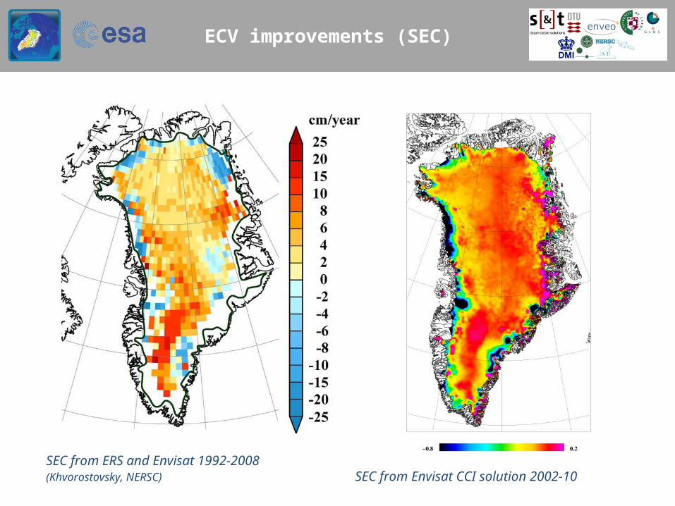
ECV improvements (SEC)
SEC from ERS and Envisat 1992-2008 (Khvorostovsky, NERSC) SEC from Envisat CCI solution 2002-10

ECV improvements (IV)
CCI coastal coverage 1995/96 NE Greenland ice stream zoom-in

Time series: CFL
Jakobshavn glacier CFL(EnviSat ASAR-summer)
Time series SAR imagery(Sermeq Avannarleq)
1993
2003
2010

Uncertainties: SEC and IV
1993
2003
SEC uncertainty (scale 0-0.5 m/yr)
IV velocities (left) and uncertainty (right), m/yrALOS/PALSAR, NE Greenland, with GPS sites
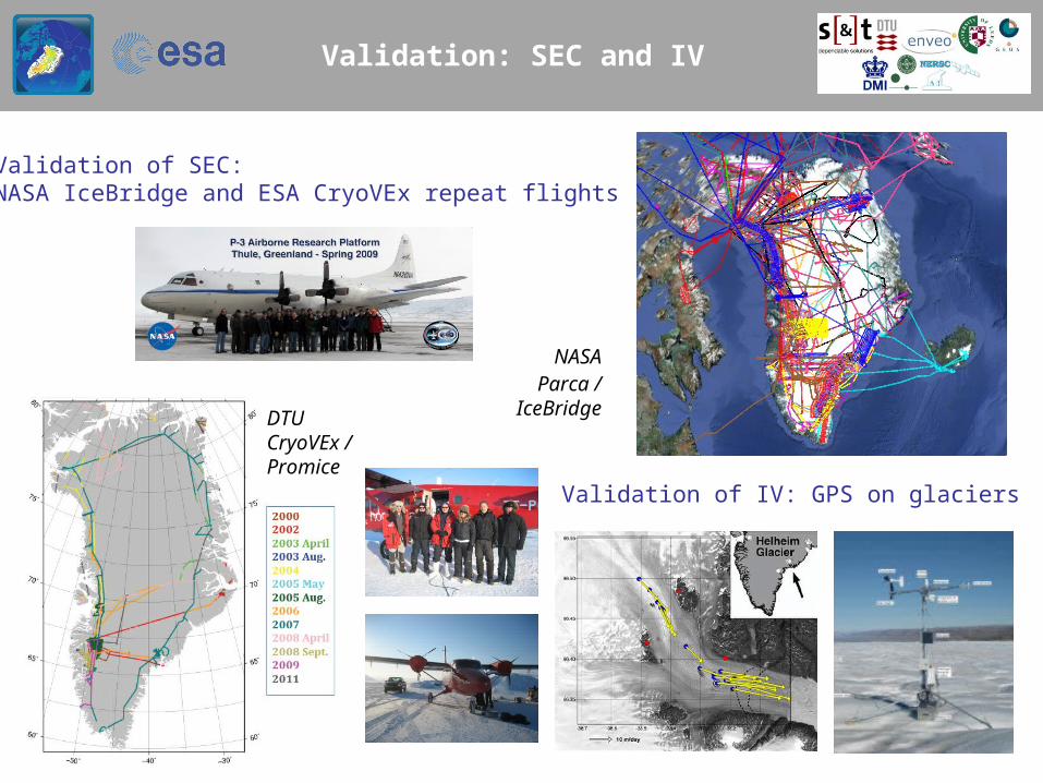
Validation: SEC and IV
1993
2003
Validation of SEC:NASA IceBridge and ESA CryoVEx repeat flights
DTU CryoVEx /Promice
NASAParca /
IceBridge
Validation of IV: GPS on glaciers
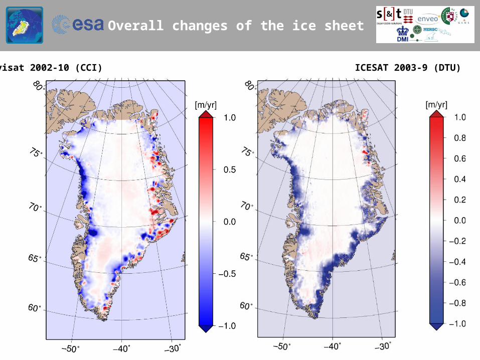
Overall changes of the ice sheet
2003
Envisat 2002-10 (CCI) ICESAT 2003-9 (DTU)
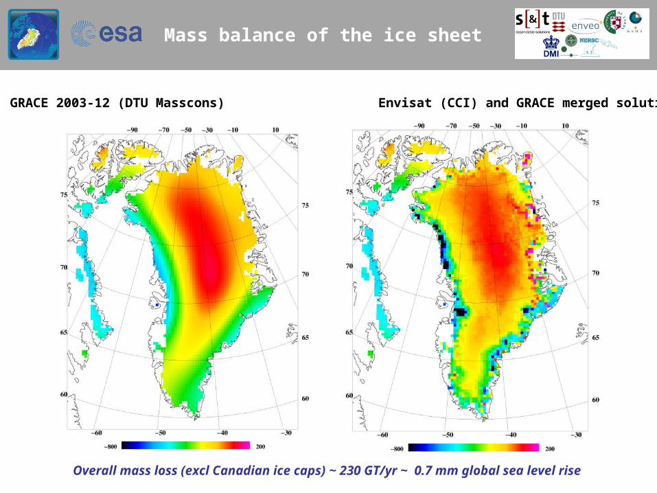
Mass balance of the ice sheet
GRACE 2003-12 (DTU Masscons) Envisat (CCI) and GRACE merged solution
Overall mass loss (excl Canadian ice caps) ~ 230 GT/yr ~ 0.7 mm global sea level rise

Trends in Greenland ice sheet
5-year running means of Envisat (ECV time series)
2003-7 2004-8 2005-9 2006-10
-1 -0.5 0 0.5 1 m/yr
A: accelerating lossD: decelerating
D
A A

Glacier changes: CFL movie 1992-2010

CCI auxillary data
Improved DEM of Greenland from digital mapping, ASTER, ERS/ICESat and CryoSat • Reference for SEC and IV .. resolution 200 m-1 km, polar stereographic or UTM• Land/ice masks … including outlying glaciers and ice caps … new CCI 500 m mask
Ice Sheets CCI status
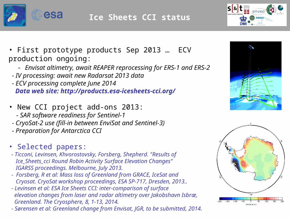
• First prototype products Sep 2013 … ECV production ongoing: - Envisat altimetry, await REAPER reprocessing for ERS-1 and ERS-2 - IV processing: await new Radarsat 2013 data - ECV processing complete June 2014 Data web site: http://products.esa-icesheets-cci.org/ • New CCI project add-ons 2013: - SAR software readiness for Sentinel-1 - CryoSat-2 use (fill-in between EnviSat and Sentinel-3) - Preparation for Antarctica CCI • Selected papers: - Ticconi, Levinsen, Khvorostovsky, Forsberg, Shepherd. "Results of Ice_Sheets_cci Round Robin Activity Surface Elevation Changes“ IGARSS proceedings. Melbourne, July 2013. - Forsberg, R et al: Mass loss of Greenland from GRACE, IceSat and Cryosat. CryoSat workshop proceedings, ESA SP-717, Dresden, 2013.. - Levinsen et al: ESA Ice Sheets CCI: inter-comparison of surface elevation changes from laser and radar altimetry over Jakobshavn Isbræ, Greenland. The Cryosphere, 8, 1-13, 2014. - Sørensen et al: Greenland change from Envisat, JGR, to be submitted, 2014.

SE-Greenland calving front, Køge Bugt
Phase-1 achievements: • First European SAR mapping of ice velocity at margins / basins• Demonstrated the potential of Envisat for height change mapping• Time series of calving fronts – 20+ major outlet glaciers
Phase-2 developments:• Seamless SEC 1991-2017 (ERS, Envisat, CS-2, Sentinel-3)• 2x icesheet-wide velocity mapping, Sentinel-1, 2014-17• Time series of velocity 1991-present on 7 main glaciers• GRACE-derived mass balance as new ECV • Antarctica Ice Sheet CCI project - Close coordination with Greenland CCI (joint CRG, joint GRACE RR)
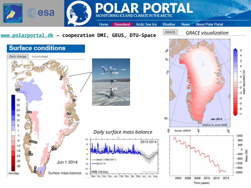
www.polarportal.dk – cooperation DMI, GEUS, DTU-Space
Daily surface mass balance
GRACE visualization

Antarctic ice sheet CCI
Start 2015 – Phase II directly (build on Ice_Sheets_CCI – UK lead): - Altimetry elevation changes 1991-present (ERS, Envisat, CryoSat) - Ice velocities from SAR – common software and cloud computing - GRACE mass balance - Grounding Line Locations on major icestreams and ice shelves

Thanks for your attention
Jotulstraumen, East Antarctica, DTU 2012