its -related aspects of development of urban transport systems
TRANSCRIPT

1
Moscow State Automobile and Road Technical University
Department «Telematics for Transport»
Dmitry B. Efimenko
(Tutor: Sultan V. Zhankaziev)
ITS-related aspects of development of Urban transport systems
KEYWORDS
Automatic Vehicle Location (AVL), Coordinate (position data), time and the navigation
support (CTNS), Dispatch control system, Information, Intelligent Transport Systems (ITS),
Monitoring system, Satellite navigation, Telecommunications systems, Transport telematics,
Urban transport systems.
ABSTRACT
This article provides an overview of an ITS-related application developed for Urban
transport systems in Russia.
In today’s society, where the public relies increasingly on the transport network, Russian
Federation, as the many other countries, faces tough challenges ahead. From congestion, safety
to environmental impact, technology provides a rich variety of options to address existing and
future concerns, and Intelligent Transport Systems are at the forefront.
Deregulation of public transport in Russian market places new challenges for national
transport companies. There is an increasing need of new service models and operational schemes
allowing improved transport offer and competitive advantages. Investments are necessary to
optimize the use of transport resources and increase the quality of service for the customers.
Information and communications technologies play a fundamental role to achieve these
objectives. This is the case with both flexible transport, where telematics allows to optimize
resources and improve mobility services for the customers, and with optimization of regular, line
based transport services.
Thereupon, coordinate (position data), time and the navigation support (CTNS)
together with telecommunications became a main informational background for automation
basic technologies for the Urban transport systems.
INTRODUCTION
The exponential growth of satellite navigation devices since the last 10 years supports the
opinion expressed then that the use of factory-fitted, PDA or ‘stand-alone’ devices demonstrates
the public’s interest in minimizing journey times and avoiding travel delay and inconvenience
and there are great expectations from the delivery of accurate location based, road user and
tolling services.
The importance of secure asset-tracking is self-evident, however, it is essential that
minimum standard data concerning security on connectivity and communication are invoked
particularly with increased reliance on collecting vast amounts of data over Wireline, WI-Fi,
GPRS, Bluetooth and Ethernet connections.
This article provides an overview of a the main Moscow State Automobile and Road
Technical University’s scientific and educational activities towards the ITS-related aspects of
development of Urban transport systems. The main purpose is providing the scientific
background for the following key themes:
- Improving road network management;
- Improving road safety;
- Better travel and traveler information;
- Better public transport on the roads;

2
- Supporting the efficiency of the road freight industry;
- Reducing negative environmental impacts.
The main aspects, which involved these themes into the Urban transport systems (as the
main integrate multiplier) are Video image processing systems, Automatic Vehicle Location
(AVL) technology and telecommunications systems and Public transportation Priority Systems.
Video image processing systems for real time traffic data collection processing of images
from a video camera for real time estimation of traffic characteristics and data transmission to
the control unit, especially in the case of Web interface (which allows provision of online public
information for quick inspection of road traffic situation) .
Automatic Vehicle Location (AVL) technology and telecommunications systems is a
powerful tool for managing fleets of vehicles, from service vehicles, emergency vehicles, and
construction equipment, to public transport vehicles (buses and trains). It also is used to track
mobile remote assets, such as construction equipment, trailers, and portable power generators.
Using an AVL system allows dispatch personnel to evaluate the locations of all vehicles in a
fleet.
And, the Public transportation Priority Systems give priority to public transportation such
as buses by means of bus lanes, warning vehicles which are illegally running in the bus lane and
traffic signal preemption. For the latter, a fleet monitoring and management system, including
automated vehicle location capabilities, will be a fundamental element for effective service
operation.
The main benefits of such combination of these ITS-related applications are: improve
convenience for users, encourage the use of public transportation, ensure on-time bus operation,
reduce bus waiting time at intersection, reduce the number of traffic violators driving in a bus
lane, ensure bus safety (when making a right turn or merging into traffic out of the bus bay) .
CTNS AS THE MAIN PLATFORM FOR ITS-RELATED TRANSPORT
TECHNOLOGIES
At the present stage, development of the automated systems in Urban transport in Russia
(for example - systems of dispatching management by transport on the basis of satellite
navigation) became the real tool for control and the account of performance of transport work,
for the full provides definition of places of road accident and emergencies, increase of efficiency
at rendering medical aid and evacuation of victims, carrying out of actions of the Ministry of
Emergency Measures and mobilization readiness.
In Russia practical use of a wide spectrum of opportunities of satellite navigation for the
decision of organizational-technological problems of transport is realized within the Federal
target program (FTP) “Global Navigating System”.
In this connection, coordinate (position data), time and the navigation support (CTNS)
together with telecommunications became a necessary informational background for automation
basic technologies for the transporting passengers and goods by road, including (See fig.1):
a) Automation of dispatching management by passenger transportations (automation dispatching control movement), including Automation of gathering and the account of incomes
of passenger carriers (automate data collection, the proceeds);
b) Automation of research and monitoring of volumes of passenger traffic (on passenger
route);
c) Automation of informing of passengers (automation inform the transport process).
A global strategy for urban mobility management consists in wide usage of Intelligent
Transport System (ITS) and technologies (See fig.2) and it is not less than infrastructure,
vehicles and demand management.
To address the solutions of the organization, technological and technical tasks of CTNS
in road transport corporate systems, on-board unit’s hardware and software applications should
be built on the principles of modular architecture and the need to provide an opportunity to
modernize its based on the needs and objectives of carriers.

3
Fig.1 Interaction with base technologies
Fig. 2 A global strategy for urban mobility management
Intelligent Transport Systems - is a generic term for the integrated application of
communications, control and information processing technologies to the transportation system.
ITS covers all modes of transport and considers all elements of the transportation system
- the vehicle, the infrastructure, and the driver or user, interacting together dynamically. The
overall function of ITS is to improve decision making, often in real time, by transport network
controllers and other users, thereby improving the operation of the entire transport system. The
Demand
management
Infrastructure
Vehicles
MMoobbiilliittyy
Intelligent Transport System (ITS)
technologies
Automation of dispatching management by passenger
transportations
Automation of gathering and the account of incomes of
passenger carriers
GGeeooggrraapphhiiccaall iinnffoorrmmaattiioonn
ssyysstteemmss ((GGIISS))
CCoooorrddiinnaattee ((ppoossiittiioonn ddaattaa)),, ttiimmee aanndd tthhee nnaavviiggaattiioonn
ssuuppppoorrtt ((CCTTNNSS))
EElleeccttrroonniicc bbaasseess ooff sscchheedduulleess
Automation of research and monitoring of volumes
of passenger traffic
Automation of informing of passengers

4
definition encompasses a broad array of techniques and approaches that may be achieved
through stand-alone technological applications or as enhancements to other transportation
strategies.
ITS deployment has much to offer to all of the main groups of stakeholders: National,
regional and municipal governments and public authorities; Owners and operators of
transport networks (public- and private-sector); Automotive manufacturers; Fleet operators
(commercial and public transport); Industry and commerce; Individual travelers.
Governments have a political priority to deliver sustainable and efficient transport. They
need to evaluate the benefits of ITS (both nationally and globally) as the basis for long-term
investments. ITS methods are policy-neutral, and can be adapted to a range of needs. At national
level, governments can pave the way with enabling legislation (e.g. regulations for road user
charging) and create frameworks for private-sector involvement, (e.g. via public-private
partnerships). At regional and municipal levels, they can implement demand management and
integrated information (inter-modal and multimodal) and payment systems, to encourage
intermodal travel.
Operators of road, rail, tram and waterway networks and the associated transport
interchanges (from road to rail and transit, and the airports, ports and ferry terminals) can
manage their operations with better information and can provide users with safer or more reliable
travel conditions. Automotive manufacturers can achieve significant product differentiation and
customer loyalty by developing appropriate in-vehicle telematics products.
Vehicle fleet owners can run more cost-effective services and save on energy costs.
Businesses can move goods and services more efficiently. Individuals can plan journeys better,
enjoy safer travel, avoid delays, and make informed choices between modes. All transport
providers and users can enjoy greater security.
Ultimately, many ITS benefits are likely to be invisible to the end user - ITS will simply
improve safety, security, efficiency and comfort of the transport system and the environment
without the general public being aware that ITS is at work. Therefore there is an important role
for public awareness programmes to show transport users how they can enjoy increased safety
and security, better information, greater convenience and reduced journey times; and how
populations as a whole can enjoy the healthier environments produced by sustainable mobility.
The use of navigation and communications resources to the cargo and special transport
may be on the following tasks: information and control processes escort cargo; ensuring vehicle
alarm; monitoring the status and safety (especially in the transport of dangerous goods).
Thus, effective automation of the basic technologies in transporting systems is to be
based on the use of a specialized on-board unit’s hardware and software to achieve the objectives
of CTNS through the use of satellite navigation and the transmission of digital data of the board-
control center, and voice communications between the driver and dispatcher (controller).
Relevant ITS services include: Intelligent speed adaptation; Assistance for vulnerable
road users; Weather and road condition monitoring and information; Incident detection and
warning systems; Collision warning systems; Emergency vehicle priority; Driver monitoring
systems; Speed and traffic signal enforcement; Hazardous load monitoring; Cargo screening;
Driver vision enhancement systems; Evacuation route signing and priority.
For all transport networks the major problem is congestion, and increasing the efficiency
of existing transport systems is a major goal of ITS programs. Congestion can be reduced by
instrumenting networks to improve their real-time operation; introducing control systems;
managing demand; and encouraging off-peak travel or the use of alternative modes. Relevant
ITS services include:
1) Network efficiency: Area-wide traffic control; Long-distance traffic management;
Rerouteing guidance; Variable speed controls; Ramp metering; Incident detection and
management; Driver information.
2) Demand management: Access control; Road user charging; Congestion charging.

5
3) Encouragement of modal shift: Journey planning; Real-time passenger information
systems; Bus/tram traffic priority.
Users of urban transportation system need to feel comfortable, confident and secure.
Route confirmation, journey time estimates and clear advice on approaching interchanges and
connections all play their part. Speed controls, ramp metering, advance incident and congestion
warnings, journeys easier and less stressful. Facilities such as multimedia systems that provide
both entertainment and navigation can do this too.
ITS relies on a wide range of enabling technologies and functions.
1) Communications: Microwave, short-range radio and infrared-based dedicated
short-range communications (DSRC) - used for EFC; commercial vehicle operations (CVO) pre-
clearance; Mobile communications - used for real-time travel information; fleet management;
emergency response; The Internet - used for real-time travel information; trip planning; traffic
images; payment.
2) Geographical Location: Global navigation technology: global navigation satellite
systems (GNSS) – GPS (Usa), GLONASS (Russia), Galileo (Europe) - used for satellite-based
position finding for automatic vehicle location (AVL); tracking and tracing; distance-based EFC.
3) Geographical Information Systems: Used for location-based databases of
transportation networks, location-based services and other features.
4) Data Acquisition and Exchange: Used for real-time traffic management and
information.
5) Camera Systems and Artificial Vision: Used for enforcement and security.
6) Detection and Classification: Used for traffic management, incident management;
compliance; safety; security.
7) In-vehicle Systems: Used for travel information, vehicle control systems, accident
avoidance.
8) Digital Mapping: Databases of road and transportation networks stored on digital
media using agreed data dictionaries and standardised location referencing. Digital maps are a
key building block for ITS; Used for traffic management, traffic information, route guidance, car
park management and routing, lorry route monitoring; recreational facilities direction.
AVL-BASED AUTOMATION OF DISPATCHING MANAGEMENT BY
PASSENGER TRANSPORTATIONS FOR URBAN TRANSPORT SYSTEMS
Public transport users also expect high standards of comfort, convenience and service.
ITS can provide the realtime passenger information, automated scheduling and priority systems
needed to improve public transport. Relevant ITS services include: Real-time traffic and public
transport information; Dynamic route guidance; Automatic vehicle location (AVL); Smarteard
payment systems for toll highway and public transport use.
Examples for passenger transport, grading passenger buses for the movement of more
possible on the following tasks: management of the electronic bus route signs in operational
switching its traffic to another route; obtaining control centre video into a compartment of a bus
driver's signal, or at the request of control system;
Advanced Public Transport Systems (APTS) applications aim to improve the efficiency
and user-friendliness of public (collective) transport. They include real-time information
systems; fare advice, pre-booking and journey-planning; demand-responsive transport and ride-
sharing; and automated scheduling for better fleet management and increased security. All help
to position public transport within integrated, multimodal systems that will encourage people to
rely less on cars, and so help reduce traffic congestion and environmental pollution.
One way of promoting greater use of public transport is by providing reliable and easily-
accessible real-time passenger information (RTPI) - See fig.3-4. Automatic vehicle location
(AVL) can drive real-time information systems giving service running and connection times and
route advice in-vehicle, at-stop, at home or work, on the street or using other transport modes.
Information can be provided via various media including the Internet, interactive information

6
kiosks, text messages to cell phones, voice phone inquiry services and personal digital assistants
(PDAs). Enhancements include journey planning, fare options, booking services and 'on-arrival'
location and tourist information.
ITS support efficient operation and management of public transport vehicle fleets. On-
board AVL continuously transmits data that enables the operator's control centre to monitor
individual vehicle's schedule keeping and adjust service intervals to compensate for early or late
running. Using GIS-aided Regional multi-screen monitoring, automatic fleet monitoring can also
give early warning of maintenance needs and anticipate the risk of vehicle breakdown (See fig.
5).
Door opening/closing detection systems and automated fare collection (AFC) provide
operators with valuable passenger data - including loading, journey length, and time of travel -
which they can use to evaluate route usage and refine services to meet passenger demands and
roster vehicles and drivers more effectively, and improve financial management.
ITS-based shared and demand responsive transport systems are bridging the gap between
private and public transport. Potential users contact a control centre to specify their destination,
preferred time of travel, and any special needs.
Fig.3 Navigation system for passengers
The centre uses AVL to identify and dispatch the most conveniently-located vehicle,
which also carries other passengers on compatible routes. Charges can be billed automatically to
accounts. Fleets can consist of public transport vehicles or taxis. Car-pooling, which is being
introduced in a number of Russian cities, is a similar concept, with intending users pre-booking
vehicles to suit their individual travel needs. It also has urban planning benefits, in that building
developers can be required (or choose) to provide fewer parking spaces, so saving land and costs.
Also ITS-related modern EP systems offer major advantages over cash payment for
transport and highway operators, their passengers and customers. ETC/EFC is now well
developed on expressways, bridges and tunnels across the world.
Smartcards in AFC systems offer public transport operators more flexible ticketing,
lower administrative costs, and better management and marketing information; while passengers
save time and appreciate the convenience and security of cash-free travel. EPS also offer
prospects of interoperability within and across transport modes and systems, using a single,
intelligent payment medium.
Navigation system for passengers
Information board on the bus stop
On-street information terminals (conception)
Mobile telephone (schedules, exact time of arrival
to bus stop)
Smartphone (schedules, exact time of arrival to bus stop,
mapping)
Internet site Route database viewing
Optimal route chose
Call-center – phone information

7
Fig. 4 Information board for passengers (variants from AVL-based Dispatching system).
Fig. 5 Regional multi-screen monitoring (for bus operator) - example
Public transport vehicles can be given priority over general traffic by integrating their
operation into urban traffic control (UTC) systems. AVL enab les buses and trams to be identified
on the approaches to signalised intersections, where they 'request' the traffic light controller to
extend or recall the green phase for long enough to let them through. Detection can be via
inductive loops under the road' surface, roadside beacons, or satellite-based positioning systems
(see fig. 6).
This supplements conventional bus lanes with specially-designed track sections that deter
general traffic and speed buses past known congestion points. In mechanical systems, lateral
wheels on front wheel mountings guide the bus along raised curbs (relieving the driver of the
need to steer). The electronic system is based on an electric cable embedded in the centre of the
bus way, with onboard inductive detection that continuously steers the wheels to keep the vehicle
centred over the cable. At the end of a bus way section, traffic signal priority gives access to
general lanes.
Display of Real Time Bus
Locations (from AVL-based
Dispatching system, Russia)

8
Fig.6 The pilot project of the organization of priority travel of public transport (Mosco w
Routing network of passenger transport - example)
AUTOMATION OF RESEARCH AND MONITORING OF VOLUMES OF
PASSENGER TRAFFIC - REAL ITS-RELATED SOLUTION FOR URBAN
TRANSPORT SYSTEMS
The development and demand of the AVL-systems of public transport control initiated
the further research and development of new telematic systems for public transport such as
“Automated System for Monitoring of volumes of passenger traffic (Passenger’s Flows)”. The
demand of such system was based on the following factors:
- 50-80% of the inhabitants use the public transport every day.
- Average load of public transport is 20-50% of rated capacity, while the load at rush-
hour is 90-150% of rated capacity.
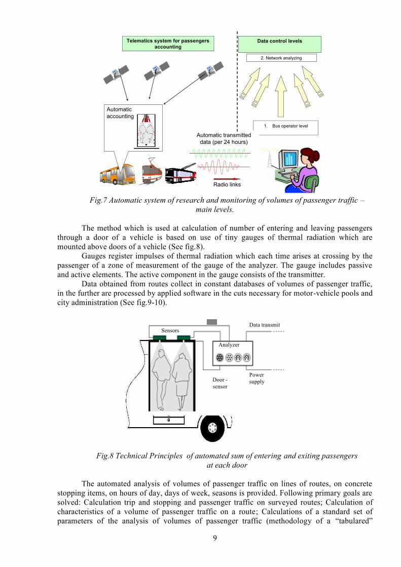
The hardware-software complex of automatic system of research and monitoring of
volumes of passenger traffic is intended for replacement of existing manual methods of
inspections of volumes of passenger traffic. There are modern means and technologies in the
basis of it. Tool means allow to carry out stage-by-stage creation of constantly operating
(working) automated system of monitoring of actually executed services on transportation of
passengers (See fig.7).
Actual loading of a considered
site street and a highway system
Decisions with
allocation
of a priority lane
9
Fig.7 Automatic system of research and monitoring of volumes of passenger traffic –
main levels.
The method which is used at calculation of number of entering and leaving passengers
through a door of a vehicle is based on use of tiny gauges of thermal radiation which are
mounted above doors of a vehicle (See fig.8).
Gauges register impulses of thermal radiation which each time arises at crossing by the
passenger of a zone of measurement of the gauge of the analyzer. The gauge includes passive
and active elements. The active component in the gauge consists of the transmitter.
Data obtained from routes collect in constant databases of volumes of passenger traffic,
in the further are processed by applied software in the cuts necessary for motor-vehicle pools and
city administration (See fig.9-10).
Fig.8 Technical Principles of automated sum of entering and exiting passengers
at each door
The automated analysis of volumes of passenger traffic on lines of routes, on concrete
stopping items, on hours of day, days of week, seasons is provided. Following primary goals are
solved: Calculation trip and stopping and passenger traffic on surveyed routes; Calculation of
characteristics of a volume of passenger traffic on a route; Calculations of a standard set of
parameters of the analysis of volumes of passenger traffic (methodology of a “tabulared”
1. Bus operator level
Automatic transmitted data (per 24 hours)
Automatic accounting
2. Network analyzing
Telematics system for passengers accounting
Data control levels
Radio links
Door -
sensor
Power
supply
Data transmit
Analyzer
Sensors

10
method); Formation of data about distribution of interstopping correspondence of trips of
passengers; An estimation of quality of transportations and efficiency of use of a rolling stock.
Each of the data sets which is collected on the route are processed identifying the stations
of the public transport and concrete trip. Collected arrays of statistic provide to get the values of
a big variety of activities related to a trip, passenger turnover on the stations, the dynamic of the
passenger’s flows during a day, an average distance of the trip and passenger turnover during the
trip. In particular one of the most urgent activities of transportation is the number of carried
passengers per hour. Inconsistency between the plan and fact values gives ground to change the
schedule of the public transport and for definition of the required vehicle number per hours
during a day (See fig.9).
Fig. 9 Schedule perfection on the base of comparing of transport necessity with the plan
A bigger amount of the collected data gives the opportunity to get information of the
passengers flows on the roads where several routes of different kinds of public transport are
working (See fig.10). The authorities can make macro analysis of the intensity of passenger’s
flows along the arterial roads and main multi-modal intersections which gives ground to a
decision-making for optimization of public transport’s route network or its schedules.
Fig.10 Intensity of passenger’s flows along the arterial roads and main multi -modal
intersections (example of the analysis)
P assengers flow s 8-9 o ’c lock.
d irection : S trog ino - m .S huk inska ja
(M osco w R ou ting ne tw ork o f passenger transport )
B us
Tram
P assengers flow s 8-9 o ’c lock.
d irection : S trog ino - m .S huk inska ja
(M osco w R ou ting ne tw ork o f passenger transport )
B us
Tram

11
Correctly designed data structure of the system provides the connection with the other
information systems, such as, for example, GIS of Moscow, Automated system in the dispatch
center for managing public transport traffic, Automated system for collecting fairs and
Automated system for designing schedules of public transport.
The main effects from application: It is provided exact enough (mistakes within the limits
of 4 - 10 %) the constant automated account of quantity of actually transported passengers on
city ground transport. The set of the information for carrying out of various analyses is formed:
from an estimation of actual volumes of passenger traffic on routes, highways and directions up
to the control of actual proceeds over each vehicle (at 100 % to payment of travel by
passengers). There is an objective basis for effective planning routing.
DIRECTIONS OF INTEGRATION OF ITS-RELATED TECHNOLOGIES OF
URBAN TRANSPORT SYSTEMS
Summarizing, it is necessary to note, that creation and development of uniform ITS of
city of Moscow is planed to be based on the general organizational-technological platform of
navigating systems, control systems of traffic flows, etc. - from accounts of uniform coordinate
(position data), time and the navigation support - under the conception of creating unified city
analytical center (See fig.11).
Efficiency of the given systems provides total efficiency of construction city ITS from
the point of view of investment appeal of projects.
Under this conception, ITS architecture is primarily about information exchange and
control between systems at various levels of abstraction, as depicted in the multi-level model in
Figure 12.
Fig. 11 The scheme of integration of the automated control systems of transport in
Moscow (conception)
The concerned project (the scheme of integration of the automated control systems of
transport in Moscow (conception) defined these levels as a way of explaining the uses that
should be made of the various models and viewpoints that may comprise an architecture.
Department of Transport and Communication of Moscow
The city center of the organization of traffic
System of the
automated control
of transport flows
The unified
dispatching center
Traffic
control centers
System of informing
of participants of movement
Complex of the Automated
control systems of traffic of
Moscow
Users - organizations and private persons

12
Level 3 Multi-Agency Interoperability Properties
Level 2 Single Agency System Properties
Level 1 System Structure
Level 0 Subsystem/ Component Design
Fig.12 Multi-level Model for Analysis of ITS Architecture for the conception of
integration of ITS-related technologies of urban transport systems
Traffic and transport managers lay down high-level properties, or policy, at Levels 3 and
2, and the architectural structure at Level 1 is then devised so that it conforms to these properties.
Level 0 is not strictly part of the architecture though it is often referred to as such, and represents
the stage at which a supplier designs a system, or component, that conforms to the architecture.
Level 3 architecture needs to reflect the real-world constraints that operate on
transport agencies, and to reflect the requirements for such system properties as interoperability
between the participating agencies and the retention of information control by the respective
agencies.
It may show where existing organisational structures must be modified and changed -
perhaps quite radically - in order to deliver ITS services. As an example, a traffic control centre
(TCC) may need to exchange data with another TCC or a traveller information centre (TIC),
possibly across national or language boundaries. Defining the nature and minimum performance
specification for this transaction matters a great deal .
CONCLUSIONS
ITS offers immense scope for integration, and some argue that it is only through
integration of ITS components that ITS will achieve its full impact. Key ingredients are thorough
planning, good communications and effective coordination of partners and stakeholder interests.
Currently, many ITS deployments are stand-alone applications since it is often more cost-
effective in the short run to deploy an individual application without worrying about all the data
exchange interfaces, communication links and different hardware platforms required for an
integrated system. However, for ITS to take the next steps forward, it will be important both for
efficiency and effectiveness reasons to think in terms of system integration. While this
integration certainly adds complexity, it is also expected to provide Russian economies of scale
in system deployment and improvements in overall system effectiveness, for example by
integrating advanced transportation management systems (ATMS) with advanced traveller
information systems (ATIS) in Moscow. For the most part, these two groups of services, while
conceptually interlinked, have developed independently.
Another aspect of system integration is interoperability - ensuring that ITS components
can function together. ITS services can make transport safer and more secure. They can
maximise its capability to contain and reduce the impact of disasters, natural and man-made, e.g.
by forward planning, cutting emergency service response times, and securing and prioritising
disaster evacuation routes.
Current technology trends are enhancing the promises of increased safety and
productivity for tomorrow's intelligent highways. The increasing availability of more powerful,
yet less expensive software-driven GNSS receivers, integrated with other positioning
technologies and wireless communications, will provide the knowledge of traffic flow and status
that is the essential element of any intelligent highway system
The benefits of ITS are plentiful and reach in to every sector of the transport realm. It is
possible to examine which coordinate (position data), time and the navigation support for ITS-
related technology and applications have been the most successful, which have been less
successful and what are the underlying factors that determine success or failure.

13
REFERENCES
1. Information technologies on motor transport / V.M.Vlasov, A.B. Nikolaev,
A.V.Postolit, V.M.Prihodko; Moscow State Automobile and Road Technical University. – М.:
Nauka, 2006. – 283 p.
2. Inteligentni Dopravni Systemy / Pavel Pribyl, Miroslav Svitek; Moscow State
Automobile and Road Technical University. –2003 – 540 p.
3. Supply with information of motor transportation systems: the school-book (manual) /
V.M.Vlasov, A.V.Postolit, D.B.Efimenko; Moscow State Automobile and Road Technical
University. – 2004. – 242 p.
4. Official site of S&R Enterprise “Transnavigatsia”,Ltd, Accessed:
http://www.transnavi.ru [Online]
5. Auckland City Council. 2003. Real time passenger information [Online], Accessed:
http://www.aucklandcity.govt.nz/auckland/transport/busesfirst/realtime.asp, [2003 July 01].
6. GIS Development. 2004. GPS technology to find place in London buses [Online],
Accessed: http://www.gisdevelopment.net/news/viewn.asp?id=GIS:N_vsmkrtbz [2004 August
9].
AUTHOR’S FULL CONTACT DETAILS
Dmitry B. Efimenko,
Lecturer of Moscow State Automobile and Road Technical University,
Department «Telematics for Transport»
Country: Russia
City: Moscow
Postcode: 125319
Address: Leningradskyi prospect 64, room 277a
Tel./Fax: +7(495)155-01-38
e-mail: [email protected], [email protected]
Direct Line: +7 905 588 7699