its regional architecture report - fargo moorhead metro ... final plan/final... · 1.1 report...
TRANSCRIPT

Fargo-Moorhead Council of Governments Case Plaza Suite 232 1 2nd St N
Fargo, ND 58102 www.fmmetrocog.org
Fargo-Moorhead Regional ITS Architecture Update
Version 3.0
Final Report
December 2014

Fargo-Moorhead Regional ITS Architecture Version 3.0
Draft Report
December 2014
Advanced Traffic Analysis Center Upper Great Plains Transportation Institute
North Dakota State University
Dept. 2880 – PO Box 6050 NDSU – Fargo, ND 58108
Tel 701-231-8058 – Fax 701-231-6265 www.ugpti.org - www.atacenter.org
The information contained in this report was obtained through extensive input from various stakeholders in the Fargo-Moorhead region. The contents of the report were written by a research team from the Advanced Traffic Analysis Center of the Upper Great Plains Transportation Institute at North Dakota State University which facilitated the development of the Regional Architecture.

ACRONYMS AVL Automated Vehicle Location CCTV Closed Circuit Television Dist District DMS Dynamic Message Sign DOT Department of Transportation EAS Emergency Alert System EOC Emergency Operations Center EV Emergency Vehicle FD Fire Department FHWA Federal Highway Administration ISP Information Service Provider ITS Intelligent Transportation Systems MAT Metro Area Transit MCO Maintenance and Construction Operations MnDOT Minnesota Department of Transportation MSP Minnesota State Petrol NDDOT North Dakota Department of Transportation NDHP North Dakota Highway Patrol OEM Office of Emergency Management PD Police Department PW Public Works RA Regional Architecture TOC Traffic Operations Center Standards ASTM American Society for Testing and Materials IEEE Institute of Electrical and Electronic Engineers ISO International Organization for Standardization ITE Institute of Transportation Engineers NTCIP National Transportation Communications for ITS Protocol SAE Society of Automotive Engineers Service Packages AD Archived Data APTS Advanced Public Transportation Systems ATMS Advanced Traffic Management Systems EM Emergency Management MCO Maintenance and Construction Operations

TABLE OF CONTENTS
Executive Summary ....................................................................................................................................... i
1.0 Introduction ............................................................................................................................................ 1
1.1 REPORT ORGANIZATION ....................................................................................................................... 1
2.0 Region and Scope .................................................................................................................................... 2
2.1 GEOGRAPHICAL BOUNDARIES .............................................................................................................. 2 2.2 SCOPE OF THE RA ................................................................................................................................. 2
3.0 Stakeholders ............................................................................................................................................ 5
4.0 System inventory .................................................................................................................................... 8
4.1 F-M CENTERS ....................................................................................................................................... 8 4.1.1 Traffic Management Center ......................................................................................................... 8 4.1.2 Emergency Management Center ................................................................................................ 10 4.1.3 Maintenance and Construction Management Center ................................................................ 11 4.1.4 Information Service Provider ..................................................................................................... 11 4.1.5 Transit Management Center ...................................................................................................... 11 4.1.6 Archived Data Management Center ........................................................................................... 11
4.2 F-M FIELD DEVICES ........................................................................................................................... 11 4.2.1 NDDOT Field Devices ............................................................................................................... 12 4.2.2 City of Fargo .............................................................................................................................. 12 4.2.3 MnDOT Field Devices ............................................................................................................... 12
4.3 F-M VEHICLES.................................................................................................................................... 13 4.4 F-M COMMUNICATION INFRASTRUCTURE .......................................................................................... 13 4.5 SUMMARY OF F-M ITS INVENTORY ................................................................................................... 14
5.0 Needs and Services ............................................................................................................................... 17
5.1 NEEDS ................................................................................................................................................ 17 5.2 SERVICES ............................................................................................................................................ 17
5.2.1 F-M ITS User Services ............................................................................................................... 17 5.2.2 F-M Service Packages ............................................................................................................... 19
6.0 Operational Concept ............................................................................................................................ 28
6.1 IMPLEMENTATION ROLES ................................................................................................................... 29 6.2 OPERATIONAL ROLES AND RESPONSIBILITIES .................................................................................... 31
7.0 Agreements ............................................................................................................................................ 33
8.0 Functional requirements ...................................................................................................................... 36
9.0 ITS Standards ....................................................................................................................................... 37
10.0 Projects Sequence ............................................................................................................................... 39
11.1 ARCHITECTURE MAINTENANCE ........................................................................................................ 40
Appendix A Fargo-Moorhead Service Packages and Information Flows
Appendix B Fargo-Moorhead Functional Requirements

Fargo-Moorhead Regional ITS Architecture Update – Final Report i
EXECUTIVE SUMMARY The Fargo-Moorhead Regional Intelligent Transportation Systems (ITS) Architecture was developed under the leadership of the Fargo-Moorhead Council of Governments (Metro COG). The goal of the F-M regional architecture (RA) is to be a framework and a roadmap that guides the implementation of ITS in the F-M region. The RA coordinates funding, deployment, information sharing, and operations of ITS in the region. The main ITS goal areas for the F-M region include enhanced traveler safety; effective traffic, freeway, and transit management; coordinated incident response; and enhanced data management and traveler information. A 10-year planning horizon was considered in the RA development. The development of the RA was facilitated by the Advanced Traffic Analysis Center (ATAC) of the Upper Great Plains Transportation Institute at North Dakota State University. A partnership agreement was established between ATAC and Metro COG for supporting the RA development and maintenance. This version of the RA is the third iteration in a maintenance process that aims to keep the architecture up-to-date in accordance with FHWA guidelines and to continue to reflect the most current ITS picture in the region. This update was completed in concert with Metro COG’s effort to update the F-M ITS Deployment Strategy and supports the strategy and other previously completed planning efforts. This version of the RA is based on the current version (7.0) of the National ITS Architecture. The development and update of the RA was guided by a stakeholder group that owns and operates ITS in the F-M region and included:
• MPO planning staff • City engineering and maintenance staff • Transit staff • State DOT district engineering and maintenance staff • Law enforcement and emergency responders • County engineering/planning staff • Agency information technology technical staff • Other agencies responsible for system operations and maintenance
The F-M RA supports the region’s vision for the establishment of a traffic operations center (TOC) that will enhance arterial and freeway traffic operations. The RA includes options for a short-term goal of a hybrid TOC where interconnect among the traffic operators and with other relevant agencies is established; signal operations are coordinated; and data, including surveillance video, are shared among agencies in the area. In addition to the hybrid TOC scenario, the RA supports the regional longer-term goal for establishing a centralized TOC where all traffic operations functions in the area would be colocated.

Fargo-Moorhead Regional ITS Architecture Update – Final Report ii
In addition to traffic operations related ITS services, the RA includes services in the following areas: transit management with a focus on fixed route and demand response transit operations; maintenance and construction management with a focus on winter maintenance; emergency management with a focus on incident management strategies; and data management with a focus on coordinating the collection and archival of transportation data. The architecture provides the basis for ITS deployment, and the information for the federally required systems engineering (SE) analysis for ITS projects. Specifically, the architecture contributes to completing the concept exploration; concept of operations; system requirements; and system validation and verification steps of the SE process. The RA is technology independent and focused on services, information sharing, and interoperability. This allows the RA to remain valid over the entire planning horizon as technologies might change.

Fargo-Moorhead Regional ITS Architecture Update – Final Report 1
1.0 INTRODUCTION This document summarizes the results of the regional Intelligent Transportation architecture development for the Fargo-Moorhead Area. Intelligent Transportation Systems (ITS) refer to integrated applications of sensing, communications, computer processing, and electronics to enhance the transportation systems. The regional architecture (RA) provides a tool to guide future ITS planning, define system requirements, coordinate agency roles and integrate functions across jurisdictional lines. The Fargo-Moorhead Regional Intelligent Transportation Systems (ITS) Architecture was prepared under the leadership of the Fargo-Moorhead Council of Governments (Metro COG). The goal of the F-M regional architecture (RA) is to guide the implementation of ITS systems in the F-M region and coordinate funding, deployment, information sharing, and operations of ITS systems in the region. The main ITS goal areas for the F-M region include enhanced traveler safety; effective traffic and transit management; coordinated incident management; and enhanced traveler information. A 15-year planning horizon was considered in the RA development. The development of the RA was facilitated by the Advanced Traffic Analysis Center (ATAC) of the Upper Great Plains Transportation Institute at North Dakota State University. ATAC also facilitated two RA updates since in 2007 and 2014.
1.1 Report Organization The F-M RA Report is organized into several main sections to facilitate the report use. In addition, an electronic file has been prepared using Turbo Architecture 4.0 in order to access the architecture and make changes or future updates. Below is a listing of the remaining sections of this report and a brief description of each section: 2 Scope and Region Identifies the geographical and architecture scope 3 Stakeholders Agencies participating in the architecture 4 System Inventory Existing and planned ITS systems 5 Needs and ITS Services ITS user services and service packages 6 Operational Concept Roles and responsibilities of participating agencies 7 Potential Agreements Regional agreements to facilitate integration 8 Functional Requirements High-level description of what the systems will do 9 ITS Standards Brief discussion of applicable ITS standards 10 Sequence of Projects Time-frame for ITS projects Appendix A Service Packages and Information Flow Diagrams Appendix B Functional Requirements

Fargo-Moorhead Regional ITS Architecture Update – Final Report 2
2.0 REGION AND SCOPE This section describes the geographical characteristics of the F-M region. It also discusses the scope of the regional architecture (RA), providing a high-level outline of the range of ITS services and systems used.
2.1 Geographical Boundaries The geographical areas included in the F-M RA primarily consisted of the Metro COG’s metropolitan boundaries, which are also included in the Metro COG’s transportation planning activities. Figure 1 shows a map of the region. Major jurisdictions within the region include:
1. City of Fargo, North Dakota 2. City of Moorhead, Minnesota 3. City of West Fargo, North Dakota 4. City of Dilworth, Minnesota 5. Cass County, North Dakota 6. Clay County, Minnesota
In addition, the North Dakota Department of Transportation (NDDOT) is responsible for operating and maintaining the state system within Fargo, including sections of two major Interstate highways (I-29 and I-94). The NDDOT also operates several traffic signals, primarily located at Interstate ramp termini. Similarly, the Minnesota Department of Transportation (MnDOT) is responsible for operating the state system on the Minnesota side as well as traffic signal operations in Moorhead and Dilworth.
2.2 Scope of the RA The scope of the F-M RA may be defined using broad ITS user services targeted for deployment within the region. The delineation of relevant ITS user services assisted in identifying relevant stakeholders and corresponding systems to be included in the RA. The range of ITS user services included the following:
1. Travel and Traffic Management a. Traffic control b. Traveler information c. Traffic surveillance
2. Public Transportation Management a. Fixed route and demand response transit services b. Fleet management c. Transit traveler information
3. Incident Management a. Incident response coordination (integrated communications)
4. Information Management a. Data archival and analysis services
5. Maintenance and Construction Management

Fargo-Moorhead Regional ITS Architecture Update – Final Report 3
a. Automated treatment (anti-icing systems) b. Winter maintenance c. Work zone and road closure management d. Fleet management

Fargo-Moorhead Regional ITS Architecture Update – Final Report 4
Figure 1 Map of the Fargo-Moorhead Region (Google)

Fargo-Moorhead Regional ITS Architecture Update – Final Report 5
3.0 STAKEHOLDERS The development of the F-M RA was guided by several stakeholder groups. An ITS Architecture Core Group had the primarily role of supporting the RA development, providing needed data, and reviewing architecture relationships. This group mainly of representatives from agencies who currently (or will) own, operate, or maintain ITS in the F-M area. Other stakeholders in the region were involved in identifying regional needs, developing roles and responsibilities, and supporting the RA. Table 3.2 lists stakeholders mapped to the F-M RA and identifies corresponding ITS elements.

Fargo-Moorhead Regional ITS Architecture Update – Final Report 6
Table 3.2 Fargo-Moorhead ITS Stakeholders
Stakeholder Description Associated ITS Elements
ATAC Advanced Traffic Analysis Center at North Dakota State University ATAC data warehouse
BNSF Fargo Burlington Northern Santa Fe – Fargo Office BNSF
County Sheriffs Cass County and Clay County Sheriff Departments County Sheriff Vehicles
Fargo Engineering City of Fargo Engineering Department
Fargo TOC Fargo Engineers Fargo Cameras Fargo Traffic Sensors Fargo Traffic Signals
Fargo FD Fargo Fire Department Fargo FD Vehicles Fargo PD Fargo Police Department Fargo PD Vehicles
Fargo PW Fargo Public Works Department
Fargo PW Operations Center Fargo PW Personnel Fargo PW Roadside Equipment Fargo PW Vehicle
FM Ambulance Ambulance service for the Fargo Moorhead area FM Ambulance Vehicles
FM Event Venus Fargodome, Fargo Civic Center, Valley Fair, etc.
Event Promoters
FM Emergency Mgmt Cass and Clay counties Emergency Management Centers FM EOC
MAT Fargo-Moorhead Metro Area Transit
MAT Bus Drivers GTC MAT Vehicles MAT Kiosks MAT Traveler Card MAT Operators
MnDOT D4 MnDOT District 4
MnDOT D4 TOC MnDOT D4 Personnel MnDOT D4 Cameras MnDOT D4 DMS MnDOT D4 Traffic Sensors MnDOT D4 Traffic Signals MnDOT D4 Maintenance Vehicles
Moorhead FD Moorhead Fire Department Moorhead FD Vehicles Moorhead PD Moorhead Police Department Moorhead PD Vehicles
Moorhead PW Moorhead Public Works
Moorhead Public Works Operations Center
Moorhead PW Vehicles Moorhead PW Roadside Equipment Moorhead PW Personnel
MSP DL Minnesota State Patrol Detroit Lakes District
MSP DL Vehicles MSP DL District
ND Division of Emergency Management
North Dakota Division of Emergency Management State Radio

Fargo-Moorhead Regional ITS Architecture Update – Final Report 7
NDDOT NDDOT Fargo District
NDDOT TOC Cameras NDDOT TOC DMS NDDOT TOC Traffic Sensors NDDOT TOC Traffic Signals NDDOT TOC NDDOT TOC Personnel NDDOT TOC Maintenance
Vehicles
NDHP North Dakota Highway Patrol - Fargo NDHP Vehicles
RRRDC Regional Partners Moorhead PD County Sheriffs Fargo PD Fargo FD FM Ambulance Moorhead FD
Red River Regional Dispatch Center
RRRDC Operators RRRDC

Fargo-Moorhead Regional ITS Architecture Update – Final Report 8
4.0 SYSTEM INVENTORY This section summarizes the results of the system inventory process for the F-M RA. Information developed for the inventory was obtained through extensive input from stakeholders. Survey instruments, interviews, and small group meetings were used to obtain and verify the inventory information. Follow up interviews were conducted to identify changes for the RA update. To facilitate the inventory process, the types of systems to be included in the inventory were defined using the National ITS Architecture. More emphasis was placed on the Physical Architecture since it contains most of the ITS hardware. However, additional information about the services provided by various physical ITS entities was also collected. Further, systems were categorized into existing or planned, with planned referring to systems, components, or services which have been identified for future deployment in the region. Using the Physical Architecture, four types of entities were identified for the F-M region:
1. Centers 2. Field Devices 3. Vehicles 4. Communications
These entities are explained in greater details in the following subsections. A summary of the F-M area ITS inventory as coded in the Turbo Architecture database is provided in section 4.5.
4.1 F-M Centers These are the locations where functions are performed (i.e., process information, issue control commands, and produce output information). There are 10 possible centers in the National ITS Architecture that provide management, administrative, and support functions for the transportation system. The center subsystems each communicate with other centers to enable coordination between modes and across jurisdictions. Out of the 10 possible centers, six were found to apply to the F-M RA. A representation of the F-M area Physical Architecture is shown in Figure 2.
4.1.1 Traffic Management Center The Traffic Management Center (subsystem) monitors and controls traffic and the road network. It communicates with the Roadway Subsystem to monitor and manage traffic flow and monitor the condition of the roadway, surrounding environmental conditions, and field equipment status.
Traffic management activities within the F-M area have increased over the last few years. Below are specific traffic management systems within the F-M area classified by agency.

Fargo-Moorhead Regional ITS Architecture Update – Final Report 9
Figure 2 Fargo-Moorhead Physical Architecture
InformationService Provider
CommercialVehicle Check
ParkingManagement
RoadwayPayment
SecurityMonitoring
Roadway
Fiel
d - V
ehic
le C
omm
unic
atio
ns
Vehi
cle
- Veh
icle
Com
mun
icat
ions
Vehicle
CommercialVehicle
Maintenance &&Construction
Vehicle
Transit Vehicle
EmergencyVehicle
PersonalInformation
Access
Remote TravelerSupport
Travelers Centers
FieldVehicles
Payment Administration
EmergencyManagement
EmissionsManagement
TrafficManagement
Archived DataManagement
Fleet and FreightManagement
CommercialVehicle
Administration
TransitManagement
Maintenanceand Construction
Management
Fixed Point - Fixed Point CommunicationsWide Area Wireless (Mobile) Communications

Fargo-Moorhead Regional ITS Architecture Update – Final Report 10
NDDOT Traffic Operations Center (TOC)
The NDDOT Fargo District has been actively deploying ITS technologies along the two major Interstate segments of I-29 and I-94 in Fargo. The District has been planning for the TOC to serve as a focal point for collecting information about system operations, actively managing the system, and coordinating traffic operations and information with the City of Fargo. Currently the TOC receives information from video camera on I-29 and I-94 and handles traffic signal operations for Interstate ramps in the Fargo area. It can also broadcast traveler information via permanent and portable dynamic message signs (DMS), local media, and a traveler information web page.
Fargo TOC
The City of Fargo maintains a modern traffic signal control system which consists of approximately 180 signals. Most of these signals have communication capabilities using dial-up modems as well as fiber cable. The city uses the Tactics central control software to facilitate effective traffic signal control management, facilitate traffic data collection, and support traffic flow analysis.
MnDOT TOC
MnDOT District 4 has performed a major update on their signal and communications system in Moorhead. An agreement is being worked out with the city of Moorhead to combine traffic operations.
Moorhead TOC
The city of Moorhead is in the process of converting all their signals to utilize the Voyage rail preemption controllers. The signals are expected to controlled with Peek’s Spinnaker central control software.
MnTOC
This planned TOC will combine signal operations in Moorhead for city and MnDOT owned signals, the city of Moorhead will take on the task of operating MnDOT signals. This arrangement is supported by the regional TOC concept of operations effort.
West Fargo TOC
The city of West Fargo operates an interconnected signal system of Econolite controllers utilized the Centracs central control software.
4.1.2 Emergency Management Center The Red River Regional Dispatch Center (RRRDC) is among the few examples nationwide of coordinated dispatch centers. The RRRDC provides dispatch services to the cities of Fargo, Moorhead, and West Fargo as well as Cass and Clay Counties. It also coordinates emergency management with the North Dakota Highway Patrol (NDHP), the Minnesota State Patrol (MSP), and other local law enforcement. The RRRDC is located in a state-of-the-art facility which contains secure communications, computer-aided dispatch, and other support systems.

Fargo-Moorhead Regional ITS Architecture Update – Final Report 11
In addition to the RRRDC, each jurisdiction within the F-M area maintains an Emergency Operations Center (EOC). The EOC brings together law enforcement, fire, emergency management, and public works agencies to coordinate response to emergencies. These EOCs currently rely on traditional phone line communications for sharing information. Metro COG had conducted emergency planning and within the process, ITS has been identified as a valuable asset. Appropriate emergency management service packages were incorporated into the RA in this update.
4.1.3 Maintenance and Construction Management Center Currently there are four entities which handle Maintenance and Construction Management (MCO) in the F-M area, including: Fargo Public Works, Moorhead Public Works, NDDOT, and MnDOT. The NDDOT will in the future coordinate its MCO activities through the TOC. It has the most significant equipment and systems in place to allow for MCO. NDDOT partnered with MnDOT and jointly deployed an automated anti-icing system on the Red River Bridge on I-94. Other agencies are adding fleet management capabilities.
4.1.4 Information Service Provider Functions associated with an Information Service Provider (ISP) are currently provided through multiple agencies in the F-M region. The NDDOT TOC is planned to coordinate traveler information dissemination especially for the freeway system. This includes providing video snapshots at key locations and issuing road condition advisories for winter weather conditions.
4.1.5 Transit Management Center The Metro Area Transit (MAT) provides public transportation services for the cities of Fargo and Moorhead. MAT operates several fixed routes in Fargo and Moorhead in addition to paratransit services. The Ground Transportation Center in Fargo provides the majority of support and management services, including a wireless system for downloading fare-box and bus data. MAT makes use of an automated fare box system which provides enhanced management capabilities, including revenue analysis, ridership analysis, GPS bus location, and transit traveler information.
4.1.6 Archived Data Management Center Several agencies currently collect data from ITS sensors. However, there currently is no single center for archiving or processing these data. The Advanced Traffic Analysis Center (ATAC) at North Dakota State University has been designated as the future data warehouse entity for the F-M area. A fiber optics communication link between the City of Fargo and ATAC exists to facilitate data transfer and access.
4.2 F-M Field Devices This type of physical entities refers to field devices used to support ITS systems. The majority of field devices in the F-M area may be classified under the Roadway Subsystem. Below is a listing of these devices by agency.

Fargo-Moorhead Regional ITS Architecture Update – Final Report 12
4.2.1 NDDOT Field Devices 1. Sensors
a. Weather i. RWIS and Surface sensors located on I-94
2. Traffic a. Video traffic detectors b. Loop detectors
3. Surveillance/monitoring a. PTZ video cameras
4. Control devices a. Traffic signal controllers
5. Warning/advisory devices a. Permanent DMS
6. Roadway treatment devices a. Red River Bridge automated anti-icing system
4.2.2 City of Fargo 1. Sensors
a. Loop detectors 2. Control devices
a. Traffic signal controllers 3. Surveillance/monitoring
a. PTZ video cameras
4.2.3 MnDOT Field Devices 1. Sensors
a. Traffic i. Loop detectors
b. Other i. Radar train detector for supporting Moorhead Area Train Detection
and Traffic Control System 2. Control devices
a. Traffic signal controllers 3. Warning/advisory devices
a. Permanent DMS on I-94 and TH10 4. Roadway treatment devices
a. Red River Bridge automated anti-icing system
4.2.4 City of Moorhead 1. Sensors
a. Traffic i. Loop detectors
b. Other i. Radar train detector for supporting Moorhead Area Train Detection
and Traffic Control System

Fargo-Moorhead Regional ITS Architecture Update – Final Report 13
2. Control devices a. Traffic signal controllers
4.2.5 City of West Fargo Field Devices
1. Sensors a. Video traffic detectors
2. Control devices a. Traffic signal controllers
3. Surveillance/monitoring a. PTZ video cameras
4.3 F-M Vehicles There are three types of vehicles included in the F-M RA. Only vehicles with existing or planned ITS capabilities are included, i.e., vehicles with advanced communications, navigations, monitoring, and control systems.
1. Emergency Vehicle for Fargo, Moorhead, Cass County, and Clay County a. Fire b. Law enforcement c. Ambulance
2. Transit Vehicle a. MAT buses with electronic fare box, AVL, and transit security
3. MCO vehicles for NDDOT and Fargo a. Snowplows equipped with AVL and monitoring sensors
4.4 F-M Communication Infrastructure Below is a brief description of existing and planned communication infrastructure in the F-M area. It should be noted that while this infrastructure has started as agency-specific, integration and interconnect efforts have taken place at several locations with more expected in the future as other services in the F-M RA are implemented.
1. Fiber a. I-29 and I-94 (NDDOT) b. Arterial network (Fargo) c. Arterial network (West Fargo) d. Arterial network (Moorhead) e. MnDOT state highway system
2. Wireless/cellular a. Moorhead train detection system b. NDDOT portable DMS

Fargo-Moorhead Regional ITS Architecture Update – Final Report 14
4.5 Summary of F-M ITS Inventory
Entity Element Name Status Element Description Stakeholder Name Alerting and Advisory Systems State Radio Existing ND State Radio ND Division of
Emergency Services Archived Data Management ATAC data warehouse Planned Advanced Traffic Analysis Center ATAC Basic Vehicle Basic Vehicle Existing Terminator Driver Driver Existing Terminator
Emergency Management
RRRDC Existing Red River Regional Dispatch Center RRRDC Regional Partners
State Radio Existing ND State Radio ND Division of Emergency Management
MSP DL District Existing Minnesota State Patrol Detroit Lakes district MSP DL FM Emergency Management Existing Cass and Clay counties Emergency Operations
Centers FM Emergency Mgmt
Emergency System Operator RRRDC Operators Existing RRRDC Operators RRRDC Regional
Partners
Emergency Vehicle Subsystem
FM Ambulance Vehicles Existing FM Ambulance vehicles FM Ambulance Fargo PD Vehicles Existing Fargo Police Department Vehicles Fargo PD Moorhead PD Vehicles Existing Moorhead Police Department Vehicles Moorhead PD County Sheriff Vehicles Existing Cass and Clay county sheriff vehicles County Sheriffs NDHP Vehicles Existing NDHP vehicles NDHP
MSP DL Vehicles Existing Minnesota State Patrol Detroit Lakes district vehicles MSP DL
Fargo FD Vehicles Existing Fargo Fire Department vehicles Fargo FD Moorhead FD Vehicles Existing Moorhead Fire Department vehicles Moorhead FD
Event Promoters Event Promoters Existing Fargo Dome, Civic Center, other venues FM Event Venus
Maintenance and Construction Center Personnel
NDDOT TOC Personnel Existing NDDOT traffic/maintenance and construction engineers NDDOT
MnDOT D4 Personnel Existing MnDOT traffic/maintenance and construction engineers MnDOT D4
Fargo PW Personnel Existing Fargo Public Works operations personnel Fargo PW

Fargo-Moorhead Regional ITS Architecture Update – Final Report 15
Moorhead PW Personnel Existing Moorhead Public Works operations personnel Moorhead PW
Maintenance and Construction Management
Fargo PW Operations Center Existing Fargo Public Works Fargo PW
NDDOT TOC Existing NDDOT Traffic Operations Center. Handles freeway management and maintenance and construction functions
NDDOT
MnDOT D4 TOC Existing MnDOT District 4 Traffic Operations Center MnDOT D4 Moorhead PW Operations Center Existing Moorhead Public Works Moorhead PW
Maintenance and Construction Vehicle
Fargo PW Vehicle Existing Fargo Public Works vehicles, snow plows, and other maintenance vehicles Fargo PW
Moorhead PW Vehicles Existing Moorhead Public Works vehicles, snow plows, and other maintenance vehicles Moorhead PW
MnDOT D4 Maintenance Vehicles Existing MnDOT D4 snow plows and other maintenance
vehicles MnDOT D4
NDDOT TOC Maintenance Vehicles Existing NDDOT snow plows and other maintenance
vehicles NDDOT
Media Media Existing Terminator Other Roadway Other Roadway Existing Terminator Pedestrians Pedestrians Existing Terminator Personal Information Access
User Personal Computing Devices Planned User Personal Computing Devices
Remote Traveler Support MAT Kiosks Existing MAT Kiosks MAT
Roadway Subsystem
NDDOT TOC Roadside Equipment Existing NDDOT roadside monitoring and control
equipment NDDOT
Fargo TOC Roadside Equipment Existing Fargo roadside monitoring and control equipment Fargo Engineering
MnDOT D4 TOC Roadside Equipment Existing MnDOT D4 traffic sensors and control devices MnDOT D4
Fargo PW Roadside Equipment Planned Fargo Public Works roadside equipment Fargo PW
Moorhead PW Roadside Equipment Planned Moorhead Public Works roadside equipment Moorhead PW
Traffic Traffic Existing Terminator

Fargo-Moorhead Regional ITS Architecture Update – Final Report 16
Traffic Management
Fargo TOC Existing Fargo Surface Street Traffic Management Center Fargo Engineering
NDDOT TOC Existing NDDOT Traffic Operations Center. Handles freeway management and maintenance and construction functions
NDDOT
MnDOT D4 TOC Existing MnDOT District 4 Traffic Operations Center MnDOT D4 Moorhead TOC Existing Moorhead Traffic Operations Center Moorhead Engineering
West Fargo TOC Existing West Fargo Traffic Operations Center West Fargo Engineering
Traffic Operations Personnel
Fargo Engineers Existing Fargo TOC Engineers Fargo Engineering
NDDOT TOC Personnel Existing NDDOT traffic/maintenance and construction engineers NDDOT
MnDOT D4 Personnel Existing MnDOT traffic/maintenance and construction engineers MnDOT D4
Moorhead Engineers Existing Moorhead Traffic Engineers Moorhead Engineering
West Fargo Engineers Existing West Fargo Traffic Engineers West Fargo Engineering
Transit Management GTC Existing Fargo-Moorhead Metropolitan Area Transit's Ground Transportation Center MAT
Transit System Operators MAT Operators Existing MAT Personnel MAT MAT Bus Drivers Existing MAT
Transit Vehicle Subsystem MAT Vehicles Existing MAT buses MAT Traveler Traveler Existing MAT users Traveler Card MAT Traveler Card Existing MAT fare cards MAT

Fargo-Moorhead Regional ITS Architecture Update – Final Report 17
5.0 NEEDS AND SERVICES This section describes the ITS user services selected for the F-M area. These services were identified from previous ITS planning efforts and from stakeholders input throughout the RA development and update.
5.1 Needs The ITS needs from the 2007 architecture were revisited and updated accordingly. The stakeholders were extensively involved in updating the status of ITS projects identified in the architecture as well as identifying new projects and applications given their experience over the past few years since the last update. Generally, the F-M area enjoys a well-developed transportation system which supports the mobility needs of individuals and businesses in the area. Several major transportation projects which greatly expanded the system’s capacity have either been completed over the last few years or are currently underway. These projects came in response to the significant growth in the area and local agencies’ plan to respond to future demands. F-M regional transportation needs relevant to the RA development may be classified into the following major areas:
1. Improve traffic operations and safety a. Peak-period traffic management b. Incident traffic management c. Special events traffic management d. Work-zone and road construction management e. Winter weather impact management
2. Enhance tools for system monitoring and management a. Better system performance data
3. Enhance traveler information and customer service 4. Enhance transit operations to improve service and increase transit use 5. Coordinate emergency and security management
5.2 Services Potential F-M ITS services were identified by mapping regional transportation needs to the National ITS Architecture. Stakeholders assisted in customizing potential ITS User Services and corresponding service packages to reflect regional needs. Subsection 5.2.1 provides a summary of the ITS User Services identified for the F-M area while Subsection 5.2.2 outlines the F-M area’s Service Packages.
5.2.1 F-M ITS User Services 1. Travel and Traffic Management

Fargo-Moorhead Regional ITS Architecture Update – Final Report 18
1.1.Pre-trip Travel Information: Assist travelers in making mode choices, travel time estimates, and route decisions prior to trip departure. Pre-trip information can be provided via web, information hot lines (511), etc. 1.2. En-route Driver Information: Provide information, such as alternative routes to destination, to vehicle drivers while en-route. 1.6. Traffic Control: Provide functions to efficiently manage the movement of traffic on streets and highways. 1.7. Incident Management: Identify incidents, such as flooded underpasses, icy bridges, special events (4th of July) etc., formulate response actions, and support initiation and ongoing coordination of response actions. 1.10. Highway Rail Intersection: Control highway and rail traffic in at-grade HRIs
2. Public Transportation Management
2.1. Public Transportation Management: Provide automatic vehicle tracking and guiding, in-vehicle personnel management, dynamic transit vehicle scheduling. 2.2. En-route Transit Information: Provide travelers with real-time transit and high-occupancy vehicle information allowing travel alternatives to be chosen once the traveler is en-route. 2.4. Public Travel Security: Create a secure environment for public transportation patrons and operators.
5. Emergency Management
5.1. Emergency Notification and Personal Security: Notify appropriate emergency response personnel regarding the need for assistance due to emergency or non-emergency situation. 5.2. Emergency Vehicle Management: Include an emergency vehicle management system which provides vehicle location and advanced communications. 5.3. Disaster Response and Recovery: Enhance the ability of the transportation system to respond to disasters.
7. Information Management
7.1. Archived Data Function: Control the archiving and distribution of ITS data. 8. Maintenance and Construction Management
8.1. Maintenance and Construction Operations: Provide functions to support monitoring, operating, maintaining, improving and managing physical roadway conditions, such as, icy bridges.

Fargo-Moorhead Regional ITS Architecture Update – Final Report 19
5.2.2 F-M Service Packages The following service packages were identified for the F-M region in order to support its needs and services. The descriptions are based on information from the National ITS Architecture. The status of each service package in the F-M area is also indicated (i.e., existing or planned. service packages with an Existing followed by an asterisk (*), indicates there are portions of the service package already deployed in the F-M area but additional portions are planned for deployment). Customized F-M Service Packages and associated Information Flows are shown in more detail in Appendix A. Please note that service packages in the Advanced Traffic Management and some in the Emergency Management areas now have three instances: one is to represent the existing conditions, and the other two are for how the service would be performed under the centralized and hybrid TPC scenarios.
ATMS01: Network Surveillance (Existing) This service package includes traffic detectors, other surveillance equipment, supporting field equipment, and fixed-point to fixed-point communications to transmit the collected data back to the Traffic Management Subsystem. The derived data can be used locally such as when traffic detectors are connected directly to a signal control system or remotely (e.g., when a CCTV system sends data back to the Traffic Management Subsystem). The data generated by this service package enables traffic managers to monitor traffic and road conditions, identify and verify incidents, detect faults in indicator operations, and collect census data for traffic strategy development and long range planning.
ATMS03: Traffic Signal Control (Existing) This service package provides the central control and monitoring equipment, communication links, and the signal control equipment that support traffic control at signalized intersections. A range of traffic signal control systems are represented by this service package ranging from fixed-schedule control systems to fully traffic responsive systems that dynamically adjust control plans and strategies based on current traffic conditions and priority requests. This service package is generally an intra-jurisdictional package.
ATMS04: Traffic Metering (Planning) This service package provides central monitoring and control, communications, and field equipment that support metering of traffic. It supports the complete range of metering strategies including ramp, interchange, and mainline metering. This package incorporates the instrumentation included in the Network Surveillance service package (traffic sensors are used to measure traffic flow and queues) to support traffic monitoring so responsive and adaptive metering strategies can be implemented.
ATMS06: Traffic Information Dissemination (Existing *) This service package provides driver information using roadway equipment such as dynamic message signs or highway advisory radio. A wide range of information can be disseminated including traffic and road conditions, closure and

Fargo-Moorhead Regional ITS Architecture Update – Final Report 20
detour information, travel restrictions, incident information, and emergency alerts and driver advisories. This package provides information to drivers at specific equipped locations on the road network. Careful placement of the roadway equipment provides the information at points in the network where the drivers have recourse and can tailor their routes to account for the new information. This package also covers the equipment and interfaces that provide traffic information from a traffic management center to the media (for instance via a direct tie-in between a traffic management center and radio or television station computer systems), Transit Management, Emergency Management, and Information Service Providers. A link to the Maintenance and Construction Management subsystem allows real time information on road/bridge closures and restrictions due to maintenance and construction activities to be disseminated. The sharing of transportation operations data described in this service package also supports other services like ATMS09- Traffic Decision Support and Demand Management.
ATMS07: Regional Traffic Control (Existing *) This service package provides for the sharing of traffic information and control among traffic management centers to support regional traffic management strategies. Regional traffic management strategies that are supported include inter-jurisdictional, real-time coordinated traffic signal control systems and coordination between freeway operations and traffic signal control within a corridor. This service package advances the ATMS03-Traffic Signal Control and ATMS04-Traffic Metering service packages by adding the communications links and integrated control strategies that enable integrated, interjurisdictional traffic management. The nature of optimization and extent of information and control sharing is determined through working arrangements between jurisdictions. This package relies principally on roadside instrumentation supported by the Traffic Signal Control and Traffic Metering service packages and adds hardware, software, and fixed-point to fixed-point communications capabilities to implement traffic management strategies that are coordinated between allied traffic management centers. Several levels of coordination are supported from sharing of information through sharing of control between traffic management centers.
ATMS08: Traffic Incident Management System (Existing) This service package manages both unexpected incidents and planned events so that the impact to the transportation network and traveler safety is minimized. The service package includes incident detection capabilities through roadside surveillance devices (e.g. CCTV) and through regional coordination with other traffic management, maintenance and construction management and emergency management centers as well as rail operations and event promoters. Information from these diverse sources is collected and correlated by this service package to detect and verify incidents and implement an appropriate response. This service package supports traffic operations personnel in developing an appropriate response in coordination with emergency management, maintenance and construction management, and other incident response personnel to confirmed

Fargo-Moorhead Regional ITS Architecture Update – Final Report 21
incidents. The response may include traffic control strategy modifications or resource coordination between center subsystems. Incident response also includes presentation of information to affected travelers using the Traffic Information Dissemination service package and dissemination of incident information to travelers through the Broadcast Traveler Information or Interactive Traveler Information service packages. The roadside equipment used to detect and verify incidents also allows the operator to monitor incident status as the response unfolds. The coordination with emergency management might be through a CAD system or through other communication with emergency field personnel. The coordination can also extend to tow trucks and other allied response agencies and field service personnel.
ATMS13: Standard Railroad Grade Crossing (Existing) This service package manages highway traffic at highway-rail intersections (HRIs) where operational requirements do not dictate more advanced features (e.g., where rail operational speeds are less than 80 miles per hour). Both passive (e.g., the crossbuck sign) and active warning systems (e.g., flashing lights and gates) are supported. (Note that passive systems exercise only the single interface between the roadway subsystem and the driver in the architecture definition.) These traditional HRI warning systems may also be augmented with other standard traffic management devices. The warning systems are activated on notification by interfaced wayside equipment of an approaching train. The equipment at the HRI may also be interconnected with adjacent signalized intersections so that local control can be adapted to highway-rail intersection activities. Health monitoring of the HRI equipment and interfaces is performed; detected abnormalities are reported to both highway and railroad officials through wayside interfaces and interfaces to the traffic management subsystem.
ATMS19: Speed Warning (Existing) This service package monitors vehicle speeds and supports warning drivers when their speed is excessive. Also the service includes notifications to an enforcement agency to enforce the speed limit of the roadway. Speed monitoring can be made via spot speed or average speed measurements. Roadside equipment can display the speed of passing vehicles and/or suggest a safe driving speed. Environmental conditions and vehicle characteristics may be monitored and factored into the safe speed advisories that are provided to the motorist. For example, warnings can be generated recognizing the limitations of a given vehicle for the geometry of the roadway such as rollover risk for tall vehicles.
MC01: Maintenance and Construction Vehicle and Equipment Tracking (Existing) This service package will track the location of maintenance and construction vehicles and other equipment to ascertain the progress of their activities. These activities can include ensuring the correct roads are being plowed and work activity is being performed at the correct locations.

Fargo-Moorhead Regional ITS Architecture Update – Final Report 22
MC05: Roadway Automated Treatment (Existing) This service package automatically treats a roadway section based on environmental or atmospheric conditions. Treatments include fog dispersion, anti-icing chemicals, etc. The service package includes the environmental sensors that detect adverse conditions, and the automated treatment system itself.
MC06: Winter Maintenance (Existing) This service package supports winter road maintenance including snow plow operations, roadway treatments (e.g., salt spraying and other anti-icing material applications), and other snow and ice control activities. This package monitors environmental conditions and weather forecasts and uses the information to schedule winter maintenance activities, determine the appropriate snow and ice control response, and track and manage response operations.
MC08: Work Zone Management (Planned) This service package manages work zones, controlling traffic in areas of the roadway where maintenance, construction, and utility work activities are underway. Traffic conditions are monitored using CCTV cameras and controlled using dynamic message signs (DMS), Highway Advisory Radio (HAR), gates and barriers. Work zone information is coordinated with other groups (e.g., ISP, traffic management, other maintenance and construction centers). Work zone speeds and delays are provided to the motorist prior to the work zones. This service package provides control of field equipment in all maintenance and construction areas, including fixed, portable, and truck-mounted devices supporting both stationary and mobile work zones.
APTS01: Transit Vehicle Tracking (Existing) This service package monitors current transit vehicle location using an Automated Vehicle Location System. The location data may be used to determine real time schedule adherence and update the transit system’s schedule in real-time. Vehicle position may be determined either by the vehicle (e.g., through GPS) and relayed to the infrastructure or may be determined directly by the communications infrastructure. A two-way wireless communication link with the Transit Management Subsystem is used for relaying vehicle position and control measures. Fixed route transit systems may also employ beacons along the route to enable position determination and facilitate communications with each vehicle at fixed intervals. The Transit Management Subsystem processes this information, updates the transit schedule and makes real-time schedule information available to the Information Service Provider.
APTS02: Transit Fixed-Route Operations (Existing) This service package performs automated dispatch and system monitoring for fixed-route and flexible-route transit services. This service performs scheduling activities including the creation of schedules, blocks and runs, as well as operator assignment. This service determines the transit vehicle trip performance against

Fargo-Moorhead Regional ITS Architecture Update – Final Report 23
the schedule using AVL data and provides information displays at the Transit Management Subsystem.
APTS03: Demand Response Transit Operations (Existing) This service package performs automated dispatch and system monitoring for demand responsive transit services. This service performs scheduling activities as well as operator assignment. In addition, this service package performs similar functions to support dynamic features of flexible-route transit services. This package monitors the current status of the transit fleet and supports allocation of these fleet resources to service incoming requests for transit service while also considering traffic conditions. The Transit Management Subsystem provides the necessary data processing and information display to assist the transit operator in making optimal use of the transit fleet. This service includes the capability for a traveler request for personalized transit services to be made through the Information Service Provider (ISP) Subsystem. The ISP may either be operated by a transit management center or be independently owned and operated by a separate service provider. In the first scenario, the traveler makes a direct request to a specific paratransit service. In the second scenario, a third party service provider determines that the paratransit service is a viable means of satisfying a traveler request and makes a reservation for the traveler.
APTS04: Transit Fare Collection Management (Existing) This service package manages transit fare collection on-board transit vehicles and at transit stops using electronic means. It allows transit users to use a traveler card or other electronic payment device. Readers located either in the infrastructure or on-board the transit vehicles enable electronic fare payment. Data is processed, stored, and displayed on the transit vehicle and communicated as needed to the Transit Management Subsystem.
APTS05: Transit Security (Existing) This service package provides for the physical security of transit passengers and transit vehicle operators. Onboard equipment (video, audio equipment, and/or event recorder systems) is deployed to perform surveillance and sensor monitoring in order to warn of potentially hazardous situations.. Transit user or transit vehicle operator activated alarms are provided onboard. Public areas and non-public transit facilities are also monitored. Onboard alarms, activated by transit users or transit vehicle operators are transmitted to both the Emergency Management Subsystem and the Transit Management Subsystem.
APTS09: Transit Signal Priority (Existing*) This service package establishes two way communications between multiple transit and traffic agencies to improve service coordination. Coordination between traffic and transit management is intended to improve on-time performance of the transit system to the extent that this can be accommodated without degrading the overall performance of the traffic network. Local coordination between the transit vehicle and the intersection for signal priority is also supported by this package.

Fargo-Moorhead Regional ITS Architecture Update – Final Report 24
APTS10: Transit Passenger Counting (Existing) This service package counts the number of passengers entering and exiting a transit vehicle using sensors mounted on the vehicle and communicates the collected passenger data back to the management center. The collected data can be used to calculate reliable ridership figures and measure passenger load information at particular stops.
EM01: Emergency Call-Taking and Dispatch (Existing) This service package provides basic public safety call-taking and dispatch services. It includes emergency vehicle equipment, equipment used to receive and route emergency calls, and wireless communications that enable safe and rapid deployment of appropriate resources to an emergency. Coordination between Emergency Management Subsystems supports emergency notification between agencies. Wide area wireless communications between the Emergency Management Subsystem and an Emergency Vehicle supports dispatch and provision of information to responding personnel.
EM02: Emergency Routing (Existing) This service package supports automated vehicle location and dynamic routing of emergency vehicles. Traffic and road conditions are provided to enhance emergency vehicle routing. Special priority can be coordinated to improve the safety and time-efficiency of responding vehicles. The Emergency Management Subsystem provides the routing for the emergency fleet based on real-time conditions and has the option of requesting a route from the Traffic Management subsystem. The Emergency Vehicle may also be equipped with dedicated short-range communications for local signal preemption.
EM06: Wide-Area Alert (Existing) This service package uses ITS driver and traveler information systems to alert the public in emergency situations such as child abductions, severe weather events, civil emergencies, and other situations that pose a threat to life and property. The alert includes information and instructions for transportation system operators and the traveling public, improving public safety and enlisting the public’s help in certain scenarios. ITS technologies supplement and support other emergency and homeland security alert systems such as the Emergency Alert System (EAS). When an emergency situation is reported and verified and the terms and conditions for system activation are satisfied, a designated agency broadcasts emergency information to traffic agencies, transit agencies, information service providers, toll operators, and others that operate ITS systems. The ITS systems, in turn, provide the alert information to transportation system operators and the traveling public using ITS technologies such as dynamic message signs, highway advisory radios, in-vehicle displays, transit displays, 511 traveler information systems, and traveler information websites.

Fargo-Moorhead Regional ITS Architecture Update – Final Report 25
EM08: Disaster Response and Recovery (Existing) This service package enhances the ability of the surface transportation system to respond to and recover from disasters. It addresses the most severe incidents that require an extraordinary response from outside the local community. All types of disasters are addressed including natural disasters (hurricanes, earthquakes, floods, winter storms, tsunamis, etc.) and technological and man-made disasters (hazardous materials incidents, nuclear power plant accidents, and national security emergencies such as nuclear, chemical, biological, and radiological weapons attacks). The service package supports coordination of emergency response plans, including general plans developed before a disaster as well as specific tactical plans with short time horizon that are developed as part of a disaster response. The service package provides enhanced access to the scene for response personnel and resources, provides better information about the transportation system in the vicinity of the disaster, and maintains situation awareness regarding the disaster itself. In addition, this service package tracks and coordinates the transportation resources - the transportation professionals, equipment, and materials - that constitute a portion of the disaster response. The service package identifies the key points of integration between transportation systems and the public safety, emergency management, public health, and other allied organizations that form the overall disaster response. In this service package, the Emergency Management subsystem represents the federal, regional, state, and local Emergency Operations Centers and the Incident Commands that are established to respond to the disaster. The interface between the Emergency Management Subsystem and the other center subsystems provides situation awareness and resource coordination among transportation and other allied response agencies. In its role, traffic management implements special traffic control strategies and detours and restrictions to effectively manage traffic in and around the disaster. Maintenance and construction provides damage assessment of road network facilities and manages service restoration. Transit management provides a similar assessment of status for transit facilities and modifies transit operations to meet the special demands of the disaster. As immediate public safety concerns are addressed and disaster response transitions into recovery, this service package supports transition back to normal transportation system operation, recovering resources, managing on-going transportation facility repair, supporting data collection and revised plan coordination, and other recovery activities.
EM09: Evacuation and Reentry Management (Existing) This service package supports evacuation of the general public from a disaster area and manages subsequent reentry to the disaster area. The service package addresses evacuations for all types of disasters, including disasters like hurricanes that are anticipated and occur slowly, allowing a well-planned orderly evacuation, as well as disasters like terrorist acts that occur rapidly, without warning, and allow little or no time for preparation or public warning. This service package supports coordination of evacuation plans among the

Fargo-Moorhead Regional ITS Architecture Update – Final Report 26
federal, state, and local transportation, emergency, and law enforcement agencies that may be involved in a large-scale evacuation. All affected jurisdictions (e.g., states and counties) at the evacuation origin, evacuation destination, and along the evacuation route are informed of the plan. Information is shared with traffic management agencies to implement special traffic control strategies and to control evacuation traffic, including traffic on local streets and arterials as well as the major evacuation routes. Reversible lanes, shoulder use, closures, special signal control strategies, and other special strategies may be implemented to maximize capacity along the evacuation routes. Transit resources play an important role in an evacuation, removing many people from an evacuated area while making efficient use of limited capacity. Additional shared transit resources may be added and managed in evacuation scenarios. Resource requirements are forecast based on the evacuation plans, and the necessary resources are located, shared between agencies if necessary, and deployed at the right locations at the appropriate times.
EM10: Disaster Traveler Information (Existing) This service package uses ITS to provide disaster-related traveler information to the general public, including evacuation and reentry information and other information concerning the operation of the transportation system during a disaster. This service package collects information from multiple sources including traffic, transit, public safety, emergency management, shelter provider, and travel service provider organizations. The collected information is processed and the public is provided with real-time disaster and evacuation information using ITS traveler information systems. A disaster will stress the surface transportation system since it may damage transportation facilities at the same time that it places unique demands on these facilities to support public evacuation and provide access for emergency responders. Similarly, a disaster may interrupt or degrade the operation of many traveler information systems at the same time that safety-critical information must be provided to the traveling public. This service package keeps the public informed in these scenarios, using all available means to provide information about the disaster area including damage to the transportation system, detours and closures in effect, special traffic restrictions and allowances, special transit schedules, and real-time information on traffic conditions and transit system performance in and around the disaster. This service package also provides emergency information to assist the public with evacuations when necessary. Information on mandatory and voluntary evacuation zones, evacuation times, and instructions are provided. Available evacuation routes and destinations and current and anticipated travel conditions along those routes are provided so evacuees are prepared and know their destination and preferred evacuation route. Information on available transit services and traveler services (shelters, medical services, hotels, restaurants, gas stations, etc.) is also provided. In addition to general evacuation information, this service package provides specific evacuation trip planning information that is tailored for the evacuee based on origin, selected destination, and evacuee-specified evacuation requirements and route parameters.

Fargo-Moorhead Regional ITS Architecture Update – Final Report 27
AD2: ITS Data Warehouse (Planned) This service package includes all the data collection and management capabilities provided by the ITS Data Mart, and adds the functionality and interface definitions that allow collection of data from multiple agencies and data sources spanning across modal and jurisdictional boundaries. It performs the additional transformations and provides the additional meta data management features that are necessary so that all this data can be managed in a single repository with consistent formats. The potential for large volumes of varied data suggests additional on-line analysis and data mining features that are also included in this service package in addition to the basic query and reporting user access features offered by the ITS Data Mart.

Fargo-Moorhead Regional ITS Architecture Update – Final Report 28
6.0 OPERATIONAL CONCEPT This section discusses the roles and responsibilities of stakeholders in the implementation and operation of the regional systems identified in the F-M RA. The operational concept outlines these roles and responsibilities for specific scenarios, e.g., traffic incidents, major winter storm, floods, etc. In addition to providing a snapshot of how things are done for a certain scenario, the operational concept explores additional integration opportunities in the region with particular focus on stakeholder involvement. The roles and responsibilities discussion under the operational concept may be categorized into implementation roles and operational roles. Implementation roles include project development, coordination, funding, and future maintenance. Operational roles focus on the technical aspects of how ITS services are performed and explore information sharing amongst the various stakeholders. The set of Service Packages for the F-M area was the vehicle used for facilitating the operational concept development. Using Service Package graphics, stakeholders were able to identify their roles for given events, current links with other stakeholders, and additional links and/or coordination that could be achieved. The mechanism for obtaining stakeholders’ input relied on using small groups of stakeholders relevant to each Service Package. Once the small group discussions were completed, the results (i.e., customized Service Packages) were presented to all the stakeholders participating in the RA development. After the Service Packages were approved by the stakeholders, relevant changes were entered into Turbo Architecture. Turbo was used to generate the operational concept for each Service Package based on National ITS Architecture conventions. The operational concept report generated by Turbo focuses on roles and responsibilities pertaining to system operations and does not include implementation roles. The following two subsections outline the roles and responsibilities developed for the F-M area. Subsection 6.1 shows implementation roles and responsibilities, arranged by Service Package. Subsection 6.2 summarizes operational roles and responsibilities, organized by stakeholders.

Fargo-Moorhead Regional ITS Architecture Update – Final Report 29
6.1 Implementation Roles
Service Packages Stakeholders with Implementation Roles
Network Surveillance NDDOT, Fargo, Moorhead, MnDOT, West Fargo
Traffic Signal Control Fargo Engineering, Moorhead Engineering, MnDOT, NDDOT, West Fargo Engineering
Traffic Metering NDDOT Traffic Information Dissemination NDDOT, MnDOT
Regional Traffic Control Fargo Engineering, Moorhead Engineering, MnDOT, NDDOT, West Fargo Engineering
Traffic Incident Management System NDDOT, MnDOT
Standard Railroad Grade Crossing Fargo Engineering, Moorhead Engineering, MnDOT
Speed Warning NDDOT, Fargo Engineering, West Fargo Engineering
Maintenance Vehicle Tracking NDDOT, MnDOT, Fargo PW, Moorhead PW, West Fargo PW
Roadway Automated Treatment NDDOT, MnDOT
Winter Maintenance Fargo PW, Moorhead PW, MnDOT, NDDOT, West Fargo PW
Work Zone Management Fargo PW, NDDOT, MnDOT, Moorhead PW, West Fargo PW
Transit Vehicle Tracking MAT Transit Fixed-Route Operations MAT Demand Response Transit Operations Transit Fare Collection Management MAT Transit Security MAT Transit Fleet Management MAT Transit Signal Priority MAT, Fargo Engineering Transit Passenger Counting MAT Emergency Call-Taking and Dispatch RRRDC
Emergency Routing Fargo Engineering, Moorhead Engineering, MnDOT, NDDOT, West Fargo Engineering
Disaster Response and Recovery FM Emergency Management, RRRDC, ND Division of Emergency Services
Evacuation and Reentry Management FM Emergency Management, RRRDC, ND Division of Emergency Services

Fargo-Moorhead Regional ITS Architecture Update – Final Report 30
Disaster Traveler Information NDDOT, MnDOT
Wide-Area Alert Fargo PD, Moorhead PD, NDHP, MSP, RRRDC
ITS Data Warehouse ATAC, Fargo Engineering, NDDOT

Fargo-Moorhead Regional ITS Architecture Update – Final Report 31
6.2 Operational Roles and Responsibilities
Responsibility Area Stakeholder Roles
Archived Data Systems
ATAC 1. Perform studies 2. Provide access to data 3. Store data
Fargo Engineering Collect and provide data for archiving NDDOT Collect and provide data for archiving MnDOT Collect and provide data for archiving Moorhead Collect and provide data for archiving West Fargo Collect and provide data for archiving
Emergency Management
County Sheriffs 1. Coordinate with other law enforcement
agencies 2. Respond to events in county jurisdictions
Fargo PD 1. Coordinate with other law enforcement
agencies 2. Respond to emergencies
Moorhead PD 1. Coordinate with other law enforcement
agencies 2. Respond to emergencies
ND Division of Emergency Management Issue Amber Alerts
NDHP Coordinate Amber Alert efforts
RRRDC Regional Partners
1. Coordinate with NDHP, West Fargo PD, and other agencies
2. Provide 9-1-1 services for the Fargo-Moorhead area
3. Provide dispatch for Fargo, Moorhead, Cass and Clay counties
Freeway Management MnDOT D4 Manage traffic operations on Minnesota's state
system
NDDOT Manage traffic operations on North Dakota's state system
Incident Management
County Sheriffs Respond to incidents on county road system
Fargo Engineering Develop, maintain, and apply incident signal plans
Fargo PD 1. Direct traffic on city streets 2. Respond to incidents 3. Send information out to media
Fargo PW Provide resources FM Event Venus Provide event plans
MnDOT D4 1. Provide resources 2. Provide surveillance images to MSP
Moorhead PD 1. Direct traffic on city streets 2. Respond to incidents 3. Send information out to media
Moorhead PW Provide resources for clearing incidents

Fargo-Moorhead Regional ITS Architecture Update – Final Report 32
MSP DL 1. Coordinate with other law enforcement and
emergency management agencies 2. Respond to incidents on MN state system
NDDOT 1. Broadcast traveler information 2. Provide resources 3. Provide surveillance images to NDHP
NDHP 1. Coordinate with other law enforcement and
emergency management agencies 2. Respond to incidents on ND state system
RRRDC Regional Partners
1. Coordinate response 2. Provide dispatch and communications
FM Emergency Management Coordinate disaster response and evacuation
West Fargo PW Provide resources for clearing incidents
Maintenance and Construction
Fargo PW
1. City system road maintenance 2. Provide maintenance information 3. Winter maintenance (snow plow operations,
sanding, anti icing) on Fargo city system
MnDOT D4
1. Provide maintenance information 2. Roadway maintenance on MN state system 3. Winter maintenance (snow plow operations,
sanding, anti-icing) on MN state system
Moorhead PW
1. Moorhead city system road maintenance 2. Provide maintenance information 3. Winter maintenance (snow plow operations,
sanding, anti icing) on Moorhead city system
NDDOT
1. Provide maintenance information 2. Roadway maintenance on ND state system 3. Winter maintenance (snow plow operations,
sanding, anti-icing) on ND state system
Surface Street Management
Fargo Engineering 1. Design, operate, and maintain signal control
in Fargo city system 2. Coordinate with NDDOT and Moorhead
MnDOT D4 1. Design, operate, and maintain signal control on MN state system in Moorhead 2. Coordinate with Moorhead
Moorhead Engineering 1. Design, operate, and maintain signal control in Moorhead city system 2. Coordinate activities with MnDOT
NDDOT 1. Signal control on ND state system 2. Coordinate with Fargo and West Fargo
West Fargo Engineering 1. Design, operate, and maintain signal control in West Fargo city system 2. Coordinate with NDDOT and Fargo
Transit Services MAT Operate fixed route and demand response transit in Fargo, Moorhead, and West Fargo
Traveler Information NDDOT Provide Interstate road conditions

Fargo-Moorhead Regional ITS Architecture Update – Final Report 33
7.0 AGREEMENTS This section briefly outlines potential agreements needed to support the F-M RA. The process of identifying needed agreement relied on the Service Packages to identify potential roles and responsibilities as well as interfaces. Anytime agencies shared operations of a system or shared formal access to system control and data a potential agreement was flagged. Discussions with stakeholders helped in finalizing the list of agreements taking into consideration existing agreements with other agencies that they have in place as well as their own agency requirements. The table on the following page shows a summary of potential agreements in the F-M region. The table provides the following information for each agreement:
1. ITS service area a. The service area where the agreement is needed
2. Purpose a. Brief statement on what the agreement addresses
3. Stakeholders a. List the stakeholders (agencies) which would be included in the agreement
4. Issues a. List specific issues to be included in the agreement

Fargo-Moorhead Regional ITS Architecture Update – Final Report 34
ITS Service Area Purpose Stakeholders Issues
Archived Data Management Data use/storage
ATAC NDDOT MnDOT Fargo Engineering Moorhead Engineering West Fargo Engineering MAT
Security, resource sharing
Advanced Traffic Management – Network Surveillance Share data
Fargo Engineering Moorhead Public Works West Fargo Public Works NDDOT-Fargo District MnDOT-District 4
Access to sensors Access to databases Access to networks/servers
Advanced Traffic Management – Inter-jurisdictional Signal Systems Interconnect
Connect signal systems between area agencies
NDDOT Fargo West Fargo
Security Data sharing Access to networks
Advanced Traffic Management – Establish MnTOC for hybrid TOC
Minnesota joint signal operations
MnDOT Moorhead
Access to networks and devices
Advanced Traffic Management – Centralized TOC
Regional centralized signal operations
NDDOT MnDOT Fargo Moorhead West Fargo
Access to networks and devices Resource sharing

Fargo-Moorhead Regional ITS Architecture Update – Final Report 35
ATMS08-Traffic Incident Management Incident traffic response Sharing data (flow, video)
Fargo Police Dept Moorhead Police Dept West Fargo Police Dept Dilworth Police Dept ND Highway Patrol MN State Patrol Cass Co. Sheriff Clay Co. Sheriff Joint Dispatch West Fargo Dispatch
Communications links Response protocols
EM01-Emergency Call-Taking and Dispatch
Coordinating 911 and dispatch RRRDC participants Joint facility/resources
(existing)
EM02-Emergency Routing Signal pre-emption
Fargo Engineering MnDOT-District 4 Joint Dispatch West Fargo Dispatch
Equipment compatibility (existing)
EM08 Disaster Response and Recovery EM09 Evacuation and Reentry Management EM10 Disaster Traveler Information
Disaster response
FM Emergency Mgmt. RRDC Participants ND Highway Patrol MN State Patrol NDDOT MnDOT ND State Emergency Mgmt.
Emergency plan coordination

Fargo-Moorhead Regional ITS Architecture – Final Report
8.0 FUNCTIONAL REQUIREMENTS This section discusses detailed functional requirements for the user services and service packages identified for the F-M region. The requirements were selected from the National ITS Architecture template based on desired functions for each system. Turbo Architecture was used to build the functional requirements and produce a Functional Requirements Report. The organization of the Functional Requirements Report produced by Turbo may be described as follows:
1. Element: Subsystems or Centers in the regional architecture 2. Entity: 3. Functional Area: 4. Requirements: 5. Status
Due to the length of the Functional Requirements Report, it is included in Appendix B. An example of the information provided in the report is provided below. Fargo-Moorhead Regional ITS Architecture (Region) Element: Fargo Fire Department Vehicles
Entity: Emergency Vehicle Subsystem Functional Area: On-board EV En Route Support On-board systems for gathering of dispatch and routing information for emergency vehicle personnel, vehicle tracking, and signal preemption via short range communication directly with traffic control equipment at the roadside.
Requirement: 1 The emergency vehicle, including roadway service patrols, shall compute the location of the emergency vehicle based on inputs from a vehicle location determination function.
Existing
Requirement: 2 The emergency vehicle, including roadway service patrols, shall send the vehicle's location and operational data to the center for emergency management and dispatch.
Existing
Requirement: 3 The emergency vehicle, including roadway service patrols, shall receive incident details and a suggested route when dispatched to a scene.
Existing
Requirement: 4 The emergency vehicle shall send the current en route status (including estimated time of arrival) and requests for emergency dispatch updates.
Existing
Requirement: 5 The emergency vehicle shall send requests to traffic signal control equipment at the roadside to preempt the signal.
Existing
Requirement: 6 The emergency vehicle shall provide the personnel onboard with dispatch information, including incident type and location, and forward an acknowledgment from personnel to the center that the vehicle is on its way to the incident scene.
Existing

Fargo-Moorhead Regional ITS Architecture – Final Report
9.0 ITS STANDARDS This section identifies applicable ITS Standards identified for the F-M RA. It should be noted that the development of ITS Standards is an ongoing process. Therefore, the set of applicable ITS standards should be updated as new standards are approved. The table below shows applicable standards for the F-M RA based on Turbo Architecture output. Standard Name Document ID Traffic Management Data Dictionary and Message Sets for External TMC Communication
ITE TMDD 2.1
NTCIP Center-to-Center Standards Group NTCIP 1102 NTCIP 1104 NTCIP 2104 NTCIP 2202 NTCIP 2303 NTCIP 2304 NTCIP 2306
NTCIP Center-to-Field Standards Group NTCIP 1102 NTCIP 1103 NTCIP 2101 NTCIP 2102 NTCIP 2103 NTCIP 2104 NTCIP 2201 NTCIP 2202 NTCIP 2301 NTCIP 2302 NTCIP 2303
Global Object Definitions NTCIP 1201 Object Definitions for Actuated Traffic Signal Controller Units NTCIP 1202 Object Definitions for Dynamic Message Signs NTCIP 1203 Object Definitions for Environmental Sensor Stations & Roadside Weather Information System NTCIP 1204
Data Dictionary for Closed Circuit Television (CCTV) NTCIP 1205 Data Collection and Monitoring Devices NTCIP 1206 Ramp Meter Controller Objects NTCIP 1207 Object Definitions for Video Switches NTCIP 1208 Transportation System Sensor Objects NTCIP 1209 Objects for Signal Systems Master NTCIP 1210 Objects Definitions for Signal Control and Prioritization (SCP) NTCIP 1211 Standard for Transit Communications Interface Profiles APTA TCIP-S-
001 3.0.0 Dedicated Short Range Communication at 915 MHz Standards Group ASTM E2158-01
ASTM PS 105-99

Fargo-Moorhead Regional ITS Architecture – Final Report
Standard Specification for Archiving ITS Generated Traffic Monitoring Data
ASTM WK7604
Incident Management Standards Group IEEE 1512 -2006 IEEE 1512.1-2006 IEEE 1512.2-2004 IEEE 1512.3-2006 IEEE P1512.4
Standard for Functional Level Traffic Management Data Dictionary (TMDD)
ITE TM 1.03
Message Sets for External TMC Communication (MS/ETMCC) ITE TM 2.01 Advanced Traveler Information Systems (ATIS) General Use Standards Group
SAE J2266 SAE J2354 SAE J2540 SAE J2540/1 SAE J2540/2 SAE J2540/3
Dedicated Short Range Communication at 5.9 GHz Standards Group ASTM E2213-03 IEEE 1609.1-2006 IEEE 1609.2-2006 IEEE 1609.4-2006 IEEE P1609.3 IEEE P802.11p
Fargo-Moorhead Regional ITS Architecture – Final Report
10.0 PROJECTS SEQUENCE This section briefly outlines possible time frame for deployment for selected ITS projects in the F-M area. Service Packages are arranged into implemented, short, medium, and long-term deployment categories. It should be noted that not all of the planned services for the F-M area have been fully developed into ITS projects yet. In the following table, Service Packages are arranged into short (0-3 years), medium (3-6 years), and long-term (6-15 years) deployment categories. Please note that Service Packages are organized in the same order they appear in the National ITS Architecture.
Service Packages Time Frame Network Surveillance Short Traffic Signals Control Implemented Traffic Metering Long Traffic Information Dissemination Medium Regional Traffic Control Short-Medium Traffic Incident Management System Medium Standard Railroad Grade Crossing Implemented Speed Warning Implemented Roadway Automated Treatment Implemented Winter Maintenance Implemented Work Zone Management Medium Transit Vehicle Tracking Implemented Transit Fixed-Route Operations Implemented Demand Response Transit Operations Implemented Transit Passenger and Fare Management Implemented Transit Security Implemented Transit Signal Priority Limited implementation Transit Passenger Counting Short Emergency Call-Taking and Dispatch Implemented Emergency Routing Implemented Wide-Area Alert Implemented ITS Data Warehouse Short-Medium

Fargo-Moorhead Regional ITS Architecture – Final Report
11.1 Architecture Maintenance As more ITS projects are deployed or the regional needs/services change in the Fargo-Moorhead area, the regional architecture must be updated to account for these changes. The Fargo-Moorhead Council of Governments has been designated with the role of maintaining the F-M regional ITS architecture. Metro COG will accomplish this role through a partnership with the Advanced Traffic Analysis Center. It is envisioned that updates will be conducted every two years or upon the deployment of a major ITS project in the area.

Fargo-Moorhead Regional ITS Architecture – Final Report
APPENDIX A FARGO-MOORHEAD SERVICE PACKAGES AND INFORMATION FLOWS
The Service Package Diagrams are available electronically at: http://www.atacenter.org/regional/fargomhd/ Viewing electronically will allow for zooming and panning which is needed for the diagrams readability

APTS01 Transit Vehicle Tracking

APTS02 Fixed-Route Operations

APTS04 Fare Collection Management

APTS05 Transit Security

APTS06 Transit Fleet Management

APTS08 Transit Traveler Information

APTS09 Transit Signal Priority

APTS10 Passenger Counting
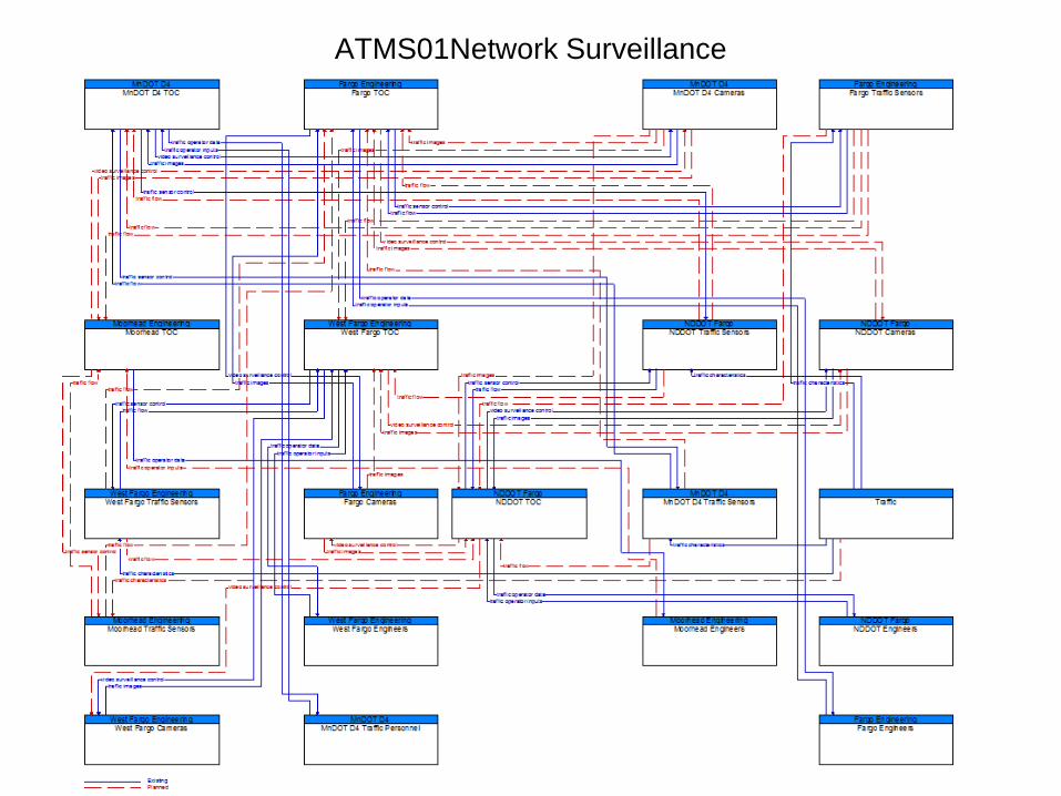
ATMS01Network Surveillance

ATMS01Network Surveillance (Hybrid)

ATMS01Network Surveillance (Centralized)

ATMS03 Traffic Signal Control

ATMS03 Traffic Signal Control (Hybrid)

ATMS03 Traffic Signal Control (Centralized)

ATMS04 Traffic Metering

ATMS04 Traffic Metering (Hybrid)

ATMS04 Traffic Metering (Centralized)

ATMS06 Traffic Info Dissemination

ATMS06 Traffic Info Dissemination (Hybrid)

ATMS06 Traffic Info Dissemination (Centralized)

ATMS07 Regional Traffic Management

ATMS07 Regional Traffic Management (Hybrid)

ATMS07 Regional Traffic Management (Centralized)

ATMS08 Incident Management

ATMS08 Incident Management (Hybrid)

ATMS08 Incident Management (Centralized)

ATMS13 Standard Railroad Grade Crossing

ATMS13 Standard Railroad Grade Crossing (Hybrid)

ATMS13 Standard Railroad Grade Crossing (Centralized)

ATMS19 Speed Warning

ATMS19 Speed Warning (Hybrid)

ATMS19 Speed Warning (Centralized)

MC01 Maintenance Vehicle Tracking

MC05 Roadway Automated Treatment

MC06 Winter Maintenance

MC08 Work Zone Management

EM01 Call-Taking & Dispatch

EM01 Call-Taking & Dispatch (Hybrid)

EM01 Call-Taking & Dispatch (Centralized)

EM02 Emergency Routing

EM02 Emergency Routing (Hybrid)

EM02 Emergency Routing (Centralized)

EM06 Wide-Area Alert

EM06 Wide-Area Alert (Hybrid)

EM06 Wide-Area Alert (Centralized)

EM08 Disaster Response and Recovery

EM09 Evacuation and Reentry Management

EM10 Disaster Traveler Information

AD2 ITS Data Warehouse

Fargo-Moorhead Regional ITS Architecture – Final Report
APPENDIX B FARGO-MOORHEAD FUNCTIONAL REQUIREMENTS

Fargo-Moorhead Regional ITS Architecture Functional Requirements
Status Architecture (Region) Fargo-Moorhead Regional ITS Architecture (Region)
Fargo Cameras Element: Roadway Entity:
Functional Area: Roadway Equipment Coordination Field elements that control and send data to other field elements (such as environmental sensors that send data to a DMS or coordination between traffic controllers on adjacent intersections), without center control.
Fargo PW Roadside Equipment Element: Roadway Entity:
Functional Area: Roadway Equipment Coordination Field elements that control and send data to other field elements (such as environmental sensors that send data to a DMS or coordination between traffic controllers on adjacent intersections), without center control.
Planned The field element shall include sensors that provide data and status information to other field element devices, without center control.
Requirement: 1
Planned The field element shall include devices that provide data and status information to other field element devices without center control.
Requirement: 3
Planned The field element shall include devices that receive configuration data from other field element devices, without center control.
Requirement: 4
Fargo TOC Element: Traffic Management Entity:
Functional Area: TMC Regional Traffic Management Coordination between traffic management centers in order to share traffic information between centers as well as control of traffic management field equipment. This may be used during incidents and special events and during day-to-day operations.
Planned The center shall exchange traffic information with other traffic management centers including incident information, congestion data, traffic data, signal timing plans, and real-time signal control information.
Requirement: 1
Planned The center shall exchange traffic control information with other traffic management centers to support remote monitoring and control of traffic management devices (e.g. signs, sensors, signals, cameras, etc.).
Requirement: 2
Fargo Traffic Sensors Element: Roadway Entity:
Functional Area: Roadway Equipment Coordination Field elements that control and send data to other field elements (such as environmental sensors that send data to a DMS or coordination between traffic controllers on adjacent intersections), without center control.
1

Status Architecture (Region) Fargo-Moorhead Regional ITS Architecture (Region)
Fargo Traffic Signals Element: Roadway Entity:
Functional Area: Roadway Signal Controls Field elements including traffic signal controllers for use at signalized intersections; also supports pedestrian crossings.
Functional Area: Roadway Signal Priority Field elements that provide the capability to receive transit vehicle signal priority requests and control traffic signals accordingly.
Existing The field element shall respond to signal priority requests from transit vehicles.
Requirement: 1
Functional Area: Roadway Equipment Coordination Field elements that control and send data to other field elements (such as environmental sensors that send data to a DMS or coordination between traffic controllers on adjacent intersections), without center control.
Planned The field element shall include sensors that provide data and status information to other field element devices, without center control.
Requirement: 1
Planned The field element shall include devices that provide data and status information to other field element devices without center control.
Requirement: 3
Planned The field element shall include devices that receive configuration data from other field element devices, without center control.
Requirement: 4
FM Cameras Element: Roadway Entity:
Functional Area: Roadway Basic Surveillance Field elements that monitor traffic conditions using loop detectors and CCTV cameras.
Existing The field element shall collect, process, and send traffic images to the center for further analysis and distribution.
Requirement: 2
Existing The field element shall return sensor and CCTV system operational status to the controlling center.
Requirement: 4
Existing The field element shall return sensor and CCTV system fault data to the controlling center for repair.
Requirement: 5
Functional Area: Roadway Equipment Coordination Field elements that control and send data to other field elements (such as environmental sensors that send data to a DMS or coordination between traffic controllers on adjacent intersections), without center control.
FM Data Warehouse Element: Archived Data Management Entity:
Functional Area: ITS Data Repository Collect and maintain data and data catalogs from one or more data sources. May include quality checks, error notification, and archive coordination.
Planned The center shall collect data to be archived from one or more data sources.
Requirement: 1
2
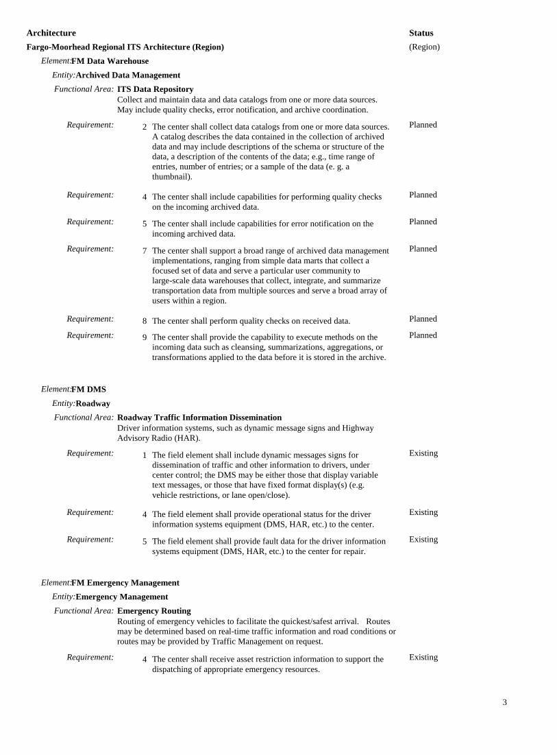
Status Architecture (Region) Fargo-Moorhead Regional ITS Architecture (Region)
FM Data Warehouse Element: Archived Data Management Entity:
Functional Area: ITS Data Repository Collect and maintain data and data catalogs from one or more data sources. May include quality checks, error notification, and archive coordination.
Planned The center shall collect data catalogs from one or more data sources. A catalog describes the data contained in the collection of archived data and may include descriptions of the schema or structure of the data, a description of the contents of the data; e.g., time range of entries, number of entries; or a sample of the data (e. g. a thumbnail).
Requirement: 2
Planned The center shall include capabilities for performing quality checks on the incoming archived data.
Requirement: 4
Planned The center shall include capabilities for error notification on the incoming archived data.
Requirement: 5
Planned The center shall support a broad range of archived data management implementations, ranging from simple data marts that collect a focused set of data and serve a particular user community to large-scale data warehouses that collect, integrate, and summarize transportation data from multiple sources and serve a broad array of users within a region.
Requirement: 7
Planned The center shall perform quality checks on received data. Requirement: 8 Planned The center shall provide the capability to execute methods on the
incoming data such as cleansing, summarizations, aggregations, or transformations applied to the data before it is stored in the archive.
Requirement: 9
FM DMS Element: Roadway Entity:
Functional Area: Roadway Traffic Information Dissemination Driver information systems, such as dynamic message signs and Highway Advisory Radio (HAR).
Existing The field element shall include dynamic messages signs for dissemination of traffic and other information to drivers, under center control; the DMS may be either those that display variable text messages, or those that have fixed format display(s) (e.g. vehicle restrictions, or lane open/close).
Requirement: 1
Existing The field element shall provide operational status for the driver information systems equipment (DMS, HAR, etc.) to the center.
Requirement: 4
Existing The field element shall provide fault data for the driver information systems equipment (DMS, HAR, etc.) to the center for repair.
Requirement: 5
FM Emergency Management Element: Emergency Management Entity:
Functional Area: Emergency Routing Routing of emergency vehicles to facilitate the quickest/safest arrival. Routes may be determined based on real-time traffic information and road conditions or routes may be provided by Traffic Management on request.
Existing The center shall receive asset restriction information to support the dispatching of appropriate emergency resources.
Requirement: 4
3

Status Architecture (Region) Fargo-Moorhead Regional ITS Architecture (Region)
FM Emergency Management Element: Emergency Management Entity:
Functional Area: Emergency Routing Routing of emergency vehicles to facilitate the quickest/safest arrival. Routes may be determined based on real-time traffic information and road conditions or routes may be provided by Traffic Management on request.
Existing The center shall track current emergency vehicle location and status. Requirement: 6
Functional Area: Incident Command Tactical decision support, resource coordination, and communications integration among emergency management agencies for Incident Commands that are established by first responders to support local management of an incident.
Existing The center shall provide tactical decision support, resource coordination, and communications integration for Incident Commands that are established by first responders to support local management of an incident.
Requirement: 1
Existing The center shall provide incident command communications with public safety, emergency management, transportation, and other allied response agency centers.
Requirement: 2
Existing The center shall track and maintain resource information and action plans pertaining to the incident command.
Requirement: 3
Existing The center shall share incident command information with other public safety agencies including resource deployment status, hazardous material information, rail incident information, evacuation advice as well as traffic, road, and weather conditions.
Requirement: 4
Existing The center shall assess the status of responding emergency vehicles as part of an incident command.
Requirement: 5
Functional Area: Emergency Response Management Strategic emergency planning and response capabilities and broad inter-agency interfaces to support large-scale incidents and disasters, commonly associated with Emergency Operations Centers.
Existing The center shall provide strategic emergency response capabilities provided by an Emergency Operations Center for large-scale incidents and disasters.
Requirement: 1
Existing The center shall manage coordinated inter-agency responses to and recovery from large-scale emergencies. Such agencies include traffic management, transit, maintenance and construction management, rail operations, and other emergency management agencies.
Requirement: 2
Existing The center shall develop, coordinate with other agencies, and store emergency response plans.
Requirement: 4
Existing The center shall allocate the appropriate emergency services, resources, and vehicle (s) to respond to incidents, and shall provide the capability to override the current allocation to suit the special needs of a current incident.
Requirement: 6
Existing The center shall receive event scheduling information from Event Promoters.
Requirement: 7
Turbo Architecture v7.0.2 4

Status Architecture (Region) Fargo-Moorhead Regional ITS Architecture (Region)
FM Emergency Management Element: Emergency Management Entity:
Functional Area: Emergency Response Management Strategic emergency planning and response capabilities and broad inter-agency interfaces to support large-scale incidents and disasters, commonly associated with Emergency Operations Centers.
Planned The center shall provide the capability to remotely control and monitor CCTV systems normally operated by a traffic management center.
Requirement: 9
Existing The center shall provide the capability to request transit resource availability from transit centers for use during disaster and evacuation operations.
Requirement: 10
Existing The center shall provide information to the media concerning the status of an emergency response.
Requirement: 12
Existing The center shall provide the capability to communicate information about emergency situations to local population through the Emergency Telecommunications System.
Requirement: 17
Functional Area: Emergency Evacuation Support Evacuation planning and coordination to manage evacuation and reentry of a population in the vicinity of a disaster or other emergency that poses a risk to public safety.
Existing The center shall manage inter-agency coordination of evacuation operations, from initial planning through the evacuation process and reentry.
Requirement: 1
Existing The center shall develop and exchange evacuation plans with allied agencies prior to the occurrence of a disaster.
Requirement: 2
Existing The center shall coordinate evacuation destinations and shelter needs with shelter providers (e.g., the American Red Cross) in the region.
Requirement: 4
Existing The center shall provide evacuation information to traffic, transit, maintenance and construction, rail operations, and other emergency management centers as needed.
Requirement: 5
Existing The center shall request resources from transit agencies as needed to support the evacuation.
Requirement: 6
Planned The center shall request traffic management agencies to implement special traffic control strategies and to control evacuation traffic, including traffic on local streets and arterials as well as the major evacuation routes.
Requirement: 7
Existing The center shall provide traveler information systems with evacuation guidance including basic information to assist potential evacuees in determining whether evacuation is necessary and when it is safe to return.
Requirement: 8
Existing The center shall monitor the progress or status of the evacuation once it begins and exchange tactical plans, prepared during the incident, with allied agencies.
Requirement: 9
Existing The center shall monitor the progress of the reentry process. Requirement: 10
5

Status Architecture (Region) Fargo-Moorhead Regional ITS Architecture (Region)
FM Emergency Vehicles Element: Emergency Vehicle Entity:
Functional Area: On-board EV En Route Support On-board systems for gathering of dispatch and routing information for emergency vehicle personnel, vehicle tracking, communications with care facilities, and signal preemption via short range communication directly with traffic control equipment at the roadside.
Existing The emergency vehicle, including roadway service patrols, shall track its current location.
Requirement: 1
Existing The emergency vehicle shall send requests to traffic signal control equipment at the roadside to preempt the signal.
Requirement: 5
Existing The emergency vehicle shall provide the personnel on-board with dispatch information, including incident type and location, and forward an acknowledgment from personnel to the center that the vehicle is on its way to the incident scene.
Requirement: 6
Existing The emergency vehicle shall send patient status information to the care facility along with a request for further information.
Requirement: 7
Existing [User Defined] The emergency vehicle, shall track its current location.
Requirement: 11
Existing [User Defined] The emergency vehicle, shall receive incident details and a suggested route when dispatched to a scene.
Requirement: 12
FM FAST Anti-icing Systems Element: Roadway Entity:
Functional Area: Roadway Equipment Coordination Field elements that control and send data to other field elements (such as environmental sensors that send data to a DMS or coordination between traffic controllers on adjacent intersections), without center control.
Functional Area: Roadway Automated Treatment Field elements that activate automated roadway treatment systems (to disperse anti-icing chemicals, etc.) based on environmental or atmospheric conditions, or under center control.
Existing The field element shall activate automated roadway treatment systems based on environmental or atmospheric conditions. Treatments can be in the form of fog dispersion, anti-icing chemicals, etc.
Requirement: 1
Existing The field element shall activate automated roadway treatment systems under center control. Treatments can be in the form of fog dispersion, anti-icing chemicals, etc.
Requirement: 2
Existing The field element shall return automated roadway treatment system and associated environmental sensor operational status to the maintenance center.
Requirement: 3
Existing The field element shall return automated roadway treatment system and associated environmental sensor fault data to the maintenance center for repair.
Requirement: 4
FM Maintenance and Construction Management Element: Maintenance and Construction Management Entity:
Functional Area: MCM Vehicle Tracking
6

Status Architecture (Region) Fargo-Moorhead Regional ITS Architecture (Region)
FM Maintenance and Construction Management Element: Maintenance and Construction Management Entity:
Functional Area: MCM Vehicle Tracking Remotely tracks the location of maintenance and construction vehicles and other equipment; presented to the center personnel.
Existing The center shall monitor the locations of all maintenance and construction vehicles and other equipment under its jurisdiction.
Requirement: 1
Existing The center shall present location data to center personnel for the fleet of maintenance and construction vehicles and other equipment.
Requirement: 2
Functional Area: MCM Incident Management Supports coordinated response to incidents - share incident notifications, manage incident response resources, and coordinate overall incident situation and response among allied response organizations.
Existing The center shall exchange alert information and status with emergency management centers. The information includes notification of a major emergency such as a natural or man-made disaster, civil emergency, or child abduction. The information may include the alert originator, the nature of the emergency, the geographic area affected by the emergency, the effective time period, etc.
Requirement: 2
Existing The center shall exchange incident and threat information with emergency management centers as well as traffic management centers; including notification of existence of incident and expected severity, location, time and nature of incident.
Requirement: 3
Existing The center shall coordinate planning for incidents with emergency management centers - including pre-planning activities for disaster response, evacuation, and recovery operations.
Requirement: 4
Existing The center shall respond to requests from emergency management to provide maintenance and construction resources to implement response plans, assist in clean up, verify an incident, etc. This may also involve coordination with traffic management centers and other maintenance centers.
Requirement: 5
Existing The center shall exchange road network status assessment information with emergency management and traffic management centers including an assessment of damage sustained by the road network including location and extent of the damage, estimate of remaining capacity, required closures, alternate routes, necessary restrictions, and time frame for repair and recovery.
Requirement: 6
Existing The center shall provide work zone activities affecting the road network including the nature of the maintenance or construction activity, location, impact to the roadway, expected time(s) and duration of impact, anticipated delays, alternate routes, and suggested speed limits. This information may be augmented with images that provide a visual indication of current work zone status and traffic impacts.
Requirement: 7
Existing The center shall receive information indicating the damage sustained by transportation assets, derived from aerial surveillance, field reports, inspections, tests, and analyses to support incident management.
Requirement: 8
7

Status Architecture (Region) Fargo-Moorhead Regional ITS Architecture (Region)
FM Maintenance and Construction Management Element: Maintenance and Construction Management Entity:
Functional Area: MCM Winter Maintenance Management Manages winter road maintenance, tracking and controlling snow plow operations, roadway treatment (e.g., salt spraying and other material applications) based on weather information.
Existing The center shall respond to requests from emergency management and traffic management centers for hazard removal, field equipment repair, and other winter roadway maintenance.
Requirement: 1
Existing The center shall provide status information about scheduled winter maintenance activities including anticipated closures and impact to the roadway, alternate routes, anticipated delays, closure times, and durations. The information is provided to other management centers such as traffic, emergency, transit, traveler information providers, other maintenance centers, and the media.
Requirement: 3
Existing The center shall collect real-time information on the state of the regional transportation system from other centers including current traffic and road conditions, weather conditions, special event and incident information and use the collected information to support winter maintenance operations.
Requirement: 6
Existing The center shall dispatch and route winter maintenance vehicle drivers and support them with route- specific environmental, incident, advisory, threat, alert, and traffic congestion information.
Requirement: 7
Existing The center shall determine the need for roadway treatment based on current and forecasted weather information, current usage of treatments and materials, available resources, requests for action from other agencies, and recommendations from the Maintenance Decision Support system, specifically under winter conditions. This supports winter maintenance such as plowing, treating, anti-icing, etc.
Requirement: 8
Existing The center shall provide dispatch instructions for vehicle operators based on input parameters from center personnel, specifically for winter conditions. This could include a treatment route, treatment application rates, start and end times, and other treatment instructions.
Requirement: 9
Functional Area: MCM Roadway Maintenance and Construction Overall management and support for routine maintenance on the roadway or right-of-way. Includes landscape maintenance, hazard removal (roadway debris, dead animals), routine maintenance activities (roadway cleaning, grass cutting), and repair and maintenance of both ITS and non-ITS equipment.
Existing The center shall respond to requests from emergency management and traffic management centers for hazard removal, field equipment repair, and other roadway maintenance.
Requirement: 2
Existing The center shall provide emergency management and traffic management centers with information about scheduled maintenance and construction work activities including anticipated closures and impact to the roadway, alternate routes, anticipated delays, closure times, and durations.
Requirement: 4
Turbo Architecture v7.0.2 8

Status Architecture (Region) Fargo-Moorhead Regional ITS Architecture (Region)
FM Maintenance and Construction Management Element: Maintenance and Construction Management Entity:
Functional Area: MCM Roadway Maintenance and Construction Overall management and support for routine maintenance on the roadway or right-of-way. Includes landscape maintenance, hazard removal (roadway debris, dead animals), routine maintenance activities (roadway cleaning, grass cutting), and repair and maintenance of both ITS and non-ITS equipment.
Existing The center shall collect current and forecast traffic and weather information from traffic management centers and weather service providers (such as the National Weather Service and value-added sector specific meteorological services).
Requirement: 9
Existing The center shall dispatch and route maintenance and construction vehicle drivers and support them with route-specific environmental, incident, advisory, threat, alert, and traffic congestion information.
Requirement: 10
Functional Area: MCM Work Zone Management Remotely monitors and supports work zone activities, controlling traffic through dynamic message signs (DMS), highway advisory radio, gates and barriers, and informing other groups of activity (e.g., traveler information systems, traffic management centers, other maintenance and construction centers).
Existing The center shall disseminate work zone information to other agencies and centers including traffic, transit, emergency management centers, other maintenance centers, traveler information providers, and the media.
Requirement: 3
Existing The center shall control traffic in work zones by providing remote control of dynamic message signs, highway advisory radio systems, gates, and barriers located in or near the work zone.
Requirement: 4
FM Maintenance Vehicles Element: Maintenance and Construction Vehicle Entity:
Functional Area: MCV Vehicle Location Tracking On-board systems to track vehicle location and reports the position and timestamp information to the dispatch center.
Existing The maintenance and construction vehicle shall track its current location.
Requirement: 1
Existing The maintenance and construction vehicle shall send the time stamped vehicle location to the controlling center.
Requirement: 2
Functional Area: MCV Winter Maintenance On-board systems that support snow plow operations and other roadway treatments (e.g., salt spraying and other material applications). Supports information sharing between snow plows.
Existing The maintenance and construction vehicle shall track the location and status of safety systems on-board the vehicle.
Requirement: 1
Existing The maintenance and construction vehicle shall monitor materials information including remaining quantity and current application rate of materials on the vehicle.
Requirement: 3
Turbo Architecture v7.0.2 9

Status Architecture (Region) Fargo-Moorhead Regional ITS Architecture (Region)
FM Maintenance Vehicles Element: Maintenance and Construction Vehicle Entity:
Functional Area: MCV Winter Maintenance On-board systems that support snow plow operations and other roadway treatments (e.g., salt spraying and other material applications). Supports information sharing between snow plows.
Existing The maintenance and construction vehicle shall respond to dispatch information from the center, presented to the vehicle operator for acknowledgement and returning status.
Requirement: 4
FM Rail Crossing Equipment Element: Roadway Entity:
Functional Area: Standard Rail Crossing Field elements at highway-rail intersections (HRIs) where operational requirements do not dictate advanced features (e.g., where rail operational speeds are less than 80 miles per hour). Includes traditional HRI warning systems augmented with other standard traffic management devices.
Existing The field element shall monitor the status of the highway-rail intersection (HRI) equipment, including both the current state and mode of operation and the current equipment condition, to be forwarded on to the traffic management center.
Requirement: 2
Existing The field element shall close the highway-rail intersection (HRI) when a train is approaching using gates, lights/signs, barriers, and traffic control signals.
Requirement: 7
Existing The field element shall support the integrated control of adjacent traffic signals to clear an area in advance of an approaching train and to manage traffic around the intersection.
Requirement: 8
FM Signals Element: Roadway Entity:
Functional Area: Roadway Signal Controls Field elements including traffic signal controllers for use at signalized intersections; also supports pedestrian crossings.
Existing The field element shall control traffic signals under center control. Requirement: 1
Existing The field element shall respond to pedestrian crossing requests by accommodating the pedestrian crossing.
Requirement: 2
Existing The field element shall report the current signal control information to the center.
Requirement: 4
Existing The field element shall report current preemption status to the center.
Requirement: 5
Existing The field element shall return traffic signal controller operational status to the center.
Requirement: 6
Existing The field element shall return traffic signal controller fault data to the center.
Requirement: 7
Existing The field element shall report current transit priority status to the center.
Requirement: 8
Functional Area: Roadway Signal Preemption Field elements that receive signal preemption requests from approaching emergency vehicles and overrides the current operation of the traffic signals
Turbo Architecture v7.0.2 10

Status Architecture (Region) Fargo-Moorhead Regional ITS Architecture (Region)
FM Signals Element: Roadway Entity:
Functional Area: Roadway Signal Preemption Field elements that receive signal preemption requests from approaching emergency vehicles and overrides the current operation of the traffic signals
Existing The field element shall respond to signal preemption requests from emergency vehicles.
Requirement: 1
Functional Area: Roadway Equipment Coordination Field elements that control and send data to other field elements (such as environmental sensors that send data to a DMS or coordination between traffic controllers on adjacent intersections), without center control.
FM Speed Warning Devices Element: Roadway Entity:
Functional Area: Roadway Equipment Coordination Field elements that control and send data to other field elements (such as environmental sensors that send data to a DMS or coordination between traffic controllers on adjacent intersections), without center control.
Functional Area: Roadway Speed Monitoring and Warning Vehicle speed sensors that detect excessive vehicle speeds, optionally based on conditions and vehicle type, informing drivers, centers and/or enforcement agencies of speed violations.
Existing The field element shall include sensors to detect vehicle speeds, under traffic or maintenance center control.
Requirement: 1
Existing If the speed detected by vehicle speed sensors is determined to be excessive, the field element shall provide a safe speed advisory to passing drivers via a driver information system (such as portable messages signs, field to vehicle communications to in-vehicle signing systems, etc.).
Requirement: 3
FM Traffic Operations Element: Traffic Management Entity:
Functional Area: Collect Traffic Surveillance Management of traffic sensors and surveillance (CCTV) equipment, collection of current traffic conditions, and distribution of the collected information to other centers and operators.
Existing The center shall monitor, analyze, and store traffic sensor data (speed, volume, occupancy) collected from field elements under remote control of the center.
Requirement: 1
Planned The center shall monitor, analyze, and distribute traffic images from CCTV systems under remote control of the center.
Requirement: 2
Planned The center shall distribute road network conditions data (raw or processed) based on collected and analyzed traffic sensor and surveillance data to other centers.
Requirement: 4
Functional Area: TMC Signal Control Remotely controls traffic signal controllers to implement traffic management strategies at signalized intersections based on traffic conditions, incidents, emergency vehicle preemptions, pedestrian crossings, etc.
11

Status Architecture (Region) Fargo-Moorhead Regional ITS Architecture (Region)
FM Traffic Operations Element: Traffic Management Entity:
Functional Area: TMC Signal Control Remotely controls traffic signal controllers to implement traffic management strategies at signalized intersections based on traffic conditions, incidents, emergency vehicle preemptions, pedestrian crossings, etc.
Existing The center shall remotely control traffic signal controllers. Requirement: 1 Existing The center shall collect traffic signal controller operational status
and compare against the control information sent by the center. Requirement: 3
Existing The center shall collect traffic signal controller fault data from the field.
Requirement: 4
Existing The center shall manage (define, store and modify) control plans to coordinate signalized intersections, to be engaged at the direction of center personnel or according to a daily schedule.
Requirement: 5
Planned The center shall implement control plans to coordinate signalized intersections based on data from sensors.
Requirement: 6
Planned The center shall manage boundaries of the control sections used within the signal system.
Requirement: 7
Existing The center shall maintain traffic signal coordination including synchronizing clocks throughout the system.
Requirement: 8
Functional Area: TMC Evacuation Support Development, coordination, and execution of special traffic management strategies during evacuation and subsequent reentry of a population in the vicinity of a disaster or major emergency. Interfaces with emergency management and other traffic management centers.
Existing The center shall coordinate planning for evacuation with emergency management centers - including pre-planning activities such as establishing routes, areas to be evacuated, timing, etc.
Requirement: 1
Functional Area: TMC Traffic Network Performance Evaluation Measures performance and predicts travel demand patterns to support traffic flow optimization, demand management, and incident management. Collects data from surveillance equipment as well as input from other management centers including emissions, event promoters, and other TMCs.
Existing The center shall monitor, analyze, and store traffic sensor data (speed, volume, occupancy) collected from field elements under remote control of the center to support overall network performance evaluations.
Requirement: 1
Existing The center shall collect and store plans from event promoters for major future events possibly impacting traffic to support overall network performance evaluations.
Requirement: 3
Planned The center shall exchange information with transit management centers including details current transit routes, the level of service on each route, and the progress of individual vehicles along their routes for use in forecasting demand and estimating current transportation network performance.
Requirement: 5
Planned The center shall exchange traffic information with other traffic management centers, including incidents, congestion data, traffic data, signal timing plans, and real-time signal control information to support overall network performance evaluations.
Requirement: 6
12

Status Architecture (Region) Fargo-Moorhead Regional ITS Architecture (Region)
FM Traffic Operations Element: Traffic Management Entity:
Functional Area: TMC Traffic Network Performance Evaluation Measures performance and predicts travel demand patterns to support traffic flow optimization, demand management, and incident management. Collects data from surveillance equipment as well as input from other management centers including emissions, event promoters, and other TMCs.
Planned The center shall provide an interface to the archive data repository to enable the operator to retrieve historical operating data for use in planning to predict future traffic patterns and conditions.
Requirement: 8
Planned This center shall use the collected information to measure overall current and forecast network performance and predict travel demand patterns.
Requirement: 9
Functional Area: Traffic Data Collection Collection and storage of traffic management data. For use by operations personnel or data archives in the region.
Existing The center shall collect traffic management data such as operational data, event logs, etc.
Requirement: 1
Planned The center shall receive and respond to requests from ITS Archives for either a catalog of the traffic data or for the data itself.
Requirement: 3
FM Traffic Sensors Element: Roadway Entity:
Functional Area: Roadway Equipment Coordination Field elements that control and send data to other field elements (such as environmental sensors that send data to a DMS or coordination between traffic controllers on adjacent intersections), without center control.
Functional Area: Roadway Data Collection Field elements to collect traffic, road, and environmental conditions information for use in transportation planning, research, and other off-line applications. Includes the sensors, supporting roadside infrastructure, and communications equipment.
Existing The field element shall collect traffic, road, and environmental conditions information.
Requirement: 1
Existing The field element shall collect sensor status and sensor faults from roadside equipment and send it along with the recorded data to a center for archival.
Requirement: 3
MAT Kiosks Element: Remote Traveler Support Entity:
Functional Area: Remote Transit Information Services Public traveler interface that provides real-time travel-related information at transit stops and multi-modal transfer points, including general annunciation, display of imminent arrival information, the latest available information on transit routes, schedules, transfer options, available services, fares, and real-time schedule adherence.
Turbo Architecture v7.0.2 13

Status Architecture (Region) Fargo-Moorhead Regional ITS Architecture (Region)
MAT Kiosks Element: Remote Traveler Support Entity:
Functional Area: Remote Transit Information Services Public traveler interface that provides real-time travel-related information at transit stops and multi-modal transfer points, including general annunciation, display of imminent arrival information, the latest available information on transit routes, schedules, transfer options, available services, fares, and real-time schedule adherence.
Existing The public interface for travelers shall collect and provide real-time travel-related information at transit stops, multi-modal transfer points, and other public transportation areas.
Requirement: 1
Existing The public interface for travelers shall collect and present to the transit traveler information on transit routes, schedules, and real-time schedule adherence.
Requirement: 2
MAT Vehicles Element: Transit Vehicle Entity:
Functional Area: On-board Transit Trip Monitoring Support fleet management with automatic vehicle location (AVL) and automated mileage and fuel reporting and auditing.
Existing The transit vehicle shall track the current location of the transit vehicle.
Requirement: 1
Functional Area: On-board Transit Fare Management On-board systems provide fare collection using a travelers non-monetary fare medium. Collected fare data are made available to the center.
Existing The transit vehicle shall read data from the traveler card / payment instrument presented by boarding passengers.
Requirement: 1
Existing The transit vehicle shall provide fare statistics data to the center. Requirement: 10
Functional Area: On-board Passenger Counting On-board systems collect transit vehicle loading data and make it available to the center.
Planned The transit vehicle shall count passengers boarding and alighting. Requirement: 1 Planned The passenger counts shall be related to location to support
association of passenger counts with routes, route segments, or bus stops.
Requirement: 2
Planned The passenger counts shall be timestamped so that ridership can be measured by time of day and day of week.
Requirement: 3
Functional Area: On-board Transit Security On-board video/audio surveillance systems, threat sensors, and object detection sensors to enhance security and safety on-board a transit vehicles. Also includes silent alarms activated by transit user or vehicle operator, operator authentication, and remote vehicle disabling.
Existing The transit vehicle shall perform video and audio surveillance inside of transit vehicles and output raw video or audio data for either local monitoring (for processing or direct output to the transit vehicle operator), remote monitoring or for local storage (e.g., in an event recorder).
Requirement: 1
14

Status Architecture (Region) Fargo-Moorhead Regional ITS Architecture (Region)
MAT Vehicles Element: Transit Vehicle Entity:
Functional Area: On-board Maintenance On-board systems to collect and process transit vehicle maintenance data including mileage and vehicle operating conditions for use in scheduling future vehicle maintenance.
Existing The transit vehicle shall collect and process vehicle mileage data available to sensors on-board.
Requirement: 1
Existing The transit vehicle shall collect and process the transit vehicle's operating conditions such as engine temperature, oil pressure, brake wear, internal lighting, environmental controls, etc.
Requirement: 2
Planned The transit vehicle shall transmit vehicle maintenance data to the center to be used for scheduling future vehicle maintenance.
Requirement: 3
Functional Area: On-board Transit Signal Priority On-board systems request signal priority through short range communication directly with traffic control equipment at the roadside (intersections, ramps, interchanges, etc.).
Existing The transit vehicle shall send priority requests to traffic signal controllers at intersections, pedestrian crossings, and multimodal crossings on the roads (surface streets) and freeway (ramp controls) network that enable a transit vehicle schedule deviation to be corrected.
Requirement: 2
Functional Area: On-board Transit Information Services On-board systems to furnish next-stop annunciation as well as interactive travel-related information, including routes, schedules, transfer options, fares, real-time schedule adherence, current incidents, weather conditions, non-motorized transportation services, and special events.
Existing The transit vehicle shall broadcast advisories about the imminent arrival of the transit vehicle at the next stop via an on-board automated annunciation system.
Requirement: 3
Existing The transit vehicle shall support input and output forms that are suitable for travelers with physical disabilities.
Requirement: 4
MATBus Element: Transit Management Entity:
Functional Area: Transit Center Vehicle Tracking Monitoring transit vehicle locations via interactions with on-board systems. Furnish users with real-time transit schedule information and maintain interface with digital map providers.
Existing The center shall monitor the locations of all transit vehicles within its network.
Requirement: 1
Existing The center shall determine adherence of transit vehicles to their assigned schedule.
Requirement: 2
Existing The center shall support an interface with a map update provider, or other appropriate data sources, through which updates of digitized map data can be obtained and used as a background for transit tracking and dispatch.
Requirement: 3
Existing The center shall provide transit operational data to traveler information service providers.
Requirement: 4
15
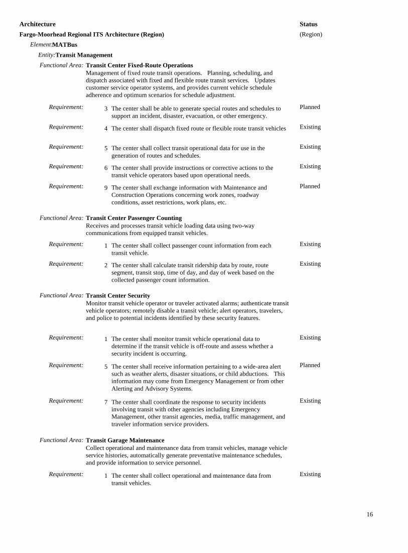
Status Architecture (Region) Fargo-Moorhead Regional ITS Architecture (Region)
MATBus Element: Transit Management Entity:
Functional Area: Transit Center Fixed-Route Operations Management of fixed route transit operations. Planning, scheduling, and dispatch associated with fixed and flexible route transit services. Updates customer service operator systems, and provides current vehicle schedule adherence and optimum scenarios for schedule adjustment.
Planned The center shall be able to generate special routes and schedules to support an incident, disaster, evacuation, or other emergency.
Requirement: 3
Existing The center shall dispatch fixed route or flexible route transit vehicles Requirement: 4
Existing The center shall collect transit operational data for use in the generation of routes and schedules.
Requirement: 5
Existing The center shall provide instructions or corrective actions to the transit vehicle operators based upon operational needs.
Requirement: 6
Planned The center shall exchange information with Maintenance and Construction Operations concerning work zones, roadway conditions, asset restrictions, work plans, etc.
Requirement: 9
Functional Area: Transit Center Passenger Counting Receives and processes transit vehicle loading data using two-way communications from equipped transit vehicles.
Existing The center shall collect passenger count information from each transit vehicle.
Requirement: 1
Existing The center shall calculate transit ridership data by route, route segment, transit stop, time of day, and day of week based on the collected passenger count information.
Requirement: 2
Functional Area: Transit Center Security Monitor transit vehicle operator or traveler activated alarms; authenticate transit vehicle operators; remotely disable a transit vehicle; alert operators, travelers, and police to potential incidents identified by these security features.
Existing The center shall monitor transit vehicle operational data to determine if the transit vehicle is off-route and assess whether a security incident is occurring.
Requirement: 1
Planned The center shall receive information pertaining to a wide-area alert such as weather alerts, disaster situations, or child abductions. This information may come from Emergency Management or from other Alerting and Advisory Systems.
Requirement: 5
Existing The center shall coordinate the response to security incidents involving transit with other agencies including Emergency Management, other transit agencies, media, traffic management, and traveler information service providers.
Requirement: 7
Functional Area: Transit Garage Maintenance Collect operational and maintenance data from transit vehicles, manage vehicle service histories, automatically generate preventative maintenance schedules, and provide information to service personnel.
Existing The center shall collect operational and maintenance data from transit vehicles.
Requirement: 1
16

Status Architecture (Region) Fargo-Moorhead Regional ITS Architecture (Region)
MATBus Element: Transit Management Entity:
Functional Area: Transit Garage Maintenance Collect operational and maintenance data from transit vehicles, manage vehicle service histories, automatically generate preventative maintenance schedules, and provide information to service personnel.
Existing The center shall monitor the condition of a transit vehicle to analyze brake, drive train, sensors, fuel, steering, tire, processor, communications equipment, and transit vehicle mileage to identify mileage based maintenance, out-of-specification or imminent failure conditions.
Requirement: 2
Existing The center shall generate transit vehicle maintenance schedules that identify the maintenance or repair to be performed and when the work is to be done.
Requirement: 3
Existing The center shall provide transit operations personnel with the capability to update transit vehicle maintenance information and receive reports on all transit vehicle operations data.
Requirement: 8
Functional Area: Transit Vehicle Assignment Assigns individual transit vehicles to vehicle blocks and downloads this information to the transit vehicle, updating assignments as necessitated by changes. It also provides an inventory management function that stores attributes about each of the transit vehicles.
Existing The center shall assign individual transit vehicles to transit blocks. Requirement: 1
Functional Area: Transit Center Information Services Provide interactive traveler information to travelers (on-board transit vehicles, at stops/stations, using personal devices), traveler information service providers, media, and other transit organizations. Includes routes, schedules, transfer options, fares, real-time schedule adherence, current incidents, weather conditions, yellow pages, and special events.
Existing The center shall provide travelers using public transportation with traffic and advisory information upon request. Such information may include transit routes, schedules, transfer options, fares, real-time schedule adherence, current incidents, weather conditions, and special events.
Requirement: 1
Functional Area: Transit Evacuation Support Support evacuation and subsequent reentry of a population in the vicinity of a disaster or other emergency. Coordinate regional evacuation plans and resources including transit and school bus fleets.
Existing The center shall manage the use of transit resources to support evacuation and subsequent reentry of a population in the vicinity of a disaster or other emergency.
Requirement: 1
Functional Area: Transit Data Collection Collection and storage of transit management data. For use by operations personnel or data archives in the region.
Existing The center shall collect transit management data such as transit fares and passenger use, transit services, paratransit operations, transit vehicle maintenance data, etc.
Requirement: 1
17

Status Architecture (Region) Fargo-Moorhead Regional ITS Architecture (Region)
MnDOT D4 Cameras Element: Roadway Entity:
Functional Area: Roadway Equipment Coordination Field elements that control and send data to other field elements (such as environmental sensors that send data to a DMS or coordination between traffic controllers on adjacent intersections), without center control.
MnDOT D4 DMS Element: Roadway Entity:
Functional Area: Roadway Equipment Coordination Field elements that control and send data to other field elements (such as environmental sensors that send data to a DMS or coordination between traffic controllers on adjacent intersections), without center control.
MnDOT D4 Maintenance Element: Maintenance and Construction Management Entity:
Functional Area: MCM Automated Treatment System Control Remotely controls automated roadway treatment systems (to disperse anti-icing chemicals, etc.) directly, or via control of the environmental sensors that activate the treatment systems automatically in the field.
Existing The center shall remotely control automated roadway treatment systems. Treatments can be in the form of fog dispersion, anti-icing chemicals, etc.
Requirement: 1
Existing The center shall remotely control the environmental sensors that upon detecting changes in environmental or atmospheric conditions, automatically activate roadway treatment systems.
Requirement: 2
Existing The center shall collect automated roadway treatment system and associated environmental sensor operational status.
Requirement: 3
Existing The center shall collect automated roadway treatment system and associated environmental sensor fault data and request repair.
Requirement: 4
Existing The center shall accept requests for automated roadway treatment system activation from center personnel.
Requirement: 5
MnDOT D4 TOC Element: Traffic Management Entity:
Functional Area: TMC Traffic Information Dissemination Controls dissemination of traffic-related data to other centers, the media, and travelers via the driver information systems (DMS, HAR) that it operates.
Existing The center shall remotely control dynamic messages signs for dissemination of traffic and other information to drivers.
Requirement: 1
Existing The center shall collect operational status for the driver information systems equipment (DMS, HAR, etc.).
Requirement: 3
Existing The center shall collect fault data for the driver information systems equipment (DMS, HAR, etc.) for repair.
Requirement: 4
Planned The center shall distribute traffic data to maintenance and construction centers, transit centers, emergency management centers, and traveler information providers.
Requirement: 6
18

Status Architecture (Region) Fargo-Moorhead Regional ITS Architecture (Region)
MnDOT D4 TOC Element: Traffic Management Entity:
Functional Area: TMC Regional Traffic Management Coordination between traffic management centers in order to share traffic information between centers as well as control of traffic management field equipment. This may be used during incidents and special events and during day-to-day operations.
Planned The center shall exchange traffic information with other traffic management centers including incident information, congestion data, traffic data, signal timing plans, and real-time signal control information.
Requirement: 1
Planned The center shall exchange traffic control information with other traffic management centers to support remote monitoring and control of traffic management devices (e.g. signs, sensors, signals, cameras, etc.).
Requirement: 2
MnDOT D4 Traffic Sensors Element: Roadway Entity:
Functional Area: Roadway Equipment Coordination Field elements that control and send data to other field elements (such as environmental sensors that send data to a DMS or coordination between traffic controllers on adjacent intersections), without center control.
MnDOT D4 Traffic Signals Element: Roadway Entity:
Functional Area: Roadway Signal Controls Field elements including traffic signal controllers for use at signalized intersections; also supports pedestrian crossings.
Functional Area: Roadway Signal Priority Field elements that provide the capability to receive transit vehicle signal priority requests and control traffic signals accordingly.
Planned The field element shall respond to signal priority requests from transit vehicles.
Requirement: 1
Functional Area: Roadway Equipment Coordination Field elements that control and send data to other field elements (such as environmental sensors that send data to a DMS or coordination between traffic controllers on adjacent intersections), without center control.
Planned The field element shall include sensors that provide data and status information to other field element devices, without center control.
Requirement: 1
Planned The field element shall include devices that provide data and status information to other field element devices without center control.
Requirement: 3
Planned The field element shall include devices that receive configuration data from other field element devices, without center control.
Requirement: 4
19

Status Architecture (Region) Fargo-Moorhead Regional ITS Architecture (Region)
MnTOC Element: Traffic Management Entity:
Functional Area: TMC Regional Traffic Management Coordination between traffic management centers in order to share traffic information between centers as well as control of traffic management field equipment. This may be used during incidents and special events and during day-to-day operations.
Planned The center shall exchange traffic information with other traffic management centers including incident information, congestion data, traffic data, signal timing plans, and real-time signal control information.
Requirement: 1
Planned The center shall exchange traffic control information with other traffic management centers to support remote monitoring and control of traffic management devices (e.g. signs, sensors, signals, cameras, etc.).
Requirement: 2
Moorhead TOC Element: Traffic Management Entity:
Functional Area: TMC Regional Traffic Management Coordination between traffic management centers in order to share traffic information between centers as well as control of traffic management field equipment. This may be used during incidents and special events and during day-to-day operations.
Planned The center shall exchange traffic information with other traffic management centers including incident information, congestion data, traffic data, signal timing plans, and real-time signal control information.
Requirement: 1
Planned The center shall exchange traffic control information with other traffic management centers to support remote monitoring and control of traffic management devices (e.g. signs, sensors, signals, cameras, etc.).
Requirement: 2
Moorhead Traffic Sensors Element: Roadway Entity:
Functional Area: Roadway Equipment Coordination Field elements that control and send data to other field elements (such as environmental sensors that send data to a DMS or coordination between traffic controllers on adjacent intersections), without center control.
Planned The field element shall include sensors that provide data and status information to other field element devices, without center control.
Requirement: 1
Planned The field element shall include devices that provide data and status information to other field element devices without center control.
Requirement: 3
Planned The field element shall include devices that receive configuration data from other field element devices, without center control.
Requirement: 4
Moorhead Traffic Signals Element: Roadway Entity:
Functional Area: Roadway Signal Controls Field elements including traffic signal controllers for use at signalized intersections; also supports pedestrian crossings.
20

Status Architecture (Region) Fargo-Moorhead Regional ITS Architecture (Region)
Moorhead Traffic Signals Element: Roadway Entity:
Functional Area: Roadway Signal Controls Field elements including traffic signal controllers for use at signalized intersections; also supports pedestrian crossings.
Functional Area: Roadway Signal Priority Field elements that provide the capability to receive transit vehicle signal priority requests and control traffic signals accordingly.
Planned The field element shall respond to signal priority requests from transit vehicles.
Requirement: 1
Functional Area: Roadway Equipment Coordination Field elements that control and send data to other field elements (such as environmental sensors that send data to a DMS or coordination between traffic controllers on adjacent intersections), without center control.
MSP DL District Element: Emergency Management Entity:
Functional Area: Emergency Dispatch Dispatch emergency vehicles to incidents, tracking their location and status. Pertinent incident information is gathered and relayed to the responding units.
Existing The center shall dispatch emergency vehicles to respond to verified emergencies under center personnel control.
Requirement: 1
Existing The center shall store the current status of all emergency vehicles available for dispatch and those that have been dispatched.
Requirement: 2
Existing The center shall relay location and incident details to the responding vehicles.
Requirement: 3
Existing The center shall track the location and status of emergency vehicles responding to an emergency based on information from the emergency vehicle.
Requirement: 4
Existing The center shall store and maintain the emergency service responses in an action log.
Requirement: 5
Planned The center shall receive traffic images to support dispatch of emergency vehicles.
Requirement: 7
Planned The center shall provide the capability to request remote control of traffic surveillance devices
Requirement: 8
Existing The center shall coordinate response to incidents with other Emergency Management centers to ensure appropriate resources are dispatched and utilized.
Requirement: 9
21

Status Architecture (Region) Fargo-Moorhead Regional ITS Architecture (Region)
ND State Radio Element: Emergency Management Entity:
Functional Area: Emergency Dispatch Dispatch emergency vehicles to incidents, tracking their location and status. Pertinent incident information is gathered and relayed to the responding units.
Existing The center shall dispatch emergency vehicles to respond to verified emergencies under center personnel control.
Requirement: 1
Existing The center shall store the current status of all emergency vehicles available for dispatch and those that have been dispatched.
Requirement: 2
Existing The center shall relay location and incident details to the responding vehicles.
Requirement: 3
Existing The center shall track the location and status of emergency vehicles responding to an emergency based on information from the emergency vehicle.
Requirement: 4
Existing The center shall store and maintain the emergency service responses in an action log.
Requirement: 5
Planned The center shall receive traffic images to support dispatch of emergency vehicles.
Requirement: 7
Planned The center shall provide the capability to request remote control of traffic surveillance devices
Requirement: 8
Existing The center shall coordinate response to incidents with other Emergency Management centers to ensure appropriate resources are dispatched and utilized.
Requirement: 9
NDDOT Cameras Element: Roadway Entity:
Functional Area: Roadway Equipment Coordination Field elements that control and send data to other field elements (such as environmental sensors that send data to a DMS or coordination between traffic controllers on adjacent intersections), without center control.
NDDOT DMS Element: Roadway Entity:
Functional Area: Roadway Equipment Coordination Field elements that control and send data to other field elements (such as environmental sensors that send data to a DMS or coordination between traffic controllers on adjacent intersections), without center control.
NDDOT Fargo Maintenance Element: Maintenance and Construction Management Entity:
Functional Area: MCM Automated Treatment System Control Remotely controls automated roadway treatment systems (to disperse anti-icing chemicals, etc.) directly, or via control of the environmental sensors that activate the treatment systems automatically in the field.
Existing The center shall remotely control automated roadway treatment systems. Treatments can be in the form of fog dispersion, anti-icing chemicals, etc.
Requirement: 1
22

Status Architecture (Region) Fargo-Moorhead Regional ITS Architecture (Region)
NDDOT Fargo Maintenance Element: Maintenance and Construction Management Entity:
Functional Area: MCM Automated Treatment System Control Remotely controls automated roadway treatment systems (to disperse anti-icing chemicals, etc.) directly, or via control of the environmental sensors that activate the treatment systems automatically in the field.
Existing The center shall remotely control the environmental sensors that upon detecting changes in environmental or atmospheric conditions, automatically activate roadway treatment systems.
Requirement: 2
Existing The center shall collect automated roadway treatment system and associated environmental sensor operational status.
Requirement: 3
Existing The center shall collect automated roadway treatment system and associated environmental sensor fault data and request repair.
Requirement: 4
Existing The center shall accept requests for automated roadway treatment system activation from center personnel.
Requirement: 5
NDDOT Ramp Meters Element: Roadway Entity:
Functional Area: Roadway Traffic Metering Control equipment including ramp, interchange, and mainline meters and the dynamic message signs that provide information about the meters and any special bypass lanes.
Planned The field element shall regulate the flow of traffic on ramps, interchanges, and the mainline, under center control.
Requirement: 1
Functional Area: Roadway Equipment Coordination Field elements that control and send data to other field elements (such as environmental sensors that send data to a DMS or coordination between traffic controllers on adjacent intersections), without center control.
NDDOT TOC Element: Traffic Management Entity:
Functional Area: TMC Traffic Metering Remotely controls ramp meters, interchange connector meters, and mainline meters, covering all types of metering as well as management of bypass lanes.
Planned The center shall remotely control systems to manage use of the freeways, including ramp, interchange, and mainline metering.
Requirement: 1
Functional Area: TMC Traffic Information Dissemination Controls dissemination of traffic-related data to other centers, the media, and travelers via the driver information systems (DMS, HAR) that it operates.
Existing The center shall remotely control dynamic messages signs for dissemination of traffic and other information to drivers.
Requirement: 1
Existing The center shall collect operational status for the driver information systems equipment (DMS, HAR, etc.).
Requirement: 3
Existing The center shall collect fault data for the driver information systems equipment (DMS, HAR, etc.) for repair.
Requirement: 4
Turbo Architecture v7.0.2 23

Status Architecture (Region) Fargo-Moorhead Regional ITS Architecture (Region)
NDDOT TOC Element: Traffic Management Entity:
Functional Area: TMC Traffic Information Dissemination Controls dissemination of traffic-related data to other centers, the media, and travelers via the driver information systems (DMS, HAR) that it operates.
Planned The center shall retrieve locally stored traffic information, including current and forecasted traffic information, road and weather conditions, traffic incident information, information on diversions and alternate routes, closures, and special traffic restrictions (lane/shoulder use, weight restrictions, width restrictions, HOV requirements), and the definition of the road network itself.
Requirement: 5
Planned The center shall distribute traffic data to maintenance and construction centers, transit centers, emergency management centers, and traveler information providers.
Requirement: 6
Functional Area: TMC Regional Traffic Management Coordination between traffic management centers in order to share traffic information between centers as well as control of traffic management field equipment. This may be used during incidents and special events and during day-to-day operations.
Planned The center shall exchange traffic information with other traffic management centers including incident information, congestion data, traffic data, signal timing plans, and real-time signal control information.
Requirement: 1
Planned The center shall exchange traffic control information with other traffic management centers to support remote monitoring and control of traffic management devices (e.g. signs, sensors, signals, cameras, etc.).
Requirement: 2
NDDOT Traffic Sensors Element: Roadway Entity:
Functional Area: Roadway Equipment Coordination Field elements that control and send data to other field elements (such as environmental sensors that send data to a DMS or coordination between traffic controllers on adjacent intersections), without center control.
NDDOT Traffic Signals Element: Roadway Entity:
Functional Area: Roadway Signal Controls Field elements including traffic signal controllers for use at signalized intersections; also supports pedestrian crossings.
Functional Area: Roadway Signal Priority Field elements that provide the capability to receive transit vehicle signal priority requests and control traffic signals accordingly.
Planned The field element shall respond to signal priority requests from transit vehicles.
Requirement: 1
Functional Area: Roadway Equipment Coordination
24

Status Architecture (Region) Fargo-Moorhead Regional ITS Architecture (Region)
NDDOT Traffic Signals Element: Roadway Entity:
Functional Area: Roadway Equipment Coordination Field elements that control and send data to other field elements (such as environmental sensors that send data to a DMS or coordination between traffic controllers on adjacent intersections), without center control.
Planned The field element shall include sensors that provide data and status information to other field element devices, without center control.
Requirement: 1
Planned The field element shall include devices that provide data and status information to other field element devices without center control.
Requirement: 3
Planned The field element shall include devices that receive configuration data from other field element devices, without center control.
Requirement: 4
RRRDC Element: Emergency Management Entity:
Functional Area: Emergency Call-Taking Provides interface to the emergency call-taking systems such as the Emergency Telecommunications System (e.g., 911) that correlate call information with emergencies reported by transit agencies, commercial vehicle operators, or other public safety agencies. Allows the operator to verify the incident and forward the information to the responding agencies.
Existing The center shall support the interface to the Emergency Telecommunications System (e.g. 911 or 7-digit call routing) to receive emergency notification information and provide it to the emergency system operator.
Requirement: 1
Existing The center shall receive emergency call information from 911 services and present the possible incident information to the emergency system operator.
Requirement: 2
Existing The center shall receive emergency call information from motorist call-boxes and present the possible incident information to the emergency system operator.
Requirement: 3
Existing The center shall receive emergency notification information from other public safety agencies and present the possible incident information to the emergency system operator.
Requirement: 5
Existing The center shall receive emergency notification information from public transit systems and present the possible incident information to the emergency system operator.
Requirement: 6
Planned The center shall send a request for remote control of CCTV systems from a traffic management center in order to verify the reported incident.
Requirement: 8
Existing The center shall forward the verified emergency information to the responding agency based on the location and nature of the emergency.
Requirement: 9
Existing The center shall update the incident information log once the emergency system operator has verified the incident.
Requirement: 10
Existing The center shall provide the capability for digitized map data to act as the background to the emergency information presented to the emergency system operator.
Requirement: 11
25

Status Architecture (Region) Fargo-Moorhead Regional ITS Architecture (Region)
RRRDC Element: Emergency Management Entity:
Functional Area: Emergency Dispatch Dispatch emergency vehicles to incidents, tracking their location and status. Pertinent incident information is gathered and relayed to the responding units.
Existing The center shall dispatch emergency vehicles to respond to verified emergencies under center personnel control.
Requirement: 1
Existing The center shall store the current status of all emergency vehicles available for dispatch and those that have been dispatched.
Requirement: 2
Existing The center shall relay location and incident details to the responding vehicles.
Requirement: 3
Existing The center shall track the location and status of emergency vehicles responding to an emergency based on information from the emergency vehicle.
Requirement: 4
Existing The center shall store and maintain the emergency service responses in an action log.
Requirement: 5
Existing The center shall provide the capability for digitized map data to act as the background to the information presented to the emergency system operator.
Requirement: 6
Planned The center shall receive traffic images to support dispatch of emergency vehicles.
Requirement: 7
Planned The center shall provide the capability to request remote control of traffic surveillance devices
Requirement: 8
Existing The center shall coordinate response to incidents with other Emergency Management centers to ensure appropriate resources are dispatched and utilized.
Requirement: 9
Functional Area: Emergency Data Collection Collection and storage of information related to Emergency Management. For use by operations personnel or data archives in the region.
Existing The center shall collect emergency service data, emergency vehicle management data, emergency vehicle data, sensor and surveillance data, threat data, and incident data.
Requirement: 1
Existing The center shall assign quality control metrics and meta-data to be stored along with the data. Meta-data may include attributes that describe the source and quality of the data and the conditions surrounding the collection of the data.
Requirement: 2
Planned The center shall receive and respond to requests from ITS Archives for either a catalog of the emergency management data or for the data itself.
Requirement: 3
West Fargo Cameras Element: Roadway Entity:
Functional Area: Roadway Equipment Coordination Field elements that control and send data to other field elements (such as environmental sensors that send data to a DMS or coordination between traffic controllers on adjacent intersections), without center control.
26

Status Architecture (Region) Fargo-Moorhead Regional ITS Architecture (Region)
West Fargo TOC Element: Traffic Management Entity:
Functional Area: TMC Regional Traffic Management Coordination between traffic management centers in order to share traffic information between centers as well as control of traffic management field equipment. This may be used during incidents and special events and during day-to-day operations.
Planned The center shall exchange traffic information with other traffic management centers including incident information, congestion data, traffic data, signal timing plans, and real-time signal control information.
Requirement: 1
Planned The center shall exchange traffic control information with other traffic management centers to support remote monitoring and control of traffic management devices (e.g. signs, sensors, signals, cameras, etc.).
Requirement: 2
West Fargo TOC Signals Element: Roadway Entity:
Functional Area: Roadway Signal Controls Field elements including traffic signal controllers for use at signalized intersections; also supports pedestrian crossings.
Functional Area: Roadway Equipment Coordination Field elements that control and send data to other field elements (such as environmental sensors that send data to a DMS or coordination between traffic controllers on adjacent intersections), without center control.
West Fargo Traffic Sensors Element: Roadway Entity:
Functional Area: Roadway Equipment Coordination Field elements that control and send data to other field elements (such as environmental sensors that send data to a DMS or coordination between traffic controllers on adjacent intersections), without center control.
27