itr: scalable location-aware monitoring (slam) systemsnms.lcs.mit.edu/projects/slam/prop.pdf ·...
TRANSCRIPT

ITR: Scalable Location-Aware Monitoring (SLAM) Systems
Hari Balakrishnan, Erik Demaine, Mike Stonebraker, Seth TellerLaboratory for Computer Science & Department of EECS
Massachusetts Institute of TechnologyCambridge, MA 02139.
November 9, 2001 – 4:05 P.M.
-1
A. SummaryThis proposal describes SLAM, a scalable network architecture integrating millions of real-world sensors with actuatorsand distributed software applications. SLAM will enable a broad variety of novel monitoring and control applicationsincluding rapid disaster response, scalable crime detection and prevention, facilities maintenance, asset monitoring,and navigation. SLAM solves three problems:
1. Full exploitation of a sensor’s data stream requires knowledge of contextual information, particularly locationand time.
2. Fine-grained monitoring of millions of assets and facilities requires the physical deployment of sensors in theenvironment—an intensive and cumbersome manual task.
3. Use of deployed sensors/actuators by distributed software applications requires network infrastructure.
The SLAM architecture has three main components that address these issues:1. Cricket, a ubiquitous and precise location infrastructure. No current location-sensing technology works ev-
erywhere in all places and at all times. Cricket is a novel multi-sensor location architecture to solve this problem,using a combination of RF and ultrasound indoors and at building perimeters, and GPS outdoors. Cricket incorporatesself-configuration algorithms and energy-efficient protocols for scalability and longevity.
2. An activated environment and efficient activation method. SLAM requires that the subject environment beactivated with sensors and actuators. Without special attention, the activation process could become unmanageabledue to the complexity of the environment. Therefore SLAM provides virtual location-based tagging, typically forimmobile objects. The human installer “affixes” virtual tags to physical regions or objects by pointing at them with aCricket-equipped handheld device, triggering an association of a unique identifier and the tagged entity’s location andother attributes in a persistent store. This eases environment activation.
3. A scalable network infrastructure connects sensor information and events to software handlers. The networkconsists of fixed and mobile sensor proxies, physically co-located with the objects and events they monitor, to integratelocation, identity, and temporal information to form an event stream. Sensors and their proxies communicate usingsensor-specific low-energy communication protocols. Applications are written as event handlers distributed across thenetwork. SLAM provides support for dynamically distributing handlers across proxies and compute servers, routingevents to handlers, and performing query processing operations.
The proposed SLAM architecture introduces three innovative ideas: ubiquitous, energy-efficient location infras-tructure (drawing on ideas from beacon-based location systems, computational geometry, and wireless networking);virtual region and object tagging for environment activation and asset management (drawing on ideas from geometricmodeling and database management systems); and distributed proxy-based event and response processing (drawing onideas from networking and database systems).
Starting with an existing environment (a building, campus, or town), the operational model to put SLAM in placeis as follows. First, the location infrastructure is activated. Location beacons are placed in the environment, and adigital representation of the environment is constructed, enabling location inference anywhere within the environment.Second, the environment is activated. Sensors and virtual and physical tags are affixed to objects of interest withinthe environment (and environment representation). Third, the SLAM network is activated, connecting raw sensordata streams to sensor proxies. The proxies annotate sensor data streams with location and temporal information, andforward them to appropriate handlers via the event-processing network. Handlers produce further events, as well asactions and notifications to be forwarded to actuators or humans.
As a challenging test case, we plan to deploy SLAM on a large university campus with millions of interestingentities. These include many sensors in offices, machine rooms, physical plant, and laboratories to monitor power,temperature, humidity, and pressure; smoke and fire detectors; burglar alarms and physical intrusion detection systems;motion detectors; monitors of leaks, floods, chemicals, and hazardous materials; large-scale theft- and crime-preventionapparatus, and navigation aids. The goal is to monitor the university’s physical assets and improve the personal safetyof over ten thousand individuals moving in and around thousands of offices, labs, and common spaces in hundreds ofbuildings.
Our target SLAM system will focus initially on three capabilities at MIT with a variety of interested partners:efficient facilities monitoring and maintenance (with MIT Physical Plant); scalable asset monitoring for inventory,crime prevention and detection (with the MIT Property Office, MIT Campus Police, and MIT Libraries); and navigationassistance, including both personal way-finding and pervasive active signage (with the MIT Schedules Office and theMIT Safety Office).
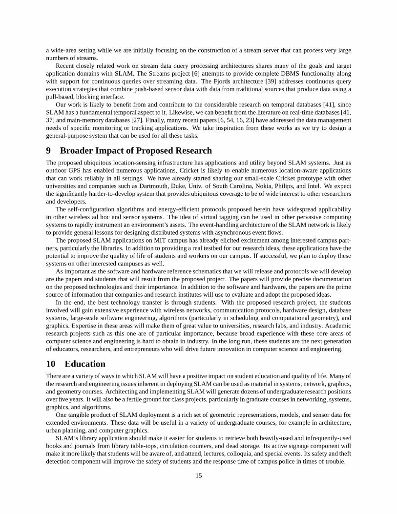
C. Project DescriptionThis is the PIs’ first proposal to NSF on any topic related to this proposal.
1 Motivation and ChallengesSLAM is a scalable location-aware computational network architecture integrating millions of real-world sensors withactuators and software applications. To provide a more specific context, consider a mixed indoor-outdoor architecturalspace extending over hundreds or thousands of meters, with hundreds of distinct buildings, such as a university cam-pus, factory complex, or town. This proposal envisions instrumenting such an environment with an infrastructure for
Scale, # Sensors
Response Time
Days / Hours Minutes Seconds
104
105
106
107 Power, ThermalMonitoring & Control Asset Tracking
Library Usage Motion Detection; Leaks, Floods
Fire Detection;Assisted Evacuation
Physical PlantRepair Orders
Lab Equipment Monitoring Personal Safety;
Active Signage
Personal Systems; Traffic & Parking
HazMat Response; Local NavigationIrrigation
Cricket NetworkSelf−Calibration
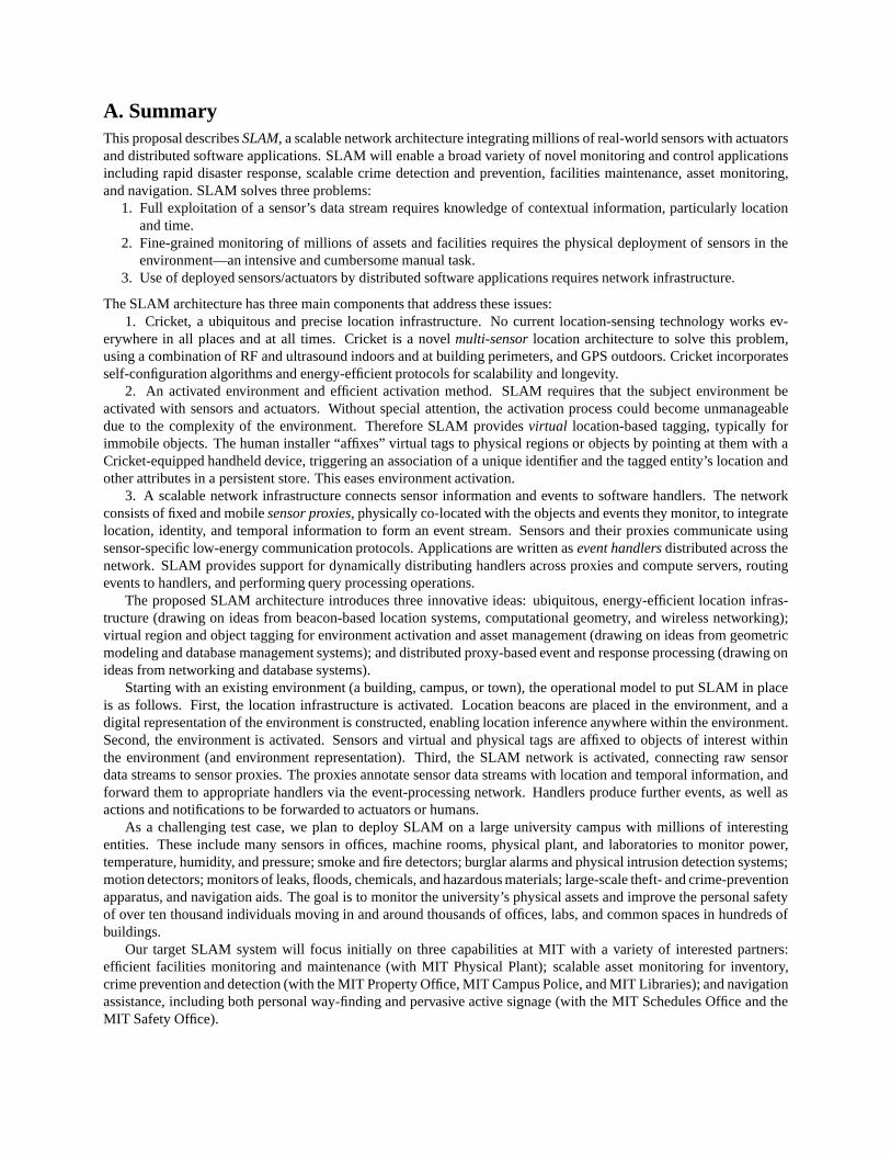
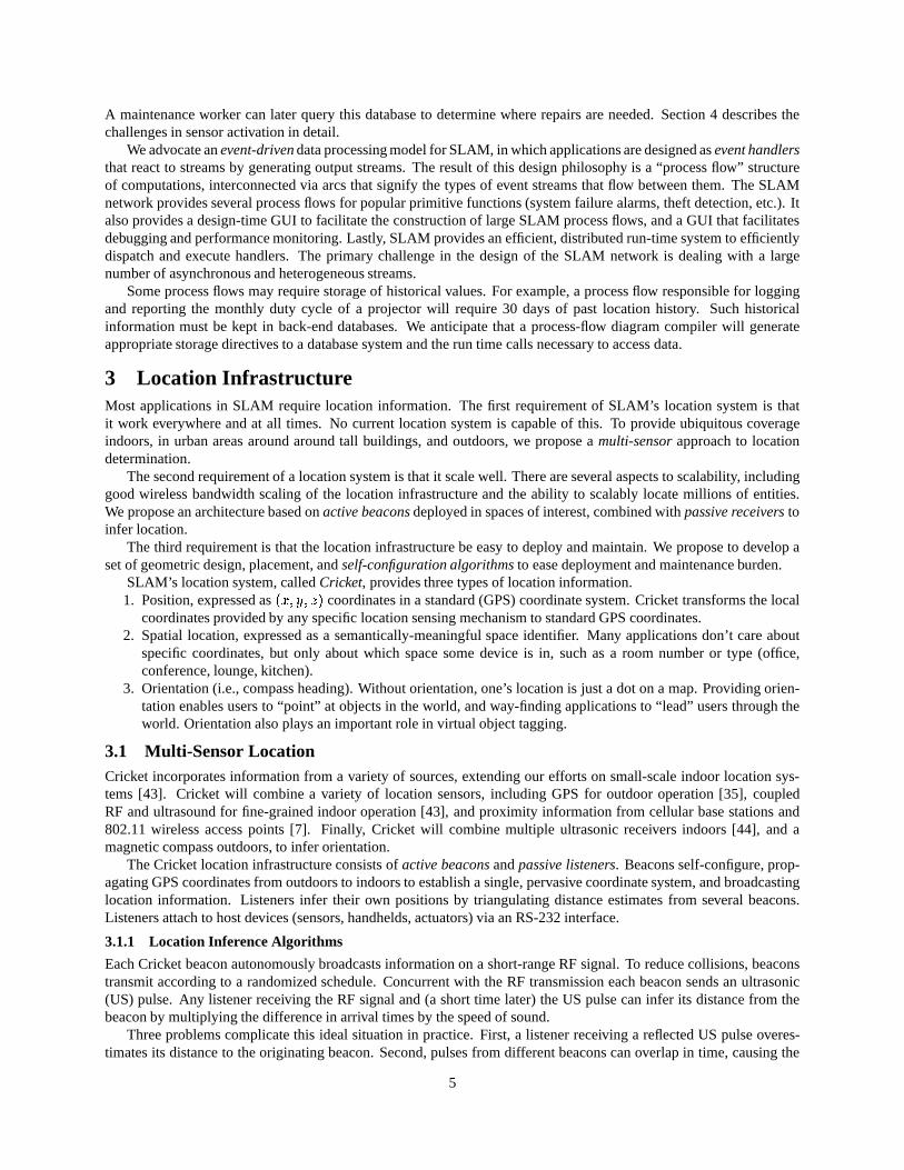
Figure 1: Sensor densities and response rates.
accurate localization, and a wide variety ofsensors to monitor the environment and thethings, resources, and events within it at ap-propriate spatial and temporal granularity(Figure 1).
This section begins with motivatingscenarios that assume that a ubiquitous lo-cation system is in place, and that any sen-sor (temperature, motion, light, moisture,hazmat, handheld PDA) can report its sen-sor reading and approximate location overa passive or active wireless link. This sec-tion describes several motivating applica-tion scenarios. The remainder of the pro-posal describes the central challenges in de-signing, deploying, and using SLAM.
1.1 Safety Scenarios
Personal safety. A student walks through campus, and feels threatened by another individual. The nearest wired “bluephone” to campus police is fifty yards away, but there are wireless panic buttons every five meters on all interior andexterior walls. The student runs, slapping the buttons as he passes. Campus police are alerted, their wall-size campusmap showing the time-trail of the student’s path. Police respond, carrying handheld devices that display the reports ofany nearby motion sensors.
Hazardous material response. An instrumented air filter notices significant deviation from the baseline dis-tribution of particle flow and size distribution, and infers that hazardous materials may have been introduced into abuilding’s air supply. SLAM’s event handler reverses the air flow through this filter, increases the flow through allclean intakes, and alerts the Safety Officer for this space.
The Safety Officer orders evacuation. SLAM’s event handler uses the building space model (air ducts, offices) toestimate the bloom of the hazmat cloud, and generates a customized evacuation route on the fly, minimizing the contactof evacuees with the hazmat cloud. Active signage advertises this route to all passers-by. The SLAM network, in orderto free bandwidth for high-priority traffic from evacuation sensors, motion detectors, etc., quenches all non-criticalsensors in the area.
1.2 Asset Tracking ScenariosAny university or corporate campus has assets: fixed assets, such as electrical and building fixtures; movable (butusually stationary) assets such as furniture, server and desktop computers, and printers; and mobile assets such asvehicles, laptops, and books. Some fixed assets, like landscaping or paint or carpet, are continuous, but can be dividedinto discrete patches by the imposition of a suitable coordinate grid. Even a small organization may have tens ofthousands of such assets; a large campus or company may have tens of millions, depending on the granularity of assettracking. Our example scenarios envision tracking the location and state of every asset, throughout its life-cycle fromperceived need, to acquisition or creation, through installation, use and maintenance, to obsolescence, decommissionand disposal.
In the library. Logging book checkouts is a poor gauge of usage, because books and journals are often pulledfrom the stacks, perused for a few hours in the library, and often mis-shelved. Exploiting each book’s unique-ID tag,
1
the librarian decides to shelve journals in more distant stacks according to their frequency of usage. Users seeking ajournal type its title as usual, and are led to the issue by their handheld. Mis-shelved items are easily located.
In the garage. The service manager checks usage of all vehicles, and dispatches them in order to equalize wearand tear. Each part’s location is tracked and stored, so the parts replacement and repair history for every vehicleis automatically archived. A failure-prediction mechanism, based on usage, nearly eliminates accidents that wouldotherwise have been caused by bad brakes, steering rods, etc.
In the maintenance garage. The service manager checks usage of all vehicles, and dispatches them in order toequalize wear and tear. Each part’s location is tracked and archived, so the parts replacement and repair history forevery vehicle is automatically archived. A failure-prediction mechanism, based on usage, nearly eliminates accidentsthat would otherwise have been caused by worn brakes, tires, and steering rods.
In the parking garage. Every employee has a physical tag on his or her car, and every parking space has anoccupancy sensor. The environment is instrumented with location-sensing hardware. Upon arrival, active signageleads the employee to an open space. The employee’s handheld infers the parking spot chosen. Upon departure, thehandheld leads the employee back to the car. (Note that this scenario does not require that any central database knowthe location or identity of the car or driver. Security and privacy considerations are discussed in Section 6.)
In the office. People at a meeting collaborate by sharing files temporarily with everyone else in the room. Oneperson brings a laptop, and another brings a projector; they infer their mutual proximity and the presentation is routedfrom laptop to projector for display without the need for a physical connection. When a participant prints his notes,they are spooled to the physically nearest printer, and the participant’s handheld directs him to the printer.
Theft prevention. An LCD projector is reserved from the audio-visual department for use within the samebuilding. A theft-tracking process monitors the location of the projector and discovers it moving outside the buildingtoward the edge of campus. The reserver is notified, and if the motion is not approved, the police are called.
1.3 Physical Plant Maintenance ScenariosThe fire marshal, during a routine inspection, notices some hazardous electrical wiring. She points her handheld device,running the safety inspection application, at the problem. The device infers its own location and orientation, retrievesa geometric model of the building from the network, and displays a few candidate assets (sprinkler system, wiring,fire alarm, blocked exit) for maintenance tagging. The marshal selects the wiring. A virtual position-based “tag” isattached to these wires in the asset database, amending the asset log and calling for maintenance.
A physical plant supervisor spots a broken banister in a stairwell. She points her handheld device, running themaintenance inspection application, at the banister. The device localizes itself in a CAD model of the building, displaysa few candidate assets for maintenance tagging (floor tiles, banisters, wall paint). She indicates the banister. A virtual(position-based) tag is attached to the banister in the asset database, amending the asset log and calling for maintenance.
A pump monitor detects unusual behavior, and adds a task to the database with an estimated priority. In extremecircumstances, the device generates active signage events to warn all people currently in the building that it is unsafe,and alerts physical plant. Flow to the pump is reduced if possible.
1.4 Local Navigation ScenariosA mobility-impaired student in a wheelchair wishes to get from his dorm room to an appointment with student services.He indicates his destination to his handheld, which then leads him to his appointment, avoiding stairs and currentconstruction areas (updated frequently by Physical Plant).
A colloquium is about to start in a building conference room. For a half-hour before the talk starts, active signagedisplays the talk title, speaker and abstract, and directions to the room. Users with handheld devices get talk notifica-tions and directions as well. Scaling up, a tour group of fifty people arrives on campus, and is given handheld deviceswith which to take a self-guided tour. Tour-planning software routes them through the campus while keeping themaway from other groups and congested hallways. Scaling up again, commencement is scheduled and 5,000 guests areexpected. Vehicle traffic, car parking, pedestrian traffic, and seating are monitored, and smart signage directs arrivingdrivers to available parking and walkers to free seats.
1.5 Fundamental ChallengesThe SLAM architecture addresses three principle challenges in realizing these scenarios.
First, full exploitation of a sensor data stream requires knowledge of contextual information, particularly locationand time. While the Global Positioning System (GPS) supports reasonably accurate position estimation in many
2
outdoor settings, it fails near and inside most buildings and in urban areas. We propose a novel multi-sensor locationarchitecture, Cricket, that solves this problem in a scalable manner, by deploying beacons in the environment andconstructing a digital representation of the environment. Cricket uses a combination of RF, ultrasound, and GPS-based sensing technologies; it incorporates self-configuration algorithms and energy-efficient protocols for scalabilityand longevity. Section 3 describes the location infrastructure and associated research challenges, including scalablelocation inference algorithms, self-configuration algorithms, and energy-efficient beacon scheduling.
Second, fine-grained monitoring of millions of assets and facilities requires the physical deployment of sensorsin the environment—an intensive and cumbersome manual task. SLAM addresses this with a scalable environmentactivation method. In addition to lightweight physical sensors and tags affixed to mobile objects of interest, SLAMuses an efficient activation method based on virtual tags. Here, a human installer points a Cricket-equipped handheldat a region or object, after which the system associates the object’s location with other attributes in persistent storage.Section 4 describes environment activation and associated research challenges.
Third, for remote monitoring and control of sensors and actuators, they must be networked to software entitiesthat can process the data they provide and take appropriate action. This requires progress on three fronts: (1) gettingthe raw data produced by sensors onto a network, (2) annotating raw sensor data with contextual information such asdata origin, location, and time, and (3) passing sensor event streams to software handlers that process this information,generating events for other software agents, actuators, or humans. SLAM’s network architecture has two levels. Thefirst level consists of sensor proxies that gather and annotate raw sensor data into location-stamped and time-stampedstreams. The second level consists of a scalable event delivery and processing network, interconnecting softwarehandlers with proxies, actuators, and (through displays) interested human parties. Section 5 discusses the SLAMnetwork and associated research challenges.
Our proposal builds on ideas and techniques from other fields including sensor networking, location sensing, com-putational geometry, geometric modeling, scalable wireless networking, and database management systems. Section 8summarizes related work.
2 System ArchitectureEntities in the environment—sensors (e.g., temperature, pressure, humidity, smoke, chemical) and actuators (e.g., con-trol elements in physical plant and machine rooms), equipment (e.g., monitors, projectors, laptops, etc.), and otheritems (e.g., books in libraries, personal assets, etc.)—must be monitored in a scalable way, and useful status infor-mation about them integrated into application software. Application software can then use the stream of entity statusinformation to take appropriate action for any event.
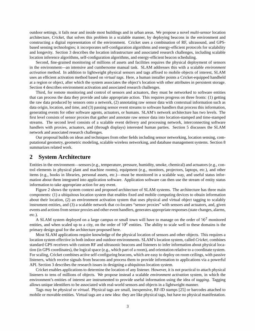
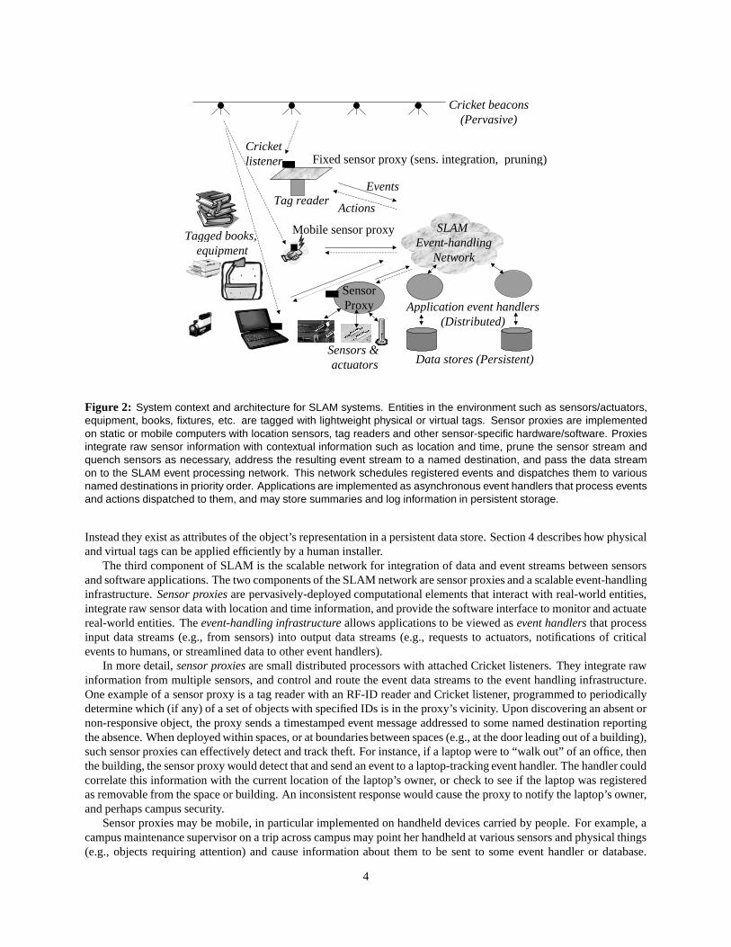
Figure 2 shows the system context and proposed architecture of SLAM systems. The architecture has three maincomponents: (1) a ubiquitous location system that enables fixed and mobile computing devices to obtain informationabout their location, (2) an environment activation system that uses physical and virtual object tagging to scalablyinstrument entities, and (3) a scalable network that co-locates “sensor proxies” with sensors and actuators, and, givenevents and actions from sensor proxies and other event handlers, generates appropriate responses (state changes, alarms,etc.).
A SLAM system deployed on a large campus or small town will have to manage on the order of�����
monitoredentities, and when scaled up to a city, on the order of
�����entities. The ability to scale well to these domains is the
primary design goal for the architecture proposed here.Most SLAM applications require knowledge of the physical location of sensors and other objects. This requires a
location system effective in both indoor and outdoor environments. SLAM’s location system, called Cricket, combinesstandard GPS receivers with custom RF and ultrasonic beacons and listeners to infer information about physical loca-tion (in GPS coordinates), the logical space (e.g., which part of a room), and orientation relative to a coordinate system.For scaling, Cricket combines active self-configuring beacons, which are easy to deploy on room ceilings, with passivelisteners, which receive signals from beacons and process them to provide information to applications via a powerfulAPI. Section 3 describes the research issues in designing a ubiquitous location system.
Cricket enables applications to determine the location of any listener. However, it is not practical to attach physicallisteners to tens of millions of objects. We propose instead a scalable environment activation system, in which theenvironment’s entities of interest are instrumented to provide useful information using the idea of tagging. Taggingallows unique identifiers to be associated with real-world sensors and objects in a lightweight manner.
Tags may be physical or virtual. Physical tags are small, inexpensive, RF-ID stamps [25] or barcodes attached tomobile or movable entities. Virtual tags are a new idea: they are like physical tags, but have no physical manifestation.
3
Cricket beacons(Pervasive)
Fixed sensor proxy (sens. integration, pruning)Cricket listener
Tag reader
Mobile sensor proxyTagged books, equipment
Sensors & actuators
SLAM Event-handling
Network
Application event handlers(Distributed)
Data stores (Persistent)
Actions
Events
SensorProxy
Figure 2: System context and architecture for SLAM systems. Entities in the environment such as sensors/actuators,equipment, books, fixtures, etc. are tagged with lightweight physical or virtual tags. Sensor proxies are implementedon static or mobile computers with location sensors, tag readers and other sensor-specific hardware/software. Proxiesintegrate raw sensor information with contextual information such as location and time, prune the sensor stream andquench sensors as necessary, address the resulting event stream to a named destination, and pass the data streamon to the SLAM event processing network. This network schedules registered events and dispatches them to variousnamed destinations in priority order. Applications are implemented as asynchronous event handlers that process eventsand actions dispatched to them, and may store summaries and log information in persistent storage.
Instead they exist as attributes of the object’s representation in a persistent data store. Section 4 describes how physicaland virtual tags can be applied efficiently by a human installer.
The third component of SLAM is the scalable network for integration of data and event streams between sensorsand software applications. The two components of the SLAM network are sensor proxies and a scalable event-handlinginfrastructure. Sensor proxies are pervasively-deployed computational elements that interact with real-world entities,integrate raw sensor data with location and time information, and provide the software interface to monitor and actuatereal-world entities. The event-handling infrastructure allows applications to be viewed as event handlers that processinput data streams (e.g., from sensors) into output data streams (e.g., requests to actuators, notifications of criticalevents to humans, or streamlined data to other event handlers).
In more detail, sensor proxies are small distributed processors with attached Cricket listeners. They integrate rawinformation from multiple sensors, and control and route the event data streams to the event handling infrastructure.One example of a sensor proxy is a tag reader with an RF-ID reader and Cricket listener, programmed to periodicallydetermine which (if any) of a set of objects with specified IDs is in the proxy’s vicinity. Upon discovering an absent ornon-responsive object, the proxy sends a timestamped event message addressed to some named destination reportingthe absence. When deployed within spaces, or at boundaries between spaces (e.g., at the door leading out of a building),such sensor proxies can effectively detect and track theft. For instance, if a laptop were to “walk out” of an office, thenthe building, the sensor proxy would detect that and send an event to a laptop-tracking event handler. The handler couldcorrelate this information with the current location of the laptop’s owner, or check to see if the laptop was registeredas removable from the space or building. An inconsistent response would cause the proxy to notify the laptop’s owner,and perhaps campus security.
Sensor proxies may be mobile, in particular implemented on handheld devices carried by people. For example, acampus maintenance supervisor on a trip across campus may point her handheld at various sensors and physical things(e.g., objects requiring attention) and cause information about them to be sent to some event handler or database.
4
A maintenance worker can later query this database to determine where repairs are needed. Section 4 describes thechallenges in sensor activation in detail.
We advocate an event-driven data processing model for SLAM, in which applications are designed as event handlersthat react to streams by generating output streams. The result of this design philosophy is a “process flow” structureof computations, interconnected via arcs that signify the types of event streams that flow between them. The SLAMnetwork provides several process flows for popular primitive functions (system failure alarms, theft detection, etc.). Italso provides a design-time GUI to facilitate the construction of large SLAM process flows, and a GUI that facilitatesdebugging and performance monitoring. Lastly, SLAM provides an efficient, distributed run-time system to efficientlydispatch and execute handlers. The primary challenge in the design of the SLAM network is dealing with a largenumber of asynchronous and heterogeneous streams.
Some process flows may require storage of historical values. For example, a process flow responsible for loggingand reporting the monthly duty cycle of a projector will require 30 days of past location history. Such historicalinformation must be kept in back-end databases. We anticipate that a process-flow diagram compiler will generateappropriate storage directives to a database system and the run time calls necessary to access data.
3 Location InfrastructureMost applications in SLAM require location information. The first requirement of SLAM’s location system is thatit work everywhere and at all times. No current location system is capable of this. To provide ubiquitous coverageindoors, in urban areas around around tall buildings, and outdoors, we propose a multi-sensor approach to locationdetermination.
The second requirement of a location system is that it scale well. There are several aspects to scalability, includinggood wireless bandwidth scaling of the location infrastructure and the ability to scalably locate millions of entities.We propose an architecture based on active beacons deployed in spaces of interest, combined with passive receivers toinfer location.
The third requirement is that the location infrastructure be easy to deploy and maintain. We propose to develop aset of geometric design, placement, and self-configuration algorithms to ease deployment and maintenance burden.
SLAM’s location system, called Cricket, provides three types of location information.1. Position, expressed as ����������� coordinates in a standard (GPS) coordinate system. Cricket transforms the local
coordinates provided by any specific location sensing mechanism to standard GPS coordinates.2. Spatial location, expressed as a semantically-meaningful space identifier. Many applications don’t care about
specific coordinates, but only about which space some device is in, such as a room number or type (office,conference, lounge, kitchen).
3. Orientation (i.e., compass heading). Without orientation, one’s location is just a dot on a map. Providing orien-tation enables users to “point” at objects in the world, and way-finding applications to “lead” users through theworld. Orientation also plays an important role in virtual object tagging.
3.1 Multi-Sensor LocationCricket incorporates information from a variety of sources, extending our efforts on small-scale indoor location sys-tems [43]. Cricket will combine a variety of location sensors, including GPS for outdoor operation [35], coupledRF and ultrasound for fine-grained indoor operation [43], and proximity information from cellular base stations and802.11 wireless access points [7]. Finally, Cricket will combine multiple ultrasonic receivers indoors [44], and amagnetic compass outdoors, to infer orientation.
The Cricket location infrastructure consists of active beacons and passive listeners. Beacons self-configure, prop-agating GPS coordinates from outdoors to indoors to establish a single, pervasive coordinate system, and broadcastinglocation information. Listeners infer their own positions by triangulating distance estimates from several beacons.Listeners attach to host devices (sensors, handhelds, actuators) via an RS-232 interface.
3.1.1 Location Inference Algorithms
Each Cricket beacon autonomously broadcasts information on a short-range RF signal. To reduce collisions, beaconstransmit according to a randomized schedule. Concurrent with the RF transmission each beacon sends an ultrasonic(US) pulse. Any listener receiving the RF signal and (a short time later) the US pulse can infer its distance from thebeacon by multiplying the difference in arrival times by the speed of sound.
Three problems complicate this ideal situation in practice. First, a listener receiving a reflected US pulse overes-timates its distance to the originating beacon. Second, pulses from different beacons can overlap in time, causing the
5

listener to wrongly associate the RF from one beacon with the ultrasonic signal from another. Third, the speed of soundis not constant, but varies with air pressure (which depends on temperature, weather, altitude, etc.).
These factors require inference algorithms at the listener to distinguish true samples from spurious ones. Ourcurrent solutions to this problem use simple statistics, but do not scale well to more than a small number of beacons.
Scalable inference. Given a set of beacons transmitting on an unknown randomized schedule, obtain atime series of distance samples. Develop an online algorithm to obtain best distance estimates to eachbeacon within a configurable time period � .
Two observations apply in the design of an efficient algorithm for this problem. First, reflections cause the statisticsof observed samples to be multi-modal. Second, there is a trade-off between the value of � and the precision of theestimate; the bigger � , the better the estimate in general, as long as the device does not move.
Location estimates arriving from different sensors (RF � US and GPS) must be combined. However, the error ineach estimate is unknown. We plan to experiment with sensor fusion algorithms to achieve reliable end-to-end locationcapability from multiple uncertain position estimates.
Different location technologies have different coordinate systems. For instance, a coupled RF � ultrasound tech-nology deployed in a building will in general have a different native origin and orientation than GPS. However, forapplications to work seamlessly across multiple technologies, having a unified coordinate space is important. We planto propagate GPS information from outdoors to indoors, to establish GPS coordinates pervasively through buildinginteriors and other areas where GPS fails.
Coordinate space fusion. Consider a network of beacons, each of which knows its approximate locationsin one or more coordinate spaces, and only some of which can communicate. Design a distributed match-ing algorithm to find rigid transforms that unify the location systems to a single coordinate space, in sucha way that is robust to errors and transient outliers.
3.1.2 Energy-efficiency
Beacons will typically not have wired power, so will have to run for months or years on power from batteries or smallsolar cells. Thus beacons must be energy-efficient. This leads to an intriguing distributed scheduling problem, sincebeacons do not need to be on and broadcasting at all times. Indeed, as the number of beacons in a vicinity increases,the expected frequency at which each beacon must broadcast decreases.
Energy Scheduling. Design a distributed constraint scheduling algorithm that determines, for each bea-con, when it should be awake and broadcasting. The constraint is that any mobile device in any positionshould be able to hear the necessary number of devices within a given time bound � . Thus several bea-cons can time-share the burden of coverage. One key issue in this problem is whether beacons can sharea central clock.
A central theme in our proposed solutions to these problems is to use randomization and proximity informationto avoid synchrony in time gaps which would lead to poor time coverage. For example, for the simple situation inwhich beacons are uniformly distributed throughout the space, a reasonable approach to scheduling is that each beaconbroadcasts every � �������� time units, where � is the average density of beacons heard by a mobile device. The problembecomes significantly more complex with varying densities of beacons and ranges through variable media (air vs.walls).
3.2 Location Infrastructure ActivationThe previous section addressed run-time issues in Cricket. This section discusses activating the location infrastructurewith minimal human effort. Beacons must be placed in a way that demarcates the meaningful spaces in an environment,and that ensures that any listener will hear enough beacons to determine its own position. Once placed, each beaconmust be configured with the position and space it inhabits.
3.2.1 Beacon Placement
A strength of the Cricket architecture is that beacons can be placed on ceilings and walls without precise calibrationor wiring, but the placement is not completely arbitrary. If two parts of a room must be distinguished, then beaconsshould be placed at roughly equal distances from the desired boundary, such that a listener anywhere can use the closestbeacon to infer which space it is in.
To deduce its position, a listener requires distance estimates from three or more beacons [44]. This at least threebeacons must be visible to, and in range of, every possible listener location. Deducing orientation is harder: at leastone of the beacons must be at an angle of �� or less from the listener (which uses several closely-spaced receivers inan asymmetrical configuration [44]).
6

Scalable Beacon Placement. Design an efficient beacon placement algorithm that positions the fewestpossible beacons in a building with specified floorplan or 3D model, so that an arbitrarily placed mobiledevice is within appropriate range � of enough beacons subject to the above constraints.
The placement problem is closely related to guarding and visibility in computational geometry [9, 51]. In particular,much is known about the simple version of scalable beacon placement in which ����� and only one beacon must beseen from any location [31, 40]. We propose to build on these results to solve the more general problem. In particular,we will analyze the computational complexity of the problem, design simple algorithms with good worst-case bounds,and design approximation algorithms that guarantee good performance in all situations (not just the worst case).
For practical use, the following harder problem needs to be solved.Incremental Placement. Design an incremental placement algorithm for positioning additional beaconsto improve coverage beyond an existing partial placement.
We will develop a greedy algorithm that, given an existing beacon constellation, computes the positioning of ��� �
additional beacons that will yield the greatest coverage benefit. We expect that a useful tool to solve this problem is thefarthest-point Voronoi diagram [42]. We envision the algorithm running on-line on the handhelds of a human installer,giving him/her guidance as to where to place the next beacon.
3.2.2 Automating Beacon Configuration
Two pieces of information must be configured into each beacon: its ����� � ��� coordinates in some coordinate system,and the space the beacon is in (e.g., building and room number). Manual configuration is infeasible even for a fewhundred beacons. Therefore we plan to develop self-calibrating beacon networks, robust to incremental insertion,deletion, and motion of beacons.
Our self-configuration strategy is to bootstrap a rigid, global coordinate system solely from inter-beacon distances.For example, given four beacons that are pairwise within range to communicate, the measured distances encode arigid tetrahedron, from which we can compute a local coordinate frame common to all four beacons. This frame isdetermined up to an unknown absolute translation and rotation; GPS coordinates of any three beacons suffice to pinthese remaining degrees of freedom. In the general setting, there are thousands of beacons, most within range of onlya constant number of other beacons, and only a small fraction of which know their GPS locations. We can representthe beacon network as an undirected graph, and propagate local and global coordinate information to arrive at a single,globally consistent position estimate for each beacon [3, 4].
This problem is fundamentally connected to rigidity theory, an area of combinatorial geometry [18, 19]. Specif-ically, a beacon connectivity graph and measured distances along each edge determine a unique coordinate frameprecisely if that metric graph has a unique geometric realization in � . Normally it suffices for the graph to be rigid oreven infinitesimally rigid, both of which are well-studied concepts [17]). We believe that many algorithmic tools fromrigidity theory can be adapted to our setting.
Beacon-centric self-calibration. Design a distributed constraint-satisfaction algorithm that runs acrossall beacons, detecting and exploiting redundant coverage to improve end-to-end accuracy.
The system should also be robust to movement of the beacons. To achieve this, each beacon will periodicallyinfer its own location from that of its neighbors. Gross inconsistency will trigger a local or global re-execution of theself-configuration phase.
It is impossible to have a fully self-configuring mechanism for spaces, since they require semantic knowledge ofhow people demarcate and name spatial regions. However, we envision a method in which a human moves through aspace, informing each beacon of which space it is in. A simple graphical or voice interface on the handheld enablesthe installer to indicate the identity, boundaries, and adjacencies of each space by interaction with or physical motionof the handheld.
3.3 Scaling and Privacy ConsiderationsCricket’s use of active beacons and passive listeners scales well: each beacon need interact with a constant numberof other beacons within range, and an unlimited number of listeners can operate in the same space at the same time.This is in contrast to affixing to each object an active transponder which periodically transmits its ID to a centralizedlocation [32]. While this approach enables tracking, it does not scale well, nor does it protect user privacy.
Section 4 describes SLAM’s virtual tagging to scale to large numbers of entities without requiring that every entityhave a Cricket listener attached.
Our proposed architecture enables applications to preserve user privacy. This issue is addressed in detail in Sec-tion 6.
7
4 Activated EnvironmentsSection 3 described “location activation”: the process of placing position beacons into a physical environment in orderto enable space and location inference by a handheld mobile listener, and constructing a functional data representationof the spaces and adjacencies within the environment. Analogously, this section describes “environment activation”:first, the placement of physical and virtual identity tags into the environment and environment representation respec-tively; and second the deployment of fixed and mobile proxy sensors, physically co-located with the objects and eventsthey are to monitor, which integrate identity, location, and temporal information to form an event stream for processingby the SLAM network (Section 5).
Just as a human activator delineated physical spaces to construct the environment model, we envision the activatormoving through the environment, activating sensors and objects of interest within each space. Each activation involvesaffixing a virtual “tag” to fixed objects, and a physical tag to moveable objects.
4.1 Virtual TagsVirtual tags are unique IDs attached to immobile objects. The tag is virtual because it does not require the physicalapplication of tags to objects. The human installer moves through the space, affixing virtual tags to each object ofinterest, and indicating each object’s type to the handheld device. Each tag includes a unique identifier, which SLAMthereafter persistently associates with the object and its location. (Note that virtual tags can never be lost forever, asthey can be reacquired simply by making a spatial query in the vicinity of the fixed object.) Indoors, for example, theactivator could tag power outlets, data jacks, lighting fixtures and switches, air vents, water sources and drains, etc.Outdoors, the activator could tag sewer drains, lighting poles, emergency phones, signage, etc.
Virtual tagging requires a fine-grained location infrastructure that provides reasonably accurate orientation infor-mation. We propose to use the Cricket compass facility for this.
4.2 Physical TagsA physical tag is small and cheap, and encodes a unique bar-coded digital ID (e.g., a 64-bit number). It can reply withits ID [25] to an RF query. The activator would apply physical ID tags to printers, laptops, phones, lab equipment,etc., informing the database of the object’s existence, type, and location. Note that environment activation can be done“lazily,” that is, in order of importance and necessity, and can be done in parallel by any number of installers, so longas they assign globally unique identifiers.
Activation populates the environment model with objects that are already in place: workstations, printers and thelike. Physical tags could also be attributed by type and applied to objects as they are put in place; as they are receivedat the building’s loading dock; or even at each object’s point of manufacture.
4.3 ReadersOne goal of SLAM is scaling to millions of entities, each with an identity and location. It is not feasible at present toattach location-sensing hardware to every entity of interest in a large campus, but we are still interested in where theyare located with high precision. For this purpose we define sensor proxies, run on fixed or mobile location-enableddevices, which annotate incoming data streams with location information, and forward the annotated streams. Section5.1 discusses this in detail.
One important class of sensor proxy is a reader, which combines location sensing with the ability to read RF-IDsor optical bar-codes. This achieves scalable deployment in a two-level hierarchy. At the lowest level, every entity has acheap (less than US $0.10) and tiny RF-ID tag or bar code. At the next level, a reader is responsible for keeping trackof entities in any given space. Because each reader has Cricket’s location-sensing hardware attached, it is possible todetermine the location of any tagged object, at any time, in a scalable manner.
Readers can be deployed in both fixed and mobile configurations. Fixed readers can perform continuous monitoringfunctions, by repeatedly querying objects, and raising an alarm if an object fails to respond or is detected in an illegallocation. Mobile readers can be used to “promote” dumb (RF-ID only) objects to first-class location-tagged objects:the object provides its ID, and the reader annotates it with location (using Cricket) and the object’s characteristics(from the database). This simple method of attaching lightweight tags combined with tag readers instrumented withsophisticated location-sensing hardware allows a scalable system to be achieved in practice.
4.4 MappingThe combination of virtual tagging and a location system can be used to develop a good mapping service for anyenvironment. This service will provide representations of architectural spaces together with the objects situated in each
8
space. This information is useful for developing user interfaces and for enabling system administrators to determinewhere to deploy additional sensors, actuators, or other entities.
We envision this mapping service constantly running in the background on the network, updating spatial repre-sentations as objects are added or removed from any environment. We choose a representation based on architecturalspaces [51, 11], grouped by function and delineated in a common coordinate frame. For example, the indoor envi-ronment is partitioned into regions roughly corresponding to offices, corridors, conference rooms, lounges, elevatorshafts, and the like. Analogously, outdoor spaces are represented by conceptual and functional grouping as courtyards,alleys, sidewalks, streets and the like. Indoor-outdoor and transitional spaces, such as entry stairs and ramps, foyers,and loading docks, are also represented. At a building system level, mains and ducts for air, water, power, data, and thelike are represented. Depending on function, other elements such as openable windows may be represented as well.
Spaces and physical assets within them are represented as nodes in a multi-valued adjacency graph whose edgesarise from the functional relationship of the space or asset to others in the representation. So, for example whenrepresenting pedestrian traffic, a corridor space shares an adjacency graph edge with every office reachable from thecorridor, but two offices sharing a wall do not share such an edge, since to move from one office to the other a personwould have to move through the common corridor. A graph over the same set of nodes (spaces), but representing airsupply, does introduce an edge between the two offices, if they share ventilation ducting (enabling air to move directlyfrom one office to the other). An openable window would induce an adjacency edge between an office and outdoorspace for evacuation planning purposes, to model air flow, or to evaluate security against theft, but not for ordinaryentrance to the office.
The deployment of a ubiquitous location system such as Cricket makes the acquisition problem significantly eas-ier. A human installer can simply move through the environment, waving his hand-held around in each space whileindicating the type of space he is in. Objects in the vicinity will be automatically discovered and sent to the mappingdatabase. A geometric post-processing step would then organize all this information into a map of the space.
5 The SLAM NetworkThis section describes the research challenges and proposed solutions in the design of the SLAM network. Thisnetwork has a two-level structure. The first level interconnects sensors with co-located sensor proxies, so that the rawdata from the sensors can be annotated with contextual information (location, time, etc.) and converted into eventstreams that can be handled by other software components. The second level of the network provides a large-scaleevent-processing infrastructure to match events with appropriate handlers, and deliver event responses and actions toother handlers, actuators, or humans. The proposed design of the SLAM network involves a novel integration of ideasfrom two research communities—networking and database systems—with the intersection coming at the combinationof event routing and sensor flow control with query processing and optimization.
5.1 Sensor ProxiesAn activated environment is full of tagged objects and sensors reporting object and environmental status. We introducesensor proxies to organize this mass of raw, distributed, transient sensor data into a scheduled, spatio-temporallyindexed event stream. An event stream in SLAM is a raw sensor data integrated with identity, location, and timestampinformation.
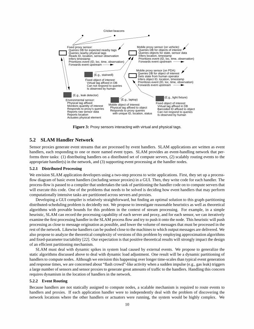
Proxies can be fixed, i.e., attached to the physical environment, or mobile, for example, attached to a handhelddevice or to a maintenance vehicle. Figure 3 illustrates some example proxy sensor configurations. In addition toannotating raw sensor data with contextual information to produce a data stream, sensor proxies implement sensor-specific communication protocols to communicate with sensors. The main issue in these protocols is energy-efficiency.
With current technology trends, it usually takes a lot more energy to transmit/receive data than perform someamount of computation, e.g., to fuse redundant sensor streams [33, 38]. In SLAM, we propose to build on this previouswork to develop sensor-specific fusion algorithms that will reduce the amount of information being transmitted at theexpense of some computation on the proxy. This is a well-known idea; our contribution will be to develop this furtherin the context of specific sensors—tags and location sensors in particular.
The other important function performed by sensor proxies relates to flow control, where they receive messagesfrom handlers in the network that request that certain sensors be quenched because the information they provide isredundant or resource-intensive.
9
Cricket beacons
Fixed proxy sensor: Queries DB for expected nearby tags Queries nearby physical tags Reads ID, location, sensor observation Infers timestamp Prioritizes event (ID, loc, time, observation) Forwards event upstream
Environmental sensor: Physical tag affixed Monitors quantity of interest Responds to proxy’s queries Reports raw sensor data Reports location Actuates physical element
Fixed object of interest: Virtual tag affixed in DB Can not respond to queries Is observed by human
Mobile proxy sensor (on PDA): Queries DB for object of interest Gets state from human operator Infers object ID, location, timestamp Prioritizes event (ID, loc, time, observation) Forwards event upstream
Mobile proxy sensor (on vehicle): Queries DB for objects of interest Queries objects for state, sensor data Infers location, timestamp Prioritizes event (ID, loc, time, observation) Forwards event upstream
Fixed object of interest: Virtual tag affixed in DB Barcoded ID affixed to object Can not respond to queries Is observed by human
Mobile object of interest: Physical tag affixed to object Responds to proxy queries with unique ID, location, status
(E.g., laptop)
(E.g., leak detector)(E.g., light fixture)
(E.g., stairwell)
Figure 3: Proxy sensors interacting with virtual and physical tags.
5.2 SLAM Handler NetworkSensor proxies generate event streams that are processed by event handlers. SLAM applications are written as eventhandlers, each responding to one or more named event types. SLAM provides an event-handling network that per-forms three tasks: (1) distributing handlers on a distributed set of compute servers, (2) scalably routing events to theappropriate handler(s) in the network, and (3) supporting event processing at the handler nodes.
5.2.1 Distributed Processing
We envision SLAM application developers using a two-step process to write applications. First, they set up a process-flow diagram of basic event handlers (including sensor proxies) in a GUI. Then, they write code for each handler. Theprocess-flow is passed to a compiler that undertakes the task of partitioning the handler code on to compute servers thatwill execute this code. One of the problems that needs to be solved is deciding how event handlers that may performcomputationally intensive tasks are partitioned across servers and proxies.
Developing a GUI compiler is relatively straightforward, but finding an optimal solution to this graph-partitioningdistributed-scheduling problem is decidedly not. We propose to investigate reasonable heuristics as well as theoreticalalgorithms with provable bounds for this problem in the context of stream processing. For example, in a simpleheuristic, SLAM can record the processing capability of each server and proxy, and for each sensor, we can iterativelyexamine the first processing handler in the SLAM process flow and try to push it onto the node. This heuristic will pushprocessing as close to message origination as possible, and lower the volume of messages that must be processed in therest of the network. Likewise handlers can be pushed close to the machines to which output messages are delivered. Wealso propose to analyze the theoretical complexity of versions of this problem by employing approximation algorithmsand fixed-parameter tractability [22]. Our expectation is that positive theoretical results will strongly impact the designof an efficient partitioning mechanism.
SLAM must deal with dynamic spikes in system load caused by external events. We propose to generalize thestatic algorithms discussed above to deal with dynamic load adjustment. One result will be a dynamic partitioning ofhandlers to compute nodes. Although we envision this happening over longer time-scales than typical event generationand response times, we are concerned about “flash crowd”-like activity when a sudden impulse (e.g., gas leak) triggersa large number of sensors and sensor proxies to generate great amounts of traffic to the handlers. Handling this concernrequires dynamism in the location of handlers in the network.
5.2.2 Event Routing
Because handlers are not statically assigned to compute nodes, a scalable mechanism is required to route events tohandlers and proxies. If each application handler were to independently deal with the problem of discovering thenetwork locations where the other handlers or actuators were running, the system would be highly complex. We
10
therefore propose to provide a discovery mechanism in the SLAM network in which desired destination handlers aresimply named, and the network takes care of routing the messages to the appropriate places in a scalable manner. Inaddition to unicast message routing, events may have to be replicated to route to multiple handlers.
We propose to investigate several different ways of solving the scalable routing problem. The simplest approachwould be to maintain this information in the centralized process-flow GUI and, each time a handler moves in thenetwork, update this information in the GUI. New handlers can now be easily added to the GUI and the appropriatenetwork plumbing between handlers set up.
For long-running SLAM systems, and in systems where trusted third parties may introduce themselves in the streamflow to observe streams of interest, it may not always be possible to maintain and update a centralized GUI. We requirea distributed and scalable discovery protocol that can return where named event handlers are currently running. Wepropose to investigate this by deriving inspiration from distributed service [1, 8, 20] and document discovery [24, 30]protocols. In particular, we will investigate the design of a scalable and dynamic event routing mechanism layered overa scalable peer-to-peer key-value lookup protocol such as Chord [49], CAN [45], Pastry [46], or Tapestry [55].
5.2.3 Event Handling
Choice of primitive handlers. Although it is reasonable for a SLAM application developer to construct his/her ownhandlers from scratch to implement any desired functionality, SLAM should provide a palette of useful parameter-ized handlers to perform common event stream manipulation functions. This is analogous to the primitive operationsprovided by relational database systems, such as join, project, and select.
One clearly desirable primitive operation is to match up the streams of messages produced by two sensors or twointermediate handlers, as well as to merge two streams. For example, one might want to know if a laptop and its powercord are in the same room. This requires matching two streams on common geographic location. However, messagesin SLAM are asynchronous, and the two streams may report values at different times. As such, we need to generalizethe traditional notion of join into a windowed operation, in which two values can be joined together if their valuesmatch within a predetermined time window. A second challenge is that some sensors are imprecise, especially forlocation. Relational database systems have traditionally assumed that data items have exact values. In SLAM, we haveto generalize operations to work on imprecise data elements.
Other primitive operations include delaying an event response until some condition is true, such as the arrival ofanother event; value interpolation, so that a stream can provide a value between measurements; and applying a user-defined function over the historical values in a stream. Providing a primitive handler in each case that is parameterizedby a function definition will allow handler support code to deal with necessary data storage, and let the user concentrateon the specific function.
Query processing and optimization. In a large SLAM network, we expect to have thousands, if not hundreds ofthousands, of handlers. Handlers in the application’s workflow will routinely generate events and query each other.Combining all the handlers into a massive query and then applying conventional query optimization is not a workableapproach. Instead, SLAM must focus on a collection of alternate tactics.
First, it will often be useful to combine multiple handlers together and co-locate them. Whenever handlers arecommutative, the cheaper one can be moved forward to be performed in advance of the more expensive one. Althoughthis is generally a good tactic, it must be used with care, because there will be handlers that generate more messagesthan they consume. In this case, a more complex test for reordering must be applied.
Another optimization tactic is to use special data structures to speed up interpretation. Consider the situation inwhich a handler’s output is split a number of times and sent to a large collection of subsequent handlers. Moreover,suppose each handler is some sort of filter operation. In the MIT power plant, for example, there might be manydifferent actions to take, depending on the value of an input sensor. In this case, it is possible to assemble all thefilters into a single “superhandler,” supported by an R-tree or other spatial index. The superhandler inserts incomingvalues into the R-tree in order to discover which processing handlers must be activated. We propose to investigate datastructures of this sort that can accelerate processing of a SLAM network.
We also propose to examine the tradeoff between storing values and recomputing them. As mentioned earlier,windowed operations require SLAM to maintain a database of historical values to be used by handler operations. Thebasic tactic to be explored is to move one or more data sets in this database from their current location between twooperators, to a position earlier in the diagram. This will force SLAM to reprocess intervening handlers, thereby addingto the processing load. On the other hand, the total amount of storage required may be reduced.
Ad-hoc queries. Users and administrators may wish to make ad-hoc queries of a running SLAM system, not aspart of the application workflow. One obvious way to do this is to allow a casual user to add handlers to a runningSLAM system. However, the previous section indicated that handlers may be moved around and combined. Hence, the
11

SLAM stream to which the casual user connects may not exist in the operational system. Also, this approach modifiesthe code of a running program, a tactic that is usually considered bad software engineering. Lastly, if the casual userasks a historical query, the required information may not have been retained by SLAM.
A possible solution is to allow a SLAM application administrator to specify that additional history should be kept,even though it is not required for correct system operation. This could be specified by annotating arcs in a SLAMdiagram. Furthermore, such an annotation would be a constraint to the optimizer that the arc cannot be removed. Then,the casual user could add handlers that performed queries of the saved data on this arc. However, there may be betterways to support ad-hoc queries, which we have to investigate.
Provisioning, flow control and quality-of-service. A steady state static analysis is needed to determine if thehardware on which SLAM is running is sized adequately for the expected load placed upon it. If not, SLAM can takeone of several corrective actions. It can repartition the diagram over the server machines to place less load on themachine that has too little capacity. Alternatively, it can place “drop” handlers into the diagram to cut down on themessage activity and lower load. Of course, intelligently performing this function requires a model of quality of servicein SLAM for each output. We propose to investigate such a model and algorithms to deal with static load adjustment.
In response to sudden spurts in activity, particular handlers or proxies may be overwhelmed by data from certainsensors. If the raw information being provided is redundant or less important, these streams should be throttled.We propose a simple back-pressure strategy through the handler network via sensor proxies to throttle raw sensorsand event-generating handlers. In addition, we propose to investigate priority-based event-generation in the handlernetwork, so that more important events are scheduled before less important ones. Unlike in traditional data networking,the notion of “quality-of-service” (QoS) in event-driven stream systems is not well-developed. Developing a deeperunderstanding and model of what QoS means in the context of SLAM systems is an important research goal. As wegain experience with SLAM, we expect to develop insights that can help model and solve QoS-related problems.
SLAM Network
Sensor Proxies
Sensors, actuators
Stream annotationSensor flow control/quenchEnergy-efficient protocols
Handler Network
Routing
Scalable protocolsusing peer-to-peerlookup methods
Handling Distribution
GUI Æ init placementDynamic load adapt’nMove handlers near sensors
Query Processing Traffic Management
Design of primitive handlersQuery optimization techniquesfor heterogeneous streams
Support for ad-hoc queries “ outside” app workflow
Sensor flow controlquench protocol
QoS-based prioriti zationof event/action forwarding
Figure 4: Research problems in the SLAM network architecture.
6 Security and Privacy ChallengesAn obvious concern with the proposed network architecture is the sensitivity of the copious data communicated. Thusan important research issue in SLAM is to design appropriate privacy models and build corresponding security mech-anisms. We describe below some of the main issues and planned solutions, but expect to become aware of all relevantissues only as we gain experience as SLAM is deployed.
Access to knowledge of the location of humans and objects on their person must be restricted. Otherwise, mosthumans would be unwilling to wear location devices because of the loss of privacy from being tracked. Fortunately, theCricket location infrastructure has an inherent privacy capability. Because the mobile devices are passive, the beaconsin the location infrastructure do not know which devices are nearby or even whether any device is nearby. Thus eachdevice has control over how its location information is distributed.
More generally, any sensor data stream may be sensitive so its distribution must be controlled. For example,security-camera output may only be appropriate for certain personnel and for certain monitoring processes. One natural
12
scheme for restricted distribution of sensor streams is capabilities [50]. Each sensor stream is encrypted accordingto a unique private access key whose possession is restricted to trusted devices. Each device or group of similardevices additionally has a public/private key pair so that the access keys may be securely communicated via public-keycryptography [2].
A second important issue is authentication: e.g., to prevent malicious alarms, we need a mechanism for verifyingthat a stream actually comes from the claimed sensor. One way to achieve this uses digital signatures [2]). When anew sensor device is installed, a human of appropriate authority signs the device’s key pair as authentic for a particularset of attributes including sensor type. The device then signs its sensor stream data with its public/private key pair. Acontent-distribution mechanism [12] may be employed to distribute the signed public keys of sensor devices, therebyenabling verification of signed sensor streams.
The third important issue is misconfiguration. While SLAM is designed to maximize automation and minimizethe possibility of human error (for example, by automating location information), each instrumented object inevitablyrequires some initial human tagging of attributes such as the type of object (laptop, printer, wall, table, etc.). In thefuture we might imagine that devices are sufficiently tagged upon manufacture with minimal error, but a SLAM systembuilt on today’s components needs to tolerate such misconfiguration errors.
We plan to investigate several approaches for dealing with misconfiguration. First, a background process maysearch for inconsistencies in data. This problem is of course inherently difficult, but may become feasible in the ex-pected case that misconfiguration errors are rare. For example, a human may specify certain “normal conditions” (e.g.,objects tagged as pumps are normally found in rooms tagged as maintenance rooms) whose violations are indicated toa system administrator. Second, when a misconfiguration is detected, either automatically or by a human, there mustbe an easy mechanism for humans to update the information. For example, the human can point her handheld to themisconfigured object, bring up configuration data, and make changes. Whether these changes are made directly orthrough a request to a system administrator depends on the authority granted to that user’s public key.
We envision that the software handlers are written primarily by trusted users and therefore can be run in a fairlytrusting environment. However, it is essential that a bug in a software handler has a limited effect outside that handler.One component of a solution to this problem is a limiting mechanism that prevents the communication network frombeing flooded by data from sensors or handlers that are not expected to produce so much data. Each data generator canhave a signed capability representing the allowed bandwidth; critical and emergency devices can be allocated unlimitedbandwidth. Another hard issue is protection against denial-of-service attacks on sensor and sensor proxy streams. Weplan to look at these in later stages of the project.
In general, the flexibility of SLAM enables a powerful set of privacy policies. Indeed, we believe that socialacceptance of simple unobtrusive sensors such as heat and motion sensors will be much broader than traditional security
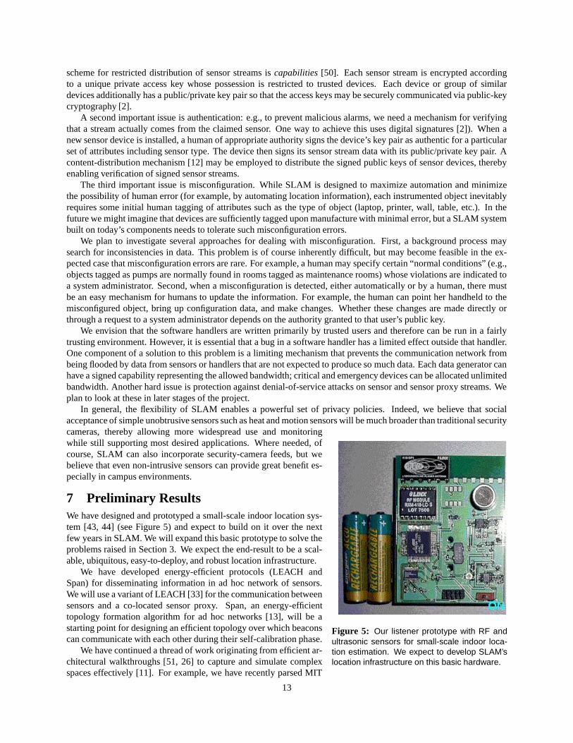
Figure 5: Our listener prototype with RF andultrasonic sensors for small-scale indoor loca-tion estimation. We expect to develop SLAM’slocation infrastructure on this basic hardware.
cameras, thereby allowing more widespread use and monitoringwhile still supporting most desired applications. Where needed, ofcourse, SLAM can also incorporate security-camera feeds, but webelieve that even non-intrusive sensors can provide great benefit es-pecially in campus environments.
7 Preliminary ResultsWe have designed and prototyped a small-scale indoor location sys-tem [43, 44] (see Figure 5) and expect to build on it over the nextfew years in SLAM. We will expand this basic prototype to solve theproblems raised in Section 3. We expect the end-result to be a scal-able, ubiquitous, easy-to-deploy, and robust location infrastructure.
We have developed energy-efficient protocols (LEACH andSpan) for disseminating information in ad hoc network of sensors.We will use a variant of LEACH [33] for the communication betweensensors and a co-located sensor proxy. Span, an energy-efficienttopology formation algorithm for ad hoc networks [13], will be astarting point for designing an efficient topology over which beaconscan communicate with each other during their self-calibration phase.
We have continued a thread of work originating from efficient ar-chitectural walkthroughs [51, 26] to capture and simulate complexspaces effectively [11]. For example, we have recently parsed MIT
13
Physical Plant’s floorplans representation to produce reference office and adjacency maps, useful to validate and visu-alize the Cricket location infrastructure.
We have developed an efficient loop-free routing algorithm that exploit location information in the network inorder to reduce packet headers to minimal size [10]. Specifically, given just the current coordinates of the packet,the coordinates of the neighboring nodes, and the coordinates of the destination, our algorithm determines where thepacket should next be delivered. This routing strategy should prove useful in the design of the beacon self-configurationprotocol.
8 Related ResearchSensor Networks & Systems. Sensor networks and systems are a current area of fertile research, and numerousprojects have recently begun. We describe only the ones most closely connected with SLAM here.
CITRIS [15] is a large-scale project in California that is addressing several issues related to sensor networks.A particular connection to our project is the application of emergency situations like earthquakes. CITRIS’s goalis to build pervasive, secure, energy-efficient, and disaster-proof information systems. SLAM can be seen as a keycomponent in any such system for enabling omnipresent location information and sensor-streaming infrastructure.
Auto-ID [47] proposes attaching persistent physical identifiers to all objects, for example to improve supply chain,inventory, and maintenance efficiency. In contrast, SLAM focuses primarily on monitoring and control applications.AUTO-ID has no notion of virtual tags.
The “Smart Dust” project at Berkeley is pursuing research in miniature sensors and self-configuring communicationprotocols for inter-sensor communication. SLAM’s approaches to beacon configuration may prove useful in SmartDust; likewise, SLAM will benefit from the novel sensors being developed by Smart-Dust. Estrin’s LECS lab atUCLA is pursuing a number of interesting sensor networking projects. Synergies with SLAM include self-configuringnetwork protocols and algorithms and location systems. However, whereas most projects in LECS focus on remotesensors collaborating with each other, SLAM’s focus is on integrating sensor information with monitoring and controlsoftware running on traditional machines in a scalable manner.
SLAM incorporates a combination of novel ideas not found in many other current systems. These include a ubiqui-tous and precise location system that works in all places, a virtual tagging mechanism for environment activation, novellow-energy communication protocols between sensors and sensor proxies, and a scalable event processing architecturethat integrates ideas from networking (event routing) with ideas from database systems (query and data processing).These ideas are all required for SLAM to scale to tens of millions of entities.
Location. In outdoor areas where line-of-sight connectivity to satellite is available, GPS [28, 35] works well inproviding location information. However, it does not work well in indoor or urban areas, where buildings and otherobstacles block the reception of signals from satellites. In addition, GPS does not provide the degree of precisionrequired for mobile applications indoors because of the low RF signal strength, high RF noise, and the reflections ofRF signals due to the presence of metallic objects. Therefore researchers have explored technologies for indoor envi-ronments based on infrared (Active Badge [53]), radio frequency (RF) signal strengths (RADAR [7]), ultrasound [29],and a combination of RF and ultrasound (Bat [32] and the current indoor version of Cricket [43]). These systems workin indoor environments but not elsewhere.
The Bat system requires a carefully calibrated infrastructure of sensors on ceilings, all wired together and connectedto a centralized controller that schedules transmission events [32]. It takes many months to deploy such a system ineven a modestly-sized building, and is hard to maintain.
We expect variants of these approaches to be a good starting point for our self-calibration system. Doherty et al.model the position estimation problem in ad-hoc sensor networks as a convex optimization problem, showing thatunder some conditions it is possible for the nodes to discover their positions relative to one another [21]. Savvides etal. [48] describe another approach to this problem.
Data processing systems. The SLAM event processing network is related to database research in adaptive queryprocessing, continuous queries, triggers, and stream processing.
Adaptive query processing techniques (e.g., [5, 34, 36, 52]) address efficient query execution in unpredictableand dynamic environments (e.g., Internet data sources) by revising the query execution plan as the characteristics ofincoming data changes. It is possible that adaptive query processing is also useful for efficient processing of streamdata and we plan to investigate the utility of this technique.
A special case of SLAM processing is as a continuous query system. Many continuous query systems have focusedon the topic of indexing the queries. A system like Niagara [14] is concerned with combining multiple data sources in
14
a wide-area setting while we are initially focusing on the construction of a stream server that can process very largenumbers of streams.
Recent closely related work on stream data query processing architectures shares many of the goals and targetapplication domains with SLAM. The Streams project [6] attempts to provide complete DBMS functionality alongwith support for continuous queries over streaming data. The Fjords architecture [39] addresses continuous queryexecution strategies that combine push-based sensor data with data from traditional sources that produce data using apull-based, blocking interface.
Our work is likely to benefit from and contribute to the considerable research on temporal databases [41], sinceSLAM has a fundamental temporal aspect to it. Likewise, we can benefit from the literature on real-time databases [41,37] and main-memory databases [27]. Finally, many recent papers [6, 54, 16, 23] have addressed the data managementneeds of specific monitoring or tracking applications. We take inspiration from these works as we try to design ageneral-purpose system that can be used for all these tasks.
9 Broader Impact of Proposed ResearchThe proposed ubiquitous location-sensing infrastructure has applications and utility beyond SLAM systems. Just asoutdoor GPS has enabled numerous applications, Cricket is likely to enable numerous location-aware applicationsthat can work reliably in all settings. We have already started sharing our small-scale Cricket prototype with otheruniversities and companies such as Dartmouth, Duke, Univ. of South Carolina, Nokia, Philips, and Intel. We expectthe significantly harder-to-develop system that provides ubiquitous coverage to be of wide interest to other researchersand developers.
The self-configuration algorithms and energy-efficient protocols proposed herein have widespread applicabilityin other wireless ad hoc and sensor systems. The idea of virtual tagging can be used in other pervasive computingsystems to rapidly instrument an environment’s assets. The event-handling architecture of the SLAM network is likelyto provide general lessons for designing distributed systems with asynchronous event flows.
The proposed SLAM applications on MIT campus has already elicited excitement among interested campus part-ners, particularly the libraries. In addition to providing a real testbed for our research ideas, these applications have thepotential to improve the quality of life of students and workers on our campus. If successful, we plan to deploy thesesystems on other interested campuses as well.
As important as the software and hardware reference schematics that we will release and protocols we will developare the papers and students that will result from the proposed project. The papers will provide precise documentationon the proposed technologies and their importance. In addition to the software and hardware, the papers are the primesource of information that companies and research institutes will use to evaluate and adopt the proposed ideas.
In the end, the best technology transfer is through students. With the proposed research project, the studentsinvolved will gain extensive experience with wireless networks, communication protocols, hardware design, databasesystems, large-scale software engineering, algorithms (particularly in scheduling and computational geometry), andgraphics. Expertise in these areas will make them of great value to universities, research labs, and industry. Academicresearch projects such as this one are of particular importance, because broad experience with these core areas ofcomputer science and engineering is hard to obtain in industry. In the long run, these students are the next generationof educators, researchers, and entrepreneurs who will drive future innovation in computer science and engineering.
10 EducationThere are a variety of ways in which SLAM will have a positive impact on student education and quality of life. Many ofthe research and engineering issues inherent in deploying SLAM can be used as material in systems, network, graphics,and geometry courses. Architecting and implementing SLAM will generate dozens of undergraduate research positionsover five years. It will also be a fertile ground for class projects, particularly in graduate courses in networking, systems,graphics, and algorithms.
One tangible product of SLAM deployment is a rich set of geometric representations, models, and sensor data forextended environments. These data will be useful in a variety of undergraduate courses, for example in architecture,urban planning, and computer graphics.
SLAM’s library application should make it easier for students to retrieve both heavily-used and infrequently-usedbooks and journals from library table-tops, circulation counters, and dead storage. Its active signage component willmake it more likely that students will be aware of, and attend, lectures, colloquia, and special events. Its safety and theftdetection component will improve the safety of students and the response time of campus police in times of trouble.
15
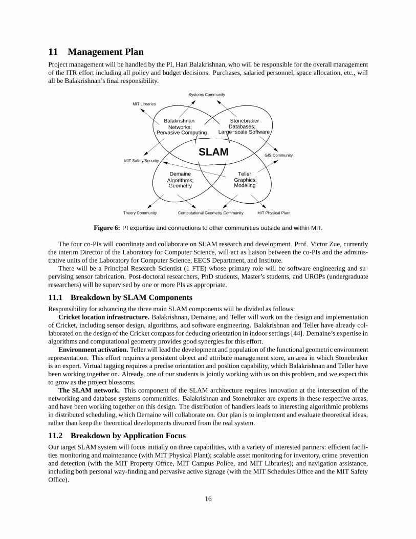
11 Management PlanProject management will be handled by the PI, Hari Balakrishnan, who will be responsible for the overall managementof the ITR effort including all policy and budget decisions. Purchases, salaried personnel, space allocation, etc., willall be Balakrishnan’s final responsibility.
Balakrishnan
Systems Community
DemaineAlgorithms; Geometry
Theory Community Computational Geometry Community
TellerGraphics;Modeling
Stonebraker
MIT Physical Plant
GIS CommunityMIT Safety/Security
SLAM
Networks;Pervasive Computing
Databases;Large−scale Software
MIT Libraries
Figure 6: PI expertise and connections to other communities outside and within MIT.
The four co-PIs will coordinate and collaborate on SLAM research and development. Prof. Victor Zue, currentlythe interim Director of the Laboratory for Computer Science, will act as liaison between the co-PIs and the adminis-trative units of the Laboratory for Computer Science, EECS Department, and Institute.
There will be a Principal Research Scientist (1 FTE) whose primary role will be software engineering and su-pervising sensor fabrication. Post-doctoral researchers, PhD students, Master’s students, and UROPs (undergraduateresearchers) will be supervised by one or more PIs as appropriate.
11.1 Breakdown by SLAM ComponentsResponsibility for advancing the three main SLAM components will be divided as follows:
Cricket location infrastructure. Balakrishnan, Demaine, and Teller will work on the design and implementationof Cricket, including sensor design, algorithms, and software engineering. Balakrishnan and Teller have already col-laborated on the design of the Cricket compass for deducing orientation in indoor settings [44]. Demaine’s expertise inalgorithms and computational geometry provides good synergies for this effort.
Environment activation. Teller will lead the development and population of the functional geometric environmentrepresentation. This effort requires a persistent object and attribute management store, an area in which Stonebrakeris an expert. Virtual tagging requires a precise orientation and position capability, which Balakrishnan and Teller havebeen working together on. Already, one of our students is jointly working with us on this problem, and we expect thisto grow as the project blossoms.
The SLAM network. This component of the SLAM architecture requires innovation at the intersection of thenetworking and database systems communities. Balakrishnan and Stonebraker are experts in these respective areas,and have been working together on this design. The distribution of handlers leads to interesting algorithmic problemsin distributed scheduling, which Demaine will collaborate on. Our plan is to implement and evaluate theoretical ideas,rather than keep the theoretical developments divorced from the real system.
11.2 Breakdown by Application FocusOur target SLAM system will focus initially on three capabilities, with a variety of interested partners: efficient facili-ties monitoring and maintenance (with MIT Physical Plant); scalable asset monitoring for inventory, crime preventionand detection (with the MIT Property Office, MIT Campus Police, and MIT Libraries); and navigation assistance,including both personal way-finding and pervasive active signage (with the MIT Schedules Office and the MIT SafetyOffice).
16
Interactions with MIT Libraries: Balakrishnan has been working with staff of the LCS Reading Room and MITLibraries, who are keen to incorporate asset tracking and navigation methods into their operating procedures. We havealready scoped out what the initial pilot will contain.
Interactions with MIT Physical Plant: Teller has collaborated extensively with MIT’s Physical Plant over the pastfew years, in an ongoing effort to achieve rapid procedural modeling of all campus buildings and floorplans. Teller willserve as the main liaison between the SLAM effort and the Physical Plant staff.
Interactions with GIS community: Stonebraker and Teller have had extensive interaction with this community aspart of other research efforts (Stonebraker’s work with NASA Earth Observing System, Teller’s City Scanning projectfor rapid urban model capture).
Interactions with MIT Safety Office and MIT Police: Balakrishnan and Teller will liaison with these administrativeunits.
Interactions with MIT Schedules Office: Demaine will lead in working with this office, and other event plannersand schedulers around LCS and MIT, toward pervasive active signage.
11.3 Five-Year PlanOur overall plan has three phases. Much of the basic research and early deployment will be done in the first severalyears, in order to tackle scaling issues immediately. Later we will focus more on evaluation and technology transfer toour partners both within and outside of MIT.
Broadly speaking, our strategy will be to deploy a prototype location infrastructure and sensor network rapidly,over an extended environment (several floors of our building), in order to generate a challenging operational scale.Algorithmic development will proceed in parallel. The current five-year plan can be summarized as:
Year 1. Develop a multi-sensor location system. At the same time, deploy our current indoor prototype withphysical RF-ID tags on a building-wide scale, evaluating performance and documenting the scaling problems. Workon solving these problems. Design algorithms for distributed event handling and query processing in the SLAMnetwork. Evaluate energy-efficiency of prototype.
Year 2. Design a virtual tagging system by leveraging the orientation capabilities of indoor sensing. Deployactive beacons more widely across MIT. Integrated design incorporating GPS and 802.11 access point information forlocation. Design and implement a generic technology-independent location API. Complete a preliminary prototype ofthe SLAM network, including query optimization and a simple static handler distribution. Engage with physical plantin deploying sensors and SLAM handlers.
Year 3. Conduct experiments with initial prototype and library tracking pilot application. Evaluate performanceand scaling problems. Evaluate energy-efficiency and traffic management problems. Develop sensor flow controlprotocols. Design energy-efficient sensor-specific protocols. Engage with campus security for asset tracking and startdeploying more widely in library system and physical plant. Start investigating security and privacy issues.
Year 4. Develop and implement scalable handler distribution and dynamic event routing methods. Develop avariety of handlers performing interesting data manipulation operations for physical plant and security applications.Evaluate performance of real system and develop modeling techniques for understand how large-scale sensor systemsbehave. Understand load behavior and response. Develop simple security solutions and deploy them.
Year 5. Demonstrate complete ubiquity of location system and show the benefits of a single system that workseverywhere. Develop a smaller version of earlier prototypes. Show scaling up to
� � �entities using both emulation
(and rigorous stress tests) and in real deployment at MIT. Gain practical experience with social acceptance and hurdles.We will release software and hardware schematics on an on-going basis through the project for the research com-
munity. We expect to contribute actively to the top conferences in the different areas covered in this proposal, includingthose run by ACM SIGMOBILE, ACM SIGCOMM, ACM SIGMOD, ACM SIGACT, and IEEE networking and datamanagement conferences. The students working on this project will gain expertise in multiple areas of computerscience: networking, algorithms, database systems, and graphics/vision.
17
D. References Cited
[1] ADJIE-WINOTO, W., SCHWARTZ, E. AND BALAKRISHNAN, H. AND LILLEY, J. The design and implementation of anintentional naming system. In Proc. ACM Symposium on Operating Systems Principles (Kiawah Island, SC, Dec. 1999),pp. 186–201.
[2] ALFRED J. MENEZES, P. C. V. O., AND VANSTONE, S. A. Handbook of Applied Cryptography. CRC Press, October 1996.
[3] ANTONE, M., AND TELLER, S. Automatic recovery of relative camera rotations for urban scenes. In Proc. CVPR (June2000), pp. II–282–289.
[4] ANTONE, M., AND TELLER, S. Scalable, absolute position recovery for omni-directional image networks. In Proc. CVPR(to appear) (2001).
[5] AVNUR, R., AND HELLERSTEIN, J. M. Eddies: Continuously adaptive query processing. In Proceedings of the ACMSIGMOD International Conference on Management of Data (2000).
[6] BABU, S., AND WIDOM, J. Continuous queries over data streams. SIGMOD Record 30, 3 (2001).
[7] BAHL, P., AND PADMANABHAN, V. RADAR: An In-Building RF-based User Location and Tracking System. In Proc. IEEEINFOCOM (Tel-Aviv, Israel, Mar. 2000).
[8] BALAZINSKA, M., AND BALAKRISHNAN, H. Twine: Scalable intentional resource discovery for pervasive computing envi-ronments. http://nms.lcs.mit.edu/projects/twine/.
[9] BIEDL, T. C., BOSE, P., DEMAINE, E. D., AND LUBIW, A. Efficient algorithms for Petersen’s matching theorem. InProceedings of the 10th Annual ACM-SIAM Symposium on Discrete Algorithms (Baltimore, Maryland, January 1999), pp. 130–139.
[10] BOSE, P., BRODNIK, A., CARLSSON, S., DEMAINE, E. D., FLEISCHER, R., LOPEZ-ORTIZ, A., MORIN, P., AND MUNRO,J. I. Online routing in convex subdivisions. In Proceedings of the 11th Annual International Symposium on Algorithms andComputation (Taipei, Taiwan, December 2000), vol. 1969 of Lecture Notes in Computer Science, pp. 47–59.
[11] BUKOWSKI, R., DOWNS, L., SIMMONS, M., SEQUIN, C., AND TELLER, S. Citywalk: A second generation walkthroughsystem. In In Proc. Virtual Systems and Multimedia (VSMM) (October 2001).
[12] Proceedings of the 1st–6th International Workshops on Web Caching and Content Distribution. Elsevier, 1996–2001.
[13] CHEN, B., JAMIESON, K., BALAKRISHNAN, H., AND MORRIS, R. Span: An energy-efficient coordination algorithm fortopology maintenance in ad hoc wireless networks. In Proc. ACM MOBICOM (Rome, Italy, July 2001).
[14] CHEN, J., DEWITT, D. J., TIAN, F., AND WANG, Y. Niagaracq: A scalable continuous query system for internet databases.In Proceedings of the ACM SIGMOD International Conference on Management of Data (2000).
[15] CITRIS – center for information technology research in the interest of society. http://www.citris.berkeley.edu/.
[16] COIFMAN, B. Identifying the onset of congestion rapidly with existing traffic detectors. Tech. Rep. UCB-ITS-PWP-99-17,University of California, Berkeley, November 1999. Submitted to Transportation Research: Part A/B.
[17] CONNELLY, R. Rigidity. In Handbook of Convex Geometry, vol. A. North-Holland, 1993, pp. 223–271.
[18] CONNELLY, R., AND DEMAINE, E. D. Geometry and topology of polygonal linkages. In Handbook of Discrete and Compu-tational Geometry, 2nd ed. CRC Press, 2002. To appear.
[19] CONNELLY, R., DEMAINE, E. D., AND ROTE, G. Straightening polygonal arcs and convexifying polygonal cycles. Discrete& Computational Geometry (2002). To appear. A preliminary version appeared in Proc. 41st Symp. Foundations of ComputerScience, 2000, pp. 432–442.
[20] CZERWINSKI, S., ZHAO, B., HODES, T., JOSEPH, A., AND KATZ, R. An Architecture for a Secure Service DiscoveryService. In Proc. ACM/IEEE MOBICOM (Aug. 1999), pp. 24–35.
[21] DOHERTY, L., PISTER, K., AND GHAOUI, L. Convex position estimation in wireless sensor networks. In Proc. IEEEINFOCOM (April 2001).
[22] DOWNEY, R. G., AND FELLOWS, M. R. Parameterized Complexity. Springer-Verlag, 1997.
[23] DUFFIELD, N. G., AND GROSSGLAUSER, M. Trajectory sampling for direct traffic observation. IEEE/ACM Transactions onNetworking 9 (2001), 280–292.
[24] FastTrack. http://www.fasttrack.nu/.
[25] FINKENZELLER, K. RFID Handbook—radio-frequency identification fundamentals and applications. John Wiley & Sons,1999.
[26] FUNKHOUSER, T., SEQUIN, C., AND TELLER, S. Management of large amounts of data in interactive building walkthroughs.In Proc. 1992 Workshop on Interactive 3D Graphics (1992), pp. 11–20.
18
[27] GARCIA-MOLINA, H., AND SALEM, K. Main memory database systems: An overview. IEEE Transactions on Knowledgeand Data Engineering 4 (1992).
[28] GETTING, I. The Global Positioning System. IEEE Spectrum 30, 12 (December 1993), 36–47.
[29] GIROD, L. Development and characterization of an acoustic rangefinder. Tech. Rep. 00-728, Computer Science Department,University of Southern California, April 2000.
[30] Gnutella. http://gnutella.wego.com/.
[31] GONZALEZ-BANOS, H., AND LATOMBE, J.-C. A randomized art-gallery algorithm for sensor placement. In Proceedings ofthe 17th ACM Symposium on Computational Geometry (2001).
[32] HARTER, A., HOPPER, A., STEGGLES, P., WARD, A., AND WEBSTER, P. The Anatomy of a Context-Aware Application.In Proc. 5th ACM MOBICOM Conf. (Seattle, WA, Aug. 1999).
[33] HEINZELMAN, W., CHANDRAKASAN, A., AND BALAKRISHNAN, H. Low-energy adaptive clustering hierarchy. IEEE JSAC(2002). To appear. Earlier version in Proc. HICSS 2000.
[34] HELLERSTEIN, J. M., FRANKLIN, M. J., CHANDRASEKARAN, S., DESHPANDE, A., HILDRUM, K., MADDEN, S., RA-MAN, V., AND SHAH, M. A. Adaptive query processing: Technology in evolution. IEEE Data Engineering Bulletin 23(2000), 7–18.
[35] HOFFMANN-WELLENHOF, B., LICHTENEGGER, H., AND COLLINS, J. Global Positioning System: Theory and Practice,Fourth Edition. Springer-Verlag, 1997.
[36] IVES, Z. G., FLORESCU, D., FRIEDMAN, M., LEVY, A., AND WELD, D. S. An adaptive query execution system for dataintegration. In Proceedings of the ACM SIGMOD International Conference on Management of Data (1999).
[37] KAO, B., AND GARCIA-MOLINA, H. An overview of realtime database systems. In Real Time Computing, W. A. Halangand A. D. Stoyenko, Eds. Springer, 1994.
[38] KULIK, J., HEINZELMAN, W., AND BALAKRISHNAN, H. Negotiation-based Protocols for Information Dissemination inWireless Sensor Networks . ACM Wireless Networks (2001). To appear. Earlier version in Proc. ACM MOBICOM 1999.
[39] MADDEN, S., AND FRANKLIN, M. J. Fjording the stream: An architecture for queries over streaming sensor data. InProceedings of the 18th International Conference on Data Engineering (2002).
[40] O’ROURKE, J. Art Gallery Theorems and Algorithms. Oxford University Press, 1987.
[41] OZSOYOGLU, G., AND SNODGRASS, R. T. Temporal and real-time databases: A survey. IEEE Transactions on Knowledgeand Data Engineering (1995).
[42] PREPARATA, F. P., AND SHAMOS, M. I. Computational Geometry: an Introduction. Springer-Verlag, 1985.
[43] PRIYANTHA, N., CHAKRABORTY, A., AND BALAKRISHNAN, H. The Cricket Location-Support System. In Proc. 6th ACMMOBICOM Conf. (Boston, MA, Aug. 2000), pp. 32–43.
[44] PRIYANTHA, N., MIU, A., BALAKRISHNAN, H., AND TELLER, S. The Cricket Compass for Context-Aware Mobile Appli-cations. In Proc. 7th ACM MOBICOM Conf. (Rome, Italy, July 2001), pp. 1–14.
[45] RATNASAMY, S., FRANCIS, P., HANDLEY, M., KARP, R., AND SHENKER, S. A scalable content-addressable network. InProc. ACM SIGCOMM (San Diego, CA, August 2001), pp. 161–172.
[46] ROWSTRON, A., AND DRUSCHEL, P. Pastry: Scalable, distributed object location and routing for large-s cale peer-to-peersystems. In Proceedings of the 18th IFIP/ACM International Conference on Distributed Systems Platforms (Middleware 2001)(Nov. 2001).
[47] SARMA, S., BROCK, D., AND ASHTON, K. The networked physical world: Proposals for engineering the next generationof computing, commerce and automatic identification. Tech. Rep. MIT AUTO-ID-WH-001, MIT Auto-ID Center, December2000.
[48] SAVVIDES, A., HAN, C.-C., AND STRIVASTAVA, M. B. Dynamic fine-grained localization in ad-hoc networks of sensors.In Proc. 7th ACM MOBICOM Conf. (Rome, Italy, July 2001), pp. 166–179.
[49] STOICA, I., MORRIS, R., KARGER, D., KAASHOEK, M. F., AND BALAKRISHNAN, H. Chord: A scalable peer-to-peerlookup service for internet applications. In Proc. ACM SIGCOMM (San Diego, Aug. 2001).
[50] TANENBAUM, A. S., MULLENDER, S. J., AND VAN RENESSE, R. Using sparse capabilities in a distributed operatingsystems. In Proceedings of the 6th International Conference on Distributed Computing Systems (May 1986), pp. 558–563.
[51] TELLER, S., AND SEQUIN, C. H. Visibility preprocessing for interactive walkthroughs. Computer Graphics (Proc. Siggraph’91) 25, 4 (1991), 61–69.
[52] URHAN, T., AND FRANKLIN, M. J. Dynamic pipeline scheduling for improving interactive query performance. In Proceed-ings of 27th International Conference on Very Large Data Bases (Rome, Italy, 2001).
19

[53] WANT, R., HOPPER, A., FALCAO, V., AND GIBBONS, J. The Active Badge Location System. ACM Transactions onInformation Systems 10, 1 (January 1992), 91–102.
[54] WOLFSON, O., CHAMBERLAIN, S., SISTLA, P., XU, B., AND ZHOU, J. DOMINO: Databases fOr MovINg Objects tracking.In Proceedings of the ACM SIGMOD International Conference on Management of Data (Philadelphia, PA, 1999).
[55] ZHAO, B., KUBIATOWICZ, J., AND JOSEPH, A. Tapestry: An infrastructure for fault-tolerant wide-area locat ion and routing.Tech. Rep. UCB/CSD-01-1141, Computer Science Division, U. C. Berkeley, Apr. 2001.
20
E. Biographical Sketches
Hari BalakrishnanProfessional PreparationSchool Degree DateUniversity of California, Berkeley Doctor of Philosophy August 1998Indian Inst. of Technology, Madras Bachelor of Technology June 1993
AppointmentsOrganization Position DateMassachusetts Inst. of Technology Assistant Professor July 1998–presentUniv. of California, Berkeley Graduate Student Researcher August 1994–August 1998Univ. of California, Berkeley Graduate Student Instructor August 1993–May 1994
Five Publications Relevant to Proposal1. Priyantha, N. B., A. Chakraborty, and H. Balakrishnan, “The Cricket Location-Support System,” Proceedings of
the 6th ACM MOBICOM Conference, Boston, MA, August 2000.
2. Priyantha, N. B., A. K. L. Miu, H. Balakrishnan, and S. Teller, “The Cricket Compass for Context-Aware MobileApplications,” Proceedings of the ACM MOBICOM Conference, Rome, Italy, July 2001.
3. Heinzelman, W. R., A. Chandrakasan, and H. Balakrishnan, “Energy-Efficient Communication Protocols forWireless Microsensor Networks,” IEEE JSAC, 2002. (To appear. Earlier version in Proc. HICSS 2000.)
4. Kulik, J. L., W. R. Heinzelman, H. Balakrishnan, “Negotiation-Based Protocols for Disseminating Informationin Wireless Sensor Networks,” ACM Wireless Networks, 2001. (To appear. Earlier version in Proc. ACMMOBICOM 1999.)
5. Adjie-Winoto, W., E. Schwartz, E., H. Balakrishnan, and J. Lilley, “The design and implementation of an in-tentional naming system,” Proceedings of the 17th ACM Symposium on Operating Systems Principles (SOSP),Kiawah Island, SC, USA, December 1999.
Five Other Selected Publications1. Andersen, D. G., H. Balakrishnan, M. F. Kaashoek, and R. T. Morris, “Resilient Overlay Networks,” Proceedings
of the 18th ACM Symposium on Operating Systems Principles (SOSP), Banff, Canada, October 2001.
2. Chen, B., K. Jamieson, H. Balakrishnan, and R. T. Morris, “Span: An Energy-Efficient Coordination Algorithmfor Topology Maintenance in Ad Hoc Wireless Networks,” Proceedings of the ACM MOBICOM Conference,Rome, Italy, July 2001.
3. Snoeren, A. C. and H. Balakrishnan, “An End-to-End Approach to Host Mobility,” Proceedings of the 6th ACMMOBICOM Conference, Boston, MA, August 2000.
4. H. Balakrishnan, H. S. Rahul, and S. Seshan, “An Integrated Congestion Management Architecture for InternetHosts,” Proceedings of the ACM SIGCOMM ’99 Conference, Cambridge, MA, USA, September 1999.
5. Balakrishnan, H., V. N. Padmanabhan, S. Seshan, and R. H. Katz, “A Comparison of Mechanisms for ImprovingTCP Performance over Wireless Links,” IEEE/ACM Transactions on Networking, December 1997. (Earlierversion in ACM SIGCOMM ’96.)
21
Synergistic Activities1. New MIT graduate course on computer networks, with heavy emphasis on teaching students to do research.
Over ten published papers have resulted from the work of students in this course in the past three years.
2. Systems developed from past research being used by researchers in the networking community: Snoop protocolfor wireless TCP, Congestion Manager (NSF-funded), Cricket (Version 1) indoor prototype.
3. Program committee member for ACM MOBICOM, ACM SIGCOMM, ACM SOSP in past years.
4. Program Co-chair for ACM SIGCOMM 2002.
Awards and HonorsAward DateRuth and Joel Spira Award for Distinguished Teaching, MIT 2001Award paper, 8th IEEE Hot Topics in Operating Systems Workshop 2001Award paper, 6th ACM MOBICOM Conf. 2000ACM Doctoral Dissertation Award 1998C.V. Ramamoorthy Distinguished Research Award, U.C. Berkeley 1998Okawa Foundation Fellow 1996Award paper, 1st ACM MOBICOM Conf. 1995Award paper, Winter Usenix Technical Conf. 1995
Recent CollaboratorsAnantha Chandrakasan (MIT), Erik Demaine (MIT), Sally Floyd (ACIRI/ICSI), David Gifford (MIT), John Guttag(MIT), Frans Kaashoek (MIT), David Karger (MIT), Randy Katz (UC Berkeley), Robert Morris (MIT), VenkataPadmanabhan (Microsoft), Srinivasan Seshan (CMU), Scott Shenker (ACIRI/ICSI), Ion Stoica (UC Berkeley), MikeStonebraker (MIT), Seth Teller (MIT)
Graduate AdvisorRandy Katz (UC Berkeley)
Graduate Students (Completed)Wendi Beth Heinzelman (Univ. of Rochester)
22
Erik D. DemaineProfessional PreparationSchool Degree DateUniversity of Waterloo Doctor of Philosophy 2001University of Waterloo Master of Mathematics 1996Dalhousie University Bachelor of Science 1995
AppointmentsOrganization Position DateMassachusetts Institute of Technology Assistant Professor 2001–presentUniversity of Waterloo Instructor 1999
Five Publications Relevant to Proposal1. R. Connelly, E. D. Demaine, and G. Rote, “Straightening Polygonal Arcs and Convexifying Polygonal Cycles,”
Discrete & Computational Geometry, to appear. Preliminary version in FOCS 2000.
2. T. Biedl, M. Demaine, S. Lazard, A. Lubiw, J. O’Rourke, M. Overmars, S. Robbins, I. Streinu, G. Toussaint,and S. Whitesides, “Locked and Unlocked Polygonal Chains in Three Dimensions” Discrete & ComputationalGeometry, 26(3):283–287, 2001. Preliminary version in SODA’99.
3. M. A. Bender, E. D. Demaine, and M. Farach-Colton, “Cache-Oblivious B-Trees,” in Proc. 41st Annual Sympo-sium on Foundations of Computer Science, November 2000, pages 399–409.
4. T. C. Biedl, P. Bose, E. D. Demaine, and A. Lubiw, “Efficient Algorithms for Petersen’s Matching Theorem,”Journal of Algorithms, to appear. Special issue of selected papers from SODA’99.
5. E. D. Demaine, I. Foster, C. Kesselman, and M. Snir, “Generalized Communicators in the Message PassingInterface,” IEEE Transactions on Parallel and Distributed Systems, to appear.
Five Other Selected Publications1. E. D. Demaine, A. L opez-Ortiz, J. I. Munro, “Experiments on Adaptive Set Intersections for Text Retrieval
Systems,” in Proceedings of the 3rd Workshop on Algorithm Engineering and Experiments, Lecture Notes inComputer Science, January 2001.
2. E. M. Arkin, M. A. Bender, E. D. Demaine, S. P. Fekete, J. S. B. Mitchell, and S. Sethia, “Optimal CoveringTours with Turn Costs,” in Proc. 12th Annual ACM-SIAM Symposium on Discrete Algorithms, January 2001,pages 138–147.
3. E. D. Demaine and A. L opez-Ortiz, “A Linear Lower Bound on Index Size for Text Retrieval,” in Proc. 12thAnnual ACM-SIAM Symposium on Discrete Algorithms, January 2001, pages 289–294. Invited to a special issueof Journal of Algorithms.
4. E. D. Demaine, A. L opez-Ortiz, and J. I. Munro, “Adaptive Set Intersections, Unions, and Differences,” in Proc.11th Annual ACM-SIAM Symposium on Discrete Algorithms, January 2000, pages 743–752.
5. P. Bose, A. Brodnik, S. Carlsson, E. D. Demaine, R. Fleischer, A. L opez-Ortiz, P. Morin, J. I. Munro, “OnlineRouting in Convex Subdivisions,” in Proc. 11th Annual International Symposium on Algorithms and Computa-tion, Lecture Notes in Computer Science, volume 1969, December 2000, pages 47–59. Invited to a special issueof International Journal of Computational Geometry and Applications.
23
Synergistic Activities1. Co-organizer of biweekly algorithmic open-problem solving session, enabling a major form of collaboration
between faculty and students and exposure of students to research, University of Waterloo (1999–2001)
2. Conference organization: DIMACS Workshop on Folding and Unfolding (Oct. 2002); Symposium on RobotArm Manipulation, AAAS Meeting (Feb. 2002); Seminar on Algorithmic Combinatorial Game Theory, SchlossDagstuhl (Germany, Feb. 2002); 13th Canadian Conference on Computational Geometry (Waterloo, Canada,Aug. 2001),
3. Conference program committee: 13th Annual ACM-SIAM Symposium on Discrete Algorithms (San Francisco,California, January 2002); 13th Canadian Conference on Computational Geometry (Waterloo, Canada, August2001).
4. Exposing research to the community. In the past 2 years, I have given plenary talks at 5 conferences, invited talksat 11 institutions, invited talks at 12 conferences and workshops, as well as 19 contributed talks at conferences.
Recent CollaboratorsOswin Aichholzer (TU Graz), Esther Arkin (SUNY Stony Brook), Michael Bender (SUNY Stony Brook), Hari Bal-akrishnan (MIT), David Benoit (InfoInteractive Inc.), Marshall Bern (Xerox PARC), Therese Biedl (U. Waterloo),Prosenjit Bose (Carleton U.), Brona Brejova (U. Waterloo), David Bremner (U. New Brunswick, Fredericton), An-drej Brodnik (Luleøa Technical U.), Svante Carlsson (Luleøa Technical U.), Eowyn Cenek (U. Waterloo), TimothyChan (U. Waterloo), Robert Connelly (Cornell U.), Carmen Cort es (U. Sevilla), Martin Demaine (MIT), ChristianDuncan (U. Miami), Vida Dujmovi c (McGill U.), David Eppstein (U. California, Irvine), Jeff Erickson (U. Illinois,Urbana-Champaign), Martin Farach-Colton (Google Inc.), S andor Fekete (TU Berlin), Rudolf Fleischer (Hong KongU. Science and Technology), Greg Frederickson (Purdue U.), Erich Friedman (Stetson U.), Ian Foster (U. Chicago),Mordecai Golin (Hong Kong U. Science and Technology), Angele Hamel (Laurier U.), George Hart (georgehart.com),Barry Hayes (PlaceWare Inc.), Michael Hoffmann (ETH Zurich), Ferran Hurtado (Polytecnic U. Catalunya), Lars Ja-cobsen (U. Southern Denmark), Craig Kaplan (U. Washington), Carl Kesselman (U. Southern California), StephenKobourov (U. Arizona), Eric Kuo (U. California, Berkeley), Stefan Langerman (McGill U.), Sylvain Lazard (INRIALorraine), Alejandro L opez-Ortiz (U. Waterloo), Anna Lubiw (U. Waterloo), Andrea Mantler (U. North Carolina,Chapel Hill), Henk Meijer (Queens U.), Joseph Mitchell (SUNY Stony Brook), Pat Morin (McGill U.), Ian Munro(U. Waterloo), Joseph O’Rourke (Smith College), Mark Overmars (Utrecht U.), Bel en Palop (U. Rey Juan Carlos),Irena Pashchenko (Stanford U.), Venkatesh Raman (Inst. Mathematical Sciences), Suneeta Ramaswami (Rutgers U.),Steven Robbins (McGill U.), Gunter Rote (FU Berlin), Vera Sacrist an (Polytecnic U. Catalunya), Robert Sedgewick(Princeton U.), Saurabh Sethia (Oregon State U.), Steven Skiena (SUNY Stony Brook), Marc Snir (IBM Research),Jack Snoeyink (U. North Carolina, Chapel Hill), Michael Soss (McGill U.), Michael Stonebraker (MIT), Ileana Streinu(Smith College), Seth Teller (MIT), Godfried Toussaint (McGill U.), Helena Verrill (Hannover U.), Tom as Vinar (U.Waterloo), Ming-wei Wang (U. Waterloo), Sue Whitesides (McGill U.).
Graduate AdvisorsAnna Lubiw and Ian Munro (Ph.D.); David Taylor (M.Math.).
Graduate Students1. Nicole Immorlica, Ph.D. candidate at MIT (tentative).
24
Michael StonebrakerProfessional PreparationSchool Degree DateUniversity of Michigan Doctor of Philosophy 1971Princeton University Bachelor of Science and Electrical Engineering 1961
AppointmentsOrganization Position DateMassachusetts Inst. of Technology Senior Lecturer 2001–presentRequired Technology, Inc. Chief Technology Officer 2001–presentCohera Corporation Founder and Chief Technology Officer 1997–2001Informix Corporation Chief Technology Officer 1996-2000Univ. of California, Berkeley Professor of the Graduate School 1994–1999Illustra Corporation Founder and Chief Technology Officer 1992-1996Univ. of California, Berkeley Professor 1982–1994Ingres Corporation Founder and Chief Technology Officer 1980-1992Univ. of California, Berkeley Associate Professor 1976–1982Univ. of California, Berkeley Assistant Professor 1971–1976Vivant! Corporation, Electric Knowledge Corporation, PowerMarket Corporation, FiveNine Solutions, Inc.
Member of the Technical Advisory Committee
Five Publications Relevant to Proposal1. Michael Stonebraker, Paul M. Aoki, Witold Litwin, Avi Pfeffer, Adam Sah, Jeff Sidell, Carl Staelin, Andrew Yu,
“Mariposa: A Wide-Area Distributed Database System,” VLDB Journal 5(1):48–63, 1996.
2. Michael Stonebraker, Paul M. Aoki, Robert Devine, Witold Litwin, Michael A. Olson, “Mariposa: A NewArchitecture for Distributed Data,” ICDE 1994, pp. 54–65.
3. Chris Olston, Allison Woodruff, Alexander Aiken, Michael Chu, Vuk Ercegovac, Mark Lin, Mybrid Spalding,Michael Stonebraker, “DataSplash,” SIGMOD 1998, pp. 550–552.
4. Alexander Aiken, Jolly Chen, Michael Stonebraker, Allison Woodruff, “Tioga-2: A Direct Manipulation DatabaseVisualization Environment,” ICDE 1996, pp. 208–217.
5. Michael Stonebraker, Jolly Chen, Nobuko Nathan, Caroline Paxson, Jiang Wu, “Tioga: Providing Data Manage-ment Support for Scientific Visualization Applications,” VLDB 1993, pp. 25–38.
Five Other Selected Publications1. Allison Woodruff, Michael Stonebraker, “Supporting Fine-grained Data Lineage in a Database Visualization
Environment,” ICDE 1997, pp. 91-102.
2. Michael Stonebraker, “The Integration of Rule Systems and Database Systems,” IEEE Transactions on Knowl-edge and Data Engineering 4(5):415–423, 1992.
3. Michael Stonebraker, Greg Kemnitz, “The Postgres Next Generation Database Management System,” Commu-nications of the ACM 34(10):78–92, 1991.
4. Michael Stonebraker, Anant Jhingran, Jeffrey Goh, Spyros Potamianos, “On Rules, Procedures, Caching andViews in Data Base Systems,” SIGMOD 1990, pp. 281-290.
5. Margo I. Seltzer, Michael Stonebraker, “Transaction Support in Read Optimizied and Write Optimized FileSystems,” VLDB 1990, pp. 174–185.
25
Synergistic Activities1. Wrote several major public domain DBMS prototypes, including Ingres and POSTGRESQL. The latter is cur-
rently widely used as a teaching instrument in universities and forms the basic for several commercial DBMSproducts.
2. Have founded the New England Database Symposium (NEDS) as a mechanism for Boston-area DBMS re-searchers to network and collaborate.
Awards and HonorsAward DateACM Software System Award 1988ACM SIGMOD Innovation Award 1992National Academy of Engineering 1998Forbes Magazine – named one of 8 innovators driving the
Silicon Valley wealth explosion in 80th anniversary issue 1998Computer Reseller News – Hall of Fame Member 1999
Recent CollaboratorsHari Balakrishnan (MIT), Mitch Cherniak (Brandeis), Erik Demaine (MIT), Joey Hellerstein (Berkeley), Betty Salzberg(Northeastern), Seth Teller (MIT), Stan Zdonik (Brown).
Graduate AdvisorDr. Arch Naylor (Michigan, now retired)
Graduate StudentsSample of more than 20 completed PhD students: Gerald Held (until recently VP/Eng’g of Oracle Corp.), RobertEpstein (founder and until recently VP/Eng’g of Sybase Corp.), Paula Hawthorn (until recently VP/Eng’g of InformixCorp.), Dale Skein (founder and CTO of Vitria Corp.), Mike Carey (until recently MTS at IBM Almadin ResearchLaboratory), Margo Seltzer (Assoc. Professor of Computer Science at Harvard), Anant Jhingran (Manager, DatabaseDepartment of IBM Almaden Research Laboratory).
26
Seth TellerProfessional PreparationSchool Degree DateUniversity of California, Berkeley Doctor of Philosophy, Computer Science 1992University of California, Berkeley Master of Science, Computer Science 1990Wesleyan University, Middletown CT Bachelor of Arts, Physics 1985
AppointmentsOrganization Position DateMassachusetts Inst. of Technology Associate Professor 1998 – presentMassachusetts Inst. of Technology Assistant Professor 1994 – 1998Princeton University Post-Doctoral Researcher 1993 – 1994Hebrew University of Jerusalem Post-Doctoral Researcher 1992 – 1993Univ. of California, Berkeley Research Assistant 1988 – 1992
Five Publications Relevant to Proposal1. Funkhouser, T., C. S equin, and S. Teller, Management of large amounts of data in interactive building walk-
throughs. In Proc. 1992 Workshop on Interactive 3D Graphics, Boston, MA, March 1992, pp. 11–20.
2. Funkhouser, T., D. Khorramabadi, C. S equin, and S. Teller, The UCB System for Interactive Visualization ofLarge Architectural Models. In Presence, 5(1):13–44, Winter 1996.
3. Capps, M., and S. Teller, Communications Visibility in Shared Virtual Worlds. In Proc. ����� Workshop onEnabling Technologies: Infrastructure for Collaborative Enterprises, June 1997.
4. Priyantha, N. B., A. K. L. Miu, H. Balakrishnan, and S. Teller, “The Cricket Compass for Context-Aware MobileApplications,” In Proc. ACM MOBICOM Conference, Rome, Italy, July 2001.
5. Bukowski, R., L. Downs, M. Simmons, C. S equin, and S. Teller, Citywalk: A Second Generation WalkthroughSystem, In Proc. ����� International Conference on Virtual Systems and Multimedia (VSMM), Berkeley, CA,October 2001.
Five Other Selected Publications1. Teller, S., and C. S equin, Visibility preprocessing for interactive walkthroughs. In Computer Graphics (Proc. SIG-
GRAPH ’91), 25(4):61–69, 1991.
2. Teller, S., Fowler, C., T. Funkhouser, and P. Hanrahan, Partitioning and ordering large radiosity computations.In Computer Graphics (Proc. SIGGRAPH ’94), 28:443–450, 1994.
3. Teller, S., N. Boyd, B. Porter, and N. Tornow, Distributed Development and Teaching of Algorithmic Concepts.In Computer Graphics (Proc. SIGGRAPH ’98 Educational Track), July 1998.
4. Coorg, S., and S. Teller, Temporally Coherent Conservative Visibility. In Computational Geometry: Theory andApplications, 12(1-2):105–124, February 1999.
5. Antone, M., and S. Teller, Scalable, Absolute Registration of Omni-Directional Image Networks, In the Interna-tional Journal of Computer Vision (to appear).
Synergistic Activities1. Teaching efforts include extensive development of use of geometric visualization and algorithm inspection tools.
2. Research efforts include an ambitious project to achieve automated model capture capability for architecturalenvironments. The project seeks to generate “reference models” by procedural generation of 3D CAD modelsfrom incompletely-specified 2D CAD. Such reference data can also be useful for the location infrastructuredescribed in the accompanying proposal.
27

3. Program committee member for SoCG (2000) and SIGGRAPH (2002).
4. Aggressive recruiting and retention of women and under-represented minority students for UROP (Undergrad-uate Research Opportunity Program), AUP (Advanced Undergraduate Project), MEng (Master of Engineering),and PhD positions.
5. Founded the MIT Computer Graphics Colloquium as a mechanism for invited speakers in the field to give talksto students and researchers at MIT.
Awards and HonorsAward DateSamuel Silver Research Award, UC Berkeley 1992
Recent CollaboratorsHari Balakrishnan (MIT), Erik Demaine (MIT), David Dobkin (Princeton), Laura Downs (UC Berkeley), CelesteFowler (SGI), Michael Hohmeyer (Berkeley, ICEM CFD), Tom Funkhouser (AT&T Labs, Princeton), Pat Hanrahan(Stanford), Tom as Lozano-P erez (MIT), Carlo S equin (UC Berkeley), Maryann Simmons (UC Berkeley), Mike Stone-braker (MIT)
Graduate AdvisorCarlo S equin (UC Berkeley)
Graduate Students (Completed)Satyan Coorg (Liberate), John Mellor (Rose-Hulman Inst. of Tech.), Kavita Bala (Cornell), George Chou, MatthewAntone (Consultant)
28
H. Facilities, Equipment and Other ResourcesThe MIT Laboratory for Computer Science (LCS) has several PCs donated by Intel and has, under other federallyfunded grants, purchased many PCs. A campus-wide 802.11 wireless network is in place at MIT. MIT LCS has on-going relationships with several companies doing PCB layout and assembly for sensor production and fabrication andto undertake large-scale manufacture of Cricket beacons and listeners.
LCS provides administrative services for all principal investigators who submit proposals through LCS. Theseadministrative services are run by the Headquarters Staff and include Fiscal, Personnel, Library, Facilities and otherLCS operations.
These services are supported by an Allocated Project Level Cost. Allocated costs are assessed against all contractsand grants at LCS. The costs are determined as percentages of direct salaries and materials and services. Thesepercentages are currently 7.1% for Personnel and 1.4% for Materials and Services. We constantly review these servicesto make reductions whenever possible.
The Personnel (or Lab Support) Allocation covers the costs of those individuals who provide LCS administrativeservices such as accounting, budget preparation, personnel, payroll, etc. This is calculated by multiplying the secondaryMTDC Base by 7.1%.
The Materials & Services Allocation covers the cost of phones, office/computer supplies, etc., for the same ad-ministrative personnel whose salaries are covered under the personnel support. This is calculated by multiplying thesecondary MTDC Base by 1.4%.
29