issn 2009-4086 national parks and wildlife service
TRANSCRIPT

Conservation Objectives Series
National Parks and Wildlife Service
Island Fen SAC 002236
ISSN 2009-4086
18 Oct 2018 Page 1 of 11 Version 1
National Parks and Wildlife Service,Department of Culture, Heritage and the Gaeltacht,
90 King Street North, Dublin 7, D07 N7CV, Ireland.
Web: www.npws.ieE-mail: [email protected]
Citation:
ISSN 2009-4086Series Editor: Rebecca Jeffrey
NPWS (2018) Conservation Objectives: Island Fen SAC 002236. Version 1. National Parks and Wildlife Service, Department of Culture, Heritage and the Gaeltacht.
18 Oct 2018 Page 2 of 11 Version 1

Introduction
European and national legislation places a collective obligation on Ireland and its citizens to maintain habitats and species in the Natura 2000 network at favourable conservation condition. The Government and its agencies are responsible for the implementation and enforcement of regulations that will ensure the ecological integrity of these sites.
A site-specific conservation objective aims to define favourable conservation condition for a particular habitat or species at that site.
Favourable conservation status of a habitat is achieved when: • its natural range, and area it covers within that range, are stable or increasing, and • the specific structure and functions which are necessary for its long-term maintenance exist and are likely to continue to exist for the foreseeable future, and • the conservation status of its typical species is favourable.
The favourable conservation status of a species is achieved when: • population dynamics data on the species concerned indicate that it is maintaining itself on a long-term basis as a viable component of its natural habitats, and • the natural range of the species is neither being reduced nor is likely to be reduced for the foreseeable future, and • there is, and will probably continue to be, a sufficiently large habitat to maintain its populations on a long-term basis.
The overall aim of the Habitats Directive is to maintain or restore the favourable conservation status of habitats and species of community interest. These habitats and species are listed in the Habitats and Birds Directives and Special Areas of Conservation and Special Protection Areas are designated to afford protection to the most vulnerable of them. These two designations are collectively known as the Natura 2000 network.
The maintenance of habitats and species within Natura 2000 sites at favourable conservation condition will contribute to the overall maintenance of favourable conservation status of those habitats and species at a national level.
1. The targets given in these conservation objectives are based on best available information at the time of writing. As more information becomes available, targets for attributes may change. These will be updated periodically, as necessary.2. An appropriate assessment based on these conservation objectives will remain valid even if the targets are subsequently updated, providing they were the most recent objectives available when the assessment was carried out. It is essential that the date and version are included when objectives are cited.3. Assessments cannot consider an attribute in isolation from the others listed for that habitat or species, or for other habitats and species listed for that site. A plan or project with an apparently small impact on one attribute may have a significant impact on another.4. Please note that the maps included in this document do not necessarily show the entire extent of the habitats and species for which the site is listed. This should be borne in mind when appropriate assessments are being carried out.5. When using these objectives, it is essential that the relevant backing/supporting documents are consulted, particularly where instructed in the targets or notes for a particular attribute.
Notes/Guidelines:
18 Oct 2018 Page 3 of 11 Version 1

Qualifying Interests
Island Fen SAC
* indicates a priority habitat under the Habitats Directive
002236
5130 Juniperus communis formations on heaths or calcareous grasslands
7230 Alkaline fens
18 Oct 2018 Page 4 of 11 Version 1

Supporting documents, relevant reports & publications
Year : 1996
Title : Botanical study of Island Fen, Clareen, Co. Offaly
Author : Devery, F.
Series : Diploma Thesis, University College Cork
Year : 2004
Title : Common Standards Monitoring guidance for lowland wetland habitats
Author : JNCC
Series : Joint Nature Conservation Committee, Peterborough
Supporting documents, NPWS reports and publications are available for download from: www.npws.ie/Publications
Year : 2012
Title : The conservation status of juniper formations in Ireland
Author : Cooper, F.; Stone, R.E.; McEvoy, P.; Wilkins, T.; Reid, N.
Series : Irish Wildlife Manuals, No. 63
Year : 2012
Title : Ireland Red List No. 8: Bryophytes
Author : Lockhart, N.; Hodgetts, N.; Holyoak, D.
Series : Ireland Red List series, NPWS
Year : 2013
Title : The status of EU protected habitats and species in Ireland. Volume 2. Habitats assessments
Author : NPWS
Series : Conservation assessments
Year : 2013
Title : Conservation status assessments for three fen habitat types - 7230, 7210 and 7140
Author : Kimberley, S.
Series : Unpublished report to NPWS
Year : 2014
Title : Guidelines for a national survey and conservation assessment of upland vegetation and habitats in Ireland, Version 2.0
Author : Perrin, P.M.; Barron, S.J.; Roche, J.R.; O’Hanrahan, B.
Series : Irish Wildlife Manuals, No. 79
Year : 2016
Title : Ireland Red List No. 10: Vascular Plants
Author : Wyse Jackson, M.; FitzPatrick, Ú.; Cole, E.; Jebb, M.; McFerran, D.; Sheehy Skeffington, M.; Wright, M.
Series : Ireland Red Lists series, NPWS
Year : in prep.
Title : The Irish Juniper Monitoring Survey 2017
Author : O'Neill, F.H.; Martin, J.R.
Series : Irish Wildlife Manuals, No. 101
Other References
NPWS Documents
18 Oct 2018 Page 5 of 11 Version 1

Year : 2011
Title : Review and revision of empirical critical loads and dose-response relationships. Proceedings of an expert workshop, Noordwijkerhout, 23-25 June 2010
Author : Bobbink, R.; Hettelingh, J.P.
Series : RIVM report 680359002, Coordination Centre for Effects, National Institute for Public Health and the Environment (RIVM)
18 Oct 2018 Page 6 of 11 Version 1

Spatial data sourcesYear : 2017
Title : Irish Juniper Monitoring Survey 2017. Version 1
GIS Operations : Clipped to SAC boundary. Expert opinion used as necessary to resolve any issues arising
Used For : 5130 (map 2)
18 Oct 2018 Page 7 of 11 Version 1
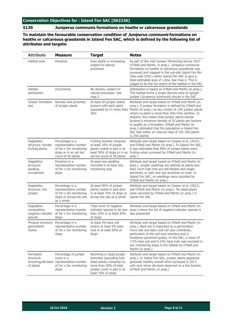
Conservation Objectives for : Island Fen SAC [002236]
5130 Juniperus communis formations on heaths or calcareous grasslands
To maintain the favourable conservation condition of Juniperus communis formations on heaths or calcareous grasslands in Island Fen SAC, which is defined by the following list of attributes and targets:
Attribute Measure Target NotesHabitat area Hectares Area stable or increasing,
subject to natural processes
As part of the Irish Juniper Monitoring Survey 2017 (O'Neill and Martin, in prep.), Juniperus communis formations on heaths or calcareous grasslands was surveyed and mapped in the sub-site Island Fen Birr (site code OY01) within Island Fen SAC to give a total estimated area of 1.6ha. See map 2. This is judged to be the full extent of the habitat in the SAC
Habitat distribution
Occurrence No decline, subject to natural processes. See map 2
Distribution is based on O'Neill and Martin (in prep.). The habitat forms a single discrete area of upright juniper (Juniperus communis) shrubs in the SAC
Juniper formation size
Number and proximity of juniper plants
At least 50 juniper plants present with each plant separated by no more than 20m
Attribute and target based on O'Neill and Martin (in prep.). A juniper formation is defined by O'Neill and Martin (in prep.) as any cluster of ≥50 juniper plants where no plant is more than 20m from another. In practice, this means that juniper plants should achieve a minimum density of 25 plants per hectare to qualify as a formation. O'Neill and Martin (in prep.) estimated that the population in Island Fen SAC falls within an interval class of 101-300 plants (c.250 plants)
Vegetation structure: female fruiting plants
Percentage in a representative number of 5m x 5m monitoring stops or in an ad hoc count of 50 plants
Fruiting females comprise at least 10% of juniper plants rooted in plot in at least 50% of stops or in an ad hoc count of 50 plants
Attribute and target based on Cooper et al. (2012) and O'Neill and Martin (in prep.). In Island Fen SAC, it was estimated that 40% of juniper plants were fruiting when surveyed by O'Neill and Martin (in prep.)
Vegetation structure: seedling recruitment
Presence in a representative number of 5m x 5m monitoring stops
At least one seedling recorded in at least one monitoring stop
Attribute and target based on O'Neill and Martin (in prep.). Juniper seedlings are defined as plants less than 15cm high that are still flexible and single-stemmed, or with only two branches at most. In Island Fen SAC, no seedlings were recorded by O'Neill and Martin (in prep.)
Vegetation structure: live juniper
Percentage in a representative number of 5m x 5m monitoring stops or across the site as a whole
At least 90% of juniper plants rooted in plot alive in at least 75% of stops or across the site as a whole
Attribute and target based on Cooper et al. (2012) and O'Neill and Martin (in prep.). No dead plants were recorded by O'Neill and Martin (in prep.) in Island Fen SAC
Vegetation composition: negative indicator species
Percentage in a representative number of 5m x 5m monitoring stops
Total cover of negative indicator species to be less than 10% in at least 50% of stops
Attribute and target based on O'Neill and Martin (in prep.) where the list of negative indicator species is also presented
Physical structure: germination niches
Percentage in a representative number of 5m x 5m monitoring stops
At least 5% bare soil and/or at least 5% bare rock in at least 50% of stops
Attribute and target based on O'Neill and Martin (in prep.). Bare soil is important as a germination micro-site and bare rock can also contribute, particularly at the soil-rock interface and in limestone pavement grikes. In this SAC, a mean of 7.5% bare soil and 0.15% bare rock was recorded in two monitoring stops in the habitat by O'Neill and Martin (in prep.)
Formation structure: browning/die-back of plants
Percentage of juniper cover in a representative number of 5m x 5m monitoring stops
Browning or dead juniper branches (excluding fully dead plants) comprise no more than 20% of total juniper cover in plot in at least 75% of stops
Attribute and target based on O'Neill and Martin (in prep.). In Island Fen SAC, juniper plants appeared generally healthy overall when surveyed in 2017, with only minor die-back observed on a few bushes (O'Neill and Martin, in prep.)
18 Oct 2018 Page 8 of 11 Version 1

Formation structure: evidence of browsing and bark stripping
Occurrence across a representative number of 5m x 5m monitoring stops
Recent browsing of juniper plants and bark stripping and trampling due to browsers evident in no more than 50% of stops
Attribute and target based on O'Neill and Martin (in prep.). This attribute concerns bark stripping by animals. Bark stripping or damage from abrasion by rock is not included here. It should be noted, however, that distinguishing between the two may be difficult. No evidence of juniper browsing was recorded in the habitat in Island Fen SAC by O'Neill and Martin (in prep.)
Indicators of local distinctiveness
Occurrence and population size
No decline in distribution or population sizes of rare, threatened or scarce species associated with the habitat
This includes species listed in the Flora (Protection) Order, 2015 and/or the red data lists (Lockhart et al., 2012; Wyse Jackson et al., 2016)
18 Oct 2018 Page 9 of 11 Version 1

Conservation Objectives for : Island Fen SAC [002236]
7230 Alkaline fens
To maintain the favourable conservation condition of Alkaline fens in Island Fen SAC, which is defined by the following list of attributes and targets:
Attribute Measure Target NotesHabitat area Hectares Area stable or increasing,
subject to natural processes
Alkaline fens habitat has not been mapped in detail for Island Fen SAC and thus the total area of the qualifying habitat in the SAC is unknown. Small areas of the habitat occur at reedbed margins in the west and north of the SAC, and also between the reedbed and the river in the east of the SAC. The alkaline fen grades into reed swamp and wet marsh habitats in places (NPWS internal files)
Habitat distribution
Occurrence No decline, subject to natural processes
See the notes for Habitat area above
Ecosystem function: soil nutrients
Soil pH and appropriate nutrient levels at a representative number of monitoring stops
Maintain soil pH and nutrient status within natural ranges
Relevant nutrients and their natural ranges are yet to be defined. However, nitrogen deposition is noted as being relevant to this habitat in NPWS (2013). See also Bobbink and Hettelingh (2011)
Ecosystem function: peat formation
Percentage cover of peat-forming vegetation and water table levels
Maintain active peat formation, where appropriate
In order for peat to form, water levels need to be slightly below or above the soil surface for c.90% of the time
Ecosystem function: hydrology - groundwater levels
Water levels (centimetres); duration of levels; hydraulic gradients
Maintain, or where necessary restore, appropriate natural hydrological regimes necessary to support the natural structure and functioning of the habitat
Fen habitats require high groundwater levels (i.e. water levels at or above the ground surface) for a large proportion of the calendar year (i.e. duration of mean groundwater level). Fen groundwater levels are controlled by regional groundwater levels in the contributing catchment area (which sustain the hydraulic gradients of the fen groundwater table). Regional abstraction of groundwater may affect fen groundwater levels. In Island Fen SAC, alkaline fen habitat is confined to a small area and is dependent on continued high water levels within the adjacent reedbed (NPWS internal files)
Ecosystem function: hydrology - surface water flow
Drain density and form Maintain, or where necessary restore, as close as possible to natural or semi-natural drainage conditions
Drainage, either within or surrounding the fen habitat, can result in the drawdown of the alkaline fen groundwater table. The depth, geometry and density of drainage (hydromorphology) will indicate the scale and impact on fen hydrology. Drainage can result in loss of characteristic species and transition to drier habitats. Some areas of the habitat in Island Fen SAC have been damaged by drainage (NPWS internal files)
Ecosystem function: water quality
Water chemistry measures
Maintain appropriate water quality, particularly pH and nutrient levels, to support the natural structure and functioning of the habitat
Fens receive natural levels of nutrients (e.g. iron, magnesium and calcium) from water sources. However, they are generally poor in nitrogen and phosphorus, with the latter tending to be the limiting nutrient under natural conditions. Water supply should also be relatively calcium-rich. Devery (1996) recorded pH of 7.58 and conductivity of 675µS/cm in the fen habitat in Island Fen SAC
Community diversity
Abundance of variety of vegetation communities
Maintain variety of vegetation communities, subject to natural processes
The entire diversity of alkaline fen vegetation communities within this SAC is unknown. Information on the vegetation communities associated with alkaline fens in the uplands is presented in Perrin et al. (2014)
Vegetation composition: brown mosses
Percentage cover at a representative number of 2m x 2m monitoring stops
Maintain adequate cover of typical brown moss species
Typical brown moss species include Bryum pseudotriquetrum, Calliergonella cuspidata, Calliergon giganteum, Campylium stellatum, Cratoneuron filicinum, Ctenidium molluscum, Fissidens adianthoides, Palustriella commutata, Scorpidium cossonii, S. revolvens and S. scorpioides. There is a rich brown moss flora in the habitat in the SAC, including the species Calliergonella cuspidata and Ctenidium molluscum (NPWS internal files)
18 Oct 2018 Page 10 of 11 Version 1

Vegetation composition: typical vascular plants
Percentage cover at a representative number of 2m x 2m monitoring stops
Maintain adequate cover of typical vascular plant species
For lists of typical plant species see the Article 17 conservation status assessment for alkaline fens (NPWS, 2013) and the fen habitats supporting document (Kimberley, 2013). See also Perrin et al. (2014) and JNCC (2004). In this SAC, the habitat is typically dominated by black-bog rush (Schoenus nigricans), with other typical species including carnation sedge (Carex panicea), long-stalked yellow-sedge (C. lepidocarpa), flea sedge (C. pulicaris), blunt-flowered rush (Juncus subnodulosus), purple moor-grass (Molinia caerulea), devil's-bit scabious (Succisa pratensis), meadow thistle (Cirsium dissectum), marsh pennywort (Hydrocotyle vulgaris), grass-of-parnassus (Parnassia palustris) and common butterwort (Pinguicula vulgaris) (Devery, 1996; NPWS internal files). Orchids include bee orchid (Ophrys apifera) and early-purple orchid (Orchis mascula) (NPWS internal files)
Vegetation composition: native negative indicator species
Percentage cover at a representative number of 2m x 2m monitoring stops
Cover of native negative indicator species at insignificant levels
Negative indicators include species not characteristic of the habitat and species indicative of undesirable impacts such as overgrazing, undergrazing, nutrient enrichment, agricultural improvement or impacts on hydrology. Native negative indicators may include graminoids such as reed canary-grass (Phalaris arundinacea) and reed sweet-grass (Glyceria maxima), tall herbs such as great willowherb (Epilobium hirsutum), bracken (Pteridium aquilinum), bramble (Rubus fruticosus) and common nettle (Urtica dioica), and bryophytes such as Brachythecium rutabulum and Kindbergia praelonga
Vegetation composition: non-native species
Percentage cover at, and in local vicinity of, a representative number of 2m x 2m monitoring stops
Cover of non-native species less than 1%
Attribute and target based on Perrin et al. (2014). Non-native species can be invasive and have deleterious effects on native vegetation. A low target is set as non-native species can spread rapidly and are most easily dealt with when still at lower abundances
Vegetation composition: native trees and shrubs
Percentage cover in local vicinity of a representative number of monitoring stops
Cover of scattered native trees and shrubs less than 10%
Attribute and target based on Perrin et al. (2014). Scrub and trees will tend to invade if fen conditions become drier. Blackthorn (Prunus spinosa) scrub is encroaching on the southern end of the habitat in the east of the SAC (NPWS internal files)
Vegetation composition: soft rush and common reed cover
Percentage cover in local vicinity of a representative number of monitoring stops
Total cover of soft rush (Juncus effusus) and common reed (Phragmites australis) less than 10%
Attribute and target based on Perrin et al. (2014)
Vegetation structure: litter
Percentage cover in local vicinity of a representative number of monitoring stops
Total cover of litter not more than 25%
Attribute and target based on JNCC (2004). More than 25% litter cover may indicate insufficient removal of biomass by grazing and/or undesirable water table levels
Physical structure: disturbed bare ground
Percentage cover at, and in local vicinity of, a representative number of 2m x 2m monitoring stops
Cover of disturbed bare ground not more than 10%
Attribute and target based on Perrin et al. (2014). While grazing may be appropriate in this habitat, excessive areas of disturbed bare ground may develop due to unsuitable grazing regimes. Disturbance can include hoof marks, wallows, human footprints, vehicle and machinery tracks. Excessive disturbance can result in loss of characteristic species and presage erosion for peatlands
Physical structure: tufa formations
Percentage cover in local vicinity of a representative number of monitoring stops
Disturbed proportion of vegetation cover where tufa is present is less than 1%
Attribute and target based on Perrin et al. (2014)
Indicators of local distinctiveness
Occurrence and population size
No decline in distribution or population sizes of rare, threatened or scarce species associated with the habitat; maintain features of local distinctiveness, subject to natural processes
This includes species on the Flora (Protection) Order, 2015 and/or the red data lists (Lockhart et al., 2012; Wyse Jackson et al., 2016). The Near Threatened frog orchid (Coeloglossum viride) (Wyse Jackson et al., 2016) has been recorded in the habitat in the SAC (NPWS internal files)
18 Oct 2018 Page 11 of 11 Version 1

Ordnance Survey Ireland 2018
Map Version 1Date: July 2018
MAP 1:ISLAND FEN SAC
CONSERVATION OBJECTIVESSAC DESIGNATION
Map to be read in conjunction with the NPWS Conservation Objectives Document.
The mapped boundaries are of an indicative and general nature only. Boundaries of designated areas are subject to revision.Ordnance Survey of Ireland Licence No EN 0059216. © Ordnance Survey of Ireland Government of Ireland
Níl sna teorainneacha ar na léarscáileanna ach nod garshuiomhach ginearálta. Féadfar athbhreithnithe a déanamh ar theorainneacha na gceantarcomharthaithe. Suirbhéarachta Ordonáis na hÉireann Ceadúnas Uimh EN 0059216. © Suirbhéarachta Ordonáis na hÉireann Rialtas na hÉireann
±0 25 50 75 100Meters
SITE CODE:SAC 002236; version 3.01. CO. OFFALY
Legend
Island Fen SAC 002236
Killyon
Clareen
Longford
Birr
CO. OFFALY
CO. TIPPERARY
SAC 002236

Map Version 1Date: July 2018
MAP 2:ISLAND FEN SAC
CONSERVATION OBJECTIVESJUNIPER
Map to be read in conjunction with the NPWS Conservation Objectives Document.
The mapped boundaries are of an indicative and general nature only. Boundaries of designated areas are subject to revision.Ordnance Survey of Ireland Licence No EN 0059216. © Ordnance Survey of Ireland Government of Ireland
Níl sna teorainneacha ar na léarscáileanna ach nod garshuiomhach ginearálta. Féadfar athbhreithnithe a déanamh ar theorainneacha na gceantarcomharthaithe. Suirbhéarachta Ordonáis na hÉireann Ceadúnas Uimh EN 0059216. © Suirbhéarachta Ordonáis na hÉireann Rialtas na hÉireann
±0 25 50 75 100Meters
SITE CODE:SAC 002236; version 3.01. CO. OFFALY
Legend
5130 Juniperus communis formations on heaths or calcareous grasslands
Island Fen SAC 002236
OSi Discovery Series County Boundary