isle of wight coastal audit - historic england · isle of wight coastal audit volume 1 report...
TRANSCRIPT

Isle of Wight Coastal Audit
Volume 1
Report prepared for English Heritage by the Isle of Wight County
Archaeology and Historic Environment Service
Second draft September 2000
i
Contents
1 Background..................................................................................................................... 1
1.1 The study area ....................................................................................................... 1
1.2 Previous work ....................................................................................................... 1
1.3 Reasons for and circumstances of the project ...................................................... 2
2 Archaeological aims and objectives............................................................................... 3
2.1 Academic or research design................................................................................ 3
3 Methods statement.......................................................................................................... 3
3.1 Desktop assessment .............................................................................................. 4
3.2 Fieldwork .............................................................................................................. 5
3.2.1 The intertidal zone................................................................................................. 5
3.2.2 The shoreline/cliff edge......................................................................................... 6
3.2.3 Landward of the coast to the 2070 benefits line ................................................... 6
4 The management units and their archaeological content............................................... 7
5 The results of the survey............................................................................................... 119
6 Ranking of archaeological and geo-archaeological importance .................................. 122
7 General management conclusions................................................................................ 125
8 Appendix 1 Sample hulk recording form..................................................................... 131
9 Bibliography ................................................................................................................. 132

1
1 Background
1.1 The study area
The Isle of Wight is an island of 38,000 hectares, enclosed by 97 kilometres of open coast. This
coastline is remarkably varied, ranging from high, rugged cliffs on the south side of the Island to
the more gentle landscape of the northern coast. The estuaries of the Medina, Newtown,
Wootton and the Western Yar comprise a further 70 kilometres.
1.2 Previous work
The archaeological potential of the coast of the Isle of Wight has been recognised since at least
the early part of the twentieth century. Antiquaries such as G.W. Colenutt and Hubert Poole
collected flint implements from the north coast of the Island, including the Medina and
Newtown estuaries, and from the eroding cliffs of the south west coast (Poole 1936). As early as
1886, palaeolithic implements were found on the shore at Priory Bay on the eastern tip of the
Island (Sampson 1976). In the Undercliff, on the south east coast, middens ranging in date from
the Bronze Age to the medieval period were noted (Sherwin unpubl.). A Late Bronze Age
urnfield was investigated at Barnes High on the south west coast (Dunning 1931), whilst more
recently, excavations were carried out at Redcliff, near Sandown, where flintwork and an early
Roman salt working site were investigated (Tomalin 1989). These sites are recorded in the Isle
of Wight Sites and Monuments Record.
In 1991 the Isle of Wight Council and English Heritage embarked upon a collaborative project
to survey and assess the full archaeological potential of a small section of the Solent coast. The
result was the Wootton-Quarr survey, a seamless archaeological view of a section of the coastal
zone. Prior to the survey, a number of flint picks and some sherds of Roman pottery were the
only intertidal finds recorded from this stretch of coast in the Isle of Wight Sites and
Monuments Record. Surprisingly, despite its modest sample area, the Wootton-Quarr survey
revealed more than 150 intertidal sites, comprising scatters of lithics, pottery and other artefacts,
and timber structures including trackways, fish traps and post alignments. Palaeo-environmental
samples were gathered from peat beds, which also contained fallen trees which were
subsequently dated dendrochronologically, and from the sediments contained within
palaeochannels which crossed the intertidal zone. It was thought likely that a similar range of
archaeological sites was being revealed by coastal erosion at other locations in the Island's
intertidal zone, whilst other sites were subject to cliffline recession. Limited fieldwork during
the Wootton-Quarr project had already identified further sites at Newtown, Thorness, East
Cowes and Puckpool on the Solent coast, and at several locations between St Catherine's Point
and Compton on the south west coast.
During the life of the Wootton-Quarr project some significant changes took place in the national
perception of coastal archaeology. These have been recently summarised (Fulford et al 1997). A
further important development was Government's promotion, through MAFF, of Shoreline
Management Plans. In many of these documents the protective measures for the concealed and
unassessed coastal archaeological resource are far from consistent or robust. These plans will,
however, be used to guide the policies and actions of the coastal protection authorities.

2
The Wootton-Quarr survey successfully highlighted some important new issues of interest to
coastal protection authorities. These concern the practical implementation of a coastal protection
programme which comprehends the actual archaeological resource contained within each of the
process units identified in a shoreline management plan. This issue is a problem common to all
sections of the British coastline and there is now a pressing need for exemplary action by a
sympathetic coastal protection authority to establish and implement the necessary archaeological
principles.
1.3 Reasons for and circumstances of the project
In 1997, English Heritage and RCHME published an assessment of English coastal archaeology
which recommended that
The record of coastal archaeology held nationally and locally should continue to be actively
developed and enhanced in order to permit effective management of the resource and to
facilitate understanding of England's development as a maritime nation... through
consolidation of existing information and through new survey and recording projects. (Fulford
et al 1997, 18-19)
As a result of this, it was proposed that rapid coastal surveys should be undertaken in order to
gain a national overview of the nature and scale of archaeological and historic sites and features
in the coastal zone.
Due to its notable geomorphological variation, the Isle of Wight coastline is particularly well
suited to test the character of archaeological sites in differing coastal settings and to establish the
nature, scale and pace of their individual timetables of destruction. In 1998, English Heritage
provided funding for a rapid coastal audit to be carried out by the Isle of Wight Archaeological
Unit. This work could draw upon the strengths of local experience and the progress which had
been achieved in the execution of the Wootton-Quarr project. The coastal audit was primarily a
SMR enhancement tool, but a secondary purpose of the project was to contribute to a study
entitled `Coastal Change, Climate and Instability', which was being carried out by the Isle of
Wight Council in collaboration with partners in France and Ireland under the auspices of
`L'Instrument Financière de l'Environnement' (LIFE) of the European Union. One of the key
tasks of this project was `to demonstrate the value of using archaeological (palaeo-
environmental) evidence to predict the nature, scale and pace of coastal change' and it was felt
that the coastal audit could provide useful information.

3
2 Archaeological aims and objectives
2.1 Academic or research design
The coastal audit had three primary aims:
• To enhance the coastal coverage of the County Sites Monuments Record and Historic
Buildings Record to a level where it is specifically equipped to deal with the protection
issues arising in select geomorphological settings covered by the Shoreline Management
Plan.
• To contribute to the European LIFE programme, which includes the publication of best
practice guidelines on the management of coastal archaeological resources, drawing
upon exemplars in Wight, Gironde and Shannon.
• To establish best practice principles in management-related field survey which can be
followed by the Coastal Protection Authorities and can be used to inform DETR in its
future initiatives in coastal protection planning.
The objectives were:
• To identify sites and structures in the coastal zone (the intertidal zone, the coast edge
and the coastal strip to the limit inland of the 2070 benefits line) using documentary
records, air photographs and in the field.
• To assess the condition and vulnerability of sites in the coastal zone.
• To prepare a report for English Heritage synthesising the results of the survey.
• To provide information for Coastal Protection Authorities and the European LIFE
programme.
3 Methods statement
The following methodologies were applied:
1. Desktop appraisal of documentary, cartographic and air photographic evidence for the
areas studied.
2. Rapid walk-over survey of the intertidal zone and shoreline of the Isle of Wight coast
and estuaries, recording features by DGPS fixing and photography.

4
1For these tasks the inland boundary was taken to be the 2070 benefits line as defined in the Isle
of Wight shoreline management plan (Halcrow 1997), except where this was felt to be
inappropriate.
1 ‘..the landward limit of the area that could be at risk at some stage over the next 75 years were the coast not to
be protected.
In the case of coastline that is unprotected, the line represents a modelled evolution prediction to the year 2070
based upon historical trends in Low Water Mark movement, modified to reflect accelerated sea level rise through
the application of Brunn's [sic] rule. In the case of coastline that is protected...frontage rates of a similar order to
those of adjacent unprotected coast are applied.
For low lying areas, where flood risk is the prime cause for concern, and in the absence of more detailed
topographical data, the line is based upon the 5m contour’ (Halcrow 1997, 2.13).
3.1 Desktop assessment
Desktop assessment was carried out for each coastal management unit before initiation of
survey and included the following:
• All sites seaward of the 2070 benefits line contained within the Isle of Wight Sites and
Monuments Record, the Maritime Sites and Monuments Record, the Historic Buildings
Record, Listed Buildings records, the English Heritage Register of Historic Parks and
Gardens and the Isle of Wight Gardens Trust Register of Parks and Gardens, were
identified and plotted on maps for use during field survey.
• Air photographs held at the Isle of Wight County Archaeological Centre were studied. In
addition, photographic archives held by the Environment Agency were examined. The
aerial photographic coverage held by the Environment Agency was inspected at
Worthing during the preparation of the project design. More than 7000 prints of the low
water study area have been taken since 1979. These are vertical views at 1:5000 and
1:3000. In view of the large number of prints available, it was decided to concentrate on
just two sets of prints, those taken in 1983 and 1997.
• Early maps and charts held by the County Archaeological Unit and the Isle of Wight
County Records Office were appraised. Buildings or structures of relevance to the coast
which were not already recorded in the county Sites and Monuments Record or Historic
Buildings Record, including lighthouses, lifeboat stations, military installations,
shipyards, bridges, quays, salterns, oyster pens, piers and jetties were noted.
• Reference was made to historical documents and previously published sources such as
VCH, local history books, etc. The Isle of Wight Industrial Archaeology Society was
also consulted.
While it was intended to complete the desktop assessment prior to fieldwork, in practice it was
often necessary to re-examine maps, aerial photographs and documentary sources after having
surveyed and become familiar with a stretch of coast.

5
3.2 Fieldwork
Fieldwork was carried out over three zones:
• the intertidal zone (coastline to extreme low water).
• cliff faces/coast edge.
• each field and parcel within a strip seaward of the 2070 benefits line.
The objectives of the fieldwork were:
• to assess the condition and survival of previously documented sites.
• to identify on the ground sites located on aerial photographs.
• to identify previously unrecorded sites.
• to produce a brief description, and photographic record of sites, include defining the
extent of sites using DGPS fixing.
• to assess the future management requirements of sites, including the need for further
recording.
3.2.1 The intertidal zone
The intertidal zone was walked with the exception of areas which had been stripped of
sediments and silts, and areas where safety would have been jeopardised, e.g. thick mud or
heavily polluted areas. In practice, however, there were few areas which were not at least
scanned from a distance.
It was not intended to examine the intertidal zone of the south west coast, from the Needles to
Blackgang, other than to visit previously recorded sites or to investigate areas of potential for
past human activity, i.e. adjacent to combes, spring outflows and possible palaeochannels.
However, much of the cliff face was surveyed from the beach, so at least the upper part of the
intertidal zone was examined at the same time.
Parts of the intertidal zone of the rocky southern end of the south east coast were walked
rapidly, largely for the purpose of recording post medieval constructions. At the same time, the
cliff face was examined.
The whole of the intertidal zone of the northern coast, including the estuaries of the Medina,
Wootton Creek, Newtown and the Western Yar to their tidal limits, was investigated. The
estuary of the Eastern Yar was not seen as a priority because it can be classified as defended
coast.
Intertidal shipwrecks and hulks were position fixed and photographed. Where possible, a Stage
6
2 survey as set out by Milne et al (1998) was undertaken (Appendix 1). However, in many cases
the vessels were buried in deep mud. In addition to making access difficult, there was not the
time nor the resources to clean and record them adequately during this rapid survey.
3.2.2 The shoreline/cliff edge
Where possible, the coast edge was examined. In some areas this was not feasible, for example
where the cliff edge was obscured by vegetation cover or due to safety considerations caused by
waterlogged or unstable cliff edges. However, in most cases, the cliff face was examined from
below.
Areas which were seen as having the greatest potential for this type of examination were the
south west coast, the Undercliff and the north coast from Alum Bay to Yaverland, excluding
urban areas and defended coast. Sites were also known to be visible in the low banks of the
estuaries.
For urban areas a gazetteer was compiled from documentary records. Known archaeological
sites were visited to assess their condition if they were readily accessible.
3.2.3 Landward of the coast to the 2070 benefits line
The coastal strip was rapidly walked wherever accessible. In urban areas and defended coast, it
was intended to restrict fieldwork to an inspection of archaeological sites previously identified
during the desktop assessment. However, numerous additional structures such as drinking
fountains, cranes and pillboxes were noted during the survey. Pre-twentieth century military
sites had been the subject of an earlier report (Saunders, 1998) so these were not examined in
any detail, although other related military features were found outside the immediate area of
these batteries and forts.
7
4 The management units and their archaeological content
The Isle of Wight Coast Shoreline Management Plan divides the Island’s coastline into six
Process Units, each of which represents ‘a section of coastline that possesses coherent
characteristics in terms of natural coastal processes which are sufficiently independent of
adjacent stretches of shoreline' (Halcrow et al, 1997, vol 2, p.2.2). These Process Units are
further subdivided into Management Units, defined by MAFF as ‘a length of shoreline with
coherent characteristics in terms of coastal processes and land us’' (Halcrow et al, ibid). For
the Isle of Wight Coast Shoreline Management Plan, a Management Unit is further defined as ‘a
length of coast that requires a specific coastal defence option for the future to meet the overall
strategic requirements for the Process Unit’. The Island’s coast has been divided into 51
Management Units (fig. 1). These include the Newtown Estuary, although the Medina and the
Western Yar are subject to their own Estuary Management Plans.
The following descriptions of each management unit, the land at risk and the recommended
strategy for each are taken from the Shoreline Management Plan, and the Estuary Management
Plans for the Medina and Western Yar Estuaries. These are followed by a brief description of
the number and range of archaeological and historic sites in each unit.

8
Figure 1 Isle of Wight Coast. Management Units

9
MANAGEMENT UNIT RYD 1 - OLD CASTLE POINT TO WEST WOODSIDE
Description
The coastal edge of this frontage is wholly undeveloped, with Norris Castle set well back. The shoreline
is almost entirely backed by woodland, with the exception of pockets of agricultural land and the open
grounds of Norris Castle. The coastal slope rises to 40m and is generally stable. The slope is
interrupted by Kings Quay, the mouth of the estuary of Palmers Brook, which is flanked by low wooded
cliffs. East of Kings Quay the low slope continues towards Woodside.
Description of Land at Risk
The predicted ‘without defences’ 75 year retreat for this unit ranges between 50 and 200m. The
resultant slope retreat would mean the loss of a large area of coastal woodland, along with agricultural
land and an area of the grounds at Norris Castle.
Recommended Strategy - Do nothing/retreat the existing defence line
The Historic Environment (fig. 2)
44 SMR entries
2 Listed buildings
2 EH Parks and Gardens Register
This management unit contains the seaward parts of the historic estates of Norris Castle,
Osborne House and Barton Manor. The grounds of Norris and Osborne are included in the
English Heritage Register of Parks and Gardens (Norris Grade II, Osborne Grade II*).
In Osborne Bay, groynes constructed of large Bembridge limestone rubble appear to have
slowed coastal erosion. The bay contains several structures relating to Queen Victoria's
residence at Osborne. Two Grade II listed structures, an ornate shelter and an Italianate style
boathouse, on the coast edge are in need of attention. The remains of a pier used by bathing
machines are visible in the intertidal zone but are in poor condition. Two hulks were recorded
buried in intertidal mud. These are probably of post medieval date.
The intertidal zone between Barton Bay and King's Quay contains palaeoenvironmental deposits
and post alignments and structures, some of which were radiocarbon dated during the Wootton-
Quarr project. A number of these are related to the deserted medieval vil of Shoflet. Prehistoric
flint implements including picks and tranchet axes have been recovered from the beach. This is
an area of high archaeological and palaeoenvironmental potential which was masked by mobile
sediment at the time of survey.
Coastal recession to the east of King's Quay appeared particularly active at the time of survey,
and erosion of the saltmarsh deposits at King's Quay was also apparent.

10
RYD 1 Condition
Ploughed
1.89%
Tree plant ed
1.89%
Damaged
3.77%
Not known
11.32%
No evidence on ground
1.89%
Ext ant
26.42%
Coast al erosion
52.83%
RYD 1 Land Use
Garden
1.89%
Building
3.77%
Grassland heathland
1.89%
Above high water
5.66%
Intertidal
50.94%
Saltmarsh
1.89%
Woodland
18.87%
Cultivated
3.77%
Boundary
1.89%
Recreational use
1.89%
Not known
7.55%
RYD 1Period
Unknown 41.86%
Modern 4.65%
Medieval 4.65%
Mesolithic 6.98%
Prehistoric 4.65%
Post medieval 37.21%
Figure 2 RYD 1

11
MANAGEMENT UNIT RYD 2 - WEST WOODSIDE TO CHAPELCORNER COPSE
Description
The sparsely developed coastal frontage of Woodside is developed on a low slope and interspersed with
areas of woodland. The eastern part of the unit contains residential developments, with the majority of
the remainder developed for tourist accommodation, and set aside for further such development in the
UDP.
Description of Land at Risk
The predicted ‘without defences’ 75 year retreat for this unit is approximately 130m to the west and
150m to the east. This would involve the loss of a number of properties on the seaward side of Woodside
Road, along with much of the caravan park area. Several landing stages fronting the village would also
be lost, along with a significant area of woodland.
Recommended Strategy - retreat the existing defence line
The Historic Environment (fig. 3)
5 SMR entries
Occasional prehistoric flint implements and Roman pottery sherds have been found on this
stretch of coast. The source of these is unknown but they may originate from the eroding coastal
slope. A wood and metal structure observed on the beach is thought to be of WW2 date.
Coastal recession was evident in this unit, with trees growing on the coastal slope tumbling onto
the foreshore.

1
Figure 3 RYD 2
2
RYD 2 Condition
Not known
20.00%
Coastal erosion
80.00%
RYD 2 Land Use
Intertidal
100.00%
RYD 2
Period
Modern
20.00%
Mesolithic
60.00%Post medieval
20.00%

13
MANAGEMENT UNIT RYD 3 - WOOTTON CREEK
Description
Wootton Creek is designated as being of international nature conservation importance. The
predominantly residential villages of Wootton and Fishbourne are both set back slightly from the coast,
along the side of the Creek. The Creek is also flanked by areas of tourist accommodation, an
engineering works, a Country Club, agricultural land and woodland. A Ro-Ro vehicle and passenger
ferry operates between Portsmouth and Fishbourne (on the east side of the creek). The part of the Creek
above Wootton Bridge is no longer intertidal and is dammed to form The Old Mill Pond. The low slope
of the sides of the creek limit the area prone to flooding to a very thin fringe above high water.
The cultural heritage here comprises multi-period archaeological deposits and structures contained
within the intertidal zone. These are of national importance and are currently subject to erosion. The
stratification of these deposits suggest that their disturbance is a very recent event and that their long
history of preservation has been due to the natural and gentle accretion of sediment on the east side of
the creek mouth.
Description of Land at Risk
The predicted ‘without defences’' 75 year scenario for this unit involves limited erosion, and flooding of
the narrow low lying area around the Creek. The Wightlink ferry terminal walls and pier would be
affected by erosion as would developments on the very edge of the Creek. Flooding would affect all low
lying land around the Creek, extending potentially to areas upstream around Old Mill Pond. Erosion of
the foreshore would destroy internationally important archaeological deposits at the mouth of the
Creek.
Recommended Strategy - Hold the existing line
The Historic Environment (fig. 4)
23 SMR entries
5 Historic buildings
2 Listed buildings
This area was examined in detail during the English Heritage funded Wootton-Quarr project,
when evidence of human activity ranging from prehistoric to post medieval in date was
recorded. Extensive palaeoenvironmental deposits including intertidal peats and recumbent
trees, and deep sequences of Holocene sediments within the Wootton channel were noted. The
survey is to be published in a monograph (Tomalin et al forthcoming).
Erosion at the mouth of the creek is particularly active, and beach levels are falling.
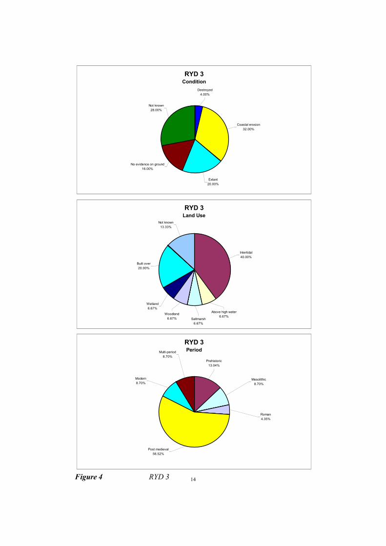
14 Figure 4 RYD 3
RYD 3 Condition
Destroyed
4.00%
Not known
28.00%
No evidence on ground
16.00%
Coastal erosion
32.00%
Extant
20.00%
RYD 3 Land Use
Built over
20.00%
Wetland
6.67%
Woodland
6.67% Saltmarsh
6.67%
Above high water
6.67%
Not known
13.33%
Intertidal
40.00%
RYD 3 Period
Post medieval
56.52%
Modern
8.70%
Multi-period
8.70%
Prehistoric
13.04%
Roman
4.35%
Mesolithic
8.70%
15
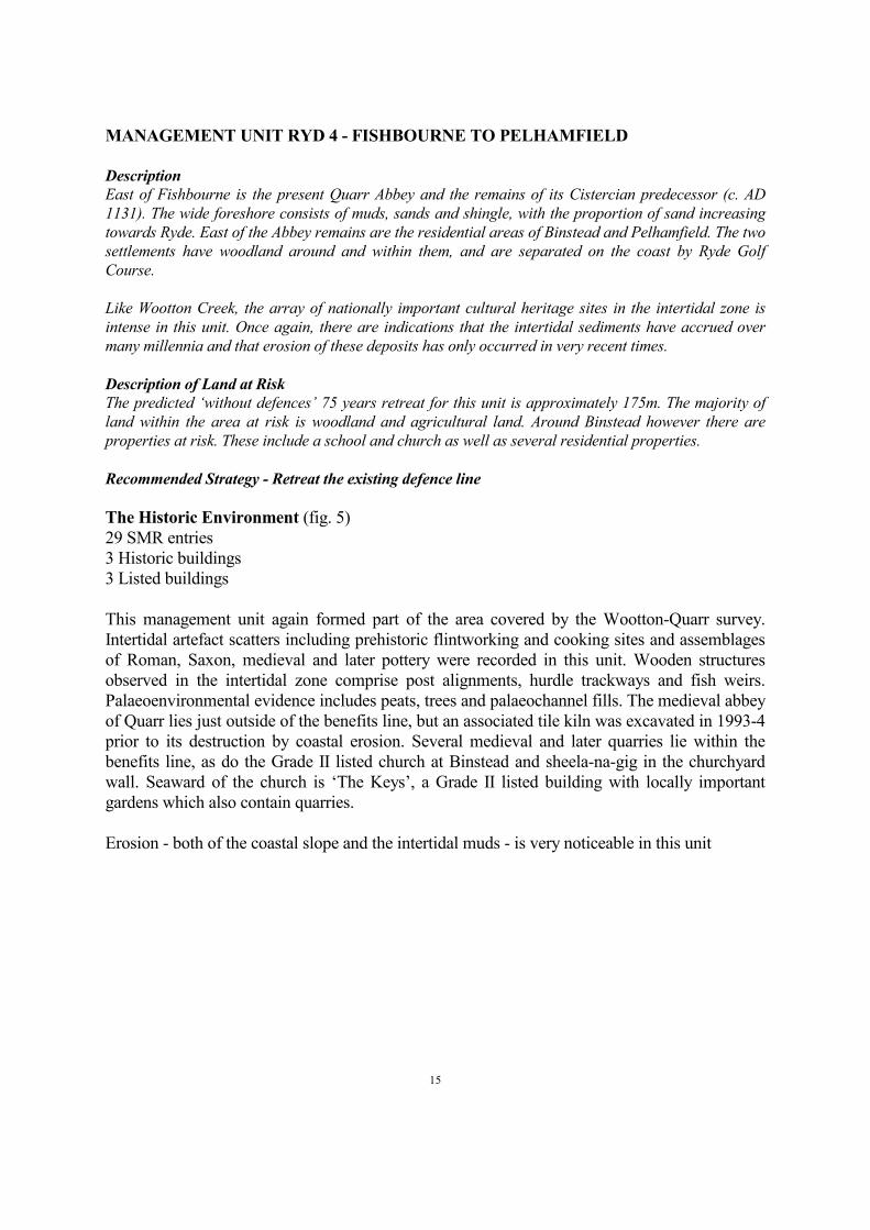
MANAGEMENT UNIT RYD 4 - FISHBOURNE TO PELHAMFIELD
Description
East of Fishbourne is the present Quarr Abbey and the remains of its Cistercian predecessor (c. AD
1131). The wide foreshore consists of muds, sands and shingle, with the proportion of sand increasing
towards Ryde. East of the Abbey remains are the residential areas of Binstead and Pelhamfield. The two
settlements have woodland around and within them, and are separated on the coast by Ryde Golf
Course.
Like Wootton Creek, the array of nationally important cultural heritage sites in the intertidal zone is
intense in this unit. Once again, there are indications that the intertidal sediments have accrued over
many millennia and that erosion of these deposits has only occurred in very recent times.
Description of Land at Risk
The predicted ‘without defences’ 75 years retreat for this unit is approximately 175m. The majority of
land within the area at risk is woodland and agricultural land. Around Binstead however there are
properties at risk. These include a school and church as well as several residential properties.
Recommended Strategy - Retreat the existing defence line
The Historic Environment (fig. 5)
29 SMR entries
3 Historic buildings
3 Listed buildings
This management unit again formed part of the area covered by the Wootton-Quarr survey.
Intertidal artefact scatters including prehistoric flintworking and cooking sites and assemblages
of Roman, Saxon, medieval and later pottery were recorded in this unit. Wooden structures
observed in the intertidal zone comprise post alignments, hurdle trackways and fish weirs.
Palaeoenvironmental evidence includes peats, trees and palaeochannel fills. The medieval abbey
of Quarr lies just outside of the benefits line, but an associated tile kiln was excavated in 1993-4
prior to its destruction by coastal erosion. Several medieval and later quarries lie within the
benefits line, as do the Grade II listed church at Binstead and sheela-na-gig in the churchyard
wall. Seaward of the church is ‘The Keys’, a Grade II listed building with locally important
gardens which also contain quarries.
Erosion - both of the coastal slope and the intertidal muds - is very noticeable in this unit

16
RYD 4 Condition
Tree planted
12.90%
Ploughed
3.23%
Overgrown
6.45%
Not known
12.90%
No evidence on ground
3.23%
Extant
12.90%
Coastal erosion
38.71%
Damaged
9.68%
RYD 4 Land Use
Boundary
6.25% Not known
3.13%
Garden
12.50%
Building
3.13%
Built over
3.13%
Cultivated
3.13%
Woodland
21.88% Grassland heathland
3.13%
Cliffs
3.13%
Above high water
3.13%
Intertidal
37.50%
RYD 4 Period
Post medieval
34.48%
Unknown
20.69%
Multi-period
3.45%
Medieval
20.69%
Roman
6.90%
Neolithic
3.45%
Mesolithic
6.90%
Prehistoric
3.45%
Figure 5 RYD 4

17
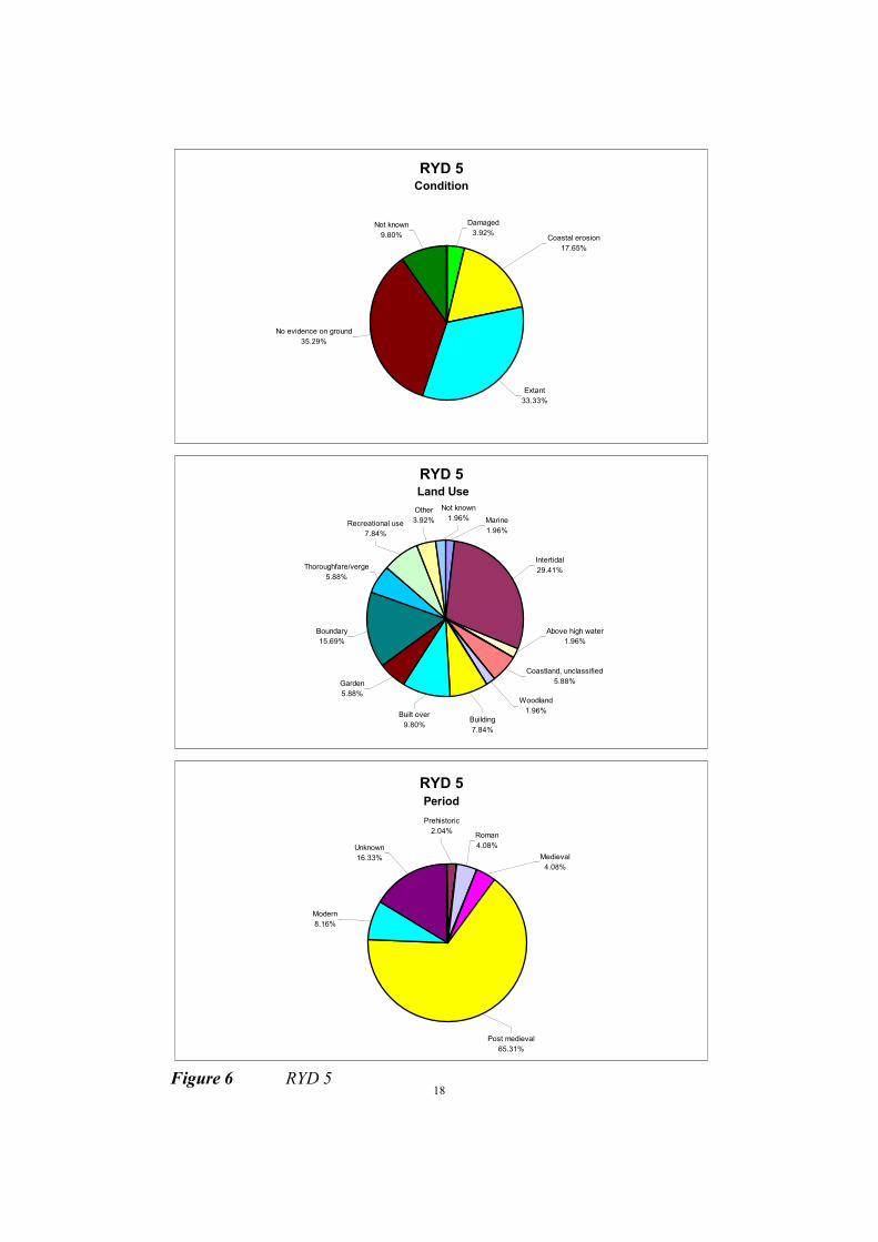
.MANAGEMENT UNIT RYD 5 - PELHAMFIELD TO PUCKPOOL HILL
Description
Pelhamfield forms the western side of Ryde. Known as the ‘gateway to the Island’, Ryde is a popular
resort on the Island and is characterised by elegant housing, shops and entertainment facilities; also by
its sandy beaches with an Esplanade and promenade. With a population of approximately 30,000 it is
also the Island’s largest town. Both a catamaran and hovercraft service operate to and from
Portsmouth. From West Ryde to the marina (east of Ryde Pier), coastal defences consist of a seawall
with a concrete apron or revetment. A new breakwater forms the defences along the northern flank of
the Marina, and this continues as a splash wall through to Puckpool Point. A convergence of longshore
drifts at Ryde has led to the accumulation of Ryde Sand, a feature designated as being of international
nature conservation importance. East of Ryde itself, at the edge of the unit, are the holiday centres of
Puckpool Point.
Description of Land at Risk
The predicted ‘without defences’ 75 years retreat for this unit is approximately 130m. The area at risk
includes Ryde's commercial and amenity seafront area, and thus any loss would have serious
implications for the local economy. Features at risk include the Pier and its ferry terminal, the
Esplanade, seafront shops and amenities, Ryde Marina, and a considerable amount of housing. Also
threatened are the Puckpool Holiday Centre, Appley Park, St Cecilia’s Abbey, and the boating lake.
Recommended Strategy - Hold the existing defence line
The Historic Environment (fig. 6)
50 SMR entries
53 Historic buildings
1 SAM
44 Listed buildings
Conservation Area
This management unit includes the town of Ryde, with its many listed buildings, including the
pier, pavilion and Appley Tower, its promenade, boating lake and coastguard cottages. At the
eastern end of the unit is Puckpool Battery, a Scheduled Ancient Monument.
In the intertidal zone, it is highly likely that a range of archaeological and palaeoenvironmental
sites similar to those recorded on the Wootton-Quarr coast are masked by Ryde Sands.
Although there is little evidence of active erosion in this management unit, aerial photographic
evidence suggests that archaeological features on the eastern side of the sands have become
uncovered in the last few years. These include at least 5 hulks, a post alignment and a stone and
timber V-shaped fish weir. The eastern end of this unit is a continuation of what is visible in
RYD 6, and includes palaeoenvironmental deposits associated with the reclaimed inlet at
Springvale.
18
RYD 5 Condition
No evidence on ground
35.29%
Extant
33.33%
Coastal erosion
17.65%
Damaged
3.92%Not known
9.80%
RYD 5 Land Use
Above high water
1.96%
Coastland, unclassified
5.88%
Woodland
1.96%
Building
7.84%
Built over
9.80%
Garden
5.88%
Other
3.92%Recreational use
7.84%
Thoroughfare/verge
5.88%
Boundary
15.69%
Not known
1.96% Marine
1.96%
Intertidal
29.41%
RYD 5 Period
Prehistoric
2.04%Roman
4.08%
Medieval
4.08%
Unknown
16.33%
Modern
8.16%
Post medieval
65.31%
Figure 6 RYD 5

19
MANAGEMENT UNIT RYD 6 - PUCKPOOL HILL TO SALTERNS ROAD,
SEAVIEW
Description
This unit is based on the low lying land around The Duver, an infilled inlet now of conservation interest
as a brackish lagoon. The area has some residential housing at Spring Vale, along with areas of holiday
bungalows. There are areas of woodland and agricultural land around Spring Vale, along with the
Flamingo Park waterfowl gardens.
Description of Land at Risk
The predicted ‘without defences’ flood risk area for this unit, in the absence of detailed topographical
data, is largely based upon the 5m contour, this being the low lying land which delimits this unit. This
area includes the majority of housing at Spring Vale and some on the edge of Seaview, part of Flamingo
Park, all holiday bungalows at the Tollgate and Salterns sites, agricultural land, and The Duver.
Recommended Strategy - Hold the existing defence line
The Historic Environment (fig. 7)
16 SMR entries
9 Historic buildings
8 Listed buildings
This unit includes the enigmatic harbour of Barnsley, though to have occupied the low lying
area now reclaimed behind a stone embankment, and later the site of a salterns complex with
some associated buildings still surviving. There are several listed buildings on the sea front and
also a row of coastguard cottages.
Intertidal features include linear and curvilinear structures composed of Bembridge limestone
rubble, the longest of which extends for almost a kilometre. These are of unknown date.
Palaeoenvironmental deposits include organic silts which are visible on the surface and it is very
likely that beneath these there is a deep stratified sequence of peats and silts similar to those
recorded in Wootton Creek which are pertinent to coastal change and sea level rise in the
eastern Solent.
The severely damaged remains of WW2 military structures including a submarine barrier are
visible in the intertidal zone and extending offshore.
Evidence from aerial photographs suggests that intertidal features in this unit are becoming
more exposed.

2
0
RYD 6 Condition
Coastal erosion
66.67%
Extant
22.22%
Not known
11.11%
No evidence on ground
0.00%
RYD 6 Land Use
Built over
5.56%
Thoroughfare/verge
5.56%
Building
11.11%
Grassland heathland
5.56%
Marine
5.56%
Intertidal
66.67%
RYD 6 Period
Post medieval
31.25%
Modern
6.25%
Unknown
50.00%
Multi-period
6.25%
Roman
6.25%
Figure 7 RYD 6

2
1
MANAGEMENT UNIT RYD 7 - SALTERNS ROAD TO PIER ROAD, SEAVIEW
Description
The village of Seaview is densely developed to the edge of the coast, with housing and an esplanade
directly behind the seawall. The unit is centred on Nettlestone Point and is relatively low lying,
positioned between the flood area of the Duver and higher land around Seagrove Bay.
Description of Land at Risk
The predicted ‘without defence’ 75 year retreat for this unit is approximately 90m. This would result in
the loss of housing along several roads including Bluett Road, the Esplanade, and the High Street.
Much of the land at risk is designated as a Conservation Area in the UDP, whose character should be
protected. Several landing stages and slipways along the coast edge would also be lost.
Recommended Strategy - Hold the existing defence line
The Historic Environment (fig. 8)
12 SMR entries
4 Historic buildings
2 Listed buildings
Conservation Area
Two listed buildings lie within the benefits line, and also a stone slipway and a redundant
chapel. Set into the sea wall to the south of the sailing club is a WW2 concrete structure
believed to have been constructed to protect telephone cables which came ashore at this point.
There is little evidence of active erosion in this unit.

2
2
RYD 7 Condition
Coastal erosion
6.25%
Damaged
18.75%
Not known
18.75%
No evidence on ground
12.50%
Extant
43.75%
RYD 7 Land Use
Built over
6.25%
Garden
6.25%
Building
12.50%
Not known
6.25%
Marine
6.25%
Intertidal
37.50%
Above high water
25.00%
RYD 7 Period
Mesolithic
7.69%
Prehistoric
7.69%
Post medieval
53.85%
Modern
30.77%
Figure 8 RYD 7
23
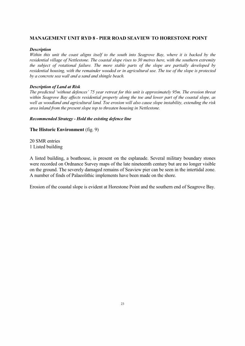
MANAGEMENT UNIT RYD 8 - PIER ROAD SEAVIEW TO HORESTONE POINT
Description
Within this unit the coast aligns itself to the south into Seagrove Bay, where it is backed by the
residential village of Nettlestone. The coastal slope rises to 30 metres here, with the southern extremity
the subject of rotational failure. The more stable parts of the slope are partially developed by
residential housing, with the remainder wooded or in agricultural use. The toe of the slope is protected
by a concrete sea wall and a sand and shingle beach.
Description of Land at Risk
The predicted ‘without defences’ 75 year retreat for this unit is approximately 95m. The erosion threat
within Seagrove Bay affects residential property along the toe and lower part of the coastal slope, as
well as woodland and agricultural land. Toe erosion will also cause slope instability, extending the risk
area inland from the present slope top to threaten housing in Nettlestone.
Recommended Strategy - Hold the existing defence line
The Historic Environment (fig. 9)
20 SMR entries
1 Listed building
A listed building, a boathouse, is present on the esplanade. Several military boundary stones
were recorded on Ordnance Survey maps of the late nineteenth century but are no longer visible
on the ground. The severely damaged remains of Seaview pier can be seen in the intertidal zone.
A number of finds of Palaeolithic implements have been made on the shore.
Erosion of the coastal slope is evident at Horestone Point and the southern end of Seagrove Bay.
2
4
RYD 8 Condition
Damaged
4.76%Coastal erosion
4.76%Not known
19.05%
No evidence on ground
42.86%
Extant
28.57%
RYD 8 Land Use
Thoroughfare/verge
14.29%
Garden
42.86%
Boundary
19.05%
Intertidal
14.29%
Above high water
4.76%
Building
4.76%
RYD 8 Period
Post medieval
84.21%
Modern
5.26%Palaeolithic
10.53%
Figure 9 RYD 8

25
MANAGEMENT UNIT RYD 9 - HORESTONE POINT TO ST HELENS TOWER
Description
The coastal slope within Priory Bay, rising to around 40m, is undeveloped and exhibits considerable
evidence of historical failure. The slope is wooded at its edge, and backed by agricultural land. Within
the coast slope is an unassessed archaeological site which is perceived to be of potential international
importance. This is a palaeolithic site perceived to reflect recent discoveries at Boxgrove, Chichester, a
site where human remains now dated to be 0.5 million years old have been identified. A north westward
littoral drift in this area has led to the development of a moderately wide sandy beach in the north and
centre of the bay, with depletion in the south, in the lee of Nodes Point. Falling bed levels in the south of
the Bay, together with slope failures have undermined or surged over/through previous coast defence
structures. Nodes Point is formed behind a foreshore outcrop of resistant limestone, acting to protect
the headland. The point itself is densely wooded, and is backed by Warners Holiday Camp (one of the
nine major holiday camps on the Island).
Description of Land at Risk
The predicted ‘without defences’ 75 year retreat for this unit is up to 100m. Erosion will generally only
affect the coastal slope, but part of Warners Holiday Camp would be lost along with agricultural land
and a recreational area. Any deeper slope instability triggered by the toe erosion may also pose a threat
to The Priory and the housing around it.
Recommended Strategy - Retreat the existing defence line
The Historic Environment (fig. 10)
21 SMR entries
This management unit contains what is possibly the most important Palaeolithic site on the
Island. Several hundred flint implements have been recovered from the beach at the foot of the
eroding coastal slope and have been traced to gravels capping the top of the cliff. This is a site
of great potential which has not yet been adequately investigated but is vulnerable to coastal
erosion.
At the foot of the cliff, the remains of a pump believed to have fed a salt water bathing pond at
The Priory are visible.
At the south end of the bay is the remains of late nineteenth century Nodes Point Battery, now
incorporated into a holiday camp, which also contains WW2 features.
Active erosion of the coastal slope is evident, particularly in the southern part of Priory Bay.

2
6
RYD 9 Condition
Damaged
13.04%
Coastal erosion
26.09%
Extant
4.35%
Not known
4.35%
No evidence on ground
52.17%
RYD 9 Land Use
Woodland
13.04%
Thoroughfare/verge
8.70%
Cliffs
8.70%
Grassland heathland
4.35%
Above high water
13.04%
Intertidal
21.74%
Not known
4.35%
Recreational use
26.09%
RYD 9 Period
Neolithic
4.76%
Prehistoric
9.52%
Palaeolithic
4.76%
Mesolithic
4.76%
Medieval
4.76%
Unknown
4.76%
Modern
9.52%
Post medieval
57.14%
Figure 10 RYD 9

27
MANAGEMENT UNIT RYD 10 - THE DUVER, ST HELENS
Description
At the north end of this unit is agricultural land, with St Helen’s Church, three houses and a public
convenience on the coast. From here St Helen's Duver trends south across Bembridge Harbour. The
Duver is a sand dune spit, owned by the National Trust, whose north-south development indicates a
reversal of longshore drift somewhere between Nodes Point and St Helen’s Church. The spit is
protected by a seawall and groynes (refurbished 1993), which prevent reworking of spit sediments.
Material drifts to the southern tip of the spit from where the dominant ebb current flushes it offshore.
The end of the Duver is developed with a boatyard and ferry jetty.
Description of Land at Risk
The predicted ‘without defences’ risk scenario for this unit, in the absence of detailed topographical
data largely based upon the 5m contour, is taken to be the loss of St Helen's Duver. This scenario would
obviously result in the loss of the boatyard and ferry jetty on the tip of the spit, and St Helen's Church,
the houses and public conveniences at its base. But the real value of The Duver is in the protection it
provides to Bembridge Harbour. The loss of The Duver would open Bembridge Harbour to direct wave
attack and erosion, vastly increasing the flooding/erosion threat to St Helen's and the extensive,
scarcely developed, flood area which extends to Yaverland.
Recommended strategy - Hold the existing line
The Historic Environment (fig. 11)
21 SMR entries
1 Historic building
1 Listed building
Structural remains on St Helens Duver include the Grade II listed tower of the former church,
now used as a seamark and with a WW2 pillbox adjoining its south side. A second pillbox is
incorporated into the sea wall further to the south.
Earthworks visible on the Duver include a large bank and the possible remains of an earthen
battery which is shown on 1866 Ordnance Survey Maps. A number of old railway carriages
have been reused as beach huts and others are incorporated into the structure of the Baywatch
Cafe.
The Duver itself potentially protects a palaeoenvironmental sequence similar to that recorded at
Wootton-Quarr which might provide a useful indication of coastal change at the eastern end of
the Island.
There was some indication of active coastal erosion to the north of the church.

2
8
RYD 10 Condition
No evidence on ground
4.76%
Not known
4.76%
Coastal erosion
4.76%
Damaged
9.52%
Extant
76.19%
RYD 10 Land Use
Other
4.76%
Intertidal
4.76%
Recreational use
4.76%
Building
14.29%
Grassland heathland
4.76%
Coastland, unclassified
66.67%
RYD 10Period
Medieval
9.52%
Post medieval
9.52%
Modern
23.81%
Unknown
57.14%
Figure 11 RYD 10

29
MANAGEMENT UNIT RYD 11 - BEMBRIDGE HARBOUR
Description
This unit is based on Bembridge Harbour, a popular amenity harbour with extensive intertidal mudflats.
The Harbour itself is backed by the village of St Helens, and undeveloped and agricultural land. The
south shore of the harbour is protected by an embankment below the B3395 road, with seawalls in front
of the yacht and sailing clubs and boatyards around the edge of the harbour. The Harbour and much of
its inland flood plain are designated as of international nature conservation importance.
Description of Land at Risk
The predicted ‘without defences’ at risk scenario for this unit, in the absence of detailed topographical
data, largely based upon the 5m contour, is taken to be the flooding of the low lying areas around and
inland of Bembridge Harbour. Along the banks of the Harbour the area at risk from flooding includes
housing in St Helens and Bembridge, the sailing/yacht clubs and boatyards, the only area of
internationally designated lagoon on the Island, and undeveloped areas, along with the loss of the road
which runs around its edge. Beyond this the area potentially affected includes the extensive area of the
River Yar which extends south west up to the coast near Yaverland. This area is predominantly
agricultural, with scattered residential properties, and more dense development towards
Yaverland/Sandown.
Recommended Strategy - Hold the existing line
The Historic Environment (fig. 12)
44 SMR entries
1 Historic building
1 Listed building
This management unit includes the stone dams of St Helens Mill and St Helens Quay. Several
intertidal post structures were recorded during the coastal audit, both adjacent to the mill dam
which is now used as a causeway, and next to the Embankment. Hulks were noted both on the
west side of St Helens Duver and adjacent to the Embankment, where they probably represent
the remains of houseboats.
Seventeen surviving houseboats were photographed alongside the Embankment during the
audit. Whilst it is questionable whether they should be included in the SMR, there are some
important vessels moored here which are worthy of note.
A Grade II listed drinking fountain is situated at the Bembridge end of the Embankment.
Some indications of erosion were noted on the seaward side of the Embankment.

30
RYD 11 Condition
Destroyed
6.52%
Damaged
6.52%
Coastal erosion
19.57%
Extant
45.65%
No evidence on ground
17.39%
Not known
4.35%
RYD 11 Land Use
Built over
6.52%
Above high water
2.17%
Intertidal
58.70%
Thoroughfare/verge
8.70%
Grassland heathland
2.17%
Building
2.17%
Coastland, unclassified
6.52%
Not known
4.35%
Other
4.35%Recreational use
4.35%
RYD 11 Period
Early medieval
2.33%Unknown
16.28%
Post medieval
34.88%
Modern
46.51%
Figure 12 RYD 11

31
MANAGEMENT UNIT RYD 12 - BEMBRIDGE POINT TO FORELAND FIELDS
Description
On the south side of the mouth of Bembridge Harbour is Bembridge Point, a sediment accumulation fed
by a reversed longshore drift from the south east. Foreshore limestone outcrops continue around the
coast from near Bembridge Point, giving protection to backing cliffs from erosion at low water. The
coast around to Foreland is protected by various groynes and seawalls. This coast is backed by the
predominantly residential village of Bembridge, although the residential development is generally
fronted by an area of wooded or undeveloped land. Behind Foreland is an area of tourist
accommodation, south of which there is a residential area.
Description of Land at Risk
The predicted ‘without defences’ 75 year retreat for this unit is between 70m and 120m. This places at
risk much of the housing along the coastal edge, particularly at Pump Lane, Beach House Road,
Beachfield Road, and Forelands Fields Road. Part of the holiday accommodation site at Foreland, a
number of recreational areas, and a waste water treatment site at Fishermans Walk along with the
associated outfall are also at risk. Retreat around Foreland would also damage the lifeboat pier and
slipway.
Recommended Strategy - Hold the existing defence line
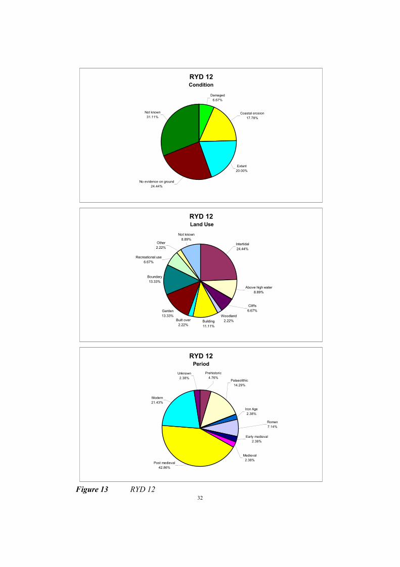
The Historic Environment (fig. 13)
42 SMR entries
6 Historic buildings
This management unit contains important palaeoenvironmental deposits. The ‘Bembridge
Raised Beach’ is visible in the cliff face, and organic sediments have been noted at Foreland and
Lane End (Preece and Scourse 1987). At the time of survey, major works were being
undertaken by Southern Water at Lane End, so it is not clear whether the deposits survive at this
location. Several Palaeolithic implements have also been recovered from the coast in this unit.
Roman and medieval finds including coins and a seal matrix are reported from the intertidal
zone.
Post medieval features include a landing place, `The Colonel's Hard', coastguard cottages at
Bembridge Point and Foreland, and military boundary stones.
There are several WW2 features on this stretch of coast. The remains of an anti-aircraft battery
are tumbling onto the beach in front of the Bembridge Coast Hotel, and another battery is
visible on 1946 air photographs to the west of this site. A gun emplacement survives at
Bembridge Point, with a pillbox to the west and another incorporated into the sea wall at
Forelands. Anti tank blocks are present on the beach.
Erosion of the coast edge is evident in this management unit, particularly in the area of the
Bembridge Coast Hotel.
32
RYD 12 Condition
Damaged
6.67%
Coastal erosion
17.78%
Not known
31.11%
No evidence on ground
24.44%
Extant
20.00%
RYD 12 Land Use
Woodland
2.22%Building
11.11%
Built over
2.22%
Garden
13.33%
Boundary
13.33%
Recreational use
6.67%
Other
2.22%
Not known
8.89%
Cliffs
6.67%
Above high water
8.89%
Intertidal
24.44%
RYD 12 Period
Prehistoric
4.76%Palaeolithic
14.29%
Iron Age
2.38%
Roman
7.14%
Medieval
2.38%
Early medieval
2.38%
Unknown
2.38%
Modern
21.43%
Post medieval
42.86%
Figure 13 RYD 12
33
MANAGEMENT UNIT RYD 13 - FORELANDS FIELDS TO CULVER CLIFF
Description
In the north east of the unit the agricultural land of Foreland Fields fronts a set back residential area of
Bembridge. At the foot of the low cliffs in front of Black Rock Ledge are a series of beach huts. South of
here the coast moves into Whitecliff Bay, at the southern extremity of which is Culver Cliff. The Bay is
backed by a playing field, agricultural land and two holiday camps, as well as undeveloped land on the
cliff top. Two cafes have been constructed at the back of the beach adjacent to access pathways from the
cliff top. Apart from the chalk of Culver Cliff, the remainder of the cliffs of the Bay are prone to a
variety of failure mechanisms. The supply of mainly fine grained material to the beach, from cliff
failure, has resulted in the formation of a wide flat beach in the lee of Culver Cliff, with a small
backshore fringe of coarse chalk and flint pebbles. Culver Cliff itself is the eastern limit of the Island's
chalk spine, which forms the Needles in the west.
Description of Land at Risk
The predicted ‘without defences’ 75 year retreat for this unit is between 60m and 170m. This places at
risk the coastal edge of the holiday camps in Whitecliff Bay, a small number of houses in the Bay, the
beach huts and cafes, agricultural land, and part of Bembridge School Playing Field.
Recommended Strategy - Do nothing
The Historic Environment (fig. 14)
9 SMR entries
This management unit contains the western end of the Bembridge Raised Beach. Palaeolithic
handaxes have been found at Bembridge School, Howgate and most recently in Whitecliff Bay.
In the post medieval period, coal was extracted in the bay at low water.
The remains of anti-invasion defences are decaying in the intertidal zone.
There is significant erosion of the cliff edge in this unit, in places causing the coastal footpath to
be diverted inland

34
RYD 13 Condition
Coastal erosion
55.56%
No evidence on ground
33.33%
Not known
11.11%
RYD 13 Land Use
Recreational use
11.11%
Cliffs
44.44%
Intertidal
44.44%
RYD 13 Period
Modern
11.11%
Post medieval
33.33%
Roman
11.11%
Bronze Age
11.11%
Palaeolithic
33.33%
Figure 14 RYD 13
35
MANAGEMENT UNIT SAN 1 - CULVER CLIFF
Description
The cliff top land of this unit is owned by the National Trust. The Bembridge and Culver Downs site also
extends inland to include Bembridge Fort. This area is predominantly agricultural and undeveloped
land, along with the Coastguard Cottages and disused gun emplacements. The relatively resistant chalk
of Culver Cliff forms approximately 60 metre cliffs, which run throughout the unit, lowering to the west.
The foreshore in front of these cliffs has accumulations of chalk debris, indicating active denudation of
these cliffs.
Description of Land at Risk
The predicted ‘without defences’ retreat in this unit is between approximately 30m and 60m. No
buildings are threatened by this retreat, with only the fringe of National Trust owned agricultural land
at risk.
Recommended Strategy - Do nothing
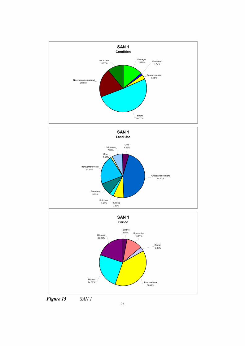
The Historic Environment (fig. 15)
65 SMR entries
2 SAM
1 Listed building
Contained within this management unit is Culver Battery and a number of earthworks which are
most likely of military origin. Several of these earthworks are very close to the cliff edge, as are
military boundary stones. Bembridge Fort, the Yarborough Monument and Culver coastguard
cottages are all prominent features, although they fall outside the benefit line. A rare Alan
Williams turret can be seen at Bembridge Fort.
Six round barrows are recorded, not all of which are now visible. One of these is scheduled.
Numerous prehistoric and Roman artefacts have been found on the down and there is a colluvial
deposit at Limpet Run which was sampled in 1988 (Allen, 1993).
The chalk cliffs of this unit appear relatively stable.
36
SAN 1 Condition
Destroyed
1.54%
Coastal erosion
3.08%
Extant
50.77%
No evidence on ground
20.00%
Not known
10.77%
Damaged
13.85%
SAN 1 Land Use
Other
1.54%
Not known
7.69%
Built over
3.08%
Boundary
9.23%
Thoroughfare/verge
21.54%
Building
7.69%
Grassland heathland
44.62%
Cliffs
4.62%
SAN 1 Period
Neolithic
3.08%
Roman
3.08%
Bronze Age
10.77%Unknown
20.00%
Post medieval
38.46%
Modern
24.62%
Figure 15 SAN 1
37
MANAGEMENT UNIT SAN 2 - CULVER CLIFF TO YAVERLAND
Description
The cliff top land through to the Sandown Bay Holiday Centre is owned by the National Trust
(Bembridge and Culver Downs). This area is predominantly agricultural and undeveloped land. On the
landward side of the Holiday Centre is an area of housing which forms part of Yaverland. The coast
here is formed of less resistant rocks subject to marine erosion, forming cliffs which gradually reduce in
height to sea level. Erosion has resulted in up to 80m of cliff recession in the last century. These cliffs
are fronted by a sand and shingle beach which is of insufficient width to prevent cliff toe erosion.
Description of Land at Risk
The predicted ‘without defences’ 75 year retreat in this unit is 120m. The area at risk is predominantly
undeveloped cliff top and agricultural land, but also included is a large part of the Sandown Bay
Holiday Centre.
Recommended Strategy - Do nothing
The Historic Environment (fig. 16)
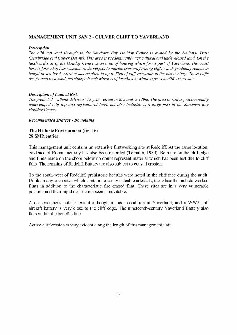
28 SMR entries
This management unit contains an extensive flintworking site at Redcliff. At the same location,
evidence of Roman activity has also been recorded (Tomalin, 1989). Both are on the cliff edge
and finds made on the shore below no doubt represent material which has been lost due to cliff
falls. The remains of Redcliff Battery are also subject to coastal erosion.
To the south-west of Redcliff, prehistoric hearths were noted in the cliff face during the audit.
Unlike many such sites which contain no easily dateable artefacts, these hearths include worked
flints in addition to the characteristic fire crazed flint. These sites are in a very vulnerable
position and their rapid destruction seems inevitable.
A coastwatcher's pole is extant although in poor condition at Yaverland, and a WW2 anti
aircraft battery is very close to the cliff edge. The nineteenth-century Yaverland Battery also
falls within the benefits line.
Active cliff erosion is very evident along the length of this management unit.
38
SAN 2 Condition
Damaged
9.68%
Destroyed
3.23%
Coastal erosion
32.26%
Extant
16.13%
No evidence on ground
12.90%
Not known
22.58%
Overgrown
3.23%
SAN 2 Land Use
Thoroughfare/verge
3.23%
Recreational use
6.45%
Not known
3.23%
Boundary
9.68%
Built over
3.23%
Intertidal
9.68%
Grassland heathland
35.48%
Cliffs
29.03%
SAN 2 Period
Mesolithic
3.57%
Prehistoric
3.57%
Iron Age
7.14%
Roman
3.57%
Medieval
7.14%
Unknown
21.43%
Modern
14.29%
Post medieval
39.29%
Figure 16 SAN 2

39
MANAGEMENT UNIT SAN 3 - YAVERLAND
Description
The cliffs reduce to a very low level over this unit, which flanks a flood area to the south. The village of
Yaverland is set slightly back from the coast and is fronted by agricultural land and a public car park.
Towards its south-west limit Yaverland Road (B3395) runs immediately behind the defences. Sandown
Zoo and the Grand Hotel are both significant features on the landward side of the road.
Description of Land at Risk
The predicted ‘without defences’ 75 year retreat for this unit is 100m. This risk area extends to include
Sandown Zoo, the Grand Hotel, the public car park, Yaverland Road and several houses on the seaward
edge of Yaverland itself. As well as the value of these assets there are also economic consequences for
tourism with the loss of the Zoo and Hotel, and for communications should the road be severed.
Recommended Strategy - Hold the existing defence line
The Historic Environment (fig. 17)
8 SMR entries
This short stretch of coast contains Sandown Fort and a WW2 pillbox. The fort also has
connections with PLUTO.
Little evidence of coastal erosion was noted on this stretch of coast.

40
SAN 3 Condition
Damaged
12.50%
Extant
12.50%
Not known
62.50% No evidence on ground
12.50%
SAN 3 Land Use
Not known
62.50%
Other
25.00%
Thoroughfare/verge
12.50%
SAN 3 Period
Modern
12.50%
Post medieval
87.50%
Figure 17 SAN 3

41
MANAGEMENT UNIT SAN 4 - SANDOWN ZOO TO FORT STREET, SANDOWN
Description
This unit is based on the low lying coastal frontage which forms the southern end of the River Yar flood
area. The defences fronting this stretch are maintained by the Environment Agency. Directly behind the
defences is a recreational area with a mini golf course and derelict former canoe lake. Behind these is
the College Farm Industrial Estate and a sewage works, along with undeveloped land, and extending
beyond along the River Yar through to Bembridge Harbour. The flood area is predominantly
agricultural land with scattered houses. The majority of the area is of high nature conservation value.
Description of Land at Risk
The predicted ‘without defences’ at risk scenario for this unit, in the absence of detailed topographical
data largely based upon the 5m contour, is taken to be the low lying area backing this frontage, which
extends through to Bembridge Harbour. The recreational area, industrial park and sewage works
behind the SAN 4 defences will obviously be effected, along with the agricultural land and properties of
the River Yar flood area. At the Bembridge end of the flood risk area there are sailing/yacht clubs and
boatyards, along with the only area of internationally designated lagoon on the Island.
Recommended strategy - Hold the existing line
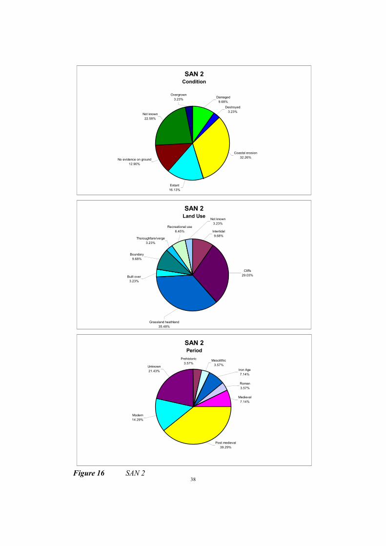
The Historic Environment (fig. 18)
6 SMR entries
For the purpose of this audit, only the coastal frontage of this unit was examined. The marsh to
the north is of high archaeological and palaeoenvironmental potential but falls behind a
protected coast.
The coastal frontage contains the site of the seventeenth century Sandown fort, the plan of
which can still be partially seen on the ground.
Little evidence of coastal erosion was noted on this protected coast.
42
SAN 4 Condition
Damaged
16.67%
No evidence on ground
50.00%
Not known
33.33%
SAN 4 Land Use
Not known
16.67%
Recreational use
50.00%
Thoroughfare/verge
16.67%
Wetland
16.67%
SAN 4 Period
Post medieval
100.00%
Figure 18 SAN 4

43
MANAGEMENT UNIT SAN 5 - FORT STREET TO FERNCLIFF ROAD, SANDOWN
Description
This unit consists of the relatively low lying, densely developed residential frontage of Sandown. This
section of the Sandown coast is fronted by commercial, tourism related, properties, and an Esplanade,
along with Sandown Pier. The town has a population of 5,300. The developed frontage is protected by a
series of seawalls. The beach is mainly fine sand, and is stable, with the dominant drift being south-
north as indicated by the accumulations on the south side of the groynes.
Description of Land at Risk
The predicted ‘without defences’ 75 year retreat for this unit is approximately 100m. This risk area
extends to include Sandown Pier, the commercial tourism frontage and Esplanade and a considerable
area of housing. As well as the value of these assets there are the economic consequences for tourism
were the Esplanade and tourist frontage to be lost. The proximity of the flood area of SAN 4 to the north
east of this unit gives the potential for retreat to outflank the adjacent flood defences.
Recommended strategy - Hold the existing defence line
The Historic Environment (fig. 19)
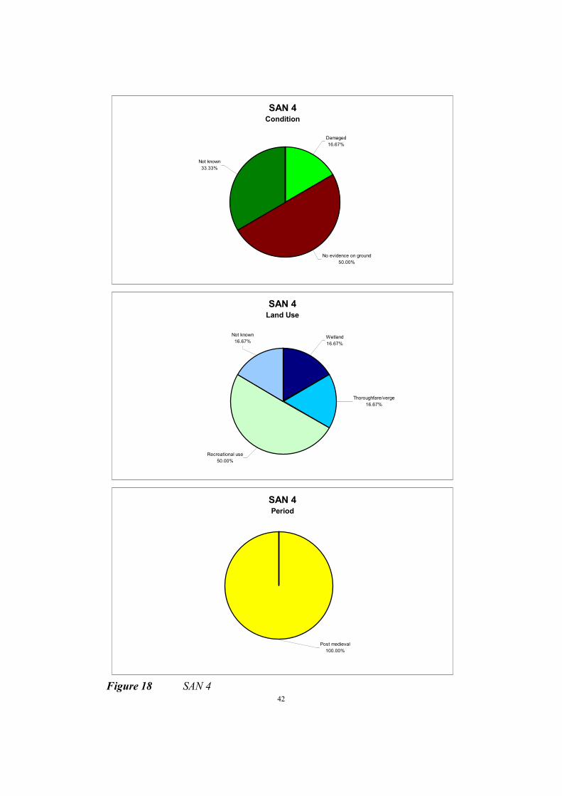
6 SMR entries
This unit includes the supposed site of the sixteenth century fort, now under water. Other
features are more modern, including the coastguard cottages, the late nineteenth century
promenade, the pier and the war memorial.
Little evidence of erosion was noted on this protected coast.
44
SAN 5 Condition
Extant
66.67%
Damaged
11.11%Not known
22.22%
SAN 5 Land Use
Building
11.11%Above high water
11.11%
Thoroughfare/verge
33.33%
Marine
22.22%
Intertidal
22.22%
SAN 5 Period
Modern
60.00%
Post medieval
40.00%
Figure 19 SAN 5

45
MANAGEMENT UNIT SAN 6 - FERNCLIFF ROAD TO HOPE BEACH
Description
Within this unit the marine cliffs rise behind the stabilised coastline. The sand beach here is backed by a
concrete apron and splash wall at the toe of the cliffs, along with a number of groynes. Along the cliff
top here Sandown merges into the residential settlement of Lake, and this in turn into Shanklin. The
entire frontage is developed to the cliff edge with residential and commercial areas.
Description of Land at Risk
The predicted ‘without defences’ 75 year retreat in this unit is 100m. This risk area extends to include
the extensive area of cliff top housing within Sandown, Lake and Shanklin. Also at risk are the A3055
Sandown Road, a Chapel, and recreational areas.
Recommended Strategy - Hold the existing defence line
The Historic Environment (fig. 20)
27 SMR entries
Most of the SMR entries in this unit are associated with military activities. These include
Sandown Battery and boundary stones associated with this monument and other military parcels
of land on the cliff top.
There are also findspots of Roman pottery from the cliff top and Palaeolithic implements on the
shore. It is likely that this material originated from gravel deposits visible in the cliff face but
due to safety considerations and the fact that much of the cliff edge is fenced, this area could not
be examined.
Evidence of cliff falls was noted within this unit, although the base of the cliff is protected.

46
F
SAN 6 Condition
Damaged
3.70%Coastal erosion
11.11%
Extant
11.11%
No evidence on ground
74.07%
SAN 6 Land Use
Thoroughfare/verge
3.70%
Other
3.70%
Boundary
7.41%
Garden
33.33%
Above high water
14.81%
Cliffs
37.04%
SAN 6 Period
Iron Age
3.70%
Palaeolithic
3.70% Roman
3.70%
Early medieval
0.00%
Modern
3.70%
Post medieval
85.19%
igure 20 SAN 6

47
MANAGEMENT UNIT SAN 7 - HOPE BEACH TO SHANKLIN CHINE
Description
Within this unit the marine cliffs are fronted by an area of reclaimed land at the cliff foot. This
reclaimed area has a putting green, tourist amenities, housing and the Esplanade, with road access at
either end. Shanklin is developed to the cliff edge with residential and commercial areas. The town has
a population of approximately 8,000.
Description of Land at Risk
The predicted ‘without defences’ 75 year retreat in this unit is 100m. The area at risk extends over the
reclaimed land, with its recreational/tourist facilities, housing and Esplanade. Once this land was lost
the cliff toe would be open to erosion, causing instability and the loss of residential and commercial
developments on the cliff top.
Recommended Strategy - Hold the existing defence line
The Historic Environment (fig. 21)
18 SMR entries
3 Historic buildings
5 Listed buildings
2 UDP parks and gardens
This unit contains the nineteenth century promenade, with some of its early shelters still
surviving. The coastguard station and lifeboat station which were located at the south end of the
esplanade no longer survive and the once listed pier was demolished after having been
extensively damaged in the storm of 1987. A hangar which was originally used to house
seaplanes during the First World War at Bembridge is now in use as an amusement arcade,
although the original structure has been greatly altered. Shanklin Chine is important as a wild
garden and for its association with PLUTO. A pillbox at the mouth of the chine and a further
example at Osborne Steps are other WW2 features. Grade II listed buildings include the Church
of St Saviour on the Cliff, Keats Inn and the clock tower on the promenade.
Little evidence of coastal erosion was noted during the survey.

48
SAN 7 Condition
No evidence on ground
5.26%
Extant
63.16%
Excavated
5.26%
Coastal erosion
5.26%
Destroyed
15.79%
Damaged
5.26%
SAN 7 Land Use
Thoroughfare/verge
21.05%
Recreational use
10.53%
Other
15.79%
Intertidal
5.26%
Above high water
10.53%
Cliffs
10.53%
Building
15.79%
Built over
5.26%
Boundary
5.26%
SAN 7 Period
Modern
22.22%
Post medieval
77.78%
Figure 21 SAN 7

49
MANAGEMENT UNIT SAN 8 - SHANKLIN CHINE TO HORSE LEDGE
Description
In the area south of Shanklin Chine developments are more scattered and set back slightly from the cliff
top. Much of the area around the Chine is a Conservation Area, so designated for its character.
Development along the cliff top includes a Hospital, housing, hotels and recreational areas, with
Luccombe Road inland of these. The cliff toe is not protected by hard defences throughout this unit, with
sections of the timber breastwork and groynes the only structures present. Thus the cliffs are exposed to
limited erosion, resulting in instability.
Description of Land at Risk
The predicted ‘without defences’ 75 year retreat in this unit is between 90m and 160m. The area at risk
would include an extensive area of cliff top land upon which are a Hospital, hotels, housing,
recreational areas, and sections of the Luccombe Road. Also affected would be Shanklin Chine and the
Conservation Area around it.
Recommended Strategy - Hold the existing defence line
The Historic Environment (fig. 22)
2 SMR entries
3 Listed buildings
1 UDP parks and gardens
The cliff face is inaccessible on this stretch of coast, although it was examined from the beach.
The unit includes Rylstone Gardens with its listed chalet and Rylstone Manor Hotel. The
hospital has not been used for several years and the site is being redeveloped.
This management unit was visited after heavy rain, and a steady trickle of debris was noted
falling from the cliff face.

50
SAN 8 Condition
Extant
100.00%
SAN 8 Land Use
Garden
100.00%
SAN 8 Period
Modern
50%
Post medieval
50%
F
igure 22 SAN 8

51
MANAGEMENT UNIT VEN 1 - HORSE LEDGE TO MONKS BAY
Description
From Horse Ledge the cliffs rise to 100 metres. This leads to the village of Luccombe, within which
there has been much damage caused to properties through instability. Scattered residential housing
occurs behind Luccombe Bay and Upper Bonchurch backs Dunnose, but the remainder of the land is
either wooded or agricultural. A National Trust site runs from just north of Luccombe Village to
Lowtherville, and includes St Boniface, Bonchurch and Luccombe Downs, much of which is also
designated as of international nature conservation value (Isle of Wight Downs SAC). The cliffs within
this unit are formed in less resistant lithologies, and are exposed to toe erosion, resulting in instability
throughout. The beaches of this section of coast comprise wave-cut bedrock shore platforms littered
with boulders. There are intermittent gravel beaches to the south, with a sand beach having
accumulated in Luccombe Bay.
Description of Land at Risk
The predicted ‘without defences’ 75 year retreat for this unit is between approximately 20m and 225m.
The area at risk is predominantly undeveloped land, in particular the amenity area of The Landslip. Of
most concern however would be the loss of a significant part of the village of Luccombe, along with
other scattered properties, and a section of the A3055 and some housing at Upper Bonchurch.
Recommended Strategy - Retreat the existing defence line
The Historic Environment (fig. 23)
16 SMR entries
2 Historic buildings
1 Listed building
This unit was visited after heavy rain and the cliff edge was generally too dangerous to examine,
in addition to being heavily wooded. In the past, several middens of medieval date were noted in
the eroding slope and it is likely that other such features may be revealed in the future. SMR
entries include the towers at Luccombe Chine House and the Landslip, the Devil's chimney and
the "wishing seat".
There was extensive evidence of active coastal erosion at the time of survey.

52
VEN 1 Condition
Damaged
5.56%
Not known
5.56%
No evidence on ground
33.33%
Coastal erosion
22.22%
Extant
33.33%
VEN 1 Land Use
Intertidal
5.56%
Not known
5.56%
Natural formation
16.67%
Building
11.11%
Wetland
5.56%
Woodland
22.22%
Cliffs
22.22%
Above high water
11.11%
VEN 1 Period
Neolithic
6.25%
Roman
12.50%
Medieval
12.50%
Post medieval
18.75%Modern
6.25%
Unknown
43.75%
Figure 23 VEN 1

53
MANAGEMENT UNIT VEN 2 - MONKS BAY TO STEEPHILL COVE
Description
This area forms part of the Undercliff of the Isle of Wight, with all developments being upon a landslide
complex. At the east end of the unit undeveloped agricultural land gives way to the residential
settlement of Bonchurch. The eastern end of Bonchurch is fronted by Monks Bay, where a detached
breakwater and rock groynes have recently been constructed in an attempt to stabilise the backing
debris cliffs. From here there are coast protection structures through to Steephill Cove. To Wheeler's
Bay the beaches are composed of boulders and small accumulations of shingle, with a build up of sand
behind the breakwater in Monks Bay. This stretch is predominantly backed by residential housing,
along with Westfield Holiday Centre, their proximity to the cliff edge being of concern in certain
locations. West of Wheeler's Bay is Ventnor, which has a population of 6000. This town along with
Bonchurch is developed on landslide terraces in front of the cliffs of the back scarp. Recreational
facilities such as Ventnor Park, Botanical Gardens, the Winter Gardens and various local interest
museums along with the attraction of the beach for bathing make Ventnor a popular tourist centre.
Description of Land at Risk
The predicted ‘without defences’ 75 year retreat in this unit is between 60m and 140m. This attaches
risk to a significant amount of infrastructure along the Ventnor/Bonchurch frontage, along with areas of
commercial, recreational and tourist accommodation land, and a section of the A3055 at Castle Cove
and at Castle Haven near Niton. Of major concern here is the potential for any cliff erosion to trigger
instability in the landslides upon which Ventnor, Bonchurch and Niton are built.
Recommended Strategy - Hold the existing defence line
The Historic Environment (fig. 24)
30 SMR entries
2 Historic buildings
2 Listed buildings
3 UDP parks and gardens
The management unit VEN 2 contains the Grade II listed church of St Boniface. An undated
earthwork adjacent to the church is vulnerable to coastal erosion. Medieval middens have been
revealed in the coastal slope and finds of prehistoric artefacts have been made both in the cliff
face and on the beach. The coastguard cottages at Ventnor are the only listed examples on the
Isle of Wight. On the promenade, features associated with tourism and recreation include the
clock tower, drinking fountain, the pavilion which is now used as an amusement arcade, the
children's paddling pool and a monument. The Cascade gardens are also worthy of note.
To the west of the seafront, at Flowers Brook, around 50 burials of as yet unknown date have
recently been excavated and a structure of unknown date and function is revealed in the cliff
face. Ventnor Park and the Botanic Gardens both fall within this unit.
Most of the coast of this management unit is protected.
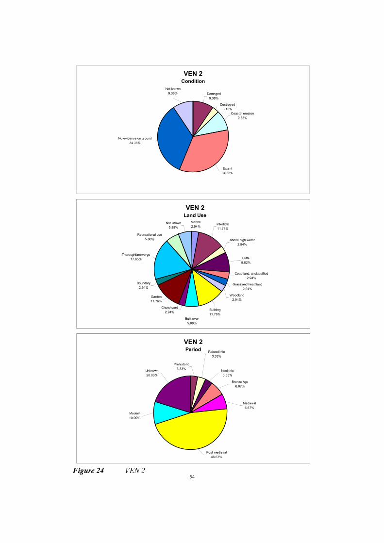
54
VEN 2 Condition
Damaged
9.38%
Destroyed
3.13%
Coastal erosion
9.38%
Extant
34.38%
No evidence on ground
34.38%
Not known
9.38%
VEN 2 Land Use
Coastland, unclassified
2.94%
Grassland heathland
2.94%
Woodland
2.94%
Churchyard
2.94%
Garden
11.76%
Marine
2.94%Not known
5.88%
Thoroughfare/verge
17.65%
Boundary
2.94%
Built over
5.88%
Building
11.76%
Cliffs
8.82%
Above high water
2.94%
Intertidal
11.76%
Recreational use
5.88%
VEN 2 Period
Neolithic
3.33%
Prehistoric
3.33%
Palaeolithic
3.33%
Bronze Age
6.67%
Medieval
6.67%
Unknown
20.00%
Modern
10.00%
Post medieval
46.67%
Figure 24 VEN 2

55
MANAGEMENT UNIT VEN 3 - STEEPHILL COVE TO EAST OF BINNEL BAY
Description
This unit consists of a large part of the St Lawrence to Niton Undercliff, with the village of St Lawrence
developed on the landslip complex. Throughout this unit the cliff top is mostly undeveloped or
agricultural land, backed by the semi-developed residential area of St Lawrence. Along this stretch of
coast the cliffs are developed in landslide debris. Several large landslide blocks, of Upper Greensand,
have proved to be more resistant to marine erosion, and these coincide with headlands such as Binnel
Point and Woody Point. Erosion of softer material between these hard points has created bays, such as
Woody Bay. The beaches of this area are predominantly formed of landslide debris including boulders.
Description of Land at Risk
The predicted ‘without defences’ 75 year retreat in this unit is between 80m and 120m. This would only
result in the loss of undeveloped and agricultural land, and a few houses in Woody Bay. Of major
concern here is the potential for any cliff erosion to trigger instability in the landslides upon which St
Lawrence is built.
Recommended Strategy - Retreat the existing defence line
The Historic Environment (fig. 25)
32 SMR entries
1 Listed building
1 UDP parks and gardens
A number of features have been identified in the cliff face of this unit both in the past and
during the current project. These include middens of Iron Age/Roman and medieval date, an
inhumation, Bronze Age material and palaeoenvironmental deposits (Preece, 1986). In the
course of the current fieldwork, Beaker and Bronze Age pottery was found associated with the
palaeoenvironmental deposits previously examined by Preece. A miniature battery of eighteenth
century date is deteriorating on the eroding cliff at Mounts Bay. Coastguard cottages survive at
Orchard Bay and Woody Bay, the former having been drastically altered but the later remaining
relatively unchanged.
At Old Park the remains of the WW2 radar station survive near the cliff edge. The concrete
bases of the two masts are visible, with adjacent earth covered shelters. Further inland, Nissen
huts and other associated buildings survive.
Garden features associated with Old Park include a ha ha which extends to the cliff edge and
which is being damaged by coastal erosion.
Active coastal erosion was apparent at the time of survey, although while some parts of the
coast were visibly eroding, other parts appeared more stable.

56
VEN 3 Condition
No evidence on ground
11.11%
Not known
5.56%
Ploughed
2.78%
Damaged
16.67%
Coastal erosion
30.56%
Extant
33.33%
VEN 3 Land Use
Thoroughfare/verge
8.33%
Recreational use
2.78%
Garden
8.33%
Building
5.56%
Intertidal
11.11%
Above high water
2.78%
Cliffs
25.00%
Grassland heathland
25.00%
Woodland
2.78%
Not known
5.56%
Cultivated
2.78%
VEN 3 Period
Medieval
9.38%
Prehistoric
12.50%
Bronze Age
3.13%
Iron Age
6.25%
Roman
6.25%
Unknown
28.13%
Modern
12.50%
Post medieval
21.88%
Figure 25 VEN 3

57
MANAGEMENT UNIT VEN 4 - EAST OF BINNEL BAY TO PUCKASTER POINT
Description
This unit consists of Binnel Bay, with high active cliffs, and Puckaster Cove, with lower more stable
cliffs. Cliff top land is extensively wooded and undeveloped, with pockets of agricultural land and
camping grounds. There are few houses near the cliff tops, including Mirables, and the A 3055 runs
behind the cliff. The beaches are predominantly formed of landslide debris, including boulders, but
within Puckaster Cove there are accumulations of gravel and cobbles.
Description of Land at Risk
The predicted ‘without defences’ 75 year retreat in this unit is between 80m and 120m. This would take
the cliff top very close to the back scarp of the Undercliff at Binnel Bay. The result of such retreat would
be the loss of much undeveloped and agricultural land along the cliff top, along with the camping
grounds at Puckaster Cove, Mirables and other housing, and a large section of the A3055.
Recommended Strategy - Retreat the existing defence line
The Historic Environment (fig. 26)
7 SMR entries
4 Historic buildings
1 UDP parks and gardens
This management unit contains the remains of substantial walls built in the late nineteenth
century in an attempt to create a harbour. A mill once stood near the shore but has been lost to
coastal erosion although the mill pond is still extant and the stone mill dam survives, albeit
damaged. Finds of Roman and Palaeolithic date have been made in this unit in the past but the
coastal slope is now covered with impenetrable scrub. The gardens of The Orchard lie within
this unit.
The coastal slope was actively eroding at the time of survey.
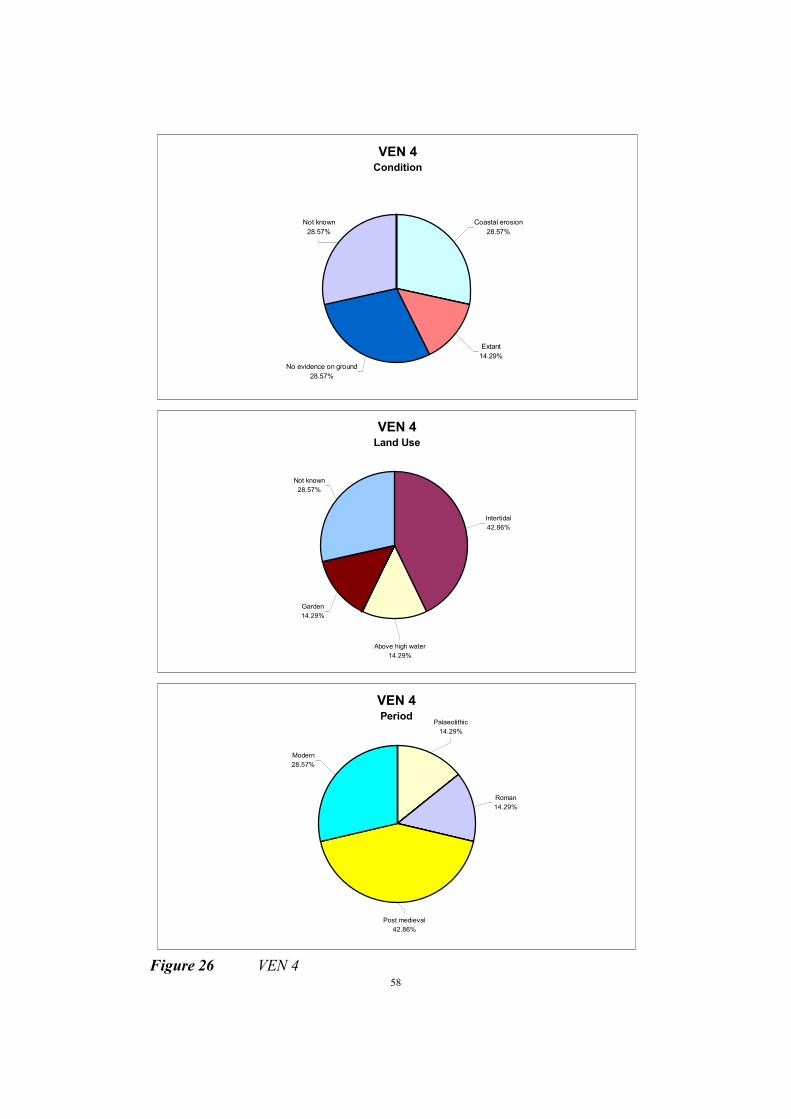
58
VEN 4 Condition
Not known
28.57%
No evidence on ground
28.57%
Extant
14.29%
Coastal erosion
28.57%
VEN 4 Land Use
Above high water
14.29%
Garden
14.29%
Not known
28.57%
Intertidal
42.86%
VEN 4 Period
Palaeolithic
14.29%
Roman
14.29%
Modern
28.57%
Post medieval
42.86%
Figure 26 VEN 4

59
MANAGEMENT UNIT VEN 5 - PUCKASTER POINT TO WEST OF CASTLEHAVEN
Description
Reeth Bay is backed by the residential village of Niton. The majority of the village is set back from the
coast, with a more sparsely developed part extending to the cliff edge. A major landslide in Reeth Bay in
January 1994 took the area of active instability to within 15m of Reeth Lodge and other housing, an
event triggered by intense winter rainfall. The cliffs within the Bay remain unstable. The beach in the
bay is predominantly formed of landslide debris including boulders, but is narrow and offers little toe
protection.
Description of Land at Risk
The predicted ‘without defences’ 75 year retreat for this unit is between 100m and 180m. Such retreat
would result in the loss of a substantial area of housing along the cliff top, along with Puckaster Farm,
and agricultural and undeveloped land.
Recommended Strategy - Hold the existing defence line
The Historic Environment (fig. 27)
8 SMR entries
6 Historic buildings
3 Listed buildings (2 gatepiers)
Sites recorded in this management unit are generally findspots, ranging from Palaeolithic to
Roman in date and coming from the beach and eroding coastal slope. However, due to erosion,
access to the coastal slope was not possible during the present survey. The landward portion of
the unit contains two sets of Grade II listed gatepiers - to Puckaster House and to the former
Victoria Hotel which was lost to coastal erosion in the nineteenth century.
The foreshore in this unit is backed by a low vertical cliff, with evidence of rock falls. Behind
the cliff edge, the coastal slope is unstable.

60
VEN 5 Condition
Not known
11.11%
No evidence on ground
22.22%
Extant
22.22%
Coastal erosion
44.44%
VEN 5 Land Use
Above high water
11.11%
Cliffs
11.11%
Waste ground
11.11%
Thoroughfare/verge
22.22%
Intertidal
33.33%
Not known
11.11%
VEN 5 Period
Palaeolithic
25.00%
Neolithic
12.50%
Bronze Age
12.50%Roman
12.50%
Post medieval
25.00%
Unknown
12.50%
Figure 27 VEN 5

61
MANAGEMENT UNIT VEN 6 - WEST OF CASTLE HAVEN TO ST CATHERINES
POINT
Description
All land around St Catherine's Point, except for the lighthouse and its grounds, are owned by the
National Trust. The Trust owned land is mostly agricultural grade 4, with the only exceptions being
Knowles Farm and a camp site at Castlehaven. Along this stretch of coast the cliffs are developed in
landslide debris, with the beach predominantly formed of landslide debris including boulders. The
Victorian lighthouse together with the unassessed multi-period archaeological site at the same vicinity
may, with further study, prove a significant resource.
Description of Land at Risk
The predicted ‘without defences’ 75 year retreat for this unit is 75m. This would mean the loss of the
Castlehaven camp site, cliff top agricultural land, and the lighthouse.
Recommended Strategy - Do nothing
The Historic Environment (fig. 28)
28 SMR entries
7 Historic buildings
2 Listed buildings (1 gatepier)
This management unit contains St Catherine's Lighthouse and Knowles Farm, a range of
historic buildings which are also significant for their connections with Marconi's radio
experiments of 1900. Iron Age/Roman and medieval midden material has been recorded since
the early part of the twentieth century at various locations in the cliff face and continues to be
found. Medieval material is also known from the ridge below Windy Corner. Further sherds
were found here during the coastal audit. A rectilinear earthwork adjacent to the cliff edge east
of the lighthouse is gradually being lost to erosion. Ridge and furrow can be seen in most of the
fields around Knowles Farm and to the south of Old Blackgang Road when conditions permit.
This unit and others in the Undercliff are significant for the use of drystone walling in field
boundaries, which is virtually unknown elsewhere on the Island. These boundaries often do not
follow the most logical and easy route, for example near the Old Blackgang Road car park, a
boundary snakes around the slope of a very steep hill rather than crossing the top or foot of it.
The management unit VEN 6 contains Niton coastguard cottages - a row of single storey stone
cottages - the site of the former Lloyd's signal station, and listed gatepiers to the east of the
lighthouse.
The edge of the low cliff in this unit is actively eroding.
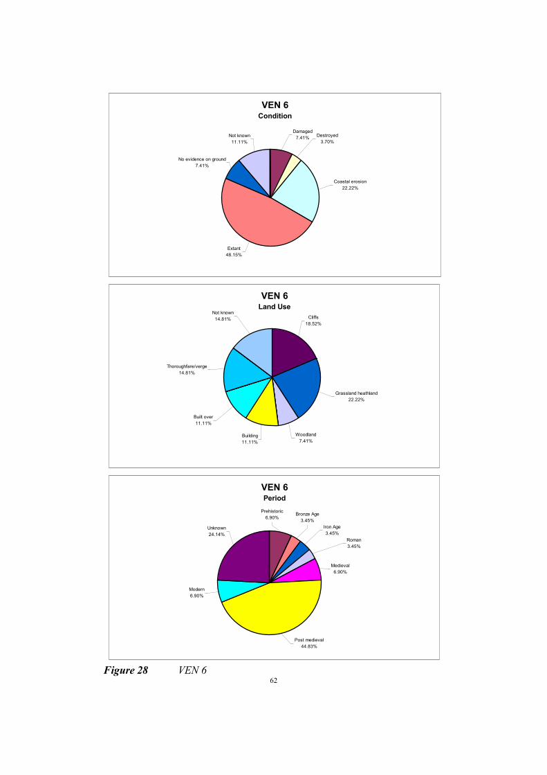
62
VEN 6 Condition
Not known
11.11%
No evidence on ground
7.41%
Damaged
7.41%Destroyed
3.70%
Coastal erosion
22.22%
Extant
48.15%
VEN 6 Land Use
Grassland heathland
22.22%
Woodland
7.41%Building
11.11%
Built over
11.11%
Thoroughfare/verge
14.81%
Not known
14.81% Cliffs
18.52%
VEN 6 Period
Iron Age
3.45%
Prehistoric
6.90%
Roman
3.45%
Bronze Age
3.45%
Medieval
6.90%
Unknown
24.14%
Modern
6.90%
Post medieval
44.83%
Figure 28 VEN 6

63
MANAGEMENT UNIT FRE 1 - ST CATHERINES POINT TO BROOK CHINE
Description
The National Trust own the cliff top at St Catherine’s Point (Knowles Farm and St Catherine’s Point
site). The site consists of grade 5 agricultural land and undeveloped land, around the lighthouse which
is not owned by the National Trust. To the west is Blackgang where steep cliffs give way to a landslide
complex in the Gault Clay. The cliff top is predominantly undeveloped here, although the Blackgang
Chine theme park, built up around the landslides, is on the seaward side of Blackgang itself.
From Blackgang though to Freshwater the cliff top is largely grade 3 agricultural land, with pockets of
development. Several holiday camps are sited on the coast in this area, along with scattered farms and
houses, the only residential concentration being at Brookgreen. The A3055 Military Road runs along
this, roughly parallel with the coast. The cliffed length of coast is entirely undefended by hard
structures. Cliff heights vary from about 100m near Blackgang to as low as 10m in a few areas. The
cliffs are prone to toe erosion with areas of landslides, block failure and vertical faced cliffs. A number
of coastal valleys (chines) interrupt the continuity of the cliffs along this stretch. A narrow beach of
shingle (to the south) and sand and shingle (central and northern areas) fronts the shoreline, with some
interruption from mudslide deposits, and rock wave cut platforms. The widespread exposure of
prehistoric archaeological sites in the eroding cliff-faces of this unit indicates that a significant portion
of the region's coastal resource is subject to active erosion. Evidence of a potential archaeological
landscape is spread out across the coastal plain between St Catherine's Point and Compton Chine. Here
the importance of the unexamined archaeological resource needs to be established by rapid survey and
evaluation in the study area.
Description of Land at Risk
The predicted `without defences' 75 years retreat for this unit is between 80m and 110m. The only
permanent developments effected by this are housing at Blackgang and Brookgreen, and sections of the
Military Road at the head of some chines. There are several cliff top caravan/holiday parks at risk, and
the remainder is either agricultural land or undeveloped.
Recommended strategy - Do nothing
The Historic Environment (fig. 29)
225 SMR entries
11 Historic buildings
2 Listed buildings
This unit commences at St Catherine’s Point, so the sites between the point and Rocken End
would more logically fit within the management unit VEN 6.
Archaeological sites between St Catherine’s Point and Rocken End include ridge and furrow, a
medieval midden in the cliff face, and stone boundary walls. The cliff edge in this unit contains
important palaeoenvironmental evidence pertinent to the formation of the Undercliff. Molluscan
analysis of the soils and radiocarbon dating of wood protruding from the cliff section have been
carried out (Preece 1986). During the present survey timbers were again seen protruding from
the cliff face.
Between Rocken End and Blackgang Chine the coast is very unstable and was difficult to
survey. The Grade II listed Shakespeare memorial on Old Blackgang Road is no longer visible

64
although the fountain which was set within a wall beneath the monument is still present. Several
houses recorded for the Isle of Wight Historic Buildings Record in 1987 have since been lost to
landslides.
At Blackgang the single storey coastguard cottages are still surviving and the corrugated iron
Mission Hall is worthy of note. An anti aircraft gun emplacement is visible at Blackgang Chine,
although in an unstable area fenced off from the public and in imminent danger of destruction.
At Cliff Terrace, a brick lined well was visible in the cliff section at the time of survey. Houses
have already been lost here to coastal erosion.
To the west of Cliff Terrace, a deposit of wind blown sand is found on the cliff top. Flint
implements have been recovered from here in the past, and during the coastal audit occasional
worked flints were observed within this material. Beneath it a lens of burnt flint was visible.
Further west, the blown sand takes the form of dunes. Here, at Walpen Chine, a sherd of Roman
pottery was recovered from within the blown sand at a depth of 1.70m below the surface.
Beaker pottery was also found in the cliff face resting on the ferruginous sands and overlain by c
2m of blown sand. Such finds give a useful indication of the time scale of the onset of
conditions conducive to dune formation.
Numerous undated hearths are visible in the cliff face of the south west coast. Early
investigators believed them to be of Mesolithic date, although none have been radiocarbon
dated and they may not all be contemporary. There have also been many finds of prehistoric
flint implements in the cliff face. Sites appear to be clustered around the mouths of the chines
and on the high points between them, such as Sudmoor and Barnes High.
Westwards from Chilton Chine, there are exposures of peat and organic material in the cliff
face. These are associated with southward running tributaries of the Western Yar, the course of
which can be seen between Compton and Chilton Chine, sometimes slightly inland and at other
times at the cliff edge where they have been truncated (Scaife, 1987). These deposits contain
important palaeoenvironmental material which has not been adequately examined. Current
exposures occur west of Chilton Chine, in Brook Bay and near Shippards Chine.
Further evidence of prehistoric occupation on the southwest coast is found at Barnes High,
where a Middle Bronze Age cemetery was recorded in 1927. This has since been lost to coastal
erosion, but during the audit a feature containing sherds of pottery of similar type to that
recovered from the cemetery was noted in the cliff face.
Evidence of Roman occupation is found on the south west coast mainly in the vicinity of
Atherfield Point, where pits are visible in the cliff face, at Barnes High, at Grange Chine and at
Sudmoor. However, cliff falls have occurred at Atherfield since the original fieldwork was
completed, destroying the features which were visible at the time of survey, but at the same time
revealing others.
There is much evidence for military activity in this management unit, with the nineteenth
century Military Road still in use today. Numerous military boundary stones and milestones are
recorded on maps - some still survive and two milestones at Chale are listed. There were

65
barracks at Grange Chine and a battery on the east side of Brook Chine. Second World War
pillboxes are present at Grange and Chilton Chines. A WW2 anti aircraft battery was located to
the west of Brighstone Holiday Camp. A concrete building survives on the cliff top and a gun
emplacement has fallen to the beach below. Brighstone Holiday Camp is itself significant in
being the first purpose built holiday camp in the country (Wade-Martins, 1987, plate 108). Even
this structure is now falling prey to coastal erosion.
Coastguard cottages are present at Grange Chine and Atherfield Point. The 1866 Ordnance
Survey shows the coastguard cottages at Atherfield to be near to the cliff edge, but these must
have been lost to erosion and the current cottages are set back further from the cliff. Lifeboat
stations at Grange Chine and Atherfield have suffered the same fate, although the lifeboat house
at Brook survives.
The cliffs along the whole of this management unit are actively eroding. Evidence of both small
scale rock falls and slumping of extensive lengths of coast were noted during the survey.

66
FRE 1 Condition
Ploughed
0.88%
Damaged
0.88% Destroyed
5.73%
Not known
10.57%
No evidence on ground
16.30%
Extant
16.30%
Excavated
0.44%
Coastal erosion
48.90%
FRE 1 Land Use
Thoroughfare/verge
8.33%
Intertidal
5.70%
Natural formation
2.63%
Building
3.07%
Woodland
1.32%
Grassland heathland
12.72%
Recreational use
1.32%
Garden
0.44%
Boundary
1.75%
Cultivated
2.19%
Cliffs
52.19%
Above high water
2.19%
Other
0.44%
Not known
5.70%
FRE 1Period
Neolithic
2.71%
Bronze Age
4.98%Iron Age
2.26%
Modern
5.43%
Unknown
12.22%
Mesolithic
7.69%
Palaeolithic
5.88%
Prehistoric
20.81%
Multi-period
0.45%
Roman
9.95%
Medieval
4.52%
Post medieval
23.08%
Figure 29 FRE 1
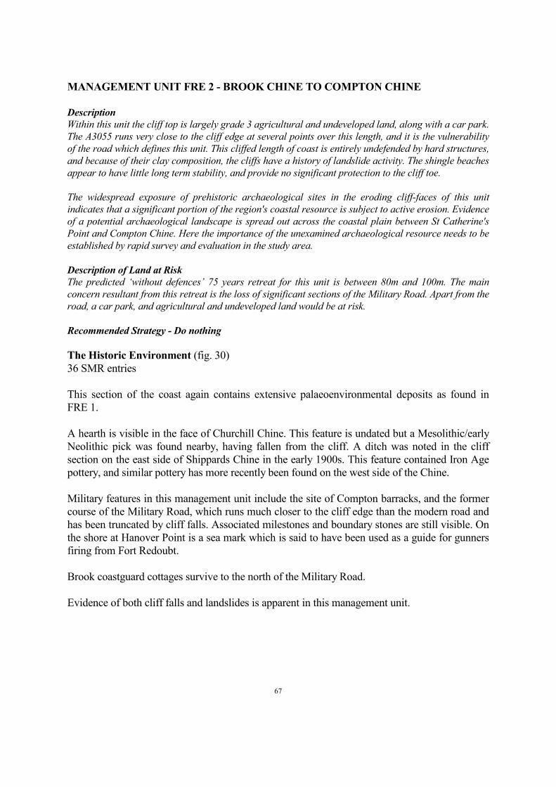
67
MANAGEMENT UNIT FRE 2 - BROOK CHINE TO COMPTON CHINE
Description
Within this unit the cliff top is largely grade 3 agricultural and undeveloped land, along with a car park.
The A3055 runs very close to the cliff edge at several points over this length, and it is the vulnerability
of the road which defines this unit. This cliffed length of coast is entirely undefended by hard structures,
and because of their clay composition, the cliffs have a history of landslide activity. The shingle beaches
appear to have little long term stability, and provide no significant protection to the cliff toe.
The widespread exposure of prehistoric archaeological sites in the eroding cliff-faces of this unit
indicates that a significant portion of the region's coastal resource is subject to active erosion. Evidence
of a potential archaeological landscape is spread out across the coastal plain between St Catherine's
Point and Compton Chine. Here the importance of the unexamined archaeological resource needs to be
established by rapid survey and evaluation in the study area.
Description of Land at Risk
The predicted ‘without defences’ 75 years retreat for this unit is between 80m and 100m. The main
concern resultant from this retreat is the loss of significant sections of the Military Road. Apart from the
road, a car park, and agricultural and undeveloped land would be at risk.
Recommended Strategy - Do nothing
The Historic Environment (fig. 30)
36 SMR entries
This section of the coast again contains extensive palaeoenvironmental deposits as found in
FRE 1.
A hearth is visible in the face of Churchill Chine. This feature is undated but a Mesolithic/early
Neolithic pick was found nearby, having fallen from the cliff. A ditch was noted in the cliff
section on the east side of Shippards Chine in the early 1900s. This feature contained Iron Age
pottery, and similar pottery has more recently been found on the west side of the Chine.
Military features in this management unit include the site of Compton barracks, and the former
course of the Military Road, which runs much closer to the cliff edge than the modern road and
has been truncated by cliff falls. Associated milestones and boundary stones are still visible. On
the shore at Hanover Point is a sea mark which is said to have been used as a guide for gunners
firing from Fort Redoubt.
Brook coastguard cottages survive to the north of the Military Road.
Evidence of both cliff falls and landslides is apparent in this management unit.

68
Figure 30 FRE 2
FRE 2 Condition
Not known
16.67%
No evidence on ground
36.11%Extant
16.67%
Coastal erosion
30.56%
FRE 2 Land Use
Building
2.78%
Not known
5.56%
Thoroughfare/verge
13.89%
Grassland heathland
19.44%
Intertidal
13.89%
Above high water
5.56%
Cliffs
38.89%
FRE 2 Period
Neolithic
2.94%
Bronze Age
2.94%
Iron Age
5.88%Roman
2.94%
Mesolithic
11.76%
Palaeolithic
2.94%
Prehistoric
20.59%
Modern
5.88%
Post medieval
44.12%
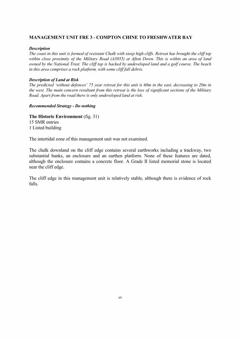
69
MANAGEMENT UNIT FRE 3 - COMPTON CHINE TO FRESHWATER BAY
Description
The coast in this unit is formed of resistant Chalk with steep high cliffs. Retreat has brought the cliff top
within close proximity of the Military Road (A3055) at Afton Down. This is within an area of land
owned by the National Trust. The cliff top is backed by undeveloped land and a golf course. The beach
in this area comprises a rock platform, with some cliff fall debris.
Description of Land at Risk
The predicted ‘without defences’ 75 year retreat for this unit is 60m in the east, decreasing to 20m in
the west. The main concern resultant from this retreat is the loss of significant sections of the Military
Road. Apart from the road there is only undeveloped land at risk.
Recommended Strategy - Do nothing
The Historic Environment (fig. 31)
15 SMR entries
1 Listed building
The intertidal zone of this management unit was not examined.
The chalk downland on the cliff edge contains several earthworks including a trackway, two
substantial banks, an enclosure and an earthen platform. None of these features are dated,
although the enclosure contains a concrete floor. A Grade II listed memorial stone is located
near the cliff edge.
The cliff edge in this management unit is relatively stable, although there is evidence of rock
falls.
70
FRE 3 Condition
Not known
13.33%
No evidence on ground
20.00%
Extant
46.67%
Coastal erosion
13.33%
Damaged
6.67%
FRE 3 Land Use
Grassland heathland
66.67%
Cliffs
20.00%
Intertidal
6.67%
Boundary
6.67%
FRE 3 Period
Prehistoric
6.67%
Unknown
40.00%
Post medieval
53.33%
Figure 31 FRE 3
71
MANAGEMENT UNIT FRE 4 - FRESHWATER BAY
Description
Within Freshwater Bay the Chalk cliffs reduce to beach level in the centre. The residential village is
fronted by an area of undeveloped land with some hotels. The Bay forms the southern end of the flood
area of the Western Yar, a vast sparsely developed area which extends north to Yarmouth. The
shoreline of Freshwater Bay is protected by concrete walls and a number of timber groynes, along with
the shingle beach.
Description of Land at Risk
The predicted ‘without defences’ scenario for this unit involves flooding of the extensive low lying area
backing Freshwater Bay, which extends north to Yarmouth. Within the Bay developments at risk include
Fort Redoubt, several hotels and a number of houses. The flood area which backs the Bay is
predominantly undeveloped and agricultural land, but there are also areas of housing, recreational and
commercial use, with more intense development around Yarmouth.
Recommended Strategy - Hold the existing defence line
The Historic Environment (fig. 32)
27 SMR entries
2 Historic buildings
This management unit contains important palaeoenvironmental deposits. A colluvial sequence
is visible in the cliff face on either side of Freshwater Bay, and Afton Marsh is similarly
significant.
Freshwater Redoubt and an associated military road and boundary stones survive, and a WW2
pillbox is located in the grounds of Freshwater Bay House, now a hotel. A second pillbox is
found on Blackbridge Road.
Freshwater coastguard cottages survive in Coastguard Lane.
Although relatively stable, cartographic evidence suggests that the bay is becoming more
concave, and the colluvial deposits in the cliff face are less resistant than the solid chalk to the
east and west.

72
FRE 4Condition
Damaged
3.70% Coastal erosion
3.70%
Not known
25.93%
No evidence on ground
37.04%
Extant
29.63%
FRE 4 Land Use
Wetland
11.11%
Building
11.11%
Built over
3.70%
Garden
3.70%
Cliffs
7.41%Grassland heathland
3.70%
Boundary
3.70%
Thoroughfare/verge
37.04%
Waste ground
3.70%
Not known
14.81%
FRE 4 Period
Palaeolithic
3.70%
Prehistoric
11.11%
Bronze Age
3.70%
Roman
3.70%
Unknown
3.70%
Modern
14.81%
Post medieval
59.26%
Figure 32 FRE 4

73
MANAGEMENT UNIT FRE 5 - FRESHWATER BAY TO THE NEEDLES
Description
To the west of Freshwater the chalk cliffs rise to heights of up to 130 metres. There are no built defences
over this frontage, with a foreshore of chalk debris, and shingle in Scratchells Bay. The majority of the
cliff top land is owned by the National Trust. This area is mainly undeveloped, with the exception of the
Coastguard Cottages and Needles Battery, both at the western extremity of the unit.
Description of Land at Risk
The predicted ‘without defences’ 75 year retreat in this unit is between 15m and 20m. This will
generally only effect the fringe of the National Trust owned `Downs' land, but also at risk is the Needles
Battery whose southern wall is already at the very edge of the cliffs.
Recommended Strategy - Do nothing
The Historic Environment (fig. 33)
50 SMR entries
4 SAM
3 Listed buildings
This unit contains a Neolithic mortuary enclosure and four Bronze Age round barrows, along
with numerous findspots of prehistoric worked flint. A substantial bank can be seen running
north-south across the slope passing west from Freshwater Bay and veering westwards, where it
continues along the northern base of the down to High Down where it can be seen near the cliff
edge. Other earthen banks are also visible on Tennyson Down. The Tennyson monument is an
important landmark in this unit.
At the western end of the Down, the Old and New Needle Batteries survive, the latter having
later served as a test site for the Black Knight and Black Arrow rockets. Coastguard cottages are
still present at High Down.
WW2 features include an anti aircraft gun emplacement, the site of a spigot mortar base and
numerous trenches dug across both High Down and Tennyson Down to prevent enemy aircraft
from landing.
The chalk cliffs of this management unit are relatively stable, although evidence of rock falls
was noted.

74
FRE 5 Condition
Not known
18.87%
No evidence on ground
24.53%
Extant
33.96%
Destroyed
3.77%
Damaged
18.87%
FRE 5 Land Use
Not known
5.66%
Boundary
9.43%
Thoroughfare/verge
1.89%
Building
5.66%
Woodland
3.77%
Cliffs
5.66%
Grassland heathland
67.92%
FRE 5 Period
Neolithic
2.00%
Bronze Age
8.00%
Prehistoric
4.00%
Unknown
20.00%
Modern
16.00%
Post medieval
50.00%
Figure 33 FRE 5

75
MANAGEMENT UNIT TOT 1 - SOUTH ALUM BAY
Description
From The Needles, the south side of Alum Bay is dominated by high chalk cliffs, with a chalk debris
foreshore. Along the White Cliffs the cliff top land is owned by the National Trust. This area is mainly
undeveloped, with the exception of the Needles Battery, at the western extremity of the unit, and the
access road to the Battery.
Description of Land at Risk
The predicted ‘without defences’ 75 year retreat in this unit is between 25m and 35m. The cliff top
National Trust downs area at risk includes large sections of the access road to the Needles Battery, and
part of the Battery itself.
Recommended Strategy - Do nothing
The Historic Environment (fig. 34)
9 SMR entries
1 SAM
1 Listed building
This management unit includes the Old Needles Battery, which played an important role in
searchlight experiments in the 1890s. The former Port War Signal Station which was later used
by the Coastguard also survives in the Battery. A WW2 spigot mortar base is located near the
access road from Alum Bay.
Evidence of a large cliff fall was visible in this management unit.

76
TOT 1 Condition
Coastal erosion
11.11%
Extant
33.33%
Not known
22.22%
Damaged
33.33%
TOT 1 Land Use
Grassland heathland
66.67%
Building
22.22%
Cliffs
11.11%
TOT 1 Period
Bronze Age
11.11%
Unknown
22.22%
Modern
33.33%
Post medieval
33.33%
Figure 34 TOT 1

77
MANAGEMENT UNIT TOT 2 - SOUTH-EAST ALUM BAY TO WEST TOTLAND
Description
The majority of this unit, up to the edge of Totland, is owned by the National Trust. The west facing side
of Alum Bay has cliffs formed of clays, and the distinctly coloured Alum Bay Sands. The cliffs are
generally steep and erode by rockfalls and slides. There is no artificial protection of these cliffs, which
are fronted by a steep shingle beach. The cliff top here is dominated by the Alum Bay Leisure Park. The
coast moves into Totland Bay at Hatherwood Point, with the undeveloped north facing side formed of
Headon Hill (120m O.D.). Lithological variations in the Hill have resulted in the development of a wide
and complex cliff slope, with both mudsliding and deep seated failures. The beach at the base of the cliff
is formed of shingle and slip debris.
Description of Land at Risk
The predicted ‘without defences’ 75 years retreat in this unit is between 30m and 85m. This would result
in the loss of a considerable area of the Alum Chine Theme Park, and the chair-lift on the fronting cliff.
Such retreat would also threaten Headon Hall, and cliff edge agricultural land along Headon Hill.
Recommended strategy - Do nothing
The Historic Environment (fig. 35)
24 SMR entries
1 SAM
This management unit includes Bronze Age round barrows on Headon Warren, and
Hatherwood Battery with its associated military road and boundary stones. The Royal Needles
Hotel, which was destroyed by fire in 1909, was occupied by Guglielmo Marconi whilst
conducting radio experiments in the late 1890s. A stone commemorating his activities has
already once been moved back from the cliff edge.
Cliff falls and slumping of the coastal slope are evident in this management unit. Hatherwood
Battery is being destroyed by slumping, and a possible round barrow has been truncated by cliff
falls.

78
Figure 35 TOT 2
TOT 2 Condition
No evidence on ground
22.73%
Extant
27.27%
Coastal erosion
18.18%
Damaged
22.73%
Not known
9.09%
TOT 2 Land Use
Recreational use
12.50%
Intertidal
4.17%
Grassland heathland
50.00%
Cliffs
25.00%
Building
4.17%
Not known
4.17%
TOT 2 Period
Bronze Age
8.70%
Neolithic
4.35%
Palaeolithic
4.35%Prehistoric
4.35%
Medieval
4.35%
Unknown
17.39%
Post medieval
56.52%

79
MANAGEMENT UNIT TOT 3 - WEST TOTLAND TO COLWELL CHINE
Description
To the east low wooded cliff slopes front the village of Totland. From Widdick Chine the developed
frontage is protected by concrete walls and timber groynes for over a kilometre. The beach along this
frontage consists of a steep shingle upper and sandy lower profile. Warden Point at the north end of the
Bay has developed as a headland due to the foreshore outcrop of resistant limestone which forms
Warden Ledge. The Point is backed by holiday camps and grade 4 agricultural land. To the east is
Colwell Bay where the low cliffs (15-20m) are generally subject to erosion. The southern part of the Bay
has holiday camps backed by the housing of Colwell.
Description of Land at Risk
The predicted ‘without defences’75 years retreat in this unit is between 60m and 90m. The land affected
by this retreat includes the developed residential and commercial frontage of Totland, along with its
esplanade and pier. Also within the risk area to the north are Fort Warden Holiday Camp, which is
proposed for residential development, and Rendle's Holiday Centre. Such losses would obviously harm
the local economy, with the loss of tourist facilities and amenities.
Recommended Strategy - Hold the existing defence line
The Historic Environment (fig. 36)
31 SMR entries
1 Historic building
1 Listed building
Most of the features recorded in this unit are military and include the Battery at Warden Point,
with its military road and boundary stones. On the sea wall beneath the battery is a late
nineteenth century searchlight and the scar where another has been demolished. The pier in
Totland Bay survives. Two coastguard stations are present in Totland. A Neolithic polished
stone axe was found on the beach but its precise grid reference is not known. This may have
eroded from the cliff face.
The coast edge of this unit is protected but there is evidence of cliff falls behind the defences.

80
TOT 3 Condition
Damaged
3.33%
Destroyed
3.33%
Coastal erosion
6.67%
No evidence on ground
60.00%
Extant
26.67%
TOT 3 Land Use
Boundary
13.33%
Built over
10.00%
Cliffs
10.00%
Above high water
13.33%
Intertidal
6.67%
Marine
3.33%Recreational use
3.33%
Thoroughfare/verge
26.67%
Building
6.67%Garden
3.33%
Woodland
3.33%
TOT 3 Period
Unknown
3.45% Neolithic
3.45%Modern
6.90%
Post medieval
86.21%
Figure 36 TOT 3

81
MANAGEMENT UNIT TOT 4 - COLWELL CHINE TO FORT ALBERT
Description
Within Colwell Bay the low cliffs (15-20m) are subject to rapid erosion. The cliffs contain a permeable
sandy strata over impermeable clays, giving a classic landsliding sequence. The central part of the Bay
maintains a good sand beach, which diminishes towards the north and south ends of the Bay. Brambles
Chine Holiday Centre is the only cliff top development in this unit, with the remainder agricultural and
undeveloped land. Fort Albert (the north eastern extremity of the unit) is protected by a concrete
seawall and is backed by Cliff End Battery, on the low cliffs.
Description of Land at Risk
The predicted ‘without defences’ 75 year retreat in this unit is 105m. At the north end of the unit this
would result in the loss of Fort Albert and Cliff End Battery. Within Colwell Bay the area at risk
includes part of Brambles Chine Holiday Centre and a hotel, along with agricultural and undeveloped
land.
Recommended Strategy - Retreat the existing defence
The Historic Environment (fig. 37)
24 SMR entries
1 Historic building
1 Listed building
This management unit includes the remains of Cliff End Battery, which contains important early
twentieth century features (Saunders, 1998), and the Grade II* listed Fort Albert. Late
nineteenth century searchlight emplacements were located below the battery but this area is
suffering from coastal erosion and slippage. The site of a WW2 anti aircraft battery lies just to
the east of Brambles Chine Holiday Centre.
A Bronze Age palstave and part of a second were found on the beach in this unit and were
thought to have fallen from the eroding cliffs.
There is evidence of active erosion of the cliff face along the length of this unit.

82
TOT 4 Condition
Damaged
16.67%
Not known
33.33%
No evidence on ground
20.83% Extant
4.17%
Coastal erosion
25.00%
TOT 4 Land Use
Churchyard
0.00%
Boundary
16.67%
Building
8.33%
Woodland
4.17%
Cliffs
20.83%
Above high water
4.17%
Intertidal
4.17%Not known
8.33%
Recreational use
12.50%
Waste ground
8.33%
Built over
8.33%
Grassland heathland
4.17%
TOT 4 Period
Bronze Age
4.55%
Modern
31.82%
Post medieval
63.64%
Figure 37 TOT 4

83
MANAGEMENT UNIT NEW 1 - FORT ALBERT TO FORT VICTORIA
Description
This stretch between Fort Albert and Fort Victoria has no hard defences. The sand and shingle beach is
backed by a low angle, densely vegetated cliff slope, and grade 3 agricultural land.
Description of Land at Risk
The predicted ‘without defences’ 75 years retreat in this unit is 105m. This would only result in the loss
of woodland on the coastal slope and agricultural land.
Recommended Strategy - Do nothing
The Historic Environment (fig. 38)
9 SMR entries
This management unit includes the site of Worsley's tower, probably already lost to the sea. An
Iron Age terret ring was found on the beach.
A military road which ran between Fort Victoria and Cliff End Battery now forms the coastal
footpath.
There is extensive slumping of the coastal slope in this management unit.
84
NEW 1 Condition
Coastal erosion
33.33%
Extant
11.11%
Not known
55.56%
NEW 1 Land Use
Woodland
55.56%
Cliffs
11.11%
Above high water
11.11%
Intertidal
11.11%Thoroughfare/verge
11.11%
NEW 1 Period
Iron Age
11.11%
Post medieval
88.89%
Figure 38 NEW 1
85
MANAGEMENT UNIT NEW 2 - FORT VICTORIA TO NORTON SPIT
Description
At the western edge of this unit is Fort Victoria, which along with the Pier and attending engine house
and cottages form a discrete Victorian Military Complex. East of the fort is Norton, a mainly residential
village with some tourist accommodation. The village is fronted by a wooded slope, which is protected
by a concrete wall. In the east of the unit the slope reduces to give a small flood risk area, also
protected by the wall along with gabions and groynes at its eastern extremity. These are fronted by a
shingle beach.
Description of Land at Risk
The predicted ‘without defences’ 75 years retreat in this unit is between 55m and 100m, with a small
area at risk of flooding in the east of the unit. The area at risk includes Fort Victoria, the Pier and
backing housing, along with Yarmouth Chalet Hotel and an area of woodland. The area is also prone to
flood risk, potentially affecting a small area of housing on the edge of Norton.
Recommended Strategy - Hold the existing defence line
The Historic Environment (fig. 39)
24 SMR entries
5 Historic buildings
1 Listed building
This unit includes Fort Victoria, on the site of earlier defences. Searchlight emplacements are
found on the beach. These include an unusual “see-saw” emplacement dating from 1888, and
slightly later structures which formed part of a series of experimental searchlights constructed
along the Needles Passage (Cantwell, 1985). These are in very poor condition. The Fort Victoria
pier is also in poor condition. The engine house has been demolished and a new development of
housing is under construction in its place.
This stretch of coast is protected, although there is some evidence of instability behind the
defences.

86
NEW 2 Condition
Not known
6.90%
No evidence on ground
51.72%
Extant
3.45%
Coastal erosion
24.14%
Damaged
13.79%
NEW 2 Land Use
Thoroughfare/verge
17.24%
Waste ground
6.90%
Recreational use
24.14%
Not known
3.45%
Marine
3.45%Intertidal
10.34%
Above high water
13.79%
Woodland
13.79%
Built over
6.90%
NEW 2 Period
Modern
12.50%
Medieval
4.17%
Post medieval
83.33%
Figure 39 NEW 2

87
MANAGEMENT UNIT NEW 3 - YARMOUTH HARBOUR
Description
Norton Spit extends eastwards across the mouth of the Yar Estuary. This shingle feature is stabilized by
timber breastwork, groynes and a length of armoured breakwater. The heavily stabilized spit protects
Yarmouth Harbour. The harbour is vital to the economy of the area both as a ferry port (services from
Lymington) and as a centre for yachting. The predominantly residential settlement of Yarmouth flanks
the harbour to the east, with Yarmouth Castle on the very edge of the harbour mouth. Yarmouth
Harbour is at the mouth of the Western Yar, forming the seaward edge of a vast sparsely developed
area which theoretically extends as far south as Freshwater Bay, and east along Thorley Brook.
Description of Land at Risk
The predicted ‘without defences’ scenario for this unit involves flooding of the vast low lying area
backing Yarmouth Harbour, which extends south to Freshwater Bay. The failure of harbour walls and
the Norton Spit defences would effectively destroy the harbour and thus the local economy. Around the
harbour, developments at risk include Yarmouth Castle, the Wightlink ferry terminal, commercial and
residential areas of Yarmouth, and harbour facilities. The flood area which backs Yarmouth is
predominantly undeveloped and agricultural land, but there are also areas of housing, recreational and
commercial use, with more intense development around Freshwater.
Recommended Strategy - Hold the existing defence line
The Historic Environment (fig. 40)
23 SMR entries
28 Historic buildings
1 SAM
18 Listed buildings
Conservation Area
This management unit contains Yarmouth Castle, a Scheduled Ancient Monument and Grade I
listed building. The church of St James is Grade II* listed, as is the George Inn. There are
numerous other historic buildings within the town.
Important palaeoenvironmental evidence is preserved beneath Norton Spit and saltmarsh within
the Western Yar. This was sampled during the Wootton-Quarr project.
The mouth of the Western Yar is protected by a breakwater.

88
NEW 3 Condition
Destroyed
4.55% Coastal erosion
4.55%
Not known
13.64%
No evidence on ground
18.18%
Extant
59.09%
NEW 3 Land Use
Not known
4.55%
Built over
13.64%
Building
27.27%
Marine
13.64%
Intertidal
13.64%
Above high water
4.55%
Coastland, unclassified
18.18%
Grassland heathland
4.55%
NEW 3 Period
Prehistoric
5.00%
Iron Age
5.00%
Modern
5.00%
Medieval
10.00%
Post medieval
75.00%
Figure 40 NEW 3
89
MANAGEMENT UNIT NEW 4 - ROYAL SOLENT YACHT CLUB TO THE
COMMON, YARMOUTH
Description
The settlement of Yarmouth is predominantly residential, with a population of 885 (1991 census). The
whole of the area covered by this unit is a Conservation Area, making the preservation of its character
a priority. The majority of the town is at risk from flooding, opening onto the flood area of the Western
Yar. The frontage of the town is protected by a sea wall and a low level shingle beach.
Description of Land at Risk
The predicted ‘without defences’ scenario for this unit involves flooding of the extensive low lying area
backing Yarmouth, which extends south to Freshwater Bay. The failure of the seawall fronting
Yarmouth would eventually result in the loss of seafront property and flooding of a large proportion of
the town. Along the seafront of the town developments at risk, within this unit, include the Royal Solent
Yacht Club, residential property, and several landing stages. The flood area of the Western Yar, which
backs Yarmouth, is predominantly undeveloped and agricultural land, but there are also areas of
housing, recreational and commercial use, with more intense development around the adjacent
Yarmouth Harbour area, and at Freshwater.
Recommended Strategy - Hold the existing defence line
The Historic Environment (fig. 41)
9 SMR entries
22 Historic buildings
17 Listed buildings
Conservation Area
This management unit contains much of the town of Yarmouth and includes the cemetery which
may also be the site of a medieval church. Numerous historic buildings and a pump capping one
of the town's wells are visible within this unit.
The coast of this unit is protected.
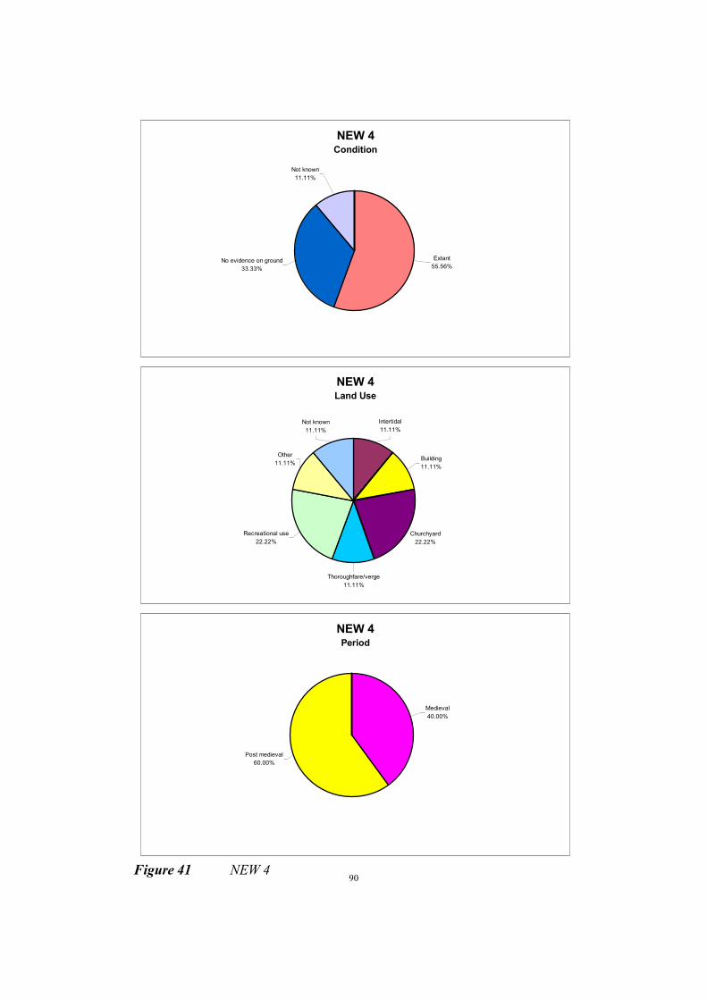
90
NEW 4 Condition
Extant
55.56%No evidence on ground
33.33%
Not known
11.11%
NEW 4 Land Use
Churchyard
22.22%
Building
11.11%
Intertidal
11.11%
Not known
11.11%
Other
11.11%
Recreational use
22.22%
Thoroughfare/verge
11.11%
NEW 4 Period
Post medieval
60.00%
Medieval
40.00%
Figure 41 NEW 4
91
MANAGEMENT UNIT NEW 5 - THE COMMON, YARMOUTH TO BOULDNOR
Description
The area of Yarmouth and Bouldnor covered by this unit includes developments which are ‘set back’
slightly from the coast, the frontage itself being an area of undeveloped land. The majority of the unit is
protected by sea walls, with groynes and gabions at its eastern end. The common fronts housing at
Yarmouth, with the A3054 moving close to the coast at the edge of the town. To the east is a low lying
undeveloped area of international nature conservation value. This area opens onto the flood risk area
of the Western Yar, a vast low lying area including much of Yarmouth and extending south to
Freshwater Bay. Bouldnor is fronted by a wooded low angle slope, which gradually rises to the east of
the village. The housing of Bouldnor is generally fronted by the A3054, although this moves inland at
Eastmore House.
Description of Land at Risk
The predicted ‘without defences’ 75 years retreat scenario for this unit potentially involves flooding of
the extensive low lying area backing Yarmouth, which extends south to Freshwater Bay. The failure of
the seawall along this unit would eventually result in both the loss of coastal property and provide a
new flood route to a large area, including much of Yarmouth and extending through to Freshwater Bay.
The developments at risk along this frontage include housing of Yarmouth and Bouldnor, a large
section of the A 3054 and a boat house at Bouldnor. The flood area of the Western Yar, which is only
separated from the coast by a thin raised strip in the central area of the unit, consists predominantly of
undeveloped and agricultural land, but there are also areas of housing, recreational and commercial
use, with more intense development around Yarmouth, and at Freshwater.
Recommended Strategy - Hold the existing defence line
The Historic Environment (fig. 42)
8 SMR entries
This section of coast includes the Common, and it is believed that a defensive dyke was dug
here to protect the town from a feared French invasion. Finds of Iron Age coins have been made
on the coastal slope and the beach.
This is a protected coast, but there is evidence of slumping at the eastern end of the unit.

92
Figure 42 NEW 5
NEW 5 Condition
Extant
12.50%
No evidence on ground
12.50%
Not known
75.00%
NEW 5 Land Use
Not known
25.00%
Recreational use
25.00%Built over
25.00%
Grassland heathland
12.50%
Cliffs
12.50%
NEW 5 Period
Palaeolithic
14.29%
Iron Age
14.29%
Unknown
14.29%
Post medieval
57.14%

93
MANAGEMENT UNIT NEW 6 - BOULDNOR TO HAMSTEAD
Description
The coastal slope gradually rises to the east of Bouldnor village, to 61 metres at Bouldnor Cliff. These
predominantly clayey cliffs are prone to mudslides and deeper failures. The cliffs reduce again to 35
metres at Hamstead Cliff. This stretch is fronted by a predominantly shingle beach, which is littered by
debris from cliff failures. Woodland and agricultural land largely back these cliffs, with some
residential properties behind Bouldnor Cliff.
Description of Land at Risk
The predicted ‘without defences’ 75 year retreat in this unit is between 35m and 130m. The large
majority of cliff top land threatened by this retreat is within Bouldnor and Gully Copses. A number of
houses close to the cliff top of the east part of Bouldnor Cliff, along with grade 4 agricultural land
along Hamstead Cliff, are the other areas at risk.
Recommended Strategy - Do nothing
The Historic Environment (fig. 43)
37 SMR entries
Many finds of prehistoric flint implements have been made along this stretch of coast, including
a large number of Mesolithic/early Neolithic picks and tranchet axes. There have also been finds
of Palaeolithic handaxes, both on the beach and in the eroding cliffs. Roman pottery has been
found at several locations, and a medieval site with pottery and worked antler in association
with hurdling is located in the intertidal silt at Bouldnor. Palaeoenvironmental evidence is
preserved in the fill of Bouldnor Creek. On the western side of the creek, a hearth containing
charcoal and fire-cracked flint was recorded during the present fieldwork.
There are numerous post medieval and modern structures located in this management unit. In
the intertidal zone is the remains of a substantial stone pier or landing stage which is thought to
have been built when plans were made to construct a new town at Bouldnor in the late
nineteenth century. The remains of three large reinforced concrete structures, also on the beach,
are probably of military origin and associated with Bouldnor Battery.
At Hamstead Point stands a stone memorial to two brothers and their friend lost at sea in the
1930s.
The coastal slope is receding rapidly in this unit and there is extensive evidence of mudslides.
Other than at the mouth of Bouldnor Creek, the intertidal zone is largely stripped to the natural
clays.

94
NEW 6 Condition
Not known
8.11%
No evidence on ground
18.92%
Extant
10.81%Coastal erosion
62.16%
NEW 6 Land Use
Not known
5.41%
Woodland
13.51%
Intertidal
64.86%
Cliffs
10.81%
Above high water
5.41%
NEW 6 Period
Neolithic
2.86%
Roman
14.29%
Medieval
5.71%
Post medieval
14.29%
Modern
20.00%
Unknown
5.71%
Prehistoric
2.86% Palaeolithic
8.57%
Mesolithic
25.71%
Figure 43 NEW 6

95
MANAGEMENT UNIT NEW 7 - NEWTOWN HARBOUR
Description
This unit is based on Newtown Harbour, an estuary which is largely owned by the National Trust.
Hamstead Duver extends from Hamstead Point east across the mouth of Newtown Harbour. This sand
and shingle feature is largely backed by woodland, and partially vegetated as it extends into the
Harbour mouth. The eastern spit at the Harbour mouth indicates a locally reversed drift, with a weak
sediment supply, resulting in a nett loss from the spit. The centre part of the spit is currently very thin,
and potentially vulnerable to breaching. There is evidence to suggest that the spits have a very long
history and that only recently have they been subject to erosion. Submerged archaeological structures
have been recently exposed on the beach of the east spit. The habitats of Newtown Harbour are of great
conservation value, a fact reflected in the protection of the site by international, national and local
designations. The area has also recently been designated a National Nature Reserve. Land around the
edge of the harbour is generally undeveloped or agricultural, with the predominantly National Trust
owned village of Newtown the main exception. The smaller villages of Shalfleet and Porchfield lie on
the very edge of the estuary, at the end of the Rodge Brook and Shalfleet Lake respectively.
Description of Land at Risk
The predicted ‘without defences’ scenario in this unit involves erosion of the spits at the mouth of the
harbour, and flooding of the surrounding low lying land. Around the harbour, the flanking flood risk
area is predominantly undeveloped or agricultural land. No properties within Newtown itself are at
risk, with a small number of houses threatened at both Shalfleet and Porchfield.
Recommended Strategy - Retreat the existing defence line
The Historic Environment (fig. 44)
109 SMR entries
19 Historic buildings
11 Listed buildings
The Newtown Estuary is rich in sites of archaeological and historic significance. Important
palaeoenvironmental and archaeological sites are found at the mouth of the estuary, both on the
East Spit and Hamstead Dover. These sites contain peats and recumbent trees as well as post
alignments, hurdle trackways, timber platforms and lithic scatters. Finds from the east spit
include a Neolithic stone axe of porphyritic rhyolite (identified by David Williams,
Southampton University), and at Hamstead Dover part of a Neolithic polished flint axe was
recovered during the present survey. Palaeoenvironmental deposits and wooden structures were
recorded on the East Spit in 1993 but many more structures were visible when the site was
visited during the current project. The spit is eroding rapidly and a lens of burnt and worked
flint contained within the spit is being lost.
Other than at the mouth of the estuary, a relatively small amount of prehistoric material was
observed during the present survey, and in general, flint scatters and hearths tended to be visible
where the saltmarsh had eroded back to the natural clay of the river bank. PRN 3789 was an
exception, a scatter of worked flint found in the intertidal mud. Post alignments and groups were
also visible where the saltmarsh was eroding.
The Newtown Estuary contains the sites of two brickworks and seven salterns, some of which
were later reused as oyster beds. Evidence of these sites can be seen in the form of post
96
alignments, earthworks and fired clay waste products. The remains of the brick kilns still
survive at Brickfield Farm.
Ridge and furrow is visible in many of the fields around the estuary, particularly round the
village of Newtown and in the eastern part of the estuary. It can also be seen in the once
reclaimed marsh adjacent to Newtown Quay which is enclosed by a bank and Bembridge
limestone walling.
Coastguard cottages survive at Newtown, and there are Grade II listed bridges at Newtown and
Shalfleet.
WW2 features around the estuary include two bombing decoys and an anti-aircraft battery at
Lower Hamstead. This site is also said to have served as a prisoner of war camp during both
world wars.
Erosion was particularly evident at the mouth of the estuary, but it became apparent during the
survey that the more sheltered area within the estuary is also being affected.

97
NEW 7 Condition
Overgrown
0.89%
Ploughed
0.89%
Tree planted
1.79%
Damaged
0.89%Not known
11.61%
No evidence on ground
7.14%
Extant
14.29%Coastal erosion
62.50%
NEW 7 Land Use
Cliffs
0.89%
Coastland, unclassified
1.79%
Intertidal
38.39%
Above high water
4.46%Saltmarsh
25.89%
Woodland
8.93%
Grassland heathland
8.04%
Thoroughfare/verge
3.57%
Marine
0.89%Cultivated
2.68%
Not known
1.79%Other
0.89%Building
1.79%
NEW 7 Period
Neolithic
3.06%
Mesolithic
2.04%
Roman
1.02%
Prehistoric
8.16%
Unknown
55.10%
Post medieval
24.49%
Modern
6.12%
Figure 44 NEW 7

98
MANAGEMENT UNIT NEW 8 - BRICKFIELDS FARM TO THORNESS WOOD
Description
In spite of a relatively sheltered location, rapid cliff erosion exists along this frontage. To the east of
Newtown Harbour low cliffs are backed by agricultural land. This gives way to Burnt Wood, near where
the cliffs rise to over 40 metres, and are characterised by landslide/mudslide failures with lobes of
failure debris across the beach. East of the woodland the cliffs are backed by agricultural land and the
tourist parks of Towers Holiday Centre and Pilgrims Park, one of the Island's major holiday camps.
Cliff height then reduces into Thorness Bay.
Description of Land at Risk
The predicted ‘without defences’ 75 year retreat in this unit is between 50m and 75m. This will
predominantly result in the loss of cliff top agricultural land and woodland. On the edge of Newtown
eastern spit the retreat threatens Brickfield Farm House, and comes close to breaching into the
Harbour itself. The only other developments at risk are the two holiday camps, whose seaward edges
are threatened.
Recommended Strategy - Do nothing
The Historic Environment (fig. 45)
30 SMR entries
This management unit has been regularly visited by a number of collectors who have recovered
numerous Mesolithic and Neolithic axes from the intertidal zone. The source of these is not yet
known. Roman pottery and other material has been recovered from the top of the eroding cliff to
the east of Brickfields Farm. At Burntwood a Bronze Age cremation and a supposed pottery kiln
of Roman date were recorded in the early part of the twentieth century.
The coastal slope is actively eroding in this management unit.
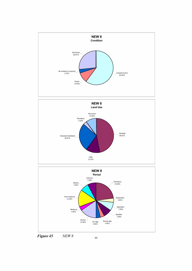
99
NEW 8 Condition
Not known
26.67%
No evidence on ground
3.33%
Extant
10.00%
Coastal erosion
60.00%
NEW 8Land Use
Woodland
3.33%
Not known
10.00%
Grassland heathland
26.67%
Cliffs
13.33%
Intertidal
46.67%
NEW 8 Period
Unknown
7.69%
Modern
7.69%
Post medieval
15.38%
Medieval
3.85%
Roman
15.38%Bronze Age
3.85%Iron Age
3.85%
Neolithic
7.69%
Mesolithic
7.69%
Palaeolithic
3.85%
Prehistoric
23.08%
Figure 45 NEW 8

100
MANAGEMENT UNIT NEW 9 - THORNESS MARSHES
Description
This unit consists of the flood area around Thorness Marshes. There are two small areas of brackish
marsh, designated as being of international nature conservation importance as a waterfowl habitat. The
flood area extends between and inland of the marshes, and is covered by agricultural and undeveloped
land.
Description of Land at Risk
The ‘without defences’ scenario for this unit involves the flooding of the low lying land around Thorness
Marshes. Apart from the marshes, the only land at risk is in agricultural use or undeveloped.
Recommended Strategy - Do nothing
The Historic Environment (fig. 46)
19 SMR entries
There was once a saltern on the east side of Thorness Marshes, although evidence for this could
not be seen during the present survey. A substantial bank was observed within the marsh but did
not appear to relate to the saltern as shown on early maps.
Palaeoenvironmental deposits are present in the intertidal zone, including peats, silts and
recumbent trees. Posts and hurdles have also been seen within these deposits. At least two
middens are present, one in the lower intertidal zone from which no dateable material has been
recovered, and the other, which contains medieval pottery sherds, at the base of the storm beach.
Indications of erosion of the intertidal sediments in this unit were evident during the survey.
These was also evidence of slumping of the coast edge in the west of the unit.
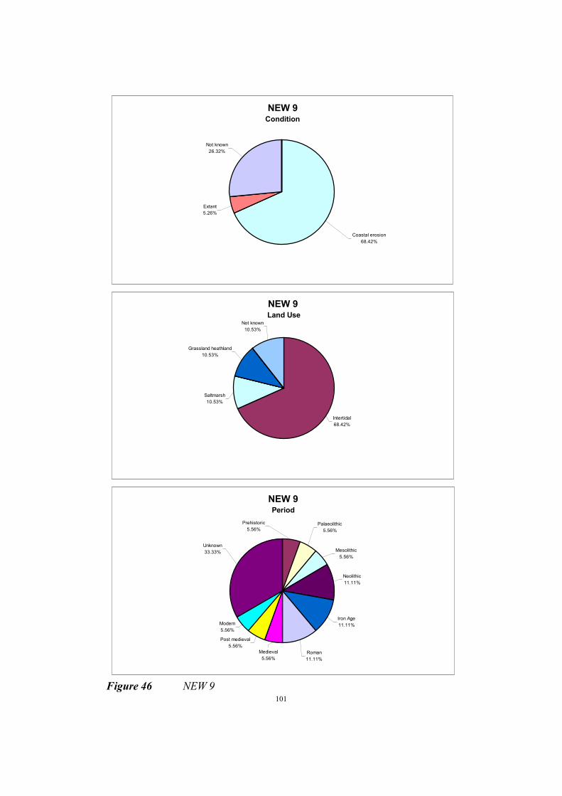
101
NEW 9 Condition
Coastal erosion
68.42%
Extant
5.26%
Not known
26.32%
NEW 9 Land Use
Intertidal
68.42%
Saltmarsh
10.53%
Grassland heathland
10.53%
Not known
10.53%
NEW 9 Period
Post medieval
5.56%
Modern
5.56%
Medieval
5.56%
Roman
11.11%
Iron Age
11.11%
Neolithic
11.11%
Mesolithic
5.56%
Palaeolithic
5.56%
Prehistoric
5.56%
Unknown
33.33%
Figure 46 NEW 9
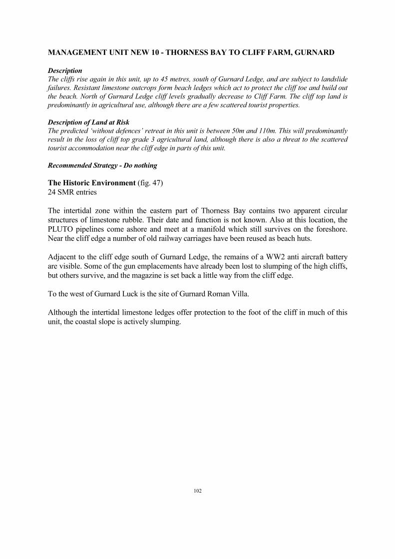
102
MANAGEMENT UNIT NEW 10 - THORNESS BAY TO CLIFF FARM, GURNARD
Description
The cliffs rise again in this unit, up to 45 metres, south of Gurnard Ledge, and are subject to landslide
failures. Resistant limestone outcrops form beach ledges which act to protect the cliff toe and build out
the beach. North of Gurnard Ledge cliff levels gradually decrease to Cliff Farm. The cliff top land is
predominantly in agricultural use, although there are a few scattered tourist properties.
Description of Land at Risk
The predicted ‘without defences’ retreat in this unit is between 50m and 110m. This will predominantly
result in the loss of cliff top grade 3 agricultural land, although there is also a threat to the scattered
tourist accommodation near the cliff edge in parts of this unit.
Recommended Strategy - Do nothing
The Historic Environment (fig. 47)
24 SMR entries
The intertidal zone within the eastern part of Thorness Bay contains two apparent circular
structures of limestone rubble. Their date and function is not known. Also at this location, the
PLUTO pipelines come ashore and meet at a manifold which still survives on the foreshore.
Near the cliff edge a number of old railway carriages have been reused as beach huts.
Adjacent to the cliff edge south of Gurnard Ledge, the remains of a WW2 anti aircraft battery
are visible. Some of the gun emplacements have already been lost to slumping of the high cliffs,
but others survive, and the magazine is set back a little way from the cliff edge.
To the west of Gurnard Luck is the site of Gurnard Roman Villa.
Although the intertidal limestone ledges offer protection to the foot of the cliff in much of this
unit, the coastal slope is actively slumping.

103
NEW 10 Condition
Damaged
8.33%
Not known
12.50%
No evidence on ground
4.17%
Extant
45.83%
Coastal erosion
29.17%
NEW 10 Land Use
Coastland, unclassified
0.00%
Grassland heathland
4.17%
Woodland
4.17%
Thoroughfare/verge
4.17%
Building
45.83%
Not known
16.67%
Intertidal
12.50%
Cliffs
12.50%
NEW 10 Period
Post medieval
8.70%
Roman
8.70%
Prehistoric
4.35%Mesolithic
4.35%
Neolithic
8.70%
Iron Age
4.35%
Modern
13.04%
Unknown
47.83%
F
igure 47 NEW 10

104
MANAGEMENT UNIT NEW 11 - GURNARD LUCK
Description
This unit is based on the low lying land flanking the Gurnard Luck stream. Inland the potential flood
area is undeveloped, but at the coastal edge, along Marsh Road in particular, there are several
residential properties and a car park and tourist facilities.
Description of Land at Risk
The predicted ‘without defences’ scenario for this unit involves the flooding of the low lying land which
delimits this unit. This area includes mainly agricultural and undeveloped land, but also housing at the
edge of Gurnard and along Marsh Road, and a beach edge car park and tourist facilities.
Recommended Strategy - Hold the existing defence line
The Historic Environment (fig. 48)
13 SMR entries
2 Historic buildings
This management unit contains a number of intertidal findspots of prehistoric and Roman date,
although the beach was masked by weed during the present survey. The bridge at Gurnard Luck
appears to be of considerable antiquity. In the intertidal zone in front of the bridge, a feature
composed of fascines of unknown date is visible.
Several railway carriages have been reused as beach huts and bungalows in Gurnard Bay. Most
of these are no longer recognisable as railway carriages.
On the east side of the bay, Marsh Cottage was once a coastguard station. This was later
replaced by the coastguard cottages in Management Unit NEW 12.
Little indication of active erosion was noted during the survey.

105
NEW 11 Condition
Coastal erosion
46.15%
Extant
38.46%
No evidence on ground
15.38%
NEW 11 Land Use
Thoroughfare/verge
7.69%
Built over
7.69%
Building
30.77%
Intertidal
38.46%
Cliffs
7.69%Wetland
7.69%
NEW 11 Period
Neolithic
8.33%
Roman
25.00%
Medieval
8.33%
Post medieval
25.00%
Unknown
33.33%
Figure 48 NEW 11

106
MANAGEMENT UNIT NEW 12 - WEST OF GURNARD TO EGYPT POINT
Description
The southern part of the unit is undefended, with slope toe protection along the esplanade frontage, in
the form of a sea wall, with a number of rock groynes locally, as well as sand and shingle beaches.
Along the undefended stretch, an unstable wooded coast slope fronts a residential area of Gurnard.
Prince's, and then Egypt Esplanades run along the edge of the beach over much of this unit, and are
largely backed by a wooded slope, although there are some slope toe properties.
Description of Land at Risk
The predicted 75 year ‘without defences’ retreat in this unit is approximately 55m. Without toe
protection not only are the properties along the edge of the beach under threat, but also slope top
properties, and as such there is a considerable amount of residential housing at risk in this unit. The
retreat also threatens The Briary Hotel, Egypt House, and much of the SINC designated woodland.
Recommended Strategy - Hold the existing defence line
The Historic Environment (fig. 49)
14 SMR entries
4 Historic buildings
This management unit contains several findspots of prehistoric and Roman date, mostly from
the intertidal zone. The former coastguard cottages survive in Solent View Road, but the site of
the brickworks has been developed.
Other post medieval features include Princes Esplanade with its commemorative plinth and
drinking fountain.
The coastal slope in the western part of this management unit is actively eroding.
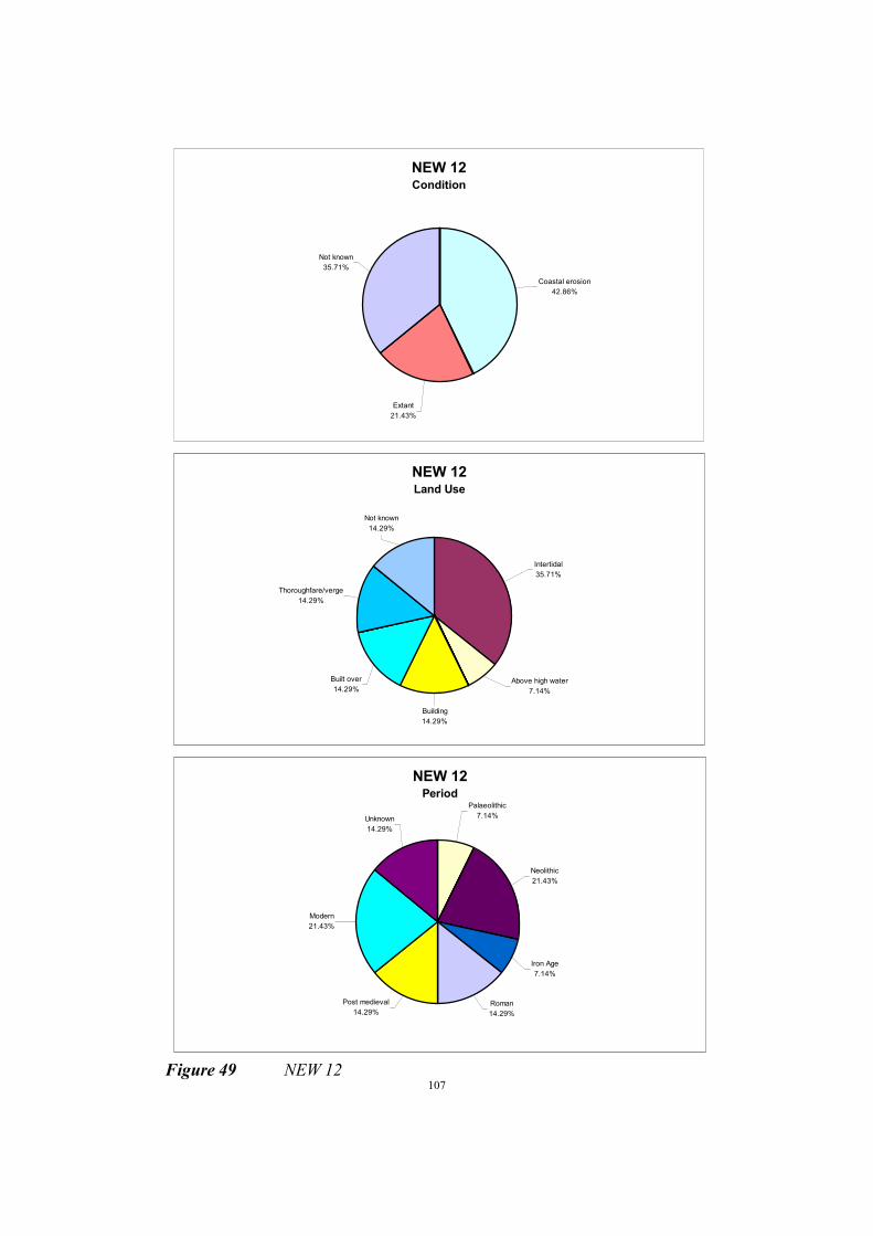
107
NEW 12 Condition
Not known
35.71%
Extant
21.43%
Coastal erosion
42.86%
NEW 12 Land Use
Building
14.29%
Built over
14.29%
Thoroughfare/verge
14.29%
Not known
14.29%
Intertidal
35.71%
Above high water
7.14%
NEW 12 Period
Unknown
14.29%
Modern
21.43%
Post medieval
14.29%
Roman
14.29%
Iron Age
7.14%
Neolithic
21.43%
Palaeolithic
7.14%
Figure 49 NEW 12

108
MANAGEMENT UNIT NEW 13 - EGYPT POINT TO COWES CASTLE
Description
From Egypt Point the coast is backed by the densely developed town of Cowes. The coastal frontage
consists predominantly of residential land, including Cowes Castle (the Club House of the Royal Yacht
Squadron), along with a thin fringe of undeveloped land along the coast edge for part of the unit. The
eastern half of the unit includes part of Cowes Conservation Area, hence there is an onus to preserve
the character of this area. Developments are protected by a series of sea walls, in various states of
repair, and a shingle beach. An esplanade runs along the top of the defences throughout the unit, and
the Queen's Road runs close behind over much of the frontage.
Description of Land at Risk
The predicted 75 year ‘without defences’ retreat in this unit is between 65m to the west and 110m to the
east. Throughout the unit this would result in the loss of the esplanade and Queen's Road, both of which
would affect the amenity value of this frontage. A significant amount of coastal housing is also
threatened, as well as Cowes Castle. The large majority of the Conservation Area within the unit is at
risk, along with much of the undeveloped open area.
Recommended Strategy - Hold the existing defence line OR Advance the existing defence line
The Historic Environment (fig. 50)
17 SMR entries
5 Historic buildings
4 Listed buildings
1 UDP parks and gardens
Conservation Area
This management unit contains the Grade II* listed Royal Yacht Squadron. Other listed
buildings include Holy Trinity Church, Egypt House and several residences in Queen's Road.
Prince's Green, a public park, falls within the benefits line and includes a Grade II listed
drinking fountain.
Also in this management unit is the light at Egypt Point and the site of a ropeworks, also near
Egypt Point. A Victorian post box is set into the boundary wall of Mornington House.
The coast edge of this management unit is protected.

109
NEW 13 Condition
Not known
13.33%
No evidence on ground
6.67%
Extant
60.00%
Coastal erosion
6.67%
Damaged
13.33%
NEW 13 Land Use
Waste ground
6.67%
Thoroughfare/verge
20.00%
Boundary
6.67%
Garden
20.00%
Building
20.00%
Intertidal
6.67%Recreational use
20.00%
NEW 13 Period
Roman
6.25%
Unknown
6.25%
Post medieval
87.50%
Figure 50 NEW 13

110
MANAGEMENT UNIT NEW 14 - COWES HARBOUR
Description
In the west part of the unit the coastal frontage consists of residential, commercial and port land uses,
protected by a series of sea walls, much of which falls within a Conservation Area. Cowes and East
Cowes together have a population of 17,000 (1991 census). The town is of great economic importance
to the Island as the main industrial port, and as a major yachting centre and ferry port. The two parts of
Cowes are separated by the River Medina, and linked by a chain ferry known as the ‘floating bridge’
(the upstream limit of this unit). On the east side of the river, coast defences consist of sea walls in front
of the developed residential and industrial areas, with various jetties in the mouth of the river.
Description of Land at Risk
The predicted 75 year ‘without defences’ retreat in this unit is approximately 130m on the west bank
and 110m on the east bank. The risk area extends to include all harbour walls and the breakwater. This
would have an impact on the function of the harbour, and thus on the local economy, both industrial
and tourism. The main commercial area of Cowes around The Parade and the High Street, on the west
bank, would also be badly affected, as well as the port related industrial areas. A significant amount of
housing is also threatened, on both sides of the harbour.
Recommended Strategy - Hold the existing defence line OR Advance the existing defence line
The Historic Environment (fig. 51)
42 SMR entries
68 Historic buildings
40 Listed buildings
Conservation Area
The protected coast of this management unit includes parts of both West and East Cowes.
In West Cowes, many buildings in the High Street, Bath Road and Birmingham Road are listed,
including the Grade II* listed malthouse in the High Street. Several shipyards with dry docks
and slipways are documented to have existed along the waterfront, and a number of quays and
piers are also recorded. A stone faced quay can be seen to the east of the Red Funnel Ferry
Terminal. During building works at the ferry terminal, brick-built barrel vaults were recorded.
These are no longer visible. This unit contains the Parade which has at its western end a slipway
and gate piers belonging to the Royal Yacht Squadron. Parts of the Medina Ropeworks still
survive at the bottom of Mill Hill Road. The industrial frontage of this unit was not examined
due to time restraints and problems of access, but would probably warrant further investigation,
although much of the area has been reclaimed.
In East Cowes, two listed buildings, the United Reform Church, now converted for residential
use, and a former seaplane factory, fall within the benefits line. In Albany Road, a former
barracks block is now used for industrial purposes. A row of coastguard cottages with separate
officer's house and boathouse are prominent on the sea front. This area is also the site of a
ropeworks. A drinking fountain on the green adjacent to the coastguard cottages was moved to
its present position from York Avenue in recent years.

111
NEW 14 Condition
Damaged
2.27%Coastal erosion
2.27%Not known
22.73%
Extant
47.73%
No evidence on ground
25.00%
NEW 14 Land Use
Thoroughfare/verge
2.27%
Recreational use
2.27%
Other
9.09%
Not known
2.27% Marine
2.27%
Intertidal
20.45%
Above high water
2.27%
Coastland, unclassified
11.36%
Boundary
20.45%
Built over
11.36%Building
15.91%
NEW 14 Period
Unknown
2.44%
Post medieval
85.37%
Modern
12.20%
Figure 51 NEW 14

112
MANAGEMENT UNIT NEW 15 - COWES BREAKWATER TO OLD CASTLE POINT
Description
To the east of the breakwater the coast slope is generally wooded and backed by agricultural land,
although immediately inland of the breakwater there is housing, alongside which runs a caravan park.
An esplanade runs along this stretch, to Old Castle Point, which is protected by a sea wall and groynes,
with a shingle beach.
Description of Land at Risk
The predicted 75 year ‘without defences' retreat in this unit is approximately 75m. Upon failure of the
defences the esplanade would be quickly lost, beyond which it is mainly woodland at risk. The predicted
retreat would threaten an area of housing near the breakwater, and the edge of the caravan park. The
integrity of the breakwater itself, and hence the harbour, is also at risk from outflanking by any erosion
in this unit.
Recommended Strategy - Hold the existing defence line OR Retreat the existing defence line
The Historic Environment (fig. 52)
10 SMR entries
This unit includes the Shedden Esplanade which is commemorated by a plaque. An undated
post alignment was recorded in the intertidal zone to the east of the breakwater. The remains of
a bathing house mark the eastern end of the unit. This structure forms the western boundary of
the Norris Castle estate, and landward of the bathing house, the boundary is marked by a wall.
To the west of the bathing house, a substantial quarry was noted in woodland during the current
survey.
This management unit has a protected coast.

113
NEW 15 Condition
Coastal erosion
20.00%
Extant
50.00%
No evidence on ground
10.00%Damaged
20.00%
NEW 15 Land Use
Woodland
30.00%
Thoroughfare/verge
10.00%
Recreational use
30.00%
Not known
10.00% Intertidal
20.00%
NEW 15 Period
Modern
33.33%
Unknown
33.33%
Post medieval
33.33%
Figure 52 NEW 15

114
THE RIVER MEDINA
The Medina Estuary is predominantly a rural estuary with the urban areas of Cowes and Newport at its
northern and southern extremes. The rural landscape is characterised by a wide shallow valley
comprising gently sloping pasture and arable farmland, pockets of woodland with saltmarsh and
intertidal mudflats at the land/water interface. A dominant feature of the landscape is the visual change
caused by the tidal cycle.
Erosion of the banks and saltmarshes adjacent to the estuary is variable but is occurring predominantly
within the middle and upper reaches of the estuary. Some sites are known to have been receding
progressively since the 1940s. Preliminary examination of aerial photography indicates approximate
losses of between 5 and 17 metres since the mid to late 1960s.
Flooding is of concern in the urban areas of Cowes, East Cowes and Newport. A recent assessment of
the low lying areas of Cowes has determined that flooding is due to the combination of high tide levels
and rapid run off from steep slopes above the settlements. Flooding events in Newport are related to
high tides.
The Historic Environment (fig. 53)
176 SMR entries
12 Historic buildings
9 listed buildings
The Medina Estuary contains rich palaeoenvironmental deposits. Layers of organic silt can most
readily be seen in the eroding river banks, where they are often associated with hearths or thin
scatters of burnt flint, but is likely that more material is stratified within the intertidal zone
where access is more difficult and the surface is masked by weed.
Prehistoric activity was first noted in the Medina Estuary in the early twentieth century when
hearths associated with late Mesolithic/early Neolithic flintwork were found during brickmaking
operations at Werrar. Numerous hearths were noted in the face of the eroding river bank during
the coastal audit but they were generally not associated with easily dateable material. Although
it is assumed that they are of prehistoric date, both in the Medina and the Newtown estuaries
they are often found in locations where later industrial activities such as brick or saltmaking also
took place, so confirmation of the date of a selection of such features is required. A scatter of
prehistoric implements has been found along the length of the river, including a Palaeolithic
handaxe at Wight Marina, numerous picks and tranchet axes, and a hoard of Bronze Age
palstaves at Werrar.
The Roman period is represented by numerous finds of coins in the intertidal muds and various
finds of Roman pottery. During the current survey, a sherd from a New Forest colour coated
beaker was found near Whippingham.
Fieldwork during the coastal audit identified post alignments and groups in the intertidal mud of
the Medina, including a concentration of such features to the south of Kingston Power Station.
It is not known how old they are or whether they are all contemporary.
Twenty hulks are recorded from the Medina. Most of these were originally identified on aerial

115
photographs and later visited during fieldwork. Some vessels which were seen on aerial
photographs are no longer visible - in some cases reclamation work along the river's edge
appears to have buried them. Problems of access made recording difficult during this project,
the main aim of which was simply to identify sites and features rather than spend time in
detailed recording.
The sites of seven brickworks are found along the river Medina below Newport. Tide mills were
present on both the east and west sides of the river, and there is documentary evidence for two
further mills near Newport Quay. The site of West Medina Mill is now occupied by a cement
works which is itself an important industrial site.
Shipyards were located at Hurstake and near the mouth of the river at both East and West
Cowes.
Salterns were once found at Cowes, and other features comprising low banks and post
alignments recorded during the audit further up river might also be associated with saltmaking.
Oyster beds are recorded at Somerton, Claybrooks and in the Medina in general.
The Newport - Cowes railway ran alongside the river, and is now in use as a cycle track, passing
over a viaduct at Dodnor. Cemeteries at Fairlee and East Cowes lie close to the river.
At Newport, there are nine listed buildings near the quay. The Quay itself is a stone structure
with an adjacent slipway. A comparison with the Ordnance Survey map of 1862 shows the
Quay to have been truncated when the railway was built. The original extent of the Quay was
apparent some years ago when the increased force of water caused by heavy rain scoured out the
river bed in this area. The harbour area of Newport has gradually extended, with the
construction of Little London, New, Carpenters, Corporation, Blackhouse and Seaclose Quays.
A hand crane survives on Seaclose Quay, and a drinking fountain is found on New Quay,
although this is not its original position. Second World War air raid shelters are located at
Newport Harbour and Medham.
At Whippingham, a substantial feature was recorded during the audit extending into the river.
Constructed of two parallel walls of stone rubble 3.65 m (12 feet) apart, its date and function is
unknown. Adjacent to this structure, a stone wall extends from the river bank to the northern
boundary of Whippingham Church.
Active erosion of the foreshore and river banks was evident along much of the Medina.

116
MEDINA Condition
Damaged
4.95%
Sealed
1.65%
Destroyed
2.75%
Not known
11.54%
No evidence on ground
10.44%
Extant
10.99%
Coastal erosion
57.69%
MEDINA Land Use
Boundary
1.10%
Thoroughfare/verge
2.76%
Garden
1.10%
Churchyard
1.10%
Built over
6.08%
Woodland
3.31%
Building
2.21%
Grassland heathland
1.10%
Coastland, unclassified
7.18%Saltmarsh
2.21%
Above high water
7.73%
Waste ground
3.87%
Recreational use
1.10%
Other
4.97%
Not known
4.42% Marine
1.10%
Intertidal
48.62%
Medina Period Mesolithic
1.73%
Palaeolithic
0.58%Prehistoric
5.20%
Unknown
33.53%
Modern
18.50%
Post medieval
31.79%
Bronze Age
0.58%
Roman
7.51%
Medieval
0.58%
Figure 53 Medina Estuary
117
THE WESTERN YAR
The Western Yar estuary is situated on the western tip of the Isle of Wight. To the east is the town of
Yarmouth, to the west is Norton. The village of Freshwater, Freshwater Bay and Afton marshes mark
the southern boundary. Norton Spit extends across the mouth of the estuary and is terminated by a small
sand dune system.
The catchment of the River Yar is predominantly rural with land use dominated by agriculture. There is
little riverside development south of the road bridge.
Human activity is concentrated to the north of the road bridge in the town and harbour areas and
Norton. Commerce is located in two areas at Saltern Quay and the Harbour.
Land at Risk/Recommended Strategy as SMP (Hold the existing defence line)
The Historic Environment (fig. 54)
30 SMR entries
9 Historic buildings
4 Listed buildings
The Western Yar differs from the Medina and Newtown Estuaries in that saltmarsh coverage is
more extensive and the river margins are masked by tall reeds and grasses. Consequently,
features were not readily visible in the river banks and intertidal zone. This probably reflects
why a smaller number of sites are recorded in the Western Yar than the other estuaries.
Listed buildings within this management unit include All Saints Church, Freshwater (Grade II*)
and St Swithin's, Thorley (Grade II*). The mill at Yarmouth is Grade II listed.
Three bridges were recorded in this unit. The most significant of these is Freshwater Causeway,
a structure of unknown antiquity which appears to have been widened at some stage. A mill
once stood adjacent to the Causeway but no evidence of this survives. Thorley Bridge also
appears to have been widened, with the east and west parapets being of different construction.
Black Bridge, although present on early maps, is of modern concrete materials.
Several earthworks are visible in the marshland adjoining the Yar. In Thorley Marshes, a bank
was recorded during the audit which possibly relates to a saltern complex shown on charts of
1759 and 1769. Also noted in this marsh was a low raised linear feature with ditch to the side,
which resembles a causeway. The mill dam which cuts off Thorley Marshes survives and is
used as a footpath. To the south of Mill Copse, another bank is shown on 1866 Ordnance
Survey maps, crossing the mouth of Barnfield Marshes. The northern part of this bank survives,
but the south western part has been incorporated into the later railway embankment. In the
intertidal zone the bank is partly revetted by a double alignment of posts, with further
alignments running diagonally across the mud in front of this. It is unclear whether these posts
protected the earlier bank or the railway embankment.
Yarmouth station house and platform survives to the east of the mill. WW2 pillboxes are
present at Freshwater Causeway, Afton and Blackbridge.

118
W. YARCondition
Sealed
3.13%Ploughed
6.25%
Not known
15.63%
No evidence on ground
9.38%
Extant
40.63%
Damaged
12.50%
Coastal erosion
12.50%
W.YAR Land Use
Garden
3.13%
Other
3.13%
Not known
6.25%
Cultivated
6.25%
Woodland
3.13%
Marine
3.13%
Intertidal
12.50%
Grassland heathland
12.50%
Building
9.38%Built over
6.25%
Churchyard
6.25%
Boundary
3.13%
Thoroughfare/verge
25.00%
W. YAR Period
Unknown
24.14%
Modern
13.79%
Post medieval
31.03%
Medieval
24.14%
Prehistoric
3.45% Early medieval
3.45%
Figure 54 Western Yar
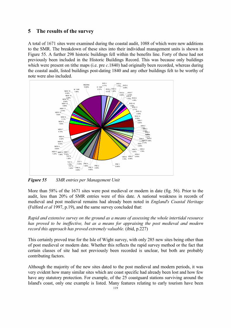
119
5 The results of the survey
A total of 1671 sites were examined during the coastal audit, 1088 of which were new additions
to the SMR. The breakdown of these sites into their individual management units is shown in
Figure 55. A further 298 historic buildings fell within the benefits line. Forty of these had not
previously been included in the Historic Buildings Record. This was because only buildings
which were present on tithe maps (i.e. pre c.1840) had originally been recorded, whereas during
the coastal audit, listed buildings post-dating 1840 and any other buildings felt to be worthy of
note were also included.
MEDINA
10.66% E. YAR
0.37%
RYD 1
2.71%
W. YAR
1.85%NEW 15
0.55%
FRE 1
13.80%FRE 2
2.09%FRE 3
0.92%
FRE 4
1.66%
TOT 1
0.55%
FRE 5
3.08%
NEW 8
1.60%
NEW 13
0.92%
NEW 12
0.86%
NEW 11
0.74%
NEW 14
2.59%
NEW 10
1.42%
NEW 9
1.11%
NEW 7
6.10%
NEW 6
2.22%
TOT 2
1.42%
NEW 5
0.43%
NEW 4
0.62%
TOT 3
1.79%
NEW 1
0.55%
TOT 4
1.36%
NEW 2
1.48%
NEW 3
1.23%
VEN 6
1.79%
VEN 5
0.49%
VEN 4
0.43%
VEN 3
1.97%
RYD 3
1.42%
RYD 4
1.79%
SAN 1
4.00%
SAN 2
1.73%SAN 3
0.49%SAN 4
0.37%
VEN 2
1.79%
VEN 1
0.99%
SAN 8
0.12%
SAN 7
1.11%
SAN 6
1.66%
RYD 12
2.59%
RYD 13
0.55%
SAN 5
0.37%
RYD 11
2.71%
RYD 10
1.29%
RYD 9
1.29%
RYD 2
0.31%
RYD 5
3.08%
RYD 8
1.23%
RYD 7
0.74%
RYD 6
0.99%
Figure 55 SMR entries per Management Unit
More than 58% of the 1671 sites were post medieval or modern in date (fig. 56). Prior to the
audit, less than 20% of SMR entries were of this date. A national weakness in records of
medieval and post medieval remains had already been noted in England's Coastal Heritage
(Fulford et al 1997, p.19), and the same survey concluded that:
Rapid and extensive survey on the ground as a means of assessing the whole intertidal resource
has proved to be ineffective, but as a means for appraising the post medieval and modern
record this approach has proved extremely valuable. (ibid, p.227)
This certainly proved true for the Isle of Wight survey, with only 285 new sites being other than
of post medieval or modern date. Whether this reflects the rapid survey method or the fact that
certain classes of site had not previously been recorded is unclear, but both are probably
contributing factors.
Although the majority of the new sites dated to the post medieval and modern periods, it was
very evident how many similar sites which are coast specific had already been lost and how few
have any statutory protection. For example, of the 25 coastguard stations surviving around the
Island's coast, only one example is listed. Many features relating to early tourism have been

120
destroyed or drastically altered, and military remains, particularly dating to the twentieth
century, have been neglected. However, a lack of statutory protection for archaeological sites of
all periods on the coast is also very apparent, with less than 6% of sites being scheduled or listed
(fig. 57).
SMR
0
100
200
300
400
500
600
700
800
900
1000
Prehistoric IA/Roman E. med/med P.
med/modern
? Multi
Post-audit
Pre-audit
Figure 56 SMR entries by period
EH Garden Register II*
0.06%
EH Garden Register II
0.06%UDP Garden
0.72%
LB II
3.00%
LB I
0.06%LB II*
0.42%SAM
0.96%
94.72%
Figure 57 SMR site protection status

121
The historic buildings on the coast enjoy somewhat better protection, with more than 50% being
listed (fig. 58).
LB II
53.02%
Not listed
46.31%
LB II*
0.67%
Figure 58 Historic buildings protection status
Many of the new additions to the SMR were identified through cartographic research.
Interrogation of aerial photographs was only of limited success. This was probably due to a
number of factors:
• Most photographs were taken during the summer months when intertidal weed growth is
at its greatest.
• The small scale of most available photographs meant that only large and obvious
features were visible.
• Natural features such as intertidal linear rock formations can be misleading.
Aerial photographs proved most useful when re-examined following familiarisation during
fieldwork. A series of photographs taken by the RAF in 1946 proved invaluable in locating
military installations such as anti-aircraft batteries, although again the prints were of a very
small scale.
122
6 Ranking of archaeological and geo-archaeological importance
It has previously been noted that there is often a reluctance on the part of archaeologists to
prioritise sites when providing information for the compilation of shoreline management plans,
‘with the argument that not enough is known about the total resource to enable priorities to be
established’ (Wessex Archaeology, 1999, p.52). Having completed the Isle of Wight coastal
audit, it is felt that the difficulty arises as much from not knowing enough about the individual
sites as not knowing enough about the total resource.
Due to the rapid nature of the audit, sites were only swiftly examined, photographed, and their
location recorded, so their true importance may not yet be known. Due to the restraints of time
and tides, areas could only be visited on one or two occasions, so it would be unrealistic to
expect to have gained a complete picture of the full extent of the archaeological evidence. This
has been learnt through experience on the Wootton-Quarr coast, where years of intensive survey
have revealed an enormous wealth of archaeological material, although original SMR records
for the area list just findspots of a small number of flint picks and a few Roman pottery sherds,
and initial site visits were not particularly promising. Much is also dependent on conditions at
the time of visit. Sites in the intertidal zone may be masked by mobile sediments, or during the
summer months, weed. Cliff faces may be too dangerous to examine closely during wet
weather, but when they dry out features may be difficult to see. The importance of repeated
visits to areas of high potential has already been emphasised (Fulford et al, 1997, p.227; Wessex
Archaeology, 1999, p.52).
A further problem is that many of the features which were identified during the audit cannot be
dated without recourse to radiocarbon dating or more detailed recording. This is particularly true
for palaeoenvironmental sites and features such as hearths which rarely contain dateable
artefactual evidence. Intertidal wooden structures including post alignments, fish weirs and
trackways are likewise difficult to date as their shape and form change little over hundreds or
even thousands of years. An examination of the woodworking techniques used to shape the
timbers may tell if they have been worked using a stone or metal axe, but timbers should not be
removed before they have been properly recorded and surveyed, and once they are removed,
storage and conservation become a problem.
From the outset, the audit was designed to cover the broadest spectrum of archaeological and
historic sites. As a result, sites identified during the project were as diverse as Palaeolithic flint
assemblages, post medieval hulks and WW2 military structures. The relative importance of
these is almost impossible to compare objectively. One way to attempt to be more objective is to
apply a range of MPP-type criteria to each site, but again this can only be successful when
comparing like with like, and when it is known what the sites represent.
The results of the coastal audit have highlighted the types of environment in which
archaeological features are likely to survive, and will help predict areas of potential for more
detailed recording. At the same time, however, the study has drawn attention to how few sites
have been adequately recorded and analysed, yet how vulnerable these are to destruction.
Indeed, it is highly likely that some of the sites noted during fieldwork no longer survive or have
been irrevocably damaged by coastal processes.
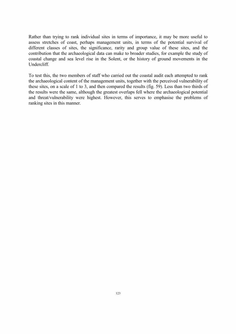
123
Rather than trying to rank individual sites in terms of importance, it may be more useful to
assess stretches of coast, perhaps management units, in terms of the potential survival of
different classes of sites, the significance, rarity and group value of these sites, and the
contribution that the archaeological data can make to broader studies, for example the study of
coastal change and sea level rise in the Solent, or the history of ground movements in the
Undercliff.
To test this, the two members of staff who carried out the coastal audit each attempted to rank
the archaeological content of the management units, together with the perceived vulnerability of
these sites, on a scale of 1 to 3, and then compared the results (fig. 59). Less than two thirds of
the results were the same, although the greatest overlaps fell where the archaeological potential
and threat/vulnerability were highest. However, this serves to emphasise the problems of
ranking sites in this manner.
124
RYD 1
RYD 2
RYD 3
RYD 4
RYD 5
RYD 6
RYD 7
RYD 8
RYD 9
RYD 10
RYD 11
RYD 12
RYD 13
SAN 1
SAN 2
SAN 3
SAN 4
SAN 5
SAN 6
SAN 7
SAN 8
VEN 1
VEN 2
VEN 3
VEN 4
VEN 5
VEN 6
FRE 1
FRE 2
FRE 3
FRE 4
FRE 5
TOT 1
TOT 2
TOT 3
TOT 4
NEW 1
NEW 2
NEW 3
NEW 4
NEW 5
NEW 6
NEW 7
NEW 8
NEW 9
NEW 10
NEW 11
NEW 12
NEW 13
NEW 14
NEW 15
W. YAR
MEDINA
E. YAR
Archaeological potential Threat/vulnerabilityLow High
Figure 59 Perceived archaeological potential and threat to management units

125
7 General management conclusions
Perhaps unsurprisingly, most of the historic buildings are found in management units where the
preferred option in the Shoreline Management Plan is some kind of active intervention, most
often ‘hold the existing defence line’. However more than 42% of archaeological sites recorded
on the open coast (i.e. excluding estuaries) fall in units where the management option is ‘do
nothing’ (fig. 60). Almost a quarter of SMR entries are from the intertidal zone and a further
14% of sites have been seen in the cliff faces. It is probably true that sites in these zones will be
under-represented in the SMR because of their inaccessibility, the fact that they may be difficult
to see, and the comparative recency that the value of intertidal archaeology has been recognised.
Coastal protection schemes are unlikely to be economically viable in most of the areas in which
the archaeological resource is richest, and in addition, archaeologically significant areas often
fall within SSSIs or the Area of Outstanding Natural Beauty. Similar observations have been
made on the Northumberland coast, where it was concluded, ‘It is clear that natural processes
of erosion are the major cause of new exposures and damage to archaeology, and equally
clearly, it is impossible to control the action of nature in this context. Consequently, some
means of responding more or less instantly to news of such developments is essential to the
proper management and protection of the coastal resource.’ (Northumberland County Council,
1994, p.30).
In other cases, works designed to protect landward areas may have a detrimental effect on
archaeological and palaeoenvironmental sites in the intertidal zone and on the coast edge.
However, it is perhaps where sites with the highest archaeological potential coincide with the
management option ‘do nothing’ that the archaeological resource is most at risk, ‘insofar as
‘Hold’ and ‘Retreat’ imply active intervention with the possibility of including archaeological
work at the point of intervention’ (Wessex Archaeology, 1999, p.45). There is therefore a need
for an ongoing programme of monitoring in such areas.
The coastal audit has provided a snapshot of the range and condition of archaeological sites
which were present at the time of the survey. Most of these sites are not adequately recorded or 2
understood, but equally, more features are constantly being exposed or destroyed .
2 This point was emphasised several months after completion of the fieldwork, when a member of the public
reported seeing an urn containing a cremation exposed in the cliff face on the south west coast of the Island. This
area had been closely examined during the Coastal Audit. Subsequent investigations by the archaeological service
revealed a further two inverted urns of Bronze Age date which were safely retrieved.
One of the
conclusions made in Northumberland is equally applicable on the Island, where, following a
rapid coastal survey it was felt that what had been achieved was ‘no more than a preliminary
inspection of the archaeological resource and the problems affecting it. Regular programmes of
fieldwork require implementation if a full and accurate picture of the coast is to be generated...
This programme should be devised in such a way that it occurs repeatedly over a significant
period of time, and allows for observations to be made in different conditions, and at different
times of the year’' (Northumberland County Council, 1994, p.29).

126
SMR
Nothing/retreat
2.70%
Hold/advance
3.50%
Hold/retreat
0.55%
Nothing
36.67%
Hold
29.18%
Retreat
14.31%
Estuary
13.08%
Historic Buildings
Nothing
6.04%Estuary
7.05%
Hold/advance
24.50%
Retreat
9.73%
Hold
52.68%
Figure 60 Management options

127
During the coastal audit, a number of areas were highlighted as being particularly important
archaeologically, and most susceptible to coastal processes. These include (fig. 61 and table 1):
Springvale (Management Units RYD 5 and RYD 6). This area requires more detailed survey.
The intertidal stone features which seem to be restricted to this small area of coast on the Island
need to be recorded and associated timbers dated. The remains of a V-shaped stone fish weir
with circular pound at the apex may be particularly significant and hurdling which is
incorporated within the structure should be dated. Palaeoenvironmental evidence needs to be
assessed. The wrecks which are visible on Ryde East Sands need to be further examined.
Priory Bay (RYD 9). The Palaeolithic site at Priory Bay remains unassessed but is vulnerable to
erosion of the coastal slope.
Yaverland cliffs (SAN 2). This unit contains rich prehistoric and Roman sites at Redcliff which
should be monitored as material continues to erode from the cliffs. Hearths which have been
noted to the south of Redcliff require further recording and sampling. Military features on the
cliff edge should be recorded.
The Undercliff (Management Units VEN 1 - VEN 6). Middens and other features in the cliff
face and the coastal slope need to be recorded and evaluated together with earlier records and
palaeoenvironmental evidence. The archaeological evidence has an important role to play in the
study of the formation of the Undercliff.
The south west coast between Blackgang and Compton (Management Units FRE 1 and FRE 2).
These cliffs are actively eroding, revealing evidence of human occupation of all periods, and
important associated palaeoenvironmental evidence. These features, in particular hearths and
palaeoenvironmental sites need to be properly recorded and dated. Whilst it could be argued that
these features are not coast specific and that similar evidence survives away from the cliff edge,
the proximity of the areas of human activity to the chines and the course of the old Western Yar
suggests that the whole is a finite, interrelated resource which is rapidly being depleted. On the
southern part of the south west coast, the presence of archaeological and palaeoenvironmental
material within and underneath wind blown sand may provide an indication of the time scale of
cliff top dune formation on this stretch of coast.
Newtown East Spit (Management Unit NEW 7). The potential of this site was recognised
during the Wootton-Quarr survey, and many new features were identified during the brief visit
for the coastal audit. These new features need to be recorded and levelled, and further visits are
needed at extreme low water.
Hamstead Dover (Management Unit NEW 7). This western side of the mouth of the Newtown
Estuary has similar potential to the East Spit. Post alignments need to be surveyed and dated.
Trees need recording and assessing for dendrochronological dating. More detailed survey is
required at extreme low water.
Thorness Beach (Management Unit NEW 9). The intertidal zone of this area is potentially very
significant and needs more close investigation. Already, peats containing fallen trees have been
noted. Timber structures including post alignments and hurdles have been seen, flint

128
Figure 61 Archaeologically rich areas at risk from coastal processes

129
implements have been recovered and midden material of Roman and medieval date is eroding
from the intertidal silt. All of these features are important for charting the history of coastal
change in the Western Solent, whilst the fallen trees may also help extend the
dendrochronological dating sequence for the Isle of Wight.
River Medina. Hearths and palaeoenvironmental sites have been observed in the eroding river
banks. Whilst it is often assumed that these are prehistoric, there is a need to record and date a
selection of features to see whether they are broadly contemporary and to ensure that they are
not related to later industrial activities. Around twenty hulks are present in the intertidal muds of
the Medina. Some have already been lost to land reclamation and there is a need to record those
which survive, some of which, for example the “Bee”, represent important local vessel types.
Intertidal post alignments and structures, especially where they are concentrated, need further
examination.
Management Unit Management Option Threat Key Sites
RYD 5/RYD 6 Hold Intertidal erosion Stone fish weir; Hulks;
Stone features;
Palaeoenvironmental
sites
RYD 9 Retreat Cliff recession Palaeolithic assemblage
SAN 2 Do nothing Cliff recession Hearths; Prehistoric and
Roman occupation;
military sites
VEN 3 Retreat Cliff recession Palaeoenvironmental
sites; Middens
VEN 6 Do nothing Cliff recession Palaeoenvironmental
sites; Middens
FRE 1/2 Do nothing Cliff recession Hearths; findspots;
palaeoenvironmental
sites; funerary urns
NEW 7 Do nothing Intertidal erosion Intertidal trackways &
platforms;
palaeoenvironmental
sites; lithic scatters
NEW 9 Do nothing Intertidal erosion Intertidal timber
structures; PLUTO;
palaeoenvironmental sites
River Medina - Intertidal erosion;
development
Intertidal timber
structures; hulks;
palaeoenvironmental
sites; hearths
130
In addition, certain classes of sites or structures were noted as being inadequately recorded or
protected:
Hulks in general need more detailed survey. In many cases during the coastal audit, problems of
access through deep mud made it difficult to carry out even basic recording, but it is known that
some of the vessels are at least of local, if not greater, importance. Ideally, hulk recording
should be undertaken as a specific project by a team equipped with the necessary materials to
gain access safely, and clean and record the vessels.
Industrial features such as salterns, brickworks and evidence of shipbuilding warrant further
study. In particular, several sites were identified during the survey which may have been salterns
but which were not identified as such on the available maps and charts.
Military structures, especially those of WW2 date need to be properly identified and recorded.
Many are very vulnerable to coastal erosion. Recently, contact has been made with the Defence
of Britain Project local coordinator for the Isle of Wight. He is visiting military sites and
commenting on their function and survival.
3
Many coastguard cottages survive relatively unaltered but only one group is listed .
3
Since the completion of the Coastal Audit, a planning application to demolish the Coastguard Cottages at Alum
Bay and replace them with two semi-detached properties has been submitted.
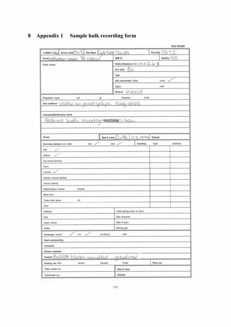
131
8 Appendix 1 Sample hulk recording form
132
9 Bibliography
Allen, M.J. 1993. The land-use history of the southern English chalklands with an evaluation of
the Beaker period using environmental data; colluvial deposits as environmental and
cultural indicators unpub. PhD thesis, University of Southampton.
Anon, 1998. The Western Yar Estuary Management Plan
Cantwell, A. 1985. Fort Victoria: a history IWCC
Dunning, G.C. 1931. `A late Bronze Age urnfield at Barnes, Isle of Wight, and notes on the late
Bronze Age in the Isle of Wight', Proc Isle Wight Nat Hist Archaeol Soc, 2, 108-117
Fulford, M. Champion, T. and Long, A. 1997. England's Coastal Heritage: a survey for English
Heritage and the RCHME, EH/RCHME
Halcow, Sir W. and Partners, 1997. Isle of Wight Coast, Shoreline Management Plan. Produced
for the Isle of Wight Council and the Environment Agency.
Milne, G. McKewan, C. and Goodburn, D. 1998. Nautical Archaeology on the Foreshore: Hulk
Recording on the Medway, RCHME
Northumberland County Council, 1994. A Strategy for Coastal Archaeology in
Northumberland,
Poole, H.F. 1936. `An outline of the Mesolithic flint cultures of the Isle of Wight', Proc Isle
Wight Nat Hist Archaeol Soc, 2, 551-581
Preece, R.C. 1986. Faunal remains from radio-carbon dated soils within landslip debris from the
Undercliff, Isle of Wight, Southern England, J Arch Science 13 189-200
Preece, R.C. and Scourse, J.D. 1987. `Pleistocene sea-level history in the Bembridge area of the
Isle of Wight', in Barber, K.E. (ed), Wessex and the Isle of Wight field guide, Quaternary
Research Association, 136-149
Sampson, F.R. 1976. Priory Bay: a study of an unstratified Palaeolithic site in the Isle of Wight,
unpubl. undergraduate dissertation, University of Southampton
Saunders, A. 1998. Fortifications of Portsmouth and the Solent: a review of pre-20th century
coastal defence sites and associated remains, English Heritage
Scaife, R.G. 1987. `The late-Devensian and Flandrian vegetation of the Isle of Wight', in
Barber, K.E. (ed), Wessex and the Isle of Wight field guide, Quaternary Research
Association, 156-180)
Sherwin, G.A. 1936-42. Archaeological Survey of the Isle of Wight, unpubl. manuscript
Tomalin, D.J. 1989. `An early Roman cliff-top salt-working site at Redcliff Battery, Sandown,
Isle of Wight', Proc Isle Wight Nat Hist Archaeol Soc, 9, 91-120
Tomalin, D.J. Loader, R.D. and Scaife, R.G. forthcoming. Coastal archaeology in a dynamic
environment: a Solent case study, draft report for English Heritage
Wade-Martins, P. (ed), 1987. Norfolk from the Air
Wessex Archaeology, 1999. Shoreline Management Plans and the Historic Environment: final
report of a strategic study for English Heritage, Wessex Archaeology

If you would like this document in a different format, please contact our Customer Services department: Telephone: 0870 333 1181 Fax: 01793 414926 Textphone: 01793 414878 E-mail: [email protected]