ir 624 - rehabilitation and closure ecological risk … · web view624internal report r bartolo, s...
TRANSCRIPT

624
internal
report
Rehabilitation and closure
ecological risk assessment
for Ranger Uranium Mine:
Documentation of initial
problem formulation
activities
R Bartolo, S Paulka, R van Dam,
S Iles & A Harford
October 2013
Release status – Public
Project number – RES-2012-012

This page has been left blank intentionally.
Rehabilitation and closure ecological risk assessment for Ranger Uranium Mine:
Documentation of initial problem formulation activities
R Bartolo, S Paulka, R van Dam, S Iles & A Harford
Supervising Scientist DivisionGPO Box 461, Darwin NT 0801
November 2013
Project number RES-2012-012
(Release status – Public)

How to cite this report:
R Bartolo, S Paulka, R van Dam, S Iles & A Harford 2013. Rehabilitation and closure ecological risk assessment for Ranger Uranium Mine: Documentation of initial problem formulation activities. Internal Report 624, November, Supervising Scientist, Darwin.
Project number – RES-2012-012
Authors of this report:Renee Bartolo– Environmental Research Institute of the Supervising Scientist, GPO Box 461, Darwin NT 0801, AustraliaRick van Dam – Environmental Research Institute of the Supervising Scientist, GPO Box 461, Darwin NT 0801, AustraliaAndrew Hartford – Environmental Research Institute of the Supervising Scientist, GPO Box 461, Darwin NT 0801, Australia
The Supervising Scientist is a division of the Australian Government Department of the Environment.Supervising ScientistDepartment of the Environment GPO Box 461, Darwin NT 0801 Australia© Copyright Commonwealth of Australia, 2014.
IR624 is licensed by the Commonwealth of Australia for use under a Creative Commons By Attribution 3.0 Australia licence with the exception of the Coat of Arms of the Commonwealth of Australia, the logo of the agency responsible for publishing the report, content supplied by third parties, and any images depicting people. For licence conditions see: http://creativecommons.org/licenses/by/3.0/au/ This report should be attributed as ‘Rehabilitation and closure ecological risk assessment for Ranger Uranium Mine’: Documentation of initial problem formulation activities Commonwealth of Australia 2014’.The Commonwealth of Australia has made all reasonable efforts to identify content supplied by third parties using the following format © Copyright, Energy Resources Australia Ltd (ERA).The views and opinions expressed in this publication are those of the authors and do not necessarily reflect those of the Australian Government or the Minister for the Environment. While reasonable efforts have been made to ensure that the contents of this publication are factually correct, the Commonwealth does not accept responsibility for the accuracy or completeness of the contents, and shall not be liable for any loss or damage that may be occasioned directly or indirectly through the use of, or reliance on, the contents of this publication.
Printed and bound in Darwin NT by Supervising Scientist Division

ContentsExecutive summary 1
1 Introduction 41.1 Project definition 41.2 Focus of this project 41.3 Project background 71.4 Project aims and objectives 81.5 Report outline 8
2 Approach 92.1 Conceptual models workshop 102.2 Review process post workshop to finalise assessment endpoints
and conceptual models 10
3 Causal conceptual models 153.1 Aquatic ecosystem 153.2 Terrestrial ecosystem 283.3 People: Cultural and Socio-economic 42
4 Summary 50
References 52
Appendix 1: Workshop Agenda for the Ranger Mine closure causal maps 2-day workshop (25-26 February 2013) 53
Appendix 2: Workshop Attendees 55
Appendix 3: Measuring Ecological processes for the Ranger Uranium Mine Ecological Risk Assessment – Draft discussion paper 56Assessment Endpoints 57Measurement Endpoints 57Measured v Derived data 58
References 61
iii

TablesTable 2.1 Original and reviewed assessment endpoints...............12Table 2.2 Standardised terminology for sources, pathways and
stressors....................................................................................14Table 3.1 Revisions and status of terminology in the model for
aquatic ecosystems endpoints...................................................16Table 3.2 Revisions and status of terminology in the model for
erosion characteristics of the rehabilitated landform meets agreed closure criteria..............................................................28
Table 3.3 Revisions and status of terminology in the model for wildlife on the rehabilitated site is on a trajectory towards meeting agreed closure criteria................................................31
Table 3.4 Revisions and status of terminology in the model for vegetation on the disturbed sites of the RPA is on a trajectory towards meeting agreed closure criteria..................................34
Table 3.5 Definition of source and stressor components of the models for 1) habitat diversity and ecosystem functions within the landscape of the Magela Creek sub-catchment and broader KNP is comparable to an agreed reference condition and 2) aesthetic values meet the expectations of the stakeholders in the ARR......................................................................................37
Table 3.6 Revisions and status of terminology in the model for spatial pattern of the landscape in the ARR is comparable to the habitat diversity and ecosystem functions previously documented for the ARR...........................................................38
Table 3.7 Revisions and status of terminology in the model for aesthetic values meet the expectations of the stakeholders in the ARR......................................................................................40
Table 3.8 Revisions and status of terminology for Sources in the cultural values models...............................................................44
Table 3.9 Revisions and status of terminology for Stressors in the cultural values models...............................................................45
Table 1 Examples of Ecological Processes modified from Department of the Environment, Water, Heritage and the Arts (2008)........................................................................................59
Table 2 Ecological components modified from Department of the Environment, Water, Heritage and the Arts (2008)..................60
iv
FiguresFigure 1.1 Spatial scales defined for the ecological risk
assessment..................................................................................9Figure 2.1 Overview of the approach for this project...................12Figure 3.1 Sub-model for the protection of off-site aquatic
ecosystems from metals and radionuclides...............................21Figure 3.2 Sub-model for the protection of off-site aquatic
ecosystems from solutes and nutrients.....................................22Figure 3.3 Sub-model for the protection of off-site aquatic
ecosystems from organic chemicals..........................................23Figure 3.4 Sub-model for the protection of off-site aquatic
ecosystems from suspended and bedload sediments................24Figure 3.5 Sub-model for the protection of off-site aquatic
ecosystems from invasive species.............................................25Figure 3.6 Sub-model for the protection of on-site aquatic
ecosystems from metals and radionuclides...............................26Figure 3.7 Sub-model for the protection of on-site aquatic
ecosystems from solutes and nutrients.....................................27Figure 3.8 Sub-model for the protection of on-site aquatic
ecosystems from organic chemicals..........................................28Figure 3.9 Sub-model for the protection of on-site aquatic
ecosystems from suspended and bedload sediments................29Figure 3.10 Sub-model for the protection of on-site aquatic
ecosystems from invasive species.............................................30Figure 3.11 Conceptual model for erosion characteristics of the
rehabilitated landform...............................................................33Figure 3.12 Conceptual model for wildlife on the rehabilitated
site.............................................................................................36Figure 3.13 Conceptual model for vegetation on the disturbed
sites of the RPA.........................................................................39Figure 3.14 Conceptual model for spatial pattern of the landscape
in the ARR..................................................................................42Figure 3.15 Conceptual model for aesthetic values meeting the
expectations of stakeholders in the ARR...................................44Figure 3.16 Conceptual model for cultural values developed
during the workshop.................................................................46Figure 3.17 Revised conceptual model for the assessment
endpoint, Landform is able to be accessed, and is readily traversable, by people...............................................................49
v

Figure 3.18 Revised conceptual model for the assessment endpoint, Presence of culturally important species at right time and abundance..........................................................................50
Figure 3.19 Revised conceptual model for the assessment endpoint, Landform, vegetation and water bodies on-site meets agreed cultural closure criteria.................................................51
Figure 3.20 Revised conceptual model for the assessment endpoint, Return of traditional practices (e.g. burning, harvesting).................................................................................52
vi

Executive summaryInitial conceptual models (causal maps) of potential stressors and their pathways have been developed as part of the problem formulation phase of the ecological risk assessment focused on closure and rehabilitation of Ranger Uranium Mine. The conceptual models were drafted during a two day workshop with stakeholders who formed breakout groups around four themes (aquatic ecosystems; terrestrial ecosystems (Ranger Project Area); terrestrial ecosystems (landscape); and people), and were subsequently reviewed by a small review group and finalised by the breakout groups. Components of the problem formulation that were undertaken include: Setting the spatial and temporal scales that are the focus of the
ecological risk assessment. There are three temporal phases: i) decommissioning; ii) stabilisation and monitoring; and iii) post-closure. The five spatial scales defined are: i) the Ranger mine site (disturbed footprint); ii) the Ranger Project Area (RPA); iii) Magela Creek catchment; iv) Kakadu National Park; and v) the Alligator Rivers Region (ARR).
Identify the key sources, stressors and ecological assets that will be examined for the decommissioning, stabilisation and monitoring, and the post-closure phases of Ranger uranium mine’s closure. The values are documented in Pollino et al. (2013).
Determine the ecological assessment endpoints. Numerous assessment endpoints were developed for the four themes.
For aquatic ecosystems three assessment endpoints were developed for both the on-site and off-site environment reflecting their different management goals:
1) Off-site water quality meets agreed closure criteria specified for water quality.
2) Habitat diversity of off-site aquatic ecosystems are comparable to the agreed reference condition.
3) Biodiversity (structure and function) of off-site/on-site aquatic ecosystems are comparable to the agreed reference condition.
4) On-site water quality is on a trajectory towards meeting agreed closure criteria specified for water quality on-site.
5) Habitat diversity of on-site aquatic ecosystems is on a trajectory towards meeting agreed closure criteria.
6) Biodiversity (structure and function) of on-site aquatic ecosystems are on a trajectory towards meeting agreed closure criteria.
1
The biodiversity assessment endpoints are proposed and not finalised as the ecological processes and functions that were identified during the workshop have not been drafted as conceptual models. The ecological processes and functions will be addressed in the near future by the Closure Criteria Working Group (CCWG). For terrestrial ecosystems (RPA) three assessment endpoints were developed:
7) Erosion characteristics of the rehabilitated landform meet agreed closure criteria.
8) Wildlife on the rehabilitated site is on a trajectory towards meeting agreed closure criteria.
9) Vegetation on the disturbed sites of the RPA is on a trajectory towards meeting agreed closure criteria.
For terrestrial ecosystems (landscape) two assessment endpoints were developed:
10)Habitat diversity and ecosystem function within the landscape of the Magela Creek sub-catchment and broader Kakadu National Park is comparable to an agreed reference condition.
11)Aesthetic values meet the expectations of the stakeholders in the ARR.
For people four assessment endpoints were developed:12)Landform is able to be accessed, and is readily traversable,
by people.13)Presence of culturally important species at right time and
abundance.14)Landform, vegetation and water bodies on-site meets
agreed cultural closure criteria.15)Return of traditional practices (e.g. burning, harvesting).
Develop conceptual models for the above-mentioned closure phases of the Ranger mine site:
The aquatic ecosystems breakout group drafted one large conceptual model that included all sources, stressors, pathways, measurement points and assessment endpoints during the workshop. This large model needed to be reduced into ten sub-models in order to define differences in the pathways to measurement endpoints for each of the stressors.
The terrestrial ecosystem (RPA) breakout group drafted four conceptual models during the workshop, with three being reviewed post workshop. The fourth model not revised to date, focused on ‘protection of human health’. The human health model will be dealt with separately in the future, combining it with the human health model drafted by the people group.
The terrestrial ecosystem (landscape) breakout group drafted three conceptual models during the workshop. These have been
2

revised to two conceptual models as the sources and stressors were similar between two of the models that were output from the workshop, and review of the assessment endpoints indicated that the models were quite similar.
The people breakout group drafted two conceptual models – one for cultural landscape and the other for human health. Currently, the group has focused on refining the cultural landscape model. The human health model will be dealt with separately in the future as discussed above. The original cultural landscape model, drafted during the workshop, has been split into four separate conceptual models, to reflect the revised assessment endpoints.
Communicate and document the outcomes from the problem formulation phase:
A report was produced by Pollino et al. (2013) which details background material, and the values and draft conceptual models produced during the workshop. These are not reported in detail here.
Revision of the conceptual models presented here and communication is ongoing.Part of the problem formulation phase project included the development of an analysis plan (design, data needs, and methods for undertaking the risk analysis phase of the assessment), which was undertaken and reported by Pollino et al. (2013). It is recommended that the AS/NZS ISO 31000:2009 generic framework for risk management be adopted as it is considered best practice. The US EPA ecological risk assessment guidelines (US EPA 1998) can be used in conjunction with the ISO risk management standard. Pollino et al. (2013) recognise there are many approaches for undertaking risk analysis, but they focused on Bayesian networks, a recommended approach in the ISO/IEC 31010 Standard which supports the risk management standard (it is focused on risk analysis techniques). Bayesian networks have also been identified as a potential tool by Energy Resources Australia (ERA).
3
1 Introduction1.1 Project definitionEnergy Resources of Australia (ERA) and the Supervising Scientist Division (SSD) are collaborating on an ecological risk assessment for the rehabilitation and closure of Ranger uranium mine. The risk assessment will be conducted in three phases. The three phases of the assessment are: (1) Problem formulation, (2) Risk analysis, and (3) Interpretation of results.This project focuses on the problem formulation phase. The problem formulation, particularly the conceptual models, for the rehabilitation/closure risk assessments will inform the development of closure criteria and measures for monitoring the criteria.Two experienced external facilitators, Carmel Pollino and Susan Cuddy, from CSIRO, guided and assisted in the problem formulation.Outcomes of the project are: Stakeholder workshop facilitated by an external ecological risk
assessment expert. Identification and agreement on key sources, stressors and
ecological assets and ecological assessment endpoints to be examined for the three phases of Ranger’s closure.
Development of conceptual models (causal maps). An analysis plan (design, data needs, and methods for
undertaking the risk analysis phase of the assessment). Traditional Ecological Knowledge (TEK) is addressed and
incorporated throughout the problem formulation.
1.2 Focus of this projectThere are specific temporal and spatial scales that are the focus of the ecological risk assessment.The rehabilitation and closure of Ranger uranium mine will proceed in three temporal phases: Decommissioning – has commenced with the backfilling of Pit 3
and the decommissioning of the site will continue through to 2026.
Stabilisation and monitoring – is the period post-decommissioning occurring over a decadal time frame. The site will be moving towards an ecosystem that could be considered for incorporation into the surrounding Kakadu National Park.
Post-closure - is the period where monitoring has demonstrated that the closure criteria have been achieved, ERA have been
4

issues a close-out certificate and released from their responsibility for the site, and the site has been returned to the traditional owners. In the short-term, from the perspective of traditional owners, this time frame is from issue of the close-out certificate to 7 generations (approximately 300 years). In the long-term this phase is ongoing to 10,000 years after the close-out certificate has been issued; specifically this time frame applies to the requirement for tailings containment.
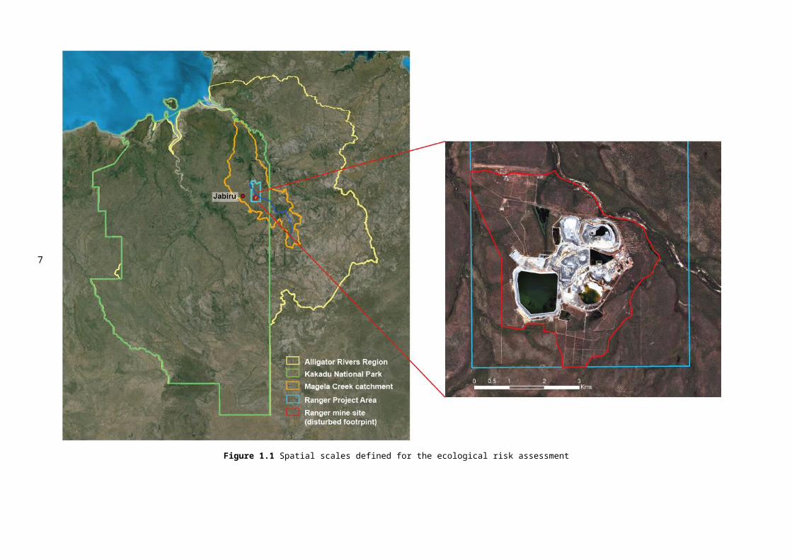
There are five spatial scales defined for this ecological risk assessment as shown by Figure 1.1: the Ranger Mine site (disturbed footprint); the Ranger Project Area; Magela Creek catchment; Kakadu National Park; and the Alligator Rivers Region.
5

Figure 1.1 Spatial scales defined for the ecological risk assessment
6
1.3 Project backgroundERA is required to close Ranger uranium mine by January 2026. ERA is conducting a major science and engineering study to develop a closure strategy. ERA and SSD have been conducting environmental studies for many years to ensure environmental protection during operations and rehabilitation and after closure. The study needs are identified by the Alligator Rivers Region Technical Committee (ARRTC) and are known as Key Knowledge Needs (KKNs).Two of the ARRTC KKNs relate to Ecological Risk Assessments of Ranger’s rehabilitation and closure. One relates to three phases (decommissioning, stabilization, long term post-closure) of rehabilitation and closure of the site itself (KKN 2.7.1; Box 1). The other relates to landscape scale risks of the closed site in the context of other relevant regional landscape process and threats (KKN 5.1.1; Box 2).
7
Box 1KKN 2.7.1 Ecological risk assessments of the rehabilitation and post rehabilitation phasesIn order to place potentially adverse on-site and off-site issues at Ranger during the rehabilitation phase within a risk management context, it is critical that a robust risk assessment framework be developed with stakeholders. The greatest risk is likely to occur in the transition to the rehabilitation phase, when active operational environmental management systems are being progressively replaced by passive management systems. A conceptual model of transport/exposure pathways should be developed for rehabilitation and post rehabilitation regimes and the model should recognise the potential that some environmental stressors from the mine site could affect the park and vice versa. Implicit in this process should be consideration of the effects of extreme events and climate change.Conceptual modelling should be followed by a screening process to identify and prioritise key risks for further qualitative and/or quantitative assessments. The conceptual model should be linked to closure criteria and post-rehabilitation monitoring programs, and be continually tested and improved. Where appropriate, risk assessments should be incorporated into decision making processes for the closure plan. Outputs and all uncertainties from this risk assessment process should be effectively communicated to stakeholders.

Another driver for undertaking the risk assessment is updating the KKNs themselves. The KKNs for rehabilitation are based on the understanding of environmental risks and issues developed over several decades of studying the mine and surrounding environment. ARRTC wishes to base the next review of the KKNs on conceptual models and associated risks identified through a formal risk assessment process.
1.4 Project aims and objectivesThe overall aim of this project was to complete the Problem Formulation phase (i.e., develop the conceptual models and framework) for the Ranger rehabilitation and closure ecological risk assessments (minesite and landscape scale) in advance of the risk analysis stage. Embedded in this was the need to include Traditional Ecological Knowledge through all phases of the project.To achieve this aim, specific project tasks were identified: Determine the ecological assessment endpoints. Identify the key sources, stressors and ecological assets that will
be examined for the decommissioning, stabilisation and monitoring, and the post-closure phases of Ranger uranium mine’s closure.
Develop conceptual models for the above-mentioned closure phases of the Ranger mine site.
8
Box 2KKN 5.1.1 Develop a landscape-scale ecological risk assessment framework for the Magela catchment that incorporates, and places into context, uranium mining activities and relevant regional landscape processes and threats, and that builds on previous work for the Magela floodplain
Ecological risks associated with uranium mining activities in the ARR, such as current operations (Ranger) and rehabilitation (Nabarlek, Jabiluka, future Ranger, South Alligator Valley), should be assessed within a landscape analysis framework to provide context in relation to more diffuse threats associated with large-scale ecological disturbances, such as invasive species, unmanaged fire, cyclones and climate change. Most key landscape processes occur at regional scales, however the focus will be on the Magela catchment encompassing the RPA. A conceptual model should first be developed to capture links and interactions between multiple risks and assets at multiple scales within the Magela catchment, with risks associated with Ranger mining activities made explicit. The spatially explicit Relative Risk Model will be used to prioritise multiple risks for further qualitative and/or quantitative assessments. The conceptual model and risk assessment framework should be continually tested and improved as part of Best Practice. Where appropriate, risk assessments should be incorporated into decision making processes using advanced risk assessment frameworks such as Bayesian Networks, and all uncertainties made explicit. This risk assessment process should integrate outputs from KKN 1.2.1 (risks from the surface water pathway – Ranger current operations) and the new KKN 2.6.1 (risks associated with rehabilitation) to provide a landscape-scale context for the rehabilitation of Ranger into Kakadu National Park, and should be communicated to stakeholders.
Communicate and document the outcomes from the problem formulation phase.
Development of an analysis plan (design, data needs, and methods for undertaking the risk analysis phase of the assessment).
1.5 Report outlineThis report is divided into four sections. Detailed background material is not presented in this report as this has been provided previously (Iles 2012, Bartolo et al. 2013, Pollino et al. 2013). Section 2 outlines the approach taken to develop the conceptual models. Section 3 presents the casual models and definitions of some terms used in the models. Section 4 provides a summary and recommendation for Phase 2 of the ecological risk assessment, the risk analysis phase.
9
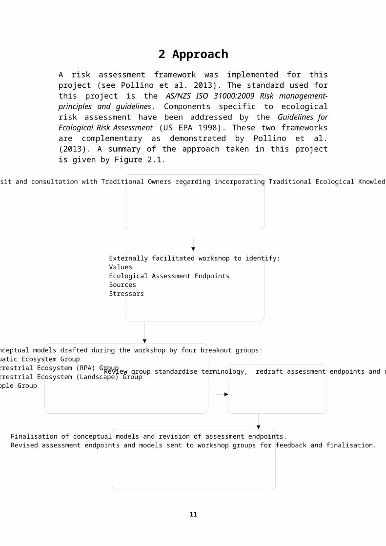
Externally facilitated workshop to identify:ValuesEcological Assessment EndpointsSourcesStressors
External facilitator mine site visit and consultation with Traditional Owners regarding incorporating Traditional Ecological Knowledge in the risk assessment process.
Conceptual models drafted during the workshop by four breakout groups:Aquatic Ecosystem GroupTerrestrial Ecosystem (RPA) GroupTerrestrial Ecosystem (Landscape) GroupPeople Group
Finalisation of conceptual models and revision of assessment endpoints.Revised assessment endpoints and models sent to workshop groups for feedback and finalisation.
Review group standardise terminology, redraft assessment endpoints and conceptual models
2 ApproachA risk assessment framework was implemented for this project (see Pollino et al. 2013). The standard used for this project is the AS/NZS ISO 31000:2009 Risk management-principles and guidelines. Components specific to ecological risk assessment have been addressed by the Guidelines for Ecological Risk Assessment (US EPA 1998). These two frameworks are complementary as demonstrated by Pollino et al. (2013). A summary of the approach taken in this project is given by Figure 2.1.
Figure 2.1 Overview of the approach for this project
10
2.1 Conceptual models workshopIn order to develop conceptual models for minesite rehabilitation and closure, a 2 day workshop with relevant stakeholders was externally facilitated by Carmel Pollino and Susan Cuddy from the CSIRO. Appendices 1 and 2 contain the workshop agenda and participants list. Prior to the workshop, the external facilitators met with Traditional Owners to ensure their concerns and views were included, and to capture information relevant to the incorporation of Traditional Ecological Knowledge (TEK) into the assessment framework.Over the two day workshop the participants undertook exercises in context setting (spatial and temporal), determining values and drafting of conceptual models. Values and conceptual models were drafted in four key themes by breakout groups as follows: Aquatic Ecosystem Terrestrial Ecosystem (RPA scale) Terrestrial Ecosystem (Landscape scale) People
2.2 Review process post workshop to finalise assessment endpoints and conceptual modelsThe workshop provided no time for any refinement of the models or the development of consistency between models produced from each focus group.After the workshop a smaller working group (ERA and SSD) was formed to progress and review each of the conceptual models. The aim of this review was to provide: Consistency in terminology and structure Review of the wording used to describe assessment endpoints,
so that the assessment endpoints are measurable or can be related directly to a measurement endpoint.
Consistency in models Removal of duplication Simplification where possible.The review group identified that the workshop participants had identified numerous assessment endpoints that were closer to what are referred to as “management goals” by the US EPA (1998) and other key ecological risk assessment references (Suter II 1990, 1996, 2007). It was evident that clearer guidance on this issue should have been provided before or at the workshop.
11
Management goals – are statements about the desired condition of ecological values of concern. Management goals driving a specific risk assessment may come from the law, interpretations of the law by regulators, desired outcomes voiced by community leaders and the public, and interests expressed by affected parties. Assessment endpoints – are explicit expressions of the actual environmental value that is to be protected, operationally defined by an ecological entity and its attributes. Their ability to support risk management decisions depends on whether they are measurable ecosystem characteristics that adequately represent management goals.Defining assessment endpoints is a two-step process:1. Identification of the specific valued ecological entity. This can be
species (e.g. magpie geese), a community (e.g. benthic invertebrates), an ecosystem (e.g. billabong), a specified habitat (e.g. riparian forest), a unique place, or other entity of concern (e.g. scared site).
2. Identification of the characteristic about the entity of concern that is important to protect and potentially at risk. For example define what is important for magpie geese (e.g. nesting conditions), or a billabong (e.g. abundance of macrophytes).
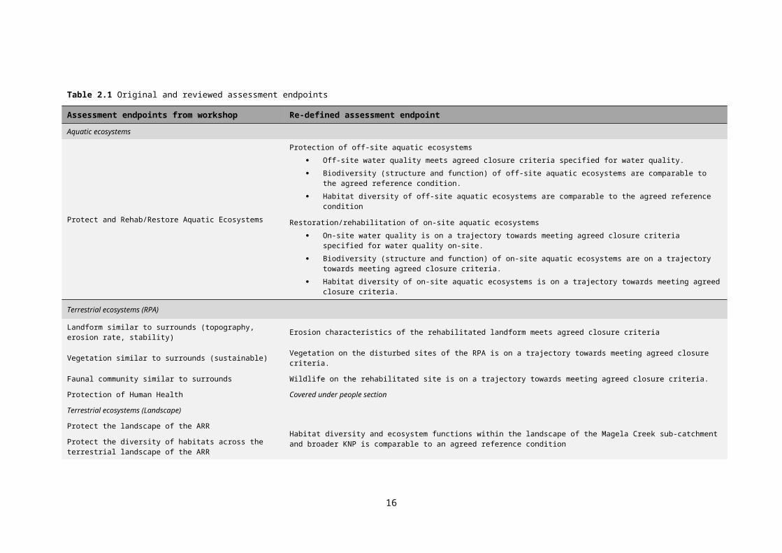
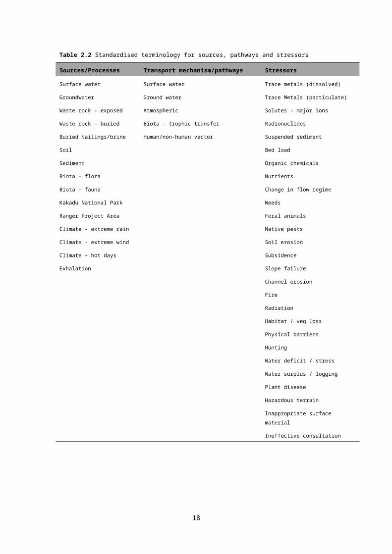
The difference between assessment endpoints and management goals is that the former are neutral and specific, and as such they do not represent a desired achievement (goal). Assessment endpoints do not contain words like ‘protect’, ‘maintain’ or ‘restore’, or indicate directional change such as ‘loss’ or ‘increase’.Based on the information and guidance contained in the previously mentioned references, the assessment endpoints were redefined. Table 2.1 provides the original and revised assessment endpoints. It should be noted that several of the assessment endpoints refer to the closure criteria or trajectories towards closure criteria. While this does not meet the exact definition of an assessment endpoint, it was decided that the specific details of which parameter should be used in the endpoints, and their threshold values, will be set by the Closure Criteria Working Group (CCWG). When these are finalised then the assessment endpoints can be adjusted to be more specific. In addition to the review of assessment endpoints, a review of terminology was conducted. It was noticed that the focus groups used different terminology to describe common sources, stressors and pathways used in the conceptual models. The review group has developed a set of standard terminology (see Table 2.2). This is not an exhaustive list and can be added to or changed if required.A revised set of conceptual models, along with a summary paper detailing (i) how each model was modified to incorporate the new
12
assessment endpoints and (ii) the changes to consistent terminology, were provided to each of the four focus groups. Focus group members were asked to review the models with the following objectives: The values identified are represented in the models. Review of the updated assessment endpoints (specifically, do
they meet the definition of an assessment endpoint as provided). Identify any components that have been omitted from the
workshop or review. Review the linkages between sources, stressors and pathways
are correct.Details of each of the conceptual models developed, and changes made as part of the review process, are provided in the subsequent sections.
13

Table 2.1 Original and reviewed assessment endpoints
Assessment endpoints from workshop Re-defined assessment endpoint
Aquatic ecosystems
Protect and Rehab/Restore Aquatic Ecosystems
Protection of off-site aquatic ecosystems
Off-site water quality meets agreed closure criteria specified for water quality.
Biodiversity (structure and function) of off-site aquatic ecosystems are comparable to the agreed reference condition.
Habitat diversity of off-site aquatic ecosystems are comparable to the agreed reference condition
Restoration/rehabilitation of on-site aquatic ecosystems
On-site water quality is on a trajectory towards meeting agreed closure criteria specified for water quality on-site.
Biodiversity (structure and function) of on-site aquatic ecosystems are on a trajectory towards meeting agreed closure criteria.
Habitat diversity of on-site aquatic ecosystems is on a trajectory towards meeting agreed closure criteria.
Terrestrial ecosystems (RPA)
Landform similar to surrounds (topography, erosion rate, stability) Erosion characteristics of the rehabilitated landform meets agreed closure criteria
Vegetation similar to surrounds (sustainable) Vegetation on the disturbed sites of the RPA is on a trajectory towards meeting agreed closure criteria.
Faunal community similar to surrounds Wildlife on the rehabilitated site is on a trajectory towards meeting agreed closure criteria.
Protection of Human Health Covered under people section
Terrestrial ecosystems (Landscape)
Protect the landscape of the ARRHabitat diversity and ecosystem functions within the landscape of the Magela Creek sub-catchment and broader KNP is comparable to an agreed reference conditionProtect the diversity of habitats across the terrestrial landscape
of the ARR
Protect the aesthetic values of the ARRAesthetic values meet the expectations of the stakeholders in the ARR
People
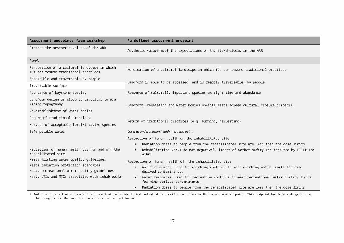
Re-creation of a cultural landscape in which TOs can resume traditional practices Re-creation of a cultural landscape in which TOs can resume traditional practices
14
Assessment endpoints from workshop Re-defined assessment endpoint
Accessible and traversable by peopleLandform is able to be accessed, and is readily traversable, by people
Traversable surface
Abundance of keystone species Presence of culturally important species at right time and abundance
Landform design as close as practical to pre-mining topographyLandform, vegetation and water bodies on-site meets agreed cultural closure criteria.
Re-establishment of water bodies
Return of traditional practicesReturn of traditional practices (e.g. burning, harvesting)
Harvest of acceptable feral/invasive species
Safe potable water Covered under human health (next end point)
Protection of human health both on and off the rehabilitated site
Meets drinking water quality guidelines
Meets radiation protection standards
Meets recreational water quality guidelines
Meets LTIs and MTCs associated with rehab works
Protection of human health on the rehabilitated site
Radiation doses to people from the rehabilitated site are less than the dose limits
Rehabilitation works do not negatively impact of worker safety (as measured by LTIFR and AIFR)
Protection of human health off the rehabilitated site
Water resources1 used for drinking continue to meet drinking water limits for mine derived contaminants.
Water resources1 used for recreation continue to meet recreational water quality limits for mine derived contaminants.
Radiation doses to people from the rehabilitated site are less than the dose limits
1 Water resources that are considered important to be identified and added as specific locations to this assessment endpoint. This endpoint has been made generic as this stage since the important resources are not yet known.
15

Table 2.2 Standardised terminology for sources, pathways and stressors
Sources/Processes Transport mechanism/pathways Stressors
Surface water Surface water Trace metals (dissolved)
Groundwater Ground water Trace Metals (particulate)
Waste rock - exposed Atmospheric Solutes - major ions
Waste rock - buried Biota - trophic transfer Radionuclides
Buried tailings/brine Human/non-human vector Suspended sediment
Soil Bed load
Sediment Organic chemicals
Biota - flora Nutrients
Biota - fauna Change in flow regime
Kakadu National Park Weeds
Ranger Project Area Feral animals
Climate - extreme rain Native pests
Climate - extreme wind Soil erosion
Climate – hot days Subsidence
Exhalation Slope failure
Channel erosion
Fire
Radiation
Habitat / veg loss
Physical barriers
Hunting
Water deficit / stress
Water surplus / logging
Plant disease
Hazardous terrain
Inappropriate surface material
Ineffective consultation
16

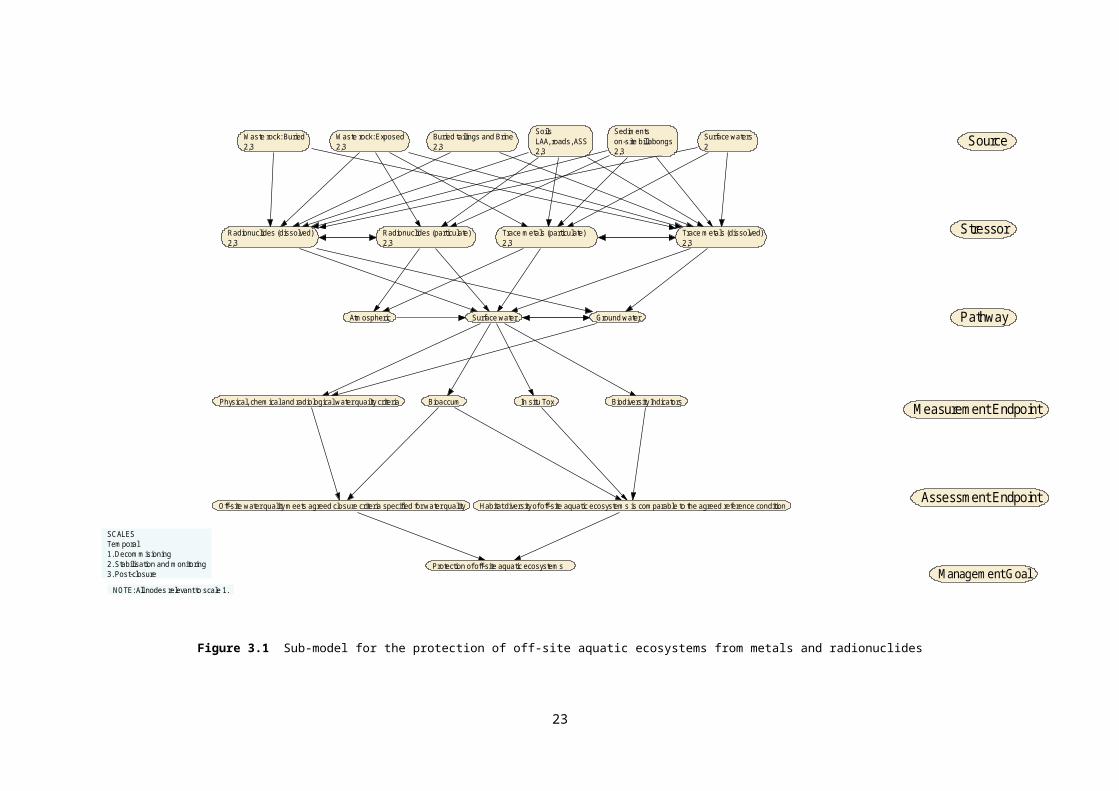
3 Causal conceptual models3.1 Aquatic ecosystemThe aquatic ecosystems breakout group drafted one large conceptual model that included all sources, stressors, pathways, measurement points and assessment endpoints during the workshop. The end point of this large model was identified as a management goal and needed to be broken down into six separate assessment endpoints. In addition it was not possible to include all sources and stressors for one endpoint in the one model as this created a problem for tracing of pathways and would subsequently create issues when the risk analysis phase commenced. The assessment endpoints for the off-site risks now include “Off-site water quality meets agreed closure criteria specified for water quality” and “Habitat diversity of off-site aquatic ecosystems are comparable to the agreed reference condition”. The on-site assessment endpoints include “On-site water quality is on a trajectory towards meeting agreed closure criteria specified for water quality on-site” and “Habitat diversity of on-site aquatic ecosystems is on a trajectory towards meeting agreed closure criteria”.At this stage, the initial values relating to ecological processes and ecological function that were identified during the workshop have not been progressed into conceptual models. A draft paper outlining how ecological processes may be addressed is included in Appendix 3. The assessment endpoints currently proposed are, “Biodiversity (structure and function) of off-site aquatic ecosystems are comparable to the agreed reference condition” and “Biodiversity (structure and function) of on-site aquatic ecosystems are on a trajectory towards meeting agreed closure criteria”. Feedback is being sought on these proposed assessment endpoints and a set of measurements endpoints needs to be defined. It is likely that these additional assessment and measurement endpoints could then be incorporated into the current sub-models.At the completion of the review 10 sub-models (Figures 3.1-3.10) had been produced that were based on stressors that have common pathways and measurement endpoints for four of the six assessment endpoints. Terminology has been standardised according to a list of terms produced by a review group. For example, the source ‘contaminated soil’ is now referred to as ‘soil’. Table 3.1 outlines the changes in terminology used in the revised model for the assessment endpoints. Unless specified in Table 3.1, the terms have remained the same between the workshop output and the revision of the models. Also listed in Table 3.1 are 3 sources and 1 stressor that were not included in any of the sub-models. The three sources
17
did not neatly fit into the sub-models because they could be seen as mechanisms that activate sources. Transport pathways were moved from between sources and stressor to between stressors and measurement endpoints.In reviewing the conceptual models, it was clear that ecological processes were not clearly defined and that there is clarity required on this. A small focus group from the Aquatic Ecosystems breakout group have drafted a paper discussing ecological processes and how these can be measured (Appendix 3). This aspect of the conceptual models will be further addressed through the CCWG.
Table 3.1 Revisions and status of terminology in the model for aquatic ecosystems endpoints
Terminology from Workshop Standardised terminology
Status in revised models
Source
Vehicle-People Kakadu National Park The source has also been changed to
Kakadu National Park to acknowledge
stressor being carried from off-site
Contaminated soils Soils Changed to soils as this encompasses both
contaminated and uncontaminated soils
Contaminated sediments Sediments Changed to sediments as this
encompasses both contaminated and
uncontaminated sediments
Untreated mine waters Surface waters Changed to surface waters as this
encompasses all contaminated and
uncontaminated waters on-site
Treated mine waters Surface waters Changed to surface waters as this
encompasses all contaminated and
uncontaminated waters on-site
Industrial areas fuel stores Plant and Mill areas Changed to be more descriptive
Extreme Climate Events Not included in any sub-
model
This source was not used in any of the sub-
models. It is likely to be a mechanism that
triggers other sources
Physical disturbance Not included in any sub-
model
This source was not used in any of the sub-
models. It is likely to be a mechanism that
triggers other sources
18
Terminology from Workshop Standardised terminology
Status in revised models
Meandering creek Not included in any sub-
model
This source was not used in any of the sub-
models. It is likely to be a mechanism that
triggers other sources
Stressors
Sediments SPM Suspended sediments Changed for consistent terminology
Inorganics_metals Trace metals (dissolved)
Trace metals (particulate)
Changed for consistent terminology. As
split into dissolved and particulate fractions.
Inorganics_solutes Solutes – major ions Changed for consistent terminology
Invasive species Weeds
Feral animals
Split into two stressor as each will have
specific assessment endpoints
High/Low flow Not included in any
submodel
This stressor did not fit well in any of the
sub-models
Transport pathways
Biota_transfer
Vehicles_people
Human/Non human vector Changed to include both pathways in one.
19
Source
Stressor
Waste rock: Buried2,3
Waste rock: Exposed2,3
Buried tailings and Brine2,3
SoilsLAA, roads, ASS2,3
Sedimentson-site billabongs2,3
Surface waters2
Assessment Endpoint
Measurement EndpointBiodiversity Indicators
PathwayAtmospheric Surface water Ground water
Habitat diversity of off-site aquatic ecosystems is comparable to the agreed reference condition
Management Goal
Trace metals (dissolved) 2,3
Trace metals (particulate) 2,3
Radionuclides (particulate)2,3
Radionuclides (dissolved)2,3
Bioaccum In situ ToxPhysical, chemical and radiological water quailty criteria
Off-site water quality meets agreed closure criteria specified for water quality
NOTE: All nodes relevant to scale 1.
SCALESTemporal1. Decommisioning2. Stabilisation and monitoring3. Post-closure
Protection of off-site aquatic ecosystems
Figure 3.1 Sub-model for the protection of off-site aquatic ecosystems from metals and radionuclides
20
Waste rock: Buried2,3
Waste rock: Exposed2,3
Buried tailings and Brine2,3
SoilsLAA, roads, ASS2,3
Sedimentson-site billabongs2,3
Surface Waters2 Source
Ground water Surface water
Solutes: Major ions2,3
Nutrients2
Protection of off-site aquatic ecosystems
Habitat diversity of off-site aquatic habitats are comparable to the agreed reference condition
Physical, chemical and radiological water quality criteria
Stressor
Pathway
Measurement Endpoint
Assessment Endpoint
Management Goal
In s itu Tox Biodiversity Indicators
Off-site water quality meets agreed closure criteria specified for water quality
SCALESTemporal1. Decommisioning2. Stabilisation and monitoring3. Post-closureNOTE: All nodes relevant to scale 1.
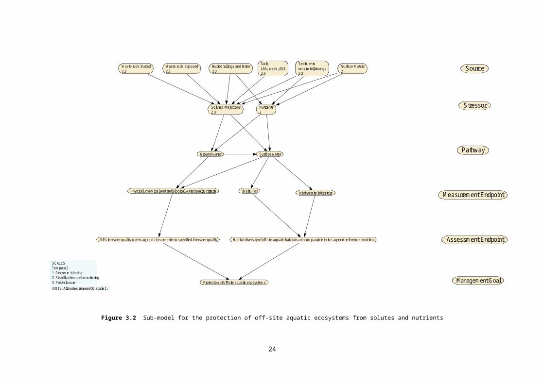
Figure 3.2 Sub-model for the protection of off-site aquatic ecosystems from solutes and nutrients
21
SoilsLAA, roads, ASS2,3
Sedimentson-site billabongs2,3
Mine waters: untreated2
Plant and Mill area2,3
Physical, chemical and radiological water quality criteria
Habitat diversity of off-site aquatic habitats are comparable to the agreed reference condition
Protection of off-site aquatic ecosystems
Off-site water quality meets agreed closure criteria specified for water quality
Ground waterSurface waterAtmosphere
Organic Chemicals2,3
Waste rock: Exposed2,3
Fire2,3
Buried tailings and Brine2,3
Bioaccum In situ Tox Biodiversity Indicators
Source
Stressor
Pathway
Measurement Endpoints
Assessment Endpoint
Management Goal
SCALESTemporal1. Decommisioning2. Stabilisation and monitoring3. Post-closureNOTE: All nodes relevant to scale 1.
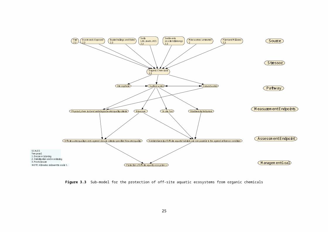
Figure 3.3 Sub-model for the protection of off-site aquatic ecosystems from organic chemicals
22
SoilsLAA, roads, ASS2,3
Suspended Sediment2
Beadload2
Surface water Surface water
Physical, chemical and radiological water quality criteria Channel Morphology
Habitat diversity of off-site aquatic ecosystems are comparable to the agreed reference conditionOff-site water quality meets agreed closure criteria specified for water quality
Protection of off-site aquatic ecosystems
Sedimentson-site billabongs2,3
Waste rock: Exposed2,3
Kakadu National Park2,3
Biodiversity indicatorsIn situ tox
NOTE: All nodes relevant to scale 1.
Source
Stressor
Pathway
Measurement Endpoint
Assessment Endpoint
Management Goal
SCALESTemporal1. Decommisioning2. Stability and monitoring3. Post-closure
Figure 3.4 Sub-model for the protection of off-site aquatic ecosystems from suspended and bedload sediments
23
Waste rock: Exposed2,3
SoilsLAA, roads, ASS2,3
Sedimentson-site billabongs2,3
Biota Fauna2,3
Biota Flora2,3
Weeds2, 3
Feral Animals2,3
Native pests2
Disease2,3
Kakadu National Park2,3
Stressor
Source
Assessment endpoint
Measurement Enpoint
Pathway
Management Goal
Habitat diversity of off-site aquatic ecosystems are comparable to the agreed reference condition
Biodiversity indicators
Protection of off-site aquatic ecosystems
Human/Non Human vectorSurface waterAtmosphere
NOTE: All nodes relevant to scale 1.
SCALESTemporal1. Decommisioning2. Stabilisation and monitoring3. Post-closure
Figure 3.5 Sub-model for the protection of off-site aquatic ecosystems from invasive species
24
Source
Stressor
Waste rock: Buried2,3
Waste rock: Exposed2,3
Buried tailings and Brine2,3
SoilsLAA, roads, ASS2,3
Sedimentson-site billabongs2,3
Surface waters2
Assessment Endpoint
Measurement EndpointBiodiversity Indicators
PathwayAtmospheric SurfaceWater Groundwater
Management GoalRestoration/rehabilitation of on-site aquatic ecosystems
Trace metals (dissolved) 2,3
Trace metals (particulate) 2,3
Radionuclides (particulate)2,3
Radionuclides (dissolved)2,3
Physical, chemical and radiological water quality criteria Bioaccum In situ Tox
Habitat diversity of on-site aquatic ecosystems is on a trajectory towards meeting agreed closure criteria
SCALESTemporal1. Decommisioning2. Stabilisation and monitoring3. Post-closure
NOTE: All nodes relevant to scale 1.
On-site water quality is on a trajectory towards meeting agreed closure criteria specified for water quality on-site
Figure 3.6 Sub-model for the protection of on-site aquatic ecosystems from metals and radionuclides
25
Waste rock: Buried2,3
Waste rock: Exposed2,3
Buried tailings and Brine2,3
SoilsLAA, roads, ASS2,3
Sedimentson-site billabongs2,3
Surface Waters2 Source
Ground water Surface water
Solutes: Major ions2,3
Nutrients2
Restoration/rehabilitation of on-site aquatic ecosystems
Stressor
Pathway
Measurement Endpoint
Assessment Endpoint
Management Goal
Biodiversity Indicators
On-site water quality is trending towards agreed closure criteria specified for water quality on-site Habitat diversity of on-site aquatic ecosystems is trending towards agreed closure criteria
Physical, chemical and radiological water quality criteria In s itu Tox
NOTE: All nodes relevant to scale 1.
SCALESTemporal1. Decommisioning2. Stabilisation and monitoring3. Post-closure
Figure 3.7 Sub-model for the protection of on-site aquatic ecosystems from solutes and nutrients
26
NOTE: All nodes relevant to scale 1.
SourceWaste rock: Exposed2,3
Buried tailings and Brine2,3
SoilsLAA, roads, ASS2,3
Sedimentson-site billabongs2,3
Mine waters:untreated2
Plant and Mill area2,3
Organic Chemicals2,3
Physical, chemical and radiological water quality criteria
Stressor
Pathway
Measurement Endpoint
Assessment Endpoint
Management GoalRestoration/rehabilitation of on-site aquatic ecosystems
Bioaccum Biodiversity Indicators
Atmosphere
In situ Tox
Habitat divers ity of on-s ite aquatic ecosystems is on a trajectory towards meeting agreed closure criteria
Surface water Ground water
Fire2,3
On-site water quality is on a trajectory towards meeting agreed closure criteria specified for water quality on-site
SCALESTemporal1. Decommisioning2. Stabilisation and monitoring3. Post-closure
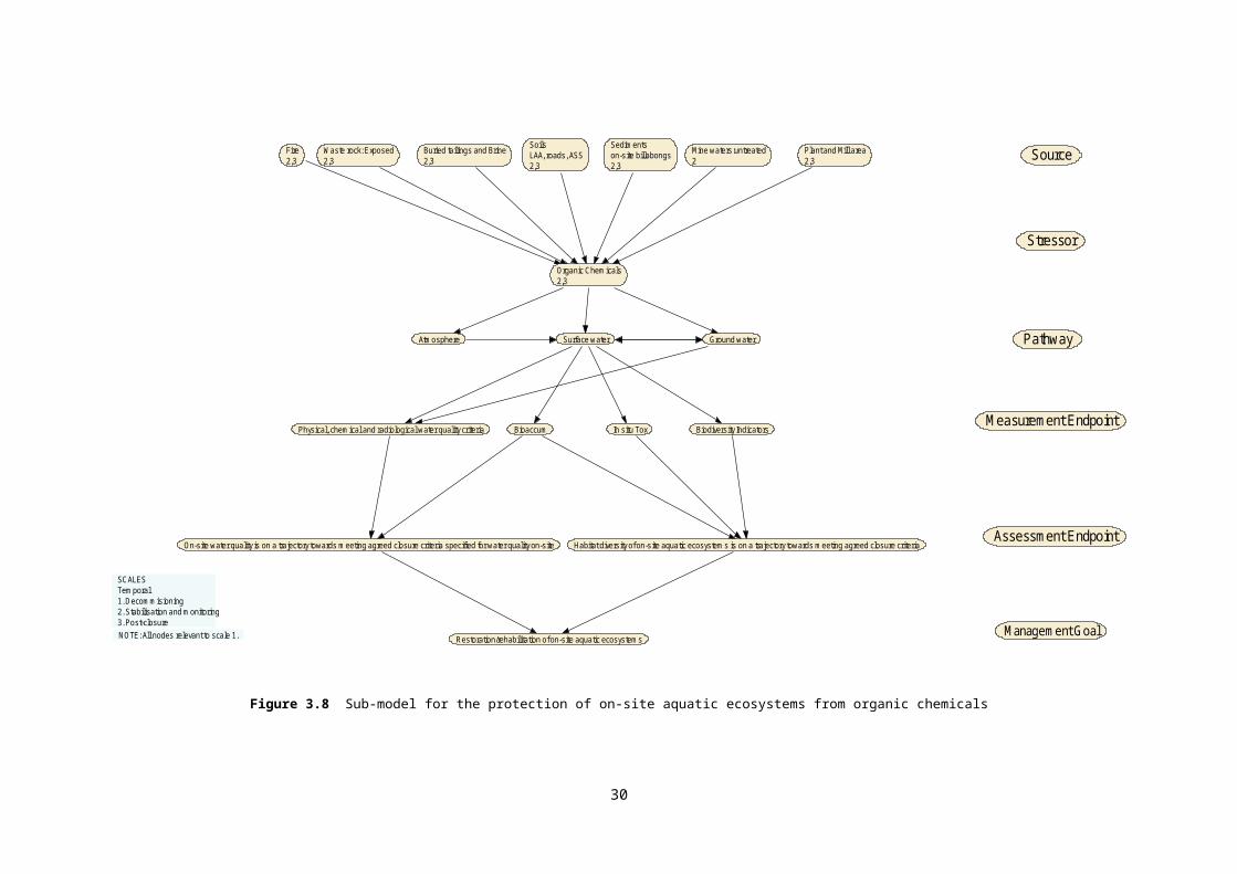
Figure 3.8 Sub-model for the protection of on-site aquatic ecosystems from organic chemicals
27

Waste_rock: Exposed2,3
SoilsLAA, roads, ASS2,3
Sedimentson-site billabongs2,3
Source
Suspended Sediment2
Beadload2
Stressor
Surface water Surface water Pathway
Measurement EndpointBiodiversity indicatorsIn situ toxPhysical, chemical and radiological water quality criteria Channel Morphology
Assessment Endpoints
Management GoalRestoration/rehabilitation of on-site aquatic ecosystems
Kakadu National Park2,3
Habitat divers ity of on-site aquatic ecosystems is on a trajectory towards meeting agreed closure criteria
SCALESTemporal1. Decommisioning2. Stabilisation and monitoring3. Post-closure
NOTE: All nodes relevant to scale 1.
On-site water quality is on a trajectory towards meeting agreed closure criteria specified for water quality on-site
Figure 3.9 Sub-model for the protection of on-site aquatic ecosystems from suspended and bedload sediments
28

Figure 3.10 Sub-model for the protection of on-site aquatic ecosystems from invasive species
29
Waste rock: Exposed2,3
SoilsLAA, roads, ASS2,3
Sedimentson-site billabongs2,3
Biota Fauna2,3
Biota Flora2,3
Weeds2, 3
Feral Animals2,3
Native pests2
Disease2,3
Kakadu National Park2,3
Habitat diversity of on-site aquatic ecosystems is on a trajectory towards meeting agreed closure criteria
Biodiversity indicators
Restoration/rehabilitation of on-site aquatic ecosystems
Human/Non Human vectorAtmosphere
NOTE: All nodes relevant to scale 1.
Stressor
Source
Assessment Endpoint
Measurement Endpoint
Pathway
Management Goal
Surface water
SCALESTemporal1. Decommisioning2. Stabilisation and monitoring3. Post-closure

3.2 Terrestrial ecosystem3.2.1 Ranger Project AreaThe terrestrial ecosystem (RPA) breakout group drafted four conceptual models. Three of these models had the assessment endpoints revised to be more specific and measurable, and have also been updated with the standardised terminology. The model focused on ‘protection of human health’ will be dealt with separately in the future, combining it with the human health model drafted by the people group.The assessment endpoint ‘Landform similar to surrounds (topography, erosion rate, stability) has been revised to ‘Erosion characteristics of the rehabilitated landform meet agreed closure criteria’ (see Figure 3.11).Terminology has been standardised according to a list of terms produced by a review group. Table 3.2 outlines the changes in terminology used in the revised model for the assessment endpoint: ‘Erosion characteristics of the rehabilitated landform meets agreed closure criteria’. Unless specified in Table 3.2, the terms have remained the same between the workshop output and the revision of the models. Measurement endpoints have been revised based on the measurement endpoints derived from the workshop.Table 3.2 Revisions and status of terminology in the model for erosion characteristics of the rehabilitated landform meets agreed closure criteria
Terminology from Workshop (including definition by break out group)
Standardised terminology
Status in revised models
Source or Management Case
Natural geological/extreme event driven (Management Case)
Earthquake (Management Case)
This is not specifically included in the list for sources
Revised to ‘Natural geological process or event’ which could include events such as earthquakes.
Climate Change (Management Case)
Extreme rainfall events (Source)
Climate – extreme rainfall Revised to ‘Climate Change – Extreme rainfall’ as ‘Extreme rainfall events’ was included as a source and ‘Climate Change’ was included as a management case in the workshop model.
Sea Level Rise (Management Case)
This is not specifically included in the list for sources
Suggested revision is ‘Climate Change – Sea Level Rise’ treated as a source.
The following are listed as one Management Case:
Poor design
Inadequate characterisation of materials
Quantity and Quality
Conflict between stakeholders
This is not specifically included in the list for sources
Suggested revision is ‘Poor design of final landform’ treated as a source.
Stressor
30

Terminology from Workshop (including definition by break out group)
Standardised terminology
Status in revised models
Lack of stability (originally included as a source)
This is not specifically included in the list for sources or stressors.
Suggested revision is to move to Stressor group.
31
Terminology from Workshop (including definition by break out group)
Standardised terminology
Status in revised models
Failure of re-vegetation This is not specifically included in the list for sources or stressors. Assumed that it is defined as habitat/vegetation loss in this context. Habitat/vegetation loss is included in the list of stressors.
Suggested revision is to move to Stressor group.
Meander of Magela This is not specifically included in the list for sources or stressors.
Suggested revision is to move to Stressor group.
Changes in groundwater level This is not specifically included in the list for s stressors, but is included as both a source and transport mechanism /pathways in those lists.
Suggested revision is to move to Stressor group.
Transport pathway/Change Process
Wave erosion
Tidal erosion
Not clear as to whether these were stressors or transport pathway/change process in the model.
This is not specifically included in the list for Transport mechanism/pathways.
Currently left as ‘Wave erosion/tidal erosion’ in the revised model and moved to transport pathway/change process. The group will need to decide whether this is appropriate.
Erosion (soil)
Gullys, rills etc
Not clear as to whether these were stressors or transport pathway/change process in the model.
‘Soil erosion’ is included in the list for Stressors.
Changed to ‘Soil erosion’ in the revised model and moved to transport pathway/change process. The group will need to decide whether this is appropriate.
Subsidence ‘Subsidence’ is included in the list for Stressors.
Currently left as ‘Subsidence’ in the revised model and moved to transport pathway/change process. The group will need to decide whether this is appropriate.
Slope failure ‘Slope failure’ is included in the list for Stressors.
Currently left as ‘Slope failure’ in the revised model and moved to transport pathway/change process. The group will need to decide whether this is appropriate.
Erosion (channel) ‘Channel erosion’ is included in the list for Stressors.
Changed to ‘Channel erosion’ in the revised model and moved to transport pathway/change process. The group will need to decide whether this is appropriate.
32

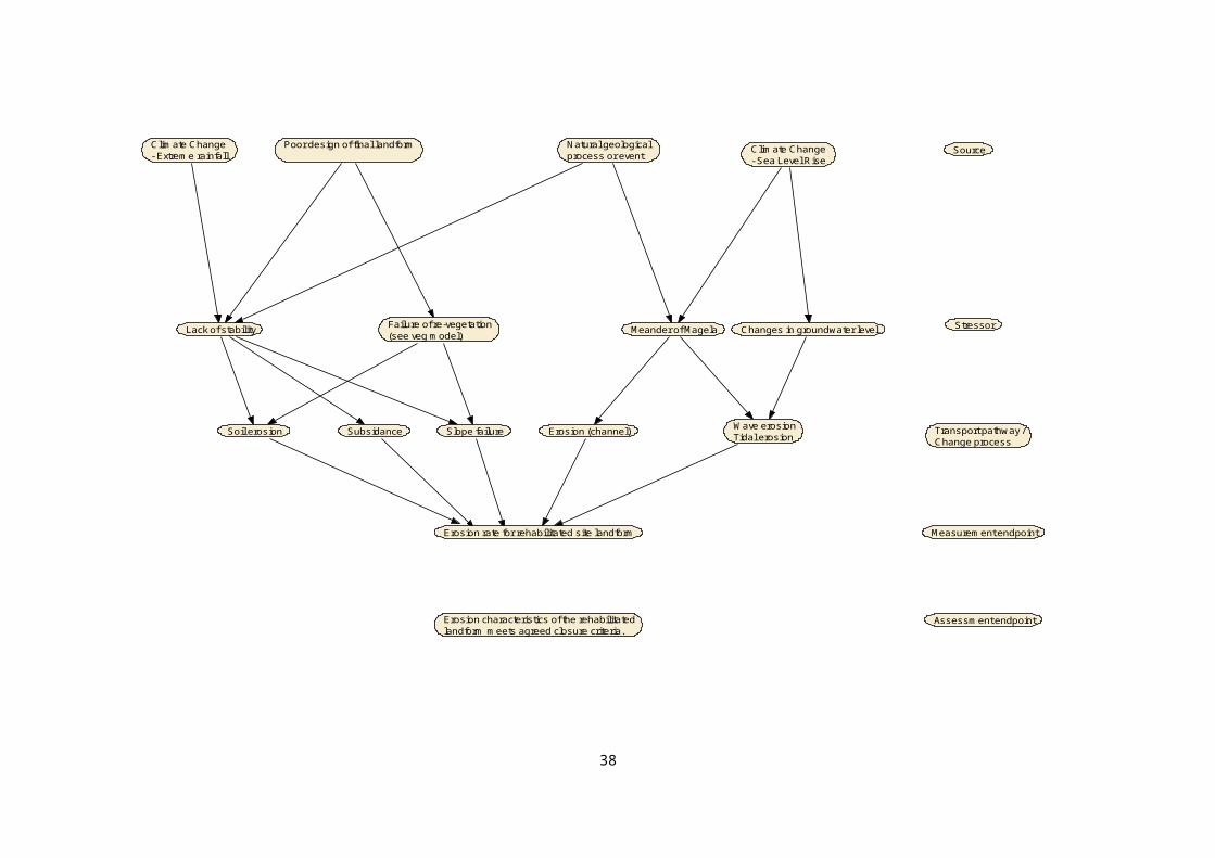
Figure 3.11 Conceptual model for erosion characteristics of the rehabilitated landform.
33
Changes in groundwater levelMeander of Magela
Erosion characteristics of the rehabilitatedlandform meets agreed closure criteria.
Climate Change- Extreme rainfall
Transport pathway /Change process
Climate Change - Sea Level Rise
Wave erosionTidal erosion
Natural geological process or event
Erosion (channel)Soil erosion Slope failure
Lack of stability Failure of re-vegetation(see veg model)
Erosion rate for rehabilitated site landform
Subsidance
Source
Stressor
Measurement endpoint
Assessment endpoint
Poor design of final landform

The model for ‘Faunal communities similar to surrounds’ has a revised assessment endpoint: ‘Wildlife on the rehabilitated site is on a trajectory towards meeting agreed closure criteria’ (see Figure 3.12). Unless specified in Table 3.3, the terms have remained the same between the workshop output and the revision of the models.Table 3.3 Revisions and status of terminology in the model for wildlife on the rehabilitated site is on a trajectory towards meeting agreed closure criteria
Terminology from Workshop (including definition by break out group)
Standardised terminology
Status in revised models
Source or Management Case
Sources:
Water quality
Bioaccumulation in food
This is not specifically included in the list for sources, although ‘surface water’ and ‘groundwater’ could be used as in place of water quality. ‘Ranger Project Area’ describes the source for the terrestrial environment at the onsite scale.
Revised to ‘Ranger Project Area’ which covers the original sources and management cases without the need for requiring a series of sub-models to simplify exposure pathways for multiple sources and management cases in the model.
Failure of revegetation (see reveg model) (Management Case)
This is not specifically included in the list of sources.
Suggested revision is ‘Failure of revegetation (see reveg model)’ treated as a ‘Transport pathway/Change process’.
Human (Management Case) This is not specifically included in the list for sources.
Suggested revision is ‘Human’ treated as a ‘Transport pathway/Change process’ and use the standardised terminology ‘Human/non-human vector’.
Management Cases:
Material characteristics (Physical and Chem)
Soil/Substrate Contamination (non-rad)
This is not specifically included in the list for sources.
Suggested revision is ‘Material characteristics (Physical and Chem)’ and ‘Soil/Substrate Contamination (non-rad)’ are treated as a ‘Transport pathway/Change process’, and suggested standardised terminology is ‘surface water’ and ‘biota-trophic transfer’ as material of concern is predominantly transported by surface water. Is there a need to include ‘atmospheric’ and ‘ground water’?
Stressor
Adverse radiological conditions External gamma exposure Revised to ‘External gamma exposure’. Group to review whether this encapsulates adverse radiological conditions.
Lack of habitat (food,shelter, etc) Habitat/Vegetation loss Revised to ‘Habitat/Vegetation loss’.
Competition with ferals Feral animals & weeds Revised to ‘Feral animals & weeds’.
Fire beyond background Fire Revised to ‘Fire’. It is assumed that fire as a stressor implies that fire is beyond background frequency and intensity.
Toxicity to fauna Contaminants Revised to ‘Contaminants’.
Transport pathway/Change Process
Note: No transport pathways/Change processes were included in the original models.
34

Terminology from Workshop (including definition by break out group)
Standardised terminology
Status in revised models
Failure of revegetation (see reveg model)
This is not specifically included in the list for transport pathway/change processes
Suggest inclusion in this model as a change process.
Human/non-human vector Include as stated.
Biota-trophic transfer Include as stated.
Surface water Include as stated.
35
Figure 3.12 Conceptual model for wildlife on the rehabilitated site.
36
Wildlife on the rehabiltated site is on a trajectory towards meeting agreedclosure criteria Assessment endpoint
Wildlife surveys of species and abundance
Ranger Project Area
Failure of revegetation(see reveg model)
Fire
Human/non-human vector Biota-trophic transfer Surface water
HuntingHabitat/Vegetation loss
Feral animals &weeds
Contaminants Physical barriers External gamma exposure
Measurement endpoint
Stressor
Transport pathway /Change process
Source

The model for ‘Vegetation community similar to surrounds’ has a revised assessment endpoint: ‘Vegetation on the disturbed sites of the RPA is on a trajectory towards meeting agreed closure criteria’ (see Figure 3.13). Unless specified in Table 3.4, the terms have remained the same between the workshop output and the revision of the models.Table 3.4 Revisions and status of terminology in the model for vegetation on the disturbed sites of the RPA is on a trajectory towards meeting agreed closure criteria
Terminology from Workshop (including definition by break out group)
Standardised terminology
Status in revised models
Source or Management Case
Climate Change (Management Case)
Climate - hot days
Climate – extreme rain
Climate – extreme wind
Revised to ‘Climate – Extreme rainfall & wind’ as ‘Cyclones and Extreme rainfall’ was included as a source. Also ‘Climate Change – hot days’ was included as a source, as a surrogate to replace ‘Drought/Low rainfall’ which was included as a source.
Management Cases:
Resourcing
Park Management-resources
These are not specifically included in the list of sources.
Suggested revision is to remove both of these from the model. ‘Resourcing’ is not linked to any other components in the model and it is unclear what the term refers to. Similarly, ‘Park Management – resources’ is not clearly linked to the model except for ‘Limited seed stock’ which is suggested to be included as a source as shown by the original model.
Limited seed stock (Source)
Failure of irrigation – mech & tech (Source)
These are not specifically included in the list for sources.
Suggested revision is to include ‘Limited seed stock’ and ‘Failure of irrigation – mech & tech’ as sources because results of these sources are key stressors in both the original and revised models.
Lack of faunal activity (Source) This is not specifically included in the list for sources.
Suggested revision is to remove ‘Lack of faunal activity’ from the revised model. From the linkage to ‘Disease and Pests’ it is unclear as what to what this term refers to. Does it refer to predation?
Source:
Soil condition
Weathering of rock
No initial soils-rock as initial substrate
‘Soil’ is included in the list for sources.
Suggested revision is use ‘Soil’ as the source.
Source:
Landform design
- Construct of substrate
- Waste holding cap
This is not specifically included in the list for sources.
‘Waste rock- exposed’ and ‘Waste rock – buried’ are on the source list.
Suggested revision is to replace ‘Landform design’ with standardised terminology ‘Waste rock – exposed & buried’. Does ‘buried tailings/brine’ need to be included also?
Weeds (Source) This is not specifically included in the list for sources, but is included in the list for stressors.
Suggested revision is to treat ‘Weeds’ as a stressor.
37

Terminology from Workshop (including definition by break out group)
Standardised terminology
Status in revised models
Humans (Source) This is not specifically included in the list for sources, but is included in the list for transport mechanism/pathways.
Suggested revision is ‘Human’ treated as a ‘Transport pathway/Change processes and use the standardised terminology ‘Human/non-human vector’. This also recognises the transport of material by non-human vectors which were not accounted for in the original model.
Ranger Project Area Not included in the original model as it is assumed this was implicit due to the spatial scale of the model. However for humans to be a transport mechanism they need to be originating from a source. Is the source the RPA or KNP, or both?
Stressor
Lack of water for growth Water deficit/stress Revised to ‘Water deficit/stress’.
Waterlogging Water surplus/logging Revised to ‘Water surplus/logging’.
Feral grazing Feral animals Removed from revised model as there were no links to sources in the original model.
Lack of plants:
Species selection, Diversity, Abundance
This is not specifically included in the list for stressors.
Suggested revision is to include ‘Lack of plant species: Diversity & Abundance’ as a stressor
Poor recruitment This is not specifically included in the list for stressors.
Suggested revision is to remove ‘Poor recruitment’ from the revised model as it can be covered by the stressor ‘Lack of plant species: Diversity & Abundance’.
Increased competition This is not specifically included in the list for stressors.
Suggested revision is to remove ‘Increased competition’ from the revised model. Does this relate to weeds? If so, it is covered by the stressors ‘Weeds’.
Landform stability This is not specifically included in the list for stressors. ‘Slope failure’, ‘Soil erosion’ and ‘Subsidence’ are included in the list for stressors.
‘Landform stability’ has been included in the revised model as a stressor. Does this need to be replaced by ‘Slope failure’, ‘Soil erosion’ and ‘Subsidence’ and do each of these have different linkages to the sources?
Radiation exposure
Toxic effects from contaminated soils
Lack of microbial activity
This is not specifically included in the list for stressors.
However ‘External gamma exposure’ and ‘Contaminants’ are included on the list of stressors.
Suggested revision is to replace ‘Radiation exposure, Toxic effects from contaminated soils, Lack of microbial activity’ with ‘External gamma exposure’ and ‘Contaminants’.
Transport pathway/Change Process
Note: No transport pathways/Change processes were included in the original models.
Human/non-human vector Suggested revision is to add to revised model.
38

Figure 3.13 Conceptual model for vegetation on the disturbed sites of the RPA.
39
Plant disease & pests Fire Weeds
Climate-hot days Waste rock- exposed & buried
Ranger Project Area
Climate-extreme rain & wind
Source
Lack of plant species:Diversity & abundance
Human/non-human vectorTransport pathway /Change process
Assessment Endpoint
Soil
Stressor
Measurement endpoint
Landform stability(see landform model)
Water surplus/logging External gamma exposure ContaminantsWater deficit/stress
Limited seed stock Failure of irrigation(mech and tech)
Plant specieis composition and structureAnnual weed surveys in accordance with closure criteria
Areal extent of successful revegetationon disturbed surfaces
Vegetation on the distutrbed sites of the RPA is on a trajectory towards meetingagreed closure criteria
3.2.2 LandscapeThe terrestrial ecosystem (landscape) breakout group drafted three conceptual models. These have been revised to two conceptual models. The models for ‘Protect the landscape of the ARR’ and ‘Protect the diversity of habitats across the terrestrial landscapes of the ARR’ were collapsed into one model for a revised assessment endpoint: ‘Habitat diversity and ecosystem functions within the landscape of the Magela Creek sub-catchment and broader KNP is comparable to an agreed reference condition’ (see Figure 3.14). This was undertaken as the sources and stressors were similar between the two models that were output from the workshop, and review of the assessment endpoints indicated that the models were quite similar. The definitions of components in the terrestrial ecosystem models as shown in Table 3.5 were largely derived from the definition of terms developed by the landscape terrestrial working group during the workshop.Terminology has been standardised according to the list of terms produced by a review group. For example, the source ‘offsite’ is now referred to as ‘Kakadu National Park’. Table 3.6 outlines the changes in terminology used in the revised model for the assessment endpoint: ‘Habitat diversity and ecosystem functions within the landscape of the Magela Creek sub-catchment and broader KNP is comparable to an agreed reference condition’. Unless specified in Table 3.6, the terms have remained the same between the workshop output and the revision of the models. There were no links between the stressor ‘floristic composition during minesite revegetation’ and any stressors that were directly linked to a measure of effect. This stressor may be poorly defined and either needs to be revised by the group or removed from the model. In the revised model it is linked to the stressors ‘fire’ and ‘weeds’.Measurement endpoints have been revised based on the measurement endpoints derived from the workshop.Table 3.5 Definition of source and stressor components of the models for 1) habitat diversity and ecosystem functions within the landscape of the Magela Creek sub-catchment and broader KNP is comparable to an agreed reference condition and 2) aesthetic values meet the expectations of the stakeholders in the ARR.
Component in conceptual model
Definition as used in the model
Source
Unsuitable growth medium Landform substrate that is not suitable for survivability of plant species
Climate Change – Extreme or decrease in rainfall
Increase in extreme precipitation events or decrease in seasonal rainfall which impacts on rainfall variability.
40
Component in conceptual model
Definition as used in the model
Floristic composition during minesite revegetation
Floristic composition of revegetation becomes a source of fuel load for fires, or enables establishment of weeds, or becomes dominated by a small number of species.
Stressors
Solutes Radionuclides, inorganic toxicants & organic toxicants
Sediment Runoff & erosion from landform into ARR
Weeds Weeds offsite (terrestrial & aquatic) – Spread to onsite from wind, non-human and human vectors
Weeds onsite (terrestrial & aquatic) – Effect of final landform floristic composition on final landscape. Also spread to offsite via non-human and human vectors. Aquatic weeds affect terrestrial fauna.
41

Component in conceptual model
Definition as used in the model
Fire Fire can be any or all of the following: stressor, value, biophysical, cultural.
Fire offsite – Unmanaged fire from KNP and ARR.
Fire onsite – Fire originating onsite and spreading offsite.
Feral animals Feral animals offsite – unmanaged feral animals offsite
Feral animals onsite – Potential refuge for feral animals
Rainfall variability Combination of high frequency, high intensity, low frequency or low intensity. Can affect floristic and fuel loads.
Line of sight-physical barriers Visibility from point x to point y in the landscape
Table 3.6 Revisions and status of terminology in the model for spatial pattern of the landscape in the ARR is comparable to the habitat diversity and ecosystem functions previously documented for the ARR
Terminology from Workshop (including definition by break out group)
Standardised terminology
Status in revised models
Source
Offsite - Kakadu National Park (KNP) and the Alligator Rivers Region (ARR)
Kakadu National Park Revised to standardised terminology
Climate Change Climate – extreme rainfall
Climate – extreme wind
Climate – hot days
Revised to ‘Climate Change – Extreme or decrease in rainfall’
Hot days not included, question to focus group; Is this required?
Unsuitable growth medium NIL Remains as is
Stressors
Solutes - Radionuclides, inorganic toxicants & organic toxicants
Solutes – trace metals
Solutes – major ions
Radionuclides
Currently left as ‘solutes’ in the revised model. The group will need to decide whether the pathways need to be split up and in addition, a more appropriate measure of effect needs to be derived.
Sediment - Runoff & erosion from landform into ARR
Suspended sediment
Bedload
Currently left as ‘sediments’ in the revised model. The group will need to decide whether the pathways need to be split up and in addition, a more appropriate measure of effect needs to be derived.
Rainfall variability - High frequency, high intensity, etc
Can affect floristic composition and fuel loads
Maybe linked to ‘water deficit/stress’ and ‘water/surplus’
Currently left as ‘rainfall variability’ in the revised model. The group will need to decide whether the pathways need to be split up and in addition, a more appropriate measure of effect needs to be derived.
42

Source
Measurement endpoint
Kakadu National Park Ranger Project Area
Weeds Fire Rainfall variabilitySedimentSolutes Stressor
Climate Change - Extreme or Decrease in Rainfall
Remote sensing analysis of availability ofdiverse ecosystems-areal extent of habitats
Assessment endpointHabitat diversity and ecosystem functionswithin the landscape of the Magela Creek sub-catchment and broader KNP is comparable to an agreed reference condition
Landscape metrics (derived from landscape ecology indices)eg. random, clustered or uniform dominance contagion contiguity or fragmentation juxtaposition
FeralAnimals
Unsuitable growth medium
Floristic composition during minesite revegetation
Figure 3.14 Conceptual model for spatial pattern of the landscape in the ARR.
43

The model for ‘Protect the aesthetic values of the ARR’ has a slightly revised assessment endpoint: Aesthetic values meet the expectations of the stakeholders in the ARR (see Figure 3.15). It is documented (Suter 1990) that aesthetics cannot be given a clear operational definition prior to surveys of stakeholders and that aesthetic values may also conflict with ecological values. Until the aesthetics are parameterised from the stakeholders’ perspective, this assessment endpoint and subsequent measures of effects cannot be reviewed any further.Table 3.7 outlines the changes in terminology used in the revised model for this assessment endpoint. Unless specified in Table 3.7, the terms have remained the same between the workshop output and the revision of the models.Table 3.7 Revisions and status of terminology in the model for aesthetic values meet the expectations of the stakeholders in the ARR
Terminology from Workshop (including definition by break out group)
Standardised terminology
Status in revised models
Stressors
Line of sight – Visibility from point x to point y
Physical barriers Currently noted as Line of Sight – physical barriers. The group will need to decide whether this is an appropriate representation of the stressor.
Solutes - Radionuclides, inorganic toxicants & organic toxicants
Solutes – trace metals
Solutes – major ions
Radionuclides
Currently left as ‘solutes’ in the revised model. The group will need to decide whether the pathways need to be split up and in addition, a more appropriate measure of effect needs to be derived.
Sediment - Runoff & erosion from landform into ARR
Suspended sediment
Bedload
Currently left as ‘sediments’ in the revised model. The group will need to decide whether the pathways need to be split up.
44
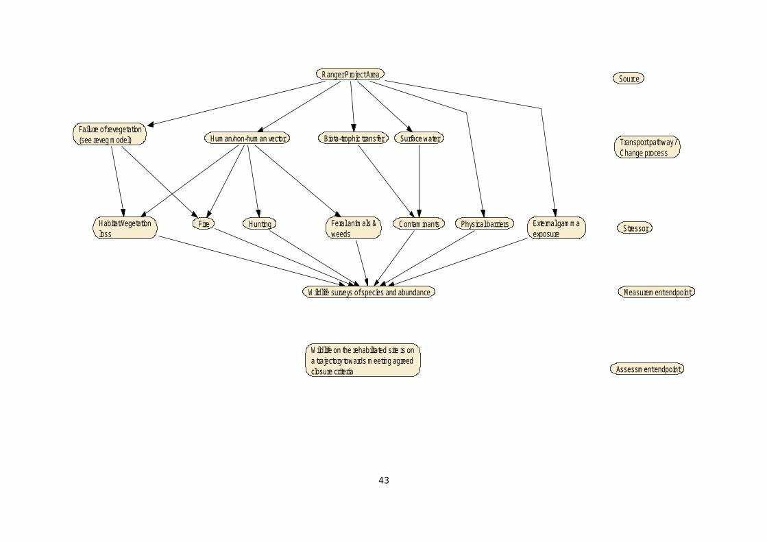
Figure 3.15 Conceptual model for aesthetic values meeting the expectations of stakeholders in the ARR.
45
Source
Stressor
Measurement endpoint
Assessment endpoint
Community vectorse.g. social science surveys
RPA
Sediment Weeds FeralAnimals Fire
SolutesLine of sight- physical barriers
Water colour
Aesthetic values meet the expectations of stakeholders in the ARR
3.3 People: Cultural and Socio-economicThe people breakout group drafted two conceptual models – one for cultural landscape and the other for human health. The review focused on refining the cultural landscape model. The human health model will be dealt with separately in the future, combining it with the human health model drafted by the terrestrial ecosystems (Ranger Project Area) group.The original cultural landscape model, shown in Figure 3.16, has been split into four separate conceptual models, to reflect the revised assessment endpoints. The revised assessment endpoints are as follows: landform is able to be accessed, and is readily traversable, by
people presence of culturally important species at right time and
abundance landform, vegetation and water bodies on-site meets agreed
cultural closure criteria return of traditional practices (e.g. burning, harvesting).The revised assessment endpoints capture the key elements of the sub-assessment endpoints that were captured in the terminal node (last box) of the original model (Figure 3.16). Those that are not captured are Safe potable water and Re-establishment of water bodies. The first one is more related to human health and, as noted, is not covered at this stage, but could potentially be captured in the Return of traditional practices assessment endpoint if the presence of safe potable water was to be deemed necessary for traditional owners to undertake certain activities. The second one would be covered in the Landform, vegetation and water bodies on-site meets agreed cultural closure criteria assessment endpoint.Tables 3.8 and 3.9, outline key changes in terminology for sources and stressors (respectively) used in the revised models compared to the original model, as well as new terms introduced during the revision of the models. Measurement endpoints for each of the models have been added, as they were not specifically addressed during the workshop. The four revised models are presented in Figures 3.17–3.20. A key outcome of the revision of the cultural models was that most are critically linked to a number of the other assessment endpoints. For example, the presence of important species at the right time and abundance will be highly dependent on the success of revegetation and aquatic ecosystem rehabilitation and establishment, and associated wildlife recolonisation, all of which are issues addressed by other models. Thus, in a number of cases, these other models were linked to the cultural models, rather than trying to fully
46

duplicate these models (or variations thereof) within the cultural models.
The revised models presented here are in draft form only, and will require further input and revision. For example, the Presence of culturally important species at right time and abundance model will only be able to be finalised once the important species, and their requirements, are identified. Similarly, the Return of traditional practices model will only be able to be finalised once specific traditional practices, and their requirements, are identified.
47

Figure 3.16 Conceptual model for cultural values developed during the workshop.
48
Temporal scales: stabilisation & post-closure phasesSpatial scales: Minesite, RPA (except for fire)
TailingsSurface_landform
Stability Radiation Appropriate_material
Loss of traditional knowledge/practices
Governance / management consultation
Ineffective consultation Lack of resourcesControl of political process Fire
Deviation from mine closure strategy
Chemical_contaminants
Culture
Accessible by peopleAbundance of keystone speciesSafe potable waterTraversable surfaceLandform design as close as practical to pre-mining typographyRe-establishment of water bodiesReturn of traditional burning practicesHarvest of acceptable feral/invasive species
Re-creation of a cultural landscape in which TOs can resume traditional practices

Table 3.8 Revisions and status of terminology for Sources in the cultural values models
Terminology from Workshop (including definition by break out group)
Standardised or new terminology
Status in revised models
Surface landform Waste rock - exposed Revised to standardised terminology
Tailings Buried tailings/brine Revised to standardised terminology
Governance/management consultation
Nil Not included. Several of the stressors arising from this Source were deemed to be outside the scope of this assessment, while several others were retained (see Stressors, below)
Mine rehabilitation plan:
landform design characteristics
revegetation plan water body establishment/
rehabilitation plan
New sources added to one model to reflect importance of rehab plans properly reflecting cultural values, and subsequent communication of expectations and what can be achieved
Waste rock - buried Included in the site accessibility/ traversibility model due to potential radiation does issues
Buried tailings/brine Included in the site accessibility/ traversibility model due to potential radiation does issues
Climate – extreme rain Included in the site accessibility/ traversibility model due to potential effects on landform stability and topography
Kakadu National Park Included in the site accessibility/ traversibility model as a source of potential weed invasion and infestation of the rehabilitated mine site
Ranger Project Area Included in the site accessibility/ traversibility model as a source of potential weed invasion and infestation of the rehabilitated mine site
49

Table 3.9 Revisions and status of terminology for Stressors in the cultural values models
Terminology from Workshop (including definition by break out group)
Standardised or new terminology
Status in revised models
Stability Slope failure Revised to standardised terminology
Radiation Radiation dose Revised to standardised terminology
Appropriate material Inappropriate surface material Revised to standardised terminology
Chemical contaminants Solutes – trace metals
Solutes – major ions
Organic chemicals
Not directly used in revised models, but are indirectly captured through other models feeding into the revised models (as indicated in the models)
Control of political process Nil Deemed to be outside the scope of this assessment
Fire Fire Not directly used in revised models, but is indirectly captured through other models feeding into the revised models (as indicated in the models)
Ineffective consultation Ineffective consultation Used as is
Lack of resources Nil Deemed to be outside the scope of this assessment
Deviation from mine closure strategy
Nil Not included in revised models, but captured through the inclusion of relevant mine rehabilitation plan components as sources
Physical barriers Included in the site accessibility/ traversibility model.
Soil erosion Included in the site accessibility/ traversibility model.
Weeds Included in the site accessibility/ traversibility model.
50

Figure 3.17 Revised conceptual model for the assessment endpoint, Landform is able to be accessed, and is readily traversable, by people.
51
Measurement_Endpoint
Stressor
Source
Assessment_EndpointLandform is able to be accessed, and is readily traversable, by people
Inappropriate_surface_materialSoil_erosion WeedsSlope_failure
Kakadu_National_ParkClimate_extreme_rainWaste_rock_exposed
Weed densitySurface rock size distributionNo. large gulliesHills lope stability
Ranger Project Area
Temporal scales: post-closure phasesSpatial scales: Minesite
Physical_barriers
Buried tailings/brineWaste rock - buried
Access to the site Radiation dose limit
Radiation dose

Figure 3.18 Revised conceptual model for the assessment endpoint, Presence of culturally important species at right time and abundance.
52
Measurement_Endpoint
Assessment_Endpoint
Timing of important wildlife species presence
Important plant species abundance
Related_Models
Presence of culturally important species at right time and abundance Temporal scales: post-closure phasesSpatial scales: Minesite
Note: Important species will need to be finalised before models can be identified.
Timing of important plant species presence
Important wildlife species abundance
Model for "Vegetation on the rehabilitated site is on a trajectory towards meeting agreed closure criteria" modified to suit identified important plant species
Model for "Biodiversity (structure and function) of on-site aquatic ecosystems are on a trajectory towards meeting agreed closure criteria" modified to suit identified important aquatic species
Model for "Wildlife on the rehabilitated site is on a trajectory towards meeting agreed closure criteria" modified to suit identified important wildlife species
Figure 3.19 Revised conceptual model for the assessment endpoint, Landform, vegetation and water bodies on-site meets agreed cultural closure criteria.
53
Measurement_Endpoint
Assessment_Endpoint
Landform topography Condition of water bodies
Model for "Biodiversity (structure and function) of on-site aquatic ecosystems are on a trajectory towards meeting agreed closure criteria" modified to suit identified important aquatic species
Related_ModelsOutput from model for "Erosion characteristics of the rehabilitated landform meets agreed closure criteria" to inform the landform topography measurement endpoint
Model for "Vegetation on the rehabilitated site is on a trajectory towards meeting agreed closure criteria" modified to suit cultural closure criteria for vegetation
Number of water bodies
Landform, vegetation and water bodies on-site meet agreed cultural closure criteria
Vegetation density and composition
Source
StressorIneffective consultation Ineffective consultation
Mine rehabilitation plan -revegetation plan
Ineffective consultation
Mine rehabilitation plan -water body establishment/rehabilitation plan
Mine rehabilitation plan -landform design characteristics
Temporal scales: post-closure phasesSpatial scales: Minesite
Figure 3.20 Revised conceptual model for the assessment endpoint, Return of traditional practices (e.g. burning, harvesting).
54
Measurement_Endpoint
Assessment_Endpoint
Related_Models
Return of traditional practices (e.g. burning, harvesting)
Vegetation community amenable to sustainable burning
Output from model for "Presence of culturally important species at right time and abundance" to inform the risk to returning to relevant traditional practices (e.g. harvesting)
Model for "Vegetation on the rehabilitated site is on a trajectory towards meeting agreed closure criteria" modified to suit closure criteria for "Vegetation community amenable to sustainable burning" measurement endpoint
Temporal scales: post-closure phasesSpatial scales: Minesite
Output from model for "Landform is able to be accessed, and is readily traversable, by people" to inform the site access and traversibility measurement endpoint
Site access and traversibility

4 SummaryThe main objective of this project was to complete the Problem Formulation phase (i.e. develop the conceptual models and framework) for the rehabilitation/closure ecological risk assessments for Ranger (the minesite and landscape scale risk assessments), and to include TEK throughout this phase.In meeting this objective a number of tasks were undertaken during a stakeholder workshop and subsequent reviews by small focus groups and the breakout groups from the workshop and are summarised as follows: Identify the key sources, stressors and ecological assets that will
be examined for the decommissioning, stabilisation and monitoring, and the post-closure phases of Ranger uranium mine’s closure. The values are documented in Pollino et al. (2013).
The key values identified by the workshop participants were formulated into ecological assessment endpoints. Post-workshop, these endpoints were modified into fifteen assessment endpoints covering four themes:
1) Off-site water quality meets agreed closure criteria specified for water quality.
2) Habitat diversity of off-site aquatic ecosystems are comparable to the agreed reference condition.
3) Biodiversity (structure and function) of off-site aquatic ecosystems are comparable to the agreed reference condition.
4) On-site water quality is on a trajectory towards meeting agreed closure criteria specified for water quality on-site.
5) Habitat diversity of on-site aquatic ecosystems is on a trajectory towards meeting agreed closure criteria.
6) Biodiversity (structure and function) of on-site aquatic ecosystems are on a trajectory towards meeting agreed closure criteria.
7) Erosion characteristics of the rehabilitated landform meet agreed closure criteria.
8) Wildlife on the rehabilitated site is on a trajectory towards meeting agreed closure criteria.
9) Vegetation on the disturbed sites of the RPA is on a trajectory towards meeting agreed closure criteria.
10)Habitat diversity and ecosystem functions within the landscape of the Magela Creek sub-catchment and broader KNP is comparable to an agreed reference condition
11)Aesthetic values meet the expectations of the stakeholders in the ARR.
12)Landform is able to be accessed, and is readily traversable, by people.
55

13)Presence of culturally important species at right time and abundance.
14)Landform, vegetation and water bodies on-site meets agreed cultural closure criteria.
15)Return of traditional practices (e.g. burning, harvesting). Nineteen conceptual models were redrafted by the review group
and finalised by the focus groups. There are three assessment endpoints that are yet to have models redrafted and finalised; two models for aquatic ecosystems and one for human health. These will be addressed in the near future; the first two upon completion of the ecological processes definition; and the last by combining the human health models drafted by both the terrestrial (RPA) and people breakout groups.
A report was produced by Pollino et al. (2013) which details background material, and the values and draft conceptual models produced during the workshop. Revision of the conceptual models presented here and communication is ongoing through the CCWG processes.
In reviewing the conceptual models, it was clear that ecological processes were not clearly defined and that there is clarity required on this. Ecological processes are specifically mentioned in the Environmental Requirements for the operation and closure of the Ranger Uranium mine. A small focus group from the aquatic ecosystems breakout group have drafted a paper discussing ecological processes and how these can be measured (Appendix 3). This aspect of the conceptual models will be further addressed through the CCWG.Once the causal models are finalised, they will be used as the basis for scoping the risk analysis phase of the risk assessment. The risk analysis phase of the rehabilitation risk assessment will commence in 2013–14. Progress to date has been hampered due to staff availability (resourcing) for the project, both within SSD and ERA. Part of the problem formulation phase project included the development of an analysis plan (design, data needs, and methods for undertaking the risk analysis phase of the assessment), which was undertaken and reported by Pollino et al. (2013). It is recommended that the AS/NZS ISO 31000:2009 generic framework for risk management be adopted as it is considered best practice. The US EPA ecological risk assessment guidelines (US EPA 1998) can be used in conjunction with the ISO risk management standard. Pollino et al. (2013) recognise there are many approaches for undertaking risk analysis, but they focused on Bayesian networks, a recommended approach in the ISO/IEC 31010 Standard which supports the risk management standard (it is focused on risk analysis techniques). Bayesian networks have also been identified as a potential tool by Energy Resources Australia (ERA). Bayesian networks are probabilistic graphical networks, which can be used to directly apply the conceptual model from the problem
56
formulation in a modelling platform for quantifying risks and associated uncertainties.
57

ReferencesBartolo R, Parker S, van Dam R, Bollhoefer A, Kai-Nielsen K,
Erskine W, Humphrey C & Jones D 2013. Conceptual models of stressor pathways for the operational phase of Ranger Uranium Mine. Internal Report 612, Supervising Scientist, Darwin.
Iles S 2012. Draft Ranger Environmental Risk Assessment Framework Proposal, June 2012, ERA Ltd, Darwin.
Pollino CA, Cuddy SM & Gallant S 2013. Ranger rehabilitation and closure risk assessment: problem formulation. CSIRO Water for a Healthy Country Flagship, Canberra, Australia.
Suter II GW 1990. Endpoints for Regional Ecological Risk Assessments. Environmental Management. 14. 9-23.
Suter II GW 1996. Guide for Developing Conceptual Model for Ecological Risk Assessments. ES/ER/TM-186, Oak Ridge national Laboratory, Oak Ridge.
Suter II GW 2007. Ecological Risk Assessment (2nd Ed). CRC Press, US.
US EPA 1998. Guidelines for ecological risk assessment. DC Federal Register, May 14, 1998, Washington.
52

Appendix 1: Workshop Agenda for the Ranger Mine closure causal maps 2-day workshop (25-
26 February 2013)Day 1 (25/02/2013)
Time Topic / objective Notes
9.30-10.00 Introduction
Role, Organisation, Interest/role in mine
closure planning
What do participants anticipate getting OUT of the workshop (as well
as putting INTO the workshop); measures of success by which we can
judge the success of the workshop
10.00-10.30 Context for workshop; and workshop overview
Closure planning process Requirements
for risk assessment
Shelly – closure context and goals and decisions about what Risk
Assessment is intended / must achieve; policy/legal/reputation
compliance requirements; evaluation criteria
Agree on objectives and outcomes for
workshop
Carmel –language and concepts; workshop process and outcomes
Agree on how we meet workshop
objectives (agenda)
Carmel – what process will we use (brainstorming, break-out groups,
prioritisation); rules of ‘play’, including how to resolve/arbitrate
differences of opinion
10.30-11.20 Mine closure – risk assessment objectives
Overview the objectives; and discussion
around the scales
Scope and scales (time, space, interacting scales that we need to
consider?)
11.20-11.30 Break
11.30-1.00p Defining values
Existing (already documented) and new
ones
Brainstorming (post-it notes)
- Need to distinguish between values and drivers
1.00-1.45 LUNCH BREAKOver lunch, project team (Carmel, Sue, Rick, Renee, Shelly) create
‘straw man’ with values grouped into 4 groups, e.g. Park v. Mine
interests OR value types OR mine closure phases OR
exposure/threats (least preferred as models non-integrated)
1.45-3.00 Role of values in risk assessment
To define, and agree as a workshop
‘team’, on the core set of values
Split into break-out groups to workshop the ‘groups’ of values.
What is role of each value? What is missing from the assessment by
not including it? Can it be measured? How relevant is to mine closure?
Can multiple values be combined?
May need to rank values
3.00-3.15 BREAK
53

Time Topic / objective Notes
3.15-4.15 Defining assessment endpoints
List of core values converted into
assessment endpoints
Convert each of the ‘core’ values into assessment endpoints (e.g.
indicators)
Still in groups
4.15-4.20 Wrap up Carmel, and Shelly
Day 2 (26/02/2013)
Time Topic / Objective Note
9.00-10.00 Refresh / review
Assessment endpoints Review progress
Refresh of causal mapping needs Carmel – use the one that Carmel & Sue put together night before
from Day 1
10.00-10.15 Break
10.15-2.30p Development of causal maps
10.15a –
12.30p
What are the key threats to endpoints? For each threat, identify
– sources (mine derived v. non-mine),
- relevant scale (decommissioning, stabilization and monitoring, post-closure / mine site, KNP);
- mobilisation processes, - transport and exposure pathways; - interactions;- available knowledge base; key uncertainties
12.30-1.45 LUNCH
1.45-2.30 Continue threats session Causal diagrams
2.30-4.00 Collation / synergies
Groups come together (models by scale
by value)
Synergies; can we collapse these ‘models’ down? What is best way to
finalise the presentation of these ‘models’? (don’t need to do on the
day, part of consequent write-up)
BREAK SOMEWHERE
4.00-4.30 WRAP UP
Gaps; where to from here Carmel
Wrap up, Next steps Shelly – e.g. data identification and collation; Approval/sign-off process
re outcomes of workshop
54

Appendix 2: Workshop AttendeesName Organisation Breakout Group
Carmel Pollino CSIRO Facilitator
Sue Cuddy CSIRO Facilitator
Michelle Iles Energy Resources Australia Aquatic
Sharon Paulka Energy Resources Australia Terrestrial (RPA)
Nicole Jacobsen Energy Resources Australia People
Linda Pugh Energy Resources Australia Terrestrial (Landscape)
Daniel McIntyre Energy Resources Australia Terrestrial (Landscape)
Mark Lewty Energy Resources Australia Terrestrial (RPA)
Steve Winderlich Kakadu- Parks Australia People
Howard Smith Northern Land Council People
Adam Thompson Northern Land Council People
Geoff Kyle Gundjeihmi Aboriginal Corporation People
Sally-Anne Stromhayer Department of Resouces (NT) Terrestrial (RPA)
David Mulligan Alligator Rivers Region Technical
Committee
Terrestrial (RPA)
Keith Tayler Supervising Scientist Division-Office
of the Supervising Scientist
Terrestrial (RPA)
Rick van Dam Supervising Scientist Division-
Environmental Research Institute of
the Supervising Scientist (ERISS)
People
Renee Bartolo ERISS Terrestrial (Landscape)
Chris Humphrey ERISS Aquatic
Wayne Erskine ERISS Terrestrial (RPA)
Kate Turner ERISS Aquatic
Andreas Bollhoefer ERISS Aquatic
Andrew Harford ERISS Aquatic
Amy George ERISS Aquatic
Tim Whiteside ERISS Terrestrial (Landscape)
Che Doering ERISS Aquatic
55
Appendix 3: Measuring Ecological processes for the Ranger Uranium Mine Ecological Risk
Assessment – Draft discussion paperThe Environment Requirements for closure of the Ranger Uranium mine includes the following;
“d) maintain the natural biological diversity of aquatic and terrestrial ecosystems of the Alligator Rivers Region, including ecological processes.”
Consequently, “ecological processes” was flagged as a necessary ‘Assessment Endpoint’ in the Ranger Closure and Rehabilitation Ecological Risk Assessment workshop of 25-26 February 2013. However, the conceptual model developed for the Ecological Risk Assessment method is designed for the assets or components (e.g. biodiversity) which are sustained by ecological processes. Thus, ecological processes are a suitable endpoint, but their value is derived from the direct assessment and measure of key ecological components. Ecological processes require further definition, delineation and prioritisation to be successfully incorporated into the current Risk Assessment Framework. Consequently, discussions concerning the concepts of Ecological Processes, and how to measure them, were continued the day after the ARRTC 30 meeting. The meeting included 4 key ecologists; Paul Boon (ARRTC independent member), Chris Humphrey (ERISS), Amy George (ERISS) and Kyla Clarke (ERA). Ecological processes are essential in conservation and rehabilitation programs because such programs will ultimately fail if the ecological processes that support assets are not established or maintained. Consequently, ecological processes are a fundamental requirement in the Australian Ramsar Ecological Character Description methodology (Department of the Environment, Water, Heritage and the Arts 2008). A number of recent papers have aimed to define, or at least list, ecological processes, the threats to these process and/or management strategies to preserve ecological processes (McGregor et al. 2008, Bennett et al. 2009, Cork et al. 2009, McDonald & Williams 2009). These papers listed a number of ecological processes but sometimes without a specific definition of ecological processes. Nevertheless, Trail (2007) defined ecological processes as:
“The interactions and connections between living and non living systems, including movements of energy, nutrients and species.’
56

Most simplistically, ecological processes are the dynamic forces within an ecosystem between and within organisms, populations and communities (Aust Heritage Commission 2008). As such, the definition of ecological processes embeds concepts relevant to both biotic and abiotic components that interact to form a functional ecosystem. The Department of the Environment, Water, Heritage and the Arts (2008) lists 7 broad categories of ecological processes (Table 1). Each of these processes has numerous measurement endpoints and the ability to measure these processes varies markedly. The challenge for any ecological risk assessment is appropriately mapping ecological components with key ecological processes supporting them and providing the justification for them through identifying ecological values, benefits and services. This allows an evaluation of what is currently measured and identification of possible additional measures to be developed within a monitoring program. Some of the data that informs an ecological process may be readily measurable but how the different components integrate to affect the overall ecosystem needs to be assessed using available data. Ecological processes are both temporally and spatially dynamic and measuring environmental change is paramount to knowing the status of ecological processes. Monitoring programs are useful for this when they generate information on ecological trajectories (Bennett et al. 2009). Thus, reference approach needs to reflect trajectories as well as the spatial representation of processes and the relative role of key components in maintaining structural heterogeneity. Examining ecological process is about similarity in process rather than simply similarity in structure. Measuring and comparing ecological processes is difficult and Bennet et al. (2009) have recommended that one of the first steps is to identify the key ecological processes that sustain an ecosystem. Hence, ecological processes that are to be assessed as part of Ranger’s environment requirements will need to be clearly identified. Ideally, this should be an outcome of this risk assessment processes that identifies the most important processes that can sustain an ecosystem on the post-rehabilitated mine site. The Kakadu National Park Ramsar Site Ecological Character Description (BMT WBM 2010) may provide a starting point since the ecological character description (ECD) is described from critical and supporting ecological components, processes, and services for the region. However, the list of processes does not fully capture the spatial representation of the links between measured data and large-scale ecological processes since the ECD focuses on large-scale components and processes only.
Assessment EndpointsThe Risk Assessment currently proposes Assessment Endpoints as; “Biodiversity (structure and function) of off-site aquatic ecosystems are comparable to the agreed reference condition” and “Biodiversity (structure and function) of on-site aquatic ecosystems
57
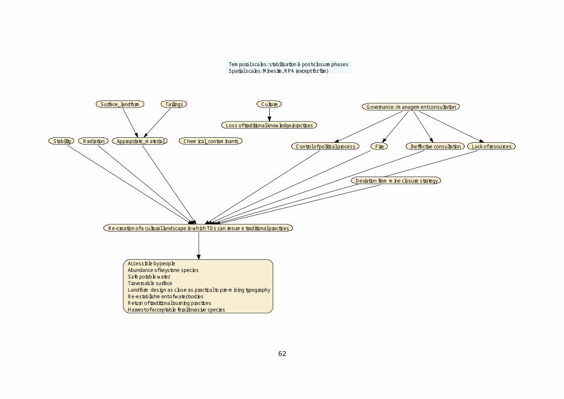
are on a trajectory towards meeting agreed closure criteria”. However, a key conclusion of the 23 May meeting was that structural biodiversity was better viewed as a Measurement Endpoint that informs functional biodiversity (aka ecological processes). This is because “biodiversity” is something that can be measured and has a direct relationship to ecological processes.
Measurement EndpointsAs shown in Table 1, Ecological processes can be split into abiotic and biotic processes. Specifically, abiotic processes include:
Formation of habitat structure Geochemical processes (soil/sediment and aquatic)Hydrological processesClimatic processesNatural disturbance regimes
Biotic processes include: Movement of organisms, including recruitment and/or
regenerationPrimary productionPredation, herbivory, competition, parasitism and mutualism
The ECD does not split processes. Rather it groups all processes together, but recognizes that they may be physical, chemical or biological. The measurement endpoints are more closely aligned with ecological components which are always physical, chemical or biological parts of the ecosystem (e.g. habitats, species, nutrients) (Department of the Environment, Water, Heritage and the Arts 2008).
Measured v Derived dataIt is noteworthy that some data previously collected for biodiversity assessments, may also inform ecological processes. For example, the identification of species during biological monitoring surveys can be used to derive information on the organism traits that have a more direct relationship to their function in the ecosystem. Similarly, size structure data gathered on fish communities during biological monitoring studies in the ARR may be used to inform ecological processes associated with reproduction/recruitment and dispersion/migration of fish.
58

Table 1 Examples of Ecological Processes modified from Department of the Environment, Water, Heritage and the Arts (2008)
Process Examples
Climatea Precipitation
Temperature
Evaporation
Wind
Geomorphology a Topography/morphology
Connectivity of surface waters
Water source
Soils
Sedimentation
Erosion
Hydrology a Water balance (water flowing in, water flowing out)
Groundwater infiltration and seepage
Surface–groundwater interactions
Tidal regime
Inundation regime (volume, frequency, duration, height and seasonality [timing] of inundation)
Energy and nutrient dynamics
Primary production
Nutrient cycling (nitrogen, phosphorus)
Carbon cycling
Decomposition
Oxidation–reduction
Processes that maintain animal and plant populations
Reproduction
Regeneration
Dispersal
Migration
Pollination
Species interactions
Competition
Predation
Succession
Herbivory
Diseases and pathogens
Physical processes
Stratification
Mixing
Sedimentation
Erosion
Evaporation
Infiltration
Natural disturbance regimes b
FireFloods and droughtCyclonesExtreme temperaturesDisturbance regimes (i.e. the combination of frequency, duration, intensity and extent of disturbance) have greater long-term influence than single events
a For some wetlands these processes may be viewed as components or broken down into their components.b Not included in Australian Heritage Commission (2002)
59

Table 2 Ecological components modified from Department of the Environment, Water, Heritage and the Arts (2008)
Component Examples Measured
Physical form Area of the wetlands and creeks
Wetland form (e.g. depth, shape and bathymetry [the study of underwater depth])
Landform topography
Yes – Remote sensing
Yes? HGCP will know
Yes – Landform modelling
Soils and sediments Site and soil/sediment profile characterisation (e.g. using the Australian Soil and Land Survey Field Handbook McDonald et al. 1990).
Soil profile classification (e.g. using Isbell 2002) – most profiles should fall into the Hydrosol Soil Order and classification to the Sub-Order or Great Group level will be sufficient in most cases.
Soil physical properties (e.g. structure, texture, consistency and profile)
Soil chemical properties (e.g. organic content, nutrients, sulfides, acid neutralising capacity, salts and pH)
Soil biological properties (e.g. soil organisms such as bacteria and fungi, invertebrates – shellfish, mites and worms)
Not sure what this means?
Probably (HGCP) not sure?
Probably (HGCP)
Yes – to some extent but focusing mostly on metals
Some information being generated from the sed U tox project. CDU have done some LAA bacterial work
Physicochemical water Nutrients (e.g. nitrogen, phosphorus)
Electrical conductivity
Cations and anions
Turbidity
Temperature
Dissolved oxygen
pH
Nutrient cycling
Light attenuation
Yes – possibly limited sampling? Without much spatial or temporal solution.
Yes
Yes
Yes – especially in Magela and Gulungal
Yes
Yes – not sure how extensive
Yes
Not sureLimited but can be inferred from turbidity
Biota Wetland plants
Vertebrate fauna (e.g. fish, amphibians, reptiles, waterbirds, mammals)
Phytoplankton, including diatoms
Aquatic macroinvertebrates
Remote sensing. Ecological surveys
Yes – fish channel billabongs and shallow lowland billabongs
Much historical (1978-81) data. . More limited recently, GTB study and some during recessional flow sampling
Yes – year recessional flow sampling in creeks. Intermittent billabong sampling
60

ReferencesAustralian Heritage commission (2002). Australian Natural
Heritage Charter for conservation of places of natural heritage signficance. Second Edition. Australian Heritage Commission. Canberra. http://www.environment.gov.au/system/files/resources/56de3d0a-7301-47e2-8c7c-9e064627a1ae/files/australian-natural-heritage-charter.pdf. Accessed 5 February 2014.
Bennett AF, Haslem A, Cheal DC, Clarke MF, Jones RN, Koehn JD, Lake PS, Lumsden LF, Lunt ID, Mackey BG, Nally RM, Menkhorst PW, New TR, Newell GR, O’Hara T, Quinn GP, Radford JQ, Robinson D, Watson JEM & Yen AL 2009. Ecological processes: A key element in strategies for nature conservation. Ecological Management & Restoration 10 (3), 192-199.
BMT WBM (2010). Ecological Character Description for Kakadu National Park Ramsar Site. Prepared for the Australian Government Department of Sustainability, Environment, Water, Population and Communities. http://www.environmentgov.au/resource/kakadu-national-park-ramsar-site-ecological-character-description. Accessed 5 February 2014.
Cork S, Sattler P & Tait J 2009. Rapid Desktop Assessment of Australian Ecosystem and Biodiversity Conservation Opportunities.
Department of the Environment, Water, Heritage and the Arts (2008). National Framework and Guidance for Describing the Ecological Character of Austalia’s Ramsar Wetlands. Module 2 of the National Guidelines for Ramsar Wetlands; Implementing the Ramsar Convention in Australia. Australian Government Department of the Environment, Water, Heritage and the Arts, Canberra. http://www.environment.gov.au/resource/national-framework-and-guidance-describing-ecological-character-australian-ramsar-wetlands. Accessed 5 February 2014.
McDonald T & Williams J 2009. A perspective on the evolving science and practice of ecological restoration in Australia. Ecological Management & Restoration 10 (2), 113-125.
McGregor A, Coffey B, Deutsch C, Wescott G & Robinson J 2008. Ecological processes in Victoria: Policy priorities for sustaining biodiversity.
Trail 2007. Making ecological processes iconic. In: Decision Point. unpublished paper.
61