iqmulus processing contest 2013
TRANSCRIPT

The IQmulus Processing Contest
S. Biasotti1, J. Boehm2, R. Lindenbergh3, C. Mallet4 1CNR – IMATI –GE, 2UCL, 3TuDelft, 4IGN
ISPRS Laser Scanning 2013
What’s the IQmulus Processing Contest?
• Aim:– enable reproducible evaluation of the performance of geospatial data processing– create benchmarks and evaluation methodologies
• Target services:– point cloud registration and alignment– feature extraction, classification, and detection – characterization of dynamic events
• The IQmulus Processing Contest provides– a selection of test datasets with a ground truth;– a platform where the participant will be able to run their methods in a unique
and standard infrastructure;– uniform evaluation criteria and methods.
• The IQmulus contest is featured by the EU IQmulus project (http://www.iqmulus.eu/)
November 2013
ISPRS Laser Scanning 2013
The IQmulus Processing Contest
• Two tracks are currently running– Feature extraction: drainage basins• Three participants (four methods)
– Point cloud registration• Six participants (three outside of the consortium),
six methods
November 2013

ISPRS Laser Scanning 2013
The IQmulus Processing Contest
• For each track, the salient/crucial points are:– The creation/selection of the datasets– The creation/definition of a ground-truth– The definition/identification of evaluation
measures• Quantitative measures: time, memory occupied• Qualitative measures: quality of the registration,
average error, deviation, accuracy of the features detected, etc…
November 2013
ISPRS Laser Scanning 2013
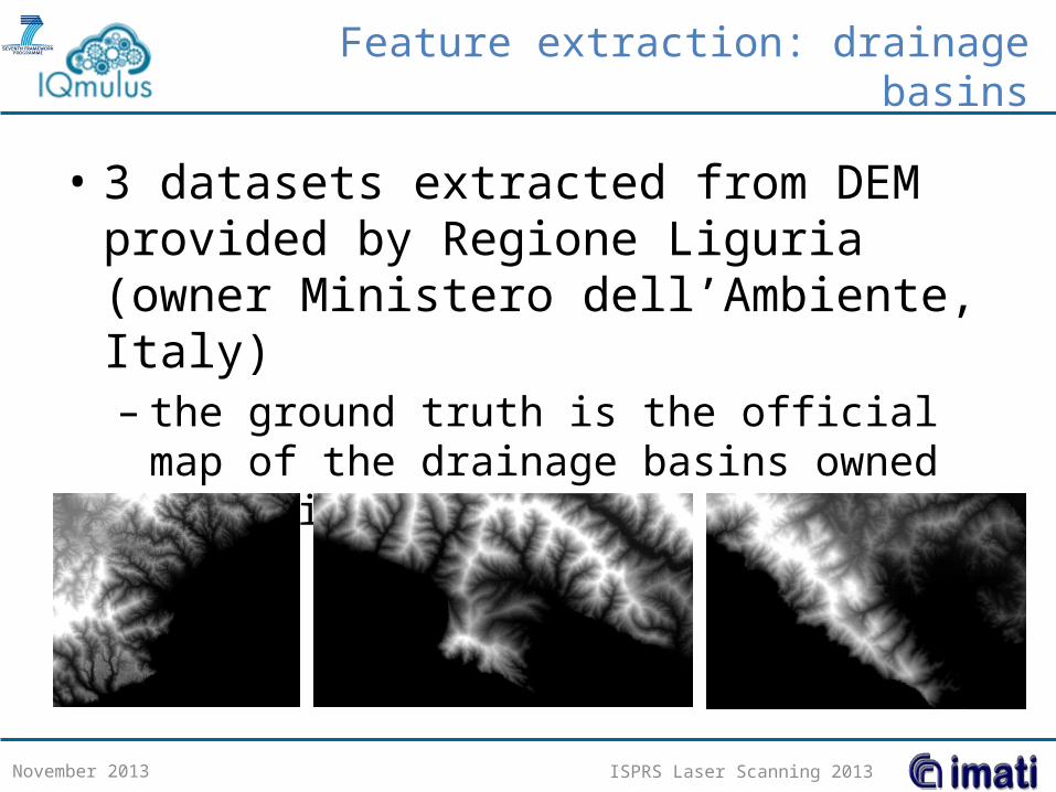
Feature extraction: drainage basins
• 3 datasets extracted from DEM provided by Regione Liguria (owner Ministero dell’Ambiente, Italy)– the ground truth is the official map of the drainage
basins owned by Regione Liguria
November 2013

ISPRS Laser Scanning 2013
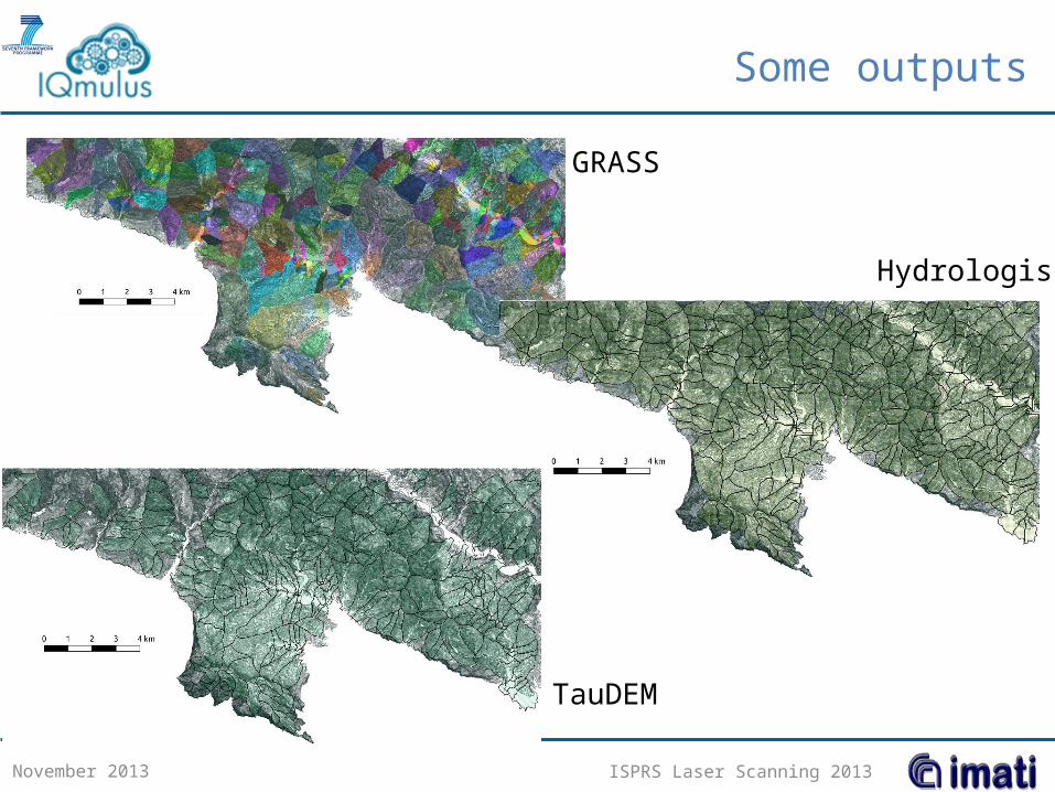
Feature extraction: drainage basins, first results
• The results of three popular methods are available (Hydrologis, GRASS, TauDEM)– Each participant was required to submit up to three runs with
different parameters
November 2013
Portofino’s area
Ground truth
ISPRS Laser Scanning 2013
Some outputs
November 2013
Hydrologis
GRASS
TauDEM

ISPRS Laser Scanning 2013
Visual comparison
November 2013
ISPRS Laser Scanning 2013
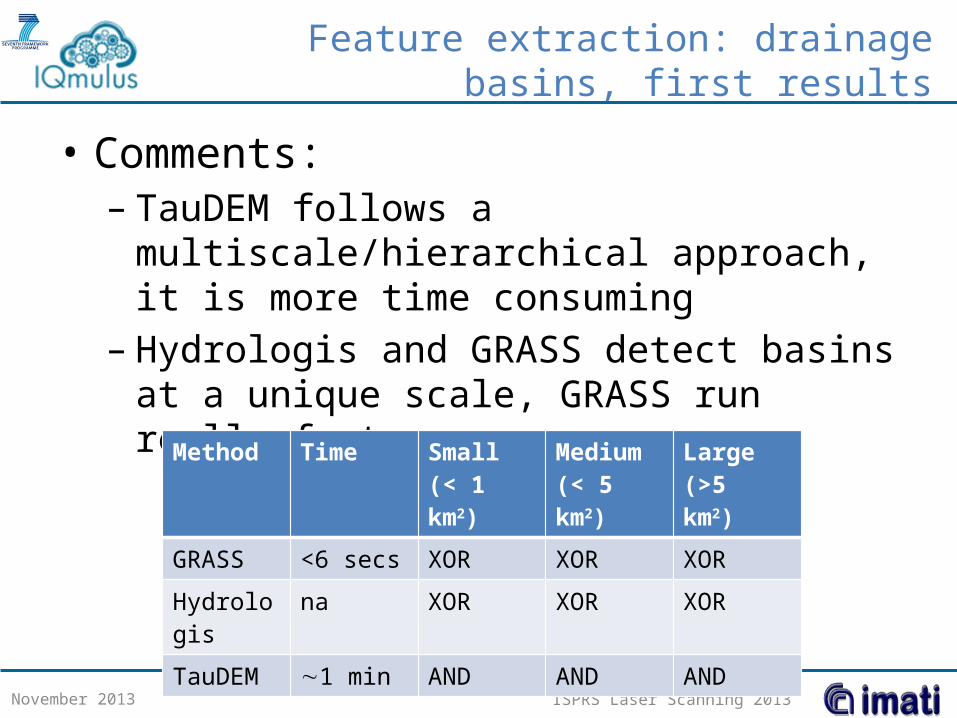
Feature extraction: drainage basins, first results
• Comments:– TauDEM follows a multiscale/hierarchical
approach, it is more time consuming– Hydrologis and GRASS detect basins at a unique
scale, GRASS run really fast
November 2013
Method Time Small (< 1 km2)
Medium(< 5 km2)
Large(>5 km2)
GRASS <6 secs XOR XOR XOR
Hydrologis na XOR XOR XOR
TauDEM 1 min AND AND AND

ISPRS Laser Scanning 2013
Registration track
• 6 datasets – 4 datasets provided by IGN
• the ground truth is known– 2 datasets originated from airborne
Lidar scans provided by Regione Liguria; Gaussian noise is added, the point clouds are rotated and non-uniformly filtered• the ground truth is the original dataset with
the record of the correspondences
November 2013

ISPRS Laser Scanning 2013
Registration track: first results
• Some methods are still running
November 2013
ICP - PCL

ISPRS Laser Scanning 2013
Do you want to familiarize with the contest?
• It is accessible at http://collage.ge.imati.cnr.it/workbench• Sign-in to the infrastructure by sending an email to
[email protected]• We set up a common infrastructure/environment: The
“Collage Authoring Workbench” to access via http protocol– It is possible to upload your own executable, to select the
input/output files and to run it with a «simple» script– Several interpreters (e.g. batch, octave, wine, gnuplot, etc) are
available– The output is a .xml file with a «doi» that can be made publicly
available and linked to (other) webpages
November 2013

ISPRS Laser Scanning 2013
Collage Authoring Workbench
November 2013

ISPRS Laser Scanning 2013
The IQmulus Processing Contest
• Future plans:– Shortly, we’ll made available the report of the
results at http://www.ge.imati.cnr.it/iqmulus_contest
– New track proposals:• Feature extraction• Reconstruction from airborne Lidar scans• …
November 2013

Thanks for your kind attention!
more information at:http://www.ge.imati.cnr.it/iqmulus_contest