investigation on modis fire detection algorithms in ... · 1 investigation on modis fire detection...
TRANSCRIPT
1
Investigation on MODISfire detection algorithms in
Kalimantan island
Keiji Kushida (Hokkaido Univ.)
2
Backgrounds• NASA fire detection algorithm (Giglio et al.,
2003) is based on many pervious studies (e.g.,Justice et al., 2002) and experiences for theglobal application.
• However, it is necessary to study theapplicability in a specific region that has its owncharacteristics (e.g., Liew et al., 2005).
• Especially, the estimation of the backgroundradiance temperature influences on the resultsof the fire detection, while it is affected by theconditions surround the fire (background fires,the atmosphere, reflected solar illumination,and etc.) (e.g., Wang et al., RSE in press).
3
Objectives• To investigate the fire detection algorithm for
Kalimantan island based on NASA fire detectionalgorithm (Giglio et al., 2003) using field-observedfire situations in central Kalimantan,
• To investigate the estimation of the backgroundradiance temperature from NDVI (Huh et al., 2006)and visible to near infrared bands (VIS-NIR), and
• (Working hypothesis) (In the NASA algorithm, theradiance temperature of the backgrounds is used.)It is effective for removing the effects ofbackground fires, the atmosphere to use spectralindices such as NDVI and VIS-NIR bands in theplace of the radiance temperature of each of thepixels.
4
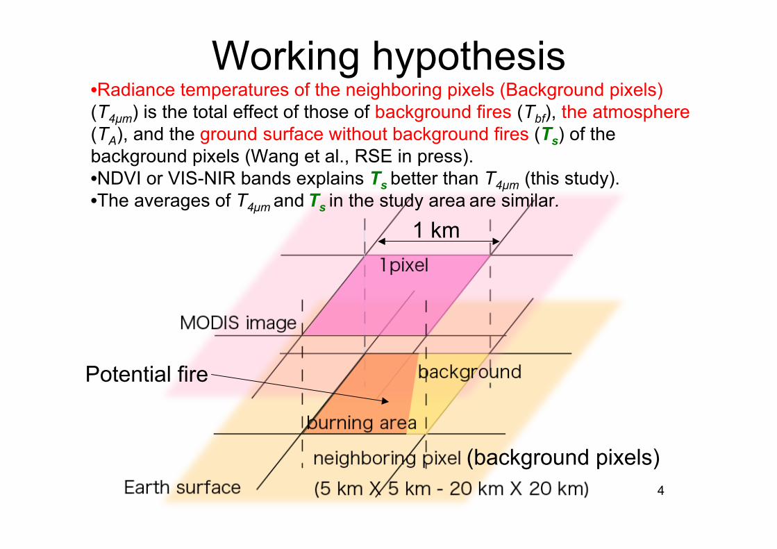
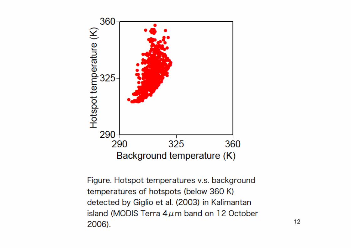
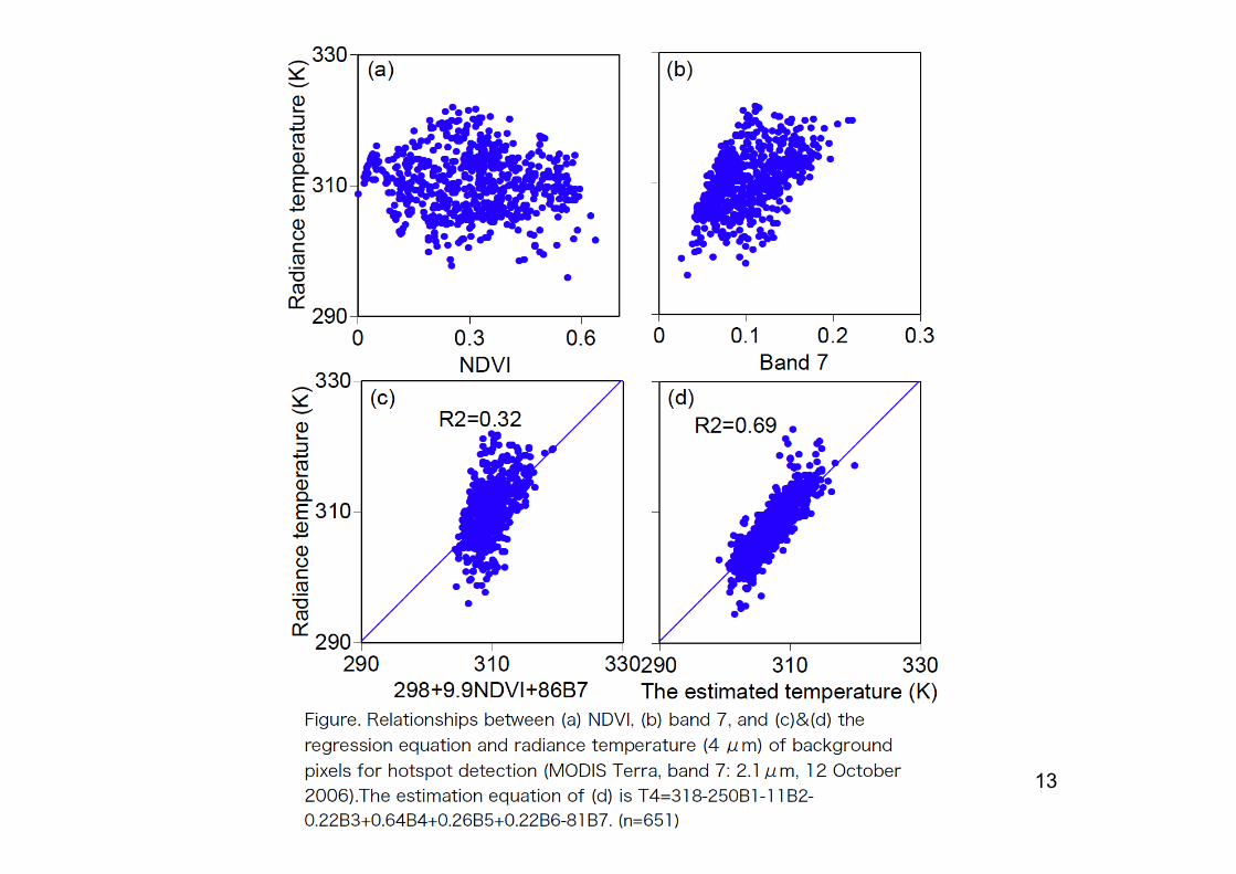
Working hypothesis•Radiance temperatures of the neighboring pixels (Background pixels)(T4µm) is the total effect of those of background fires (Tbf), the atmosphere(TA), and the ground surface without background fires (Ts) of thebackground pixels (Wang et al., RSE in press).•NDVI or VIS-NIR bands explains Ts better than T4µm (this study).•The averages of T4µm and Ts in the study area are similar.
1 km
Potential fire
(background pixels)
5
Methods• Describe the NASA algorithm (Giglio et al.,
2003) in C language (Macintosh X) and checkthe operations using L1B(MOD02),MOD03(geo-location) (downloaded fromDAAC/NASA), MODIS SwathTool (WinXP,USGS), Erdas imagine (WinXP),
• Add the algorithm of radiance temperatureestimation of the background pixels by NDVIand VIS-NIR bands, and
• Apply to MODIS images of Kalimantan(2006.October) and compare the firedetection results of the NASA and the newalgorithms with field-observed fire situations.
6
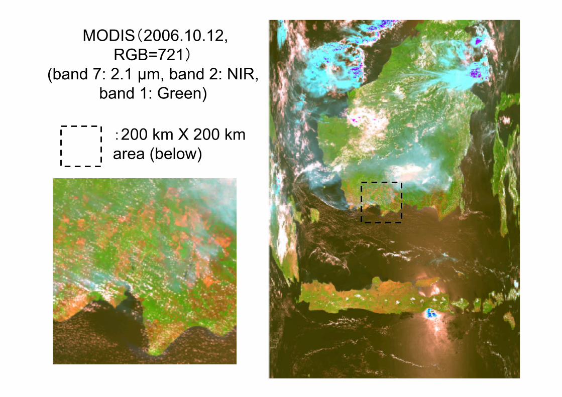
MODIS(2006.10.12,RGB=721)
(band 7: 2.1 µm, band 2: NIR,band 1: Green)
:200 km X 200 kmarea (below)
7
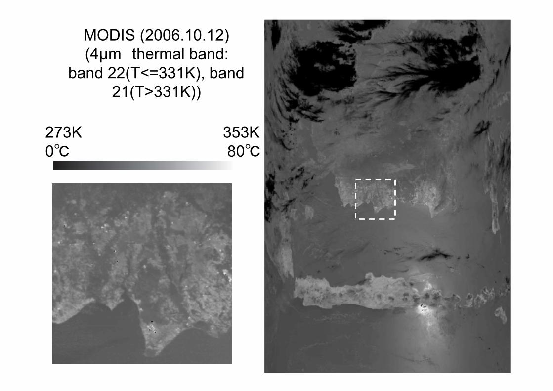
MODIS (2006.10.12)(4µm thermal band:
band 22(T<=331K), band21(T>331K))
273K 353K0℃ 80℃

8
MODIS (2006.10.12)(11 µm thermal band:
band 31)
273K 353K0℃ 80℃
9
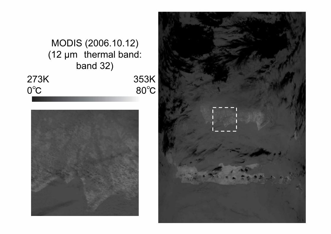
MODIS (2006.10.12)(12 µm thermal band:
band 32)273K 353K0℃ 80℃
10
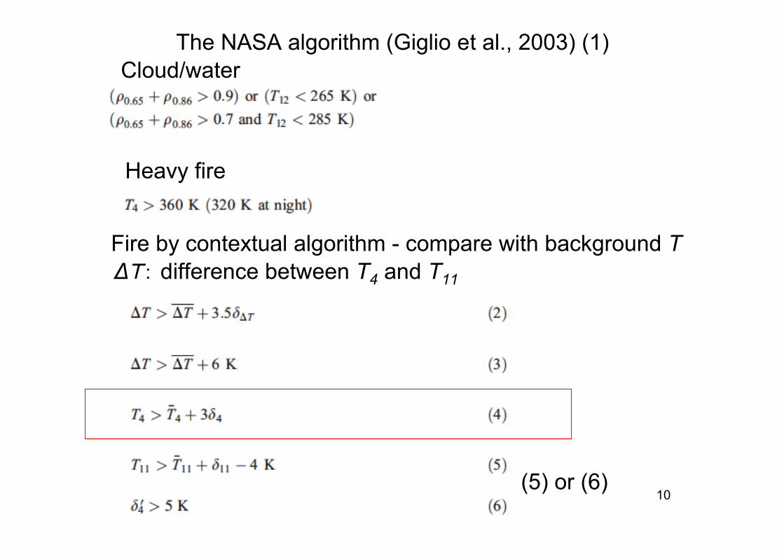
Cloud/water
Heavy fire
Fire by contextual algorithm - compare with background TΔT: difference between T4 and T11
The NASA algorithm (Giglio et al., 2003) (1)
(5) or (6)
11
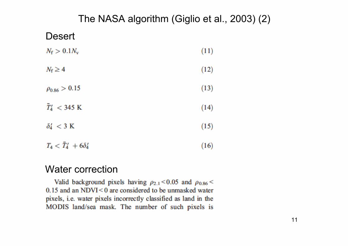
Desert
Water correction
The NASA algorithm (Giglio et al., 2003) (2)
12
13
14
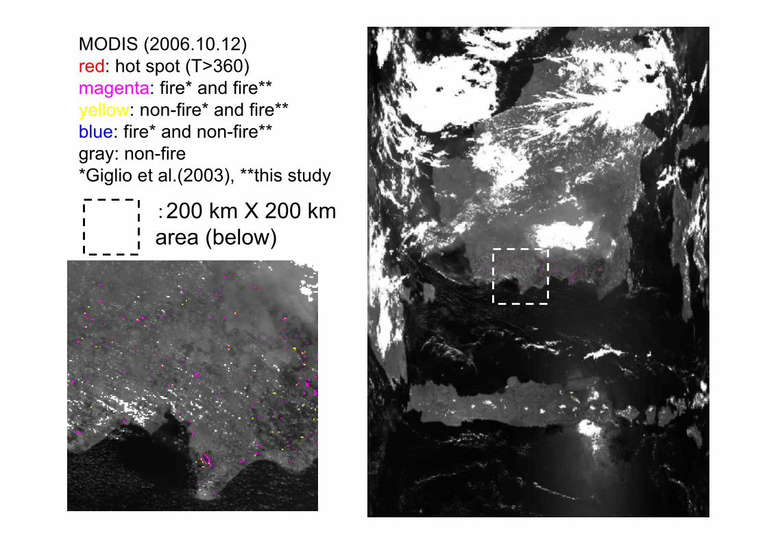
MODIS (2006.10.12)red: hot spot (T>360)magenta: fire* and fire**yellow: non-fire* and fire**blue: fire* and non-fire**gray: non-fire*Giglio et al.(2003), **this study
:200 km X 200 kmarea (below)
15
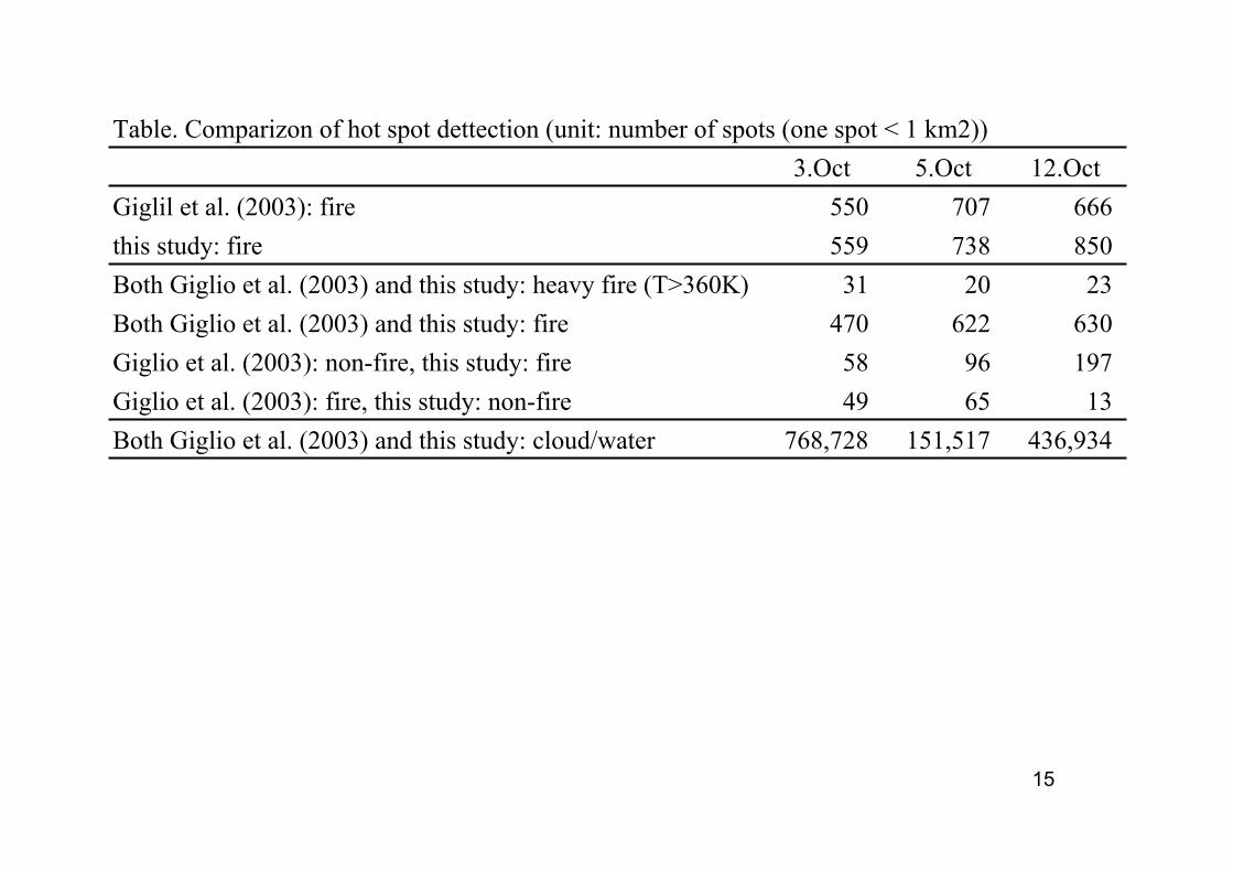
3.Oct 5.Oct 12.Oct
Giglil et al. (2003): fire 550 707 666
this study: fire 559 738 850
Both Giglio et al. (2003) and this study: heavy fire (T>360K) 31 20 23
Both Giglio et al. (2003) and this study: fire 470 622 630
Giglio et al. (2003): non-fire, this study: fire 58 96 197
Giglio et al. (2003): fire, this study: non-fire 49 65 13
Both Giglio et al. (2003) and this study: cloud/water 768,728 151,517 436,934
Table. Comparizon of hot spot dettection (unit: number of spots (one spot < 1 km2))
16
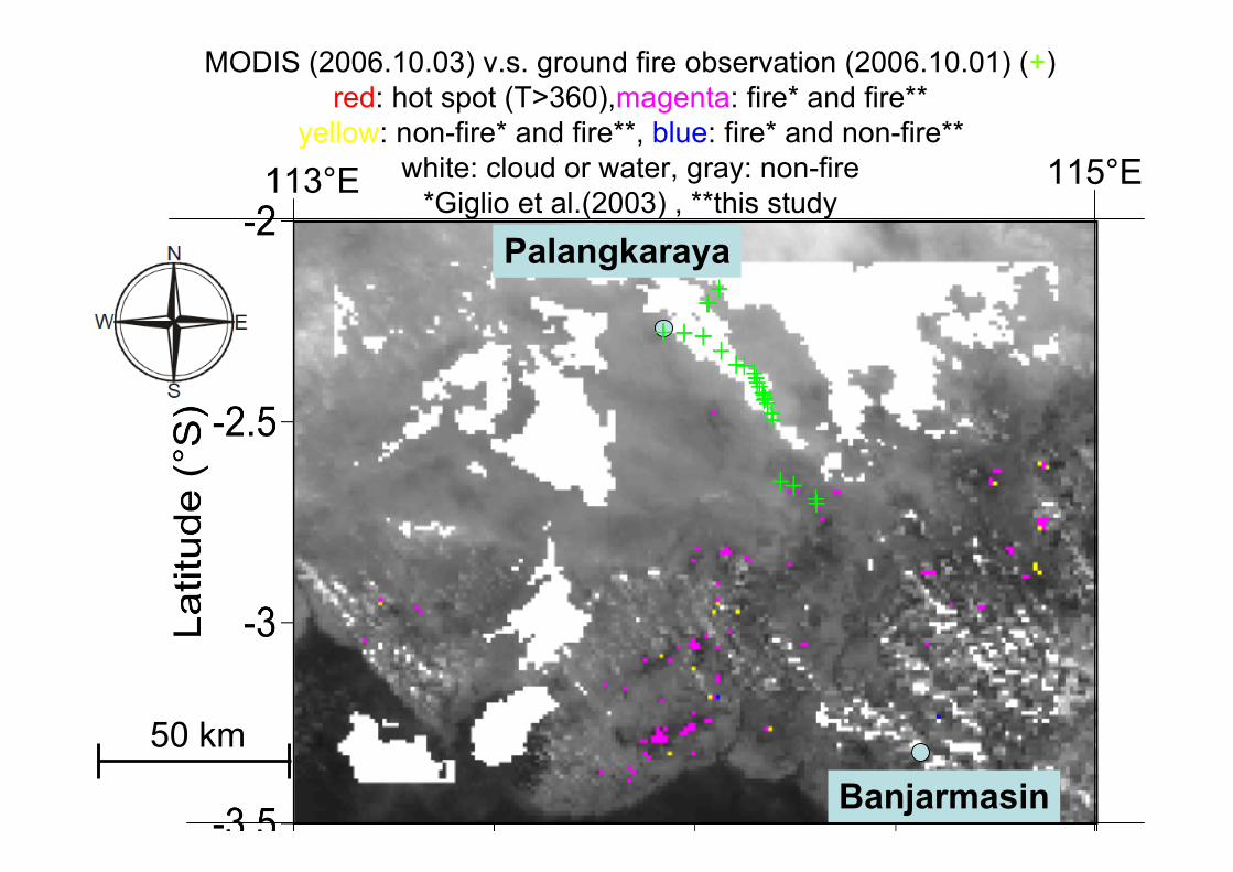
MODIS (2006.10.03) v.s. ground fire observation (2006.10.01) (+)red: hot spot (T>360),magenta: fire* and fire**
yellow: non-fire* and fire**, blue: fire* and non-fire**white: cloud or water, gray: non-fire
*Giglio et al.(2003) , **this study
Palangkaraya
113°E 115°E
Banjarmasin
50 km
17
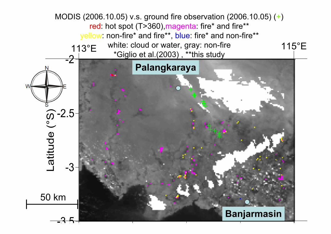
MODIS (2006.10.05) v.s. ground fire observation (2006.10.05) (+)red: hot spot (T>360),magenta: fire* and fire**
yellow: non-fire* and fire**, blue: fire* and non-fire**white: cloud or water, gray: non-fire
*Giglio et al.(2003) , **this study113°E 115°E
Palangkaraya
Banjarmasin
50 km
18
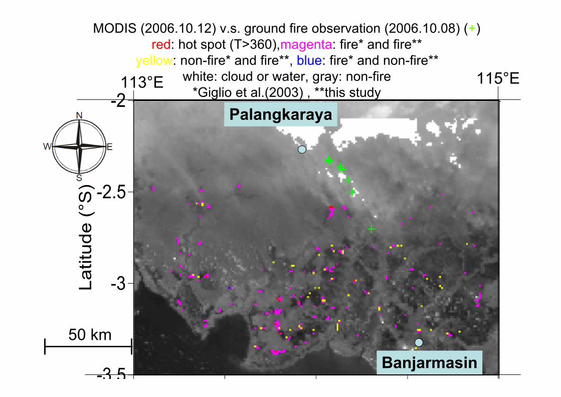
MODIS (2006.10.12) v.s. ground fire observation (2006.10.08) (+)red: hot spot (T>360),magenta: fire* and fire**
yellow: non-fire* and fire**, blue: fire* and non-fire**white: cloud or water, gray: non-fire
*Giglio et al.(2003) , **this study113°E 115°E
Palangkaraya
Banjarmasin
50 km
19
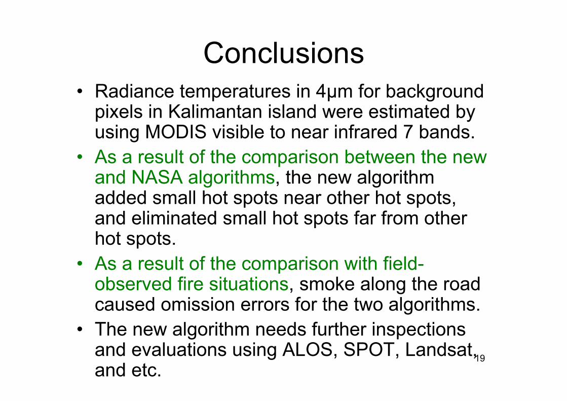
Conclusions• Radiance temperatures in 4µm for background
pixels in Kalimantan island were estimated byusing MODIS visible to near infrared 7 bands.
• As a result of the comparison between the newand NASA algorithms, the new algorithmadded small hot spots near other hot spots,and eliminated small hot spots far from otherhot spots.
• As a result of the comparison with field-observed fire situations, smoke along the roadcaused omission errors for the two algorithms.
• The new algorithm needs further inspectionsand evaluations using ALOS, SPOT, Landsat,and etc.