introduction to low impact development - ced … intro to low impact... · introduction to low...
TRANSCRIPT

Introduction to Low Impact Development Course No: C04-016
Credit: 4 PDH
J. Paul Guyer, P.E., R.A., Fellow ASCE, Fellow AEI
Continuing Education and Development, Inc. 9 Greyridge Farm Court Stony Point, NY 10980 P: (877) 322-5800 F: (877) 322-4774 [email protected]

J. Paul Guyer, P.E., R.A. Paul Guyer is a registered civil engineer, mechanical engineer, fire protection engineer, and architect with over 35 years experience in the design of buildings and related infrastructure. For an additional 9 years he was a senior advisor to the California Legislature on infrastructure and capital outlay issues. He is a graduate of Stanford University and has held numerous national, state and local positions with the American Society of Civil Engineers and National Society of Professional Engineers.
An Introduction to Low Impact Development
G u y e r P a r t n e r s4 4 2 4 0 C l u b h o u s e D r i v e
E l M a c e r o , C A 9 5 6 1 8( 5 3 0 ) 7 7 5 8 - 6 6 3 7
j p g u y e r @ p a c b e l l . n e t
© J. Paul Guyer 2010 1

© J. Paul Guyer 2010 2
This course is adapted from the Unified Facilities Criteria of the United States government, which is in the public domain, has unlimited distribution and is not copyrighted.
CONTENTS 1. INTRODUCTION 2. STORMWATER MANAGEMENT USING THE HYDROLOGIC CYCLE APPROACH 3. LID DESIGN GOALS AND OBJECTIVES 4. COMPARISON OF LID TO CONVENTIONAL PRACTICES 5. DISTRIBUTED MICRO-SCALE SYSTEMS
© J. Paul Guyer 2010 3

1. INTRODUCTION 1.1 DEFINITION OF LID. Low Impact Development (LID) is a stormwater management
strategy concerned with maintaining or restoring the natural hydrologic functions of a
site to achieve natural resource protection objectives and fulfill environmental regulatory
requirements. LID employs a variety of natural and built features that reduce the rate of
runoff, filter out its pollutants, and facilitate the infiltration of water into the ground. By
reducing water pollution and increasing groundwater recharge, LID helps to improve the
quality of receiving surface waters and stabilize the flow rates of nearby streams. LID
incorporates a set of overall site design strategies as well as highly localized, small-
scale, decentralized source control techniques known as Integrated Management
Practices (IMPs). IMPs may be integrated into buildings, infrastructure, or landscape
design. Rather than collecting runoff in piped or channelized networks and controlling
the flow downstream in a large stormwater management facility, LID takes a
decentralized approach that disperses flows and manages runoff closer to where it
originates. Because LID embraces a variety of useful techniques for controlling runoff,
designs can be customized according to local regulatory and resource protection
requirements, as well as site constraints. New projects, redevelopment projects, and
capital improvement projects can all be viewed as candidates for implementation of LID.
Figure 1-1 below depicts the key elements of LID.
© J. Paul Guyer 2010 4
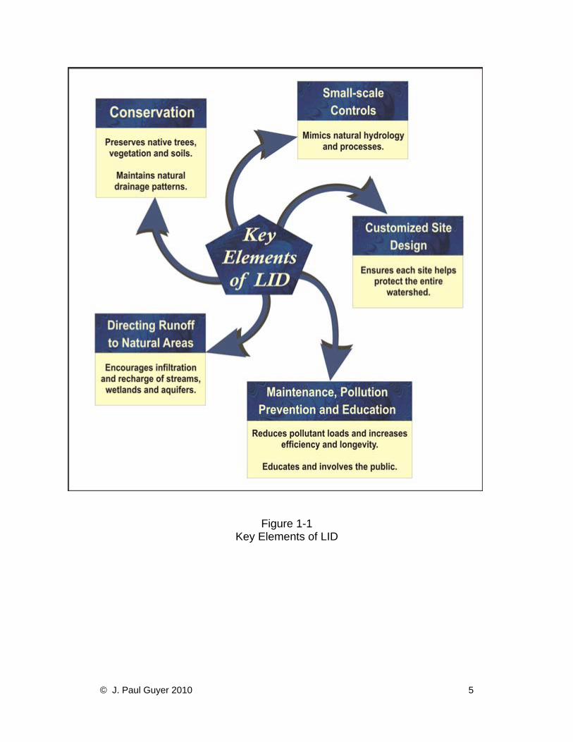
Figure 1-1 Key Elements of LID
© J. Paul Guyer 2010 5
1.2 BACKGROUND ON THE USE OF LID. The use of LID was pioneered in the
1990s by the Prince George’s County, Maryland Department of Environmental
Resources (PGDER). Prince George’s County has a population of over 800,000, and
land uses within the County are very diverse, ranging from sparsely populated natural
and agricultural areas to densely populated urban centers. The LID effort in Prince
George’s County began with the development and use of bioretention cells. A
bioretention cell is created by replacing existing soil with a highly porous soil mixture,
grading the area to form a shallow depression, and replanting the area with specially
selected vegetation. The vegetation must be able to tolerate temporarily saturated soil
conditions as well as the pollutants contained in the local runoff. When it rains,
bioretention areas collect the runoff and then filter out the pollutants as the water
passes down through the soil.
The County’s initial experience with bioretention led to a full-scale effort to incorporate
LID into the County’s resource protection program. In 1998, the County produced the
first municipal LID manual. This was later expanded into a nationally distributed LID
manual published in 2000. A feasibility study was prepared by the Low Impact
Development Center in 2002 that provided guidance on how LID could be used to
retrofit urban areas. Numerous municipalities, including Portland, Oregon, are
incorporating LID techniques into their urban resource protection programs. Although
LID concepts and techniques are new to many planners in the United States, many of
these techniques have been successfully used in Europe and Asia for many years. The
effectiveness of these projects in managing runoff, reducing construction and
maintenance costs, and creating ancillary benefits such as community involvement has
created significant interest in LID. The challenge is to adapt these approaches and
techniques to the unique requirements of facilities on a wider scale.
1.3 THIS DISCUSSION. This discussion provides an introduction to guidelines for
integrating LID planning and design into a facility’s regulatory and resource protection
programs. It will be useful to engineers, planners, maintenance personnel, regulatory
compliance staff, and community outreach staff who want a basic understanding of the
© J. Paul Guyer 2010 6

technical and administrative concepts associated with the design, construction, and
maintenance of LID features. It answers the following questions:
• What is LID and what value does it have for facility owners?
• What are the basic planning, design, construction, and maintenance
considerations?
• How can this approach be incorporated into facility operations?
• Where are successful examples of LID facilities and programs?
• Where can additional guidance be obtained?
1.4 LID SITE DESIGN STRATEGIES. The goal of LID site design is to reduce the
hydrologic impact of development and to incorporate techniques that maintain or restore
the site’s hydrologic and hydraulic functions. The optimal LID site design minimizes
runoff volume and preserves existing flow paths. This minimizes infrastructural
requirements. By contrast, in conventional site design, runoff volume and energy may
increase, which results in concentrated flows that require larger and more extensive
stormwater infrastructure. Generally, site design strategies for any project will address
the arrangement of buildings, roads, parking areas, and other features, and the
conveyance of runoff across the site. LID site design strategies achieve all of the basic
objectives of site design while also minimizing the generation of runoff. Some examples
of LID site design strategies discussed include:
• Grade to encourage sheet flow and lengthen flow paths.
• Maintain natural drainage divides to keep flow paths dispersed.
• Disconnect impervious areas such as pavement and roofs from the storm
drain network, allowing runoff to be conveyed over pervious areas instead.
• Preserve the naturally vegetated areas and soil types that slow runoff,
filter out pollutants, and facilitate infiltration.
• Direct runoff into or across vegetated areas to help filter runoff and
encourage recharge.
• Provide small-scale distributed features and devices that help meet
© J. Paul Guyer 2010 7

regulatory and resource objectives.
• Treat pollutant loads where they are generated, or prevent their
generation.
1.5 LID Devices. Reevaluate the site design once all of the appropriate site design
strategies are considered and proposed to determine whether the stormwater
management objectives have been met. Stormwater management controls, if required,
should be located as close as possible to the sources of potential impacts. The
management of water quality from pavement runoff, for example, should utilize devices
that are installed at the edge of the pavement. These types of controls are generally
small-scale (because the site planning strategies have created small-scale drainage
areas and runoff volumes) and can be designed to address very specific management
issues. The objective is to consider the potential of every part of the landscape, When
selecting LID devices, preference should be given to those that use natural systems,
processes, and materials. The following list briefly defines the LID devices.
1.6 BASIC LIST OF INTEGRATED MANAGEMENT PRACTICES (IMP). Here is a
basic list of IMPs that are available.
• Bioretention: Vegetated depressions that collect runoff and facilitate its
infiltration into the ground.
• Dry Wells: Gravel- or stone-filled pits that are located to catch water from roof
downspouts or paved areas.
• Filter Strips: Bands of dense vegetation planted immediately downstream of a
runoff source designed to filter runoff before entering a receiving structure or
water body.
• Grassed Swales: Shallow channels lined with grass and used to convey and
store runoff.
• Infiltration Trenches: Trenches filled with porous media such as bioretention
material, sand, or aggregate that collect runoff and exfiltrate it into the ground.
© J. Paul Guyer 2010 8

• Inlet Pollution Removal Devices: Small stormwater treatment systems that are
installed below grade at the edge of paved areas and trap or filter pollutants in
runoff before it enters the storm drain.
• Permeable Pavement: Asphalt or concrete rendered porous by the aggregate
structure.
• Permeable Pavers: Manufactured paving stones containing spaces where water
can penetrate into the porous media placed underneath.
• Rain Barrels and Cisterns: Containers of various sizes that store the runoff
delivered through building downspouts. Rain barrels are generally smaller
structures, located above ground. Cisterns are larger, are often buried
underground, and may be connected to the building’s plumbing or irrigation
system.
• Soil Amendments: Minerals and organic material added to soil to increase its
capacity for absorbing moisture and sustaining vegetation.
• Tree Box Filters: Curbside containers placed below grade, covered with a grate,
filled with filter media and planted with a tree in the center.
• Vegetated Buffers: Natural or man-made vegetated areas adjacent to a water
body, providing erosion control, filtering capability, and habitat.
• Vegetated Roofs: Impermeable roof membranes overlaid with a lightweight
planting mix with a high infiltration rate and vegetated with plants tolerant of heat,
drought, and periodic inundation.
© J. Paul Guyer 2010 9

2. STORMWATER MANAGEMENT USING THE HYDROLOGIC CYCLE APPROACH 2.1 INTRODUCTION. Development affects the natural hydrologic cycle. The
hydrologic cycle consists of the following processes:
• Convection
• Precipitation
• Runoff
• Storage
• Infiltration
• Evaporation
• Transpiration, and
• Subsurface flow.
A hydrologic budget describes the amounts of water flowing into and out of an area
along different paths over some discrete unit of time (daily, monthly, annually).
Grading, the construction of buildings, and the laying of pavement typically affect the
hydrologic budget by decreasing rates of infiltration, evaporation, transpiration and
subsurface flow, reducing the availability of natural storage, and increasing runoff. In a
natural condition such as a forest, it may take 25 to 50 mm (one to two inches) of rainfall
to generate runoff. In the developed condition, even very small amounts of rainfall can
generate runoff because of soil compaction and connected impervious areas. The result
is a general increase in the volume and velocity of runoff. This, in turn, increases
the amount of pollution that is carried into receiving waters and amplifies the generation
of sediment and suspended solids resulting from bank erosion.
2.2 DESIGN INPUTS. Both LID and conventional stormwater management techniques
attempt to control rates of runoff using accepted methods of hydrologic and hydraulic
analysis. The particular site characteristics that are considered will depend on the
nature of the project. Land use, soil type, slope, vegetative cover, size of drainage area
and available storage are typical site characteristics that affect the generation of runoff.
© J. Paul Guyer 2010 10

The roughness, slope and geometry of stream channels are key characteristics that
affect their ability to convey water. While conventional approaches to stormwater
management design typically include only the hydrologic components of precipitation,
runoff conveyance and storage capacity within their scopes, LID design recognizes the
significance of other components of the hydrologic cycle as well. How these other
components are actually taken into account will depend on the information available and
purpose of the design. One LID design objective, for example, may be to maintain a
natural groundwater recharge rate for a given site. Determining the appropriate number,
size, and location of infiltration devices can require an extensive atmospheric data set
(temperature and precipitation) to calculate evapotranspiration rates, along with
measures of soil hydraulic conductivity. The following section describes how LID design
can make use of precipitation, storage, infiltration, evaporation, and transpiration data.
The discussion includes a brief description of each of these types of data, and
compares the use of these data from LID and conventional stormwater management
perspectives.
2.3 PRECIPITATION DATA. Precipitation data is often analyzed in terms of the
frequency at which storm events of different magnitudes and durations occur at a given
location. Stormwater management designs may take into account the total annual
depths or the volume generated by a storm of a specific frequency and duration (e.g. 2-
year 24-hour storm event). Hydrologic models may use precipitation data to develop a
synthetic design storm that reflects the pattern and intensity of precipitation for the
project location region or use actual gage data from a given storm event. The level of
detail and accuracy of data used is dependent on the requirements of the hydrologic
model. For example, to develop a simple water balance for on-site irrigation only a few
years of annual rainfall totals may be required. Some advanced urban hydraulic models,
on the other hand, may require the collection of rainfall data in 2-minute intervals over
several years to determine the appropriate system design.
2.3.1 LID Precipitation Analysis. An important approach to analyzing the effectiveness
of an LID design is to consider the number of storm events for which the design will
© J. Paul Guyer 2010 11

provide enough storage and infiltration capacity to capture all of the precipitation on-site.
This is useful because maintaining the hydrologic integrity or water balance of a site is
better accomplished by managing the frequent smaller events rather than the
occasional large events. For example, in the Washington, D.C. region there are
approximately 80 storm events per year that collectively generate approximately 1000
mm (40 in) of precipitation. Approximately 75 of these storm events generate 13 mm
(0.5 in) or less of precipitation. Figure 2-1 illustrates this concept.
Figure 2-1
Frequency of Small Storms
© J. Paul Guyer 2010 12
This kind of analysis allows the designer to determine the overall storage and infiltration
capacity required to control the desired number of storm events within any given year or
period. The analysis can also be undertaken in terms of the precipitation depth
associated with discrete storm events such as the 1-year 24-hour storm.
2.3.2 Conventional Precipitation Analysis. Conventional practices, as well as many
state and local regulations, often require site engineers to control only specific events
such as the 2-year 24-hour storm events. In the Washington, D.C. area, this would
mean reducing the peak runoff to predevelopment rates for only those events in which
76 mm (3 in) of rainfall. Events that occur more or less frequently would be less
effectively controlled.
2.4 STORAGE. Precipitation may be temporarily detained within site depressions or
held in the soil. When the capacity of a depression is exceeded, the water is released
as runoff that may be captured further downstream. Water that is not released as runoff
will be infiltrated into the soil, taken up by plants, or evaporated back into the
atmosphere. Natural land cover often provides depression storage in small undulations
in the topography. Greater storage capacity is provided in ponds or lakes.
2.4.1 LID Storage Concepts. LID employs site planning and grading techniques to
direct or maintain the flow of runoff to naturally occurring storage areas such as
wetlands. Keeping the storage area volume stable helps to maintain the existing
hydrologic and biological function of the storage area. An LID design may also include
small-scale retention components (retention is defined as the volume of runoff that
never reaches the drainage area outlet). Retention can be provided in a variety of ways
that not only support the management of runoff, but also supply water for on-site use.
For example, a cistern may be used to store and release water for peak flow control as
well as to store water for domestic purposes. Additionally, some industrial buildings can
provide roof storage and release water for use in cooling systems. Another example is a
green wall within a building. The green wall is used to modify temperature and improve
air quality by having stored roof water flow across the vegetation. Capturing runoff in
© J. Paul Guyer 2010 13
small volumes helps to prevent erosion, because the runoff is less likely to reach
damaging flow rates. The distribution of storage components also tends to result in a
more robust stormwater management system, because the failure of one component
will not cause the entire system to fail. Care must be taken when ponding or storing
water to make sure there is adequate flow, infiltration, evaporation, or discharge, and
that unwanted carriers of disease such as mosquitoes are adequately controlled.
2.4.2 Conventional Storage Concepts. Conventional stormwater strategies often
include the storage of water in large centralized end-of-pipe facilities. Site designs direct
and convey most runoff as quickly as possible to these facilities and then discharge
through an outlet structure at a limited release rate (e.g., 2-year 24-hour
predevelopment runoff rate). Conventional runoff management techniques can
dramatically reduce the flow of runoff into natural storage areas such as wetlands,
depriving a variety of organisms of the level of moisture they need. Conventional
approaches can have other negative impacts. By removing opportunities for storage
onsite, rates of ground water recharge will be reduced. In addition, the concentrated
flow conveyed to large-scale facilities accumulates pollutants and increases the erosive
force of the water, which must be slowed down and treated to maintain the natural
energy and chemical balance of the ecosystem. An increase in temperature as the
water is pooled may also be detrimental to the ecological integrity of the receiving water.
2.5 INFILTRATION. Water stored in depressions will infiltrate into the soil at different
rates, depending on the soil type and the amount of moisture already in the soil. Some
of the water that infiltrates into the ground may then percolate further downward into an
aquifer, or travel horizontally and reappear as surface flow in a stream. A portion of the
water will be held in the soil and extracted by vegetation. The capacity of the soil to
absorb and infiltrate water is dependent on a variety of factors such as soil structure
(e.g., pore spaces and particle size), classification (percentage of sand, silt, and clay)
and biological activity (e.g., roots, worms). Water is filtered by the soil system by various
mechanisms such as adsorption and chemical and biological reactions. Under natural
conditions, a significant portion of the annual precipitation may infiltrate into the ground.
© J. Paul Guyer 2010 14

As land is developed, however, many natural depressions that would otherwise collect
water are eliminated, the soil is compacted, and impervious area is added in the form of
buildings and pavement. Consequently, levels of infiltration typically decrease when a
site is developed. The additional runoff generated often results in degradation of the
watercourse because of bank erosion, increased flooding, and alteration of habitat
characteristics. The infiltration flow patterns and processes are extremely important to
maintain the water balance in wetlands and the base flow in stream channels.
2.5.1 LID Infiltration Concepts. Maintaining natural infiltration rates is an important
aspect of LID design. Accomplishing this requires an accurate understanding of the
existing soils and groundcover conditions. For example, a clay soil on a predevelopment
site may have very little infiltration capacity or a sandy soil, which is compacted, may
have reduced capacity. The design should take care not to overload the hydraulic
conductivity of existing soils. Soil maps by themselves are not sufficient to determine
the capacity of the soils to absorb and filter water; additional field testing is required.
Dispersing flows, maintaining natural flow patterns, and directing flows towards soils
with high capacities for infiltration will help maintain ground water levels. Amending soils
by adding organic materials, reducing compaction by aeration, maintaining leaf or “duff”
layers in natural areas, and reducing compaction requirements for non-load bearing
areas will also enhance and maintain infiltration rates and patterns. Although soils and
natural areas have a high capacity to filter and treat pollutants, careful planning must
take place to ensure that potential pollutants such as nitrates, oils, or other urban runoff
contaminants are adequately treated before entering any potential water supply.
Infiltration areas should not be located near areas that have potential for hazardous
waste spills or contamination. It is important to ensure that runoff is adequately filtered
before it is allowed to infiltrate, especially if local aquifers are particularly shallow. In
cases where the water table is very high, it is often advisable to avoid infiltration
altogether.
2.5.2 Conventional Infiltration Concepts. Conventional approaches concentrate on
the infiltration capacity of a single end-of-pipe management facility such as a pond.
© J. Paul Guyer 2010 15
Infiltration potential elsewhere on the site is often discounted or only analyzed for its
effect on the flow of runoff into the facility. The conventional infiltration objective is to
concentrate flows in one area and then utilize the infiltration capacity of the natural soil
or conduits such as gravel. Natural groundwater flow patterns and recharge are often
not considered. Conventional approaches may result in the elimination of critical
volumes of flows to sensitive areas such as wetlands. Additionally, in many urban
areas, the high loads of fine sediments to centralized facilities and the impacts of
construction compaction can severely limit the infiltration capacity of the facility.
2.6 EVAPOTRANSPIRATION. Evapotranspiration is the loss of water from the ground
by evaporation and transpiration. Evaporation is the return of moisture to the
atmosphere from depressions, pond areas, or other surfaces. Transpiration is the return
of water to the atmosphere through plants; moisture is absorbed by the roots and
released through the leaves. The rate of evapotranspiration is dependent on air
temperature, humidity, wind speed, sunlight intensity, vegetation type, and soil
conditions.
2.6.1 LID Evapotranspiration Concepts. LID designs use open areas and vegetation
to promote evapotranspiration. Larger areas used for evaporation, such as ponds,
should have a flow regime that controls mosquito breeding. LID designs should not
pond water for more than 72 hours as it may provide an opportunity for mosquitoes to
breed. By keeping surface areas small and shallow, water can quickly evaporate and
pollutants volatilize through plant uptake or evaporation. LID designs also employ the
capacity of vegetated areas to absorb, process, volatilize, and treat non-point source
pollution as well as atmospheric pollution. Interception by leaves can significantly
reduce the requirement for storage and infiltration. A mature canopy can intercept a
significant number of small-volume, frequently occurring storms, absorbing precipitation
into the plant leaves or evaporating precipitation from the leaf surface. Additionally,
uptake of soil moisture by plants helps to maintain the soil’s capacity to absorb rainfall.
© J. Paul Guyer 2010 16

2.6.2 Conventional Evaporation Concepts. Conventional stormwater approaches are
based on peak flow control over a short duration (usually 24 hours or less). For these
single event designs, the evaporation process is often discounted or not considered.
© J. Paul Guyer 2010 17

3. LID DESIGN GOALS AND OBJECTIVES 3.1 INTRODUCTION. Agencies are faced with the responsibility of managing and
protecting the natural resources of often large parcels of land reserved for many
different functions. Uses can be intensive and can pose a variety of stormwater
challenges. For example, an industrial facility or supermarket may generate stormwater
pollutants and alter the downstream hydrology. There is no single management
practice that can be universally applied to all drainage areas. Table 3-1 illustrates the
removal effectiveness of various BMPs (Best Management Practices) for a variety of
pollutants. The table below illustrates the complexity of stormwater management; there
is no single BMP or technique that can be used to effectively address all of the potential
watershed issues.
Particle Size Grading Treatment Measures Hydraulic Loading
(µm) (m/yr) _________________ _________________________ _______________
Gross solids (>5000) Gross Pollutant Traps 1,000,000 to 100,000 Coarse-to-Medium Particulates Gross Pollutant Traps 50,000 to 5,000
(125 to 5000) Sedimentation Basins Grass Swales/Filter Strips Surface Flow Wetlands
Fine Particulates Sedimentation Basins 2,500 to 1,000 (125 to 10) Grass Swales/Filter Strips
Surface Flow Wetlands Infiltration Systems Sub-Surface Flow Wetlands
Very Fine Colloidal Particulates Grass Swales/Filter Strips 500 to 50 (10 to 0.45) Surface Flow Wetlands
Infiltration Systems Sub-Surface Flow Wetlands
Dissolved Particles Surface Flow Wetlands 10 (<0.45) Infiltration Systems
Sub-Surface Flow Wetlands
Table 3-1
© J. Paul Guyer 2010 18

3.2 REGULATORY AND NATURAL RESOURCE DESIGN ISSUES. Many regulatory
compliance or flood control (peak rate design) schemes for construction are designed to
achieve only one objective (e.g., pre-development control for the 2-year 24- hour storm
event). Regulations often fail to consider overall natural resource management,
hydrologic objectives, and stewardship responsibilities of facilities. Budget constraints
often limit construction funding to that necessary for conveyance or flood control
requirements. The limited framework may create situations where regulatory
requirements are met but the design results in degradation of the natural resources. LID
principles use hydrology as the integrating framework of design, and protect the overall
ecology of the watershed. LID allows facilities to meet the regulatory requirement for
flood control (by storing and infiltrating a sufficient volume) while sufficiently filtering
targeted pollutants through natural and man-made systems.
3.3 FUNDAMENTAL SITE PLANNING CONCEPTS. The goal of LID site planning is to
allow for full development and function of the intended site activity while maintaining the
site’s essential natural or existing hydrologic function. The LID site design process is
sequential and iterative, and embraces the following five concepts:
• Hydrology is the Integrating Framework for the Design
• Distribute Controls through Micromanagement
• Stormwater is Controlled at the Source
• Utilize Non-structural Systems Where Possible
• Create Multifunctional Landscape, Buildings and Infrastructures
3.3.1 Hydrology is the Integrating Framework for the Design. LID designs have the
goal of mimicking the natural site drainage processes and functions. Techniques are
used to modify hydrologic processes, such as infiltration or storage, to meet the specific
water quality, water quantity, and natural resource objectives. LID designs create an
effective drainage process for stormwater on the site. A stormwater management
system will come closest to mimicking natural flow patterns when storage and infiltration
components are distributed across the site.
© J. Paul Guyer 2010 19
3.3.2 Distribute Controls Through Micromanagement. In order to emulate natural
processes, it is imperative to view the site as a series of interconnected smallscale
design controls. Such a structure creates opportunities for redundancy in treatment and
control, the development of a “treatment train” for water quality control, and the
opportunity to strategically locate LID components.
3.3.3 Stormwater is Controlled at the Source. Controlling and treating runoff as it is
being generated reduces or eliminates the risks associated with transporting pollutants
further downstream through pipes and channels. Management of stormwater at the
source is especially valuable if remediation is required, such as in the case of an
accidental spill of pollutants, because the problem can be easily isolated or the
treatment system adjusted.
3.3.4 Incorporate Non-Structural Systems. LID designs recognize the potential of
natural systems to intercept and filter pollutants. Phytoremediation techniques that take
advantage of the biological and chemical processes of the plant soil complex have
shown tremendous potential in stormwater management. These natural systems are
easy to design, construct, and maintain, even though the naturally occurring filtering and
treatment processes may be quite complex and multidimensional. Benefits of using
these small-scale and simplified systems (such as soil amendments, landscaping, or
revegetation) include the reduced need for costly large-scale construction projects (such
as underground concrete vaults or proprietary filters). Figure 3-1 illustrates the range of
biological and chemical processes that have been documented to occur in a
bioretention cell. The bioretention cell is a landscape area constructed of specialized
soil and plants that can effectively absorb and treat urban runoff.
© J. Paul Guyer 2010 20

Figure 3-1
Biological and Chemical Processes that Occur in a Bioretention Cell Source: Prince George’s County, Maryland Department of Environmental Resources (PGDER), 2000.
3.3.5 Utilize Multifunctional Landscape, Buildings and Infrastructures. There are a
wide variety of LID practices available. The primary criterion in selecting LID practices is
that the design of the component contributes to satisfying the design and regulatory
objectives. Design features are often multifunctional and satisfy multiple objectives. The
development of vegetated roofs is a good example. A vegetated roof can reduce the
effects of atmospheric pollution, reduce runoff volume and frequency, reduce energy
costs, create an attractive environment, and have reduced replacement and
maintenance, and longer life cycle costs. There are many types of vegetated roofs that
can be developed including pre-made grids, or cells, or whole systems.
© J. Paul Guyer 2010 21

3.4 LID MANAGEMENT AND DESIGN STRATEGIES. LID design is an iterative
process that requires a thorough understanding of the management objectives, a
detailed understanding of the physical and natural resources of the site, a conceptual
site design that can be refined to achieve the goal of a hydrologically functional
landscape, and a long-term maintenance plan.
3.4.1 LID Site Planning Components. This section presents the aims of LID site
planning and, in light of existing site development requirements, describes how LID site
design can be best approached to manage runoff.
3.4.1.1 Hydrologic and Hydraulic Objectives. The purpose of LID site planning is to
significantly maintain the predevelopment runoff volume and flow rate. Ideally, and
where site conditions allow, this will be achieved in a way that replicates the site’s
predevelopment hydrologic functions. Sites that are characterized before development
by porous soils, substantial vegetative ground cover, and ungraded topography
naturally perform several important hydrologic functions:
• Facilitate infiltration, evapotranspiration, retention and detention of runoff
• Limit runoff flow rates because of ground surface roughness
• Help control water quality through surface and subsurface filtering of pollutants
and sediments
On a developed site, these hydrologic functions can continue to be provided by the
preservation of natural features or construction of a variety of man-made features.
Taken together, the utilization of these features comprises a distributed source control
strategy that is designed to not only meet regulatory requirements but also to provide
superior natural resource protection. Maintaining areas with high soil porosity,
vegetative ground cover, and shallow ponding will help meet the following objectives:
• Flood control. Facilitating the infiltration of runoff and decreasing overland flow
rates reduces the risk of flooding in receiving waters. To meet design objectives
© J. Paul Guyer 2010 22

and regulatory requirements completely, supplemental controls may still be
required.
• Volume Control. The overall volume of runoff that leaves a site is kept as close
as possible to predevelopment levels.
• Peak Control. The peak runoff rate does not increase above predevelopment
levels, and the entire runoff hydrograph emulates the predevelopment
hydrograph.
• Filtering and Treatment of Pollutants. Runoff is directed across vegetated areas
and through porous media to provide significant reductions in the concentration
of sediments and pollutants in the water.
• Groundwater Recharge. Infiltration is expedited to enhance groundwater
recharge rates and help sustain base flows in nearby streams.
3.4.2 LID Design Approach. The LID approach to site design seeks to maintain or
restore the hydrologic impacts of site development using a combination of runoff
management strategies, site design techniques, and distributed source controls (IMPs).
LID design requires that site plans address the overall natural resource and compliance
issues within the watershed. The long-term success of this approach requires an
understanding of the maintenance requirements and life-cycle effectiveness of the LID
practices and the development of an appropriate maintenance and pollution prevention
plan for the facility.
While the influence of each of the components of the design process varies from site to
site, a general process has been developed to ensure that all of these components are
considered. Although the preference in LID design is to reduce the hydrologic impacts
on the site and to retain naturally effective hydrologic features, it is recognized that
significant impacts may occur because of the nature of certain activities. When
compensating features are required, LID emphasizes the use of integrated site features
that control runoff as close as possible to the source, rather than transporting pollutants
and attempting to mitigate for lost functions elsewhere. Table 3-2 illustrates the general
flow of the design process.
© J. Paul Guyer 2010 23

1. Conserve Natural Areas 2. Minimize Development Impacts 3. Maintain Watershed Timing 4. Provide Integrated Management Practices (IMP) 5. Manage for Pollution Prevention
Table 3-2
LID Design Process
This approach is often an iterative process that requires several attempts to
balance all of the design components in the most economical and environmentally
effective way. Described below are the individual design components.
3.4.2.1 Conservation of Natural Areas. LID is a stormwater management strategy
that addresses the overall regulatory and resource protection goals of a site in a
watershed context. Because development typically occurs incrementally, this approach
will allow for adjustments or modifications to site design strategies and techniques to
reflect dynamic resource protection and regulatory issues. Communities and bases
often have extensive watershed management and natural resources conservation
goals; master plans identify sensitive environmental areas and preservation areas such
as wetlands, mature woods, and habitats. The LID site design should address any
potential impacts to these areas and encourage conservation of these areas within the
site. Examples of conservation include:
• Preserving a forest corridor that connects with an existing stream valley
• Maintaining flow volume and discharge rates to offsite wetlands
• Incorporating buffers around sensitive habitat areas
© J. Paul Guyer 2010 24
3.4.2.2 Minimization of Development Impacts. Within the portion of the site selected
for the placement of roads, buildings, and other development activities, minimal
disturbance techniques (site fingerprinting) can be used to avoid soil compaction, retain
mature trees, and limit the environmental impact of staging areas. Examples of minimal
disturbance techniques include:
• Delineating and flagging the smallest site disturbance area possible
• Minimizing the size of construction impacts or offsite easements and property
acquisition
• Minimizing the size of material storage areas during and after construction
• Maintaining flow patterns
3.4.2.3 Control of Watershed Timing and Runoff Patterns. Maintaining the site’s
natural runoff control areas and restricting building over the site’s more pervious soils
will help keep the infiltration capacity of the site close to predevelopment levels.
Maintaining the watershed timing of a site is also important. The cumulative effects of
decreasing the post-development watershed times of concentration of several sites can
have a significant impact on downstream habitat. It is also desirable to maintain natural
vegetation in steeply sloped areas and to retain natural drainage divides. This will
encourage dispersed flow paths and, consequently, help reduce the development of
channels that lead to erosion and flooding problems. Adequate drainage from buildings,
walkways, and roads must be provided. Traditional designs often create a drainage
system that has the effect of increasing the rate at which runoff moves into receiving
waters during storm events. In turn, this produces a higher volume of runoff, a higher
peak rate of flow, and an earlier runoff event than would occur under less developed
conditions. The opportunity for groundwater recharge is eliminated, because infiltration
into swales and grassed areas cannot effectively occur if runoff passes through quickly.
The overall grading objective for LID is to provide a surface landform that will distribute
flows in a shallow and slow moving pattern toward areas where the infiltration capacity
is highest. Examples of LID techniques to control rates of runoff and watershed timing
include:
© J. Paul Guyer 2010 25
• Use flatter rather than steeper grades, provided that adequate drainage for
buildings and traffic is maintained
• Reduce the height of slopes, to prevent runoff from gaining speed as it moves
downhill
• Where flow begins to accumulate, increase the length of flow paths, diverting and
redirecting the flow, preferably with vegetated features
• Minimize use of curb and gutter systems and piped drainage systems in favor of
grassed swales
• Minimize the amount of impervious area used for pavement
• Disconnect impervious areas by directing runoff from buildings and pavements
onto lawns or other vegetated areas, keeping flow velocities at a level that will
not cause erosion
• Preserve naturally vegetated areas and existing topography in places where
these help slow runoff and encourage infiltration
• Use weirs and check dams in swales
3.4.2.4 Use of Integrated Management Practices (IMPs). Once all of the design
strategies and techniques have been implemented, IMPs are selected to achieve the
site water quality and quantity objectives. IMPs are distributed, multifunctional, small-
scale controls, selected based on their ability to achieve the site design water quality
and quantity objectives in a cost effective manner. IMPs are not a “one-size-fits-all”
approach. For example, using amended soils to filter and store runoff may be
appropriate for a rural road section with high traffic but inappropriate next to a parking
area that may be subjected to compaction from overflow parking or vehicle movement.
3.4.2.5 Pollution Prevention. The goal of pollution prevention is to reduce, reuse and
recycle a variety of pollutants before they become environmental problems. The final
step of the LID design approach is to incorporate programs that keep pollution out of
runoff in the first place and, consequently, to increase the longevity of the IMPs.
Reduction of fertilizer, pesticide and herbicide use and the implementation of regular
street sweeping are some common pollution prevention activities.
© J. Paul Guyer 2010 26
3.5 DESIGN GUIDANCE AND STANDARDS 3.5.1 Methods to Determine Effectiveness. Stormwater projects are typically
designed with a particular objective in mind, such as flood control or water quality
improvement. Such projects typically require that the designer evaluate the
effectiveness of the proposed treatments at meeting the stated objectives. A number of
hydrologic models have been developed to model surface runoff from a given drainage
area. Because conventional models are primarily concerned with computing flow rates
or flood hydrographs at a point of interest, this approach to hydrologic analysis must be
modified in cases where not all of the runoff from a given site converges to a single
point. Typical watershed models take into account general land cover and stream
channel characteristics. To account for LID features and runoff management devices,
refinement of the analysis may be desirable. A variety of tools are freely available from
public agencies:
3.5.1.1 Natural Resources Conservation Service (NRCS). The NRCS, formerly
called the Soil Conservation Service, has been developing runoff models for decades.
The NRCS models TR-20 and TR-55 account for variations in land cover and the
velocity of water movement across a watershed. Of particular interest are the
determination of a drainage area’s curve number (CN) and time of concentration (Tc).
The value of CN reflects the degree to which land surface conditions will generate
runoff, while the value of Tc indicates how quickly the runoff will converge at a particular
point downstream. TR-20 and TR-55 are popular for watershed modeling but are
generally not recommended for predicting runoff from small storms.
3.5.1.2 Federal Highway Administration (FHWA). The FHWA has developed a
variety of software packages, primarily concerned with channel and pipe hydraulics.
These programs are most useful in those areas where detailed analysis of flow behavior
based on predetermined flow rates is required.
3.5.1.3 Hydrologic Engineering Center of the U.S. Army Corps of Engineers (HEC). The Hydrologic Engineering Center of the U.S. Army Corps of Engineers actively maintains a suite of tools for modeling surface water hydrology and hydraulics.
© J. Paul Guyer 2010 27

3.5.1.4 EPA. The EPA maintains the Storm Water Management Model (SWMM) that
performs simulations of both water quantity and quality for urban runoff events. In late
2002, EPA extensively revised SWMM to include more detailed analysis of small-scale
stormwater management devices. The SWMM algorithm is able to explicitly simulate
storage and, therefore, is particularly appropriate for simulating discrete LID systems.
Obtaining reasonable estimates of storage parameters needed in SWMM is of critical
importance. Creative adaptations of SWMM may be necessary because the model does
not directly model runoff from an impervious surface onto a pervious one.
3.5.1.5 Prince George’s County, Maryland. The Prince George’s County Department
of Environmental Resources – Programs and Planning Division, working with Tetra
Tech, Inc., has developed a BMP evaluation module to assist in assessing the
effectiveness of LID technology. This module uses simplified process-based algorithms
to simulate BMP control of modeled flow and water quality time series generated from
runoff models such as the Hydrologic Simulation Program, FORTRAN (HSPF). These
simple algorithms include weir and orifice control structures, storm swale
characteristics, flow and pollutant transport, flow routing and networking, infiltration and
saturation, evapotranspiration, and a general loss/decay representation for pollutants. It
offers the user the flexibility to design retention style or open-channel BMPs, define flow
routing through a BMP or BMP network, simulate IMPs such as reduced or
discontinuous impervious surfaces through flow networking, and compare BMP controls
against a defined benchmark such as a simulated pre-development condition. Because
the underlying algorithms are based on physical processes, BMP effectiveness can be
evaluated and estimated over a wide range of storm conditions, BMP designs, and flow
routing configurations. Such a tool provides a quantitative medium for assessing and
designing TMDL allocation scenarios and evaluating the effectiveness of a proposed
management approach. Five basic design aspects were used to develop the
methodology for the module. They are: (1) the incorporation of input runoff data, (2)
design and representation of a site plan, (3) configuration of BMPs of various sizes and
functions, (4) schematic representation of flow routing through a network of BMPs, and
(5) evaluation of the impact of a site design with BMPs. The module interface is the
© J. Paul Guyer 2010 28

platform for an interactive linkage between each of the five design features of the
module.
3.5.1.6 Commercial Sources. In addition to the freely available models, there are a
variety of commercial models on the market. Information about these other tools can be
found on the Internet.
3.5.2 Monitoring Strategies. A variety of techniques are available to monitor the
effectiveness of LID features for managing water quantity and quality.
3.5.2.1 Water Quantity Monitoring. The effectiveness of LID in controlling runoff
volume and peak flow rates can be monitored either at individual features on a site or at
some selected point downstream where flow paths converge and a measurement
device can be installed.
3.5.2.2 Small Scale. On a small scale, both manual and automatic sampling
methods can be used to calculate flow rates upstream and downstream of an LID
installation, based on the depth measured using a weir or a rate of flow measured using
a conveyance device.
3.5.2.3 Large Scale. On a larger scale, where LID features are used as retrofits in
developed areas, the effectiveness of the retrofits can be assessed by comparing pre-
LID and post-LID flow rates downstream. Using these data and some straightforward
hydrologic calculations, a characteristic hydrograph can be developed to evaluate the
site’s response to storm events resulting from the implementation of LID treatments.
Data from stream gages should indicate that runoff from smaller storms has decreased
after LID implementation. As more LID features are used for stormwater retrofits on a
site, the decrease in runoff will become more significant.
3.5.2.4 Water Quality Monitoring Parameters. The effectiveness of a runoff
management feature can be evaluated using the flow through the feature, the quality of
the receiving waters, or both. The Nationwide Urban Runoff Program (NURP) has
identified the standard pollutants characterizing urban runoff in Table 3-3 below:
© J. Paul Guyer 2010 29
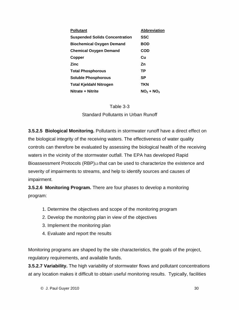
Pollutant AbbreviationSuspended Solids Concentration SSC Biochemical Oxygen Demand BOD Chemical Oxygen Demand COD Copper Cu Zinc Zn Total Phosphorous TP Soluble Phosphorous SP Total Kjeldahl Nitrogen TKN Nitrate + Nitrite NO2 + NO3
Table 3-3
Standard Pollutants in Urban Runoff
3.5.2.5 Biological Monitoring. Pollutants in stormwater runoff have a direct effect on
the biological integrity of the receiving waters. The effectiveness of water quality
controls can therefore be evaluated by assessing the biological health of the receiving
waters in the vicinity of the stormwater outfall. The EPA has developed Rapid
Bioassessment Protocols (RBP)13 that can be used to characterize the existence and
severity of impairments to streams, and help to identify sources and causes of
impairment.
3.5.2.6 Monitoring Program. There are four phases to develop a monitoring
program:
1. Determine the objectives and scope of the monitoring program
2. Develop the monitoring plan in view of the objectives
3. Implement the monitoring plan
4. Evaluate and report the results
Monitoring programs are shaped by the site characteristics, the goals of the project,
regulatory requirements, and available funds.
3.5.2.7 Variability. The high variability of stormwater flows and pollutant concentrations
at any location makes it difficult to obtain useful monitoring results. Typically, facilities
© J. Paul Guyer 2010 30
must collect a large number of samples to adequately characterize how a device is
functioning under natural conditions. The monitoring approach used on any given site
will depend on regulatory requirements, the pollutants of concern, the physical
characteristics of the runoff management features, and the availability of funds and
personnel for planning, sampling and analysis.
3.5.2.8 State and Local Program Conformance. Water quality monitoring programs
should be undertaken to conform to state and local protocols. A detailed guidance
manual for water quality data collection, management and interpretation is available
from the Environmental Protection Agency15 and the Department of Transportation. The
guidelines, which are primarily concerned with meeting the national stormwater BMP
database requirements, can be easily adapted for use in a variety of monitoring
activities.
3.5.2.9 Sampling Locations. An effective monitoring effort for decentralized runoff
management requires a judicious selection of sampling locations as well as sampling
times and techniques. The challenge is often to complete the monitoring effort
effectively under budget constraints. If the site design includes many LID features,
sampling only a few may provide a reasonable basis to estimate the effectiveness of the
full suite of features.
3.5.2.10 Sampling Protocols. Monitoring protocols vary depending on the expected
chemical composition of the runoff, the pollutant of concern, the desirability of
monitoring the effectiveness of a device at a given location, and the importance of
assessing water quality at points downstream. As sampling data is collected over time,
trends in the water quality become apparent. Adjustments in the monitoring plan may be
appropriate to ensure that across the site samples are not taken any more or less
frequently than necessary to ensure that a desirable level of water quality is maintained.
© J. Paul Guyer 2010 31
4. COMPARISON OF LID TO CONVENTIONAL PRACTICES 4.1 INTRODUCTION. Conventional stormwater management practices focus on
providing an efficient site drainage system that rapidly conveys runoff away from
buildings and off pavement, and then attenuates the peak runoff rate at a large
stormwater management facility downstream. In contrast, LID provides runoff
management as far upstream as possible – where it originates – and if necessary, also
at multiple points along each flow path. LID and conventional practices can be further
compared in a variety of ways:
4.2 COMPLIANCE VS. WATER RESOURCE OBJECTIVES. While conventional
stormwater management is primarily concerned with attenuating the peak runoff rate
from a developed site, the principal goal of LID is to ensure maximum protection of the
ecological integrity of the receiving waters by maintaining the watershed’s hydrologic
regime.
4.3 WATER QUANTITY CONTROL. Conventional drainage practices effectively
reduce peak runoff rates, but do not reduce runoff volume. Instead, conventional
drainage practices increase runoff volume by not mitigating the effects of the increased
impervious area. The LID features that facilitate infiltration, by comparison, help to
reduce runoff volume directly. Runoff volume reductions using LID features can be
significant when infiltration is increased over a sufficiently large area. Conventional
drainage reduces the amount of subsurface water available to the base flow in nearby
streams. LID features that enhance infiltration can have the beneficial effect of helping
to maintain those base flows. Other LID features allow the strategic use of stormwater
on-site, while conventional drainage designs focus on moving the water rapidly off-site.
A conventional stormwater management facility has a limited ability to manage water
quality because it is limited to removal by settlement of pollutants. An LID approach, by
comparison, takes advantage of a variety of mechanisms that filter water either overland
or via infiltration to the subsurface.
© J. Paul Guyer 2010 32

4.4 CONSTRUCTION COSTS. Construction costs for LID will vary depending on the
characteristics of predevelopment site features, the density of development, the
particular LID features selected, and their size and design. For example, the cost of
bioretention areas will be a function of the depth of porous backfill and the degree to
which underdrains are utilized. Case studies for commercial, townhouse, and detached
home residential areas in Prince George’s County, Maryland, have demonstrated that
LID site design costs can compare favorably with conventional approaches.17 Costs are
not simple to generalize. The scale of the project, availability of materials, and skills and
training of staff are all factors. IMPs involving landscaped areas are often simple to
maintain because work can often be performed by landscaping crews or residents; hard
structures, such as permeable paving systems with underdrains, may require more
specialized maintenance.
4.5 OPERATION AND MAINTENANCE. Regular inspections of conventional
stormwater management facilities are required to ensure that the storage volume has
not been reduced by sediment, outlets are not clogged by debris, and structural features
maintain their integrity. For a site designed using an LID approach, runoff management
features will tend to be higher in number and several types of features (e.g., bioretention
areas) need to be maintained by the property owner. The maintenance of these LID
features is straightforward and can easily be performed as part of regular landscaping.
Other LID features typically employed along public streets (such as tree filters) require
more specialized maintenance to ensure that the filter media are not clogged and toxic
materials such as heavy metals do not accumulate to a level at which they become a
health hazard.
4.6 RETROFIT POTENTIAL. Retrofitting an already developed area with a conventional
stormwater management system requires a considerable amount of space and is likely
to involve extensive site disturbance. The LID micro-scale systems listed in the previous
chapter require less site disturbance for each installment. LID retrofits may be much
easier than conventional retrofits on sites where intensive development has already
occurred. Locating sites for installing small devices is far easier than finding a large site
© J. Paul Guyer 2010 33

for a stormwater management facility. LID retrofits can be customized to pollutant
loads, allowing more complete control over pollutant removal.
© J. Paul Guyer 2010 34

5. DISTRIBUTED MICRO-SCALE SYSTEMS 5.1 INTRODUCTION. In addition to land surface strategies, LID practices include
incorporating small landscaped features and manufactured devices into a site. The
management of runoff as it is generated reduces the need for management further
downstream. Small distributed systems can perform several important runoff
management functions:
• Increase rates of infiltration
• Slow down runoff, reducing flow rates from the site and increasing time for
infiltration
• Add retention (the amount of water stored at the surface for the duration of the
storm event)
• Add detention, which causes water to be restrained temporarily before it moves
further downstream
• Improve water quality by filtering pollutants through media
5.2 REPRESENTATIVE LID PRACTICES. LID uses design components (IMPs) that
can be selected and customized for specific stormwater management objectives. The
selective use and customization of these components will involve a variety of standards
and specifications for construction and maintenance. Described below is a collection of
LID practices and their design, construction and maintenance characteristics.
Distributed micro-scale systems can include, but are not limited to:
• Soil amendments
• Bioretention
• Dry Wells
• Filter Strips
• Vegetated Buffers
• Grassed Swales
• Infiltration Trenches
© J. Paul Guyer 2010 35

• Inlet Pollution Removal Devices
• Rain Barrels and Cisterns
• Tree Box Filters
• Vegetated Roofs
• Permeable Pavers
Table 5-1 presents the variety of runoff management functions provided by these
features.
Table 5-1
Functions of LID Features
5.2.1 Nutrient Processing. Surface water runoff in urban areas can include significant
quantities of chemical nutrients, particularly nitrogen and phosphorous.
When these nutrients reach local water bodies, they can contribute to eutrophication.
(Eutrophication is a naturally occurring process in which nutrients accumulate in a body
of water over time; the term is often used to signify acceleration of this process by
© J. Paul Guyer 2010 36
human activity.) Several of the LID components described in this UFC (see Chapter 8)
filter out these nutrients to various degrees of effectiveness, depending on the design.
LID approaches that utilize vegetation not only filter nitrogen and phosphorous out of
the water and into the soil, but also make these nutrients available to the plants to form
plant tissue.
5.2.2 Treatment Train Approach to Water Quality. Following a typical flow path
beginning where runoff is generated from an impervious area, runoff water quality
control can be implemented in the following steps:
• Minimization. Design the site to treat pollutants effectively in small quantities,
rather than allow larger quantities of runoff to accumulate before treatment.
• Natural Filtration. Use the physical, chemical and biological processes of
vegetation and soils to filter pollutants.
• Constructed Filtration. Use the physical, chemical and biological processes of
distributed micro-scale systems to filter pollutants.
• Evaporation. Store and evaporate water in shallow depressions so that
particulates can be removed.
• Pollution prevention. Incorporate management practices such as restricted
fertilizer use and diligent street sweeping to reduce pollutant loads. (Note that
while the first four steps above pertain to site features, this final step pertains to
post-construction maintenance).
Figure 5-1 shows a typical treatment train process for phosphorus removal.
© J. Paul Guyer 2010 37

Figure 5-1
Treatment Train Process for Phosphorus Removal
5.2.3 Energy Processing. LID features that incorporate vegetation can help to
moderate high ambient air temperatures. Even on a small scale, vegetation will have a
local cooling effect. Vegetation can be selected and placed to improve shading, or to
provide a buffer against winds. Using vegetated roofs can result in significant energy
savings in the operation of a building’s air conditioning system.
5.2.4 Multifunctional Infrastructure and Buildings. Some LID features can
simultaneously provide a variety of hydrologic functions. A bioretention area, for
example, can filter runoff for quality control, detain it, and infiltrate the stormwater into
the ground. Similarly, vegetated roofs on buildings reduce runoff, reduce pollutants in
both the water and the air, and moderate the internal building temperature.
5.2.5 Ancillary Benefits. This discussion describes LID primarily in terms of hydrologic
impacts. LID runoff management strategies can also contribute to an aesthetically
pleasing landscape, increasing the value of the property where these strategies are
employed. In a variety of completed projects, micro-scale runoff management features
have provided architectural interest in various forms, such as employing berms in
© J. Paul Guyer 2010 38

otherwise open spaces, rainwater channels along pedestrian streets, fountains fed by
intermittent stormwater, and bioretention areas that attractively subdivide large parking
lots. The visibility of these features also provides opportunities for citizens and property
owners to become more aware of the importance of stormwater in our urban
environment.
© J. Paul Guyer 2010 39