introduction: shaping the future with conservation...
TRANSCRIPT

Introduction: Shaping the future with conservation planning
F. Lance Craighead, PhD; and Charles L. Convis Jr.
This book, Conservation Planning: Shaping the Future, provides an introduction and guide for anyone planning for landscape conservation. The goal of a conservation plan is to maintain or enhance biodiversity, ecosystem function, and ecosystem structure, while accommodating human-oriented land uses that may be detrimental to that goal. At its simplest, creating a plan requires the conservation planner to make decisions about the most appropriate land use for a given site at a given time. To make these decisions correctly re-quires the best available information about the natural systems being conserved, particularly the biological processes that comprise the system. Those processes are represented by the plant and animal communities that an ecosystem supports as well as by the interactions between them. Understanding what these processes are, and how to use them to guide conservation decisions, is the purpose of this book. It outlines an approach using computer-based tools and procedures that are easily accessible via the Internet and the guidelines herein.
These guidelines focus on key natural species as indicators of biological integrity and complexity. They also incorporate best practices for understanding and maintaining ecosystems as integral communities that include human activities but are not dominated by them. Instead of the traditional anthropocentric approach to planning taken by most local governments — a focus on efficient allocation of goods and services for hu-man economies — we explore various pathways to maintain ecosystem health and services as the first priority. The final plan, in most cases, is centered on a map of current or desired land status or use for a given area and scale. Because conservation planning occurs within a nested hierarchy of scales, from the global scale down to the subwatershed or parcel level, this book explores approaches that can be used at all levels. But it focuses primarily on local scales at which conservation plans can be effectively implemented by agencies, organizations, and individuals: for example, county government, forest districts, watershed councils, and lo-cal citizens’ groups.
This book outlines a virtual journey through all the steps necessary to complete an ideal (at least at this point in time) conservation plan. Viewed through the lens of geodesign (design science based on geographic
1

2
Conservation Planning Shaping the Future
information systems [GIS]; Steinitz 2010), this approach incorporates several of the nine basic methods that Steinitz described as the basis for modern landscape planning (see sidebar “Nine fundamental geodesign planning approaches” later in this chapter). Developing the plan requires the use of computer-based tools that provide a spatial representation of the biological processes comprising the ecosystem. It is likely that any real-world application will not be able to use every step and tool available. This book should help identify the best tools and approaches available for a conservation planner’s specific area of interest. It is important to realize that planning is an iterative process, and each iteration can improve upon the previous version. Do not be deterred by uncertainties: even a very simple conservation plan is better than no plan at all, as long as it is based upon the best available science. The process can be revisited in the future and improved.
Geodesign is one of the fastest growing frontiers in conservation science. According to Steinitz (2010), six fundamental questions must be addressed in any planning or design situation:
1. How should the landscape be described?2. How does the landscape operate?3. Is the current landscape working well?4. How might the landscape be altered?5. What predictable differences might the changes cause?6. How should the landscape be changed?Steinitz also describes nine fundamental methods by which plans are created (see sidebar “Nine funda-
mental geodesign planning approaches” later in this chapter). This taxonomy is useful because many plans involve a mixture of approaches, each of which has specific strengths and weaknesses as well as specific capa-bilities for how much or how little it can be participatory, collaborative, or democratic. These are important implications for conservation planners to consider as they go about their work. These methods are not mutu-ally exclusive, and as a conservation plan is developed, elements of several approaches may be incorporated.
The most important step in any journey is the first one. Once that step is firm and solid, take the next one. In this introduction, we briefly outline the topics (steps) that are explored in detail in the chapters to come, and explain how they have developed over time. Each chapter explains why the topic is important and how to apply the tools and procedures as part of a larger plan.
At first, the chapters in this book were planned to go from the general to the specific. We envisioned that readers could begin each topic with a broad overview and continue reading as deep into the subject matter as their interest and understanding allowed. Then they could skip ahead to other chapters, perhaps to return later, with more specific questions to answer. In the end, the chapters did not all fit into an easy formula, which is a testament to the individuality and personal visions of each of the authors. The same approach, however, should be useful: explore with curiosity, and if you get bogged down, skip ahead to more interesting fare and read to the end of the book to get a sense of the subject matter. Then, especially if you have an ap-plication in mind, focus on the wealth of detail and related material the authors have provided. In addition, we encourage readers and other conservation planners to draw from, and contribute to, the website we have established at http://www.esri.com/conser vationbook. The website is our beginning attempt to address one of the needs that Frank Davis points out in chapter 15: “Most conservation planners lack the resources, formal training, or sufficiently strong incentives to employ best data management practices and to publish their data and information in a way that facilitates reuse. I will simply lodge a plea for allocating more resources to training and open sharing of data and information to continue broadening the collaborative network of conservation planners.” As we learned in the eight years of B Bar meetings that led to this book, the other key to successfully navigating a plan is creating a community effort. Planning cannot be done alone; it is a

Introduction: Shaping the future with conservation planning
Chapter 1 • 3
Basic Data and Analysis
Chapter 10Connectivity
Chapter 9Cores
Chapter 6Focal Species
Chapter 5Land Use
Chapter 4Land Cover
Re�nedConservation
Plan
DraftConservation
Plan
Chapter 3Scale and
Time Frame
Chapter 2Socioeconomics
The Planning Process• Conceptual Framework• Plan Creation• Monitoring & Change• Plan Revision
Advanced Analysis
Chapter 11Viability
Chapter 12Optimization
Predictive Plan
Predicted Change
Chapter 2Ecosystems
Services
Chapter 8Habitat
(Marine/Aquatic)Chapter 7
Habitat (Terrestrial)
Land Use
Chapter 5Future
Land Use
Chapter 13ClimateChange
Figure 1.1. A conceptual workflow of the conservation planning process. Arrows lead through a series of topics that correspond to the chapters in the book. The steps to a basic conservation plan are enclosed in the green box. This process can form a conserva-tion plan that can be refined or revisited. Advanced analyses that can improve the basic plan are enclosed in the blue box. Predic-tive analyses that can help anticipate change in the environment for inclusion in the plan are enclosed in the purple box. Because it is iterative, this flow chart loop is actually a spiral that coils upwards in time, using newer, and hopefully better, data and techniques.Figure from Lance Craighead and Charles Convis.

4
Conservation Planning Shaping the Future
community activity requiring a commitment from the stakeholders affected, to the experts and advisors, to decision makers. Our hope is that this book, the website, and additional resources still to come will help to build the larger conservation planning community as a resource for local communities.
This process can be envisioned as a flow chart such as figure 1.1. The process starts within the circle at the bottom as goals and approaches are conceptualized. Part of that step includes reading this book. Some
Figure 1.2. The conservation planning journey. To develop a conservation plan requires data representing the natural world, including humans. The data is organized and manipulated using such tools (represented by the pathway) as GIS and mathematical models into an architecture that becomes more refined and accurate as the steps proceed. The conservation plan (represented by the distant plaza) that is developed is an abstraction of the natural world as it is experienced by key animal species (focal spe-cies). Humans experience the world in different ways that are influenced by land use and economies. Spatial units in the plan are assigned values that represent their importance to ecosystems and native species. Once a plan is developed, it can be used to guide land-use choices in the present and to predict how those choices will play out in the future (represented by the pathway in the distance). Kristine J. Ellingsen © 2010.

Introduction: Shaping the future with conservation planning
Chapter 1 • 5
questions a planner might ask could range from very broad — “What do we want this landscape to look like in 50 years?” — to much more specific — “How can we maintain enough habitat for pygmy rabbits or grizzly bears?” or “Where can we develop wind power without endangering sage grouse?” The question will deter-mine the scale of analysis, the type of data needed, and the methods to be employed. The main focus of this book is on planning for focal species at finer scales of analysis, but the approaches provided are applicable at any scale. As planners proceed step by step through the planning process, they eventually return to the first step when they can refine the questions, use different or newer data, and apply other methods.
Readers can also think of the process of conservation planning as a journey. It is a journey of many steps and can be more artistically envisioned as in figure 1.2. As in the flow chart, it is possible to imagine coming back to the start to begin a new iteration of the process. However, in today’s world, irreversible changes are occurring to the landscape so rapidly that a more realistic image may be that a conservation planner has only one opportunity to influence the changes to come.
Regardless of how the conservation planning process is envisioned, it is a journey that can be made by any dedicated group of concerned people. One goal of this book is to level the playing field so that rigorous and scientifically defensible local plans can provide alternatives to top-down approaches that local communi-ties may face from industry or government. Historically, resources have mainly been available for planning from the top down because money and power have been concentrated at the top of social hierarchies, and planning was an expensive proposition. However, in modern societies, the majority of decisions that directly affect landscapes may be influenced from the top but are often made at the bottom, at the level of counties, towns, villages, and landowners.
The book describes a bottom-up approach that has been used successfully by practitioners around the world. Our goal is to provide resources and guidance in one source so that conservation planners do not have to develop their own process by trial and error. Many more tools and approaches exist than can be included in a single book, and they are dynamic: constantly improving as the science progresses. Therefore, the con-tributors to this book, with support from Esri, have built the website, http://www.esri.com/conser vationbook, as an accompaniment where additional, and continually updated, data, information, and tools can be accessed.
This book focuses on the mechanics — the nuts and bolts — of conservation plans. Such planning takes place within broader social contexts, and to be successful, a plan needs to be implemented as it is being de-signed, through processes such as regulation, legislation, consensus, policy initiatives, land protection, good stewardship, economic incentives, voluntary compliance, and neighborly agreement. The breadth and detail of implementation are beyond the scope of this book, but are outlined by Ban et al. (chapter 8, table 8.1) as described in Pressey and Bottrill (2009), and discussed in more detail by Chan et al. (chapter 2). Imple-mentation of the results of a conservation plan needs to occur concurrently with the development of the plan itself and be driven by stakeholders. Approaches to ensure that the science is applied on the ground, implementation tools, strategies, and tactics, are also discussed in more detail on the accompanying website.
We believe that local stakeholders, particularly people in local communities, have a deeper interest in con-servation planning than those in distant positions of authority. They live in, and are more dependent upon, the quality and health of the natural environment around them. We believe that there has been a shortage of guidance and resources to help local residents and governments develop good conservation plans that can best represent their point of view and values. Now that computers and software tools are universally avail-able, and access to data and tools is available through the Internet, it is possible to enable virtually anyone to protect and manage the landscapes they love, in ecologically effective ways as a part of larger, functioning ecosystems. This is the new frontier of conservation planning.

6
Conservation Planning Shaping the Future
Nine fundamental geodesign planning approaches
Descriptions of these approaches are based on work by Steinitz (2010).1. Anticipatory. Experienced planners use this approach when they are confident in their knowledge
and able to create a new plan solely from their own understanding and experience. To implement the plan they typically work backwards from the desired goal to the current conditions to deduce what steps need to happen. This approach is most common on smaller, short-term, local-scale projects.
2. Participatory. In this approach, a group of people prepares individual designs, each reflecting the designer’s vision, expertise, and knowledge. Then all of the designs are integrated using a GIS to analyze where they agree and differ. The group arrives at one final design by consensus. This approach is common where groups or communities are the beneficiaries of a plan, and the design needs to be done by committee rather than by one individual. Implementation is achieved also by working backwards from the agreed goal to the current conditions in a deductive fashion.
3. Sequential. Planners may use this approach when they are not confident about an end design but are certain about the individual steps, elements, or requirements that must be addressed to get from the current conditions to the desired future state. This type of planning frequently occurs when committees cannot visualize a final plan but instead must address each of the critical is-sues individually, moving on to the next issue only when the prior one has been resolved. This committee-based approach is common on larger plans and often involves 20 to 50 steps, and can take much longer to accomplish.
4. Combinatorial. Planners may use this approach when they are not confident in either a design vision or the steps to get there and must account for many options at each design step, creating a huge combination of possible plan alternatives to sift through. To simplify their choices, they use inductive reasoning to simultaneously evaluate the combinations of options that may ad-dress the issues best. Often, a starting point is to identify a few extreme cases as the boundaries of the possibilities and then to examine different combinations of the options that create plan alternatives. Each alternative is then evaluated and ranked, and a final candidate is selected. An advantage of this approach is that it requires the evaluation of the most important assumptions early on, which helps avoid serious mistakes further into the planning process. A disadvantage is that it leads to the creation of a large number of alternative designs that must be compared and evaluated.
5. Constraining. This approach is similar to the combinatorial one, but it seeks to simplify the planning process by limiting the number of alternative designs. It requires that each major as-sumption be further evaluated in a Delphi method (expert opinion) process to refine the range of options so that a smaller number of design combinations is possible. This method is useful for enhancing efficiency by limiting the potentially large number of possible combinations when using a committee-based plan that includes direct public participation.
6. Optimizing. This approach assumes that the planner knows the major requirements and their relative importance and limits, as in the constraining approach, but goes further by assigning cost

Introduction: Shaping the future with conservation planning
Chapter 1 • 7
values to each requirement and conducting optimization analysis that identifies which alternatives are the “cheapest” for the outcomes they might produce. It assumes that the planner can assign costs and values effectively to the individual requirements, which turns out to be difficult and depends greatly on the planner’s knowledge of the community for which the plan is intended. A key difficulty is ranking and assigning values without first being able to establish their context by studying a proposed comprehensive plan. This approach is commonly used in evaluating po-tential reserve and corridor designs in terms of their acquisition and management costs, and the relative efficiency by which conservation goals can be achieved for given expenditures of scarce resources, as discussed in chapter 12.
7. Rule-based. This approach is similar to the optimizing approach in that planners are not working with a finalized design vision. Many of the major requirements can be expressed only as a set of formal rules or computer algorithms governing the design. Outcomes of algorithms need to be tested and will depend on initial states and inputs. Rules can be applied that currently do not exist, allowing for simulation and testing of different what-if scenarios. One useful technique of rule-based approaches is to use algorithms that translate design outcomes into a common simple metric to facilitate comparisons, such as economic value or replacement cost of ecosystem services. The challenge with rule-based approaches is in designing sequences of rules so that they accurately describe all relevant parts of the system or problem. Once designed, rule-based models are then easy to run and refine, even for very large problems over many different scales and scenarios.
8. Agent-based. This is a type of rule-based approach that describes rules not for the whole system, but only for individual computer-generated “actors.” The sum of the individual decisions of many actors then defines the system. The goal of this planning exercise is to find the best solution for a number of independent actors carrying out tasks that represent desired activities the final plan will support or enhance. Each independent actor conducts tasks in response to a simulated computer environment, and the combined results of many different actors create an overview of an allocation that best permits them to meet their needs. One strength of this approach is that it can use a relatively small number of reasonably simple rules to model the behavior of a single
“actor,” and then let the computer randomly generate millions of different tasks and summarize their final patterns in a fairly complex final plan. It is suited to larger, multifaceted planning situ-ations. As chapters 10 and 14 discuss, it is also a commonly used technique for evaluating wildlife movement over the landscape and designing migration corridors.
9. Mixed agent-based and sequential. The rules that define a successful agent-based model can them-selves arise from other kinds of planning approaches. In this approach, a sequential change mod-el (or a constraining or combinatorial approach) is used to generate rules and evaluation inputs that can drive an agent-based examination of the cumulative effects of many individual actors. This examination can extend through successive time stages to model either historical growth or future projected growth, using a sequential modeling approach again. This overall approach is called “mixed” because it combines elements from several basic modeling approaches.

8
Conservation Planning Shaping the Future
What is conservation planning?
Recent definitions of conservation planning include that of Pressey et al. (2008): “Conservation planning is the process of locating, configuring, implementing and maintaining areas that are managed to promote the persistence of biodiversity and other natural values.” (See also Margules and Pressey [2000] and Ban et al., chapter 8.) Noss et al. (1997) explain that “conservation planning is really as much an art as a science.” Groves (2003, 2008) provides two categories of conservation planning: (1) the “scientifically-based, systematic methods for establishing conservation priorities,” and (2) “development and implementation of methods for achieving on-the-ground conservation results or in measuring the effectiveness of conservation actions,” recognizing the disconnect between developing a plan and actually implementing it. In the sense of this book, which focuses on development, conservation planning can be defined as the use of the best scientific information to ensure that natural systems are conserved as human-induced change takes place.
Conservation planning is closely related to several other ecologically oriented fields and disciplines with similar names, and using similar theories and methods, such as ecological planning, biogeography, landscape architecture, landscape ecology, suitability analysis, range management, and comprehensive land-use planning. It differs, often in subtle ways, in that the primary goal is to maintain populations of native plants and ani-mals (including humans) in functioning ecosystems. Conservation planning addresses patterns (or structure) and processes (or systems) of biodiversity (see also Ban et al., chapter 8). Often there is incomplete knowl-edge of these elements of biodiversity, and the best science consists of relying on indices or surrogates of the underlying ecological principles.
A good conservation plan must address current economic needs of human societies but also include the economic impacts of damage to vital ecosystem services, such as clean water, in establishing where develop-ment can and cannot occur (see Chan et al., chapter 2). Conservation ought to have both biodiversity- and human-oriented objectives because humans are an integral, and extraordinarily influential, component of ecosystems.
Conservation planning is site-specific, scale-specific, data driven, iterative, adaptable, and powered by hu-man desires and understanding. Change is inevitable, but people can direct many of the human dimensions of change: we can guide or control human activities so as to protect or maintain natural systems. Because hu-mans are a part of natural systems and human density varies across the landscape, we are faced with a spec-trum of environmental conditions that have been affected to varying degrees by humans. We cannot afford to conserve only intact, pristine landscapes. We also need to consider the bits and pieces of natural systems that still remain within human-altered landscapes. Although this book hopes to provide the best scientific tools and techniques to use with the highest quality base data, we want to emphasize that some approaches can use whatever good data is available. To reiterate: even a very simple science-based conservation plan is better than no plan at all.
Conservation planning is as much a process for balanced landscape decisions as it is a blueprint. That process begins with the best available data and techniques, and then leads to collaborative discussion and de-velopment of options leading to working maps, followed by implementation of the plan. As new and better data or techniques become available, or increased interest and funding is developed, the plan can be refined and the process can be modified. The plan evolves or adapts in the sense that it gets progressively better at representing the real world and managing the role of humans in that landscape. In particular, conservation planning has benefited from geographic information systems (GIS). GIS are “computerized systems for the storage, retrieval, manipulation, analysis, and display of geographically referenced data” (Mark et al. 1996).

Introduction: Shaping the future with conservation planning
Chapter 1 • 9
GIS use has revolutionized the scope and power of conservation planning because of its ability to accommodate, integrate, and analyze physical, biological, cultural, social, economic, and political data.
The goal of conservation planning can be described as shaping the future. Designing a future with in-tact ecosystems and balanced use of resources is an optimal goal for all people on the planet as well as for its biodiversity. However, strong economic incentives exist for individuals to exploit resources for personal gain at the expense of the common good (Hardin 1968). In modern societies, planning that interferes with profit will often experience resistance from vested interests; conservation planners may need to defend their choices in courts of law and in courts of public opinion. We feel that the strongest defense is to have the best available science supporting decisions. This is another goal of this book: to enable conservationists to apply the best available data and scientific tools to land-use questions, and to answer those questions with defensible results.
The modern science of conservation planning has grown throughout its history as new tools and ap-proaches have been developed. Each new advance has laid a foundation for refinements and new tools to build upon. This history is mirrored in the organization of chapters for this book. If we return to the flow-chart of the process (figure 1.1) and the metaphor of conservation planning as a journey of many steps (figure 1.2), we can explore each topic or step as a chapter in this book.
To begin modern conservation planning, the literal first step should be to walk across the landscape so that you can see the environment and talk to local people. This is the best way to learn what the landscape is like. The more direct experience you have with the topography, plants, animals, and human stakeholders, the better. No amount of computerized data can provide the same understanding of a landscape as first-hand knowledge (although in many cases this may not be possible). The next step is to boot up a computer. Within a GIS framework we begin to see the landscape from a variety of perspectives that complement on-the-ground knowledge. Then these perspectives can be combined.
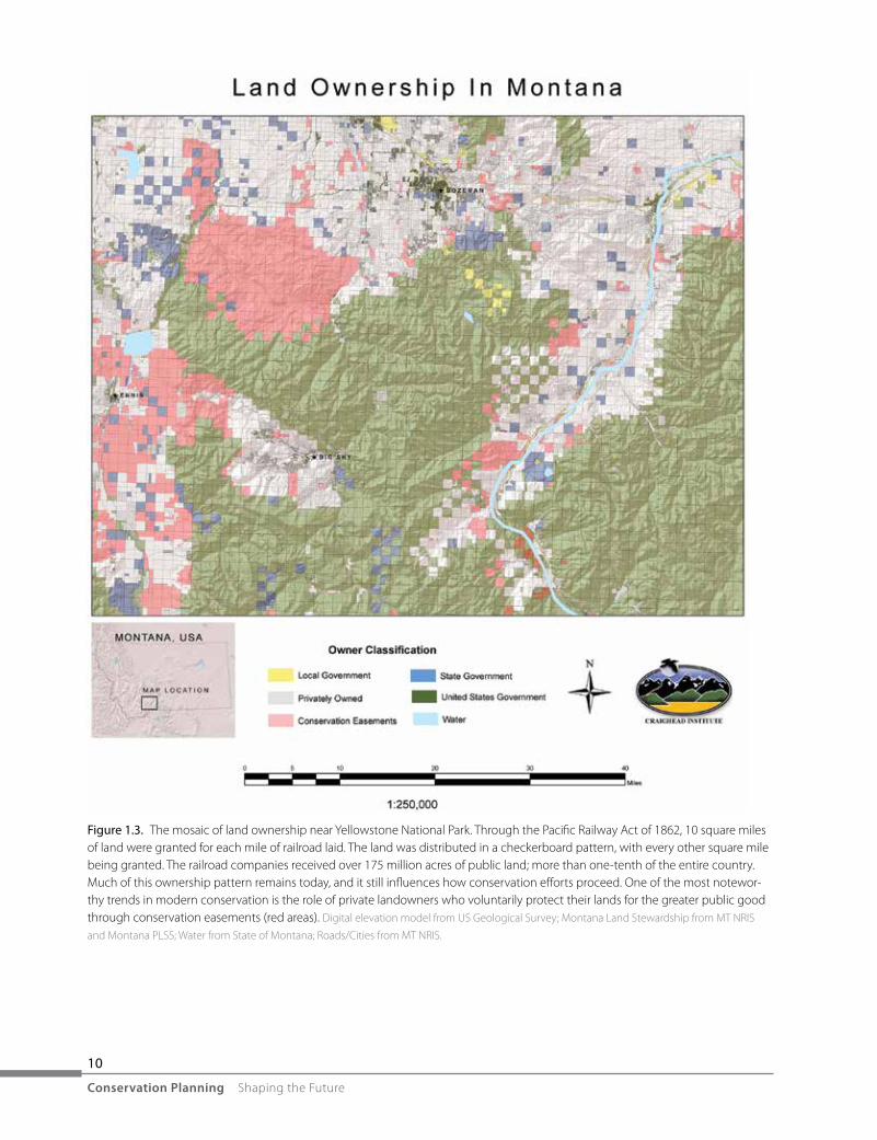
If we focus on North America, one of the first things we might notice is that the environment we have inherited, and which we hope to plan sustainably for the future, is the result of a series of activities, initiatives, policies, and legislation that has produced a patchwork of land uses (figure 1.3). This mosaic of private lands, public lands, protected areas, urban areas, industrial parks, agricultural landscapes, and all other gradations of land use — crisscrossed with a complex network of roads, railroads, transmission lines, pipelines, seismic trails, off-road trails, hiking trails, and myriad other linear infrastructure features — has been so heavily affected by human activities that many of its natural systems no longer function well. Despite this incredible amount of human alteration, though, North America contains many of the healthiest and most intact landscapes left on the planet.
Whom is this book for?
This book is a hands-on guide that describes what the contributors feel are the best scientific methods to be used at each stage of a conservation plan. It should be most valuable for planners in nongovernmental conser-vation organizations and in city, county, and state agencies; government professionals in land-management
10
Conservation Planning Shaping the Future
Figure 1.3. The mosaic of land ownership near Yellowstone National Park. Through the Pacific Railway Act of 1862, 10 square miles of land were granted for each mile of railroad laid. The land was distributed in a checkerboard pattern, with every other square mile being granted. The railroad companies received over 175 million acres of public land; more than one-tenth of the entire country. Much of this ownership pattern remains today, and it still influences how conservation efforts proceed. One of the most notewor-thy trends in modern conservation is the role of private landowners who voluntarily protect their lands for the greater public good through conservation easements (red areas). Digital elevation model from US Geological Survey; Montana Land Stewardship from MT NRIS
and Montana PLSS; Water from State of Montana; Roads/Cities from MT NRIS.

Introduction: Shaping the future with conservation planning
Chapter 1 • 11
agencies; and students interested in conservation or planning. Although applicable anywhere in the world, this book may be particularly useful in developing countries. It should also be useful for activists concerned about the adequacy of existing land management, policy makers (including at the county, state, and national level), GIS technicians involved in conservation projects, conservation biologists, wildlife biologists, foresters, landscape architects, scientific consultants for real estate developers, or anyone else wishing to understand and actively guide changes in land use. The book is designed primarily for those working at a local scale but within a broader framework of conservation planning.
We hope that this book will be used as a primary or supplemental text for college courses. Suggested courses include landscape ecology, conservation planning, parks management, protected areas management, and wildlife modeling. This book may be the first introduction for many readers into a community that is working together with common tools and approaches to achieve a common goal: the maintenance of biodi-versity and ecosystem function.
Implementing the methods outlined in this book requires a good working knowledge of GIS in most cases. However, the book should also be useful for other people, perhaps working as part of a conservation planning team, with expertise in biology, project management, land management, and so on. There are a number of large international conservation organizations employing conservation planning methods at different scales: The Nature Conservancy, Conservation International, World Wildlife Fund, The Wildlands Project, and the Wildlife Conservation Society, to name a few. Noteworthy conservation plans have also been developed by smaller groups like Round River Conservation Studies or the Southern Rockies Ecosystem Project. This book is intended to fill in the gaps that those programs do not cover. If The Nature Conservancy is develop-ing a conservation action plan (see Unnasch and Karl, chapter 3) for your landscape of concern, you may not need this book. However, if you want to help guide conservation for any of the millions of areas that do not yet have scientifically based projects in place, this book is for you.
Where do we go from here?
As concerned citizens of our only planet, we can plan human-impacted landscapes that are healthier than those we have now; and more likely to ensure the clean air and water we will need for survival. In the same way that human beings survived through millennia by saving important resources for later, modern human societies can decide to plan for a rational, sustainable future and not be subject to the whims of chance, self-interest, and greed. We are at a point where we can make conscious decisions about how the land should look now and in the time of our grandchildren. Conservation planners at all levels ask the same fundamental questions: What do we want this landscape to look like in the future? How much do we need to protect to ensure that natural systems and ecosystem services do not collapse? What activities can we undertake without tipping the balance? These are the questions that conservation science and planning has repeatedly addressed for the past four decades or so. These are the questions that we will continue to address, and to answer with progressively greater confidence in the future.

12
Conservation Planning Shaping the Future
An overview of the process
The modern science of conservation planning encompasses tools and techniques from many disciplines, and it benefits from advances ranging from software to satellites, and genetics to geography. In these sciences, each new advance facilitates new refinements, new processes, and new tools. This interlocking history is mir-rored in the progression of chapters of this book.
The tools that modern practitioners have found most useful for conservation planning are presented herein in a logical progression. The book begins with a section containing chapters on foundational tools and data, and explores ways to use these basic concepts to examine complex representations of the real world, in-cluding habitat and connectivity. These are the building blocks of a plan and comprise chapters 2 through 10.
The book then discusses ways to include larger issues, such as population dynamics, efficient allocation of space, and human economies, to refine the plan and ensure that the needs of both people and wildlife (and thus biodiversity) are met, but not grossly exceeded. This section includes chapters 11 and 12, along with much of chapter 2.
Finally, dynamic changes in the environment can be factored into a plan that synthesizes what we know and projects those trends into the future. This section includes chapters 13 and 14, along with sections of chapter 5.
The details are presented by a series of different authors who have painstakingly edited their chapters in concert with the rest of the book to present a logical flow of work in a consistent fashion.
This book takes the approach of trying to view the world from the point of view of key animals in ecosys-tems (focal species). Ecosystems exist because of the relationship of structures, the physical architecture of an ecosystem, with processes, the dynamic flow of interactions, energy, and materials within the ecosystem. Processes happen because physical structures (such as forests, grasslands, or fungi) exist to support them, and structures exist because processes operate to build and maintain them. This distinction is important for considerations of scale, because physical structures have a spatial scale implicit in every description of them, and processes have a temporal scale implicit in measurements or descriptions of their operation.
What geographers and ecologists know is that the understanding of ecological processes and structures at a given scale in the ecosystem may have little or nothing to do with the structures and process that govern that same ecosystem at other scales. In the framework of geodesign, Steinitz (2010) has identified at least three different scales for planning that represent distinctly different methods and dynamics, which any plan must specifically account for to avoid failure:
• 1:5,000—thescaleofindividual,localprojects• 1:25,000—thescaleofmunicipalities• 1:250,000—thescaleofwatershedsandregionsScales are hierarchical in that processes described at one scale can influence processes occurring at other
scales, such as the obvious influence of macroclimate on microclimate. Less obvious are micro-influences that matter at the watershed scale, such as beetle lifecycle biology that allows an outbreak to destroy entire forests. Although this book will focus on local to watershed scales, current conservation plans increasingly are required to account for the global-scale dynamics of climate change (chapter 13).

Introduction: Shaping the future with conservation planning
Chapter 1 • 13
Developing a basic plan
The basic assumption is that an ecosystem is functioning well if it can continue to support key species that require a comprehensive collection of habitats. The goal of conservation planning is to keep an ecosystem functioning in the face of human-orchestrated change. We begin by trying to understand the social and economic context within which the plan must operate (chapter 2). As we think about which species are most important in a landscape, we begin by focusing on a particular scale or scales (chapter 3). With a scale in mind, we consider land-cover classification and choose datasets that map the areas we want, usually through remote sensing (chapter 4). Similarly, we assemble datasets that capture human activities on the landscape (chapter 5). As we do this, we need to systematically select a suite of species that most efficiently represent the biological systems (chapter 6). Accurate maps of existing vegetation and other land cover are then used to predict the spatial occurrence of habitat for the selected animal species, using habitat models (chapter 7). An analogous approach is used to identify important elements in aquatic and marine systems (chapter 8). Although we have chosen a scale initially to determine what data to use, at each step of analysis there may be additional issues of scale, which must be addressed carefully to ensure that data at the correct resolution is matched with an appropriate analysis scale to produce a meaningful result. Models of predicted habitat are then used as surrogates for species distribution and are used to develop models and maps of “core” habi-tat (chapter 9). Suitable habitat for one species can be combined with models for other species to delineate important core habitat for a suite of species. Animal movement between core areas can then be assessed and routes can be mapped using connectivity approaches (chapter 10).
At this point in the process, a conservation planner would have a rough blueprint for a network of core areas and linkage corridors that define a conservation area, a nature reserve, or whatever term is desired (the draft conservation plan in figure 1.1).
Refining a conservation plan
Once habitat and core areas have been identified, they can be analyzed in terms of their ability to maintain a given population and allow it to persist, with the tools of population viability analysis (PVA; chapter 11). Multispecies PVAs can help determine the size and configuration of core areas and linkages that can support a suite of focal species. Spatial optimization approaches can be used with a conservation plan as guidelines to determine current minimal areas that meet specific thresholds or targets in terms of number of species protected, percentage of habitat protected, or other metrics (chapter 12). The linkages can also be optimized to identify minimal areas that meet the desired biological thresholds. Similarly, economic goals can be iden-tified, both for the values of ecological processes to humans (ecosystems services valuation), and for extrac-tive or competing uses of space and resources for human economic activities (chapter 2). Any or all of these analyses can result in a more refined conservation plan.

14
Conservation Planning Shaping the Future
Planning for the future
Finally, reserve designs or conservation areas can be assessed in light of climate change (chapter 13) and land-use trends (chapter 5) to determine what the habitat will look like in the future and what other areas need to be considered to maintain species and ecosystems. Although the landscape in the future, after climate change, is uncertain, a few certainties exist. Focal species in general tend to be sensitive to human activities and developments; providing adequate habitat requires the management of human impacts in areas large enough for population persistence. Even if the landscape comes to support different habitats and focal species in the future, their conservation will still require areas of limited human impact. Thus, the first step in planning for climate change is to identify areas of little human development and to maintain that light human footprint into the future. We can preserve the stage even though the actors may change as the play unfolds.
We can proceed with conservation planning under existing conditions with the understanding that some human aspects of those conditions can, and must, remain somewhat static as the climate changes. We can also predict many of the changes in land use that are likely in the future, in concert with natural changes due to global warming.
Understanding the process
A conservation plan, as we all know, is developed in context. The biophysical context — topography, vegetation, climate, and wildlife — determines the appropriate data and approaches that are used. The social context — public and private lands, government and nongovernment agencies and organizations, stake-holders, economies, values, and beliefs — will determine future anthropogenic changes and also the best approaches to implement the plan.
In chapter 14, an overview of some of the basic scientific modeling approaches is presented in a stepwise process that demonstrates how increasing complexity can be incorporated. The disparity between the mod-eled environment and the real world is discussed, and the assumptions inherent in common models are ar-ticulated. Models are illustrated with examples of elephant and snow leopard conservation that demonstrate many of the challenges faced in parts of the world that do not have the infrastructure and access to informa-tion that exists in North America. Chapter 15 summarizes the book as a whole and its context within the changing world of conservation planning.
Implementing conservation on the ground
The social context is an integral part of the scientific approach. Choices that are made in the scientific process need to reflect the fabric of the communities in which the resultant conservation design will be interwoven. We live in a society that views the natural world strongly along a continuum of values, with extreme view-points of utilitarianism (human dominion over nature) at one end and protectionism (humans as a destroyer

Introduction: Shaping the future with conservation planning
Chapter 1 • 15
of nature) at the other. Between the two value systems lies an infinite number of viewpoints that see humans as a part of nature: as a steward, an interloper, a bystander, a passive participant, an active recreationist, and so on.
To be successfully realized in a democratic society, a conservation plan must be embraced by the com-munity that it encompasses. It must be adopted by a quorum of stakeholders who will help guide the process and work to make it happen on the ground. To this end, the scientific choices that are made must somehow take into account the social values and beliefs that will determine whether — or not — the science is accepted. A conservation plan must provide something good for almost everybody, and involve the key stakeholders so that they feel a sense of ownership. At the same time, the requirements for maintaining biodiversity must not be compromised.
Modern conservation science has been forged in the crucible of our society and reflects a diversity of interest: currently, many core protected areas with minimal human alteration are juxtaposed with highly urbanized or otherwise altered landscapes. In between are natural habitats with varying degrees of human influence. The challenge is to provide enough habitat to maintain ecosystem processes and functions, vegeta-tion, and animals, even though the habitat is embedded in a matrix of human-altered landscapes. This book should provide the tools to achieve this precarious balance.
In the future, the landscape will be different, and the answers to these questions will also change. We can anticipate some of these changes, but not all, and the overall goals will remain the same. Conservation of na-ture is based upon four well-accepted tenets: (1) to represent ecosystems across their natural range of varia-tion in strictly protected areas, (2) to maintain viable populations of native species, (3) to sustain ecological and evolutionary processes within an acceptable range of variability, and (4) to build a conservation network resilient to environmental change, particularly climate change (after Noss and Cooperrider 1994). As the climate changes, species will shift in response, and species assemblages will change. Thus, the ecosystems and natural communities themselves will change, but their range of variation should still be represented if protected areas are created with that degree of variation taken into account. We feel that basing reserve de-signs, and the conservation plans that include them, on focal species rather than primarily on representation of current communities, will be more responsive to the coming changes.
The steps in the journey
The authors of chapters in this book collectively represent centuries of experience in developing and using the tools and processes they describe. Each author brings a unique perspective and voice to the subject. The editors have endeavored to find a balance between presenting the material in a standard and consistent fash-ion and allowing authors to explain things in the way that they best express themselves.

16
Conservation Planning Shaping the Future
Chapter 2 Integrating conservation planning with human communities, ecosystem services, and economics
Kai Chan, Natalie Ban, and Robin Naidoo begin by framing conservation planning in the context of social considerations and the importance of stakeholders in implementation. Because people are integral parts of ecosystems, their needs and effects are critically important to consider, even as conservation plans may focus on preservation of other species and the maintenance of systems that humans tend to degrade. The authors explain how the values of ecosystem services can be balanced with the need for human economies that occupy the same landscapes: how to incorporate ecosystem services into conservation planning.
Chapter 3 Scale and conservation planning
Robert Unnasch and Jason Karl discuss the relationship of scale to the ecological factors that are important for conservation. Scale is a fundamental property of how ecological systems, structures, and processes are described and understood. Conservation plans are developed within a nested hierarchy of scales; the appro-priate scale depends upon the conservation goals.
Chapter 4 Land-cover data: The foundation for conservation planning
Thomas Olenicki discusses the foundation of the process of building a conservation plan. Once a particular scale (or scales) is determined, the next step is to explore land-cover classification, which is used to map large areas through remote sensing. Many land-cover datasets are available, and this chapter provides guidance in choosing the appropriate data. He outlines a land-cover classification scheme that should elucidate vegeta-tion patterns more relevant to wildlife habitat than current approaches. Additional guidance for use of land cover is provided in chapters 5, 8, and 14.
Chapter 5 Integrating land use and landscape change with conservation planning
David Theobald explains how reserve designs or conservation areas that are planned under existing conditions can be assessed in light of human development. This chapter focuses on how to make use of the tools and approaches that are readily available. He discusses the suite of important land uses, including urbanization, agriculture, energy, recreation. These occur any place human use is dominant. The chapter then addresses the broader view of land-use analysis, which is about application: what is practical to do depends upon the spatial extent and the time frame. Finally, he discusses how predicted changes in land use can be evaluated to guide future conservation decisions.

Introduction: Shaping the future with conservation planning
Chapter 1 • 17
Chapter 6 Selecting species as targets for conservation planning
Brent Brock and Eric Atkinson explain how we can use species as an index to more complex ecological processes and functions, and how to choose the best suite of species for a particular area. They provide a review of focal species approaches, many of which they have used and experienced in conservation planning processes. Finally, they outline an approach that, compared with other methods, they have found improves the efficiency of analysis without sacrificing objectivity or accuracy.
Chapter 7 Identification of habitat and assessment of habitat quality for conservation of terrestrial animals
Brett Dickson, Steven Sesnie, Erica Fleishman, and David Dobkin explore ways to represent habitat for terrestrial species. They discuss a wide variety of habitat models used to predict the spatial occurrence of habitat for selected animal species based on accurate maps of existing vegetation and other land cover. They then provide an example in which they assess habitat values using an occupancy modeling approach. This approach can be used with any species for which suitable data exists.
Chapter 8 Marine and freshwater conservation planning: From representation to persistence
Natalie Ban and her colleagues, Stephanie Januchowski-Hartley, Jorge Alvarez-Romero, Morena Mills, Bob Pressey, Simon Linke, and Debora de Freitas, explore ways to represent habitat for aquatic and marine spe-cies, and discuss a range of issues, from land cover to connectivity, that require different ways of thinking about conservation in much more dynamic systems than on land. Because water-based systems have fun-damental differences from terrestrial systems, this chapter revisits many of the topics of other chapters to understand them better from an aquatic or marine perspective. A full exploration of water-based systems is beyond the scope of this book. Because the major focus of the book is terrestrial systems, the authors provide a necessarily broad overview of marine and aquatic approaches with guidance to more in-depth learning.
Chapter 9 Identification and mapping of habitat cores
We return to the terrestrial world, where Richard Church discusses ways to think about and identify which areas of habitat are the most important. “Core” habitat is a commonly used but context-dependent concept, somewhat difficult to define and measure in concrete terms. In most conservation planning, “core” has been used to reflect a sense of intact habitat that is unaffected by human disturbance or other neighboring habitat. This chapter explores various techniques for using models of habitat as surrogates for species distribution that are then used to model, identify, and map core habitat.

18
Conservation Planning Shaping the Future
Chapter 10 Assessing habitat connectivity
Peter Singleton and Brad McRae explain ways to examine the landscape that lies between intact blocks of good habitat. They explain why connectivity is important and introduce spatial analysis concepts and meth-ods for evaluating habitat connectivity and landscape permeability. The chapter gives an overview of a few of the more common methods of landscape permeability analysis and discusses their strengths and weaknesses. They explain how a team approach can be used to assess connectivity, and they discuss ways to communicate the results — a key final step that should be incorporated into each stage of the conservation planning process.
Chapter 11 Conservation planning to ensure viability of populations and metapopulations
Jessica Stanton and Reşit Akçakaya discuss conservation planning from the perspective of preserving natural populations of species: an important (if not the ultimate) goal of conservation planning is to prevent spe-cies extinction. Assessing viability is the most direct way of measuring how close to this goal a conservation plan is, or will be in the future when the planned conservation actions are in place. Viability is the likelihood that a species (or a population) will remain extant in the future. This chapter provides guidance in the use of population viability analysis (PVA): a method for calculating this likelihood, either under current conditions, or under assumed future changes. Multispecies PVAs can help determine the size and configuration of core areas and linkages that can support a suite of focal species.
Chapter 12 Optimization models for reserve site selection and design
Justin Williams brings an engineering approach, operations research, to conservation planning and discusses the tools available for finding optimal spatial solutions. Optimization models are primarily tools for deci-sion support as opposed to decision making. Their purpose is not to dictate a course of action, but to provide guidance, information, and insight for planning and decision making. This chapter provides an overview of what optimization models are and attempts to clarify their role in conservation planning. An example of a simple optimization model used for reserve site selection and design in North America’s Inland Temperate Rainforest is provided.
Chapter 13 Integrating conservation planning with projected trends in climate change
Dominique Bachelet discusses how a conservation plan can be assessed in light of climate change. She discusses projected trends in climate, and the resulting simulated climate change impacts, stressing the limitations of current approaches due to model result uncertainties, incomplete understanding of biotic
Introduction: Shaping the future with conservation planning
Chapter 1 • 19
interactions and ecosystem processes, and lack of data. She proposes a list a conservation planning strategies to prepare for future change due to direct and indirect effects of climate change, and provides guidance to other resources.
Chapter 14 Mapping biological processes to the appropriate spatial modeling tools
Kevin Johnston, David Western, and Rodney Jackson begin by explaining how and why we need to view the world from the point of view of animals in ecosystems. Then they outline step by step how this can be done; especially in landscapes where resources and data may be limited. This chapter revisits the entire conserva-tion planning process with a practical perspective to help conservation planners think about what assump-tions they are making and why that may be important. They illustrate their approach with case studies where conservation goals were addressed using elephants, snow leopards, and other focal species.
Chapter 15 Summary: Building a broader base for conservation planning
And finally, Frank Davis brings his unique perspective on conservation planning to a discussion of what this book accomplishes, how it compares to traditional planning approaches, and the need to incorporate conservation approaches in the future.
References
Groves, C. R. 2003. Drafting a Conservation Blueprint: A Practitioner’s Guide to Planning for Biodiversity. Washington, DC: Island Press.
———. 2008. “The Conservation Biologist’s Toolbox for Planners: Advances, Challenges, and Opportunities.” Land-scape Journal 27(1): 81–96.
Hardin, G. 1968. “The Tragedy of the Commons.” Science 162: 1,243–48.Margules, C. R., and R. L. Pressey. 2000. “Systematic Conservation Planning.” Nature 405: 243–53. http://courses.
washington.edu/esrm200/Margules_Pressey_Conser vation_Planning_Nature_2000.pdf.Mark, D. M., N. Chrisman, A. U. Frank, P. H. McHaffie, and J. Pickles, with contributions from M. Curry, J. Goss,
F. Harvey, K. Hillis, R. Miller, E. Sheppard, and D. Varanka. 1996. “The GIS History Project.” http://www.ncgia.buffalo.edu/gishist/bar_harbor.html.

20
Conservation Planning Shaping the Future
Noss, R.F., and A. Y. Cooperrider. 1994. Saving Nature’s Legacy — Protecting and Restoring Biodiversity. Washington, DC: Island Press.
Noss, R. F., M. A. O’Connell, D. D. Murphy. 1997. The Science of Conservation Planning. Habitat Conservation under the Endangered Species Act. Washington, DC: Island Press.
Pressey, R. L., and M. C. Bottrill. 2009. “Approaches to Landscape- and Seascape-Scale Conservation Planning: Convergence, Contrasts, and Challenges.” Oryx 43: 464–75.
Pressey, R. L., M. Cabeza, M. E. Watts, R. M. Cowling, and K. A. Wilson. 2008. “Conservation Planning in a Chang-ing World.” Trends in Ecology and Evolution 22 (11): 583–92.
Steinitz, C. 2010. “Ways of Designing.” Esri GeoDesign Summit Presentation, January 5, 2010. http://video.esri.com/watch/54/ways-of-designing.