introducing autonomous car methodology in wsn · introducing autonomous car methodology in wsn...
TRANSCRIPT
International Journal of Computer & Organization Trends –Volume 5 Issue 1 – Jan to Feb 2015
ISSN: 2249-2593 http://www.ijcotjournal.org Page 41
Introducing Autonomous Car Methodology in
WSNPromita Maitra
1, Sohini Nandi
2, Ipsita Saha
3, Poojarini Mitra
4, Sayani Chandra
5
1Student, Dept. of Computer Science and Engineering, Gurunanak Institute of Technology, WBUT
1157/F, Nilgunj Road, Sodepur, Panihati, Kolkata - 700114, West Bengal, India
2Student, Dept. of Computer Science and Engineering, Gurunanak Institute of Technology, WBUT
2157/F, Nilgunj Road, Sodepur, Panihati, Kolkata - 700114, West Bengal, India
3Assistant Professor, Dept. of Computer Science and Engineering, Gurunanak Institute of Technology, WBUT
3157/F, Nilgunj Road, Sodepur, Panihati, Kolkata - 700114, West Bengal, India
43Assistant Professor, Dept. of Computer Science and Engineering, Gurunanak Institute of Technology, WBUT
4157/F, Nilgunj Road, Sodepur, Panihati, Kolkata - 700114, West Bengal, India
53Assistant Professor, Dept. of Computer Science and Engineering, Gurunanak Institute of Technology, WBUT
5157/F, Nilgunj Road, Sodepur, Panihati, Kolkata - 700114, West Bengal, India
Abstract - An autonomous car, also known as a driverless
car, self-driving car or robot car, is an autonomous vehicle
capable of fulfilling the human transportation capabilities of
a traditional car. As an autonomous vehicle, it is capable of
sensing its environment and navigating without human
input. Robotic cars exist mainly as prototypes and
demonstration systems, but are likely to become more
widespread in the near future. Expert members of the
Institute of Electrical and Electronics Engineers (IEEE) have
estimated that up to 75% of all vehicles will be autonomous
by 2040.
Collision avoidance is the great challenge in the
active safety of the road vehicles. In India the total annual
deaths due to road accidents has crossed 1.18 lakh,
according to the latest report of National Crime Records
Bureau (NCRB). In this report we describe part of the
work conducted related to the studies of route finding
and vehicle collision detection and removal algorithms in a
situation where multiple vehicles are moving
simultaneously.
This is a description of the functional
capabilities of a series of computer programs that can be
used to investigate the consequences of autonomous car
methodology in WSN. Main three elements of the
simulation tools for autonomous driving are 1. Shortest
Route Finding, 2. Collision Detection, 3. Collision
Avoidance
In this work it was deemed desirable to have an
interface between the simulation programs so that users
can take a note of the vehicle movement profiles while
running in a multi-car scenario given the input cases for
vehicle operations. Program functions and the interfaces
between programs are outlined. Some simulation run
cases are shown for various functions implementing
user-specified map containing blocks. The screenshots
captured during the case studies are also illustrated in this
report.
Keywords - WSN, Autonomous Car, Route Finding,
Collision Detection
I. INTRODUCTION
Wireless sensor networks (WSNs) have a
number of applications such as environmental
monitoring, target tracking, disaster recovery, and
surveillance. A WSN typically consist of one or
more sink nodes and a large number of
sensor/relay nodes. As the research on WSNs
continues to evolve, low-end Cameras are being
adapted to extend the capability of sensing.
It becomes more challenging to control
congestion, collision and find the shortest route in
WSNs as more advanced sensors, such as CMOS
cameras and microphones, are added to WSNs [1][2].
Thus, in this paper, we focus on finding the shortest
possible route for a particular set of input and detect
collisions while moving in a multi-car scenario
possibly avoiding all the detected collisions based on
the estimation in a WSN.
The contribution of our work is threefold:
First, We develop new algorithms to estimate the
hop-count for reaching destination from source using
a particular algorithm and find the shortest from them.
We consider all the static blocks mentioned in map
while making this decision. Second, we opt for a
multi-car scenario where more than one car can run
simultaneously detecting possible collision in a one-
hop radius. Third, local node control to modify the
already decided route for possible collision avoidance
technique if a collision is detected somewhere while
running.
A. Advantages of Autonomous Car
Fewer traffic collisions
Increased roadway capacity and reduced
traffic congestion (due to reduced need for
safety gaps), and the ability to better manage
traffic flow.
International Journal of Computer & Organization Trends –Volume 5 Issue 1 – Jan to Feb 2015
ISSN: 2249-2593 http://www.ijcotjournal.org Page 42
Relief of vehicle occupants from driving and
navigation chores.
Higher speed limit for autonomous cars.
Removal of constraints on occupants' state
Alleviation of parking scarcity
Elimination of redundant
Reduction of space required for vehicle
parking.
Reduction in the need for traffic police and
vehicle insurance.
Reduction of physical road signage –
autonomous cars could receive necessary
communication electronically
Smoother ride.
B. Wireless Sensor Network (WSN)
A wireless sensor network (WSN) consists of
spatially distributed autonomous sensors to monitor
physical or environmental conditions, such as
temperature, sound, pressure, etc. and to cooperatively
pass their data through the network to a main location.
The more modern networks are bi-directional, also
enabling control of sensor activity. The development
of wireless sensor networks was motivated by military
applications such as battlefield surveillance; today
such networks are used in many industrial and
consumer applications, such as industrial process
monitoring and control, machine health monitoring,
and so on.
C. Vehicular Ad-hoc Network (VANET)
A vehicular ad hoc network (VANET) uses
cars as mobile nodes in a MANET to create a mobile
network. A VANET turns every participating car into
a wireless router or node, allowing cars approximately
100 to 300 metres of each other to connect and, in
turn, create a network with a wide range. As cars fall
out of the signal range and drop out of the network,
other cars can join in, connecting vehicles to one
another so that a mobile Internet is created.
It is estimated that the first systems that will
integrate this technology are police and fire vehicles to
communicate with each other for safety purposes.
Intelligent vehicular ad-hoc network (InVANET) is
another term for promoting vehicular networking.
InVANET integrates multiple networking
technologies such as Wi-Fi IEEE 802.11p, WAVE
IEEE 1609, WiMAX IEEE 802.16, Bluetooth, IRA
and ZigBee. Vehicular ad hoc networks are expected
to implement wireless technologies such as dedicated
short-range communications (DSRC) which is a type
of Wi-Fi. Other candidate wireless technologies are
cellular, satellite, and WiMAX. Vehicular ad hoc
networks can be viewed as component of the
intelligent transportation systems (ITS). As promoted
in ITS, vehicles communicate with each other via
inter-vehicle communication (IVC) as well as with
roadside base stations via roadside-to-vehicle
communication (RVC).
II. PROPOSED SIMULATION MODEL
A. Explanation of The Model
It was decided to represent the area as a n X n
matrix format. This matrix has blocks and nodes. The
blocks represent buildings, bridges and nodes
represents cars or vehicles. Matrix cell position of
blocks and the type of blocks i.e. buildings or bridges
and start and end matrix cell position of that bridge are
stored in a global database. When a car finds a block
at its next cell position [3], it checks whether it is a
building or bridge. If it’s a building, then the car
changes its direction or path; and if it’s a bridge then it
goes using it. The route using which the car is
travelling is stored in another database, called local
database. Any change in the route is updated on it.
First, the project started with just one node
and some blocks. At this stage the start and destination
cell positions were given to the code. Here three
algorithms were used to reach the destination: in the
first one, we first consider the row and move the car
node along the node. If there is block at that row or
the row number of destination matrix cell position is
achieved, then we move the care along the column. In
the second one, we first consider the column and then
row; and in the third one we move the car node
diagonally first, then if a building prevents its motion
or destination row or column achieved then the row or
column, which one is smaller in number is taken into
consideration when the difference between current
matrix cell position and destination matrix cell
position row and column is found out. Using these
three algorithms, the available paths are found and
then the shortest one among them is picked.
On the second phase of software
implementation two nodes and take run time input
were taken. With the concept of Java threads, two
threads implements two cars. In this stage users are
given the permission or facility to add or remove or
reposition blocks, i.e. buildings or bridges to the
matrix.
On the third phase the collision detection
system was developed. Here a car checks for another
car or buildings within one block radius of it. If it is a
building then it detects collision. If it’s a car then it
searches for the route of the other car in the local
database. If the next matrix cell for both cars is
common then it detects a possible collision. Till now
only two nodes were considered, but from this phase
users will be able to check with more than two cars
with all of them having different sources and
destinations.
On the fourth phase the collision avoidance
system was developed. When a car detects a collision,
it either automatically stops, allows the other car to
pass by or it finds the current position of the other car
having same next position. Then it chooses a position
International Journal of Computer & Organization Trends –Volume 5 Issue 1 – Jan to Feb 2015
ISSN: 2249-2593 http://www.ijcotjournal.org Page 43
as its next which is not adjacent to the other car’s
current position.
B. The Main Model Algorithm
Start
Enter Total Number of Cars
Enter Source and Destination Position for each Car
Calculate routes following 3 algorithms
Find the shortest among them considering hop count
While (the Car is not at Destination)
Calculate Next Position following the
shortest Route
Check if there is any collision possibility
If (Collision)
Find the second Car’s current
position
Remove Collision by changing first
Car’s Next Position
End If
Update Next Position in Database
Move the Car in the calculated Next Position
End While
End
C. Pseudo code for Route-Finding Algorithms
1) Row-First Algorithm:
Row:
While (Current Row != Destination Row)
Try to proceed along the row first to reach
destination row
If(Block)
Goto Column
End if
End While
Column:
While (Current Column != Destination Column)
Try to proceed along the row first to reach
destination column
If(Block)
Goto Row
End if
End While
2) Column-First Algorithm:
Column:
While (Current Column != Destination Column)
Try to proceed along the row first to reach
destination column
If(Block)
Goto Row
End if
End While
Row:
While (Current Row != Destination Row)
Try to proceed along the row first to reach
destination row
If(Block)
Goto Column
End if
End While
3) Diagonal-First Algorithm:
While (Current Column and Row != Destination
Column and Row)
Try to proceed to the adjacent diagonal cell
If(Block)
If (Current Column != Destination
Column)
Follow Column-First
Algorithm to find next
Else
Follow Row-First
Algorithm to find next
End If
End if
End While
4) Pseudo code for Collision-Detection Algorithm:
Get Next Position of the Car
Check in Global Database for a match in Next
Position
If (Match Found)
Generate Collision Alert
Modify Next Position with Collision
Removal Algorithm
Else
Continue moving the car in the Next Position
End If
5) Pseudo code for Collision-Removal Algorithm
Get Current Position of the Other Cars
For all the adjacent cells of First Car
If (The cell is adjacent to Any Other Car)
Avoid the Cell
Else
Choose the Cell as Next Position of
First Car
Update in database
Break For Loop
End If
End For
III. RESULTS
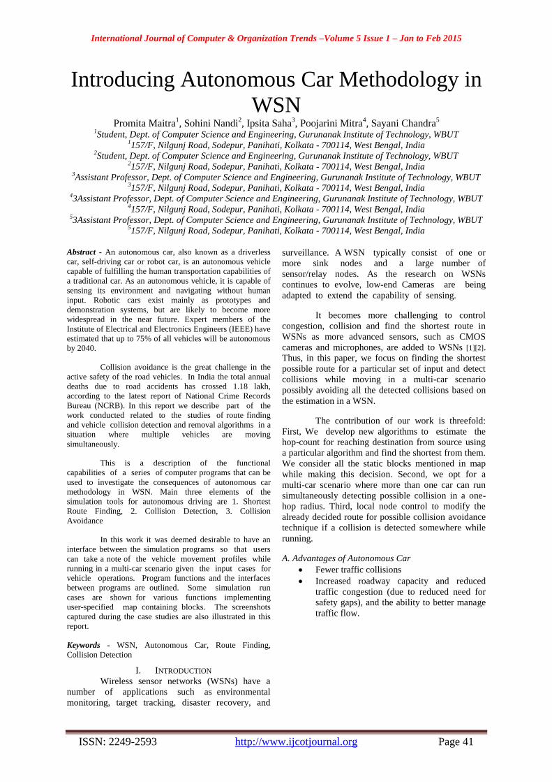
A. Comparison of three Route Finding Algorithms
To compare the time taken and the distance
covered by the car using three different algorithms we
developed, we give the same source and destination as
input in a 10 x 10 matrix and plot a graph using the
matrix cell position the car traversed. We took the Y
axis of the graph as the route column and the X axis as
the route row and plotted the graph. This graph clearly
shows which route finding algorithm takes least time
and traverses least amount of path to reach
destination.
International Journal of Computer & Organization Trends –Volume 5 Issue 1 – Jan to Feb 2015
ISSN: 2249-2593 http://www.ijcotjournal.org Page 44
Fig. 1 Three routes from source to destination
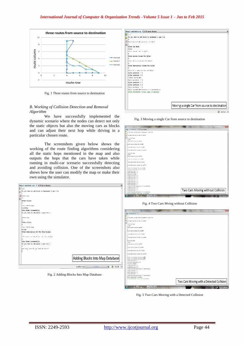
B. Working of Collision Detection and Removal
Algorithm
We have successfully implemented the
dynamic scenario where the nodes can detect not only
the static objects but also the moving cars as blocks
and can adjust their next hop while driving in a
particular chosen route.
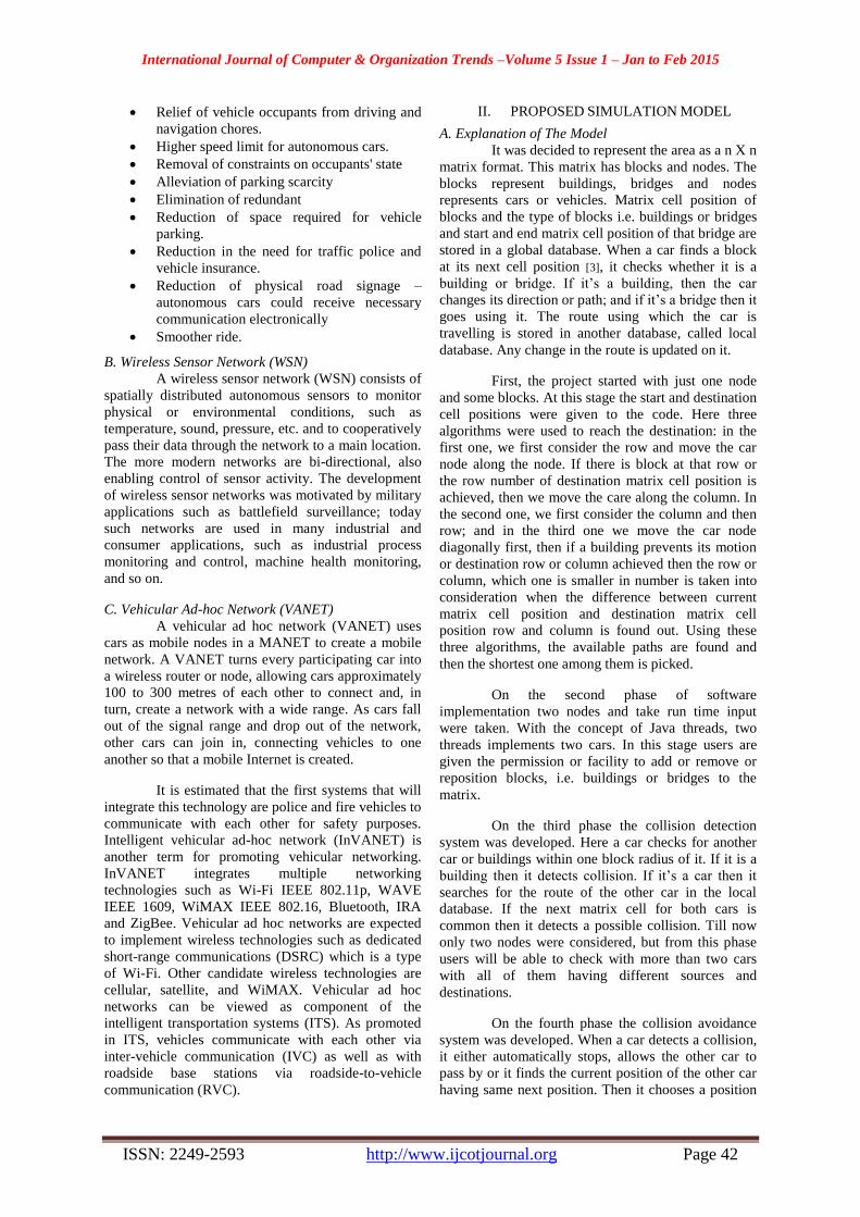
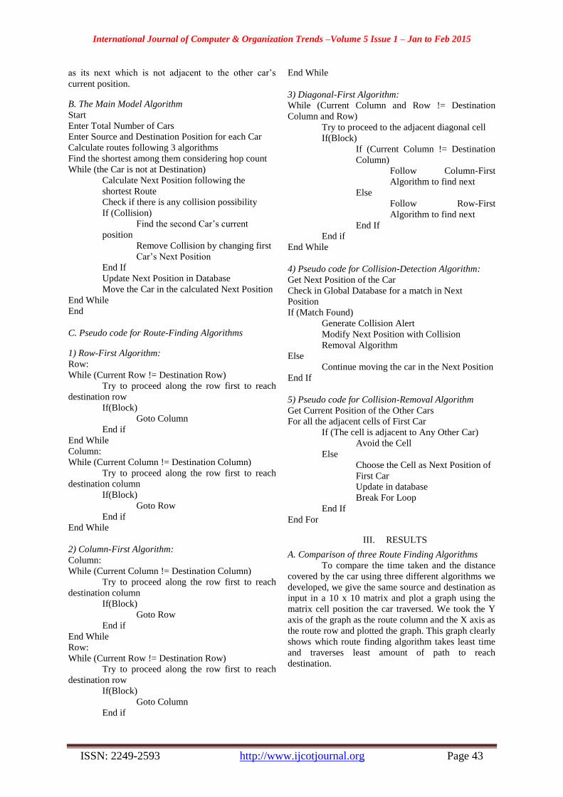
The screenshots given below shows the
working of the route finding algorithms considering
all the static hops mentioned in the map and also
outputs the hops that the cars have taken while
running in multi-car scenario successfully detecting
and avoiding collision. One of the screenshots also
shows how the user can modify the map or make their
own using the simulator.
Fig. 2 Adding Blocks Into Map Database
Fig. 3 Moving a single Car from source to destination
Fig. 4 Two Cars Mving without Collision
Fig. 5 Two Cars Moving with a Detected Collision
International Journal of Computer & Organization Trends –Volume 5 Issue 1 – Jan to Feb 2015
ISSN: 2249-2593 http://www.ijcotjournal.org Page 45
IV. CONCLUSION
In this software simulation, we mainly
focused on three parts.
Adding different types of blocks into database
Finding shortest route from source to destination
Detect and remove collision on way to destination
After finding three routes for a particular
source-destination combination, we even did a
comparative study among those algorithms plotting a
graph to determine which the best one is. But we
cannot omit a particular one because any of these
three can be useful for a particular set of source and
destination.
More features can be added to the existing
algorithms, like a collision detection algorithm for
curved path or a congestion detection technique after
finding the shortest route.
REFERENCES
[1] J. Jeong, S. Guo, T. He, D.H.C. Du "Autonomous Passive
Localization Algorithm for Road Sensor Networks", Proc. 11th World Congr. Intell. Transp. Syst., 2004
[2] A. Barth and U. Franke "Where will the oncoming vehicle be
the next second?", Proc. IEEE Intell. Veh. Symp., pp.1068 -1073 2008
[3] A. E. Broadhurst, S. Baker and T. Kanade "A prediction and
planning framework for road safety analysis, obstacle avoidance and driver information", Proc. 11th World Congr.
Intell. Transp. Syst., 2004