into the ice sea - rozenberg publishers: academic ... the ice sea.pdf“into the ice sea” is the...
TRANSCRIPT
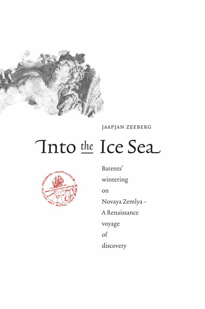
fiInto the Ice SeaflfiInto the
Ice Sea
Barents’
wintering
on
Novaya Zemlya –
A Renaissance
voyage
of
discovery
jaapjan zeeberg
j a a p j a n
z e e b e r g
Archaeologists connected with Amsterdam’s Rijksmuseum journeyedinto the Russian Arctic to rediscover the graves, ship, and winteringcabin of Willem Barents’ expedition, lost 400 years ago on the shores
of a remote Arctic island while charting a passage to Asia.
“Into the Ice Sea” is the account of several expeditions duringthe 1990s and their historical parallels of four centuries. This is
a book about Reformation and exploratory Romanticism,Arctic discovery and the Ancients, and the fortunes of a
Russian admiral, chasing the demon of his own creation acrossthe floes of the Kara Sea, the former Ice Sea.
With the original journal from Barents’ ship in hand, the authorspresent a view of the Arctic through the eyes of a sixteenth-century
explorer, and in the geometry of Barents’ ship and cabin discoverthe key to a Renaissance past.
This book will make you happier and wiser.
rozenberg publishers
amsterdam
isbn 90 5170 787 8
043136-3 Zeeberg-bd 11-04-2005 12:01 Pagina 1

Into the Ice Sea
jaapjan zeeberg
Into the Ice SeaBarents’ wintering on Novaya Zemlya –
A Renaissance voyage of discovery
With contributions by Pieter Floore
This publication was made possible by the financial support of Het Nationaal Comité Willem Barentsz (Amsterdam) and
J.E. Jurriaanse Stichting (Rotterdam)
© J.J. Zeeberg, 2005
With contributions by Pieter FlooreCopy editing by Luisa Alexander Izzo (Calgary, Canada)
Design: Puntspatie [bno], Amsterdam
All rights reserved. Save exceptions stated by the law, no part ofthis publication may be reproduced, stored in a retrieval system ofany nature, or transmitted in any form or by any means, electronic,
mechanical, photocopying, recording or otherwise, included acomplete or partial transcription, without the prior written
permission of the publishers, application for which should beaddressed to the publishers:
Rozenberg Publishers, Bloemgracht 82hs,1015 TM Amsterdam, The Netherlands.
Tel.: + 31 20 625 54 29, Fax: + 31 20 620 33 95 [email protected]
isbn 90 5170 787 8 (Hardbound) | isbn 90 5170 926 9 (Paperback)
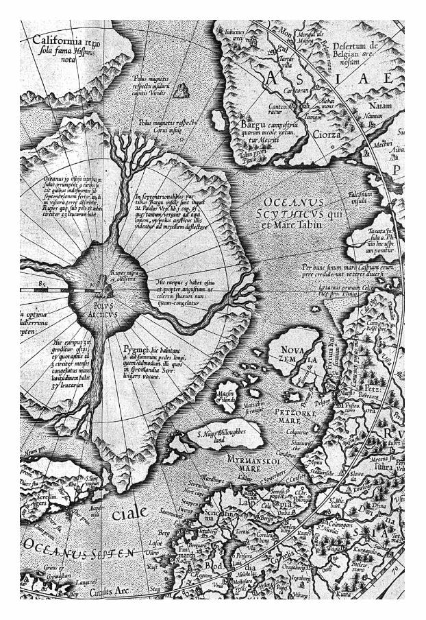
frontispieceGerard Mercator’s map of the Arctic, published in his atlas of 1595.
This map explains why the Dutch, discovering Spitsbergen,believed they had run into Greenland.
cover Acis and Galatea, by Jacob de Gheyn (308 ~358 mm), depicting the
Greek myth of secret love between a sea nymph and a shepherd,printed in Amsterdam in 1590. Seven copies were found in the stack
of prints recovered from the Saved House.

Introduction 7
Into the Ice Sea 13
Nova Zembla: Tale and Discovery of the Saved House 35
Dutch Expansion in the Sixteenth Century 51
To Japan: Liefde through the Strait of Magellan 67
Aftermath: Henry Hudson and the Fourth Dutch Expedition 77
Touchdown on Novaya Zemlya – We Uncover the Saved House 87
Digging into the Sixteenth Century 103
Two Years Later 117
Into the Kara Sea aboard R/V Ivan Kiriev 135
Repulsed by the Storm 153
In Search of Willem Barents 165
Waiting to Be Rescued 185
Terra Firma: Ashore in the Bay of Strangers 199
The House on Shore 211
We Find Parts of the Ship 231
In the Yugor Strait 249
What Mean These stones? 263
Acknowledgments 273
Appendices 277
References 301
Index 309
Contents

When your children shall ask, ‘What mean these stones?’(Joshua 4:21), let your children know – this is a memorial
to the way God was with us and protected us, in the desert trialsof life and in the icy waters of death.
(Chester A. Dollar, The Worship Channel, 27 August 2000)
Introduction
[7]
1. In Dutch: Amsterdam: Cornelis Claesz1598, 1599, 1605; Meyn 1617; Colijn 1619;Hartgers 1646, 1648. In Latin: CornelisClaesz 1598. In French: Cornelis Claesz 1598,1600, 1609; Paris: G. Chaudière 1599 (noplates). In Italian: Venice: Ciotti & Porro1599 (based on the German edition). InEnglish: London: Pauier 1609; London:Hakluyt Society 1853, 1876. In German:Nuremberg: Levinus Hulsius 1598, 1602,1612, 1660 (strongly edited; second, thirdand fourth editions are abridgements of the
first edition); Frankfurt: De Bry 1599, 1628,1629; Hamburg: Capel 1675, 1678 (abstractby Saeghman). The Dutch edition has fivemaps and 27 plates by engraver brothersJohannes and Baptista van Doetecum. Thesewere copied and adapted for the Germanedition and as a result the prints appear inmirror image. De Veer seems to have beeninvolved in the production of the Germanedition, because it has omissions andcontains passages and illustrations that donot occur in the original, but are verifiable.
A voyage into the Arctic is a voyage into the history of exploration, the traces ofwhich still scar many a polar coast. Between the wastes and building ruins of thepast century, huts, markers, campsites, and graves recall the struggle for eachmile, while the names of capes, mountains, and rivers bear witness to the step-wise geographical progress that was diligently laid down in charts of the newlywon territory. One of these steps, from 1596, is documented by a work entitledThe True and perfect Description of three Voyages, so strange and wonderful, that thelike has never been heard of before.[1] This Renaissance adventure, chronicled by
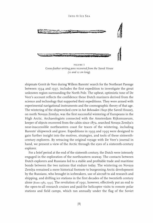
shipmate Gerrit de Veer during Willem Barents’ search for the Northeast Passagebetween 1594 and 1597, includes the first expedition to investigate the greatunknown region surrounding the North Pole. The upbeat, optimistic tone of DeVeer’s account reflects the confidence these Dutch mariners derived from thescience and technology that supported their expeditions. They were armed withexperimental navigational instruments and the cosmographic theory of that age.The wintering of the shipwrecked crew in het Behouden Huys (the Saved House),on north Novaya Zemlya, was the first successful wintering of Europeans in theHigh Arctic. Archaeologists connected with the Amsterdam Rijksmuseum,keeper of objects recovered from the cabin since 1872, searched Novaya Zemlya’snear-inaccessible northeastern coast for traces of the wintering, includingBarents’ shipwreck and grave. Expeditions in 1993 and 1995 were designed togain further insight into the motives, strategies, and tools of these sixteenth-century explorers. By retracing the original voyage with De Veer’s journal inhand, we present a view of the Arctic through the eyes of a sixteenth-centuryexplorer.
For a brief period at the end of the sixteenth century, the Dutch were intenselyengaged in the exploration of the northeastern seaway. The contacts betweenDutch explorers and Russians led to a stable and profitable trade and maritimebonds between the two nations that endure today. The wintering on NovayaZemlya remained a mere historical footnote to burgeoning Arctic developmentby the Russians, who brought in icebreakers, use of aircraft to aid research andshipping, and drifting ice stations in the first decades of the twentieth centuryalone [Barr 1985, 1991]. The revolution of 1991, however, effectively put an end tothe open-to-all research cruises and paid-for helicopter visits to remote polarstations and field camps, which ran annually under the flag of the Soviet
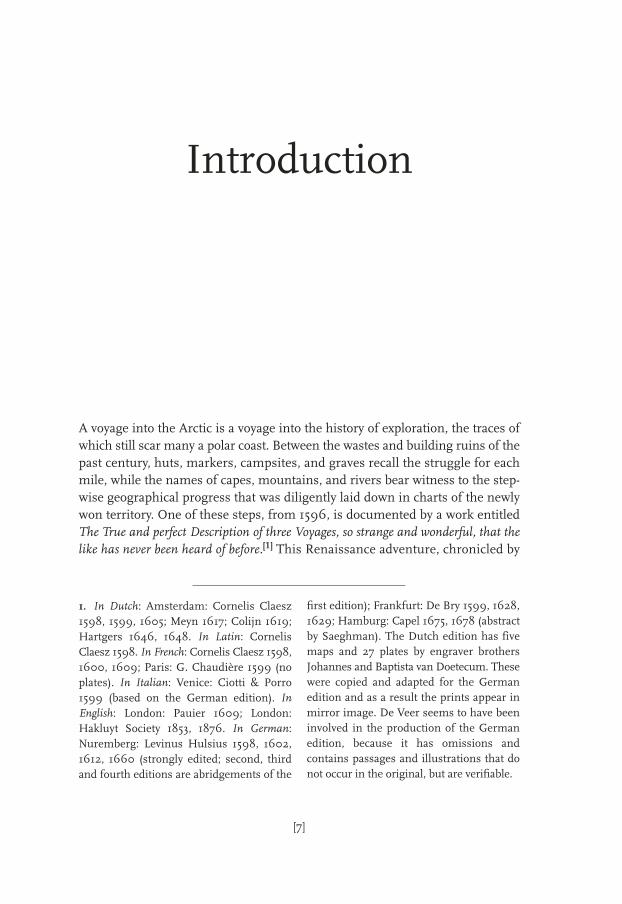
figure 1Goose-feather writing pens recovered from the Saved House
(11 and 12 cm long).
[8]
Into the Ice Sea

Academy of Sciences. With Arctic towns and settlements spinning into isolation,dented helicopters grounded for lack of spare parts, and weather stations thatonce accommodated vessel navigation obsolete and abandoned, it was the histor-ical footnote that gave something to hold on to during the early 1990s: a pointof reference in the maelstrom of a reforming economy. The present is the key tothe past is the key to the future, as the uniformitarians say. During the 1990s,Russian Arctic research continued through international partnerships thatprovided Western scientists opportunity to rediscover the Eurasian North. Today,many of the historical issues are resurfacing. In a warming environment, theNorthern Sea Route, a shipping lane between the Atlantic and Pacific oceans, ispredicted to become accessible for non-strengthened vessels within years, andthe Arctic nations are prepared to battle over the right to use it [US ONR 2001; Kerr
2002]. Traffic through these once-remote districts will be increasing, and demandfor their vast mineral resources and timber is growing every day. Four centuriesago, there was already a trade route to the Ob River and the depot of Mangazeya,from which pelts, ivory from mammoth and walrus, and “mountain crystals”(pyrites and other sparkly minerals that resembled gold or silver) found their wayacross Europe.[2]
The Netherlanders explored the Arctic frontier for three consecutive years(1594, 1595, and 1596) with fleets consisting of freighters and warships andcarrying merchants, cartographers, geographers, translators, and soldiers. Theysearched for a seaway across the North Pole that would yield access to themarkets of Asia while avoiding Spanish or Portuguese harbors and patrols. Thethird expedition, under the leadership of Willem Barents, was stranded onNovaya Zemlya’s Cape Spory Navolok in August 1596. On an escarpment of thewindswept Arctic desert, overlooking the frozen sea, the castaways constructeda cabin from wreckage. They wintered there, and in the following spring theytook to sea in the two open boats from their vessel, escaping the Arctic in eightydays. Their cabin, partly destroyed to make the boats seaworthy, was covered bysnow three or four months later. In the cold of the Little Ice Age, a climateepisode that lasted until ca. 1860 [Note #3 in Chapter 15], this snow hardened toice. Ice encapsulated the cabin’s interior until the arrival of the next visitor,Norwegian walrus hunter Elling Carlsen, in the summer of 1871. The recovery
[9]
Introduction
2. By the year 2080, the navigation seasonfor the Northern Sea Route will have in-creased from 20–30 days per year to 90–100days, and even more for ice-strengthenedvessels [ACIA 2005]. Projecting current rates
of change, mean annual air temperatures inthe High Arctic are predicted to rise by asmuch as 6°C (present Cape Zhelaniya aver-ages are 2°C for the summer months and–20°C for the winter months [Zeeberg 2001]).

of the wintering camp by Carlsen, in conjunction with De Veer’s account of dailylife in those very quarters, has given archaeologists an unparalleled, multidimen-sional view of this site.
The Saved House held a commercial sample of the booming Europeancultures. It was an extraordinary winter camp, with linens, pewter tableware, avariety of Renaissance prints by Hendrick Goltzius and Jacob de Gheyn, aneighty-year-old Gothic clock, wax candles, leather-bound books, and ornatelydecorated Venetian chalices. On Novaya Zemlya the explorers left carpenter tools,household goods, clothing, instruments, prints, merchandise, and armamentthey wouldn’t need in the boats. Nineteenth-century visitors to the Saved Housecame as treasure hunters and failed to record even the most basic observations,such as the dimensions and layout of the cabin. Russian surveys during the ColdWar, notably by Dmitri Kravchenko in 1979, found the wintering site still litteredwith debris. Many traces of the original encampment remained preserved underthe layer of soil and mosses – twenty to thirty centimeters thick – that coveredthe site. Comparison of the 1979 finds with those from 1871 demonstrates thatcorrosion rates and decay accelerated in the last century, in part because of post-Little Ice Age climate warming. The recovery project gained further urgency after1992, when international tour operators began to exploit the mystery of theformerly inaccessible Russian Arctic. Annual visits to Novaya Zemlya with char-tered icebreakers and helicopters continue, the Saved House being a main pointof interest.
This book synthesizes the fruits of five summer field seasons in the NovayaZemlya archipelago between 1991 and 2000. Our expeditions were designed toprovide an observational and analytical basis to the historical record by (1)mapping activity areas in and around the remnant building structure during an
[10]
Into the Ice Sea
figure 2Expedition and ship logos for the 1995 expedition.

archaeological survey, (2) locating and recovering remains of the vessel on thebeach and offshore, and (3) recovering the bodies of Willem Barents and ClaesAndriesz Goutijck. De Veer in his account of the voyage implies that they wereburied on the coast of north Novaya Zemlya, and by survey on foot we inspectedca. 180 km of Novaya Zemlya’s northern coast in 1995 and 1998. Ship and campremains and the objects recovered from the Saved House provide the materiallink between the diary and its historical context. “The hands of our seamentouched those objects,” wrote maritime historian Jarig Mollema in 1947 afterviewing an exhibit of the finds, “and one leaves feeling as though their handshave grabbed ours.”
[11]
Introduction

figure 1Title page of the 1609 English edition of De Veer’s work.

Winter was sweeping its last wet strokes across the saturated Dutch land whenDmitri Kravchenko arrived in Amsterdam on the morning of 3 March 1991.He was a man with a mission and a scientist with an obsession. The slim, 52-year-old archaeologist with pallid beard and sunken face called himselfcaptain, admiral, and historian. For more than a decade, Kravchenko had beenobsessed by the glimpse into the past allowed him on a remote, snow-dustedArctic island. Now his goal was the Rijksmuseum in the center of town. In asmall suitcase he carried plans to complete Willem Barents’ voyage around theEurasian continent. Kravchenko expected that in the Netherlands his reputationas investigator of Barents’ wintering would open wide many doors, throughwhich money would flow prodigiously. In full regalia, an old-fashioned RussianNavy uniform replete with gold braids, he presented himself at the mainentrance of the museum, queuing with tourists before the box office and ner-vously searching for words.
“I must see Barents expert, Dr. Braat,” Kravchenko began, striding up thesteps to the counter.
“Sir, this is the entrance to the museum,” replied the woman behind the thickglass window. “Would you like to buy a ticket?”
“I have twenty years’ experience in the Arctic territory,” Kravchenko continued,unfazed. “At the site of the Saved House, we erected a cross six meters tall and acairn in honor of Barents and his men. That monument is also intended as awarning: This is a historic spot, which must be preserved!”
Into the Ice SeaChapter One
[13]
[14]
Into the Ice Sea
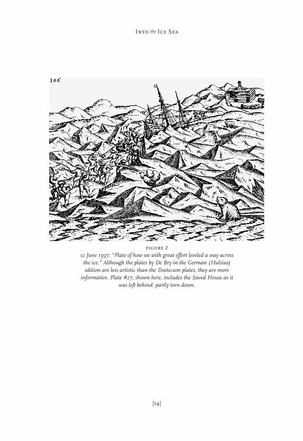
figure 212 June 1597: “Plate of how we with great effort leveled a way across
the ice.” Although the plates by De Bry in the German (Hulsius)edition are less artistic than the Doetecum plates, they are more
informative. Plate #27, shown here, includes the Saved House as itwas left behind: partly torn down.
The clerk in the box office nodded politely (people were more patient thenthan they are today) and then waved for Security.
Kravchenko asked for an interview with Joost Braat, curator and archivist inthe Rijksmuseum’s Dutch history section. During the past twelve years, they hadmet occasionally in Moscow, and now Kravchenko was back – with a new plan.[1]
It soon transpired that he was not at the right address after all: the offices andarchives were in another building, across the street from the museum. “You’reholding up the line,” the security guard told him. “Please step back.” Kravchenkohesitated and then, uttering Russian phrases, made his way outside through therevolving doors.
“Problem – but small problem,” he muttered, backing away from theimposing nineteenth-century building to try and spot another entry. When herealized that the officer was keeping an eye on him, he decided to look for theinstitute’s offices. Crossing the street, he searched the name plates and steppedup to one labeled “Rijksmuseum”. The door buzzed open. He stepped inside andreceived further scrutiny. But a few minutes later – at last – a familiar face! Muchto Kravchenko’s relief, he had found Joost Braat.
In 1974, Joost Braat had initiated a cautious diplomatic approach to Sovietauthorities about finalizing the salvage of Willem Barents’ Saved House. In theCold War years, such efforts required good contacts. Braat, then a Communistby conviction, had met with M.I. Belov, director of St. Petersburg’s Arctic andAntarctic Research Institute (AARI), and inquired how much really waspreserved of the Saved House. “Nothing... There is nothing left,” was the reply,but in 1977, Belov arranged for Dmitri Kravchenko to visit northern Novaya
[15]
Into the Ice Sea
1. Kravchenko participated in a search ofthe coasts of the Kara Sea – promoted byKomsomol’skaya Pravda and led by D.M.Shparo in 1973, 1974, and 1975 – for tracesof the expedition of Vladimir Rusanov withGerkules, which disappeared after roundingnorth Novaya Zemlya in 1912. In 1934, acairn and a wooden pole with the carving“Gerkules 1913” were discovered on a smallisland at the mainland coast (GerkulesIsland, 75°47'N, 88°18'E). The 1934 expedi-tion found belongings of Rusanov andGerkules in among the driftwood on a smallisland in the archipelago of Shkery Minina(74°54'N, 86°35'E) [Barr 1984]. Shparo’s sur-
vey produced a fireplace on MikhailovIsland, with objects similar to those found in1934. Otto Sverdrup, searching for the partyaccording to instructions left by Rusanov atWest Matochkin Shar, spent the winter of1914–1915 at Cape Vylda, close to GerkulesIsland [Barr 1974a, b; 1984]. Ice conditions inthe eastern Kara Sea were severe in 1912 and1913, even for the icebreaker Vaygach, whichwas headed for discovery of SevernayaZemlya [Barr 1991]. The Rusanov party,therefore, may have wintered on northeastNovaya Zemlya or Gerkules Island and sub-sequently moved west along the coast ofTaymyr, probably toward Dikson.

figure 1Willem Barents’ book of charts (Caertboeck) for the Mediterranean
Sea, published by Cornelisz Claesz in 1595.
Demise of an Empire and Birth of a Republic
Nine printed books and a manuscript were retrieved after 1871 from the ice thatfilled the ruins of the Saved House. These were practical works: navigationalhandbooks, a Dutch translation of Mendoza’s History of China, religious booksand a Dutch-French dictionary, and also a historical reference of the Netherlands,which signifies that the Dutch in their winter quarters were keenly aware of theirmoment in history. The chronicles of Holland, Zeeland, and Friesland until the year1517 (Delft, 1585) is a leather-bound history book with fancy copper locks, writtenin part by Ellert de Veer (1540–1598), Gerrit’s father. With the title extension,“and what has happened since the reign of Charles of Burgundy, Fifth RomanEmperor” (Charles V, 1500–1558), the authors provided a link to their own time.This line is followed by Gerrit de Veer, who dedicated his exploration account tothe States General and to Maurits, Prince of Orange by birth, “Stadholder andCommander of Gelderland, Holland, Zeeland, West-Friesland, Utrecht, andOverijssel, etc., and Admiral at sea.”
And Jan Huyghen van Linschoten [1601], who also dedicated his account of theArctic region to the Prince, further explains in his introduction:
Because the undertaking was Your own work and occurred in Your name and underYour policies...[The exploration of the World] had been on our minds for years and
Dutch Expansion in the
Sixteenth Century
Chapter Three
[51]
has now materialized through the insights of our national government and ournation’s Stadholder, Our beloved Protector, His Serene Highness, the late Prince[William I] of Orange, who took particular pleasure [in new discoveries]. For a longtime, many difficulties arising from disturbances and war prevented us from ulti-mately turning our words into actions, but in our hearts, the drive continued to sparkand was never extinguished. When the Almighty finally lifted our burdens throughthe military leadership of our intrepid hero, Prince Maurits, who succeeded hisfather, and through the wisdom of the States General, the fires were rekindled.[L’Honoré-Naber 1917, p. 26]
Willem Barents and the Novaya Zemlya wintering are associated with the blos-soming of Dutch commerce and culture and the dawning of the Golden Age.Dutch expansion and voyages of discovery at the close of the sixteenth centurywere direct consequences of years of revolution and war. Following the divisionof the Habsburg Empire in 1559, Spain’s northern territories had been entrustedto the leadership of Willem of Orange (1533–1584), a wealthy noblemanappointed by Philip II stadholder of the provinces of Zeeland, Holland, andUtrecht. Protests against the close-knit political and church systems propagatedby Calvin (1509–1564) in France and Luther (1483–1546) in Germany were stim-ulated by tax increases imposed on the financially flourishing Netherlands.When military forces arrived in 1567 to oppress the rebellion, the Netherlandersunder the leadership of Orange rose up against Madrid, starting a war that wasto last eighty years. Outlawed by Philip, Willem of Orange was shot dead by aFrench assassin in June 1584. A year later, the Spanish regained control ofAntwerp, the Netherlands’ booming metropolis and economic center thatinspired Bruegel’s “Tower of Babel” (1563). This city was a major staple marketfor commodities from the Mediterranean and Baltic seas and goods from theAmericas imported by the Spanish. Over the next decade, half the population ofall major cities in the southern Netherlands moved to the north – 38,000 fromAntwerp alone. The cities of Holland during the 1580s received the flow ofrefugees with relative ease, and the immigrants from the south broughtadvanced skills to an assemblage of seamen, shipyard workers, peat-diggers, andpeasants [Wilson 1976; Israel 1995]. International trade rapidly broadened the viewof the surrounding world, and the merchant fleet, especially, provided the eyesand ears of the Reformation.
Spanish influences were omnipresent in Holland during the 1580s and 1590s,as a result of the two countries’ common history. Despite the war, the Netherlan-ders were considered Spanish citizens and could pursue careers in service to theEmpire. On the third voyage to the Arctic, the explorers carried Spanish currency(reals), ate mazamorra (porridge), and named several landforms in Spanish. Jan
[52]
Into the Ice Sea
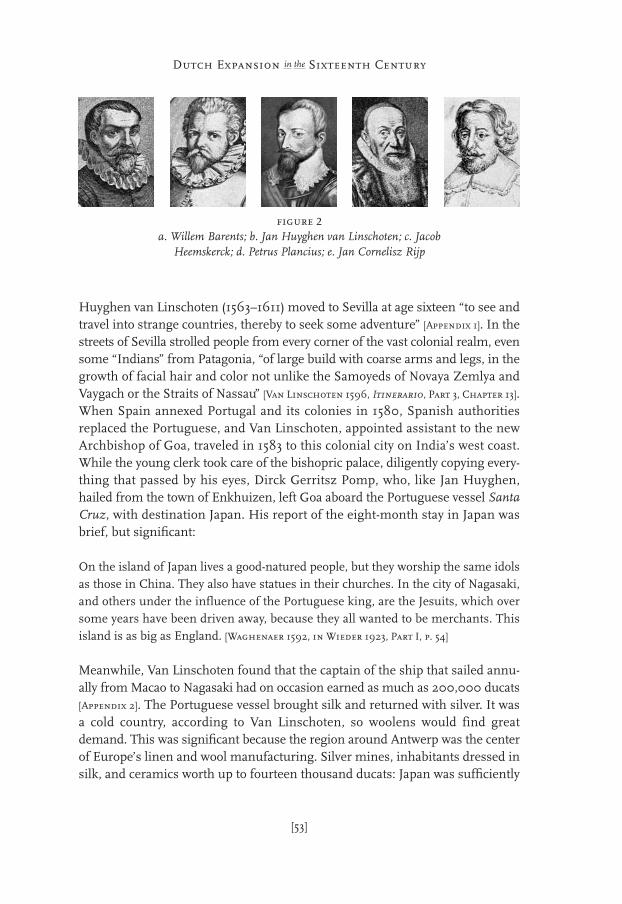
Huyghen van Linschoten (1563–1611) moved to Sevilla at age sixteen “to see andtravel into strange countries, thereby to seek some adventure” [Appendix 1]. In thestreets of Sevilla strolled people from every corner of the vast colonial realm, evensome “Indians” from Patagonia, “of large build with coarse arms and legs, in thegrowth of facial hair and color not unlike the Samoyeds of Novaya Zemlya andVaygach or the Straits of Nassau” [Van Linschoten 1596, Itinerario, Part 3, Chapter 13].When Spain annexed Portugal and its colonies in 1580, Spanish authoritiesreplaced the Portuguese, and Van Linschoten, appointed assistant to the newArchbishop of Goa, traveled in 1583 to this colonial city on India’s west coast.While the young clerk took care of the bishopric palace, diligently copying every-thing that passed by his eyes, Dirck Gerritsz Pomp, who, like Jan Huyghen,hailed from the town of Enkhuizen, left Goa aboard the Portuguese vessel SantaCruz, with destination Japan. His report of the eight-month stay in Japan wasbrief, but significant:
On the island of Japan lives a good-natured people, but they worship the same idolsas those in China. They also have statues in their churches. In the city of Nagasaki,and others under the influence of the Portuguese king, are the Jesuits, which oversome years have been driven away, because they all wanted to be merchants. Thisisland is as big as England. [Waghenaer 1592, in Wieder 1923, Part I, p. 54]
Meanwhile, Van Linschoten found that the captain of the ship that sailed annu-ally from Macao to Nagasaki had on occasion earned as much as 200,000 ducats[Appendix 2]. The Portuguese vessel brought silk and returned with silver. It wasa cold country, according to Van Linschoten, so woolens would find greatdemand. This was significant because the region around Antwerp was the centerof Europe’s linen and wool manufacturing. Silver mines, inhabitants dressed insilk, and ceramics worth up to fourteen thousand ducats: Japan was sufficiently
[53]
Dutch Expansion in the Sixteenth Century
figure 2a. Willem Barents; b. Jan Huyghen van Linschoten; c. Jacob
Heemskerck; d. Petrus Plancius; e. Jan Cornelisz Rijp

attractive to establish trading contacts, indeed! Pomp and Van Linschotentogether set sail for their patria in 1589.[1]
Van Linschoten returned to the Netherlands on 3 September 1592. Three yearslater, he published his vast collection of records and notations. The Voyage or navi-gation of Jan Huyghen van Linschoten to East- or Portuguese India – the Itinerario,as it is commonly called – described the maritime routes to the Indies, physicalfacts of the eastern sea-lanes and the shores of America and Africa, consularreports, and economic and political treatises of Spain and Portugal. VanLinschoten presented an accurate layout of the “East Indian” riches and the mea-sures taken by the Iberians to shield them from others, recommending Java as asecure target. He was unable, however, to accompany brothers Cornelis and Fred-erik de Houtman on the first Dutch intercontinental voyage (April 1595 to August1597). Just as that journey was being prepared, he accepted an invitation to jointhe first polar expedition in 1594, “although I had only recently returned from theEast Indian Countries, had barely completed the description of that country, andhad only briefly enjoyed my country and the company of my few remainingfriends” [Round by the North (1601), in L’Honoré-Naber 1914, p. 27].
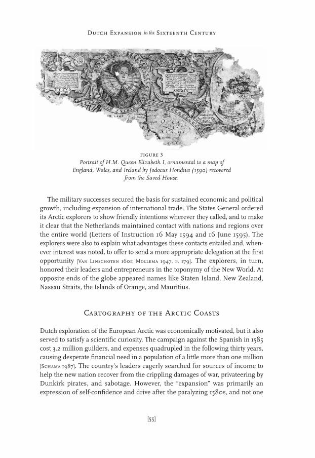
The consolidation of the Dutch state that enabled the intercontinental voyagesbegan in 1588, when Spain diverted its attention to England. The need for an allyat sea had persuaded Elizabeth to withdraw English support for the Dutch oppo-sition, which, by sustaining the unrest in the Netherlands, had incapacitated theyoung republic. The English had regarded the populist rebellion against Spainwith mixed feelings; support to Orange had been half-hearted, although Wals-ingham and other advisors recommended otherwise. Only after Antwerp fell in1585 did Queen Elizabeth abandon her neutrality toward Philip, and Englishtroops were hailed in as liberators in Holland and Zeeland. (Gardiner in 1876found a portrait of Elizabeth, ornamental to a map of England and Wales byHondius [1590], in the Saved House.) Further consolidation took place whenSpain in 1590 declared war on France, relieving the north of the pressure of theSpanish Army. The Netherlands’ military leaders quickly took advantage of thesesudden shifts in the international power field, recapturing many towns and forti-fications along the eastern and southern fronts between 1590 and 1592. PrinceMaurits had reorganized the Dutch forces along the lines of the Roman armies:infantrymen armed with pikes and muskets were trained for swift, disciplinedmoves across rivers and through marshlands.
[54]
Into the Ice Sea
1. Pomp would attempt to return to Japanwith Mahu and De Cordes in 1598, but in1599, the Spanish captured him, along with
his vessel Blijde Boodschap (‘Good Tidings’),on the west coast of South America (Chapter4).
The military successes secured the basis for sustained economic and politicalgrowth, including expansion of international trade. The States General orderedits Arctic explorers to show friendly intentions wherever they called, and to makeit clear that the Netherlands maintained contact with nations and regions overthe entire world (Letters of Instruction 16 May 1594 and 16 June 1595). Theexplorers were also to explain what advantages these contacts entailed and, when-ever interest was noted, to offer to send a more appropriate delegation at the firstopportunity [Van Linschoten 1601; Mollema 1947, p. 179]. The explorers, in turn,honored their leaders and entrepreneurs in the toponymy of the New World. Atopposite ends of the globe appeared names like Staten Island, New Zealand,Nassau Straits, the Islands of Orange, and Mauritius.
Cartography of the Arctic Coasts
Dutch exploration of the European Arctic was economically motivated, but it alsoserved to satisfy a scientific curiosity. The campaign against the Spanish in 1585cost 3.2 million guilders, and expenses quadrupled in the following thirty years,causing desperate financial need in a population of a little more than one million[Schama 1987]. The country’s leaders eagerly searched for sources of income tohelp the new nation recover from the crippling damages of war, privateering byDunkirk pirates, and sabotage. However, the “expansion” was primarily anexpression of self-confidence and drive after the paralyzing 1580s, and not one
[55]
Dutch Expansion in the Sixteenth Century
figure 3Portrait of H.M. Queen Elizabeth I, ornamental to a map of
England, Wales, and Ireland by Jodocus Hondius (1590) recoveredfrom the Saved House.
of need, as contended by contemporary historians such as Emmanuel vanMeteren. The grain trade with Italy, generally tolerated by Spain to relieve grainshortages, had grown to involve 400 ships a year. Dutch expansionism was acommercial enterprise, “...on the one hand to prevent our competitors fromgaining an advantage over us, and on the other hand out of an insatiable lust forprofits” [Van Linschoten 1601, in L’Honoré-Naber 1914, p. 28]. The steady flow ofgeographical data generated by the merchants and their scouts invited frequentupdates of sea-route descriptions and navigational handbooks, further stimu-lating international trade. Products and art that the Mediterranean trade broughtin from Italy heralded the northern European Renaissance. With Goltzius, whostudied Roman antiquity during a stay in Italy in 1591, Haarlem became one ofEurope’s most influential art centers. The artwork recovered from the SavedHouse includes allegories, a series of Roman heroes, and many prints of Biblicalscenes, because Holland’s clergymen and scholars were still quarreling aboutwhat the snake might have hissed in Paradise.
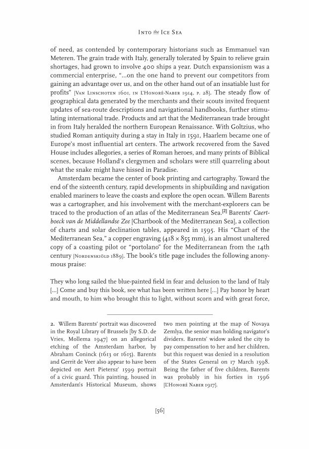
Amsterdam became the center of book printing and cartography. Toward theend of the sixteenth century, rapid developments in shipbuilding and navigationenabled mariners to leave the coasts and explore the open ocean. Willem Barentswas a cartographer, and his involvement with the merchant-explorers can betraced to the production of an atlas of the Mediterranean Sea.[2] Barents’ Caert-boeck van de Middellandse Zee [Chartbook of the Mediterranean Sea], a collectionof charts and solar declination tables, appeared in 1595. His “Chart of theMediterranean Sea,” a copper engraving (418 ~ 855 mm), is an almost unalteredcopy of a coasting pilot or “portolano” for the Mediterranean from the 14thcentury [Nordenskiöld 1889]. The book’s title page includes the following anony-mous praise:
They who long sailed the blue-painted field in fear and delusion to the land of Italy[...] Come and buy this book, see what has been written here [...] Pay honor by heartand mouth, to him who brought this to light, without scorn and with great force,
[56]
Into the Ice Sea
2. Willem Barents’ portrait was discoveredin the Royal Library of Brussels [by S.D. deVries, Mollema 1947] on an allegoricaletching of the Amsterdam harbor, byAbraham Coninck (1613 or 1615). Barentsand Gerrit de Veer also appear to have beendepicted on Aert Pietersz’ 1599 portraitof a civic guard. This painting, housed inAmsterdam’s Historical Museum, shows
two men pointing at the map of NovayaZemlya, the senior man holding navigator’sdividers. Barents’ widow asked the city topay compensation to her and her children,but this request was denied in a resolutionof the States General on 17 March 1598.Being the father of five children, Barentswas probably in his forties in 1596[L’Honoré Naber 1917].
praise him day, month and year [...] Praise Willem Barentszoon, who acts not withoutGod (Rust baart Lust).
The Northeast Passage had been partially mapped in the sixteenth centurythrough a compilation of observations, word-of-mouth knowledge, and knowl-edge ascribed to the Ancients, notably the Roman geographer Pliny the Elder(A.D. 23–79) and Ptolemy (A.D. 87–150) [cf. Wallis 1984; Okhuizen 1996]. The crit-ical point in the seaway was Cape Tabin (the present Cape Chelyuskin), the north-ernmost cape in Asia. Tabin promontorium Plinio (Cape Tabin according to Pliny)was first shown on Gerard Mercator’s chart of the Arctic (1569, revised by his sonin 1595 and 1601), which appears to include Vilkitsky Strait between the mainlandand the hypothetical Arctic Continent. Cape Tabin was also displayed on Ortelius’Theatrum Orbis Terrarum (1570), as well as on maps by Lucas Jansz Waghenaer(1589, 1592), Plancius (1594), and Hondius (1595). Later additions accurately indi-cate continuing geographic discoveries, e.g. “the New Land that Olivier Brunel[3]
has found, situated under the Northern Pole, named Nova Zembla” on Waghe-naer’s map of 1592 [Schilder 1984]. The Yugor Strait, 2–10 km wide, was believedto yield exclusive entrance to the Northeast Passage. The strait now known as theKara Gates, to the north of Vaygach Island, had not been explored, and it does notappear on the maps of Barents and De Veer. On Isaac Massa’s map (1602), it ismarked: “Here one may cross at high tide – otherwise it is dry.”
The investors in the first two expeditions tried to secure exclusive rights to thenorthern sea route. On 26 August 1594, aboard Zwane, one of the Zeelandvessels of the Dutch fleet exploring the Russian north, Van Linschoten wrote:“One should of course build a stronghold on Idols Point [Cape] near the entranceof the [Yugor] Strait. Then no force in the world could harm us there. With someconstructions behind this point, a harbor can be created where ships can be shel-tered and supplied” [Van Linschoten 1601, in L’Honoré-Naber 1914, p. 30]. The success-ful Zeeland merchant Balthasar de Moucheron, an acquaintance of Mercator anddriving force behind the Dutch Arctic explorations, wrote to the States of Hollandand Zeeland (6 April 1595):
If one succeeds in sailing to Cape Tabin and sending back a message [about havingreached this Cape], it is of the uttermost importance that you [the States] have assured
[57]
Dutch Expansion in the Sixteenth Century
3. Olivier Brunel (1545?–1605?) workedthroughout Russia during the 1560s as mer-chant for the Stroganovs [Koolemans-Beij-
nen 1876]. Brunel’s exploration of northernRussia and Novaya Zemlya during the 1580s
is evident from De Veer’s reference(8 August 1594) to “the place where OlivierBrunel had been before, called Costinsarch”(see also Chapter 5).
1993 Journal of Pieter Floore
Friday, 27 August 1993 – A cold day! No wind, but very damp, with thick fog.I have no idea what is going on, but every morning I wake as if from a coma. Ittakes a good half hour for me to regain my senses and get dressed. Until today,I held on to the illusion that we would be able to complete our tasks at the SavedHouse, but excavation is terribly labor-intensive, which makes for slow progress.Keeping up with the administration of finds took me almost the entire day. Hansstays all alone in his small tent, surrounded by a good number of bags, and hediligently tries to keep up with the avalanche of new discoveries. Henk van Veen,who is sharing that tent with Hans, is sent off after breakfast, and all day his cotis used as a sorting station. On our chart of the excavation, slowly but surely, theorganization of the Saved House is taking shape.
The hearth, in the centre of the House, has now been completely unearthed.Few objects are found in the hearth itself, but small items in its immediatesurroundings betray its intensive use. We have found the small bones of Arcticfoxes, a welcome supplement to the winterers’ menu. The small skulls werecracked so they could consume everything, even the brains. It has beensuggested that this helped to stem the outbreak of scurvy, the much-feareddisease that results from Vitamin C deficiency. The human body cannot makeVitamin C (ascorbic acid) by itself: we derive it primarily from fresh fruit and
[103]
Digging into theSixteenth Century
Chapter Seven
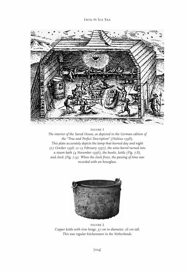
figure 2Copper kettle with iron hinge, 37 cm in diameter, 26 cm tall.
This was regular kitchenware in the Netherlands.
[104]
Into the Ice Sea
figure 1The interior of the Saved House, as depicted in the German edition of
the “True and Perfect Description” (Hulsius 1598). This plate accurately depicts the lamp that burned day and night
(27 October 1596; 12–13 February 1597), the wine barrel turned intoa steam bath (4 November 1596), the bunks, kettle (Fig. 7.8),
and clock (Fig. 7.9). When the clock froze, the passing of time wasrecorded with an hourglass.
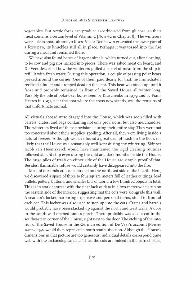
vegetables. But Arctic foxes can produce ascorbic acid from glucose, so theirmeat contains a certain level of Vitamin C [Note #2 in Chapter 8]. The wintererswere able to snare almost 30 foxes. Victor Dershawin excavated the lower part ofa fox’s paw, its knuckles still all in place. Perhaps it was tossed into the fireduring a meal and remained there.
We have also found bones of larger animals, which turned out, after cleaning,to be cow and pig ribs hacked into pieces. There was salted meat on board, andDe Veer described how the winterers pulled a barrel of meat from the ship torefill it with fresh water. During this operation, a couple of passing polar bearspeeked around the corner. One of them paid dearly for that: he immediatelyreceived a bullet and dropped dead on the spot. This bear was stood up until itfroze and probably remained in front of the Saved House all winter long.Possibly the pile of polar-bear bones seen by Kravchenko in 1979 and by FransHeeres in 1991, near the spot where the cross now stands, was the remains ofthat unfortunate animal.
All victuals aboard were dragged into the House, which was soon filled withbarrels, crates, and bags containing not only provisions, but also merchandise.The winterers lived off these provisions during their entire stay. They were nottoo concerned about their supplies’ spoiling. After all, they were living inside anatural freezer. Although we have found a great deal of trash on the floor, it’slikely that the House was reasonably well kept during the wintering. SkipperJacob van Heemskerck would have maintained the rigid cleaning routinesfollowed aboard ship even during the cold and dark months inside the House.The huge piles of trash on either side of the House are simple proof of that.Besides, flammable refuse would certainly have disappeared into the fire.
Most of our finds are concentrated on the northeast side of the hearth. Here,we discovered a space of three to four square meters full of leather cuttings, leadbullets, pottery, buttons, and smaller bits of fabric: a few hundred objects in total.This is in stark contrast with the near lack of data in a two-meter-wide strip onthe eastern side of the interior, suggesting that the cots were alongside this wall.A seaman’s locker, harboring expensive and personal items, stood in front ofeach cot. This locker was also used to step up into the cots. Crates and barrelswould probably have been stacked up against the north and west walls. A doorin the south wall opened onto a porch. There probably was also a cot in thesoutheastern corner of the House, right next to the door. The etching of the inte-rior of the Saved House in the German edition of De Veer’s account [Hulsius
edition, 1598] would then represent a north-south bisection. Although the House’sdimensions in that picture are too generous, individual details correspond quitewell with the archaeological data. Thus, the cots are indeed in the correct place,
[105]
Digging into the Sixteenth Century

but they are represented on too small a scale. If there were six cots, then each cotwas meant for three men. Aboard ship it was also customary for several men toshare one cot. In the Saved House, that would have allowed them to profit fromeach other’s body warmth. A cot measured approximately 1.5 to 1.7 meters long.Even though the mariners were not very tall – Van Heemskerck’s body armor inthe Rijksmuseum is small – they would probably have slept in a half-sitting posi-tion, as people were wont to do in those days.
Svetlana has been a complete no-show at the digs. Together with Yuri, shekeeps busy in the kitchen. The culinary level of the field kitchen has been consid-erably raised by her arrival. Today, we’ll be getting Uga, a delicious soup with fishfrom the Yenisey River. This afternoon, the weather also took a turn for thebetter. The fog lifted and the sun broke through the clouds. Henk, Dirk, and Itook a walk towards the ruins of the wooden lighthouse on the cape to gatherfirewood for our camp. After keeping a fire going for almost ten days, we haveto walk farther and farther to gather firewood. Driftwood on the beach in frontof the Saved House was already in very short supply, but now it has beendepleted. Sometime during the 1950s a wooden lighthouse a good 15 meters tallwas constructed on the southern tip of the promontory. There is a small shelternext to it. The glass prism of the lighthouse’s lamp lies spread about the remainslike a sort of eternal ice. From what’s left of the wooden tower, one gets a grandview of the entire cape until far past Ice Harbor. It is so clear that objects on thehorizon don’t grow blurry, but rather become too small for the eye to see. Every-thing is flat, the sea as well as the land. In the nineteenth century, CharlesFrancis Hall of the United States spent two years with the Eskimos in NorthernCanada. One day, Hall was with an Eskimo hunter and viewed his surroundingswith a telescope. Although the hunter boasted sharp eyesight, with the telescopehe could bring closer those things that were barely visible even for him. He toldHall that the telescope provided a view into tomorrow. Hall wondered at theremark, and when I read it I did not understand it either, but now it suddenlymakes sense. Here, you can easily see 30 km, and if you are at a higher elevation,even farther. However far you can see, you will see as far across the landscape asyou can cover by foot in a day. You will always be looking at today.
Upon returning, I asked René Gerritsen if he could cover the excavation with hisflying camera today. The kite took off with the camera tilting from underneath itat a 45° angle to obtain oblique images. The kite-flying session ran its coursebeautifully, and this will result in splendid photographs. Today it is exactly 397years ago that the Dutch vessel got stuck in the ice and the decision was made tosit out the winter on Novaya Zemlya. Henk read from the diary and brought thefestivities to a close with a speech, in which he simultaneously commemorated
[106]
Into the Ice Sea

the dead of the sojourn. Devoutly we doffed our caps. As usual, Henri wasputting it all on film, and as usual, it would all have to be repeated. Then Tacohurried to include the event in his reporting and transmit it all with the satellitephone. René again managed to send seven digital photos to the Utrechts Nieuws-blad. They, in turn, announced that they will have a full-page spread on the expe-dition.
Svetlana will pull double guard duty tonight, so I will hit the sack early. Shethought we had been working hard. The temperature started dropping thisevening and is expected to go below freezing. Dirk and I have been lying in ourtent, still chatting, for quite a while.
Saturday, 28 August 1993 – The wind gauge indicates a Force 8 wind. Large wavesare crashing in a haze of ocean spray along the coast, and foam is gusting upalmost to our camp. The coast had been almost free of ice for the last few days,but now many ice floes come floating by out of the north. Reluctantly, we startedour work near the Saved House. It was so frigid that I could hardly look into thewind. A few minutes later, a polar bear alert sounded. Two young bears hadheaded out to sea not too far from camp, only to come plodding along the beachtowards the lighthouse. We had barely started again when Vadim showed ussomething unbelievable. Yesterday he astonished everyone with a leadencompass-case casually left behind near the hearth, in the center of the SavedHouse. This could be the compass De Veer wrote about on 29 January 1597. Inthe square that he has just started to dig, Vadim is working around the end of aglass drinking horn preserved in the soil. The object is made out of crystal-clearglass, decorated with gilded paint. Two of these extremely rare horns are kept inthe Amsterdam Rijksmuseum. In the sixteenth century, it was nearly impossiblefor most glassblowers to produce such colorless glass. Only the masterfulVenetian glassblowers proved capable of this tour-de-force. This is not to say, yet,that this horn originated in Italy. Attracted by financially strong buyers, Italianshad long been working in countries bordering the North Sea. These types ofobjects, however, are unusual on a ship, and I believe this horn is part of theprecious cargo taken aboard in Amsterdam.
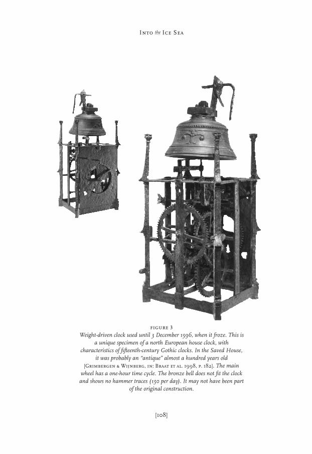
Van Heemskerck and Barents carried a highly diverse sample of arts andcrafts available in the Dutch Republic. Their cargo was not a specific trade cargo,because they were not yet sure what might interest the peoples of Cathay andJapan. Jan Huyghen van Linschoten, during his stay in Goa, learned frommissionaries that the Chinese Emperor was particularly enamored of clocks. Theclock that Carlsen discovered in 1871, also depicted on Hulsius’ print of the SavedHouse’s interior, certainly was not a ship’s clock. This timepiece with weightswas totally unsuited for shipboard use and was likely selected as a gift for the
[107]
Digging into the Sixteenth Century
[108]
Into the Ice Sea
figure 3Weight-driven clock used until 3 December 1596, when it froze. This is
a unique specimen of a north European house clock, withcharacteristics of fifteenth-century Gothic clocks. In the Saved House,
it was probably an “antique” almost a hundred years old[Grimbergen & Wijnberg, in: Braat et al. 1998, p. 182]. The main
wheel has a one-hour time cycle. The bronze bell does not fit the clockand shows no hammer traces (150 per day). It may not have been part
of the original construction.

Emperor. The two very large maps of the United Netherlands recovered from theremains of the Saved House were also intended to impress the mightiest ofAsian Rulers. Commercially and politically, the voyage of Barents and VanHeemskerck was very much experimental.
Today, work progressed slowly because everybody soon became cold and tiredin the icy wind. It remained to be seen if we could finish our research, for towardthe end of the afternoon it started snowing. Powdery snow has continued to fallall during the evening. I transferred the data from Kravchenko’s field sketches toour charts to compare the results of the two investigations. This afternoon, Hansresearched the spot outside the northeast corner, where Kravchenko had markedhis largest concentration of discoveries. As expected, it delivered scant results: afew small shards and nails remained, but nothing else. This was probably a spotwhere debris and scrap had been deposited during the disassembly of the Houseby Carlsen and Gardiner in the 1870s. The refuse heap on the southwest sidethat we dug into this week is totally overgrown with a thick layer of moss andsmall plants, as can be expected after 400 years.
A big ivory gull (Pagophila eburnea – somewhat rare in these parts) was soaringabout our camp all day long. Yuri tossed some food remnants at it. The bird isvery tame and flies away only when you come close, so just about everybody hasalready taken its picture. Another rare bird was a dead Redwing (Turdus iliacus),which Dirk stumbled on near Kravchenko’s camp [Re birds on Novaya Zemlya: cf.
Zeeberg 2001, p. 146–147]. Oh yes, the new satellite phone went dead tonight. WillJos Goos send us a new one again?
Sunday, 29 August 1993 – I unzipped my tent to a white Novaya Zemlya. Itsnowed all night, and the accumulation is 30 cm for sure. This year may see anearly winter. Thus, the investigations have come to an end for Vadim. He is ofthe opinion that all work has to come to a stop, because we cannot possibly worklike this. Two days ago, he suddenly announced that he has to go to Spitsbergenon 30 August, and could we just call for the helicopter? Everyone was surprised,and Henk van Veen was clearly dumbfounded. “Couldn’t this man haveannounced his itinerary before our trip?” said the expression on his face. “Wesat around the table for days, and besides, the schedule and all agreements werealready documented months ago.” Vadim probably already sensed that repeatinghis urgent request would arouse resistance from his Dutch colleagues, so hebrought Svetlana along to buttress his arguments. She also wants to go homebecause her mother is ill. It seemed best to everyone to just continue workingand avoid further discussions. After a few hours in his tent, Vadim rejoined theexcavations, continuing his tasks as though nothing had happened.
[109]
Digging into the Sixteenth Century
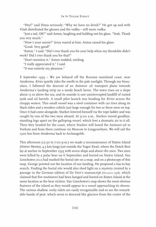
7 September 1995 – “Barents and his crew were gentlemen,” Jerzy told the crowdgathered in the mess. “Take, for instance, this exquisitely shaped copper button.It shows that they were not a bunch of vagrants but rather gentlemen. They trav-eled in style. After discovering the Northeast Passage, Barents was to immedi-ately establish trade contacts and therefore had bolts of fabric, among otherthings, on board. We have now found the leaden seals from this cloth near theSaved House.” R/V Ivan Kiriev has embarked on its voyage home, and Jerzypresented the results of nine days of hard labor to the ship’s crew. A selection ofobjects has been exhibited on the mess room tables. The expeditions of 1993 and1995 together produced 1370 itemized artifacts. More than a hundred soilsamples were collected for analysis of plant seeds, pollen, and human parasites(fleas and lice). The survey has revealed the cabin’s floor plan and given us a viewof its interior and its building structure. The objects that we recovered bearwitness as to how the men gathered around the fire and mended their clothing,shoes, and instruments. We’ve completed the Rijksmuseum’s Nova Zemblacollection with the smallest objects, including several decorative items that wereprobably part of the trade cargo. The prime example of these is the series of ninemythological figurines, 3 to 4 cm tall, which demonstrate the influence of theRenaissance in northern Europe towards the end of the sixteenth century. Thecommercial load represented a sample of the booming European cultures andthe Golden Section layout of the cabin fits well in this picture.
[249]
In the Yugor StraitChapter Sixteen
The expedition’s finds are being processed at two tables in a laboratory roomon the top deck of the ship, behind the bridge. Some sample bags simply containan amorphous mass of soil, held together by moss, which is gradually extractedto reveal diverse kinds of potsherds, nails, textiles, and bones. All the shards arethen relabeled and sorted by color: orange-glazed shards are collected in bagswith other orange-glazed shards, green shards with green shards, white withwhite, etc. etc. Objects are individually inspected, soil fragments are brushed off,and then the objects are repackaged. The iron nails are wrapped in wet toiletpaper, then in aluminum foil, to delay corrosion. The pewter figurines, of whichten were found altogether, are being dried by immersion in alcohol. The mysteryof the lead plaque showing Barents’ signature has been resolved. The inscriptionis not a signature, but indicates a “3 ons” weight measure. After the exhibitionfor Kiriev’s crew, these fragile finds are repackaged, to be opened, we hope, onlyat the Rijksmuseum’s preservation studio in one of the turrets of the majesticbuilding in Amsterdam. Conservator Ab Hoving described the major “historicalsensation” he got from a small glass plate that he just couldn’t rub clean. “In thesame collection of artifacts, I found three out of four parts of the frame that hadheld the glass, and suddenly I realized this had been a mirror. The corroded glassthat I had been ignorantly studying a moment earlier once reflected the
[250]
Into the Ice Sea
10 km
70º N
Idols Cape
Varnek
Vaygach
IslandBarents
Sea
Dolgaya
Novaya Zemlya
Bay
Yugor S
trait
Staten
Isla
nd
Amde
rma
Cape Bolvansky(PS Fjedorova)
Kara Sea
Kara Gates
Cross
Cape
Chabarova
figure 1Vaygach Island and the Kara Gates on a satellite image from 18 June2003; note sea ice in the Kara Sea and Yugor Strait, and the influence
of relatively warm Atlantic water.

winterers’ faces, and for a brief moment I felt their presence. It was as if theywere looking over my shoulder in the remaining layer of mercury.”
The successful completion of the research activities is exuberantly celebrated,and tall tales abound. Our comrades from Ivanov Bay, by their own accounts,were put through quite an ordeal, and had almost been abandoned in that abom-inable Arctic land. They were indestructible, however, and we call them Ivanova-tarakan: the Ivanov Cockroaches. Pieter and George told how Russians who wererain-soaked or had fallen overboard would stand over fire “until they weresteaming and their pants caught fire.” Later that night, through the drubbing andhowling of another storm, feeble songs could be heard throughout the ship asStarkov, drunk but indefatigable, tried to remember some German opera. Whenhe’s on, the singing is splendid: Starkov’s tenor with Dima’s basso. With the beergone, an alcoholic meltdown followed with the last vodka. The chef was on thekitchen floor, dead-drunk. Sailors grinned as they stepped over him; they wereworking and wouldn’t touch a drop.
Shortly after midnight, when the ritual drinking orgy had ended, Jerzy pushedme on ahead of him, behind Vitali and Dima: “Hurry, hurry!” Dima has abrother, Daniel, and another brother who lives in St. Louis, Missouri, who resem-bles Jerzy like two drops of vodka. Tonight, all three of us are brothers, becausewe’ve stayed on the longest. You too, Vitali – you are our brother, too. Embracing,we stumbled into Vitali’s cabin. Vitali was wearing his speznats shirt – the blue-and-white stripes of the Russian Navy. He nodded amiably and stirred hisheating coil in a glass of water that, indeed, started bubbling in no time. He hada plastic bag full of cookies and also offered us condensed milk with our tea.Then the door opened, first just a wee bit, and Anton entered.
“There you are!” he said. He was listening at each door until he found us, Ithought; he returned to the mess room and found everybody gone. Anton satdown on the bunk, dangling his legs over the edge. Since he was unable to leannow, he sat down bent slightly forward; it looked like he was broken. Vitalifinished his hospitable household chores and proceeded to show us a picture ofhis small daughter, a cheerful girl of five. I glanced once again towards Vitali, thecharmer, and I could see little direct resemblance, but really, she is a beautifulchild. The picture also affected Anton, who had been drinking and was a bitmore emotional than usual. While Dima softly hummed a melancholy song withJerzy plucking at his beard, Anton wrestled a photograph of his loved ones fromhis wallet. He peered at it and then, without taking his eyes off the photo, passedit on to me with a smile. I grasped the black-and-white print: a Dutch womanand a Dutch girl, smiling at the photographer. “They’re coming to pick me up,”he said, “they’re coming to pick me up at the airport. Maybe you’ve seen thembecause they also saw me off.” I handed the photo back to him.
[251]
In the Yugor Strait
[252]
Into the Ice Sea
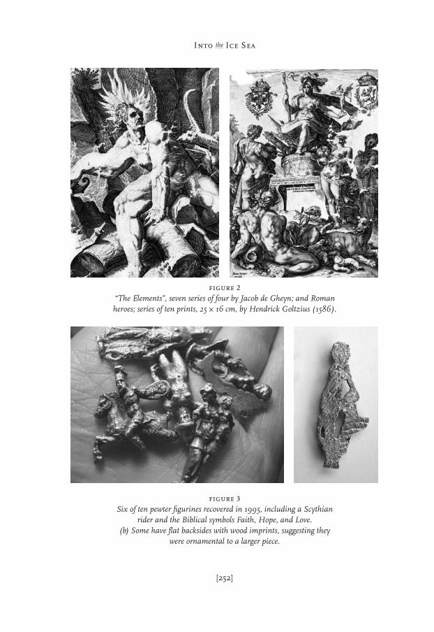
figure 2“The Elements”, seven series of four by Jacob de Gheyn; and Romanheroes; series of ten prints, 25 ~ 16 cm, by Hendrick Goltzius (1586).
figure 3Six of ten pewter figurines recovered in 1995, including a Scythian
rider and the Biblical symbols Faith, Hope, and Love. (b) Some have flat backsides with wood imprints, suggesting they
were ornamental to a larger piece.
“Hey!” said Dima seriously: “Why we have no drink?” He got up and withVitali distributed the glasses and the vodka – still more vodka.
“Just a tad, OK?” said Anton, laughing and holding out his glass. “Yeah. Thankyou very much.”
“How’s your movie?” Jerzy roared at him. Anton raised his glass:“Good. Very good!”“Anton,” I said, “Did I ever thank you for your help when my theodolite didn’t
work? Did I ever thank you for that?”“Don’t mention it,” Anton nodded, smiling.“I really appreciated it,” I said.“It was entirely my pleasure.”
8 September 1995 – We are belayed off the Russian mainland coast, nearAmderma. Kiriev quietly rides the swells in the pale sunlight. Through my binoc-ulars, I followed the descent of an Antonov 26 transport plane towardsAmderma’s landing strip on a sandy beach berm. The town rises on a slopeabout 15 m above the sea, and its seaside is one uninterrupted landfill of rustedjunk and oil barrels. A small pilot launch was heading for Kiriev across thechoppy waters. This small vessel was a steel container with car tires along itsblack sides and a wooden cubicle just large enough for two or three men on top.Once it had come alongside, Starkov lowered himself via the rope ladder and wascaught by one of the two men aboard. At 9:00 a.m., Starkov waved goodbye,standing legs apart on the galloping vessel, which lent a dramatic air to it all.Then they headed for the coast, where Starkov will board the Antonov-26 toVorkuta and from there continue via Moscow to Longyearbyen. We will sail the1300 km from Amderma back to Archangelsk.
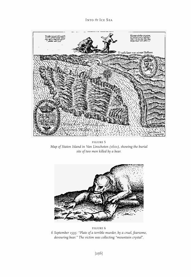
This afternoon (12:30 to 7:00 p.m.) we made a reconnaissance of Staten Island(Ostrov Mestny, 4.5 km long) just outside the Yugor Strait, where the Dutch fleetlay at anchor in September 1595 with seven ships and about 180 men. Two menwere killed by a polar bear on 6 September and buried on Staten Island. VanLinschoten [1601] had marked the burial site on a map, and on a photocopy of thismap, George pointed out the location of our landing. He proposed a bay-to-baysearch. Finding the burial site would also shed light on a mystery created by apassage in the German edition of De Veer’s manuscript [Hulsius 1598], whichclaimed that five mutineers had been hanged and buried on Staten Island at thesame location as the bear victims. Van Linschoten’s map shows the most obviousfeatures of the island as they would appear to a vessel approaching its shores.The various shallow, rocky inlets are easily recognizable and so are the remark-able bands of peat, which seem to descend like glaciers from the center of the
[253]
In the Yugor Strait
[254]
Into the Ice Sea
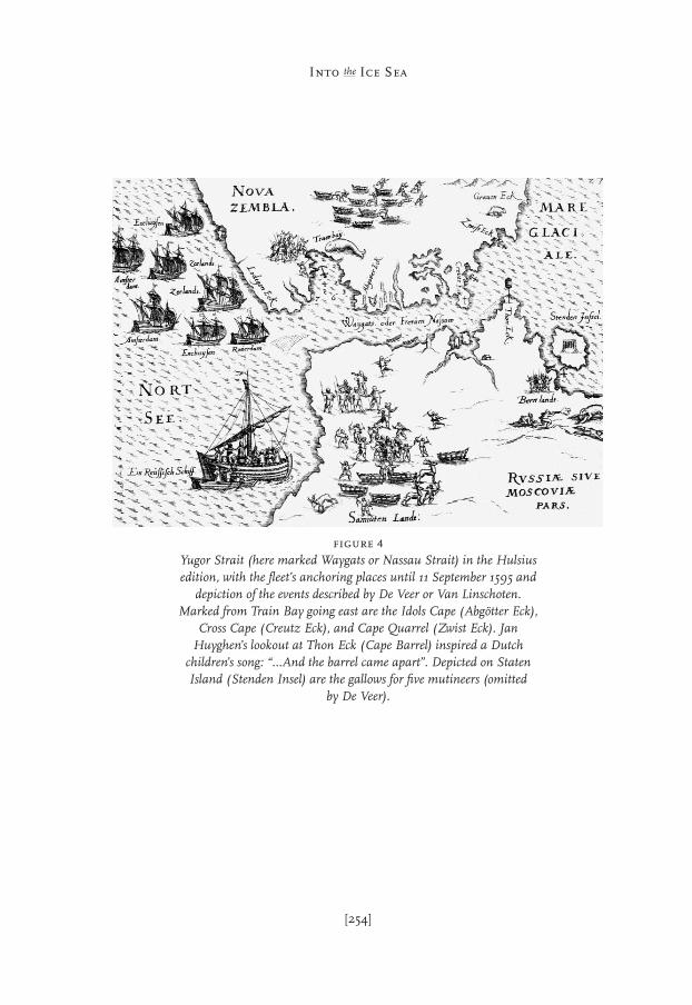
figure 4Yugor Strait (here marked Waygats or Nassau Strait) in the Hulsiusedition, with the fleet’s anchoring places until 11 September 1595 and
depiction of the events described by De Veer or Van Linschoten.Marked from Train Bay going east are the Idols Cape (Abgötter Eck),
Cross Cape (Creutz Eck), and Cape Quarrel (Zwist Eck). JanHuyghen’s lookout at Thon Eck (Cape Barrel) inspired a Dutch
children’s song: “…And the barrel came apart”. Depicted on StatenIsland (Stenden Insel) are the gallows for five mutineers (omitted
by De Veer).
island to the sea. On the highest, central part of the island is a wooden tower witha light on top. This lighthouse is powered by a thermonuclear battery of the kindthat is used on interplanetary spacecraft, with cooling fins on the sides. Electricityis generated by a strontium radioisotope, so we were advised to maintain aminimum distance of 50 m. Our search of the burial site yielded modern nailsand a German cartridge from World War II. “Peat lies meters deep along theshore,” George said, disappointed. “What all may have covered up those 400-year-old graves? They can’t be found.”
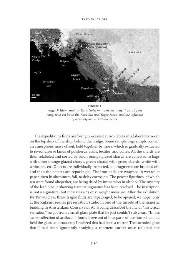
9 September 1995 – The sky was overcast: through a few threadbare holes in thecloud cover, golden rays spray across a dark world. Kiriev was sailing a straightline through Yugor Strait, a channel 5 km wide between Vaygach Island and theRussian mainland. Balthasar de Moucheron had wanted to erect his fort wherethe strait narrows to about 3 km, to close this entry to the Northeast Passage tocompeting vessels (Chapter 3). From the aft-deck, I observed the angular bendin the ship’s wake from a sudden change of course. Ahead in the distance, Isuddenly noticed a lonely settlement atop a plateau on the southern coast. Theship was closing in on it fast, and I recognized wooden buildings on the beach,towers on the plateau, and then, through my binoculars, barbed wire – walls ofbarbed wire. I hurried forward along the gangway, where a few Russians staredsilently ahead.
“Chabarova,” one said grimly: “Gulag.”Across the water from the prison camp, Kiriev dropped anchor in Vaygach’s
Train Bay at 5:00 p.m. The landscape appeared liquid under hundreds of movingreindeer. The second Dutch expedition also anchored in Train Bay, “shelteredfrom all winds and a good anchoring ground,” when it encountered sea ice inYugor Strait in August 1595. The explorers named the bay after the train oil thatSamoyed whale hunters were producing on shore [Appendix 8]. This was a poten-tial staging area for the exploration of Asia and a party went ashore to establishcontacts with the locals. On the beach the Dutch found five whales, but theSamoyeds[1] had fled when they saw the fleet entering the bay, leaving theirloaded sledges behind. The theft of some hides from those sledges was severelypunished. According to the statutes that had been read to each seaman as hemustered, Admiral Nay ordered that the responsible sailor would be left behind
[255]
In the Yugor Strait
1 The indigenous people were called Samo-yeds, a combination of saam-yedno, meaning‘land of the bog people,’ the Saami. TheSamoyeds, with other Ugrian [in Russian,
Yugorski] tribes, came over the Ural Moun-tains from Siberia. In their own language,they call themselves Nenets [Nentsi], mean-ing ‘people’.
[256]
Into the Ice Sea
figure 5Map of Staten Island in Van Linschoten (1601), showing the burial
site of two men killed by a bear.
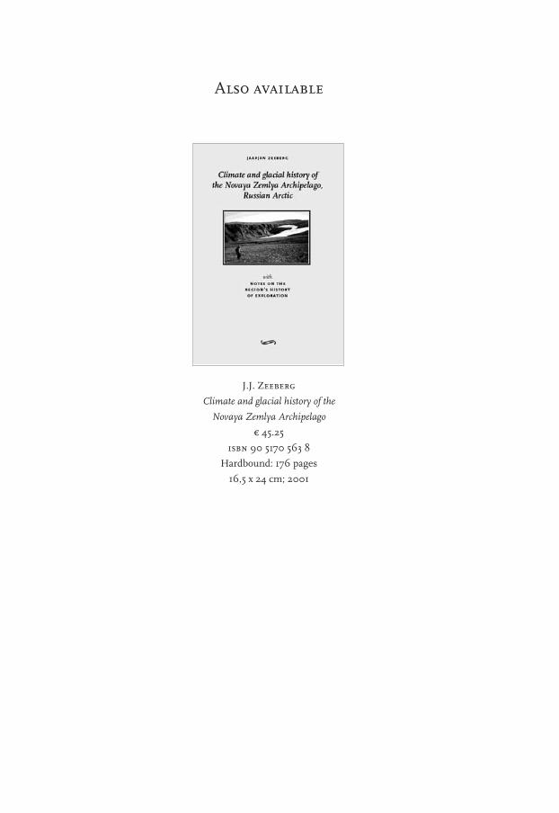
figure 66 September 1595: “Plate of a terrible murder, by a cruel, fearsome,
devouring bear.” The victim was collecting “mountain crystal”.

on Vaygach Island. He had another man keelhauled, accidentally tearing hisbody into two pieces, as graphically depicted by an etching in the German editionof De Veer’s log [Hulsius 1598]. While the ship lay at anchor, other men died as athick fog enveloped the bay. The dead were buried on land, but to the horror ofthe seamen, polar bears emerging from the fog exhumed and consumed thebodies. The Admiral then dispatched 54 armed men on the southern coast ofYugor Strait to find other inhabitants of the region and collect information onwater depths and the ice season. “We found them one mile inland [German mile= 6.3 km: Verhoeff 1983], where we did not expect to find people at all”, wrote DeVeer [31 August 1595].
“They were standing in two groups, five and five, and we were hard by thembefore we knew it. Then our interpreter went alone towards them to speak withthem. They perceived this and sent a man towards us. When that man cameclose to our interpreter, he drew an arrow from its quiver and threatened toshoot. Our man feared for his life, because he was unarmed, and shouted inRussian: “Do not shoot, we are friends.” When the other heard this, he cast downhis bow and arrow. Our translator called again: “We are friends,” to which theother answered, “Then you are welcome,” and they saluted each other bybending their heads down to the ground”
We didn’t have to wait long for contact with the “Samoyeds”. As soon as Kirievhad dropped anchor, small outboards came racing past. The men in these boatswaved frantically, made a rapid turn around the vessel to come alongside, andquickly climbed aboard. They were of small stature with brown, weatheredoriental faces: Nenets, as they should be called today. We kept our distance whilethe crew, tactfully but forcefully, confined them to the aft deck. They were afteralcohol but received our (virtually untouched) stock of chocolate bars and someother delicacies instead. Invited to come ashore, we prepared the landing craft.As we approached a pier, only children and a few elders were waiting. The kidsdidn’t smile; they just stared. Just like many other Arctic settlements, Varnek isa mess of broken glass and oil barrels. On a peninsula in the bay, the Commu-nists exploited lead and copper mines. The miners lived in Varnek in woodenbarracks, which still make up the majority of its dwellings. The young adults thatwe encountered were hammered. It is terribly desolate, even now in summer,the most exuberant of seasons.
Considering all they have been put through, it is a miracle that anything iseven left of the original Nenets culture. Alcohol has disrupted their societies.Children start drinking around the age of ten. George explained that the Nenetslack the enzyme required to break down alcohol: thus, they remain drunk for
[257]
In the Yugor Strait
J.J. Zeeberg
Climate and glacial history of the
Novaya Zemlya Archipelago
e 45.25
isbn 90 5170 563 8
Hardbound: 176 pages
16,5 x 24 cm; 2001
Also available

fiInto the Ice SeaflfiInto the
Ice Sea
Barents’
wintering
on
Novaya Zemlya –
A Renaissance
voyage
of
discovery
jaapjan zeeberg
j a a p j a n
z e e b e r g
Archaeologists connected with Amsterdam’s Rijksmuseum journeyedinto the Russian Arctic to rediscover the graves, ship, and winteringcabin of Willem Barents’ expedition, lost 400 years ago on the shores
of a remote Arctic island while charting a passage to Asia.
“Into the Ice Sea” is the account of several expeditions duringthe 1990s and their historical parallels of four centuries. This is
a book about Reformation and exploratory Romanticism,Arctic discovery and the Ancients, and the fortunes of a
Russian admiral, chasing the demon of his own creation acrossthe floes of the Kara Sea, the former Ice Sea.
With the original journal from Barents’ ship in hand, the authorspresent a view of the Arctic through the eyes of a sixteenth-century
explorer, and in the geometry of Barents’ ship and cabin discoverthe key to a Renaissance past.
This book will make you happier and wiser.
rozenberg publishers
amsterdam
isbn 90 5170 787 8
043136-3 Zeeberg-bd 11-04-2005 12:01 Pagina 1