interstate 84 greater danbury, ct toll plaza …hvceo i-84 greater danbury toll plaza impact study 3...
TRANSCRIPT
HVCEO I-84 GREATER DANBURY TOLL PLAZA IMPACT STUDY 1
INTERSTATE – 84
GREATER DANBURY, CT
TOLL PLAZA IMPACT STUDY
PREPARED BY HVCEO IN OCTOBER OF 2009
www.hvceo.org/transport/i84_toll_plaza_impact_study.pdf
1. INTRODUCTION
2: I-84 TOLLED EXPRESS LANE
2A. OVERVIEW
2B: EXIT FROM LEFT LANE CONSTRAINT
2C. "LEXUS LANE” EQUITY ISSUE
3: I-84 TOLL IN DANBURY AT NYS LINE
3A. OVERVIEW
3B. CONSTRAINT AT NYS BORDER
3C. DIVERSION TO COMBINED ROUTES 6 AND 202
3D. DIVERSION THRU RIDGEFIELD
3E. DIVERSION THRU NEW FAIRFIELD AND SHERMAN
3F. LOWERED RETAIL TRADE
3G. DISINCENTIVE FOR WORKFORCE
4. FULL LENGTH TOLLING OF I-84
4A. OVERVIEW
4B. DIVERSION TO ROUTE 6
4C. DIVERSION INDUCED BY EACH LOCATION
5. LIMITED CRITERIA AND EVALUATION
5A. OVERVIEW
5B. COMMUNITY DISRUPTION IMPACTS
5C: ENVIRONMENTAL JUSTICE IMPACTS
5D. CULTURAL AND HISTORIC IMPACTS
5E. STATE PLAN NOT INCLUDED

HVCEO I-84 GREATER DANBURY TOLL PLAZA IMPACT STUDY 2
1. INTRODUCTION
The funding outlook for highway upgrades in Connecticut has dimmed in recent
years, so much so that some state leaders are studying the reimposition of tolls.
Accordingly a rallying point for these interests, a major statewide tolling study, was
completed for Connecticut early in 2009.
It was the Connecticut Transportation Strategy Board within the Connecticut Office
of Policy and Management that was responsible for this research, the full title of
which is "Connecticut Electronic Tolling and Congestion Pricing Study” (CT Tolling
Study).
The full 2009 CT Tolling Study is available for review (19.1MB) at
www.ct.gov/opm/lib/opm/tsb/reports_tsb/final_report_-_tolling_study.pdf
This voluminous research examines options for reinstituting tolling on limited access
highways in Connecticut. It includes some specific evaluations for I-84 thru Danbury,
Bethel and Newtown and these are the focus for the remainder of this chapter.
From its outset the CT Tolling Study assumes that any future tolls in Connecticut will
be designed with minimal or no use of traditional "full stop" toll booths. Instead, we
will encounter “fast lanes” and digital camera license plate reading technologies.
Traditional toll at left. Open road toll system at right, the
Raritan Toll Plaza on New Jersey's Garden State Parkway. Sensors
above read EZ Pass tags and license plates, collecting tolls at high speeds.

HVCEO I-84 GREATER DANBURY TOLL PLAZA IMPACT STUDY 3 But while waiting in lines to pay will be much less of an impact and safety factor than
with Connecticut toll controversies of the 1980s, impact evaluations in this HVCEO
evaluation assume that for the foreseeable future, a significant percentage of drivers
will still pay in cash and non-electronically.
Traditional toll booths requiring level road conditions for a safe “full stop” for vehicles
will still be required. Thus the impact of toll diversion to avoid payment becomes the
key off-expressway impact issue, reducing the more traditional factors of safe
stopping and toll booth delay.
True to the times the 2000 state study considered "congestion pricing", an emerging
approach that applies user fees based on supply and demand. Historically, highway
tolls have typically been applied at a uniform rate regardless of hour, day or
congestion level.
But with congestion pricing the toll amount varies, higher during peak periods or to
use a special express lane.
And to its credit the 2009 CT Tolling Study includes a realistic political perspectives
on tolling, demonstrated by these excerpts from page 3-1:
Any new tolling or congestion pricing would entail putting tolls on roads that had previously
been toll free. This makes matters complicated, because this changes the rules. Housing and
work location decisions that had been made with one set of rules now would have a different
set of rules (3-1).
Although the net result of a tolling or congestion project may be positive, there are likely to be
perceived winners and losers particularly in the short term before the benefits of the toll
revenue can be realized.... And the rules might change for some people (in one corridor, for
example) and not for others (3-1).
In some cases, the question of how toll revenue is spent (for example, on highway and/or
transit improvements on a specific facility or region) can compensate the losers, but current
laws may hinder the State’s ability to broadly redistribute toll revenue (3-1).
Short-term impacts caused by diversion from tolled to untolled routes may reach a new
equilibrium over time as people adjust their lives to the new rules, but the short-term impacts
will be seen as real enough (3-1).
The CT Tolling Study is organized around the nine primary test concepts listed
below. Each is followed by a notation as to which were deemed most relevant to
Greater Danbury and thus examined further.
--- Concept A: Creation of New Tolled Express Lanes ("congestion pricing"). While
the CT Tolling Study found this concept to be impractical, it was reviewed as
option A-2 was specifically designed for I-84 from Danbury to Waterbury.
--- Concept B: Border Tolling at Major Highways. Same toll at all times and no
congestion pricing. The CT Tolling Study found that this concept would raise
significant revenues. Reviewed below as I-84 Danbury to Waterbury was included.
--- Concept C: Toll Trucks On Limited Access Highways. Not reviewed as the
Tolling Study itself eliminated this option.

HVCEO I-84 GREATER DANBURY TOLL PLAZA IMPACT STUDY 4 --- Concept D: High Occupancy Vehicle Lane (HOV) to High Occupancy Toll Lane
(HOT) Lane Conversion. Not reviewed as this options only concerned the Hartford
Area.
Tolling Study Concept D above only dealt with
tolling I-91 and I-84 in the Hartford Area. Concepts A, B and F
provided specific information on tolling I-84 in Greater Danbury.
--- Concept E: Convert Highway Shoulders to High Occupancy Toll Lanes. Not
reviewed as the Study itself eliminated this option.
--- Concept F: Toll Individual Highways Needing New Capacity, no congestion
pricing. Reviewed as option F-2 concerned I-84 Danbury to Waterbury.
--- Concept G-1: Toll All Limited Access Highways. Analysis is the same as for
Concept F-2.
--- Concept G-2: Tax All Vehicle Miles Traveled. Not reviewed as there was no
specific proposal for or separate impact on Greater Danbury.
--- Concept H: Most Congested Corridor Tolling. Not reviewed as focus was I-95
and Route 15 only.
2: I-84 TOLLED EXPRESS LANE (REVIEW OF CT TOLLING
STUDY CONCEPT A-2)
2A. OVERVIEW CT Tolling Study Concept A-2 was reviewed as I-84 thru Danbury was specifically
examined.
The addition of a tolled "congestion priced" express lane was found by the CT
Tolling Study to be unsuitable for I-84 thru our area. The discussion below
documents that decision and provides additional comment.
HVCEO I-84 GREATER DANBURY TOLL PLAZA IMPACT STUDY 5 Two possible project corridors in Connecticut were identified under this concept, I-
95 between Branford and the Rhode Island Line and I-84 between Danbury and
Waterbury.
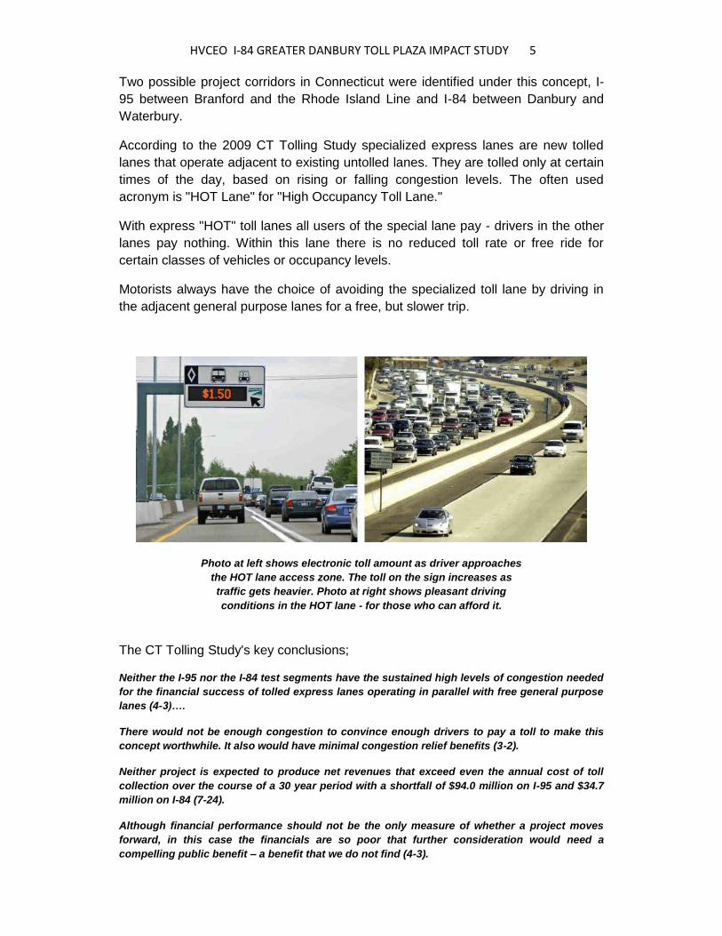
According to the 2009 CT Tolling Study specialized express lanes are new tolled
lanes that operate adjacent to existing untolled lanes. They are tolled only at certain
times of the day, based on rising or falling congestion levels. The often used
acronym is "HOT Lane" for "High Occupancy Toll Lane."
With express "HOT" toll lanes all users of the special lane pay - drivers in the other
lanes pay nothing. Within this lane there is no reduced toll rate or free ride for
certain classes of vehicles or occupancy levels.
Motorists always have the choice of avoiding the specialized toll lane by driving in
the adjacent general purpose lanes for a free, but slower trip.
Photo at left shows electronic toll amount as driver approaches
the HOT lane access zone. The toll on the sign increases as
traffic gets heavier. Photo at right shows pleasant driving
conditions in the HOT lane - for those who can afford it.
The CT Tolling Study's key conclusions;
Neither the I-95 nor the I-84 test segments have the sustained high levels of congestion needed
for the financial success of tolled express lanes operating in parallel with free general purpose
lanes (4-3)….
There would not be enough congestion to convince enough drivers to pay a toll to make this
concept worthwhile. It also would have minimal congestion relief benefits (3-2).
Neither project is expected to produce net revenues that exceed even the annual cost of toll
collection over the course of a 30 year period with a shortfall of $94.0 million on I-95 and $34.7
million on I-84 (7-24).
Although financial performance should not be the only measure of whether a project moves
forward, in this case the financials are so poor that further consideration would need a
compelling public benefit – a benefit that we do not find (4-3).
HVCEO I-84 GREATER DANBURY TOLL PLAZA IMPACT STUDY 6 Even though construction of this tolling option for I-84 thru Greater Danbury appears remote,
the following two HVCEO staff generated perspectives on the tolled express lane concept are
included for the record.
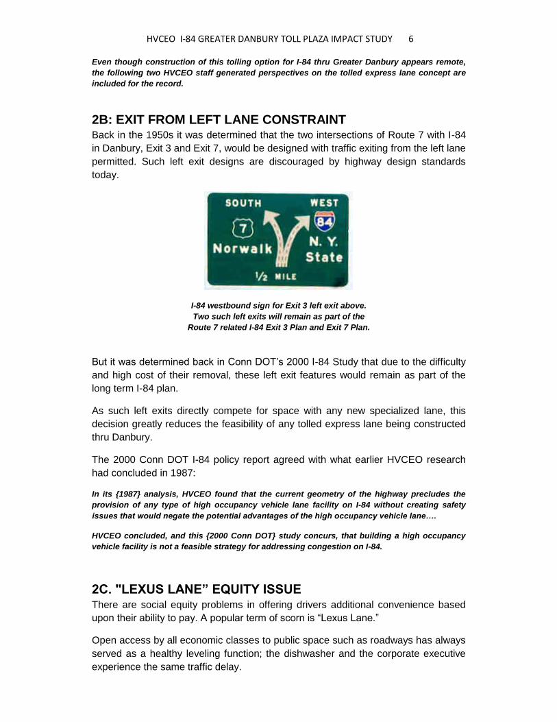
2B: EXIT FROM LEFT LANE CONSTRAINT Back in the 1950s it was determined that the two intersections of Route 7 with I-84
in Danbury, Exit 3 and Exit 7, would be designed with traffic exiting from the left lane
permitted. Such left exit designs are discouraged by highway design standards
today.
I-84 westbound sign for Exit 3 left exit above.
Two such left exits will remain as part of the
Route 7 related I-84 Exit 3 Plan and Exit 7 Plan.
But it was determined back in Conn DOT’s 2000 I-84 Study that due to the difficulty
and high cost of their removal, these left exit features would remain as part of the
long term I-84 plan.
As such left exits directly compete for space with any new specialized lane, this
decision greatly reduces the feasibility of any tolled express lane being constructed
thru Danbury.
The 2000 Conn DOT I-84 policy report agreed with what earlier HVCEO research
had concluded in 1987:
In its {1987} analysis, HVCEO found that the current geometry of the highway precludes the
provision of any type of high occupancy vehicle lane facility on I-84 without creating safety
issues that would negate the potential advantages of the high occupancy vehicle lane….
HVCEO concluded, and this {2000 Conn DOT} study concurs, that building a high occupancy
vehicle facility is not a feasible strategy for addressing congestion on I-84.
2C. "LEXUS LANE” EQUITY ISSUE There are social equity problems in offering drivers additional convenience based
upon their ability to pay. A popular term of scorn is “Lexus Lane.”
Open access by all economic classes to public space such as roadways has always
served as a healthy leveling function; the dishwasher and the corporate executive
experience the same traffic delay.
HVCEO I-84 GREATER DANBURY TOLL PLAZA IMPACT STUDY 7 To remove this aspect of equality in a public place would be detrimental to needed
social cohesion and a dismal "unamerican" infrastructure precedent.
In summary, both the CT Tolling Study and past and current HVCEO analyses
concur that this concept has little merit.
3: I-84 TOLL IN DANBURY
AT NEW YORK STATE LINE (REVIEW OF CT TOLLING STUDY CONCEPT B)
3A. OVERVIEW The goal of the CT Tolling Study's border tolling concept is significant revenue
generation, with the funds then used to finance various transportation improvements
not necessarily near the border crossings tolled.
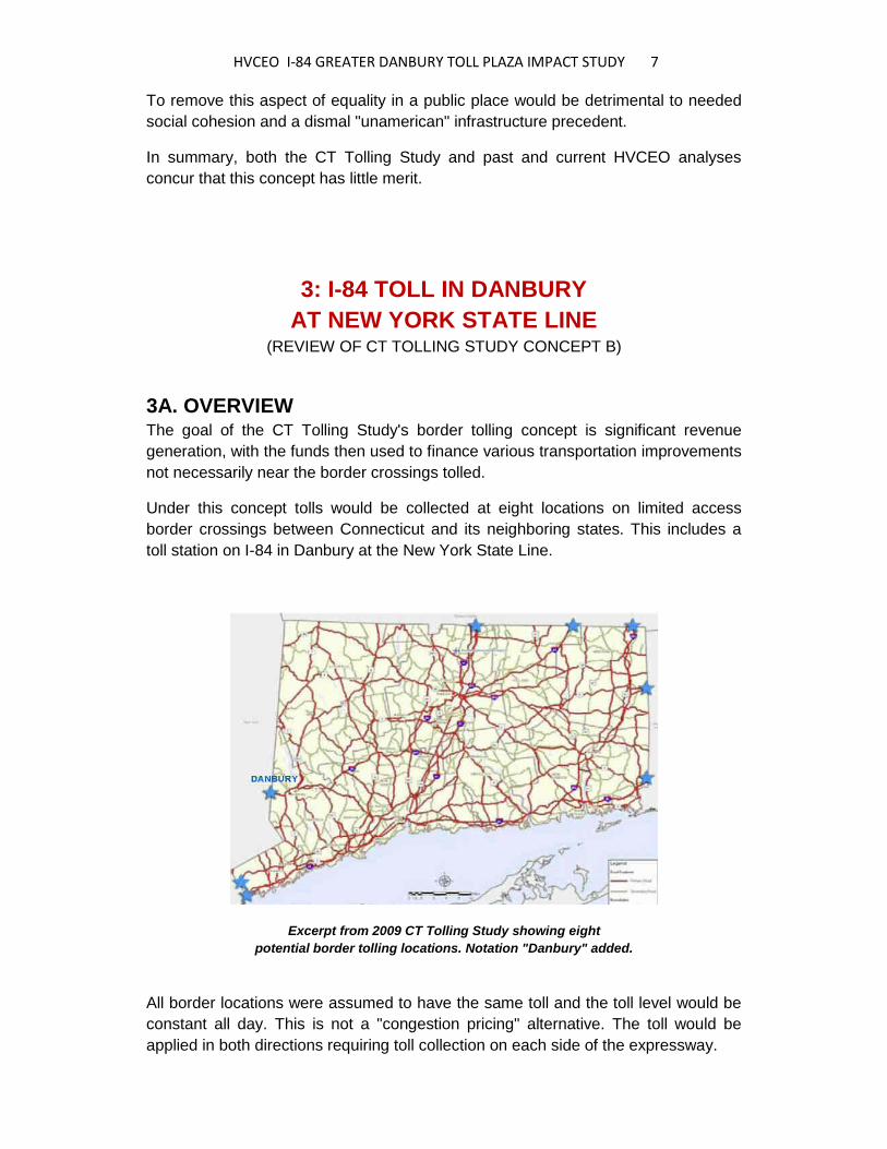
Under this concept tolls would be collected at eight locations on limited access
border crossings between Connecticut and its neighboring states. This includes a
toll station on I-84 in Danbury at the New York State Line.
Excerpt from 2009 CT Tolling Study showing eight
potential border tolling locations. Notation "Danbury" added.
All border locations were assumed to have the same toll and the toll level would be
constant all day. This is not a "congestion pricing" alternative. The toll would be
applied in both directions requiring toll collection on each side of the expressway.

HVCEO I-84 GREATER DANBURY TOLL PLAZA IMPACT STUDY 8 The 2009 Study also found that border tolls would have wide reaching impacts;
These impacts are potentially considerable. Traffic diversion to local routes could have
negative impacts on water and air quality, community ambiance, bicycle and pedestrian safety
and quality, noise, energy consumption and cultural/historic resources.
From an economic and equity perspective, travelers in the border regions would incur most of
the costs and impacts, but few of the benefits. This could significantly disadvantage these
regions of the State (4-6).
However, the study found that border tolling on all eight limited access highways
including on Danbury's I-84 "will raise a significant amount of revenue, even at the
lowest toll rates, resulting in more than enough revenue to cover the cost of toll
collection and construction" (Report's Table 12.14).
In fact the Danbury border toll would be the second most lucrative statewide, as
shown below:
ANNUAL REVENUE GENERATED
1) $190,744,086 at I-95 at New York Border
2) $104,164,285 at I-84 at New York Border
3) $103,678,619 at I-91 at Massachusetts Border
4) $70,126,772 at I-84 at Massachusetts Border
5) $50,981,886 at Route 15 at New York Border
6) $50,243,822 at I-95 at Rhode Island Border
7) $26,482,126 at I-395 at Massachusetts Border
8) $12,765,501 at Route 6 at Rhode Island Border
Sum: $609,187,097 Statewide
The particularly high revenue stream at Danbury will be appealing to toll advocates.
3B. CONSTRAINT AT NEW YORK STATE BORDER The CT tolling Study was not expected to evaluate specific geographic limitations to
toll plaza placement at each of the eight border locations.
As well known locally there would be constraints to building a toll booth on I-84 at
the New York State Line.
Yellow line is NY/CT border. I-84 eastbound traffic could too easily divert to
Route 6 as the Exit 1 eastbound off ramp originates in New York State.

HVCEO I-84 GREATER DANBURY TOLL PLAZA IMPACT STUDY 9 According to a 3/26/2009 statement by Danbury State Senator Michael McLachlan;
The geometry of I-84 construction itself brings into question the feasibility of any toll booth
being placed on I-84 at the Connecticut - New York State Line.
The reason is that the eastbound exit ramp to I-84 Exit 1 in Danbury starts in New York State.
Thus eastbound I-84 traffic can easily divert to parallel Route 6, making this driving decision
while still in New York territory.
This limitation does not preclude moving the toll station somewhat to the east to be
entirely within Connecticut. But again high diversion potential to parallel Routes 6
and 202 makes the viability of that option appear limited, and a consistent statewide
border tolling policy could not be achieved due to the Danbury exception.
3C. DIVERSION TO COMBINED ROUTES 6 AND 202 It is well known that tolls at any level are an incentive for some drivers to leave the
tolled roadway for a no cost alternative route. The 2009 CT Tolling Study deals
realistically with this impact at the eight potential border tolling points and to its
credit proceeds to quantify the traffic diversion.
The study notes that generally "while overall levels of traffic diversion to alternate
routes would be small relative to total volumes on the limited access highways, the
impacts will be significant on certain local traffic conditions" (4-5).
Vehicles diverted per day at the various potential border tolls, ranked below from
highest to lowest, are estimated by the CT Tolling Study as follows (4-5):
1) 14,000 at I-95 at New York Border
2) 13,800 at I-84 at New York Border
3) 10,500 at I-95 at Rhode Island Border
4) 8,100 at I-84 at Massachusetts Border
5) 6,900 at I-395 at Massachusetts Border
6) 5,200 at Route 15 at New York Border
7) 1,000 at I-91 at Massachusetts Border
8) 630 at Route 6 at Rhode Island Border
Note that the Danbury site received the second highest traffic diversion impact.
For perspective on the diversion of 13,800 vehicles, consider that at the Danbury –
New York State Line the 2007 I-84 daily volume was 76,300. The anticipated 13,800
vehicle diversion is 18% of that 76,300 total.
Concerning specific impacts of a toll on I-84 near the New York border, the CT
Tolling Study found that “About 13,800 vehicles per day (1,380 in the peak hour)
would be diverted. Vehicles crossing the border in either direction could use Route
6/202, which runs parallel to the highway” (8-13).

HVCEO I-84 GREATER DANBURY TOLL PLAZA IMPACT STUDY 10 The CT Tolling Study conclusion as to toll bypass impact on Mill Plain Road – Lake
Avenue Extension is that it would be relatively benign:
Route 6/202 which parallels I-84 is a commercial corridor in Danbury with a lower intensity of
use in the New York section.
It is capable of handling the additional traffic albeit with some additional congestion and ramp
delays, and community impacts would be minimal give the nature of the surrounding land uses
(8-13).
The diversion of heavy trucks would be an issue although the overall numbers in any given
hour would be relatively small (8-13).
The mild conclusions above are not consistent with other Conn DOT data. The
segment of combined Routes 6 and 202 from Old Ridgebury Road easterly past the
intersection with Driftway Road to Kenosia Avenue is documented by Conn DOT as
overcapacity at present. Documentation is Conn DOT’s 2008 Congestion Screening
and Monitoring Report.
Adding 13,800 vehicles to current traffic levels would create significant traffic
congestion on Danbury's west side. These combined volumes would also have a
negative impact upon roadside businesses dependent upon convenient access.
Consider the addition of 13,800 vehicles per day to the current substantial Routes 6
and 202 volumes, which the Conn DOT 2007 Traffic Volume Log documents as
follows:
8,000 New York State Line east .04 miles to Saw Mill Road
7,200 Saw Mill Road east 1.06 miles to Corporate Center Entrance
16,100 Corporate Center Entrance .12 miles east to Old Ridgebury Road
18,000 Old Ridgebury Road east 1.04 miles to Mill Plain Shopping Center
19,200 Mill Plain Shopping Center east .09 miles to Driftway Road
20,300 Driftway Road .13 miles to Kenosia Avenue
17,300 Kenosia Avenue east .52 miles to Western CT State University
19,000 Western CT State University east .62 miles to Mill Ridge Road
22,400 Mill Ridge Road east .08 miles to I-84 westbound Exit 4 exit ramp
20,400 I-84 westbound Exit 4 exit ramp east .12 miles to I-84 eastbound Exit 4 entrance ramp
Yes, the segment of this roadway east of I-84 Exit 2 is endorsed for eventual
widening by Danbury and HVCEO. But, this addition of capacity is being planned to
relieve current congestion and to allow for economic growth, not to facilitate I-84 toll
booth bypass traffic.
In the fields of professional engineering and planning it is difficult to formulate traffic
diversion policy without expressing a personal bias or preference of some sort. It
appears that the unstated bias in the CT Tolling Study is that where there is already
considerable traffic, adding to it is more acceptable locally than attempting such
substantial additions in low traffic rural areas.
HVCEO I-84 GREATER DANBURY TOLL PLAZA IMPACT STUDY 11 For example the CT Tolling Study projects that at the eastern end of I-84 in
Connecticut;
I-84 at Massachusetts Border, about 8,100 vehicles daily would be diverted onto local roads
between I-84 Exit 74 in Union and the first entrance to I-84 in Massachusetts.
Traffic diverted from I-84 would have to use local roadways located in a mostly low-density
rural/residential area. Thus, the additional traffic could have an impact on community character.
Yet for the 13,800 daily vehicles to be diverted into Danbury little “community
character” impact is forecast by the CT Tolling Study.
But according to the 2002 Danbury Plan of Conservation and Development "the Mill
Plain corridor has experienced considerable growth and development in recent
years.... Community concerns that can affect future development potential include
growing traffic congestion on Mill Plain Road and protection of the Lake Kenosia
Class II public water supply watershed."
It was not clear to Tolling Study staff that this is a roadway that nearby residents still
care about, not an artery turned over primarily to commercial interests.
And perhaps most importantly, diversion on to parallel roads due to growing
congestion on I-84 was studied in Conn DOT’s 2000 “I-84 Corridor Deficiencies and
Needs Study.” It was found by Conn DOT then that:
The most vulnerable roadways for traffic diversions are the Route 6/202 corridor from Exits 2 to
4, and the Route 6/25 corridor from Exit 8 and Exit 10. Neither corridor is prepared to absorb
potential traffic diversions from I-84 in the future.
Thus the 2000 and 2009 state traffic studies are in as to the potential to divert I-84
bypass traffic onto parallel Routes 6 and 202 in Danbury.
3D. DIVERSION THRU RIDGEFIELD We can also project geographically broader, longer trip diversions due to the
placement of an I-84 toll near the Connecticut – New York State Line.
In 2002 an HVCEO traffic engineering consultant evaluated traffic impacts of casino
development in Danbury south of I-84 Exits 1 and 2. To a driver the disincentive of
an upcoming bottleneck is similar in impact to an upcoming cash charge. It was
found in the 2002 study that:
With a casino in place, traffic demand would exceed available capacity to a substantial degree
at the I-684/I-84 interchange for the south-to-east ramp as well as the east-to-south ramp, and
along I-84 between the I-684 interchange and Exit 2 in Connecticut...
Traffic shifts from I-684 and I-84 will most likely use Route 116, Route 121, Route 35 and
Ridgebury Road.
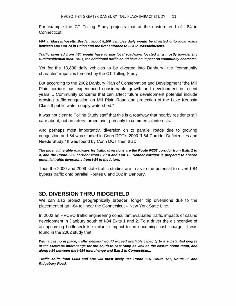
HVCEO I-84 GREATER DANBURY TOLL PLAZA IMPACT STUDY 12
The red star is a potential toll collection point on I-84.
To avoid it, some I-84 to I-684 and I-684 to I-84 trips would
divert thru Ridgefield via Routes 35, 7 and local roads.
In the 2002 casino traffic impact study some traffic diverts into Ridgefield due to a
congestion disincentive on I-84 near the State Line. In this current analysis it is
predicted that, in a similar manner, some traffic would divert into Ridgefield due to a
financial charge on I-84 near the State Line.
As noted above delay and cost are two different variables and their inducement of
traffic diversion is not identical. Yet from the driver's perspective, these two
variables are closely associated due to their practical impact on driver behavior.
It is assumed for the purposes of this 2009 analysis that a significant fraction of the
2002 Ridgefield diversion would occur under future Danbury I-84 West Side tolling
conditions. The Danbury toll would induce a percentage of the 2002 casino impact
projection cited below:
--- Diversion route from I-684 at NY Exit 6, crossing into Connecticut to eastbound Route 35,
then onto Ridgefield's Main Street north, then to Ridgebury Road north connecting to Saw Mill
Road and vice versa.
--- The projected traffic shifts will affect traffic conditions along numerous local roadways in
Ridgefield. The following lists the percentage increases projected by the 2002 study for the
Friday afternoon 5 PM to 6 PM peak hour along various roadway sections:
--- +180% on Ridgebury Road north of Route 116
--- +130% on Route 116 southeast of Ridgebury Road
--- +100% on Route 35 southwest of Route 102
--- + 75% on Route 35 north of Route 102 (Main Street)
--- + 25% on Route 116 northwest of Ridgebury Road
HVCEO I-84 GREATER DANBURY TOLL PLAZA IMPACT STUDY 13 --- + 15% on Branchville Road (Rte.102) west of Route 7
--- + 5% on Route 7 south of Branchville Road (Rte 102)
That Route 35 thru Ridgefield already has its own traffic delay and congestion
issues was fully documented by HVCEO in its 2005 Route 35 Traffic Improvement
Plan.
Additional I-84 diversion traffic was not anticipated during that 2005 study and would
be problematic to add in now.
3E. DIVERSION THRU
NEW FAIRFIELD AND SHERMAN It has long been known that some traffic patterns thru New Fairfield reflect relative
congestion on nearby I-84. A News Times article of 10/10/2000 quotes New York
State Police;
Many commuters from Danbury and New Fairfield regularly use Milltown Road or Doansburg
Road to New York Route 22 before heading towards I-684 to avoid the morning and evening
bottlenecks found along I-84.
This same "back roads" bypass routing thru New Fairfield is utilized whenever the
truck weigh station on I-84 is in operation.
Significant testimony at the 3/2009 Conn DOT I-84 toll hearing in Danbury focused
on diversion in both New Fairfield and Sherman due to the potential tolling of I-84 at
the New York State border:

HVCEO I-84 GREATER DANBURY TOLL PLAZA IMPACT STUDY 14
Illustration of projected traffic diversion impact area
presented by State Senator Michael McLachlan at
3/2009 Danbury toll hearing. See full size illustration at:
http://www.hvceo.org/images/I84tollstudymclachlanmaplarge.pdf
For a further evaluation of this larger impact area, consider that to the east and
parallel to the New York State Line, routed with a north to south orientation is
Connecticut Route 39 thru the Towns of New Fairfield and Sherman.
Then west of and parallel to the New York State Line running north-south is New
York Route 22, thru the New York Towns of Patterson, Pawling and Dover.
I-84 running east-west links both routes. And both routes provide access from
outlying suburban and semi-rural areas to major trip attractors in Danbury and
further south on Route 7.
It is logical that a toll on I-84 near Exits 1 and 2 will affect the choices these drivers
make as to their least cost (in time or money) route south.
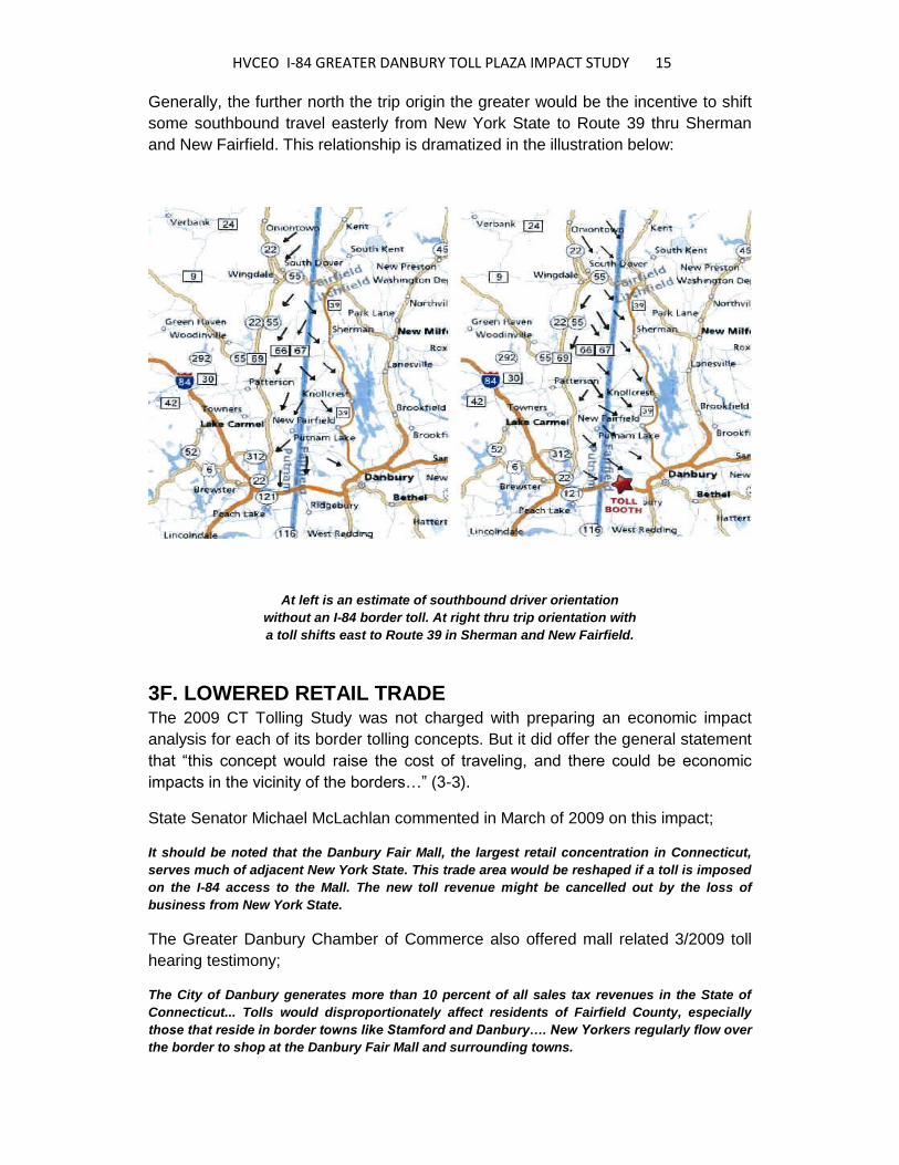
HVCEO I-84 GREATER DANBURY TOLL PLAZA IMPACT STUDY 15 Generally, the further north the trip origin the greater would be the incentive to shift
some southbound travel easterly from New York State to Route 39 thru Sherman
and New Fairfield. This relationship is dramatized in the illustration below:
At left is an estimate of southbound driver orientation
without an I-84 border toll. At right thru trip orientation with
a toll shifts east to Route 39 in Sherman and New Fairfield.
3F. LOWERED RETAIL TRADE The 2009 CT Tolling Study was not charged with preparing an economic impact
analysis for each of its border tolling concepts. But it did offer the general statement
that “this concept would raise the cost of traveling, and there could be economic
impacts in the vicinity of the borders…” (3-3).
State Senator Michael McLachlan commented in March of 2009 on this impact;
It should be noted that the Danbury Fair Mall, the largest retail concentration in Connecticut,
serves much of adjacent New York State. This trade area would be reshaped if a toll is imposed
on the I-84 access to the Mall. The new toll revenue might be cancelled out by the loss of
business from New York State.
The Greater Danbury Chamber of Commerce also offered mall related 3/2009 toll
hearing testimony;
The City of Danbury generates more than 10 percent of all sales tax revenues in the State of
Connecticut... Tolls would disproportionately affect residents of Fairfield County, especially
those that reside in border towns like Stamford and Danbury…. New Yorkers regularly flow over
the border to shop at the Danbury Fair Mall and surrounding towns.
HVCEO I-84 GREATER DANBURY TOLL PLAZA IMPACT STUDY 16 Tolls would discourage commuters from northern Westchester and Putnam counties from
shopping in Greater Danbury. Any sales tax advantage we have over New York could be lost
and any gain in revenue from tolls will be offset, perhaps significantly, by a diminution in sales
taxes.
The Danbury Fair Mall, located on the west side of Connecticut's seventh largest
City and 6.3 miles from the New York State Line, was deliberately sited there and
sized to serve the population of adjacent New York State.
This fact was documented back in 1981 when the shape of the Danbury Fair Mall
trade area was projected by an economic consultant to HVCEO.
The trade area draw included the eastern half of New York State’s Putnam County
as well as much of northern Westchester County, reaching southwesterly along I-
684 as far as the New York State Towns of Bedford and Yorktown (see map of
cross-border relative town affluence).
A field survey of license plates at the mall parking lot was conducted on Monday,
June 8, 2009. Twenty nine percent of the vehicles parked in the sample area had
license plates issued by New York State, a quick confirmation of this retail giant's
significant New York State trade area.
3G. DISINCENTIVE FOR WORKFORCE As with retail sales there are strong cross-border job market relationships between
Greater Danbury and adjacent New York State.
The Greater Danbury Housing Market Assessment released by HVCEO in January
of 2009 calculated that of the total commuters entering the Housatonic Valley
Region for work each day, 16.5% (5,082 workers) enter the Region eastbound
specifically via I-84 in Danbury at the New York Line.
The westward flow of commuters into New York State is not organized by specific
portal exiting the region. However, 12% (4,535) of the City of Danbury's employed
population worked in adjacent New York State in 2000. The percentage from New
Fairfield was an even higher 24%.
3H. RESTRICTED USE OF TOLLS COLLECTED A perceived inequity from a Danbury border toll would result if toll revenues
collected were invested far from the western Danbury toll collection point, well
outside of Greater Danbury.
The CT Tolling Study makes a statement on the equity issue:
A greater equity issue would be where the revenue generated by these tolls is applied in the
future. Some of these border crossings are relatively uncongested, and thus it is likely that
nearby residents and businesses would pay the tolls, but the benefits (revenue) would be spent
elsewhere in the State (8-25).

HVCEO I-84 GREATER DANBURY TOLL PLAZA IMPACT STUDY 17 The primary legal/institutional issue is that current federal law requires that revenue from tolls
on existing Interstate highways be used to improve the highway on which it is collected (4-6).
It is relevant to cite a current Massachusetts toll funding controversy. As of June
2009 a class action law suit seeks to repay Massachusetts Turnpike Authority I-90
toll payers hundreds of millions of dollars in what is called “illegal taxes.”
The key argument is that I-90 tolls were used to pay for recent “Big Dig” I-93
improvements in Boston, that I-90 toll payers from the west of Boston have been
unfairly underwriting I-93 improvement costs.
Given this federal constraint, the CT Tolling Study concludes that;
Using border tolls as a mechanism for general transportation improvements would not be
allowed, at least on the Interstate border crossings. However, these roadways traverse long
distances through the State and the revenue could presumably be used anywhere along the
route (4-6).
Just as Greater Danbury needs one lane added in each direction as well as exit by
exit renovations, similar investments are needed easterly beyond Newtown in
Southbury, Middlebury and central Waterbury.
The Route 8 and I-84 expressway to expressway "Mixmaster" renovation in central
Waterbury, at $2 billion, could be the recipient of Danbury border toll revenues.
Conn DOT has narrowed options for reconstruction of the Interchange of I-84 and
Route 8 in Waterbury. The price tag is as much as $2 billion. This investment is of
value to Greater Danbury, but peripheral compared to needs closer to home.
4. FULL LENGTH TOLLING OF I-84
TO FUND ONLY I-84 IMPROVEMENTS ( REVIEW OF CT TOLLING STUDY CONCEPT F-2)
4A. OVERVIEW This CT Tolling Study concept examines just two full highway corridors in
Connecticut. These are from Branford easterly to the Rhode Island Line and I-84
from Danbury Easterly to Waterbury. These would include traditional steady rate
tolls without time variable congestion pricing for now.

HVCEO I-84 GREATER DANBURY TOLL PLAZA IMPACT STUDY 18
Excerpt from 2009 CT Tolling Study showing
segments of I-84 and I-95 where tolling could pay
for nearby widening. Notation "Danbury" added.
In this next tolling concept, segments of the I-84 corridor would first be
reconstructed with an additional general purpose lane in each direction, just as
Conn DOT and HVCEO agree should happen. But then the resulting higher capacity
corridor would be tolled to pay for the completed expansion.
According to the CT Tolling Study;
Studies have shown that while drivers are very resistant to tolling previously free highways,
they are more willing to pay tolls if they can see the connection between the tolls and a
significant improvement in highway operations. The additional general purpose lane would be
intended to achieve that improvement (12-1).
Tolling all of I-84 from Danbury to Waterbury would produce substantial revenue for
the state.
According to the Tolling Study's Table 12.11, in 2015 at 10 cents per mile $108
million would be raised annually, $200 million annually if 20 cents per mile and $262
million if 30 cents per mile.
As for the toll collection option to be used for this Concept, the Study states on page
12-6:
We have assumed that all vehicle miles traveled on the improved highway would be tolled. This
will require an extensive network of toll collection equipment ... A potentially less costly
approach would be to allow some toll-free travel, akin to the old Connecticut Turnpike.
An analysis of the revenue productivity of different tolling locations and amounts could be
done to optimize the relationship between costs of collection and revenue.

HVCEO I-84 GREATER DANBURY TOLL PLAZA IMPACT STUDY 19 However, since this is a retrofit of an existing toll-free highway, tolling some movements and
not others would likely face stiff opposition from those that would have to pay tolls.
4B. DIVERSION TO ROUTE 6 As with the other toll proposals, if all of I-84 from Danbury to Waterbury were tolled,
there would be toll avoidance traffic diverted to nearby parallel routes.
But, the Tolling Study's detailing of Concept F-2 did not test assumptions as to
specific toll booth locations on I-84 and how much traffic would therefore be diverted
section by section. Thus HVCEO research necessarily develops its own estimates
of these amounts.
Yet one invaluable data item was generated for this concept, the “anticipated
alternate routing” that I-84 drivers are predicted to seek when avoiding new I-84 toll
plazas.
Except for a small difference in Downtown Danbury (using Liberty Street and Patriot
Drive rather than Main Street north to White Street) the expected toll diversion route
is precisely identical to the historic west to east pre-I-84 routing of Route 6 across
Danbury, Bethel and Newtown.
This comes as no surprise to old time residents here as I-84 was built quite
deliberately as the replacement to Route 6 and the two remain a parallel pair.
CT TOLLING STUDY’S I-84 DANBURY PROJECTED DIVERSION ROUTE: The
Study defines this route as entering Danbury from the west on combined Routes 6
and 202 (Mill Plain Road). It then proceeds easterly on combined Routes 6 and 202
as that route’s local name changes to Lake Avenue Extension.
Continue east under the Route 7 Expressway on to local roads. The first is Lake
Avenue with current traffic volume at 14.9k and then West Street with current
volume at 16.0k.
Next the diversion route encounters a barrier to trucks, an old style railroad bridge
with a height clearance of only 10 feet, 7 inches, not allowing for CT maximum legal
truck heights for traffic on I-84.
Then, for those vehicles that fit under the railroad bridge, westerly on into the center
of Downtown Danbury's Central Business District.
Crossing Route 53 – Main Street, the toll avoidance route follows Liberty Street
(with a volume of 11.4k), north briefly on Patriot Drive (16.1k) then turns east onto
White Street (18.8k) past Western CT State University. A 14 foot pedestrian bridge
here would block any CT DOT specially permitted overheight vehicles.
The toll avoidance route then continues northeasterly as White Street becomes
Newtown Road (19.9k), Newtown Road becomes unmarked CT Route 806
(volumes rise easterly 26.2k to 35.7k near I-84 Exit 8).

HVCEO I-84 GREATER DANBURY TOLL PLAZA IMPACT STUDY 20 Avoidance vehicles would then continue northeast to I-84 Exit 8. Depending upon
toll location or option they could skirt the interchange and remain on Route 6
easterly into Bethel.
CT TOLLING STUDY’S I-84 BETHEL PROJECTED DIVERSION ROUTE:
Continuing east from the Danbury City Line, the CT Tolling Study's I-84 alternate
routing runs west to east along Route 6 in Bethel and easterly to the Newtown Town
Line. Average daily traffic volumes range from 41.4k at Exit 8 falling easterly to
10.4k at the Newtown Line
CT TOLLING STUDY’S I-84 NEWTOWN PROJECTED DIVERSION ROUTE: The
designated route runs east along Route 6 from the Bethel Town Line, past I-84 Exit
9 (14.4k) now on combined Routes 6 and 25 at about 13.0k, then on Route 6
(Church Hill Road) at the Flagpole Intersection (18.5k).
Then easterly past I-84 Exit 10 where traffic volume rises to 17.2k. The I-84
diversion route then proceeds easterly down Church Hill Road (volumes falling
16.1k to 13.3k) to Sandy Hook Center.
Turning north on Glen Road (unmarked Conn DOT Route 816) towards Southbury,
current volumes are light at 4.8k down to 3.1k at the bridge over the Housatonic
River into Southbury.
The top view shows I-84 in green. The black line added in the bottom
view is the CT Tolling Study's diversion route onto Old Route 6. This
close and parallel proximity will induce significant traffic impacts.

HVCEO I-84 GREATER DANBURY TOLL PLAZA IMPACT STUDY 21 Given the close geographic availability of this immediately available toll alternative
route, the temptation to divert will be significant, yielding negative impacts to the
three communities.
4C. DIVERSION INDUCED
BY EACH TOLL LOCATION
To estimate off-expressway toll diversion amounts, this analysis generated a
percentage diversion factor from existing I-84 traffic. The CT Tolling Study offers a
specific figure for border locations, but none for undefined potential toll plaza
locations in Danbury, Bethel and Newtown under here.
Below are the CT Tolling Report excerpts and HVCEO staff assumptions utilized to
estimate a conservative diversion factor of 12.0%:
The CT Tolling Study states for this Concept that “At a toll rate of 10 cents per mile,
about 5.5% of I-84 traffic would choose not to pay the toll” (12-21).
The Danbury border toll traffic impact was specifically estimated by the Toll Study at
13,800. Viewing this figure in context, I-84 average daily 2007 traffic volume just
east of Exit 1 is 76,300, yielding a diversion percentage of 18%. This is significantly
higher than the 5.5% diversion figure, not tied to a specific toll location, cited above.
The low 5.5% was for tolling at ten cents per mile. Twenty cent or thirty cent per mile
tolls would induce more diversion to the Old Route 6 parallel route. Data support for
this is found in Tables 12.8 thru 12.10 which identify overall Danbury – Waterbury I-
84 diversion due to different tolling levels. Of total vehicle miles of travel under
tolling conditions, 18% is on the alternative route at ten cents per mile toll, 24% at
twenty cents and 32% at thirty cents.
Commenting on diversion at the 10 cent per mile level, the Study states “Assuming
85% of that diverted traffic would go to the alternate routes identified would result in
an estimated 29% increase in vehicle miles of travel along the alternate routes.
Under this scenario, the overall average speed of the corridor is forecast to be
slightly improved and a significant reduction in corridor hours of delay is estimated
to occur“ (12-21).
Continuing, “as toll rates increase to 20 and 30 cents per mile, the impact of diverted
traffic to the local network results in an overall corridor impact that is unfavorable, as
overall average speeds are reduced and a substantial increase in vehicle hours of
delay is realized” (12-21).
Consider also the diversion implications of this statement from the Tolling Study
describing Concept F: "This concept would significantly improve traffic operations on
the existing highways, but would divert considerable traffic to free parallel routes -
Route 1 along I-95 and a series of routes in the I-84 corridor. As a result, overall
traffic operations in the corridor would be about a wash at the lowest tested toll level

HVCEO I-84 GREATER DANBURY TOLL PLAZA IMPACT STUDY 22 (10 cents), and would significantly degrade at the two higher levels due to the
greater diversion to local routes.".
Weighing all of the above factors, a 12% factor is considered reasonable by this
current study for estimating impact. With this percentage normally I-84 traffic pushed
on to Old Route 6 is estimated at these amounts:
Base Volumes from 2007 CT DOT Traffic
Log, followed by diversion assumption:
I-84 Exit 1 to 2 volume is 76,300, of which 12% is 9,160
I-84 Exit 2 to 3 volume is 83,700, of which 12% is 10,040
I-84 Exit 3 to 4 volume is 103,700, of which 12% is 12,440
I-84 Exit 4 to 5 volume is 116,500, of which 12% is 13,980
I-84 Exit 5 to 6 volume is 104,500, of which 12% is 12,540
I-84 Exit 6 to 7 volume is 125,000, of which 12% is 15,000
I-84 Exit 7 to 8 volume is 92,400, of which 12% is 11,090
I-84 Exit 8 to 9 volume is 79,200, of which 12% is 9,500
I-84 Exit 9 to 10 volume is 77,600, of which 12% is 9,310
I-84 Exit 10 to 11 volume is 73,900, of which 12% is 8,870
I-84 Exit 11 to 13 volume is 70,300, of which 12% is 8,440
Traffic Diversion Impact if Toll
Between Danbury's Exits 1 and 3:
The Tolling Study's impact evaluation for a state border toll, described and
evaluated in Section 3 above, provides the documentation for this location.
It is worth noting again that it was found by Conn DOT back in its 2000 Study that
“the most vulnerable roadways for traffic diversions are the Route 6/202 corridor
from Exits 2 to 4, and the Route 6/25 corridor from Exit 8 and Exit 10. Neither
corridor is prepared to absorb the potential traffic diversions from I-84 in the future.”
Traffic Diversion Impact if Toll
Between Danbury's Exits 3 and 4:
Placement of a toll booth within this short segment appears unlikely due to
geometric constraints. There is a continuous curve and complexity in the lane
arrangements proposed under the Future Exits 3 and 4 Plan.
Traffic Diversion Impact if Toll
Between Danbury Exits 4 and 5:
During the mid-eighties four lane I-84 thru Danbury had become congested at rush
hours. A widening to six lanes was planned and then opened to traffic in 1988. That
is a 50% increase in capacity which immediately relieved time consuming peak hour
bottlenecks.
Observers in 1988 noticed a drop in traffic volumes on key inner city arteries, as
local traffic reverted to using I-84 for many Danbury origin to Danbury destination
trips - trips that stayed within this geographically large City.

HVCEO I-84 GREATER DANBURY TOLL PLAZA IMPACT STUDY 23 This experience mirrors an important impact of an I-84 toll booth if located anywhere
in central Danbury today; inducement of traffic from point to point within Danbury
itself to move off of I-84.
Estimated diversion into Danbury from a toll booth between Exits 4 and 5 is about
14,000 vehicles per day. This is a very high additional traffic load to consider placing
on City streets.
According to the CT Tolling Study the logical diversion route for the 14,000 here is
east on Lake Avenue, which already has a daily volume of 14,900. The additional
14,000 would then continue on West Street, which has a current daily volume of
16,000.
A problematic issue here is the low clearance of the railroad overpass on West
Street. With a clearance of only ten feet, seven inches, well below legal truck height
minimums in Connecticut. Larger trucks from I-84 and new to Danbury streets would
face a crisis as to how to proceed or reverse course.
This old low clearance bridge is not slated for replacement, serving admirably today
as an informal "traffic calming" device, discouraging very large commercial vehicles
from using West Street to cut through central Danbury.
Additionally, given the placement of a toll specifically between I-84 Exits 4 and 5
eastbound, toll avoidance traffic might well turn north onto Danbury's North Main
Street to reach the Exit 5 eastbound on ramp. This load would mix with the North
Main Street traffic volume of 18,800.
Traffic Diversion Impact if Toll
Between Danbury's Exits 5 and 6:
There is a good probability that this I-84 segment would be considered too short and
its planned ramp configuration too complex to enable safe traffic movements at a
potential toll plaza here.
As shown on CT DOT’s Future I-84 Exit 5 and 6 Plan, the adjacent exits are to be
closely linked. And the revised configuration includes a readily available eastbound
frontage ramp for toll bypass.
Traffic Diversion Impact if Toll
Between Danbury's Exits 6 and 7:
Toll placement along this segment is particularly tempting, as it has always been,
and is projected by Conn DOT to remain, the highest volume segment of I-84 in
Danbury, Waterbury or the towns in between.
The 2007 average daily volume here was a remarkable 125,000, those vehicles
representing a significant segment of Danbury's, the Region's and the State's
commerce and industry. The volume between Exits 6 and 7 is projected by Conn
DOT to rise to a stunning 172,500 by 2030.

HVCEO I-84 GREATER DANBURY TOLL PLAZA IMPACT STUDY 24 Not surprisingly the projected diversion to avoid the toll booth here is high; 15,000
daily. Again additional bypass traffic in that volume range would impact the central
sections of Danbury quite significantly.
Overall there are multiple ways in which local Danbury traffic might reorganize its
routing to get off of I-84 rather than pay $3 or even $5 per trip.
For example, many shopping trips originating in northwest Danbury now use I-84 to
reach Danbury's large east side shopping areas. If a toll booth were placed on I-84
between Exit 6 and Exit 7 a significant percentage of internal Danbury traffic
currently using I-84 would likely divert through central Danbury.
Other routings could be affected. For example shopping trips from New Fairfield to
big box retail destinations in the Danbury - Brookfield border area at present enter I-
84 at Exit 6 and depart at Exit 7.
To avoid a $3 toll between Exits 6 and 7 a significant segment of this traffic would
be expected to travel from Route 37 easterly on the combination of Stacey Road,
East Pembroke Road, etc. to reach Nabby Road, all local City streets.
Southbound Route 7 traffic from Brookfield might use Federal Road and alternatives
near Danbury Hospital to reach I-84 westbound access at Exit 5.
There are other bypass combinations as well. The point to be made is that I-84 in
central Danbury is now used for Danbury to Danbury trips entirely internal to the
City. Toll diversion would be a percentage of these trips, not just a percentage of I-
84 thru traffic, inducing a disruptive traffic impact in Danbury.
Traffic Diversion Impact if Toll
Between Danbury's Exits 7 and 8:
As with the segment between Exits 3 and 4, the placement of a toll booth within this
section appears unlikely due to easy bypass opportunities: a future eastbound
frontage road allows complete bypass of any eastbound toll plaza. This bypass
feature is incorporated into the Future Exit 7 Plan.
Traffic Diversion Impact if Toll Between
Bethel's Exit 8 and Newtown's Exit 9:
Diversion impacts in northern Bethel and eastern Newtown would be high, with
Route 6 and local roads absorbing the about 9,500 I-84 diversion.
Back in 1997 Bethel was one of the municipalities requesting Conn DOT to
undertake an I-84 congestion relief improvement plan, then finalized by Conn DOT
in 2000. That 1997 Bethel initiative was reflected in the Bethel Plan of Development
dated that year:
For years the widening of I-84 from two lanes to three lanes in each direction has
been viewed as an important improvement for the region. This widening would have
beneficial impacts on Route 6 in the sense that no traffic volumes would shift from I-
84 onto Route 6 because of a lack of capacity on I-84.

HVCEO I-84 GREATER DANBURY TOLL PLAZA IMPACT STUDY 25 Currently significant traffic volumes shift from I-84 onto Route 6 whenever there are
any blockages (e.g. accidents or construction on I-84)…. [The policy is to] widen
Route 6 thru Bethel from two to four lanes only if it is shown that the need to widen
is generated locally and is not the result of an overflow from I-84.
As noted below Bethel's Route 6 Stony Hill "Smart Growth" planning effort is well
documented on that Town's web site. Sidewalks are included and the planned
ambience of Stony Hill will not be achieved if I-84 thru traffic is deliberately added.
Traffic Diversion Impact if Toll
Between Newtown's Exits 9 and 11:
There is the same bypass issue in Newtown as seen in Bethel and Danbury to the
west; I-84 was built to bypass Route 6 and any major delay on I-84 today floods the
Old Route 6 in Newtown with traffic. The bypass projection above predicts about
9,000 bypass vehicles added into Newtown's daily traffic.
Consider this amount relative to current volume here: on combined Routes 6 and 25
about 13,000, then on Route 6 (Church Hill Road) at the Flagpole Intersection
18,500, and then easterly past I-84 Exit 10 the volume is 17,200.
Concerning Newtown, back in 1997 that community was also one of the
municipalities requesting Conn DOT to undertake an I-84 congestion relief plan,
completed by Conn DOT in 2000.
The successful 1997 advocacy effort was supported by the perspective in the 1995
Newtown Plan of Development:
Route 6 was the main east-west access road through the region until it was paralleled by I-84 in
the 1960’s. Route 6 serves regional traffic as well as the businesses and local streets along its
length.…
Route 6 is often affected by traffic on I-84. Drivers on I-84 near Exits 8, 9 and 10 will exit at
Newtown for an alternate route and use Route 6. Presently there is occasional congestion on
Route 6 due to I-84 traffic and this congestion is expected to increase in the future. The Region
is advocating widening I-84 to six lanes.
There would be numerous diversion routes for local traffic to take to avoid a $3 or $5
toll between Newtown's Exits 9 and 11. Some of Brookfield's southbound Route 25
traffic destined for I-84 eastbound would no longer enter I-84 at Exit 9 but instead
take other roads to Exit 10 or Exit 11.
A toll booth between Exits 10 and 11 would likely reallocate the current high volume
traffic balance between the parallel roadway pair of Church Hill Road and Mile Hill
Road.
Due to their central roles in townwide traffic distribution, Sandy Hook Center and the
Flagpole Intersection are destined to be significantly impacted by an I-84 toll booth
almost anywhere in central Newtown.
To yet again repeat a key 2000 Conn DOT policy statement;

HVCEO I-84 GREATER DANBURY TOLL PLAZA IMPACT STUDY 26 The most vulnerable roadways for traffic diversions are the Route 6/202 corridor from Exits 2 to
4, and the Route 6/25 corridor from Exit 8 and Exit 10 [Newtown]. Neither corridor is prepared to
absorb potential traffic diversions from I-84 in the future.
Traffic Diversion Impact if Toll Between
Newtown's Exits 11 and 13 (no Exit 12):
The 2009 CT Tolling Study defines the toll avoidance route in this section as
proceeding easterly down Church Hill Road, (traffic volumes falling from 16,100 to
13,300) to Sandy Hook Center.
Then the diversion route turns north on Glen Road towards Southbury, where
current traffic volumes are light at 4,800 dropping to 3,100 at the bridge over the
Housatonic River into Southbury. The additional traffic load added on due to
diversion would be about 8,500.
As for another impact factor, the Greater Danbury Housing Market Assessment
completed by HVCEO in January of 2009 included commuter flow calculations that
can be related to toll impact here.
That study documented that of the total volume of commuters entering the
Housatonic Valley Region from all directions for work each day, a substantial 26%
enter the Region from just the singe portal of the westbound I-84 bridge over the
Housatonic River.
An I-84 toll would be an incentive to not commute in for this portion of the much
needed regional employee base.
5. LIMITED IMPACT
CRITERIA AND EVALUATION
5A. OVERVIEW The 2009 CT Tolling Study includes a short overview analysis of environmental
impacts for the various tolling concepts presented. This includes in Table 12.12 on
page 12-28 brief comments on "Project F-2 - Toll All Lanes of I-84 Danbury to
Waterbury to Fund Improvements."
Some of these impact criteria and the depth of future evaluation that will need to be
tied to them, if or when tolling is studied further, are discussed below.

HVCEO I-84 GREATER DANBURY TOLL PLAZA IMPACT STUDY 27
5B. COMMUNITY DISRUPTION IMPACTS Regarding "Concept F-2 Toll All Lanes Danbury to Waterbury," Table 12.12 in the
CT Tolling Study states regarding Community Disruption: "Yes, minor adverse,
diversions through the two urban centers of Waterbury and Danbury, and two
suburban towns of Newtown and Southbury."
Given the substantial traffic diversion estimated by HVCEO the conclusion "minor
adverse" for Danbury and Newtown will surely be challenged if state toll plaza
studies enter the detailed feasibility stage for our area.
An omission is that disruption to the Stony Hill Corridor in Bethel was not included.
The efforts of Bethel to provide its Stony Hill - Route 6 neighborhood a greater
"sense of place" and pedestrian amenities is a corridor planning model for the
Region.
Bethel's Route 6 roadside "Smart Growth" planning effort is well documented on
that Town's web site.
5C: ENVIRONMENTAL JUSTICE IMPACTS Regarding Concept F-2 "Toll All Lanes Danbury to Waterbury," for the criteria
Environmental Justice the CT Tolling Study's Table 12.12 states: "Yes, minor
adverse in Danbury and Waterbury."
Federal "Environmental Justice" mandates are met for tolling if a detailed tolling
feasibility study determines that low income and minority groups benefit from the toll
project in a manner similar to that of the general population, rather than be singled
out for receipt of negative impacts of proposed projects.
The lower income neighborhoods in central Danbury shown on this map would,
according to the CT Tolling Study, be bisected at their center by the I-84 toll plaza
diversion traffic route carrying 12% of formerly I-84 traffic.
In 2007 HVCEO specifically designated central Danbury as an Environmental
Justice evaluation area where the equality of project outcome must be determined
for all federal transportation projects that HVCEO endorses.
The question is would the Environmental Justice impact in central Danbury exceed
the "minor adverse" predicted by the CT Tolling Study.
5D. CULTURAL AND HISTORIC IMPACTS For the criteria "Cultural and Historic" Regarding Concept F-2, Table 12.12 states
"Yes, minor adverse two diversions through historic village of Sandy Hook (eastern
Newtown) and historic center of Southbury."
HVCEO I-84 GREATER DANBURY TOLL PLAZA IMPACT STUDY 28 Missing from this section is the center of the Newtown Borough and the Flagpole
Intersection, these in central Newtown.
According to the 2004 Newtown Plan of Conservation and Development "the
Borough is the Historic Heart of Newtown... The Borough forms a very powerful
visual image that adds to the perception of Newtown's community character."
The Borough of Newtown Historic District Commission has jurisdiction in this area.
The Newtown Borough was also designated as a historic district on the National
Register of Historic Places in 1996.
Traffic patterns in this area have been studied by HVCEO and recommended
improvements careful related to adjacent aesthetic and historical features.
The center of the Borough is part of the CT Tolling Study's toll diversion route,
including the intersection of Route 6 and Route 25. The historic Newtown Flagpole,
featured some years ago on the national Reader's Digest Calendar, stands in the
center of that intersection. The eastbound diversion route makes a left turn at the
Flagpole.
5E. STATE PLAN NOT INCLUDED This state policy document, officially known as the Conservation and Development
Policies Plan for Connecticut, has been maintained by CT OPM since 1973. Its
purpose is to coordinate and shape all major state agency funded construction.
This master State Plan was not included as an impact criteria by the CT Tolling
Study. HVCEO recommends that if state tolling studies proceed to detailed siting
that it be included.
The most serious conflict between the CT Tolling Study and the State Plan concerns
the State Plan's protection district for Downtown Danbury. The Tolling Study
predicts that the I-84 toll plaza diversion route would run directly through Downtown
Danbury and that district.
The State Plan's "Regional Center" designation is valuable in that state agencies
must give such areas "highest priority for affirmatively supporting rehabilitation and
further development toward revitalization of the economic, social, and physical
environment."
Presumably this high sounding policy would preclude deliberate state actions to
divert nearby I-84 traffic into the designated central Danbury protection area.
The 2009 HVCEO Regional Plan Map is almost identical to the state plan map in its
geographic designation of a special protection district for Downtown Danbury.
This separate policy map guides HVCEO's regional transportation policy.