international training course on …r-dmuch.jp/en/results/dl_files/proceedings_of_itc_2013.pdfnamely...
TRANSCRIPT

Proceedings ofUNESCO Chair Programme on Cultural Heritage and Risk Management,
2013, 8th yearFrom 7th to 21st September 2013,At Kyoto, Kobe and Tohoku, Japan
Organized by Institute of Disaster Mitigation for Urban Cultural Heritage, Ritsumeikan University (RitsDMUCH), Kyoto, Japan In Cooperation with UNESCO World Heritage Centre, ICCROM, ICOMOS / ICORP
Kaminoyama Shrine, located on the hill side of Shizugawa area, Minami-Sanriku-Cho This pole put up by Miyagi University shows that the Tsunami came up till this point.
Disaster Prevention Building, Minami-Sanriku-Cho This 3 storied building was affected by the Tsunami and several officers responsible for disaster prevention lost their lives.
INTERNATIONAL TRAINING COURSE ON DISASTER RISK MANAGEMENT OF CULTURAL HERITAGE
Proceedings of the INTER
NA
TION
AL TR
AIN
ING
CO
UR
SE ON
DISA
STER R
ISK M
AN
AG
EMEN
T OF C
ULTU
RA
L HER
ITAG
E 2013, 8th year

Proceedings ofUNESCO Chair Programme on Cultural Heritage and Risk Management,
2013, 8th yearFrom 7th to 21st September 2013,At Kyoto, Kobe and Tohoku, Japan
Organized by Institute of Disaster Mitigation for Urban Cultural Heritage, Ritsumeikan University (RitsDMUCH), Kyoto, Japan In Cooperation with UNESCO World Heritage Centre, ICCROM, ICOMOS / ICORP
INTERNATIONAL TRAINING COURSE ON DISASTER RISK MANAGEMENT OF CULTURAL HERITAGE

PREFACE
In response to the increasing vulnerability of cultural heritage due to natural and human induced disasters such as the great East Japan earthquake and Tsunami (2011), the Institute of Disaster Mitigation for Urban Cultural Heritage, Ritsumeikan University, Kyoto organized the Eighth International Training Course on Disaster Risk Management of Cultural Heritage as part of its UNESCO Chair Program. The course was organized in Kyoto, Kobe and Tohoku area of Japan from 7th to 21st September 2013 and was attended by nine participants from Afghanistan, Indonesia, Iran, Italy, Maldives, Nepal, Nigeria, Tanzania and Thailand. The main objective of the course was to provide an overview of the various aspects of disaster risk management of cultural heritage, namely assessment, mitigation, preparedness, response and recovery.
The theme of the 8th UNESCO Chair International Training Course on Disaster Risk Management of Cultural Heritage was “Reducing disaster risks to historic urban areas and their territorial settings through mitigation.” Therefore, the special focus was on policies and planning measures for mitigating risks to cultural heritage from multiple hazards such as earthquakes, floods, landslides and fires, especially in rapidly urbanizing context of developing countries. Special techniques for mitigating risks from earthquakes and fires were also highlighted besides policies, planning and design interventions for long term restoration and rehabilitation of cultural heritage following disaster through a special workshop in the area affected by the Great East Japan Disaster in 2011.
During the course, lectures, workshops and site visits on various themes were organized with the support of various organizations as well as well qualified Japanese and International resource persons. The participants of the course also developed outlines of disaster risk management plans for case study sites from their home countries.
The proceedings of the International Training Course are an effort to disseminate key ideas, tools, methods and approaches that were discussed during the two weeks. It is hoped that this effort will further contribute towards developing initiatives for building capacity of various stakeholders for managing disaster risks to cultural heritage properties located in urban environments. It is also hoped that this will further contribute towards strengthening international network of professionals and relevant institutions for protecting cultural heritage from disasters.
Thanks are due to all the staff and faculty members of the institute, who helped in organizing the course and contributed to them. We are sincerely thankful to Prof. Kenzo Toki, former Director of our Institute and also other resource persons, without whose valuable contributions, these events would not have achieved the success.
Takeyuki Okubo (Director) and Rohit Jigyasu (UNESCO Chair holder)
Date of Publication: March 2014
Published by: Institute of Disaster Mitigation for Urban Cultural Heritage, Ritsumeikan University 58 Komatsubara Kita-machi, Kita-ku, Kyoto 603-8341 Japan
In cooperation with: UNESCO World Heritage Centre ICCROM ICOMOS / ICORP
Authors: Rohit JIGYASU, UNESCO Chair Holder, Professor Naoko Ushitani ITAYA, Associate Professor Participants of UNESCO Chair Programme
Layout by: ADTHREE Publishing Co., Ltd. 4-27-37 Higashi Nakano, Nakano-ku, Tokyo 164-0003 Japan
Printed by: YAMASHIRO Printing Co., Ltd. 588 Houkyouin Higashi-machi, Kamigyo-ku, Kyoto 602-0062 Japan
© All rights reserved.No part of this book may be reproduced, restores in retrieval system, or transmitted in any form without the written permission from the Publisher.

Table of Contents
PREFACE 3
1 Introduction 7
1.1 Background and Objective of
the 8th International Training Course 2013 8
1.2 Timetable 12
2 New Topics Covered during ITC 2013 15
2.1 Assessing Values of Cultural Heritage 16
2.2 Integrating Cultural Heritage in Post Disaster Recovery;
the Case of Minami Sanriku-Cho,
Great East Japan Disaster Affected Area 18
3 Formulating Disaster Risk Management Plans of the Following Cultural Heritage Sites 23
3.1 A Final Concept Note on Disaster Reduction on
Culture Heritage Will Be Conducted in Afghanistan 24
3.2 Disaster Risk Management Plan of Kotagede Heritage Area 26
3.3 Golestan Palace, Tehran Bazaar
and Their Surrounding Old Urban Fabrics in Tehran 30
3.4 Monumental Cemetry of Staglieno Genova 34
3.5 Portovenere, Cinque Terre and the Island (Palmaria, Tino, Tinetto) 38
3.6 Formulating Disaster Risk Management Plans of
Laamu Atoll Isdhoo Ancient Mosque and Male Old Friday Mosque 42
3.7 Disaster Risk Management Plan of Historic Core of Tansen 46
3.8 Disaster Risk Management Strategy of
Sukur Cultural Heritage Site Adamawa State, Nigeria 50
3.9 Mainstreaming Disaster Risk Management (DRM) in
Historic Urban Landscape (HUL) Case of Stone Town of Zanzibar 56
3.10 Disaster Risk Management for the Historic City of Ayutthaya 60
4 The Activities of Former Participants of the International Training Course 71
4.1 International Symposium
"Cultural Heritage Protection In Times Of Risk:
Challenges And Opportunities" in Turkey, 2012 72
4.2 ICOMOS ICORP International Meeting in Nepal, 2013 76
4.3 Regional Training Course in India, 2013 80
Appendix 83
List of Resource Persons 84
List of Participants 86
Photos of ITC 2013 87

1 Introduction

Introduction
1.1 Background and Objectives of The 8th International Training Course 2013
8 9
1.1 Background and Objectives of The 8th International Training Course 2013Disasters and Cultural Heritage
IntroductionRecent disasters in North East of Japan and Christchurch in New Zealand as well as destructive earthquakes that hit Haiti and Chile in 2010 have caused enormous loss of life, property and cultural heritage. This disaster has once again shown that cultural heritage is highly vulnerable to natural disasters such as earthquake, the Tsunami, fire, floods and cyclones.
Therefore it is important to undertake proactive measures that can reduce risks to cultural heritage from these catastrophic events through adequate mitigation and preparedness. In the post disaster phase, the challenge is how to salvage heritage properties, which are at risk of demolition and to assess their damage. The long term challenge during recovery phase is how to repair and retrofit them and undertake reconstruction that respects tangible as well as intangible heritage values. Besides there are challenges of engaging various stakeholders at the local, national, regional and international levels for protecting cultural heritage during such severe situations.
Region 0-100km 100-200km Within200km Over 200km Total
Cultural/Mix 100 91 191 27% 513 73% 704
Australia/New Zealand 1 1 14% 6 86% 7
Caribbean 2 3 5 45% 6 55% 11
Central America 10 10 20 59% 14 41% 34
Central Asia 2 2 22% 7 78% 9
Eastern Africa 2 1 3 14% 18 86% 21
Eastern Asia 10 11 21 42% 29 58% 50
Eastern Europe 1 1 2% 56 98% 57
European Russia 0 0% 14 100% 14
Melanesia 1 1 2 100% 0% 2
Middle Africa 1 1 100% 0% 1
Northern Africa 3 4 7 21% 27 79% 34
Northern America 1 1 7% 13 93% 14
Northern Europe 1 1 2% 49 98% 50
South America 8 16 24 57% 18 43% 42
Southeastern Asia 6 1 7 39% 11 61% 18
Southern Africa 0 0% 7 100% 7
Southern Asia 6 8 14 29% 34 71% 48
Southern Europe 35 23 58 45% 70 55% 128
Western Africa 0 0% 16 100% 16
Western Asia 13 8 21 40% 31 60% 52
Western Europe 2 2 2% 87 98% 89
Natural 36 18 54 31% 120 69% 174
Total 136 109 245 28% 633 72% 878
In the light of these challenges, comprehensive risk management is essential for the protection of cultural heritage from disasters. Therefore Cultural Heritage and Risk Management project of Institute of Disaster Mitigation for Urban Cultural Heritage, Ritsumeikan University (RitsDMUCH) aims to organize the UNESCO Chair International Training Programme and develop a scientific support network, in order to build the institutional capacity needed to formulate comprehensive risk management plans that are based on the characteristics of cultural heritage and nature of hazards in the regional context.
Ritsumeikan University and its Training CourseUNESCO Chair Programme on the International Training Course on Disaster Risk Management of Cultural Heritage is a follow-up of the recommendations adopted at the Special Thematic Session on Risk Management for Cultural Heritage held at UN-WCDR (World Conference on Disaster Reduction) in January 2005 in Kobe, Hyogo, Japan. One of these recommendations advocated the need for the academic community to develop scientific research, education and training programs incorporating cultural heritage in both its tangible and intangible manifestations, into risk management and disaster recovery. The importance of strengthening knowledge, innovation and education to build a culture of disaster prevention at WH properties was reiterated also by the World Heritage Committee at its 30th session (Vilnius, Lithuania, July 2006).
Furthermore, the “Declaration”, adopted at the International Disaster Reduction Conference (IDRC) of Davos (August 2006) confirmed that “concern for heritage, both tangible and intangible, should be incorporated into disaster risk reduction strategies and plans, which are strengthened through attention to cultural attributes and traditional knowledge.”
In response to these recommendations by the international community, RitsDMUCH has been acting as a focal point for organizing international research, training and information network in the field of cultural heritage risk management and disaster mitigation. Besides RitsDMUCH also functions as international secretariat for ICOMOS-International Scientific Committee on Risk Preparedness (ICORP).
The past training courses have been attended by participants from Indonesia, Korea, China and the Philippines from East Asia; Myanmar and Malaysia from South-East Asia, India, Pakistan, Bangladesh, Sri Lanka, Nepal and Bhutan from South Asia; Iran and Turkey from the Middle East; Kenya and Uganda from Africa; Peru, Jamaica, Colombia and Mexico from South and Central America; Palau from Oceania; Serbia and Moldova from Europe and Fiji and New Zealand in the Pacific region.
Objectives and Methodology of the Training CourseThe main objective of the course is to provide an overview of the various aspects of disaster risk management of cultural heritage. In particular, the course provides interdisciplinary training to:・Undertake an integrated risk assessment by analyzing the vulnerability of cultural heritage to
disasters risks;・Build an integrated system for disaster risk management of cultural heritage, incorporating
mitigation, preparedness, response and recovery measures;・Formulate risk management plans for cultural heritage that correspond to the urban and
regional disaster management plans and policies; and・Establish an international scientific support network for risk management of cultural heritage in
order to build the institutional capacity needed to formulate comprehensive risk management plans that are based on the characteristics of cultural heritage and nature of hazards in the regional context.
Regional Distribution of World Heritage sites located on the Earthquake Zones

Introduction
1.1 Background and Objectives of The 8th International Training Course 2013
10 11
The course comprises lectures, site visits, workshops, discussions, team projects and individual/group presentations. Participants are expected to actively participate throughout the course. The course aims at promoting the development of collaborations and network building among scholars and professionals in cultural heritage protection. This course is provided scientific support by the World Heritage Centre (UNESCO) and ICCROM.
Based on the information obtained from lectures and site visits, and exercises through workshops, the training course also sets the goal of raising planning skills in cultural heritage disaster prevention, by having each participant make a plan during a team project for the prevention of disaster to his/her country’s cultural heritage, in line with each country’s respective social and economic situation. In order to do so, the Institute has asked the participants to prepare the relevant materials before coming to Japan, so that the two participants from each country could learn from each other’s experience through this process.
Special Theme of 2013 International Training ProgrammeHistoric Urban Areas and their territorial settings are irreplaceable and highly complex cultural resources that have evolved over time and contain various heritage components and systems such as traditional housing, urban spaces, ecological features such as water systems and intangible components such as rituals and social activities that have sustained these areas for generations.
However these historic areas and their settings are becoming increasingly fragile due to unprecedented transformation processes that have posed grave risks to their heritage values and have increased their vulnerability to natural hazards such as earthquakes, landslides and floods.
Several catastrophic disasters in recent years such as Mumbai floods of 2005, Hurricane Katrina affecting New Orleans in 2005, Christchurch, Haiti and Chile Earthquakes of 2010 and recent Great East Japan Earthquake and Tsunami and Thailand Floods in 2011 have caused extensive damage to rich cultural heritage located in these areas.
Post disaster recovery of cultural heritage is an extremely difficult and long process that involves not only repair and restoration but also revival and recreation of tangible and intangible heritage that is closely connected to peoples’ lives. However at the same time, it is also an opportunity to
reduce risks of future disasters by putting in place, mitigation measures at policy, planning and technological levels through an integrated approach aimed at comprehensive risk management and sustainable development of historic areas. Moreover these should effectively engage various stakeholders at the city, national, regional as well as international levels for protecting cultural heritage in historic areas during such catastrophic situations in the future. This would be the best way for protecting cultural heritage for present and future generations.
Considering these issues, the theme of the 8th UNESCO Chair International Training Course on Disaster Risk Management of Cultural Heritage would be “Reducing disaster risks to historic urban areas and their territorial settings through mitigation.” The year's training programme will focus on policies and planning measures for mitigating risks to cultural heritage from multiple hazards such as earthquakes, floods, landslides and fires, especially in rapidly urbanizing context of developing countries. Special techniques for mitigating risks from earthquakes and fires will also be highlighted besides policies, planning and design interventions for long term restoration and rehabilitation of cultural heritage following disaster through a special workshop in the area affected by the Great East Japan Disaster in 2011.

12 13
9/7 (Sat) 9/8 (Sun) 9/9 (Mon) 9/10 (Tue) 9/11(Wed) 9/12 (Thu) 9/13(Fri) 9/14(Sat)
9/15(Sun)
9/16 (Mon/Holiday) 9/17 (Tue) 9/18 (Wed) 9/19 (Thu) 9/20 (Fri) 9/21
(Sat)
Theme Introduction Self-StudyPrinciples,
Framework andRisk Analysisat Site Level
Risk Assessment at
Urban level
Disaster Scenarios for Prioritization
Risk Prevention and Mitigation
Emergency Preparedness and Response
Planning for Recovery:
Lessons from Kobe
From Response to Recovery: Great East
Japan Disaster
From Response
to Recovery: Great East
Japan Disaster
Self-Study Policy for Risk Management
Formulating DRM Plan
Formulating DRM Plan Open Jury
Venue DMUCH DMUCHWHS in Kyoto
Kiyomizu-DeraDMUCH
DMUCHSannei-zaka DMUCH DMUCH Ninna-ji
DMUCH Kobe Minami Sanriku-Cho
Minami Sanriku-Cho Sendai to Kyoto DMUCH DMUCH DMUCH DMUCH
Before 9:30-10:00(30)Registration
9:30-10:30(60)Lecture 3
Disaster Risk Management
of Cultural Heritage -
Significance and Core Principles
(R.JIGYASU)
9:20-9:50(30)Recap
9:20-9:50(30)Recap
9:20-9:50(30)Recap
9:20-9:50(30)Recap To Ninna-ji To Kobe and
Sendai 8:00-9:00(60)Lecture 17East Japan
Great Earthquake and Cultural Heritage
(N.ITAYA)
10:30-11:40(70)Lecture18
Post Disaster and Recovery process by the Government
and Community in
case of Minami Sanriku-Cho(Y.HIRAOKA,
M.KUDO)8:30->13:00
To Kyoto
9:20-9:50(30)Recap
9:20-9:50(30)Recap
9:20-9:50(30)Recap
Preparation of Open Jury
10:00-11:10(70)Lecture 5
Introduction to the Context of Japanese
Wooden Cultural Heritage
(N.TSURUOKA, Kyoto Pref.)
10:00-11:10(70)Lecture 7Disaster
Imagination Game (DIG)(T.OKUBO)
10:00-11:10(70)Lecture 8
Ecology and Sustainability of Historic Urban
Areas(S.MOFFATT)
10:00-10:50(50)Lecture 10
Introduction to the Integrated Methodology for Assessing
Risks(R.JIGYASU)
10:00-11:10(70)Lecture 19 Lessons
learnt from the Recovery
Process of Historic South Gate, Seoul
(Sangsun JO)
10:00-11:10(70)Lecture 21
Management Systems for
Heritage Sites(J.KING, ICCROM)
10:00-11:10(70)Lecture 22Engaging
Communities for Disaster
Risk Reduction(R.SHAW)
1st
10:00-10:10(10)Opening Address
(K.WATANABE,Vice Chancellor)
10:00-10:30Self-study
10:30-12:00(90)Site Visit 3
World Heritage Site Fire
Prevention Facilities at
Ninna-ji Temple(H.OMORI)
9:30-11:30(120)Lecture 15Experience of the Great
Hanshin-Awaji Earthquake,
Risk Assessment
(Y.MURAKAMI,Hyogo Pref.)
Lecture 16Planning
for Disaster Mitigation of Cultural Heritage
Training of Heritage Manager
(Y.MURAKAMI,Hyogo Pref.)
10:10-11:10(60)Orientation to the Course
(R.JIGYASU)
10:45-11:30(45)Lecture 4Assessing the Values of Cultural Heritage
(R.JIGYASU)
8:00->10:30To Minami
Sanriku-Cho
10:50-11:50(60)Workshop 5
Assessing Risk Levels
(R.JIGYASU)to Sannei-zaka Lunch
2nd
11:30-12:40(70)Lecture 1
The Need for Disaster Risk Management for Cultural Heritage in
Historic Cities: The Case of
Kyoto(K.TOKI)
11:50-13:00(70)
Workshop 1Assessing the
Values(R.JIGYASU)
11:30-12:40(70)Lecture 6Dynamic
Analysis of Earthquakes and Seismic Performance of Japanese
Historical Structures
(K.MUKAIBO)
12:00-13:30(90)Site Visit 2
Sannei-zaka Important
Preservation District
(T.OKUBO)
11:30-12:40(70)Lecture 9Disaster
Mitigation and Integrated Planning of
Historic Cities(S.MOFFATT)
12:10-13:20(70)Lecture 11
GIS for Disaster Management of Historical City,
Kyoto(K.YANO)
Site Visit 5Minami Sanriku-
Choaffected by the
East Japan Disaster
11:00-12:00Kamino-yama
Shrine(M.KUDO) 13:30-
16:30(180)Workshop 7Integrating
Cultural Heritage in
the Recovery of Minami
Sanriku-Cho (Y.HIRAOKA,
K.GOTO, Local
Resource Persons)
11:30-12:40(70)Lecture 20Emerging Polices for
Disaster Risk Management
of Urban Cultural
Heritage in Japan
(D.KITAGAWA,ACA Japan)
Lunch Lunch Lunch
13:00-18:00(300)Case Study(Resource Persons)
13:00-18:00(300)Case Study(Resource Persons)
13:00-14:00(60)Lecture23
Global Initiaitves for Disaster Risk
Management of World Cultural
Heritage(G.BOCCARDI,
UNESCO WHC)
To DMUCH
Lunch Lunch Lunch Lunch Lunch Lunch Lunch Lunch Lunch Lunch Lunch
3rd
14:00-16:30(150)
Presentationsby the Training
Participants/Cultural
Heritage and Disaster
(Resource Persons)
Self-Study
To Kiyomizu-Dera To DMUCH
14:00-16:30(150)Workshop 4Building a
Disaster Risk Scenarios
(S. MOFFATT)
14:20-15:30(70)Lecture 12
Flood prevention and Mitigation Techniques
(Y.SATOFUKA)
14:00-15:10(70)Lecture 14Disaster
Prevention for Cultural Heritage in Kyoto City
(Y.MACHIDA,Kyoto City)
12:50-13:50(60)Disaster
Reduction and Human Renovation Institution
Theater and 3D
13:30-14:30(60)Affected by
the East Japan Disaster
(Y.HIRAOKA)
15:00-17:00(120)Hadenya,
Case study area for Workshop (Y.HIRAOKA,
K.GOTO)
Self-Study
14:00-18:00(240)Case Study(Resource Persons)
14:00-17:00(180)Open Jury
(All the lecturers)
14:30-16:00(90)Site Visit 1
Observations of Risks at WHS in Kiyomizu-
Dera(N.TSURUOKA,
Kyoto Pref.)
15:30-17:00(90)
Workshop 3Risk
Assessment Exercise:
Presentation and Discussion
on DIG(T.OKUBO)
To the site
4th
16:50-18:00(70)Lecture 2
Introduction to the Context of Historic City of
Kyoto(M.YAMASAKI)
To DMUCH 15:50-17:00(70)Lecture 13
LANDSLIDE, Prevention
and Mitigation Techniques
(R.FUKAGAWA)
15:30-17:00(90)Workshop 6Role Playing
Exercise:Emergency Response
Procedures(R.JIGYASU)
14:30-16:00(90)Site Visit 4
After the Kobe Earthquake
Site(Y.MURAKAMI,
Hyogo Pref.)
17:00-18:00(60)
Workshop 2Impact of
Disaster on Cultural Heritage
/in case of Kiyomizu-
Dera Temple, Introduction to
Key Terminology(R.JIGYASU)
5th 19:00-20:30(90)Welcome Dinner
17:30-18:00(30)
Case Study(Resource Persons)
17:00-18:00(60)Case Study(Resource Persons)
17:00-18:00(60)Case Study(Resource Persons)
17:00-18:00(60)Case Study(Resource Persons)
16:00->20:30To Sendai
17:00->19:00To Sendai
17:30-19:30(120)
Farewell Party
accommodation Kyoto Kyoto Kyoto Kyoto Kyoto Kyoto Kyoto Sendai Minami Sanriku Sendai Kyoto Kyoto Kyoto Kyoto Kyoto
UNESCO Chair on Cultural Heritage and Risk Management TIMETABLE OF THE INTERNATIONAL TRAINING COURSE ON DISASTER RISK MANAGEMENT OF CULTURAL HERITAGE 2013, 8th year
Organized by Institute of Disaster Mitigation for Urban Cultural Heritage, Ritsumeikan University, Kyoto, JapanIn Cooperation with UNESCO World Heritage Centre, ICCROM, ICOMOS

2 New Topics Covered during ITC 2013

New
Topics Covered during ITC
2013
2.1 Assessing Values of Cultural Heritage
16 17
2.1 Assessing Values of Cultural HeritageRohit JIGYASU
In order to undertake risk assessment of cultural heritage, it is critical to systematically assess all the heritage values as risks would need to be assessed with respect to the potential impact on these values. Values are perceived and expressed differently in various languages. Moreover values can be judged on the basis of use, exchange, rarity, aesthetics, symbolism and spiritual connection. Heritage values can be classified as artistic, architectural, historic, associational, environmental, scientific etc. Moreover each attribute of a heritage site consists of multiple values to different extent.
Continuing use of heritage places and objects does not affect their heritage value, provided that the qualities that make them significant are not compromised. Therefore consideration of use and spiritual values is especially important in case of living heritage sites. However sometimes some heritage values for a particular heritage site may compete each other e.g. environmental values may be in conflict with architectural values in case old trees have grown around monuments thereby adversely affecting the physical fabric or in cases where poorly displayed collections can negatively impact the architectural values of the building in which they are housed.
Fig. 1 Historic versus Religious Values
Fig. 2 ‘Past’ is ‘Present’
It is important to consider authenticity, integrity and sustainability as the qualifiers for determining heritage values embedded in various attributes of the site. Authenticity can range from material, use, spirit and workmanship, while integrity may be architectural, structural, artistic or contextual. The attributes containing these values may consist of tangible or intangible components and systems linking them.
It is important to consider a differential change in the set of values associated with the attribute i.e. one value may change at the cost of another. Also multiple perspectives of various stakeholders including local community should be considered while assessing heritage values associated with various attributes of the site. A comprehensive understanding of values and their qualifiers translates into various conservation interventions. Their appropriate consideration can help in taking decisions on various aspects such as Usage (Whether to retain original usage or not?), rehabilitation (retain original inhabitants or allow gentrification?), reconstruction (whether or not? copies are authentic or not?), post disaster recovery (to what extent? what to retain and what to change?). Risks to heritage values can be assessed by analysing the potential impact of various natural and human-induced hazards on the potential loss of various values associated with each attribute of the site. Comprehensive assessment of heritage values is a prerequisite for the same.
Challenges ofconserving ‘living’ heritage

New
Topics Covered during ITC
2013
2.2 Integrating Cultural Heritage in Post Disaster Recovery; the Case of Minami-Sanriku-Cho, Great East Japan Disaster Affected Area
18 19
2.2 Integrating Cultural Heritage in Post Disaster Recovery; the Case of Minami-Sanriku-Cho, Great East Japan Disaster Affected AreaNaoko ITAYAAssociate Professor, Kinugasa Research Organization, DMUCH, Ritsumeikan University
1. IntroductionWhat is the role of cultural heritage in reconstructing a place after it has been hit by a devastating disaster? In order to find out the answer, we visited Minami-Sanriku-Cho, one of the areas affected by the Great East Japan Earthquake, as part of the UNESCO Chair Programme International Training Course on Disaster Risk Management of Cultural Heritage. During the course, we carried out a field work and a workshop as well as exchanged opinions with local experts in Hadenya area, which had been severely damaged by the disaster.
2. Outline of damage due to Great East Japan Earthquake and subsequent TsunamiAn earthquake of magnitude 9.0 occurred in Tohoku Region on March 11th 2011 at 14:46, which was later named as Great East Japan Earthquake. After the strong quake, the tsunami hit coastal as well as inland areas. Loss and damage of lives and properties caused by this disaster are1):-・Impact on people: 18,703 deaths, 2,674 people missing and 6,220 injured ・Damage of houses: 126,574 houses completely destroyed, 272,302 houses half-destroyed and
759,831 partially destroyed・damage of non-residential buildings: 14,085 public buildings and other 82,532 buildings The garden of Motsu-ji Temple, which is a part of “Hiraizumi – Temples, Gardens and
Archaeological Sites Representing the Buddhist Pure Land”, which was inscribed on the UNESCO World Heritage List in 2011, is one of the designated cultural assets that was damaged by the disaster. In Motsu-ji Temple, the standing rock placed in the garden inclined due to the earthquake.
・Cultural assets2): 744 including 5 National Treasures and 160 Important Cultural Properties
3. Damage in Minami-Sanriku-ChoMinami-Sanriku-Cho is located 100 kilometers northeast of Sendai, whichis the largest city in Tohoku Region (Fig.1). Minami-Sanriku-Cho comprises of beautiful ria coast and small islands that are designated as a quasi-national park. The main industry of the area is fish farming. The population in Minami-Sanriku-Cho has been decreasing ever since its peak in 1955. In 2010 before the Great East Japan Earthquake, it decreased to 17,429 people and people aged 65 years or over reached 30.1% due to accelerated age of the population.
Fig. 1 Location of Minami-Sanriku-Cho Fig. 2 Location of Minami-Sanriku-Cho
Fig. 3-1 Local experts explaining the history, culture and social structure of the community and damage caused by the disaster
Fig. 3-2 Togura Shrine
Fig. 3-3 Hadenya spring prayer © Tohoku History Museum
On March 11th 2011, Minami-Sanriku-Cho was struck by Great East Japan Earthquake and later devastated by the 15 meters high tsunami. This catastrophe affected 876 people in total, including 566 deaths and 320 missing people. Four out of the five train stations in the town were washed away and the railroad was cut off. Tunnels were filled up with rubble and fishing boats. As a result the victims could not escape from the affected area and at the same time rescue team could not access the area 3)
When looking at the history, Sanriku area has been hit by a large tsunami in every 50 years approximately, most recently Meiji-Sanriku Earthquake in 1896, Showa-Sanriku Earthquake in 1933 and Chile Earthquake in 1960. However, the 2011 tsunami caused far more damage than what had been estimated based on these Tsunamis.
4. Workshop in Hadenya community, Minami-Sanriku-ChoOn September 15th and 16th 2013, we visited Hadenya community in Minami-Sanriku-Cho that had been seriously damaged by the Great East Japan Earthquake and subsequent tsunami (Fig.2). Participants carried out an onsite field work after deepening their understanding about history, culture, social structure, post-disaster situation, ongoing reconstruction project in the community by exchanging opinions with local experts (Fig.3). They were then divided into two groups and the following questions were addressed. By giving answers to these questions, they formulated plans to maintain the values that have been fostered in the Hadenya community and including these in the ongoing reconstruction process. (Fig. 4)
Fig. 4 Workshop
New
Topics Covered during ITC
2013
2.2 Integrating Cultural Heritage in Post Disaster Recovery; the Case of Minami-Sanriku-Cho, Great East Japan Disaster Affected Area
20 21
(1) What are the main heritage attributes of the disaster affected traditional village of Hadenya?(2) How can these attributes be integrated in the recovery process through design and planning?(3) Which stakeholder would be involved in recovery planning and implementation and how?
5. Focusing on FestivalHadenya community possesses built heritage sites such as Togura Shrine and Mao Shrine as well as intangible heritage such as Hadenya’s spring prayer and Motoyoshi-Hoin-Kagura. Hadenya spring prayer is a festival that is held in Togura Shrine every spring. On February 15th according to the old lunar calendar, shishimai (lion dance) starts from the east border of the community and visits all the households to catch and hold evil spirits in the mouth. It arrives at the west border at sunset and evil spirits taken from each household are all purified and thrown out. This festival is designated as an intangible folk cultural property of Minami-Sanriku-Cho4). Group A focused on this festival.Group A: Group A first discussed what this place meant before being hit by the Tsunami. Assuming what kind of value would have been maintained otherwise without the Tsunami , they came to the conclusion that an emphasis should be placed on people and culture, how to connect people with culture and how to keep this connection. They had “Place”, “People” and “Religion/Culture” as keywords and developed a plan to build a sustainable and strong community through cultural landscape approach. We can find out the value of cultural landscape only when we have a sense of connection with the past. Therefore, it is important to find ways of maintaining the connection and memories about the past.Identifying the value: The most highly-valued attribute in Hadenya community would be festivals celebrated by local people. The route of shishimai to visit all the households in the community represents close ties between community members and was an essential part of the festival.Maintaining the value: As the construction site for new residential area has been already fixed in the ongoing reconstruction project, no house can be built along the original shishimai route. However, this route should be conserved by some means. Although it might be impossible to conserve the route as it was, community members should be provided with some opportunities to talk about the past tradition of shishimai.Stakeholders: Traditional social organization, community members, tourists and universities that specialize in urban planning and construction need to be involved. Those places where many people get together such as market and public facilities could be developed so they can connect themselves with past memories.The value of both tangible and intangible culture is maintained and community members become unified through organizing festivals. There should be a discussion forum in which all the residents can participate and share their knowledge and opinions. Researchers from universities should offer their expertise from different backgrounds to contribute to community building.
6. Recovering the connection between valuable attributes and community membersGroup B: Focused on the connection between each of the valuable attributes and community members. They intended to maintain the cultural value of the whole community by identifying valuable attributes and eliminating possible danger to them through a field work.Identifying the value: Togura Shrine, Mao Shrine, Heavenly Maiden’s tomb that is located in the east of the community, ruins of Jomon Period and rice paddy were identified as valuable attributes. The community building could be aimed to make the value of these attributes more comprehensive and recognizable, and to connect it with the lifestyle of community members.Maintaining the value: It would be necessary to consider developing a new residential area near the shrines. The participants also suggested that archaeological excavations are carried out before the construction starts. Local experts pointed out that the ruins of Jomon period were found just along the old coastline. Other objects of historical value might be excavated, which should be taken into consideration when the construction site is determined.
Furthermore, they analysed how to reintegrate separated communities. Regular meetings can raise awareness of community building and help reintegrate the communities. Also, education at schools and nurseries plays an important role in encouraging young children to think about what is expected to protect the value of their own community, as well as developing their awareness on disaster mitigation. Stakeholders: Decisions should mainly be made by all the community members so that they have a sense of belonging as well as ownership. Banks providing reconstruction funds and the relevant department of government in charge of cultural properties protection should also be involved in discussions. Moreover researchers at universities should offer appropriate expertise. In addition, the role of economists who can estimate the economic value of cultural heritage as well as that of historians and experts in cultural properties is also significant. Discussions on how to maintain the religious value of cultural properties should be included in the decision-making process. Opinions from people engaging in fishery and agriculture, which form the core of the economic activities, are also essential.
7. ConclusionIn these workshops organized in Minami-Sanriku-Cho during the UNESCO Chair International Training Course, the course participants made several proposals on recovery of community ties based on tangible and intangible cultural properties. They also showed that community ties can be maintained through efforts aimed at at ensuring cultural continuity in post disaster reconstruction process
References1) Fire and Disaster Management Agency, Ministry of General Affairs: About the 2011 Tohoku-Pacific Ocean
Earthquake (Great East Japan Earthquake) (Report No. 148): September 2013 2) Ministry of Education, Culture, Sports, Science and Technology: Information on damage due to the Great
East Japan Earthquake (Report No. 208), September 2012 3) Edited by Hidetatsu Eto: Situation of municipalities damaged by the Great East Japan Earthquake –
statistics and maps, Japan Statistical Association, Pg.348, 20134) Seminar by Prof. Masaoka at Tohoku Gakuin University: Folk culture of Hadenya – Lifestyles in a coastal
village of Minami-sanriku, Miyagi Prefecture -, Tohoku History Museum, March 2008

3 Formulating Disaster Risk Management Plans of the Following Cultural Heritage Sites
Formulating D
isaster Risk M
anagement Plans of the Follow
ing Cultural H
eritage Sites
3.1 A Final Concept Note on Disaster Reduction on Culture Heritage Will Be Conducted in Afghanistan
24 25
3.1 A Final Concept Note on Disaster Reduction on Culture Heritage Will Be Conducted in AfghanistanSaleh Mohammad SAMITAga Khan Foundation- Afghanistan
1. IntroductionThe main goals of Disaster Risk Management are community resilience and risk reduction. This is achieved through appropriate interventions at each stage in the disaster management cycle: Disaster Response, Disaster Recovery and Disaster Preparedness and Mitigation, as outlined in Figure 1 below. The negative impact of disasters can be reduced through (1) community and organizational preparednesss, (2) disaster planning and (3) advocacy. To date, much attention has been given to protecting human life and reducing damage to social and economic assets, with positive results in more developed countries, but less so in poorer countries that lack the resources for proper disaster response, recovery, and preparedness and mitigation. Thus, a lot of work still needs to be done to bring more equity to the Disaster Risk Management.
Afghanistan is one of the poorest countries in the world, and also one of the most disaster prone countries in the world, ranking 15th on the United Nations’ World Risk Index 2011. Afghanistan is located in a zone of high seismic activity, and country’s geology and geography renders it prone to earthquakes, volcanoes, landslides and avalanches, as well as frequent floods and droughts. Poor and isolated communities tend to be more vulnerable that communities with better transportation, communications and infrastructure. As a result, Afghanistan’s capacity for effective disaster risk management is limited. In response, there is a growing commitment from communities, government and the international community to improve disaster risk management throughout Afghanistan.Recent disasters in areas rich in cultural heritage have increased awareness that cultural heritage is an important socio-economic asset, and needs to be considered throughout the disaster management cycle, but especially in relation to disaster preparedness and mitigation. This was highlighted during an International Training Course on Disaster Risk Management of Cultural Heritage 2013 held from 7th to 21st September 2013 at Ritsumeikan University in Japan. The training was attended by 10 participants (trainees) representing Afghanistan, Indonesia, Iran, Italy, Maldives, Nepal, Nigeria, Tanzania and Thailand. These are all disaster prone countries with significant cultural heritage that is at risk from disasters. Site visits and workshops were held in Kyoto and Kobe. The participants learned that rehabilitation of cultural heritage was an important part of the rehabilitation process following the Great Earthquake and Tsunami of 2011. Resource person included Japan experts, as well as Mr. Joseph King, Sites Unit Director of ICCROM (International Centre for the Study of the Preservation and Restoration of Cultural Property) and Mr. Giovanni Boccardi, Focal Point Officer on Sustainable Development of UNESCO World Heritage Centre in Paris. Participants made a commitment to promoting the protection of cultural heritage in their home country from disaster risk.
This is especially relevant for Afghanistan which, because of its strategic location in Asia through recorded history, is rich in cultural heritage. This cultural heritage needs protection from both natural disasters and also the devastating impact of human conflict, and is in need of rehabilitation work much like to tsunami-impacted areas in Japan. The participant from Afghanistan was a senior staff member from the Aga Khan Foundation in Afghanistan (AKF-A), which is part of the Aga Khan Development Network (AKDN) . The Aga Khan Trust for Culture (AKTC) is presently carrying out important rehabilitation work on a number of cultural heritage in Afghanistan. AKF-A is facilitating the development of the tourism sector in Afghanistan, and cultural heritage sites are important assets for tourism development, both domestic and international.It is therefore very important for Afghanistan to build international linkages for the rehabilitation and disaster risk management of these important heritage sites. It anticipated that this MOU
between Ritsumeikan University-Japan and AKDN represented by AKF-A and AKTC lead to many more joint initiatives, starting with the joint facilitation and implementation of a Workshop on Disaster Risk Management of Cultural Heritage to be held in Kabul. The workshop will bring together experts from Afghanistan and Japan, and provide a forum in which a wide range of stakeholder can share experiences and develop recommendations for future joint interventions.
2. The Key Objectives for the Disaster Risk Management will be:-・To raise awareness of the need for disaster
risk management of cultural heritage as an integral part of the national disaster risk management system in Afghanistan.
・To bring together the main stakeholders working for disaster risk management and the protection of cultural heritage to share their experiences and lesion-learned and to identity the gaps to be filled by future programming.
・To identify and define the roles and responsibilities of the various stakeholders in relation to the disaster risk management of cultural heritage in Afghanistan.
・To develop a follow up plan to to further strengthen and unify the current interventions for the disaster risk management of cultural heritage in Afghanistan.
・To make sure that all national and sectoral development policies, plans, programs and projects are designed to reduce potential risks (current and future) to Afghanistan’s rich and globally important natural heritage from both natural and man-made disasters.
・To make certain that all national and sectoral development policies, plans, programs and projects do not inadvertently increase vulnerability to disaster in all aspects: social, physical, and economic and environment;
3. The participants Organizations・Participants from the facilitator organizations;・Ministry of Information and Culture;・Ministry of Urban Development;・Ministry of Public Affairs;・Ministry of Rural Rehabilitation and Development;・Afghanistan Natural Disaster Management Authority (ANDMA);・Directorate of Environmental Protection;・Municipality; ・Ministry of Public Health;・Department of geology, Faculty of Engineering-Kabul University;・Any other organizations working to the similar filed;・Ministry of Water and Power;・National Museum-Afghanistan; ・Ministry of Mine and Petroleum;・Ministry of Interior;・Ministry of Defense;・Independent Department of Local Governance (IDLG);
Fig. 1 Disaster Management Cycle Source: International Federation of Red Cross and Red
Crescent Societies (2010), A Practical Guide to Gender-Sensitive Disaster Management.

Formulating D
isaster Risk M
anagement Plans of the Follow
ing Cultural H
eritage Sites
3.2 Disaster Risk Management Plan of Kotagede Heritage Area
26 27
1. PrefaceThe establish government in Yogyakarta starting since 1775M, with the emerging of Mataram Kingdom in the Islamic periode. The first capital city of Mataram Kingdom was Kotagede as a royal city, before move to Yogyakarta Royal Palace. Kotagede have pattern as an old and ancient city, that this pattern influenced the other old capital city in Java after this periode. So, that’s why the Kotagede area have a high significant value of tangible and intangible culture on it, and became one of the 13 heritage area that have a cultural conservation area. Cultural conservation area is one of the government policy to preserve the value of the past.
The existing of Kotagede Heritage Area threat by the location which have a high risk of earthquake zone. When earthquake at May 27, 2006 was happened in Yogyakarta, Kotagede heritage area was entered in World Monument Watch List of 100 Most Endangered Sites. After that, step by step, this area loosing one of the components of architectural value. There are the numbers of traditional houses by selling for economical reason.
2. Significant Values of Kotagede Heritage Area 1)
a. Historical : Ancient City in 1775M, and become the first capital of Mataram Kingdom before move to
Yogyakarta City in present. Component ancient city of Mataram Kingdom (mosque, cemetary, fortress, ancient square and roads)
b. Architectural : Historic residential (traditional houses) and historic urban landscapec. Cultural : Art and tradition. Tangible and intangible culture in Kotagede area have a high
significant valued. Socio-economical : Tourism. Become one of priority for tourist destination and center of culture
in Yogyakarta
3. Risk Analysis 2)
a. Potential HazardBased on analysis, the potential hazard in Kotagede heritage area : earthquake and vandalism. It can detect from vulnerabilities’s area, which have :a.1. Vulnerability Exposure : High level of earthquake area, Priority of tourim area, In the
border area of 2 governments administrative, which have different policy, In the authority of traditional management of royal Mataram Kingdom, Narrow street, Densely populated,
Densely settlement and infrastructurea.2. Vulnerability Sensitivity : Ancient building with soft brick material, Old houses with wooden
material, The timber construction.a.3. Vulnerability Adaptive Capacity : Ineffectiveness of management (lack coordination of
local community, lack implementation of exixting heritage regulation), Lack of awareness about heritage, Lack of equipment disaster system
b. ImpactsCultural properties damage, historical environment damage, loss of life, loss of identity, lost of system, livelihood damage, tourism down, decreasing inome, absence of specific policy of heritage management and DRM Plan, loosing the number of traditional houses by selling for economical reason, damage heritage building by ignoring them in maintenance
4. Goals and Scenario 2)
a. Goals Coming from vision : Yogyakarta as World Heritage City, so the goal is Preserve and sustaine
Kotagede Heritage Area and It’s Values, Supporting Yogyakarta as World Heritage City.b. Scenarios : consist of 3 main action as below :
b.1. Protection : Kotagede DRM Plan, Kotagede Site Management Plan, Kotagede Management Board.
b.2. Development : Enhance sense belonging of the values, Strengthen local community institution, and Improvement of local community.
b.3. Proper Use : Sustainability for people welfare
5. Actors of Cultural DRM Plan 2)
Fig. 1 Ancient City of Kotagede which have significant values, magnet for tourism
Fig. 2 Kotagede on high risk level of earthquake zone destroy all the significant values
3.2 Disaster Risk Management Plan of Kotagede Heritage AreaDian Lakshmi PRATIWICultural Service Office Government of Yogyakarta Special Territory, Indonesia
Level Core Team Stakeholders
National(Supervisor)
Technical Cultural Office under Ministry of Education & Culture
Ministry of Education and Culture, National DRM Board, National Planning Board
Regional(Team leader & Technical team)
Yogyakarta Cultural Service Office, Regional DRM Board, Regional Planning Board,Public Work Service Office,Tourism Service Office,Center of DRM Study
Royal institution,Regional Financial Authority,Fire & Rescue dept, Dept of Health, Police Contingent, & Private Institution
Regency & Municipality(Technical team)
Cultural & Tourism Service Office of City & Bantul Regency, Yogyakarta City & Bantul Regency Planning Board,Yogyakarta City & Bantul Regency Public Work Service Office
Fire & Rescue Dept.,Dept of Health, Police Contingent
Local(Supporting team)
Local Government (District & Sub District),Particular royal Institution, Local community (Forum Joglo, Organization of Kotagede Heritage Area)
Resident, homeowner, religion organization, NGO
Formulating D
isaster Risk M
anagement Plans of the Follow
ing Cultural H
eritage Sites
3.2 Disaster Risk Management Plan of Kotagede Heritage Area
28 29
Type of Mitigation Measures Objective Person involved
Development of Cultural DRM Policy
Integrated Cultural sector in DRM Policy
DRM Expert, Gov. Officers, relevsnt stakeholders
Arrange site management Plan Guideline for site preservation in context with DRM
Cultural sector, Cultural & DRM expert
Arrange infrastructure plan Guideline for constructing infrastructure
Public work, environmental cultural sector, related stakeholders
Arrange equipment Plan Guideline for equipment needs and using
Gov. Officer, related stakeholders, local gov, local community
Arrange evacuation plan Evacuation area for DRM can identified & designated
DRM Board, regency & municipal planning, local gov & community
Landuse & planning Guideline for urban landuse & planning development for keeping identity of heritage area
Regency & municipal planning, related stakeholders
Building guideline (ex. Homeowner’s manual for traditional houses)
Regulated for urban construction develop to maintaine the characteristic of heritage area
Architec, engineers, regency & municipality planning board, cultural sector
Create particular Kotagede management Board
Enhance coordination & implementation all plan which come to Kotagede Heritage Area
Local Gov. Local Community
Training of DRM Implementation
Giving information of action plan
Local Gov, Local community, related stakeholders
6. Disaster Risk Mitigation Plan 2) 7. Emergency Preparedness & Response 2)
8. Recovery Planning 2)
References1) Cultural Service Office: Master Conservation Plan of Kotagede Heritage Area, Cultural Service Office,
Gov. Of Yogyakarta Special Territory, p25-60, 20102) Jigyasu, R. : DISASTER RISK MANAGEMENT OF CULTURAL HERITAGE IN URBAN AREAS - A Training
Guide, published by Research Center for Disaster Mitigation of Urban Cultural Heritage, Ritsumeikan University(RitsDMUCH), Kyoto, Japan, p70-143, 2013
Plan Actvity
Cultural Heritage
to rescue damage heritage, to protec damage heritage by temporary consolidation, to conduct immediate damage assesment, to coordinate with Regency, Municipality, & authorities, and in case vandalism : to communicate, dialog & mediation
Evacuation Divided area into 5 blocks, People evacuation route based on every block which have main road for acces,Tourist evacuation route by steps : go to open space, follow this route to main road, go to lifeline building or hospital/clinic if any accidents.
Equipment Divides 6 blocks in historic residential for packages of emergency equipment. 5 -6 houses for 1 block, Each block provide 2 -3 hydrant, extinguishers and fire alarm for each house, Sub district Offices for storage of emergency equipment
Term Recovery Planning
Immediate Term
Rapid condition assesment, Rapid damage assesment, Establishment of human needs and protection vulnerable people,Emergency recovery.
Short Term Revise the current heritage regulation to include DRM Plan,Provide DRM Plan for all specific heritage Area, Implementation of DRM project for cultural heritage, Establishment a special department on Cultural heritage DRM Plan, Repaire disaster environment and public infrastructure, Giving grant for repairing people houses (especially for traditional houses),Recovery of psycological, social, economical, and cultural of people,Recovery fungtion of public service,
Long Term Advanced mitigation measures for all Cultural Heritage area, Enhancing people partisipation involved in Heritage area Management Plan,Sustainability of preservation cultural heritage and system of DRM on Cultural Heritage

Formulating D
isaster Risk M
anagement Plans of the Follow
ing Cultural H
eritage Sites
3.3 Golestan Palace, Tehran Bazaar and Their Surrounding Old Urban Fabrics in Tehran
30 31
3.3 Golestan Palace, Tehran Bazaar and Their Surrounding Old Urban Fabrics in TehranKambod Amini HOSSEINIAssociate Professor, Disaster Risk Management Research CenterInternational Institute of Earthquake Engineering and Seismology, Tehran, Iran
1. IntroductionIran is located in an active part of the Alpine-Himalayan Orogenic belt and considered as a seismic prone country in the world. Several active faults exist in different parts of the country, as shown in Figure 11). On the other hand, irregular growth of Iran’s cities during the last decades has gradually increased the vulnerability of the built environment to potential earthquakes. This may cause considerable damages and casualties in earthquakes, similar to what observed in the Manjil (1990) and Bam (2003) earthquakes.Considering the high risk of earthquake in Iran, and the historical background of most cities, it is expected that in any potential earthquakes, some of the existing cultural heritages may be affected. Amongst the historical sites damaged by earthquakes in Iran, Kharaghan Twin Towers (damaged by Avaj Earthquake of 2001) and Bam Citadel (damaged by the Bam Earthquake of 2003) are good examples that show the importance of paying attention towards the historical buildings and monuments in earthquakes (Figure 2). Golestan Palace (as a world heritage) and Tehran Bazaar are also important historical places in Iran that are located in the central parts of Tehran in an old urban fabric (Figure 3). By now several activities were carried out by Tehran Municipality and other relevant authorities to reduce
the vulnerability of this part. However, the results were not reduced the risk to an acceptable level due to complex socio-economic and physical condition of the site. In addition no considerable measures applied by now to make a disaster management plan for these sites. There are two main hazards threatening this area. The first one is the potential earthquake and the second one is fire that may ignite due to earthquake or other causes. The most important vulnerability types and the potential impacts of earthquakes in the selected areas can be also classified as follows:・Physical vulnerability of historical buildings, old urban fabrics, lifelines and transportation
systems, etc. This may results in casualties, damages to buildings and infrastructures, road blockages, interruption of necessary services, etc.
・Economic vulnerability such as accumulation of unprotected assets and properties, lack of appropriate insurance, etc. This may cause loss of properties, financial loss, unemployment, interruption in distribution of goods, secondary losses, etc.
・Social vulnerability including unpreparedness, lack of appropriate awareness, lack of social cohesion, delinquency, and so on. This may result in riot, robbery, suicide, addiction, etc.
・Response capacity shortages that is a result of vulnerability and low capacity of firefighting, medical care and security centers. This may cause lack of capability to provide necessary services in time and as results further casualties and damages.
In order to prepare an appropriate earthquake risk management plan for the study area, at the first stage a scenario of the impacts of an earthquake in this area has been prepared. For this purpose, based on existing vulnerability, the consequence of event was imagined for 24 hours after the earthquake in different aspects as shown in Table 1.
2. Reducing the seismic risk in old and historical urban fabrics Based on what approved by the Iranian Council of Architecture and Urban Planning, the vulnerable urban fabrics should have one, two or all of the following characteristics 2):・Size of the building ground: Less than 100 m2;・Building age: More than 50 years;・Width of adjacent roads: Less than 6 m.
In order to improve the condition of the places having the above conditions, some policies have been adopted by the government to renovate such fabrics (i.e. setting back from the adjacent roads and merging small units as well as opening some spaces). For this purpose, relevant authorities provide low profit loans, permits for additional storey without payment to the municipality for reconstruction old buildings and proposing some discounts in providing urban services (gas, electricity, etc.). As seen, the above criteria do not pay sufficient attention to the risk of natural hazards such as earthquake; while the first target for renovation of old fabrics, was to reduce their impacts. In addition, many important buildings and structures with cultural or historical values exist among the old urban fabrics, but there is no clear distinction between them and their adjacent buildings.
Fig. 1 Map of active faults and location of some strong earthquakes in Iran
Fig. 2 Damage to: (A) Kharaghan Twin Towers by Avaj Earthquake of 2001; (B) Bam Citadel by Bam Earthquake of 2003
Fig. 3 A view on Golestan Palace and Tehran Bazaar
(A) (B)

Formulating D
isaster Risk M
anagement Plans of the Follow
ing Cultural H
eritage Sites
3.3 Golestan Palace, Tehran Bazaar and Their Surrounding Old Urban Fabrics in Tehran
32 33
Therefore, preparing an integrated plan for improving such areas physically, along with developing some measures for promoting preparedness and response in these sites can be considered as the main elements of earthquake risk mitigation and management plan in old and historical sites. The main components of this plan for Golestan Palace, Tehran Bazaar and its surrounding areas are as follows:
A- Mitigation: Preparing and enforcing necessary rules and regulation for protecting cultural heritages sites against potential disasters, retrofitting the existing buildings of Golestan Palace, existing mosques in the area and the tradition fabrics of Bazaar considering their historical background, protecting objects of the palace as well as bazaar against potential damages and fires, allocating sufficient open spaces for evacuation in appropriate places, opening two main corridors (NS and WE directions) in the middle of Bazaar for improving access to the central parts, developing firefighting bases and emergency water reservoirs around the Bazaar and making redundant emergency water network systems with necessary amount of hydrants and hoses, developing some warehouses inside the area and keeping necessary tools for conducting rescue and relief activities by the local people, removing the flammable material from the internal parts of the Bazaar, development of fire detection and extinguishing system in the area.
B- Preparedness and Response Measures: To make an Incident Command System (ICS) for the site, increasing public awareness and knowledge about the risk of earthquake in the area, organizing workshops and seminars for local people as well as relevant authorities, preparing diagnosis and evacuation maps by participating local people and distributing among the local residents, strengthening community based disaster management groups, conducting Disaster Imagination Games (DIG) and on site drills, establishment of volunteer groups and training them for conducting response activities, developing and enforcing appropriate insurance, preparing security plan to protect the sites and its objects after a disaster.
C- Recovery: Preparing necessary plans for damage assessment, preparing necessary reconstruction plan for the old urban fabrics and cultural heritage sites in advance, preparing temporary operation plan of the sites, estimating the socio-economic impacts of earthquake to local communities and supplying necessary measures to recover these aspects.
3. ConclusionIn order to reduce the potential impacts of earthquake in Tehran Bazaar and its surrounding areas, some measures were proposed in this section at different aspects of mitigation, preparedness, response and recovery. These activities need to be prioritized based on importance factors and their impacts on saving lives, properties and cultural heritages. Then the priority projects should be prepared and implemented in short to long term periods. In short term the planning activities as well as improving preparedness and response capacities can be implemented. Mid-term projects (within 5 years) include those projects that may decrease the vulnerability level of historical buildings. Finally, retrofitting or renovating of old urban fabrics, developing emergency roads and open spaces inside the Bazaar fabric can be implemented in long term plans (about 12 years). It seems by implementing the above mentioned plans and projects, the earthquake risk in the site can be reduced to an acceptable level.
References1) Hessami, K., et al.: Major active faults of Iran, International Institute of Earthquake Engineering and
Seismology, Tehran, Iran. 20032) Amini Hosseini, K., et al.: Local disaster management assessment and implementation strategy, World
Bank Project, 4697-IRN, International Institute of Earthquake Engineering and Seismology, Tehran, Iran. 2009
Disaster Situation Urban area conditions Cultural heritage conditions
Emergency response condition
Out
brea
k
- An earthquake of magnitude 6.7 occurs by the Ray Fault at 11 a.m.
- Some fires ignite due to damages of gas pipelines.
- It is visually observed that a huge number of buildings have been collapsed.
- A lot of people are dead or injured.
- Several traffic accidents take place on roads around the site.
- Golestan Palace and Imam mosque severely damaged and a lot of visitors have been died and injured.
- Many visitors are trapped in the collapsed buildings of the palace and mosques.
- Only about 30% of staff remains safe at the emergency bases.
- Emergency facilities have been partially or totally destructed.
- Communication of response bases to their headquarters has been interrupted.
2 to
3 h
ours
late
r
- Several aftershocks occurred and it made more difficulties for rescue and relief activities.
- Fire spreads in some commercial centers and due to damages to water network and hydrants, it cannot be extinguished easily
- It is estimated that more than 50% of buildings collapsed and hundreds of peoples instantly died in and around the site.
- Damages of lifelines take place in the whole area and only satellite system is working.
- District Mayor orders to establish EOC.
- Almost half of medical centers and fire fighting bases are heavily damaged.
- Some of the visitors start to assist others, but due to lack of tools, it is difficult.
- The staffs of sites are requesting assistance from the relevant organization, but due to large scale damages in whole city, no rescue team is available.
- Most of the roads are blocked around the sites due to debris or abandoned cars.
- Order of evacuation is issued, but few residents can take note.
- Emergency operations start by available facilities and staff.
- Most of offices, hospitals, fire-stations and facilities are damaged, unable to function properly.
- Huge number of injured are rushed to hospitals, but they are unable to function.
- People try to recover those buried under debris.
1 da
y la
ter
- Fire extinguished in most places as the flammable materials already burnt.
- Aftershocks decrease and it make better conditions for response activities.
- MOI declares a state of emergency and rescue and relief teams arrive from national and international resources.
- Wireless system and mobile telecommunication become partially available. However they are not easily accessible.
- Data of damage come in.
- Emergency transportation route is determined and opened.
- All the visitors and trapped people inside the sites have been evacuated.
- Great confusion takes place at the sites, as they are not assured how to keep security of the sites.
- Some security forces are arriving to secure the national treasures.
- The situation of evacuees is not clear as the places are not ready.
- A lot of heavily injured victims are left untreated.
- The survivors’ needs cannot be provided appropriately.
- It becomes clear that damages totally overwhelm the rescue resources.
- Field care teams start to partially deploy at some evacuation places.
Table 1 Earthquake scenario for the first 24 hours
Formulating D
isaster Risk M
anagement Plans of the Follow
ing Cultural H
eritage Sites
3.4 Monumental Cemetery of Staglieno, Genova
34 35
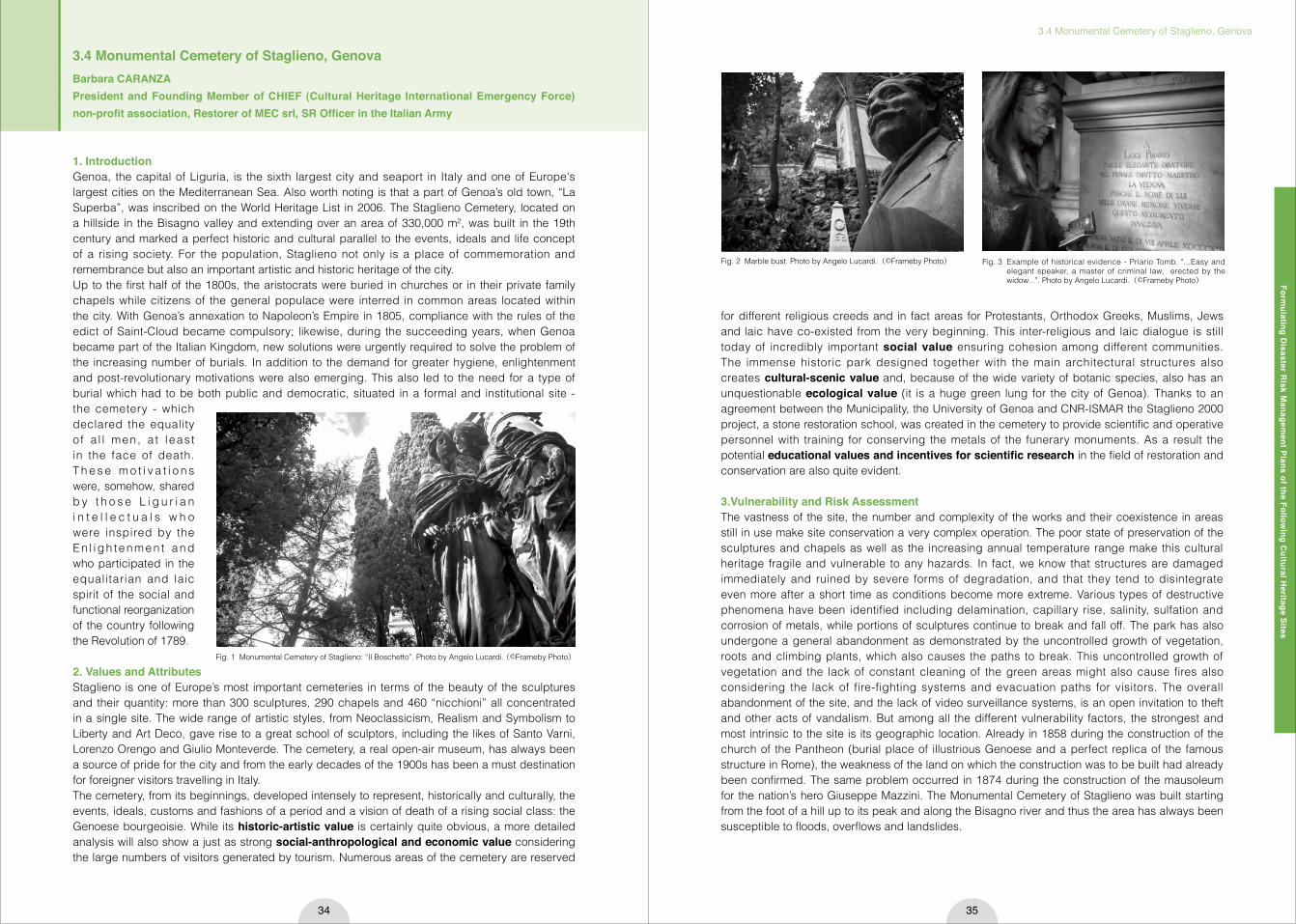
1. IntroductionGenoa, the capital of Liguria, is the sixth largest city and seaport in Italy and one of Europe's largest cities on the Mediterranean Sea. Also worth noting is that a part of Genoa’s old town, “La Superba”, was inscribed on the World Heritage List in 2006. The Staglieno Cemetery, located on a hillside in the Bisagno valley and extending over an area of 330,000 m², was built in the 19th century and marked a perfect historic and cultural parallel to the events, ideals and life concept of a rising society. For the population, Staglieno not only is a place of commemoration and remembrance but also an important artistic and historic heritage of the city.Up to the first half of the 1800s, the aristocrats were buried in churches or in their private family chapels while citizens of the general populace were interred in common areas located within the city. With Genoa’s annexation to Napoleon’s Empire in 1805, compliance with the rules of the edict of Saint-Cloud became compulsory; likewise, during the succeeding years, when Genoa became part of the Italian Kingdom, new solutions were urgently required to solve the problem of the increasing number of burials. In addition to the demand for greater hygiene, enlightenment and post-revolutionary motivations were also emerging. This also led to the need for a type of burial which had to be both public and democratic, situated in a formal and institutional site - the cemetery - which declared the equality o f a l l men, a t leas t in the face of death. T h e s e m o t i v a t i o n s were, somehow, shared b y t h o s e L i g u r i a n i n t e l l e c t u a l s w h o were inspired by the En l i gh tenmen t and who participated in the equalitarian and laic spirit of the social and functional reorganization of the country following the Revolution of 1789.
2. Values and AttributesStaglieno is one of Europe’s most important cemeteries in terms of the beauty of the sculptures and their quantity: more than 300 sculptures, 290 chapels and 460 “nicchioni” all concentrated in a single site. The wide range of artistic styles, from Neoclassicism, Realism and Symbolism to Liberty and Art Deco, gave rise to a great school of sculptors, including the likes of Santo Varni, Lorenzo Orengo and Giulio Monteverde. The cemetery, a real open-air museum, has always been a source of pride for the city and from the early decades of the 1900s has been a must destination for foreigner visitors travelling in Italy.The cemetery, from its beginnings, developed intensely to represent, historically and culturally, the events, ideals, customs and fashions of a period and a vision of death of a rising social class: the Genoese bourgeoisie. While its historic-artistic value is certainly quite obvious, a more detailed analysis will also show a just as strong social-anthropological and economic value considering the large numbers of visitors generated by tourism. Numerous areas of the cemetery are reserved
for different religious creeds and in fact areas for Protestants, Orthodox Greeks, Muslims, Jews and laic have co-existed from the very beginning. This inter-religious and laic dialogue is still today of incredibly important social value ensuring cohesion among different communities. The immense historic park designed together with the main architectural structures also creates cultural-scenic value and, because of the wide variety of botanic species, also has an unquestionable ecological value (it is a huge green lung for the city of Genoa). Thanks to an agreement between the Municipality, the University of Genoa and CNR-ISMAR the Staglieno 2000 project, a stone restoration school, was created in the cemetery to provide scientific and operative personnel with training for conserving the metals of the funerary monuments. As a result the potential educational values and incentives for scientific research in the field of restoration and conservation are also quite evident.
3.Vulnerability and Risk AssessmentThe vastness of the site, the number and complexity of the works and their coexistence in areas still in use make site conservation a very complex operation. The poor state of preservation of the sculptures and chapels as well as the increasing annual temperature range make this cultural heritage fragile and vulnerable to any hazards. In fact, we know that structures are damaged immediately and ruined by severe forms of degradation, and that they tend to disintegrate even more after a short time as conditions become more extreme. Various types of destructive phenomena have been identified including delamination, capillary rise, salinity, sulfation and corrosion of metals, while portions of sculptures continue to break and fall off. The park has also undergone a general abandonment as demonstrated by the uncontrolled growth of vegetation, roots and climbing plants, which also causes the paths to break. This uncontrolled growth of vegetation and the lack of constant cleaning of the green areas might also cause fires also considering the lack of fire-fighting systems and evacuation paths for visitors. The overall abandonment of the site, and the lack of video surveillance systems, is an open invitation to theft and other acts of vandalism. But among all the different vulnerability factors, the strongest and most intrinsic to the site is its geographic location. Already in 1858 during the construction of the church of the Pantheon (burial place of illustrious Genoese and a perfect replica of the famous structure in Rome), the weakness of the land on which the construction was to be built had already been confirmed. The same problem occurred in 1874 during the construction of the mausoleum for the nation’s hero Giuseppe Mazzini. The Monumental Cemetery of Staglieno was built starting from the foot of a hill up to its peak and along the Bisagno river and thus the area has always been susceptible to floods, overflows and landslides.
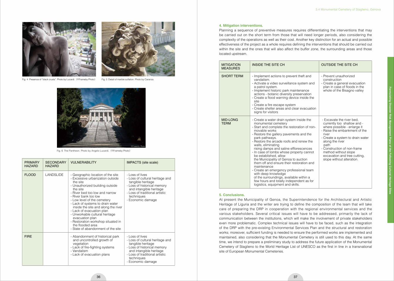
Fig. 1 Monumental Cemetery of Staglieno: “Il Boschetto”. Photo by Angelo Lucardi. (©Frameby Photo)
Fig. 2 Marble bust. Photo by Angelo Lucardi.(©Frameby Photo) Fig. 3 Example of historical evidence - Priario Tomb. "...Easy and elegant speaker, a master of criminal law, erected by the widow...”. Photo by Angelo Lucardi.(©Frameby Photo)
3.4 Monumental Cemetery of Staglieno, GenovaBarbara CARANZA President and Founding Member of CHIEF (Cultural Heritage International Emergency Force) non-profit association, Restorer of MEC srl, SR Officer in the Italian Army
Formulating D
isaster Risk M
anagement Plans of the Follow
ing Cultural H
eritage Sites
3.4 Monumental Cemetery of Staglieno, Genova
36 37
Fig. 4 Presence of “black crusts”. Photo by Lucardi.(©Frameby Photo) Fig. 5 Detail of marble sulfation. Photo by Caranza.
Fig. 6 The Pantheon. Photo by Angelo Lucardi.(©Frameby Photo)
PRIMARY HAZARD
SECONDARY HAZARD
VULNERABILITY IMPACTS (site scale)
FLOOD LANDSLIDE - Geographic location of the site- Excessive urbanization outside
the site- Unauthorized building outside
the site- River bed too low and narrow- River bank too low- Low level of the cemetery- Lack of systems to drain water
inside the site and along the river- Lack of evacuation plan - Unworkable cultural heritage
evacuation plan- Restoration workshop situated in
the flooded area- State of abandonment of the site
- Loss of lives- Loss of cultural heritage and
tangible heritage- Loss of historical memory
and intangible heritage- Loss of traditional artistic
techniques- Economic damage
FIRE - Abandonment of historical park and uncontrolled growth of vegetation
- Lack of fire-fighting systems- Vandalism- Lack of evacuation plans
- Loss of lives- Loss of cultural heritage and
tangible heritage- Loss of historical memory
and intangible heritage - Loss of traditional artistic
techniques- Economic damage
4. Mitigation interventions.Planning a sequence of preventive measures requires differentiating the interventions that may be carried out on the short term from those that will need longer periods, also considering the complexity of the operations as well as their cost. Another key distinction for an actual and possible effectiveness of the project as a whole requires defining the interventions that should be carried out within the site and the ones that will also affect the buffer zone, the surrounding areas and those located upstream.
5. Conclusions.At present the Municipality of Genoa, the Superintendence for the Architectural and Artistic Heritage of Liguria and the writer are trying to define the composition of the team that will take care of preparing the DRP in cooperation with the regional environmental services and the various stakeholders. Several critical issues will have to be addressed, primarily the lack of communication between the institutions, which will make the involvement of private stakeholders even more problematic. Complex technical issues will have to be faced, such as the integration of the DRP with the pre-existing Environmental Services Plan and the structural and restoration works; moreover, sufficient funding is needed to ensure the performed works are implemented and maintained, also considering that the Monumental Cemetery is still used to this day. At the same time, we intend to prepare a preliminary study to address the future application of the Monumental Cemetery of Staglieno to the World Heritage List of UNESCO as the first in line in a transnational site of European Monumental Cemeteries.
MITIGATION MEASURES
INSIDE THE SITE CH OUTSIDE THE SITE CH
SHORT TERM - Implement actions to prevent theft and vandalism.
- Activate a video surveillance system and a patrol system.
- Implement historic park maintenance actions - botanic diversity preservation
- Create a flood warning device inside the site
- Create a fire escape system- Create shelter areas and clear evacuation
signs for visitors
- Prevent unauthorized construction
- Create a general evacuation plan in case of floods in the whole of the Bisagno valley
MID-LONG TERM
- Create a water drain system inside the monumental cemetery
- Start and complete the restoration of non-movable works
- Restore the gallery pavements and the park pathways.
- Restore the arcade roofs and renew the walls, eliminating
rising damps and saline efflorescences- In case of tombs whose property cannot
be established, allow the Municipality of Genoa to auction
them off and ensure their restoration and maintenance
- Create an emergency professional team with deep knowledge
of the surroundings, available within a few hours and totally independent as for logistics, equipment and skills.
- Excavate the river bed, currently too shallow and - where possible - enlarge it
- Raise the embankment of the river
- Create a system to drain water along the river
path- Construction of non-frame
method without slope excavation and tree cutting, slope without alteration.

Formulating D
isaster Risk M
anagement Plans of the Follow
ing Cultural H
eritage Sites
3.5 Portovenere, Cinque Terre and the Islands (Palmaria, Tino and Tinetto)
38 39
3.5 Portovenere, Cinque Terre and the Islands (Palmaria, Tino and Tinetto)Paola MUSSINIArchitect, Vice President and Founding Member of CHIEF (Cultural Heritage International Emergency Force) non-profit association, Italy
1. IntroductionPortovenere, Cinque Terre and the Islands is a multilayered, multifaceted and complex site, located in northern Itlay, along the Ligurian coastline. Because of its exceptional values, it was inscribed on the UNESCO World Heritage List in 1997 as a cultural landscape: comprises circa 4,689 ha, where five small seaside colorful little hamlets (Cinque Terre) plus one (Portovenere), long terraces cultivated with vineyards and olive trees and small uninhabited islets, perfectly merge, creating a most unique and charming ensamble.Inscribed for criteria (ii) (iv) (v), it was described by the Committee as “a cultural site of outstanding value, representing the harmonious interaction between people and nature to produce a landscape of exceptional scenic quality that illustrates a traditional way of life that has existed for a thousand years and continues to play an important socio-economic role in the life of the community”1).
2. Values and Attributes of the SiteBeing a multifaceted and really vast property located on more than 15 km of coastline, the site can be considered and read at different scales, thus showing diverse attributes related to particular values. Three main parts can be identified, homogenous in geomorphology, social features, history and actual management system, as components of the whole site: the Cinque Terre National Park, the small town of Portovenere and the three islets.Beyond this apparent fragmentation, some important common values and issues link all the parts together at a large, comprehensive scale:・the characteristic jagged, steep coastline, which the work of man over the millennia has
transformed into an intensively terraced landscape so as to be able to wrest from nature a few hectares of land suitable for agriculture (growing vines and olive trees).
・The adaptation process of human communities to this seemingly rough and inhospitable nature by building compact settlements directly on the rock, with winding streets. The general use of natural stone for rooting gives these settlements a characteristic appearance (they are generally grouped round religious buildings or medieval castles).
・The change in the socio-economic dynamics that started in the 1990s: the territory has been transformed to an internationally recognized touristic destination among the favorite ones in Italy; the once close agricultural based community is now a population almost entirely devoted to hospitality.
3. Risk AssessmentThe transformations in dynamics along with the consequently generated touristic pressure and the absence of a coherent and comprehensive management strategy, has lead to some key changes in the whole territory’s structure: once cultivated terraces, are now abandoned, because their owners are occupied in the tourism sector, soil got fragile and little riverbeds have been covered in order to become driveways. What once were little inaccessible places, are now visited by million of people every year. The land is vulnerable, because of its own geomorphological structure and a dangerous lack of
Fig. 1 Location of the site. In red the core zone of the UNESCO site
maintenance, to external “climatic” factors, working as a multiplier of the impacts.On October 25th 22 inches of rain (a third of an average year's total) fell in only four hours. Because of the topography and the ability of the flash flooding to drain, Riomaggiore, Manarola, and Corniglia were undamaged, while Monterosso and Vernazza were buried under three meters of mud and debris and left without water, electricity, or phone connec t ions . Homes , i n f ras t ruc tu re , businesses and the surrounding territory were washed away (over 100 million Euros of damages), six people died and several were missing before the National Coast Guard could reach the two villages.Giving all these assumptions I decided to list as main risk factors for Cinque Terre, Portovenere and the Islands flood, touristic pressure and fire and since a devastating flash flooding event occurred in October 2011, I decided to analyze this as most dangerous and probable to happen to work on my “worst case scenario”: imaging a catastrophic situation due to a flood and trying to outline all possible consequences, helped me finding out the main goals a Disaster Risk Management Strategy for this site should have.
4. Drafting the DRMP Strategy for Portovenere, Cinque Terre and the IslandAfter the evaluation of the current state of conservation, the management policies and the risk factors threatening the site, I set two main goals the DRMP strategy needs to reach:・to strengthen the protection of the site in a wide and comprehensive perspective. The principal
problem of this site is, in my opinion, that it was never thought and therefore managed as a whole: no effective common policies were ever implemented;・and to implement a sustainable development plan of the site, that combine Cultural Heritage
protection and socio-economic strategies.In this perspective, previously detected vulnerabilities may be overcome as follows:
5. A Preliminary Action PlanAfter having set the methodological approach, I tried to outline the activities to be designed and completed in order to fulfill the DRM strategy, to ensure a more effective management of risks, overcoming the present problems and issues:Actions to be implemented in the short period (6 months):・figure out the “lesson learned” form the experience and disseminate results and considerations;・organize Capacity building for quick response activities;・provide a proper damage assessment methodology;・design a framework of activities for post-event quick assessment implementation;・update/make geometrical surveys of buildings;・install automatic environmental detection systems;・organize training meeting with the population (share the content of the plan, make demonstrations
and rehearsals);・develop criteria to prioritise buildings for assistance after disasters;・develop conservation case studies as best practice to look up to;・examine and update existing inventories and databases;・make a list of contacts of personnel with emergency responsibilities;・list contacts of trained conservators available.
Fig. 2 A portion of abandoned terraces: vegetation grows wild, cracking the handmade drywalls that used to keep the terrain in case of landslides. (Photo taken by the author, Monterosso, July 2011).

Formulating D
isaster Risk M
anagement Plans of the Follow
ing Cultural H
eritage Sites
3.5 Portovenere, Cinque Terre and the Islands (Palmaria, Tino and Tinetto)
40 41
Actions to be implemented in the long period (1-2 years):・construction of safety measures (riverbed and mountainside along the highway);・review existing policies and procedures for cultural heritage structural reinforcement;・raise awareness and build memory: develop techniques and an interpretive programme for
awareness of heritage buildings and places;・establish maintenance systems;・verify and update insurances.
6. ConclusionsPortovenere, Cinque Terre and the Islands is a very interesting case study for the application of DRM methodologies. First of all because of the outstanding value of the cultural heritage it comprises (material and immaterial) and then for the living nature of the landscape and the very close connection between man and nature.The dynamics that have shaped the site as the multilayered and complex item it visible nowadays, are still readable in the features of the land, in the urban layouts and in the historic and artistic assets.Its conservation, due to lack of DRM policies, lack of maintenance strategies and factors related to climate change, are still at a serious risk: the 2011 event may only be the first of a series of catastrophes.It would be therefore important to be able to effectively put into practice the considerations drafted during this course and to study a comprehensive management plan of the site, considering cultural her i tage preservat ion, sustainable economic development and risk prevention, with the support of all the stakeholders involved.
References1) 21COM VIII.C Inscription: Portovenere, Cinque Terre, and the Islands (Palmaria, Tino and Tinetto) (Italy)
Fig. 3 The hamlet of Manarola (Cinque Terre) viewed from a terraced vineyard.
PRIMARY HAZARD
SECONDARY HAZARD
VULNERABILITY IMPACTS(site scale)
IMPACTS(site specific)
Flood Landslide • Hydrogeological structure
• Fragile soil (abandoned terraces: in 2011 50% of the surveyed landslides happened in abandoned terraces and 48% in not managed forest areas)
• Difficult relationships among Portovenere and Cinque Terre managers
• Lack of a comprehensive management system
• Improper urban interventions that increase not permeable surfaces
• Difficult accessibility (mainly footpath)
• Loss of lives• Partial/total
collapse of buildings
• Partial/total collapse of infrastructures
• Reduction in structural efficiency
• Economic damages
• Erosion of soil• Changes in the
coastline• Damages to
buildings’ systems• Loss of traditional
skills• Infiltration• Damages/loss of
artefacts• Damages to
surfaces• Loss of
biodiversity
TERRACED LANDSCAPETerracesDrywallsCOASTAL SETTLEMENTSUrban patternHistorical buildingsNATURAL ENVIRONMENTMARITIME LANDSCAPEINTANGIBLE HERITAGE Traditional building techniquesTraditional farming techniques
Touristic pressure
• Vandalism• Improper
urban planning
• Lack of a comprehensive management system
• Disproportion numbers of visitors and inhabitants (2.500.000 visitors/year, 8.095 residents)
• Lack of a comprehensive TCC analysis
• Profitability of tourism related activities
• Lack of buffer zone • Lack of a touristic plan
(it should apply also to the centres in the buffer zone)
• Incoherent settlement of Fegina (Monterosso)
• Abandonment • Damages to
the maritime biodiversity
• Increase of pollution
• Increase of waste• Damages of
the maritime landscape
• Change in the local economic system
• Loss of traditional skills and knowledge
• Increase in resources use
TERRACED LANDSCAPETerracesDrywallsCOASTAL SETTLEMENTSUrban patternHistorical buildingsNATURAL ENVIRONMENTMARITIME LANDSCAPEINTANGIBLE HERITAGE Traditional building techniquesTraditional farming techniques
Fire • Combustion/increase of temperature
• Explosion• Use of
improper extinguishing methods
• Lack of maintenance • Lack of control/
monitoring• Increase of dry season
and high temperatures• Urban and landscape
pattern• Presence of a big gas
plant in La Spezia area• Massive presence of
vegetation
• Loss of biodiversity
• Loss of lives• Damages to
buildings• Blockage
of common infrastructure
TERRACED LANDSCAPETerracesDrywallsCOASTAL SETTLEMENTSUrban patternHistorical buildingsNATURAL ENVIRONMENTMARITIME LANDSCAPEINTANGIBLE HERITAGE Traditional building techniquesTraditional farming techniques
VULNERABILITY MITIGATION MEASUREHydrogeological structure • Survey and assessment of the current condition of the soil
• Strengthen the resistance of not cultivated areas (new plantation)
• Put in place a remote sensing system to progressively assess modification and activate early warning
• Organize periodic cleaning of the riverbeds• Watertight windows and doors at ground level
Fragile soil (abandoned terraces) • Survey and in depth analysis of abandoned terraces (location, s.o.c., property status…)
• Implement policies to favour the maintenance of terraces
Difficult relationships among Portovenere and Cinque Terre managers
• MoU among all the parties involved• Organize regular communication meetings
Lack of a comprehensive management system
• Draft of a comprehensive management plan. Current management policies need to be taken into account and implemented (Plan of Cinque Terre National Park, PTCP, Civil Protection Emergency Plan)
• Provide and implement a DRR framework to be integrated with the Management Plan
Improper urban interventions that increase not permeable surfaces
• Discourage new constructions• Forbid coverage of riverbeds
Difficult accessibility • Provide alternative emergency escape routes• Signage system available on site
Table 1 Detailed description and analysis of the main risk factors Table 2 The table above list the measure to apply in order to mitigate the vulnerabilities
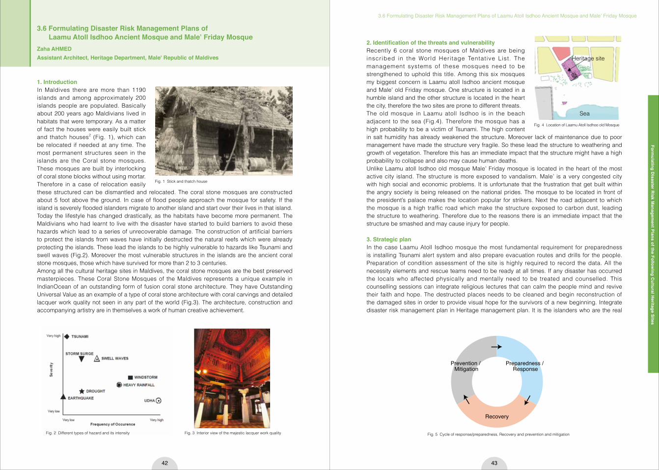
Formulating D
isaster Risk M
anagement Plans of the Follow
ing Cultural H
eritage Sites
3.6 Formulating Disaster Risk Management Plans of Laamu Atoll Isdhoo Ancient Mosque and Male’ Friday Mosque
42 43
1. IntroductionIn Maldives there are more than 1190 islands and among approximately 200 islands people are populated. Basically about 200 years ago Maldivians lived in habitats that were temporary. As a matter of fact the houses were easily built stick and thatch houses2 (Fig. 1), which can be relocated if needed at any time. The most permanent structures seen in the islands are the Coral stone mosques. These mosques are built by interlocking of coral stone blocks without using mortar. Therefore in a case of relocation easily these structured can be dismantled and relocated. The coral stone mosques are constructed about 5 foot above the ground. In case of flood people approach the mosque for safety. If the island is severely flooded islanders migrate to another island and start over their lives in that island. Today the lifestyle has changed drastically, as the habitats have become more permanent. The Maldivians who had learnt to live with the disaster have started to build barriers to avoid these hazards which lead to a series of unrecoverable damage. The construction of artificial barriers to protect the islands from waves have initially destructed the natural reefs which were already protecting the islands. These lead the islands to be highly vulnerable to hazards like Tsunami and swell waves (Fig.2). Moreover the most vulnerable structures in the islands are the ancient coral stone mosques, those which have survived for more than 2 to 3 centuries. Among all the cultural heritage sites in Maldives, the coral stone mosques are the best preserved masterpieces. These Coral Stone Mosques of the Maldives represents a unique example in IndianOcean of an outstanding form of fusion coral stone architecture. They have Outstanding Universal Value as an example of a type of coral stone architecture with coral carvings and detailed lacquer work quality not seen in any part of the world (Fig.3). The architecture, construction and accompanying artistry are in themselves a work of human creative achievement.
2. Identification of the threats and vulnerabilityRecently 6 coral stone mosques of Maldives are being inscribed in the World Heritage Tentat ive List. The management systems of these mosques need to be strengthened to uphold this title. Among this six mosques my biggest concern is Laamu atoll Isdhoo ancient mosque and Male’ old Friday mosque. One structure is located in a humble island and the other structure is located in the heart the city, therefore the two sites are prone to different threats. The old mosque in Laamu atoll Isdhoo is in the beach adjacent to the sea (Fig.4). Therefore the mosque has a high probability to be a victim of Tsunami. The high content in salt humidity has already weakened the structure. Moreover lack of maintenance due to poor management have made the structure very fragile. So these lead the structure to weathering and growth of vegetation. Therefore this has an immediate impact that the structure might have a high probability to collapse and also may cause human deaths.Unlike Laamu atoll Isdhoo old mosque Male’ Friday mosque is located in the heart of the most active city island. The structure is more exposed to vandalism. Male’ is a very congested city with high social and economic problems. It is unfortunate that the frustration that get built within the angry society is being released on the national prides. The mosque to be located in front of the president’s palace makes the location popular for strikers. Next the road adjacent to which the mosque is a high traffic road which make the structure exposed to carbon dust, leading the structure to weathering. Therefore due to the reasons there is an immediate impact that the structure be smashed and may cause injury for people.
3. Strategic plan In the case Laamu Atoll Isdhoo mosque the most fundamental requirement for preparedness is installing Tsunami alert system and also prepare evacuation routes and drills for the people. Preparation of condition assessment of the site is highly required to record the data. All the necessity elements and rescue teams need to be ready at all times. If any disaster has occurred the locals who affected physically and mentally need to be treated and counselled. This counselling sessions can integrate religious lectures that can calm the people mind and revive their faith and hope. The destructed places needs to be cleaned and begin reconstruction of the damaged sites in order to provide visual hope for the survivors of a new beginning. Integrate disaster risk management plan in Heritage management plan. It is the islanders who are the real
Fig. 1 Stick and thatch house
Fig. 2 Different types of hazard and its intensity
Prevention / Mitigation
Preparedness / Response
Recovery
Fig. 5 Cycle of response/preparedness, Recovery and prevention and mitigation
3.6 Formulating Disaster Risk Management Plans of Laamu Atoll Isdhoo Ancient Mosque and Male’ Friday MosqueZaha AHMEDAssistant Architect, Heritage Department, Male' Republic of Maldives
Fig. 3 Interior view of the majestic lacquer work quality
Fig. 4 Location of Laamu Atoll Isdhoo old Mosque
Heritage site
Sea

Formulating D
isaster Risk M
anagement Plans of the Follow
ing Cultural H
eritage Sites
3.6 Formulating Disaster Risk Management Plans of Laamu Atoll Isdhoo Ancient Mosque and Male’ Friday Mosque
44 45
caretakers of the site, therefore more training programs about conservation and maintenance need to be conducted. The cycle of response/preparedness, Recovery and prevention and mitigation continues. In the case of Male’ Friday mosque the initial preparedness is installing cctv and other surveillance appliances. Moreover introduce boards to notify that the site is under surveillance. Like Laamu Atoll mosque, this mosque also need to prepare evacuation and drills for the people. Preparation of condition assessment of the site is highly required to record the data. In the recovery stage the people responsible for vandalism needs to be captured and should be punished. As soon as possible the destructed site needs to be cleaned and reconstructed. It is highly recommendable to involve community in the reconstruction of the site, as this will strengthen the community bond, with the structure. Integrate disaster risk management plan in Heritage management plan. Organize more awareness programs to the city dwellers, to increase their respect and love for the site. Proper management system of the site need to be established. The cycle of response/preparedness, Recovery and prevention and mitigation continues.
4. Disaster mitigation and risk preparedness plan (short & long term)The most essential element to protect the heritage site is making a strong legal framework. Presently there is no specific law to safe guard Maldives, heritage law need to be drafted and established. To increase efficiency of the management of heritage site a manual to maintain and monitor the sites need to be prepared. These manuals need to be familiar to the site managers of the islands. In the case of mosque the site managers are usually religious leader. Daily updates are needed to be exchanged between the site managers and Department of heritage. The security of the sites can be increased by collaborating with the National defense force. More drills can be conducted to aware the people. These programs can also increase the community relationship with the site.
5. ConclusionFormulating a disaster risk management plans involve important role from the policy level and also the community level. As the policy will guide the people and the community to take care of the site and be well prepared to face the disasters. Therefore the output of the management plan will make the people more aware of the site. Subsequently the community will start to love the site and will get more attached with the site. Outcome of the management plan will be the people will be able to seek harmony and faith from the site and this will ultimately provide safe guarders of the place.
References1) Jigyasu, R.: CULTURAL HERITAGE IN URBAN AREAS - A Training Guide, published by Research Center
for Disaster Mitigation of Urban Cultural Heritage, Ritsumeikan University (RitsDMUCH), Kyoto, Japan, 2013
2) Mohamed, N.: Essays on Early Maldives, National Center for Linguistic and Historic Research, 2007
ACTORS SHORT TERM MID TERM LONG TERM
Department of Heritage ( A. Architect)+DRM unit+Religious leader+ Attorney General Office
・Prepare and Revise the existing heritage law・Create a manual to
monitor and maintain the site・Incorporate the
manual in the DRM plan・Train a person from
the island to monitor the place・Fund Raising
Programs
・Update the manual・Train staffs to use the
manual・Collect the updates
of the site・Research the new
threats and try to find preventive measures・Update the DRM
plan・Conduct awareness
program of the importance of the heritage sites
・Review the manual・Plan for climatic
change・Review the heritage
law
Site Manager (Religious leader)+ Department of Heritage(Research officer)
・Monitor the site・Daily updates
informed to Dep. Heritage
・Improve the monitoring system by introducing high technology・Record the daily
conditions and find solution for improvement
・Review the monitoring system・Review the data base
and identify the new threats
Table 1 Disaster mitigation and risk preparedness plan

Formulating D
isaster Risk M
anagement Plans of the Follow
ing Cultural H
eritage Sites
3.7 Disaster Risk Management Plan of Historic Core of Tansen
46 47
1. IntroductionTansen, a Nepalese hill town of 11th century, enlisted as tentative world heritage site (in 2008, http://whc.unesco.org/en/tentativelists/5262/) offers traditional buildings with unique window features along the narrow streets, religious and historic attributes combined with culture as the attractions and assets of the town. Cultural heritages such as temples, central open space, palace, monasteries, mosque, church, stone paved streets, parks, public rest houses, school buildings, libraries, etc. are scattered at different locations. These all evolved with the combination of Magar and Newari cultures together with Hinduism and Buddhism. Due to its terrain, streetscape and preparedness of the authorities, the town is relatively at high risk of disaster. The municipality, local communities, Non-Governmental Organizations and even the central government have not yet prepared adequate plan for the management of these risks. As the core area of the town, consisting of many heritages, is very much at risk; the same is taken as case study for the preparation of disaster risk management plan.
2. Objectives of the StudyThe main objective of this study is to prepare disaster risk management plan of historic core of Tansen Municipality as part of integration of disaster risk management into the periodic plan of the municipality, focusing on the urban cultural heritage, besides the life and property of the citizen. It is expected that the plan will demonstrate the elements for adoption and integration by other Nepalese towns possessing similar conditions while preparing disaster risk management plan.
3. Disaster Risk Analysis3.1 EarthquakeThe nationwide earthquake of 1934 made significant damage in Tansen as well. In particular the palace, in the middle of the town, was also damaged alongwith many houses. The map “Nepal: Natural Hazard Risk” prepared by OCHA Regional Office for Asia, in 2001, shows Tansen in the high magnitude earthquake zone (Fig. 1).
3.2 Flood and LandslideAlthough there is no river running through the town three large natural channels drain out storm water from the uphill, particularly Shreenagar area. Construction of buildings in the proximity of these natural channels and Shreenagar hill is increasing without paying due attention to protect likely erosion, thereby increasing the disaster risk.
3.3 FireIn the core area the main streets are barely 6m wide whereas the inner alleys are even less than 2m wide. The municipal authority lacks proper equipment and preparedness to fight against fire. As the settlement in the core area is very dense and the old buildings are constructed with large quantity of timber it is highly vulnerable to fire.
3.4 Temples and BiharsThere are many temples and Bihars in Tansen. These attributes have both historic and religious values. Many of the temples and Bihars lack maintenance. One of the natural channels carries storm water by the side of Amarnarayan Temple hence the temple premise is highly vulnerable to flash flood (Fig. 2).
3.5 Palace and SquareTansen inher i ts h istor ic, pol i t ical and architectural values. It is highly vulnerable to fire, earthquake and encroachment. The palace was burnt out completely by the Maoists (one of the Nepalese political parties) during the conflict period in the country (Fig.3).
3.6 Streets and Traditional HousesThe combination of traditional architectural buildings, particularly in Newari and Rana style along the stone paved streets in the sloppy contour presents a very attractive cityscape of Tansen. The traditional cityscape is changing due to lack of sensitivity and respect towards the traditional architecture. The new construction is not in compliance with traditional architecture. The traditional settlement of Tansen is thus highly vulnerable to the disasters from earthquake, fire and encroachment.
3.7 FestivalsTansen celebrates a number of festivals. These festivals bring people of Tansen together. The chariot of Bhagawati Jatra goes through many places in the town. The various festivals thus celebrated have cultural value forming the symbol of unity, reflecting the identity of the people of Tansen. Given the situation, majority of the roads less than 6m wide, inner alleys less than 2m wide the festival route, tourist route, route for fire engine, major escape route; towns is highly vulnerable to the risks arising from these situations (Fig. 4).
4. Worst Case ScenarioThe findings of above analysis can be summarized as follows to derive worst case scenario.・narrow streets and alleys obstructing access not only for rescue but also for escape;・increasing vulnerable structures, flash flood, ignorance and lack of sensitivity towards risk
concerns and conservation of cultural heritage;・lack of building regulations, weak enforcement, deteriorated landscape;
Fig. 1 Location of Tansen in Natural Hazard Risk Map
Fig. 2 Flood Risk to Amar Narayan Temple
Fig. 3 Various Attributes of Tansen
Fig. 4 Risks During Festivals
3.7 Disaster Risk Management Plan of Historic Core of TansenArjun KOIRALADepartment of Urban Development and Building ConstructionUrban Governance and Development ProgramAdvisor- Urban planning and Infrastructure Development, Municipal Support TeamGFA Consulting Group GmbH
Formulating D
isaster Risk M
anagement Plans of the Follow
ing Cultural H
eritage Sites
3.7 Disaster Risk Management Plan of Historic Core of Tansen
48 49
・inadequate capacity of authorities: lack of equipment, human resource, training; firefighting system not developed; lack of integration of disaster management plan in the municipal plan and the district level Disaster Risk Preparedness and Response Plan.
In this situation, earthquake followed by fire may result in significant loss of life, property and heritage. This might cause loss of social harmony of the communities and the town may remain with lost identity and pride.
5. Municipal Disaster Risk Management PlanThe disaster risk management plan for the historic core of Tansen town, focusing on cultural heritage, is proposed as follows.
5.1 VisionThe pride of historic city of Tansen is retained by the community and offered to future generations.
5.2 GoalThe capacity of the historic town Tansen and local community to manage the disaster risk, conserve the heritage and save life and property of its citizen is enhanced. As a result, it is expected that the historic, architectural and natural features are integrated in overall development of the town; heritage site management system is in place and the disaster risks (earthquake, fire) are minimized; and citizen live with pride of the town’s identity.
5.3 StrategyThe following strategies are proposed:・ improv ing and s t rengthen ing the
i n s t i t u t i o n a l c a p a c i t y o f Ta n s e n Municipality to respond the disaster risk management, focusing on cultural heritage;
・ensuring participation of local communities to respond to the risks of earthquake, fire and other hazards; and safeguarding both the natural and cultural heritages;
・reinforcing local coordination for cultural heritage management
6. Emergency Preparedness and Response 6.1 FirefightingInstallation of firefighting mechanism (e.g. fire hydrants at appropriate distance in the main streets along which the city supply is laid), and provision of portable pumping system where the firefighting engine cannot reach are proposed. These systems, after installation, are primarily operated by Tole Lane Organizations (a community based organization of small neighbourhood), supported by city authority. In order to supplement the water requi rement to extinguish fire utilization of existing ponds; reservoirs of individual houses are proposed.
Fig. 5 Emergency Preparedness for Firefighting
Fig. 6 Evacuation Directions and Places
Similarly installation of firefighting mechanism at each heritage site is proposed. The main streets are also designated as the routes for fire engine to the heritage sites (Fig 5).
6.2 Evacuation Direction and PlacesThe places for early shifting of heritage attributes immediately after disaster and evacuation of people to designated safe places are presented in Fig 6.
7. Action PlanThe activities for short (first 5 years) and long terms (6th year onward) are listed below.
7.1 Short Term Plan・conduction of awareness and training programmes on heritage and associated risk; ・equipping municipality with basic human and equipment resources and building capacity of
municipal key staff and community members to safeguard cultural heritages;・installing firefighting mechanisms along streets and at heritage sites;・regenerating traditional water sources, maintaining heritages;・coordinating activities with relevant agencies; and integrating disaster risk management plan in
Periodic Plan and the District Disaster Preparedness and Response Plan;・preparing landuse plan and updating building regulations;
7.2 Long Term Plan・retrofitting traditional buildings and improving access to high risk areas;・constructing storm water drainage system;・installing firefighting mechanisms in heritage sites;・preparing and implementing heritage sites management plan;・carrying out research and development activities.
8. Institutional ArrangementA three tiered institutional arrangement is proposed which will share the responsibilities for planning activities (by a Core Planning Team), extending emergency services of the municipality and other agencies (by an Emergency Team) and taking immediate emergency action when disaster occurs (by a community level Response Team).
References 1) Nepal Government: Local Self Governance Act, 1999 2) Nepal Government : The Natural Calamity Relief Act (1982), as amended to 1992 3) Nepal Government: National Strategy for Disaster Risk Management, 2009 4) Nepal Government: National Action Plan on Disaster Management in Nepal, 1996 5) Nepal Government: Municipal Periodic Planning Guideline, 2002 6) Tansen Municipality: Periodic Plan of Tansen Municipality, 2010 7) District Natural Disaster Relief Committee: Disaster Preparedness and Response Plan Palpa, 2011 8) UNESCO: Heritage Homeowner’s Preservation Manual, 2006 9) Tansen Municipality: Socio-economic Profile of Tansen Municipality, 200910) Kai Weise: Notes on the Destruction of Tansen Durbar, 200611) Ritsumeikan University: Compilation of Lecture Notes of the International Training Programme on
Disaster Risk Management of Urban Cultural Heritage, 2013
Formulating D
isaster Risk M
anagement Plans of the Follow
ing Cultural H
eritage Sites
3.8 Disaster Risk Management Strategy of Sukur Cultural Heritage Site Adamawa State, Nigeria
50 51
1. Introduction A hazard is a phenomenon or process, either natural or man-made that can endanger a group of people, their belongings and environment (Wikipedia, The Free encyclopedia, en.wikipedia.org/wiki/Hazard). Natural disasters, whether of meteorological origin such as cyclones, floods, tornadoes and droughts or of geological nature such as earthquakes, volcanoes, mud / landslides and subsidence, are well known for their devastating impact on human life, economy and environment. With tropical climate and unstable land forms, coupled with high population density, poverty, illiteracy and lack of well-developed infrastructure, developing countries are more vulnerable to suffer from the damaging potential of such disasters. Though, it is almost impossible to completely neutralize the damage due to these disasters, it is possible to minimize the potential risks by developing disaster early warning strategies and prepare mitigation plans to provide resilience to such disasters.The cultural landscape of Sukur is a remarkably intact physical expression of a society and its spiritual and material culture. The landscape represents an unusual symbiotic interaction between nature and culture, the dead and the living, and the past and the present.
During the 23rd Session of the World Heritage Committee Marakesh Morocco held 29 November – 4 December, 1999, the Committee inscribed the property -Sukur Cultural Landscape- on the World Heritage List based on criteria (iii), (v) and (vi) with the Id. N° 938. Nigeria’s National Commission for Museum and Monuments (NCMM) has the mandate to oversee the Sukur World Heritage Site (WHS) in Nigeria, while the National Emergency Management Agency (NEMA) has the mandate on disaster management issues.
A critical analysis of the policy frameworks of the two agencies -NCMM and NEMA- show the absence of deliberate Disaster Risk Management strategy for the protection of cultural heritage sites and especially this WHS. There are no indications that provisions are deliberately made for mitigation efforts with adequate resources through a strategic plan targeted at the WHS. In addition, participatory involvement of Communities in WHS in implementation of policies have not been strategically defined in order to carve out the roles they must play in the light of emergencies / disasters as is the case presently in Sukur WHS.
2. Location of StudySukur is in Madagali Local Government Area, Adamawa State Northeast Region of Nigeria. The exact location is 10° 44' N, 13° 34' E. Magadali borders Michika to the north, Askira Uba to the west, Gwoza local government area to the south and the Republic of Cameroon to the east. As in most part of the northeast region, the site experiences acute dryness on the soil, which hardly supports luxuriant growth of grass and other flora biodiversities. However, there is luxuriant growth of trees around riverbeds, mountains and highlands, which supports arable and animal husbandry. The population is made up of both sedentary arable farmers and migratory herdsmen, mainly of Fulani ethnic group.
3. JustificationSukur Cultural Landscape in Adamawa State of Nigeria, one of the three (3) States in which a State of Emergency has been declared by the Nigerian government since May 2013 due to incursion of the Boko Haram terrorist group within the state leading to the rising situation of human insecurity and their possible incursion through the territorial borders of Nigeria with neighboring African countries. Sukur is prone to potential armed conflict especially the incursion by this terrorist group who might resort to this heritage site either as a “safe haven” while fleeing from military attack or it might become one of the targeted sites / locations for reprisal destruction by the Boko Haram sect in retaliation for the ‘clamp-down’ by government forces. Furthermore, disaster risks are changing due to the changing effects of climate which will prompt more intense and frequent extreme natural and man-made events including floods, droughts due to over-grazing and intensive land cultivation leading to reduced soil fertility and productivity in Sukur. According to Article 11 (4) of the Convention concerning the Protection of the World Cultural and Natural Heritage, a heritage site threatened by serious and specific dangers may be included in the List of World Heritage in Danger [due to] threat of an armed conflict. Given the criteria (iii), (v) and (vi) which form the basis of enlistment of Sukur Cultural Landscape as World Heritage Site, it is advisable that proactive measures be taken to mitigate risks and damage, due to threats posed both by armed conflict and changing climatic condition on the socio-economic livelihood and long term sustainable conservation of the heritage site.
4. MethodologyStructured interview was used to obtain information from 20 respondents selected through simple random sampling techniques in Sukur community and from staff of NCMM responsible for oversight function of the site. The primary data collected include socio-economic profile of the community in and around the site, history of natural and human-induced disaster incidences (fire and mudslides). Secondary data used were relevant literatures of research work of the Fig. 1 Sukur Cultural Heritage Site
Fig. 2 Sukur Cultural Landscape
3.8 Disaster Risk Management Strategy of Sukur Cultural Heritage Site Adamawa State, NigeriaKenechukwu Chudi ONUKWUBEProgram Consultant, Development Education and Advocacy Resource for Africa Initiative(DEAR Africa), Nigeria

Formulating D
isaster Risk M
anagement Plans of the Follow
ing Cultural H
eritage Sites
3.8 Disaster Risk Management Strategy of Sukur Cultural Heritage Site Adamawa State, Nigeria
52 53
geographical area carried out by scholars, nomination dossier of the site, topographic, geological and hydrological maps of the site, digital photographs, National policy on disaster management and the policy thrust of the NCMM. These were analyzed based on two disaster scenarios using the back-casting and fore-casting approach to determine the possible risks the site is exposed to and to propose mitigation strategies, emergency preparedness and response, and required resources.
5. Theoretical FrameworkThe theoretical framework of analyzing inter-linkage between environmental changes, possible conflict situation and the negative impact on cultural heritage sites may be complicated. Without the full understanding of the intervening factors, it may be difficult to grasp the true nature of the relationship between human activity, environmental change, social disruption and conflict in northeast, Nigeria. An illustration of a framework of analysis advanced by Homer-Dixon (1991) is utilized as the primary theoretical anchor in this study as shown in figure 1 and 2. Environmental degradation due to climate change may affect water availability to the soil, plants and animals. These affect the inhabitant’s access to and utilization of natural resource for sustenance of livelihood. When this happens, it can trigger-off intra or inter-conflicts resulting in arson as because the population of unemployed hungry inhabitants either migrate or struggle over the meager resources. Scarce resources would lead to poor nutrition which increases the risk of higher disease burden and in extreme cases death of both human and animal population.In North East Nigeria, there are many conflicts, which are environmentally induced. These are conflicts over grazing land, over cattle, over water points and over cultivable land. While there are conflicts over grazing land and over cattle amongst pastoral people, there are also conflicts over cultivable land amongst peasant farmers within the same ethnic group and also between ethnic groups. Such conflicts amongst pastoralists are common and widespread in Nigeria. The eco-violence theories perspective of conflict explains that conflict is generated by the scarcity of natural resources.
6. DiscussionsThe site has high exposure to potential hazards of mudslides due to fragility of soil, sparse vegetation, high impact rainfall, flood, and fire due to arson resulting from either uncontrolled bush burning or arson caused by conflicts or militia incursion. These are likely to exacerbate due to low awareness on disaster risks management, low per capita (household) income, continuous loss of vegetative cover, weak collaboration between stakeholders and absence of a disaster risks management plan / strategy.To address these, the mitigation measures as shown in figure 3 and the Management Plan with budgets in Figure 4 below are proposed respectively.
Fig. 3 Sukur Cultural Heritage Site
Fig. 4 Logical Model of the interactive relationship between Environmental degradation and the social effects
Fig. 5 Environmental Change and Acute Conflict Nexus Adopted from Homer – Dixon (1991)

Formulating D
isaster Risk M
anagement Plans of the Follow
ing Cultural H
eritage Sites
3.8 Disaster Risk Management Strategy of Sukur Cultural Heritage Site Adamawa State, Nigeria
54 55
POTENTIALHAZARDS
ADDRESS THESEWEAKNESSES
DUETO
WHAT MUST BE DONE
DAMAGE / LOSS OF ATTRIBUTES, EROSION HUMANLIFE, TOURISM AND REVENUE
INADEQUATE AWARENESSON DR MANAGEMENT
Discuss proposal through Consultative meetings withCore Team and Partners
・Complementary or Alternative income generating activities)
・ Develop Local level Evacuation Plan and Incidence control system
・ Micro-level DR monitoring and assessment system
・ Cultivation and maintenance of trees
・ Clarify roles for first responders and secondary responders for fire or flood disaster
・ Site Management Committee is adequately equipped to give immediate repairs and maintenance to the heritage attributes / artifacts and routine maintenance of immediate site environment
・Train primary responders on use of DRM Equipment, Procedures & Controls
LOW LEVEL OF HOUSEHOLDINCOME
CONTINUOUS LOSS OFVEGETATIVE COVER
WEAK COLLABORATIONBETWEEN STAKEHOLDERS
EXISTINGMANAGEMENT PLAN HAS
NO DRM STRATEGY
Increase the level of awareness on DRM (e.g. importance of vegetative cover, Erosion
prevention, sustainable land cultivation measures, alternative sources of household fuel)
Fig. 6 Mitigation Measuers at Local Level (Community, Local & State Covernment)
Table 1 Disaster Management Strategy for Ideal SituationReferences1) Emeka E. Obioha: Climate Change, Population Drift and Violent Conflict over Land Resources in
Northeastern Nigeria, J. Hum. Ecol., 23(4): 311-324, 20082) Homer-Dixon, T. F.: Environment scarcity and Violent Conflict. Evidence from cases. International Security,
19(1): 5-40, 19943) Internet documentations on Sukur http://www.ucalgary.ca/sukur/repcom99xtract.pdf) and http://
ipsnews2.wpengine.com4) National Commission for Museums and Monuments http://www.ncmmnigeria.com/5) UNESCO WHC Nomination Document (938) 6) Wikipedia, The Free encyclopedia, en.wikipedia.org/wiki/Hazard
WHAT INDICATORS WHO WHEN BUDGET (USD)
Core Team is established and functional
• Regular Site Activities Monitoring and Documentation
• Update of Site map to show relief, clear boundary and location of Emergency response systems
• Cluster level emergency and evacuation planning
• Core Team leads with District, Local and State Govts.
Short- Term1- 5years
50,000
Community Mobilization
• Capacity building on DRM• Routine maintenance of attributes and
immediate site environment• Stakeholder engagement
• Core Team leads with District, Local and State Govts.
Short term1- 5years
20,000
High level Intensive advocacy
• Budgets and Legal framework of DRM strategy developed;
• Bi-annual Council on DR Mitigation for Cultural Heritage commences
• Review of existing management Plan • DRM Strategy mainstreamed into
existing Emergency Management Policies at all level
• Core Team leads in Consultation with Local and State Governments.
Short To Medium Term (5 - 10 years)
50,000
Emergency Management
• Prevention and Response equipment / system in place
• Evacuation System in Place; Energy Saving stoves
• Land Use and Land Suitability maps produced
• State and National Government Emergency management Agencies
Short To Medium Term(5 - 10 year)
100,000
Site Recovery • Restoration of trees / vegetation and buildings
• Introduction of alternative complimentary livelihood programs (to address Education, health, cultural, economic and community cohesion challenges); Trauma care and counseling; Enhance security and Immigration systems at all levels; Reconstruction of Homes
State and National Government Emergency Management Agencies
Short To Medium Term(5 - 10 year)
300,000
Collaboration with Stakeholders/ Partners
Consultative meetings; Management Plans adopted by national and international community; Public-Private Partnerships to enhance Research &funding supports
State and National Govts.; International community
Medium To Long Term(5 - 10 year)
25,000
Monitoring and Evaluation
Review of Management, DRM and Tourism Plans Status of Partnerships / Collaboration initiatives reviewed & enhanced
Core Team Continuous 20,000

Formulating D
isaster Risk M
anagement Plans of the Follow
ing Cultural H
eritage Sites
3.9 Mainstreaming Disaster Risk Management (DRM) in Historic Urban Landscape (HUL)
56 57
1. IntroductionZanzibar Stone town (fig.1) was inscribed in the UNESCO World Heritage List in 2000. With only 20, 000 inhabitants, the town is the administrative, social and cultural capital of the Zanzibar archipelago which has 1.3M inhabitants in an area of 2, 460 km². Historically, and until the end of the 19th century, stone town was also the main hub of a wide commercial network which linked the African continent, Indian subcontinent and the Persian Gulf and capital of the powerful commercial empire. The World Heritage Site contains different types of buildings that reflect influences of the monsoon winds which allowed the development of trades and fusion of cultures values from Africa, the Persian Gulf, India Sub-continent, and Europe. It also retains form of urban cultural unique to this region, and makes it an outstanding example of a Swahili trading town. Behind, 1.3 km of seafront, lies an intricate network of narrow streets edged by mainly two or three storey buildings demonstrate a complex fusion of Swahili, Indian, Arab and European influences in building traditions and town planning. The most important features of these buildings are “baraza”, wooden curved doors and balconies, verandas and loggia which occupy the attention of both tourists and managers of the town.
2. Historic Urban Landscape (HUL)Today, the key role played by culture in development is more and more emphasised. The number of States Parties inscribed in UNESCO Convention (180 states) for the Protection of the World Cultural and Natural is a good indicator. With development, these heritage sites, especially cultural sites, face a myriad of pressures which threat their Outstanding Universal Values (OUV) (Cameroun 2009). In fact, the daunting challenge is now shifting from a sheer «conscience of conservation” (Erder 1986) to the need of management systems to meet the future challenges of promotion and protection of heritage sites. More, compared to other UNESCO properties, historic cities face additional challenges because of its strategic position in naturing a culture that anables the developments of large territories (fig. 2). As Munjeri (1999) remarks, historic cities are mostly threated by the process of urban transformation. To cope that threats, UNESCO adopt a new HUL Recommendation to facilitate development in the urban historic context (Ron 2013). Hence, there is a
constant need of adaptation of our understanding of the notion of heritage (Choay 1999), that gives a comprehensive room in the management process of living historic cities (Ron 2013). For this reason, it is also crucial to integrate Disaster Risk Management (DRM) approach in dealing with heritage promotion and protection in historic city and in urban planning and development (Gabrielli 2010) to bridge and articulate an inter-disciplinary approach to culture heritage management.
3. Mainstreaming Disaster Risk Management (DRM) in HUL
Disaster Risk Management is the UN development Agenda. Although many challenges may lead to a disaster, the continuous growth of cities and the expected 70% of world population in the urban area by 2050 present crucial challenge in urban area. Disaster Risk reduction is therefore a target of post-2015. More, following Hyogo Framework of Action (2005-2015), disaster risk reduction has also been considered as cross cutting issues. Mainstreaming DRM in development policy is one of the key element of the Hyogo Framework of Action. Again, the mid-term review of Hyogo Framework has also put forward some gaps that need to be considered in post-2015, namely to “mainstream and integrate disaster risk reduction into development, climate change adaption, environmental and humanitarian planning (UNESCO and all)”. In another word, making a city resilience is a step in supporting disaster risk management. As in the HUL recommendations, city resilience requires understanding and commitment of local and nationa stakeholders to fomule policy and make plan for DRM. In this context, mainstreaming DRM in the HUL is an approach that can influence sustainability, resilience and development of historic cities. In the same spirit, in 2012, RistDMUCH has taken a special initiative by putting a focus on “Risk Reduction for Sustainability of Historic Cities” (Jigyasu and Arora 2013)
4. DRM Plan of the Stone Town of Zanzibar Stone town of Zanzibar doesn’t have a history of disaster. Two main hazards have been catastrophic in the town: Hurricane and fire. The 19th century hurricane had been very disastrous to the town by destroying near the one third of its built environment. Since that date, the Islands have not experienced a similar case. However, today, the Stone town faces three types of risks, namely: fire, flood and climatic change. In fact, the transformation of the Stone town with the increase in population, the growth of tourist industry and the lack of infrastructures have amplified the risk of disaster, especially fire. (Fig.3)
In today’s management system, talking about cultural heritage promotion and management is also talking about management of risks. Any disaster impact is essential component of management system of any cultural heritage site, especially historic town. Like the Zanzibar Stone town, most of African heritage cities lack strategic plan for disaster risk management. Hence, mainstream DRM in HUL approach in the best strategy for sustainable development of Stone town. More, integrating approach to disaster risk management for cultural heritage in urban area is also one of the core of objectives of the RitsDMUCH course. In the preparation of DRM of Stone town and following the disaster risk management cycle, the three steps assessments, before, during, after risk were engaged. For risk assessment, three values of the Stone town of Zanzibar were analysed, namely, buildings, urban fabric and cultural fusion. The attributes of each of these values were associated accordingly. For example, 26
3.9 Mainstreaming Disaster Risk Management (DRM) in Historic Urban Landscape (HUL) Case of Stone Town of Zanzibar
Muhammad Juma MUHAMMADDirector, Department of Urban and Rural Planning, Tanzania
Fig. 1 Stone town of Zanzibar [c. Author]
Fig. 3 Consequences of fire in Stone Town [c. Author]
Fig. 2 Stone Town of Zanzibar; Heritage area and Buffer zone [c. STCDA]

Formulating D
isaster Risk M
anagement Plans of the Follow
ing Cultural H
eritage Sites
3.9 Mainstreaming Disaster Risk Management (DRM) in Historic Urban Landscape (HUL)
58 59
grade-1 buildings, gazetted as monuments, are important attributes of the first value: building. Streetscapes and multi-uses of building are the attribute of second and third values, respectively. For risk analysis, the focusing was on three hazards, namely fire, storms and man-made hazard. The vulnerability of all attributes of the Stone town were also scrutinized. The impacts of the hazard were clearly defined following the analysis of the vulnerabilities (fig.4)
The goal of the disaster Risk management of Stone town of Zanzibar is to manage better the historic city as HUL. Hence, the analysis of its stakeholders, partners and core teams in the preparation of DRM were influenced by considering HUL approach. The idea of integrated planning as a tool of DRM was very important in this respect. This is also why the mitigation measures before and after the disaster of the Stone town are considering four important elements: policy, guideline, land use and infrastructure. As a pilot of DRM plan in Stone town, a scenario of fire near the National Museum was tested (fig.5). An evacuation plan, was imagined to make sure that there are open space for temporary evacuation before the permanent solutions have been adopted. In the evacuation root, necessary tools such as fire hydrants were also proposed. Indeed, it is important to mainstream DRM plan to sectorial policy before the disaster, but it is also important to establish communication unit after the disaster. The recovering plan of the Stone town was also prepared in the same logic of evolving important actors at short, medium and long term strategies to deal with the situation of scenario before, during and after the disaster.
5. Conclusion A comprehensive relation on ideas of heritage promotion, conservation, management, and planning is an essential step on preparation of DRM of an urban heritage site. A lack of articulation or inadequate interpretation on these ideas creates difficulties in safeguarding significant values of heritage, and hinders as well endeavours to its promotion and management. HUL approach intends to guide an intergrade idea for safeguarding historic cities to face challenges of globalized, urbanized world. It for this reason that mainstreaming DRM in a HUL approach seems to be an appropriate approach for risk mitigation to build a resilience historic city. As a part of global
strategy on sustainable development, the approach, tools and guidelines developed during the preparation of DRM of Stone town, will be integrated in the process of preparing the Master Plan of Zanzibar city and of the National Land Use plan of Zanzibar. The preparation of DRM for the Stone town of Zanzibar has been a good case to understand how to mainstream the DRM plan in the Historic Urban Landscape for its better protection and promotion.
References 1) Bernard Feilden and Jukka Jokilehto: Management Guideline for World Heritage Sites, Rome, ICCROM,
1998 2) Bruno Gabrielli: Urban Planning Challenged by Historic Urban Landscape, in UNESCO, World Heritage
Paper, 27, Paris, 2010 3) Cevat Erder: Our Architectural Heritage: From Conscious to Conservation, in Museum and Monuments,
XX, Paris, UNESCO, 1986 4) Christian Cameroun: The Evolution of the Concept of the Outstanding Universal Values, in Conserving
the Authentic: Essays in Honour of Jukka Jokilehto, ed. Nicholas Stanley-Price and Joseph King, Rome, ICCROM, 2009
5) Dawson Munjeri: Legislation and practices: Implication and the way forward, in Legal Frameworks for the Protection of Immovable Cultural Heritage in Africa, Rome, ICCROM, 2005
6) Francois Choay: l' allegorie du patrimoine, Paris, Seuil, 1999 7) Rohit Jigyasu, Vanicka Arora: Rohit Jigyasu, Vanicka Arora : CULTURAL HERITAGE IN URBAN
AREAS - A Training Guide, published by Research Center for Disaster Mitigation of Urban Cultural Heritage, Ritsumeikan University(RitsDMUCH), Kyoto, Japan, 2013
8) Ron Van Oers: Preventing the goose with the golden eggs from catching bird flu, UNESCO Effort in Safeguarding the Historic Urban Landscape, in Cities between Integration and Disintegration: Opportunities and Challenges, ISOCARP, Review 02, Sitges, Spain, 2006
9) Ron Van Oers: Swahili Historic urban Landscape, Applying HUL in East Africa, in Swahili: Historic Urban Landscape, Report on the HUL workshop and Field Activities on the Swahili Coast in East Africa 2011-2012
10) UNESCO and all, Building Resilience to Disasters Through partnerships: Lessons from the Hyogo Framework for Action, 2013
Fig. 5 An evacuation plan during the fire in the State Museum
Fig. 4 Vulnerability and Impact of hazard in Stone Town

Formulating D
isaster Risk M
anagement Plans of the Follow
ing Cultural H
eritage Sites
3.10 Disaster Risk Management for the Historic City of Ayutthaya
60 61
1. IntroductionAyutthaya is the former administrative center or capital city of Siam Kingdom evolving to be Thailand nowadays. It was establish in 1350 A.D. and lasted for 417 years before it was destroyed and burnt during the battle in 1767 A.D.. Then it was deserted for nearly hundred years. From the historical documents and some archaeological studies, bricks from some ruins of this deserted city were brought to build the forts and city walls of the new capital city, Bangkok. Since the reign of King Rama IV (1851-1868A.D.) some ruins particularly in palace, temples or religious buildings were restored or reconstructed as well as the rehabilitation started. However, not until 1970s the major restoration was carried out by the Fine Arts Department (FAD). Since then the city has been protected, conserved and maintained consistently by the Department.
Ayutthaya is located and surrounded by the Chao Phraya River, Lopburi River and Pha Sak River. The three rivers run from the north and turn around the town of Ayutthaya, then meet and merge together as Chao Phraya River which flows to Bangkok southward. During 1350-1369 A.D. the canal connecting these three rivers was dug. In consequence the town was shaped like the island surrounded by rivers as shown in the map below (see fig.1). As a result the area has been called “Koh Muang”, meaning Ayutthaya Island.
The rivers and canal connecting three rivers functioned as the city moat, part of the fortification system of Ayutthaya at that time. At the same time the canals in the city were dug for the irrigation, domestic uses and transportation purposes. This demonstrates the advanced technological k n o w l e d g e i n h y d ro l o g i c a l engineering of people in that p e r i o d . F ro m t h e p re v i o u s studies, the palaces, temples and residents of high rank people were probably built in the city wall while it was obviously found that
the foreign communities such as Japanese, Portuguese and Dutch villages were situated outside the city wall, the other side of the rivers.
2. Studied Area for Disaster Risk Management PlanningThe Historic City of Ayutthaya was inscribed in the World Heritage List in 1991 A.D.. It is also established as the Ayutthaya Historical Park under the Fine Arts Department. The area of this World Heritage (WH) property occupies the major part of Ayutthaya Island. However the DRM planning covers the whole area of Ayutthaya Island including the WH Property. Regarding to the Act of Ancient Monuments, Antiques, Objects of Arte and National Museum of 1960 A.D. (amended 1992 A.D.), the project area is statutory protected as the national ancient monument in1997 A.D.. In addition, for the area outside the city wall which is the opposite site of the rivers, the individual sites or group of remains are registered as the national ancient monument as well.
At present the remains of some temples, palaces, city wall and two forts are still exist because the major building material is bricks while the residential structures traditionally were built by timbers. Therefore so far the evidence of the residential areas is very limited. Some temples were reconstructed a long time ago and serve the new settlement. In the area of the city wall, the later settlements from several periods since the reign of King Rama IV have been built and located together with the remains of the town from past time. According the archaeological studies Ou Thong Road is claimed that it was built on the remains of the city wall and go around Ayutthaya Island.
3. Main Attributes Reflecting its Outstanding Universal Values Considering values and significance and the WH property’s outstanding universal value (OUV) of the project area, the physical attributes carrying these values can be categorised into four kinds of heritage value as follow.
1. Archaeological remains of the Royal palace and important temples, above ground.1.2 Archaeological evidences
underground.1.3 Chao Sam Phraya National Museum housing the very high invaluable collections
particularly in collections of golden amulet and royal accessories.1.4 Archaeological remains of temples, above ground, outside the WH property.1.5 Archaeological evidences underground, outside the WH property.
It is remarked that the archaeological remains and evidence in 1.1 and 1.2 mean the whole area of the WH property which is an archaeological complex.
2. Architectural value 2.1 Historic buildings such as FAD Regional Office, former Governor Office,
Chankasem National Museum comprising historic buildings from various periods, a provincial prison, post office which is a historic building designed in the Modern period architectural style, etc.
2.2 Temples and mosques that are still in use.2.3 “Hao raw” market designed in the Modern period architectural style and still plays a crucial
role in the present day life of people who live in Ayutthaya Island.2.4 Vernacular buildings often seen in the communities located along the river bank.
Fig. 1 Ayutthaya Map in 1665 A.D. by Johannes Vingboons (Afbeldinge der stadt Iudiad Hooft des Choonincrick Siam)
Fig. 2 Studied area for DRM Planning
Fig. 3 Map shown the boundary of World Heritage Property
3.10 Disaster Risk Management for the Historic City of AyutthayaHatthaya SIRIPHATTHANAKUNOffice of Architecture, Fine Arts Department, Ministry of Culture, THAILAND

Formulating D
isaster Risk M
anagement Plans of the Follow
ing Cultural H
eritage Sites
3.10 Disaster Risk Management for the Historic City of Ayutthaya
62 63
3. Urban valueThe urban value can be interpreted through the historic urban structures of Ayutthaya being seen and exist nowadays including :3.1 Hydrologic system. Some parts of the irrigation system still exist and function as they did
in the past such as the main canals.3.2 Remains of fortification system i.e. city wall, fort “Phom phet”.3.3 Remains of ancient path ways.
4. Intangible value 4.1 Buddhism practices can be found generally in temples in uses as well as the remains of
old temples which sometime become worshipped by local people once again.4.2 Local customs and traditions4.3 Craftsmanship/ productions from culture or the traditional knowledge i.e. Roti with cotton-candy, weaving toys,etc.4.4 Knowledge about elephants
Obviously one attribute can also carry more than one kind of values. For instance, the remains of fortification are both archaeological and urban heritage, as well as perhaps architectural heritage. Furthermore for deeper analysis the other kinds of values will be identified. In consequence the attributes of this project area that will be affected by the disasters should be understood.
4. Natural Disasters According to the natural environment of Ayutthaya, there are various natural hazards affecting this area such as flood, landslide, tropical spiral storm and earthquake. However, it can be obviously seen that flood is the most frequent hazard affecting the central plain of Thailand including Ayutthaya. From the historical document it was claimed that there was a severe flood in 1782 A.D., three years after the beginning of Ratthanakosin Period. It can be also implied that whenever Bangkok was flooded the area in the North such as Ayutthaya located along the same Chaophraya River would have the same situations. Regarding to the document there have been severe floods in 1831 A.D., 1942 A.D., 1995 A.D. and 2011 A.D.. It seems that floods happened more frequent and for the flooding level it is also claimed to be higher. Furthermore, from the Royal Chronicle, floods in this area always happened during September to early December.
Regarding to the average water level of Chaophraya River at Ayutthaya, it is remarked that before construction of Thailand’s two major dams the water level was higher. From historical document, within 176 years from1831 to 2007 A.D., several times of severe floods were recorded. For example, in the Reign of King Rama VIII the major flood was recorded in 1942 A.D.. In addition for the average amount of rainfall monthly from 1973 – 2008 A.D. a larger amount of rainfall is obviously seen in September to November every year. Consequently, from the history of floods, the average water level and the amount of rainfall it can be suspected that annual rain fall may not the major cause of floods in central plain of Thailand.
5. Existing Management SystemAlthough the area of Historic City of Ayutthaya WH property has been taken care and managed by Ayutthaya Historical Park while the whole area of Ayutthaya Island has been registred as the national monument and under the FAD Regional Office. The area outside the Historical Park is under the control of local municipality and the province.
For the disaster risk management, in general the Department of Disaster Prevention and Mitigation is the main government agency responsible to standardise prevention and mitigation of disasters for the security and tranquility of Thailand. One of its designations is to enforce the Act of Disaster
Prevention and Mitigation 2550 B.E. (2007 A.D.) through the National Committee on Disaster Prevention and Mitigation, chaired by the Prime Minister or the assigned Deputy Prime Minister. According to the act Disaster Prevention and Mitigation Plan at three levels including national level, provincial level and Bangkok Area are needed to be established and implemented.
After the 2011 flood, the new governmental organisation called Office of the National Water and Flood Management Policy was established aiming to integrate the information from all involving agencies. Then two national committees have been appointed to carry on National Water Management for Future of the Nation Building 2012 and Master Plan for Sustainable Water Resources Management.
6. Risk AnalysisAs mention above, flood is the most severe and frequent hazard affecting this project area. It can also lead to the secondary hazard such as landslide/sunken, soil erosion, electricity leakage and theft. Ayutthaya is also vulnerable from its natural setting i.e. location, monsoon, depression and climate change and from human inductions i.e. urbanization, construction, mistake of water management, past intervention, unprepared management, lack of corporation among the involving organistions and change of architecture style and building techniques.
The impacts of flood which can devalue the Historic City of Ayutthaya through its attributes are ranging from loss of original materials such as the original bricks, lime mortar of the ancient ruins and the river/canal bank to museum objects. It is possible that antiques and artifacts kept in the museums can be stolen or broken during the emergency time. Apart from that moist and rising damp can also make the earlier deterioration to the ruins, old temples and museum objects. Indirectly, for economic aspect, cultural buildings and tourism coming from the heritage attributes can be affected. In addition the local artisans carrying the knowledge of traditional living and handicraft may not be able to transmit their knowledge to the next generation due to lives damages, for instance. Last but not least, staffs of heritage sites and visitors are unsecured during the flooding.
7. ScenarioOwing to the other kinds of hazard that can affect to Ayutthaya, the worst case of scenario can happen as the following. There are much more monsoons and depressions in a year because of climate change. The location of Ayutthaya which is along the river and near the Gulf of Thailand and its natural character is flood plain as a result this area is vulnerable to flood.
At the same time the area also is vulnerable from urbanisation and construction of retaining walls along the river at the northern part, so water cannot flow to the fields along the way southward. This leads to the decrease of flood plain. At a result the larger amount of water flows to Ayutthaya. Then there is the possibility that the big dam of the West region can collapse due to the earthquake at the western mountainous area which is found several active faults. Following by the water from the dam flow to the lower area which is the central plain where Ayutthaya is located. Moreover past intervention such as using inappropriate materials and techniques leads to the deterioration of the archaeological ruins. Similarly because of change of traditional architectural style and building techniques to the modern style which does not reflect the local ventilation and natural surroundings, in consequences the buildings such as houses cannot stand for flood. The situation makes Ayutthaya is flooded severely more than ever. Then human cannot flight with the flood. Any kinds of flood protections do not work because the flood level much higher and stronger than expected.
Therefore the evacuation is the last thing people can do. Unfortunately because of unprepared
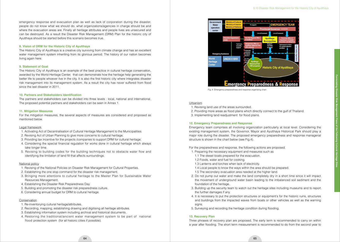
Formulating D
isaster Risk M
anagement Plans of the Follow
ing Cultural H
eritage Sites
3.10 Disaster Risk Management for the Historic City of Ayutthaya
64 65
emergency response and evacuation plan as well as lack of corporation during the disaster, people do not know what we should do, what organizations/agencies in charge should be and where the evacuation areas are. Finally all heritage attributes and people lives are unsecured and can be destroyed. As a result the Disaster Risk Management (DRM) Plan for the historic city of Ayutthaya should be started before this scenario becomes true.
8. Vision of DRM for the Historic City of AyutthayaThe Historic City of Ayutthaya is a creative city surviving from climate change and has an excellent water management system inheriting from its glorious period. The history of our nation becomes living again here.
9. Statement of GoalThe Historic City of Ayutthaya is an example of the best practice in cultural heritage conservation, awarded by the World Heritage Center, that can demonstrate how the heritage help generating the better life to people whoever live in the city. It is also the first historic city where integrates disaster risk management into its management system. As a result the city has never suffered from flood since the last disaster in 2011.
10. Partners and Stakeholders IdentificationThe partners and stakeholders can be divided into three levels : local, national and international. The proposed potential partners and stakeholders can be seen in Annex 1.
11. Mitigation Measures For the mitigation measures, the several aspects of measures are considered and proposed as mentioned below.
Legal framework1. Activating Act of Decentralisation of Cultural Heritage Management to the Municipalities.2. Revising Act of Urban Planning to give more concerns to cultural heritage.3. Providing tax incentive for the projects /companies to support DRM for cultural heritage. 4. Considering the special financial regulation for works done in cultural heritage which always
take longer time.5. Revising to building codes for the building techniques not to obstacle water flow and
identifying the limitation of land fill that affects surroundings.
National policy1. Revising of the National Policies on Disaster Risk Management for Cultural Properties.2. Establishing the one stop command for the disaster risk management.3. Bringing more attentions to cultural heritage to the Master Plan for Sustainable Water
Resources Management.4. Establishing the Disaster Risk Preparedness Day. 5. Building and promoting the disaster risk preparedness culture.6. Considering annual budget for DRM to cultural heritage.
Conservation1. Re-inventorying cultural heritage/attributes.2. Recording, mapping, establishing drawing and digitising all heritage attributes. 3. Establishing information system including archival and historical documents.4. Restoring the traditional/ancient water management system to be part of national
flood protection system (for all historic cities if possible).
Urbanism1. Revising land use of the areas surrounded.2. Providing more areas as flood plains which directly connect to the gulf of Thailand. 3. Implementing land readjustment for flood plains.
12. Emergency Preparedness and ResponseEmergency team comprises all involving organization particularly at local level. Considering the existing management system, the Governor, Mayor and Ayutthaya Historical Park should play a major role during the disaster. The proposed emergency preparedness and response managerial structure is shown in the chart below (see Fig.4).
For the preparedness and response, the following actions are proposed.1. Preparing the necessary equipment and measures such as 1.1 The diesel boats prepared for the evacuation. 1.2 Foods, water and fuel for cooking. 1.3 Lanterns and torches when lack of electricity. 1.4 Local people to know the ways within the area should be prepared. 1.5 The secondary evacuation area needed at the higher land. 2. Do not pump out water and make the land completely dry in a short time since it will impact
the movement of underground water basin leading to the imbalanced soil sediment and the foundation of the heritage.
3. Building up the security team to watch out the heritage sites including museums and to report the further damages if any.
4. It is necessary to put the protection structures or equipment's for the historic ruins, structures and buildings from the impacted waves from boats or other vehicles as well as the warning signs.
5. Surveying and recording the heritage condition during flooding.
13. Recovery PlanThree phrases of recovery plan are proposed. The early term is recommended to carry on within a year after flooding. The short term measurement is recommended to do from the second year to
Fig. 4 Emergency preparedness and response organising chart

Formulating D
isaster Risk M
anagement Plans of the Follow
ing Cultural H
eritage Sites
3.10 Disaster Risk Management for the Historic City of Ayutthaya
66 67
the fifth years. The last phrase is proposed to do for the actions that need more than five years to achieve. To make the recovery plan more comprehensive, integrated and sustainable, all aspects of measurement, ranging from physical aspects to social aspects, are considered and proposed, such as legal framework, national policy, conservation measures, urbanism, infrastructure construction, maintenance/monitoring actions, capacity building/ raising awareness activities and research and develop. The proposed activities and pilot actions for recovery plan can be seen in Annex 2 and Annex 3.
14. ConclusionAt present the DRM of the Historic City of Ayutthaya has been carrying out by the Fine Arts Department (FAD) in parallel with the Collaboration Project between FAD and UNESCO Bangkok leaded by the expert from UNESCO Institute for Water Education (UNESCO-IHE) based in the Netherlands. The project started to undertake the two-year work that will assess flood risks at Ayutthaya World Heritage site. The outcome of this project is expected to be able to support the DRM of the Historic City of Ayutthaya. Furthermore it is noted that to achieve in the implementation, this DRM plan should be considered in the wider context so it is necessary to consider the larger area planning such as the National Water Management for the Future of the Nation Building 2012 and the Master Plan for Sustainable Water Resources Management which are planned for five years to be completed and now confronting the political unstable situation in the country. Ultimately all partners and stakeholders participatory activities will be added during the planning process as one of most important key success of the DRM planning for the Historic City of Ayutthaya.
Annex 1. Partners and Stakeholders IdentificationLocal level
Partners Stake holders
1. Mayor of Ayutthaya Municipality2. Fine Arts Department Regional Office3. Management Office of Ayutthaya Historical
Park4. Chao Sam Phraya National Museum5. Chankasem National Museum6. Public Works and Urban Planning
Department, Provincial Office7. Provincial office of Disaster Risk Prevention
and Mitigation Department
1. Local Communities2. Local educational institute/University3. Provincial Office of Ministry of Culture4. Local charity organisations and NPOs
Partners Stake holders
1. Fine Arts Department2. Public Works and Urban Planning Department3. Hydro and Agro Informatics Institute4. Disaster Risk Prevention and Mitigation
Department5. Meteorology Department6. Royal Irrigation Department
1. The Royal Crown Property Bureau2. Office of Natural Resources and
Environmental Policy and Planning3. Thai ICOMOS 4. The Association of Siamese Architect5. Thailand Creative Design Center (TCDC)6. Department of Religious Affairs7. Department of Cultural Promotion8. Anthropological Center of Ministry of Culture9. PTT Exploration and Production Public
Company Limited
Partners Stake holders
1. ICCROM2. ICOMOS – ICORP3. UNESCO Bangkok 4. UNESCO-IHE
1. World Heritage Center2. World Monument Fund3. International Experts from Japan, Portugal,
the Netherland and China4. ASEAN Community
Early term (1 year) Short term (2-5 years) Long term (more than 5 years)
1. Activation Act of Decentralisation of Cultural Heritage Management to the Municipalities by Fine Arts Department and Ministry of Interior
1. Revision Act of Urban Planning to give more concerns to cultural heritage
2. Revision to building code for the building technique not to obstacle water flow and identifying the limitation of land fill that affects surrounding by Public works and urban planning department
1. Providing tax incentive for the projects/companies to support DRM for cultural heritage by the Revenue Department
2. Considering the special financial regulation for works done in cultural heritage which always take longer time by The Comptroller General’s Department (CGD)
Early term (1 year) Short term (2-5 years) Long term (more than 5 years)
1. Bringing more attentions to cultural heritage to the Master Plan for Sustainable Water Resources Management by Ministry of Environment and Natural Resource
2. Establish the Disaster Risk Preparedness Day by National Government
1. Revision of the National Policies on Disaster Risk Management for Cultural Properties by Fine Arts Department, Disaster prevention and mitigation department
2. Establish the one stop command for the disaster
risk management for cultural heritage by Fine Arts Department, Ayutthaya Municipality and the Province
1. Revision Act of Urban Planning to give more concerns to cultural heritage by Public Works and Urban Planning Department
2. Building and promoting the disaster risk preparedness culture by Fine Arts Department, Disaster prevention and mitigation department
3. Considering annual budget for DRM to cultural heritage by Fine Arts Department
Early term (1 year) Short term (2-5 years) Long term (more than 5 years)
1. Damages Assessment2. Re-inventory cultural
heritage/ attributes3. Conservation interventions
i.e. structural stabilisation, landscape recovery
by Fine Arts Department, Regional office and WH management office, Academic
1. Recording, mapping, establishing drawing and digitising all heritage attributes
2. Establishing information system including archival and historical document
by Fine Arts Department, Regional office and WH management office
1. Restoration the traditional/ancient water management system to be part of national flood protection system ( all historic cities)
2. Land expropriation for some necessary areas is proposed by Fine Arts Department, Land Department, The treasury department, Ministry of finance
National level
International level
National policy
Conservation
Annex 2. Recovery Plan Legal framework

Formulating D
isaster Risk M
anagement Plans of the Follow
ing Cultural H
eritage Sites
3.10 Disaster Risk Management for the Historic City of Ayutthaya
68 69
Early term (1 year) Short term (2-5 years) Long term (more than 5 years)
1. Providing more areas as flood plains and directly connect to the gulf of Thailand by Ministry of Environment and Natural Resource, Public works and Urban Planning Department
1. Revision for land use of the area surrounded
by Public works and Urban Planning Department
1. Implementing land readjustment for flood plains - Public works and Urban Planning Department
Early term (1 year) Short term (2-5 years) Long term (more than 5 years)
1. Collecting and gathering the existing researches and studies on the adaptation of traditional knowledge and skill to contemporarily function by Fine Arts Department, National Research Institute
1. Supporting and promoting the research on traditional architectural style of water settlement by Fine Arts Department
1. Developing the output of the research to be more practical by Fine Arts Department
2. Encouraging the study and supporting to utilize the traditional handicraft and skill by Cultural Promotion Department
Early term (1 year) Short term (2-5 years) Long term (more than 5 years)
1. Surveying and assessing damages to infrastructure and emergency repair
by Ministry of Transportation, Public works and urban planning department, Electricity Authority, Telephone Authority and Water for Domestic Use Authority
1. Revision for the future infrastructure system i.e. road alignment not to obstacle water flow
by Ministry of Transportation, Public works and urban planning department, Electricity Authority, Telephone Authority and Water for Domestic Use Authority
1. Considering to build flood protection system that do
not rely on electricity by Public Works and Urban Planning Department
Early term (1 year) Short term (2-5 years) Long term (more than 5 years)
1. Activate the community’s heritage watch/guard by Fine Arts Department, Ministry of Interior, Communities and Academic
1. Establish maintenance and monitoring plan for cultural heritage on the regular basis
2. Proposing financial preparation for the heritage to buy the monitoring equipment
3. Considering the most appropriate design of monitoring system
by Fine Arts Department, Ministry of Interior
1. Considering to install the necessary equipment for DRM prior to the World Heritage Properties by Fine Arts Department
Early term (1 year) Short term (2-5 years) Long term (more than 5 years)
1. Disseminate the information on DRM and organising the activities for communities both national and local level
2. To start building the attitudes of people to DRM & Conservation
by Fine Arts Department, Disaster Prevention and Mitigation Department
3. Adding swimming and sailing practice in educational institute by Ministry of Education, Disaster Prevention and Mitigation Department
1. Strengthen the knowledge and understanding on DRM to the national and local officials and staff
2. Producing the mass media and support TV programme on DRM
3. Translating to Thai and Publicise the books, manual and guidelines
by Fine Arts Department
1. Conducting the research on the traditional /ancient water management system to be part of national flood protection system (all historic cities)
2. Land expropriation for some necessary areas is proposed by Fine Arts Department, Land Department, The Treasury Department, Ministry of Finance
3. Revision and add DRM into school in all levels from elementary to high school by Ministry of Education
Urbanism Research and Develop
Infrastructure Construction
Maintenance/Monitoring
Capacity Building/Raising Awareness
Annex 3. Action Plans and Pilot ProjectsProject I : Building the attitudes of people to DRM & ConservationHost : Fine Arts Department, Disaster Prevention and Mitigation DepartmentPartners : Academic Sectors, Local Universities, Municipalities, Communities, Media, ICOMOS ThailandTargets : Involving officials, local and national, Community representatives, Staff of Charity Organisations Activities : Public Lecture, Workshop, Site visits, Social Media and TV programmesDuration : 2 yearsFunding : Ministry of Culture, Ministry of InteriorOutcome : Better understanding in DRM and conservation
Project II : Restoration of the traditional/ancient water management systemHost : Fine Arts DepartmentPartners : Academic Sectors, Local Universities, Municipalities, Communities, National Research Council of Thailand Activities : Phrase Ⅰ - Collecting and gathering the existing researches and studies on the adaptation of traditional knowledge and skill to contemporarily function PhraseⅡ - Study the water system through landscape archaeological methodology and other tools to build up the model of ancient system PhraseⅢ - Reconstruction the ancient water system Duration : 1 year/2 years/3 yearsFunding : Ministry of Culture, National Research Council of Thailand Output : The sustainable water management system
4 The Activities of Former Participants of the International Training Course

The Activities of Form
er Participants of the International Training Course
4.1 International Symposium “Cultural Heritage Protection in Times of Risk: Challenges and Opportunities” in Turkey, 2012
72 73
The outline of the International Symposium "Cultural Heritage Protection in Times of Risk: Challenges and Opportunities" organized between the dates 15-16 November 2012 in Istanbul was determined during the ICOMOS-ICORP meeting, which took place on November 30, 2011 in Paris. The organization was planned as a small conference and ICORP meeting in the beginning. The most important reason behind the fact that it turned into an international symposium was keeping the devastating effects of the Tohuku Earthquake in March 2011 in Japan, Van and ErcişEarthquakes in October and November 2011 in Turkey as well as the ongoing conflicts in different regions of the world on the cultural heritage and people on the international scientific agenda.
During the short period of 10 months between the decision and the realization of this organization, a huge number of cultural heritages was completely destroyed or damaged due to man-made disasters in the countries hosting important world heritages like Syria, Mali, Egypt and leaving behind a blankness in human memory.
CULTURAL HERITAGE PROTECTION IN TIMES OF RISK: Challenges and Opportunities Symposium was realized under the partnership of Yıldız Technical University, International Council on Monuments and Sites-International Committee on Risk Preparedness - ICOMOS ICORP, and Istanbul Governorate Special Provincial Administration Istanbul Project Coordination Unit - IPKB.
The Symposium was organized by Yıldız Technical University, Department of Restoration and
chaired by Associate Prof. Dr. Zeynep Gül Ünal (ITC2010 Participant), from Yıldız Technical University, Faculty of Architecture and member of ICOMOS ICORP. Prof.Kenzo Toki from Ritsumeikan University, Prof. Dr. Rohit Jigyasu, President of ICOMOS ICORP, Faculty Members of Yıldız Technical University, Faculty of Architecture, Prof.Dr. Cevat Erder, the former President of ICCROM as well as the former, the new presidents and the board members of ICOMOS Turkey supported the Symposium's Advisory Committee. 27 renowned scientists, including Prof.Dr. Kanefusa Masuda and Prof.Dr. Takeyuki Okubo from Ritsumeikan University, as well as the former attendees and organisers of RitsDMUCH ITC Rohit Jigyasu, Christopher Marrion, Kai Weise, Zeynep Gül Ünal joined the Symposium's Scientific Committee.
Fig. 1 During the session of Symposium
Fig. 2 2012 ICORP Meeting in Istanbul
Fig. 3 Stand in Silence for the memory of Herb Stovel on the begening of ICORP meeting.
4.1 International Symposium “Cultural Heritage Protection in Times of Risk: Challenges and Opportunities” in Turkey, 2012Zeynep Gul UNALAssociate Proffessor, Yıldız Technical University, Faculty of Architecture Restoration Department
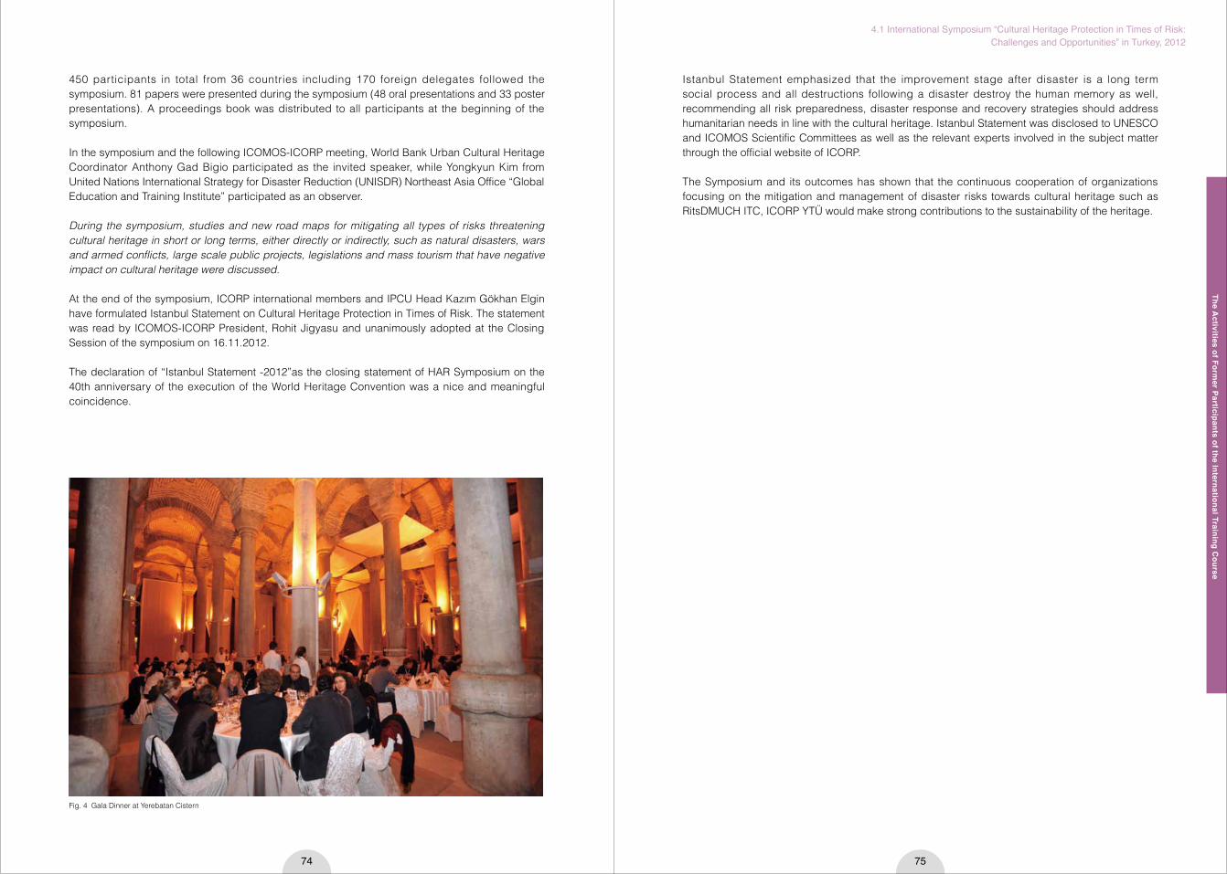
The Activities of Form
er Participants of the International Training Course
4.1 International Symposium “Cultural Heritage Protection in Times of Risk: Challenges and Opportunities” in Turkey, 2012
74 75
Fig. 4 Gala Dinner at Yerebatan Cistern
450 participants in total from 36 countries including 170 foreign delegates followed the symposium. 81 papers were presented during the symposium (48 oral presentations and 33 poster presentations). A proceedings book was distributed to all participants at the beginning of the symposium.
In the symposium and the following ICOMOS-ICORP meeting, World Bank Urban Cultural Heritage Coordinator Anthony Gad Bigio participated as the invited speaker, while Yongkyun Kim from United Nations International Strategy for Disaster Reduction (UNISDR) Northeast Asia Office “Global Education and Training Institute” participated as an observer.
During the symposium, studies and new road maps for mitigating all types of risks threatening cultural heritage in short or long terms, either directly or indirectly, such as natural disasters, wars and armed conflicts, large scale public projects, legislations and mass tourism that have negative impact on cultural heritage were discussed.
At the end of the symposium, ICORP international members and IPCU Head Kazım Gökhan Elgin have formulated Istanbul Statement on Cultural Heritage Protection in Times of Risk. The statement was read by ICOMOS-ICORP President, Rohit Jigyasu and unanimously adopted at the Closing Session of the symposium on 16.11.2012.
The declaration of “Istanbul Statement -2012”as the closing statement of HAR Symposium on the 40th anniversary of the execution of the World Heritage Convention was a nice and meaningful coincidence.
Istanbul Statement emphasized that the improvement stage after disaster is a long term social process and all destructions following a disaster destroy the human memory as well, recommending all risk preparedness, disaster response and recovery strategies should address humanitarian needs in line with the cultural heritage. Istanbul Statement was disclosed to UNESCO and ICOMOS Scientific Committees as well as the relevant experts involved in the subject matter through the official website of ICORP.
The Symposium and its outcomes has shown that the continuous cooperation of organizations focusing on the mitigation and management of disaster risks towards cultural heritage such as RitsDMUCH ITC, ICORP YTÜ would make strong contributions to the sustainability of the heritage.
The Activities of Form
er Participants of the International Training Course
4.2 ICOMOS ICORP International Meeting in Nepal, 2013
76 77
1. The International Training Courses and continued collaboration with Ritsumeikan UniversityAs a participant of the international training course on disaster risk management of cultural heritage in 2008, Kai Weise chose to work on a disaster risk management plan for Patan Durbar Square monument zone of the Kathmandu Valley World Heritage property. The final projects of all course participants were presented at the ‘International Forum on Disaster Mitigation for Cultural Heritage 2008’ on 14 November 2008, in Kyoto. The proposal for Patan was one of two projects that were then presented in Tokyo at the international symposium ‘How to Promote Risk Management for World Cultural Heritage Sites in Earthquake Zones’ on 17 November 2008.
The Research Center for Disaster Mitigation of Urban Cultural Heritage, Ritsumeikan University (Rits-DMUCH) showed interest in establishing a research project in the Kathmandu Valley. Kai Weise helped coordinate the ‘Kathmandu Symposium on Protecting World Cultural Heritage Sites and their Historic Urban Environment from Earthquakes" that took place from16 to 19 February 2009 within the Kathmandu Valley World Heritage property. At the event which was inaugurated by the Japanese ambassador, a MOU was signed between Ritsumeikan University and Tribhuvan University to carry out a joint research project. The outcome of the symposium was compiled and adopted as the ‘Kathmandu Recommendations’. Kai Weise was a resource person during the workshop organized by the Department of Archaeology (Nepal) on 20 February 2009 on field testing of the ‘Managing Disaster Risks for World Heritage - Resource Manual’.
Kai Weise participated in the following four international training courses from 2009 to 2012 as a resource person. The international training course in 2009 took place for a week in Kyoto followed by a week in Kathmandu. Kai Weise coordinated the implementation of the course in Kathmandu and assisted in lecturing those participants from Nepal who joined the course for only the second part.
He also worked on the compilation and editing of the proceedings of the Kathmandu Symposium and the training courses in 2009 and 2010.Kai Weise worked as the local project coordinator for the Kathmandu Research Project 2010: Risk Assessment of Cultural Heritage in the Historic City of Patan. He helped coordinate the documentation and assessment of the Jatapol area of Patan as part of the research project being carried out between Ritsumeikan University and Tribhuvan University. The project ended with the ‘Follow up Consultative Meeting on Disaster Risk Management for the Historic City of Patan’ at
the Institute of Engineering, Tribhuvan University on 28 January 2013. Kai Weise presented on “Integrating Disaster Risk Management into the Management of World Heritage”.
2. Activities beyond the Ritsumeikan activitiesKai Weise became a member of the ICOMOS Scientific Committee for Risk Preparedness (ICORP) in 2009.
As a UNESCO Consultant, Kai Weise assisted in the organization of the International Conference on Disaster Management and Cultural Heritage, held in Thimphu, Bhutan, from 12 to 14 December 2010. The conference was organized by the Ministry of Home and Cultural Affairs, Royal Government of Bhutan with support from World Bank, UNDP, UNESCO and UNISDR.
On 7 November 2012, Kai Weise participated in the seminar on the 1954 Hague Convention for the Protection of Cultural Property in the Event of Armed Conflict and its Protocols, held in Kathmandu and presented a paper on the case of the destruction of Tansen Durbar. The seminar was organized by ICRC, UNESCO and the Department of Archaeology of Nepal
Kai Weise was a member of the Scientific Committee for the ‘International Symposium on Cultural Heritage protection in times of ‘Risk’: Challenges and Opportunities’, held in Istanbul, Turkey from 15 to 17 November 2012. The symposium was organized by Yidiz Technical University and ICOMOS/ICORP. The symposium was followed by the ICOMOS/ICORP annual meeting.
Kai Weise gave a lecture on ‘Right to cultural patrimony and human value of cultural property: Protection of Cultural Property’ at the 22nd South Asia Teaching Session on International Humanitarian Law which was held in Kathmandu between 5 and 12 April 2013. The training session was organized by the International Committee of the Red Cross (ICRC) for participants of South Asia including Myanmar, Afghanistan and Iran.
In June 2012 it became five years since the cabinet of the Government of Nepal adopted the Integrated Management Framework for the Kathmandu Valley World Heritage property. The establishment of the management framework was initially facilitated by Kai Weise as a UNESCO Consultant between 2004 and 2007. According the framework document, the entire management system is required to be reviewed and if found necessary amended accordingly. It became clear that one of the main issues that was not sufficiently addressed in the Management Framework was Disaster Risk Management. It was therefore necessary to initiate a detailed discussion on the integration of disaster risk management into the overall management system of the Kathmandu Valley World Heritage property.
At the 2012 ICORP Meeting, Kai Weise agreed to organize the following annual ICORP meeting in Kathmandu. This led to the idea of linking this to the review of the Integrated Management Framework of the Kathmandu Valley World Heritage property. This was the catalyst for organizing the ‘Revisiting Kathmandu, International Symposium on safeguarding living urban Heritage’ which was held from 25 to 29 November 2013. The symposium was jointly organized by UNESCO Office in Kathmandu, Department of Archaeology, ICOMOS Nepal and ICORP. (Note: ICOMOS Nepal was in the process of being established with Kai Weise as interim president)
The ICORP Business Meeting was held on 25 November, 9:00 to 13:30. This was followed by an interaction programme with Nepal Risk Reduction Consortium (NRRC) in the beautiful Bahadur Shah hall, part of the Patan Durbar. At the interaction programme, there were presentations by Rohit Jigyasu (President ICOMOS/ICORP), Moira Reddick, (Coordinator of Nepal Risk Reduction Consortium) and Becky-Jay Harrington (Flagship 4 Coordinator: Integrated Community Based Disaster Risk Reduction Management). In return, Kai Weise presented the outcome of the ‘Revisiting Fig. 1 The proceeding documents compiled and edited by Kai Weise
4.2 ICOMOS ICORP International Meeting in Nepal, 2013Kai Ube Prasad WEISEChairperson of the Planners' Alliance for the Himalayan and Allied Regions (PAHAR Nepal)
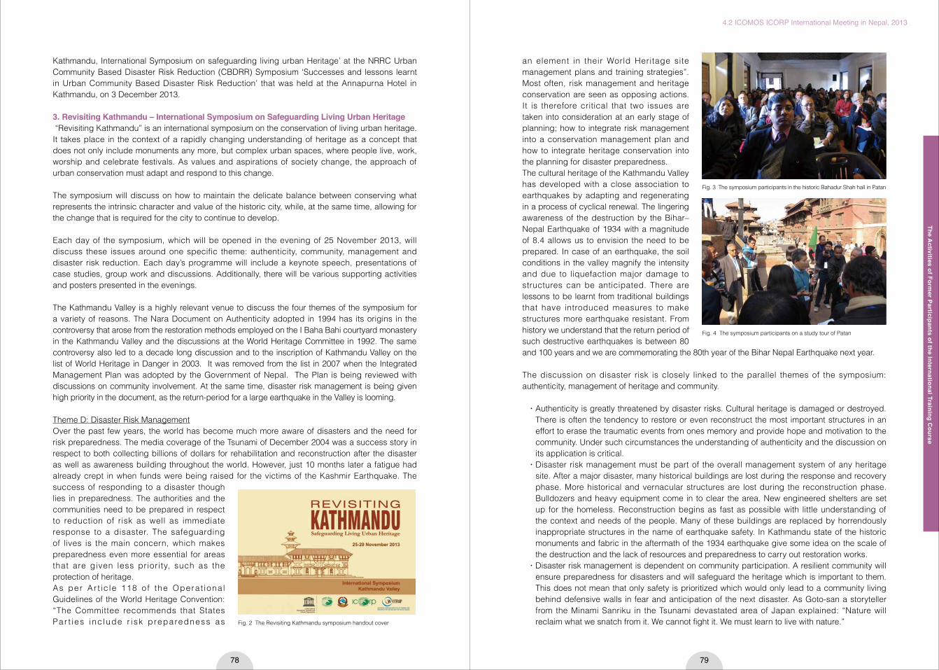
The Activities of Form
er Participants of the International Training Course
4.2 ICOMOS ICORP International Meeting in Nepal, 2013
78 79
Kathmandu, International Symposium on safeguarding living urban Heritage’ at the NRRC Urban Community Based Disaster Risk Reduction (CBDRR) Symposium ‘Successes and lessons learnt in Urban Community Based Disaster Risk Reduction’ that was held at the Annapurna Hotel in Kathmandu, on 3 December 2013.
3. Revisiting Kathmandu – International Symposium on Safeguarding Living Urban Heritage “Revisiting Kathmandu” is an international symposium on the conservation of living urban heritage. It takes place in the context of a rapidly changing understanding of heritage as a concept that does not only include monuments any more, but complex urban spaces, where people live, work, worship and celebrate festivals. As values and aspirations of society change, the approach of urban conservation must adapt and respond to this change.
The symposium will discuss on how to maintain the delicate balance between conserving what represents the intrinsic character and value of the historic city, while, at the same time, allowing for the change that is required for the city to continue to develop.
Each day of the symposium, which will be opened in the evening of 25 November 2013, will discuss these issues around one specific theme: authenticity, community, management and disaster risk reduction. Each day’s programme will include a keynote speech, presentations of case studies, group work and discussions. Additionally, there will be various supporting activities and posters presented in the evenings.
The Kathmandu Valley is a highly relevant venue to discuss the four themes of the symposium for a variety of reasons. The Nara Document on Authenticity adopted in 1994 has its origins in the controversy that arose from the restoration methods employed on the I Baha Bahi courtyard monastery in the Kathmandu Valley and the discussions at the World Heritage Committee in 1992. The same controversy also led to a decade long discussion and to the inscription of Kathmandu Valley on the list of World Heritage in Danger in 2003. It was removed from the list in 2007 when the Integrated Management Plan was adopted by the Government of Nepal. The Plan is being reviewed with discussions on community involvement. At the same time, disaster risk management is being given high priority in the document, as the return-period for a large earthquake in the Valley is looming.
Theme D: Disaster Risk ManagementOver the past few years, the world has become much more aware of disasters and the need for risk preparedness. The media coverage of the Tsunami of December 2004 was a success story in respect to both collecting billions of dollars for rehabilitation and reconstruction after the disaster as well as awareness building throughout the world. However, just 10 months later a fatigue had already crept in when funds were being raised for the victims of the Kashmir Earthquake. The success of responding to a disaster though lies in preparedness. The authorities and the communities need to be prepared in respect to reduction of risk as well as immediate response to a disaster. The safeguarding of lives is the main concern, which makes preparedness even more essential for areas that are given less priority, such as the protection of heritage.As per Ar t ic le 118 of the Operat ional Guidelines of the World Heritage Convention: “The Committee recommends that States Par t ies inc lude r i sk preparedness as Fig. 2 The Revisiting Kathmandu symposium handout cover
an element in their World Heritage site management plans and training strategies”. Most often, risk management and heritage conservation are seen as opposing actions. It is therefore critical that two issues are taken into consideration at an early stage of planning; how to integrate risk management into a conservation management plan and how to integrate heritage conservation into the planning for disaster preparedness.The cultural heritage of the Kathmandu Valley has developed with a close association to earthquakes by adapting and regenerating in a process of cyclical renewal. The lingering awareness of the destruction by the Bihar–Nepal Earthquake of 1934 with a magnitude of 8.4 allows us to envision the need to be prepared. In case of an earthquake, the soil conditions in the valley magnify the intensity and due to liquefaction major damage to structures can be anticipated. There are lessons to be learnt from traditional buildings that have introduced measures to make structures more earthquake resistant. From history we understand that the return period of such destructive earthquakes is between 80 and 100 years and we are commemorating the 80th year of the Bihar Nepal Earthquake next year.
The discussion on disaster risk is closely linked to the parallel themes of the symposium: authenticity, management of heritage and community.
・Authenticity is greatly threatened by disaster risks. Cultural heritage is damaged or destroyed. There is often the tendency to restore or even reconstruct the most important structures in an effort to erase the traumatic events from ones memory and provide hope and motivation to the community. Under such circumstances the understanding of authenticity and the discussion on its application is critical.
・Disaster risk management must be part of the overall management system of any heritage site. After a major disaster, many historical buildings are lost during the response and recovery phase. More historical and vernacular structures are lost during the reconstruction phase. Bulldozers and heavy equipment come in to clear the area. New engineered shelters are set up for the homeless. Reconstruction begins as fast as possible with little understanding of the context and needs of the people. Many of these buildings are replaced by horrendously inappropriate structures in the name of earthquake safety. In Kathmandu state of the historic monuments and fabric in the aftermath of the 1934 earthquake give some idea on the scale of the destruction and the lack of resources and preparedness to carry out restoration works.
・Disaster risk management is dependent on community participation. A resilient community will ensure preparedness for disasters and will safeguard the heritage which is important to them. This does not mean that only safety is prioritized which would only lead to a community living behind defensive walls in fear and anticipation of the next disaster. As Goto-san a storyteller from the Minami Sanriku in the Tsunami devastated area of Japan explained: “Nature will reclaim what we snatch from it. We cannot fight it. We must learn to live with nature.”
Fig. 3 The symposium participants in the historic Bahadur Shah hall in Patan
Fig. 4 The symposium participants on a study tour of Patan

The Activities of Form
er Participants of the International Training Course
4.3 Regional Training Course in India, 2013
80 81
Gujarat offers rich cultural heritage including art, music, cave paintings, archaeology and architecture. Unfortunately Gujarat is also prone to disasters such as cyclone, earthquake, floods, drought, industrial disasters etc. The state is also one of the most urbanized and industrialized states in India. During the past decade, the state has had to face the brunt of several disasters – both natural and manmade. These disasters have widespread impact on people, infrastructure and the rich heritage of Gujarat. Most of the risk reduction efforts are targeted towards reducing risk to life and property. It is also essential to take proactive measures to protect cultural heritage as it is the symbol of a city’s identity and history.
It has been observed that there is a need for a specialized approach to risk management of cultural heritage in urban areas. Unfortunately, not many experts possess the skills and understanding of both disaster management and cultural heritage. In this regard, Institute of Disaster Mitigation for Urban Cultural Heritage, Ritsumeikan University (RitsDMUCH), Kyoto, Japan has taken noteworthy steps towards building capacity of professionals in this interdisciplinary field of disaster risk reduction for cultural heritage.
After attending the International Training Course on Disaster Risk Management of Cultural Heritage at Rits-DMUCH in the year 2012, a dialogue was initiated to develop a training module catering the needs of professionals working in India. In this regard, Gujarat Institute of Disaster Management (GIDM, Gandhinagar) is collaborating with Institute of Disaster Mitigation for Urban Cultural Heritage, Ritsumeikan University (RitsDMUCH, Japan) for conducting a training course on ‘Disaster Risk Management for Cultural Heritage’. RitsDMUCH offers expertise with interdisciplinary knowledge and skills, understanding of innovative techniques and rich field experience across different countries.
The objectives of the training course is to train the participants in formulating appropriate plans and procedures for reducing disaster risks to cultural heritage through mitigation, preparedness, response and recovery. It would also provide an opportunity to professionals
for sharing their knowledge and research findings with scholars in this field. Also, it would an opportunity to administrators and decision makers to discuss the issues and limitations in heritage conservation and risk reduction.
The target participants for the course are Administrators from Municipal Corporations and Collector Offices; Staff from Department of Archaeology, Museums etc.; practicing professional and students of conservation, archaeology, architecture and planning.
The course is a five days program which would discuss International experience of managing cultural heritage in Kyoto, significance and core principles in DRM for cultural heritage, key concepts in heritage conservation, community based disaster risk assessment techniques, mitigating cultural heritage against fire and earthquakes, policies for DRM in Japan, case studies of Gujarat Earthquake and Champaner World Heritage Site etc. The course would also include classroom exercises, discussions and field visit.
The walled city of Ahmedabad has been identified for the field exercise. Ahmedabad is also unique as it is trying to achieve the status of World Heritage City. It provides excellent model of cultural heritage in highly dense urban setting. Unfortunately, illegal constructions around monuments are jeopardizing their safety and aesthetic value. On a positive note, government agencies, universities and independent professionals are taking efforts to protect the cultural heritage of Ahmedabad city.
The training course would be conducted in February 2014 at the New Campus of Gujarat Institute of Disaster Management, Gandhinagar, Gujarat (India).
Fig. 1 Sculpture at Champaner WHSPhoto: Vikas Lakhani
Fig. 3 GIDM Campus at Gandhinagar, Gujarat India Photo: GIDM Library
Fig. 2 Sculpture at Walled city of Ahmedabad Photo: Rohit Jigyasu
4.3 Regional Training Course in India, 2013Vikas LAKHANIDeputy Director, GIDM Gujarat State Disaster Management Authority

Appendix

Appendix
84 85
List of Resource PersonsGiovanni BOCCARDIFocal Point-Sustainable Development,Disaster Risk Reduction, Capacity Building, UNESCO WHC
Joseph KINGDirector of the Sites Unit,ICCROM
Kenzo TOKIProfessor,Institute of Disaster Mitigation for Urban Cultural Heritage, Ritsumeikan University (RitsDMUCH)
Noriyoshi TSURUOKACultural Asset Division,Board of Education, Kyoto Prefecture
Masafumi YAMASAKIProfessor,Department of Architecture and Urban Design, College of Science and Engineering,Ritsumeikan University
Rohit JIGYASUUNESCO Chair Holder,President of ICCOMOS-ICORP,Professor, RitsDMUCH
Kyosuke MUKAIBOAssistant Professor,Department of Architecture and Urban Design, College of Science and Engineering, Ritsumeikan University
Yoshinori MACHIDADisaster Prevention Manager,Disaster Prevention and Crisis Management Office,Administrative and Budgetary Bureau, Kyoto City
Hikokazu OMORIDirector,Omori Architectural Office
Yasumichi MURAKAMIDirector,Cultural Asset DivisionHyogo Prefecture Board of Education
Naoko USHITANI ITAYAAssociate Professor,RitsDMUCH
Yoshihiro HIRAOKAProfessor,Architecture Design Laboratory,Department of Design Information,Miyagi University
Mayumi KUDOCenter for Regional Alliances,Miyagi University
Kazuma GOTOCenter for Regional Alliances,Miyagi University
Takeyuki OKUBOProfessor,Department of Civil Engineering, College of Science and Engineering, Ritsumeikan UniversityDirector, RitsDMUCH
Sebastian MOFFATTPresident and CEO,CONSENSUS Institute Inc.
Keiji YANOProfessor,Department of Humanities, Geography Major, College of Letters, Ritsumeikan University
Yoshifumi SATOFUKAProfessor,Department of Civil Engineering,College of Science and Engineering,Ritsumeikan University
Ryoichi FUKAGAWAProfessor,Department of Civil Engineering,College of Science and Engineering,Ritsumeikan University
Sang sun JOResearch Associate and Curator,Heritage Repair Division,Cultural Heritage Administration of KOREA
Daijiro KITAGAWACultural Properties Department,Agency for Cultural Affairs
Rajib SHAWAssociate Professor,Graduate School of Global Environmental Studies,Kyoto University
Yumi-Isabelle NAITO AKIEDAPart-time Lecturer,Tokyo University of the Arts
Hirokazu KOICenter for Research and Development Strategy,Japan Science and Technology Agency

Appendix
86 87
Photos of ITC 2013
Site investigation of wooden heritage buildings at Kiyomizu-Dera Temple, WHS
Observing Fire Prevention Facilities for Cultural Assets at Ninna-ji Temple, WHS
Mr. Joseph King from ICCROM accompanying team members during their site visit to the Minami-Sanriku Cho affected by the Great East Japan Earthquake (2011 Tohoku) and Tsunami Disaster
At Togura shirine (Minami-Sanriku Cho) while listening to the experience during Tohoku disaster by a local resident
Presentation of completion certificates to the Participants ITC 2013 Participants and Lecturers
List of Participants
Saleh Mohammad SAMIT, AfghanistanNational Manager,Community Development ProgrammeAga Khan Foundation- Afghanistan
Dian LAKSHMI PRATIWI, IndonesiaHead of Archaeological Section,Division of History, Archaeological and Museum, Cultural Service Office,Government of Yogyakarta Special Territory
Kambod AMINI HOSSEINI, IranAssociate ProfessorDisaster Risk Management Research CenterInternational Institute of Earthquake Engineering and Seismology
Barbara CARANZA, ItalyPresident and Founding member of CHIEF (Cultural Heritage International Emergency Force) non-profit association, Restorer of MEC srl, SR Officer in the Italian Army
Paola MUSSINI, ItalyArchitect, Vice President and Founding Member of CHEF (Cultural Heritage International Emergency Force) non-profit association, Italy
Zaha AHMED, MaldivesAssistant Architect,Heritage Department,Male' Republic of Maldives
Arjun KOIRALA, NepalAdvisor, Urban Planning and Infrastructure Development, Municipal Support Team, GFA Consulting Group GmbH,Department of Urban Development and Building Construction,Urban Governance and Development Program
Kenechukwu ChudiONUKWUBE, NigeriaProgram Consultant,Development Education and AdvocacyResources for Africa Initiative (DEAR Africa)
Muhammad JumaMUHAMMAD, TanzaniaDirector,Urban and Rural PlanningDepartment of Urban and Rural Planning
HatthayaSIRIPHATTHANAKUN, ThailandOffice of Architecture,Fire Arts Department, Ministry of Culture, THAILAND
