international demonstrations of the platform for transport ... · technology both in transport and...
TRANSCRIPT
International Demonstrationsof the Platform for Transport Planning and Travel Information


Contents
Connecting Travellers, Transport Operators and Transport Planners .....3
Urban Mobility Challenges ...........................................................4
Meeting the Challenge – Innovation in Viajeo.................................5
The Demo Sites
Athens ..................................................................................6
São Paulo ..............................................................................8
Beijing ................................................................................ 10
Shanghai ............................................................................. 12
1

The project will integrate the open platform with local components and demonstrate use of the open platform in four cities: Athens, São Paulo, Beijing and Shanghai. The project concept is illustrated below:
Transport Planning• Planning of public transport• Environmental benefit planning
Transport Operation and Management • Urban traffic management and control• Public transport operation• Taxi fleet operation
Information Generation• Real time traffic information• Environmental benefit planning• Dynamic route guide• Public transport information• Cross modal journey planning
Information Dissemination• Display system in buses and metros, at bus stops and interchanges• On-board navigation system• Mobile phone traveller information to support cross modal journey
The Open Platform
Demo Cities
Athens São Paulo Beijing Shanghai
Data Exchange Network
2

Connecting Travellers, Transport Operators and Transport Planners
Traffic data plays a critical role in traffic management, traveller information services and transport planning. Local authorities, ITS service providers and infrastructure operators have invested a considerable amount of money into data collection. Fixed sensors and floating vehicles have been deployed in order to collect real time data. However, different ownerships of data leads to the situation that data collected by one operator or service provider cannot be shared by other operators - neither in real-time nor as historical data. For example, many bus companies have equipped their buses with on-board units with GPS and GSM modules in order to monitor the location and speed of buses. While the real-time data collected by the on-board units is used for real-time bus operations, the real-time data is also accumulated into a historical database used for service quality evaluation (e.g. punctuality) and timetable planning. Without data sharing, such data is not used as floating vehicle data by traffic control operators. Moreover, traffic data collected by traffic control operators cannot be used by the bus companies neither for real-time operations nor for route and timetable planning. Sharing data can avoid not only repetition but can also increase data quality and coverage.
Lack of data sharing has been well recognised and many efforts have been made to solve the issue. Separate data ownerships can be addressed by agreements between different data owners. However, data collected by different operators often have different formats and quality, so may be difficult to share. Although there were numerous traffic data standardisation trials, data collected for different purposes rarely share either formats or standards of quality control. Therefore, it is necessary to develop an open platform which is able to connect different data sources and users and facilitate data sharing.
The Viajeo project aims at designing, implementing, demonstrating and validating an open platform with interfaces for a wide range of mobility services. The open platform will be able to integrate data from various stakeholders and process the data to support real-time traffic management and traveller information services as well as long-term transport planning.
3

Cities and metropolitan areas face ever increasing demands on their transport systems, especially in developing regions with growing populations and massive urban migration. The cities selected as the location of the Viajeo demonstrations are particularly known for their mobility challenges: Athens, São Paulo, Beijing and Shanghai. They were also chosen on the basis of their reputation as national role models, allowing the results of successful demonstrations to be extended to other cities in these countries and also potentially to other countries in the respective continents.
The European demonstration city will be the greater Athens area that, together with its suburbs, has about 3 million inhabitants, or almost the half of the Greek population. Since the Olympic Games in 2004, Athens has been literally transformed into a more functional city that enjoys state-of-the-art technology both in transport and in modern urban development. However, the continuing development brings growing congestion. Although new infrastructure is available, it does not bring corresponding benefits due to lack of information to traffic managers and travellers.
In China, the two major cities Beijing and Shanghai are facing serious bottlenecks in their urban transport systems. Because of the Olympic Games 2008 in Beijing and Expo 2010 in Shanghai, both cities have substantially extended their transport systems including information services for travellers. However, these information systems have been developed individually and operated separately. Thus, these two cities are perfect candidates for demonstrating the Viajeo integrated open platform.
In the Brazilian city of São Paulo there has been a decrease in use of public transport and a significant increase in use of private cars due to poor quality of public transport services. The increased use of private cars has caused increased traffic accidents, congestion and pollution, threatening the sustainability of the metropolis. Encouragement of the use of public transport and improving traffic control and management would help the city to solve its transport problems. This gives the Viajeo project a great opportunity to demonstrate its open platform in order to improve traffic and transport data provision and information dissemination in São Paulo.
Urban Mobility Challenges
4

Meeting the Challenge – Innovation in Viajeo
A comprehensive implementation toolkit for operators, service and information providers to interface their native databases and operating systems with other entities needed to offer integrated traffic and transport information based services.
A flexible and wide range of standardised interfaces enabling data integration, aggregation and exchange as appropriate for a mix of provider and user stakeholders, and for a variety of data types.
A comprehensive database that integrates real-time and forecast traffic data and supports the development of historical database and traffic models.
5
The Demo Sites - Athens
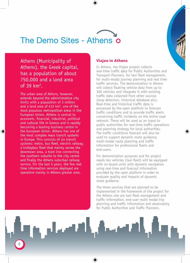
Viajeo in AthensIn Athens, the Viajeo project collects real-time traffic data for Public Authorities and Transport Planners, for taxi fleet management, for multi-modal journey planning and real time traffic services. The demonstration in Athens will collect floating vehicle data from up to 300 vehicles and integrate it with existing traffic data collected from other sources (loop detectors, historical database etc). Real-time and historical traffic data is processed by the open platform to forecast traffic conditions and to provide traffic alerts concerning traffic incidents on the entire road network. These will be used as an input to public authorities for real-time traffic operations and planning strategy for local authorities. The traffic conditions forecast will also be used to support dynamic route guidance, multi-modal route planning and traffic information for professional fleets and end-users.
For demonstration purposes and for project needs ten vehicles (taxi fleet) will be equipped with on-board units with dynamic navigation using real-time and forecast information provided by the open platform in order to evaluate quality and impacts of dynamic route guidance.
The three services that are planned to be implemented in the framework of the project for the Athens site are taxi fleet management and traffic information, end-user multi modal trip planning and traffic information and observatory for Public Authorities and Traffic Planners.
Athens (Municipality of Athens), the Greek capital, has a population of about 750,000 and a land area of 39 km2. The urban area of Athens, however, extends beyond the administrative city limits with a population of 3 million and a land area of 412 km2, one of the most populous metropolitan areas in the European Union. Athens is central to economic, financial, industrial, political and cultural life in Greece and is rapidly becoming a leading business centre in the European Union. Athens has one of the most complex mass transit systems in Europe. This consists of six transit systems: metro, bus fleet, electric railway, a trolleybus fleet that mainly serves the downtown area, a tram line connecting the southern suburbs to the city centre and finally the Athens suburban railway service. For the last 5 years, the few real time information services deployed are operative mainly in Athens greater area.
6

Leader of Athens site: Partners:
Viajeo Platform
Overall Athens Site - Simplified View
Floating Car Data(FCD)
Existing real timeinformation
Historical/scheduled data
ANCO, MAGNETTI MARELLI,MIZAR
Real time routing/dispatching
INFOTRIP, ANCO
Taxi fleets
ANCO
Real time trafficinformation
INFOTRIP
End-user mobiledevices & website
INFOTRIP
Local authorities
GPS equipped taxis(taxi fleet)
ANCO, MAGNETTI MARELLI
Existing real-time & scheduled/
historical database
INFOTRIP, CERTH/HIT Multi-modaljourney planning/
routing
Observatory
INFOTRIP
CERTH/HITCERTH/HIT
Traffic engine(traffic info & alerts)
Traffic dataprocessing & model
Data Source Data Type Data Processing Services Users
CERTH/HIT
MIZAR
7
The Demo Sites - São Paulo
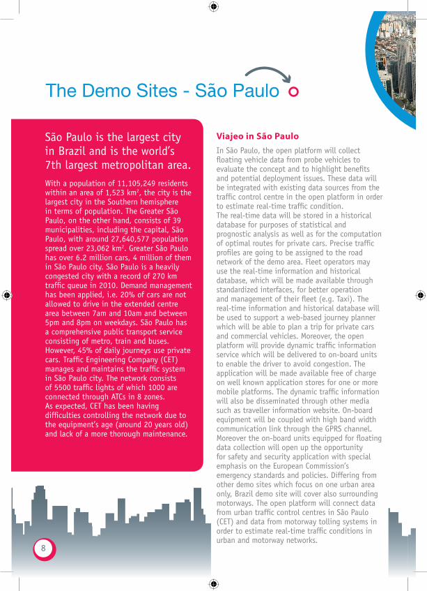
Viajeo in São PauloIn São Paulo, the open platform will collect floating vehicle data from probe vehicles to evaluate the concept and to highlight benefits and potential deployment issues. These data will be integrated with existing data sources from the traffic control centre in the open platform in order to estimate real-time traffic condition. The real-time data will be stored in a historical database for purposes of statistical and prognostic analysis as well as for the computation of optimal routes for private cars. Precise traffic profiles are going to be assigned to the road network of the demo area. Fleet operators may use the real-time information and historical database, which will be made available through standardized interfaces, for better operation and management of their fleet (e.g. Taxi). The real-time information and historical database will be used to support a web-based journey planner which will be able to plan a trip for private cars and commercial vehicles. Moreover, the open platform will provide dynamic traffic information service which will be delivered to on-board units to enable the driver to avoid congestion. The application will be made available free of charge on well known application stores for one or more mobile platforms. The dynamic traffic information will also be disseminated through other media such as traveller information website. On-board equipment will be coupled with high band width communication link through the GPRS channel. Moreover the on-board units equipped for floating data collection will open up the opportunity for safety and security application with special emphasis on the European Commission’s emergency standards and policies. Differing from other demo sites which focus on one urban area only, Brazil demo site will cover also surrounding motorways. The open platform will connect data from urban traffic control centres in São Paulo (CET) and data from motorway tolling systems in order to estimate real-time traffic conditions in urban and motorway networks.
São Paulo is the largest city in Brazil and is the world’s 7th largest metropolitan area. With a population of 11,105,249 residents within an area of 1,523 km2, the city is the largest city in the Southern hemisphere in terms of population. The Greater São Paulo, on the other hand, consists of 39 municipalities, including the capital, São Paulo, with around 27,640,577 population spread over 23,062 km2. Greater São Paulo has over 6.2 million cars, 4 million of them in São Paulo city. São Paulo is a heavily congested city with a record of 270 km traffic queue in 2010. Demand management has been applied, i.e. 20% of cars are not allowed to drive in the extended centre area between 7am and 10am and between 5pm and 8pm on weekdays. São Paulo has a comprehensive public transport service consisting of metro, train and buses. However, 45% of daily journeys use private cars. Traffic Engineering Company (CET) manages and maintains the traffic system in São Paulo city. The network consists of 5500 traffic lights of which 1000 are connected through ATCs in 8 zones. As expected, CET has been having difficulties controlling the network due to the equipment’s age (around 20 years old) and lack of a more thorough maintenance.
8
Leader of São Paulo site: Partners:
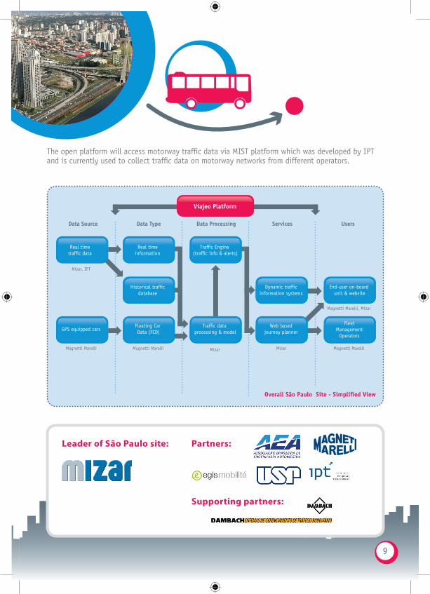
Viajeo Platform
Overall São Paulo Site - Simplified View
Real time information
Traffic Engine (traffic info & alerts)
Historical traffic database
Floating Car Data (FCD)
Dynamic traffic information systems
End-user on-board unit & website
Fleet Management
Operators GPS equipped cars
Web based journey planner
Traffic data processing & model
Data Source Data Type Data Processing Services Users
Mizar, IPT
Magnetti Marelli Magnetti Marelli Mizar
Magnetti Marelli, Mizar
Magnetti Marelli Mizar
Real time traffic data
The open platform will access motorway traffic data via MIST platform which was developed by IPT and is currently used to collect traffic data on motorway networks from different operators.
Supporting partners:
9

The Demo Sites - Beijing
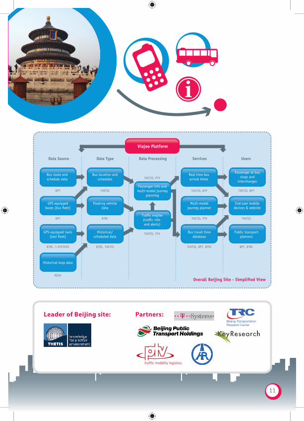
Viajeo in BeijingThe Viajeo project in Beijing aims to encourage usage of public transport, so improving passenger information service is one of the main tasks. The project in Beijing collects real time traffic data using GPS/GPRS equipped public transport vehicles (over 200 buses from 6 bus lines), taxis and private cars. The open platform will integrate data from different sources to get a real-time “picture” of current traffic conditions. The integrated data will be used to forecast travel times, for private vehicles as well as buses, including real-time bus arrival time. Travel time information about buses will, for instance, help operators with their public transport planning (frequency, timetable, etc) and real time fleet operation. The real-time bus arrival time will be delivered to passengers at bus stops and interchanges, while travel times will be made accessible to people through the web and wireless smart devices to ensure comfort, confidence in service reliability and personal safety.
A number of terminals with an internet connection will be installed on buses allowing the passenger to access the multi-modal journey planner to plan their journeys or obtain real-time information about the next steps of their multi-modal journeys. The multi-modal journey planner will also provide information on walking directions and safe cycling routes. The multi-modal journey planner will also provide functions for car-sharing and taxi-sharing.
Beijing, the capital of the People’s Republic of China, is China’s second largest city after Shanghai, with more than 13 million residents in its urban area. Few cities in the world besides Beijing served as the political and cultural centre of an area as immense as China for so long. The city, an integral part of China’ history for centuries, is renowned for its beautiful palaces, temples and city walls and gates. Beijing is growing into a major transport hub, with a sophisticated network of roads, railways and a major international airport. Five completed ring roads (a 6th Ring Road is under completion, while there are some references to a 7th) encircle a city with nine expressways virtually heading in all compass directions, supplemented by eleven China National Highways. The Beijing metro system currently has 9 lines, 147 stations and 228 km of tracks in operation. Beijing has more than 800 bus routes and transported 389 billion passengers last year.
10
Leader of Beijing site: Partners:Beijing Transportation Research Center
Viajeo Platform
Overall Beijing Site - Simplified View
Bus location andschedules
Floating vehicledata
Historical/scheduled data
THETIS
THETIS, PTVReal time busarrival times
THETIS, BTP
Passenger at busstops and
interchanges
THETIS, BPT
Multi-modaljourney planner
THETIS, PTV
End-user mobiledevices & website
THETIS
Public transportplanners
BPT, BTRC
Bus route andschedule data
BPT
GPS equippedbuses (bus fleet)
BPT
GPS equipped taxis(taxi fleet)
BTRC, T-SYSTEMS
Historical loop data
RIOH
Bus travel timedatabase
THETIS, BPT, BTRC
Passenger info andmulti-modal journey
planning
Traffic engine(traffic info and alerts)
Data Source Data Type Data Processing Services Users
BTRC, THETIS
BTRC
THETIS, PTV
11
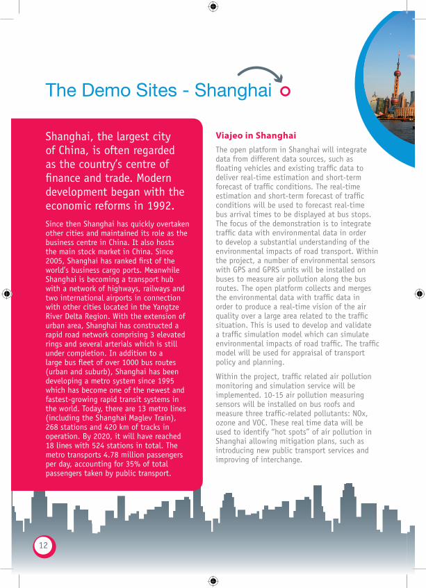
Shanghai, the largest city of China, is often regarded as the country’s centre of finance and trade. Modern development began with the economic reforms in 1992. Since then Shanghai has quickly overtaken other cities and maintained its role as the business centre in China. It also hosts the main stock market in China. Since 2005, Shanghai has ranked first of the world’s business cargo ports. Meanwhile Shanghai is becoming a transport hub with a network of highways, railways and two international airports in connection with other cities located in the Yangtze River Delta Region. With the extension of urban area, Shanghai has constructed a rapid road network comprising 3 elevated rings and several arterials which is still under completion. In addition to a large bus fleet of over 1000 bus routes (urban and suburb), Shanghai has been developing a metro system since 1995 which has become one of the newest and fastest-growing rapid transit systems in the world. Today, there are 13 metro lines (including the Shanghai Maglev Train), 268 stations and 420 km of tracks in operation. By 2020, it will have reached 18 lines with 524 stations in total. The metro transports 4.78 million passengers per day, accounting for 35% of total passengers taken by public transport.
The Demo Sites - Shanghai
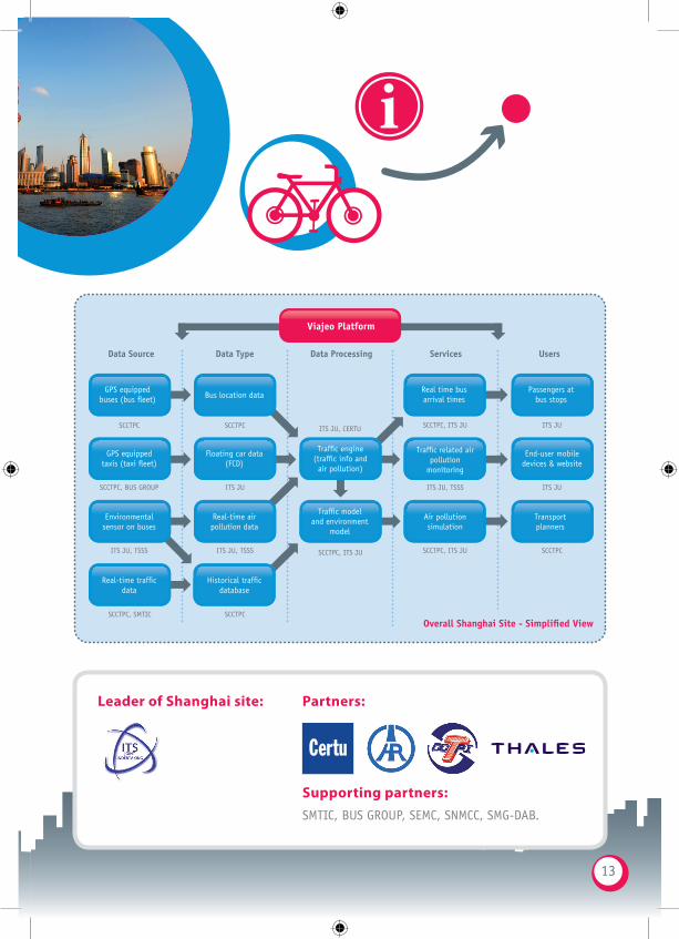
Viajeo in ShanghaiThe open platform in Shanghai will integrate data from different data sources, such as floating vehicles and existing traffic data to deliver real-time estimation and short-term forecast of traffic conditions. The real-time estimation and short-term forecast of traffic conditions will be used to forecast real-time bus arrival times to be displayed at bus stops. The focus of the demonstration is to integrate traffic data with environmental data in order to develop a substantial understanding of the environmental impacts of road transport. Within the project, a number of environmental sensors with GPS and GPRS units will be installed on buses to measure air pollution along the bus routes. The open platform collects and merges the environmental data with traffic data in order to produce a real-time vision of the air quality over a large area related to the traffic situation. This is used to develop and validate a traffic simulation model which can simulate environmental impacts of road traffic. The traffic model will be used for appraisal of transport policy and planning.
Within the project, traffic related air pollution monitoring and simulation service will be implemented. 10-15 air pollution measuring sensors will be installed on bus roofs and measure three traffic-related pollutants: NOx, ozone and VOC. These real time data will be used to identify “hot spots” of air pollution in Shanghai allowing mitigation plans, such as introducing new public transport services and improving of interchange.
12
Leader of Shanghai site: Partners:
Viajeo Platform
Overall Shanghai Site - Simplified View
Bus location data
Floating car data(FCD)
Real-time airpollution data
Real time busarrival times
Passengers at bus stops
Traffic related airpollution
monitoring
End-user mobiledevices & website
Transportplanners
GPS equippedbuses (bus fleet)
GPS equippedtaxis (taxi fleet)
Environmentalsensor on buses
Real-time trafficdata
Historical trafficdatabase
Air pollutionsimulation
Traffic engine(traffic info andair pollution)
Traffic modeland environment
model
Data Source Data Type Data Processing Services Users
SCCTPC
SCCTPC, BUS GROUP
ITS JU, TSSS
SCCTPC, SMTIC
SCCTPC
SCCTPC
ITS JU, TSSS
ITS JU
ITS JU, CERTU
SCCTPC, ITS JU
ITS JU
ITS JU
SCCTPC
SCCTPC, ITS JU
ITS JU, TSSS
SCCTPC, ITS JU
Supporting partners: SMTIC, BUS GROUP, SEMC, SNMCC, SMG-DAB.
13

Beijing Transportation Research Center
Viajeo in brief
Project coordinator: ERTICO - ITS EuropeDuration: 36 months, from September 2009 until August 2012Total budget: €5.9 millionEC contribution: €3.6 million
Co-funded by the EC DG Research for Specific International Cooperation Actions (SICA) Support by the Italian Ministry for the Environment, Land and Sea
More [email protected] www.viajeo.eu