internal memo - boprc.govt.nz · web viewdeveloped by inner word limited for opus international...
TRANSCRIPT

River Lake Ltd
Memo
TO Andy Woolhouse
COPY Niroy Sumeran (Bay of Plenty Regional Council)FROM Keith Hamill
DATE 16 October 2017 Updated 26 October 2017
FILE
SUBJECT Lake Ōkāreka overflow, Waitangi Stream: Ecology effects of increased flow. Resource consent application CH17-00717
Introduction
Lake Ōkāreka does not have a natural surface outlet, instead a gravity pipeline provides a controlled outlet to the Waitangi Stream. The existing resource consent allows a maximum outlet flow of 239 L/s. High rainfall during 2017 increased the level of Lake Ōkāreka beyond typical ranges and threatened property. The Bay of Plenty Reginal Council (BOPRC) responded by utilising the emergency works provision (S330) of the RMA to increase the outflow from the lake to 500 L/s (about 345 L/s from the existing pipe and 155 L/s from an additional pipe and pump).
BOPRC has applied for an emergency consent to increase the discharge of water from Lake Ōkāreka to the Waitangi Stream from 240 L/s to 500 L/s. BOPRC will lodge a second consent application to address the long term management of lake levels and discharge rates. Consultants have been engaged to provide assessment and control options, which will be reviewed and formulated into the consent application.
The consent authority has requested further information under section 92 of the RMA. This included a request for:
5. An assessment of the effects from the increased flow on the velocity within all existing culverts and the need to provide for fish passage as a result.
6. Detail of the increase in water depth and velocity across the 240 L/s to 500 L/s range of flows and an assessment of ecological effects of this change.
8. A description of the discharge water quality versus the baseline (spring flow alone) Waitangi Stream water quality, including detail of differences in water temperature.
9. An assessment of the latest TLI results of Lake Ōkāreka and the potential water quality effects on the Waitangi Stream and Lake Tarawera resulting from the increased flow.
10. Detail of the intake screen design and mesh size and its effectiveness in reducing the transfer of unwanted organisms into Lake Tarawera
River Lake Ltd Page 1 of 11
River Lake LtdPO Box 853, Whakatane 3158 New ZealandM. +64 27 308 7224
This memo provides an ecological assessment of increasing the flow from 240 L/s to 500 L/s and addresses the questions raised in the section 92 request.
Existing environment
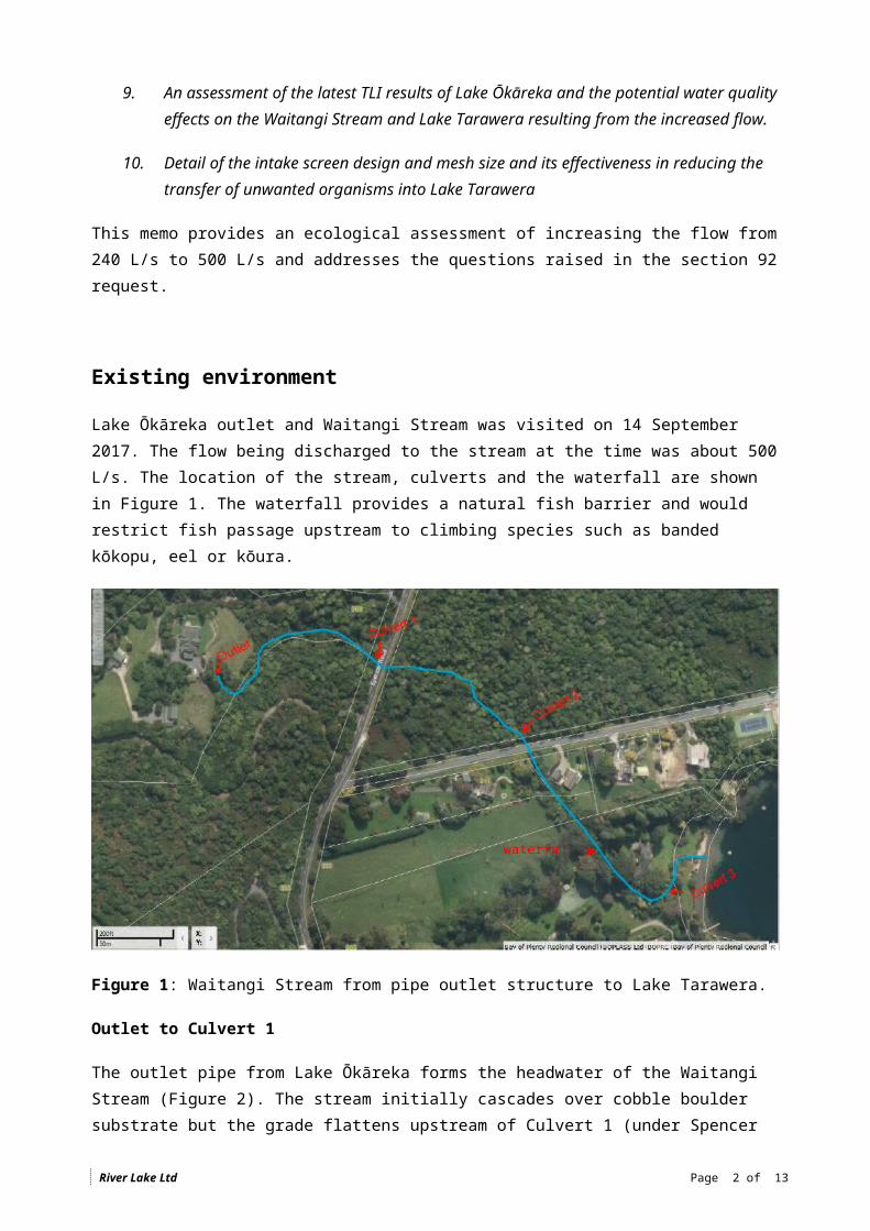
Lake Ōkāreka outlet and Waitangi Stream was visited on 14 September 2017. The flow being discharged to the stream at the time was about 500 L/s. The location of the stream, culverts and the waterfall are shown in Figure 1. The waterfall provides a natural fish barrier and would restrict fish passage upstream to climbing species such as banded kōkopu, eel or kōura.
Figure 1: Waitangi Stream from pipe outlet structure to Lake Tarawera.
Outlet to Culvert 1
The outlet pipe from Lake Ōkāreka forms the headwater of the Waitangi Stream (Figure 2). The stream initially cascades over cobble boulder substrate but the grade flattens upstream of Culvert 1 (under Spencer Road) (Figure 3). Stream banks are stable and vegetated. There is no indication of the higher flows adversely affecting the stream morphology or ecology in this section.
River Lake Ltd Page 2 of 11
waterfall

Figure 2: Outlet pipe from Lake Ōkāreka and headwater of the Waitangi Stream
Figure 3: Upstream of culvert 1 (Spencer Road) facing upstream.
Culvert 1 to culvert 2
Culvert 1 is unlikely to provide fish passage at the 500 L/s flow occurring during the site visit due to the high-water velocity through the culvert. It is likely that the culvert would be a partial fish passage barrier even at lower flows. Installing baffles would allow fish passage through this culvert if downstream barriers are also addressed.
Downstream of Culvert 1 (Spencer Road) the Waitangi Stream is about 3.2m wide and 0.4m deep (in runs). Mid-stream water velocity was fast (about 1m/s), but the cobble stream bed and vegetated stream margin provided roughness, flow heterogeneity and potential habitat for fish and invertebrates. Mayfly were common on the cobble substrate indicating high water quality. The stream bed and bank morphology appear stable; however, the stream channel is relatively confined and it is possible that the stream bed could start to erode for flow further increased (Figures 5 and 6).
River Lake Ltd Page 3 of 11

Figure 4: Outlet to culvert 1 (Spencer Road). Baffles in the culvert and apron would improve fish passage.
Figure 5: Waitangi Stream section downstream of Culvert 1 (Spencer Road)
Figure 6: Substrate in Waitangi Stream downstream of Culvert 1 (Spencer Road)
River Lake Ltd Page 4 of 11

Culvert 2 to the waterfall
Culvert 2 is a 1200mm diameter culvert. At the time of the site visit the water depth flowing through the culvert was about 0.2m and the velocity was very fast (>3 m/s). The high velocity is a barrier to fish passage but it could be mitigated by installing baffles within the culvert. Boulders have recently been added at the culvert outlet, prior to this work the culvert was perched by over 1m – which would have been a major fish barrier (Niroy Sumeran pers. Comm. 2017).
The stream channel is confined and incised and the higher flow and velocity had caused considerable erosion of the stream bed for a distance of about 60m downstream of the culvert. Scour holes were present in the stream bed (to about 0.9m deep) and the gravel - cobble substrate was sparse and unconsolidated. BOPRC had placed boulders at the culvert outlet to provide scour protection and protected the stream from further erosion by installing cloth erosion protection, plywood panelling along the stream bank and plywood weirs (about 300mm height) (Figures 7 and 8).
The plywood weirs were effective at providing hydraulic heterogeneity, dissipating some of the energy and slowing the flow, but the runs between weirs still had fast flowing water. Near culvert 2 outlet the stream width (between the plywood) was about 1.9m, water depth 0.7m and velocity about 1.2 m/s. Further downstream, in the runs between weirs the water depth was about 0.3 to 0.4m and water velocity about 1 m/s midstream and about 0.4-0.6 m/s on the stream edge.
Downstream of the plywood weirs and closer to the top of the waterfall the stream widens (about 2.3m water width) and the mid-stream velocity slightly reduces (to about 0.7 to 1.2 m/s).
Figure 7: Outlet to Culvert 2. Water velocity was very fast.
River Lake Ltd Page 5 of 11

Figure 8: Downstream of Culvert 2 (facing downstream). Plywood panels and weirs to provide erosion protection.
Downstream of waterfall to Lake Tarawera
The Waitangi Stream has a natural waterfall about 110m upstream from its confluence with Lake Tarawera (Figure 9). Between the waterfall and the lake is a trout spawning site; between the waterfall and culvert 3, the steam is about 3-4m wide and about 0.4m to 0.55m deep with occasional deep pools (0.85m deep) (Figure 10). The maximum midstream water velocity in runs was about 0.65 m/s, but considerably slower on the water edge. Downstream of culvert 3 the stream is about 2m wide and 0.7m deep. Riparian vegetation provides good shading and cover along the stream length.
Trout appear to be able to negotiate culvert 3 because several rainbow trout were observed between the culvert and the waterfall at the time of the site visit. However, it is possible that culvert 3 is a partial barrier to fish. The water depth in the culvert was about 0.3m and the velocity very fast (about 2.2m/s). A wooden structure at the culvert outlet help maintain water depth upstream, but it may also make passage by fish more challenging (Figure 11). Fish passage though the culverts could be improved by removing the wooden structure on the culvert and instead constructing a rock v-vane type weir about 3 metres upstream of the culvert. A second culvert has recently been installed to take high flows. The water depth through this was relatively shallow at the time of the site visit.
Sand deposits are apparent on the stream margins. Sand deposition was also present prior to the stream flow increasing to 500 L/s, but it is possible that they have expanded with the upstream sediment erosion. There are still large areas of clear gravel suitable for trout spawning (Figure 12).
River Lake Ltd Page 6 of 11

Figure 9: Waitangi Stream waterfall
Figure 10: Trout spawning area in Waitangi Stream downstream of the waterfall
Figure 11: Culvert 3 on Waitangi Stream, original culvert on the left and the second culvert is on the right.
River Lake Ltd Page 7 of 11

Figure 12: Sediment deposition in the trout spawning area prior to flows increasing above 239L/s (30 June 2017, N. Sumeran).
Effects of increased flow on fish passage through culverts
The waterfall on Waitangi Stream forms a natural fish barrier to non-climbing fish species and it is likely that all of the culverts are partial fish barriers even under consented flows (i.e. 240 L/s). However, the recently high stream flow (500 L/s) will have increase water velocity through the culverts and further reduced potential for fish passage.
Fast water velocity will be causing a fish passage barrier through Culvert 1 and Culvert 2; and is likely to restrict fish passage even for climbing fish species that can negotiate the waterfall. This could be mitigated by retrofitting baffles into these culverts; for example, installing flexible iris baffles at about 1.5m spacing through the culvert and on the apron. These would reduce water velocity, provide backwaters and increase water depth through the culverts.
Spawning trout appear to be getting through Culvert 3, but the fast water velocity and barriers are the stream inlet are likely to make this challenging. Fish passage though the culverts will be improved when the temporary wooden structure on the culvert is removed. This could be achieved by constructing a rock v-vane type weir about 3 metres upstream of the culvert. The final solution will be agreed with Fish and Game Council.
Effects of increased flow on stream ecology
Most of the Waitangi Stream runs in a confined channel and the increase in flow from 240 L/s to 500 L/s would have increased both water depth and velocity. The primary adverse effect of this change is the increase in water velocity downstream of Culvert 2 eroding the stream bed. Gravel and cobbles have been removed from this section of the stream and along with it the habitat for aquatic macroinvertebrates (e.g. mayfly) has been lost.
River Lake Ltd Page 8 of 11

Protection measure by BOPRC appear to have stabilised the erosion, but more permanent protection measure would be need if flows up to 500 L/s were to continue. This might include installing rock v-vane type structures, bank protection and reinstating gravel/cobble substrate. These features assist with erosion protection but also provide hydraulic heterogeneity and instream habitat features to allow habitat and passage of macroinvertebrates and fish.
If flows were to further increase (e.g. to 600 L/s) there is a real risk that additional sections of the stream bed could start to actively erode (e.g. upstream of Culvert 2). This could remove substrate that currently provides high quality macroinvertebrate habitat.
Water quality of discharge compared to Waitangi Stream baseflow
No water quality information is available to compare the Waitangi Stream at its source with the Waitangi Stream after it has been augmented with Lake Ōkāreka outlet water. Almost all the water in the Waitangi Stream comes from the Lake Ōkāreka outlet pipe, and the baseflow in the Waitangi Stream is estimated to be only 5 L/s and 30 L/s in summer and winter respectively. The Waitangi Stream channel has adjusted over many years to having outlet water from Lake Ōkāreka.
The additional water from Lake Ōkāreka outlet over and above the consented flow of 239 L/s will have negligible effect on water quality in the Waitangi Stream because the Waitangi Stream flow is already dominated by the outlet water. However, erosion caused by the increase in stream flow may reduce water clarity downstream.
TLI results of Lake Ōkāreka and effect on Waitangi Stream and Lake Tarawera
Lake Tarawera has historically been classed as oligotrophic, but water quality has been deteriorating over the last 20 years and the most recent water quality results class the lake as ‘mesotrophic’. The trophic level index (TLI) is 3.1. The deterioration is driven by an increasing trend in nitrogen and phosphorus. The concentration of phosphorus (P) in Lake Tarawera is relatively high compared to nitrogen (TN:TP ratio = 5.2), and the increasing trend in P has been particularly strong (i.e. increasing by 7.2% per year from 2002-2014) (Hamill and Scholes 2015). The high P concentration is probably influenced by geothermal inputs.
Lake Ōkāreka is classed as mesotrophic but has slightly worse overall water quality compared to Lake Tarawera (TLI score of 3.4 compared to 3.1 for Lake Tarawera) (Table 1). The TLI score of Lake Ōkāreka has been relatively stable (no trend) over the long term (Hamill and Scholes 2017). Compared with Lake Tarawera, Lake Ōkāreka has higher concentrations of nitrogen and lower concentrations of phosphorus. Water clarity, temperature and pH are similar (Table 2).
The increase in flow from Lake Ōkāreka to Lake Tarawera via the Waitangi Stream will increase the concentration of nitrogen but dilute the concentration of phosphorus in Lake Tarawera. The overall effect of the change in flow on the water quality of Lake Tarawera is expected to be undetectable.
River Lake Ltd Page 9 of 11
Erosion of the Waitangi Stream from the high flows may cause a localised reduction in clarity at the outlet, but this effect was not visible at the time of the site visit.
Table 1: TLI scores in Lake Ōkāreka and Lake Tarawera to 2017 (Scholes 2017).
Lake 3-year mean TLI
to 2017 TLI 2017 Trophic StatusOkareka 3.3 3.4 MesotrophicTarawera 3.1 3.1 Mesotrophic
Table 2: Lake Ōkāreka and Lake Tarawera summary water quality for the period 2011-2014 (Hamill and Scholes 2015)
Variable Ōkāreka TaraweraTLI 3.2 2.9TN (mg/m3) 183 92TP (mg/m3) 10.1 19.1Chl-a (mg/m3) 3.7 1.5Secchi (m) 7.8 8.2EZD (m) 15.1 22.1Temperature 15.2 15.3pH 7.6 7.8EC (uS/cm) 60 402NOx-N (mg/m3) 2.4 1.7NH4-N (mg/m3) 3.2 1.7DRP (mg/m3) 2.9 10.4DO min (g/m3) 3.6 6.3TN:TP 19.8 5.2DIN:TP 0.6 0.2
Intake screen design
The Section 92 requested details of the intake screen design and mesh size and its effectiveness in reducing the transfer of unwanted organisms into Lake Tarawera. The outlet to Lake Ōkāreka has a screen size of about 100mm. This will screen debris but will not stop the transfer of organisms between Lake Ōkāreka and Lake Tarawera. However, it is unlikely that there are any unwanted organisms in Lake Ōkāreka that are not already in Lake Tarawera because the lakes have been connected for many years. The higher flow rates will have negligible difference on the transfer of organisms between the lakes because even at 500 L/s there was low water velocities in the outlet channel upstream of the intakes.
Common aquatic plant pests of Elodea canadensis, Lagarosiphon major, Egeria densa and Ceratophyllum demersum (hornwort) are present in both Lake Ōkāreka and Lake Tarawera.
Conclusions
River Lake Ltd Page 10 of 11

Increasing the flow of the Waitangi Stream to 500 L/s has caused erosion of the stream bed between Culvert 2 and the waterfall. This has removed what is likely to have been high qualtiy habitat for aquatic macroinvertebrtes. The stream habitat above the waterfall has potential to support fish species with the ability to climb, but the increase in water velocity is likely to be restricting fish passage through the existing culverts. Some of the exiting culvert may have been fish barriers even before the increase in stream flow. Recommendations are made on how to mitigate these effects in the long term.
References
Hamill K.D., Scholes P. 2015. Rotorua Te Arawa Lakes State and Trends to 2014/15. Bay of Plenty Regional Council Technical Report.
Scholes P. 2017. Rotorua Lakes 20162017 TLI Update. Memo to Linda Goldsmith, 26 July 2017. File reference Obj A2661946
River Lake Ltd Page 11 of 11