interim report for hkas 2011 archaeological investigation ... interrim report for hkas 2011... ·...
TRANSCRIPT

1
Interim Report for HKAS 2011 Archaeological Investigation at Kau Liu-Tin Sam, San Tau Site of Archaeological Interest, Lantau Island
1. Introduction
The San Tau Site of Archaeological Interest (STSAI – AMO Ref: AM96-0772) is located at
the western side of Tung Chung Bay on the north coast of Lantau Island, and facing Chek
Lap Kok Airport (Figures 1 & 2). The STSAI was in general considered to be an excellent
choice for the HKAS field project because the Tung Chung area, including the original island
of Chek Lap Kok and the adjacent coastline of North Lantau, has previously produced
significant and important archaeological remains of prehistoric, earlier and later historical
periods (e.g. Meacham 1993; Drewett 1995). More specifically, although the STSAI had seen
relatively little fieldwork, there were clear indications that the backbeach area north of Kau
Liu-Tin Sam may contain a Six Dynasties-Tang burial ground.
A general study area, measuring 50m N-S by 100m E-W (SW corner coordinates: 809725E,
816850N), was identified in the project proposal, within which a three phase investigation
methodology was proposed comprising ground penetrating radar (GPR) survey, test-pitting
and extended excavation. In practice, a combination of dense undergrowth and the presence
of villagers‟ fruit trees restricted the detailed study to an area 25m N-S by 35m E-W, focused
on the area of known archaeological potential identified by previous fieldwork.
The first use of archaeological geophysics in Hong Kong proved to be highly successful and
the GPR survey revealed a number of anomalies suggestive of archaeological remains.
Subsequent testing of such anomalies in two areas at the eastern end of the site confirmed the
presence of nine burials, eight of which were mid-late Tang dynasty in date. Several other
possible burials of similar date were noted in section extending beyond the excavation area.
The project has thus achieved its main goals by successfully field testing GPR in Hong Kong
conditions, thereby also confirming the presence and extent of a major Tang dynasty burial
ground at present unique in Hong Kong.
2. Project Background
2.1 Geology, Topography, Drainage & Land Use
The vast majority of the STSAI is located on an extensive alluvial fan at the mouth of a short,
steep-sided valley fed by a large stream (Figure 2). The alluvium gives way to a mixture of
sandy backbeach deposits in the north and east of the Site, while estuarine mud and sand are
found on the coastline in between (Figure 3). The presence of the northern area of backbeach
deposits testifies to the fact that, prior to the construction of the airport, the coastline was
much more exposed to wave action and there was formerly a fine sandy beach (Mr Ho pers.
comm.). The southern and western margins of the site are marked by solid geology in the
form of fine to medium grained granite with occasional basalt and quartz intrusions. At the
interface between the solid geology of the surrounding hills and the alluvium there is a broad
band of slope debris (GEO 1994).
In terms of topography, the STSAI is bounded to the north and east by the modern coastline
and to the west and south by steep hillsides. The alluvium recorded in the eastern half of the

2
site is low-lying at between 2.2-5m PD, while the backbeach area north of Tin Sam lies at
c.5-6m PD and then rises to the south and south-west, reaching c.12m PD in Kau Liu, which
lies at the foot of the mountain protected by its fung shui woodland. The 1:1000 mapping
records the location of former agricultural fields across almost the entire STSAI and, not
surprisingly therefore, evidence of agricultural terracing was noted during previous
investigations of the backbeach area. During the excavation the elderly land tenant visited the
site and explained how the natural slope of the hillside and backbeach had been cut back and
the material redeposited to create a flat area for agriculture. During the excavation, such
activity was evidenced in the truncated profile of early historical deposits and mixture of
ancient and more modern material found in the upper strata. Plates 1-3 inclusive show the
general condition of the site when first visited in August 2011 (see Figure 4 for plate
viewpoints).
2.2 Existing Archaeological Information
Although the maximum extent of the STSAI is very large (c.750m SW-NE by c.700m NW-
SE), known archaeological deposits are localised and in need of further definition. The
present study area to the north of Kau Liu-Tin Sam has been the subject of three previous
archaeological field investigations as detailed below. NB: In the absence of coordinates for
previous excavations, their locations were plotted on Figure 4 based on maps provided in the
project reports held at the Heritage Discovery Centre. The proposed methodology was thus
designed to accommodate any uncertainty over the precise locations of previous
interventions.
2.2.1 North Lantau Survey (CUHK 1991)
During the North Lantau Survey, five test pits (coded TG1-5) were excavated on the Tin Sam
backbeach (CUHK 1991) but only Qing dynasty finds were produced and the area was
interpreted as recent sand dune. Although no archaeological potential was identified, the
approximate locations of the five test pits (blue squares) are shown in Figure 4 for
comparison with later findings.
2.2.2 Tung Chung & Tai Ho Comprehensive Feasibility Study (Mott Connell Ltd 1998)
A CHIA project in 1997 conducted 13 tests north of Tin Sam comprising ten 0.3m diameter
hand-dug „small diameter probes‟ (SDP) coded TS1-10 (green stars), of which two were then
expanded into test squares (green squares): TS2 became TS-A (1.5 x 1.5m) and TS-B (1.0 x
2.5m) was opened beside TS8. A third test square TS-C (1.5 x 1.5m) was excavated a few
metres to the south of TS-B as it was thought that the main prehistoric focus might lie in that
direction.
In the western area, SDP numbers TS1 and TS2 revealed Tang and Song layers with pottery,
while TS3 produced just one Tang dynasty sherd (Figure 4). Test square TS-A, which was
subsequently opened up around TS2, confirmed the presence of a Song cultural layer and a
much richer Tang deposit with frequent pottery sherds and a cluster of 62 coins. The latter
was interpreted as possible evidence for a Tang dynasty cemetery. Perhaps most notable,
given the good evidence for Tang dynasty activity, was the complete absence of kiln debris in
the area.
Approximately 60m to the east of TS-A, SDP TS7 produced two small sherds of Neolithic
pottery while TS8, although producing no finds, contained sandy strata thought likely to be
productive in a wider exposure. A 1.0 by 2.5m test square (TS-B) opened up adjacent to TS8

3
produced a number of fresh sherds of late Neolithic/Bronze Age pottery in a sloping, sandy
backbeach-type stratum. A further test square (TS-C), excavated a few metres south of TS-B,
and at a slightly higher elevation, revealed a 1m thick layer of redeposited soil with Qing to
modern finds – clearly the result of agricultural terracing, sealing a late Neolithic/Bronze Age
deposit with more abundant finds than TS-B. Based on the contrasting finds frequencies
between TS-B and TS-C, the excavator suggested that the main prehistoric deposit area was
probably even further to the south and upslope from TS-C.
2.2.3 2nd
Territory Wide Survey 1997-8 (Report: AMO 1998)
As part of the 2nd
TWS, the Guangzhou Institute of Archaeology and Cultural Relics (AMO
1998) excavated a 2 x 3m test pit (red square) in the area of earlier historical deposits
identified that same year in the project discussed above. Once again a Song layer was
identified sealing Tang dynasty deposits – although here of a much more significant nature,
comprising as they did of two early Tang burials, which were laid out parallel to one another
and orientated north-south (Figure 4). As is common in Hong Kong‟s acidic soils, no skeletal
material survived; however, the position of grave goods and personal ornaments, in particular
a hairpin, should have indicated the head position of one of the interred individuals, although
this detail is not included in the very brief summary report.
2.3 Discussion
Within the Kau Liu-Tin Sam backbeach zone, the contrast between the positive findings of
both of the 1997 fieldwork projects and the lack of archaeology found by CUHK in 1991 is
puzzling. However, in order to establish a meaningful research methodology for the project,
the patterning of both positive and negative findings had to be taken into consideration.
When considered together (Figure 4), the patterning of negative findings from the Mott
Connell and CUHK projects seemed to suggest several things: firstly that the eastern limit of
the earlier historical deposits lay west of TS4 and TG1; secondly, that the prehistoric deposit
area – predicted to extend upslope from TS-C (Mott Connell 1998), appears not to do so if
the findings of TG2 and TG5 (CUHK 1991) are reliable. Moreover, the negative results from
TS6, TS9 and TS10 (Mott Connell 1998) and TG3 and TG4 (CUHK 1991) gave few clues as
to the fuller extent of prehistoric deposits in the eastern half of the study area – although TS6,
9 and 10 were very small interventions at just 0.3m diameter.
In terms of the positive findings – the known archaeological resource, the western early
historical focus appeared richer and arguably more significant in terms of Hong Kong
archaeology than the eastern, less defined focus of late Neolithic to Bronze period activity.
Indeed, the identification of early Tang burials was a rare finding in Hong Kong and burials
of early historical date have only very occasionally occurred and then in ones and twos (e.g.
Sham Wan: Meacham 1978; Hai Dei Wan: Meacham 2009). If the two burials and cache of
Tang coins previously identified could be shown to be part of larger cemetery then it would
add important new data on local funerary traditions in that period.
The present project‟s research methodology was therefore designed to identify, define and
provide a fuller understanding of the extent and character of early historical funerary activity
within the western backbeach site.

4
3. Methodology
3.1 Overview & Objectives
Given the rather limited scale and coverage of previous fieldwork on the western backbeach
site, a three-stage investigation methodology was created comprising:
Stage 1: ground penetrating radar (GPR) survey;
Stage 2: excavation of a series of 2x2m test pits;
Stage 3: expanded excavation in one or more locations in order to provide a better
opportunity to understand horizontal stratigraphy and aid in the identification of cut
features, in particular graves.
The methodology was thus designed to address a series of research objectives:
1. To field test GPR as a preliminary site evaluation technique in Hong Kong
archaeology;
2. To establish the fuller extent of the Tang-Song deposits;
3. To establish the presence or absence of prehistoric deposits within the study area, and
their spatial relationship, if any, with overlying Tang-Song deposits;
4. To more fully define the character of Tang dynasty activity and assess the degree of
continuity or change exhibited between it and the overlying Song horizon;
5. To maximise information retrieval, especially from sealed contexts (such as graves)
through the use of appropriate recovery methods (i.e. dry sieving and/or flotation);
6. To reveal something of the environmental context for each of the main periods
through suitable sampling methodologies.
3.2 Implementation Overview
3.2.1 Site Clearance
In order to set out the site survey grid it was first necessary to clear the dense tangle of
undergrowth and small trees that had colonised the backbeach following the end of farming
activity many years earlier. Over a period of two days a flat area measuring 20m N-S by 30m
E-W (in maximum extent) was cleared for the GPR survey.
3.2.2 Survey Grid
The qualified land surveyors then established a 5m site grid within which the GPR survey
was then conducted. An alpha-numeric coding system was applied to the entire 50m x 100m
study area: 5m grid A1 being in the SW corner, while 5m grid J20 was in the NE corner.
3.2.3 Stage 1 Investigation: GPR Survey
The GPR survey comprised a total of nineteen 5m grids (Figure 5 blue outline), which were
surveyed using a 1m survey interval in both the N-S and E-W directions. During the survey,
GPR data and GPS 3-D positional data were continuously logged to computer – thus
guaranteeing both spatial accuracy and precise modelling of sub-surface anomalies, both of
which are essential for the interpretation of results in terms of archaeological features. The
GPR survey provided very encouraging results (see 4.1 below), which were then used to
guide the positioning of a series of 2x2m test pits.
3.2.4 Stage 2 Investigation: Test Pit Excavation
Initially two 2x2m test pits (TP1 and TP2) were positioned over GPR anomalies at the
eastern end of the survey area, while a third 2x2m test pit was later added to the west (TP3)

5
(see Figure 5 pink squares). Test pits TP1 and TP2 both encountered rich but poorly defined
archaeological deposits relating to Tang dynasty funerary activity and were subsequently
extended in an attempt to make greater sense of the remains (see 4.2 below). In light of the
complexity encountered in TP1 and TP2 it was decided to record and close down TP3 and
focus on dealing with the challenging archaeology being discovered to the east.
3.2.5 Stage 3 Investigation: Expanded Excavation
Based on the findings in TP1 and TP2, both trenches were extended to reveal wider areas in
the hope of identifying in plan the outlines of graves suggested by clusters of grave goods
found following removal of apparently homogenous layers. Eventually the area between TP1
and TP2, which was labelled TP4, was excavated down to the base of Qing-modern
agricultural disturbance in order to link the stratigraphy across the main excavation areas (see
Figure 5 green outline). With a wider area of exposure, and with very careful trowel cleaning
and great attention to textural and colour variation, it was eventually possible to identify with
some confidence the presence of nine graves, plus two probable examples, as well as several
others only partially visible in section. Of the nine relatively clear graves, a total of six Tang
dynasty graves (G1-G4, G6 & G7) and one later, probably Qing, example (G5) were
excavated and recorded during the fieldwork.
4. Results
4.1 GPR
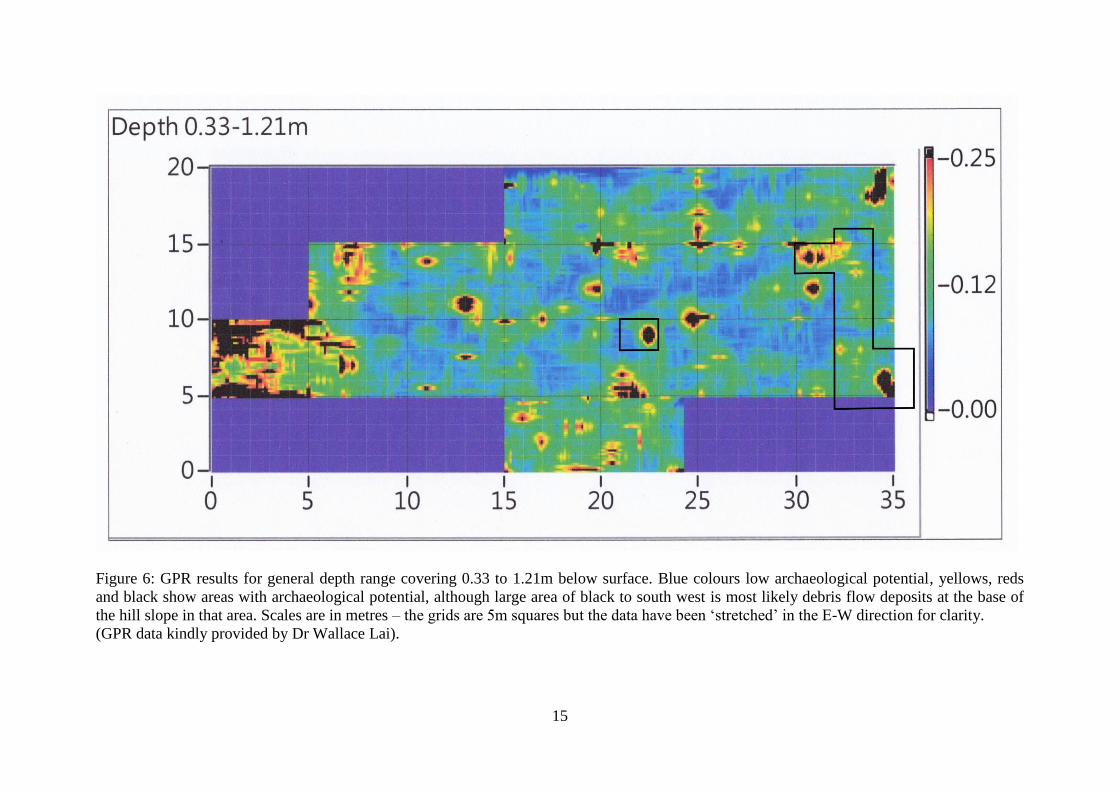
When processed, the GPR results proved to be highly encouraging and a number of discrete
anomalies were identified across the surveyed area. Although a contrasting results were
visible in each of the horizontal „slices‟ (e.g. 0-0.33m; 0.33-0.77m; 0.77-1.21m etc), the plot
of results in the 0.33-1.21m depth range provides an excellent summary of results and shows
a series of very promising sub-circular to sub-rectangular anomalies between 1-3m in length.
For convenience, the position of the main extended excavation area (TP1, 2 & 4) and TP3 are
both highlighted with black boundaries in Figure 6. In Figure 6 the blue colours reflect the
site background of sandy backbeach deposits and are therefore of low archaeological
potential, while the yellows, reds and black responses reflect sub-surface features that provide
a physical contrast to that background. Increasing archaeological potential is suggested
moving from green, through yellow, red and then to black (although the large area of black to
the south west is most likely debris flow deposits at the base of the hill slope in that area –
note their curving front edge).
4.2 Excavation
4.2.1 Test Pit 1
Test Pit 1 was opened up as a 2x2m excavation over a large geophysical anomaly in the
north-eastern part of the site. The thin topsoil (101) produced a mixture of Qing-modern
materials, Tang dynasty pottery and a bronze hairpin of probable Song dynasty date (Plate 4).
Beyond the reach of modern disturbance was a deep sandy layer (102b) which produced only
ancient material in the form of Tang dynasty pottery and a number of bronze belt decorations
(kwa) and strap ends all of which are of Sun Ji‟s (1987) Type II and dated to the middle Tang
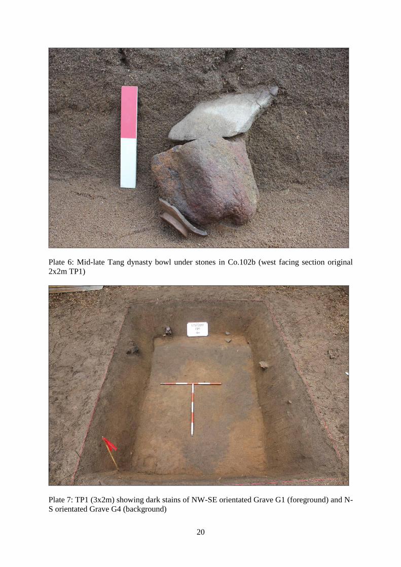
dynasty (Plate 5). At the base of layer 102b in the surface of underlying sandy deposit 107
was a large basin found in association with an iron axe head (Plate 6), which had clear
suggestions of being a structured (i.e. intentionally placed) deposit. Also at the base of 102b
was a small bowl with solid foot of mid-late Tang date, upon which were stacked two stones.
The latter was the first evidence of a pattern of funerary practice that was recorded in several
6
graves subsequently discovered on site. Although no grave cuts or contrasting fills were
visible while excavating to the base of layer 102b, when the trench was extended and the base
was cleaned further, two thin organic-enhanced spreads were noted in plan (Plate 7) – one
orientated NW-SE (110) and the other just to the east orientated N-S (108). Putting the
evidence together, it then seemed very likely that the basin, axe, bronze strap-ends and
rectangular-eyed kwa were collectively related to a NW-SE orientated grave (G1). The N-S
orientated organic spread (108 – Grave G4) appeared to extend under the north and south
baulks at the eastern end of the trench and it was therefore decided to extend into a „T‟-
shaped layout. The extension revealed a rich assemblage of grave goods to the north of the
dark spread comprising over 100 Tang coins of Kai Yuan Tong Bao type (Xu 1991), iron
knives, a U-shaped (probably silver) hairpin and a spouted pottery vessel (Plate 8). While to
the south there was a pair of small crude cups associated with a smaller cluster of similar
coins. The hairpin was particularly significant in that it can be taken to indicate the original
orientation of the deceased with the head to the north.
At the end of the excavation a 1x1.5m sondage was excavated below the centre of the west
facing section, which revealed that context 107 continued beyond the limit of excavation at
c.1.3m below surface (3.75m PD). No other cultural materials were identified during
excavation of the sondage.
4.2.2 Test Pit 2
Test Pit 2 was located in the south-east corner of the GPR survey area and again was 2x2m in
size. Here again, there was a relatively thin topsoil layer (201) with some dark patches
suggestive of burning and probably planting pits of quite recent age - a mixture of mostly
Qing-modern finds was produced. Beneath the topsoil, layer 202 was again an apparently
homogenous layer producing evidence for B&W porcelain and village ware as well Tang
green crackle glazed and stoneware sherds. Toward the base of 202 three clusters of artefacts
were identified (Plate 9): in the NW corner was a complete bowl associated with a scatter of
green crackle glazed and stoneware jar sherds; in the north centre of the trench was an
inverted bowl associated with an iron object (probably a nail) and a few pottery sherds; while
in the SE corner of the trench was a further group of finds comprising a cluster of prehistoric
sherds on top of a stoneware lug handle, an iron knife (protruding from the section), a
complete crackle glazed bowl, and a few loose stoneware jar sherds. Possibly associated with
the eastern two clusters was a long thin stone, while another of similar shape was located
south of the NW cluster - few other stones were found throughout the remainder of layer 202.
Although absolutely no trace of grave cut(s) was noted in plan, the obvious conclusion was
that the finds discovered represented the surviving traces of probably two burials – the
eastern finds were allocated to Grave G2 and the western to Grave G3. Painstaking cleaning
of the 2x2m pit‟s vertical sections confirmed through subtle textural and colour contrasts
what had not been visible in plan: two heavily truncated cut features (just 0.20m deep) were
indeed visible in the south facing section cutting into the underlying paler sandy layer (203).
Layer 202 was consequently divided into 202a (probable Qing horizon) sealing 202b (fill of
G2) and 202c (fill of G3). A further, more recent (probably Qing) cut feature was also noted
cutting from the top of Qing horizon 202a (fill 207, cut 208).
In order to better understand the patterning of cut features in plan, the trench was extended in
all directions to eventually create an area of excavation measuring 4m N-S by 4.5m E-W.
After removal of topsoil (101) a number of quite recent agricultural features were noted
cutting into the surface of 202a, while feature 207-208 was identified in plan as an elongated
oval feature interpreted as a probable Qing dynasty grave (G5), which had truncated Tang
7
grave G3 (Plate 10). On excavation, the homogenous fill of G5 produced a small, mixed
assemblage of Tang and Qing sherds and a collection of iron objects at its southern end.
When all more recent features had been removed, layer 202a was excavated down to the
surface of the Tang horizon and, with extremely careful trowelling, regular fine mist spraying,
and special attention to texture and colour, a number of intercutting grave-like cut features
and smaller pits were identified in plan (Plate 11).
It was thus possible to identify a total of five Tang dynasty graves (G2, G3, G6, G7 and G8)
and three discrete pits – one filled with charcoal but undated (P4; fill 219), a second
containing the rim and shoulder of very large Tang dynasty purple-slipped jar (P5; fill 224),
and the other with a late Tang-Northern Song high foot-ring base (P6; fill 228). Grave G2
proved to have the richest assemblage of grave goods in TP2 including iron swords and
knives, coins, a complete crackle glazed bowl, bronze kwa, reused prehistoric pottery and
iron nails (Plate 12). To the north of G2, and orientated E-W, was Grave G6. Although not
completely defined within the extended trench footprint, the vast majority seemed to be
present and the fill was therefore excavated revealing the arrangement of grave goods shown
in Plate 13. Most interesting was the identification of a perfectly preserved U-shaped hairpin
identical to that found in Grave 4 (Plate 13), which gave a clear indication of the head-to-the-
west orientation of the burial. Interestingly, the tradition of smashing pots under rocks first
seen in TP1 was again present in G6 where, at the opposite end of the grave to the hairpin, a
large rock was found on top of several sherds of a purple-slipped coarse bowl.
At the end of the excavation a sondage was excavated in the north-east corner of the trench,
which showed that deposit 203 continued without further findings to the limit of excavation
at c.1.2 below surface (4.00m PD).
4.2.3 Test Pit 3
Test Pit 3 was opened up as another 2x2m test pit; however, in light of the complex findings
in TP1 and TP2, it was decided to cease excavation with little more than the topsoil removed,
record and leave it for future investigation.
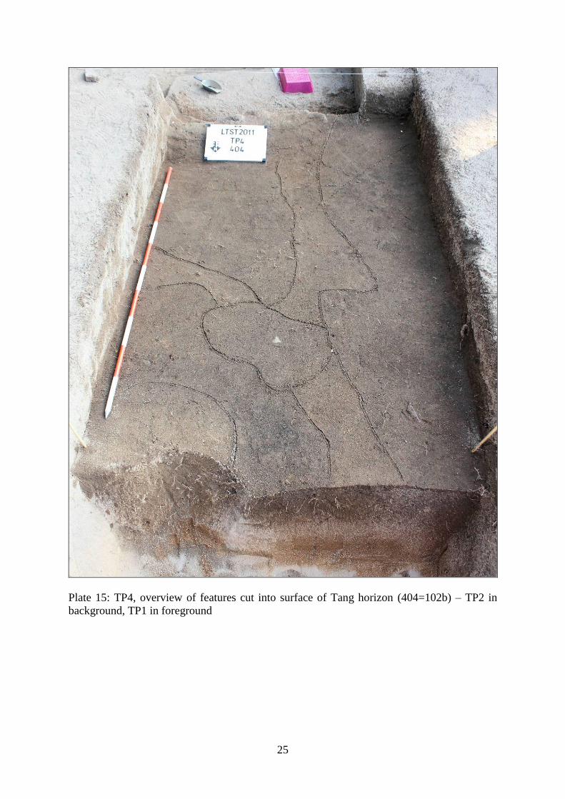
4.2.4 Test Pit 4
Test Pit 4 was in fact not a separate excavation but, rather, was the label applied to the 2x3m
area opened up to connect the stratigraphy in TP1 and TP2. Trowel excavation continued to
the base of Qing dynasty disturbance and the surface was carefully cleaned to reveal a series
of features cutting into the general Tang dynasty horizon (404), which could be equated to
layer 102b in TP1 (Plate 15). Connecting layer 404 to a single horizon in TP2 was less easy
due to the intense pattern of intercutting features in the north-west corner of the latter trench.
The excavation of TP4 was invaluable in demonstrating that the apparently major contrasts in
the general character of strata in TP1 and TP2 were in fact the result of a gradual change from
the base-of-hillside to the south to the middle of the sandy backbeach 10m to the north.
Several features cutting into the surface of 404 clearly continued into TP1 and these
relationships can be more fully investigated in subsequent fieldwork. The combined extent of
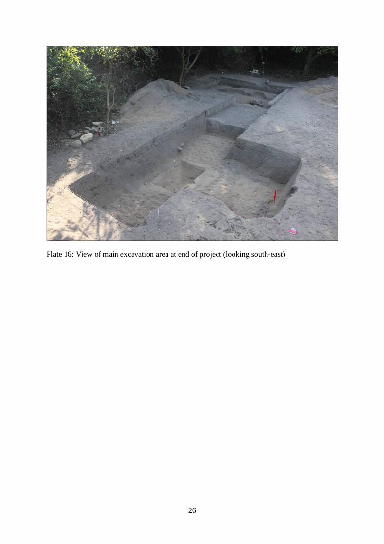
the TP1, 2 and 4 excavation areas is shown in Plate 16.
5. Discussion
The project set out to address a number of research objectives and these have in large part
been successfully achieved.
8
The first application of archaeological geophysics in Hong Kong has demonstrated that GPR
is an effective technique when used on backbeach sites that have good contrasts between the
sandy background and archaeological deposits. Exactly what elements of the archaeological
resource were being detected by the GPR has still to be definitively established. However,
comparative analysis of the archaeological and geophysical data should be able to identify
useful relationships between anomaly type, shape and intensity and different categories of
archaeological remains. Such relationships can then be used as a predictive tool in the
analysis and interpretation of GPR responses across the remainder of the surveyed area,
which can then be tested in future research.
Based on the GPR survey and excavation results, it seems likely that the Tang dynasty
cemetery extends across the entire length and width of the surveyed area – and into adjoining
areas to the south, east and west. In contrast, the previously identified Song horizon seems to
be less clearly defined at the eastern end of the site, although fuller analysis and study of the
ceramics from layers overlying the Tang deposits is yet to be completed and some Northern
Song pottery and a hairpin were recovered. The present geophysical survey and excavation
have also more fully defined the character of Tang dynasty funerary activity and revealed
some interesting features of the burial tradition, in particular, the inclusion of pots smashed
under stones within several graves. There are also clear indications of multiple phases of
Tang dynasty burials using a number of different orientations, with the eight fairly clearly
identified burials having a majority (four) laid out N-S (G2, G3, G4 & G8), followed by two
NNW-SSE (G7 & G9), with NW-SE (G1) and E-W (G6) orientations having one example
each. The only reasonably clear evidence for intercutting is provided by G2 cutting into G6,
but the grave goods from both seem of similar date.
The previous identification of the two graves discovered in 1997 as “early Tang” (AMO 1998)
is not reflected in the present findings where the pottery and bronze buckles, strap ends and
kwa seem to suggest a main focus of activity in the mid-late Tang dynasty, not earlier.
Moreover, the present pottery and bronze belt fittings appear to be more-or-less identical to
those shown in the 1998 report so the early dating suggested previously perhaps requires
review.
Information retrieval was maximised throughout the excavations by the use of 0.5cm dry
sieving (20% of general cultural layers, 100% of sealed contexts), which yielded a good crop
of artefacts that would otherwise have been missed. I addition, a total of 32 flotation samples
were taken from graves and pits as well as the fills of several pottery grave goods. These have
been sent to a palaeobotanical researcher for analysis and the findings will be presented in the
project report.
6. References:
AMO 1998. 2nd
Territory Wide Survey of Hong Kong: North Lantau Survey. Unpublished
fieldwork report.
CUHK 1991. North Lantau Archaeological Investigation. Unpublished fieldwork report.
Drewett, P. 1995. Neolithic Sha Lo Wan. Antiquities and Monuments Office Occasional
paper No.2. Hong Kong: AMO
9
Geotechnical Engineering Office 1994. 1:20,000 Scale HGM20 Series Map of Solid and
Superficial Geology, Sheet 9: Tung Chung. Hong Kong: Hong Kong SAR Government.
Lands Department 2011a. 1:1000 Map Series HP1C, Sheet 9-DE-2D. Hong Kong: Hong
Kong SAR Government
Lands Department 2011b. 1:1000 Map Lot Index Plan, Sheets 9-SE-2C, 2D, 7A & 7B. Hong
Kong: Hong Kong SAR Government
Meacham, W. 1978. Sham Wan, Lamma Island: an archaeological site study. Hong Kong
Archaeological Society, Journal Monograph III.
Meacham, W. 1993. Archaeological investigations on Chek Lap Kok Island. Hong Kong
Archaeological Society, Journal Monograph IV.
Meacham, W. 2009. The archaeology of Hong Kong. Hong Kong: Hong Kong University
Press.
Mott Connell Ltd. 1998. Agreement No. CE 1/97 Remaining development in Tung Chung and
Tai Ho Comprehensive Feasibility Study, Working Paper No. WP12 Historical,
Archaeological & Cultural Heritage Impact Assessment. Unpublished report.
Sun, Ji. 1987. „Ancient leather belts of China‟, in The Thirtieth Anniversary of the cultural
relics publishing house: treatises on archaeology and culture. Beijing: Cultural Relics
Publishing House.
Xu, Diankui. 1991. „Preliminary discussion on the phasing of Tang Kai Yuan Tong Bao‟,
Kaogu (06), pp.
Appendix 1: Figures

10
Figure 1: Location of San Tau Site of Archaeological Interest
11
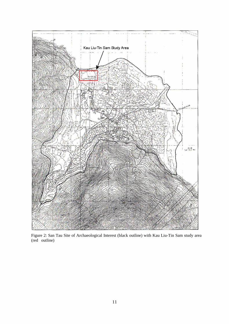
Figure 2: San Tau Site of Archaeological Interest (black outline) with Kau Liu-Tin Sam study area
(red outline)

12
Figure 3: Study area geology with San Tau Site of Archaeological Interest (blue outline) and
Kau Liu-Tin Sam study area in red. Study area geology comprises: Qb = beach deposits
including backbeach, Qd = slope debris, Qa = alluvium. For scale, study area is 50 x 100m in
size; north as indicated. GEO (1994); © Hong Kong SAR Government

13
Figure 4: 1:1000 map showing study area boundary & locations of previous interventions. Key: squares = test pits; stars = small diameter probes;
P1 to P3 = Plate locations; colour codes: blue = CUHK (1991), green = Mott Connell (1997), red = AMO 2nd
TWS (1997-8). Land ownership:
private lots (thick black dashed outline) & Government Land (labelled “DD6 TC” with thick yellowish brown dashed outline). For scale Study
Area is 50 x 100m in size, north as indicated. Lands Department (2011); © Hong Kong SAR Government

14
Figure 5: 1:1000 map showing study area (red outline) overlain with 5m grid for reference. Stage 1 GPR survey grids outlined in blue.
Stage 2 test pits shown in pink, and extended excavation area outlined in green. Scale as shown. North as indicated. Map data: Lands
Department (2011); © Hong Kong SAR Government
15
Figure 6: GPR results for general depth range covering 0.33 to 1.21m below surface. Blue colours low archaeological potential, yellows, reds
and black show areas with archaeological potential, although large area of black to south west is most likely debris flow deposits at the base of
the hill slope in that area. Scales are in metres – the grids are 5m squares but the data have been „stretched‟ in the E-W direction for clarity.
(GPR data kindly provided by Dr Wallace Lai).

16
Appendix 2: Plates
Plate 1: Agricultural terracing – view looking WSW from footpath (viewpoint see Figure 5)

17
Plate 2: Western part of study area – view looking south-west (viewpoint see Figure 5)

18
Plate 3: Eastern part of study area – view looking east from top of bank beside footpath
(viewpoint see Figure 5)

19
Plate 4: Song dynasty hairpin from TP1 topsoil (101)
Plate 5: Mid-late Tang bronze strap end of Sun Ji Type II (1987), TP1 (102b)
20
Plate 6: Mid-late Tang dynasty bowl under stones in Co.102b (west facing section original
2x2m TP1)
Plate 7: TP1 (3x2m) showing dark stains of NW-SE orientated Grave G1 (foreground) and N-
S orientated Grave G4 (background)

21
Plate 8: TP1-EX, cluster of grave goods at N end of Grave G4: including 100+ coins, iron
knives & spouted pottery vessel.
Plate 9: TP2 (2x2m), showing clusters of grave goods apparently in base of layer 202

22
Plate 10: Qing grave G5 (fill 207)
Plate 11: TP2-EX (4x4.5m), showing features visible below layer 202a (original 2x2m square
outlined in white for convenient reference – grave goods in original TP reburied for security)

23
Plate 12: Grave G2 (fill 202b) showing arrangement of grave goods (storyboard is standing
on fill of E-W orientated Grave G6, which was cut by G2)

24
Plate 13: TP2 Grave G6
Plate 14: TP2 Grave G6 hairpin (silver?)
25
Plate 15: TP4, overview of features cut into surface of Tang horizon (404=102b) – TP2 in
background, TP1 in foreground
26
Plate 16: View of main excavation area at end of project (looking south-east)