intercrater plains on mercury: insights into unit definition ... · intercrater plains on mercury:...
TRANSCRIPT

Icarus 241 (2014) 97–113
Contents lists available at ScienceDirect
Icarus
journal homepage: www.elsevier .com/locate / icarus
Intercrater plains on Mercury: Insights into unit definition,characterization, and origin from MESSENGER datasets
http://dx.doi.org/10.1016/j.icarus.2014.06.0130019-1035/� 2014 Elsevier Inc. All rights reserved.
⇑ Corresponding author. Address: Department of Geological Sciences,Brown University, 324 Brook St., Box 1846, Providence, RI 02912, USA.Fax: +1 4018633978.
E-mail address: [email protected] (J.L. Whitten).
Jennifer L. Whitten a,⇑, James W. Head a, Brett W. Denevi b, Sean C. Solomon c,d
a Department of Geological Sciences, Brown University, Providence, RI 02912, USAb The Johns Hopkins University Applied Physics Laboratory, Laurel, MD 20723, USAc Department of Terrestrial Magnetism, Carnegie Institution of Washington, Washington, DC 20015, USAd Lamont-Doherty Earth Observatory, Columbia University, Palisades, NY 10964, USA
a r t i c l e i n f o a b s t r a c t
Article history:Received 28 March 2014Revised 9 June 2014Accepted 10 June 2014Available online 19 June 2014
Keywords:MercuryVolcanismMercury, surfaceGeological processesCratering
Orbital observations by the MErcury Surface, Space ENvironment, GEochemistry, and Ranging (MESSEN-GER) spacecraft are used to re-evaluate the nature and origin of the oldest mapped plains deposits onMercury, the intercrater and intermediate plains units defined by Mariner 10 investigators. Despite thelarge areal extent of these plains, which comprise approximately one-third of the planetary surface areaviewed by Mariner 10, their formation mechanism was not well constrained by Mariner 10 imaging. Onehypothesis attributed plains formation to ponding of fluidized impact ejecta to create relatively smoothsurfaces. Another hypothesis was that these plains are of volcanic origin. To assess the origin of theseolder plains and the contribution of early volcanism to resurfacing on Mercury, we have used MESSEN-GER data to analyze the morphology, spectral properties, impact crater statistics, and topography of Mar-iner 10 type-areas of intercrater and intermediate plains. On the basis of new criteria for theidentification of intercrater and intermediate plains derived from these observations, we have remapped18% of the surface of Mercury. We find that the intercrater plains are a highly textured unit with an abun-dance of secondary craters, whereas the intermediate plains are composed of both intercrater andsmooth plains. We suggest that the term ‘‘intermediate plains’’ not be used to map the surface of Mercuryhenceforth, but rather this unit should be subdivided into its constituent intercrater and smooth plainsunits. We argue that a substantial percentage of the intercrater plains are composed of volcanic materialson the basis of (1) examples of areas where ejecta from a small number of superposed craters have trans-formed smooth plains deposits of volcanic origin into a unit indistinguishable from intercrater plains; (2)the range in ages of intercrater plains deposits as interpreted from crater size–frequency distributions;and (3) the near-global distribution of intercrater plains compared with the uneven distribution of impactbasins and their associated ejecta deposits.
� 2014 Elsevier Inc. All rights reserved.
1. Introduction
The first spacecraft images of Mercury were obtained by Mari-ner 10 (M10) during three flybys in 1974–1975. M10 imagedapproximately 40% of the planet’s surface (Fig. 1), �55% of whichwas covered with several different plains deposits. The earliestgeological interpretation of images from the first M10 flyby(Murray et al., 1974) included a regional map showing three dis-tinct geologic units: plains material, hilly and lineated terrain,and heavily cratered terrain. The intercrater plains unit shortly
thereafter was identified as a subdivision of this ‘‘heavily crateredterrain’’ marked by level to gently rolling, densely cratered surfacesbetween craters >30 km in diameter (Trask and Guest, 1975; Trask,1976). From geologic maps (Trask and Guest, 1975; Schaber andMcCauley, 1980; DeHon et al., 1981; Guest and Greeley, 1983;McGill and King, 1983; Grolier and Boyce, 1984; Spudis andProsser, 1984; Trask and Dzurisin, 1984; King and Scott, 1990;Strom et al., 1990) constructed from M10 images, it is clear thatthe intercrater plains are the most widespread unit on the portionof the planet imaged by that spacecraft. A distinguishing character-istic of the intercrater plains is their high density of small, super-posed craters 5–15 km in diameter (Trask and Guest, 1975;Strom, 1977; Leake, 1981) (Fig. 2). According to Trask and Guest(1975), the majority of these small craters are likely to be second-ary impact craters formed from material ejected from larger craters

Fig. 1. Map of the study locations in this analysis. Red polygons represent the areas dominated by intercrater plains (ICP), and blue polygons denote the areas dominated byintermediate plains (IP); the numbers are specific identifiers used for reference in the text. The darkened area indicates the part of Mercury that was not imaged by M10.Identified basins (Fassett et al., 2012) are outlined in white. The white dashed box outlines the region mapped in Fig. 8. Overlaid on the MDIS 250 m/pixel mosaic is a model ofglobal topography derived by stereo photogrammetry and referenced to a sphere of radius 2440 km (Edmundson et al., 2011; Becker et al., 2012). Simple cylindricalprojection.
98 J.L. Whitten et al. / Icarus 241 (2014) 97–113
(>30 km in diameter) within the heavily cratered terrain. Thesuperposition of these secondary craters was invoked as evidencethat the majority of the intercrater plains are older than the heavilycratered terrain (Trask and Guest, 1975). This observed strati-graphic relationship and inferred relative age, combined with theunit extent and crater size–frequency distributions, led to thehypothesis that the intercrater plains are remnants of a volcanicsurface that partially predated a period of heavy bombardmentof the terrestrial planets (Murray et al., 1975; Trask and Guest,1975).
The findings from the Apollo 16 mission to the Moon, however,called into question a volcanic origin for plains units on Mercury.Before the Apollo 16 mission, the high-reflectance Cayley plainson which the Apollo 16 astronauts landed were thought to be
Fig. 2. Example of a Mariner 10 image of intercrater plains (ICP), as defined by Traskand Guest (1975). The lobate scarp Santa Maria Rupes cuts across these intercraterplains from the northwest to southeast. The image is approximately 200 km across;north is up. Mariner 10 frame 27448.
products of highland volcanism (Milton, 1964; Wilhelms andMcCauley, 1971). During the mission (Young et al., 1972) andthereafter (Hodges et al., 1973; Muehlberger et al., 1980), however,the abundance of brecciated material in returned samples (Gastet al., 1973) indicated that these light plains were produced byimpact-related processes involving some combination of local,regional, and basin-related material (Eggleton and Schaber, 1972;Head, 1974; Oberbeck et al., 1974). This discovery from the Moon,along with the lack of distinct contrasts in reflectance between sur-rounding morphologic units on Mercury (Hapke et al., 1975; Ravaand Hapke, 1987) and the muted morphology of local wrinkleridges there (e.g., Strom et al., 1975), prompted some researchersto explore the idea that the intercrater plains on Mercury wereemplaced as fluidized ejecta from basin impacts (Wilhelms,1976; Oberbeck et al., 1977). The surface morphology and reflec-tance relationships on Mercury matched Cayley plains materialmore closely than those of the volcanic lunar mare deposits.
The dominant formation mechanism for the intercrater plainson Mercury continues to be debated, with ideas for the unit’s for-mation focused on two hypotheses: (1) formation as volcanic flows(Murray et al., 1974, 1975; Strom, 1977; Kiefer and Murray, 1987;Spudis and Guest, 1988) and (2) formation by the emplacement offluidized impact ejecta, an origin similar to that hypothesized forthe Cayley plains on the Moon (Trask and Guest, 1975;Wilhelms, 1976; Oberbeck et al., 1977). Another plains unit, theintermediate plains defined in some geological maps constructedfrom M10 images (Schaber and McCauley, 1980; Guest andGreeley, 1983; McGill and King, 1983; Grolier and Boyce, 1984;Spudis and Prosser, 1984; Trask and Dzurisin, 1984; King andScott, 1990; Strom et al., 1990), shares many of the same character-istics as the intercrater plains (except that it is less densely cra-tered), including an uncertain formation origin.
Widespread resurfacing occurred early in Mercury’s geologichistory, as evidenced by a deficit of craters 20–100 km in diametercompared with the lunar highlands, and at least a portion of thatresurfacing is thought to have occurred by the emplacement ofintercrater plains (Fassett et al., 2011; Strom et al., 2011; Marchi

J.L. Whitten et al. / Icarus 241 (2014) 97–113 99
et al., 2013). The global distribution of these ancient intercraterplains has a substantial influence on the interpretation of the geo-logic history of Mercury. If most or all of the intercrater plains arevolcanic in origin, then volcanism played a substantial role on Mer-cury during its earliest history. However, if most of these depositsare impact-related, then a different thermal evolution is implied,perhaps more like that of the Moon, for which the onset of majormare volcanism occurred near the end of the late heavy bombard-ment of the inner Solar System and partially flooded an earliercrust (Taylor, 1989) of distinctly different composition (e.g.,Shearer et al., 2006).
To address these issues, we use observations from the MErcurySurface, Space ENvironment, GEochemistry, and Ranging (MES-SENGER) spacecraft, in orbit about Mercury since March 2011, toassess several type areas of intercrater and intermediate plainsunits defined during geologic mapping from M10 images, and werevisit the interpretations of these areas. In the sections that followwe utilize the high-resolution image and topography data providedby the MESSENGER mission, together with the M10 geologic maps,to define more clearly the intermediate and intercrater plains unitsin order to understand their origin and role in the geologic historyof Mercury and to provide criteria for future mapping. Consider-able uncertainty remains regarding the influence and extent of vol-canic activity early in Mercury’s history, so the confidentidentification of volcanic units can provide important informationabout the volcanic flux and thermal history and its relationship tothe thermal history of other planetary bodies (e.g., Head andSolomon, 1981). A goal of this analysis is to provide new insightsinto the definition and distinction of the intercrater and intermedi-ate plains and their origins and to formulate improved guidelinesfor the definition and use of these unit terms for future analyseswith MESSENGER data and in planning for the upcoming BepiCo-lombo mission of the European Space Agency and the Japan Aero-space Exploration Agency (Benkhoff et al., 2010).
2. Methods
To characterize intercrater and intermediate plains, we haveexamined the M10 geologic unit definitions and used MESSENGER
Table 1Locations of areas of intercrater plains and intermediate plains included in this study.
Study regions Latitudea Longitudea Area (km
ICP1 52.25 �98.89 1.30 � 10
ICP2 35.49 �107.89 1.30 � 10
ICP3 12.80 �132.76 1.30 � 10
ICP4 �30.09 �46.43 1.30 � 10
ICP5 �16.26 �150.51 1.30 � 10
IP1 �22.00 �126.85 1.30 � 10
IP2 73.77 �148.97 1.30 � 10
IP3 33.00 �30.16 1.30 � 10
IP4 �2.17 �126.14 1.30 � 10
IP5 �55.86 �130.84 1.30 � 10
a Latitude and longitude values are the coordinates for the center of each study regio
data to reassess and refine these definitions further. Ten differentareas located between 0� and 180�E longitude (Fig. 1 and Table 1)and previously mapped with M10 data (Fig. 3, column 4) (Schaberand McCauley, 1980; Guest and Greeley, 1983; McGill and King,1983; Grolier and Boyce, 1984; Spudis and Prosser, 1984; Traskand Dzurisin, 1984) were chosen for analysis. To facilitate compar-ison, half of the study regions selected for our reanalysis were orig-inally mapped from M10 images predominantly as intermediateplains, and the other half were mapped predominantly as intercra-ter plains. These 10 regions were chosen on the basis of the sizeand continuity of the geologic unit, and all have approximatelythe same area (�130,000 km2). For each of the 10 study regionswe analyzed images acquired by the MESSENGER Mercury DualImaging System (MDIS; Hawkins et al., 2007) and topographicmaps and profiles derived from Mercury Laser Altimeter (MLA;Cavanaugh et al., 2007) observations (Fig. 3, columns 1 and 2).
The size–frequency distributions of impact craters were deter-mined for each study region (Fig. 1) to estimate relative ages. MDISimages (Hawkins et al., 2007) were used to identify all visible cra-ters, including embayed craters, greater than �6 km in diameter(Strom et al., 2008). Including secondary craters in counts cancause a surface to appear older than it actually is because second-ary craters on Mercury can have diameters as large as 10 km (e.g.,Strom et al., 2008); craters <10 km in diameter were included inthis study only if they did not display one of the morphologic char-acteristics of secondary craters, including an oblate rim, a herring-bone pattern, or a location within a chain or cluster. To comparethe areal density of impact craters and relative ages of the geologicunits, we report values of N(10) and N(20) for each study area,where N(D) is the number of craters with diameter P D (in km)per 106 km2 area within a given region. The standard deviation(r) for each value of N(D) is taken to be equal to the square rootof the number of craters per diameter bin per area, i.e.,r = [
pN(D)/A] � 106 km2, where A is the unit area in km2 (Crater
Analysis Techniques Working Group, 1979).MDIS images have also been used to characterize the morphol-
ogy of these 10 study areas. Both a 250 m/pixel base map and indi-vidual MDIS wide-angle camera (WAC) and narrow-angle camera(NAC) images with resolutions <250 m/pixel were obtained where
2) Color unit coverage N(10) N(20)
5 LRM: 78.5% 169 ± 36 62 ± 22HRP/IP: 14.1%LBP: 0.02%Unmapped: 7.4%
5 HRP/IP: 52.9% 323 ± 50 162 ± 35LRM: 29.2%Unmapped: 17.9%
5 HRP/IP: 15.2% 370 ± 53 162 ± 35Unmapped: 84.8%
5 HRP/IP: 55.9% 300 ± 48 131 ± 32Unmapped: 44.1%
5 LRM: 15.7% 154 ± 34 62 ± 22Unmapped: 84.3%
5 HRP/IP: 59.9% 77 ± 24 31 ± 15Unmapped: 40.1%
5 Unmapped: 100% 361 ± 53 115 ± 305 HRP/IP: 60.2% 223 ± 41 100 ± 28
Unmapped: 39.8%5 HRP/IP: 83.0% 177 ± 37 108 ± 29
Unmapped: 17.0%5 Unmapped: 100% 223 ± 41 92 ± 27
n.

100 J.L. Whitten et al. / Icarus 241 (2014) 97–113
available. M10 unit definitions were employed to evaluate theobserved morphologies and determine if MESSENGER data supportthe original unit classification. M10 geologic units were comparedwith MDIS color image products, such as the global color unit mapof Denevi et al. (2009), to determine if there is a correlationbetween morphologic and color boundaries and also if there areobservable color differences within and between the morphologicunits. The topography of the intercrater and intermediateplains study regions was characterized with individual MLAprofiles, an MLA gridded data product (Zuber et al., 2012), anddigital terrain models derived from stereo photogrammetric analysis(Edmundson et al., 2011; Becker et al., 2012) of MDIS images.
3. Results
3.1. Intercrater plains
3.1.1. MorphologyMost of the intercrater plains regions mapped from M10 images
have a highly textured surface that appears substantially rougherin the higher-resolution MDIS images (Fig. 3, compare column 1,MESSENGER, and column 5, M10). This surface texture is createdby small secondary craters (<10 km in diameter), which aredegraded and partially filled with smooth material (Fig. 3a). Largercraters in the study regions are all but completely filled withsmooth material, and their rims are almost totally obscured (e.g.,Fig. 3a, f and k). Some of these craters would be impossible to iden-tify were it not for the difference in texture between their smoothresurfaced interiors and the highly sculpted crater exterior. Freshcrater chains or secondary clusters are easily identified aroundyounger impact craters, and older crater chains can be identifiedby the alignment of degraded, filled secondary craters (Fig. 3u).Some study regions have isolated, irregular smooth patches inter-mixed with the heavily textured surface, and other study regionshave parallel lobate scarps (e.g., Strom et al., 1975) that are typi-cally associated with smoother geologic materials (i.e., Fig. 3u).
3.1.2. TopographyTopographic data, generally unavailable from M10, provide
important information on the regional elevations of the intercraterplains study areas (Fig. 3, column 2). Three (ICP1, ICP2, and ICP3) ofthe five intercrater plains study regions are covered by MLA data;for all five study areas there are stereographic data. General agree-ment between the two topographic datasets in areas of overlapprovides confidence that stereo photogrammetry may be used tocompare and characterize the intercrater (and intermediate) plainsstudy regions in areas where MLA data are not available. The inter-crater plains occur at a variety of elevations, from �0.8 km to0.5 km relative to a datum of 2440 km radius, according to theaverage elevation of each intercrater plains study region.
The intercrater plains are more varied in local relief than mightbe expected for a volcanic plains unit. As shown by Whitten andHead (2013b), heavily cratered terrain on the Moon that has beenflooded by volcanic deposits tends to show a narrow range of ele-vations. In some settings, intercrater plains are seen on highlandplateaus and in topographic depressions within close proximity(Fig. 3l). Many of the most abrupt variations in local topographywithin the intercrater plains are controlled by impact crater ejectadeposits and degraded crater remnants. The modest relief in ICP1 iscontrolled by large, partially filled impact structures (Chong-Gauguinbasin; Fassett et al., 2012), except for the low-lying southernportion of this study area. The 1.0 km elevation change acrossICP2 (Fig. 3g) is gradual and is consistent with the lack of any freshcraters >30 km in diameter. In ICP3 the high relief (�1.6 km;Fig. 3l) is produced by the location of the study area on the edge
of a plateau east of Budh Planitia, which accounts for the observedincrease in topography northward (Fig. 1). There are severaldepressions formed from older impact structures in the southernportion of ICP3, but they are not part of the intercrater plains.ICP4 is on the western edge of a large, high-standing plateau thatextends from 45�N to 45�S and 315�E to 0�E (Fig. 1b), creating�2.8 km of relief (Fig. 3q) within the study region. The southwest-ern topographic low is related to an overlap of the ‘‘probable’’�830-km-diameter Andal-Coleridge basin (Fassett et al., 2012)with this study region (Fig. 1). ICP5 has a similar geometry; it liespartly on another high-standing plateau to the east–southeast ofTolstoj basin (Fig. 1) and has a relief of �1.5 km (Fig. 3v); thelow-lying topography in ICP5 contains no known major impactstructures. The variation in the topography of intercrater plainscould be the result of modification by superposed impact cratersor changes to long-wavelength topography after plains emplace-ment (e.g., Zuber et al., 2012; Klimczak et al., 2013).
3.1.3. MDIS color unitsIntercrater plains mapped from M10 images are represented in
each of the MDIS color units defined by Denevi et al. (2009; Fig. 3,column 3), except for the low-reflectance blue plains (LBP). Themajority of ICP3 and ICP5 were not mapped with the flyby MDIScolor data owing to poor illumination geometry or lack of coverage.Those regions that do overlap with the MESSENGER MDIS colorflyby data are composed of multiple color units, including thehigh-reflectance red plains (HRP) and intermediate plains (IP),and low-reflectance material (LRM) (Fig. 3, column 3; Table 1),where red and blue denote more and less steeply increasing spec-tral reflectance from visible to near-infrared wavelengths, respec-tively. The HRP and IP units were mapped together by Deneviet al. (2009) and are therefore reported together in this paper. Tex-ture differences can be used to distinguish the morphologicallysmooth HRP/IP unit from the other color units, but there is no con-sistent textural difference between LRM and geologic materialswithin other color units. Approximately 50% of both ICP2 andICP4 are composed of HRP/IP, occurring either as interior materialin impact basins and large craters or as a plains-like deposit out-side of impact features. The remaining mapped area in ICP2 is com-posed of �29% LRM, typically as widespread plains-like units. Theremaining area in ICP4 was not mapped by Denevi et al. (2009).ICP1 is mostly composed of LRM material, with minor amountsof HRP/IP. There is no morphologic evidence for flow-like embay-ments between the different color units in the intercrater plains.
3.1.4. Crater statisticsCumulative crater size–frequency distributions (SFDs) were
computed for each of the five intercrater plains study regions(Fig. 4a–e). The superposed craters range in size from 6 km indiameter to several hundred kilometers in diameter. For mostof the ICP study regions, the SFDs have a similar slope and den-sity of impact craters, especially those <30 km in diameter, exceptfor ICP1 and ICP5 (see below). Collectively, the crater SFDs forintercrater plains overlap and have a slightly higher crater den-sity at a given diameter than intermediate plains study regions(Fig. 4k).
As expected for Mercury, the steep slopes of the crater SFDs atdiameters <10 km (Fig. 4a, e, f, i and j) are believed to be the resultof secondary cratering (Strom et al., 2008; Xiao et al., 2014), aninterpretation supported by the abundant secondary craters visible(Fig. 3, left column). Several of the crater SFDs have a steep roll-offfor the bins at the largest crater diameters (ICP2, ICP4 and ICP5;Fig. 4b, d and e), consistent with the finding of others that Mercuryis deficient in craters 20–100 km diameter relative to theMoon (Fassett et al., 2011). ICP1 has a lower density of craters12–20 km diameter, a result that could be a consequence of

Fig. 3. Subsets of the intercrater plains (ICP) study regions identified in Fig. 1. Column 1: MDIS 250 m/pixel mosaic or WAC and NAC images. North is up (white arrow).Column 2: topography data from stereo photogrammetry (�2.6 km/pixel) overlaid on MDIS data. Column 3: color units mapped by Denevi et al. (2009). White areas areunmapped. Column 4: M10 geologic map. Column 5: M10 images. (a) is from images EW0226880104G, EW0226837761G and EW0226795417G. (f) is from imagesEW0226964416G, EW0226922188G, and EW0226879730G. (k, p, and u) are from the 250 m/pixel MDIS base map. All images and maps are in stereographic projectionscentered on the given study region (see Table 1 for coordinates).
J.L. Whitten et al. / Icarus 241 (2014) 97–113 101
resurfacing from Chong-Gauguin basin (�330 km in diameter),located in the northwest corner of the study region. The N(10) val-ues for the intercrater plains study regions vary between 154 ± 34and 370 ± 53, and N(20) values are between 62 ± 22 and 162 ± 35(Table 1). These ranges correspond to Tolstojan to pre-Tolstojanages (Fig. 5; Spudis and Guest, 1988).
The intercrater plains study regions were analyzed for spatialrelationships between the locations of small secondary cratersand the proximity of fresh impact craters. Nearby fresh impactcraters could cause intercrater plains regions to be artificiallyaged by an abundance of secondary craters. To assess this possi-bility, the relationship between crater diameter and maximum
distance of secondary craters (Gault et al., 1975) was extrapo-lated linearly to determine the maximum distance of secondarycraters for 23 fresh impact craters adjacent to our study regions.We found no relationship between proximity of relatively freshimpact craters and the steepness of the upturn observed in thecrater SFDs. Such a lack of a relationship is in part a result ofour attempt to exclude secondary craters from the crater counts;fresh secondary craters are much easier to identify and excludefrom crater counts than degraded ones. Thus, the upturnsobserved in SFDs likely result from the inclusion of morphologi-cally degraded secondary craters which, at this size range, are dif-ficult to distinguish from degraded primary craters.

Fig. 4. (a–j) Cumulative crater size–frequency distributions for the intercrater and intermediate plains study regions. Insets are expanded views of the size–frequencydistributions for craters between 5 and 20 km diameter. Gray regions indicate portions of the crater size–frequency distribution strongly affected by secondary craters, asevidenced by the break in slope near 10 km diameter (dashed line). For several study regions, this break in slope is less obvious because we attempted to avoid secondarycraters in constructing these plots. Nonetheless, it is clear that avoiding secondary craters in this size range is difficult for Mercury and poses a challenge for determiningcrater size–frequency distributions at smaller diameters (Strom et al., 2008). Some of the distributions have shallow slopes at the smallest diameters because not all of thesesmallest craters (�6 km diameter) were counted. The number n of craters counted in each study region is indicated. (k) Average crater size–frequency distributions for theintercrater and intermediate plains study regions and their associated errors. Red and blue areas span the range of values for individual study areas.
102 J.L. Whitten et al. / Icarus 241 (2014) 97–113
3.1.5. Intercrater plains: SummaryTo summarize, intercrater plains are densely cratered at diam-
eters <10 km in diameter, and this extensive cratering has createda highly textured surface. Despite the surface roughness, severalbroad morphologic features that might be the result of volcanismare distinguishable, such as large infilled craters (e.g., Fig. 3a, kand u), but no specific volcanic features (e.g., vents, flow fronts)
were identified. The resolution of the MESSENGER dataset enabledthe identification of these characteristic features, which are usefulcriteria for further mapping of intercrater plains and provide asharper view of the surface than did M10 data (Fig. 3, column 5).The intercrater plains as defined and mapped do not have any clearrelation with topography (Fig. 3, column 2). This unit covers high-standing plateaus and continues into topographic depressions. The

Fig. 5. Crater density values N(10) (top) and N(20) (bottom) for the ICP and IP studyregions of this paper, as well as for different plains areas (Spudis and Guest, 1988;Denevi et al., 2013a) and basins (Spudis and Guest, 1988; Fassett et al., 2009) onMercury. The plots show that N(10) and N(20) values provide consistent estimatesof relative age. Values for intercrater and intermediate plains indicate that theseunits are Tolstojan to pre-Tolstojan in age. Errors in N are large for several studyregions, which implies that many of the study areas could have formed at any timeduring the pre-Tolstojan and Tolstojan periods. Spudis and Guest (1988) did notreport N(10) values. The figure is modeled from Fig. 26 of Spudis and Guest (1988),so the abscissa is aligned with corresponding lunar stratigraphic systems (Pre-Nectarian, Nectarian, and Imbrian periods), for which absolute ages are known ormay be estimated. Data points are arbitrarily spaced evenly within each timeperiod.
J.L. Whitten et al. / Icarus 241 (2014) 97–113 103
intercrater deposits identified from M10 images are not composedof a single color unit (Denevi et al., 2009). Different regions of theintercrater plains have some of the reddest (HRP/IP) and bluest(LRM) spectral reflectance, as well as the highest (HRP/IP) and low-est (LRM) reflectance values, suggesting that whatever their ori-gin(s), the intercrater plains have a range of color unit variations.We confirm the pre-Tolstojan and Tolstojan age estimates of theseintercrater plains regions (Fig. 5).
3.2. Intermediate plains
3.2.1. MorphologyMost of the intermediate plains regions are composed of many
moderately cratered smooth plains-like deposits (Fig. 6a, k and p)with some highly textured regions (Fig. 6f and u). The highly tex-tured surfaces result from a combination of sculpted ejecta andsmall secondary craters and appear similar to the intercraterplains. Recent crater chains (Fig. 6a) and, in a few study regions,parallel lobate ridges (Fig. 6k) are observed. In the smootherregions there is evidence for buried craters (typically <25 km diam-eter), such as partially buried rims and wrinkle-ridge rings(Fig. 6p). Such circular patterns of wrinkle ridges are believed tohave been formed by compressional stresses localized by a shal-lowly buried crater rim crest (Guest and Fielder, 1968;Cruikshank et al., 1973; Watters, 1993; Freed et al., 2012;Watters et al., 2012) and are typically observed in volcanic terrains(e.g., Lambert R on the Moon and Mercury’s northern smoothplains; Head et al., 2011). Impact-degraded craters are identifiedby filled interiors and disrupted crater rims that have been modi-fied by ejecta from later impact events. A lunar example of animpact-modified crater is the Ptolemaeus crater, which was filledwith Imbrium ejecta and had its rim scoured by Imbrium ejecta.Larger craters in intermediate plains are partially infilled (e.g.,Fig. 6f and u), and the more degraded craters have lost most oftheir rim elevation.
3.2.2. TopographyIP1 is located within the Beethoven basin, and its surface slopes
down toward the center of the basin (Fig. 6b). IP2 (Fig. 1) has a ridgethrough its center and slopes toward the northern smooth plainsand Suisei Planitia to the south (total relief is �2.0 km). Stereo-graphic data show that IP3 (Fig. 1) has a large north–south-trendingtrough (�175 km wide) with a total relief of �1.2 km in the studyarea. The topography in IP4 (Fig. 6q) is generally low-lying, partiallythe result of an unnamed�245-km-diameter crater in the northernpart of the study region (Fig. 1). IP5 (Fig. 6v) is located within aheavily cratered region containing highly undulating crater topog-raphy (i.e., crater rims and depressions). MLA and stereographicdata indicate that the morphologically smooth regions of the inter-mediate plains are located at lower elevations than the roughertextured material (intercrater plains). Similar to the case forintercrater plains, much of the observed topographic variability ofintermediate plains could be the result of impact crater morphology(fresh or degraded) or changes to long-wavelength topography sub-sequent to plains emplacement (e.g., Zuber et al., 2012; Klimczaket al., 2013).
3.2.3. MDIS color unitsSeveral of the selected intermediate plains study regions were
mapped using the MESSENGER flyby color data (Denevi et al.,2009), including IP1, IP3, and IP4. IP2 and IP5 were not mappedowing to poor viewing conditions (Fig. 6, column 3; Table 1). Thethree regions of intermediate plains mapped are >50% HRP/IP,and the remaining area was unmapped. In contrast to the M10intercrater plains, which are characterized by a wide variety ofcolor units, the intermediate plains appear to have generally simi-lar MDIS color characteristics; the unit is dominated by HRP/IPmaterial. This HRP/IP color signature has also been correlated withthe presence of smooth plains units identified by their morphologyand interpreted to be of volcanic origin (e.g., Robinson et al., 2008;Denevi et al., 2009; Head et al., 2011). The agreement in MDIS colorcharacteristics between the M10-defined intermediate plains andM10- and MESSENGER-defined smooth plains material is consis-tent with the observation of many small patches of smooth plains

Fig. 6. Subsets of the intermediate plains (IP) study regions identified in Fig. 1. Column 1: MDIS 250 m/pixel mosaic or WAC and NAC images. North is up (white arrow).Column 2: topography data from stereo photogrammetry (�2.6 km/pixel) overlaid on MDIS data. Column 3: color units mapped by Denevi et al. (2009). White color indicatesunmapped region. Column 4: M10 geologic map. Column 5: M10 images. (a) is from the 250 m/pixel MDIS base map. (f) is from images EW0214589955G, EW0214589935G,EW0214676881G, and EW0214633400G. (k) is from images EW0213025967G, and EW0213025938. (p) is from images EN0226963098M, EN0226920771M,EN0226920672M, and EN0226920674M. (u) is from image EN0227550741M. All images and maps are in stereographic projections centered on the given study region(see Table 1 for coordinates).
104 J.L. Whitten et al. / Icarus 241 (2014) 97–113
deposits within the M10-mapped intermediate plains (Fig. 6, col-umn 1).
3.2.4. Crater statisticsAs is the case with the intercrater plains, the intermediate
plains study regions have an abundance of secondary craters, asindicated by the sharp upturn in crater SFDs at diameters <10 km(Fig. 4f–j). In IP2 and IP3 there is a small break in slope at 10 kmbefore the crater SFD levels out at the smallest crater diameters,likely due to incomplete counting in the smallest-diameter bins.Most of these crater SFDs cluster together on a cumulative plot
(Fig. 4k). IP1 (Fig. 4f) is an outlier crater SFD, having a differentshape to its distribution and a lower overall density of craters atall sizes. IP2 and IP3 are almost uniformly cratered across their sur-faces and show a crater SFD more typical for intermediate plains(Fig. 4g and h). IP4 and IP5 show distributions (Fig. 4i and j) poten-tially indicative of resurfacing, an inference supported by embayedand partially buried craters in IP4 (Fig. 6p). The N(10) values for theintermediate plains study regions have a larger range, from 77 ± 24to 361 ± 53, than the intercrater plains study regions (Table 1). Cal-culated N(20) values are between 31 ± 15 and 115 ± 30 and corre-spond to Calorian through pre-Tolstojan ages (Spudis and Guest,
J.L. Whitten et al. / Icarus 241 (2014) 97–113 105
1988). From the N(20) values, IP1 is associated with the Caloriantime period, along with many other smooth plains deposits(Spudis and Guest, 1988). The N(10) and N(20) values for thefour remaining intermediate plains regions correspond to thepre-Tolstojan time period (Fig. 5).
3.2.5. Intermediate plains: SummaryOn the basis of high-resolution MESSENGER datasets, the inter-
mediate plains unit defined at M10 resolution appears in the studyregions examined here to be a combination of older intercraterplains units and younger smooth plains deposits, rather than a dis-tinctive geologic unit. Fresh crater chains, lobate scarps, and buriedcraters are observed in this map unit (Fig. 6k). No volcanic land-forms (e.g., vents, flow fronts) were detected within the unit. Manyof the smooth plains associated with the M10-mapped intermedi-ate plains are topographically lower than some of the other moreheavily cratered parts (i.e., IP5; Fig. 6u and v). With the exceptionof IP1, all of these intermediate plains regions have crater size–fre-quency distributions that overlap with those for the intercraterplains (Fig. 4k) and correspond to the pre-Tolstojan time period(Fig. 5; Table 1).
4. Discussion
4.1. Summary of intercrater and intermediate plains units
The intercrater and intermediate plains units require morestringent identification criteria than were used previously in orderto avoid confusion. M10 mapping efforts indicated that the inter-crater plains covered a third of the imaged surface of Mercury(e.g., Strom, 1977; Kiefer and Murray, 1987), and MESSENGER data
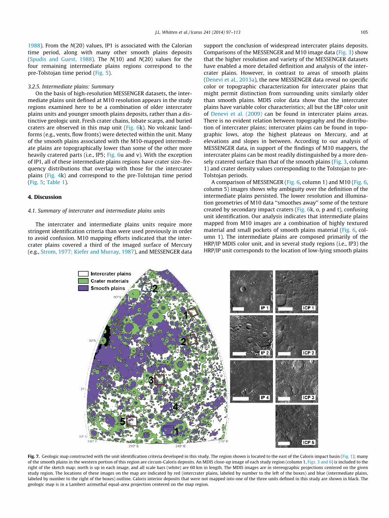
Fig. 7. Geologic map constructed with the unit identification criteria developed in this stuof the smooth plains in the western portion of this region are circum-Caloris deposits. Anright of the sketch map; north is up in each image, and all scale bars (white) are 60 kmstudy region. The locations of these images on the map are indicated by red (intercratelabeled by number to the right of the boxes) outline. Caloris interior deposits that were ngeologic map is in a Lambert azimuthal equal-area projection centered on the map regi
support the conclusion of widespread intercrater plains deposits.Comparisons of the MESSENGER and M10 image data (Fig. 3) showthat the higher resolution and variety of the MESSENGER datasetshave enabled a more detailed definition and analysis of the inter-crater plains. However, in contrast to areas of smooth plains(Denevi et al., 2013a), the new MESSENGER data reveal no specificcolor or topographic characterization for intercrater plains thatmight permit distinction from surrounding units similarly olderthan smooth plains. MDIS color data show that the intercraterplains have variable color characteristics; all but the LBP color unitof Denevi et al. (2009) can be found in intercrater plains areas.There is no evident relation between topography and the distribu-tion of intercrater plains; intercrater plains can be found in topo-graphic lows, atop the highest plateaus on Mercury, and atelevations and slopes in between. According to our analysis ofMESSENGER data, in support of the findings of M10 mappers, theintercrater plains can be most readily distinguished by a more den-sely cratered surface than that of the smooth plains (Fig. 3, column1) and crater density values corresponding to the Tolstojan to pre-Tolstojan periods.
A comparison of MESSENGER (Fig. 6, column 1) and M10 (Fig. 6,column 5) images shows why ambiguity over the definition of theintermediate plains persisted. The lower resolution and illumina-tion geometries of M10 data ‘‘smoothes away’’ some of the texturecreated by secondary impact craters (Fig. 6k, o, p and t), confusingunit identification. Our analysis indicates that intermediate plainsmapped from M10 images are a combination of highly texturedmaterial and small pockets of smooth plains material (Fig. 6, col-umn 1). The intermediate plains are composed primarily of theHRP/IP MDIS color unit, and in several study regions (i.e., IP3) theHRP/IP unit corresponds to the location of low-lying smooth plains
dy. The region shown is located to the east of the Caloris impact basin (Fig. 1); manyMDIS close-up image of each study region (column 1, Figs. 3 and 6) is included to thein length. The MDIS images are in stereographic projections centered on the given
r plains, labeled by number to the left of the boxes) and blue (intermediate plains,ot mapped into one of the three units defined in this study are shown in black. The
on.

106 J.L. Whitten et al. / Icarus 241 (2014) 97–113
deposits. In addition, the M10 intermediate plains map unit has anabundance of secondary craters <10 km in diameter (i.e., upturn at10 km; Fig. 4), sharing this defining quality of the intercraterplains. The majority of the M10 intermediate plains are dated aspre-Tolstojan (Fig. 5) on the basis of crater density values, suggest-ing that these deposits formed early in the geologic history ofMercury.
On the basis of this analysis, we propose that the definition ofintercrater plains should include a highly textured surface mor-phology (Fig. 3a, f, k and p) with few smooth patches. The unitswe mapped had a high crater density, N(10)>�225, and an upturnin their crater SFDs at diameters <10 km that is attributed to anabundance of secondary craters. Intermediate plains should beanalyzed in detail and subdivided into either intercrater or smoothplains units; the highly textured regions with the abundance ofsecondary craters (as indicated by the upturn in the crater SFDs,Fig. 4) should be included in the intercrater plains unit, and patchesof smooth plains material >750 km2 (partially infilling craters�50 km in diameter or greater) should be grouped with othersmooth plains deposits. These proposed geologic unit definitionsrequire the reclassification of several study regions, as describedbelow.
IP1 is located in the center of Beethoven basin (Figs. 1, 6 and 8),and on the basis of morphology, MDIS color, and crater size–fre-quency distribution it should be reclassified as smooth plainsmaterial (Denevi et al., 2013a). The N(20) value of 31 ± 15 for IP1is comparable to smooth plains N(20) values, which range from10 ± 10 to 45 ± 12 (Fig. 5; Table 1; Denevi et al., 2013a). Otherintermediate plains regions, including IP3 and IP4 (Figs. 1, 6 and8), should also be reclassified as smooth plains. The morphologyof these two study regions is smooth with some small regions hav-ing a more intercrater-plains-like texture, again with smootherareas located at lower elevations. Low N(10) values, corresponding
Fig. 8. Examples of the different morphologies included in the intercrater plains map ucraters have sharp and easily identifiable crater rims and can occur in chains. (b) Olderbackground hummocky texture. (c and d) Mixtures of degraded and fresh craters. In (c) t(d) the degraded craters are difficult to identify individually and thus contribute more toor chains. Superposed secondary craters are indistinguishable from one another and blenbase map. Lambert azimuthal equal-area projection, centered on the map region in Fig.
to a lower density of secondary craters, for IP3 and IP4 are closer tosmooth plains values than to intercrater plains N(10) values(Table 1). The low N(10) value is in contrast to the higher N(20) val-ues, suggestive of a pre-Tolstojan age. This apparent contradictionin crater density values may indicate an extended interval of volca-nic eruptions, as detailed below (Section 4.4). The prevalence of theHRP/IP MDIS color unit (Denevi et al., 2009) in these two regions,coupled with the latest mapping of smooth plains deposits(Denevi et al., 2013a), supports such a reclassification of IP3 andIP4. IP5 (Figs. 1, 6 and 8) shows the same general characteristicsas IP3 and IP4. The morphology of the unit indicates that IP5 islikely to be an older smooth plains deposit. IP2, in contrast, shouldbe mapped as intercrater plains, on the basis of its heavily crateredtexture (Fig. 6, column 1) and intercrater plains-like crater size–frequency distribution (Table 1). The N(10) and N(20) values forIP2 are among the highest values for all of the study areas.
In addition to the reclassification of intermediate plains, there isone intercrater plains study region (ICP5) that, according to ourinterpretation of the N(10) crater density values (Table 1), shouldbe labeled as smooth plains. However, the interpretation assmooth plains is not supported by the morphology of the studyarea. ICP5, located to the east of Tolstoj basin (Fig. 1), includesregions of smooth plains that embay older intercrater plainsdeposits. This interpretation of the local stratigraphy is supportedby the topography data, with smooth plains located in low-lyingareas and the older intercrater plains areas having higher eleva-tions (Fig. 3v). The surface of ICP5 is covered with ancient north-west–southeast-trending secondary crater chains from Valmikicrater (�210 km diameter) and younger secondary craters fromSophocles crater (�142 km diameter). The calculated N(10) valueof 154 ± 34 is consistent with other smooth plains values, as isthe N(20) of 62 ± 22 (Table 1). It appears as though the recent sec-ondary impact modification has roughened the surface sufficiently
nit. (a) Superposed secondary craters from relatively immature impacts. Secondarysecondary craters and chains with flat floors. Some crater rims blend in with the
here are more fresh craters and degraded craters are more easily distinguishable. Informing a hummocky textured surface. (e) Areas with no obvious secondary cratersd together to form a hummocky texture. All images are from the MDIS 250 m/pixel7.

J.L. Whitten et al. / Icarus 241 (2014) 97–113 107
to characterize ICP5 as intercrater plains; the conflict between themorphologic interpretation and the N(10) and N(20) values thatare similar to those of smooth plains deposits indicate that, in thisparticular location, secondary crater production has outpaced thatof primary impacts.
4.2. Discussion of criteria to distinguish intercrater plains formationprocesses
As noted above, two hypotheses have been proposed to explainthe formation mechanism for intercrater plains, volcanism (Murrayet al., 1974, 1975; Strom, 1977; Kiefer and Murray, 1987; Spudisand Guest, 1988) and emplacement as fluidized ejecta from largeimpacts (Wilhelms, 1976; Oberbeck et al., 1977). Here we discussthe identification criteria (Table 2) that may be useful in distin-guishing between these hypotheses for specific intercrater plainsdeposits.
The Mariner 10 science team interpreted the intercrater plainsto be mostly volcanic deposits, on the basis of the extensive arealdistribution of the deposits (e.g., Murray et al., 1975) as a majorpiece of evidence. Mapped intercrater plains deposits are wide-spread across the surface of Mercury (Trask and Guest, 1975;Schaber and McCauley, 1980; Guest and Greeley, 1983; McGilland King, 1983; Grolier and Boyce, 1984; Spudis and Prosser,1984; Trask and Dzurisin, 1984; King and Scott, 1990; Stromet al., 1990), implying that the formation process was active onessentially a global scale. The extended distribution of volcanicsmooth plains, especially the northern smooth plains and Caloris(Fassett et al., 2009; Head et al., 2011; Denevi et al., 2013a), cou-pled with models of magma ascent and eruption (Wilson andHead, 2008), suggests that flood basalt volcanism was the domi-nant eruption style for smooth plains on Mercury and may havebeen for intercrater plains as well.
Additionally, M10 data and the acquired MDIS global coverageof Mercury have revealed a deficit of craters 20–100 km in diame-ter compared with the Moon (e.g., Strom, 1977; Strom et al., 2008;Fassett et al., 2011), interpreted to be the result of volcanic plainsformation during the period of heavy bombardment of the innerSolar System. Basins >300 km in diameter on Mercury have anasymmetric distribution, with the majority of large basins occur-ring in the western hemisphere (Fassett et al., 2012). This asym-metric distribution of basins implies an asymmetric distributionof remaining impact basin deposits and thus could indicate that
Table 2Lines of evidence that would support a volcanic or impact origin for the intercrater plains
Volcanic Impact
1. Widespread distribution 1. Smaller d2. Continuous, areally extensive deposits (�105 to 106 km2)a 2. Concentr3. Paucity of craters <100 km in diameterb 3. Spectral4. Spatial density and distribution of large basins (>500 km
diameter)c4. Proportio
5. Distinct compositional boundaries within or at margins ofdepositse
5. Abundanfor crater
6. Specific landforms (e.g., ghost craters, sinuous rilles, rimlessdepressions, wrinkle ridges)g
7. Interior heat production and thermal historyh
a Head et al. (2011) and Denevi et al. (2013b).b e.g., Strom (1977), Strom et al. (2011) and Fassett et al. (2011).c Fassett et al. (2012).d e.g., O’Keefe and Ahrens (1977) and Cintala (1992).e Robinson et al. (2008) and Denevi et al. (2009).f Richardson (2009).g e.g., Head et al. (2008, 2009a, 2009b).h Peplowski et al. (2011).
older basins have been modified beyond recognition by volcanisminstead of later impact events.
Volcanic deposits might be expected to have distinct composi-tional boundaries coincident with morphologic boundaries, in amanner similar to the smooth plains deposits (Robinson andLucey, 1997; Robinson et al., 2008; Denevi et al., 2009, 2013a). Vol-canic deposits might also contain volcanic vents or other diagnos-tic landforms (e.g., Head et al., 2009a, 2009b; Byrne et al., 2013;Hurwitz et al., 2013).
MESSENGER Gamma-Ray Spectrometer (GRS) measurements ofthe surface abundances of the radioactive elements Th, K, and Uindicate that Mercury’s interior heat production may have beenfour times higher �4 Ga than at present (Peplowski et al., 2011).Such greater heat production could have supported partial meltingof the mantle and widespread source regions for volcanic activityduring the period of heavy bombardment. Additionally, the lackof a low-density anorthositic crust and the low abundances of ironand titanium in volcanic materials on Mercury (Nittler et al., 2011)may have prevented the generation of magmas higher in densitythan average crustal material, in contrast to the situation on theMoon (e.g., Head and Wilson, 1992) and favorable to early surfaceeruptions.
Under the fluidized ejecta hypothesis, impact melt or impactejecta and locally excavated material ponded in topographic lowsand produced plains that were later covered with myriad second-ary craters. Instead of forming large continuous deposits, suchmaterial was more likely to form discrete smaller deposits similarto the Imbrian smooth plains (Wilhelms and McCauley, 1971;Oberbeck et al., 1977; Meyer et al., 2013) that are concentratedin isolated patches around the lunar nearside basins. Regional het-erogeneity in the color properties of intercrater plains might beexpected if the unit were produced from impact-related processes,depending on the lateral and vertical heterogeneity of Mercury’scrust (Denevi et al., 2009) and the depth of excavation of individualimpacts. On the other hand, lunar light plains do not show majorvariations in color properties relative to background highlands;exceptions are subtle differences related to cryptomaria (e.g.,Hawke and Spudis, 1980; Antonenko et al., 1995; Whitten andHead, 2013a). The heterogeneous MDIS color properties of inter-crater plains could also result from mixing of crustal materials bythe �4 Gy of impacts after plains emplacement.
Cratering models for the terrestrial planets (e.g., Richardson,2009) suggest that the lunar highlands are saturated (meaning thatfor each new crater formed another crater of similar diameter is
.
iscrete deposits associated with craters or basinsation around large basins and craterscharacteristics similar to those of surrounding terrainnally more melt in craters on Mercury than the Moond
ce of primary craters, coupled with cratering models indicating surface saturations >128 km in diameterf

108 J.L. Whitten et al. / Icarus 241 (2014) 97–113
destroyed). Mercury (Fassett et al., 2011) shows a size distributionof large craters (>128 km in diameter) similar to that of the Moon,providing support for an impact-related origin for some intercraterplains deposits. Regardless of the dominant formation process, theintercrater plains have been extensively modified by primary andsecondary impact cratering.
4.3. Geologic mapping
Analysis of the plains units identified in the M10 geologic mapswith MESSENGER data suggests that surface morphology providesgood criteria for the definition and identification of smooth plains,but poor criteria for the intercrater plains (i.e., the lack of colorcontrasts and extensive topographic variation) other than high val-ues of crater density. A regional assessment and a remapping ofthese major units were completed over a broad study region span-ning 18% of the surface of Mercury; the resulting map is shown inFig. 7. This remapping exercise provides a basis for assessing thecandidate modes of origin for intercrater and intermediate plains.
4.3.1. Definition of map units4.3.1.1. Crater materials. Crater rims, central peaks, and ejectadeposits were mapped for all observable craters > 20 km in diame-ter. Buried craters were not mapped because their original mor-phology has been obscured by plains deposits. Digital terrainmodels from stereo photogrammetry and MDIS image data wereused to determine the extent of crater ejecta deposits. Only thecontinuous ejecta deposit was mapped for most craters becauseits morphology is more readily distinguished for each individualcrater. Determining the extent of the secondary crater field forindividual impacts becomes more difficult with increasing craterdegradation. Impact craters and their associated ejecta depositsobscure the underlying material, making plains unit identificationdifficult in certain situations; these impacts could have superposedeither smooth or intercrater plains deposits. Therefore for Fig. 7 wemapped only the uppermost surface unit.
4.3.1.2. Smooth plains. Analysis of MESSENGER data has not sub-stantially changed the definition of the smooth plains depositsfrom the original unit definition developed by the M10 team.Smooth plains are level to gently sloped over distances of 100–200 km, and they have a low density of superposed craters (e.g.,Trask and Guest, 1975; Denevi et al., 2013a). These deposits canbe expansive, such as the Caloris exterior plains (e.g., Trask andGuest, 1975; Denevi et al., 2013a) and the northern smooth plains(Head et al., 2011), and they can be small in area, contained withincraters tens of kilometers in diameter. Smooth plains of volcanicorigin are characterized by regionally smooth deposits; the pres-ence of kipukas; sharp and distinctive color boundaries; an associ-ation with volcanic vents; the presence of partially buried impactcraters, ghost craters, and wrinkle ridges at expected rim and peakring locations; and burial of crater terraces by smooth plains (e.g.,Head et al., 2008, 2009a, 2011; Denevi et al., 2013a).
4.3.1.3. Intercrater plains. The intercrater plains constitute a mor-phologic unit that can still be characterized by an extremely tex-tured surface, caused by the high density of craters <10 km indiameter (Fig. 8). The areas mapped are plains regions betweencraters >20 km in diameter; the elevation of areas of intercraterplains varies by �5 km, but the slope of the mapped plains regionsis generally <2.0�. Thus, locally the intercrater plains are nearlylevel deposits, but regionally the plains are a more gently rollingor undulating unit. As mapped, the intercrater plains include awide variety of heavily cratered surface morphologies, fromregions with fresh and distinct secondary impact craters (Fig. 8a)to regions with muted surface textures where the secondary
craters are degraded and have merged together (Fig. 8b–e). Sec-ondary craters and chains tend to be in distributions radial to theirprimary crater (Fig. 8a and c).
4.3.2. Application to geologic mappingOn the basis of these definitions of plains units, the geological
map in Fig. 7 was constructed. The mapped area (13.5 � 106 km2)spans a substantial part of the western hemisphere of Mercury(80�N to 30�S and 180�E to 270�E). The map includes 7 of 10 ofour study regions, in order to compare with previous geologicmaps and to ensure that map patterns are not controlled by impactbasin structures or long-wavelength topography that may havepostdated plains formation (Zuber et al., 2012). The most currentglobal tectonic maps (e.g., Byrne et al., 2014) indicate no majorlong-wavelength topographic undulations in our mapped region.The fractional areas occupied by the three units defined aboveare �30% smooth plains, �33% intercrater plains, and �33% cratermaterials. The remaining area (�4%) is covered by hummocky Cal-oris interior units (Caloris Montes, Nervo Formation, and the OdinFormation) that do not meet the unit definitions described aboveand were therefore not mapped in this study.
The location of the map region to the east of Caloris is respon-sible for the nearly equivalent proportions of intercrater andsmooth plains (Fig. 7). There is a high concentration of smoothplains deposits at 170�E longitude, within and around the Calorisbasin, compared with other regions of Mercury (Denevi et al.,2013a). Approximately 78% of the mapped smooth plains area iscontained in 15 large continuous deposits >15,000 km2 in area;the remaining 23% of the smooth plains area (Fig. 7) consists ofsmall (<15,000 km2) deposits located within and adjacent to cra-ters 20–200 km in diameter. The smooth plains deposits generallycollocate with topographic lows; these areas are typically, but notexclusively, associated with impact structures.
All of the study areas previously mapped as intercrater plainson the basis of M10 data (Fig. 3) are still classified as intercraterplains in this map, except for ICP5. In contrast, the M10-definedintermediate plains (Fig. 6) are all reclassified because of our revi-sion of unit definitions. Of the three intermediate plains studyareas contained in the map (Fig. 7), one has been reclassified asentirely smooth plains (IP1), another is mostly intercrater plainsmaterial (IP2), and the last is dominated by smooth plains material(IP4).
4.4. Implications of geologic mapping
The region selected for mapping (Figs. 1 and 7) providesinsights into the dominant formation process of the intercraterplains. The improved resolution and coverage of MESSENGER MDISdata have permitted detailed analysis of the additive effect of sec-ondary craters on smooth plains. Secondary crater fields are exten-sive and can heavily modify the surface proximal to the impactcrater. Young, volcanically emplaced smooth plains, such as thenorthern smooth plains (Head et al., 2011), can quickly developan intercrater plains-like texture if there are multiple near-contemporaneous impacts within a small area (Fig. 9). Thisevolution from a smooth-plains to an intercrater-plains morphologycan occur with as few as two young, nearby impact craters. Forinstance, the overlapping ejecta deposits of Gaudí and Stieglitzcraters (Fig. 9a) create an intercrater plains texture (Fig. 9b) on partof the volcanically emplaced northern smooth plains. When thefull region is assessed it is obvious that the area shown in Fig. 9bis a recently modified part of a larger smooth plains deposit.
This same effect is observed at larger scales as well (Fig. 9c andd). The northwestern boundary of Sobkou Planitia has been alteredby Strindberg and Ahmad Baba craters (Fig. 9c). Intercrater plainsand the smooth plains in this area have a gradational contact.

Fig. 9. Two examples of the transformation of smooth plains to intercrater plains by secondary cratering. (a) An area of northern smooth plains (Head et al., 2011) thatincludes the relatively young craters Gaudí (81 km diameter, left) and Stieglitz (100 km diameter, right). Black box outlines the area of panel (b). (b) Close-up of theoverlapping ejecta deposits from Gaudí and Stieglitz craters. The overlapping secondary craters from Gaudí and Stieglitz created intercrater plains out of the northern smoothplains at this small scale. (c) An area surrounding two fresh impact craters, Strindberg (189 km diameter, left) and Ahmad Baba (126 km diameter, top), in the northwesternregion of Sobkou Planitia, a basin-hosted smooth plains deposit. Superposition of ejecta deposits from the large craters has created an extensive intercrater plains deposit. Thewhite dashed line shows the approximate boundary between the smooth and intercrater plains regions, and the black box outlines the area of panel (d). (d) An intercraterplains deposit created from the overlapping ejecta deposits of Strindberg and Ahmad Baba craters. These regions of intercrater plains (b and d) were created from themodification of smooth plains by the superposed ejecta deposits of only two craters each, emphasizing the rapidity with which intercrater plains can be formed.
J.L. Whitten et al. / Icarus 241 (2014) 97–113 109
The intercrater plains dominate in the northern portion of Fig. 9cand then eventually grade into smooth plains in the south. As inthe area in Figs. 9a and b, the superposition of secondary cratersfrom relatively young impact craters was able to produce intercra-ter plains from smooth plains.
It is easy to identify a buildup of secondary craters on extensivevolcanic surfaces (e.g., 9a and b), but it becomes more difficult tomap out crater materials when an impact occurs on a heavily cra-tered surface, such as the intercrater plains, because secondary cra-ter fields can readily blend into the surrounding terrain. The twoexamples of Fig. 9 suggest that smooth volcanic plains could haveformed throughout the geologic history of Mercury and later beenheavily modified by nearby impact craters. During the early historyof Mercury, when cratering rates were relatively high (e.g., Stromand Neukum, 1988; Marchi et al., 2009, 2013; Le Feuvre andWieczorek, 2008), it would have been possible to convert a depositof smooth volcanic plains into intercrater plains within a geologi-cally short interval, making the identification of ancient volcanicdeposits challenging from modern images.
That intercrater plains are typically found on gently undulatingterrain is consistent with a volcanic origin. Typically, clearly iden-tified smooth plains deposits on Mercury (e.g., Denevi et al., 2013a)are areally extensive, with gently rolling to level surfaces. Somesuch surfaces, however, have been modified by long-wavelengthtopographic change (e.g., Zuber et al., 2012; Klimczak et al.,2013; Byrne et al., 2014). The topographic signature associatedwith impact-produced deposits, such as the lunar Imbrian plains,in contrast, is more variable in that elevations do not cluster
around a single elevation as they would with a more nearly hori-zontal original surface (Schultz and Spdudis, 1979). However, theintercrater plains texture is observed both on the flanks of high-standing plateaus and in topographic depressions across the sur-face of Mercury (e.g., ICP4, ICP5, IP3). This observation suggeststhat the intercrater plains formation process must be able to actover an elevation range of several kilometers (a finding that wouldsupport an origin by emplacement of impact ejecta onto topogra-phy more nearly similar to that found today), or that the plainsformed horizontal surfaces (a finding that would support an origineither as volcanic deposits or fluidized ejecta) that were subse-quently modified by uplift, subsidence, or tilting (Oberst et al.,2010; Zuber et al., 2012; Klimczak et al., 2013) and secondarycratering.
Predicted extents of continuous ejecta deposits on Mercury(Gault et al., 1975; Melosh, 1989) suggest that the influence ofthe ejecta deposit does not extend outward of the crater rim bymore than two crater radii, less than on the Moon because of Mer-cury’s higher surface gravitational acceleration. By this rule ofthumb, intercrater plains are observed to be more widely distrib-uted than the lateral extent of continuous basin ejecta depositsand thus cannot all be impact-produced deposits (cf. Wilhelms,1976). Analysis of the distribution of high-reflectance smoothplains around the lunar Orientale basin has shown that the major-ity of smooth plains occur at approximately two to four basin radiioutward of the Cordillera Ring (Meyer et al., 2013). These observa-tions support the idea that secondary basin ejecta materials shouldbe considered as candidate source material for intercrater plains,

110 J.L. Whitten et al. / Icarus 241 (2014) 97–113
but it is important to keep in mind the differences (i.e., surfacegravitational acceleration, impact velocity, target rheology)between the Moon and Mercury that could affect cratering effi-ciency on these two planetary bodies. The higher gravitationalacceleration at the surface of Mercury is believed to have asubstantial influence on the lower total extent of ejecta depositscompared with the Moon (e.g., Gault et al., 1975). Therefore, onMercury, basin secondary ejecta deposits are likely to pond in ter-rain nearer to the basin rim than 2–4 basin radii. Even if basin sec-ondary ejecta proves to be a substantial component (�20%; Meyeret al., 2013) of the material at 1.3–2.6 basin radii (scaling the lunarvalues by 0.65; Gault et al., 1975), the deposits formed are typicallysmall and discontinuous, making it difficult to resurface large por-tions of the mercurian crust. Small, well-preserved basins such asRaditladi (258 km in diameter) and Rachmaninoff (306 km indiameter) do not have areally extensive plains deposits associatedwith their ejecta deposits. In addition, if discrete plains depositsdid form on Mercury in this manner, then such deposits shouldbe observed around young basins on Mercury similar in age tothe lunar Orientale basin (�3.7 Ga; Le Feuvre and Wieczorek,2011). Such deposits are not observed around young basins suchas Rembrandt (Whitten et al., 2014).
A comparison of the distribution of intercrater plains on Mer-cury with the asymmetric distribution of known impact basins(Fassett et al., 2012) supports the interpretation that the formationmechanism for intercrater plains could be dominated by volcanicprocesses. However, at least a portion of the intercrater plainsareas in this study are within approximately one basin radius ofthe nearest identified impact basin structure, indicating that basinejecta is present at these sites, at least as a component of animpact-gardened regolith that also includes locally derived mate-rial (e.g., Oberbeck et al., 1974). For either plains emplacementmechanism, the number of craters with diameters >20 km(�7390 craters; Fassett et al., 2011) has been sufficient to producethe morphology (i.e., the rough texture produced by secondaryimpacts) observed across intercrater plains today.
A comparison of the crater density values and the smooth mor-phology of individual study regions lends support to the idea thatvolcanic activity on Mercury was widespread early in the planet’shistory (Fig. 5). From our analysis, an N(10) value of �225 can beused to distinguish between smooth and intercrater plains depos-its. On the other hand, N(20) crater density values have moreoverlap for regions that are morphologically classified as eithersmooth or intercrater plains. For example, IP3 and IP4 have highN(20) values, suggesting that these regions are pre-Tolstojan inage. However, the MDIS color data and the dominant smooth mor-phology of IP3 and IP4 indicate that these are regions of smoothplains. This apparent contradiction can be resolved by an extendedinterval of eruptions of smooth plains lavas. The large N(20) values,which include embayed craters in IP3 and IP4, represent the craterdensity on an ancient surface by this argument, whereas the N(10)values record the age of the younger smooth plains. Craters >20 kmin diameter are less likely to be buried by a volcanic eruption,having crater rim heights of �0.66 km or more (Pike, 1988), and,therefore, can remain intact and observable even though the sur-rounding terrain and smaller craters are buried (e.g., Whitten andHead, 2013b). Craters <10 km in diameter, in contrast, have rimheights of <0.5 km (Pike, 1988), implying that lava flows at least0.5 km thick would bury these smaller craters. This relationshipbetween crater density and regional morphology is consistent withthe view that early smooth plains on Mercury were emplaced vol-canically and able to resurface the regions between large cratersacross large areas (Whitten and Head, 2013b). The variation inN(10) for the identified smooth plains regions (i.e., ICP5, IP1, IP3,IP4, IP5) suggests variability in ages, an observation likely to bethe result of differences in time of emplacement.
The spread in crater size–frequency distributions (Fig. 4) maynot span the entire duration of volcanic activity and, instead, partof this variation may be the result of a variable preservation stateof the intercrater plains deposits. Intercrater plains regions moreheavily modified by volcanic resurfacing or basin ejecta depositionmight have a lower crater density than well-preserved depositsand contribute to a spread in crater size–frequency distributions.Estimates of the timing of intercrater plains formation can be madeby examining the crater size–frequency distributions for each ofthe study regions. Crater statistics for all of the regions definedas intercrater plains in our analysis (i.e., ICP1, ICP2, ICP3, ICP4,IP2) cluster together (Fig. 4k) and have N(20) values of �70–160(Table 1). Whereas the crater size–frequency distributions are sim-ilar among the intercrater plains study regions, the cratering statis-tics are not identical, suggesting some variability in the unit ages.One recent estimate for the absolute age of a region with the high-est observed crater density on Mercury is �4.0–4.1 Ga (Marchiet al., 2013), providing evidence that ancient terrains can be pre-served for billions of years on Mercury.
On the basis of the evidence outlined above, especially the rateat which smooth volcanic plains can be transformed into intercra-ter plains, we conclude that the intercrater plains could haveformed as a series of areally extensive volcanic flows that weremodified by superposed primary and secondary impacts. Strati-graphic relationships between the intercrater plains and super-posed impact craters suggest that this unit was deposited overan extended period of time during the period of heavy bombard-ment, an inference supported by crater size–frequency distribu-tions (Fig. 5, Table 1). This interpretation of intercrater plainsformation differs from the proposal that such units were emplacedlargely as impact deposits (e.g., Wilhelms, 1976; Oberbeck et al.,1977). The continual emplacement of volcanic flows and subse-quent modification would result in a continuum of cratered depos-its; the oldest deposits are the most densely cratered and highlytextured (Fig. 8e) whereas the youngest plains deposits have anabundance of secondary craters but are not as modified as theolder deposits (Fig. 8a). Other evidence presented in previous stud-ies, including a paucity of craters <100 km diameter (e.g., Strom,1977; Strom et al., 2011; Fassett et al., 2011) and the near-globaldistribution of the intercrater plains (Trask and Guest, 1975;Spudis and Prosser, 1984; Denevi et al., 2009; Fig. 7), supportsthe interpretation that the intercrater plains were formed by themodification of early volcanic deposits during the period of heavybombardment.
More data are needed to fully understand the origin of the inter-crater plains unit. Since much of the surface of Mercury has beenaffected by impact processes it would be helpful to know the com-position of the material excavated by craters tens of kilometers indiameter superposed on the mapped intercrater plains to deter-mine the composition at depth (e.g., Denevi et al., 2013b). If theexcavated compositions of these craters are similar to the HRP/IPcolor unit typical of the smooth plains or if the crater materialhas compositions distinct from the surrounding terrain, such infor-mation would provide strong evidence for a volcanic origin. If theexcavated materials have a compositional signature similar to thatof the impacted surface, such information would lend more sup-port to an impact-related formation hypothesis. High-resolutionspectral datasets from MESSENGER’s Mercury Atmospheric andSurface Composition Spectrometer (MASCS) (McClintock andLankton, 2007) and the MErcury Radiometer and Thermal InfraredSpectrometer (MERTIS) instrument (Hiesinger et al., 2010) on theBepiColombo Mercury Planetary Orbiter (Benkhoff et al., 2010)can be utilized to identify mineralogically distinct intercraterplains regolith by employing spectral classification (e.g., D’Amoreet al., 2013; Izenberg et al., 2014) or spectral mixing models. Anal-ysis of global topography, particularly with regional slopes
J.L. Whitten et al. / Icarus 241 (2014) 97–113 111
removed (e.g., Head et al., 2002), would aid in analyzing elevationacross the intercrater plains by highlighting variations that mightbe typical of volcanic flooding (e.g., Whitten and Head, 2013b).Lastly, a high-resolution global topographic dataset, especially atlower latitudes where intercrater plains are mapped, would enableanalysis of the surface roughness of all intercrater plains regions,potentially enabling identification of subunits (e.g., Kreslavskyand Head, 2000; Kreslavsky et al., 2013; Yang et al., 2013).
5. Conclusions
High-resolution MESSENGER data acquired at optimal viewinggeometries for morphologic mapping studies have enabled a moredetailed analysis of the intercrater and intermediate plains unitsdefined for Mercury’s surface during the mapping and data analy-sis that followed the Mariner 10 flybys. The lower resolution ofM10 images and lack of systematic topographic measurementscaused some features (e.g., crater and basin rims, degraded andsubdued craters) to be included in ‘‘plains.’’ MESSENGER datasetsindicate that the plains units are most easily identified andmapped on the basis of morphology and areal density of impactcraters. Intercrater plains are highly textured, sculpted by impactejecta, and covered with secondary craters in a variety of statesof degradation. Crater size–frequency distributions indicate thatthe intercrater plains are ancient and are consistently older thanthe smooth plains. MDIS color data indicate that the intercraterplains are characterized by a wide variety of spectral units. Fromthis analysis, we interpret the intermediate plains to be composedmainly of intercrater plains with patches of smooth plains materialand, therefore, we suggest that the intermediate plains unit shouldbe subdivided into these two units and that each should then bemapped separately. The removal of the intermediate plains makesthe distinction between the smooth plains and the intercraterplains clearer than in earlier maps and analyses.
Our work supports a volcanic origin for a substantial percentageof the intercrater plains (Fig. 7). The basis for this conclusionincludes (1) the ability of ejecta from a small number of super-posed craters to transform known smooth plains deposits of volca-nic origin into a unit indistinguishable from intercrater plains; (2)the variety of ancient ages for intercrater plains deposits as inter-preted from crater size–frequency distributions; and (3) thenear-global distribution of intercrater plains (between cratersP30 km in diameter) compared with the uneven distribution ofimpact basins and their associated ejecta deposits. Several condi-tions early in Mercury’s history also support a volcanic origin forintercrater plains including the lack of a low-density anorthositiccrust (Nittler et al., 2011), the extended distribution of youngervolcanic deposits (e.g., Denevi et al., 2013a), and the paucity of cra-ters <100 km diameter (e.g., Strom, 1977; Fassett et al., 2011;Marchi et al., 2013).
Nonetheless, an impact origin is still a possibility for someintercrater plains. For example, MESSENGER data have revealedseveral local intercrater plains deposits that are interpreted to beimpact related (Denevi et al., 2013b). These case studies indicatethe importance of interpreting each individual deposit with careand seeking characteristics (Table 2) that would support either avolcanic or impact-related origin.
Despite the difficulty in ascertaining the origin of a specificoccurrence of intercrater plains, this work provides useful criteriafor distinguishing the different plains units on Mercury. The unitdefinitions described in this study, especially for the intercraterplains, can be used to produce consistent geological maps of Mer-cury and aid in the interpretation of specific examples of intercra-ter plains. Additionally, spectral information from MASCS,elemental information from MESSENGER’s GRS and X-Ray
Spectrometer, and data from the future BepiColombo mission(e.g., the MERTIS instrument) can be used to further define unitboundaries and identify mineralogically or compositionally dis-tinct intercrater plains material. An ability to identify and mapthe distribution of more rigorously defined intercrater and smoothplains will aid in unraveling the geological stratigraphy of Mercury.Once the intercrater plains have been fully mapped, subtle varia-tions in morphology, spectral properties, and topography can beinvestigated to define deposits of varying age and, more broadly,sharpen our understanding of the geologic history of Mercury.
Acknowledgments
We gratefully acknowledge funding from the MESSENGER pro-ject, which is supported by the NASA Discovery Program undercontracts NASW-00002 to the Carnegie Institution of Washingtonand NAS5-97271 to The Johns Hopkins University Applied PhysicsLaboratory.
References
Antonenko, I., Head, J.W., Mustard, J.F., Hawke, B.R., 1995. Criteria for the detectionof lunar cryptomaria. Earth Moon Planets 69, 141–172.
Becker, K.J. et al., 2012. Global controlled mosaic of Mercury from MESSENGERorbital images. Lunar Planet. Sci. 43. Abstract 2654.
Benkhoff, J. et al., 2010. BepiColombo – Comprehensive exploration of Mercury:Mission overview and science goals. Planet. Space Sci. 58, 2–20. http://dx.doi.org/10.1016/j.pss.2009.09.020.
Byrne, P.K. et al., 2013. An assemblage of lava flow features on Mercury. J. Geophys.Res. Planets 118, 1303–1322. http://dx.doi.org/10.1002/jgre.20052.
Byrne, P.K., Klimczak, C., S�engör, A.M.C., Solomon, S.C., Watters, T.R., Hauck II, S.A.,2014. Mercury’s global contraction much greater than earlier estimates. Nat.Geosci. 7, 301–307. http://dx.doi.org/10.1038/NGE02097.
Cavanaugh, J.F. et al., 2007. The Mercury Laser Altimeter instrument for theMESSENGER mission. Space Sci. Rev. 131, 451–479. http://dx.doi.org/10.1007/s11214-007-9273-4.
Cintala, M.J., 1992. Impact-induced thermal effects in the lunar and Mercurianregoliths. J. Geophys. Res. 97, 947–973. http://dx.doi.org/10.1029/91JE02207.
Crater Analysis Techniques Working Group, 1979. Standard techniques forpresentation and analysis of crater size–frequency data. Icarus 37, 467–474.
Cruikshank, D.P., Hartmann, W.K., Wood, C.A., 1973. Moon: ‘Ghost’ craters formedduring mare filling. Moon 7, 440–452.
D’Amore, M. et al., 2013. Exploiting the Mercury surface reflectance spectroscopydataset from MESSENGER: Making sense of three million spectra. Lunar Planet.Sci. 44. Abstract 1900.
DeHon, R.A., Scott, D.H., Underwood, J.R., 1981. Geologic map of the Kuiper (H-6)Quadrangle of Mercury. Map I-1233, Misc. Investigations Ser., U.S. GeologicalSurvey, Denver, Colo.
Denevi, B.W. et al., 2009. The evolution of Mercury’s crust: A global perspectivefrom MESSENGER. Science 324, 613–618. http://dx.doi.org/10.1126/science.1172226.
Denevi, B.W. et al., 2013a. The distribution and origin of smooth plains on Mercury.J. Geophys. Res. Planets 118, 891–907. http://dx.doi.org/10.1002/jgre.20075.
Denevi, B.W. et al., 2013b. The volcanic origin of a region of intercrater plains. LunarPlanet. Sci. 44. Abstract 1218.
Edmundson, K.L. et al., 2011. Preliminary photogrammetric control of MESSENGERorbital images of Mercury. Abstracts with Programs 43 (5), Paper 100-6.Geological Society of America, Boulder, Colo., p. 267.
Eggleton, R.E., Schaber, G.G., 1972. Cayley formation interpreted as basin ejecta. In:Apollo 16 Preliminary Science Report. Special Publication SP-315, NASA,Washington, DC, pp. 29-7 to 29-16.
Fassett, C.I. et al., 2009. Caloris impact basin: Exterior geomorphology, stratigraphy,morphometry, radial sculpture, and smooth plains deposits. Earth Planet. Sci.Lett. 285, 297–308. http://dx.doi.org/10.1016/j.epsl.2009.05.022.
Fassett, C.I., Kadish, S.J., Head, J.W., Solomon, S.C., Strom, R.G., 2011. The globalpopulation of large craters on Mercury and comparison with the Moon.Geophys. Res. Lett. 38, L10202. http://dx.doi.org/10.1029/2011GL047294.
Fassett, C.I. et al., 2012. Large impact basins on Mercury: Global distribution,characteristics, and modification history from MESSENGER orbital data. J.Geophys. Res. 117, E00L08. http://dx.doi.org/10.1029/2012JE004154.
Freed, A.M. et al., 2012. On the origin of graben and ridges within and nearvolcanically buried craters and basins in Mercury’s northern plains. J. Geophys.Res. 117, E00L06. http://dx.doi.org/10.1029/2012JE004119.
Gast, P.W. et al., 1973. The Apollo 16 lunar samples: Petrographic and chemicaldescription. Science 179, 23–34.
Gault, D.E., Guest, J.E., Murray, J.B., Dzurisin, D., Malin, M.C., 1975. Somecomparisons of impact craters on Mercury and the Moon. J. Geophys. Res. 80,2444–2460.

112 J.L. Whitten et al. / Icarus 241 (2014) 97–113
Grolier, M.J., Boyce, J.M., 1984. Geologic map of the Borealis region (H-1) ofMercury. Map I-1660, Misc. Investigations Ser., U.S. Geological Survey, Denver,Colo.
Guest, J.E., Fielder, G., 1968. Lunar ring structures and the nature of the maria.Planet. Space Sci. 16, 665–673.
Guest, J.E., Greeley, R., 1983. Geologic map of the Shakespeare (H-3) Quadrangle ofMercury. Map I-1408, Misc. Investigations Ser., U.S. Geological Survey, Denver,Colo.
Hapke, B., Danielson, G.E., Klaasen, K., Wilson, L., 1975. Photometry and colorimetryof Mercury. J. Geophys. Res. 80, 2431–2443.
Hawke, B.R., Spudis, P.D., 1980. Geochemical anomalies on the eastern limb andfarside of the Moon. In: Papike, J.J., Merrill, R.B. (Eds.), Proceedings of theConference on the Lunar Highlands Crust. Pergamon, New York, pp. 467–481.
Hawkins III, S.E. et al., 2007. The Mercury Dual Imaging System on the MESSENGERspacecraft. Space Sci. Rev. 131, 247–338. http://dx.doi.org/10.1007/s11214-007-9266-3.
Head, J.W., 1974. Stratigraphy of the Descartes region (Apollo 16): Implications forthe origin of samples. Moon 11, 77–99.
Head, J.W., Solomon, S.C., 1981. Tectonic evolution of the terrestrial planets. Science213, 62–76.
Head, J.W., Wilson, L., 1992. Lunar mare volcanism: Stratigraphy, eruptionconditions, and the evolution of secondary crusts. Geochim. Cosmochim. Acta56, 2155–2175. http://dx.doi.org/10.1016/0016-7037(92)90183-J.
Head, J.W., Kreslavksy, M.A., Pratt, S., 2002. Northern lowlands of Mars: Evidence forwidespread volcanic flooding and tectonic deformation in the Hesperian Period.J. Geophys. Res. 107 (E1), 5003. http://dx.doi.org/10.1029/2000JE001445.
Head, J.W. et al., 2008. Volcanism on Mercury: Evidence from the first MESSENGERflyby. Science 321, 69–72. http://dx.doi.org/10.1126/science.1159256.
Head, J.W. et al., 2009a. Volcanism on Mercury: Evidence from the first MESSENGERflyby for extrusive and explosive activity and the volcanic origin of plains. EarthPlanet. Sci. Lett. 285, 222–242. http://dx.doi.org/10.1016/j.epsl.2009.03.007.
Head, J.W. et al., 2009b. Evidence for intrusive activity on Mercury from the firstMESSENGER flyby. Earth Planet. Sci. Lett. 285, 251–262. http://dx.doi.org/10.1016/j.epsl.2009.03.008.
Head, J.W. et al., 2011. Flood volcanism in the northern high latitudes of Mercuryrevealed by MESSENGER. Science 333, 1853–1856. http://dx.doi.org/10.1126/science.1211997.
Hiesinger, H., Helbert, J., MERTIS Co-I Team, 2010. The Mercury Radiometer andThermal Infrared Spectrometer (MERTIS) for the BepiColombo mission. Planet.Space Sci. 58, 144–165. http://dx.doi.org/10.1016/j.pss.2008.09.019.
Hodges, C.A., Muehlberger, W.R., Ulrich, G.E., 1973. Geologic setting of Apollo 16.Proc. Lunar Sci. Conf. 4, 1–25.
Hurwitz, D.M. et al., 2013. Investigating the origin of candidate lava channels onMercury with MESSENGER data: Theory and observations. J. Geophys. Res.Planets 118, 471–486. http://dx.doi.org/10.1029/2012JE004103.
Izenberg, N.R., Klima, R.L., Murchie, S.L., Blewett, D.T., Holsclaw, G.M., McClintock,W.E., Malaret, E., Mauceri, C., Vilas, F., Sprague, A.L., Helbert, J., Domingue, D.L.,Head III, J.W., Goudge, T.A., Solomon, S.C., Hibbitts, C.A., Dyar, M.D., 2014. Thelow-iron, reduced surface of Mercury as seen in spectral reflectance byMESSENGER. Icarus 228, 364–374.
Kiefer, W.S., Murray, B.C., 1987. The formation of Mercury’s smooth plains. Icarus72, 477–491.
King, J.S., Scott, D.H., 1990. Geologic map of the Beethoven (H-7) Quadrangle ofMercury. Map I-2048, Misc. Investigations Ser., U.S. Geological Survey, Denver,Colo.
Klimczak, C. et al., 2013. Insights into the subsurface structure of the Caloris basin,Mercury, from assessments of mechanical layering and changes in long-wavelength topography. J. Geophys. Res. Planets 118, 2030–2044. http://dx.doi.org/10.1002/jgre.20157.
Kreslavsky, M.A., Head, J.W., 2000. Kilometer-scale roughness of Mars: Results fromMOLA data analysis. J. Geophys. Res. 105, 2669526711. http://dx.doi.org/10.1029/2000JE001259.
Kreslavsky, M.A., Head, J.W., Neumann, G.A., Rosenburg, M.A., Aharonson, O., Smith,D.E., Zuber, M.T., 2013. Lunar topographic roughness maps from Lunar OrbiterLaser Altimeter (LOLA) data: Scale dependence and correlation with geologicfeatures and units. Icarus 226, 52–66. http://dx.doi.org/10.1016/j.icarus.2013.04.027.
Le Feuvre, M., Wieczorek, M.A., 2008. Nonuniform cratering of the terrestrialplanets. Icarus 197, 291–306. http://dx.doi.org/10.1016/j.icarus.2008.04.011.
Le Feuvre, M., Wieczorek, M.A., 2011. Nonuniform cratering of the Moon and arevised crater chronology of the inner Solar System. Icarus 214, 1–20. http://dx.doi.org/10.1016/j.icarus.2011.03.010.
Leake, M.A., 1981. The Intercrater Plains of Mercury and the Moon: Their Nature,Origin, and Role in Terrestrial Planet Evolution. Ph.D. Thesis, Univ. Arizona,Tucson, Ariz.
Marchi, S., Mottola, S., Cremonese, G., Massironi, M., Martellato, E., 2009. A newchronology for the Moon and Mercury. Astron. J. 137, 4936–4948. http://dx.doi.org/10.1088/0004-6256/137/6/4936.
Marchi, S., Chapman, C.R., Fassett, C.I., Head, J.W., Bottke, W.F., Strom, R.G., 2013.Global resurfacing of Mercury 4.0–4.1 billion years ago by heavy bombardmentand volcanism. Nature 499, 59–61. http://dx.doi.org/10.1038/nature12280.
McClintock, W.E., Lankton, M.R., 2007. The Mercury Atmospheric and SurfaceComposition Spectrometer for the MESSENGER mission. Space Sci. Rev. 131,481–521. http://dx.doi.org/10.1007/s11214-007-9264-5.
McGill, G.E., King, E.A., 1983. Geologic map of the Victoria (H-2) Quadrangle ofMercury. Map I-1409, Misc. Investigations Ser., U.S. Geological Survey, Denver,Colo.
Melosh, H.J., 1989. Impact Cratering: A Geologic Process. Oxford Univ. Press, Oxford,UK, 245pp.
Meyer, H.M., Denevi, B.W., Boyd, A.K., Robinson, M.S., 2013. The distribution andorigin of lunar light plains around Orientale basin. Lunar Planet Sci. 44. Abstract1539.
Milton, D.J., 1964. Stratigraphy of the Terra Part of the Theophilus Quadrangle.Astrogeol. Studies Ann. Prog. Rept., July 1963 to July 1964, pt. A, Open-fileReport, U.S. Geological Survey, Denver, Colo., pp. 17–27.
Muehlberger, W.R., Hörz, F., Sevier, J.R., Ulrich, G.E., 1980. Mission objectives forgeological exploration of the Apollo 16 landing site. In: Papike, J.J., Merrill, R.B.(Eds.), Proceedings of the Conference on the Lunar Highlands Crust. Pergamon,New York, pp. 1–49.
Murray, B.C. et al., 1974. Mercury’s surface: Preliminary description andinterpretation from Mariner 10 pictures. Science 185, 169–179. http://dx.doi.org/10.1126/science.185.4146.169.
Murray, B.C., Strom, R.G., Trask, N.J., Gault, D.E., 1975. Surface history of Mercury:Implications for terrestrial planets. J. Geophys. Res. 80, 2508–2514. http://dx.doi.org/10.1029/JB080i017p02508.
Nittler, L.R. et al., 2011. The major-element composition of Mercury’s surface fromMESSENGER X-ray spectrometry. Science 333, 1847–1850. http://dx.doi.org/10.1126/science.1211567.
Oberbeck, V.R., Morrison, R.H., Hörz, F., Quaide, W.L., Gault, D.E., 1974. Smoothplains and continuous deposits of craters and basins. Proc. Lunar Sci. Conf. 5,111–136.
Oberbeck, V.R., Quaide, W.L., Arvidson, R.E., Aggarwal, H.R., 1977. Comparativestudies of lunar, martian, and mercurian craters and plains. J. Geophys. Res. 82,1681–1698.
Oberst, J., Preusker, F., Phillips, R.J., Watters, T.R., Head, J.W., Zuber, M.T., Solomon,S.C., 2010. The morphology of Mercury’s Caloris basin as seen in MESSENGERstereo topographic models. Icarus 209, 230238. http://dx.doi.org/10.1016/j.icarus.2010.03.009.
O’Keefe, J.D., Ahrens, T.J., 1977. Impact-induced energy partitioning, melting, andvaporization on terrestrial planets. Proc. Lunar Planet. Sci. Conf. 8, 3357–3374.
Peplowski, P.N. et al., 2011. Radioactive elements on Mercury’s surface fromMESSENGER: Implications for the planet’s formation and evolution. Science333, 1850–1852. http://dx.doi.org/10.1126/science.1211576.
Pike, R.J., 1988. Geomorphology of impact craters on Mercury. In: Vilas, F.,Chapman, C.R., Matthews, M.S. (Eds.), Mercury. Univ. Ariz. Press, Tucson, Ariz.,pp. 165–273.
Rava, B., Hapke, B., 1987. An analysis of the Mariner 10 color ratio map of Mercury.Icarus 71, 397–429. http://dx.doi.org/10.1016/0019-1035(87)90037-6.
Richardson, J.E., 2009. Cratering saturation and equilibrium: A new model looks atan old problem. Icarus 204, 697–715.
Robinson, M.S., Lucey, P.G., 1997. Recalibrated Mariner 10 color mosaics:Implications for mercurian volcanism. Science 275, 197–200. http://dx.doi.org/10.1126/science.275.5297.197.
Robinson, M.S. et al., 2008. Reflectance and color variations on Mercury: Regolithprocesses and compositional heterogeneity. Science 321, 66–69.
Schaber, G.G., McCauley, J.F., 1980. Geologic map of the Tolstoj (H-8) Quadrangle ofMercury. Map I-1199, Misc. Investigations Ser., U.S. Geological Survey, Denver,Colo.
Schultz, P.H., Spudis, P.D., 1979. Evidence for ancient mare volcanism. Proc. LunarPlanet. Sci. Conf. 10, 2899–2918.
Shearer, C.K. et al., 2006. Thermal and magmatic evolution of the Moon. Rev.Mineral. Geochem. 60, 365–518.
Spudis, P.D., Guest, J.E., 1988. Stratigraphy and geologic history of Mercury. In: Vilas,F., Chapman, C.R., Matthews, M.S. (Eds.), Mercury. Univ. Ariz. Press, Tucson,Ariz., pp. 118–164.
Spudis, P.D., Prosser, J.G., 1984. Geologic map of the Michaelangelo (H-12)Quadrangle of Mercury. Map I-1659, Misc. Investigations Ser., U.S. GeologicalSurvey, Denver, Colo.
Strom, R.G., 1977. Origin and relative age of lunar and mercurian intercrater plains.Phys. Earth Planet. Inter. 15, 156–172.
Strom, R.G., Neukum, G., 1988. The cratering record on Mercury and the origin ofimpacting objects. In: Vilas, F., Chapman, C.R., Matthews, M.S. (Eds.), Mercury.Univ. Ariz. Press, Tucson, Ariz., pp. 336–373.
Strom, R.G., Trask, N.J., Guest, J.E., 1975. Tectonism and volcanism on Mercury. J.Geophys. Res. 80, 2478–2507.
Strom, R.G., Malin, M.C., Leake, M.A., 1990. Geologic map of the Bach (H-15)Quadrangle of Mercury. Map I-2015, Misc. Investigations Ser., U.S. GeologicalSurvey, Denver, Colo.
Strom, R.G., Chapman, C.R., Merline, W.J., Solomon, S.C., Head, J.W., 2008. Mercurycratering record viewed from MESSENGER’s first flyby. Science 321, 79–81.http://dx.doi.org/10.1126/science.1159317.
Strom, R.G. et al., 2011. Mercury crater statistics from MESSENGER flybys:Implications for stratigraphy and resurfacing history. Planet. Space Sci. 59,1960–1967. http://dx.doi.org/10.1016/j.pss.2011.03.018.
Taylor, S.R., 1989. Growth of planetary crusts. Tectonophysics 161, 147–156.Trask, N.J., 1976. Cratering history of the heavily cratered terrain on Mercury. Geol.
Romana 15, 471–476.Trask, N.J., Dzurisin, D., 1984. Geologic map of the Discovery (H-11) Quadrangle of
Mercury. Map I-1658, Misc. Investigations Ser., U.S. Geological Survey, Denver,Colo.

J.L. Whitten et al. / Icarus 241 (2014) 97–113 113
Trask, N.J., Guest, J.E., 1975. Preliminary geologic terrain map of Mercury. J.Geophys. Res. 80, 2461–2477. http://dx.doi.org/10.1029/JB080i017p02461.
Watters, T.R., 1993. Compressional tectonism on Mars. J. Geophys. Res. 98, 17049–17060. http://dx.doi.org/10.1029/93JE01138.
Watters, T.R. et al., 2012. Extension and contraction within volcanically buriedimpact craters and basins on Mercury. Geology 40, 1123–1126.
Whitten, J.L., Head, J.W., 2013a. Ancient lunar mare volcanism: Identification,distribution, and composition of cryptomare deposits. Lunar Planet. Sci. 44.Abstract 1247.
Whitten, J.L., Head, J.W., 2013b. Detecting volcanic resurfacing of heavily crateredterrain: Flooding simulations on the Moon using Lunar Orbiter Laser Altimeter(LOLA) data. Planet. Space Sci. 85, 24–37. http://dx.doi.org/10.1016/j.pss.2013.05.013.
Whitten, J.L., Head, J.W., Helbert, J., Solomon, S.C., 2014. Rembrandt basin:Distinguishing between volcanic and impact-produced smooth plains depositson Mercury. Lunar Planet. Sci. 45. Abstract 1289.
Wilhelms, D.E., 1976. Mercurian volcanism questioned. Icarus 28, 551–558. http://dx.doi.org/10.1016/0019-1035(76)90128-7.
Wilhelms, D.E., McCauley, J., 1971. Geological map of the near side of the Moon.Map I-703. Misc. Investigations Ser., U.S. Geological Survey, Denver, Colo.
Wilson, L., Head, J.W., 2008. Volcanism on Mercury: A new model for the history ofmagma ascent and eruption. Geophys. Res. Lett. 35, L23205. http://dx.doi.org/10.1029/2008GL035620.
Xiao, Z., Strom, R.G., Chapman, C.R., Head, J.W., Klimczak, C., Ostrach, L.R., Helbert, J.,D’Incecco, P., 2014. Comparisons of fresh complex impact craters on Mercuryand the Moon: Implications for controlling factors in impact crater excavation.Icarus 228, 260–275.
Yang, D., Zuber, M.T., Head, J.W., Solomon, S.C., 2013. Distribution of topographicslope and roughness in Mercury’s northern hemisphere. Lunar Planet. Sci. 44.Abstract 2347.
Young, J.W., Mattingly, T.K., Duke, C.M., 1972. Crew observations. In: Apollo 16Preliminary Science Report. Special Publication SP-315, NASA, Washington, DC,pp. 5-1 to 5-6.
Zuber, M.T. et al., 2012. Topography of the northern hemisphere of Mercury fromMESSENGER laser altimetry. Science 336, 217–220. http://dx.doi.org/10.1126/science.1218805.