integrating spatial management with fisheries management€¦ · integrating spatial management...
TRANSCRIPT
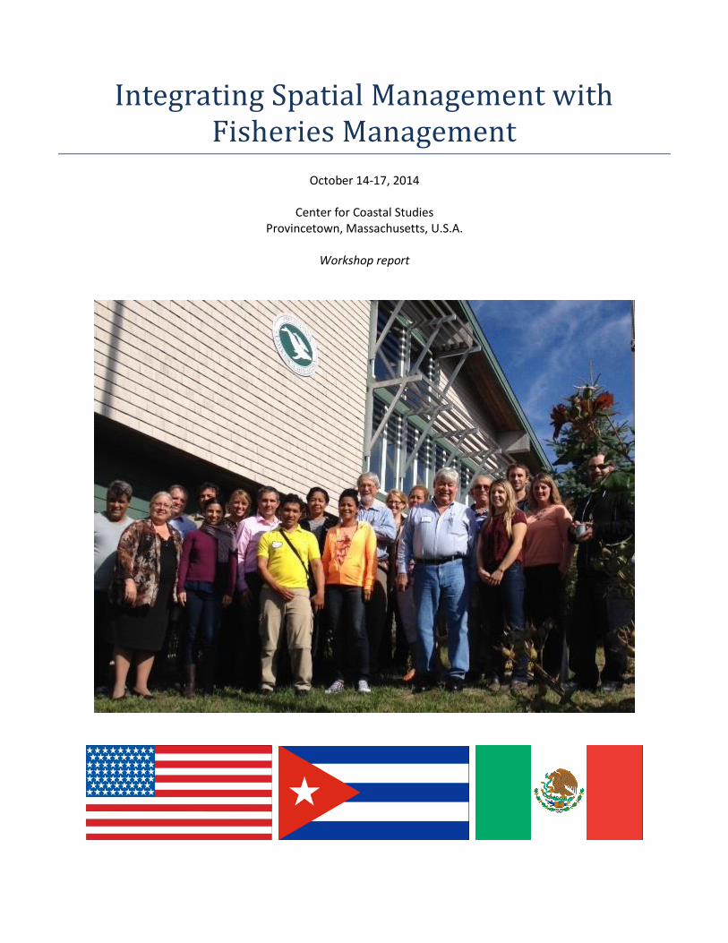
Integrating Spatial Management with Fisheries Management
October 14-17, 2014
Center for Coastal Studies Provincetown, Massachusetts, U.S.A.
Workshop report

ACKNOWLEDGEMENTS We thank the John D. and Catherine T. MacArthur Foundation, Ford Foundation, Christopher Reynolds Foundation, and Turner Foundation for their generosity in providing funds that made this workshop possible, as well as other efforts to strengthen collaborations, enhance scientific understanding and improve environmental management in Cuba. This workshop would not have been possible without the generous support of the Center for Coastal Studies (CCS), which provided a superb meeting venue at no cost, logistical support, guest presentations, and discounted local services. We would not have been able to enjoy such a fitting environment for the workshop with the efforts of CCS. Dolphin Fleet, a partner and supporter of CCS took the group out to Stellwagen Bank National Marine Sanctuary to see humpback whales, seabirds, other marine life and fishing vessels, also at no cost. This made the concepts and issues addressed at the workshop much more tangible, and provided a much needed break from four days of hard work and in-depth discussions. Last but not least, Patricia Pattison, a core member of EDF’s Cuba Program, was not able to attend the workshop because it coincided with her wedding (congratulations, Patricia!). However, she put in many long hours in advance preparing materials, making numerous logistical arrangements, and otherwise ensuring that the workshop went as smoothly as it possibly could.
1 INTEGRATING SPATIAL MANAGEMENT WITH FISHERIES MANAGEMENT
1. INTRODUCTION Cuba sits at the convergence of the Caribbean Sea, Gulf of Mexico and Atlantic Ocean. The largest of the Antillean chain, Cuba accounts for nearly half of the land mass of the Caribbean Islands. Stretching for 750 miles, Cuba supports diverse landscapes and seascapes and is the most important island in the region in terms of biodiversity. With more than 3,000 endemic vascular plant species, and more than 160 endemic animal species, Cuba is considered by many to be the “crown jewel of the Caribbean.” Cuba boasts magnificent coral reefs that support many hundreds of marine species – including endangered sea turtles, reef fish, sharks, dolphins and manatees – across more than 4,000 islets and keys. Some of the island’s elkhorn coral thickets are among the best remaining in the Caribbean, a relic of a once-profuse ecosystem severely damaged elsewhere, but also an important hope for the future. However, with increased fishing pressure and demand for seafood, overfishing has become a significant problem in recent years. Cuban scientists estimate that more than 40% of commercially important fish species are overfished, which poses a major threat to Cuba’s fishing communities, food security and marine biodiversity. To reverse this trend, resource managers, scientists, fishermen and government officials are looking for new ways to sustain their fishery resources and protect vital fish habitats, while also improving the livelihoods of communities. SOS Pesca is a multi-stakeholder initiative that aims to protect marine fish and coral reefs in southern Cuba through community-based resource management. SOS Pesca is funded by the European Union and led in Cuba by the National Center for Protected Areas (CNAP), the Italian NGO COSPE, and WWF-Netherlands, and includes the participation of the Ministry of Food and a number of other Cuban agencies and institutions. Environmental Defense Fund (EDF) is supporting SOS Pesca by providing technical assistance and expertise on fisheries science and management, and on the protection of essential marine habitats through spatial management tools. EDF’s experience and extensive research has shown that innovative strategies that combine fishery management with marine protected areas (MPAs) are the most effective ways to preserve and recover fish populations while safeguarding fishermen’s livelihoods. This research is particularly relevant to SOS Pesca’s two pilot communities, Playa Florida and Guayabal, where alternative fishery management practices and MPAs are being considered as ways in which to sustain fishery resources and habitats and to improve livelihoods. To advance efforts toward sustainable marine fisheries and ecosystems in Cuba, EDF and SOS Pesca leaders organized a four-day workshop in Provincetown, Massachusetts to explore how fisheries management and spatial management tools can be successfully integrated to achieve ecological, economic and social objectives. The workshop brought together scientists, managers, fishing leaders and conservationists from Cuba with those from two of its closest neighbors, the United States and Mexico, for presentations and discussions of case studies from the three nations, as well as interactive group exercises. The goal was to provide scientists and managers in Cuba with new knowledge and tools to resolve conflicts between conservation and fisheries objectives for MPAs, and to more effectively utilize spatial approaches in fisheries management. This report provides summaries of case studies from the three countries presented during the workshop, followed by lessons learned from those case studies. Next, summaries are provided of discussions that focused on innovative new directions for the integration of spatial management and fisheries management, with a particular eye to applications in Cuba. The workshop participants are listed in Appendix I and the agenda is included in Appendix II.
2 INTEGRATING SPATIAL MANAGEMENT WITH FISHERIES MANAGEMENT
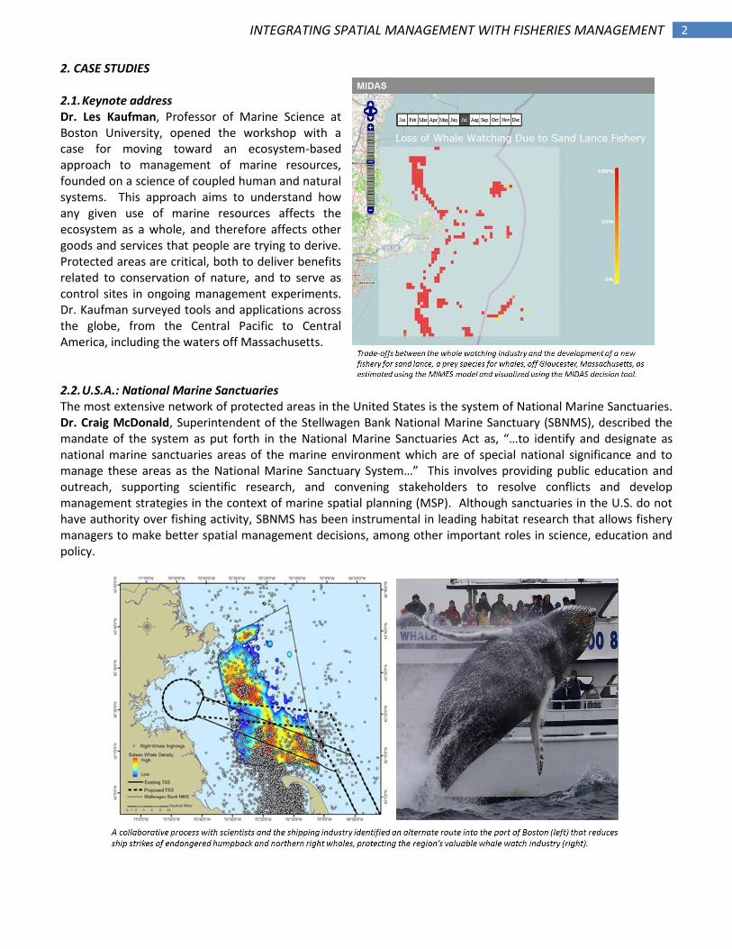
2. CASE STUDIES 2.1. Keynote address Dr. Les Kaufman, Professor of Marine Science at Boston University, opened the workshop with a case for moving toward an ecosystem-based approach to management of marine resources, founded on a science of coupled human and natural systems. This approach aims to understand how any given use of marine resources affects the ecosystem as a whole, and therefore affects other goods and services that people are trying to derive. Protected areas are critical, both to deliver benefits related to conservation of nature, and to serve as control sites in ongoing management experiments. Dr. Kaufman surveyed tools and applications across the globe, from the Central Pacific to Central America, including the waters off Massachusetts. 2.2. U.S.A.: National Marine Sanctuaries The most extensive network of protected areas in the United States is the system of National Marine Sanctuaries. Dr. Craig McDonald, Superintendent of the Stellwagen Bank National Marine Sanctuary (SBNMS), described the mandate of the system as put forth in the National Marine Sanctuaries Act as, “…to identify and designate as national marine sanctuaries areas of the marine environment which are of special national significance and to manage these areas as the National Marine Sanctuary System…” This involves providing public education and outreach, supporting scientific research, and convening stakeholders to resolve conflicts and develop management strategies in the context of marine spatial planning (MSP). Although sanctuaries in the U.S. do not have authority over fishing activity, SBNMS has been instrumental in leading habitat research that allows fishery managers to make better spatial management decisions, among other important roles in science, education and policy.
3 INTEGRATING SPATIAL MANAGEMENT WITH FISHERIES MANAGEMENT
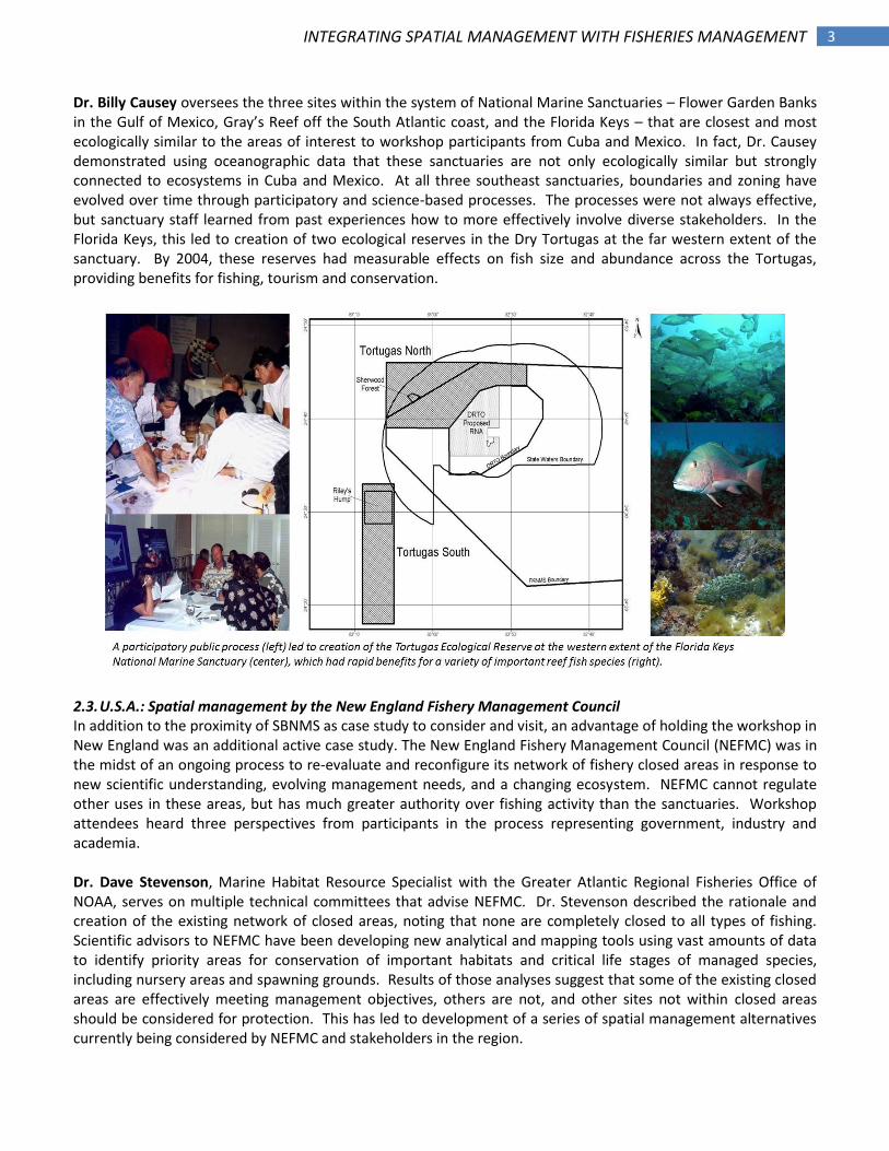
Dr. Billy Causey oversees the three sites within the system of National Marine Sanctuaries – Flower Garden Banks in the Gulf of Mexico, Gray’s Reef off the South Atlantic coast, and the Florida Keys – that are closest and most ecologically similar to the areas of interest to workshop participants from Cuba and Mexico. In fact, Dr. Causey demonstrated using oceanographic data that these sanctuaries are not only ecologically similar but strongly connected to ecosystems in Cuba and Mexico. At all three southeast sanctuaries, boundaries and zoning have evolved over time through participatory and science-based processes. The processes were not always effective, but sanctuary staff learned from past experiences how to more effectively involve diverse stakeholders. In the Florida Keys, this led to creation of two ecological reserves in the Dry Tortugas at the far western extent of the sanctuary. By 2004, these reserves had measurable effects on fish size and abundance across the Tortugas, providing benefits for fishing, tourism and conservation.
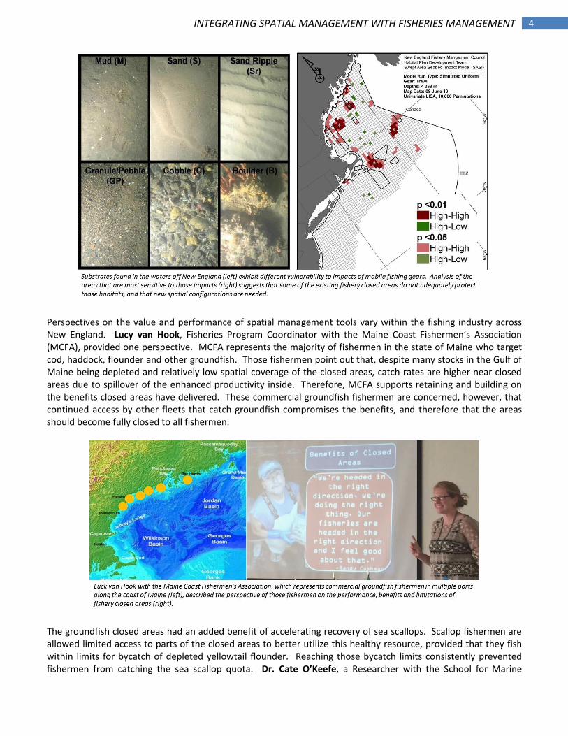
2.3. U.S.A.: Spatial management by the New England Fishery Management Council In addition to the proximity of SBNMS as case study to consider and visit, an advantage of holding the workshop in New England was an additional active case study. The New England Fishery Management Council (NEFMC) was in the midst of an ongoing process to re-evaluate and reconfigure its network of fishery closed areas in response to new scientific understanding, evolving management needs, and a changing ecosystem. NEFMC cannot regulate other uses in these areas, but has much greater authority over fishing activity than the sanctuaries. Workshop attendees heard three perspectives from participants in the process representing government, industry and academia. Dr. Dave Stevenson, Marine Habitat Resource Specialist with the Greater Atlantic Regional Fisheries Office of NOAA, serves on multiple technical committees that advise NEFMC. Dr. Stevenson described the rationale and creation of the existing network of closed areas, noting that none are completely closed to all types of fishing. Scientific advisors to NEFMC have been developing new analytical and mapping tools using vast amounts of data to identify priority areas for conservation of important habitats and critical life stages of managed species, including nursery areas and spawning grounds. Results of those analyses suggest that some of the existing closed areas are effectively meeting management objectives, others are not, and other sites not within closed areas should be considered for protection. This has led to development of a series of spatial management alternatives currently being considered by NEFMC and stakeholders in the region.
4 INTEGRATING SPATIAL MANAGEMENT WITH FISHERIES MANAGEMENT
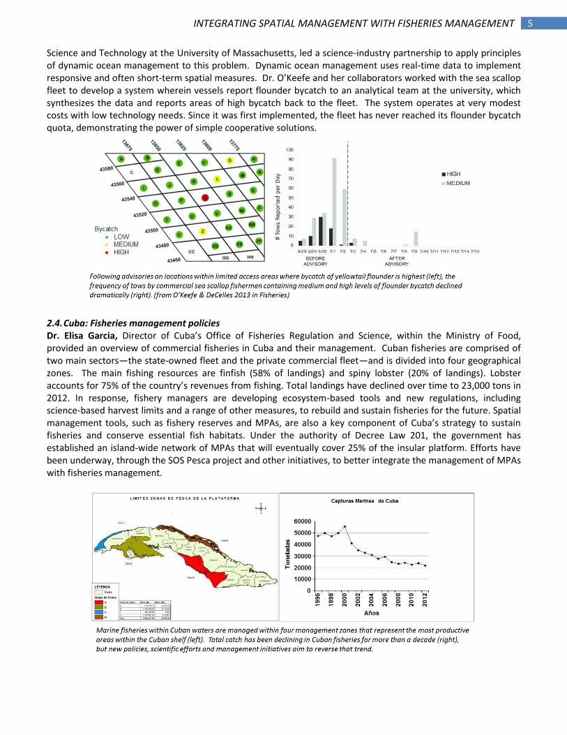
Perspectives on the value and performance of spatial management tools vary within the fishing industry across New England. Lucy van Hook, Fisheries Program Coordinator with the Maine Coast Fishermen’s Association (MCFA), provided one perspective. MCFA represents the majority of fishermen in the state of Maine who target cod, haddock, flounder and other groundfish. Those fishermen point out that, despite many stocks in the Gulf of Maine being depleted and relatively low spatial coverage of the closed areas, catch rates are higher near closed areas due to spillover of the enhanced productivity inside. Therefore, MCFA supports retaining and building on the benefits closed areas have delivered. These commercial groundfish fishermen are concerned, however, that continued access by other fleets that catch groundfish compromises the benefits, and therefore that the areas should become fully closed to all fishermen.
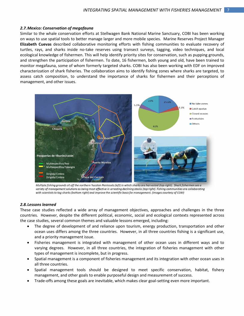
The groundfish closed areas had an added benefit of accelerating recovery of sea scallops. Scallop fishermen are allowed limited access to parts of the closed areas to better utilize this healthy resource, provided that they fish within limits for bycatch of depleted yellowtail flounder. Reaching those bycatch limits consistently prevented fishermen from catching the sea scallop quota. Dr. Cate O’Keefe, a Researcher with the School for Marine
5 INTEGRATING SPATIAL MANAGEMENT WITH FISHERIES MANAGEMENT
Science and Technology at the University of Massachusetts, led a science-industry partnership to apply principles of dynamic ocean management to this problem. Dynamic ocean management uses real-time data to implement responsive and often short-term spatial measures. Dr. O’Keefe and her collaborators worked with the sea scallop fleet to develop a system wherein vessels report flounder bycatch to an analytical team at the university, which synthesizes the data and reports areas of high bycatch back to the fleet. The system operates at very modest costs with low technology needs. Since it was first implemented, the fleet has never reached its flounder bycatch quota, demonstrating the power of simple cooperative solutions.
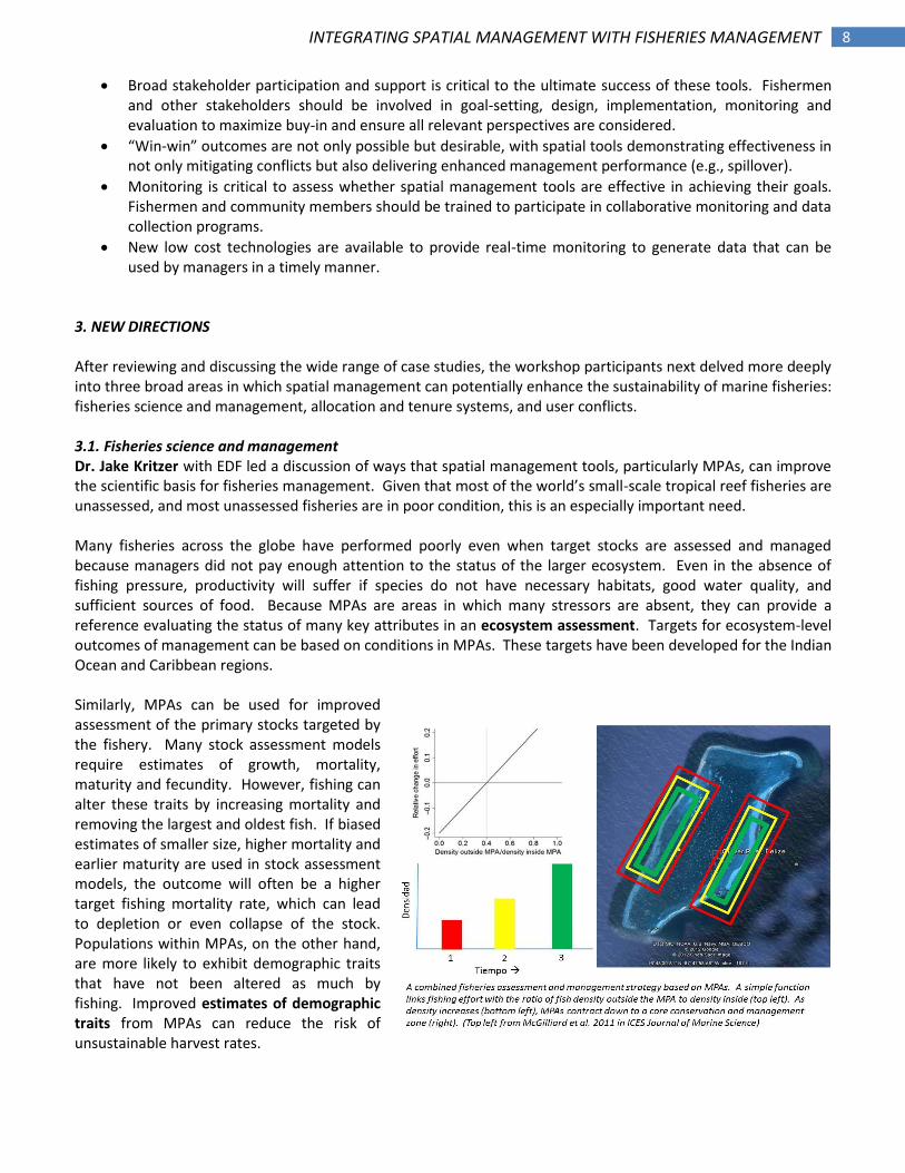
2.4. Cuba: Fisheries management policies Dr. Elisa Garcia, Director of Cuba’s Office of Fisheries Regulation and Science, within the Ministry of Food, provided an overview of commercial fisheries in Cuba and their management. Cuban fisheries are comprised of two main sectors—the state-owned fleet and the private commercial fleet—and is divided into four geographical zones. The main fishing resources are finfish (58% of landings) and spiny lobster (20% of landings). Lobster accounts for 75% of the country’s revenues from fishing. Total landings have declined over time to 23,000 tons in 2012. In response, fishery managers are developing ecosystem-based tools and new regulations, including science-based harvest limits and a range of other measures, to rebuild and sustain fisheries for the future. Spatial management tools, such as fishery reserves and MPAs, are also a key component of Cuba’s strategy to sustain fisheries and conserve essential fish habitats. Under the authority of Decree Law 201, the government has established an island-wide network of MPAs that will eventually cover 25% of the insular platform. Efforts have been underway, through the SOS Pesca project and other initiatives, to better integrate the management of MPAs with fisheries management.

6 INTEGRATING SPATIAL MANAGEMENT WITH FISHERIES MANAGEMENT
2.5. Cuba: Spatial management and the SOS Pesca project Maykel Rodríguez, with the National Enterprise of Flora and Fauna within the Cuban Ministry of Agriculture, described efforts to better integrate fisheries and MPAs within the SOS Pesca Project’s two pilot communities, Playa Florida and Guayabal. Two MPAs – Refuge Santa Maria and Refuge Monte Capauana – will soon be established in the area through a participatory process that includes fishermen and members of the communities. Both are designed to protect spawning and nursery areas for finfish while allowing fishing on the offshore reefs. These areas are also important refuges for migratory birds and American crocodiles. Managers and stakeholders are particularly focused on addressing threats to the protected areas, including overfishing, illegal fishing, destructive fishing gears, and problems associated with lionfish, walking catfish and other invasive species. The ultimate goal is to produce and implement management plans for both MPAs.
2.6. Mexico: Kanan Kay Alliance Stuart Fulton, Marine Reserves Project Manager with Comunidad y Biodiversidad (COBI) in Mexico, described the Kanan Kay Alliance, which unites fishing cooperatives, foundations, scientists, government agencies, and NGOs to promote sustainable fishing and to establish 20% of the waters around Quintana Roo as no-take reserves. These reserves started as community agreements that later gained legal status through the national fishing law under the jurisdiction of the National Fishing and Aquaculture Commission (CONAPESCA). COBI led development of a participatory monitoring program for the reserves. Data collected by scientists, fishermen and volunteers show high concurrence, illustrating the robustness of the program. Early results suggest that mean size of fish is already increasing within the reserves after only one year, especially for heavily exploited snappers and groupers. Monitoring has also identified an important spawning site for Nassau grouper.
7 INTEGRATING SPATIAL MANAGEMENT WITH FISHERIES MANAGEMENT
2.7. Mexico: Conservation of megafauna Similar to the whale conservation efforts at Stellwagen Bank National Marine Sanctuary, COBI has been working on ways to use spatial tools to better manage larger and more mobile species. Marine Reserves Project Manager Elizabeth Cuevas described collaborative monitoring efforts with fishing communities to evaluate recovery of turtles, rays, and sharks inside no-take reserves using transect surveys, tagging, video techniques, and local ecological knowledge of fishermen. This will help identify priority sites for conservation, such as pupping grounds, and strengthen the participation of fishermen. To date, 16 fishermen, both young and old, have been trained to monitor megafauna, some of whom formerly targeted sharks. COBI has also been working with EDF on improved characterization of shark fisheries. The collaboration aims to identify fishing zones where sharks are targeted, to assess catch composition, to understand the importance of sharks for fishermen and their perceptions of management, and other issues.
2.8. Lessons learned These case studies reflected a wide array of management objectives, approaches and challenges in the three countries. However, despite the different political, economic, social and ecological contexts represented across the case studies, several common themes and valuable lessons emerged, including:
The degree of development of and reliance upon tourism, energy production, transportation and other ocean uses differs among the three countries. However, in all three countries fishing is a significant use, and a priority management issue.
Fisheries management is integrated with management of other ocean uses in different ways and to varying degrees. However, in all three countries, the integration of fisheries management with other types of management is incomplete, but in progress.
Spatial management is a component of fisheries management and its integration with other ocean uses in all three countries.
Spatial management tools should be designed to meet specific conservation, habitat, fishery management, and other goals to enable purposeful design and measurement of success.
Trade-offs among these goals are inevitable, which makes clear goal-setting even more important.
8 INTEGRATING SPATIAL MANAGEMENT WITH FISHERIES MANAGEMENT
Broad stakeholder participation and support is critical to the ultimate success of these tools. Fishermen and other stakeholders should be involved in goal-setting, design, implementation, monitoring and evaluation to maximize buy-in and ensure all relevant perspectives are considered.
“Win-win” outcomes are not only possible but desirable, with spatial tools demonstrating effectiveness in not only mitigating conflicts but also delivering enhanced management performance (e.g., spillover).
Monitoring is critical to assess whether spatial management tools are effective in achieving their goals. Fishermen and community members should be trained to participate in collaborative monitoring and data collection programs.
New low cost technologies are available to provide real-time monitoring to generate data that can be used by managers in a timely manner.
3. NEW DIRECTIONS After reviewing and discussing the wide range of case studies, the workshop participants next delved more deeply into three broad areas in which spatial management can potentially enhance the sustainability of marine fisheries: fisheries science and management, allocation and tenure systems, and user conflicts. 3.1. Fisheries science and management Dr. Jake Kritzer with EDF led a discussion of ways that spatial management tools, particularly MPAs, can improve the scientific basis for fisheries management. Given that most of the world’s small-scale tropical reef fisheries are unassessed, and most unassessed fisheries are in poor condition, this is an especially important need. Many fisheries across the globe have performed poorly even when target stocks are assessed and managed because managers did not pay enough attention to the status of the larger ecosystem. Even in the absence of fishing pressure, productivity will suffer if species do not have necessary habitats, good water quality, and sufficient sources of food. Because MPAs are areas in which many stressors are absent, they can provide a reference evaluating the status of many key attributes in an ecosystem assessment. Targets for ecosystem-level outcomes of management can be based on conditions in MPAs. These targets have been developed for the Indian Ocean and Caribbean regions. Similarly, MPAs can be used for improved assessment of the primary stocks targeted by the fishery. Many stock assessment models require estimates of growth, mortality, maturity and fecundity. However, fishing can alter these traits by increasing mortality and removing the largest and oldest fish. If biased estimates of smaller size, higher mortality and earlier maturity are used in stock assessment models, the outcome will often be a higher target fishing mortality rate, which can lead to depletion or even collapse of the stock. Populations within MPAs, on the other hand, are more likely to exhibit demographic traits that have not been altered as much by fishing. Improved estimates of demographic traits from MPAs can reduce the risk of unsustainable harvest rates.
9 INTEGRATING SPATIAL MANAGEMENT WITH FISHERIES MANAGEMENT
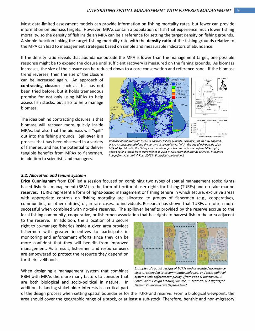
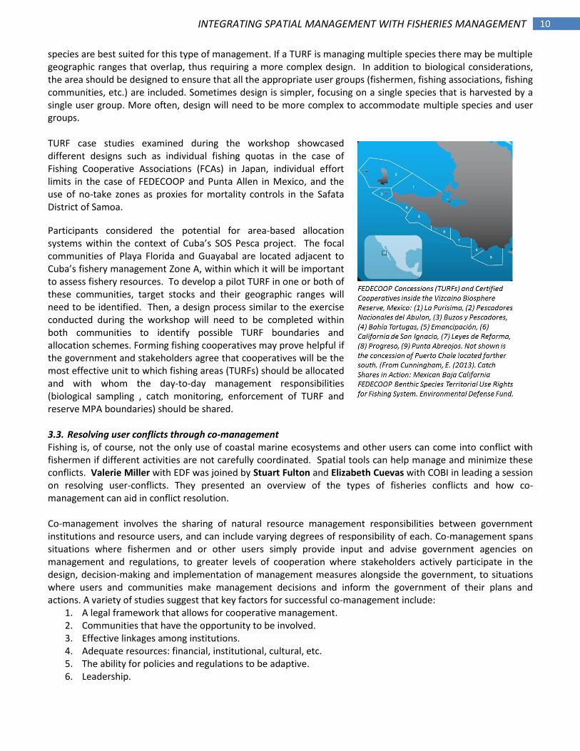
Most data-limited assessment models can provide information on fishing mortality rates, but fewer can provide information on biomass targets. However, MPAs contain a population of fish that experience much lower fishing mortality, so the density of fish inside an MPA can be a reference for setting the target density on fishing grounds. A simple function linking the target fishing mortality rate with the density ratio of the fishing grounds relative to the MPA can lead to management strategies based on simple and measurable indicators of abundance. If the density ratio reveals that abundance outside the MPA is lower than the management target, one possible response might be to expand the closure until sufficient recovery is measured on the fishing grounds. As biomass increases, the size of the closure can be reduced down to a core conservation and reference zone. If the biomass trend reverses, then the size of the closure can be increased again. An approach of contracting closures such as this has not been tried before, but it holds tremendous promise for not only using MPAs to help assess fish stocks, but also to help manage biomass. The idea behind contracting closures is that biomass will recover more quickly inside MPAs, but also that the biomass will “spill” out into the fishing grounds. Spillover is a process that has been observed in a variety of fisheries, and has the potential to deliver tangible benefits from MPAs to fishermen, in addition to scientists and managers. 3.2. Allocation and tenure systems Erica Cunningham from EDF led a session focused on combining two types of spatial management tools: rights based fisheries management (RBM) in the form of territorial user rights for fishing (TURFs) and no-take marine reserves. TURFs represent a form of rights-based management or fishing tenure in which secure, exclusive areas with appropriate controls on fishing mortality are allocated to groups of fishermen (e.g., cooperatives, communities, or other entities) or, in rare cases, to individuals. Research has shown that TURFs are often more successful when combined with no-take reserves. The spillover benefits provided by the reserve accrue to the local fishing community, cooperative, or fishermen association that has rights to harvest fish in the area adjacent to the reserve. In addition, the allocation of a secure right to co-manage fisheries inside a given area provides fishermen with greater incentives to participate in monitoring and enforcement efforts since they can be more confident that they will benefit from improved management. As a result, fishermen and resource users are empowered to protect the resource they depend on for their livelihoods. When designing a management system that combines RBM with MPAs there are many factors to consider that are both biological and socio-political in nature. In addition, balancing stakeholder interests is a critical part of the design process when setting spatial boundaries for the TURF and reserve. From a biological viewpoint, the area should cover the geographic range of a stock, or at least a sub-stock. Therefore, benthic and non-migratory
10 INTEGRATING SPATIAL MANAGEMENT WITH FISHERIES MANAGEMENT
species are best suited for this type of management. If a TURF is managing multiple species there may be multiple geographic ranges that overlap, thus requiring a more complex design. In addition to biological considerations, the area should be designed to ensure that all the appropriate user groups (fishermen, fishing associations, fishing communities, etc.) are included. Sometimes design is simpler, focusing on a single species that is harvested by a single user group. More often, design will need to be more complex to accommodate multiple species and user groups. TURF case studies examined during the workshop showcased different designs such as individual fishing quotas in the case of Fishing Cooperative Associations (FCAs) in Japan, individual effort limits in the case of FEDECOOP and Punta Allen in Mexico, and the use of no-take zones as proxies for mortality controls in the Safata District of Samoa.
Participants considered the potential for area-based allocation systems within the context of Cuba’s SOS Pesca project. The focal communities of Playa Florida and Guayabal are located adjacent to Cuba’s fishery management Zone A, within which it will be important to assess fishery resources. To develop a pilot TURF in one or both of these communities, target stocks and their geographic ranges will need to be identified. Then, a design process similar to the exercise conducted during the workshop will need to be completed within both communities to identify possible TURF boundaries and allocation schemes. Forming fishing cooperatives may prove helpful if the government and stakeholders agree that cooperatives will be the most effective unit to which fishing areas (TURFs) should be allocated and with whom the day-to-day management responsibilities (biological sampling , catch monitoring, enforcement of TURF and reserve MPA boundaries) should be shared. 3.3. Resolving user conflicts through co-management Fishing is, of course, not the only use of coastal marine ecosystems and other users can come into conflict with fishermen if different activities are not carefully coordinated. Spatial tools can help manage and minimize these conflicts. Valerie Miller with EDF was joined by Stuart Fulton and Elizabeth Cuevas with COBI in leading a session on resolving user-conflicts. They presented an overview of the types of fisheries conflicts and how co-management can aid in conflict resolution. Co-management involves the sharing of natural resource management responsibilities between government institutions and resource users, and can include varying degrees of responsibility of each. Co-management spans situations where fishermen and or other users simply provide input and advise government agencies on management and regulations, to greater levels of cooperation where stakeholders actively participate in the design, decision-making and implementation of management measures alongside the government, to situations where users and communities make management decisions and inform the government of their plans and actions. A variety of studies suggest that key factors for successful co-management include:
1. A legal framework that allows for cooperative management. 2. Communities that have the opportunity to be involved. 3. Effective linkages among institutions. 4. Adequate resources: financial, institutional, cultural, etc. 5. The ability for policies and regulations to be adaptive. 6. Leadership.
11 INTEGRATING SPATIAL MANAGEMENT WITH FISHERIES MANAGEMENT
7. Tenure or other secure use rights. 8. Mechanisms for monitoring and enforcement.
Workshop participants considered co-management arrangements in more detail by examining the system being used for fisheries in Quintana Roo, Mexico. Successful co-management in one sector, such as fisheries, can be a template for expansion among resource users. Important components include:
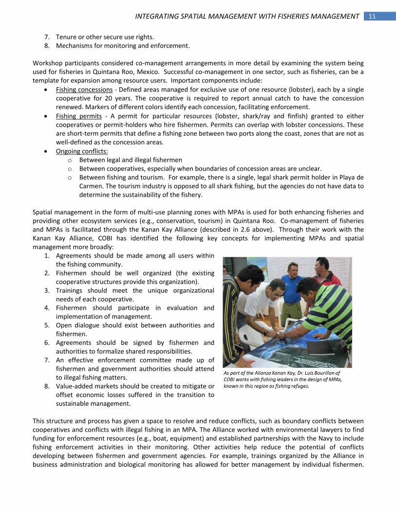
Fishing concessions - Defined areas managed for exclusive use of one resource (lobster), each by a single cooperative for 20 years. The cooperative is required to report annual catch to have the concession renewed. Markers of different colors identify each concession, facilitating enforcement.
Fishing permits - A permit for particular resources (lobster, shark/ray and finfish) granted to either cooperatives or permit-holders who hire fishermen. Permits can overlap with lobster concessions. These are short-term permits that define a fishing zone between two ports along the coast, zones that are not as well-defined as the concession areas.
Ongoing conflicts: o Between legal and illegal fishermen o Between cooperatives, especially when boundaries of concession areas are unclear. o Between fishing and tourism. For example, there is a single, legal shark permit holder in Playa de
Carmen. The tourism industry is opposed to all shark fishing, but the agencies do not have data to determine the sustainability of the fishery.
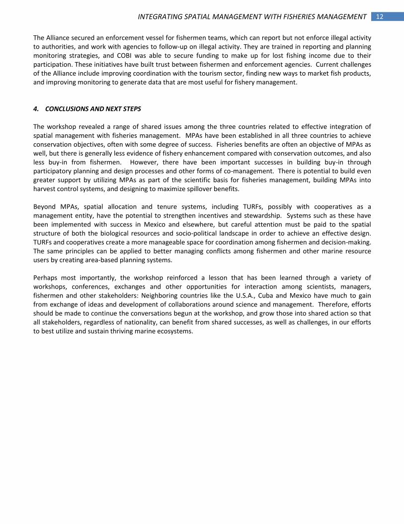
Spatial management in the form of multi-use planning zones with MPAs is used for both enhancing fisheries and providing other ecosystem services (e.g., conservation, tourism) in Quintana Roo. Co-management of fisheries and MPAs is facilitated through the Kanan Kay Alliance (described in 2.6 above). Through their work with the Kanan Kay Alliance, COBI has identified the following key concepts for implementing MPAs and spatial management more broadly:
1. Agreements should be made among all users within the fishing community.
2. Fishermen should be well organized (the existing cooperative structures provide this organization).
3. Trainings should meet the unique organizational needs of each cooperative.
4. Fishermen should participate in evaluation and implementation of management.
5. Open dialogue should exist between authorities and fishermen.
6. Agreements should be signed by fishermen and authorities to formalize shared responsibilities.
7. An effective enforcement committee made up of fishermen and government authorities should attend to illegal fishing matters.
8. Value-added markets should be created to mitigate or offset economic losses suffered in the transition to sustainable management.
This structure and process has given a space to resolve and reduce conflicts, such as boundary conflicts between cooperatives and conflicts with illegal fishing in an MPA. The Alliance worked with environmental lawyers to find funding for enforcement resources (e.g., boat, equipment) and established partnerships with the Navy to include fishing enforcement activities in their monitoring. Other activities help reduce the potential of conflicts developing between fishermen and government agencies. For example, trainings organized by the Alliance in business administration and biological monitoring has allowed for better management by individual fishermen.
12 INTEGRATING SPATIAL MANAGEMENT WITH FISHERIES MANAGEMENT
The Alliance secured an enforcement vessel for fishermen teams, which can report but not enforce illegal activity to authorities, and work with agencies to follow-up on illegal activity. They are trained in reporting and planning monitoring strategies, and COBI was able to secure funding to make up for lost fishing income due to their participation. These initiatives have built trust between fishermen and enforcement agencies. Current challenges of the Alliance include improving coordination with the tourism sector, finding new ways to market fish products, and improving monitoring to generate data that are most useful for fishery management. 4. CONCLUSIONS AND NEXT STEPS The workshop revealed a range of shared issues among the three countries related to effective integration of spatial management with fisheries management. MPAs have been established in all three countries to achieve conservation objectives, often with some degree of success. Fisheries benefits are often an objective of MPAs as well, but there is generally less evidence of fishery enhancement compared with conservation outcomes, and also less buy-in from fishermen. However, there have been important successes in building buy-in through participatory planning and design processes and other forms of co-management. There is potential to build even greater support by utilizing MPAs as part of the scientific basis for fisheries management, building MPAs into harvest control systems, and designing to maximize spillover benefits. Beyond MPAs, spatial allocation and tenure systems, including TURFs, possibly with cooperatives as a management entity, have the potential to strengthen incentives and stewardship. Systems such as these have been implemented with success in Mexico and elsewhere, but careful attention must be paid to the spatial structure of both the biological resources and socio-political landscape in order to achieve an effective design. TURFs and cooperatives create a more manageable space for coordination among fishermen and decision-making. The same principles can be applied to better managing conflicts among fishermen and other marine resource users by creating area-based planning systems. Perhaps most importantly, the workshop reinforced a lesson that has been learned through a variety of workshops, conferences, exchanges and other opportunities for interaction among scientists, managers, fishermen and other stakeholders: Neighboring countries like the U.S.A., Cuba and Mexico have much to gain from exchange of ideas and development of collaborations around science and management. Therefore, efforts should be made to continue the conversations begun at the workshop, and grow those into shared action so that all stakeholders, regardless of nationality, can benefit from shared successes, as well as challenges, in our efforts to best utilize and sustain thriving marine ecosystems.
13 INTEGRATING SPATIAL MANAGEMENT WITH FISHERIES MANAGEMENT
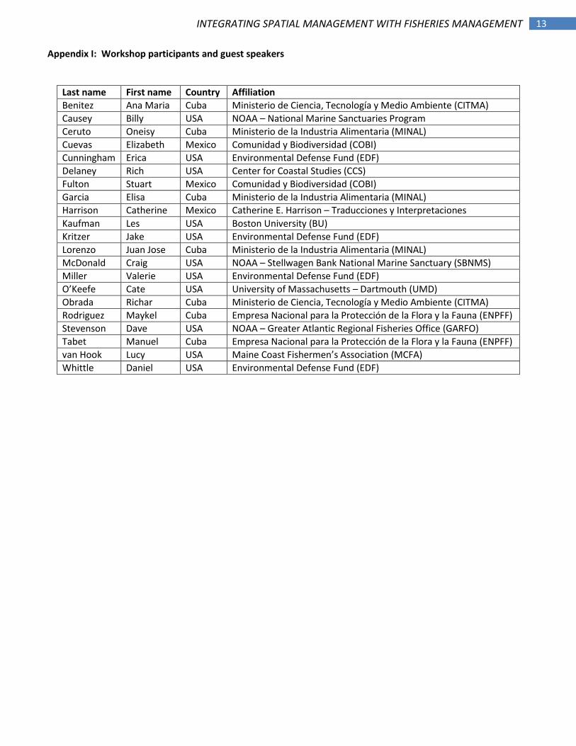
Appendix I: Workshop participants and guest speakers
Last name First name Country Affiliation
Benitez Ana Maria Cuba Ministerio de Ciencia, Tecnología y Medio Ambiente (CITMA)
Causey Billy USA NOAA – National Marine Sanctuaries Program
Ceruto Oneisy Cuba Ministerio de la Industria Alimentaria (MINAL)
Cuevas Elizabeth Mexico Comunidad y Biodiversidad (COBI)
Cunningham Erica USA Environmental Defense Fund (EDF)
Delaney Rich USA Center for Coastal Studies (CCS)
Fulton Stuart Mexico Comunidad y Biodiversidad (COBI)
Garcia Elisa Cuba Ministerio de la Industria Alimentaria (MINAL)
Harrison Catherine Mexico Catherine E. Harrison – Traducciones y Interpretaciones
Kaufman Les USA Boston University (BU)
Kritzer Jake USA Environmental Defense Fund (EDF)
Lorenzo Juan Jose Cuba Ministerio de la Industria Alimentaria (MINAL)
McDonald Craig USA NOAA – Stellwagen Bank National Marine Sanctuary (SBNMS)
Miller Valerie USA Environmental Defense Fund (EDF)
O’Keefe Cate USA University of Massachusetts – Dartmouth (UMD)
Obrada Richar Cuba Ministerio de Ciencia, Tecnología y Medio Ambiente (CITMA)
Rodriguez Maykel Cuba Empresa Nacional para la Protección de la Flora y la Fauna (ENPFF)
Stevenson Dave USA NOAA – Greater Atlantic Regional Fisheries Office (GARFO)
Tabet Manuel Cuba Empresa Nacional para la Protección de la Flora y la Fauna (ENPFF)
van Hook Lucy USA Maine Coast Fishermen’s Association (MCFA)
Whittle Daniel USA Environmental Defense Fund (EDF)
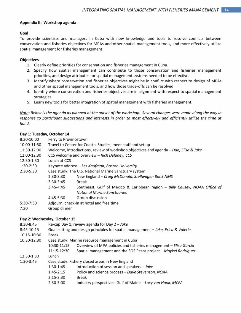
14 INTEGRATING SPATIAL MANAGEMENT WITH FISHERIES MANAGEMENT
Appendix II: Workshop agenda Goal To provide scientists and managers in Cuba with new knowledge and tools to resolve conflicts between conservation and fisheries objectives for MPAs and other spatial management tools, and more effectively utilize spatial management for fisheries management. Objectives
1. Clearly define priorities for conservation and fisheries management in Cuba. 2. Specify how spatial management can contribute to those conservation and fisheries management
priorities, and design attributes for spatial management systems needed to be effective. 3. Identify where conservation and fisheries objectives might be in conflict with respect to design of MPAs
and other spatial management tools, and how those trade-offs can be resolved. 4. Identify where conservation and fisheries objectives are in alignment with respect to spatial management
strategies. 5. Learn new tools for better integration of spatial management with fisheries management.
Note: Below is the agenda as planned at the outset of the workshop. Several changes were made along the way in response to participant suggestions and interests in order to most effectively and efficiently utilize the time at hand. Day 1: Tuesday, October 14 8:30-10:00 Ferry to Provincetown 10:00-11:30 Travel to Center for Coastal Studies, meet staff and set up 11:30-12:00 Welcome, introductions, review of workshop objectives and agenda – Dan, Elisa & Jake 12:00-12:30 CCS welcome and overview – Rich Delaney, CCS 12:30-1:30 Lunch at CCS 1:30-2:30 Keynote address – Les Kaufman, Boston University 2:30-5:30 Case study: The U.S. National Marine Sanctuary system
2:30-3:30 New England – Craig McDonald, Stellwagen Bank NMS 3:30-3:45 Break 3:45-4:45 Southeast, Gulf of Mexico & Caribbean region – Billy Causey, NOAA Office of
National Marine Sanctuaries 4:45-5:30 Group discussion
5:30-7:30 Adjourn, check-in at hotel and free time 7:30 Group dinner Day 2: Wednesday, October 15 8:30-8:45 Re-cap Day 1; review agenda for Day 2 – Jake 8:45-10:15 Goal-setting and design principles for spatial management – Jake, Erica & Valerie 10:15-10:30 Break 10:30-12:30 Case study: Marine resource management in Cuba 10:30-11:15 Overview of MPA policies and fisheries management – Elisa Garcia
11:15-12:30 Spatial management and the SOS Pesca project – Maykel Rodríguez 12:30-1:30 Lunch 1:30-3:45 Case study: Fishery closed areas in New England
1:30-1:45 Introduction of session and speakers – Jake 1:45-2:15 Policy and science process – Dave Stevenson, NOAA 2:15-2:30 Break 2:30-3:00 Industry perspectives: Gulf of Maine – Lucy van Hook, MCFA
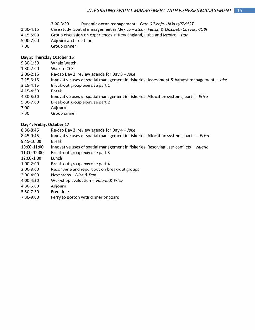
15 INTEGRATING SPATIAL MANAGEMENT WITH FISHERIES MANAGEMENT
3:00-3:30 Dynamic ocean management – Cate O’Keefe, UMass/SMAST 3:30-4:15 Case study: Spatial management in Mexico – Stuart Fulton & Elizabeth Cuevas, COBI 4:15-5:00 Group discussion on experiences in New England, Cuba and Mexico – Dan 5:00-7:00 Adjourn and free time 7:00 Group dinner Day 3: Thursday October 16 9:30-1:30 Whale Watch! 1:30-2:00 Walk to CCS 2:00-2:15 Re-cap Day 2; review agenda for Day 3 – Jake 2:15-3:15 Innovative uses of spatial management in fisheries: Assessment & harvest management – Jake 3:15-4:15 Break-out group exercise part 1 4:15-4:30 Break 4:30-5:30 Innovative uses of spatial management in fisheries: Allocation systems, part I – Erica 5:30-7:00 Break-out group exercise part 2 7:00 Adjourn 7:30 Group dinner Day 4: Friday, October 17 8:30-8:45 Re-cap Day 3; review agenda for Day 4 – Jake 8:45-9:45 Innovative uses of spatial management in fisheries: Allocation systems, part II – Erica 9:45-10:00 Break 10:00-11:00 Innovative uses of spatial management in fisheries: Resolving user conflicts – Valerie 11:00-12:00 Break-out group exercise part 3 12:00-1:00 Lunch 1:00-2:00 Break-out group exercise part 4 2:00-3:00 Reconvene and report out on break-out groups 3:00-4:00 Next steps – Elisa & Dan 4:00-4:30 Workshop evaluation – Valerie & Erica 4:30-5:00 Adjourn 5:30-7:30 Free time 7:30-9:00 Ferry to Boston with dinner onboard