integrated systems for forecasting urban meteorology, air pollution and population exposure:...
TRANSCRIPT

Integrated Systems for Forecasting Urban Meteorology, Air Pollution and
Population Exposure: Experience of European FUMAPEX and COST715
Studies
Alexander BaklanovDanish Meteorological Institute
[email protected] contributions from the project partners
The First GURME Air Quality Forecasting Workshop for the Latin America project,
Santiago de Chile, 13-16 October 2003 University of Chile
Faculty of Physical and Mathematical Sciences

European COST Action 715: URBAN METEOROLOGY
‘Meteorology Applied to Urban Air Pollution Problems’Action period: 1999-2003
(Chairman Bernard Fisher, UK)
• WG1: Wind fields in urban areas (Chair M. Rotach).
• WG2: Mixing height and surface energy budgets (Chair M Piringer).
• WG3: Meteorology during peak pollution episodes (Chair J. Kukkonen).
• WG4: Input data for urban air pollution models (Chair M. Schatzmann).
Basel UrBan Boundary Layer Experiment (BUBBLE), initiated by the Swiss COST organisation (Leader M. Rotach) UBL/CLU, Marseille, France, an associated project of ESCOMPTE UBL/CLU, Marseille, France, an associated project of ESCOMPTE (Leader P.
Mestayer)

Integrated Systems for Forecasting Urban Meteorology, Air Pollution
and Population Exposure
FUMAPEX
EVK4-2001-00281http://fumapex.dmi.dk
Shared-cost RTD, November 2002 – October 2005
The Fifth Framework Programme (FP5)Energy, Environment and Sustainable Development
Sub-programme: Environment and Sustainable DevelopmentKey Action 4: City of Tomorrow and Cultural Heritage

Project participants
Danish Meteorological Institute, DMI A.Baklanov (co-ordinator), A.Rasmussen
German Weather Service, DWD B. Fay
Hamburg University, MIHU M.Schatzmann
Centro De Estudios Ambientales Del Mediterrano, CEAM M. Millan
Ecole Centrale de Nantes, ECN P. Mestayer
Finnish Meteorological Institute, FMI J. Kukkonen
ARIANET Consulting, ARIA NET S. Finardi
Environ. Protection Agency of Emilia Romagna, ARPA M. Deserti
The Norwegian Meteorological Institute, DNMI N. Bjergene, E. Berge
Norwegian Institute for Air Research, NILU L.H. Slordal
University of Hertfordshire, UH R.S. Sokhi
INSA CNRS-Universite-INSA de Rouen, CORIA A. Coppalle
Finnish National Public Health Institute, KTL M. Jantunen
Environmental Protection Agency of Piedmont, ARPAP F. Lollobrigida
Environment Institute - Joint Research Center, JRC EI A. Skouloudis
Swiss Federal Institute of Technology, ETH A. Clappier, M. Rotach
University of Uppsala, MIUU S. Zilitinkevich
Université catolique de Louvain, UCL G. Schayes
Danish Emergency Management Agency, DEMA S.C. Hoe
Helsinki Metropolitan Area Council, YTV P. Aarnio
Norwegian Traffic Authorities, NTA P. Rosland
Municipality of Oslo, MO O.M. Hunnes

WHY to study it now ?
Meteorological fields constitute a main source of uncertainty in urban air quality (UAQ) forecasting models.
Historically, UAQ forecasting and NWP models were developed separately and there is no tradition for co-operation between the modelling groups.
This was plausible in the previous decades when the resolution of NWP models was too poor for city-scale air pollution forecasting, but the situation has now changed and it is obvious that a revision of the conventional conception of urban air quality forecasting is required.

FUMAPEX objectives
(i) the improvement of meteorological forecasts for urban areas,
(ii) the connection of NWP models to UAQ and population exposure models,
(iii) the building of improved Urban Air Quality Information and Forecasting Systems (UAQIFS), and
(iv) their application in cities in various European climates.

In order to achieve the innovative FUMAPEX goal of establishing and implementing an improved new UAQIFS in four European target cities to assist sustainable urban development, the following steps have to be achieved:
1. improve predictions of the meteorological fields needed by UAP models by refining resolution and developing specific parameterisations of the urban effects in NWP models,
2.develop suitable interface/meteorological pre-processors from NWP to UAP models,
3.validate the improvements in NWP models and meteorological pre-processors by evaluating their effects on the UAP models against urban measurement data,
4.apply the improved meteorological data to UAQ and population exposure models and compare and analyse the results, and
5. successfully link meteorologists/NWP modellers with urban air pollution scientists and ’end-users’ of UAQIFS.

FUMAPEX Work Packages Structure
WP 1 Analysis and evaluation of air pollution episodes in European cities (leaded by J. Kukkonen, FMI)
WP 2 Assessment of different existing approaches to forecast UAP episodes (leaded by R.S. Sokhi, UH)
WP 3 Testing the quality of different operational meteorological forecasting systems for urban areas (leaded by B. Fay, DWD)
WP 4 Improvement of parameterisation of urban atmospheric processes and urban physiographic data classification (leaded by A. Baklanov, DMI)
WP 5 Development of interface between urban-scale NWP and UAP models (leaded by S. Finardi, Arianet)
WP 6 Evaluation of the suggested system (UAQIFS) to uncertainties of input data for UAP episodes (leaded by N. Bjergene, DNMI)
WP 7 Development and evaluation of population exposure models in combination with UAQIFS’s (leaded by M. Jantunen, KTL)
WP 8 Implementation and demonstration of improved Urban Air Quality Information and Forecasting Systems (leaded by L.H. Slørdal, NILU)
WP 9 Providing and dissemination of relevant information (leaded by A. Skouloudis, JRC)WP 10 Project management and quality assurance (leaded by A. Rasmussen, DMI).

Current regulatory (dash line) and suggested (solid and Current regulatory (dash line) and suggested (solid and dash lines) ways for systems of forecasting of urban dash lines) ways for systems of forecasting of urban
meteorology for UAQIFSmeteorology for UAQIFS
Release / EmissionData
Meteorological observations
Global / Regional NWP models
Limited area NWP
Meso-meteorological models(e.g. non-hydrostatic)
Local scale models
Meteo preprocessors,Interfaces
Urban Air Pollution and Emergency Preparedness models
Resolution: Models, e.g.:
15 km ECMWF/HIRLAM, GME 1-5 km LM, HIRLAM, > 0.1 km MM5, RAMS, LM ~ 1-10 m CFD, box models

During the last decade substantial progress in NWP modelling and in the description of urban atmospheric processes was achieved.
Modern nested NWP models are approaching the resolution of the meso- and city-scale utilising land-use databases down to 1 km resolution or finer.
In combination with the recent scientific developments in the field of urban atmospheric physics and the enhanced availability of high-resolution urban surface characteristics, the capability of the NWP models to provide high quality urban meteorological data will therefore increase.
Existing operational UAP models often employ simple local measurements and meteorological pre-processors with a poor description of the temporal and spatial evolution of meteorological variables on the urban scale.
Modern UAP models demand a lot more of additional meteorological input data, such as humidity distribution, cloud characteristics, intensity and type of precipitation, radiation characteristics etc.
Clearly, present UAP models could greatly benefit from utilising meteorological data from NWP models to give a physically consistent basis for urban air quality forecasts.
Possibilities of NWP Models for UAP forecasting
Shortcomings of existing NWP:Shortcomings of existing NWP:
Despite the increased resolution of existing operational NWP models, urban and non-urban areas mostly contain similar sub-surface, surface, and boundary layer formulation. These do not account for specifically urban dynamics and energetics and their impact on the numerical simulation of the atmospheric boundary layer and its various characteristics (e.g. internal boundary layers, urban heat island, precipitation patterns). Additionally, NWP models are not primarily developed for air pollution modelling and their results need to be designed as input to urban and mesoscale air pollution models.

Urban BL features
• Local-scale inhomogeneties, sharp changes of roughness and heat fluxes,
• Wind velocity reduce effect due to buildings,• Redistribution of eddies due to buildings, large => small,• Trapping of radiation in street canyons,• Effect of urban soil structure, diffusivities heat and water vapour,• Anthropogenic heat fluxes, urban heat island,• Internal urban boundary layers (IBL), urban Mixing Height,• Effects of pollutants (aerosols) on urban meteorology and climate,• Urban effects on clouds and precipitation.

Existing Approaches for Treatment of Urban BL Features
• Urban roughness effects (e.g., Bornstein, 1975, 2001; Hunt et al., 2003)
• Urban surface energy balance (Oke et al., 1999, Piringer et al., 2002)
• Town Energy Balance (TEB) scheme (Masson, 2000)
• Urban surface exchange sub-layer model (Martilli et al., 2001)
• SM2-U urban area soil submodel (Mestayer et al., 2002)
• Prognostic models for UBL height (Zilitinkevich and Baklanov, 2002; Gryning and Bartchvarova, 2002).

Urban Scale NWP modeling needs
• Higher grid resolution / downscaling
• Physiographic data / Land use / RS data
• Calculation of urban roughness
• Calculation of urban heat fluxes
• Urban canopy model
• Mixing height in urban areas
• Urban measurement assimilation in NWP models

Urban Air Pollution models
Population Exposure/Dose models
Urban heat flux parametrisation
Soil model for urban areas
Urban roughness classification & parameterisation
Usage of satellite information on
surface
Meso- / City - scale NWP models
Mixing height and eddy
diffusivity estimation
Down-scaled models or ABL
parameterisations
Estimation of additional advanced
meteorological parameters for UAP
Grid adaptation and interpolation,
assimilation of NWP data
WP5: Interface to UAP models
WP4: NWP models for urban areas
Scheme of the suggested improvements of meteorological forecasts (NWP) in urban areas and interfaces to UAP models

Main problems to be solved:
• Nested high resolution, urban scale resolved models; on-line coupling atmospheric mesoscale models with heterogeneous chemistry and aerosol models.
• Improvement of the urban boundary layer parameterisation, e.g. turbulent sensible and latent heat fluxes, revised roughness and land use parameters and models.
• Assimilation of surface characteristics based on satellite data and additional urban meteorological measurements for urban scale NWP models.
•A model interface capable to connect meso-scale meteorological model results to updated UAQ and atmospheric chemistry models.
• An improved integrated urban meteorology, air pollution and population exposure modelling system suitable to be applied to any European urban area on a basis of available operational weather forecast.
•Evaluation and sensitivity studies of these improvements on the meteorological input fields for UAQ models and the resulting air quality simulations.

Improvement of parameterisation of urban atmospheric processes and urban physiographic data classification
Three levels of complexity of the NWP 'urbanization': 1. Simple corrections of the surface roughness for urban areas (e.g., following to
Grimmond and Oke, 1999) and heat fluxes (adding the additional urban heat flux., e.g., via heat/energy production/using in the city and albedo change) within the existing non-urban physical parameterisations of the surface layer in the model with higher resolution and improved land-use classification. It is realised in the DMI-HIRLAM model.
2. Improvement and realization of a new flux aggregation technique, suggested by Risø NL in cooperation with DMI (Hasager et al., 2002: SAT-MAP-Climate Report) for urban areas. This module was realized in the DMI-HIRLAM model for non-urban areas for the moment. However, the approach can be extended for the urban canopies as well (we need experimental data to verify the parameterisations for urban areas).
3. Implementation of special physical parameterisations/submodel for the urban sub-layer into the NWP model. In the FUMAPEX project we plan to realize at least two different urban submodels/modules in HIRLAM and in MM5:
(i) urban surface exchange parameterisation, developed by the Swiss partner (the model description in: Martilli et al., 2002),
(ii) SM2-U urban area soil submodel, developed by the French partners (Mestayer etc., 2002).

Land-use classification and roughness simulation in DMI-HIRLAM model
Land-use classification over Denmark with 1 km resolution.
Roughness length for: (left) I-version in 1.4 km resolution, (centre) D-version in 5 km resolution, (right) E-version in 15 km resolution.

High resolution DMI-HIRLAM NWP forecast for Copenhagen areaHigh resolution DMI-HIRLAM NWP forecast for Copenhagen area
Examples of forecasted wind fields at 10-meter height and of 2-meter air temperature for the Copenhagen metropolitan area by the experimental version of DMI-HIRLAM with the horizontal resolution of 1.4 km.

New flux aggregation technique suggested by Risø NL in cooperation with DMI (Hasager et al., 2002)
Version ‘H’ Version ‘z0t’

The urban effects represented in the Martilli (2001) parameterization:
RoofWall
Street
Momentum Turbulence Heat
DragWake
diffusionRadiation

Temperature measured and simulated by FVM with and without the urban parameterization over Mexico City
simulation with urban parameterisation
simulation with rural parameterisation
measurements
© Clappier et al., 2003

SM2-U model structure (P. Mestayer and I. Calmet)SM2-U model structure (P. Mestayer and I. Calmet)
2nd soil layer
Surface soil layer
3rd soil layer
Surface soil layerbaresT
roofsT vegsT
artsT watsT
soilT
Sensibleheat flux
Latentheat flux
Net radiative flux = solar, atmospheric,and surface visible and IR radiations
Storedheat flux
Anthropicheat flux
natsT
Sea
LakeReturntowards
equilibrium
SMU2-U Energy Budget

Buildings
Artificial soil
Naturalsoil
Bare soil Water
2nd soil layer
Precipitations
Evapotranspiration
InfiltrationDrainagenetwork
Water drainageout of system
Returntowards
equilibrium
Run off
Superficial soil layer
3rd soil layer
Drainage
Superficial soil layer
bareE roofE artE natE watE
Sea
Lake
P
SM2-U WATER BUDGETSM2-U WATER BUDGET
© Mestayer et al., 2003

FUMAPEX NWP models for 'urbanization‘:
1. DMI-HIRLAM (Partner 1: DMI);
2. Lokalmodell (LM) (Partner 2: DWD);
3. MM5 (Partner 9: DNMI (met.no));
4. RAMS (Partner 4: CEAM);
5. Finite Volume Model, FVM (Partner 16: EPFL)
6. Topographic Vorticity-Mode Mesoscale (TVM) Model (Guy Schayes, UCL, subcont. of DMI).

Urban BL features for MH estimation
(i) internal urban boundary layer (IBL),(ii) elevated nocturnal inversion layer, (iii) strong horizontal inhomogeneity and temporal non-stationarity, (iv) so-called ‘urban roughness island’, zero-level of urban canopy,
and z0u z0T,(v) anthropogenic heat fluxes from street to city scale, (vi) downwind ‘urban plume’ and scale of urban effects in space
and time, (vii) calm weather situation simulation, (viii) non-local character of urban MH formation, (ix) urban soil, effect of the water vapour fluxes.

Applicability of ‘rural’ methods of the MH estimation for urban areas:
• For estimation of the daytime MH, applicability of common methods is more acceptable than for the nocturnal MH.
• For the convective UBL the simple slab models (e.g. Gryning and Batchvarova, 2001) were found to perform quite well.
• The formation of the nocturnal UBL occurs in a counteraction with the negative ‘non-urban’ surface heat fluxes and positive anthropogenic/urban heat fluxes, so the applicability of the common methods for the SBL estimation is less promising.
• The determination of the SBL height needs further developments and verifications versus urban data. As a variant of the methods for SBL MH estimation the new Zilitinkevich et al. (2002) parameterisation can be suggested in combination with a prognostic equation for the horizontal advection and diffusion terms (Zilitinkevich and Baklanov, 2002).
• Meso-meteorological and NWP models with modern high-order non-local turbulence closures give promising results (especially for the CBL), however currently the urban effects in such models are not included or included with great simplifications.

WP 7: Exposure modelling (KTL)
Meteorological Models
Urban Air Pollution Models
Population Exposure Models
Emis-sions
Population Exposure Models
Populations/Groups Indoor concentrations
Outdoor concentrations
Time activity
Micro-environments
E x p o s u r e
KansanterveyslaitosFolkhälsoinstitutetNational Public Health Institute

Definition of exposure as the interface between man and the environment
ENVIRONMENT
MAN
Emission
Environmental contamination
Microenvironmental contamination
Exposure
Whole body dose
Target organ dose
Health impact
KansanterveyslaitosFolkhälsoinstitutetNational Public Health Institute

Bologna (#5)
Oslo (#1)
Vienna
Turin (#2) Milano
Graz
Brussels
London Hanover
Copenhagen (#6)
Budapest
Prague
Paris
Lisboa
Berlin
Helsinki (#3)
Castellón/Valencia (#4)
Frankfurt
Vilnius
Marseille
Moscow
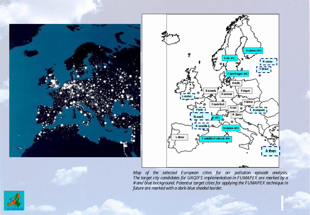
Map of the selected European cities for air pollution episode analysis. The target city candidates for UAQIFS implementation in FUMAPEX are marked by a # and blue background. Potential target cities for applying the FUMAPEX technique in future are marked with a dark-blue shaded border.
Basel
Athens

FUMAPEX target cities for improved UAQIFS implementation
#1 – Oslo, Norway#2 – Turin, Italy#3 – Helsinki, Finland#4 – Valencia/Castellon, Spain#5 – Bologna, Italy#6 – Copenhagen, Denmark
Different ways of the UAQIFS implementation: (i) urban air quality forecasting mode, (ii) urban management and planning mode, (iii) public health assessment and exposure prediction mode,(iv) urban emergency preparedness system.

CoverTurin City Urban Area: Modelling System for Forecasting Meteorology and Air Quality
S. Finardi, G. Calori
F. Lollobrigida, R. De Maria, M. Clemente

Modelling system general features
General requirements:
• Target resolution resolving urban area features : 1 km;
• Considered pollutants: SO2, NO2, CO, PM10, O3 and Benzene;
• Limiting models inter-dependence, modularity;
• User oriented results production and management

Scheme of the different elements composing the UAQIFS for Turin city
Emission Data
Urban Meteorological
Models
Concentration Fields
Geographic & Physiographic Data
Downscaling & Interfaces
UAQ
Models
Large Scale Forecast
& Meteo Data
Local DTM
and CORINE
land cover
RAMS
LOKAL MODELL
(provided by Piedmont Region Weather Service)
Regional emission inventory - INEMAR
FARM

Target Areas
Grid 2
Grid 3

CO forecast
CO 1st day h 22 - a
Grid 1
FUMAPEX test case3 1-way nested grids
Grid 2
Contour interval: 50 ppb
Grid 3
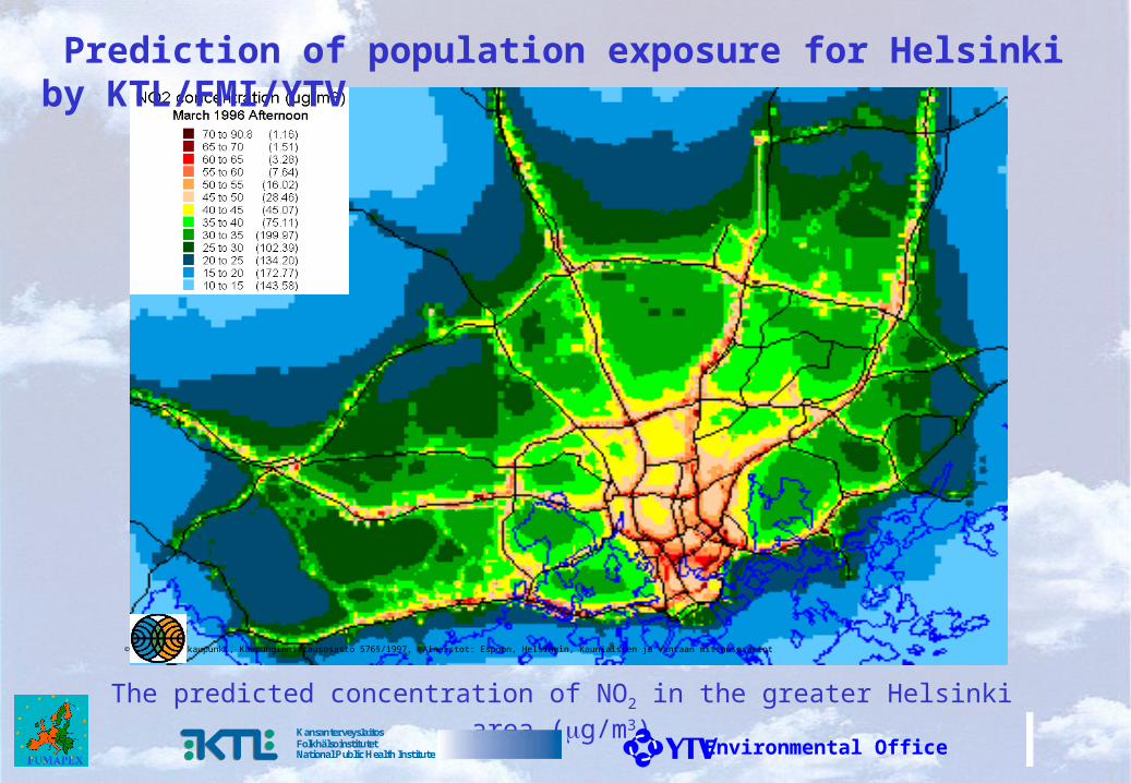
The predicted concentration of NO2 in the greater Helsinki area (g/m3)
© Helsingin kaupunki, Kaupunginmittausosasto 576§/1997, ©Aineistot: Espoon, Helsingin, Kauniaisten ja Vantaan mittausosastot
Environmental OfficeKansanterveyslaitosFolkhälsoinstitutetNational Public Health Institute
Prediction of population exposure for Helsinki by KTL/FMI/YTV

The predicted population activity (number of persons).
© Helsingin kaupunki, Kaupunginmittausosasto 576§/1997, ©Aineistot: Espoon, Helsingin, Kauniaisten ja Vantaan mittausosastot
Environmental OfficeKansanterveyslaitosFolkhälsoinstitutetNational Public Health Institute

The predicted exposure of population to NO2 (g/m3 *persons).© Helsingin kaupunki, Kaupunginmittausosasto 576§/1997, ©Aineistot: Espoon, Helsingin, Kauniaisten ja Vantaan mittausosastot
Environmental OfficeKansanterveyslaitosFolkhälsoinstitutetNational Public Health Institute

Early warning and emergency preparedness:The availability of reliable UAQIFS with urban scale weather and pollution forecasts could be of relevant support for emergency management: (i) fires, (ii) accidental radioactive or toxic emissions, (iii) potential terrorist attacks with radioactive, chemical or biological matter releases, etc.
DMImeteorologicalstations
DMIradiosoundingstations
DMImeasurements onmasts
RISØmeteorologicalmast
Copenhagen Metropolitan Area

DMI recent activity and achievements:
• high resolution (up to 1.4 km horizontal resolution) numerical modelling of regional meteorological processes;
• using fields of effective roughness length, satellite-based sea surface temperature and albedo in DMI-HIRLAM-E model;
• new algorithms for the SBL mixing height in atmospheric models;• highly accurate advection scheme in atmospheric models;• atmospheric chemistry and aerosol dynamics and deposition
models; • on-line coupling of meteorological and atmospheric pollution
models; • mini-ensemble of meteorological forecast;• integrated operational modelling for emergency preparedness and
the ARGOS system.
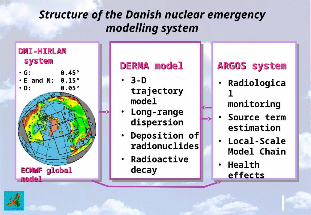
Structure of the Danish nuclear emergency modelling system
DMI-HIRLAM systemDMI-HIRLAM system
• G: 0.45°• E and N: 0.15°• D: 0.05°• L: 0.014°
ECMWF global modelECMWF global model
DERMA modelDERMA model
• 3-D trajectory model
• Long-range dispersion
• Deposition of radionuclides
• Radioactive decay
ARGOS systemARGOS system
• Radiological monitoring
• Source term estimation
• Local-Scale Model Chain
• Health effects

HIRLAM-ARGOS-RIMPUFF simulation of a hypothetical accident at the Barsebæk NPP for the Copenhagen metropolitan area
DMI-HIRLAM forecast meteo-fields, 1.4 km horiz. resolution
ARGOS forecast:ARGOS forecast:Xe-135Xe-135 Time Integr. Air Conc. Time Integr. Air Conc.

For more information:
FUMAPEX web-site: http://fumapex.dmi.dk
FUMAPEX progress report: http://www.dmi.dk/f+u/publikation/vidrap/2003/Sr03-12.pdf
COST715 web-site: http://www.fmi.fi/ENG/ILA/COST715/
Thank you !