integrated multi- functional observing networks for surface transportation (and many other sectors)...
TRANSCRIPT

Integrated Multi-Functional Observing Networks for Surface Transportation (and many other sectors)
Walter DabberdtVaisala
Boulder, CO
3rd National Surface Transportation Weather Symposium
July 25-27, 2007
Vienna, VA

©Vaisala | 26 July 2007 | WDabberdt | WIST-2007 | Page 2
Potential Participants and Partners
• NWS
• FAA
• FHWA
• FRA
• DHS
• DoD
• City emergency managers
• Flood control districts
• Air quality management districts
• Private companies– Weather measurement companies– Telecommunications companies– Tower owners– Others
• Academia

©Vaisala | 26 July 2007 | WDabberdt | WIST-2007 | Page 3
User Sectors:
• Surface Transportation:– Road masters; freight companies – Rail traffic controllers– Airport and airline operators; FAA– Harbor masters, pilots and ship’s officers; USCG
– Ports, inland and coastal
• Others (first and second tier):– National Weather Service– Private weather services– Emergency managers– Electric utilities and transmission companies– Insurance– Agriculture– Air quality– Construction– Traders and brokers– Media– General public

©Vaisala | 26 July 2007 | WDabberdt | WIST-2007 | Page 4
Critical Atmospheric Phenomena
• Winter storms
• Nor’ easters
• Snow- and ice storms
• Hurricanes
• Air pollution
• Fog, low clouds and other visibility-reducing phenomena
• Thunderstorms, including MCS’s• Lightning• Flash floods• Hail• Straight-line winds• Tornadoes
• Windstorms (w/o precipitation)
• Aviation hazards• In-cloud icing• Downbursts• Turbulence
• Heat and cold extreme events

©Vaisala | 26 July 2007 | WDabberdt | WIST-2007 | Page 5
General applications
• Detection/Analysis of current state of the near-Earthatmospheric state
• Nowcasting/very short-range forecasting (0+ to ~2 hrs)
• Short-range mesoscale prediction (~3 to 48 hrs)
0 4
obse
rvat
ions
now
cast
ing
- cu
r re n
t ca
pab
ilit
y
Rel
ativ
e F
orec
ast
Acc
urac
y
mesosca
le
foreca
sting
Nominal Time -- hours
blending region

©Vaisala | 26 July 2007 | WDabberdt | WIST-2007 | Page 6
General applications
• Analysis/description of current state of the earth-atmosphere regime
• Nowcasting/very short-range forecasting (0+ to ~2 hrs)
• Short-range mesoscale prediction (~3 to 48 hrs)
Site of interest time
are
a
analysis
mesoscale prediction
nowcasting
Schematic
illustrationSchematic
illustration

©Vaisala | 26 July 2007 | WDabberdt | WIST-2007 | Page 7
Candidate Measurement Systems
• Weather radar: reflectivity; velocity, polarization; refractivity
• Wind profilers: radar, sodar; lidar; aircraft
• Thermodynamic soundings: RAOBS, aircraft; lidar
• Lightning detection: CG; total• Radiometers: microwave -- scanning;
• GPS receivers: precipitable water vapor -- column integrated; maybe slant path and 3D
• Surface mesonets: PTU; V; LW, SW, net radiation; energy & momentum fluxes
• Satellites: Geo-; POES; LEO
• Pavement condition: sfc temperature;
sfc state

©Vaisala | 26 July 2007 | WDabberdt | WIST-2007 | Page 8
Commonality ....
Wx R
adar
Doppler Lidar
Radar WP
Lightning
Satellite
Visibil
ity
Wind
Temp.
Precip
.
Sfc. S
tate
RAOB
ship - harbors & coastalair - te
rminal opsrailroadshighways
6
5 5
3 3
10
6
1010 10
53
5 5
33
10
6
10
6
10
5
10
8 8
1010 10
8
1010
10
5
10
55
55
10
4
33
1
5
0
1
2
3
4
5
6
7
8
9
10
IMP
AC
T F
AC
TO
R
OBSERVING SYSTEM
MO
DE
Commonality of Surface Transport Weather-Observation Needs (general -- includes current state, nowcasting & short-range forecasting)
ship - harbors &coastalair - terminalopsrailroads
highways

©Vaisala | 26 July 2007 | WDabberdt | WIST-2007 | Page 9
Benefits and Challenges of MF-MP Networks
• Benefits of MF Networks:– Share risks – technical and financial– Minimize investments per partner– Profit (private sector)– Cost reduction (public sector)– Research opportunities (all sectors)
• Challenges, Obstacles and Impediments:– Competition– IP rights– Data rights– Partner selection– Partner performance– Public-private barriers– “Curse of dimensionality” – managing multiple partners

©Vaisala | 26 July 2007 | WDabberdt | WIST-2007 | Page 10
Observing Challenges (physical)
• Network design– Phenomenologically driven: local circulations; processes
– Needs driven: Base (or common) network vs. all-inclusive network
– How to optimize? Is it possible?
• Scientific/measurement challenges– PBL structure
– MH
– O3 and PM
– Water vapor
– QPE
©Vaisala | 26 July 2007 | WDabberdt | WIST-2007 | Page 11
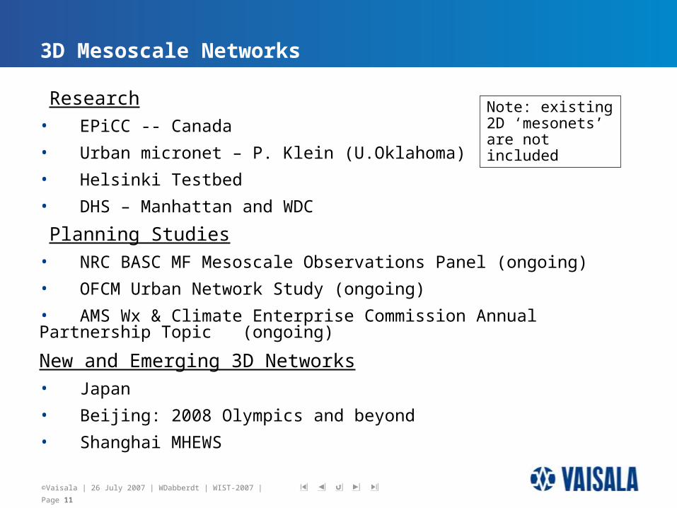
3D Mesoscale Networks
Research• EPiCC -- Canada
• Urban micronet – P. Klein (U.Oklahoma)
• Helsinki Testbed
• DHS – Manhattan and WDC
Planning Studies
• NRC BASC MF Mesoscale Observations Panel (ongoing)
• OFCM Urban Network Study (ongoing)
• AMS Wx & Climate Enterprise Commission Annual Partnership Topic (ongoing)
New and Emerging 3D Networks• Japan
• Beijing: 2008 Olympics and beyond
• Shanghai MHEWS
Note: existing 2D ‘mesonets’ are not included

©Vaisala | 26 July 2007 | WDabberdt | WIST-2007 | Page 12
Flooding
Food safety
Heat-health
Road maintenance & safety
Chemical dispersion
Air quality
Smoke
Storm surge
Energy
Multi-HazardEWS
Weather and Climate Hazards
Ensemble Prediction Systems
Weather- and Climate-related Hazards
Other Hazards
Weather Information
Risk Models & Processes
Forecast and Prediction SystemWeather
Information
RelatedPartners
Example of an Emerging 3D MF-MP System: Shanghai Multi-Hazard Forecast and Prediction System
Earthquakes
Tsunamis

©Vaisala | 26 July 2007 | WDabberdt | WIST-2007 | Page 13
The conceptual design for comprehensive observations of urban atmospheric boundary
City-Scale Early Detection & Monitoring System (conceptual)

©Vaisala | 26 July 2007 | WDabberdt | WIST-2007 | Page 14
Microscale Meteorological Observation System(conceptual) -------- In the World EXPO 2010 Site

©Vaisala | 26 July 2007 | WDabberdt | WIST-2007 | Page 15
How to move forward? Some Questions:
• Role of Government?
• IP rights?
• Risk sharing?
• Cost sharing?
• Revenue sharing?
• Chisholm Network – a prototypical concept?
©Vaisala | 26 July 2007 | WDabberdt | WIST-2007 | Page 16
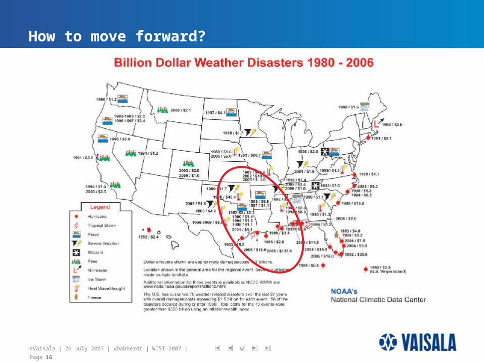
How to move forward?

©Vaisala | 26 July 2007 | WDabberdt | WIST-2007 | Page 17
~1000km
A possible prototype network?
Major Cities Included: Dallas-Ft. Worth; Houston; Austin; Oklahoma City; Amarillo; Lubbock; San Antonio; Corpus Christi; Shreveport; Tulsa; New Orleans; Mobile; Little Rock; Jackson; ........
“The Chisholm Network”
~1500km
