integrated floodplain management: options and approaches€¦ · emotionally as to the importance...
TRANSCRIPT

Better Options for IFM: Uptake Promotion NRSP Project R8306
Final Technical Report Annex F
Training Module on
Integrated Floodplain Management: Options and Approaches
Md. Mahbubur Rahman, M. Mokhlesur Rahman and Md. Matiar Rahman
September 2005
Center for Natural Resource Studies (CNRS)House 14 (2nd floor), Road 13/C, Block E, Banani, Dhaka-1213
Tel: 9886514, Fax: (880-2) 9886700, E-mail: [email protected]
This document is an output of a project funded by the UK Department for International Development (DFID) for the benefit of developing countries. The views expressed are not necessarily those of DFID.

Table of Contents
Training Schedule.................................................................................................................. iv
Background.......................................................................................................................... 1
Aim of the Training Module ................................................................................................. 1
Target Participants .............................................................................................................. 1
Specific Objectives of the training ....................................................................................... 2
Duration of the Training ...................................................................................................... 2
The Training Module ............................................................................................................ 2
Equipments and Logistics ................................................................................................... 2
Topics and Sessions............................................................................................................ 3
Session 1. Pretest, Expectations of the Participants and Introduction of the Subjectand Objective of the Training ............................................................................. 4
Session 2. Understanding Floodplain Resources System and Production Dynamics ......... 5
Session 3. Present Status of the Floodplain Resources, Systems understanding of theProblem and Need for Integrated Management .............................................. 11
Session 4. Better Options for Integrated Floodplain Management .................................... 17
Session 5. Fishing Effort Control ....................................................................................... 22
Session 6. Crop Diversification in Floodplains................................................................... 30
Session 7. Sluice Gate Management................................................................................. 36
Session 8. Land Retirement............................................................................................... 40
Session 9. Habitat Degradation: Problems, Issues, and Participatory Habitat Restoration ....................................................................................................... 42
Session 10. Watershed Management................................................................................ 47
Session 11. Consensus Building Among Stakeholders ..................................................... 48
Session 12. Institutional Approach in IFM.......................................................................... 54
Pre and Post Test Questioner............................................................................................ 65
Reference and Further reading...........................................................................................68
ii

List of Tables
Table 1: Broad based classification of floodplain ecosystem habitats.....................................7
Table 2: Hydrological seasons, fish habitat features, and fish biological functions..................9
Table 3: Catch per unit effort (CPUE) of major gears in Charan Beel...................................24
Table 4: Model predictions of average recruits, natural mortality, yield, % gain in yield, fishing mortality and yield-per-recruit (Y/R) for different reserve areas during the dry season (December-May)......................................................................................................25
Table 5: Model predictions of average recruits, natural mortality, yield, % gain in yield, fishing mortality and yield-per-recruit (Y/R) monthly closure...............................................28
Table 6: Comparison of different methods.............................................................................29
Table 7: Expected irrigation demands for rabi crops (mm per ha for rabi season, not including land soaking and preparation demands)...................................................33
Table 8: Performance of alternative rabi crops demonstrated at Charan Beel site in Year 1 (October ’03-March ’04)...........................................................................................34
Table 9: Cost analysis of earthwork activities, % distribution of costs by types activities......46
Table 10: Shows examples of primary and secondary stakeholders of two different resource systems in the context of Bangladesh....................................................................51
List of Figures
Figure 1. Systems problems: Floodplain management..........................................................14
Figure 2. The systems implication of lowland winter rice production.....................................15
Figure 3. Fish catch trend in Charan Beel..............................................................................24
Figure 4. Predicted percentage increase in annual yield plotted as a function of reserve area in Charan Beel........................................................................................................26
Figure 5. The systems implications of lowland winter rice production...................................32
Figure 6. CPUA-hectare irrigated relationship for alternative rabi crops................................33
Figure 7. Comparative cost-benefit of boro rice and 4 alternative rabi crops cultivated in Charan Beel............................................................................................................34
Figure 8. Return over investment (%) for different rabi crops................................................35
Figure 9. Flowchart showing major steps of PAPD................................................................50
iii

iv
Integrated Floodplain Management
Training Schedule
Day One
Time Topic Facilitator9:00-10:00 Session 1. Pre-test, Expectations of the Participants and
Introduction of the Subject and Objective of the Training 10:00-10:30 Tea Break 10:30-11:30 Session 2. Understanding Floodplain Resources System
and Production Dynamics 11:30-13:00 Session 3. Present Status of the Floodplain Resources,
Systems understanding of the Problem and Need for Integrated Management
13:00-14:00 Lunch 14:00-14:30 Session 4. Better Options for Integrated Floodplain
Management 14:30-14:45 Tea Break 14:45-16:45 Session 5. Fishing Effort Control 16:45-17:00 Open discussion and closing of the day
Day Two
Time Topic Facilitator9:00-9:30 Recapitulation of previous days activities 9:30-13:00 Session 6. Crop Diversification in Floodplains 10:30-11:30 Tea Break (within the session) 13:00-14:00 Lunch 14:00-14:45 Session 7. Sluice Gate Management 14:45-15:30 Session 8. Land Retirement 15:30-15:45 Tea Break 15:45-17:00 Session 9. Habitat Degradation: Problems, Issues, and
Participatory Habitat Restoration 17:00-17:15 Open discussion and closing of day two
Day Three
Time Topic Facilitator9:00-9:30 Recapitulation of previous days activities 9:30-10:15 Session 10. Watershed Management 10:15-11:15 Tea Break 11:15-13:00 Session 11. Consensus Building Among Stakeholders 13:00-14:00 Lunch 14:00-16:00 Session 12. Institutional Approach in IFM 16:00-16:15 Tea Break 16:15-16:45 Post Test 16:45-17:15 Review of the expectations, open discussion and closing
of the training

R8306 FTR Annex F
Training ModuleIntegrated Floodplain Management: Methods and Approaches
Background
The livelihoods of Bangladeshi people, especially the rural poor living around floodplain beels, are largely dependent on floodplain resources. Their nutrition, incomes, and other day-to-day needs are fulfilled by the nearby floodplain beels. Semi-natural diversefloodplains are highly productive ecosystems providing important benefits that exceed theproductivity of intensive agricultural systems. These benefits, sometimes described as‘goods and services’, include the functions of groundwater recharge, pollution abetment, soil fertility. Wetland products include fish, fuel wood, wild plants for food, and fodder. Wetlandsare also an important aesthetic component of the landscape. Floodplains have many other uses and benefits that are essential to communities, and industrial and agricultural activities.Thus, floodplains are multiple resource systems with many different types of users andmultiple stakeholders
Agriculturalists view the floodplains as rice production fields. The fisheries sector sees floodplains as fish production grounds. Overall, the national emphasis has been to producemore rice ignoring other benefits and products thus converting natural wetlands into ricefields. To the community dwelling in and around a floodplain it is their livelihood not just arice field. Floodplains provide many products and services that have been utilized by manypeople in rural communities for generations. Wetlands also are significant for the local andregional environment, including for biodiversity conservation.
The diverse resource system and the stakeholders’ indicate an integrated management ofthese resources. This training “Integrated Floodplain Management: Methods and Approaches” is expected to help people in this regard.
Aim of this Training Module
The aim of the training is to educate the targeted participants both cognitively and emotionally as to the importance of IFM, consensus building, and institutionalization, in IFM.This will prepare them in planning programmes, motivating stakeholders, andinstitutionalizing IFM through consensus building among stakeholders.
Target Participants
NGO staff, government officials of different levels working with Department of Fisheries (DOF), Department of Agricultural Extension (DAE), Water Development Board (BWDB),and Local Government Engineering Department (LGED) who are involved in facilitation offloodplain resources systems management programmes. At the resource level, CBO members, and leaseholders – are all target participants of this training.
DFID NRSP Training ModuleF-1

R8306 FTR Annex F
Specific Objectives of the Training
After completion of the training on this module, the participants will be able to describe andexplain:
i. what integrated floodplain management is, its components and importance; ii. systems implications of boro rice, crop diversification and its benefits to cultivation
in floodplains;iii. fishing effort control and its methods with justification;iv. The need and ways of fish friendly management of sluice gates, watershed
management, and land retirement as part of IFM. v. Importance and process of consensus building among the stakeholders;vi. The importance and process of institutionalization in sustainable IFM.
Duration of the Training
An estimated duration for this training is three full days.
The Training module
The training module covers eleven technical sessions along with an introductory sessionwith a pre-test, a post-test and open discussion session at the end. Each of the 11 technicalsessions presented here with a session guide followed by resource materials for the users,the prospective facilitators. The session guides describes how to conduct the sessions, whatmaterials required and what methods can be followed, while resource materials will provide updated information on the topic. A sample pre and posttest questioner is also furnishedhere with.
Equipments and Logistics
1. OHP/Multimedia projector2. Computer 3. Transparency sheets4. VIPP board, pin5. VIPP cards6. White board7. Flipchart board8. Markers 9. Flipchart papers/ large papers10. Adhesive tap11. Handout for the participants12. Pen, notepad, training folder, name tag for the participants
DFID NRSP Training ModuleF-2

R8306 FTR Annex F
Topics and Sessions
1. Introduction of the Subject, Expectations of the Participants and Pretest 2. Understanding Floodplain Resources System 3. Present Status of the Floodplain Resources, Use Pattern and Need for Integrated
Management4. Components of IFM 5. Fishing Effort Control 6. Crop Diversification7. Sluice Gate Management8. Land Retirement9. Habitat Restoration10. Watershed Management11. Consensus Building Among Stakeholders 12. Institutional Approach in IFM 13. Post Test14. Open Discussion and Closing of Training
DFID NRSP Training ModuleF-3

R8306 FTR Annex F
Session 1. Pre-test, Expectations of the Participants and Introduction of the Subject and Objective of the Training
Attending this session participants present knowledge on integrated floodplain management will be tested to identify gaps; will inform their expectations from this training;will be able to tell about the training subjects and the objectives.
1 hour.
Answering preset question on the training, brainstorming, and writing on VIPP cards, presentation, and discussion.
Question and answer sheets, VIPP cards, slides/OHP sheets, training schedule.
White board, VIPP cards and board, Multimedia projector, markers,adhesive tap, board pin.
Step 1. Questionnaire and answer sheets will be supplied to all participants; they will answer the questions based on their present knowledge. After answering, all the answer sheets will be collectedexamined by the facilitators afterwards to determine gaps in knowledge of the participants.
Step 2. All the participants will be supplied with a VIPP card to write their expectation from this training on that. Each participant will be requested to write one expectation. After collection, the facilitator will read out all the expectations for all the participants. The VVIP cards with expectations will be hanged in the training room.
Step 3. The facilitator will introduce the training subject broadly and the training objectives.
This session is planned to know the present knowledge of the participants on floodplain resources and their integrated uses, their expectations from this training, and to inform them of the training objective and the sessions of the training in relation to their knowledge level and expectations.
A post-test will be required to test the change in knowledge after training.
Objectives:
Time:
Methods:
ResourceMaterials:
Equipment:
Process:
Notes for Facilitator:
DFID NRSP Training ModuleF-4

R8306 FTR Annex F
Session 2. Understanding Floodplain Resources System and Production Dynamics
After attending this session, participants will able to describe andexplain the physical and biological resources of floodplain systems of Bangladesh.
1 hour.
Presentation, discussion, question answer through brainstorming.
OHP/multimedia slides, Handout: “Floodplain Resources System in Bangladesh,”.
OHP/multimedia projector, White board, Easel board, Flip chart paper, Marker.
Facilitator will present physical and biological resources systems of floodplains of Bangladesh. During the presentation he will createscope for discussion through question asking and brainstorming in a participatory way.
This session is planned to widen participants’ knowledge on various physical and biological floodplain resources, highlighting the integration among them. In the existing situation people tend see the resources with a sectoral view and tends to focus on the sectoralactivities. That is why a systems understanding of the resource base and all sorts of activities is important for sustainable management. That is termed here as integrated floodplain management.
Objectives:
Time:
Methods:
ResourceMaterials:
Equipments:
Process:
Notes for Facilitators:
DFID NRSP Training ModuleF-5

R8306 FTR Annex F
Understanding Floodplain Resources System and Production Dynamics
Floodplains are generally highly productive ecosystems, providing many important benefits.These benefits, sometimes described as ‘goods and services’, may be floodplain functions(e.g. groundwater recharge, soil fertility), uses of the wetland or its products (e.g. fishing,wood collection or research site) or attributes of the wetland (e.g. aesthetic component of thelandscape). Many of the benefits provided are essential to communities, and to industrial and agricultural activities. Floodplains are extremely productive systems and may exceed the productivity of intensive agricultural systems.
Most professionals suggest all inland water areas except the big rivers are floodplainsirrespective of their temporal dimension. So the floodplain habitats can be identified are beel, haor, baor, small rivers and canals with associated vast seasonally flooded lands usedmainly as rice fields.
Perhaps the most important of all the common property resources of the floodplains are the floodwaters themselves. They enable the fundamental process of land formation itself to occur and also bring great benefits that underpin the fishery and agro-ecology and economyof the entire country.
Loss of wetlands will remove these benefits. This is not to put a case for ‘development vs.conservation’, but simply to state that maintenance of wetlands as functioning ecosystemswill often ensure that important contributions to development are maintained.
Floodplain Habitats
Bangladesh is a floodplain of three major river systems – the Ganges the Brahmaputra and the Meghna. The country is literally crisscrossed by around 250 large and small rivers; there are thousands of haor, baor, beel, khal etc. along the floodplains of these rivers. The vastwater bodies along with their diverse fauna and flora present a unique highly productivefloodplain ecosystem.
Floodplain ecosystems are influenced by the prevailing hydrological regime. The spatial andtemporal variation in water depth, flow patterns and water quality, as well as the frequencyand duration of inundation, are often the most important factors determining the ecologicalcharacter of a floodplain, which influences fisheries production, fertility of land and production of many other aquatic resources and agriculture.
Floodplain habitats are a. tributaries and distributaries; d. canals; e. beel, haor, baor; f.seasonally flooded areas – inundated rice fields; g. river scour holes and deep part of a beelincluding kuas/pagers.
All the major rivers flow into the Bay of Bengal. At the confluence of the rivers, fresh water mixes with seawater producing brackish water that forms a distinct estuarine zone. The richness in inland open water fisheries yield and species diversity in Bangladesh is due to its high diversity of habitats, microhabitats, and seasonal features along with hydrologicalfeatures. Natural system of replenishment of varieties of fish species in the open waters is possible due to the combined effect of hydrology and habitat diversity over the seasons.
Fish behaviour and their use pattern of habitats are sharply different between dry and wet seasons. This difference influences fish lifecycle including growth – they use almost every diverse habitat type in completing their lifecycle; on the other hand this difference determinesfishing practices and efforts.
DFID NRSP Training ModuleF-6

R8306 FTR Annex F
Features of floodplain habitats in Bangladesh
1. The floodplains in Bangladesh present a very rich and diverse fishery comprising over 300 species of finfish and shellfish.
2. Diverse habitat systems and complex hydrological regimes having strong seasonaldimensions provide opportunities for the entire fish communities and other biota to renewand replenish annually and thereby contribute to sustain the yield and diversity ofspecies in the this open waters.
3. The hydrological regime has a vital role in maintenance and sustenance of the inland fisheries production in typical flooded river basins. Seasonal contraction and expansionof water regime is the characteristic feature of the flooded river basin, which determine the fisheries production through providing opportunities for performing various biologicalfunctions of fish.
4. Diversity of habitats is also another major contributor in having a robust inland fisheriesyield and ichthyo-diversity, which provide diverse microhabitats essential for various fish species to complete their natural biological cycles.
5. Strong seasonal changes in the hydrological regime in the flooded river basins resultedin changes in the qualitative and quantitative dimensions of wetland habitats over theseasons.
The fish communities also adjust and adapt their life cycles in accordance with the changing hydrological cycles and so with the changing habitat features. People living at the ecosystemlevel who are the users of the flooded basins for either fishing or farming also determine theirfishing and farming strategy and actions with the changing hydrological regimes over theseasons.
Table 1: Broad-based Classification of Floodplain Ecosystems Habitats. Habitattypes
Seasonalfeatures
Dry season status Wet season status
Major orPrimaryRivers
Perennial Mostly isolated but linked withsecondary rivers, may have linkwith some tertiary rivers
May become flooded over bank and get connected with wider complex floodplain habitats
SecondaryRivers
Mostlyperennial
Lost connection with floodplaincomplex but linked with rivers
Flooded over bank and connected with floodplaincomplex
TertiaryRivers
Mostlyseasonal
Lost connection with floodplain and poorly linked or no link with riversystems, beds are often cultivated(seed beds & boro rice)
Flooded over bank and connected with floodplaincomplex linked with river systems
Khals Mostlyseasonal
Isolated from floodplain and having poor or no link with rivers, bedscultivated (seed bed and boro rice)
Flooded and connected withrivers and floodplain beels
Beels Mostlyperennial
Become smaller, isolated fromkhals and rivers, cropland andfallow
Flooded and connected withrivers, khals and adjacent flooded lands
Haors Mostlyseasonal
Most part becomes dry, crop lands,grassland or fallow except for beels within haors.
Flooded and connected with rivers, khals and adjacent flooded lands
DFID NRSP Training ModuleF-7

R8306 FTR Annex F
Habitattypes
Seasonalfeatures
Dry season status Wet season status
FloodedLands
Seasonal Dry, crop land grassland and fallow Flooded and merged withvast sheet of water in the basin
Baors Perennial Isolated, edges under cropcultivation (boro rice, seed beds)
Isolated, some are linked with flooded lands or beels
Kuas/Pagars
Mostlyperennial
Isolated, not under cultivation often pumped out to dry for fishing
Flooded and merged with vast sheet of water in the basin
Hydrology, Habitats and Fish Biological Functions
Ecosystems Considerations for management
Habitat quality and quantity Seasonality Connectedness
Fish biological functions Human practices
Hydrology in the flooded river basins is the major factor for sustaining fisheries production,maintaining biodiversity and determining fishing practices. Therefore, the hydrology has great influence on inland capture fisheries production and thus governs the whole system. There are annual changes in the hydrological regime. In the monsoon season, a huge volume of floodwater from vast watershed in the upper riparian areas drains throughBangladesh to the Bay of Bengal through around 700 rivers.
The extent of monsoon floodwater varies between years due to various reasons: intensity and volume of monsoon rains, amount, and timing of snow melt in the Himalayan hills.These annual hydrological regimes determine the spatial and temporal aspects of wetlandhabitats in terms of hectare-months of water and accordingly changes in fisheries productionoccur between years, both in terms of quality (composition) and quantity.
Therefore, habitats alone cannot determine the fishery rather all these are highly depended and influenced by the annual hydrological regimes. In low flooding year, many habitats inrelatively higher elevated basins could not adequately support the fish to perform their biological functions in full, although the habitats are comparatively in good shape. On theother hand, in high flood year higher fish production is experienced due to increased spatialand temporal habitat area in terms of hectare-months, which allow fish to perform theirbiological functions more successfully than in a dryer year.
Fish life cycles in the typical floodplains like in Bangladesh are adjusted to the annual hydrological features and fish accordingly move out to various habitats at different times ofthe year in order to complete their life cycles. Therefore, any changes in hydrology affect thehabitats (quality and quantity) and eventually in the fisheries production.
Wetland habitats including microhabitats are essential for the sustenance of fisheries production and biodiversity. Fish and other aquatic biota require suitable habitats for performing their various biological functions and unless these habitat requirements are met, fish cannot perform their biological functions. For example, Major Carps (rui, catla, mrigel)require flooded basins in the upper riparian areas of major rivers with current and rainfall forspawning. These species will not spawn if they do not get suitable habitats. It is seen that adults of these species remain in abundance in tertiary rivers in the lower riparian areas or in
DFID NRSP Training ModuleF-8

R8306 FTR Annex F
beels but they do not spawn there. In culture ponds, eggs develop in the gonad of major carps in the early monsoon but are absorbed in the late monsoon as they do get suitablespawning habitats in ponds.
The ease of fish movement among the habitat is also a determining factor of the habitat. Inaddition to habitat types, water depth range, vegetation and its type are also a part of habitatdiversity.
Hydrological regimes of floodplains are one of the major factors sustaining fisheriesproduction, maintaining biodiversity and determining fishing practices. There are annual changes in the hydrological regimes; a huge volume of floodwater is a feature of monsoon season. This annual hydrological regime determines the spatial and temporal aspects of wetland habitats in terms of hectare-months and accordingly changes the fisheriesproduction. In a high flood year higher fish production is observed.
Table 2: Hydrological Seasons, Fish Habitat Features and Fish Biological FunctionsSeasons/Months
Habitat Quantity Habitat Quality Fish BiologicalFunctions
FishingPractices
Remarks
1. Dry Season(December-February)
Habitats becomeisolated, lowestspatial water area, lowestdepth, many wetlandsbecome dry
Highestpollutionconcentration,lowtemperature,bad water quality, many wetlands can not support fish
All biological functions of fish reduced, fish takerefuge in rivers,river pools, andperennial beels
Fishing intensity peaks,perennialwetlandspumped out to dry for fishing,most wetlandsare fished out
Fish becomevulnerable or exposed to natural andfishingmortality
2.Pre/Early-Monsoon(March-May)
Water area startsto expand spatially with theonset of rain
Water qualityimproves withrising watervolume and temperatures
Biologicalfunctions initiate, fish perform longitudinal (longdistance) andlateral (short distance)migrations for spawning andfeeding
Less fishingintensity.Fishing in beeledges with lessharmful gearsbut fishing in khals causedestruction dueto catching ofmigrating fish
Sensitive time for fishmigration, fish productivityand diversity depends on successfulmigration
3. Monsoon(June-August)
Spatial and depthparameters ofwetland reachedthe highest, huge area underwater, all sorts of floodplainhabitats getintegrated
Best water quality with richfish food, hugearea forspawning,feeding andgrowth
All biological functions of fish (migration,spawning,nursing, feeding,growth, etc.)peaks
Fishing peaks in flooded areaswith variousgears, openaccess fishingwith few exceptions, useof harmful gearslike kona jal,current jal peaked
Best time for the entire fishcommunity for naturalreplenishment,however,harmful gearscause damageto fishery
4. Late/post Monsoon(September-November)
Spatial water area rapidlydecreases,different wetlandhabitats becomeisolated
Water qualitystill remainsgood,
Fish migrate totheir dry seasonrefuge areas likeperennial beelsand rivers
Fishing peaks in khals duringtheir returnmigration, beel,river fishingcontinues
Sustainednatural fish productiondepends on successfulreturnmigration to their refugeareas.
Source: Rahman, M. 2004.
DFID NRSP Training ModuleF-9

R8306 FTR Annex F
Fish migration and growth
Open water fish are broadly categorized into two groups: white fish, that reside primarily inflowing waters such as rivers; and black fish that primarily reside in static waters such as lakes and beels. White fish typically migrate upstream into floodplains, beels, haors through connectivity’s during spawning season. Black fish on the other hand spawn and remain in the same lake or beel.
Daget (1960) described two types of river fish migrations in Bangladesh: i. longitudinalmigration within the river channel and ii. lateral migration to and from floodplains. Welcome(1975) mentioned that each type of migration requires a different type of behaviour and probably different sets of physical stimuli. A gradual rise in the river water in different areasof the country usually starts from late February or early March (pre-monsoon). The process of sexual maturation and staging migration and movement for breeding activity occur in thispre-monsoon period when the air and water temperatures rise. During the early monsoon (April-May), almost all species of fish are seen with ripe or ripening gonads. For the major carp species of Bangladesh, the upper reaches of the Brahmaputra in the Assam Hills, theGanges below Farakka and upper Barak region are the major breeding areas according to Tsai and Ali (1985).
Some species of prawn and fish require brackish/saline water to spawn; they migratedownstream to estuarine and coastal environments. The juvenile’s then undertake upstream migration through the rivers to reach the food rich floodplains to feed and grow until recession of flood. The growing prawns, like the carps, move back into the flowing river habitat with the receding waters. The opposite of prawn is Hilsha, a fish that lives in marineenvironment in the Bay of Bengal but migrates into the fresh water habitats in the upstreamof the river system to breed.
Maintaining ecosystem functions
Protection of ecosystem components Restoration of degraded ecosystem components Preservation of ecosystem componentsWise use of ecosystem resources
DFID NRSP Training ModuleF-10
R8306 FTR Annex F
Session 3. Present Status of the Floodplain Resources, SystemsUnderstanding of the Problem and Need for Integrated
Management
After attending this session participants will be able to describe and explain:i. the present status and use pattern of the floodplain resources of
Bangladesh and related issues; ii. the need for an integrated approach for management of these
resources.
1 hour 30 minutes.
Presentation, discussion, small group work.
Slide/OHP sheets, Handout: “Present Status of the Floodplain Resources, Use Pattern and Need for Integrated Management”.
OHP/Multimedia projector, White board, Flipchart board, Flipchartpaper, Marker, Adhesive tap.
Step 1. Facilitator will initiate the discussion by introducing the topic and make a presentation on present status and uses of the floodplain resources of the country.Step 2. After that the facilitator will invite the participants for a group work on “why integrated floodplain management is necessary”. He will divide the participants in small groups. The group will select a leader who will present the group findings.
Facilitator will conclude the session.
This session will specify the issues and difficulties of a sectoralapproach while the resource system it self is integrated. How the sectoral approach in use pattern is responsible for the degradation of the resources. And why the integrated approach is urgently needed.
Objectives:
Time:
Methods:
ResourceMaterials:
Equipments:
Process:
Notes for Facilitators:
DFID NRSP Training ModuleF-11

R8306 FTR Annex F
Present Status of the Floodplain Resources, Systems Understanding of the Problem and Need for Integrated Management
From our experiences and observations we know that the floodplain habitats are degrading,production of fisheries has declined in quantity, species diversity and big size fish in catch over a period of time. DoF information shows a rapid increase in culture fisheries; in relation, present official status of the open water capture fisheries is declining.
Present status of the floodplain production systems
Biological and productivity
Overall 30-40% fish catch declined during 1975 – ’76 to ’89 – ’90 period (DoF) (Tk50-100 Crore lost annually)
Overall fish consumption declined 15% per capita, for the poorest the decline is 38%during ’95 to 2000 period (BBS)
Major carp and large catfish catch declined 50%. Healthy open water body productionis 250 to 300 kg/ha, but some places found 51 to 160 kg/ha (MACH baseline). CBFMProject baseline is 45 – 125 Kg/ha.
More than 20% of all fresh water fish species are in danger of extinction (IUCN).
Recent fisheries sector review predicts 0.9 – 2.1% fall per year in inland capturefishery production.
Flow reduction in major river systems is about 50% during the last 20 years (Water Board) due to barrages (in India), local extraction and other reasons leaving millions of ha open water area impacted.
FCDI projects also damaged many open water bodies in the country, mainly converting wetlands into rice fields, disrupting connectivity and siltation, and ultimatelyproducing drastically changed ecosystems. Impacts on wetlands can be caused byboth human activities within them and because of the interconnectedness of thehydrological cycle, by activities take place within the wider catchments.
Issues related to floodplain resources
Issues related to physical and biological resources
1. Lack of dry season water in river, beel, khals (flow reduction, siltation, FCDIstructures.
2. Boro rice cultivation during winter, its influence on the critical dry season aquatic habitats.
3. Loss of connectivity between beel-khal-river (roads, FCDI structure, siltation).4. Sedimentation of beels, rivers and khals (loss of forest cover, lack of soil
conservation measures).5. Pollution (industrial, agricultural, domestic).6. Destructive fishing practice and over fishing. 7. Due to overexploitation slow growing, late maturing species are being replaced
by quick growing fast maturing ones. 8. Conversion of aquatic habitat (agriculture, urbanization, roads, industry).
DFID NRSP Training ModuleF-12

R8306 FTR Annex F
Policy issues related to open water resources
1. Present leasing policy of the Jalmohals; 2. Lack of any national sanctuary policy; 3. Land use planning; 4. Difficulty to implement the Fish Act and need for review;5. Lack of national and local resource planning and management – agriculture,
water, industry, pollution.6. Fisherman and wetland is not properly defined.
Watershed degradation
Unsustainable cultivation in hill slopesCutting of hills Loss of riparian vegetation cover Increased HYV boro cultivation
Water abstraction/diversion
Results in a serious siltation down in the open water bodies.
Consequences of wetland degradation
1. Imbalance in nature; 2. Loss of habitat of many animals and plants thus loss of biodiversity;3. Onset of desertification;4. Low-lying areas will be inundated;5. Water pollution – loss of natural recycling system; 6. Loss of common property renewable natural resource – reduced food and fodder,
reduced livelihood security/safety net for the poor specially.
Why integrated management floodplains is important
More than two-thirds of Bangladesh is wetlands Wetlands are rich in biodiversity, both plants and animals Over 80% of rural people depends on various wetland resources at varying degrees Poor receive about 50% of the direct benefits and share in many of the remaining benefits
Why community based management?
1. Resource users, who get the benefit, whose livelihood is dependent, should manage the resources.
2. Local people can use their knowledge and information about the resource. 3. Local people, users will be more interested in sustainable management and long-
term use of resources if they have right over resources.
What are the problems of floodplain production system?
In Bangladesh floodplains are predominantly converted into rice fields, moreover, every yearthe Water Development Board constructs embankments and other structures so that farmers can bring perennial parts of a beel under rice cultivation, destroying the habitat for original aquatic life thus reducing resources production and other goods and services of wetlands.Excessive pressure on fisheries resources, and destructive fishing methods are another set of problem of the production system. These are coupled with upper watershed issues
DFID NRSP Training ModuleF-13

R8306 FTR Annex F
creating a threatened situation for the floodplains and wetlands benefits, and even theirexistence. These are the main problems or conflicting issues within floodplain productionsystem in Bangladesh. Below the dimension of the problem and their impacts are discussed.
Understanding of an integrated view of the management problem related toFloodplain Resources
The broad constraints to improved floodplain resource in Bangladesh investigated were:(i) Excessive effort levels in fishing leading to reduced fish productivity,(ii) Reduced water levels (due to sluice gate management, both during the flood
season and ahead of the dry season, and water abstraction for dry-season rice irrigation) leading to reduced fish productivity, and
(iii) Early flood arrival events damaging dry-season rice crops prior to harvest.
Figure 1 : Systems problems: Floodplain management
Overfishing
Loss ofyear
Lack of stock
Borocultivation
Early drainage Water abstractionConversion
Lack of dry season waterEncroachment
Dykes/regulatorsSiltation
Loss of biodiversityLoss of
productionObstructionof migration Habitat
degradation
Lack of dryseason water
Loss of connectivity
Watershedissues
Pollution
Degradedriparianvegetation
Soilerosion
Unsustainablecultivation
Collectively, these represent some of the major NR-related constraints in hydrologically modified floodplain sites. There are strong systems linkages binding at least some of theseconstraints. Understanding these linkages also provides a key to integrated floodplainmanagement. This linkage is outlined in the diagram (Figure 1)
DFID NRSP Training ModuleF-14

R8306 FTR Annex F
Figure 2: The systems implications of lowland winter rice production
Dry-season rice production in low and very low land, in and
adjacent to water-bodies.
Need to ensure landis dry byDecember/January
Use sluice gates to maximise waterdrainage at start of dry season.
Need to prevent earlyfloods in mid-May andearly June from damagingcrop prior to harvest
Use sluice gates to prevent floodwater entryat start of flood season.
Irrigate such land from surface waterabstracted from water-body itself.
Reduced habitat for Fishery
Reduced habitatfor Fishery
Reduced accessibility for migrating fish & reducedhabitat for fishery
Reduced fish catch
Dry season rice production in the beel/very low lands thus lies at the heart of the problemsstudied here. Firstly, sluices are opened to maximise drainage out of the floodplain at the end of the flood season, so that lowland will sufficiently dry out for rice cultivation. Secondly,proximity to the water-body encourages the subsequent irrigation of such plots from the residual water in the water-body. Thirdly, low-lying rice plots are most susceptible to damagefrom early flooding prior to harvest, which leads to pressure being put on sluice gateauthorities to keep gates closed in the early flood season.
Dry season water retention is key to the floodplain fishery, i.e., the ‘habitat effect’ is strong in the dry season, and the drainage and irrigation aspects described above rapidly desiccatethe habitat available to the fishery. Research results show that this ‘habitat effect’ is relatively low in the early flood season – i.e., floodplain water level reduction due to early flood seasonsluice closure does not impact the fishery excessively. However, other work (Halls, et.al.,1998; DeGraaf et. al., 1999) shows that there is nevertheless a ‘migration effect’, whereby migratory species and their developing larvae are blocked from entering the floodplain by thesluice gates. The net effect is reduced fish catch, upon which the poorest disproportionatelydepend.
An additional point needs to be noted. Once the trend for very low land dry season rice production is established, there is an impetus for accelerated deterioration of the fishery. Asthe water levels and the value of the fisheries decline, there is correspondingly less incentiveto protect the water-bodies and the fisheries, both for the government and localcommunities. Weakened protection encourages further encroachment of farming interest onthe water cover. Also, other trends are contributing to the perpetuation and acceleration of
DFID NRSP Training ModuleF-15

R8306 FTR Annex F
the interlinked chain of problems described above. For instance, cheaper and more mobileLLPs are now available, and these are able to exploit even the shallower water-bodies in aneconomically viable way.
Somewhat separate from the interconnected issues specified above is the problem ofexcessive effort in the fisheries. This is inevitably the consequence of steady populationgrowth in a poor, land-constrained economy. Yet even this aspect has a connection to thedesiccation of water-bodies due to dry season rice production. Reduced water levels improve ‘catchability’ for even inexpensive, labour intensive gear. This is likely to encouragefurther effort in the fishery, at least in the short-run, further undermining the long-runproductivity of the fishery.
Existing social power structures serve to enable these trends. A small number of largelandowners may have disproportionate influence on the system. As FAP 17 (1994, page 54) notes in the context of the PIRDP, ‘The closure of the sluices during the period from lateBaishak (early May) to late Joisthya (early July) is reportedly aimed at protecting a smallamount of boro in the lowest parts of the beel. According to local people, operatingschedules are dictated by the fact that most of the boro land is owned (or occupied) by large and powerful landowners who are able to influence sluice gate operation’. In contrast,professional fishers have low social standing and are disorganized, and hence are forced toaccept and adapt to changes in the system rather than help shape it.
Water resources management in Bangladesh is based on a complex set of social, legal and customary rights. Over time, these have been modified by the penetration of market forcesand interventions by the state. One of the consequences has been the attribution of various forms of common property and their displacement by private property.
DFID NRSP Training ModuleF-16
R8306 FTR Annex F
Session 4. Better Options for Integrated Floodplain Management
After attending this session participants will be able to describe and explain the components and options of integrated floodplain management.
30 minutes.
Presentation, question and answer through brainstorming, discussion.
OHP/Multimedia slides, Handout: “Components and Options of Integrated Floodplain Management”.
OHP/Multimedia projector, white board, flipchart board, flipchart paper, marker.
The facilitator will initiate the discussion by introducing the topic. He will present the components and options of IFM to the participants. In the process he will also ask questions to add-on from the participantsexperience and involve them more.
This is the introductory session for the components and options for integrated floodplain management. Here each of the components,options and issues will be discussed in brief just to familiarize them to the participants so that they understand the interlinks and can conceptualize the whole process of IFM.
Objectives:
Time:
Method:
ResourceMaterials:
Equipments:
Process:
Notes for Facilitators:
DFID NRSP Training ModuleF-17

R8306 FTR Annex F
Better Options for Integrated Floodplain Management
The options for sustainable integrated floodplain management are:
1. Fishing Effort Control 2. Crop Diversification3. Fish Friendly Sluice Gate Management 4. Land Retirement
Each of the options are discussed briefly here, detail session on each of them are part of thismodule.
Fishing Efforts Control
What is fishing effort control?
Reduction of destructive fishing gears and methods, reduction of fishing pressure to asustainable rate along with conservation measures can be denoted as fishing effort control.
Why fishing effort control?
Fishing pressure, harmful fishing gears and destructive fishing methods are among themajor reasons for reduction of fisheries resources from the open waters of the country.All the mentioned factors are destroying the once rich open water fisheries resources. Imposing methods for fishing effort control is urgent. This will hopefully ensure that sufficientmother fish remain in the water bodies to spawn and propagate in the next breeding season,and thus sustain fish populations.
What are the methods of fishing effort control?
Conserved area or Sanctuary: Whole or a part of a water body is demarcated,announced, and maintained as no fishing zone. Where fish and other aquatic animalsare not harvested or disturbed through out the year. Closed season: Ban on fishing during critical part of its life cycle. As a result, fish canbreed and propagate successfully, allowing produce to grow bigger. Restriction on harmful fishing gears: Restriction on current jal, moshari jal etc. restriction on mesh size of net is proved very useful for maintaining a healthy fishery. Ban on destructive fishing practice: Complete dewatering, cross dams along with fishing at a sluice gate opening is considered destructive for fish. Bans should beimposed on these methods. Ban on harvesting immature fish: Harvesting of immature fish should also be stoppedto allow fish to breed at least once in their lifetime. Bans should also be imposed on thecarrying and marketing of immature fish.
DFID NRSP Training ModuleF-18

R8306 FTR Annex F
Crop Diversification
What is rabi crop diversification?
Diversification of rabi crops means here to reduce cultivation of water hungry boro rice in thefloodplains and increase other rabi crop cultivation; those that need much less irrigation water. The main objective is to reduce the use of beel water, which is critically needed for fish and other aquatic life at that time. Experiments shows that there are a range ofalternative crops that can be cultivated successfully in the floodplains instead of boro rice,and can benefit farmers even more using only one-quarter of the irrigation water. This will also benefit fishermen by improving fisheries.
Why is crop diversification for floodplains needed?
The dry season is the most critical period for floodplain fish; water in the beels or other depressions becomes scarce, and sometimes dries up completely, making the habitatuninhabitable for aquatic life. That is why it is important to keep sufficient water during dry season in the beel so that at least some mother fish can be sustained. However, boro rice cultivation in the floodplains is a big obstacle in this regard. To cultivate boro rice farmerstend to drain out beel water as soon as possible, and will use up the remaining beel water for irrigation. At the end, before harvesting, they will keep the gate closed, preventing early floodwater from entering the beels. As a result, beels are dry and aquatic life under threat.
An experiment in Pabna Irrigation Project shows that after irrigating 500 ha boro rice fishproduction reduced drastically and fisheries completely collapsed after irrigating 700 ha boro rice.
What are the benefits for fisheries from cultivation of alternative rabi crops?
If the floodplains are cultivated with maize, wheat, potato, garlic or other rabi crops, thoserequires much less irrigation water, it will help keep more water in the beel for fish. Pabna Irrigation Project experiments suggest that even after irrigation of 2,500 ha. for wheat, it is possible to obtain a fisheries production up to 50 kg/ha. If onions are cultivated, the same amount of fish can be obtained even after irrigating 4000 ha.
This clearly shows that the beel fishery can be protected if diversified cropping pattern can be introduced.
What are the benefits of rabi crop diversification?
If floodplains are cultivated with diversified rabi crops, it will benefit the farmersmore and this will also be benefited for the aquatic ecosystem. Other rabi crops can be harvested 3-4 weeks earlier than boro rice thus can avoidthe risk of damage by heavy rain or early flooding. As the crop is harvested well in advance, the sluice gates can be kept open duringearly flooding to facilitate fish migration.Diversified cropping in rabi season and deep water Amon cultivation duringmonsoon will benefit the farmers as well as will provide an improved habitat for fish. If sufficient water can be retained in beels, it is possible to increase fisheries production to a satisfactory level.
DFID NRSP Training ModuleF-19

R8306 FTR Annex F
What are the suitable alternative rabi crops?
Many alternative rabi crops such as wheat, maize, onion, garlic, potato and many other vegetable crops can be beneficially cultivated in the floodplains of Bangladesh. (Cropselection should be done based on soil quality) These crops need much less irrigation water (Table 1), thus keeping some more water for fisheries.
Sluice Gates Management
There is 653-flood control and irrigation (FCDI) schemes at present exist in Bangladesh and are impacting 5.5 million ha. wetlands. FCDI schemes are beneficial to the farmers, but atthe cost of fisheries production and livelihood of millions of fishers and the natural wetlandenvironment. This session first tries to create an understanding of the impact of these sluice gates in general, secondly, to suggest a fish friendly management of the sluice gates.
What is the significance of obstacles to fish migration?
One of the main reasons of the loss of floodplain fisheries production and biodiversity is the loss of migration facilities to complete fish’s biological cycle. As a result spawning andgrowth of fish is hampered, production decreased, biodiversity threatened.
Why fish friendly operation sluice gate required?
To protect rice crop in the floodplains there are about 13,000 km embankment and 4,190 sluice gates constructed under 653 flood control and irrigation projects in Bangladesh. As a result 5.5 million ha. of floodplain are directly impacted. These sluices and embankmentshave severely impacted and reduced fisheries production and species diversity of the areas. This is why operating the sluice gates in a fish-friendly manner is very important. Researchreveals that fish and crop friendly operation can benefit both, and increase fish productionsignificantly and conserve species diversity.
What is fish friendly operation of sluice gates?
Sluice gates are operated mainly targeting crops, they are opened or closed to benefit cropsalone. Natural fish movement never considered in this regard. But sluice gate managementshould be in such a manner that allows fish movement from one habitat to other in need andin time, which is urgent for fishes in the nature to propagate and survive, this way of sluice gate operation can be denoted as fish friendly sluice gate operation. It will enhance fisheries production and will conserve species diversity as well.
Land retirement
A natural outcome of the dry season sluice gate management strategy outlined above is the ‘retirement’ of some previously boro-cropped land from cultivation. As discussed above, this needs only be a small fraction of the total cultivable land, in the deeper areas of water-bodies, and adjacent to drainage channels. There may also be value in strategic retirementof occasional parcels of further land – for instance, plots vulnerable to early flooding1, for the protection of which landowners petition sluice gate controllers to keep gates closed in theearly flood season. Critically for the feasibility of this strategy, estimation is that theseretirements need only constitute a small fraction of overall cultivable land in individual floodplain hydrological units.
1 Although, these may be the same very low plots that are inundated by increased dry season water retention.
DFID NRSP Training ModuleF-20

R8306 FTR Annex F
Which Lands are Suitable for Retirement and how can this be achieved?
As the water decreases farmers tend to plant rice on those lands in the beel beds, these lands are mostly khas. These lands are at high risk of flood damage in the early floodingseason. Returns of rice from these lands are quite uncertain; these lands are suitable for retirement. But the success depends on how to motivate farmers to abstain from planting on these lands.
Experience suggest that motivate farmers to plant on these sorts of land is difficult. Strongmotivational work with awareness
DFID NRSP Training ModuleF-21

R8306 FTR Annex F
Session 5. Fishing Effort Control
After attending this session participants will be able to describe and explain:i. what is fishing effort control, why it is important:ii. the measures for fishing effort control, their importance,
decision making and implementation process of these measures.
2 hours.
Participatory discussion, presentation, small group work.
OHP/Multimedia slides, Handout: “Fishing effort control”.
OHP/Multimedia projector, white board, flipchart board, flipchart paper, marker, adhesive tap.
The facilitator will initiate discussion through introducing the topic, hewill than through brainstorming find out what is fishing effort controlmeans and why it is important for fisheries management.
After that he will invite participants to a small group work on what are the measures taken for fishing effort control and why (importance of each of the measures) and how to implement these measures in a givensituation, what difficulties might arise in doing this.
After presentation of each of the groups and discussion the facilitator will conclude the session.
This session is the fisheries management part of the integrated floodplain management, so the relationship also be discussed. The facilitator will gain practical knowledge on the effort control measures,participatory decision-making process and on perceived difficulties before hand.
Objectives:
Time:
Methods:
ResourceMaterials:
Equipments:
Process:
Notes for Facilitators:
DFID NRSP Training ModuleF-22

R8306 FTR Annex F
Fishing Effort Control
What is fishing effort control?
Reduction of destructive fishing gears and methods, reduction of fishing pressure to asustainable rate along with conservation measures can be denoted as fishing effort control.
Why fishing effort control?
Fishing pressure, harmful fishing gears and destructive fishing methods are among themajor reasons for reduction of fisheries resources from the open waters of the country.All the mentioned factors are making the once rich open water fisheries resources empty. Soimposing methods for fishing effort control is urgent at this moment. This will hopefullyensure that sufficient mother fish remain in the water bodies to spawn and propagate in thenext breeding season, and thus sustainable fish population will be maintained.
What are the methods of fishing effort control?
Conserved area or Sanctuary: Whole or a part of a water body is demarcated, announced and maintained as no fishing zone. Where fish and other aquatic animalsare not harvested or disturbed through out the year. Closed season: Ban on fishing during critical part of its life cycle. As a result, fish canbreed and propagate successfully, allowing produce to grow bigger. Restriction on harmful fishing gears: Restriction on current jal, moshari jal etc.restriction on mesh size of net is proved to be very useful tool for maintaining a healthy fishery.Ban on destructive fishing practice: Complete dewatering, cross dams along withfishing at a sluice gate opening is considered destructive for fish. Bans should beimposed on these methods. Ban on harvesting immature fish: Harvesting of immature fish should also be stoppedto allow fish to breed at least once in their lifetime. Bans should also be imposed onthe carrying and marketing of immature fish.
What is the result of effort control?
Experience in many projects working for fisheries management projects (MACH, CBFM 2,4th Fisheries Projects) shows that fish friendly management and harvesting can result inremarkable increase in production. Again proper enforcement of all these managementmeasures will have a positive impact on other aquatic resources that will bring benefit for thepoor resource users too.
Charan Beel results with and without effort control measures
In Charan Beel, Kalihati, Tangail estimated fish catch was 72.5 MT during the first year (August 1999 to May 2000 - adjusted) of monitoring (Figure 3) and declined gradually until the fourth project year (June 2002 to May 2003) to 45.89 MT. Catch increased following CBFM-2 interventions in place from fifth year of monitoring (June 2003 to May 2004) and reached 111.12 MT in the sixth year. As usual, fish catch was highest in October/November and low during the dry season.
DFID NRSP Training ModuleF-23

R8306 FTR Annex F
Figure 3: Catch per unit effort (CPUE)
0
5
10
15
20
25
30
Aug99
Nov99
Feb00
May00
Aug00
Nov00
Feb01
May01
Aug01
Nov01
Feb02
May02
Aug02
Nov02
Feb03
May03
Aug03
Nov03
Feb04
May04
Aug04
Nov04
Feb05
May05
MT
Figure 3: Fish catch trend in Charan beel.
Catch per unit effort (CPUE) of various gears varied depending on the size and nature ofgear, such as active or passive, traps or nets, etc. Major fishing took place using ber jals in Charan beel. As expected, CPUE decreased in line with total catch uptil June 2002 – May2003 and then increased until last year (Table 3).
Table 3: Catch per unit effort (CPUE) of major gears in Charan Beel.
CPUE (kg per unit effort) GearAug'99 - May'00
June'00 - May'01
June'01 - Apr'02
June'02 - May'03
June'03 - May'04
June'04 - May'05
Ber jal 23.977 47.145 30.653 21.327 23.500 50.923Current jal 0.226 0.192 0.163 0.320 0.278 0.373Daon borshi 0.021 0.006 0.004 0.007 0.022 0.029Deul jal 4.854 4.523 5.437 2.514 11.859 8.823Doar 0.082 0.048 0.055 0.063 0.100 0.066Jhaki jal 1.533 1.223 2.233 1.778 3.359 2.962Kathi borshi 0.004 0.005 0.007 0.010 0.015 0.011Thela jal 1.284 1.492 1.197 1.458 1.527 1.328
Is it possible to enforce effort control?
At present in many localities under different development projects fishers or other resources users are successfully imposing effort control measures, monitoring by themselves and enjoying benefits.
Fish Sanctuary
What is fish sanctuary?
The whole or part of a water body where fish and other aquatic life can take shelter and continue some of their biological activities with out interruption or disturbance can bedenoted as a fish sanctuary. Harvesting of fish and other aquatic resources from a sanctuaryis strictly prohibited. As a result, fish taking shelter in a sanctuary can breed and propagatein the following breeding season, playing an important role in increasing fisheries productionand maintaining biodiversity.
DFID NRSP Training ModuleF-24

R8306 FTR Annex F
Why sanctuary?
Many research results show that each year after indiscriminate fishing only 2% fish cansurvive in the floodplains of Bangladesh. This 2% of fish is not sufficient to replenish the vastfloodplains. That is why, to maintain an optimum fish stock, for sustainable productivity andfish species diversity, fish sanctuaries have proved to be successful.
How big should a sanctuary be?
Research findings in the Pabna Irrigation Project suggest that maintaining 10 to 15% of dry season water area of a water body, as sanctuary will result in 50% increase in fisheries production. In case of a river or a Haor a part of it, in case of a beel complex a beel within the complex can be conserved as sanctuary.
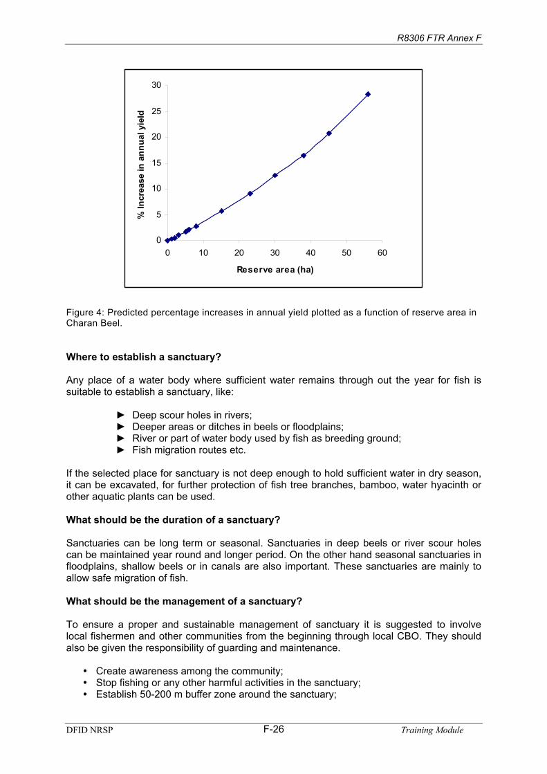
Prediction from modeling results: A total dry season reserve area of less than 20 ha is predicted to bring only modest increases in yield (Table 4 and Figure 4). The model predicts that reserve area must exceed at least 25 ha before improvements in yield in excess of 10% are achieved. This reflects the fact that currently much of the total fishing effort is expended early in the season giving rise to growth over-fishing. Reserves are predicted to increaserecruitment by reducing overall exploitation rates and thereby improving the survival of the spawning stock.
Table 4: Model predictions of average recruits, natural mortality, yield, % gain in yield, fishing mortality and yield-per-recruit (Y/R) for different reserve areas during the dry season (December– May).
Reservearea (ha)
% ofminarea Recruits M (y-1)
PredictedYield (kg) % Gain F (y-1) Y/R (g)
0 0 4873538 0.16 10186 0 3.27 2.091 1 4902654 0.16 10214 0.3 3.26 2.082 2 4932120 0.16 10241 1 3.26 2.083 4 4992129 0.16 10297 1 3.26 2.065 6 5053618 0.16 10353 2 3.26 2.056 8 5116642 0.16 10410 2 3.25 2.038 10 5181260 0.16 10469 3 3.25 2.02
15 20 5530515 0.17 10774 6 3.23 1.9523 30 5930338 0.18 11106 9 3.21 1.8730 40 6392582 0.18 11469 13 3.18 1.7938 50 6933110 0.19 11868 17 3.16 1.7145 60 7573621 0.20 12309 21 3.13 1.6356 75 8792025 0.21 13069 28 3.08 1.49
DFID NRSP Training ModuleF-25
R8306 FTR Annex F
0
5
10
15
20
25
30
0 10 20 30 40 50 60
Reserve area (ha)
% In
crea
sein
ann
ual y
ield
Figure 4: Predicted percentage increases in annual yield plotted as a function of reserve area in Charan Beel.
Where to establish a sanctuary?
Any place of a water body where sufficient water remains through out the year for fish is suitable to establish a sanctuary, like:
Deep scour holes in rivers;Deeper areas or ditches in beels or floodplains;River or part of water body used by fish as breeding ground; Fish migration routes etc.
If the selected place for sanctuary is not deep enough to hold sufficient water in dry season,it can be excavated, for further protection of fish tree branches, bamboo, water hyacinth or other aquatic plants can be used.
What should be the duration of a sanctuary?
Sanctuaries can be long term or seasonal. Sanctuaries in deep beels or river scour holes can be maintained year round and longer period. On the other hand seasonal sanctuaries infloodplains, shallow beels or in canals are also important. These sanctuaries are mainly to allow safe migration of fish.
What should be the management of a sanctuary?
To ensure a proper and sustainable management of sanctuary it is suggested to involve local fishermen and other communities from the beginning through local CBO. They should also be given the responsibility of guarding and maintenance.
Create awareness among the community; Stop fishing or any other harmful activities in the sanctuary;Establish 50-200 m buffer zone around the sanctuary;
DFID NRSP Training ModuleF-26

R8306 FTR Annex F
Responsibility to look after, repairing etc. should be given to local organization.
So far, established sanctuaries in different water bodies in different parts of Bangladeshhave proved to be successful. A joint effort of establishing sanctuaries and maintenancewould be an effective step towards enhancing open water fisheries.
Periodic Ban on Fishing or Closed Season
What is a periodic ban or closed season?
Generally, people fish round the year in the rivers, beels, and haors using different types of gears. The ever-increasing number of fishermen and gears creates a pressure on this self-sustaining resource that causes a decline in production. That is why periodic ban on fishing has proved to be successful method for fisheries management. People impose a ban on fishing during critical periods of a fish’s life cycle.
Why is periodic ban important?
One of the major causes of declining floodplain fisheries production and biodiversity is overfishing. Over fishing reduces and finishes the stock, as a result production and diversity gradually reduces. To overcome this problem and maintain a sustainable stock, periodic bans on fishing are proved to be a successful method.
How long should be the ban period?
Length of periodic ban should be determined based on situation and need. Fishing bans canbe 1 to 3 months period, maybe less or more. In this regard, the number of fishermen and their rate of dependence should be taken into consideration.
Which period is suitable for fishing ban?
As because ban is imposed for a short period, it should be determined which period will bemore effective to maximize production. Experiences in Pabna Irrigation Project on 6,773 Hafloodplain shows:
One-month ban in January resulted in 102% increase in production, which is higherthan any other month. If a 1-month ban imposed in April will increase production by95%.Two months ban in January-February will result in 125% increase in production.Based on local situation ban during April-May period will result in 20% increase in production.Three months ban during January-March can result in 139% increase in fishproduction, which is more effective than any other period of the year. Three months ban during July-September would increase production up to 124%, during October-December it is only 68%.
Local decision on this is more important depending on the water extent of the period andseasonality.
Model predictions: Closures during any month are predicted to improve yields reflectingexcessive levels of fishing mortality (Table 5). The greatest gains are achieved by closing the fishery in July or August when fish are still growing rapidly. Currently this fishery is being growth over-fished as reflected in the large predicted gains in yield-per-recruit (Y/R) when the fishery is closed during this period of rapid fish growth. Significant gains are also
DFID NRSP Training ModuleF-27

R8306 FTR Annex F
predicted by closing the fishery in April when fish densities are high and fish are vulnerable to capture. Improved fish survival increases recruitment to the fishery later in June.
Three-month closures from June to August are predicted to increase yields by as much as 60%, although earlier closures between May and July also predicted to result in significantincreases in yield. A closure during this period may be more acceptable to fishers.
Table 5: Model predictions of average recruits, natural mortality, yield, % gain in yield, fishing mortality and yield-per-recruit (Y/R) for monthly closures.
Closed Recruits M (y-1)PredictedYield (kg)
%Gain F (y-1)
Y/R(g)
None 4873538 0.16 10186 0 3.27 2.1June 5071325 0.16 10436 2 3.24 2.1July 4947936 0.17 12547 23 3.25 2.5Aug 5035625 0.17 12577 23 3.25 2.5Sep 5216786 0.18 11544 13 3.23 2.2Oct 5403782 0.18 10800 6 3.23 2.0Nov 5289288 0.18 10529 3 3.23 2.0Dec 5175803 0.17 10463 3 3.24 2.0Jan 5149475 0.17 10473 3 3.25 2.0Feb 5243845 0.17 10559 4 3.25 2.0March 5693328 0.17 10940 7 3.22 1.9April 5988554 0.17 11172 10 3.22 1.9May 5262929 0.16 10466 3 3.23 2.0
Feb-April 8167682 0.20 12809 26 3.13 1.6April-June 6935067 0.18 11863 16 3.13 1.7May-July 5588908 0.18 13495 32 3.18 2.4June-Aug 5325425 0.20 16974 67 3.20 3.2
With respect to the situation in Bangladesh, how long should a ban period be?
Considering the population presser and dependence on fishing, especially by the poor fishers, a short period of ban, 1-2 months, would be feasible.
Some other management tools:
1. Gear regulation: Harmful or destructive fishing gears are not allowed, mesh size offishing nets are controlled. CBOs within their management areas can stop usingcurrent jal, fixed engines, moshari jal, dewatering, etc. This will stop destructivefishing practices and allow fingerlings to grow bigger.
2. Regulation of size limits of fish: Minimum size limits for specific species can beimposed on fish that may be retained on board any fishing craft or landed, orexposed or offered for sale. This will allow big fish to grow up to its first spawning year at least.
3. Quota system: In principle the quota on catch (a fixed maximum catch per year per gear) is a direct regulation. It needs much data on the productivity and production.For Jalmohals in Bangladesh and in many other places it is very difficult to apply.
4. Limited entry: Allows only the limited number of fishermen required to cause the desired mortality, but allowing them to fish freely. For a Jalmohal this can be determined by the CBOs along with GoB and NGO officials.
DFID NRSP Training ModuleF-28

R8306 FTR Annex F
5. Licensing: Keeping the capacity at the desired level compared to the potential of theresource needs some type of licensing system.
6. Leasing of fishing rights of a water body: Control goes to one person or to anorganization.
7. The improvement and increase of living resources: Through physicalinterventions like stocking and habitat improvement.
Table 6: Comparison of different methods Method Data
requirementCostinvolvement
Objective Efficiency Fishersacceptance
1. Closed season Medium Low Increasedspawning success
Efficient Medium
2. Protected area Low Medium Protect mother fish Efficient High3. Gear regulation
High Medium Reduced &selective fishing
Medium Low
4. Regulation offish size
Medium Medium Fish attainsmaturity
Low Low
5. Quota High High Maintains optimumfishing pressure
Low Low
6. Limited entry High Medium DO Low Medium7. Licensing High Medium DO Medium Medium8. Leasingsystem
Low Low Revenue/ oneman/body controls
Medium Medium
9. PhysicalImprovement of resource
Medium High Re-establishhabitat
Efficient High
Difficulties of open water fisheries management in Bangladesh
1. Number of dependent or user is very high. 2. National level policy and planning is not resource friendly.3. Sufficient information for scientific management is lacking. 4. People (users mainly) are not aware of the sustainable use of the resource. 5. Many other factors beyond wetlands are also responsible for resource degradation.6. Fish acts needs review and are not properly enforced.
DFID NRSP Training ModuleF-29

R8306 FTR Annex F
Session 6. Crop Diversification in Floodplains
Attending this session participants will be able to describe and explain:i. the existing cropping pattern and need for diversification in
floodplains;ii. the process of selecting suitable crops for floodplains; iii. brief cultivation method of some selected crops; iv. cost-benefits of the selected crops with boro rice.
3 hours.
Presentation, brainstorming, participatory discussion.
OHP/Multimedia slides, Handout: “Crop Diversification in Floodplains”.
OHP/Multimedia projector, white board, flipchart board, flipchart paper, marker, adhesive tap.
Step 1. The facilitator will initiate the discussion through introducingthe topic, through brain storming he will figure out the existingcropping pattern of floodplains. He than will present the systemsimplications of boro rice cultivation in the floodplains. Step 2. The facilitator will invite participants in a group work. The participants in small groups will identify suitable crops for floodplain areas and the reason why they have selected them. Each groups will present their findings. Step 3. With assistance from the participants the facilitator will analyzecost and benefits of some of the selected crops and compare with the cost and benefits of boro rice. The facilitator will conclude the session.
The facilitator will clarify that the floodplain is not only for growingrice, there are many other resources in the floodplains including fish. Diversified cropping pattern will be helpful for all the resources, as well as it will benefit farmer more.
Objectives:
Time:
Methods:
ResourceMaterials:
Equipments:
Process:
Notes for Facilitators:
DFID NRSP Training ModuleF-30

R8306 FTR Annex F
Crop Diversification in Floodplains
In Bangladesh floodplains are predominantly converted into rice fields, more over Water Development Board (BWDB) every year constructing embankments and other structures sothat farmers can bring perennial part of a beel under rice cultivation, destroying the habitat inhabitable for original aquatic life thus reducing resources production and other goods andservices of wetlands.
Where and when is boro rice cultivated?
At present most of the floodplains and surrounding high lands are cultivated with boro rice inthe dry winter season. Generally, boro rice is planted during December-January and harvested in April-May. Boro rice demands a very high quantity of water that is 3-4 times thatof other rabi crops that are cultivated in the winter season. This uses the water from beels,canals and rivers and further reduces the already reduced aquatic habitat in critical dryseason. That is why instead of single boro rice if diversified cropping is practiced in thefloodplains, it will be beneficial for both farmers and the aquatic habitats.
What kind of problem created for fish by cultivating boro rice?
Analysis of situations suggests that boro cultivation in the floodplains has 3-fold effects onfish. All 3 effects are very harmful natural fisheries (Figure 5). It is to be noted here that 1 haboro rice cultivation demands 10,000 cub.m. of irrigation water.
Firstly, farmers tend to drain out water to dry-up and prepare land for boro rice cultivation atthe beginning of dry winter season during November-December.
Secondly, during intercultural operation farmers uses water from the beels, canals, rivers and other surface water sources to irrigate the boro rice. This further reduces the already reduced aquatic habitat.
Thirdly, during the early flooding time in April-May they stops entry of early rainwater into the floodplains till the rice is harvested. Brood fish, fry-fingerlings cannot migrate from onehabitat to another which is a part of their life cycle.
All these activities reduces and destroys dry season fish habitats disrupts fish migration. Theobvious result is reduced fisheries production and biodiversity.
DFID NRSP Training ModuleF-31

R8306 FTR Annex F
Figure 5: The systems implications of lowland winter rice production
Dry-season rice production in low and very low land, in and
adjacent to water-bodies.
Need to ensure landis dry byDecember/January
Use sluice gates to maximise waterdrainage at start of dry season.
Need to prevent earlyfloods in mid-May andearly June from damagingcrop prior to harvest
Use sluice gates to prevent floodwater entryat start of flood season.
Irrigate such land from surface waterabstracted from water-body itself.
Reduced habitat for Fishery
Reduced habitatfor Fishery
Reduced accessibility for migrating fish & reducedhabitat for fishery
Reduced fish catch
NRSP Training ModuleF-32
ssure being put on sluice gateorities to keep gates closed in the early flood season.
he question hehether the water will be used for rice alone or for both rice and fish.
Dry season rice production in the beel/very low lands thus lies at the heart of the problemsstudied here. Firstly, sluices are opened to maximise drainage out of the floodplain at the end of the flood season, so that lowland will sufficiently dry out for rice cultivation. Secondly,proximity to the water-body encourages the subsequent irrigation of such plots from the residual water in the water-body. Thirdly, low-lying rice plots are most susceptible to damagefrom early flooding prior to harvest, which leads to pre
uth
re, w
a
Through these process wetlands are loosing their natural productivity, resulting in loss production and biodiversity of fish and other aquatic animals and plants. Tis
DFID

R8306 FTR Annex F
What is rabi crop diversification?
Diversification of rabi crops means here to reduce cultivation of water hungry boro rice in thefloodplains and increase other rabi crop cultivation; those need much less irrigation water.The main objective is to reduce the use of beel water, which is critically needed for fish and other aquatic life at that time. Experiments shows that there are a range of alternative crops that can be cultivated successfully in the floodplains instead of boro rice, and can benefitfarmers even more using only one-quarter of the irrigation water. This will also benefit fishermen by improving fisheries.
Why is crop diversification for floodplains are needed?
The dry season is the most critical period for floodplain fish, water in the beels or other depressions becomes scarce, and sometimes dries up completely, making the habitatuninhabitable for aquatic life. That is why it is important to keep sufficient water during dry season in the beel so that at least some mother fish can be sustained. However, boro rice cultivation in the floodplains is a big obstacle in this regard. To cultivate boro rice farmerstend to drain out beel water as soon as possible, and will use up the remaining beel water for irrigation. At the end, before harvesting, they will keep the gate closed, preventing early floodwater from entering the beels. As a result, beels are dry and aquatic life under threat.
An experiment in Pabna Irrigation Project shows that after irrigating 500 ha boro rice fishproduction reduced drastically and fisheries completely collapsed after irrigating 700 ha bororice (Figure 1).
What benefit for fisheries from cultivation of alternative rabi crops?
CPUA (KG/HA) IN RESPONSE TO RABI IRRIGATIONABSTRACTION
0
50
100
150
0 1000 2000 3000 4000 5000
HA IRRIGATED
CPU
A onionswheat
If the floodplains are cultivated with maize, wheat, potato, garlic or other rabi crops, thoserequires much less irrigation water, itwill help keep more water in the beel
for fish. Pabna Irrigation Projectexperiments suggest that even afterirrigation of 2,500 ha. for wheat, it is possible to obtain a fisheriesproduction up to 50 kg/ha. If onionsare cultivated, the same amount of fish can be obtained even afterirrigating 4000 ha. (Figure 6). Thisclearly shows that the beel fisherycan be protected if diversifiedropping pattern can be introduced. c
hat are the benefits of rabi crop diversification? W
If floodplains are cultivated with diversified rabi crops, it will benefitthe farmers more and this will alsobe benefited for the aquatic ecosystem through retaining morewater in the dry season. Other rabi crops can be harvested 3-4 weeks earlier than boro ricethus can avoid the risk of damage by heavy rain or early flooding.
190Potato
175Onion
240Maize
200Wheat
835HYV Boro
IrrigationRabi
Table 7: Expected irrigation demands for rabi crops at Jhendiah (mm per ha for rabi seasonsoaking and preparation demands)
, not including land
Figure 6: CPUA – Hectares irrigated relationship for alternate rabi crops
320Brinjal
DFID NRSP Training ModuleF-33

R8306 FTR Annex F
As the crop is harvested well in advance, the sluice gates can be kept open during early flooding to facilitate fish migration.Diversified cropping in rabi season and deep water Amon cultivation during monsoon will benefit the farmers as well as will provide an improved habitat for fish.If sufficient water can be retained in beels, it is possible to increase fisheries productionto a satisfactory level.
What are the suitable alternative rabi crops?
Many alternative rabi crops such as wheat, maize, onion, garlic, potato and many other vegetable crops can be beneficially cultivated in the floodplains of Bangladesh. (Cropselection should be done based on soil quality) These crops need much less irrigation water (Table 8), thus keeping some more water for fisheries.
Table 8: Performance of alternative rabi crops demonstrated at Charan Beel site in year-1 (October’03-March’04)
Crops that performedbest
Crops that performedfairly well
Crops that did not do well - not suitable (or further trials are required)
TomatoMaizeSweet gourdEgg plant Bitter gourd RadishLong yard beanRed Spinach
ChilliWheatPotatoDattaCucumberLintelKalaiMotor shuti
OnionWater melonBush bean
Some Piloting Results
Eighty-five farmers piloted alternative rabi crops in Charan Beel area during 2003-’04 rabiseason with the assistance from CNRS and local DAE officials. The major crops were wheat, maize, potato and garlic. The results are presented here.
Comparing the cost and returns of all rabi crops demonstrated in Charan Beel, the results from potato was found encouraging (Figure 7 and 8). In absolute term, the gross returns of potato, of Tk.43,573/ha, was found to be the highest. However, the initial investment neededfor potato was also the highest (Tk.53,045/ha). Although the gross return from potato was highest, the amount of return was found low, at82% of the investment. Thus, onehas to invest relatively more moneyto cultivate potato.
Next to potato, garlic produced the second highest return, Tk.33,678/ha. The cost of productionof garlic was also higher (Tk.26,600/ha) than that of wheat and maize. However, in case garlic thenet return over investment was higher (126.61%).
Figure 7: Comparative cost-benefit of boro rice and 4alternative rabi crops cultivated in Charan Beel
11,300
53,045
26,600
18,172
31,772
9,345
43,573
33,678
24,81920,689
0
10,000
20,000
30,000
40,000
50,000
60,000
wheat potato garlic maize boro
DFID NRSP Training ModuleF-34

R8306 FTR Annex F
Comparing all rabi crops, the highest return over investment of 137% was recorded for maize crop where Tk.24,819/ha was the net return against the production costs of Tk.18,172/ha only.
Wheat produced the least return of Tk. 9,345/hawas achieved in absolute term. The investment in wheat was also very low, only Tk. 11,300/ha. However, return over investment was 83%, which is similar to that of potato (82%) and higher than thatof boro rice (65%). Thus, wheat can be consideredas the cheaper crop. With relatively low costs, thiscan be grown. Thus, wheat should be a goodchoice for the poor farmers in the rabi season.
As observed, in terms of income, boro is not thatbad. Although the investment in boro is higher thanmany rabi crops (except potato) the net return was found nearly double than that of wheat and near tomaize. However, due to the cost-benefit ratio boro, it is not the right choice for farmers.Figure 13 shows that the net return over investment in boro was 65% only, was the lowest than all other rabi crops.
137127
83 82
65
0
30
60
90
120
150
maize garlic w heat potato boro
Figure 8: Return over investment (%) for different rabi crops
Based on the production performance and analysis of cost-benefits of different rabi crops, itcan be concluded that all the four major alternative rabi field crops demonstrated are suitable for the Charan Beel site. Therefore, depending on land elevation and soil quality, farmerscan continue cultivation of these rabi crops profitably along with boro rice.
DFID NRSP Training ModuleF-35

R8306 FTR Annex F
Session 7. Sluice Gate Management
After attending this session participants will be able to describe and explain:i. present management practice of sluice gates and its impact to
floodplain fisheries; ii. how to operate sluice gates in a fish friendly way.
45 minutes.
Presentation, brainstorming through question and answer.
OHP/Multimedia slides, handout on: “Sluice Gate Management”.
OHP/Multimedia projector, white board, marker.
The facilitator will initiate the discussion with introducing the topic; he will present sluice gate structure, its present practice of operation, its impact on floodplain fish migration and fisheries production. After that he will present the methods and ways of fish friendly operation of sluice gates.
Present practice of sluice gate management is only targeting rice that is harmful for fish and other aquatic resources. But there are ways to manage sluice gates in a fish friendly manner, which will not harm rice but benefit aquatic resources within the floodplain. The ways and means of fish friendly operation of sluice gates also needs to describeand explain. Participants should be as much as possible included in the discussion process and share their local experiences.
Objectives:
Time:
Methods:
ResourceMaterials:
Equipments:
Process:
Notes for Facilitators:
DFID NRSP Training ModuleF-36

R8306 FTR Annex F
Sluice Gates Management
There is 653-flood control and irrigation (FCDI) schemes at present exist in Bangladesh and are impacting 5.5 million ha. wetlands. FCDI schemes are beneficial to the farmers, but atthe cost of fisheries production and livelihood of millions of fishers and the natural wetlandenvironment. This session first tries to create an understanding of the impact of these sluice gates in general, secondly, to suggest a fish friendly management of the sluice gates.
What is the significance of obstacles to fish migration?
One of the main reasons of the loss of floodplain fisheries production and biodiversity is the loss of migration facilities to complete fish’s biological cycle. As a result spawning andgrowth of fish is hampered, production decreased, biodiversity threatened.
What are the major obstacles? Studies identified followings as the major obstacles to fish migration:
1. Flood control and irrigation projects: At present there are 653 such projects in thecountry that are negatively impacting 5.5 million ha. wetland. Fish migration to andfrom these wetlands is either completely or largely stopped. Generally three types ofstructures are built in these sorts of projects:
a. Earthen embankments along the river to protect spill over from the river toadjacent crop fields, floodplains and beels.
b. Mouth of Canal blocked to stop river water entering the beels or floodplainsthrough canals.
c. Regulators at the mouth of canal/distributaries to regulate entry of water to adjacent beel or floodplains.
All these three types of flood control structures hamper fish migration. Among them,regulators are less harmful if operated in a fish friendly manner, allowing limited fish movement, which is possible without hampering rice production.
2. Catching migratory fish: With the onset of monsoon, when fish start to migrate,many people begin catching fish in, and at the mouth of, canals / small links that areused as their migratory routs. Studies revealed that 50% of the migratory fish are caught before reaching the regulators.
3. Silted up of the canals: Due to afforestration and unplanned land use land slide anderosion has increased in the hills and uplands and as a result canals and small rivers are being silted up. As a result, water flow through them either completely stopped or reduced significantly, which is hampering fish migration. Silted up of the canalbetween Juginee Beel and Laohajang River at Tangail District is a good example, where the fish production in the beel reduced suddenly as the connection was disrupted and no fish could enter into the beel from the river.
4. Fishing at the regulator or sluice gate points: There are 4,190 regulators or sluicegates in 653 FCDIs. When fish tries to enter into the floodplains through them people sets net and other gears there and catches up the fish those were able to escapefrom catching in the canals.
How to remove these obstacles to fish migration?
Re-excavation of silted canals, so that early season flooding water carrying fishspawn and hatchlings can enter into the floodplains through them.
DFID NRSP Training ModuleF-37

R8306 FTR Annex F
Stop catching migratory fishes, while they are going one habitat to another for breeding or growing.Stop fishing at the regulator points by using nets, spears or other means especiallyduring spawning migration. Keep the gate open during fish migration period, especially during spawning period toallow brood fish and spawn/hatchling movement. The sluice gate committee can dothis with out hampering rice. Declare as seasonal sanctuary can also protect fish from catching in canals or at themouth of the sluice gate or regulator.
Why fish friendly operation sluice gate required?
To protect rice crop in the floodplains there are about 13,000 km embankment and 4,190 sluice gates constructed under 653 flood control and irrigation projects in Bangladesh. As a result 5.5 million ha. of floodplain are directly impacted. These sluices and embankmentshave severely impacted and reduced fisheries production and species diversity of the areas. This is why operating the sluice gates in a fish-friendly manner is very important. Researchreveals that fish and crop friendly operation can benefit both, and increase fish productionsignificantly and conserve species diversity.
What is fish friendly operation of sluice gates?
Sluice gates are operated mainly targeting crops, they are opened or closed to benefit cropsalone. Natural fish movement never considered in this regard. But sluice gate managementshould be in such a manner that allows fish movement from one habitat to other in need andin time, which is urgent for fishes in the nature to propagate and survive without damagingrice, this way of sluice gate operation can be denoted as fish friendly sluice gate operation. Itwill enhance fisheries production and will conserve species diversity as well.
This sort of operation of the sluice gate needs the willingness of the committee, close observation on day-to-day water extant and decision-making. It will be possible to achieve if the committee is well motivated and have fisher representatives.
How important is fish friendly operation of sluice gates?
In different parts of Bangladesh there are four very expansive fish passes are constructed toallow fish movement to and from river and enclosed floodplains. However, all the four fish pass are ineffective at present due to technical and management faults. Considering thesituation local people and the scientists suggests that instead of constructing more costlyfish passes it would be prudent to establish a fish friendly operation of the existing sluicegates, where the gate will be closed or opened coordinately to allow fish movement throughthem whilst at the same time protecting crops. Fishermen and farmers representative will jointly discuss and decide. Piloting results proves that it is possible to increase fishproduction considerably with out hampering crops in this way.
How to operate a sluice gate in a fish friendly manner?
Sluice gate should be kept open with the onset of monsoon when fish starts moving from floodplains to river and river to floodplains so that fish and fish spawn and hatchlings can move one habitat to another as per their need. At the same time it should be regularlymonitored whether floodwater is damaging the crops or not. Again, at the end of themonsoon gate should be kept closed as long as possible to maintain sufficient water insidethe embankment to allow fish to grow for a longer period too, this will also increase fisheriesproduction.
DFID NRSP Training ModuleF-38

R8306 FTR Annex F
What are the principles of fish friendly sluice operation?
To enhance fisheries production within flood control projects 6 principles should be followed: Gate should be open frequently at the onset of monsoon to allow fish to enter into thefloodplains, but water scours should be avoided at the mouth. At the end of monsoon when water starts to recede, the water should be released slowly.At the end of monsoon some more water should be preserved inside the embankment aslong as possible, this will allow fishes a longer growing time. The connectivity’s from river to gate and from gate to beel should be well protected; fishing is controlled to allow fish, spawn and hatchlings to enter.Framers should be motivated so that they will grow early harvestable low waterdemanding crops instead of boro rice so that it will be possible to keep the gate open for longer period and well in advance.
All this activities should be done with the participation of local community and all stakeholders including farmers and fishers.
DFID NRSP Training ModuleF-39

R8306 FTR Annex F
Session 8. Land Retirement
After attending this session participants will be able to describe and explaini. in relation to present agricultural practice why land retirement is
important;ii. which lands are suitable for sacrifice for fisheries and how to
achieve.
45 minutes.
Presentations, brainstorming, small group work, open discussion.
OHP/Multimedia slides, handout: “Land Retirement”.
OHP/Multimedia projector, white board, Marker.
The facilitator will initiate discussion by introducing the topic. He will present the present farmers practice of gradually extending rice cultivation and acquiring wetlands and justify why land retirement is important for floodplain management. He will also highlight which lands are suitable for retirement and the social and institutionalapproach for achieving this.
Land retirement is a newer and less attractive option for farmers but important for fisheries. So it is important to emphasis on the process of community management.
Objectives:
Time:
Methods:
ResourceMaterials:
Equipments:
Process:
Notes for Facilitators
DFID NRSP Training ModuleF-40

R8306 FTR Annex F
Land retirement
A natural outcome of the dry season sluice gate management strategy outlined above is the ‘retirement’ of some previously boro-cropped land from cultivation. As discussed above, this needs only be a small fraction of the total cultivable land, in the deeper areas of water-bodies, and adjacent to drainage channels. There may also be value in strategic retirementof occasional parcels of further land – for instance, plots vulnerable to early flooding2, for the protection of which landowners petition sluice gate controllers to keep gates closed in theearly flood season. Critically for the feasibility of this strategy, estimation is that theseretirements need only constitute a small fraction of overall cultivable land in individual floodplain hydrological units.
Which Lands are Suitable for Retirement and how can this be achieved?
As the water decreases farmers tend to plant rice on those lands in the beel beds, these lands are mostly khas. These lands are at high risk of flood damage in the early floodingseason. Returns of rice from these lands are quite uncertain; these lands are suitable for retirement. But the success depends on how to motivate farmers to abstain from planting on these lands.
Experience suggest that motivate farmers not to plant rice on these sorts of land is difficult.Strong motivational work with awareness is required under long term programmes.Incentives for doing this might attract farmers to abstain from cultivating such lands.
2 Although, these may be the same very low plots that are inundated by increased dry season water retention.
DFID NRSP Training ModuleF-41

R8306 FTR Annex F
Session 9. Habitat Degradation: Problems, Issues, and Participatory Habitat Restoration
After attending this session participants will be able to describe and explaini. present status of floodplain habitats of Bangladesh; how they
are degrading, what are the related problems and issues; ii. how to restore habitats in a participatory way.
1 hour 30 minutes.
Presentation, brainstorming, discussion, small group work.
OHP/Multimedia slides, handout on: “Habitat Degradation: Problemsand Issues and Participatory Habitat Restoration”.
OHP/Multimedia Projector, flipchart paper, flipchart board, white board, Marker.
Step 1. The facilitator will initiate the discussion through introducingthe topic. He will make a presentation on present status of floodplainhabitats.Step 2. He will than invite participants for a small group work on how these floodplains are degrading, what are the problems and issues arising from this degradation. Each group will present their findings and discuss. Step 3. The facilitator will identify activities for floodplain habitatrestoration with the help of participants and note them on the flipchartpaper. He will than with the help of participants determine the ways and means for accomplishing them.
The Facilitator will conclude the session.
Present status of specific habitat and activities for restoration to be identified before hand through PAPD. During implementation detailed action plan preparation and accomplishment is better to do with a local existing or formed organization.
Objectives:
Time:
Methods:
ResourceMaterials:
Equipments:
Process:
Notes for Facilitators:
DFID NRSP Training ModuleF-42

R8306 FTR Annex F
Habitat Degradation: Problems, Issues, and Participatory Habitat Restoration
A habitat is the home or the area where an organism lives. Habitats include all the features of the environment.
Due to various anthropogenic and natural causes, the wetland habitats in Bangladesh areunder threat. Most of habitats in the floodplains have been degraded, many habitats have been degraded partially and degradation initiated in the remaining habitats. In fact, there is no habitat left in Bangladesh, which is free from any disturbance or in other words, there is no habitat in its natural condition. However, there are a few in near natural condition wherethe anthropogenic interventions are less due to difficulty in access or under stringent control of an organization or agency.
Sustainable management of inland open water fisheries therefore requires understanding offloodplain environments, biology of fish species or guilds and interrelationship of fish andphysical habitats in dynamic floodplain ecosystems through which the robust fishery ofmultiple species composition attain a self-sustaining status in nature.
The major causes of degradation of wetland habitats
Siltation of the wetland beds Conversion of wetland into crop landsFragmentation of wetland due to road and other infrastructureWater control dykes and regulators Clearing of forests from wetlandsClearing of trees and vegetation in the watershedUnsustainable cultivation practices in the watershed
How have these degradations taken place?
All these are man-made and by the people at various hierarchies of use, who manage andcontrol the wetland habitats. For example, local people encroach in the wetland, grab khas lands, and convert them into croplands. They carry out unsustainable cultivation practices inthe watershed, and cut trees in the swamp areas, as well as in the watershed and riparian areas. Government agencies construct flood control dykes, regulators and rural roads at seldom consider wetland ecology and related issues, sustenance of inland capture fisheriesproduction and livelihood aspects of floodplain communities. Due to lack of trans-boundarymanagement arrangements with the upper riparian countries, Bangladesh receives huge quantity of silt, which rapidly fills up the wetland habitats thus degrading the habitats,resulting reduced fish yield, and declining species diversity.
The overall scenario is alarming. Lack of a proper and effective policy to protect the wetlands in Bangladesh generates frustration therefore; ways and means of protecting the valuable fishery in the open waters are at risk. Scientific knowledge and information base on the underlying facts and issues of wetland functions, values, and contribution to the income and livelihood of the millions of rural people in Bangladesh is not in an articulated form. Although there are many studies and projects generating important information and outputs includingsuitable approaches in floodplain resource management, concrete guideline to move forwardis still lacking largely due to patchy information and division of interests and responsibilities
DFID NRSP Training ModuleF-43

R8306 FTR Annex F
Restoration of wetland habitat
What is restoration of wetland habitat?
Restoration of habitats can be defined as the activities undertaken to bring back the degraded or semi-degraded wetland habitats in to their functional stages. The restoredhabitats should be brought to a stage so that the said habitats after restoration can support a species or group of species or a community or communities to perform its or their relevantrequired natural functions at different life stages viz. migration, reproduction, feeding, growth and refuge. For example, if a canal is restored, fish and other aquatic biota can perform their migration, similarly if a degraded beel is restored to a perennial stage, then fish and otheraquatic biota can have year round habitat for feeding, growth and refuge (in the dry season).
Wetland restoration can be defined as reestablishment of a disturbed or altered wetland as one with greater function or acreage. This may involve re-establishing original vegetation, hydrology, or other parameters to re-establish original or closer-to-original wetland functions (Fields, 1993). Degraded wetlands present restoration opportunities for improvements towater quality, habitat, water storage and other functions, and these opportunities can beparticularly useful for watershed-scale environmental planning. The goal of restoration is typically to re-establish wetland ecosystems to levels that existed before human influence.
How to assess restoration activities?
Ideally, restoration of a wetland habitat should be assessed through comparing the changes ofvalue and functions of a wetland by capturing pre and post restoration information. Such effortis usually considered very much scientific research. However, to assess the changes offisheries resources due to the restoration of habitat, following methods/process could beconsidered as worthwhile and easy to adopt at the project level, since the approach is new andis being tested in Bangladesh.
How to do social monitoring?
Household monitoring program is an indirect tool of assessment of habitat restoration thatfocuses on overall value. The objective of this program is to compare the changes associatedwith capture fisheries due to restoration/intervention. Household monitoring program can bedesigned to generate pre and post project database on:
Fish and aquatic resource consumption Species diversity
Involvement of people in fishing and aquatic resource harvesting Fishing income
Following two methods can be adopted in collecting data from the sample households:
a) Traditional Method: Traditional method refers to the conventional method of data collectionthrough deploying trained enumerators to selected households using structured questionnaires.Resident Monitors (RMs) from the respective local villages can be deployed to collect data fromthe sample households.
b) Participatory Method: Participatory method refers to the process of data collection involvingrural women or students who have basic literacy and numerical skills for using very simple datacards. They can record information from their own household and from adjacent households for
DFID NRSP Training ModuleF-44

R8306 FTR Annex F
selected days in every month by direct observation. They can also use traditional balance forweighing fish and others.
How to do biological monitoring?
A direct way to measure the changes in fish production and species diversity in the wetlandswithin a restored area is to follow a catch-monitoring program to generate pre and postintervention data; however the survey methods can be complex and may not cover the overallvalues. The points are:
• Fish harvest• Species diversity• Fishermen types and fishing intensity• Fishing methods and arrangements• Fish migration
What should be the approach?
To achieve the objectives of restoration of a wetland, implementing agencies should criticallyassess the associated activities and to be systematic in approach of each of such activity.Emphasis should be given to involving the local people in the site identification, planning, andimplementation processes. To this end, measures should be taken to incorporate the people'sknowledge and perceptions in the implementation framework as well as to preserve/ensureinterests of various occupational and stakeholders groups likely to be affected by therestoration. Some points are listed below which are important to consider during planning:
1. The activity is planned with the CBO from the beginning and wider community isfully aware.
2. Physical and biological benefit of the plan must be determined.3. Period for earth cutting or any other physical activities will be very short in open
water bodies.4. The soil type and condition must be checked and plan made accordingly.5. In some cases dewatering will be helpful to start early.6. Plan for place and proper dumping of earth.7. Vested interested group of people will show up.
How to select a site?
In selecting the site, different activities have to be carried out at various stages. The stages andactivities are briefly presented below:At the first stage, several visits are to be paid to working areas. Various types of maps andsatellite imagery should be collected and used to locate suitable wetlands for restoration viz.beels, khals in the working area. During such reconnaissance visits, preliminary discussionshould be undertaken with the local community and officials regarding restoration concepts andcomponents, and other related aspects of possible sites.
However, some basic criteria should be set to select the restoration sites
• The site should be as such that fish migration is obstructed or delayed due to choking ofkhals due to siltation due to rural infrastructures which act as a hindrance;
• The proposed intervention would not adversely affect socio-economic and ecologicalfunctions of the wetland;
• There exist community interests and consensus of the proposed rehabilitation of khals andbeels.
DFID NRSP Training ModuleF-45

R8306 FTR Annex F
Habitat restoration should be part of an overall management plan developed throughparticipatory planning by the local community with local government. Steps involved in such aprocess include:
Reconnaissance survey, area demarcation and resource mapping.Stakeholders’ identification and categoraization.Orientation of local government (UP, Upazilla etc.).Participatory planning, for example PAPD with direct stakeholders’ to identifyproblems and agreement on possible solutions and priority actions.Formation of implementation committee from the resource users communities.
Develop detailed proposal.Commission necessary approvals from respective government department andlocal government body.Generate/collect resources for implementation of project activities.
How to calculate the cost of restoration?
The major cost required for physical intervention in a restoration program is for earthwork.Head wise percentage of cost analysis in earthwork activities has been made on the basis of CNRS experience in 2001 (Table 9).
Table 9: Cost analysis of earthwork activities, % Distribution of costs by types of activities.
Direct laborfor earth cutting
Labor for casualmaintenancework
De-watering
De-weeding
Honorarium
Meeting Transportation
Photocopy&stationers
Miscellaneous
88.01 2.27 3.29 0.33 3.05 0.15 1.21 1.65 1.65
It is experienced that average earthwork cost for wetland restoration (in a beel) is Tk. 1,240per 1000 cft and therefore a total of Tk. 420,000.00 is required to excavate 3 feet depth in one-hectare beel area. In addition, a few labourers are required for accomplishing somecasual works (not directly involved in earthwork). Very short time period is available for earthwork in wetlands. To undertake the earthwork, in some cases, de-watering may be required. Local committee designates a few community people/ committee members forsupervising the earthwork activities and therefore they are paid honorarium for their job. Committee sits in a series of meetings for earthwork. Local people are hired to serve thenotice and there are other costs to hold meetings viz. refreshment, conveyance etc.Transportation cost is required for project staff, engineer, shifting of equipment duringearthwork. A large amount of photocopying is needed for reproducing master roll, proposals,minutes, and other necessary papers. Stationary like measurement tape, file, scale, pen,stapler, etc are also required. Miscellaneous cost covers various types of compensation for community viz. damages of standing crops, and to meet unpredicted expanses.
DFID NRSP Training ModuleF-46

R8306 FTR Annex F
Session 10. Watershed Management
After attending this session participants will be able to describe and explaini. present status of watersheds in Bangladesh, how they are
degrading and what are the related problems and issues; ii. how to do watershed management and what are the activities.
45 minutes.
Presentation, brainstorming, participatory discussion.
OHP/Multimedia slides, handout on: “Participatory WatershedManagement”.
OHP/Multimedia projector, flipchart paper, flipchart board, white board, marker.
Step 1. Through introducing the topic the facilitator will initiate the discussion, and will create an understanding on watershed and its importance for concerning floodplains. He will than make a presentation on present status of the watersheds, causes of degradation and its consequences on the floodplains.
Step 2. Through brainstorming he will list down activities for watershed management and ways and means for achieving them.
The facilitator will conclude the session.
Watershed and its issues may be a new area for most of the participantsso a elaborate explanations might be required. Again, for manyfloodplains watershed may be beyond their reach or a cross boundary issue.
Objectives:
Time:
Methods:
ResourceMaterials:
Equipments:
Process:
Notes for Facilitators:
DFID NRSP Training ModuleF-47

R8306 FTR Annex F
Session 11. Consensus Building Among Stakeholders
Objectives:
Time:
Methods:
ResourceMaterials:
Equipments:
Process:
The facilitator will conclude the session.
Floodplains are multi resource system used by multiple stakeholders. So for an participatory integrated management of these resources consensus among the stakeholders is a must. At present PAPD is being used by many organizations for participatory programms for sustainable management of common property resources in particular. This session is planned for creating an understanding among the participants on the need and process of consensus building. Doing PAPD in reality will require more training.
After attending this session participants will be able to describe and explaini. the importance of consensus building among stakeholders in
IFM;ii. method and process of consensus building among primary and
secondary stakeholders.
2 hours.
Presentation, brainstorming, participatory discussion, small group work.
OHP/Multimedia slides, Handout: “Consensus Building AmongStakeholders”.
OHP/Multimedia projector, white board, flipchart board, flipchart paper, marker, adhesive tap.
Step 1. The facilitator will initiate the discussion through introducingthe topic. He than will invite all the participants to a group work by dividing them into small groups. In small group they will work out:
i. Who are the primary and secondary stakeholders of floodplain resources?
ii. Why it is important to build consensus among the stakeholders?
Step 2. The facilitator will present the process of PAPD method in building consensus among the stakeholders. During the process of presentation he will involve participants to share there experienceselsewhere.
Notes for Facilitators:
DFID NRSP Training ModuleF-48
R8306 FTR Annex F
Consensus Building Among Stakeholders
Consensus building among the stockholders in integrated floodplain management is very important, mainly because this will deal with multiple stakeholders and with multiple resources. Intervention in any of the resources systems might influence others, moreimportantly management of all the resources system would ensure a sustainable productionof the natural system.
CNRS evolved and using PAPD for consensus building among multiple stakeholders successfully for several years in natural resources use and other cases.
What is PAPD?
PAPD (Participatory Action Plan Development) is a participatory method for building consensus among multiple stakeholder groups on the sustainable management of natural resources. PAPD uses different participatory tools to reach consensus amongst the community on actions that area needed to improve the management of natural resources.The method recognizes the many stakeholders involved in the management and use of natural resources and ensures that all stakeholders’ views are represented. PAPD encourages community participants to respect others’ concerns and appreciate their dependency on the resource base as well as the function and values of the resourcesystems. A flowchart below shows the PAPD process sequentially.
In PAPD processes, the participating stakeholders will identify problems related to the natural resources within their locality and prepare a consensual plan on solutions throughanalyzing each of the prioritized problems. An action plan is then developed with theparticipation of all stakeholders’ (both primary and secondary). The method requires activeparticipation of stakeholders from different occupational groups and classes as it gives an opportunity for their opinions and concerns to be discussed and recognized. The method can potentially reduce conflict during project implementation and if the situation arises it assiststhe local people with resolving it. Thorough the process the local users of certain resourcesunderstand the importance of their participation in all the steps (starting from identification ofproblems, deciding upon solutions, preparing a work plan and in implementation). Thisenables them to feel a sense of ownership and play a more effective role during implementation of solutions.
DFID NRSP Training ModuleF-49

R8306 FTR Annex F
Problem Census Community members are divided into separate
Stakeholder groups (e.g. fishermen, farmers, etc.) to identify the problems they face in their communities and
solutions.
Problem Cluster and PrioritisationSecondary stakeholders (e.g. chief executive of a sub-
district (UNO); fisheries and agriculture officers, union parishad chairman, NGO representatives.) join with primary
stakeholders to discuss and prioritise problems related tonatural resources management.
Analysis of solutions Separate stakeholder groups appraise identified solutions to
assess the socio-economical, technical, environmental,political and sustainability (STEPS) impact of the actions
needed to achieve the solutions.
Consensus on SolutionsPrimary and secondary stakeholders jointly review the
compiled analysis of solutions recommended by separate primary stakeholder groups and agree potential solutions
The end product of PAPD is a consensual community
action plan
Before starting PAPD a preparationphase is needed for facilitators to:
familiarise themselves with the local environment and people’slivelihoods (wealthranking/census, resourcemapping, participatory land use survey, focus group discussions)identify stakeholders who will participate in the PAPD
4-6 villages with around 1000households in total4 stakeholder groups (e.g. fishers,farmers, women, day labourer, etc.) Two skilled facilitators’ teamVenue that allows for concurrentsessions
In the following situation a PAPD will take aminimum 8 days:
Wetland area around 300 ha
After a PAPD, communitiesdevelop a more detailed action
plan, which will beimplemented through existing
or newly formed local community institutions.
Key steps in PAPD
Figure 9: Flow chart showing major steps of PAPD
When is PAPD used?
Rural people, especially the poor, are directly dependent on common pool resources withintheir locality. The increasing pressure on these resources, along with unplanned use causes rapid degradation of the resources. Considering all these factors, the need to practicesustainable resource management is inevitable, where all the stakeholders and their representatives participate in planning and implementation processes through consensus. At present both non-government and government sector projects involved in natural resources management emphasise the participation of local stakeholders for their improvedlivelihood and sustainability of resource base. Government agencies in Bangladesh are central to any common pool resources management in the country (for example, theDepartment of Environment, Department of Forests and Department of Fisheries). There arealso many national, international and UN organizations involved in participatory resourcemanagement initiatives, which aim to benefit the poor. PAPD is an appropriate method for all these organisations. PAPD can ensure effective participation of user communities to achieve
DFID NRSP Training ModuleF-50
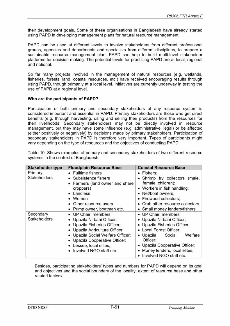
R8306 FTR Annex F
their development goals. Some of these organisations in Bangladesh have already started using PAPD in developing management plans for natural resource management.
PAPD can be used at different levels to involve stakeholders from different professionalgroups, agencies and departments and specialists from different disciplines, to prepare a sustainable resource management plan. PAPD can help to build multi-level stakeholderplatforms for decision-making. The potential levels for practicing PAPD are at local, regionaland national.
So far many projects involved in the management of natural resources (e.g. wetlands,fisheries, forests, land, coastal resources, etc.) have received encouraging results throughusing PAPD, though primarily at a local level. Initiatives are currently underway in testing the use of PAPD at a regional level.
Who are the participants of PAPD?
Participation of both primary and secondary stakeholders of any resource system is considered important and essential in PAPD. Primary stakeholders are those who get directbenefits (e.g. through harvesting, using and selling their products) from the resources fortheir livelihoods. Secondary stakeholders may not be directly involved in resource management, but they may have some influence (e.g. administrative, legal) or be affected(either positively or negatively) by decisions made by primary stakeholders. Participation ofsecondary stakeholders in PAPD is therefore very important. Types of participants might vary depending on the type of resources and the objectives of conducting PAPD.
Table 10: Shows examples of primary and secondary stakeholders of two different resourcesystems in the context of Bangladesh.
Stakeholder type Floodplain Resource Base Coastal Resource Base PrimaryStakeholders
Fulltime fishers Subsistence fishers
Farmers (land owner and share croppers)
Landless Women
Other resource users Pump owner, boatman etc.
Fishers; Shrimp fry collectors (male,female, children); Workers in fish handling;
Net/boat owners; Firewood collectors;
Crab other resource collectorsSmall money lenders/fishers
SecondaryStakeholders
UP Chair, members; Upazila Nirbahi Officer; Upazila Fisheries Officer;Upazila Agriculture Officer; Upazila Social Welfare Officer; Upazila Cooperative Officer; Lessee, local elites; Involved NGO staff etc.
UP Chair, members; Upazila Nirbahi Officer; Upazila Fisheries Officer;Local Forest Officer; Upazila Social WelfareOfficer;Upazila Cooperative Officer; Money lenders, local elites;Involved NGO staff etc.
Besides, participating stakeholders’ types and numbers for PAPD will depend on its goal and objectives and the social boundary of the locality, extent of resource base and other related factors.
DFID NRSP Training ModuleF-51

R8306 FTR Annex F
How to do PAPD?
PAPD is done in three phases: i. pre-PAPD activities, ii. PAPD sessions and iii. Post PAPD activities. Each of the phases are again divided into several steps, activities and tasks arelisted below.
Phase 1. Pre-PAPD Activities
1. Acquire knowledge of the local area2. Acquire knowledge on natural resources system 3. Acquire knowledge on social and institutional systems4. Identify stakeholder groups5. Acquire knowledge on household socioeconomic features 6. Select participants for PAPD7. Preparation for conducting PAPD sessions
Phase 2. PAPD Sessions
Planning for PAPD
PAPD Step 1: Problem Census Activity 1. Problem identification Activity 2. Problem selection Activity 3. Problem prioritization
PAPD Step 2: Problem Cluster and Prioritization Activity 4. Problem analysis and solutionsActivity 5. Problem cluster and consensus on solutions
PAPD Step 3: Impact Analysis of Solutions Activity 6. Stakeholder analysisActivity 7. Impact analysis of solutionsActivity 8. Analysis of indicators for consensus building
PAPD Step 4: Consensus on Proposed Activities Activity 9. Consensus among primary and secondary stakeholders forproposed activities Activity 10. Opinion of local government and local administration on proposedsolutionsActivity 11. Community action plan for implementation of activities
Phase: 3. Post PAPD Activities
Activity 1. Informing resource users about the planActivity 2. Formation of plan implementation committee or institutionActivity 3. Detailed planning, budgeting, approval and resource collectionActivity 4. Implementation of activities Activity 5. Monitoring and evaluation
How PAPD Benefits a Community?
Participation in a shared learning process, which is not controlled by the most vocal or socio-politically powerful. It is a pro-poor method that actively encourages participation by the poorer members of a community.
DFID NRSP Training ModuleF-52

R8306 FTR Annex F
Facilitating a community to have greater control over the change process and improvementin their community’s management and use of natural resources.
Ensuring the agenda for discussion is internally driven and evolves with time rather thanbeing fixed and imposed by external actors.
What can be achieved with PAPD?
1. Understanding in a community on how to reach consensus amongst differentstakeholders.
2. Community action plans that identify interventions, which are agreed on andacceptable to all stakeholders.
3. An opportunity for communities to improve the management of natural resources,especially common property resources.
What is needed for a PAPD?
PAPD needs skill facilitation and a good understanding of the resource systems and local social functions.
PAPD takes a minimum of 8 days with 2 to 4 skilled facilitators in a situation dealing with 4 to 6 different primary stakeholder groups (e.g. Fishers, farmers, landless, women,sharecropper, leaseholders etc.). The length of PAPD depends on the number ofstakeholder groups and facilitators.
For details on PAPD please see:
CNRS/ITAD 2004. The PAPD Facilitators’ Guide. Version 1 November 2004. Dhaka, Bangladesh: Centre for Natural Resources Studies (CNRS).
DFID NRSP Training ModuleF-53

R8306 FTR Annex F
Session 12. Institutional Approach in IFM
Objectives:
Time:
Methods:
ResourceMaterials:
Equipments:
Process:
Notes for Facilitators:
After attending this session participants will be able to describe and explaini. the importance of institutionalization in IFM; ii. process of institutionalization in IFM;iii. what are the barriers and challenges for institutional
sustainability.
2 hours.
Presentations, brainstorming, small group work, open discussion.
OHP/Multimedia slides, handout: “Institutional Approach in IFM”.
OHP/Multimedia projector, white board, flipchart board, flipchart paper, marker.
The facilitator will initiate discussion by introducing the topic. He will through discussion create an understanding of community institutionsamong the participants. He will invite participants in small groups to work on: i. importance of community institutions in IFM; ii. who should participate and why; iii. structure of a community institution for IFM iv. what should be done for institutional sustainability.
This session is designed to widen participants understanding on the importance of community institutions in IFM, its structure, who should participate, how it will sustain.
DFID NRSP Training ModuleF-54

R8306 FTR Annex F
Institutional Approach in IFM
Effective local participation is considered at present central to sustainable management of common property natural resources. This appears in the form of Community BasedManagement (CBM) with the participation of user communities. Many recent projects haveestablished community based organizations and committees for resource management,termed as “Resource Management organizations (RMIs)”. Certainly these are increasingparticipation of all levels of stakeholders, secondary stakeholders also realizing theimportance, programmes are more inclusive. But evidence suggests that most of them could not make much progress or have failed largely on two counts: i. pro-poor outcomes and ii.sustainability. This session will discuss mainly approaches, models and structures and certainly the barriers and challenges ahead in institutionalization process involved in IFMprojects for ensuring programme performance through community participation.
The process and institutions need to be more inclusive and focus on achieving equitable benefits through collective actions. Here some CBM approaches, structure, barriers and challenges for establishing CBM is presented.
Possible management approaches and models for CBM
In 1950, under the State Acquisition and Tenancy Act, wetlands fisheries were acquired andrecorded as land. Ministry of Land started managing them through district and other local administrations. The management often referred as ‘revenue-oriented’ management;biological management and entitlements are ignored for revenue and considered as a major barrier for sustainable management and equitable distribution.
Realizing the practical situations government has taken some steps, but those was not thatmuch helpful to rectify the situation. For instance “Abolition of leasing of Open Jalmohals: 1995”, aiming to protect the interest of poor fishermen and make the earning of theirlivelihoods easier the government has decided to abolish the procedure of leasing rivers,canals and jalmohals. In practice the influential peoples, those who have mussel power, areharvesting the benefit. Community based management of common property renewablenatural resource is considered as a potential alternative and is gaining popularity inBangladesh. This coincides with a change in emphasis towards participatory sustainable resource management and use and involves the local institutions for this. Again, entitlementand equitable access to resources is still a big question. Related questions are: who are fullydependent on the resources for their livelihood and for their family nutrition supply? whoshould participate? what sort/structure of community organization will be able to manage the resources properly and will ensure the poor users entitlement? Based on these questionssome approach, models and structures are proposed below.
a) Approach 1: fishers managed fishery
The first approach includes stakeholder identification through household census,identification of fishers, and forming groups by NGOs with male fishers only. Grouprepresentatives will then identify the community activities (through consensus among thegroup members and among the groups), and these group representatives will be themembers of the Beel or River Management Committee. The NGO role is to facilitate the community participation, and to give direct support (training, credit, etc.) to the groupmembers in technical aspects of management.
DFID NRSP Training ModuleF-55

R8306 FTR Annex F
Stakeholders/others
Identify fishers
Household census
Fishers managed fishery Better-managed
fishery through poor fishers participation
Sustainableimprovement of livelihoods of poor fishersdependent on aquatic resources
Formation of male fishers group
Formation of water body management committee IGA, training, credit,
marketing to the poor fishers
Beel Management, habitat restoration,fishery enhancement
Improved inlandfisheries managementpolicies
NGO
Greater access to and control over the use of aquatic resources by poor people
Welfarefund
Creditfund
More
Sustainable, equitable and participatorymanagement of
resources.
b) Approach 2: Community managed fishery
The second approach starts with stakeholder analysis, informal grouping according to livelihood characteristics, building consensus among the livelihood category and then amongall stakeholders on the natural resource problems and constraints, and possible solutions,analysis of social, economic and ecological/environmental impacts of the possible solutionsand finalization of an action plan. Waterbody Management Committee will be formed according to the suggestions of all stakeholders to then implement these plans. Direct NGOsupport to groups of poor people is not the basis of the approach but is a component where it would help to compensate for their adoption of fishing limits.
DFID NRSP Training ModuleF-56

R8306 FTR Annex F
More
sustainable, equitable and participatorymanagement of
resources.
Welfarefund
Creditfund
NGO
Extra benefits to poor
Greater access to and control over the use of aquatic resources by poorpeople Improved inland
fisheries managementpolicies
Water body ManagementCommittee
GroupFormation
Action Plan/rulesPrioritization of problems/issues
Stakeholders identificationParticipatory Action Plan Development
Sustainableimprovement oflivelihoods of poor people dependant on aquatic resources Stakeholders/others
Household census
Better-managedfishery throughcommunityparticipation
Communitymanaged fishery
DFID NRSP Training ModuleF-57

R8306 FTR Annex F
Possible models of community based organizations at the water body level
For better management of fisheries through any of the CBM approaches, local organizations need to be developed which in the long run will be established a recognized institution forlocal resources management. There are many different possible organizationalarrangements. Possible community based organizations as envisaged by the NGOs can becategorized into “models”. Which of these will be followed depends on the local situation,local needs and types of constraint. The selection of the model will be completelyparticipatory. The involved staff will assist villagers to form the organization or committee.The size and composition of the committee would be decided through general meetings orduring the Participatory Action Plan Development (PAPD) process.
The following are some of the possible categories of model identified so far but they are notintended to be a complete list of possible organizational arrangements.
a) In the first model the NGO forms groups with only fishers who fish for an income butare poor. The management committee includes NGO supported full time fishers only, but other NGO members may join the committee if the fishers want to involve them.
NGO supported full-Time fishers
Other NGOMembers
b) In the second model all types of fishers can participate in the managementcommittee. Other stakeholders may form an advisory committee to support themanagement committee. Such an advisory committee would probably include localinfluential and elites, local government and NGO coordinator.
NGO supported full-timefishers+ subsistence +part-time fishers
AdvisoryCommittee+
c) The third model includes NGO supported fishers in the organization but formal representation of concerned GOB office, Local government official, and NGO will beincluded to support the fisher representatives.
d) The fourth model includes NGO supported fishers and other fishers. These are thegroups who fish for income.
NGO Supported Fishers
NGO supported fishers + Others
Formal Representatives
DFID NRSP Training ModuleF-58

R8306 FTR Annex F
e) The fifth model includes representatives from all types of stakeholders. A shadowadvisory committee including Union Parishad Chairman, representatives oflandowners and Kua owners might be formed somewhat distinct from those who fish.This model could be applicable for floodplain.
Union Parishad, landowners, Kua owners
All stakeholders who fish for income or forfood
f) The sixth model includes a Resource Management Committee (RMC) formed by theleaders/representatives of NGO group members who pay revenue for the waterbody.The beel area shrinks during the dry season and expands greatly in the monsoon season and the people who own the surrounding land may also fish and often haveboth common interests and conflicts with the fishers. The RMC could be a sub-committee of a larger organization or could be linked with a second floodplain levelbody that would liaise with and support the RMC. This model could be applicable foropen beels and some closed beels.
Surrounding Floodplain
Owners / Other Stakeholders
NGO Supported fishery pay lease
g) The last model includes only NGO supported full-time fishers. This model will beapplicable for the closed jalmohols where fishers pay government revenue and stockfish and have exclusive rights; it might also be relevant in some rivers where poor fishers access rights under NFMP.
NGO supported Full time Fisher
Possible linkages for cluster of water bodies
Projects target to identify and test mechanisms for linking local community management ofwater bodies in larger clusters. Preliminary arrangements for this have been identified through discussions with some of the partners, although these are likely to develop and
DFID NRSP Training ModuleF-59

R8306 FTR Annex F
evolve over time. In each cluster of waterbodies, each beel or each section of river isexpected to have its own management committee.
In riverine cluster sites different river sections (reaches) would each have a committeeformed with multi-stakeholders (50% beneficiary + 50% others). There will be a formal advisory committee formed with representatives from all levels - Union Parishad, local government, NGO, other professionals etc. Representatives from about three adjacentsection committees will form an informal zonal committee. Representatives from each zonalcommittee will form an apex central coordinating committee. The section committees and central committee would be formally registered as cooperatives and a coordinatingcommittee of cooperative societies will be formed, an example is given below:
Groups
ZonalCommittee
Groups
Sectioncommittee
Sectioncommittee
ZonalCommittee
Groups
Sectioncommittee
ZonalCommittee
ZonalCommittee
Central River Management Coordination Committee (Apex body)
Another alternative linkage arrangement the management organizations (committees) foreach water body in a cluster will be linked through a ”zonal” (cluster) committee. Representatives from the zonal committee of each cluster along with representatives of any separate water bodies with community organizations would then form a central committee atthe district or upazila level. This would be appropriate where there are several clusters possibly with different NGOs supporting CBM in each cluster. (see following figure)
Cluster IICluster I
Central Management Committee (Apex body)
Zonal RMC Zonal BMC
SectionCommittee
SectionCommittee
SectionCommittee
BMCBMCBMC
Finally, the institutional approach, model and structure and the linkages would be decided bythe local community based on the resources that will be facilitated by the involved NGO in consultation with other stakeholders.
DFID NRSP Training ModuleF-60

R8306 FTR Annex F
Barriers in Institutional Approach
Facilitation & Guidance
CollectiveAction
EquitableBenefits
Consensus andEnthusiasm
Many recent Natural ResourcesManagement (NRM) projects have emphasized increased localparticipation, mainly throughCommunity Based Management(CBM). They have establishedcommunity based organizationsand committees for resource management, here termed“Resource ManagementInstitutions (RMI)’. Evidencesuggests that most of them couldnot make much progress (have failed) largely on two counts: pro-poor outcomes and sustainability. The process and institutions need to be more inclusiveand focus on achieving equitable benefits through collective actions.
What are the Barriers?
Collective Action: Inadequate participation 1. Pre-initiative indifference can be due to lack of clear understanding of project
objectives among community members, and through real exclusion of the poor (as insome fisheries projects).
2. Post initiative decline in support for institutions can arise if certain stakeholders aredisenfranchised or alienated and if the opportunity cost for participation is too high.
Facilitation: weak facilitation1. Declining dialogue and interaction: participation tends to be an early focus (for
example as an early stage of the project cycle) but later interaction between primary stakeholders and facilitating/supporting agencies becomes less frequent.
2. Gaps between objectives and understanding: the level of support for new initiatives aimed at benefiting the wider communities for the long term depends on residentsclear understanding of project objectives, institutions and activities, but process documentation revealed gaps.
3. Poor linkages and ineffective coordination between government agencies and partner NGOs at national and local levels give rise to conflicts (or confusion) andresult in poor participation. Government agencies tend to focus on technical aspectsand production, while NGOs are seen as responsible for livelihoods and equity. Forexample, Local Government has not been formally involved in most project activities,and this is a missed opportunity. MACH experience suggests establishing a stronglink with a suitable (or appropriate) local government committee for community-basedmanagement of wetland resources produces positive results.
4. Lack of NGO Capacity: poor skills of NGOs and their staff in facilitating local RMIs have failed to maximize participation and develop effective organizations. FFPevidence suggests that smaller NGOs were less effective.
Equitable Outcome: inequitable poverty outcomes1. Resource capture by non-targets: ‘resource capture’ by elites and the workings of local
power structures can result in benefits being channelled (or siphoned) away from the poor. New opportunities that arise from IFM interventions are most readily accessed by
DFID NRSP Training ModuleF-61

R8306 FTR Annex F
the wealthier who can afford investment in time and money. The problem is more acutewhere interventions, such as fisheries management in several projects, are based onsubsidy (provision of access rights and inputs) without due concern for mechanisms to assure preferential access to (or by?) the poor.
2. Unrestricted access to RMIs: community organizations open to all create an opportunityfor the powerful to join committees, influence decision-making and take control ofresources. Approaches that limit elite capture, while including some elites who can helpinfluence opinion positively need to be found.
3. Limited understanding of constitutional arrangements: constitutional arrangements(voting rights, eligibility for different posts, etc.) governing the operation of the RMIs needto be established early or there is space for elite dominance as in several fisheries wherethere is a past history of cooperatives that lacked transparency.
4. Influence of pre-existing power structures: often the distribution of benefits is influencedby pre-existing power structures (e.g. UP Chairman, mosque committee members,samaj), for example OLP and Jalmohal project identified mastaans or previousleaseholders and their associates as a major problem. However, MACH has invested inbuilding linkages to local, formal institutions. UP Chairmen may act as arbitrators whenconflicts or discrepancies occur.
5. Unwillingness to challenge local elites: NGOs have generally been unwilling to challengelocal elites in fear of post project adverse reaction. NGO skills and commitment tohelping the rights of poor people, challenge local elites and overcome conflicts cannot beassumed. In general, most projects lack focus (lack of provision) on grass rootsadvocacy aspect and thus the RMIs are week in systematically raising their voices tochallenges local elites and other anomalies.
6. Fuzzy property rights regimes: this problem arises when the local reality does notcorrespond with pre-defined IFM objectives. In some cases this can be incorporated for the benefit of sustainable and equitable IFM, for example local access arrangements aresometimes found to operate on behalf of a broad range of stakeholders which may beequitable by giving seasonal open access to local poor in beels and encourageagreement on and compliance with conservation measures.
7. A sectoral focus to IFM can introduce conflict and polarize the positions of different usergroups, for example in some CBFM sites only fishers have been supported when thereare multiple stakeholders. Participatory Action Plan Development (PAPD) has been successfully used to develop mutual awareness and consensus between farmers, fishers and other interest groups.
8. A structured orientation to NRM: should move away from a focus on technical serviceprovisions. So far IFM has not empowered the beneficiaries on awareness of rights and entitlements, which would enable them to counteract ‘exploitation’ or ‘exclusion’ by powerful interests. Several projects use production increases as their success indicatorbut the poor may be excluded in the process of raising production.
Consensus: Lack of Widespread Support1. Intervention induced conflict: Unfortunately, IFM interventions have tended in several
cases to alienate some groups, widen differences in interests and create conflicts. Thisprobably relates to the difficulty in achieving collective benefits available to a wide rangeof stakeholders. Conflict has been less in some sites where PAPD was used.
2. Lack of strategic communication and policy influencing: lesson learning and policyinfluence have been ad-hoc and unstructured. There was no uptake of research findingsand lessons learnt from projects to create widespread support or scale up IFM neither in the policy arena nor for transferring this for new programmes. Donors and projects are
DFID NRSP Training ModuleF-62

R8306 FTR Annex F
increasingly aware of this and projects such as CBFM2 and MACH includecommunications for policy influence but that still lacking of effective strategy and actions.
Integrated Floodplain Management: Challenges Ahead
Collective Action
1. The purpose of IFM institutions must be clearly explained before interventions, and project messages must be easy to understand.
2. Activities and objectives should impact a range of groups in a range of ways so that all stakeholder groups can realize benefits.
3. Cost-effectiveness for participants must be ensured, and the wider community andmembers of RMIs should expect transparency and accountability from theirrepresentatives.
Facilitation4. Project staff should maintain dialogue and disseminate the project’s messages
throughout its life span.
5. Cooperation among government agencies and NGOs is crucial. Forging links betweenRMIs, local government and the local administration is critical for sustainability of new RMIs.
6. The experience of NGOs recruited to develop and support RMIs should be assessedcarefully. Training needs of NGOs and their staff should be assessed at the time of recruitment.
7. Local NGOs should be backed up by close support and mentoring from experienced field based technical assistance staff, or a more experienced NGO team.
Equitable Outcome 8. Ensure early inclusive planning and increase staff awareness of power issues.
9. Avoid strongly subsidized inputs for production and access rights; instead start with low cost smaller actions.
10. Formalizing (registration with social services or cooperative) RMIs can help improve theprospects of sustainability but is not sufficient to ensure appropriate institutions.
11. The needs and proper representation of fishers/resource users should be incorporated inall IFM projects.
12. A full understanding of the role of the key informal institutions should be achieved prior to any intervention.
13. Inclusive and participatory decision-making (PAPD) can provide a role for the elite in supporting IFM initiatives.
14. Facilitators need to adapt to existing local access arrangements and fully understand them in relation to the livelihoods of the poor, particularly the opportunities they provideat certain times of the year.
15. Some form of social reconnaissance should attempt to map informal NRM mechanisms.
16. By adopting a more integrated approach including different livelihoods groups, new IFMcan build relationships and linkage among those groups.
DFID NRSP Training ModuleF-63

R8306 FTR Annex F
17. Project design should incorporate elements of empowerment and awareness of rights and entitlements.
Consensus18. A process approach can build capacity through flexibility and adaptability of project
activities.
19. Implementing agencies should be aware of the bottlenecks that tend to appear and of strategies to avoid them.
20. Dispute or conflict resolution should be seen as an integral part of RMIs.
21. The capacity of each project to consider these issues is limited. National policies arestarting to stress cross-sectoral links, with calls for integration at ministerial level.
22. A structured approach to communication for policy influence should be incorporated innew IFM initiatives.
23. Because floodplain management performance (outcomes and impacts) relate very closely to approach and objective, IFM agencies should carefully consider their futurerole and approach in the light of lessons learnt from past experience.
DFID NRSP Training ModuleF-64

R8306 FTR Annex F
Pre and Post Test Questioner Integrated Floodplain Management
Time: 30 minutes
Answer all the questions
(Each of the questions carries 2 marks)
1. What is floodplain?
(Put tick on the correct answer)
2. Which of the following is not a floodplain product?
a. Rice b. Grass c. Stone d. Crab
3. Who is not a primary stakeholder of floodplain resources?
a. Fish trader b. Farmer c. Fuel wood collector d. Rickshaw puller
4. Which one is not a natural floodplain habitat?
a. Beel b. Canal c. Haor d. Pond
5. Which one is not a benefit (services) from existence of a wetland?
a. Ground water rechargeb. Flood extent control c. Balancing local climate d. Cultivate rice.
6. Which one is the main crop cultivated in the Bangladesh floodplains at present?
a. Wheat b. Boro rice c. Amon rice d. Potato
7. Which one is a problem for sustaining floodplain fisheries associated with boro rice cultivation in the floodplains?
a. Use of beel water for irrigation during critical dry season; b. Boro rice is costly;c. Boro rice is a less profitable crop; d. Boro rice grows everywhere.
8. Which one of the followings is a component of integrated floodplain management?
a. Cultivation of rice in the floodplainsb. Fishing in the floodplainsc. Crop diversification in the floodplainsd. Harvesting grass from floodplains.
9. Which one is a suitable alternative crop to boro rice in rabi season for floodplains?
a. Wheat b. Jute c. Tea d. Papaya
DFID NRSP Training ModuleF-65

R8306 FTR Annex F
10. Which set of the followings are the components of IFM?
a. Crop diversification, grass harvesting and wetland management; b. Rice cultivation, travelling by boat and fish harvesting; c. Crop diversification, fishing effort control, sluice gate management and land
retirement;d. Effort control, fishing, and water management;
11. Which statement best fits with IFM objectives?
a. Save beel water;b. Save paddy;c. Improve communication;d. Sustainable use and secured livelihood for all users.
12. Which one of the following IFM components will be most difficult to implement?
a. Crop diversification b. Fishing effort control c. Land retirementd. Sluice gate management.
13. Why land retirement (for land at the beel bottom) is a difficult choice in Bangladesh?
a. This land is suitable for growing rice;b. Farmers tend to plant rice any fallow land around and gradually occupy; c. This land is costly;d. This land is more fertile.
14. Why it is important to keep open the sluice gate during early monsoon?
a. So that river water can enter and facilitate fish migration b. So that flood water can inundate rice c. So that rice can get more water and grow bigger d. So that farmers can harvest rice easily.
15. Who is the most potential barrier to IFM implementation?
a. Local seed dealer;b. Irrigation machine owner; c. Farmers; d. Fishers.
Put tick on the true statement.
16. In IFM: a. All resource users’ participation is equally important;b. Only fishers’ participation is enough;c. Only farmer’s participation is enough;d. Participation is not much important.
17. To ensure participation:
a. Local institution is important;b. Local elite and vocal people are important; c. Different stakeholders need to be separated;d. Local government is enough.
DFID NRSP Training ModuleF-66
R8306 FTR Annex F
18. In IFM:
a. A fishers separate plan is more important;b. Consensual action plan of all the stakeholders is a key; c. Consensual action plan is not much important; d. A farmer’s plan is more important.
19. For the poor resource users:
a. Rice field is more important;b. Wetlands are more important;c. Conversion of wetland is beneficial; d. Aquatic resources are not important.
20. To strengthening of an IFM Institution:
a. Registration with a relevant government organization is the only requirement; b. Registration with a relevant government organization is important;c. Registration is not at all required;d. Registration creates problem.
21. In community based management conflicts:
a. Should be avoided;b. Are not expected;c. Should be seen as an integral part; d. Need not to resolve.
22. In IFM related community level conflict resolution:
a. The CBO should take lead;b. The NGO should take lead; c. The concerned government agency should take the lead; d. No reaction should be shown.
23. In IFM role of local formal and informal institutions:
a. Should be ignored;b. Should be considered and used for future development; c. Should be illuminated; d. Should be eliminated.
24. IFM activities with CBOs:
a. Should be started with high cost activities subsidised from project; b. Should be started with low cast activities; c. No subsidy should be given; d. CBO will bear all costs.
25. In a CBO managed IFM in the present situation:
a. Always only poor gets the benefit; b. Benefits can be channelled to wealthier people; c. All participants gets equal benefits; d. No body gets any benefit.
DFID NRSP Training ModuleF-67
R8306 FTR Annex F
Reference and Further reading 1. BBS. 1995. Fish Consumption.
2. CNRS. 2005. Fact Sheets: “Integrated Floodplain Management” is an effective initiative for poverty reduction through sustainable management of wetland resources. Better Options for IFM: Uptake Promotion. NRSP (R8306).
3. CNRS.2005. Policy Brief 1: Integrated Floodplain Management: Better options for sustainablelivelihoods. Better Options for IFM: Uptake Promotion. NRSP (R8306).
4. CNRS.2005. Policy Brief 2. Integrated Floodplain Management: How can we better utilize scarcedry season water for balanced production of fish and crops in Bangladesh floodplains? Better Options for IFM: Uptake Promotion. NRSP (R8306).
5. CNRS.2005. Policy Brief 3: Integrated Floodplain Management: How can we save fish from beingover fished in Bangladesh floodplain. Better Options for IFM: Uptake Promotion. NRSP (R8306).
6. CNRS.2005. Policy Brief 4. Integrated Floodplain Management: Can sluice gates be operated toenhance the fisheries inside modified floodplains? Better Options for IFM: Uptake Promotion. NRSP (R8306).
7. de Graaf, G. J., Born, B., Uddin, K.A., Marttin, F. 2001. Floods, fish and fishermen. Dhaka: TheUniversity Press
8. FAP 17. 1995. Fisheries Studies and Pilot Project.
9. FRSS. 1995-2004. Fish Catch Statistics. Fisheries Resource Survey Systems. Department ofFisheries, Bangladesh.
10. Halls, A. S., Kirkwood, G. and Payne, A.I. 2001. A dynamic pool model for floodplain-Riverfisheries, unpublished manuscript.
11. Halls, A. S. 1998. Impact of flood control schemes on river fish migrations and assemblages inBangladesh. Journal of Fish Biology 53:358-380
12. Halls, A.S. 2005. Integrated Floodplain Management Modeling Report. Better Options for Integrated Floodplain Management (R8306).
13. Halls, A.S. 2005. Floodplain Fisheries: A Managers Guide. London, MRAG Ltd. 6p.
14. Halls, A.S., D.D. Hoggarth, S. Huq, M. Rahman and H. Reid. 2005. Promotion of FMSPGuidelines for Floodplain Fisheries Management and Sluice Gate Control. FMSP Project (R8486).53pp.
15. Hoggarth, D. D., Halls, A.S. 1997. Fisheries dynamics of modified floodplains in southern Asia:Project Final Technical Report to ODA.
16. ITAD-CNRS. 2005. Institutional Integration for Sustainable Integrated Floodplain Management.Training Module. Institutions Promotion Project (R8495).
17. IUCN. 1993. Fresh water wetlands in Bangladesh: Issues and approaches for management.Dhaka:IUCN
18. Lewins, R. 2004. Integrated Floodplain Management – Instructional Environments and Participatory Methods. Final Technical Report. ITAD Limited. (R8195)
DFID NRSP Training ModuleF-68

R8306 FTR Annex F
DFID NRSP Training ModuleF-69
19. Lewins, R., A. Suman, A. Islam, P. Sultana, M. Rahman and H. Ahmed. 2005. Social and Institutional Uptake of IFM Options – Observations Derived from Project Documentation. Final Technical Report. Better Options for Integrated Floodplain Management in Bangladesh: Uptake Promotion (R8306).
20. Mulhall, A., M. Rahman, and A. Islam. 2005. Communications Plan. Annex D. Final Technical Report. Better Options for IFM: Uptake Promotion. NRSP (R8306).
21. Rahman, M., M.A. Islam. 2005. Final Technical Report. Annex A. Better Options for IFM: Uptake Promotion. NRSP (R8306).
22. Rahman, M., et. al. 2005. Piloting of IFM Options: Charan, Kalihati, Tangail Site. Final Technical Report. Annex B-1. Better Options for IFM: Uptake Promotion. NRSP (R8306).
23. Shankar, B. 2002. Maximization of Joint Benefits from Multiple Resource Use in Bangladesh Floodplain. Final Report. NRSP, DFID.
24. Sultana, P., P. Thompson, H. Ahmed and A. Hossain. 2005. Piloting IFM Options: Narail Site.Final Technical Report. Annex B-2. Better Options for Integrated Floodplain Management in Bangladesh: Uptake Promotion (R8306).
25. Tsai, C.F., and Youssouf Ali, M. 1997. Open water fisheries of Bangladesh Dhaka: University Press Ltd.