integrated catchment management directorate environmental ... · integrated catchment management...
TRANSCRIPT

Waikato Regional Council Internal Series 2017/17
Integrated Catchment Management Directorate
Environmental Best Practice Guidelines

Prepared by Leanne Lawrence For: Integrated Catchment Management Waikato Regional Council Private Bag 3038 Waikato Mail Centre HAMILTON 3240 June 2017 Environmental Best Practice Guidelines July 2016.docm
(https://discover.wairc.govt.nz/otcs/llisapi.dll?func=ll&objaction=overview&objid=8814325)
www.waikatoregion.govt.nz
ISSN 2230-4355 (Print)
ISSN 2230-4363 (Online)


Doc # 8814325
Disclaimer
This internal series report has been prepared for the use of Waikato Regional Council as a reference document and as such does not constitute Council’s policy. Council requests that if excerpts or inferences are drawn from this document for further use by individuals or organisations, due care should be taken to ensure that the appropriate context has been preserved, and is accurately reflected and referenced in any subsequent spoken or written communication. While Waikato Regional Council has exercised all reasonable skill and care in controlling the contents of this report, Council accepts no liability in contract, tort or otherwise, for any loss, damage, injury or expense (whether direct, indirect or consequential) arising out of the provision of this information or its use by you or any other party.


Doc # 8814325
Acknowledgements Mike Lake, Environmental Officer, Integrated Catchment Management
Graeme Ridley and Leanne Lawrence, Ridley Dunphy Environmental Limited
Integrated Catchment Management Environmental Compliance team
Integrated Catchment Management Operations team
Department of Conservation
Auckland/Waikato Fish and Game Council

Doc #8814325 Page 1
Contents Acknowledgements vii
Introduction & purpose 4
How these guidelines work 5
Section 1: General best practice 6
1 Site & job assessment 7
1.1 RMA, Regional plan & Resource consents 7
1.2 Consultation 8
1.3 Hazardous substances spillage 9
1.4 Archaeological sites or waahi tapu 9
2 Works plan development 10
2.1 Purpose 10
2.2 Content 10
Section 2: Activity based best practice 12
3 Vegetation removal – willows & other plant pests 13
3.1 Purpose & operational objectives 13
3.2 Key environmental objectives & principles 13
3.3 Regional plan & resource consents 13
3.4 Timing of works 17
3.5 Scoping of works 18
3.6 Physical Works 18
3.7 Erosion & sediment control considerations 20
3.8 Follow-up & maintenance 20
3.9 Opportunities for enhancement 21
3.10 Photographs & illustrations 22
4 In stream debris management / obstruction removal 24
4.1 Purpose & operational objectives 24
4.2 Key environmental objectives & principles 24
4.3 Regional plan & Resource consents 24
4.4 Timing of works 27
4.5 Scoping of works 28
4.6 Physical works 28
4.7 Erosion & sediment control considerations 29
4.8 Follow-up & maintenance 30
4.9 Opportunities for enhancement 30
4.10 Photographs & illustrations 30
5 Poplar/willow vegetation groynes & training lines 32
5.1 Purpose & operational objectives 32
5.2 Key environmental objectives & principles 32
5.3 Regional plan & Resource consents 32
5.4 Timing of works 36
5.5 Scoping of works 37
5.6 Physical works 37
5.7 Erosion & sediment control considerations 38
Page 2 Doc #8814325
5.8 Follow-up & maintenance 39
5.9 Opportunities for enhancement 39
5.10 Photographs & illustrations 40
6 Vegetation lopping & layering 42
6.1 Purpose & operational objectives 42
6.2 Key environmental objectives & principles 42
6.3 Regional plan & Resource consents 43
6.4 Timing of works 45
6.5 Scoping of works 46
6.6 Physical works 47
6.7 Erosion & sediment control considerations 47
6.8 Follow-up & maintenance 48
6.9 Opportunities for enhancement 49
6.10 Photographs & illustrations 49
7 Hard engineering erosion protection works 50
7.1 Purpose & operational objectives 50
7.2 Key environmental objectives & principles 50
7.3 Regional plan & Resource consents 50
7.4 Timing of works 53
7.5 Scoping of Works 54
7.6 Physical works 55
7.7 Erosion & sediment control considerations 56
7.8 Follow-up & maintenance 57
7.9 Opportunities for enhancement 57
7.10 Photographs & illustrations 58
8 Gravel management/extraction 59
8.1 Purpose & operational objectives 59
8.2 Key environmental objectives & principles 59
8.3 Regional plan & Resource consents 59
8.4 Timing of works 63
8.5 Scoping of works 64
8.6 Physical works 65
8.7 Erosion & sediment control considerations 65
8.8 Follow-up & maintenance 66
8.9 Opportunities for enhancement 67
8.10 Photographs & illustrations 67
9 Bank battering 69
9.1 Purpose & operational objectives 69
9.2 Key environmental objectives & principles 69
9.3 Regional plan & Resource consents 69
9.4 Timing of works 73
9.5 Scoping of works 74
9.6 Physical works 74
9.7 Erosion & sediment control considerations 75
9.8 Follow-up & maintenance 76
9.9 Opportunities for enhancement 77
9.10 Photographs & illustrations 77

Doc #8814325 Page 3
10 Mechanical silt removal & land drainage 78
10.1 Purpose & operational objectives 78
10.2 Key environmental objectives & principles 78
10.3 Regional plan & Resource consents 79
10.4 Timing of works 82
10.5 Scoping of works 83
10.6 Physical works 84
10.7 Erosion & sediment control considerations 85
10.8 Follow-up & maintenance 86
10.9 Opportunities for enhancement 86
10.10 Photographs & illustrations 87
11 Vegetation Spraying 89
11.1 Purpose & operational objectives 89
11.2 Key environmental objectives & principles 90
11.3 Regional plan & Resource consents 90
11.4 Timing of works 94
11.5 Scoping of works 94
11.6 Physical works 95
11.7 Follow-up & maintenance 96
11.8 Opportunities for enhancement 96
11.9 Waikato Regional Plan Notification Requirements for Rule 6.2.4.9 97
12 Glossary of terms 101
Section 3: Appendices 107
Appendix A: Process flow chart for planning ICM activities 109
Appendix B: Methodology for channel diversions/realignment 110

Page 4 Doc #8814325
Introduction & purpose The purpose of these Best Practice Guidelines (BPG’s) is to provide a set of methodologies associated with river and drainage activities conducted by the Integrated Catchment Management Directorate (ICM) that are generally accepted as representing the best available management practices; while also achieving the best environmental and operational outcomes. This “toolbox” of measures will be used when planning and undertaking river and drainage maintenance and management activities by ICM. The BPG’s are also to ensure all ICM staff working across the Waikato region are working in a manner which is consistent with best practice, to assist with the training of new staff, and to assist with compliance monitoring and reporting.
It should be noted that these Best Practice Guidelines are not intended to be used by other/external parties or works.
The BPG’s are not intended to provide high level or strategic guidance on how waterways and catchments should be managed in an integrated manner; and it is assumed that when implementing these BPG’s, that the decision has already been made to undertake the work.
If undertaking ICM works, it is important to always check approvals that exist for the specific site and activity, as compliance with the BPG’s does not necessarily mean compliance with specific resource consent, Waikato Regional Plan requirements or other statutory requirements. Staff and contractors should always familiarise themselves with the details of any resource consent or Waikato Regional Plan requirements prior to the commencement of works. Once confirmed, the BPG’s should then be used as a toolbox to ensure that best practice is implemented as required.
When planning to undertake river and drainage maintenance and management works, the BPG’s are to be considered and incorporated in the works methodology. Any methodology that deviates from the BPG’s must include alternative measures that can also demonstrate compliance with the Regional Plan and any relevant resource consent. Undertaken poorly, river and drainage maintenance and management activities can result in significant disturbance of land surfaces, aquatic and riparian habitat, increased sediment loads, high fish mortality, and the destruction of fish spawning areas. If time is taken to carefully plan the project and best practice is implemented, then effects can be minimised or even avoided.

Doc #8814325 Page 5
How these guidelines work The BPG’s are divided into three sections, and each should be referred to when planning ICM river and drainage maintenance and management activities, as below:
Section 1 – General best practice
This covers general best practice information and principles to be incorporated when planning and carrying out all ICM river and drainage maintenance and management
activities.
Section 2 – Activity based best practice
This covers best practice information and principles to consider when planning and carrying out specific ICM river and drainage maintenance and management activities, and is to be undertaken in addition to the general best practice outlined in Section 1.
Section 3 – Appendices
The appendices include useful supporting documents to assist with planning and undertaking ICM activities which are referred to throughout the BPG’s.
Appendix A includes a flow chart which summarises the process when planning and undertaking ICM river and drainage maintenance and management activities.

Page 6 Doc #8814325
Section 1: General best practice This covers general best practice information and principles to be incorporated when planning and carrying out all ICM river and drainage maintenance and management
activities.

Doc #8814325 Page 7
1 Site & job assessment Prior to committing to undertake an ICM catchment activity, a full site and task assessment should be undertaken to determine which specific best practice measures are required. Key considerations include;
Does the site require intervention and what would be the impacts of doing nothing? This should help in determining the level of intervention necessary. A low impact solution such as constructing a ‘live’ willow groyne may be successful in reclaiming the eroded section of stream and have significantly less environmental impact than diverting and filling/stabilising the old channel.
Is the work a priority for Waikato Regional Council assistance including funding?
Can the works comply with Waikato Regional Council Permitted Activity requirements? Is there an existing resource consent, or will a new resource consent be required? If consents are in place can the works comply with the conditions of these consents?
Are there other planning requirements such as District Planning consents, iwi considerations, historic places requirements required?
Is the methodology or the timing of the proposed works going to impact on fisheries, habitats or other values?
Are there any additional measures that can be included in the works to enhance the existing environment?
Do the works promote the intent of the Waikato Tainui Environmental Plan, the Vision and Strategy for the Waikato River and in particular a coordinated, cooperative and collaborative approach to natural resource and environmental management within the Waikato Tainui rohe.
Do the works promote the intent of any other iwi environmental/fisheries management plans (e.g. Maniapoto, Raukawa, Te Awara River Iwi Trust) within their relevant rohe.
1.1 RMA, Regional plan & Resource consents
The Resource Management Act 1991 (RMA) is the legislation which manages natural and physical resources – including; air, water, river/lake beds and land use. Putting it simply, the RMA only allows an activity to occur where there is a rule in a Regional (or District) Plan that permits it or does not restrict it (i.e. a Permitted Activity Rule). If there is not a Permitted Activity Rule allowing the activity to occur, then a resource consent must be obtained authorising that activity. There are some activities where a resource consent cannot be obtained, either because the resource consent application has been declined, or the activity is prohibited under the Regional (or District/City) Plan. It is important to note that these BPG’s focus on the practical implementation requirements of the Waikato Regional Plan and its resource consents. Territorial Authorities have their own District or City Plans and requirements, and these should be checked prior to the commencement of works to ensure compliance can be achieved with the Territorial Authority requirements also.

Page 8 Doc #8814325
Non-compliance with the Regional (or District/City Plan) and/or resource consents is an offence under the RMA. There are several enforcement provisions under the RMA, including; abatement notices, enforcement orders, infringement notices and prosecution. The current maximum penalties under the RMA are:
For a company, a maximum fine of $600,000
For an individual person, a maximum fine of $300,000, or up to 2 years’ imprisonment.
If there is any doubt with what rules/consents must be complied with during works, please contact the ICM Environmental Compliance team as soon as possible.
1.2 Consultation
Consultation is an important requirement when planning works. Often it is a requirement of the Waikato Regional Plan (WRP) or resource consent to inform the Waikato Regional Council’s Resource Use Directorate and/or other key stakeholders prior to commencing works. Depending on the consent, this consultation may have been undertaken via the Annual Plan process. Ensure relevant resource consent requirements regarding consultation are followed. Consultation, regardless of the WRP or resource consent minimum requirements is important to enable improved local relationships, to ensure ICM are aware of stakeholder concerns and solutions, and to assist with providing stakeholders/land owners with a better understanding of ICM activities and requirements. Parties to consider consulting with prior to the commencement of works include (but are not limited to):
The local tangata whenua, especially where there is nearby marae, local interest, and/or areas of archaeological or cultural significance.
Neighbouring property owners and downstream water users.
Any other potentially affected parties, such as the local territorial authority, New Zealand Transport Agency, or other infrastructure owners/managers such as KiwiRail, power or utility companies etc.
If the Department of Conservation (DOC) own or manage the land which adjoins the site (e.g. a marginal strip or other protected area); then seek permission/concession from DOC and incorporate any specific requirements into the Works plan and methodology.
If DOC has an active interest in the area; or works are proposed in a “Significant Indigenous Fisheries and Fish Habitat Class” waterway (check OurMaps, refer to Appendix C) - consult with DOC so they are aware of when, how and where the activity will be undertaken.
If Fish and Game have an active interest in the area, or works are proposed in a “Significant Trout Fisheries and Trout Habitat Class” waterway (check OurMaps, refer to Appendix C), or within or adjacent to a wetland; consult with the local branch of Fish and Game (or DOC in the Taupo area) so they are aware of when, how and where the activity will be undertaken.
Doc #8814325 Page 9
1.3 Hazardous substances spillage
Ensure that no fuel storage or machine refuelling occurs where fuel could enter a watercourse in the event of a spillage. This may include within floodplain locations. Ensure that an appropriate oil spill clean-up kit is kept on site during works, to contain any contaminants that spill on the ground or in water. Refer to, and implement the Oil Spill Contingency Guidelines – River and Catchment Services Operations, May 2006 (Appendix D). Incorporate hazardous substances spillage contingency measures into the overall works plan referred to in Section 2 of these BPG’s.
1.4 Archaeological sites or waahi tapu
Works shall, as far as practicable, not disturb archaeological sites or waahi tapu (sacred sites). Refer to Appendix K for the full ICM Accidental Archaeological Discovery Protocol. In summary, the following assessment and actions should occur. Prior to the commencement of works, the site should be assessed to determine whether the proposed works are going to impact on any archaeological sites or waahi tapu. This assessment could include:
Ascertaining any interests or values within or near the proposed works location, including consideration of any relevant iwi environmental and/or fisheries plans; by consulting with the local tangata whenua, and/or seeking advice from WRC’s Tai-ranga-whenua team, ICM’s Environmental Compliance team or RUD.
Checking for any identified archaeological sites within or near the proposed works location (check OurMaps, refer to Appendix C).
When an accidental discovery occurs, it is important to immediately cease all earthworks within 10 metres of the discovery, and stay away from the area to avoid any further disturbance. If there is any doubt regarding the historic nature of the discovery, always take a cautious approach by assuming it is an archaeological discovery until advised otherwise.
The following procedure must be followed by the person responsible for the site (e.g. the ICM works supervisor/project manager/contractor):
1. Immediately cease all earth moving work and shut down earth disturbing
machinery within 10 metres of any part of the discovery. Stay away from the area
to avoid any further disturbance.
2. Secure the immediate vicinity of the discovery to restrict access and ensure
remains and/or cultural remains are left undisturbed (e.g. by installing a temporary
mesh fence).
3. As soon as practicable, and within 6 hours of the discovery, inform:
The Director and/or a Section Manager of the ICM Directorate;
The ICM Environmental Compliance team.
Provide them with as much information as possible about the site and what has been uncovered or found on the site.
4. As soon as practicable, and within 24 hours of the discovery, ICM shall inform:

Page 10 Doc #8814325
The Director and/or a Section Manager of the Resource Use Directorate (RUD);
Heritage New Zealand [email protected], 09 307 9920;
The relevant Territorial Authority;
NZ Police if the discovery is of potential human remains; and
The appropriate Mana Whenua representative.
5. ICM shall assist with any investigation as required, and proffer a site inspection for
initial assessment and response with the RUD, and all other parties that have
expressed an interest to attend.
6. If the accidental discovery is of potential human remains the remainder of the
process does not apply until the NZ Police confirm they have no further interest.
7. Following the site inspection and consultation between all parties, RUD and
Heritage NZ will determine the statutory requirements and Mana Whenua will
determine cultural requirements.
8. Works may only recommence within the area of the discovery upon the written
approval of the Resource Use Directorate, after considering the following matters:
Mana Whenua interests and values;
Protocols agreed upon by Mana Whenua and ICM;
ICM’s interests;
Any Heritage New Zealand authorisations;
Any archaeological or scientific evidence; and
The assessment of the discovery by a registered archaeologist.
2 Works plan development
2.1 Purpose
The purpose of a “works plan” is to document the specific requirements of the proposed project, including all planning requirements, specific operational details, best practice and any ecological considerations from within the consent conditions. A works plan may be a standalone document; or detailed within other project documents, such as works orders, work briefs, project management plans, contract documentation etc. The works plan is to be prepared prior to the commencement of works by the Project Manager/Works Supervisor, and depending on the complexity of the project, may need to be reviewed by one of the following; Operations Manager, Zone Manager or the ICM Environmental Compliance Team. The site supervisor will need to approve this plan prior to works commencing. Ensure that all aspects of the works plan comply with any resource consent and/or Permitted Activity requirements. A works plan that incorporates these requirements is likely to result in compliant works being undertaken.
2.2 Content
A works plan will need to be tailored for the nature and risk of the works proposed, with minor works reflecting a short and succinct document; while complex works may involve a more detailed plan development.

Doc #8814325 Page 11
A works plan should include the following:
1. Documentation describing the overall project, including details of the physical works methodology, rehabilitation/stabilisation works, and future planting and maintenance works.
2. Details of the Best Practice “tools” implemented on the project (refer to Section 1 and the applicable activity(s) in Section 2).
3. Details of hazardous substances spillage contingency measures (refer Appendix D).
4. Resource consent or Permitted Activity requirements relevant to the project.
Appendix E includes example works plan template.
Appendix A includes a flow chart which summarises the process when planning and undertaking ICM river and drainage maintenance and management activities.

Page 12 Doc #8814325
Section 2: Activity based best practice
This covers best practice information and principles to consider when planning and carrying out specific ICM river and drainage maintenance and management activities, in
addition to the general best practice outlined in Section 1.

Doc #8814325 Page 13
3 Vegetation removal – willows & other plant pests
3.1 Purpose & operational objectives
Vegetation removal can occur in stream or on riparian margins, where trees/vegetation is restricting the flow of a waterway, causing either flooding or erosion issues. Willows are the most common species causing such problems. The result of historic willow planting or self-seeding has in many areas caused a dense infestation of willow in positions where some trees or sections of willow plantings obstruct floodwater and direct it against banks, causing localised erosion. The willow species in use today are mostly non-brittle, sterile willows, but the progeny of earlier plantings remain throughout most river systems in the Waikato (e.g. crack willow (Salix fragilis) and grey willow (Salix cinerea). This section does not include aquatic vegetation removal (such as glyceria, hornwort etc). For aquatic vegetation removal, refer to Section 10 – Mechanical Silt Removal & Land Drainage of this document. All Lopping and layering activities shall be undertaken in accordance with the Approved Code of Practice for Safety and Health in Tree Work, Part 3, River and Stream Operations1.
3.2 Key environmental objectives & principles
Undertake the works in a manner that minimises the amount of disturbance of habitat within the stream (aquatic) and along the edges of the channel (riparian) habitats. This includes minimising working during periods of the year when plants, fish and animals are particularly sensitive to disturbance (e.g. spawning periods). Standing woody vegetation, even weed species, benefit aquatic ecosystems by providing shade, stabilising banks and providing cover for many species. As a consequence large-scale removal can have significant adverse environmental effects.
Retain as much wood/debris within the stream as possible. Wood provides important habitat for fish and other aquatic species and plays an important role in how stream ecosystems function.
3.3 Regional plan & resource consents
It is very important to ensure when you are planning works, to identify whether the works are authorised by a Waikato Regional Plan Permitted Activity rule or an existing ICM resource consent. If the works do not comply with a Permitted Activity rule, and there are no existing ICM resource consents that authorise that activity in the applicable location – then a new resource consent will need to be obtained. If a new resource consent is required allow at least 12 weeks to go through the process.
3.3.1 Waikato Regional Plan rules
Please Note: This is a guide only based on the consent and regional plan rule requirements at the time of the writing of this Guideline. These requirements should be
1 http://www.worksafe.govt.nz/worksafe/information-guidance/all-guidance-items/acop-tree-work-part-3/rivers.pdf

Page 14 Doc #8814325
checked and site specific information should be applied, and if there is any doubt please check with the ICM Environmental Compliance team prior to the commencement of works to confirm.
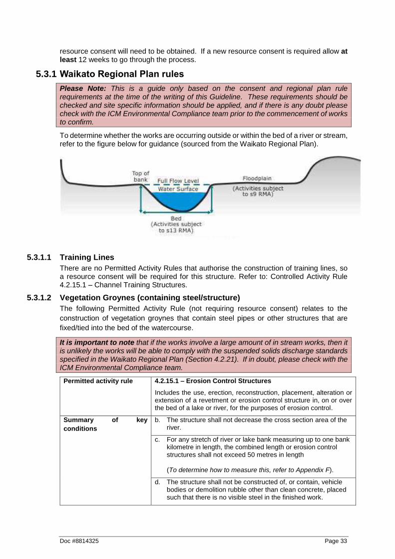
To determine whether the works are occurring outside or within the bed of a river or stream, refer to the figure below for guidance (sourced from the Waikato Regional Plan).
The following Permitted Activity Rules (not requiring resource consent) relates to mechanical vegetation removal.
It is important to note that if there is dense vegetation within the watercourse itself, and/or the works involve a large amount of in stream works, then it is unlikely the works will be able to comply with the suspended solids discharge standards specified in the Waikato Regional Plan (Section 4.2.21). If in doubt, please check with the ICM Environmental Compliance team.
In Stream (on the bed) vegetation clearance permitted activity rule:
Permitted activity rule 4.3.9.2 – Vegetation Clearance
Includes the clearance of vegetation in, on or under the beds of rivers and lakes.
Summary of key
conditions
c. The activity shall not take place in Significant Indigenous and Fish Habitat Class waters during August to December inclusive and Trout Fisheries and Trout Spawning class water during May to September inclusive. (Check OurMaps, refer to Appendix C).
h. The Waikato Regional Council shall be notified in writing at least 10 working days prior to commencing the activity if it occurs within a flood or drainage control scheme area that is managed by the Waikato Regional Council or a territorial authority. (Email [email protected] and cc. [email protected])
i. The activity shall comply with the suspended solids discharge standards as set out in Section 4.2.21 of the Waikato Regional Plan.
k. The activity shall not be located in, on, or under the bed of a river or lake that is identified as a Significant Geothermal Feature. (Check OurMaps, refer to Appendix C).

Doc #8814325 Page 15
Riparian (on land) vegetation clearance permitted activity rule:
Permitted activity rule 5.1.4.11 – Soil Disturbance, Roading and Tracking and Vegetation Clearance
Includes the clearance of vegetation within high risk erosion areas and riparian clearance where it is for the express purposes of erosion control or natural hazard mitigation; and the standards listed in Section 5.1.5 of the Waikato Regional Plan are complied with.
Summary of key
conditions
l. All vegetation that is being felled within five metres of a perennial water body shall be felled away from the water body, except edge vegetation, or vegetation leaning over a water body, which if necessary may be felled in accordance with safety practices.
m. All exposed areas of soil resulting from the activity shall be stabilised against erosion by vegetative cover or other methods as soon as practical following completion of the activity.
n. The activity shall not be located within 20 metres of a Significant Geothermal Feature. (Check OurMaps, refer to Appendix C).
o. The concentration of suspended solids in any non-point discharges from roading, tracking and vegetation clearance activities shall meet the following standards;
i. in Waikato Region Surface class waters - 100 grams per cubic metre suspended solids concentration
ii. in Indigenous Fisheries and Fish Habitat class waters - 80 grams per cubic metre suspended solids concentration
iii. in Trout Fisheries and Trout Spawning Habitat class waters - 25 grams per cubic metre suspended solids concentration
iv. in Contact Recreation class waters - black disc horizontal visibility greater than 1.6 metres
v. in Natural State class waters - the activity or discharge shall not increase the concentration of suspended solids in the receiving water by more than 10 percent
Standard o) shall apply, except where the suspended solids concentration or black disc horizontal visibility in the receiving water is greater than the standards specified, at the time and location of discharge or of undertaking the activity. Then there shall not be any increase (i.e. further deterioration) in the receiving water suspended solids concentration or black disc horizontal visibility of more than 20% as a result of the activity or discharge.
The point at which compliance with this standard shall be measured is after reasonable mixing has occurred which in any instance does not exceed 200 metres from the point of discharge.
(Check OurMaps, refer to Appendix C).

Page 16 Doc #8814325
3.3.2 ICM Resource consents for mechanical vegetation removal
ICM has resource consents which authorise mechanical vegetation removal in the following key areas. These consents include specific consent conditions which need to be complied with.
If in doubt, please discuss with the ICM Environmental Compliance team prior to the commencement of works to confirm consents and requirements.
Resource Consent Name Discover Link
Waihou Comprehensive Consent Resource Consent Certificate - 120925 (2036375).doc
(https://discover.wairc.govt.nz/otcs/llisapi.dll?func=ll&objac
tion=overview&objid=2144910)
Coromandel Area 1 Thames Coast Resource Consent Certificate - 118160 (1634729).doc
(https://discover.wairc.govt.nz/otcs/llisapi.dll?func=ll&objac
tion=overview&objid=1977424)
Coromandel Area 2 Coromandel Resource consent certificate 120203 (2214639).doc
(https://discover.wairc.govt.nz/otcs/llisapi.dll?func=ll&objac
tion=overview&objid=2309798)
Coromandel Area 3 Colville Resource Consent Certificate - 120206 (1669925).doc
(https://discover.wairc.govt.nz/otcs/llisapi.dll?func=ll&objac
tion=overview&objid=2052618)
Coromandel Area 4 Whangapoua Resource consent certificate 120200 (2579799).doc
(https://discover.wairc.govt.nz/otcs/llisapi.dll?func=ll&objac
tion=overview&objid=2730357)
Coromandel Area 5 Whitianga Resource Consent Certificate - 114708 (1235688).doc
(https://discover.wairc.govt.nz/otcs/llisapi.dll?func=ll&objac
tion=overview&objid=1314200)
Coromandel Area 6 Tairua Resource Consent Certificate - 114711 (1235732).doc
(https://discover.wairc.govt.nz/otcs/llisapi.dll?func=ll&objac
tion=overview&objid=1314258)
Coromandel Area 7 Whangamata Resource Consent Certificate - 114705 (1235588).doc
(https://discover.wairc.govt.nz/otcs/llisapi.dll?func=ll&objac
tion=overview&objid=1313877)
Tongariro River Resource Consent Certificate - 121305 (2111143).docm
(https://discover.wairc.govt.nz/otcs/llisapi.dll?func=ll&objac
tion=overview&objid=2297028)
Tauranga Taupo River Resource Consent Certificate 125772 (2738038).docm
(https://discover.wairc.govt.nz/otcs/llisapi.dll?func=ll&objac
tion=overview&objid=2946438)
3 Zones Discretionary
Comprehensive Consent
Consent certificate 121848 - final version (August)
(2215490).docm

Doc #8814325 Page 17
(https://discover.wairc.govt.nz/otcs/llisapi.dll?func=ll&objac
tion=overview&objid=2311671)
3.4 Timing of works
In most cases timing restrictions is not just best practice but a requirement of a resource consent or a Permitted Activity. Always confirm timing restrictions with any applicable resource consents or Permitted Activity requirements. Works should be undertaken during periods of dry and fine weather, and low flows. Use weather charts from the internet to predict upcoming weather patterns. If works are a matter of urgency, then determine whether works can be undertaken as s.330 Emergency works (refer to Appendix G), or under any applicable resource consent storm response provisions.
3.4.1 Fishery values
As a guide, the following table sets out the timing restrictions/considerations for works relating to fishery values, which adhere to best practice. Avoid instream works in months shaded black (except where significant bank erosion or flooding is imminent). Disturbance of intertidal vegetation during the months shaded grey should be avoided to provide inanga spawning habitat in the following months.
Value
Jan
Feb
Ma
r
Ap
r
Ma
y
Ju
n
Ju
l
Au
g
Se
p
Oc
t
No
v
De
c
Indigenous fish migration
Trout spawning
Inanga spawning (tidal areas)
Check the Waikato Regional Plan layer in OurMaps to determine the fishery classification for the applicable watercourse (refer to Appendix C).
3.4.2 Other timing considerations
Other timing considerations should include:
Avoiding critical farming events e.g. lambing, maize harvest, hay/silage growing/cutting.
Avoiding works during the duck hunting season.
Avoid works within “threatened” or “at risk” bird nesting habitat or known presence. If in doubt, please check with the ICM Environmental Compliance team prior to the commence of works for guidance.
Spring and autumn are generally ideal weather conditions for stabilisation of disturbed areas (for grass strike/growth).
Plan any follow-up planting from May to September.
Plan any follow-up regrowth spraying in February/March prior to leaf fall.

Page 18 Doc #8814325
3.5 Scoping of works
a. For extensive vegetation removal programmes a staged approach should be used, with the total length of channel cleared to be compliant with the consent conditions or no greater than 1.5km in any 12-month period (as a best practice measure). Shorter lengths should be considered where particularly high stream values have been identified, or where vegetation removal will increase flow velocities and the likelihood of erosion. Staging vegetation removal will reduce the amount of disturbance caused at any one time, will reduce the associated environmental risk and will speed up ecological recovery.
b. Consider the erosion and sediment control measures to be implemented for the duration and at the conclusion of works, and include details of these in the site Works Plan.
c. Any non-weedy species should be left in place provided they are not likely to cause future flooding or stream diversion issues and are compatible with any replanting programme.
d. Clearly identify the extent of works upstream and downstream by identifying the boundaries on an aerial photograph/map/engineering drawing, and then mark these boundaries onsite using tape/markers/dazzle paint etc.
e. Clearly identify the position of where the debris to be removed is to be placed. If this is to be placed away from the site via truck movements, ensure that access is identified and suitable for the purpose.
f. Plan machinery access in a way that minimises disturbance of riparian vegetation.
g. Ensure machinery is sufficient in size so that it stays out of the channel and minimises time of operation and disturbance (e.g. for maximum efficiency you will need an excavator with a thumb).
h. If the site has high public visibility, or is a site where public/recreational users can readily access; place signage prior to the commencement of the works upstream and downstream of the works site to identify the works and outline any site hazards/public entry restrictions. Ensure all health and safety aspects are fully addressed.
i. Consider potential impacts of the work on recreational river users and their access (e.g. anglers, swimmers, canoeists); and downstream water takes and take steps to minimise these.
j. Factor in costs and time associated with follow-up fencing, riparian planting and maintenance.
3.6 Physical Works
a. Organise an onsite pre-construction meeting with the works supervisors, relevant ICM staff, the contractors, and; if appropriate the landowners and/or other key stakeholders. Ensure that the best practice methodologies to be implemented, all Regional Plan and/or resource consent requirements and limitations for the project are discussed and understood. Provide a copy of all relevant documents and the work plan to all relevant personnel.
b. Ensure machinery is washed down prior to and following works to prevent the spread of unwanted organisms such as alligator weed and didymo. Refer to Keep it clean – Machinery hygiene guidelines and logbook to prevent the spread of pests and weeds, June 2013.2
2 http://www.waikatoregion.govt.nz/PageFiles/42184/Keepitclean.pdf
Doc #8814325 Page 19
c. Vehicles and machinery shall avoid entering or working in the flowing water, wherever safe and possible. If machinery must enter or cross a stream, then details of the specific site and reason must be part of the Works Plan.
d. If possible, leave a section of undisturbed trees/vegetation at the downstream end of the works, then commence removal works at the upstream end of the proposed works area, working downstream towards the undisturbed section. The length of this undisturbed section will depend on the width of the watercourse, and the density of the vegetation. This technique may reduce the impacts of sediment disturbance and catch floating debris in the downstream trees and vegetation. Ensure to remove floating or accumulated debris at the end of each working day.
e. Ground/soil disturbance shall be kept to a minimum, and ensure that operators are aware that excessive ground/soil disturbance is likely to result in additional stabilisation requirements (e.g. hay mulch).
f. Operate excavators on slash if required (e.g. when the ground is not firm) to minimise the disturbance to the ground/soil. Avoid ‘screwing’ excavators/tracked machines and causing unnecessary soil disturbance, particularly when in close proximity to a watercourse, on sloped ground or an overland flow path; where sediment run off is more of a risk.
g. Cut trees as close to the ground as practical.
h. Cut and lift debris rather than pull and drag to avoid unnecessary ground/soil disturbance.
i. Do not pull out stumps or snags from the bed of a watercourse unless they are directly causing or are likely to cause erosion. These provide important habitat for fish if left or repositioned elsewhere in the channel.
j. Fell trees away from watercourses to minimise erosion, flooding and navigational safety effects; where safe and practical to do so. Use machine assistance to prevent damage to the stream banks. Remove any trees/limbs/floating debris that fall into the watercourse where safe and practical to do so.
k. Stack loose slash and debris with an experienced operator and machine equipped with a ‘stick rake’ or ‘thumb’ to minimise excessive ground/soil disturbance.
l. Flor willows, it is desirable to poison stumps and slash material when leaf growth is vigorous (usually during February/March). For other species, poison stumps at the time of cutting. Use Glyphosate 1:100 in accordance with the manufacturer’s label with a penetrant (e.g. Pulse at 100mls per 100 litres) and marker dye to poison stumps and/or regrowth. Note that Section 6.2 of the Waikato Regional Plan includes specific Permitted Activity requirements for agrichemical spraying; and Section 11 of this document includes best practice with regards to vegetation spraying. These sections should be checked to ensure compliance with and incorporation of applicable requirements.
m. Chemical spraying should be avoided in or near areas that are considered particularly sensitive (e.g. in areas with rare or threatened lizard species are present) which have been identified within the Annual Works Programme and/or site specific Works Plan.
n. Pile debris in high piles as far away from the flood zone as possible. If there is a risk that piles will be moved by a flood, then they should be disposed of immediately or anchored in place.
o. Debris should not be placed within wetlands or boggy areas.
p. Burn or chip willow stockpiles as soon as possible following removal (note that the use of tyres is prohibited). Green trees will produce a lot of smoke so if this is likely to be a problem, wait preferably 12 months for the trees to dry out before burning. Poplars
Page 20 Doc #8814325
will need to be left for up to 24 months to dry out before they can be burnt, particularly if they are a cottonwood variety. Check with the local authority regarding fire restrictions and air quality District/City Plan provisions prior to burning.
q. Ensure that machinery, equipment and vegetation material are removed from the potential flood zone at the end of each working day, to avoid the possibility of floodwater washing machinery or materials downstream. If the works are being undertaken as a Permitted Activity, then it is a requirement to remove machinery, equipment and vegetation material from the flood plain at the completion of the activity (unless a resource consent is obtained to deposit this material within a flood plain).
3.7 Erosion & sediment control considerations
Ensure that operations are carried out in a manner that minimises the disturbance of the works area and river bank/bed and minimise the discharge of sediment entering the watercourse by including the following:
a. Plan to stabilise (e.g. hay/straw mulch and/or grass seed, coir matting, geotextile cloth) disturbed embankment and riparian areas as works progress; and/or upon completion of works.
b. Hay/straw mulch provides “instant” stabilisation, and when combined with grass seeding, the mulch creates a “micro climate” which generally enables a good grass strike in colder and/or drier conditions. Hay/straw mulching is very effective in preventing erosion while grass seed strikes/grows, particularly on light soils or flat/moderate gradients. Limitations of hay/straw mulch include on steep gradients or where it can be washed away (e.g. within a watercourse channel). Coir matting or geotextile cloth options may be more appropriate in these circumstances.
c. A site is considered “stabilised” once at least 80% of vegetation cover (or artificial/structural cover) has been achieved.
d. If the gradient is particularly steep, or within a watercourse channel then coir matting or geotextile cloth should be considered to prevent erosion. However, this needs to be used with care to ensure that this cloth does not smother, or limit, vegetative growth. Refer to manufacturers specifications to ensure the correct product and grade is used.
e. Undertake works during periods of dry weather and low-river flows. Spring and autumn are when weather conditions are ideal for vegetation establishment of disturbed areas.
f. Check daily weather forecasts and ensure that site managers and contractors are prepared for adverse weather.
g. Machinery should grab and lift trees/slash/debris (not drag) to minimise ground/soil disturbance. This is where the size of the excavator used becomes important.
h. Monitor dust during works, and ensure that appropriate measures are undertaken to minimise any dust generation. Ensure that areas of exposed works are limited as much as practicable, by staging works and progressively stabilising completed areas. If dust becomes an issue, suppressing dust by utilising water carts or water sprinkler systems should be utilised.
3.8 Follow-up & maintenance
3.8.1 Riparian works
a. If required as resource consent condition or if part of the works agreement, carry out riparian fencing and planting works to exclude stock from the banks of the waterway.
Doc #8814325 Page 21
b. When carrying out riparian planting use native tree species wherever possible. If willows are required for stabilisation/erosion control, ensure male hybrids are selected (for example, male matsudana (Salix matsudana)). Please note that it is not permitted to plant crack (Salix fragilis) or grey (Salix cinerea) willow, or any other plant pest identified in the Regional Pest Management Strategy document.
c. Undertake a programme of willow re-growth spraying. It may take several years of re-growth spraying before it is under control. Re-growth spraying is best carried out during February/March when re-growth shoots are most active. This spraying activity needs to be in accordance with the manufactures recommended use of the herbicide and the requirements of the Permitted Activity rules within Section 6.2 of the Waikato Regional Plan or the conditions of any relevant consents, with particular caution used when in the vicinity of a stream or river.
3.8.2 Stream works
Any works within or on the bed of a watercourse are considered to be high risk activities and will require on-going and vigilant maintenance to minimise erosion and sediment generation. To achieve this, identify and correct any aspects that may indicate potential problems. Take particular notice of the following aspects:
a. Establishment of grass/vegetation cover, and whether additional grass seed and/or hay mulch is required;
b. Prevent stock access to the stream bank to assist with re-vegetation and minimise direct stream bank impacts;
c. Whether the work undertaken has alleviated the bank erosion issues, or whether further erosion protection works are required; and
d. Any bank erosion issues caused by removing the vegetation.
3.9 Opportunities for enhancement
Depending on site characteristics and the objectives of the works there may be opportunities to incorporate measures that will enhance ecological values for the site of works above and beyond best practice. In some cases, enhancement measures may also be required through resource consents. Examples of relevant enhancement measures include:
Seek opportunities to establish and widen riparian buffers. The wider the buffers are, the greater the ecological benefits they can provide and the more likely those areas will become self-sustaining.
Strategically plant quick growing non-weedy tree species in places where they can later be dropped into the channel to create vegetation groynes or provide habitat features for fish.
Strategically leave some trees where they can provide important shade for the stream or to protect light or frost sensitive species that will be planted later.
Reposition wood within the channel rather than remove it to maintain habitat for fish. Wood can be moved or re-orientated so that it does not impede flow and can even be used for erosion protection.
Chip woody vegetation rather than burn it. This is more environmentally friendly and also provides a useful product that can be used for feed pads or suppressing weeds around new plantings.
These options can be discussed with an ICM ecologist, and should be site and situation specific.

Page 22 Doc #8814325
3.10 Photographs & illustrations
Photo 1. Removal of woody vegetation from a small stream showing minimal ground disturbance.
Photo 2. Preparing logs for placement to create fish habitat and gradient control

Doc #8814325 Page 23
Photo 3. Large logs immediately following placement for gradient control and fish habitat

Page 24 Doc #8814325
4 In stream debris management / obstruction removal
4.1 Purpose & operational objectives
Channel obstructions are site specific and normally require removal as special work. They generally involve fallen trees, flood delivered logs, a mat or raft of vegetation, gravel, debris or a collapsed length of riverbank. Removal is required to maintain floodway capacity, reduce or prevent erosion, minimise stream diversions and prevent damage to structures.
4.2 Key environmental objectives & principles
Undertake the works in a manner that minimises the amount of disturbance of habitat within the stream (aquatic) and along the edges of the channel (riparian) habitats. This includes minimising works during periods of the year when plants, fish and animals are particularly sensitive to disturbance (e.g. spawning periods).
Retain as much wood or large rocks within the stream as possible. Wood provides important habitat for fish and other aquatic species and has an important role in how stream ecosystems function.
4.3 Regional plan & Resource consents
It is very important to ensure when you are planning works, to identify whether the works are authorised by a Waikato Regional Plan Permitted Activity rule or an existing ICM resource consent.
If the works do not comply with a Permitted Activity rule, and there are no existing ICM resource consents that authorise that activity in the applicable location – then a new resource consent will need to be obtained. If a new resource consent is required allow at least 12 weeks to go through the process.
4.3.1 Waikato Regional Plan Rules
Please Note: This is a guide only based on the consent and regional plan rule requirements at the time of the writing of this Guideline. These requirements should be checked and site specific information should be applied, and if there is any doubt please check with the ICM Environmental Compliance team prior to the commencement of works to confirm.
To determine whether the works are occurring outside or within the bed of a river or stream, refer to the figure below for guidance (sourced from the Waikato Regional Plan).

Doc #8814325 Page 25
The following Permitted Activity Rule (not requiring resource consent) relate to the removal of in stream debris/obstructions.
It is important to note that if the works involve a large amount of in stream works, then it is unlikely the works will be able to comply with the suspended solids discharge standards specified in the Waikato Regional Plan (Section 4.2.21). If in doubt, please check with the ICM Environmental Compliance team.
Permitted activity rule 4.3.10.1 – Removal of Obstructions
Includes the removal of vegetation, rocks, gravel, sediment and any other debris that are blocking or obstructing a river channel and are or are likely to directly result in erosion or flooding or cause a navigation or safety hazard.
Summary of key
conditions
a. The activity shall be limited to the extent necessary to clear obstructions and, in any event, the total length of works shall be limited to five times the width of the river bed or 100 metres per kilometre per 12-month period whichever is the lesser.
g. The activity shall comply with the suspended solids discharge standards as set out in Section 4.2.21 of the Waikato Regional Plan.
k. The activity shall not take place in Significant Indigenous and Fish Habitat Class waters during August to December inclusive and Trout Fisheries and Trout Spawning class water during May to September inclusive. (Check OurMaps, refer to Appendix C).
l. The location of the proposed obstruction removal shall be notified to the Waikato Regional Council at least 24 hours prior to commencing activities. (Email [email protected] and cc. [email protected])
m. The activity shall not take place in a water body that is identified as a Natural State Water body in the Water Management Class maps or in a wetland. (Check OurMaps, refer to Appendix C).
4.3.2 ICM Resource consents for obstruction removal
ICM has resource consents which authorise obstruction removal in the following key areas. These consents include specific consent conditions which need to be complied with.
If in doubt, please discuss with the ICM Environmental Compliance team prior to the commencement of works to confirm consents and requirements.
Resource Consent Name Discover Link
Waihou Comprehensive Consent Resource Consent Certificate - 120925 (2036375).doc
(https://discover.wairc.govt.nz/otcs/llisapi.dll?func=ll&objac
tion=overview&objid=2144910)
Waihou Obstruction Removal s42A Report NN - Waihou & Lower Piako Obstruction
Removal - 135115 (3304189).doc

Page 26 Doc #8814325
(https://discover.wairc.govt.nz/otcs/llisapi.dll?func=ll&objac
tion=overview&objid=3437017)
Coromandel Area 1 Thames Coast Resource Consent Certificate - 118160 (1634729).doc
(https://discover.wairc.govt.nz/otcs/llisapi.dll?func=ll&objac
tion=overview&objid=1977424)
Coromandel Area 2 Coromandel Resource consent certificate 120203 (2214639).doc
(https://discover.wairc.govt.nz/otcs/llisapi.dll?func=ll&objac
tion=overview&objid=2309798)
Coromandel Area 3 Colville Resource Consent Certificate - 120206 (1669925).doc
(https://discover.wairc.govt.nz/otcs/llisapi.dll?func=ll&objac
tion=overview&objid=2052618)
Coromandel Area 4 Whangapoua Resource consent certificate 120200 (2579799).doc
(https://discover.wairc.govt.nz/otcs/llisapi.dll?func=ll&objac
tion=overview&objid=2730357)
Coromandel Area 5 Whitianga Resource Consent Certificate - 114708 (1235688).doc
(https://discover.wairc.govt.nz/otcs/llisapi.dll?func=ll&objac
tion=overview&objid=1314200)
Coromandel Area 6 Tairua Resource Consent Certificate - 114711 (1235732).doc
(https://discover.wairc.govt.nz/otcs/llisapi.dll?func=ll&objac
tion=overview&objid=1314258)
Coromandel Area 7 Whangamata Resource Consent Certificate - 114705 (1235588).doc
(https://discover.wairc.govt.nz/otcs/llisapi.dll?func=ll&objac
tion=overview&objid=1313877)
Tongariro River Resource Consent Certificate - 121305 (2111143).docm
(https://discover.wairc.govt.nz/otcs/llisapi.dll?func=ll&objac
tion=overview&objid=2297028)
Tauranga Taupo River Resource Consent Certificate 125772 (2738038).docm
(https://discover.wairc.govt.nz/otcs/llisapi.dll?func=ll&objac
tion=overview&objid=2946438)
3 Zones Discretionary
Comprehensive Consent
Consent certificate 121848 - final version (August)
(2215490).docm
(https://discover.wairc.govt.nz/otcs/llisapi.dll?func=ll&objac
tion=overview&objid=2311671)
3 Zones Controlled
Comprehensive Consent
Evaluation report for resource consent application(s)
119807, 119808 - RCS Controlled Activity Consents - Mid
& Lower Waikato and Waipa Catchments (1483314).doc
(https://discover.wairc.govt.nz/otcs/llisapi.dll?func=ll&objac
tion=overview&objid=1643517)

Doc #8814325 Page 27
3 Zones Obstruction Removal Resource Consent Certificate 124998 (2241674).docm
(https://discover.wairc.govt.nz/otcs/llisapi.dll?func=ll&objac
tion=overview&objid=2372199)
4.4 Timing of works
In most cases timing restrictions is not just best practice but a requirement of a resource consent or a Permitted Activity. Always confirm timing restrictions with any applicable resource consents or Permitted Activity requirements. Consents specific to obstruction removal (e.g. 3 Zones Obstruction Removal and Waihou Obstruction Removal) include year-round timing provided specific requirements and conditions are adhered to. Works should be undertaken during periods of dry and fine weather, and low flows. Use weather charts from the internet to predict upcoming weather patterns. If works are a matter of urgency, then determine whether works can be undertaken as s.330 Emergency works (refer to Appendix G), or under any applicable resource consent storm response provisions.
4.4.1 Fishery values
As a guide, the following table sets out the timing restrictions/considerations for works relating to fishery values, which adhere to best practice. Avoid instream works in months shaded black (except where significant bank erosion or flooding is imminent). Disturbance of intertidal vegetation during the months shaded grey should be avoided to provide inanga spawning habitat in the following months.
Value
Jan
Feb
Ma
r
Ap
r
Ma
y
Ju
n
Ju
l
Au
g
Se
p
Oc
t
No
v
De
c
Indigenous fish migration
Trout spawning
Inanga spawning (tidal areas)
Check the Waikato Regional Plan layer in OurMaps to determine the fishery classification for the applicable watercourse (refer to Appendix C).
4.4.2 Other timing considerations
Other timing considerations should include:
Avoiding critical farming events e.g. lambing, maize harvest, hay/silage growing/cutting.
Avoiding works during the duck hunting season.
Avoid works within “threatened” or “at risk” bird nesting habitat or known presence. If in doubt, please check with the ICM Environmental Compliance team prior to the commence of works for guidance.
Spring and autumn are generally ideal weather conditions for stabilisation of disturbed areas (for grass strike/growth).

Page 28 Doc #8814325
Plan any follow-up planting from May to September.
4.5 Scoping of works
a. Clearly identify the extent of works upstream and downstream by identifying the boundaries on an aerial photograph/map/engineering drawing, and then mark these boundaries onsite using tape/markers/dazzle paint etc.
b. Consider the erosion and sediment control measures to be implemented for the duration and at the conclusion of works, and include details of these in the site Works Plan.
c. Clearly identify the position of where the debris to be removed is to be placed. If this is to be placed away from the site via truck movements, ensure that access is identified and suitable for the purpose.
d. If the site has high public visibility, or is a site where public/recreational users can readily access; place signage prior to the commencement of the works upstream and downstream of the works site to identify the works and outline any site hazards/public entry restrictions. Ensure all health and safety aspects are fully addressed.
e. Consider potential impacts of the work on recreational river users and their access (e.g. anglers, swimmers, canoeists); and downstream water takes and take steps to minimise these.
f. Plan machinery access in a way that minimises disturbance of riparian vegetation.
g. Factor in costs and time associated with follow-up fencing, riparian planting and maintenance.
4.6 Physical works
a. Organise an onsite pre-construction meeting with the works supervisors, relevant ICM staff, the contractors, and; if appropriate the landowners and/or other key stakeholders. Ensure that the best practice methodologies to be implemented, all Regional Plan and/or resource consent requirements and limitations for the project are discussed and understood. Provide a copy of all relevant documents and the work plan to all relevant personnel.
b. Ensure machinery is washed down prior to and following works to prevent the spread of unwanted organisms such as alligator weed and didymo. Refer to Keep it clean – Machinery hygiene guidelines and logbook to prevent the spread of pests and weeds, June 2013.3
c. Ensure machinery is sufficient in size so that it stays out of the channel and minimises time of operation and disturbance.
d. Vehicles and machinery shall avoid entering or working in the flowing water, wherever safe and possible. If machinery must enter or cross a stream, then details of the specific site and reason must be part of the Works Plan.
e. Cut and lift debris rather than pull and drag. Do not disturb the riverbed or riparian margins more than is necessary to reduce the erosion/flood hazard to an acceptable level.
f. Care should be taken not to remove obstructions that are providing desirable gradient control where removal may trigger head-ward channel erosion.
3 http://www.waikatoregion.govt.nz/PageFiles/42184/Keepitclean.pdf

Doc #8814325 Page 29
g. Selective removal of the obstruction should occur to avoid unnecessary bed disturbance and to leave habitat which is suitable for fish and/or other aquatic habitat.
h. Wherever possible seek to retain large woody debris or rock obstructions within the channel by trimming, repositioning, re-orientating and anchoring rather than remove it from the channel.
i. Undertake maintenance work frequently to ensure problems are identified and remedied before they become larger issues. As a preventative measure, remove unstable material/vegetation before it falls into a watercourse.
j. Dispose of material by burning/burial/or removal from floodway, and in accordance with the Waikato Regional Plan and relevant District Plan.
k. Check any material removed from wetted channel for any stranded fish or freshwater mussels. Return any aquatic life according to the appropriate Aquatic Life Recovery Protocols (see Appendix I).
l. Ensure that machinery, equipment and obstruction material are removed from the potential flood zone at the end of each working day, to avoid the possibility of floodwater washing machinery or materials downstream. If the works are being undertaken as a Permitted Activity, then it is a requirement to remove machinery, equipment and obstruction material from the flood plain at the completion of the activity (unless a resource consent is obtained to deposit this material within a flood plain).
4.7 Erosion & sediment control considerations
Ensure that operations are carried out in a manner that minimises the disturbance of the works area and river bank/bed and minimise the discharge of sediment entering the watercourse by including the following:
a. Plan to stabilise (e.g. hay/straw mulch and/or grass seed, coir matting, geotextile cloth) disturbed embankment and riparian areas as works progress; and/or upon completion of works.
b. Hay/straw mulch provides “instant” stabilisation, and when combined with grass seeding, the mulch creates a “micro climate” which generally enables a good grass strike in colder and/or drier conditions. Hay/straw mulching is very effective in preventing erosion while grass seed strikes/grows, particularly on light soils or flat/moderate gradients. Limitations of hay/straw mulch include on steep gradients or where it can be washed away (e.g. within a watercourse channel). Coir matting or geotextile cloth options may be more appropriate in these circumstances.
c. A site is considered “stabilised” once at least 80% of vegetation cover (or artificial/structural cover) has been achieved.
d. If the gradient is particularly steep, or within a watercourse channel then coir matting or geotextile cloth should be considered to prevent erosion. However, this needs to be used with care to ensure that this cloth does not smother, or limit, vegetative growth and therefore counter the erosion benefits. Refer to manufacturers specifications to ensure the correct product and grade is used.
e. Undertake works during periods of dry weather and low-river flows. Spring and autumn are when weather conditions are ideal for vegetation establishment of disturbed areas.
f. Check daily weather forecasts and ensure that site managers and contractors are prepared for adverse weather.

Page 30 Doc #8814325
4.8 Follow-up & maintenance
4.8.1 Riparian works
a. If required as resource consent condition or if part of the works agreement, carry out riparian fencing and planting works to exclude stock from the banks of the waterway.
b. When carrying out riparian planting use native tree species wherever possible. If willows are required for stabilisation/erosion control, ensure male hybrids are selected (for example, male matsudana (Salix matsudana)). Please note that it is not permitted to plant crack (Salix fragilis) or grey (Salix cinerea) willow or any other plant pest identified in the Regional Pest Management Strategy document.
c. Undertake regular maintenance inspections and undertake maintenance as required.
4.8.2 Stream works
Any works within or on the bed of a watercourse are considered to be high risk activities and will require on-going and vigilant maintenance to minimise erosion and sediment generation. To achieve this, identify and correct any aspects that may indicate potential problems. Take particular notice of the following aspects:
a. Establishment of grass/vegetation cover, and whether additional grass seed and/or hay mulch is required
b. Whether the removal of the obstruction/debris has alleviated the bank erosion issues, or whether further erosion protection works are required.
4.9 Opportunities for enhancement
Depending on site characteristics and the objectives of the works there may be opportunities to incorporate measures that will enhance ecological values for the site of works above and beyond best practice. In some cases, enhancement measures may also be required through resource consents. Examples of relevant enhancement measures include:
Replace any wood or large rock obstructions with similar forms of structure that will not cause erosion or significant flooding. These can be tucked into the bank or in areas where they do not reduce channel capacity. Ensure that any required resource consents have been obtained first.
Seek opportunities to establish and widen riparian buffers. The wider buffers are, the greater the ecological benefits they can provide, and more likely that they will become self-sustaining.
Chip woody vegetation that is removed rather than burn it. This is more environmentally friendly and also provides a useful product that can be used for feed pads or suppressing weeds around new plantings.
These options can be discussed with the ICM ecologist, and should be site and situation specific.
4.10 Photographs & illustrations

Doc #8814325 Page 31
Photo 4 Root ball left in place to provide fish habitat and to prevent stream bank erosion

Page 32 Doc #8814325
5 Poplar/willow vegetation groynes & training lines
5.1 Purpose & operational objectives
This activity includes the use of anchored willows or poplars to train the river to flow in a certain path and is usually used to control stream bank erosion. For example, works may be undertaken to divert flow away from an eroding bank or to make it take a particular flow path around an island. Groynes and training lines can be constructed using a range of methods. Refer to Appendix F regarding measuring structures.
5.1.1 Vegetation groynes
In rivers where the banks are moderately sloped and the river channel needs to be trained to a particular width, vegetation groynes are commonly used. This involves burying the trunks of poplar or willow trees in the bank of a river, with foliage extending into the river channel. The trees are anchored (sometimes using steel pipes, railway iron or screw anchors) in series so that they form a continuous protective live buffer along the river bank. Water velocities will be slower behind each groyne encouraging the deposition of sediment at the toe of the banks and over time minimising erosion.
5.1.2 Training lines
In large rivers, especially where there are steep banks training lines are often utilised. This involves anchoring vegetation to the bed of the river by using steel pipes, railway iron or screw anchors. A training line creates a new river bank alignment different to that existing before the works. This provides relatively heavy vegetative protection and where willows are used, trees develop strong root systems. The vegetative barrier formed encourages low flow velocities behind the barrier which result in the deposition of sediment and infilling of the area during times of flood.
5.2 Key environmental objectives & principles
Undertake the works in a manner that minimises the amount of disturbance of habitat within the stream (aquatic) and along the edges of the channel (riparian) habitats. This includes minimising works during periods of the year when plants, fish and animals are particularly sensitive to disturbance (e.g. spawning periods).
Natural rates of bank erosion are important for providing a diverse range of habitats and for allowing rivers and stream to function properly. Unnecessary fixing of banks should therefore be avoided. To this end soft-engineering approaches, which include vegetation groynes and training lines should be used in preference to rock rip-rap.
5.3 Regional plan & Resource consents
It is very important to ensure when you are planning works, to identify whether the works are authorised by a Waikato Regional Plan Permitted Activity rule or an existing ICM resource consent. If the works do not comply with a Permitted Activity rule, and there are no existing ICM resource consents that authorise that activity in the applicable location – then a new
Doc #8814325 Page 33
resource consent will need to be obtained. If a new resource consent is required allow at least 12 weeks to go through the process.
5.3.1 Waikato Regional Plan rules
Please Note: This is a guide only based on the consent and regional plan rule requirements at the time of the writing of this Guideline. These requirements should be checked and site specific information should be applied, and if there is any doubt please check with the ICM Environmental Compliance team prior to the commencement of works to confirm.
To determine whether the works are occurring outside or within the bed of a river or stream, refer to the figure below for guidance (sourced from the Waikato Regional Plan).
5.3.1.1 Training Lines
There are no Permitted Activity Rules that authorise the construction of training lines, so a resource consent will be required for this structure. Refer to: Controlled Activity Rule 4.2.15.1 – Channel Training Structures.
5.3.1.2 Vegetation Groynes (containing steel/structure)
The following Permitted Activity Rule (not requiring resource consent) relates to the
construction of vegetation groynes that contain steel pipes or other structures that are
fixed/tied into the bed of the watercourse.
It is important to note that if the works involve a large amount of in stream works, then it is unlikely the works will be able to comply with the suspended solids discharge standards specified in the Waikato Regional Plan (Section 4.2.21). If in doubt, please check with the ICM Environmental Compliance team.
Permitted activity rule 4.2.15.1 – Erosion Control Structures
Includes the use, erection, reconstruction, placement, alteration or extension of a revetment or erosion control structure in, on or over the bed of a lake or river, for the purposes of erosion control.
Summary of key
conditions
b. The structure shall not decrease the cross section area of the river.
c. For any stretch of river or lake bank measuring up to one bank kilometre in length, the combined length or erosion control structures shall not exceed 50 metres in length (To determine how to measure this, refer to Appendix F).
d. The structure shall not be constructed of, or contain, vehicle bodies or demolition rubble other than clean concrete, placed such that there is no visible steel in the finished work.

Page 34 Doc #8814325
e. The activity shall comply with the suspended solids discharge standards as set out in Section 4.2.21 of the Waikato Regional Plan.
h. Where the weight of the structure is insufficient to keep it in place it shall be anchored to the bed and bank of the river.
j. The Waikato Regional Council shall be informed in writing of the location of the structure at least 10 working days prior to work commencing. (Email [email protected] and cc. [email protected])
k. The structure shall not be located in a water body identified as a Natural State water body in the Water Management Class Maps. (Check OurMaps, refer to Appendix C).
o. The activity shall not be located in, on, or under the bed of a river or lake that is identified as a Significant Geothermal Feature. (Check OurMaps, refer to Appendix C).
5.3.2 Vegetation groynes (containing NO steel/structure)
The following Permitted Activity Rule (not requiring resource consent) relates to the construction of vegetation groynes that contain no steel pipes or other structures that are fixed/drilled into the bed of the watercourse. Therefore, the groyne just contains the tree(s) itself.
It is important to note that if the works involve a large amount of in stream works, then it is unlikely the works will be able to comply with the suspended solids discharge standards specified in the Waikato Regional Plan (Section 4.2.21). If in doubt, please check with the ICM Environmental Compliance team.
Permitted activity rule 4.3.8.1 – Introduction and Planting of Plants
Includes the introduction, planting or layering of any plant or any part of any plant, with the exclusion of plant pests as identified in the Waikato Regional Pest Management Strategy, in, on or under the beds or banks of any lake or river, for the purpose of soil conservation or streamside enhancement.
Summary of key
conditions
f. The Waikato Regional Council shall be informed in writing of the location of the structure at least 10 working days prior to work commencing. (Email [email protected] and cc. [email protected])
g. The activity shall comply with the suspended solids discharge standards as set out in Section 4.2.21 of the Waikato Regional Plan.
i. Plants shall not replace indigenous flora or have the potential to smother indigenous flora.

Doc #8814325 Page 35
5.3.3 ICM Resource consents for vegetation groynes/training lines
ICM has resource consents which authorise the construction of vegetation groynes and/or training lines in the following areas: These consents include specific consent conditions which need to be complied with.
If in doubt, please discuss with the ICM Environmental Compliance team prior to the commencement of works to confirm consents and requirements.
Resource Consent Name Discover Link
Waihou Comprehensive Consent Resource Consent Certificate - 120925 (2036375).doc
(https://discover.wairc.govt.nz/otcs/llisapi.dll?func=ll&objac
tion=overview&objid=2144910)
Lower Piako Comprehensive
Consent
Resource Consent Certificate 117596 (2284739).docm
(https://discover.wairc.govt.nz/otcs/llisapi.dll?func=ll&objac
tion=overview&objid=2471786)
Coromandel Area 1 Thames Coast Resource Consent Certificate - 118160 (1634729).doc
(https://discover.wairc.govt.nz/otcs/llisapi.dll?func=ll&objac
tion=overview&objid=1977424)
Coromandel Area 2 Coromandel Resource consent certificate 120203 (2214639).doc
(https://discover.wairc.govt.nz/otcs/llisapi.dll?func=ll&objac
tion=overview&objid=2309798)
Coromandel Area 3 Colville Resource Consent Certificate - 120206 (1669925).doc
(https://discover.wairc.govt.nz/otcs/llisapi.dll?func=ll&objac
tion=overview&objid=2052618)
Coromandel Area 4 Whangapoua Resource consent certificate 120200 (2579799).doc
(https://discover.wairc.govt.nz/otcs/llisapi.dll?func=ll&objac
tion=overview&objid=2730357)
Coromandel Area 5 Whitianga Resource Consent Certificate - 114708 (1235688).doc
(https://discover.wairc.govt.nz/otcs/llisapi.dll?func=ll&objac
tion=overview&objid=1314200)
Coromandel Area 6 Tairua Resource Consent Certificate - 114711 (1235732).doc
(https://discover.wairc.govt.nz/otcs/llisapi.dll?func=ll&objac
tion=overview&objid=1314258)
Coromandel Area 7 Whangamata Resource Consent Certificate - 114705 (1235588).doc
(https://discover.wairc.govt.nz/otcs/llisapi.dll?func=ll&objac
tion=overview&objid=1313877)
Tongariro River Resource Consent Certificate - 121305 (2111143).docm
(https://discover.wairc.govt.nz/otcs/llisapi.dll?func=ll&objac
tion=overview&objid=2297028)

Page 36 Doc #8814325
Tauranga Taupo River Resource Consent Certificate 125772 (2738038).docm
(https://discover.wairc.govt.nz/otcs/llisapi.dll?func=ll&objac
tion=overview&objid=2946438)
3 Zones Discretionary
Comprehensive Consent
Consent certificate 121848 - final version (August)
(2215490).docm
(https://discover.wairc.govt.nz/otcs/llisapi.dll?func=ll&objac
tion=overview&objid=2311671)
3 Zones Controlled
Comprehensive Consent
Evaluation report for resource consent application(s)
119807, 119808 - RCS Controlled Activity Consents - Mid
& Lower Waikato and Waipa Catchments (1483314).doc
(https://discover.wairc.govt.nz/otcs/llisapi.dll?func=ll&objac
tion=overview&objid=1643517)
5.4 Timing of works
In most cases timing restrictions is not just best practice but a requirement of a resource consent or a Permitted Activity. Always confirm timing restrictions with any applicable resource consents or Permitted Activity requirements. Works should be undertaken during periods of dry and fine weather, and low flows. Use weather charts from the internet to predict upcoming weather patterns. If works are a matter of urgency, then determine whether works can be undertaken as s.330 Emergency works (refer to Appendix G), or under any applicable resource consent storm response provisions.
5.4.1 Fishery values
As a guide, the following table sets out the timing restrictions/considerations for works relating to fishery values, which adhere to best practice. Avoid instream works in months shaded black (except where significant bank erosion or flooding is imminent). Disturbance of intertidal vegetation during the months shaded grey should be avoided to provide inanga spawning habitat in the following months.
Value
Jan
Feb
Ma
r
Ap
r
Ma
y
Ju
n
Ju
l
Au
g
Se
p
Oc
t
No
v
De
c
Indigenous fish migration
Trout spawning
Inanga spawning (tidal areas)
Check the Waikato Regional Plan layer in OurMaps to determine the fishery classification for the applicable watercourse (refer to Appendix C).
5.4.2 Other timing considerations
Other timing considerations should include:

Doc #8814325 Page 37
Avoiding critical farming events e.g. lambing, maize harvest, hay/silage growing/cutting.
Avoiding works during the duck hunting season.
Avoid works within “threatened” or “at risk” bird nesting habitat or known presence. If in doubt, please check with the ICM Environmental Compliance team prior to the commence of works for guidance.
Spring and autumn are generally ideal weather conditions for stabilisation of disturbed areas (for grass strike/growth).
Plan any follow-up planting from May to September.
5.5 Scoping of works
a. Clearly identify the extent of works upstream and downstream by identifying the boundaries on an aerial photograph/map/engineering drawing, and then mark these boundaries onsite using tape/markers/dazzle paint etc. Ensure the materials required for the structure are identified and obtained as necessary.
b. A suitably qualified or experienced person shall determine a suitable alignment for the river/stream reach, having regard to stable meander curvatures observable elsewhere in the river/stream. The history of the reach should be determined using aerial photography held on Waikato Regional Council files from the preceding two decades. If creating a new channel alignment, consider the upstream and downstream impacts caused by changes in gradients and stream flow diversion.
c. Consider the erosion and sediment control measures to be implemented for the duration and at the conclusion of works, and include details of these in the site Works Plan.
d. If the site has high public visibility, or is a site where public/recreational users can readily access; place signage prior to the commencement of the works upstream and downstream of the works site to identify the works and outline any site hazards/public entry restrictions. Ensure all health and safety aspects are fully addressed.
e. Consider potential impacts of the work on recreational river users and their access (e.g. anglers, swimmers, canoeists); and downstream water takes and take steps to minimise these.
f. Plan machinery access in a way that minimises disturbance of riparian vegetation.
g. Factor in costs and time associated with follow-up fencing, riparian planting and maintenance.
5.6 Physical works
a. Organise an onsite pre-construction meeting with the works supervisors, relevant ICM staff, the contractors, and; if appropriate the landowners and/or other key stakeholders. Ensure that the best practice methodologies to be implemented, all Regional Plan and/or resource consent requirements and limitations for the project are discussed and understood. Provide a copy of all relevant documents and the work plan to all relevant personnel.
b. Ensure machinery is washed down prior to and following works to prevent the spread of unwanted organisms such as alligator weed and didymo. Refer to Keep it clean –

Page 38 Doc #8814325
Machinery hygiene guidelines and logbook to prevent the spread of pests and weeds, June 2013.4
c. Batter preparation, foundation excavation and tree placement shall be undertaken by machinery operating from the river bank wherever safe and possible.
d. Vehicles and machinery shall avoid entering or working in the flowing water, wherever safe and possible. If machinery must enter or cross a stream, then details of the specific site and reason must be part of the Works Plan.
e. Ground/soil disturbance shall be kept to a minimum, and ensure that operators are aware that excessive ground/soil disturbance is likely to result in additional stabilisation requirements (e.g. hay mulch).
f. Operate excavators on slash if required (e.g. when the ground is not firm) to minimise the disturbance to the ground/soil. Avoid ‘screwing’ excavators/tracked machines and causing unnecessary soil disturbance, particularly when in close proximity to a watercourse, on sloped ground or an overland flow path; where sediment run off is more of a risk.
g. Undertake as much work as possible “in the dry” and outside of the wetted channel, to minimise the level of disturbance on aquatic habitats. In order to do this, measures such as a permanent or temporary channel diversion may be required (refer to Appendix B for a channel diversion/realignment methodology), or a constructed bund within the channel to isolate the site from flows.
h. Ensure the structure is well anchored. If not, there is the potential for the structure to be washed downstream causing blockages, erosion and/or flooding effects.
i. Ensure that machinery, equipment and vegetation material are removed from the potential flood zone at the end of each working day, to avoid the possibility of floodwater washing machinery or materials downstream. If the works are being undertaken as a Permitted Activity, then it is a requirement to remove machinery, equipment and vegetation material from the flood plain at the completion of the activity (unless a resource consent is obtained to deposit this material within a flood plain).
5.7 Erosion & sediment control considerations
Ensure that operations are carried out in a manner that minimises the disturbance of the works area and river bank/bed and minimise the discharge of sediment entering the watercourse by including the following:
a. Undertake as much work as possible “in the dry” and outside of the wetted channel, to minimise the level of disturbance on aquatic habitats. In order to do this, measures such as a permanent or temporary channel diversion may be required (refer to Appendix B for a channel diversion/realignment methodology), or a constructed bund within the channel to isolate the site from flows.
b. Plan to stabilise (e.g. hay/straw mulch and/or grass seed, coir matting, geotextile cloth) disturbed embankment and riparian areas as works progress; and/or upon completion of works.
c. Hay/straw mulch provides “instant” stabilisation, and when combined with grass seeding, the mulch creates a “micro climate” which generally enables a good grass strike in colder and/or drier conditions. Hay/straw mulching is very effective in preventing erosion while grass seed strikes/grows, particularly on light soils or flat/moderate gradients. Limitations of hay/straw mulch include on steep gradients or
4 http://www.waikatoregion.govt.nz/PageFiles/42184/Keepitclean.pdf

Doc #8814325 Page 39
where it can be washed away (e.g. within a watercourse channel). Coir matting or geotextile cloth options may be more appropriate in these circumstances.
d. A site is considered “stabilised” once at least 80% of vegetation cover (or artificial/structural cover) has been achieved.
e. If the gradient is particularly steep, or within a watercourse channel then coir matting or geotextile cloth should be considered to prevent erosion. However, this needs to be used with care to ensure that this cloth does not smother, or limit, vegetative growth and therefore counter the erosion benefits. Refer to manufacturers specifications to ensure the correct product and grade is used.
f. Undertake works during periods of dry weather and low-river flows. Spring and autumn are when weather conditions are ideal for vegetation establishment of disturbed areas.
g. Check daily weather forecasts and ensure that site managers are prepared for adverse weather.
5.8 Follow-up & maintenance
5.8.1 Riparian works
a. If required as resource consent condition or if part of the works agreement, carry out riparian fencing and planting works to exclude stock from the banks of the waterway.
b. When carrying out riparian planting use native tree species wherever possible. If willows are required for stabilisation/erosion control, ensure male hybrids are selected (for example, male matsudana (Salix matsudana)). Please note that it is not permitted to plant crack (Salix fragilis) or grey (Salix cinerea) willow or any other plant pest identified in the Regional Pest Management Strategy document.
c. Undertake regular maintenance inspections and undertake maintenance as required.
5.8.2 Stream works
Any works within or on the bed of a watercourse are considered to be high risk activities and will require on-going and vigilant maintenance to minimise erosion and sediment generation. To achieve this, identify and correct any aspects that may indicate potential problems. Take particular notice of the following aspects:
a. Establishment of grass/vegetation cover, and whether additional grass seed and/or hay mulch is required.
b. Establishment of the vegetation groynes/training lines, and whether any additional trees/vegetation is required.
c. Whether the new alignment of the watercourse as a result of the works has alleviated any bank erosion issues or whether further erosion protection works are required.
d. Checking that the structure is still well anchored.
e. Any erosion issues which is undercutting the structure and/or causing structure instability.
5.9 Opportunities for enhancement
The installation of vegetation groynes and training lines will typically provide additional aquatic and riparian habitat. Depending on site characteristics and the objectives of the works there may be opportunities to incorporate measures that will enhance ecological values for the site of works above and beyond best practice. In some cases, enhancement

Page 40 Doc #8814325
measures may also be required through resource consents. Examples of relevant enhancement measures include:
Install more groynes, training lines or brushwork than is required to achieve the operational objectives of the project. This will provide habitat that can be used to offset negative environmental impacts caused by other projects undertaken by ICM.
Incorporate large woody debris into vegetation groynes to provide more complex habitat.
Seek opportunities to establish and widen riparian buffers. The wider buffers are, the greater the ecological benefits they can provide, and more likely that they will become self-sustaining.
These options can be discussed with an ICM ecologist, and should be site and situation specific.
5.10 Photographs & illustrations
Photo 5. New vegetation groynes installed in the Moakurarua River.

Doc #8814325 Page 41
Photo 6. Established vegetation groynes in the Moakurarua River.

Page 42 Doc #8814325
6 Vegetation lopping & layering
6.1 Purpose & operational objectives
Lopping is the felling of existing vegetation around the outside of a bend in a river. They are lopped in a downstream direction so that felled material may be anchored in place and re-grow to provide vegetative protection to protect or remedy bank erosion. The lopped tree is often not cut completely through and is left attached to its original stump so it continues to grow from the original tree roots. A Lopping/layering strap should be used around the original tree trunk above the cut area to prevent the trunk splitting as it is felled. No scarf is used when lopping and the tree is often pushed over with an excavator. Layering is very similar to lopping except that the material is brought to the site from another location and tied to the stream bank or bed, and is essentially another form of training line laterally along the river bank. All Lopping and layering activities shall be undertaken in accordance with the Approved Code of Practice for Safety and Health in Tree Work, Part 3, River and Stream Operations5. Vegetation lopping and layering is a widely used method for controlling lateral erosion in watercourses as it armours the bank in its existing locality, and slows water velocities. Willow is a common species used and the method is generally used in places where stream flow velocities are such that normal willow stakes or native plantings won’t initially withstand the forces of the flood events (such as outsides of bends). The method is often used in preference to rock riprap as it is cheaper to construct and is a much ‘softer’ option. It cannot be used where water velocities are severe and where the channel will be significantly restricted when the willows grow. It can be used in conjunction with rock work to reduce the quantity of rock required. Tree material is secured in place using wire or rope fastened to anchors driven into the stream bed or bank or (in the case of lopping) by partially cutting the tree trunk so that the tree topples but does not detach from the stump. Anchoring must be adequate to retain the material on site during all expected flow conditions until sufficient new roots have formed to anchor the willow material. Please note that it is not permitted to use/plant crack (Salix fragilis) or grey (Salix cinerea) willow or any other plant pest identified in the Regional Pest Management Strategy document.
6.2 Key environmental objectives & principles
Undertake works in a manner that minimises the amount of disturbance of habitat within the stream (aquatic) and along the edges of the channel (riparian) habitats. This includes minimising works during periods of the year when plants, fish and animals are particularly sensitive to disturbance (e.g. spawning periods).
Natural rates of bank erosion are important for providing a diverse range of habitats and for allowing rivers and stream to function properly. Unnecessary fixing of banks should therefore be avoided. To this end soft-engineering approaches, which include vegetation groynes and training lines should be used in preference to rock rip-rap.
5 http://www.worksafe.govt.nz/worksafe/information-guidance/all-guidance-items/acop-tree-work-part-3/rivers.pdf

Doc #8814325 Page 43
6.3 Regional plan & Resource consents
It is very important to ensure when you are planning works, to identify whether the works are authorised by a Waikato Regional Plan Permitted Activity rule or an existing ICM resource consent. If the works do not comply with a Permitted Activity rule, and there are no existing ICM resource consents that authorise that activity in the applicable location – then a new resource consent will need to be obtained. If a new resource consent is required allow at least 12 weeks to go through the process.
6.3.1 Waikato Regional Plan rules
Please Note: This is a guide only based on the consent and regional plan rule requirements at the time of the writing of this Guideline. These requirements should be checked and site specific information should be applied, and if there is any doubt please check with the ICM Environmental Compliance team prior to the commencement of works to confirm.
To determine whether the works are occurring outside or within the bed of a river or stream, refer to the figure below for guidance (sourced from the Waikato Regional Plan).
The following Permitted Activity Rule (not requiring resource consent) relates to vegetation lopping and layering (provided that it contains no steel pipes or other structures that are fixed/drilled into the bed of the watercourse).
It is important to note that if the works involve a large amount of in stream works, then it is unlikely the works will be able to comply with the suspended solids discharge limits specified in the Waikato Regional Plan (Section 4.2.21). If in doubt, please check with the ICM Environmental Compliance team.
Permitted activity rule 4.3.8.1 – Introduction and Planting of Plants
Includes the introduction, planting or layering of any plant or any part of any plant, with the exclusion of plant pests as identified in the Waikato Regional Pest Management Strategy, in, on or under the beds or banks of any lake or river, for the purpose of soil conservation or streamside enhancement.
Summary of key
conditions
g. The Waikato Regional Council shall be informed in writing of the location of the structure at least 10 working days prior to work commencing. (Email [email protected] and cc. [email protected])
Page 44 Doc #8814325
h. The activity shall comply with the suspended solids discharge standards as set out in Section 4.2.21 of the Waikato Regional Plan.
j. Plants shall not replace indigenous flora or have the potential to smother indigenous flora.
6.3.2 ICM Resource consents for vegetation lopping & layering
ICM has resource consents which authorise vegetation lopping and/or layering in the following areas: These consents include specific consent conditions which need to be complied with.
If in doubt, please discuss with the ICM Environmental Compliance team prior to the commencement of works to confirm consents and requirements.
Resource Consent Name Discover Link
Waihou Comprehensive Consent Resource Consent Certificate - 120925 (2036375).doc
(https://discover.wairc.govt.nz/otcs/llisapi.dll?func=ll&objac
tion=overview&objid=2144910)
Lower Piako Comprehensive
Consent
Resource Consent Certificate 117596 (2284739).docm
(https://discover.wairc.govt.nz/otcs/llisapi.dll?func=ll&objac
tion=overview&objid=2471786)
Coromandel Area 1 Thames Coast Resource Consent Certificate - 118160 (1634729).doc
(https://discover.wairc.govt.nz/otcs/llisapi.dll?func=ll&objac
tion=overview&objid=1977424)
Coromandel Area 2 Coromandel Resource consent certificate 120203 (2214639).doc
(https://discover.wairc.govt.nz/otcs/llisapi.dll?func=ll&objac
tion=overview&objid=2309798)
Coromandel Area 3 Colville Resource Consent Certificate - 120206 (1669925).doc
(https://discover.wairc.govt.nz/otcs/llisapi.dll?func=ll&objac
tion=overview&objid=2052618)
Coromandel Area 4 Whangapoua Resource consent certificate 120200 (2579799).doc
(https://discover.wairc.govt.nz/otcs/llisapi.dll?func=ll&objac
tion=overview&objid=2730357)
Coromandel Area 5 Whitianga Resource Consent Certificate - 114708 (1235688).doc
(https://discover.wairc.govt.nz/otcs/llisapi.dll?func=ll&objac
tion=overview&objid=1314200)
Coromandel Area 6 Tairua Resource Consent Certificate - 114711 (1235732).doc
(https://discover.wairc.govt.nz/otcs/llisapi.dll?func=ll&objac
tion=overview&objid=1314258)
Coromandel Area 7 Whangamata Resource Consent Certificate - 114705 (1235588).doc
(https://discover.wairc.govt.nz/otcs/llisapi.dll?func=ll&objac
tion=overview&objid=1313877)

Doc #8814325 Page 45
Tongariro River Resource Consent Certificate - 121305 (2111143).docm
(https://discover.wairc.govt.nz/otcs/llisapi.dll?func=ll&objac
tion=overview&objid=2297028)
Tauranga Taupo River Resource Consent Certificate 125772 (2738038).docm
(https://discover.wairc.govt.nz/otcs/llisapi.dll?func=ll&objac
tion=overview&objid=2946438)
3 Zones Discretionary
Comprehensive Consent
Consent certificate 121848 - final version (August)
(2215490).docm
(https://discover.wairc.govt.nz/otcs/llisapi.dll?func=ll&objac
tion=overview&objid=2311671)
3 Zones Controlled
Comprehensive Consent
Evaluation report for resource consent application(s)
119807, 119808 - RCS Controlled Activity Consents - Mid
& Lower Waikato and Waipa Catchments (1483314).doc
(https://discover.wairc.govt.nz/otcs/llisapi.dll?func=ll&objac
tion=overview&objid=1643517)
6.4 Timing of works
In most cases timing restrictions is not just best practice but a requirement of a resource consent or a Permitted Activity. Always confirm timing restrictions with any applicable resource consents or Permitted Activity requirements. Most works should be undertaken during periods of dry weather, and low flows. Use weather charts from the internet to predict upcoming weather patterns. However, vegetation lopping and layering works are best done during the winter months when the tree is dormant. Layering during the autumn should be avoided, as strike rates when leaf fall occurs can be very poor. In any case, timing restrictions included in any resource consent condition or Permitted Activity rule will need to be complied with. If in doubt, discuss with the ICM Environmental Compliance team prior to the commencement of works. If works are a matter of urgency, then determine whether works can be undertaken as s.330 Emergency works (refer to Appendix G), or under any applicable resource consent storm response provisions.
6.4.1 Fishery values
As a guide, the following table sets out the timing restrictions/considerations for works relating to fishery values, which adhere to best practice. Avoid instream works in months shaded black (except where significant bank erosion or flooding is imminent). Disturbance of intertidal vegetation during the months shaded grey should be avoided to provide inanga spawning habitat in the following months.
Value
Jan
Feb
Ma
r
Ap
r
Ma
y
Ju
n
Ju
l
Au
g
Se
p
Oc
t
No
v
De
c
Indigenous fish migration
Trout spawning
Page 46 Doc #8814325
Inanga spawning (tidal areas)
Check the Waikato Regional Plan layer in OurMaps to determine the fishery classification for the applicable watercourse (refer to Appendix C).
6.4.2 Other timing considerations
Other timing considerations should include:
Avoiding critical farming events e.g. lambing, maize harvest, hay/silage growing/cutting.
Avoiding works during the duck hunting season.
Avoid works within “threatened” or “at risk” bird nesting habitat or known presence. If in doubt, please check with the ICM Environmental Compliance team prior to the commence of works for guidance.
Spring and autumn are generally ideal weather conditions for stabilisation of disturbed areas (for grass strike/growth).
Plan any follow-up planting from May to September.
6.5 Scoping of works
a. Clearly identify the extent of works upstream and downstream by identifying the boundaries on an aerial photograph/map/engineering drawing, and then mark these boundaries onsite using tape/markers/dazzle paint etc.
b. Consider the erosion and sediment control measures to be implemented for the duration and at the conclusion of works, and include details of these in the site Works Plan.
c. A suitably qualified or experienced person shall determine a suitable alignment for the river/stream reach, having regard to stable meander curvatures observable elsewhere in the river/stream. The history of reach should be determined using aerial photography held on Waikato Regional Council files from the preceding two decades. If creating a new channel alignment, consider the upstream and downstream impacts caused by changes in gradients.
d. Clearly identify the position of where any debris to be removed is to be placed. If this is to be placed away from the site via truck movements, ensure that access is identified and suitable for the purpose.
e. If the site has high public visibility, or is a site where public/recreational users can readily access; place signage prior to the commencement of the works upstream and downstream of the works site to identify the works and outline any site hazards/public entry restrictions. Ensure all health and safety aspects are fully addressed.
f. Consider potential impacts of the work on recreational river users and their access (e.g. anglers, swimmers, canoeists); and downstream water takes and take steps to minimise these.
g. Plan machinery access in a way that minimises disturbance of riparian vegetation.
h. Factor in costs and time associated with follow-up fencing, riparian planting and maintenance.
Doc #8814325 Page 47
6.6 Physical works
a. Organise an onsite pre-construction meeting with the works supervisors, relevant ICM staff, the contractors, and; if appropriate the landowners and/or other key stakeholders. Ensure that the best practice methodologies to be implemented, all Regional Plan and/or resource consent requirements and limitations for the project are discussed and understood. Provide a copy of all relevant documents and the work plan to all relevant personnel.
b. Ensure machinery is washed down prior to and following works to prevent the spread of unwanted organisms such as alligator weed and didymo. Refer to Keep it clean – Machinery hygiene guidelines and logbook to prevent the spread of pests and weeds, June 2013.6
c. Vehicles and machinery shall avoid entering or working in the flowing water, wherever safe and possible. If machinery must enter or cross a stream, then details of the specific site and reason must be part of the Works Plan.
d. Ground/soil disturbance shall be kept to a minimum, and ensure that operators are aware that excessive ground/soil disturbance is likely to result in additional stabilisation requirements (e.g. hay mulch).
e. Operate excavators on slash if required (e.g. when the ground is not firm) to minimise the disturbance to the ground/soil. Avoid ‘screwing’ excavators/tracked machines and causing unnecessary soil disturbance, particularly when in close proximity to a watercourse, on sloped ground or an overland flow path; where sediment run off is more of a risk.
f. Ensure that all material is securely anchored to prevent any material breaking free and being washed downstream.
g. Each tree should overlap the butts of the next tree by at least 25% to provide adequate coverage of vegetation.
h. Lopping and layering is not suitable where deep water is at the toe of an eroding bank, as this will undermine the works. Consider using riprap at the toe in this situation, and then lopping or layering into the riprap.
i. If it is likely more lopping or layering will be required in the area in the future, plant more species that could be used in the future in situ (for example, poplar and willow). This will provide an at source supply of material.
j. The design of layering must take account of future maintenance requirements. Once established the structures may require further maintenance works including layering and placing additional trees. Clear access to the works is required for that purpose.
k. Ensure that machinery, equipment and vegetation material are removed from the potential flood zone at the end of each working day, to avoid the possibility of floodwater washing machinery or materials downstream. If the works are being undertaken as a Permitted Activity, then it is a requirement to remove machinery, equipment and vegetation material from the flood plain at the completion of the activity (unless a resource consent is obtained to deposit this material within a flood plain).
6.7 Erosion & sediment control considerations
Ensure that operations are carried out in a manner that minimises the disturbance of the works area and river bank/bed and minimise the discharge of sediment entering the watercourse by including the following:
6 http://www.waikatoregion.govt.nz/PageFiles/42184/Keepitclean.pdf

Page 48 Doc #8814325
a. Plan to stabilise (e.g. hay/straw mulch and/or grass seed, coir matting, geotextile cloth) disturbed embankment and riparian areas as works progress; and/or upon completion of works.
b. Hay/straw mulch provides “instant” stabilisation, and when combined with grass seeding, the mulch creates a “micro climate” which generally enables a good grass strike in colder and/or drier conditions. Hay/straw mulching is very effective in preventing erosion while grass seed strikes/grows, particularly on light soils or flat/moderate gradients. Limitations of hay/straw mulch include on steep gradients or where it can be washed away (e.g. within a watercourse channel). Coir matting or geotextile cloth options may be more appropriate in these circumstances.
c. A site is considered “stabilised” once at least 80% of vegetation cover (or artificial/structural cover) has been achieved.
d. If the gradient is particularly steep, or within a watercourse channel then coir matting or geotextile cloth should be considered to prevent erosion. However, this needs to be used with care to ensure that this cloth does not smother, or limit, vegetative growth and therefore counter the erosion benefits. Refer to manufacturers specifications to ensure the correct product and grade is used.
e. Undertake works during periods of dry weather and low-river flows. Spring and autumn are when weather conditions are ideal for vegetation establishment of disturbed areas.
f. Check daily weather forecasts and ensure that site managers are prepared for adverse weather.
6.8 Follow-up & maintenance
6.8.1 Riparian works
a. If required as resource consent condition or if part of the works agreement, carry out riparian fencing and planting works to exclude stock from the banks of the waterway.
b. When carrying out riparian planting use native tree species wherever possible. If willows are required for stabilisation/erosion control, ensure male hybrids are selected (for example, male matsudana (Salix matsudana)). Please note that it is not permitted to plant crack (Salix fragilis) or grey (Salix cinerea) willow or any other plant pest identified in the Regional Pest Management Strategy document.
c. Undertake regular maintenance inspections and undertake maintenance as required, which may include placing additional trees/layering.
6.8.2 Stream works
Any works within or on the bed of a watercourse are considered to be high risk activities and will require on-going and vigilant maintenance to minimise erosion and sediment generation. To achieve this, identify and correct any aspects that may indicate potential problems. Take particular notice of the following aspects:
a. Establishment of the layered/lopped vegetation;
b. Establishment of grass/vegetation cover on un-stabilised areas, and whether additional grass seed and/or hay mulch is required;
c. Whether the solution implemented has alleviated the bank erosion issue of concern or whether further erosion protection works are required: and
d. Any erosion which is undercutting the structure.

Doc #8814325 Page 49
6.9 Opportunities for enhancement
Depending on site characteristics and the objectives of the works there may be opportunities to incorporate measures that will enhance ecological values for the site of works above and beyond best practice. In some cases, enhancement measures may also be required through resource consents. Examples of relevant enhancement measures include:
Incorporate wood, large boulders or other structures that may enhance fish habitat within the new channel.
Place larger rocks on the outside edge of structures. These will create larger gaps and spaces which provide the best habitat for fish. Avoid infilling the gaps with finer material.
Seek opportunities to establish and widen riparian buffers. The wider buffers are, the greater the ecological benefits they can provide, and more likely that they will become self-sustaining.
These options can be discussed with an ICM ecologist, and should be site and situation specific.
6.10 Photographs & illustrations

Page 50 Doc #8814325
7 Hard engineering erosion protection works
7.1 Purpose & operational objectives
“Hard engineering” erosion protection works (including rock riprap, rock groynes, gabion baskets and retaining walls) are often used to stabilise or repair eroding river banks where other “softer” methods such as willow layering or vegetation groynes are not effective. They may require some prior excavation of the bank, and in some cases, an associated loss of riparian vegetation – although usually only temporarily. In places where the water is deep and the bank is being severely undercut, rock riprap and gabion baskets can be placed below the water level with riparian planting above the water level. This stabilises the toe and prevents further undercutting occurring, and allows the riparian planting to establish without slumping. In other places where erosion is occurring over a long length of bank (30m+), rock groynes may be used with infill willow planting or layering between the rock groynes. Rock groynes can provide important habitat, especially in channels where existing habitat is lacking. These habitat values can be enhanced by incorporating designs that create larger voids between the rocks or scour out stable pools. Refer to Appendix F regarding measuring structures.
7.2 Key environmental objectives & principles
Undertake the works in a manner that minimises the amount of disturbance of habitat within the stream (aquatic) and along the edges of the channel (riparian) habitats. This includes minimising works during periods of the year when plants, fish and animals are particularly sensitive to disturbance (e.g. spawning periods).
Minimise bank armouring by limiting the use of rip-rap. Natural rates of bank erosion are important for providing a diverse range of habitats and for allowing rivers and stream to function properly. Unnecessary fixing of banks should therefore be avoided. To this end soft-engineering approaches and rock groynes should be used in preference to rock rip-rap wherever possible
7.3 Regional plan & Resource consents
It is very important to ensure when you are planning works, to identify whether the works are authorised by a Waikato Regional Plan Permitted Activity rule or an existing ICM resource consent. If the works do not comply with a Permitted Activity rule, and there are no existing ICM resource consents that authorise that activity in the applicable location – then a new resource consent will need to be obtained. If a new resource consent is required allow at least 12 weeks to go through the process.
7.3.1 Waikato Regional Plan Rules
Please Note: This is a guide only based on the consent and regional plan rule requirements at the time of the writing of this Guideline. These requirements should be checked and site specific information should be applied, and if there is any doubt please

Doc #8814325 Page 51
check with the ICM Environmental Compliance team prior to the commencement of works to confirm.
To determine whether the works are occurring outside or within the bed of a river or stream, refer to the figure below for guidance (sourced from the Waikato Regional Plan).
The following Permitted Activity Rule (not requiring resource consent) relates to the construction of hard engineering erosion protection works (including rock riprap, rock groynes and gabion baskets).
It is important to note that if the works involve a large amount of in stream works, then it is unlikely the works will be able to comply with the suspended solids discharge limits specified in the Waikato Regional Plan (Section 4.2.21). If in doubt, please check with the ICM Environmental Compliance team.
Permitted activity rule 4.2.15.1 – Erosion Control Structures
Includes the use, erection, reconstruction, placement, alteration or extension of a revetment or erosion control structure in, on or over the bed of a lake or river, for the purposes of erosion control.
Summary of key
conditions
e. The structure shall not decrease the cross section area of the river.
f. For any stretch of river or lake bank measuring up to one bank kilometre in length, the combined length or erosion control structures shall not exceed 50 metres in length (To determine how to measure this, refer to Appendix F)
g. The structure shall not be constructed of, or contain, vehicle bodies or demolition rubble other than clean concrete, placed such that there is no visible steel in the finished work.
f. The activity shall comply with the suspended solids discharge standards as set out in Section 4.2.21 of the Waikato Regional Plan.
i. Where the weight of the structure is insufficient to keep it in place it shall be anchored to the bed and bank of the river.
l. The Waikato Regional Council shall be informed in writing of the location of the structure at least 10 working days prior to work commencing. (Email [email protected] and cc. [email protected])

Page 52 Doc #8814325
m. The structure shall not be located in a water body identified as a Natural State water body in the Water Management Class Maps. (Check OurMaps, refer to Appendix C).
p. The activity shall not be located in, on, or under the bed of a river or lake that is identified as a Significant Geothermal Feature. (Check OurMaps, refer to Appendix C).
7.3.2 ICM Resource consents for hard engineering erosion protection works
ICM has resource consents which authorise the construction of rock riprap, rock groynes and gabion baskets in the following areas: These consents include specific consent conditions which need to be complied with.
If in doubt, please discuss with the ICM Environmental Compliance team prior to the commencement of works to confirm consents and requirements.
Resource Consent Name Discover Link
Waihou Comprehensive Consent Resource Consent Certificate - 120925 (2036375).doc
(https://discover.wairc.govt.nz/otcs/llisapi.dll?func=ll&objac
tion=overview&objid=2144910)
Lower Piako Comprehensive
Consent
Resource Consent Certificate 117596 (2284739).docm
(https://discover.wairc.govt.nz/otcs/llisapi.dll?func=ll&objac
tion=overview&objid=2471786)
Coromandel Area 1 Thames Coast Resource Consent Certificate - 118160 (1634729).doc
(https://discover.wairc.govt.nz/otcs/llisapi.dll?func=ll&objac
tion=overview&objid=1977424)
Coromandel Area 2 Coromandel Resource consent certificate 120203 (2214639).doc
(https://discover.wairc.govt.nz/otcs/llisapi.dll?func=ll&objac
tion=overview&objid=2309798)
Coromandel Area 3 Colville Resource Consent Certificate - 120206 (1669925).doc
(https://discover.wairc.govt.nz/otcs/llisapi.dll?func=ll&objac
tion=overview&objid=2052618)
Coromandel Area 4 Whangapoua Resource consent certificate 120200 (2579799).doc
(https://discover.wairc.govt.nz/otcs/llisapi.dll?func=ll&objac
tion=overview&objid=2730357)
Coromandel Area 5 Whitianga Resource Consent Certificate - 114708 (1235688).doc
(https://discover.wairc.govt.nz/otcs/llisapi.dll?func=ll&objac
tion=overview&objid=1314200)

Doc #8814325 Page 53
Coromandel Area 6 Tairua Resource Consent Certificate - 114711 (1235732).doc
(https://discover.wairc.govt.nz/otcs/llisapi.dll?func=ll&objac
tion=overview&objid=1314258)
Coromandel Area 7 Whangamata Resource Consent Certificate - 114705 (1235588).doc
(https://discover.wairc.govt.nz/otcs/llisapi.dll?func=ll&objac
tion=overview&objid=1313877)
Tongariro River Resource Consent Certificate - 121305 (2111143).docm
(https://discover.wairc.govt.nz/otcs/llisapi.dll?func=ll&objac
tion=overview&objid=2297028)
Tauranga Taupo River Resource Consent Certificate 125772 (2738038).docm
(https://discover.wairc.govt.nz/otcs/llisapi.dll?func=ll&objac
tion=overview&objid=2946438)
3 Zones Discretionary
Comprehensive Consent
Consent certificate 121848 - final version (August)
(2215490).docm
(https://discover.wairc.govt.nz/otcs/llisapi.dll?func=ll&objac
tion=overview&objid=2311671)
3 Zones Controlled
Comprehensive Consent
Evaluation report for resource consent application(s)
119807, 119808 - RCS Controlled Activity Consents - Mid
& Lower Waikato and Waipa Catchments (1483314).doc
(https://discover.wairc.govt.nz/otcs/llisapi.dll?func=ll&objac
tion=overview&objid=1643517)
7.4 Timing of works
In most cases timing restrictions is not just best practice but a requirement of a resource consent or a Permitted Activity. Always confirm timing restrictions with any applicable resource consents or Permitted Activity requirements. Works should be undertaken during periods of dry and fine weather, and low flows. Use weather charts from the internet to predict upcoming weather patterns. If works are a matter of urgency, then determine whether works can be undertaken as s.330 Emergency works (refer to Appendix G), or under any applicable resource consent storm response provisions.
7.4.1 Fishery values
As a guide, the following table sets out the timing restrictions/considerations for works relating to fishery values, which adhere to best practice. Avoid instream works in months shaded black (except where significant bank erosion or flooding is imminent). Disturbance of intertidal vegetation during the

Page 54 Doc #8814325
months shaded grey should be avoided to provide inanga spawning habitat in the following months.
Value
Jan
Feb
Ma
r
Ap
r
Ma
y
Ju
n
Ju
l
Au
g
Se
p
Oc
t
No
v
De
c
Indigenous fish migration
Trout spawning
Inanga spawning (tidal areas)
Check the Waikato Regional Plan layer in OurMaps to determine the fishery classification for the applicable watercourse (refer to Appendix C).
7.4.2 Other timing considerations
Other timing considerations should include:
Avoiding critical farming events e.g. lambing, maize harvest, hay/silage growing/cutting.
Avoiding works during the duck hunting season.
Avoid works within “threatened” or “at risk” bird nesting habitat or known presence. If in doubt, please check with the ICM Environmental Compliance team prior to the commence of works for guidance.
Spring and autumn are generally ideal weather conditions for stabilisation of disturbed areas (for grass strike/growth).
Plan any follow-up planting from May to September.
7.5 Scoping of Works
a. Ensure the site is easily accessible for heavy rock trucks.
b. Clearly identify the extent of works upstream and downstream by identifying the boundaries on an aerial photograph/map/engineering drawing, and then mark these boundaries onsite using tape/markers/dazzle paint etc. Any work locations such as storage of rip rap material and machinery access should also be identified.
c. Consider the erosion and sediment control measures to be implemented for the duration and at the conclusion of works, and include details of these in the site Works Plan.
d. A suitably qualified or experienced person shall determine a suitable alignment for the river/stream reach, having regard to stable meander curvatures observable elsewhere in the river/stream. The history of the reach should be determined using aerial photography held on Waikato Regional Council files from the preceding two decades. If creating a new channel alignment, consider the upstream and downstream impacts caused by changes in gradients.
e. If the site has high public visibility, or is a site where public/recreational users can readily access; place signage prior to the commencement of the works upstream and downstream of the works site to identify the works and outline any site hazards/public entry restrictions. Ensure all health and safety aspects are fully addressed.

Doc #8814325 Page 55
f. Consider potential impacts of the work on recreational river users and their access (e.g. anglers, swimmers, canoeists); and downstream water takes and take steps to minimise these.
g. Plan machinery access in a way that minimises disturbance of riparian vegetation.
h. Factor in costs and time associated with follow-up fencing, riparian planting and maintenance.
7.6 Physical works
a. Organise an onsite pre-construction meeting with the works supervisors, relevant ICM staff, the contractors, and; if appropriate the landowners and/or other key stakeholders. Ensure that the best practice methodologies to be implemented, all Regional Plan and/or resource consent requirements and limitations for the project are discussed and understood. Provide a copy of all relevant documents and the work plan to all relevant personnel.
b. Ensure machinery is washed down prior to and following works to prevent the spread of unwanted organisms such as alligator weed and didymo. Refer to Keep it clean – Machinery hygiene guidelines and logbook to prevent the spread of pests and weeds, June 2013.7
c. Batter preparation, foundation excavation and rock placement shall be undertaken by machinery operating from the river bank wherever safe and possible.
d. Vehicles and machinery shall avoid entering or working in the flowing water, wherever safe and possible. If machinery must enter or cross a stream, then details of the specific site and reason must be part of the Works Plan.
e. Undertake as much work as possible “in the dry” and outside of the wetted channel, to minimise the level of disturbance on aquatic habitats. In order to do this, measures such as a permanent or temporary channel diversion may be required (refer to Appendix B for a channel diversion/realignment methodology), or a constructed bund within the channel to isolate the site from flows. Details of these measures must be included in the Works Plan.
r. Ground/soil disturbance shall be kept to a minimum, and ensure that operators are aware that excessive ground/soil disturbance is likely to result in additional stabilisation requirements (e.g. hay mulch).
f. Operate excavators on slash if required (e.g. when the ground is not firm) to minimise the disturbance to the ground/soil. Avoid ‘screwing’ excavators/tracked machines and causing unnecessary soil disturbance, particularly when in close proximity to a watercourse, on sloped ground or an overland flow path; where sediment run off is more of a risk.
g. If the foundation of the rock/structure consists of fine sediments or erodible material (e.g. sand); and where both the material and the potential for flow to cause erosion exists; then consider whether geotextile cloth is required to be placed under the rock/structure to minimise the risk of the sediment coming through the structure, or erosion being caused behind or under the structure.
h. Use adequately sized and well graded rock to withstand all anticipated flood flows.
i. Plan for future maintenance requirements. Do not plant trees amongst the rock and only plant low growing shrubs behind the rock to allow access for future maintenance.
7 http://www.waikatoregion.govt.nz/PageFiles/42184/Keepitclean.pdf

Page 56 Doc #8814325
j. The rock used should be clean quarry spalls ex face, or other suitable rock material, which is free of soil, mud, clay, fines or other soluble debris; and is not readily erodible.
k. If broken concrete is used instead of rock, it should be clean, stable material, appropriately sized, not readily broken down, and free of iron, steel, soil, mud, clay, contaminants, or any soluble material and be well graded.
l. Rock structures should always be located so that they do not obstruct stream flows, reduce the stream cross sectional area, divert flows such that they cause downstream issues or cause a navigation hazard. Rock should be placed on a specified design slope. This is generally 1.5:1 or 2:1.
m. Rock groynes can provide important habitat, especially in channels where existing habitat is lacking, or where “threatened” or “at risk” species are present. These habitat values can be enhanced by incorporating designs that create larger voids between the rocks or scour out stable pools. Options can be discussed with an ICM ecologist, and should be site and situation specific.
s. Ensure that machinery, equipment and construction material are removed from the potential flood zone at the end of each working day, to avoid the possibility of floodwater washing machinery or materials downstream. If the works are being undertaken as a Permitted Activity, then it is a requirement to remove machinery, equipment and construction material from the flood plain at the completion of the activity (unless a resource consent is obtained to deposit this material within a flood plain).
7.7 Erosion & sediment control considerations
Ensure that operations are carried out in a manner that minimises the disturbance of the works area and river bank/bed and minimise the discharge of sediment entering the watercourse by including the following:
a. Undertake as much work as possible “in the dry” and outside of the wetted channel, to minimise the level of disturbance on aquatic habitats. In order to do this, measures such as a permanent or temporary channel diversion may be required (refer to Appendix B for a channel diversion/realignment methodology), or a constructed bund within the channel to isolate the site from flows. Dewatering and treatment of this water may be required as an appropriate sediment control measure if the water within the constructed bund area becomes heavily sediment laden and there is a risk of it being discharged to the subject waterway. Details of these measures, including monitoring and maintenance to ensure their effectiveness and structural integrity; must be included in the Works Plan.
b. Plan to stabilise (e.g. hay/straw mulch and/or grass seed, coir matting, geotextile cloth) disturbed embankment and riparian areas as works progress; and/or upon completion of works.
c. Hay/straw mulch provides “instant” stabilisation, and when combined with grass seeding, the mulch creates a “micro climate” which generally enables a good grass strike in colder and/or drier conditions. Hay/straw mulching is very effective in preventing erosion while grass seed strikes/grows, particularly on light soils or flat/moderate gradients. Limitations of hay/straw mulch include on steep gradients or where it can be washed away (e.g. within a watercourse channel). Coir matting or geotextile cloth options may be more appropriate in these circumstances.
d. A site is considered “stabilised” once at least 80% of vegetation cover (or artificial/structural cover) has been achieved.
e. If the gradient is particularly steep, or within a watercourse channel then coir matting or geotextile cloth should be considered to prevent erosion. However, this needs to

Doc #8814325 Page 57
be used with care to ensure that this cloth does not smother, or limit, vegetative growth and therefore counter the erosion benefits. Refer to manufacturers specifications to ensure the correct product and grade is used.
f. Undertake works during periods of dry weather and low-river flows. Spring and autumn are when weather conditions are ideal for vegetation establishment of disturbed areas.
g. Check daily weather forecasts and ensure that site managers are prepared for adverse weather.
h. Monitor dust during works, and ensure that appropriate measures are undertaken to minimise any dust generation. Ensure that areas of exposed works are limited as much as practicable, by staging works and progressively stabilising completed areas. If dust becomes an issue, suppressing dust by utilising water carts or water sprinkler systems should be utilised.
7.8 Follow-up & maintenance
7.8.1 Riparian works
a. If required as resource consent condition or if part of the works agreement, carry out riparian fencing and planting works to exclude stock from the banks of the waterway.
b. When carrying out riparian planting use native tree species wherever possible. If willows are required ensure male hybrids are selected (for example, male matsudana (Salix matsudana)). Please note that it is not permitted to plant crack (Salix fragilis) or grey (Salix cinerea) willow or any other plant pest identified in the Regional Pest Management Strategy document.
c. Undertake regular maintenance inspections and undertake maintenance as required.
7.8.2 Stream works
Any works within or on the bed of a watercourse are considered to be high risk activities and will require on-going and vigilant maintenance to minimise erosion and sediment generation. To achieve this, identify and correct any aspects that may indicate potential problems. Take particular notice of the following aspects:
a. Establishment of grass/vegetation cover, and whether additional grass seed and/or hay mulch is required.
b. Whether the engineering solution implemented has alleviated the bank erosion issue of concern or whether further erosion protection works are required.
c. Any erosion issues which is undercutting the structure.
7.9 Opportunities for enhancement
Depending on site characteristics and the objectives of the works there may be opportunities to incorporate measures that will enhance ecological values for the site of works above and beyond best practice. In some cases, enhancement measures may also be required through resource consents. Examples of relevant enhancement measures include:
Incorporate wood, pipes (such ceramic pipes), large boulders or other structures that may enhance fish habitat within the new channel. If nova-coil is used, then ensure that it is installed securely with other stable materials. The aim is to create large spaces within the structure which can provide cover for fish.
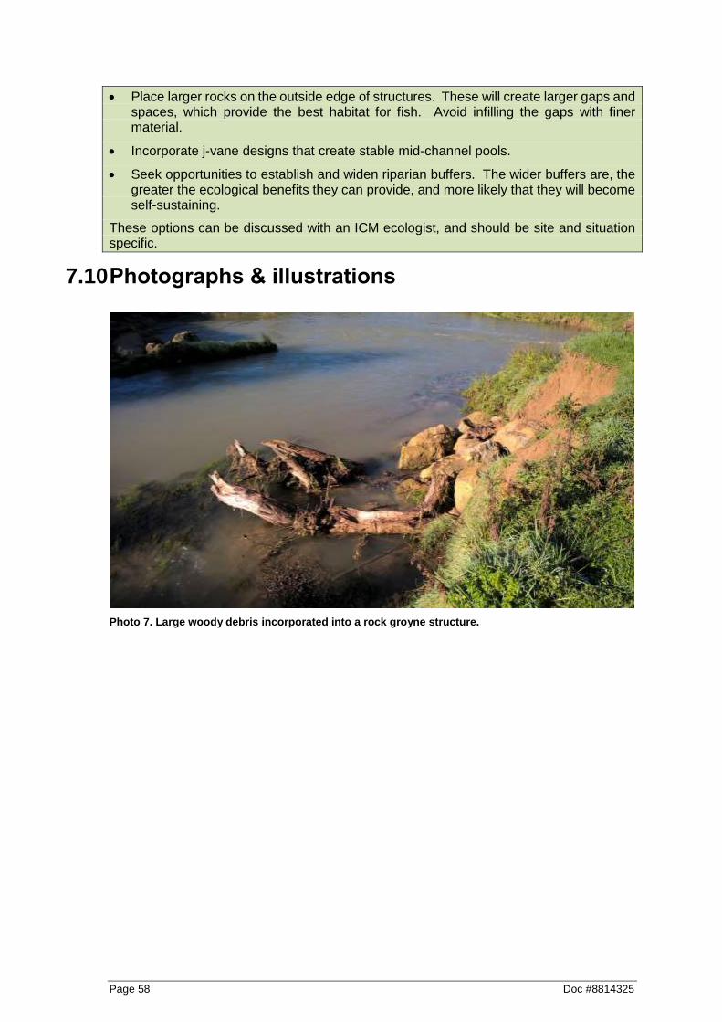
Page 58 Doc #8814325
Place larger rocks on the outside edge of structures. These will create larger gaps and spaces, which provide the best habitat for fish. Avoid infilling the gaps with finer material.
Incorporate j-vane designs that create stable mid-channel pools.
Seek opportunities to establish and widen riparian buffers. The wider buffers are, the greater the ecological benefits they can provide, and more likely that they will become self-sustaining.
These options can be discussed with an ICM ecologist, and should be site and situation specific.
7.10 Photographs & illustrations
Photo 7. Large woody debris incorporated into a rock groyne structure.

Doc #8814325 Page 59
8 Gravel management/extraction
8.1 Purpose & operational objectives
The process of managing and maintaining a river system includes ensuring the river and tributary stream channels are protected from erosion; and ensuring channels are largely free of damage causing obstructions. In addition, the channels must be of adequate capacity to effectively minimise the effects of flooding onto surrounding land. To achieve this, gravel may occasionally need to be moved within or from the bed of a channel in key areas that will help to maintain the watercourse in a stable path. This activity can be clearly separated into two distinct types:
8.1.1 Gravel management & channel training
This is where gravel movement is carried out, normally in conjunction with planting or willow lopping/layering/groynes and involves the movement and repositioning of deposited material within the channel or floodway. An eroding or unstable system will often deposit material, resulting in bank erosion and sedimentation. When planting or other methods are used to stabilise the outside of bends, the strategic movement of deposited gravel can assist in the overall stability of the channel.
8.1.2 Gravel extraction
This is the removal of surplus bed load material that a waterway carries and deposits in an area that reduces channel capacity overall and therefore creates or worsens flooding or erosion. It often results from a significant flood event, a series of minor events and often occurs where there is a gradient change in the river.
8.2 Key environmental objectives & principles
Undertake the works in a manner that minimises the amount of disturbance of habitat within the stream (aquatic) and along the edges of the channel (riparian) habitats. This includes minimising works during periods of the year when plants, fish and animals are particularly sensitive to disturbance (e.g. spawning periods).
Reduce the potential for fish stranding to occur by following the Aquatic Life Recovery Protocol (refer to Appendix I) during works.
Retain or restore as many of the habitat features that were present prior to works taking place as practicable. This includes riffle (fast & shallow), run (fast & deep) and pool (slow & deep) habitats as well as any variations in wetted width. The aim here is to maintain variability in width, depth and velocity by avoiding the creation of a section of channel that is the same along its entire length.
Gravel bars and islands are also important parts of a river system, providing valuable habitat and should be retained where possible.
8.3 Regional plan & Resource consents
It is very important to ensure when you are planning works, to identify whether the works are authorised by a Waikato Regional Plan Permitted Activity rule or an existing ICM resource consent. If the works do not comply with a Permitted Activity rule, and there are no existing ICM resource consents that authorise that activity in the applicable location – then a new

Page 60 Doc #8814325
resource consent will need to be obtained. If a new resource consent is required allow at least 12 weeks to go through the process.
8.3.1 Waikato Regional Plan rules
Please Note: This is a guide only based on the consent and regional plan rule requirements at the time of the writing of this Guideline. These requirements should be checked and site specific information should be applied, and if there is any doubt please check with the ICM Environmental Compliance team prior to the commencement of works to confirm.
To determine whether the works are occurring outside or within the bed of a river or stream, refer to the figure below for guidance (sourced from the Waikato Regional Plan).
The following Permitted Activity Rules (not requiring resource consent) relates to gravel management/extraction. Note that often bed disturbance (including gravel) associated with the construction of erosion control structures is allowed for under the relevant permitted activity rule or resource consent. Ensure any specific requirements or conditions are adhered to.
It is important to note that if the works involve a large amount of in stream works, then it is unlikely the works will be able to comply with the suspended solids discharge limits specified in the Waikato Regional Plan (Section 4.2.21). If in doubt, please check with the ICM Environmental Compliance team.
Extraction of bed material associated with the maintenance of a legally established structure permitted activity rule:
Permitted activity rule 4.3.6.1 – Extraction of Bed Material and Disturbance of River and Lake Beds Associated with the Maintenance of a Legally Established Structure
Includes the extraction and/or disturbance of bed material for the purpose of cleaning debris from within or surrounding a lawfully established structure.
Summary of key
conditions
a. The activity shall provide for the safe passage of fish both upstream and downstream.
b. The bed disturbance and/or extraction of bed material shall be limited to the extent necessary to clear debris or bed material and, in any event, shall not exceed a total length of 100 metres.
g. The activity shall comply with the suspended solids discharge standards as set out in Section 4.2.21 of the Waikato Regional Plan.

Doc #8814325 Page 61
h. Any erosion occurring as a result of the structure shall be remedied as soon as practicable.
j. The activity shall not be located in, on, or under the bed of a river or lake that is identified as a Significant Geothermal Feature. (Check OurMaps, refer to Appendix C).
Sand and gravel extraction permitted activity rule:
Permitted activity rule 4.3.7.1 – Sand and Gravel Extraction, Waihou River Catchment and Ohinemuri River Catchment
Includes the extraction of up to 50 cubic metres per year of sand and gravel from a river bed within the Waihou River Catchment and Ohinemuri River Catchment, excluding water bodies identified as Natural State in the Water Management Class Maps.
(Check OurMaps, refer to Appendix C).
Summary of key
conditions
a. Machinery shall not be operated in any flowing water.
b. The removal of sand and gravel shall take place no closer than two metres from flowing water.
c. Sand and gravel shall not be extracted to a depth exceeding 0.5 metres below water level.
d. Sand and gravel extraction shall not take place within 20 metres of any structure in, on, under or over the bed of the river.
e. Sand and gravel extraction shall not take place within 100 metres upstream of a water intake.
f. All excavated sand and gravel shall be removed from the river bed not stockpiled in the floodplain.
g. The Waikato Regional Council shall be notified in writing of the sand and gravel extraction at least 10 working days prior to commencing the activity.
(Email [email protected] and cc. [email protected])
j. The activity shall comply with the suspended solids discharge standards as set out in Section 4.2.21 of the Waikato Regional Plan.
Removal of Gravel as an obstruction permitted activity rule:
Permitted activity rule 4.3.10.1 – Removal of Obstructions
Includes the removal of vegetation, rocks, gravel, sediment and any other debris that are blocking or obstructing a river channel and are or are likely to directly result in erosion or flooding or cause a navigation or safety hazard.
Summary of key
conditions
h. The activity shall be limited to the extent necessary to clear obstructions and, in any event, the total length of works shall be limited to five times the width of the river bed or 100 metres per kilometre per 12-month period whichever is the lesser.

Page 62 Doc #8814325
h. The activity shall comply with the suspended solids discharge standards as set out in Section 4.2.21 of the Waikato Regional Plan.
l. The activity shall not take place in Significant Indigenous and Fish Habitat Class waters during August to December inclusive and Trout Fisheries and Trout Spawning class water during May to September inclusive. (Check OurMaps, refer to Appendix C).
n. The location of the proposed obstruction removal shall be notified to the Waikato Regional Council at least 24 hours prior to commencing activities. (Email [email protected] and cc. [email protected])
o. The activity shall not take place in a water body that is identified as a Natural State Water body in the Water Management Class maps or in a wetland. (Check OurMaps, refer to Appendix C).
8.3.2 ICM Resource consents for gravel management/extraction
ICM has resource consents which authorise gravel management/extraction in the following areas:
If in doubt, please discuss with the ICM Environmental Compliance team prior to the commencement of works to confirm consents and requirements.
Resource Consent Name Discover Link
Waihou Comprehensive Consent Resource Consent Certificate - 120925 (2036375).doc
(https://discover.wairc.govt.nz/otcs/llisapi.dll?func=ll&objac
tion=overview&objid=2144910)
Coromandel Area 1 Thames Coast Resource Consent Certificate - 118160 (1634729).doc
(https://discover.wairc.govt.nz/otcs/llisapi.dll?func=ll&objac
tion=overview&objid=1977424)
Coromandel Area 2 Coromandel Resource consent certificate 120203 (2214639).doc
(https://discover.wairc.govt.nz/otcs/llisapi.dll?func=ll&objac
tion=overview&objid=2309798)
Coromandel Area 3 Colville Resource Consent Certificate - 120206 (1669925).doc
(https://discover.wairc.govt.nz/otcs/llisapi.dll?func=ll&objac
tion=overview&objid=2052618)
Coromandel Area 4 Whangapoua Resource consent certificate 120200 (2579799).doc
(https://discover.wairc.govt.nz/otcs/llisapi.dll?func=ll&objac
tion=overview&objid=2730357)
Coromandel Area 5 Whitianga Resource Consent Certificate - 114708 (1235688).doc
(https://discover.wairc.govt.nz/otcs/llisapi.dll?func=ll&objac
tion=overview&objid=1314200)

Doc #8814325 Page 63
Coromandel Area 6 Tairua Resource Consent Certificate - 114711 (1235732).doc
(https://discover.wairc.govt.nz/otcs/llisapi.dll?func=ll&objac
tion=overview&objid=1314258)
Coromandel Area 7 Whangamata Resource Consent Certificate - 114705 (1235588).doc
(https://discover.wairc.govt.nz/otcs/llisapi.dll?func=ll&objac
tion=overview&objid=1313877)
Tongariro River Resource Consent Certificate - 121305 (2111143).docm
(https://discover.wairc.govt.nz/otcs/llisapi.dll?func=ll&objac
tion=overview&objid=2297028)
Tauranga Taupo River Resource Consent Certificate 125772 (2738038).docm
(https://discover.wairc.govt.nz/otcs/llisapi.dll?func=ll&objac
tion=overview&objid=2946438)
3 Zones Discretionary
Comprehensive Consent
Consent certificate 121848 - final version (August)
(2215490).docm
(https://discover.wairc.govt.nz/otcs/llisapi.dll?func=ll&objac
tion=overview&objid=2311671)
8.4 Timing of works
In most cases timing restrictions is not just best practice but a requirement of a resource consent or a Permitted Activity. Always confirm timing restrictions with any applicable resource consents or Permitted Activity requirements. Works should be undertaken during periods of dry and fine weather, and low flows. Use weather charts from the internet to predict upcoming weather patterns. If works are a matter of urgency, then determine whether works can be undertaken as s.330 Emergency works (refer to Appendix G), or under any applicable resource consent storm response provisions.
8.4.1 Fishery values
As a guide, the following table sets out the timing restrictions/considerations for works relating to fishery values, which adhere to best practice. Avoid instream works in months shaded black (except where significant bank erosion or flooding is imminent). Disturbance of intertidal vegetation during the months shaded grey should be avoided to provide inanga spawning habitat in the following months.
Value
Jan
Feb
Ma
r
Ap
r
Ma
y
Ju
n
Ju
l
Au
g
Se
p
Oc
t
No
v
De
c
Indigenous fish migration
Trout spawning
Inanga spawning (tidal areas)

Page 64 Doc #8814325
Check the Waikato Regional Plan layer in OurMaps to determine the fishery classification for the applicable watercourse (refer to Appendix C).
8.4.2 Other timing considerations
Other timing considerations should include:
Avoiding critical farming events e.g. lambing, maize harvest, hay/silage growing/cutting.
Avoiding works during the duck hunting season.
Avoid works within “threatened” or “at risk” bird nesting habitat or known presence. If in doubt, please check with the ICM Environmental Compliance team prior to the commence of works for guidance.
Spring and autumn are generally ideal weather conditions for stabilisation of disturbed areas (for grass strike/growth).
Plan any follow-up planting from May to September.
8.5 Scoping of works
a. Clearly identify the extent of works upstream and downstream by identifying the boundaries on an aerial photograph/map/engineering drawing, and then mark these boundaries onsite using tape/markers/dazzle paint etc. Ensure areas are also identified where any gravel removed will be placed.
b. Consider the erosion and sediment control measures to be implemented for the duration and at the conclusion of works, and include details of these in the site Works Plan.
c. A suitably qualified or experienced person shall determine a suitable alignment for the river/stream reach, having regard to stable meander curvatures observable elsewhere in the river/stream. The history of the reach should be determined using aerial photography held on Waikato Regional Council files from the preceding two decades. If creating a new channel alignment, consider the upstream and downstream impacts caused by changes in gradients.
d. If the site has high public visibility, or is a site where public/recreational users can readily access; place signage prior to the commencement of the works upstream and downstream of the works site to identify the works and outline any site hazards/public entry restrictions. Ensure all health and safety aspects are fully addressed.
e. Ensure downstream water users that could be effected by the works are notified.
f. Plan works so that runs, riffle and pool habitats are maintained in the stream ecosystem. To do this look at the run, riffle pool layout upstream and recreate the pattern once you have completed gravel management/extraction works.
g. Plan machinery access in a way that minimises disturbance of riparian vegetation.
h. If gravel is to be extracted from the river/stream bed, then ensure the gravel removed is clean of sediment prior to disposal. If the extracted gravel contains sediment then select an appropriate disposal site for extracted gravel that minimises sediment runoff entering (or re-entering) the stream channel system (e.g. leaving a vegetation buffer strip between the gravel and the river/stream channel).
i. Determine whether the works can be undertaken “in the dry” or whether a permanent or temporary channel diversion, or a constructed bund within the channel to isolate the site from flows; is required (refer to Appendix B for a channel diversion/realignment methodology). Details of these measures must be included in the Works Plan.
Doc #8814325 Page 65
j. Factor in costs and time associated with follow-up fencing, riparian planting and maintenance.
8.6 Physical works
a. Organise an onsite pre-construction meeting with the works supervisors, relevant ICM staff, the contractors, and; if appropriate the landowners and/or other key stakeholders. Ensure that the best practice methodologies to be implemented, all Regional Plan and/or resource consent requirements and limitations for the project are discussed and understood. Provide a copy of all relevant documents and the work plan to all relevant personnel.
b. Ensure machinery is washed down prior to and following works to prevent the spread of unwanted organisms such as alligator weed and didymo. Refer to Keep it clean – Machinery hygiene guidelines and logbook to prevent the spread of pests and weeds, June 2013.8
c. Ensure the contractor uses machinery suitable for the job. Using larger machines will limit excavation time and therefore periods of disturbance.
d. Leave logs and buried debris providing they do not create an obstruction or diversion that may promote erosion; as this material can provide fish habitat and can also aid in stabilising the bed.
e. Only extract the amount of gravel required to maintain the channel flood carrying capacity, or to alleviate erosion effects; once works are completed the river will re-sort the bed in response to the new alignment and current velocities created by the works. Channel capacity may be specified within consent conditions, and as such this needs to be referred to and complied with at all times.
f. Avoid creating wide shallow channels.
g. Undertake as much work as possible “in the dry” and outside of the wetted channel, to minimise the level of disturbance on aquatic habitats. In order to do this, measures such as a permanent or temporary channel diversion may be required (refer to Appendix B for a channel diversion/realignment methodology), or a constructed bund within the channel to isolate the site from flows. Details of these measures must be included in the Works Plan.
h. Undertake aquatic life recovery if required under consent conditions or through related mitigation plans. Protocols for undertaking aquatic life recovery are provided in Appendix I.
i. Ensure that machinery, equipment and gravel material are removed from the potential flood zone at the end of each working day, to avoid the possibility of floodwater washing machinery or materials downstream. If the works are being undertaken as a Permitted Activity, then it is a requirement to remove machinery, equipment and gravel material from the flood plain at the completion of the activity (unless a resource consent is obtained to deposit this material within a flood plain).
8.7 Erosion & sediment control considerations
Ensure that operations are carried out in a manner that minimises the disturbance of the works area and river bank/bed and minimise the discharge of sediment entering the watercourse by including the following:
a. Undertake as much work as possible “in the dry” and outside of the wetted channel, to minimise the level of disturbance on aquatic habitats. In order to do this, measures
8 http://www.waikatoregion.govt.nz/PageFiles/42184/Keepitclean.pdf

Page 66 Doc #8814325
such as a permanent or temporary channel diversion may be required (refer to Appendix B for a channel diversion/realignment methodology), or a constructed bund within the channel to isolate the site from flows. Dewatering may be required to an appropriate control measure if the water within the constructed bund area becomes heavily sediment laden. Details of these measures, including monitoring and maintenance to ensure their effectiveness and structural integrity; must be included in the Works Plan.
b. Plan to stabilise (e.g. hay/straw mulch and/or grass seed, coir matting, geotextile cloth) disturbed embankment and riparian areas as works progress; and/or upon completion of works.
c. Hay/straw mulch provides “instant” stabilisation, and when combined with grass seeding, the mulch creates a “micro climate” which generally enables a good grass strike in colder and/or drier conditions. Hay/straw mulching is very effective in preventing erosion while grass seed strikes/grows, particularly on light soils or flat/moderate gradients. Limitations of hay/straw mulch include on steep gradients or where it can be washed away (e.g. within a watercourse channel). Coir matting or geotextile cloth options may be more appropriate in these circumstances.
d. A site is considered “stabilised” once at least 80% of vegetation cover (or artificial/structural cover) has been achieved.
e. If the gradient is particularly steep, or within a watercourse channel then coir matting or geotextile cloth should be considered to prevent erosion. However, this needs to be used with care to ensure that this cloth does not smother, or limit, vegetative growth and therefore counter the erosion benefits. Refer to manufacturers specifications to ensure the correct product and grade is used.
f. Undertake works during periods of dry weather and low-river flows. Spring and autumn are when weather conditions are ideal for vegetation establishment of disturbed areas.
g. Check daily weather forecasts and ensure there are preparations for adverse weather.
h. Monitor dust during works, and ensure that appropriate measures are undertaken to minimise any dust generation. Ensure that areas of exposed works are limited as much as practicable, by staging works and progressively stabilising completed areas. If dust becomes an issue, suppressing dust by utilising water carts or water sprinkler systems should be utilised.
8.8 Follow-up & maintenance
8.8.1 Riparian works
a. If required as resource consent condition or if part of the works agreement, carry out riparian fencing and planting works to exclude stock from the banks of the waterway.
b. When carrying out riparian planting use native tree species wherever possible. If willows are required for stabilisation/erosion control, ensure male hybrids are selected (for example, male matsudana (Salix matsudana)). Please note that it is not permitted to plant crack (Salix fragilis) or grey (Salix cinerea) willow or any other plant pest identified in the Regional Pest Management Strategy document.
c. Undertake regular maintenance inspections and carry out maintenance as required.
8.8.2 Stream works
a. Any works within or on the bed of a watercourse are considered to be high risk activities and will require on-going and vigilant maintenance to minimise erosion and sediment generation. To achieve this, identify and correct any aspects that may indicate
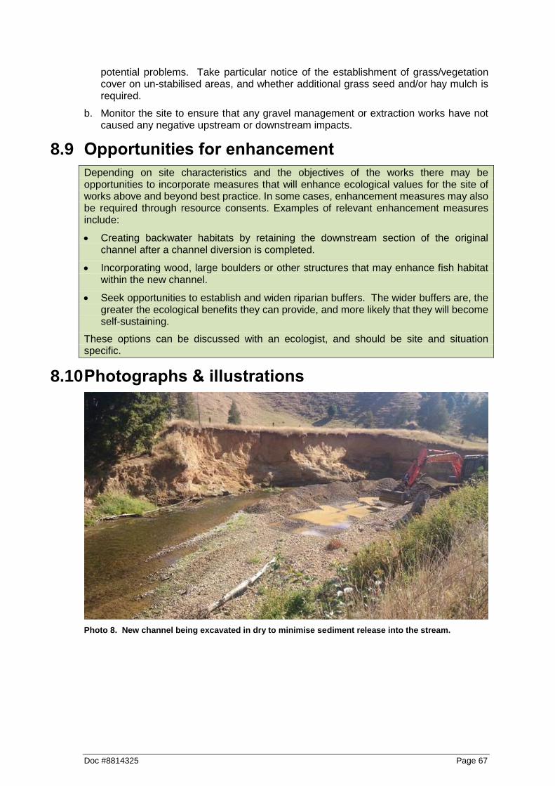
Doc #8814325 Page 67
potential problems. Take particular notice of the establishment of grass/vegetation cover on un-stabilised areas, and whether additional grass seed and/or hay mulch is required.
b. Monitor the site to ensure that any gravel management or extraction works have not caused any negative upstream or downstream impacts.
8.9 Opportunities for enhancement
Depending on site characteristics and the objectives of the works there may be opportunities to incorporate measures that will enhance ecological values for the site of works above and beyond best practice. In some cases, enhancement measures may also be required through resource consents. Examples of relevant enhancement measures include:
Creating backwater habitats by retaining the downstream section of the original channel after a channel diversion is completed.
Incorporating wood, large boulders or other structures that may enhance fish habitat within the new channel.
Seek opportunities to establish and widen riparian buffers. The wider buffers are, the greater the ecological benefits they can provide, and more likely that they will become self-sustaining.
These options can be discussed with an ecologist, and should be site and situation specific.
8.10 Photographs & illustrations
Photo 8. New channel being excavated in dry to minimise sediment release into the stream.

Page 68 Doc #8814325
Photo 9. Temporary bund being isolate disturbance and minimise sediment release.

Doc #8814325 Page 69
9 Bank battering
9.1 Purpose & operational objectives
This activity involves establishing a sloped bank with a protective surface cover (stabilisation) to reduce the potential for stream bank erosion. The activity normally involves re-grading steep stream banks and establishing vegetative ground cover and shrub vegetation, and is usually undertaken in conjunction with stabilisation of the stream bank toe. The final result is a stabilised river or stream bank that is less prone to lateral stream bank erosion. However, care needs to be taken when undertaking bank battering to ensure the amount of sediment deposition into the watercourse is minimised and that appropriate re-vegetation occurs.
9.2 Key environmental objectives & principles
Undertake the works in a manner that minimises the amount of disturbance of habitat within the stream (aquatic) and along the edges of the channel (riparian) habitats. This includes minimising works during periods of the year when plants, fish and animals are particularly sensitive to disturbance (e.g. spawning periods).
Avoid or minimise the risk of sedimentation into the stream or river by implementing appropriate erosion and sediment controls, site stabilisation and other best practice techniques.
9.3 Regional plan & Resource consents
It is very important to ensure when you are planning works, to identify whether the works are authorised by a Waikato Regional Plan Permitted Activity rule or an existing ICM resource consent. If the works do not comply with a Permitted Activity rule, and there are no existing ICM resource consents that authorise that activity in the applicable location – then a new resource consent will need to be obtained. If a new resource consent is required allow at least 12 weeks to go through the process.
9.3.1 Waikato Regional Plan rules
Please Note: This is a guide only based on the consent and regional plan rule requirements at the time of the writing of this Guideline. These requirements should be checked and site specific information should be applied, and if there is any doubt please check with the ICM Environmental Compliance team prior to the commencement of works to confirm.
9.3.1.1 Bank Battering Works
It should be noted that earthworks/tracking near/on the banks watercourses has a high risk of sedimentation and erosion, and there are some key restrictions to the Permitted Activity Rule. If the proposed bank battering/associated earthworks exceed any of the following limits, then please discuss with the ICM Environmental Compliance team prior to the commencement of works to confirm requirements:

Page 70 Doc #8814325
Soil disturbance/earthworks resulting in a cut slope batter which is greater than 3 metres in vertical height over a cumulative distance of more than 30 metres in length.
Tracking activities greater than 100 metres in length.
Soil disturbance/earthworks greater than 250 cubic metres in volume (solid measure).
Soil disturbance/earthworks activities greater than 0.2 hectares in area (2,000 square metres).
The following Permitted Activity Rule (not requiring resource consent) relates to bank battering (where the above limits are not exceeded).
It is important to note that the works involve a large amount of in stream works, then it is unlikely the works will be able to comply with the suspended solids discharge standards specified in the Waikato Regional Plan (Section 4.2.21). If in doubt, please check with the ICM Environmental Compliance team.
Permitted activity rule 5.1.4.11 – Soil Disturbance, Roading and Tracking and Vegetation Clearance
Includes soil disturbance and tracking within high risk erosion areas; and the standards listed in Section 5.1.5 of the Waikato Regional Plan is complied with.
Summary of key
conditions
b. Erosion/sediment controls shall be installed and maintained on all earthworks during and on completion of the works to avoid adverse effects of sediment on water bodies.
m. All exposed areas of soil resulting from the activity shall be stabilised against erosion by vegetation cover or other methods as soon as practical following the completion of the activity.
n. The activity shall not be located within 20 metres of a Significant Geothermal Feature. (Check OurMaps, refer to Appendix C).
o. The concentration of suspended solids in any non-point discharges from roading, tracking and vegetation clearance activities shall meet the following standards;
vi. in Waikato Region Surface class waters - 100 grams per cubic metre suspended solids concentration
vii. in Indigenous Fisheries and Fish Habitat class waters - 80 grams per cubic metre suspended solids concentration
viii. in Trout Fisheries and Trout Spawning Habitat class waters - 25 grams per cubic metre suspended solids concentration
ix. in Contact Recreation class waters - black disc horizontal visibility greater than 1.6 metres
x. in Natural State class waters - the activity or discharge shall not increase the concentration of suspended solids in the receiving water by more than 10 percent
Standard o) shall apply, except where the suspended solids concentration or black disc horizontal visibility in the receiving

Doc #8814325 Page 71
water is greater than the standards specified, at the time and location of discharge or of undertaking the activity. Then there shall not be any increase (i.e. further deterioration) in the receiving water suspended solids concentration or black disc horizontal visibility of more than 20% as a result of the activity or discharge.
The point at which compliance with this standard shall be measured is after reasonable mixing has occurred which in any instance does not exceed 200 metres from the point of discharge. (Check OurMaps, refer to Appendix C).
9.3.1.2 Cleanfill/spoil placement
The bank battering activity will generate spoil material that will need to be disposed of. This is referred to as cleanfill material. Placing cleanfill/spoil (either temporary or permanent) within a “high risk location” is not permitted and will require a resource consent. Discuss such consent requirements with ICM Environmental Compliance team prior to works commencing. A “high risk location” includes a location:
Within a floodplain;
Within 10 metres of a watercourse;
Within the catchment of, or within 10 metres of (whichever is the lesser) a cave entrance;
Within a wetland; or
Within a significant geothermal feature;
The following Permitted Activity Rule (not requiring resource consent) relates to cleanfill placement outside of a “high risk location”.
Permitted activity rule 5.2.5.4 – Small Scale Cleanfill Disposal Outside of High Risk Locations
Includes the placement of cleanfill onto or into land outside of:
- A high risk erosion area
- A floodplain of a river - The catchment of, or within 10 metres of, whichever is the
lesser, a sink hole or cave entrance - Any wetlands that are areas of significant indigenous
vegetation and/or significant habitats of indigenous fauna
- A significant geothermal feature
And where the total volume of cleanfill does not exceed 2,500 cubic metres per annum.
Summary of key
conditions
b. Records of the source and composition of all material disposed of shall be maintained and made available to the Waikato Regional Council upon request to demonstrate that only cleanfill has been disposed of.
c. The cleanfill has no acid producing material.
Page 72 Doc #8814325
f. Where the site is to receive a total volume of more than 1,000 cubic metres of cleanfill (loose measure) the Waikato Regional Council shall be notified in writing 7 days prior to the commencement of works.
g. The placement of the material shall be undertaken and maintained in a manner so as to ensure its long-term stability.
i. The concentration of suspended sediment in any discharge to a water body shall comply with the suspended sediment criteria as set out in Section 3.2.4.6 of the Waikato Regional Plan.
9.3.2 ICM Resource consents for bank battering
ICM has resource consents which authorise bank battering works and cleanfill placement in the following key areas. These consents include specific consent conditions which need to be complied with.
If in doubt, please discuss with the ICM Environmental Compliance team prior to the commencement of works to confirm consents and requirements.
Resource Consent Name Discover Link
Waihou Comprehensive Consent Resource Consent Certificate - 120925 (2036375).doc
(https://discover.wairc.govt.nz/otcs/llisapi.dll?func=ll&objac
tion=overview&objid=2144910)
Lower Piako Comprehensive
Consent
Resource Consent Certificate 117596 (2284739).docm
(https://discover.wairc.govt.nz/otcs/llisapi.dll?func=ll&objac
tion=overview&objid=2471786)
Coromandel Area 1 Thames Coast Resource Consent Certificate - 118160 (1634729).doc
(https://discover.wairc.govt.nz/otcs/llisapi.dll?func=ll&objac
tion=overview&objid=1977424)
Coromandel Area 2 Coromandel Resource consent certificate 120203 (2214639).doc
(https://discover.wairc.govt.nz/otcs/llisapi.dll?func=ll&objac
tion=overview&objid=2309798)
Coromandel Area 3 Colville Resource Consent Certificate - 120206 (1669925).doc
(https://discover.wairc.govt.nz/otcs/llisapi.dll?func=ll&objac
tion=overview&objid=2052618)
Coromandel Area 4 Whangapoua Resource consent certificate 120200 (2579799).doc
(https://discover.wairc.govt.nz/otcs/llisapi.dll?func=ll&objac
tion=overview&objid=2730357)
Coromandel Area 5 Whitianga Resource Consent Certificate - 114708 (1235688).doc
(https://discover.wairc.govt.nz/otcs/llisapi.dll?func=ll&objac
tion=overview&objid=1314200)

Doc #8814325 Page 73
Coromandel Area 6 Tairua Resource Consent Certificate - 114711 (1235732).doc
(https://discover.wairc.govt.nz/otcs/llisapi.dll?func=ll&objac
tion=overview&objid=1314258)
Coromandel Area 7 Whangamata Resource Consent Certificate - 114705 (1235588).doc
(https://discover.wairc.govt.nz/otcs/llisapi.dll?func=ll&objac
tion=overview&objid=1313877)
3 Zones Discretionary
Comprehensive Consent
Consent certificate 121848 - final version (August)
(2215490).docm
(https://discover.wairc.govt.nz/otcs/llisapi.dll?func=ll&objac
tion=overview&objid=2311671)
Land Drainage (Franklin, Waikato,
North Waikato, Aka Aka/Otaua &
South Waikato Drainage Areas)
Resource Consent Certificate 121726 - Silt Removal
November 2011 (for final staff report - minor typos over the
October version) (2082129).docm
(https://discover.wairc.govt.nz/otcs/llisapi.dll?func=ll&objac
tion=overview&objid=2237080)
9.4 Timing of works
In most cases timing restrictions is not just best practice but a requirement of a resource consent or a Permitted Activity. Always confirm timing restrictions with any applicable resource consents or Permitted Activity requirements. Works should be undertaken during periods of dry and fine weather, and low flows. Use weather charts from the internet to predict upcoming weather patterns. If works are a matter of urgency, then determine whether works can be undertaken as s.330 Emergency works (refer to Appendix G), or under any applicable resource consent storm response provisions.
9.4.1 Fishery values
As a guide, the following table sets out the timing restrictions/considerations for works relating to fishery values, which adhere to best practice. Avoid instream works in months shaded black (except where significant bank erosion or flooding is imminent). Disturbance of intertidal vegetation during the months shaded grey should be avoided to provide inanga spawning habitat in the following months.
Value
Jan
Feb
Ma
r
Ap
r
Ma
y
Ju
n
Ju
l
Au
g
Se
p
Oc
t
No
v
De
c
Indigenous fish migration
Trout spawning
Inanga spawning (tidal areas)
Check the Waikato Regional Plan layer in OurMaps to determine the fishery classification for the applicable watercourse (refer to Appendix C).

Page 74 Doc #8814325
9.4.2 Other timing considerations
Other timing considerations should include:
Avoiding critical farming events e.g. lambing, maize harvest, hay/silage growing/cutting.
Avoiding works during the duck hunting season.
Avoid works within “threatened” or “at risk” bird nesting habitat or known presence. If in doubt, please check with the ICM Environmental Compliance team prior to the commence of works for guidance.
Spring and autumn are generally ideal weather conditions for stabilisation of disturbed areas (for grass strike/growth).
Plan any follow-up planting from May to September.
9.5 Scoping of works
a. Clearly identify the extent of works upstream and downstream by identifying the boundaries on an aerial photograph/map/engineering drawing, and then mark these boundaries onsite using tape/markers/dazzle paint etc. This needs to include identifying early in the process the location of the cleanfill stockpile and associated haul roads/access to this location.
b. Consider the erosion and sediment control measures to be implemented for the duration and at the conclusion of works, and include details of these in the site Works Plan.
c. If the site has high public visibility, or is a site where public/recreational users can readily access; place signage prior to the commencement of the works upstream and downstream of the works site to identify the works and outline any site hazards/public entry restrictions. Ensure all health and safety aspects are fully addressed.
d. Consider potential impacts of the work on recreational river users and their access (e.g. anglers, swimmers, canoeists); and downstream water takes and take steps to minimise these.
e. Determine an appropriate disposal site(s) for the spoil heaps. Ensure the locations are away from the stream in a manner whereby they will not increase flooding effects on other properties. Placing spoil heaps within a high risk location, including a floodplain will require a resource consent (unless a consent already exists). If in doubt discuss with the ICM Environmental Compliance team.
f. Factor in costs and time associated with follow-up fencing, riparian planting and maintenance.
g. Plan machinery access in a way that minimises disturbance of riparian vegetation.
9.6 Physical works
a. Organise an onsite pre-construction meeting with the works supervisors, relevant ICM staff, the contractors, and; if appropriate the landowners and/or other key stakeholders. Ensure that the best practice methodologies to be implemented, all Regional Plan and/or resource consent requirements and limitations for the project are discussed and understood. Provide a copy of all relevant documents and the work plan to all relevant personnel.
b. Ensure machinery is washed down prior to and following works to prevent the spread of unwanted organisms such as alligator weed and didymo. Refer to Keep it clean –

Doc #8814325 Page 75
Machinery hygiene guidelines and logbook to prevent the spread of pests and weeds, June 2013.9
c. Determine the appropriate machinery (e.g. is a 20 tonne long reach excavator required or will at 12 tonne machine do the job). Use machinery that will minimise the risk of depositing sediment into the watercourse.
d. Vehicles and machinery shall avoid entering or working in the flowing water, wherever safe and possible. If machinery must enter or cross a stream, then details of the specific site and reason must be part of the Works Plan.
e. Do not carry out excavations or earthworks below the waterline, as this will increase the risk of sediment deposition and erosion. If works are required below the waterline, then a resource consent is likely to be required.
f. Always pull material back away from the watercourse to minimise the risk of sedimentation discharge.
g. Place spoil heaps away from the stream in a manner whereby they will not increase flooding effects on other properties. Placing spoil heaps within a high risk location, including a floodplain will require a resource consent (unless a consent already exists). If in doubt discuss with the ICM Environmental Compliance team.
h. Ensure that machinery, equipment and silt material are removed from the potential flood zone at the end of each working day, to avoid the possibility of floodwater washing machinery or materials downstream. If the works are being undertaken as a Permitted Activity, then it is a requirement to remove machinery, equipment and silt material from the flood plain at the completion of the activity (unless a resource consent is obtained to deposit this material within a flood plain).
9.7 Erosion & sediment control considerations
Ensure that operations are carried out in a manner that minimises the disturbance of the works area and river bank/bed and minimise the discharge of sediment entering the watercourse by including the following:
a. Consider the erosion and sediment control measures to be implemented for the duration and at the conclusion of works, and include details of these measures in the site Works Plan.
b. Plan to stabilise (e.g. hay/straw mulch and/or grass seed, coir matting, geotextile cloth) disturbed embankment and riparian areas as works progress; and/or upon completion of works.
c. Hay/straw mulch provides “instant” stabilisation, and when combined with grass seeding, the mulch creates a “micro climate” which generally enables a good grass strike in colder and/or drier conditions. Hay/straw mulching is very effective in preventing erosion while grass seed strikes/grows, particularly on light soils or flat/moderate gradients. Limitations of hay/straw mulch include on steep gradients or where it can be washed away (e.g. within a watercourse channel). Coir matting or geotextile cloth options may be more appropriate in these circumstances.
d. A site is considered “stabilised” once at least 80% of vegetation cover (or artificial/structural cover) has been achieved.
e. If the gradient is particularly steep, or within a watercourse channel then coir matting or geotextile cloth should be considered to prevent erosion. However, this needs to be used with care to ensure that this cloth does not smother, or limit, vegetative growth
9 http://www.waikatoregion.govt.nz/PageFiles/42184/Keepitclean.pdf
Page 76 Doc #8814325
and therefore counter the erosion benefits. Refer to manufacturers specifications to ensure the correct product and grade is used.
f. Undertake works during periods of dry weather and low-river flows. Spring and autumn are when weather conditions are ideal for vegetation establishment of disturbed areas.
g. Check daily weather forecasts and ensure that site managers and contractors are prepared for adverse weather.
h. Consider the use of other instant stabilisation techniques such as hydroseeding to achieve a stable and secure site.
i. Utilising “traditional” erosion and sediment control measures, such as silt fences, as necessary to minimise sediment generation and discharge. Such measures shall comply with the design as specified in the Waikato Regional Council’s Erosion and Sediment Control Guidelines for Land Disturbing Activities10.
j. Monitor dust during works, and ensure that appropriate measures are undertaken to minimise any dust generation. Ensure that areas of exposed works are limited as much as practicable, by staging works and progressively stabilising completed areas. If dust becomes an issue, suppressing dust by utilising water carts or water sprinkler systems should be utilised.
9.8 Follow-up & maintenance
9.8.1 Riparian works
a. If required as resource consent condition or if part of the works agreement, carry out riparian fencing and planting works to exclude stock from the banks of the waterway, and to assist with embankment stability.
b. When carrying out riparian planting use native tree species wherever possible. If willows are required for stabilisation/erosion control, ensure male hybrids are selected (for example, male matsudana (Salix matsudana)). Please note that it is not permitted to plant crack (Salix fragilis) or grey (Salix cinerea) willow or any other plant pest identified in the Regional Pest Management Strategy document.
c. Undertake regular maintenance inspections and undertake maintenance as required.
9.8.2 Stream works
Any works within or on the bed of a watercourse are considered to be high risk activities and will require on-going and vigilant maintenance to minimise erosion and sediment generation. To achieve this, identify and correct any aspects that may indicate potential problems. Take particular notice of the following aspects:
a. Ripping or degradation of any geotextile lining;
b. Establishment of grass/vegetation cover, and whether additional grass seed and/or hay mulch is required;
c. Surface erosion/scour occurring over the batter;
d. Whether the solution implemented has alleviated the bank erosion issue of concern or whether further erosion protection works are required: and
e. Erosion which is undercutting the bank at or below the waterline.
10 http://www.waikatoregion.govt.nz/PageFiles/27354/TR0902.pdf

Doc #8814325 Page 77
9.9 Opportunities for enhancement
Depending on site characteristics and the objectives of the works there may be opportunities to incorporate measures that will enhance ecological values for the site of works above and beyond best practice. In some cases, enhancement measures may also be required through resource consents. Examples of relevant enhancement measures include:
Create a low lying bench at the base of the batter that will inundate during small floods or high tides. Once vegetated these will provide a number of ecological functions including feeding areas, flood refuges, and spawning areas for whitebait. These may not be appropriate on the outside of bends that experience high flow velocities.
Seek opportunities to establish and widen riparian buffers. The wider buffers are, the greater the ecological benefits they can provide, and more likely that they will become self-sustaining.
Incorporate soft-engineering structures (e.g. wood) to protect the bank and provide habitat.
These options can be discussed with an ICM ecologist, and should be site and situation specific.
9.10 Photographs & illustrations

Page 78 Doc #8814325
10 Mechanical silt removal & land drainage
10.1 Purpose & operational objectives
Mechanical silt removal involves the excavation of accumulated material from the bed of a waterway (which could include a natural, modified or artificial watercourse) using a hydraulic excavator. The purpose of the work is to remove excess sediment deposited on bed of the waterway and accumulated aquatic weed to ensure the channel capacity is maintained to alleviate flooding and erosion risks. Drain spraying is an alternative method to maintain drains, and involves the application of chemical to kill unwanted vegetation or aquatic weed growing within a drain. Fencing drains to exclude stock and undertaking a regular spray maintenance program can significantly reduce the need for mechanical silt removal. Drain spraying can mean that drains (excluding peat drains) will only need to be mechanically cleaned every 5-10 years as opposed to every 1-2 years.
10.1.1 Waikato Regional Council land drainage schemes
The Waikato Region has a large network of drains within land drainage scheme areas. The Waikato Regional Council (WRC) are responsible for managing some of these land drainage scheme areas. These drains are managed to ensure the adjacent land can be adequately drained and to alleviate flooding by maintaining the condition and capacity of the drains using cleaning methods and best practice as set out in this document. Drains are only cleaned if required, and on average this involves spraying once or twice a year and mechanical clearance once every 10 years (with the exception of peat drains which are generally cleaned more frequently). It is recognised that drains are also important habitats (or could be important habitats) and have multiple uses and values. Mechanical clearing is undertaken in stages so that approximately 10% of a drainage network is cleaned in any one year, reducing the chance for erosion and reducing the time it takes for the ecosystem to recover. Fencing of drains is also encouraged as this prevents stock from accessing the drain, eroding the drain banks; and adding sediment, nutrients and faecal material directly into the drain. Overtime, this also reduces the need for mechanical clearance.
10.2 Key environmental objectives & principles
Undertake the works in a manner that minimises the amount of disturbance of habitat within the stream (aquatic) and along the edges of the channel (riparian) habitats. This includes minimising works during periods of the year when plants, fish and animals are particularly sensitive to disturbance (e.g. spawning periods).
Reduce the potential for fish mortality to occur at high risk sites by following the aquatic life recovery protocols (refer to Appendix I).
Silt and aquatic weed removal should only be carried out if required, and should be undertaken in stages (limited to 10% of the drainage network in any one year) to minimise the overall disturbance to plants and fish and their habitats.
Fencing of drains should be encouraged to prevent stock from eroding the banks of the drains and adding sediment, nutrients and faecal material directly to the drain.

Doc #8814325 Page 79
Avoid spraying any native vegetation growing on the banks of the drains. This can include vegetation such as grassy sedges, rushes, ferns, toetoe, cabbage trees and flax.
Consultation with DOC will be particularly important where land drainage intersects or boarders wetlands and/or protected areas.
10.3 Regional plan & Resource consents
It is very important to ensure when you are planning works, to identify whether the works are authorised by a Waikato Regional Plan Permitted Activity rule or an existing ICM resource consent. If the works do not comply with a Permitted Activity rule, and there are no existing ICM resource consents that authorise that activity in the applicable location – then a new resource consent will need to be obtained. If a new resource consent is required allow at least 12 weeks to go through the process.
10.3.1 Waikato Regional Plan rules
Please Note: This is a guide only based on the consent and regional plan rule requirements at the time of the writing of this Guideline. These requirements should be checked and site specific information should be applied, and if there is any doubt please check with the ICM Environmental Compliance team prior to the commencement of works to confirm.
To determine whether the works are occurring outside or within the bed of a river or stream, refer to the figure below for guidance (sourced from the Waikato Regional Plan).
It is important to determine whether the watercourse is deemed “artificial”, “modified” or “natural”; as this will impact on the Regional Plan and resource consent requirements.
Refer to Appendix J to assist in defining “modified” and “artificial watercourses”.
10.3.1.1 Silt Removal within modified/natural watercourses
A “modified watercourse” is defined as:
“An artificial or modified channel that may or may not be on the original watercourse alignment and which has a natural channel at its headwaters.”
A modified watercourse is treated the same as a “natural watercourse” under the RMA and Regional Plan.
There are no applicable Permitted Activity Rules that authorise silt removal within a modified or natural watercourse channel; therefore, a resource consent will be required for this activity. Refer to: Discretionary Activity Rule 4.3.4.4 – Bed Disturbance Activities.
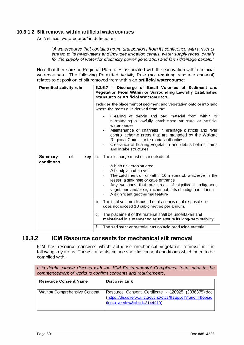
Page 80 Doc #8814325
10.3.1.2 Silt removal within artificial watercourses
An “artificial watercourse” is defined as:
“A watercourse that contains no natural portions from its confluence with a river or stream to its headwaters and includes irrigation canals, water supply races, canals for the supply of water for electricity power generation and farm drainage canals.”
Note that there are no Regional Plan rules associated with the excavation within artificial watercourses. The following Permitted Activity Rule (not requiring resource consent) relates to deposition of silt removed from within an artificial watercourse:
Permitted activity rule 5.2.5.7 – Discharge of Small Volumes of Sediment and Vegetation From Within or Surrounding Lawfully Established Structures or Artificial Watercourses.
Includes the placement of sediment and vegetation onto or into land where the material is derived from the:
- Clearing of debris and bed material from within or surrounding a lawfully established structure or artificial watercourse
- Maintenance of channels in drainage districts and river control scheme areas that are managed by the Waikato Regional Council or territorial authorities
- Clearance of floating vegetation and debris behind dams and intake structures
Summary of key
conditions
a. The discharge must occur outside of: - A high risk erosion area
- A floodplain of a river - The catchment of, or within 10 metres of, whichever is the
lesser, a sink hole or cave entrance - Any wetlands that are areas of significant indigenous
vegetation and/or significant habitats of indigenous fauna
- A significant geothermal feature
b. The total volume disposed of at an individual disposal site does not exceed 10 cubic metres per annum.
c. The placement of the material shall be undertaken and maintained in a manner so as to ensure its long-term stability.
f. The sediment or material has no acid producing material.
10.3.2 ICM Resource consents for mechanical silt removal
ICM has resource consents which authorise mechanical vegetation removal in the following key areas. These consents include specific consent conditions which need to be complied with.
If in doubt, please discuss with the ICM Environmental Compliance team prior to the commencement of works to confirm consents and requirements.
Resource Consent Name Discover Link
Waihou Comprehensive Consent Resource Consent Certificate - 120925 (2036375).doc
(https://discover.wairc.govt.nz/otcs/llisapi.dll?func=ll&objac
tion=overview&objid=2144910)

Doc #8814325 Page 81
Lower Piako Comprehensive
Consent
Resource Consent Certificate 117596 (2284739).docm
(https://discover.wairc.govt.nz/otcs/llisapi.dll?func=ll&objac
tion=overview&objid=2471786)
Coromandel Area 1 Thames Coast Resource Consent Certificate - 118160 (1634729).doc
(https://discover.wairc.govt.nz/otcs/llisapi.dll?func=ll&objac
tion=overview&objid=1977424)
Coromandel Area 2 Coromandel Resource consent certificate 120203 (2214639).doc
(https://discover.wairc.govt.nz/otcs/llisapi.dll?func=ll&objac
tion=overview&objid=2309798)
Coromandel Area 3 Colville Resource Consent Certificate - 120206 (1669925).doc
(https://discover.wairc.govt.nz/otcs/llisapi.dll?func=ll&objac
tion=overview&objid=2052618)
Coromandel Area 4 Whangapoua Resource consent certificate 120200 (2579799).doc
(https://discover.wairc.govt.nz/otcs/llisapi.dll?func=ll&objac
tion=overview&objid=2730357)
Coromandel Area 5 Whitianga Resource Consent Certificate - 114708 (1235688).doc
(https://discover.wairc.govt.nz/otcs/llisapi.dll?func=ll&objac
tion=overview&objid=1314200)
Coromandel Area 6 Tairua Resource Consent Certificate - 114711 (1235732).doc
(https://discover.wairc.govt.nz/otcs/llisapi.dll?func=ll&objac
tion=overview&objid=1314258)
Coromandel Area 7 Whangamata Resource Consent Certificate - 114705 (1235588).doc
(https://discover.wairc.govt.nz/otcs/llisapi.dll?func=ll&objac
tion=overview&objid=1313877)
3 Zones Discretionary
Comprehensive Consent
Consent certificate 121848 - final version (August)
(2215490).docm
(https://discover.wairc.govt.nz/otcs/llisapi.dll?func=ll&objac
tion=overview&objid=2311671)
Land Drainage (Franklin, Waikato,
North Waikato, Aka Aka/Otaua &
South Waikato Drainage Areas)
Resource Consent Certificate 121726 - Silt Removal
November 2011 (for final staff report - minor typos over the
October version) (2082129).docm
(https://discover.wairc.govt.nz/otcs/llisapi.dll?func=ll&objac
tion=overview&objid=2237080)
Deposition of sediment and
vegetation in to wetlands (Lower
Waikato, Waipa, Central Waikato
and Land Drainage)
s42A Report - ICM comprehensive wetland deposition
application - 136365 (3672555).doc
(https://discover.wairc.govt.nz/otcs/llisapi.dll?func=ll&objac
tion=overview&objid=4098997)
10.3.3 Other activities near land drainage schemes
Whilst fencing and planting is encouraged, it is important that the access to drains (that are part of a WRC or territorial authority drainage scheme) for maintenance is not compromised by farm activities such as fencing and planting.

Page 82 Doc #8814325
The Waikato Regional Plan (Discretionary Activity Rule 4.2.18.1 – Maintaining Access for Maintenance Purposes) requires landowners who are within a WRC or territorial authority drainage scheme to contact the Waikato Regional Council if they wish to do any of the following within 10 metres of a drainage scheme drain (except in the Hauraki District Council area where a 15 metre distance shall apply):
Plant trees, shrubs and/or construct any structure
Place fences perpendicular to a scheme drain without a gate
Place fences greater than 1,200mm high parallel to scheme drains
Place fences parallel to scheme drains that prevents access for maintenance
Place an artificial watercourse without a culvert perpendicular to a scheme drain
Many territorial authorities have Land Drainage Bylaws that control land drainage activities undertaken in drainage scheme areas that are under district council jurisdiction. Rules within Land Drainage Bylaws are in addition to those in the Waikato Regional Plan.
10.4 Timing of works
In most cases timing restrictions is not just best practice but a requirement of a resource consent or a Permitted Activity. Always confirm timing restrictions with any applicable resource consents or Permitted Activity requirements. Works should be undertaken during periods of dry and fine weather, and low flows. Use weather charts from the internet to predict upcoming weather patterns. If works are a matter of urgency, then determine whether works can be undertaken as s.330 Emergency works (refer to Appendix G), or under any applicable resource consent storm response provisions.
10.4.1 Fishery values
As a guide, the following table sets out the timing restrictions/considerations for works relating to fishery values, which adhere to best practice. Avoid instream works in months shaded black (except where significant bank erosion or flooding is imminent). Disturbance of intertidal vegetation during the months shaded grey should be avoided to provide inanga spawning habitat in the following months.
Value
Jan
Feb
Ma
r
Ap
r
Ma
y
Ju
n
Ju
l
Au
g
Se
p
Oc
t
No
v
De
c
Indigenous fish migration
Trout spawning
Inanga spawning (tidal areas)
Check the Waikato Regional Plan layer in OurMaps to determine the fishery classification for the applicable watercourse (refer to Appendix C).

Doc #8814325 Page 83
10.4.2 Other timing considerations
Other timing considerations should include:
Avoiding critical farming events e.g. lambing, maize harvest, hay/silage growing/cutting.
Avoiding works during the duck hunting season.
Avoid works within “threatened” or “at risk” bird nesting habitat or known presence. If in doubt, please check with the ICM Environmental Compliance team prior to the commence of works for guidance.
Spring and autumn are generally ideal weather conditions for stabilisation of disturbed areas (for grass strike/growth).
Plan any follow-up planting from May to September.
10.5 Scoping of works
a. Clearly identify the extent of works upstream and downstream by identifying the boundaries on an aerial photograph/map, and then mark these boundaries onsite using tape/markers/dazzle paint etc.
b. Consider the erosion and sediment control measures to be implemented for the duration and at the conclusion of works, and include details of these in the site Works Plan.
c. Check on OurMaps (refer to Appendix C) whether the proposed location is within 200 metres a listed wetland within Table 3.7.7 of Waikato Regional Plan11. If so, then additional Regional Plan or resource consent requirements may be needed. Please discuss with the ICM Environmental Compliance team.
d. Identify if aquatic life recovery is required under consent conditions or through related mitigation plans. Protocols for undertaking aquatic life recovery are provided in Appendix I.
e. Works should be designed, supervised and implemented to carry out the minimum amount of excavation necessary. Consent conditions may provide some guidance for the extent of sediment removal and as such should be referred to during this phase of works. Do not over-dig the bed of the drain.
f. Determine where spoil heaps will be placed. The spoil should be located away from the stream in a manner whereby they will not increase flooding effects on other properties. Placing spoil heaps within a floodplain may require a resource consent, if in doubt discuss with the ICM Environmental Compliance team.
g. If the site has high public visibility, or is a site where public/recreational users can readily access; place signage prior to the commencement of the works upstream and downstream of the works site to identify the works and outline any site hazards/public entry restrictions. Ensure all health and safety aspects are fully addressed.
h. Determine an appropriate disposal location for excavated silt.
i. Plan machinery access in a way that minimises disturbance of riparian vegetation.
j. Consider potential impacts of the work on recreational river users and their access (e.g. anglers, swimmers, canoeists); and downstream water takes and take steps to minimise these.
11 http://www.waikatoregion.govt.nz/Council/Policy-and-plans/Rules-and-regulation/Regional-Plan/Waikato-Regional-
Plan/3-Water-Module/37-Wetlands/377-Table-of-Wetlands-in-the-Waikato-Region-for-Rule-3746/

Page 84 Doc #8814325
k. Factor in costs and time associated with follow-up fencing, riparian planting and maintenance, where possible.
10.6 Physical works
a. Organise an onsite pre-construction meeting with the works supervisors, relevant ICM staff, the contractors, and; if appropriate the landowners and/or other key stakeholders. Ensure that the best practice methodologies to be implemented, all Regional Plan and/or resource consent requirements and limitations for the project are discussed and understood. Provide a copy of all relevant documents and the work plan to all relevant personnel.
b. Undertake aquatic life recovery if required under consent conditions or through related mitigation plans. Protocols for undertaking aquatic life recovery are provided in Appendix I.
c. Ensure machinery is washed down prior to and following works to prevent the spread of unwanted organisms such as alligator weed and didymo. Refer to Keep it clean – Machinery hygiene guidelines and logbook to prevent the spread of pests and weeds, June 2013.12
d. Determine the appropriate machinery (e.g. is a 20 tonne long reach excavator required or will at 12 tonne machine do the job). Use machinery that will minimise the duration of the works.
e. Vehicles and machinery shall avoid entering or working in the flowing water, wherever safe and possible. If machinery must enter or cross a stream, then details of the specific site and reason must be part of the Works Plan.
f. In areas where whitebait spawning may occur avoid disturbing the inter-tidal zone by using appropriately sized machinery.
g. Do not over-dig the channel or deepen the original invert level of the bed. Only remove the material necessary to reinstate the channel capacity and as specified in consent conditions.
h. If excavating within the watercourse channel leave the bed rough rather than smooth and uniform, and ensure the depth of the channel is varied (without deepening the invert level) - especially in channels with low flows.
i. For drains within peat soils, in most cases drainage can be optimised by maintaining water levels at around 0.5 metres below the surface. If extra capacity is required, drains should be widened instead of deepened. Main artery drains may need to be deeper but are usually not deeper than 1.5 - 1.8 metres. Continual deepening will lead to over drainage causing the peat to dry out and subside.
j. Leave logs and buried debris, provided that the gradient is not very flat, and they do not create an obstruction or diversion that may promote erosion.
k. The use of machinery and all other activities shall be undertaken in a manner that minimises disturbance of existing vegetation cover and the disturbance of sediment.
l. Use a slotted bucket (weed bucket) where ever possible to reduce to potential for fish to be deposited on the banks.
m. Ensure the bucket is lifted slowly to allow trapped fish/eels to escape, and to drain as much excess water as possible.
12 http://www.waikatoregion.govt.nz/PageFiles/42184/Keepitclean.pdf

Doc #8814325 Page 85
n. Ensure the excavator undertaking the work takes progressive cuts working towards the water level with the final cut just above the water.
o. If digging below the water level, bulk out all the dry material above the water level first then work on the section below water level. This will reduce the amount of sedimentation in the stream.
p. Always pull material back away from the watercourse to minimise the risk of sedimentation discharge.
q. Where disturbance of banks can be avoided leave a band of undisturbed vegetation along each bank where possible. These provide habitat refuges for fish following works and are likely to reduce fish stranding during works
r. Place spoil heaps away from the stream in a manner whereby they will not increase flooding effects on other properties. Placing spoil heaps within a floodplain may require a resource consent, if in doubt discuss with the ICM Environmental Compliance team.
s. Spoil should not be placed within wetlands or boggy areas.
t. Where possible avoid placing spoil where the movement of eels and other aquatic species back into the stream would be obstructed (e.g. on opposite side of stop banks).
u. Where possible spread spoil rather than deposit in heaps to minimise trapping of eels within the spoil and to aid in fish recovery.
v. Ensure that machinery, equipment and silt material are removed from the potential flood zone at the end of each working day, to avoid the possibility of floodwater washing machinery or materials downstream. If the works are being undertaken as a Permitted Activity, then it is a requirement to remove machinery, equipment and silt material from the flood plain at the completion of the activity (unless a resource consent is obtained to deposit this material within a flood plain).
10.7 Erosion & sediment control considerations
Ensure that operations are carried out in a manner that minimises the disturbance of the works area and river bank/bed and minimise the discharge of sediment entering the watercourse by including the following:
a. If the gradient of the site where the spoil is deposited is particularly steep, and/or where a vegetation (grass) buffer is inadequate; consider measures such as earth bunding or silt fences to minimise sediment discharging back into the watercourse.
b. Plan to stabilise (e.g. hay/straw mulch and/or grass seed, coir matting, geotextile cloth) disturbed embankment and riparian areas as works progress; and/or upon completion of works.
c. Hay/straw mulch provides “instant” stabilisation, and when combined with grass seeding, the mulch creates a “micro climate” which generally enables a good grass strike in colder and/or drier conditions. Hay/straw mulching is very effective in preventing erosion while grass seed strikes/grows, particularly on light soils or flat/moderate gradients. Limitations of hay/straw mulch include on steep gradients or where it can be washed away (e.g. within a watercourse channel). Coir matting or geotextile cloth options may be more appropriate in these circumstances.
d. A site is considered “stabilised” once at least 80% of vegetation cover (or artificial/structural cover) has been achieved.
e. If the gradient is particularly steep, or within a watercourse channel then coir matting or geotextile cloth should be considered to prevent erosion. However, this needs to be used with care to ensure that this cloth does not smother, or limit, vegetative growth

Page 86 Doc #8814325
and therefore counter the erosion benefits. Refer to manufacturers specifications to ensure the correct product and grade is used.
f. Undertake works during periods of dry weather and low-river flows. Spring and autumn are when weather conditions are ideal for vegetation establishment of disturbed areas.
g. Check daily weather forecasts and ensure that site managers and contractors are prepared for adverse weather.
h. Dewatering of material that is placed needs to be considered. This dewatering volume will need to be placed or treated such that it minimises sediment discharge into the associated stream channel with the details to be provided within the Works Plan.
i. Monitor dust during works, and ensure that appropriate measures are undertaken to minimise any dust generation. Ensure that areas of exposed works are limited as much as practicable, by staging works and progressively stabilising completed areas. If dust becomes an issue, suppressing dust by utilising water carts or water sprinkler systems should be utilised.
10.8 Follow-up & maintenance
a. If required as resource consent condition or if part of the works agreement, carry out riparian fencing and planting works to exclude stock from the banks of the waterway wherever possible. Planting overhanging species like sedges create shelter/shade for fish and keep the water cool.
b. When carrying out riparian planting use native tree species wherever possible. If willows are required for stabilisation/erosion control, ensure male hybrids are selected (for example, male matsudana (Salix matsudana)). Please note that it is not permitted to plant crack (Salix fragilis) or grey (Salix cinerea) willow or any other plant pest identified in the Regional Pest Management Strategy document.
c. Undertake regular maintenance inspections and undertake maintenance as required. Take particular notice of the following aspects:
Establishment of grass/vegetation cover, and whether additional grass seed and/or hay mulch is required.
Whether the engineering solution implemented has alleviated the bank erosion issue of concern or whether further erosion protection works are required.
Any bank erosion issues.
10.9 Opportunities for enhancement
Depending on site characteristics and the objectives of the works there may be opportunities to incorporate measures that will enhance ecological values for the site of works above and beyond best practice. In some cases, enhancement measures may also be required through resource consents. Examples of relevant enhancement measures include:
Seek opportunities to establish and widen riparian buffers. The wider buffers are, the greater the ecological benefits they can provide, and more likely that they will become self-sustaining.
Excavate pools that are slightly wider and deeper than the channel to provide fish habitat and act as inline sediment traps. This activity can cause adverse effects on habitat and channel stability depending on site conditions and so requires careful planning. Note that this activity may require resource consent.

Doc #8814325 Page 87
Place wood, pipes, large rocks or other structures to increase habitat within the channel. These can be tucked into the bank or in areas where they will have minimal effect on channel capacity.
Conduct fish recovery at sites where there are high fishery values even if not required by consent conditions. Protocols for undertaking aquatic life recovery are provided in Appendix I.
Minimise the length of channel disturbed within a drainage subdivision in any one year. This will help minimise effects on aquatic life.
These options can be discussed with an ICM ecologist, and should be site and situation specific.
10.10 Photographs & illustrations
Photo 10. Recently desilted section of channel within whitebait spawning habitat. Note avoidance of grassy vegetation along intertidal zone where whitebait eggs are laid.

Page 88 Doc #8814325
Photo 11. Example of a weed bucket used for vegetation and silt removal using a long-reach excavator.
Photo 12. Installing artificial cover objects in modified watercourse, which will be installed within the watercourse embankment to provide artificial habitat for fish/eels.

Doc #8814325 Page 89
11 Vegetation Spraying
11.1 Purpose & operational objectives
Vegetation spraying is an alternative method to maintain watercourses and drains, and involves the application of chemical to kill unwanted vegetation or aquatic weed. In the case of drains, a regular spray maintenance programme is the preferred maintenance method; and along with fencing to exclude stock, can significantly reduce the need for mechanical silt removal. Drain spraying can mean that drains (excluding peat drains) will only need to be mechanically cleaned every 5-10 years as opposed to every 1-2 years. Treatment of unwanted vegetation or aquatic weeds varies with the species and the time of year. Successful vegetation management must be based on the correct species identification and knowledge of the species; otherwise treatments can be ineffective or even counterproductive. For example: Glyceria maxima (also known as reed sweet grass, Poa aquatica, swamp grass, water meadow grass) can quickly become a large and vigorous plant that can block drains. New infestations should be treated as early as possible. Destroying the young plants at an early growth stage, before they have become established or produce seed, is the most economical and effective method of treatment. If treatment is delayed until the infestation is established, eradication in one season is improbable. Follow-up work over at least two or three seasons will be required. In some cases a broader view of the problem may be required. Local treatment may be ineffective if re-invasion occurs from upstream or from the import of material on equipment or in soil. Common vegetation treatments used in New Zealand are:
Planting shade trees to shade the water and prevent emergent macrophytes from growing;
Chemicals;
Mechanical (e.g. hand pulling and cutting, flair harvesters, weed baskets, and hydraulic excavators);
Other experimental approaches include: o Biological (e.g. grass carp); o Hydrological (e.g. flushing flows, drawdown to expose aquatic plants
etc). Timing, frequency and duration of treatment are often critical as a better kill can be achieved if plants are sprayed during the time when they are most actively growing, for example spring for convolvulus, and summer/late summer (March at the latest) for willow. Glyphosate is a broad spectrum herbicide used to control floating leaf plants (e.g. water lilies) and shoreline plants (e.g. purple loosestrife). It is a systemic herbicide that enters the plant through active green plant tissue and is translocated throughout the plant often killing the entire plant. It is non-selective; all treated plants die. It is generally applied as a liquid to leaves. Glyphosate is readily adsorbed by soil. Use Glyphosate 360 with the addition of an organosilicone penetrating agent because of the silt on the vegetation. Glysophate is not effective of on submerged plants as at least 75% of the plant must be above water level or efficiency may be reduced. Submergence will wash off the herbicide

Page 90 Doc #8814325
and rainfall within 2 hours of application will reduce effectiveness. The rain free period may be reduced to 30 minutes if a wetting agent (e.g. Pulse®) is added. Submerged aquatic weeds are difficult to kill because chemicals used need to be maintained at a sufficiently high concentration in the water for enough time to kill the weeds. Water volumes need to be determined reasonably accurately and the chemicals must be applied uniformly to achieve the desired results. Diquat dibromide (Reglone®) is used for submerged aquatic weeds, and is reportedly non-selective, and will affect non-target plants; with varying susceptibility. Diquat (Reglone®) was found to be effective on target weed species (e.g. Elodea, Lagarosiphon and hornwort) while not affecting most of the desirable native New Zealand species (e.g. Chara and Nitella species). Diquat was only partially successful in the control of aquatic weeds, particularly those that re-grow from stems or shoots buried in bottom sediments (Hudson, H.R.; editor. 2005). Endothall (Aquathol® K) is also used for aquatic weeds (e.g. hydrilla, hornwort and oxygen weed), however temperatures must be around 18 degrees or higher for Aquathol to be effective. Herbicide application can have a number of adverse environmental effects that need to be balanced against the effects of other vegetation control methods. Herbicides can be eco-toxic, with the level of toxicity varying depending on the chemical being used. As treated vegetation dies and rots down it can result in a prolonged reduction in dissolved oxygen that will stress aquatic life. Aquatic vegetation itself can provide important aquatic habitat and vegetation within the freshwater inter-tidal zone can be important for whitebait spawning. However, excessive aquatic vegetation can reduce dissolved oxygen concentrations and limit the availability of open water habitats favoured by some species.
11.2 Key environmental objectives & principles
Fencing of watercourses and drains should be encouraged to prevent stock from damaging the banks and adding sediment, nutrients and faecal material directly to the watercourse or drain.
Avoid spraying any native vegetation growing on the riparian edge or banks of watercourses or drains. This can include vegetation such as grassy sedges, rushes, ferns, toetoe, cabbage trees and flax. This vegetation is important for stabilising banks, shading, aquatic habitat and interception of nutrients.
11.3 Regional plan & Resource consents
It is very important to ensure when you are planning works, to identify whether the works are authorised by a Waikato Regional Plan Permitted Activity rule or an existing ICM resource consent. If the works do not comply with a Permitted Activity rule, and there are no existing ICM resource consents that authorise that activity in the applicable location – then a new resource consent will need to be obtained. If a new resource consent is required allow at least 12 weeks to go through the process.
11.3.1 Waikato Regional Plan rules
Please Note: This is a guide only based on the consent and regional plan rule requirements at the time of the writing of this Guideline. These requirements should be checked and site specific information should be applied, and if there is any doubt please
Doc #8814325 Page 91
check with the ICM Environmental Compliance team prior to the commencement of works to confirm.
For the purposes of the Waikato Regional Plan rules; a public amenity area means:
Those areas to which the public have right of access under any statute, regulation, law or by-law, which may include:
a. Crown or council properties, reserves, gardens, parks and airfields; b. Grasslands, sports grounds and recreational turf; c. Forest and bush areas; d. Road and rail verges and embankments, pedestrian walkways, malls and
precincts; e. Beaches and beach reserves and adjacent foreshore areas.
A conservative approach should be applied to areas next to rivers and streams, as public may have the right to access these areas.
The following Permitted Activity Rules (not requiring resource consent) relates to vegetation spraying:
Spot spraying using hand held equipment permitted activity rule:
Note that this rule does not authorise the direct discharge of agrichemicals into water.
Permitted activity rule 6.2.4.8 – Spot spraying using hand held spray equipment
Includes the discharge of agrichemicals from the ground into air, and any consequent discharge onto land, using hand held spray equipment for spot spraying.
Summary of key
conditions
a. The discharge does not occur in a public amenity area.
b. The agrichemical(s) shall be discharged in a manner that does not contravene any requirement specified in the manufacturer’s instructions.
c. The discharge shall be undertaken in such a way that no significant adverse effect of off-target drift shall occur beyond the boundary of the property being sprayed.
d. The owner or occupier of the property on which spraying is to be undertaken, is required to notify anyone who has requested prior notification. Notification shall be either verbal or in writing and shall be provided between 12 hours and three weeks prior to the commencement of the discharge. Notification shall include the:
a. date the agrichemical(s) is to be discharged b. type of agrichemical(s) to be used c. location of the discharge d. duration of the discharge e. method of discharge.
e. Where the agrichemical is being applied in a situation where it may enter water, any downstream water user within one kilometre of the point of discharge must be notified between 12

Page 92 Doc #8814325
hours and three weeks prior to commencement of the discharge.
Widespread application of agrichemical(s) permitted activity rule:
Permitted activity rule 6.2.4.9 – Widespread application of agrichemical(s)
Includes the discharge of agrichemicals into air, into water and into or onto land.
Summary of key
conditions
a. The agrichemical(s) shall be discharged in a manner that does not contravene any requirement specified in the manufacturer’s instructions.
b. The discharge shall be undertaken in such a way that no significant adverse effect of off-target drift shall occur beyond the boundary of the property being sprayed.
c. Where the agrichemical is being applied to vegetation on the banks and bed of water bodies:
i. the application and consequent breakdown of vegetation shall not result in the contamination of domestic or commercial water supplies, or the death of fauna (and/or residues being detected in fish).
ii. Where agrichemicals are applied directly to water any downstream water take within one kilometre of the point of discharge must be notified between 12 hours and three weeks prior to commencement of the discharge.
d. Within twelve months of the Plan (or this rule) becoming operative:
i. Every person undertaking the application of agrichemicals shall have a qualification certified in writing that meets the performance requirements set out in Section 6.2.10, or be under the direct supervision of a person who meets those requirements, or
ii. Every contractor or contractor employee undertaking the land based application of agrichemicals shall hold or be under the on site supervision of a person who holds a current National Certificate in Agrichemical Application, a GROWSAFE® Registered Chemical Applicators Certificate or a qualification that meets the performance requirements for contractors and contractor employees in Section 6.2.10
iii. Every pilot undertaking the aerial application of agrichemicals shall hold a Pilot’s Chemical Rating issued by the Civil Aviation Authority or an equivalent qualification.
e. The application of agrichemicals shall be undertaken in accordance with New Zealand Standard 8409:2004, Management of Agrichemicals.

Doc #8814325 Page 93
f. The owner, occupier, or manager of the property to be sprayed shall prepare a spray plan, or shall arrange for a spray plan to be prepared, at the beginning of each year or spray season, and the spray plan shall:
i. contain as a minimum the information as outlined in Section 6.2.7 of the Waikato Regional Plan or with reference to Appendix M4 of New Zealand Standard 8409:2004, Management of Agrichemicals.
ii. be given to any person within seven days of that person requesting the spray plan.
iii. Notwithstanding the requirements of part i) of this condition, for local authority parks and reserves, road side spraying operations and community based spray programmes where the spraying activities for which spray plans are required cover more than 10 properties a single spray plan can be prepared on an annual basis covering all operations. This spray plan must identify as a minimum all known sensitive areas likely to be affected by the activity and the strategies to be employed to avoid adverse effects on those areas (e.g. specific application techniques, specific notification practices, buffer zones, manning boundaries, restrictions on climate conditions when spraying can occur etc). The plan must be provided to the contractor/applicator prior to spraying commencing.
(Refer to Section 1.9 for the Spray Plan template)
g. The owner, occupier, or manager of the property to be sprayed shall keep and maintain records of agrichemical use, or shall arrange for records to be kept. These records shall, as a minimum, include the information in Appendix C of the New Zealand Standard 8409:2004 Management of Agrichemicals.
h. The owner, occupier, or manager of the property to be sprayed must follow the relevant notification requirements listed in Table 6-4 of this Plan.
11.3.2 ICM Resource consents for vegetation spraying
If in doubt, please discuss with the ICM Environmental Compliance team prior to the commencement of works to confirm consents and requirements.
ICM holds a Waikato Region wide resource consent for the discharge of agrichemicals for the control of pest plants. This consent includes specific consent conditions which need to be complied with.
ICM Region wide agrichemical resource consent:
Resource Consent Certificate - 124871 (2386107).doc(https://discover.wairc.govt.nz/otcs/llisapi.dll?func=ll&objaction=overview&objid=4077449)

Page 94 Doc #8814325
11.4 Timing of works
In most cases timing restrictions is not just best practice but a requirement of a resource consent or a Permitted Activity. Always confirm timing restrictions with any applicable resource consents or Permitted Activity requirements. Works should be undertaken during periods of dry and fine weather, with low flows and little wind. Use weather charts from the internet to predict upcoming weather patterns.
11.4.1 Fishery values
As a guide, the following table sets out the timing restrictions/considerations for works relating to fishery values, which adhere to best practice. Avoid vegetation spraying in months shaded black (except where significant bank erosion or flooding is imminent). Disturbance of intertidal vegetation during the months shaded grey should be avoided to provide inanga spawning habitat in the following months.
Value
Jan
Feb
Ma
r
Ap
r
Ma
y
Ju
n
Ju
l
Au
g
Se
p
Oc
t
No
v
De
c
Inanga spawning (tidal areas)
Check the Waikato Regional Plan layer in OurMaps to determine the fishery classification for the applicable watercourse (refer to Appendix C).
11.4.2 Other timing considerations
Other timing considerations should include:
Avoiding critical farming events e.g. lambing, maize harvest, hay/silage growing/cutting.
Avoiding works during the duck hunting season.
Avoid works within “threatened” or “at risk” bird nesting habitat or known presence. If in doubt, please check with the ICM Environmental Compliance team prior to the commence of works for guidance.
Ephemeral waterways (seasonally wet and dry) should be sprayed when the watercourse is dry.
In the case of willow regrowth spraying, spraying when leaf growth is vigorous (during February/March) is desirable.
11.5 Scoping of works
a. Ensure the required notification requirements outlined in the Permitted Activity rule, or the ICM region wide agrichemical resource consent are followed prior to commencing works.
b. Clearly identify the extent of works upstream and downstream by identifying the boundaries on an aerial photograph/map, and then mark these boundaries onsite using tape/markers/dazzle paint etc. Ensure that any areas of the site which are to be excluded from spraying are also clearly identified.

Doc #8814325 Page 95
c. Determine the most appropriate herbicide for the targeted species and proposed site. Only use chemicals appropriate for the intended use - Glysophate, Endothall (Aquathol® K) and Diquat dibromide (Reglone®) are registered for use over water.
d. Place signage, so that they are clearly visible to the public on all normal lines of entry where the public commonly have entry, to indicate that agrichemical(s) are being sprayed. The signs shall remain in place for a period equivalent to the contact re-entry time for the agrichemical(s).
e. If spraying a road or railway verge from a vehicle, the discharger shall place signs at the front and back of any vehicles used for the discharge, on which it shall be written ‘agrichemical application in progress.
f. Plan machinery access in a way that minimises disturbance of riparian vegetation.
g. Factor in costs and time associated with follow-up fencing, riparian planting and maintenance, where possible.
11.6 Physical works
a. Organise an onsite pre-construction meeting with the works supervisors, relevant ICM staff, the contractors, and; if appropriate the landowners and/or other key stakeholders. Ensure that the best practice methodologies to be implemented, all Regional Plan and/or resource consent requirements and limitations for the project are discussed and understood. Provide a copy of all relevant documents and the work plan to all relevant personnel.
b. Ensure machinery is washed down prior to and following works to prevent the spread of unwanted organisms such as alligator weed and didymo. Refer to Keep it clean – Machinery hygiene guidelines and logbook to prevent the spread of pests and weeds, June 2013.13
c. In areas where whitebait spawning may occur, avoid spraying or disturbing the inter-tidal zone.
d. Chemical spraying should be avoided in or near areas that are considered particularly sensitive (e.g. in areas with rare or threatened lizard species are present).
e. Where possible, spray weeds when they are small in size, and/or when the infestation is not widespread, to reduce the amount of dead vegetation that stays in the watercourse and reduce the risk of blockages.
f. Avoid unnecessary spraying of watercourse banks and riparian areas to minimise the risk of erosion, and to maintain habitat (see figure below for guidance).
g. Contamination of water is most likely to occur as a result of careless or excessive application of chemicals. Sensible and effective application will not only benefit the environment but reduce management costs.
h. Only use chemicals appropriate for the intended use - Glysophate, Endothall (Aquathol® K) and Diquat dibromide (Reglone®) are registered for use over water.
i. Spray only at rates recommended by the manufacturer.
j. Avoid spraying when rain is likely.
k. Take all necessary precautions to minimise spray drift.
13 http://www.waikatoregion.govt.nz/PageFiles/42184/Keepitclean.pdf
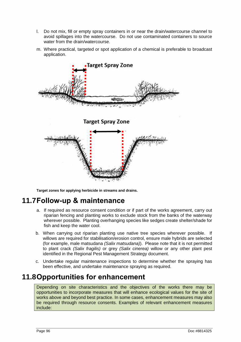
Page 96 Doc #8814325
l. Do not mix, fill or empty spray containers in or near the drain/watercourse channel to avoid spillages into the watercourse. Do not use contaminated containers to source water from the drain/watercourse.
m. Where practical, targeted or spot application of a chemical is preferable to broadcast application.
Target zones for applying herbicide in streams and drains.
11.7 Follow-up & maintenance
a. If required as resource consent condition or if part of the works agreement, carry out riparian fencing and planting works to exclude stock from the banks of the waterway wherever possible. Planting overhanging species like sedges create shelter/shade for fish and keep the water cool.
b. When carrying out riparian planting use native tree species wherever possible. If willows are required for stabilisation/erosion control, ensure male hybrids are selected (for example, male matsudana (Salix matsudana)). Please note that it is not permitted to plant crack (Salix fragilis) or grey (Salix cinerea) willow or any other plant pest identified in the Regional Pest Management Strategy document.
c. Undertake regular maintenance inspections to determine whether the spraying has been effective, and undertake maintenance spraying as required.
11.8 Opportunities for enhancement
Depending on site characteristics and the objectives of the works there may be opportunities to incorporate measures that will enhance ecological values for the site of works above and beyond best practice. In some cases, enhancement measures may also be required through resource consents. Examples of relevant enhancement measures include:

Doc #8814325 Page 97
Plant appropriate riparian vegetation where there is an opportunity to increase shading and reduce the need to spray in future (which is more effective to be undertaken on the northern side of the drain/watercourse). Access to the drain/watercourse for future maintenance needs to be considered in any planting plan (however, some restrictions may apply - refer to Waikato Regional Plan rule 4.2.18.1 Maintaining access for Maintenance Purposes).
Place wood, pipes, large rocks or other structures to increase habitat within the channel. These can be tucked into the bank or in areas where they will have minimal effect on channel capacity. The ideal location is where erosion control works are being implemented and included in their design.
Minimise the length of channel sprayed in any one year, as this will help minimise effects on aquatic life. However, spraying when vegetation is small in size and is not widespread is preferred rather than waiting for it to be large and overgrown, as this reduces the volume of decaying matter which can reduce dissolved oxygen concentrations and limit the availably of open water habitats favoured by some species.
These options can be discussed with an ICM ecologist, and should be site and situation specific.
11.9 Waikato Regional Plan Notification Requirements for Rule 6.2.4.9
Location and Nature of Chemical Application
Signage and Notification Requirements
Ground based application on private property further than 50 m from boundary of the property
There is no requirement to notify unless someone has requested notification. Where a person requests that they be notified, the owner, occupier or manager of the property to be sprayed shall provide notification in a form agreed between the two parties.
Ground based application on private property within 50 m of boundary
1. The owner, occupier, or manager of the property to be sprayed shall either:
a. provide verbal or written notification to owner(s), or occupier(s) of adjoining properties or to any other person requesting notification between 12 hours and three weeks prior to spraying, or
b. Provide written advice (at least once a year) to any person who is likely to be directly affected by spray applications that a spray plan prepared in accordance with condition f) of this rule is available on request. Notification procedures that have been mutually agreed by the parties shall be specified and noted in the spray plan.
c. And in any case, notification of adjoining private property owner(s) or occupier(s) will not be required if written permission has been obtained from them stating that notification can be in some mutually agreed form or that notification is not required.
d. Where the boundary is with a public amenity area or place of public assembly the discharger shall place signs so that they are clearly visible to the public at
Page 98 Doc #8814325
all points where the public commonly have entry, to indicate that agrichemical(s) are being sprayed. The signs shall remain in place for a period equivalent to the contact re-entry time* for the agrichemical(s).
Using an aircraft 1. The owner, occupier, or manager of the property to be sprayed shall:
Either-
a. provide verbal or written notification to owner(s), or occupier(s) of adjoining properties or to any other person requesting notification between 12 hours and three weeks prior to spraying,
b. Notify adjoining private property owner(s) or occupier(s) will not be required if written permission has been obtained from them stating that notification can be in some mutually agreed form or that notification is not required.
OR
1. The owner, occupier, or manager of the property to be sprayed shall give prior notification of the discharge, (or arrange for notification to be given), in local newspapers, or by verbal or written notice to people who may be affected in the adjoining area, between 12 hours and three weeks prior to the discharge. Notice shall include as a minimum:
a. that the spray plan for the property prepared in accordance with condition e) i) of this rule, is available for viewing
b. the likely date, time and duration of the discharge c. the location of the area on which the agrichemical(s)
is to be discharged d. the trade name and classification of the
agrichemical(s) to be discharged e. the name(s) and phone number(s) of the person6
who will discharge the agrichemical(s).
In a public amenity area, place of public assembly or as part of a community based spray programmes
Notification shall be in the form of either:
1. Prior notification of the discharge in local newspapers, or by verbal or written notice to people who may be affected in the adjoining area, between 12 hours and three weeks prior to the discharge. Notice shall include as a minimum, the following information:
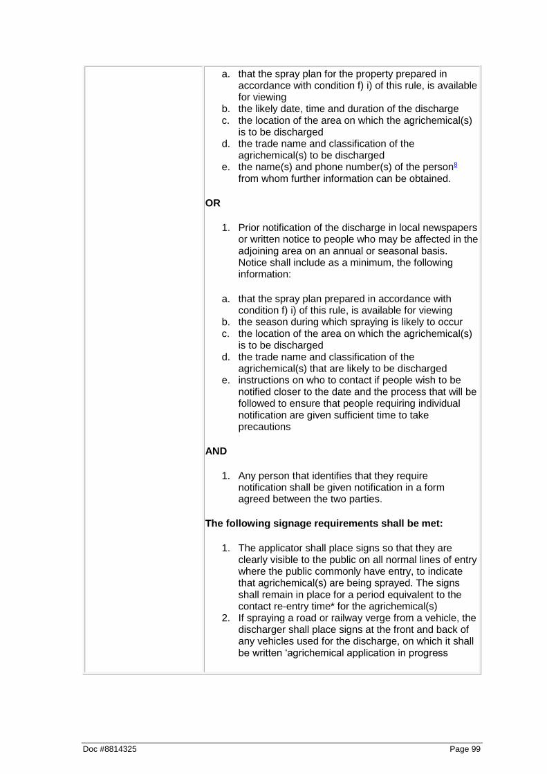
Doc #8814325 Page 99
a. that the spray plan for the property prepared in accordance with condition f) i) of this rule, is available for viewing
b. the likely date, time and duration of the discharge c. the location of the area on which the agrichemical(s)
is to be discharged d. the trade name and classification of the
agrichemical(s) to be discharged e. the name(s) and phone number(s) of the person8
from whom further information can be obtained.
OR
1. Prior notification of the discharge in local newspapers or written notice to people who may be affected in the adjoining area on an annual or seasonal basis. Notice shall include as a minimum, the following information:
a. that the spray plan prepared in accordance with condition f) i) of this rule, is available for viewing
b. the season during which spraying is likely to occur c. the location of the area on which the agrichemical(s)
is to be discharged d. the trade name and classification of the
agrichemical(s) that are likely to be discharged e. instructions on who to contact if people wish to be
notified closer to the date and the process that will be followed to ensure that people requiring individual notification are given sufficient time to take precautions
AND
1. Any person that identifies that they require notification shall be given notification in a form agreed between the two parties.
The following signage requirements shall be met:
1. The applicator shall place signs so that they are clearly visible to the public on all normal lines of entry where the public commonly have entry, to indicate that agrichemical(s) are being sprayed. The signs shall remain in place for a period equivalent to the contact re-entry time* for the agrichemical(s)
2. If spraying a road or railway verge from a vehicle, the discharger shall place signs at the front and back of any vehicles used for the discharge, on which it shall be written ‘agrichemical application in progress

Page 100 Doc #8814325

Doc #8814325 Page 101
12 Glossary of terms Notes: Terms marked * are defined in the Waikato Regional Council’s Erosion and Sediment Control Guidelines for Soil Disturbing Activities, January 2009. Terms marked ^ are defined in the Waikato Regional Plan, 2011. Terms marked + are defined by the Resource Management Act, 1991. The RMA definition at the date of public notification of this Plan is set out for information only. Users should refer to the latest version of the RMA. Terms marked ° are defined in the Waikato Regional Policy Statement, 2016. Unless a direct source is specified in a footnote, all other terms have been developed specifically for the purposes of this document.
Area of Disturbance* The area of exposed soil. Artificial Watercourse^ A watercourse that contains no natural portions from its confluence with a river or stream to its headwaters and includes irrigation canals, water supply races, canals for the supply of water for electricity power generation and farm drainage canals. Back Water Habitats14 Slow or no flow zone away from the main flowing channel and which is a surface flow dead end. Batter* A constructed slope of uniform gradient.
Bed*
a. In relation to any river: i. for the purpose of
esplanade reserves, esplanade strips, and subdivision, the space of land which the waters of the river cover at is annual fullest flow without overtopping its banks:
ii. in all other cases, the space of land which the waters of the river cover at its fullest flow without overtopping its banks; and
14 Harding J.S., Clapcott J.E., Quinn J.M., Hayes J.W., Joy M.K., Storey R.G., et al. (2009) Stream Habitat Assessment Protocols for wadeable rivers and streams
b. In relation to any lake, except a lake controlled by artificial means:
i. for the purposes of esplanade reserves, esplanade strips, and subdivision, the space of land which the waters of the lake cover at its annual highest level without exceeding its margin
ii. in all other cases, the space of land which the waters of the lake cover at its highest level without exceeding its margin; and
c. In relation to any lake controlled by artificial means, the space of land which the waters of the lake cover at its maximum permitted operating level; and
d. In relation to the sea, the submarine areas covered by the internal waters and the territorial sea.
Catchment* A geographical unit within which surface runoff is carried under gravity by a single drainage system to a common outlet. Also commonly referred to as a watershed or drainage basin. Channel* That part of a watercourse system where normal flow is contained. The channel is generally incised into the
of New Zealand. School of Biological Sciences, University of Canterbury, Christchurch.

Page 102 Doc #8814325
flood plain and for many of the stable stream systems in New Zealand can be defined in capacity as being just able to accommodate the annual return period flow (100 percent AEP) without overtopping. Also refers to an artificial conduit such as a ditch excavated to convey water. Channel Stabilisation* Stabilisation of the channel profile by erosion control and/or velocity distribution through reshaping, the use of structural linings, mass blocks, vegetation and other measures. Channel Storage* The amount of water temporarily stored in channels while en route to an outlet. Channel Training Structure^ A structure within the bed of a river that is designed to maintain the bed of the channel flow in a particular location or width. Clay (Soils) * A mineral soil consisting of particles less than 0.002 mm in equivalent diameter. A soil texture class. Cleanfill Material* That when discharged to the environment will have no adverse effect on people or the environment. This includes natural materials such as clay, soil and rock, and other inert materials such as concrete and brick, or mixtures of any of the above. Cleanfill excludes for example: a) material that has combustible, putrescible or degradable components b) materials likely to create leachate by means of biological or chemical breakdown c) any products or materials derived from hazardous waste treatment, hazardous waste stabilisation or hazardous waste disposal practices d) materials such as medical and veterinary waste, asbestos, or radioactive substances that may present a risk to human health e) soils or other materials contaminated with hazardous substances or pathogens f) hazardous substances.
15 www.cirtex.co.nz
Clean Water* Any water that has no visual signs of suspended solids, such as overland flow (sheet or channelled) originating from stable well-vegetated or armoured surfaces. Coir Matting15 A biodegradable coconut fibre matting for erosion and sediment control and landscape applications Concentrated Flow* The accumulation of material that has settled because of reduced velocity of the transporting agent (water or wind). Contour* A line across a slope connecting points of the same elevation. Contributing Drainage Area* All of that drainage area that contributes to the flow into a treatment device. A contributing drainage area can include both clean and sediment-laden water flows. Commonly referred to as the catchment area. De-watering* The removal of impounded water, generally by pumping. Refer sump pit. Disturbed Area* An area of exposed soil. Diversion* A channel or bunds constructed to convey concentrated flow. Drainage* The removal of excess surface water or ground water from land by means of surface or subsurface drains. Ephemeral Watercourse* A watercourse that flows only part of the year; includes overland flowpaths such as grassland swales and dry gullies which only flow during more intensive rainstorms. Erodible* An erodible soil is a soil that is readily entrained (moved) by actions such as rain drop impact, overland flow or wind.
Doc #8814325 Page 103
Erosion Matting* A manufactured matting of either synthetic or natural fibre used to minimise surface erosion and in some cases, promote re-vegetation. Filter Fabric* A woven or non-woven, water-permeable geotextile made of synthetic products such as polypropylene used for such purposes as preventing clogging of aggregate by fine soil particles. Refer geotextile fabric. Filter Strip* A long, narrow vegetative planting used to retard or collect sediment for the protection of adjacent properties or receiving environments. Fines (Soil) * Generally refers to the silt and clay size particles in soil. Floodplain^ The surface of relatively smooth land built of alluvium adjacent to a river channel, and covered with water during flooding of the river. Gabion Basket* A flexible woven-wire basket composed of two to six rectangular cells filled with small stones. Gabions may be assembled into many types of structures such as retaining walls, channel liners, drop structures and groynes. Geosynthetic* Erosion Control Systems (GECS) The artificial protection of erodible channels and slopes using artificial erosion control material such as geosynthetic matting, geotextiles or erosion matting. Geotextile Fabric* A woven or non-woven, impermeable or semipermeable material generally made of synthetic products such as polypropylene and used in a variety of engineering, stormwater management, and erosion and sediment control applications. Grade* The slope of a road, channel or natural ground. The finished surface of a channel bed, road bed, top of embankment or bottom of excavation. Any surface prepared for the support of construction like paving or for laying conduit.
To finish the surface of a channel bed, road bed, top of embankment or bottom of excavation. Gravel* Aggregate consisting of mixed sizes of 5 mm to 75 mm particles which normally occur in or near old streambeds and have been worn smooth by the action of water.
High Risk Erosion Area^ Means any part of any activity (where the activity is not otherwise permitted): a. where the pre-existing slope of the
land exceeds 25 degrees; or b. on coastal frontal dunes on the East
Coast; or c. on coastal sand country on the West
Coast (Mokau to Karioitahi) where loose sands are at the ground surface or within 10 centimetres of the surface; or
d. within 50 metres landward of the coastal marine area of an estuary, except in the landward margin of an authorised stopbank; or
e. adjacent to water bodies (including ephemeral watercourses draining catchments greater than 100 hectares, but excluding any other ephemeral rivers or streams), where:
i. the land slope is between 0 degrees to 15 degrees – within 10 metres from any lake, wetland or the bed of a river or lake, or
ii. the land slope is greater than 15 degrees – within that distance from the wetland, the bed of a river or lake, or from mean high water springs to the first point at which the slope reduces to 15 degrees or less, or 100 metres (whichever is the lesser, outside the minimum distance described in i)).
Headwater* The source of a watercourse. The water upstream of a structure or point on a watercourse.

Page 104 Doc #8814325
Hydrology* The science of the behaviour of water in the atmosphere, on the surface of the earth and underground. Hydroseeding* The spraying of a slurry of seed, fertiliser and paper or wood pulp over a surface to be revegetated. Impervious* Not allowing infiltration of water. Large Woody Debris (LWD)16 Trees, logs, rootwads and large branches that fall into watercourses and interact with the water, sediment, and organisms in the channel. Layering^ The felling of trees, along the bank of a water body, so the felled material may be anchored in place and regrow Mitigation* Measures taken to off-set adverse environmental effects caused by soil disturbing activities. Modified Watercourse^ An artificial or modified channel that may or may not be on the original watercourse alignment and which has a natural channel at its headwaters. Mulch* Covering on surface of soil to protect it and enhance certain characteristics, such as protection from rain drop impact and improving germination. Overland Flow Path* The route of concentrated flow. Perennial Stream* A stream that maintains water in its channel throughout the year or maintains a series of discrete pools that provides habitats for the continuation of the aquatic ecosystem. Permeability (Soil)* The rate at which water will move through a saturated soil.
16 Opperman J., Merenleder A. & Lewis D. (2006) Maintaining Wood in Streams: A Vital Action for Fish
Permitted Activity* An activity that does not exceed the thresholds specified by a Regional or District Plan whereby a resource consent is required. However, permitted activities must meet certain performance standards in terms of minimising adverse effects. Pervious* Allowing movement of water. Rehabilitation* Restoration to as near to pre-disturbance conditions as possible. This may entail such measures as revegetation for erosion control, enhancement planting, modification and armouring of watercourses. Reno Mattress* A shallow (300 - 500 mm deep), wide, flexible woven-wire basket composed of two to six rectangular cells filled with small stones. Often used at culvert inlets and outlets to dissipate energy and prevent channel erosion. Re-vegetation* The establishment of vegetation to stabilise a site. Riparian Protection Area* An area adjacent to a watercourse designated as a non-disturbance zone to provide a buffer between receiving environments (for example, watercourses) and the area of operation. Scour* The erosive or digging action of flowing water; the downward or lateral erosion caused by water. Channel-forming stream scour is caused by the sweeping away of mud and silt from the outside bank of a curved channel (meander), particularly during a flood. Sediment* Solid material, both mineral and organic, that is in suspension, is being transported or has been moved from site of origin by air, water, gravity or ice and has come to rest on the earth’s surface either above or below water.
Conservation. ANR University of California Publication 8157.

Doc #8814325 Page 105
Sediment Yield* The quantity of sediment discharged from a particular site or catchment in a given time, measured in dry weight or by volume. When erosion and sediment control measures are in place, sediment yield is the sediment discharged from the site after passing through those measures. Sheet Flow* Shallow dispersed overland flow. Silt* A soil consisting of particles between 0.05 and 0.002 mm in equivalent diameter. A soil textural class. Silt Loam* A soil textural class containing a large amount of silt and small quantities of sand and clay. Silty Clay* A soil textural class containing a relatively large amount of silt and clay and a small amount of sand. Slash* Branches trimmed from production logs. Slope^ The steepness of the land surface. Slope is measured in degrees and to an accuracy no less than that achieved by a hand held clinometer or Abney level. Soil* The unconsolidated mineral and organic material on the surface of the earth that serves as a natural medium for the growth of land plants. Earth and rock particles resulting from the physical and chemical disintegration of rocks, which may or may not contain organic matter. Includes fine material (silts and clays), sand and gravel. Soil Disturbance^ The disturbance of land surfaces by any means including blading, blasting, contouring, cutting of batters, excavation, ripping, root raking, moving or removing soil or earth. This definition excludes normal maintenance of legally established structures, roads, tracks and railway lines. This definition also excludes those activities that are defined as vegetation clearance or soil cultivation.
Stabilisation* Providing adequate measures, vegetative and/or structural that will protect exposed soil to prevent erosion. Stabilised Area* An area sufficiently covered by erosion-resistant material such as a good cover of grass, or paving by asphalt, concrete or aggregate, in order to prevent erosion of the underlying soil. Subsoil* The horizons of soils with distinct profiles. In soils with weak profile development, the subsoil can be defined as the soil below the ploughed soil (or its equivalent of surface soil), in which roots normally grow. Surface Runoff* Rain that runs off rather than being infiltrated or retained by the surface on which it falls. Surface Water* All water with its surface exposed to the atmosphere. Suspended Solids* Solids either floating or suspended in water. Temporary Watercourse* Crossing A stable watercourse crossing that is installed for the duration of an operation and is removed in its entirety at the completion of the operation. Toe (of Slope)* Where the slope stops or levels out. Bottom of the slope. Topsoil* Fertile or desirable soil material (suitable organic and structural properties) used to top-dress roadbanks, subsoils, parent material etc to provide a suitable medium for plant growth. Vegetation Clearance^ Includes the burning, cutting, crushing, spraying and/or removal of all forms of vegetation including indigenous and exotic plants. It does not include those activities relating to routine cultivation or grazing, pruning or waste thinning operations, or canopy damage resulting from forest harvest activities.
Page 106 Doc #8814325
Waahi Tapu° a sacred site. These are defined locally by the hapū and iwi who are the kaitiaki for the wāhi tapu. These typically include burial grounds and sites of historical importance to the tribe. In order to protect particular sites from interference and desecration, some tribes will refuse to disclose the exact location to outsiders. When tapu is applied to places of significance to iwi, hapū and/or whānau, they are deemed wāhi tapu. The literal translation is “sacred place”. Places can become wāhi tapu for many reasons. In some instances, they signify ahi kā; in other instances, they can be burial grounds, places used for ritual cleansing or healing, or simply where past incidents occurred. Some wāhi tapu are places or landscapes considered tapu because of their magnitude, or symbolic representation of a hapū or iwi. Water Body* Any type of surface water such as watercourses, lakes and wetlands. Watercourse* Any pathway for concentrated overland flow, including rivers, streams and ephemeral channels. Watershed* Refer catchment. Water Table* The upper surface of the free ground water in a zone of saturation; locus of points in soil water at which hydraulic pressure is equal to atmospheric pressure. Wetland+ Includes permanently or intermittently wet areas, shallow water, and land water margins that support a natural ecosystem of plants and animals that are adapted to wet conditions.

Doc #8814325 Page 107
Section 3: Appendices The appendices include useful supporting documents to assist with planning and undertaking ICM activities which are referred to throughout the Best Practice Guidelines.
Appendix A: Process flow chart for planning ICM river and drainage activities (BPG’s page 109)
Appendix B: Methodology for channel diversions/relaignment (BPG’s page 110)
Appendix C: Finding Waikato Regional Plan Water Classification Information on Our Maps (3005008).docm (https://discover.wairc.govt.nz/otcs/llisapi.dll?func=ll&objaction=overview&objid=3343074)
Appendix D: Oil Spill Contingency Guidelines- River and Catchment Services Operations - final (10645422).doc (https://discover.wairc.govt.nz/otcs/llisapi.dll?func=ll&objaction=overview&objid=10645422)
Appendix E: Works Plan template (2221970).docx (https://discover.wairc.govt.nz/otcs/llisapi.dll?func=ll&objaction=overview&objid=2326660)
Appendix F: Flow Diagram for Vegetation Clearance Rules (1130375).doc (https://discover.wairc.govt.nz/otcs/llisapi.dll?func=ll&objaction=overview&objid=4055844)
Appendix G: Section 330 Emergency Works Protocol - ICM _ RUD (Updated Oct 2015) (1401997).doc(https://discover.wairc.govt.nz/otcs/llisapi.dll?func=ll&objaction=overview&objid=1446140)
Appendix H: Measuring Erosion Protection Structures (2303621).docm (https://discover.wairc.govt.nz/otcs/llisapi.dll?func=ll&objaction=overview&objid=2515538)
Appendix I: Aquatic Life Recovery Protocols for ICM maintenance works (2804163).docm (https://discover.wairc.govt.nz/otcs/llisapi.dll?func=ll&objaction=overview&objid=2966401)
Appendix J: RCS Land Drainage - Criteria for Artificial _ Modified Watercourse Definition (3029133).docm (https://discover.wairc.govt.nz/otcs/llisapi.dll?func=ll&objaction=overview&objid=3388819)
Appendix K: Integrated Catchment Management Directorate, Accidental Archaeological Protocol (10648616).docm (https://discover.wairc.govt.nz/otcs/llisapi.dll?func=ll&objaction=overview&objid=10648616)
Other useful links:
Waikato Regional Plan: http://www.waikatoregion.govt.nz/Council/Policy-and-plans/Rules-and-regulation/Regional-Plan/Waikato-Regional-Plan/
Erosion and Sediment Control Guidelines for Soil Disturbing Activities, January 2009: http://www.waikatoregion.govt.nz/PageFiles/27354/TR0902.pdf

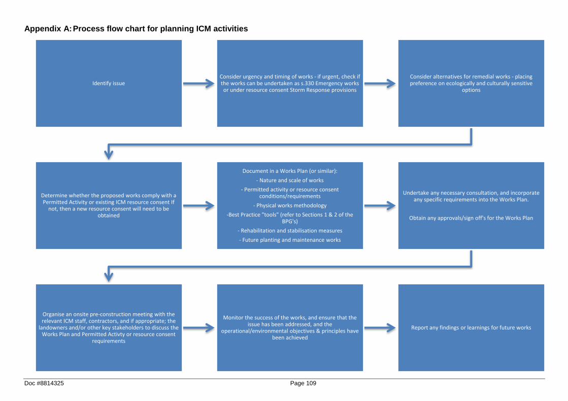
Doc #8814325 Page 109
Appendix A: Process flow chart for planning ICM activities
Identify issueConsider urgency and timing of works - if urgent, check if the works can be undertaken as s.330 Emergency works or under resource consent Storm Response provisions
Consider alternatives for remedial works - placing preference on ecologically and culturally sensitive
options
Determine whether the proposed works comply with a Permitted Activity or existing ICM resource consent If
not, then a new resource consent will need to be obtained
Document in a Works Plan (or similar):
- Nature and scale of works
- Permitted activity or resource consent conditions/requirements
- Physical works methodology
-Best Practice "tools" (refer to Sections 1 & 2 of the BPG's)
- Rehabilitation and stabilisation measures
- Future planting and maintenance works
Undertake any necessary consultation, and incorporate any specific requirements into the Works Plan.
Obtain any approvals/sign off's for the Works Plan
Organise an onsite pre-construction meeting with the relevant ICM staff, contractors, and if appropriate; the
landowners and/or other key stakeholders to discuss the Works Plan and Permitted Activty or resource consent
requirements
Monitor the success of the works, and ensure that the issue has been addressed, and the
operational/environmental objectives & principles have been achieved
Report any findings or learnings for future works

Page 110 Doc #8814325
Appendix B: Methodology for channel diversions/realignment
Channel diversions/realignment
The key objective of a channel diversion is to either;
Temporarily divert the channel to one side to allow for works to be undertaken “in the dry”, minimising sediment disturbance and disturbance of aquatic habitats; or
Permanently realign the channel to a more desirable path to alleviate erosion and flooding.
Channel diversion methodology
The following outlines the recommended methodology for a channel diversion (also see diagram over page):
Step 1 a. Excavate the diversion channel leaving a plug at each end so that the watercourse does not breach
the diversion.
b. Stabilise the new channel appropriately to ensure it does not become a source of sediment. This may include geotextile cloth fixed to the bed to avoid it washing downstream, or clean gravel.
Step 2 c. Open the downstream plug and allow water to flow up the new channel, filling the channel with some
water will reduce erosion when the upstream plug is excavated.
Step 3
d. Partially open the upstream end of the new channel while at the same time partially closing off the upstream end of the original channel so that the majority of flow (e.g. 2/3rds) passes through the new channel. Leave both channels partially open overnight (or as long as practically possible) to allow aquatic life to move out of the original channel.
Step 4
e. Fully open up the upstream end of the new channel and gradually close off the upstream end of the original channel. Allow the original channel to drain out as much possible before blocking off the downstream end. If the water within the original channel becomes heavily sediment laden; consider whether dewatering to an appropriate control measure would provide a measurable benefit.
f. Remove any large woody debris or other snags from the main channel to facilitate fish recovery. This material can be used to augment habitat in the new channel.
g. Recover as many fish trapped within the original channel as practicable. Refer to aquatic life recovery protocols (refer to Appendix I).
Step 5 h. For permanent diversions: Fill in and stabilise the original channel to reduce the potential for the
river to return to its original alignment following high flow events.
OR
i. For temporary diversions: Remove the downstream plug in the original channel, allowing water to flood back into the original channel. Remove the upstream plug and fill in both ends of the temporary channel and stabilise to reduce the potential for the river to return to this temporary alignment following high flow events.
j. Recover as many fish trapped within the temporary channel as practicable, prior to diverting the flows back to the original channel. Refer to aquatic life recovery protocols (refer to Appendix I).
Channel diversion maintenance
Ensure that the channel diversion is monitored throughout the duration of works to ensure its effectiveness, and to ensure that any signs of erosion or failure are addressed as soon as practicable.

Doc #8814325 Page 111
Methodology for channel diversions.