instability and deformation in the sedimentary cover on...
TRANSCRIPT
Instabilities and deformation in the sedimentary coveron the upper slope of the southern Aquitaine continental margin, north of the Capbreton
canyon (Bay of Biscay)
ELIANE GONTHIER 1, PIERRE CIRAC 1, JEAN-CLAUDE FAUGERES 1, MATHIEUGAUDIN 1 MICHEL CREMER 1 and JEAN-FRANÇOIS BOURILLET 2
1 Université Bordeaux I, Département de Géologie et Océanographie, UMR CNRS 5805-EPOC, 33405 Talence cedex,France. E-mail: [email protected]
2 DRO/GM, IFREMER, BP 70, 29280, Plouzané, France.
SUMMARY: Acoustic and core data have recently been collected on the shelf break and the upper part of the slope of thesouth Aquitaine continental margin. They reveal the major role played by mass-flow gravity processes in deposit erosion andredistribution, modelling of the sea-bed, and transfer of sediment toward the deep-sea. The study region is bounded in thesouth by the Capbreton canyon. The northern area, which shows a smooth morphology, is characterised by small-scale defor-mations due to sediment creep or low-amplitude slide processes. The deformations are associated with mini listric-like faultsthat bound packets of sediments in which the deposit geometry is typical of constructional sediment waves. These sedimentwaves result from the interaction of depositional and gravity deformation processes. In the southern area, closer to thecanyon, wave-like structures are still present but mostly of smaller size. They only result from gravity deformation process-es without any evidence of constructional processes. In the vicinity of the Capbreton canyon, the shelf break and upper slopehave a much more uneven morphology with sedimentary reliefs, escarpments and depressions directed toward the canyonthalweg. The depressions look like slide scars, and could be the result of regressive slides initiated at the top of the canyonflank. The age of the sliding event responsible for the formation of the depression observed today could be middle to upperQuaternary. Since their formation, these depressions act as conduits that channel the transfer of shelf sediment into thecanyon, as demonstrated by the occurrence of a meandering channel on the sea-floor of one depression.
Keywords: Bay of Biscay, canyon, continental slope, sediment wave, mass flows, sediment transfer.
RESUMEN: INESTABILIDADES Y DEFORMACIÓN EN LA CUBIERTA SEDIMENTARIA DE LA PARTE SUPERIOR DEL TALUD DEL MARGENCONTINENTAL DE AQUITANIA, NORTE DEL CAÑÓN DE CAPBRETON (GOLFO DE VIZCAYA). – Se recogieron datos acústicos y detestigos (cores) en el límite de la plataforma y la parte superior del talud en el margen continental del sur de Aquitania. Estosdatos revelan el importante papel que juegan los procesos de flujos en masa por gravedad en la erosión y redistribución delos depósitos, el modelado del lecho marino y la transferencia de sedimentos hacia el fondo del océano. La región de estu-dio está limitada al sur por el cañón de Capbreton. El área norte, que presenta una morfología suave, está caracterizada pordeformaciones de pequeña escala debidas al arrastre de sedimentos o procesos de deslizamiento de baja amplitud. Las defor-maciones están asociadas a mini fallas de tipo lístrico que delimitan bolsas de sedimentos en las cuales la geometría del depó-sito es típica de ondas de sedimento constructivas. Estas ondas sedimentarias resultan de la interacción de los procesos dedeformación deposicionales y por gravedad. En el área sur, cerca del cañón, están todavía presentes estructuras similares aondas, pero la mayor parte son de pequeño tamaño. Estas estructuras son el resultado de los procesos de deformación porgravedad sin ninguna evidencia de procesos constructivos. En las proximidades del cañón de Capbreton, el margen conti-nental y el talud superior tienen una morfología mucho más desigual con relieves sedimentarios, escarpaduras y depresionesdirigidas hacia el talweg del cañón. Las depresiones semejan marcas de deslizamientos y pueden ser el resultado de desliza-mientos regresivos iniciados en la parte superior de los flancos del cañón. Los eventos de deslizamiento responsables de laformación de las depresiones observadas actualmente podrían datarse en el Cuaternario medio o superior. Desde su forma-ción, estas depresiones funcionan como conductos que canalizan la transferencia de sedimentos de plataforma hacia el cañón,tal y como demuestra la presencia de un canal con meandros en el fondo de una de estas depresiones.
Palabras clave: Golfo de Vizcaya, cañón, talud continental, onda de sedimento, flujos en masa, transferencia de sedimento.
SCIENTIA MARINA 70S1June 2006, 89-100, Barcelona (Spain)
ISSN: 0214-8358
OCEANOGRAPHY OF THE BAY OF BISCAY.X.A.G. Morán, J.M. Rodríguez and P. Petitgas (eds.)
sm70s1089-7tif 29/5/06 20:57 Página 89

INTRODUCTION
The shelf break and the upper slope of continen-tal margins constitute a key zone for the transfer ofsediments from the inner shelf to the deep sea.However, the sedimentary processes allowing thistransfer are still poorly understood. Several types ofcurrents can interact in this zone: tidal- or climatic-induced shelf currents, superficial geostrophic cur-rents, internal waves and gravity flows (from hyper-pycnal currents to mass movements) (Shepard andMarshall, 1978; in Stanley and Moore, 1983; inSwift et al., 1991; Nittrouer and Wright, 1994;Johnson and Baldwin, 1996; Viana et al., 1998,among many others)
In this part of the margin, an important sedimen-tary process is the reworking of sediments. It isfavoured by the steep slopes (> 2°) encountered inboth active and passive margins and associated withregions with a high sedimentation rate. The presenceof gullies or canyon heads leads to a high instabilityof the deposits and a massive erosion on the flank of
these features (Mulder and Cochonnat, 1996; Bernéet al., 1999; Babonneau et al., 2002; Ercilla et al.,2002; Greene et al., 2002, among many others pub-lished recently). These processes are efficient agentsfor the transfer toward the deep of sedimentsdeposited on the outer shelf. Tectonic activity,movements along faults, and diapirism activity,sometimes associated with fluid circulation andoften underlined by pockmarks (Hovland and Judd,1988; Baraza and Ercilla, 1996; Le Moigne, 1999),are also favourable factors for sediment reworking.
The sediment reworking involves variousprocesses, ranging from low velocities over shortdistances in the case of creeping (Hill et al., 1982;Syvitsky et al., 1987; Whitham, 1993) or shear-dominated retrogressive failure (Correggiari et al.,2001) to block slides or slumps over a variable dis-tance that can evolve to debris flows and turbiditycurrents (Lewis, 1971; Lowe, 1982; Martinsen,1989; Mulder et Cochonnat, 1996; among many oth-ers). The gravity reworked deposits often haveundulated morphologies similar to depositional sed-
SCI. MAR., 70S1, June 2006, 89-100. ISSN 0214-8358
90 • E. GONTHIER et al.
1400.
LANDES
1
Ibis
PlateauLandais
Cap Ferret
K
2
2°003°00 W 1°00 W
.
44° 30
44°
N45°
44° 30
44°
N45°
2°003°00 W 1°00 W
200 m
1000
1400
1800
1800
2000
2000
2400
2800
3800
3800
3000
200
14001800
100
50
canyon
CanyonGirondeestuary
France
2000m
200 m
Capbreton
N
CAP FERRET
CAPBRETON
ADOUR River
Bay of Biscay
Spain
ab
FIG. 1. – Location map of the study area. 1a: location of the south Aquitaine margin; 1b: location of the continental slope studied, in the blackrectangle the sediment waves area deduced from acoustic imagery (in Faugères et al., 2002) and the Cap Breton canyon (rectangle 2)
corresponding to the bathymetric map realised during the Itsas cruise, see Fig. 2. - N: Nesteroff et al., 1968 core, - K: Oxybent core.
sm70s1089-7tif 29/5/06 20:57 Página 90

imentary waves. This implies that their gravity ori-gin is often difficult to establish only from seismicdata (O’Leary and Laine, 1996; Gardner et al.,1999; Faugères et al., 2002).
The sediment waves resulting from the deforma-tion of sediment during the slides correspond toextensional and compressional structures(Martinsen and Bakken, 1990). They are locatedbetween two listric faults and formed by sedimenta-ry beds that are either stretched and tilted likeantidunes (extension context) or folded and thrust-ing downstream (compressional ripples).
Such sediment wave structures are well devel-oped on the shelf break of the southern part of theAquitaine margin (Fig. 1) and are associated withgravity processes (Kenyon et al., 1978; Faugères etal., 2002). In this study, mainly based on recentacoustic data (Figs. 1 and 2), the authors give a moredetailed interpretation of these structures togetherwith a new highlight on mass sediment transferprocesses. The analysis will focus on the recent
processes of deformation, destabilisation and remo-bilisation of sediments from the shelf break andupper slope (between 250 and 1000 m).
MORPHOTECTONIC CONTEXT
The study area corresponds to the southern partof the Aquitaine continental margin developedbetween the Cap Ferret canyon to the north and theCapbreton canyon to the south (Figs. 1 and 2). Inthis region, the N-S upper slope that limits a 40 to 60km wide continental shelf results from the prograda-tion of sediments on a marginal plateau, the Landesplateau, located between 1000 and 2000 m depth.The dip of the upper slope decreases from 10° ups-lope to less than 0.5° downslope.
This region was submitted to active tectonicactivity in the Cretaceous and Palaeogene periods,as well as more recently with Triassic salt diaperreplay (Cholet et al., 1968; Valery et al., 1971;
SCI. MAR., 70S1, June 2006, 89-100. ISSN 0214-8358
SEDIMENTARY COVER OF THE CONTINENTAL MARGIN • 91
FIG. 2. – Southern part of the Aquitaine margin and detailed map of the Capbreton Canyon (rectangle 2 on Fig 1). Black lines: seismic data, itsr21, itsr26 to itsr29 and itsd37 (chirp 2-7 kHz) and location of Figures 3 and 5.
sm70s1089-7tif 29/5/06 20:57 Página 91

Kieken, 1973; Boillot et al., 1984). The Capbretoncanyon (Dauvillier, 1961; Cirac et al., 2001) is amajor morphological feature of the margin. It isincised in the colliding zone of the Aquitaine andIberian plates, whose activity began in the mid-Cretaceous in relation to the opening of the Bay ofBiscay (Schoeffler, 1965; Boillot et al., 1974; 1984)and the formation of the Pyrenees.
Previous works have shown the presence of fieldsof kilometric sediment waves on the upper slope(side-scan sonar GLORIA, Stride et al, 1969; Kenyonet al., 1978). They were interpreted as the result of thedeformation of superficial deposits due to slides. Anew interpretation was recently proposed by Faugèreset al., 2002: the waves affect a 250 to 500 m thickPlio-Quaternary sequence composed of four seismicunits and are due to the interaction of gravity defor-mation and sedimentary construction.
MATERIAL AND METHODS
New data were recently acquired on the southernAquitaine margin (Figs. 1 and 2):
- Backscatter imagery (Ifremer, mission Zee-Gascogne I et II, 1992; 1993) on the upper slope forthe major part of the study area, southern termina-tion excepted.
- A detailed bathymetry of the Capbreton canyonfrom the head located in the inner part on the conti-nental shelf down to the slope at 2500 m water depth(missions Itsas I-1999, multibeam bathymetryEM1000; Itsas II-2001, multibeam bathymetryEM300).
- More than 1000 km of sparker seismic profiles,6 traces seismic profiles (profiles named itsr) andchirp/2-7kHz (profiles named itsd) collected duringthe Itsas II cruise. Only the seismic profiles itsr21,itsr26 and itsr29 and the chirp profiles itsd37 anditsd27 to itsd29 are used in this paper;
- Gravity cores (Fig. 1), core K, Oxybent cruise,in Mulder et al., 2001 and cores N in Nesteroff et al.,1968.
RESULTS AND INTERPRETATION
In the study area, two regions located in the northand south can be distinguished according to the gen-eral morphology of the upper slope together with thesedimentary structures observed on the sea floor.
The north region
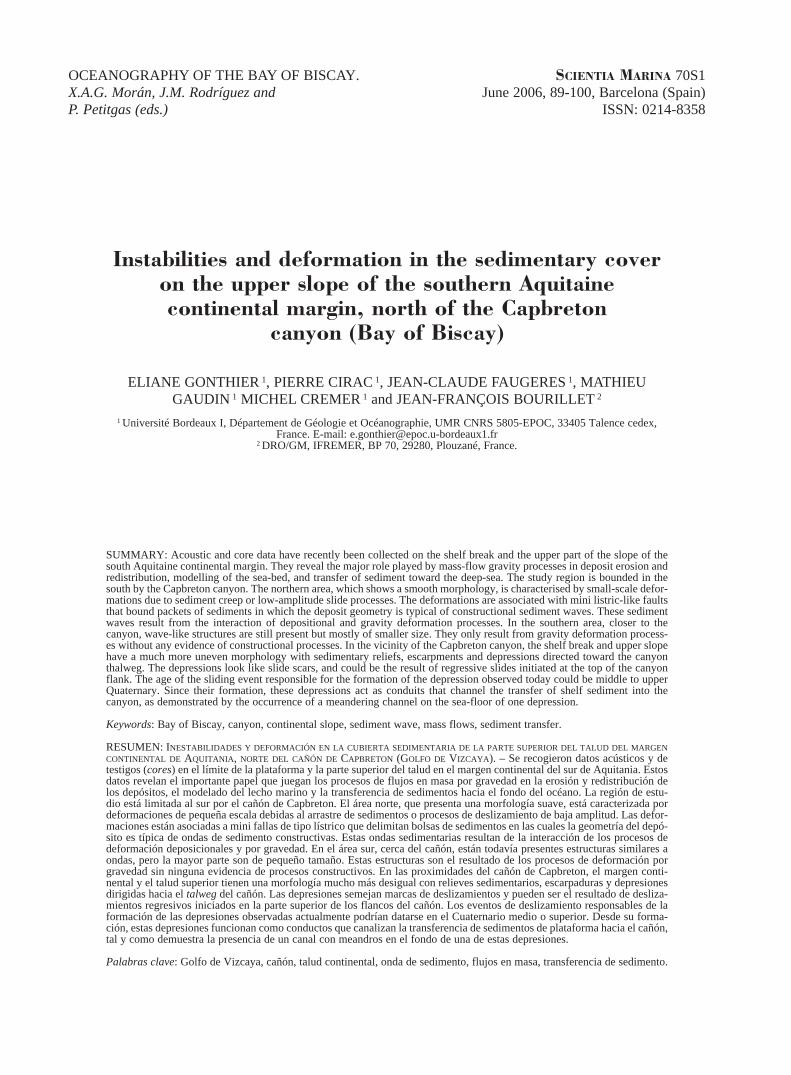
North of 43°55’N (Fig. 2) the continental shelfsea floor is flat and regular. The shelf break is wellmarked. The dip of the upper slope decreases rapid-ly with depth (more than 10° upslope and 2° at 600m water depth, to less than 0.5° below 850 m waterdepth). The upper slope morphology is characterisedby the sedimentary waves studied by Faugères et al.(2002) from the Itsas I seismic data. The newechosounder profiles acquired during the Itsas IIcruise confirm this interpretation.
In the upper sedimentary cover, from the fourunits (U1 to U4) described by Faugères et al.,(2002), only the two most superficial, U3 and U4,are visible on the Itsd37 profile (Fig. 3). These unitsare 80 to 100 thick (with 1500 m/s for sound veloc-ity in sediments). They may represent the last500,000 to 800,000 years of sedimentation for anaverage sedimentation rate of 10 cm per 1000 yearsaccording to borehole data (Fig. 1, forage Ibis inWinnock, 1973) or from cores located north of themargin (Caralp, 1968, 1971; Duprat, 1983).
In both units, deposits show spectacular sedimentwave geometries. However, the geometry in theunits is different and indicates different formationprocesses.
In U3, waves result from the interaction of twoprocesses: syn-sedimentary deformation anddynamic construction by currents. The first processinduces micro-deformation and gaps in the seismicreflectors together with the presence of discontinu-ities between two adjacent waves. These discontinu-ities, interpreted as micro-listric faults, bound sedi-mentary packets due to stretching or gravity-induced tilting associated with a small-scale slidingalong the slope (a few metres to tens of metres). Thisis the origin of the wave morphology of the secondprocess, is underlined by downlap and toplap reflec-tors and plays a role in the greater thickness of theupstream flank and in the migration of the wave inthis direction. The wave trough can be locally filledby onlapping deposits (Fig. 3).
This pattern confirms the complex origin of thesestructures in which deformation and constructionprocesses interact and lead to an antidune-type ofwave geometry (Faugères et al., 2002).
On the other hand, in the overlying U4 unit, thedeposits blanket the undulated morphology inher-ited from U3. There are neither deformation norconstruction processes but only a uniform
SCI. MAR., 70S1, June 2006, 89-100. ISSN 0214-8358
92 • E. GONTHIER et al.
sm70s1089-7tif 29/5/06 20:57 Página 92
hemipelagic/pelagic sedimentation covering theentire wave field.
The northern part of the study area is hence char-acterised by limited destabilisation processesrestricted to some period of time (during U3 forexample). This will be discussed in 5.2.
The south region
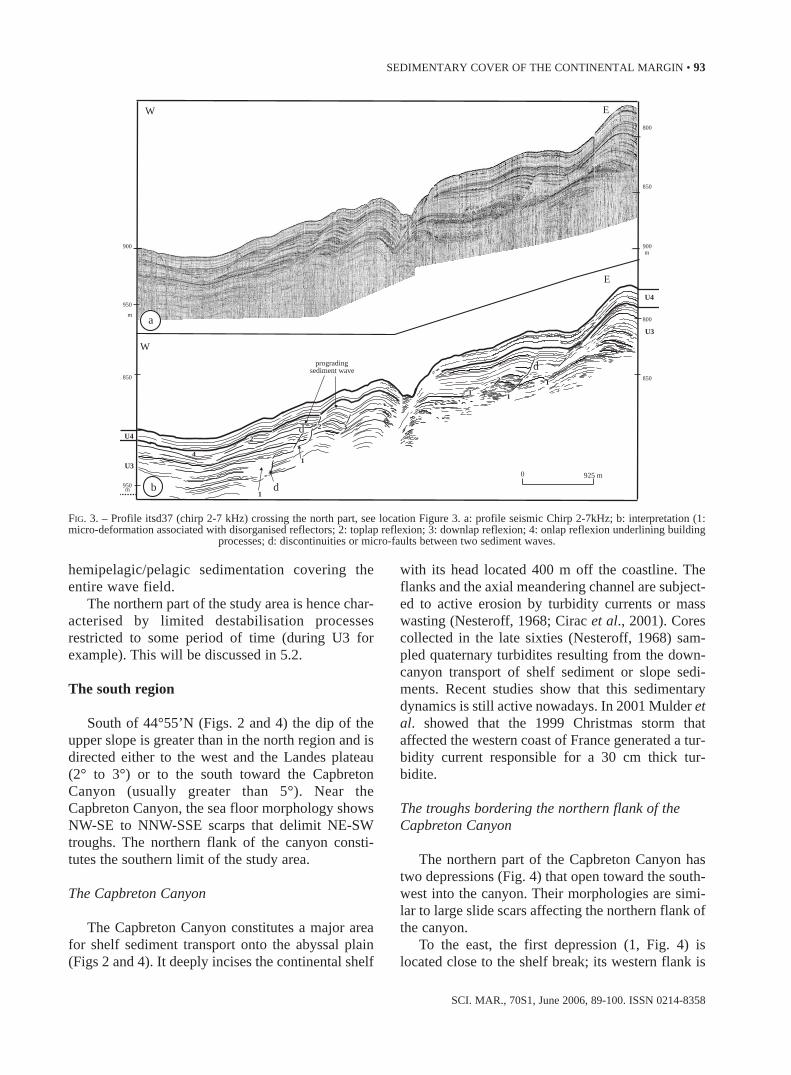
South of 44°55’N (Figs. 2 and 4) the dip of theupper slope is greater than in the north region and isdirected either to the west and the Landes plateau(2° to 3°) or to the south toward the CapbretonCanyon (usually greater than 5°). Near theCapbreton Canyon, the sea floor morphology showsNW-SE to NNW-SSE scarps that delimit NE-SWtroughs. The northern flank of the canyon consti-tutes the southern limit of the study area.
The Capbreton Canyon
The Capbreton Canyon constitutes a major areafor shelf sediment transport onto the abyssal plain(Figs 2 and 4). It deeply incises the continental shelf
with its head located 400 m off the coastline. Theflanks and the axial meandering channel are subject-ed to active erosion by turbidity currents or masswasting (Nesteroff, 1968; Cirac et al., 2001). Corescollected in the late sixties (Nesteroff, 1968) sam-pled quaternary turbidites resulting from the down-canyon transport of shelf sediment or slope sedi-ments. Recent studies show that this sedimentarydynamics is still active nowadays. In 2001 Mulder etal. showed that the 1999 Christmas storm thataffected the western coast of France generated a tur-bidity current responsible for a 30 cm thick tur-bidite.
The troughs bordering the northern flank of theCapbreton Canyon
The northern part of the Capbreton Canyon hastwo depressions (Fig. 4) that open toward the south-west into the canyon. Their morphologies are simi-lar to large slide scars affecting the northern flank ofthe canyon.
To the east, the first depression (1, Fig. 4) islocated close to the shelf break; its western flank is
SCI. MAR., 70S1, June 2006, 89-100. ISSN 0214-8358
SEDIMENTARY COVER OF THE CONTINENTAL MARGIN • 93
11
12
2
2 3
1
4
2
1
0 925 m
E
W
U4
U3
U4
U3
EW
progradingsediment wave
b
850
800
850
950
850
900
800
m
m
900
950
a
m
d
d
d
FIG. 3. – Profile itsd37 (chirp 2-7 kHz) crossing the north part, see location Figure 3. a: profile seismic Chirp 2-7kHz; b: interpretation (1:micro-deformation associated with disorganised reflectors; 2: toplap reflexion; 3: downlap reflexion; 4: onlap reflexion underlining building
processes; d: discontinuities or micro-faults between two sediment waves.
sm70s1089-7tif 29/5/06 20:58 Página 93
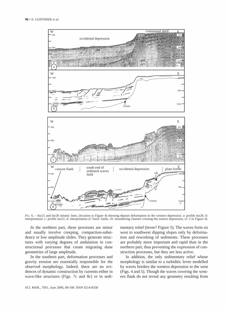
dissected by a clear meandering channel suggestingrecent turbidity current activities. However, thischannel stands a few tens of metres above thecanyon axial channel (Fig. 4). To the west, the sec-ond depression, wider than the first one (3, Figs 4, 5and 6), has a rough sea-floor without channel. Smalltopographic highs within the depression (4, Fig. 4)are interpreted either to be areas preserved from ero-sion, or slide-deposit remnants that did not reach thecanyon.
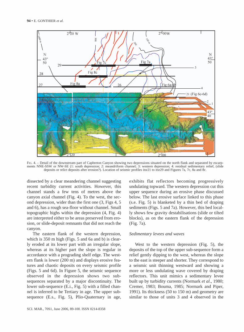
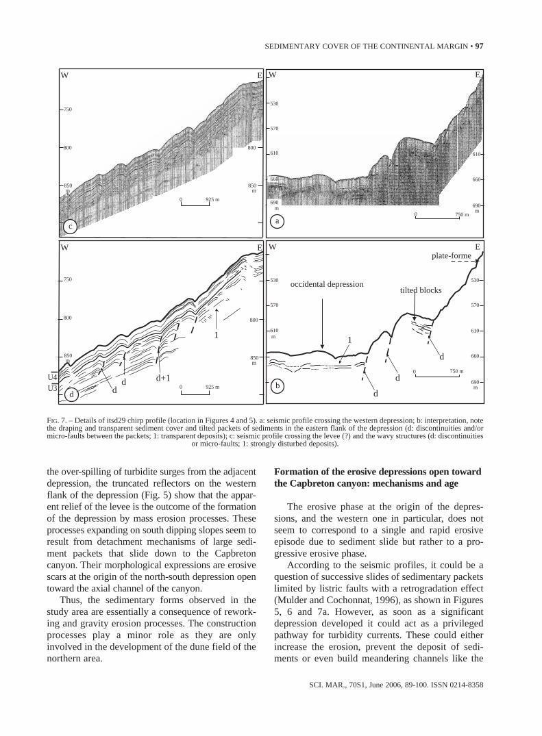
The eastern flank of the western depression,which is 350 m high (Figs. 5 and 6a and b) is clear-ly eroded at its lower part with an irregular slope,whereas at its higher part the slope is regular inaccordance with a prograding shelf edge. The west-ern flank is lower (200 m) and displays erosive fea-tures and chaotic deposits on every seismic profile(Figs. 5 and 6d). In Figure 5, the seismic sequenceobserved in the depression shows two sub-sequences separated by a major discontinuity. Thelower sub-sequence (E.i., Fig. 5) with a filled chan-nel is inferred to be Tertiary in age. The upper sub-sequence (E.s., Fig. 5), Plio-Quaternary in age,
exhibits flat reflectors becoming progressivelyundulating topward. The western depression cut thisupper sequence during an erosive phase discussedbelow. The last erosive surface linked to this phase(s.e. Fig. 5) is blanketed by a thin bed of drapingsediments (Figs. 5 and 7a). However, this bed local-ly shows few gravity destabilisations (slide or tiltedblocks), as on the eastern flank of the depression(Fig. 7a).
Sedimentary levees and waves
West to the western depression (Fig. 5), thedeposits of the top of the upper sub-sequence form arelief gently dipping to the west, whereas the slopeto the east is steeper and shorter. They correspond toa seismic unit thinning westward and showing amore or less undulating wave covered by drapingreflectors. This unit mimics a sedimentary leveebuilt up by turbidity currents (Normark et al., 1980;Cremer, 1983; Bouma, 1985; Normark and Piper,1991). Its thickness (50 to 150 m) and geometry aresimilar to those of units 3 and 4 observed in the
SCI. MAR., 70S1, June 2006, 89-100. ISSN 0214-8358
94 • E. GONTHIER et al.
FIG. 4. – Detail of the downstream part of Capbreton Canyon showing two depressions situated on the north flank and separated by escarp-ments NNE-SSW or NW-SE (1: south depression; 2: meandriform channel; 3: western depression; 4: residual sedimentary relief, (slide
deposits or relict deposits after erosion?). Location of seismic profiles itsr21 to itsr29 and Figures 7a, 7c, 8a and 8c.
sm70s1089-7tif 29/5/06 20:58 Página 94
north region and can be considered to their southernequivalent.
The undulating structures on the western flank ofthe relief (Fig. 5) correspond to the southern part ofthe wave field developing to the north (Fig. 2). Theirdimensions are on average lesser. Unlike what wasobserved in the northern part, the wave internalgeometry does not show any evidence of construc-tion processes (Figs. 8a and 8b). The structures formas sedimentary packets limited by accidents (discon-tinuities or listric faults) and are more or lessdeformed as dissymmetrical folds thrusting upslope.More or less transparent seismic facies localised in aparticular area suggest the presence of gas circula-tion that may favour instabilities.
These structures are interpreted to result fromthe deformation of the deposits by low-speed grav-ity flow. Their frequency and amplitude vary fromlarge-spaced structures, with minor deformation(Fig. 8a) because of creeping processes or sedi-ment compression around gas pipes, to structures
with a greater deformation of the beds forming ret-rograding amalgamated slid packets (Figs. 7c and8c). The amplitude of the deformations decreaseswith the distance downslope (compare Figs. 8c and8a). The accidents enlightening the slide packetsmainly affect the U3 unit and exceptionally thedraping U4 unit. This confirms the present-day nilto low activity of the sliding as observed in thenorthern area.
DISCUSSION
Morphology of the talus and upper continentalslope: role of reworking processes, gravity ero-sion and construction processes
The comparison of the talus and the upper conti-nental margin indicates that the reworking processdue to sediments sliding down seems to have beenmore active in the south than in the north.
SCI. MAR., 70S1, June 2006, 89-100. ISSN 0214-8358
SEDIMENTARY COVER OF THE CONTINENTAL MARGIN • 95
375
750
1125
1500
m
375
750
1125
1500
m
E s
W
W
E
E
E i
0
m
5 km
5 km
0
375
750
1125
1500
1875m
375
750
1125
1500
1875
sediment waves
sedimentary levÈe? depression
ch
U3+U4?
b
major discontinuity
Fig 7cFig 7a
slide deposits
continental shelf
s.e.ch
troncatedreflectors
a
FIG. 5. – Itsr29 seismic profile crossing the western depression, location in Figure 4). a: seismic line; b: interpretation (s.e.: superimposed ero-sional surface; ch: channel; E.s: upper seismic units; E.i.: lower seismic units; U3+U4?: surficial seismic units probably similar to U3+U4
units defined in the northern part of the study area, cf. Figure 3). Location of figures 7a et 7c.
sm70s1089-7tif 29/5/06 20:58 Página 95
In the northern part, these processes are minorand usually involve creeping, compaction-subsi-dence or low amplitude slides. They generate struc-tures with varying degrees of undulation in con-structional processes that create migrating dunegeometries of large amplitude.
In the southern part, deformation processes andgravity erosion are essentially responsible for theobserved morphology. Indeed, there are no evi-dences of dynamic construction by currents either inwave-like structures (Figs. 7c and 8c) or in sedi-
mentary relief (levee? Figure 5). The waves form onwest to southwest dipping slopes only by deforma-tion and reworking of sediments. These processesare probably more important and rapid than in thenorthern part, thus preventing the expression of con-struction processes, but they are less active.
In addition, the only sedimentary relief whosemorphology is similar to a turbiditic levee modelledby waves borders the western depression to the west(Figs. 4 and 5). Though the waves covering the west-ern flank do not reveal any geometry resulting from
SCI. MAR., 70S1, June 2006, 89-100. ISSN 0214-8358
96 • E. GONTHIER et al.
300300
900900
W E
15001500mm
300 300
multiple
erosion900 900
canyon flank south end of sediment waves field
occidental depression
occidental depression
W E
f f ff
f
plate-formech
1500 1500m m
300
multiple
300
900 900
1500
W
W
E
E
f f f ff
continental shelf
c
b
300 300
900 900
1500
1500
m
m
m
1500
a
d
FIG. 6. – Itsr21 and itsr26 seismic lines, (location in Figure 4) showing deposit deformation in the western depression. a: profile itsr26; b:interpretation; c: profile itsr21; d: interpretation (f: listric faults, ch: meandering channel crossing the eastern depression, cf. 2 in Figure 4).
sm70s1089-7tif 29/5/06 20:58 Página 96
the over-spilling of turbidite surges from the adjacentdepression, the truncated reflectors on the westernflank of the depression (Fig. 5) show that the appar-ent relief of the levee is the outcome of the formationof the depression by mass erosion processes. Theseprocesses expanding on south dipping slopes seem toresult from detachment mechanisms of large sedi-ment packets that slide down to the Capbretoncanyon. Their morphological expressions are erosivescars at the origin of the north-south depression opentoward the axial channel of the canyon.
Thus, the sedimentary forms observed in thestudy area are essentially a consequence of rework-ing and gravity erosion processes. The constructionprocesses play a minor role as they are onlyinvolved in the development of the dune field of thenorthern area.
Formation of the erosive depressions open towardthe Capbreton canyon: mechanisms and age
The erosive phase at the origin of the depres-sions, and the western one in particular, does notseem to correspond to a single and rapid erosiveepisode due to sediment slide but rather to a pro-gressive erosive phase.
According to the seismic profiles, it could be aquestion of successive slides of sedimentary packetslimited by listric faults with a retrogradation effect(Mulder and Cochonnat, 1996), as shown in Figures5, 6 and 7a. However, as soon as a significantdepression developed it could act as a privilegedpathway for turbidity currents. These could eitherincrease the erosion, prevent the deposit of sedi-ments or even build meandering channels like the
SCI. MAR., 70S1, June 2006, 89-100. ISSN 0214-8358
SEDIMENTARY COVER OF THE CONTINENTAL MARGIN • 97
0 750 m
E
EWplate-forme
occidental depressiontilted blocks
570
530
d
m
U4U3
750
800
850m
800
850
0 925 m
m
750
800
850m
800
W E
850
0 925 m
570
530
d d
1
d
d
0 750 m
d d+1
1
W E
610
660
690m
610
660
690m
610m
570
610
660
690m
530
W
ca
b
FIG. 7. – Details of itsd29 chirp profile (location in Figures 4 and 5). a: seismic profile crossing the western depression; b: interpretation, notethe draping and transparent sediment cover and tilted packets of sediments in the eastern flank of the depression (d: discontinuities and/ormicro-faults between the packets; 1: transparent deposits); c: seismic profile crossing the levee (?) and the wavy structures (d: discontinuities
or micro-faults; 1: strongly disturbed deposits).
sm70s1089-7tif 29/5/06 20:58 Página 97

one visible in the eastern depression (Fig. 4). Sincethis phase, underlined by several stacked erosivesurfaces (Fig. 5), the process activity is low or non-existent. This is underlined by the presence of uni-form deposits covering the bottom of the depressionand draping the latest erosive surface (Fig. 7a).Nevertheless, the flanks of the depression might stillhave been recently affected by gravity destabilisa-tion processes (Fig. 7a).
The erosive phase seems to have ended recently.Indeed, the transparent deposits draping the latesterosive surface visible on the Chirp profiles areabout 10 m thick (Fig. 7a). Although in this regionthe sedimentation rates vary with the slope mor-phology, this event could be late Quaternary in age,meaning around 100,000 years BP. This figure cor-responds to a sedimentation rate of 10 cm per 1000years proposed for the Plio-Quaternary deposits ofthe south Aquitaine margin (Caralp, 1968 and 1971;Winnock, 1973; Duprat, 1983).
Role of the Capbreton canyon
The great depth of the Capbreton canyon favoursthe destabilisation of its flank and of the borderingcontinental slope. This explains the more importantrole of these processes in the sea-floor morphologyof the south of the continental slope compared to itsnorthern part. The steepest south and southwestslopes induce the deformation of the deposits andthe development of sediment wave structures. Thosedipping toward the canyon generate retrogressiveerosion processes by detachment and sliding of sed-iment mass. These sediments reach the axial chan-nel, where they are funnelled toward the depths. Inaddition, thanks to the depressions created by largeslides, the turbidity currents initiated on the conti-nental shelf converge toward the canyon throughchannels that are visible in these depressions. Thecanyon also induces the development of a drainagenetwork on the upper slope through which the sedi-
SCI. MAR., 70S1, June 2006, 89-100. ISSN 0214-8358
98 • E. GONTHIER et al.
0 925 m
d
d
d
d
d
1
1
1
1
1
W
850
850
850
850
900m
m
925 m
925 m
800
800
800
850
850 850
850
900
900 900
950m
900
950
92500
0
m
m
W
W
U4
U4
U4
U4
U3
U3
U3
U3
W
E
E
E
E
b d
a c
FIG. 8. – Details of itsd27 and itsd28 chirp profiles (location in Figure 4). a: profile itsd27 showing very poorly developed wavy bedforms;b: interpretation; c: profile itsd28 showing more developed wavy bedforms; d: interpretation (d: discontinuities or micro-faults; 1: disturbed
deposits).
sm70s1089-7tif 29/5/06 20:58 Página 98
ments supplied from the shelf travel. However, theover-incision of the axial channel up to its headshows the upstream part of the system to be themajor sediment supplier.
The alongshore currents combined with strongstorms favour a N-S transfer of sediments on the innercontinental shelf and allow a direct feeding of theupper part of the canyon located close to the shoreline.This was evidenced with the recognition of present-day turbiditic activity by Mulder et al. (2001), under-lining the major role of the canyon in the transfer ofsediments wherever the sea-level stands.
Controlling factors of favourable periods ofgravity reworking processes
Three different factors control gravity reworkingon the upper slope:
- large sediment supply periods, either linked tostronger erosion on the continent and generally syn-chronous to lowstands in the studied region(Cremer, 1983; Castaing et al., 1980) or related to amore active hydrodynamic on the shelf during high-stands; both cases deal with a climatic control;
- sea level rise periods that could generate over-pressures in deposits with increasing water columnheight;
- tectonic activity leading, during seismic activi-ty periods, to the modification of the physical prop-erties of the deposits.
The stratigraphic data available do not allowthese factors to be discriminated. In the Plio-Quaternary deposits of the northern part of the studyarea, the interbedding of draping deposits similar tounit U4 with beds with gravity deformations anddepositional waves similar to unit U3 (Faugères etal., 2002) suggests the possible role of variations insupplies and/or the position of the sea-level.However, the change in the characteristics of the sed-imentation at the base of U4 (thickness 12 to 15 m,sedimentation rate 10 cm/1000 years), might bedated at about 120,000 to 150,000 years BP. U4shows uniform draping sediments and is synchro-nous with major eustatic variations that have notbeen recorded in the geometry of the deposits. Thismakes the control of gravity reworking processes byeustatism and larger concomitant supplies unlikely.Thus, it is possible to consider that the tectonicactivity plays a major role with, in particular, thediapirs present under the upper part of the margin,like those in the northern area mentioned above.
CONCLUSION
The study of the first set of seismic and bathy-metric data acquired on the southern part of theAquitaine continental slope highlights the impor-tance of gravity-induced reworking-erosion in thesedimentary processes affecting this type of deepmarine domain.
On the upper slope, far from the CapbretonCanyon influence, these processes are lightly activeand, combined with deposit-construction processesthey contribute to the development of sedimentarywave-like structures. Close to the canyon, they aremore spectacular and fully responsible for the model-ling of the sea-floor. On the west dipping slope theyinduce deformations within the deposits resultingfrom small-amplitude slides and mimicking sedimen-tary waves. On the steeper slope, dipping south towardthe Capbreton Canyon, they are expressed as detach-ment mechanisms and large sliding packets of sedi-ments vanishing in the canyon. These result in the ero-sive scar morphology at the origin of the N-S depres-sions in the axial channel of the Capbreton Canyon.
These structures show the great influence ofreworking-erosive processes on the upper slope inthe modelling of this part of the margin, and in thetransfer of sediments to the depths.
ACKNOWLEDGEMENTS
The authors thank the crews of the R/V “Côted’Aquitaine” (INSU) and R/V “Le Suroit” (IFRE-MER-GENAVIR). We are grateful to the differentreviewers who helped to improve this study. This isthe contribution number 1483 of the UMR-EPOC5805 CNRS.
REFERENCES
Babonneau, N., B. Savoye, M. Cremer and B. Klein. – 2002.Morphology and architecture of the present canyon and channelsystem of the Zaire deep-sea fan. Mar. Pet. Geol., 19: 4, 445-467.
Baraza, J. and G. Ercilla. – 1996. Gas-charged sediments and largepockmarks-like features on the Gulf of Cadiz slope (SW Spain).Mar. Pet. Geol., 13, 2: 253-261.
Berné, S., B. Loubrieu et l’équipe Calmar embarquée. – 1999.Canyons et processus sédimentaires récents sur la marge occi-dentale du golfe du Lion. Premiers résultats de la campagneCalmar. C. R. Acad. Sci. Paris, 328: 471-477.
Boillot, G., P.A. Dupeuble, I. Hennequin-Marchand, M. Lamboy,J.P. Leprêtre and P. Musellec. – 1974. Le rôle des décroche-ments «tardi-hercyniens» dans l’évolution structurale de lamarge continentale et dans la localisation des grands canyonssous-marins à l’ouest et au nord de la péninsule ibérique. Rev.
SCI. MAR., 70S1, June 2006, 89-100. ISSN 0214-8358
SEDIMENTARY COVER OF THE CONTINENTAL MARGIN • 99
sm70s1089-7tif 29/5/06 20:58 Página 99

Géogr. Phys. Géol. Dynam., (2): XVI -1, 75-86.Boillot, G., L. Montadert, M. Lemoine and B. Biju-Duval. – 1984.
Le golfe de Gascogne et les Pyrénées. In: G. Boillot (coord.),Les marges continentales actuelles et fossiles autour de laFrance. Masson, Paris.
Bouma, A.H. – 1985. Mississipi fan, Gulf of Mexico. In: A.H.Bouma, W.R. Normark and N.E. Barnes (eds.), SubmarineFans and Related Turbidite Systems, pp. 143-150, Springer-Verlag, New York.
Caralp, M. – 1968. Variations climatiques pléistocène dans le Golfede Gascogne d’après les foraminifères planctoniques. Bull. Inst.Geol. Bassin d’Aquitaine, 5: 87-110.
Caralp, M. – 1971. Les foraminifères planctoniques du Pléistocèneterminal dans le Golfe de Gascogne: interprétation biostrati-graphique et paléoclimatique. Bull. Inst. Geol. Bassind’Aquitaine, 11: 1-187.
Castaing, P., P. Cirac, M. Cremer, J.P. Tastet and O. Weber. – 1980.Influence des variations du niveau de la mer sur la sédimenta-tion récente de la marge Aquitaine (Golfe de Gascogne). In :26ième Congrès Géologique International, Résumés, Paris 7-17Juillet, vol II, (sections 6 à 12).
Cholet, J.B., B. Damotte, G. Grau, Y. Debyser and L. Montadert. –1968. Recherches préliminaires sur la structure géologique dela marge continentale du Golfe de Gascogne: commentaires surquelques profils de sismique réflexion flexotir. Rev. Inst. Fr.Petr., 23: 1029-1045.
Cirac, P., J.F. Bourillet, R. Griboulard, A Normand, T. Mulder etl’équipe Itsas. – 2001. Le canyon de Capbreton: nouvellesapproches morphostructurales et morphosédimentaires.Premiers résultats de la campagne Itsas. C.R. Acad. Sci., Paris,Series IIA, 332: 447-455.
Cirac, P., J.F. Bourillet, B. Loubrieu, M. Gaudin, M. Cremer and E.Gonthier. – 2002. Présentation morphostructurale et mor-phosédimentaire de la partie supérieure du canyon deCapbreton. 8th International Symposium on Oceanography ofthe Bay of Biscay. Book of Abstracts, p. 44.
Cremer, M. – 1983. Approches sédimentologique et géophysiquedes accumulations turbiditiques. L’éventail profond du Cap-Ferret (Golfe de Gascogne), la série des grés d’Annot (Alpes deHaute Provence). Ph. D. Thesis, Univ. Bordeaux.
Dauvillier, A. – 1961. L’origine du gouf de Capbreton. Sciences,Paris, 15: 47-55.
Duprat, J. – 1983. Les foraminifères planctoniques du quaternaireterminal d’un domaine péricontinental (Golfe de Gascogne,côtes Ouest Ibériques, mer d’Alboran): écologie-biostratigra-phie. Bull. Inst. Geol. Bassin d’Aquitaine, 33: 71-150.
Ercilla, G., B. Alonso, F. Estrada, F.L. Chiocci, J. Baraza and M.Farran. – 2002. The Magdalena Turbidite System (CaribbeanSea): present-day morphology and architecture model. Mar.Geol., 185: 303-318.
Faugères, J.C., E. Gonthier, T. Mulder, N. Kenyon, P. Cirac, R.Griboulard, S. Berné and Lesuavé, R. – 2002. Multi-processgenerated sediment waves on the Landes Plateau (Bay ofBiscay, North Atlantic). Mar. Geol., 182: 279-302.
Gardner, J.V., D.B. Prior and M.E. Field. – 1999. Humboldt slide -a large shear-dominated retrogressive slope failure. Mar. Geol.,154: 323-338.
Greene, H.G., N.M. Maher and C.K. Paull. – 2002. Physiography ofthe Monterey Bay National Sanctuary and implications aboutcontinental margin development. Mar. Geol., 181: 55-82.
Hill, K., K. Moran and S.M. Blasco. – 1982. Creep deformation ofslope sediments in the Canadian Beaufort sea. Geo-Mar. Lett.,2: 163-170.
Hovland, M. and A.G. Judd. – 1988. The ecology of pockmarks andseepages. In: M. Hovland and A.G. Judd (eds.), SeabedPockmarks and Seepages: Impact on Geology, Biology and theMarine Environment, pp 227-245. Graham and Trotman,London.
Johnson, H.D. and C.T. Baldwin. – 1996. Shallow clastic seas. In:H.G. Reading (ed.), Sedimentary Environments: Processes,Facies and Stratigraphy, pp. 232-280. Blackwell.
Kenyon, N.H., R.H. Belderson and A.H. Stride. – 1978. Channels,canyons and slump folds on the continental slope betweenSouth-West Ireland and Spain. Oceanol. Acta, 1: 369-380.
Kieken, M. – 1973. Evolution de l’Atlantique au cours du Tertiaire.Bull. Soc. Géol. France, 7, XV, 1: 1-44.
Le Moigne, M. – 1999. Compréhension des mécanismes de forma-tion des pockmarks sur la pente continentale du Golfe deGuinée. Mémoire de DEA: Géologie, géophysique etgéochimie sédimentaire, (Université de Paris XI, Université desSciences et Technologies de Lille, Laboratoire EnvironnementsSédimentaires IFREMER, Brest, Elf Gabon).
Lewis, K.B. – 1971. Slumping on a continental slope inclined at 1°-4°. Sedimentology, 16: 97-110.
Lowe, D.R. – 1982. Sediment gravity flows: II. Depositional mod-els with special reference to the deposits of high-density tur-bidity currents. J. Sed. Petr., 52: 279-297.
Normark, W.R. and D.J.W. Piper. – 1991. Initiation processes andflow evolution of turbidity currents: implications for the depo-sitional record. In: SEPM, Society for Sedimentary Geology(eds.), From Shoreline to Abyss, SEPM Special Publication, 46:207-230.
Martinsen, O.J. – 1989. Styles of soft-sediment deformation on aNamurian delta slope, Ireland. In: M.K.G. Whateley and K.T.Pickering (eds.) Deltas: Sites and Traps for Fossil Fuels. Geol.Soc. Lond., Sp. Pub., 41: 167-177.
Martinsen, O.J. and B. Bakken. – 1990. Extensional and compres-sional zones in slumps and slides in the Namurian of CountryClare, Ireland. J. Geol. Soc. Lond., 147: 153-164.
Mulder, T. and P. Cochonat. – 1996. Classification of offshore massmovements. J. Sediment. Res., 66: 43-57.
Mulder, T., O. Weber, P. Anschutz, F.J. Jorissen and J.M.Jouanneau, J.M. – 2001. A few months-old storm-generatedturbidite deposited in the Capbreton Canyon (Bay of Biscay,SW France). Geo-Mar. Lett., 21: 149-156.
Nesteroff, W., S. Duplaix, J. Sauvage, F. Mélières, Y. Lancelot andE. Vincent. – 1968. Conditions de sédimentation dans le Goufde Cap Breton. C.R. Acad. Sci., 266: 68-71.
Normark, W.R., G.R. Hess, D.A.V. Stow and A.J. Bowen. – 1980.Sediment waves on the Monterey fan levees: a preliminaryphysical interpretation. Mar. Geol., 37: 1-18.
Nittrouer, C.A. and L.D. Wright. – 1994. Transport of particulesacross continental shelves. Rev. Geophys., 32: 85-113.
O’Leary, D.W. and E. Laine. – 1996. Proposed criteria for recog-nizing intrastratal deformation features in marine high resolu-tion seismic reflection profiles. Geo-Mar. Lett., 16: 305-312.
Schoeffler, J. – 1965. Le «gouf» de Capbreton de l’Eocène inférieurà nos jours. In: W.F. Whittard and R. Bradshaw (eds.),Submarine Geology and Geophysics, pp. 265-270.Butterworths, London.
Shepard, F.P. and N.F. Marshall. – 1978. Currents in SubmarineCanyons and Other Sea Valleys. In: D.J. Stanley and G. Kelling(eds.), Sedimentation in submarine canyons, fans, and trench-es, pp. 3-14. Hutchinson & Ross, Dowden.
Stanley, D.J. and G.T. Moore. – 1983. The Shelf Break: CriticalInterface on Continental Margin. S.E.P.M., Spec. Publ., 33: 467 p.
Stride, A.H., J.R. Curray, D.G. Moore and R. Belderson. – 1969.Marine geology of the Atlantic continental margin of Europe.Philosl. Trans. R. Soc. London., A, 264: 31-75.
Swift, D.J.P., G.F. Oertel, R.W. Tillman and J.A. Thorne. – 1991.Shelf sand and Sandstone Bodies: Geometry, Facies andSequence Stratigraphy, Blackwell, Int. Ass. Sediment., Spec.Publ., 14: 3-31.
Syvitsky, J.P.M., D.C. Burrell, and J.M. Skei. – 1987. Fjords:Processes and Products. Springer Verlag, New York.
Valery, P., J.R. Delteil, A. Cottençon, L. Montadert, B. Damotteand J.P. Fail. – 1971. La marge continentale d’Aquitaine. In:Histoire Structurale du Golfe de Gascogne, Publications del’I.F.P., Collection colloques et séminaires 22, EditionsTechnip, tome 1, Paris, IV.8-1/IV, pp.8-23.
Viana, A.R., J.C. Faugères and D.A.V. Stow. – 1998. Bottom cur-rent controlled sand deposits - a review from modern shallow-to deep-water environments. Sediment. Geol., 115: 53-80.
Winnock, E. – 1973. Exposé succinct de l’évolutionpaléogéologique de l’Aquitaine. Bull. Soc. Géol. Fr., 7: XV, 1,8-12.
Whitham, A.G. – 1993. Facies and depositional processes in anUpper Jurassic to Lower Cretaceous pelagic sedimentarysequence, Antarctica. Sedimentology, 40: 331-349.
Received July 19, 2002. Accepted November 24, 2004.
SCI. MAR., 70S1, June 2006, 89-100. ISSN 0214-8358
100 • E. GONTHIER et al.
sm70s1089-7 29/5/06 22:35 Página 100