inspire metadata implementing rules: technical guidelines ... · title inspire metadata...
TRANSCRIPT
INSPIRE Infrastructure for Spatial Information in Europe
INSPIRE Metadata Implementing Rules: Technical Guidelines based on EN ISO 19115 and EN ISO 19119
Title INSPIRE Metadata Implementing Rules: Technical Guidelines based on EN ISO 19115 and EN ISO 19119
Creator Drafting Team Metadata and European Commission Joint Research Centre
Creation date 2007-10-26
Date of last revision 2013-10-29
Subject INSPIRE Implementing Rules for Metadata
Status V. 1.3
Publisher European Commission Joint Research Centre
Type Text
Description Guidelines based on EN ISO 19115 and EN ISO 19119 for Commission Regulation (EC) No 1205/2008 of 3 December 2008 implementing Directive 2007/2/EC of the European Parliament and of the Council as regards metadata
Contributor See Acknowledgements
Format Pdf
Source European Commission Joint Research Centre
Rights Public
Identifier MD_IR_and_ISO_20131029.doc
Language EN
Relation Not applicable
Coverage Not applicable
2
Table of Contents Acknowledgements.....................................................................................................................4 Introduction .................................................................................................................................5 Changes from Version 1.2 of 2010-06-06 ..................................................................................7 Normative references .................................................................................................................8 Verbal forms for expression of provisions ..................................................................................8 1 INSPIRE profile of ISO 19115 and ISO 19119 ................................................................. 10
1.1 ISO Core Metadata Elements ..................................................................................... 10 1.1.1 Spatial dataset and spatial dataset series ........................................................... 10 1.1.2 Services ............................................................................................................... 12 1.1.3 Conclusion ........................................................................................................... 13
1.2 INSPIRE specific constraints (SC) ............................................................................. 13 1.3 Extensions .................................................................................................................. 14
1.3.1 Spatial data service type ...................................................................................... 14 1.3.2 Classification of spatial data services .................................................................. 15
2 Basic mapping ................................................................................................................... 15 2.1 Introduction ................................................................................................................. 15
2.1.1 Xpath expression ............................................... Error! Bookmark not defined.16 2.1.2 ISO Schemas Location ...................................... Error! Bookmark not defined.16
2.2 Identification ............................................................................................................ 1817 2.2.1 Resource title ................................................................................................... 1917 2.2.2 Resource abstract ............................................................................................ 2018 2.2.3 Resource Type ................................................................................................. 2220 2.2.4 Resource locator .............................................................................................. 2321 2.2.4.1 Resource Locator for data sets and dataset series ...................................... 2321 2.2.4.2 Resource Locator for Services...................................................................... 2523 2.2.5 Unique resource identifier ................................................................................ 2624 2.2.6 Coupled resource ............................................................................................. 2825 2.2.7 Resource language .......................................................................................... 2926
2.3 Classification of spatial data and services .............................................................. 3027 2.3.1 Topic category.................................................................................................. 3027 2.3.2 Spatial data service type .................................................................................. 3229
2.4 Keyword .................................................................................................................. 3330 2.4.1 Keyword value.................................................................................................. 3431 2.4.2 Originating controlled vocabulary..................................................................... 3633
2.5 Geographic location ................................................................................................ 3835 2.5.1 Geographic bounding box ................................................................................ 3835
2.6 Temporal reference ................................................................................................ 4037 2.6.1 Temporal extent ............................................................................................... 4037 2.6.2 Date of publication ........................................................................................... 4138 2.6.3 Date of last revision ......................................................................................... 4340 2.6.4 Date of creation ................................................................................................ 4441
2.7 Quality and validity .................................................................................................. 4542 2.7.1 Lineage ............................................................................................................ 4542 2.7.2 Spatial resolution.............................................................................................. 4744
2.8 Conformity .............................................................................................................. 5047 2.8.1 Degree ............................................................................................................. 5148 2.8.2 Specification ..................................................................................................... 5249
2.9 Constraints related to access and use ................................................................... 5451 2.9.1 Limitations on public access ............................................................................ 5451 2.9.2 Conditions applying to access and use ........................................................... 5653
2.10 Responsible organisation ..................................................................................... 5855 2.10.1 Responsible party .......................................................................................... 5855 2.10.2 Responsible party role ................................................................................... 6057
2.11 Metadata on metadata .......................................................................................... 6158 2.11.1 Metadata point of contact ............................................................................... 6158 2.11.2 Metadata date ................................................................................................ 6360 2.11.3 Metadata language ........................................................................................ 6360
3 Detailed mapping .......................................................................................................... 6562 3.1 Introduction ............................................................................................................. 6562 3.2 Resource MetadataSet ........................................................................................... 6562
3
3.3 Identification Section............................................................................................... 6663 3.3.1 Sub-elements for spatial dataset and spatial dataset series ........................... 6663 3.3.2 Sub-elements for service resources ................................................................ 6764
3.4 Data Quality Section ............................................................................................... 6865 3.4.1 Lineage ............................................................................................................ 6865 3.4.2 Conformity ........................................................................................................ 6865
3.5 Responsible Organisation ...................................................................................... 6966 3.5.1 Resource responsible organisation.................................................................. 6966 3.5.2 Metadata point of contact ................................................................................. 6966
3.6 Constraint section ................................................................................................... 6966 3.7 Abbreviations .......................................................................................................... 7067
Annex A – ISO/TS 19139 encoding of the INSPIRE metadata elements ........................... 7168 A.1 Introduction ............................................................................................................. 7168 A.2 From the conceptual schema to XML File instances ............................................. 7168 A.3 Polymorphism ......................................................................................................... 7168 A.4 Management of polymorphism ............................................................................... 7168
A.4.1 Management of community extensions ........................................................... 7168 A.4.2 Parsing of metadata files ................................................................................. 7168
A.5 Management of containment by reference ............................................................ 7269 A.6 ISO 19139 and multilingual metadata .................................................................... 7269
A.6.1 The default language ....................................................................................... 7370 A.6.2 Alternate languages ......................................................................................... 7471 A.6.3 Embedded translations .................................................................................... 7471 A.6.4 Use of translation files ..................................................................................... 7572
A.7 Contexts of use ...................................................................................................... 7673 A.7.1 Use of ISO 19139 in the context of a Catalogue Service ................................ 7673 A.7.2 Use of ISO 19139 in the context of the standard interchange by transfer ...... 7673
A.8 Character encoding ................................................................................................ 7673 A.9 Temporal extent encoding ...................................................................................... 7673 A.10 Spatial resolution encoding .................................................................................. 7875 A.11 Codelists ............................................................................................................... 7976 A.12 Example of ISO 19139 XML Metadata Sets ........................................................ 8077
A.12.1 Dataset .......................................................................................................... 8077 A.12.2 Dataset series ................................................................................................ 8986 A.12.3 Service ........................................................................................................... 8986
Annex B (informative) Metadata elements for interoperability ........................................... 9895 B.1. Metadata elements required by the INSPIRE Implementing Rules on the Interoperability of Spatial Datasets and Services ............................................................ 9895 B.2. Metadata elements recommended in the INSPIRE Data Specifications Technical Guidelines ........................................................................................................................ 9996
4
Acknowledgements Many individuals and organisations have contributed to the development of these Guidelines. The original Drafting Team on Metadata (2006-08) included: Marcel Reuvers (Netherlands), Nicolas Lesage (France), Kristian Senkler (Germany), Michael Gould (Spain), Gil Ross (UK), Stefano Nativi (Italy), Jan Hjelmager (Denmark), Franz Daffner (European Environment Agency), Per Ryghaud (Norway), Thomas Vögele and Fred Kruse (Germany), David Danko (USA). We are grateful for the comments received during the consultation (28th May-15th June 2010) with the Member States via their Points of Contact. We also wish to acknowledge the contribution of Jesus Barrera and his team at GeoSpatiumLab who have provided editorial assistance in preparing this new version of the guidelines, as well as the precious contribution of Angelo Quaglia at JRC in checking the final draft. This version 1.3 of the Technical Guidelines clarifies some aspects of the implementation of the discovery metadata elements based on the experience built during the period of implementation 2010-13. It also includes an overview of the Metadata elements for Evaluation and Use defined in the INSPIRE Implementing Rules for the Interoperability of Spatial Datasets and Services This update has been funded by the EU Interoperability Solutions for European Public Adminstrations (ISA) Programme through ISA Action 1.17: A Reusable INSPIRE Reference Platform (ARE3NA), which is supporting the development of open source solutions and the technical guidelines that aid cross-sector and cross-border interoperability and the implementation of the INSPIRE Directive. Contact information Massimo Craglia (Editor) European Commission Joint Research Centre Institute for Environment and Sustainability Digital Earth and Reference Data Unit TP262, Via Fermi 2749 I-21027 Ispra (VA) ITALY E-mail: [email protected] Tel.: +39-0332-786269 Fax: +39-0332-786325 http://ies.jrc.ec.europa.eu/ http://www.jrc.ec.europa.eu/
5
Introduction According to Article 5(1) of Directive 2007/2/EC, Member States shall ensure that metadata are created for the spatial data sets and services corresponding to the themes listed in Annexes I, II and III, and that those metadata are kept up to date. According to Article 5(4) of Directive 2007/2/EC, Implementing Rules shall be adopted taking account of relevant, existing international standards and user requirements. In the context of metadata for spatial data and spatial data services, the standards EN ISO 19115, EN ISO 19119, and ISO 15836 (Dublin Core) have been identified as important standards. Commission Regulation (EC) No. 1205/2008 implementing Directive 2007/2/EC of the European Parliament and of the Council as regards metadata was adopted on of 3rd December 2008, and published on the Official Journal of the European Union on 4th December (OJ L 326, 4.12.2008, p. 12–30). Any reference in this document to “Implementing
Rules for Metadata” refers to the above-mentioned Regulation. The Regulation sets out the requirements for the creation and maintenance of metadata for spatial data sets, spatial data set series and spatial data services corresponding to the themes listed in Annexes I, II and III to Directive 2007/2/EC. It defines a number of metadata elements, their multiplicities and the value domains to be used in the metadata. NOTE 1 The metadata elements defined in the Implementing Rules for Metadata are usually called discovery metadata.
In addition to these requirements, Commission Regulation (EU) No 1089/2010 of 23 November 2010 implementing Directive 2007/2/EC of the European Parliament and of the Council as regards interoperability of spatial data sets and services (OJ L 323, 08/12/2010, p. 11–102) and its sub-sequent amendments1,2 define six additional metadata elements for interoperability as well as some theme-specific requirements for the discovery metadata
elements. Any reference in this document to “Implementing Rules for interoperability of spatial data sets and services” refers to the above-mentioned Regulation. NOTE 2 The metadata elements defined in the Implementing Rules for interoperability of spatial data sets and services are also sometimes referred to as evaluation and use metadata.
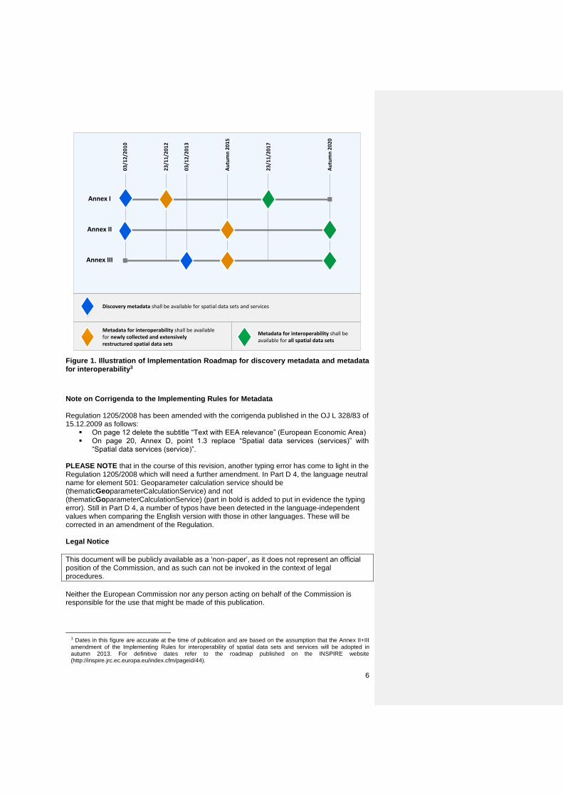
The aim of this document is to define how the requirements of the Implementing Rules for Metadata can be implemented using EN ISO 19115 and EN ISO 19119. The following subsections describe for each element of the Implementing Rules its relation with the mentioned European standards. Furthermore, Annex B provides an overview of the additional metadata elements and requirements defined in the Implementing Rules for interoperability of spatial data sets and services as well as pointers to the INSPIRE Data Specifications, which provide guidance and recommendations for their implementation. The timelines relevant for the provision of discovery metadata are different from those for metadata for interoperability. The former need to be provided according to the deadlines specified in the INSPIRE Directive for the Implementing Rules for Metadata (2 years after adoption for Annex I and II and 5 years after adoption for Annex III), while the latter need to be provided according to the deadlines specified in the INSPIRE Directive for the Implementing Rules for interoperability of spatial data sets and services (2 years after adoption for newly created or extensively restructured data sets, and 7 years for all other data sets). Figure 1Figure 1 gives an overview of the dates at which the requirements included in the two Implementing Rules for data sets related to Annex I, II or III have to be met.
1 Commission Regulation (EU) No 102/2011 of 4 February 2011 amending Regulation (EU) No 1089/2010
implementing Directive 2007/2/EC of the European Parliament and of the Council as regards interoperability of spatial data sets and services (OJ L 31, 05/02/2011, p. 13–34)
2 Commission Regulation (EU) No …/.. of XXX amending Regulation (EU) No 1089/2010 implementing Directive 2007/2/EC as regards interoperability of spatial data sets and services (Annex II+III amendment).
Formatted: English (United Kingdom)
6
Annex I
Annex II
Annex III
03
/12
/20
10
03
/12
/20
13
23
/11
/20
12
23
/11
/20
17
Au
tum
n 2
01
5
Au
tum
n 2
02
0
Discovery metadata shall be available for spatial data sets and services
Metadata for interoperability shall be available for newly collected and extensively restructured spatial data sets
Metadata for interoperability shall be available for all spatial data sets
Figure 1. Illustration of Implementation Roadmap for discovery metadata and metadata for interoperability3
Note on Corrigenda to the Implementing Rules for Metadata Regulation 1205/2008 has been amended with the corrigenda published in the OJ L 328/83 of 15.12.2009 as follows:
On page 12 delete the subtitle “Text with EEA relevance” (European Economic Area) On page 20, Annex D, point 1.3 replace “Spatial data services (services)” with
“Spatial data services (service)”. PLEASE NOTE that in the course of this revision, another typing error has come to light in the Regulation 1205/2008 which will need a further amendment. In Part D 4, the language neutral name for element 501: Geoparameter calculation service should be (thematicGeoparameterCalculationService) and not (thematicGoparameterCalculationService) (part in bold is added to put in evidence the typing error). Still in Part D 4, a number of typos have been detected in the language-independent values when comparing the English version with those in other languages. These will be corrected in an amendment of the Regulation. Legal Notice
This document will be publicly available as a ‘non-paper’, as it does not represent an official position of the Commission, and as such can not be invoked in the context of legal procedures.
Neither the European Commission nor any person acting on behalf of the Commission is responsible for the use that might be made of this publication.
3 Dates in this figure are accurate at the time of publication and are based on the assumption that the Annex II+III amendment of the Implementing Rules for interoperability of spatial data sets and services will be adopted in autumn 2013. For definitive dates refer to the roadmap published on the INSPIRE website (http://inspire.jrc.ec.europa.eu/index.cfm/pageid/44).
7
Changes from Version 1.2 of 2010-06-06 This document is Version 1.3. The changes introduced since Version 1.2 includes:
Rewording to make the text clearer,
Introduction of boxes specifying what is a Requirement, from what is a Reccomendation.
Inclusion of examples of good practice,
Recommendations on Conformity to include also conformity to INSPIRE Network Service,
Overview table of the elements of metadata for evaluation and use defined in the INSPIRE Implementing Rules for the Interoperability of Spatial Datasets and Services.
Throughout the document we have also corrected a typo from the previous version that referred to: http://standards.iso.org/ittf/PubliclyAvailableStandards/ISO_19139_Schemas/resources/Codelist/gmxCodelists.xml Whereas the live path is: http://standards.iso.org/ittf/PubliclyAvailableStandards/ISO_19139_Schemas/resources/codelist/gmxCodelists.xml Most significant changes in V. 1.3 are:
Page no. Issue
17 Change in Note to update links from Osor to Join-up
21 Section 2.2.4: separation between Resource locator for datasets and dataset series (2.2.4.1) and services (2.2.4.2)
24 Section 2.2.5: suggest use of code and codespace and provided working example
25 Section 2.2.6: Clarified definition and provided working example
26 Section 2.2.7: added Croatian to the domain
29 Section 2.3.2: clarified that if a spatial data service is also an INSPIRE Network service, then it is necessary to include in the Metadata element 2.8.2 Specifications, reference to the relevant INSPIRE Network Service Implementing Rule or amendment (see also 2.8.2)
48 Section 2.8: Recommended to avoid using “Not Evaluated” for the element Conformity now that all Technical Specifications for Datasets and Services are available. Therefore, it is recommended to evaluate and declare the conformity of all data sets (i.e. as “conformant” or “not conformant”).
49 Section 2.8.2: If a spatial data service is an INSPIRE Network service, use this element to report the relevant INSPIRE Network Implementing Rule to which it conforms. Example of how to cite correctly an INSPIRE Specification is provided
60-61 Section 2.11.3: added Croatian to the domain
79- Section A.12: Changed examples throughout
95 Section B: new section summarising the additional metadata elements required by the Implementing Rules for the Interoperability of Spatial Datasets and Services.
8
Normative references The following referenced documents are indispensable for the application of this document. For dated references, only the edition cited applies. For undated references, the latest edition of the referenced document (including any amendments) applies. [ISO 19108] EN ISO 19108:2005, Geographic Information – Temporal Schema [ISO 19108-c] ISO 19108:2002/Cor 1:2006, Geographic Information – Temporal Schema, Technical Corrigendum 1 [ISO 19115] EN ISO 19115:2005, Geographic information – Metadata (ISO 19115:2003) 4
[ISO 19119] EN ISO 19119:2005, Geographic information – Services (ISO 19119:2005) [ISO 639-2] EN ISO 639-2:1998, Codes for the representation of names of languages – Part 2: Alpha-3 code [ISO 8601] EN ISO 8601:2004, Data elements and interchange formats – Information interchange – Representation of dates and times [ISO 19139] ISO/TS 19139:2007, Geographic information – Metadata – XML schema implementation [CSW2 AP ISO] OpenGIS Catalogue Services Specification 2.0.2 - ISO Metadata Application Profile, Version 1.0.0, OGC 07-045, 2007 [ISO 10646-1] ISO/IEC 10646-1:2000, Information technology ― Universal Multiple-Octet Coded Character Set (UCS) ― Part 1: Architecture and Basic Multilingual Plane [IR MDTG] INSPIRE Metadata Implementing Rules. Guidelines based on EN ISO 19115 and EN ISO 19119 for Commission Regulation (EC) No 1205/2008 of 3 December 2008 implementing Directive 2007/2/EC of the European Parliament and of the Council as regards metadata [INSPIRE Directive] INSPIRE, Implementing Directive 2007/2/EC of the European Parliament and of the Council as regards interoperability of spatial datasets and services [Regulation 1205/2008/EC] Regulation 1205/2008/EC implementing Directive 2007/2/EC of the European Parliament and of the Council as regards metadata
Verbal forms for expression of provisions In accordance with the ISO rules for drafting, the following verbal forms shall be interpreted in the given way:
“shall” / “shall not”: a requirement, mandatory to comply with the technical guidance
“should” / “should not”: a recommendation, but an alternative approach may be
chosen for a specific case if there are reasons to do so
“may” / “need not”: a permission
Technical Guideline Requirements and Recommendations notation
4 EN ISO 19115:2005 is the adoption by CEN of ISO 19115:2003
9
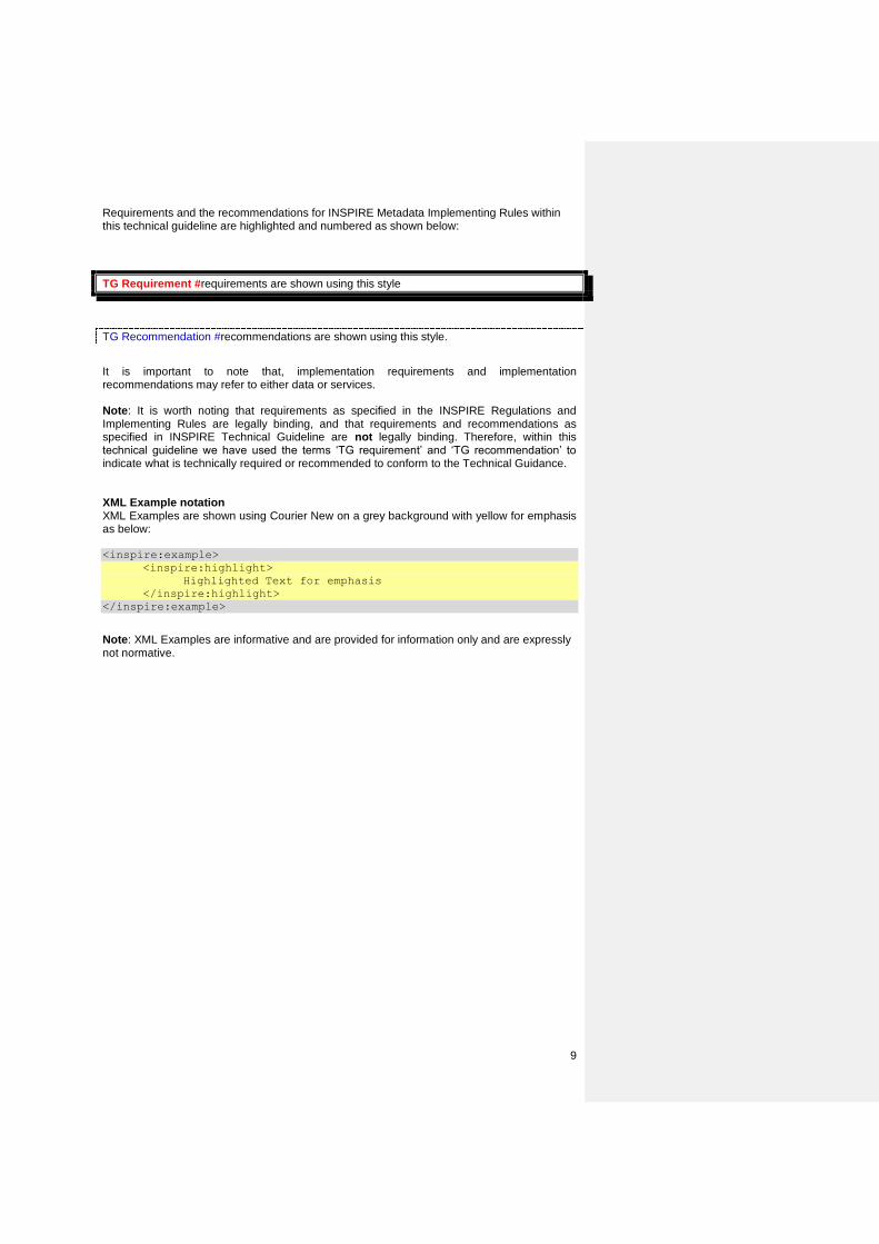
Requirements and the recommendations for INSPIRE Metadata Implementing Rules within this technical guideline are highlighted and numbered as shown below:
TG Requirement #requirements are shown using this style
TG Recommendation #recommendations are shown using this style.
It is important to note that, implementation requirements and implementation recommendations may refer to either data or services. Note: It is worth noting that requirements as specified in the INSPIRE Regulations and Implementing Rules are legally binding, and that requirements and recommendations as specified in INSPIRE Technical Guideline are not legally binding. Therefore, within this technical guideline we have used the terms ‘TG requirement’ and ‘TG recommendation’ to indicate what is technically required or recommended to conform to the Technical Guidance. XML Example notation XML Examples are shown using Courier New on a grey background with yellow for emphasis as below: <inspire:example>
<inspire:highlight>
Highlighted Text for emphasis
</inspire:highlight>
</inspire:example>
Note: XML Examples are informative and are provided for information only and are expressly not normative.
10
1 INSPIRE profile of ISO 19115 and ISO 19119
1.1 ISO Core Metadata Elements
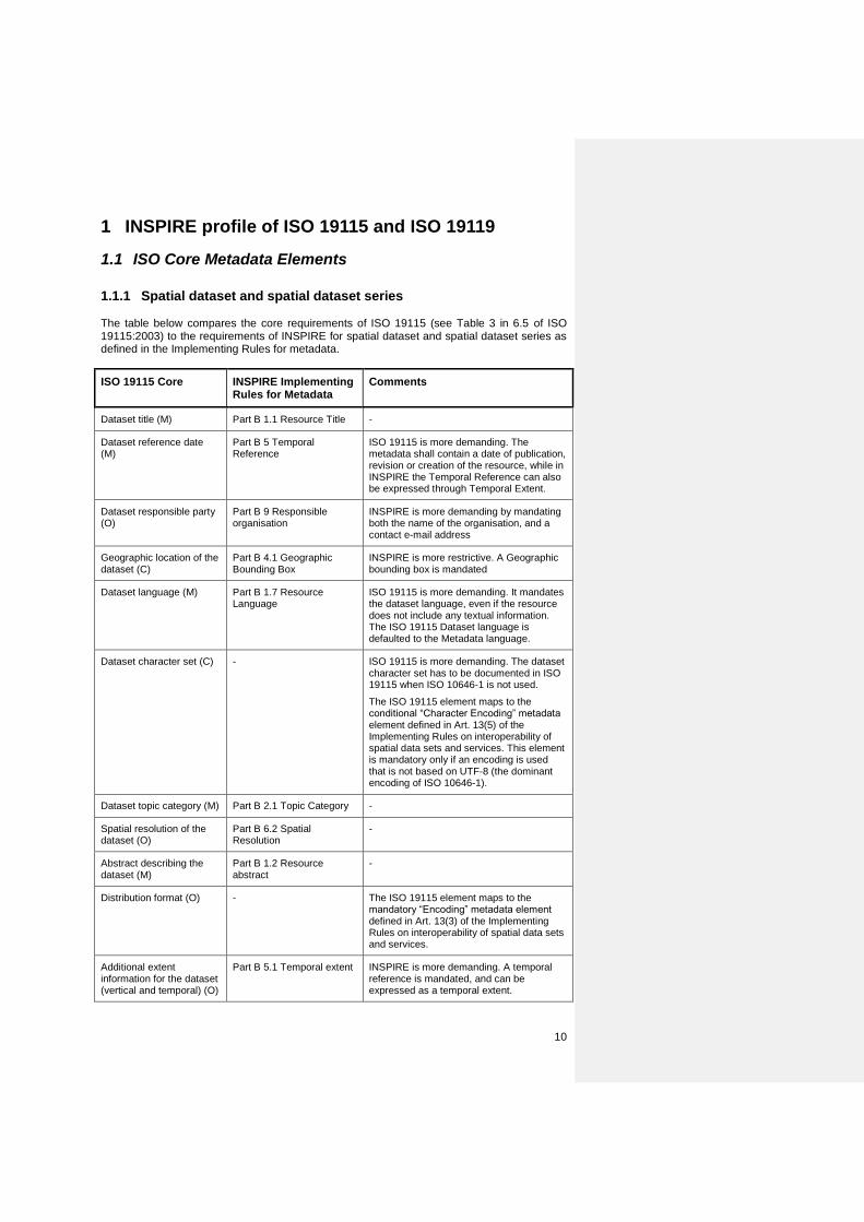
1.1.1 Spatial dataset and spatial dataset series The table below compares the core requirements of ISO 19115 (see Table 3 in 6.5 of ISO 19115:2003) to the requirements of INSPIRE for spatial dataset and spatial dataset series as defined in the Implementing Rules for metadata.
ISO 19115 Core INSPIRE Implementing Rules for Metadata
Comments
Dataset title (M) Part B 1.1 Resource Title -
Dataset reference date (M)
Part B 5 Temporal Reference
ISO 19115 is more demanding. The metadata shall contain a date of publication, revision or creation of the resource, while in INSPIRE the Temporal Reference can also be expressed through Temporal Extent.
Dataset responsible party (O)
Part B 9 Responsible organisation
INSPIRE is more demanding by mandating both the name of the organisation, and a contact e-mail address
Geographic location of the dataset (C)
Part B 4.1 Geographic Bounding Box
INSPIRE is more restrictive. A Geographic bounding box is mandated
Dataset language (M) Part B 1.7 Resource Language
ISO 19115 is more demanding. It mandates the dataset language, even if the resource does not include any textual information. The ISO 19115 Dataset language is defaulted to the Metadata language.
Dataset character set (C) - ISO 19115 is more demanding. The dataset character set has to be documented in ISO 19115 when ISO 10646-1 is not used.
The ISO 19115 element maps to the conditional “Character Encoding” metadata element defined in Art. 13(5) of the Implementing Rules on interoperability of spatial data sets and services. This element is mandatory only if an encoding is used that is not based on UTF-8 (the dominant encoding of ISO 10646-1).
Dataset topic category (M) Part B 2.1 Topic Category -
Spatial resolution of the dataset (O)
Part B 6.2 Spatial Resolution
-
Abstract describing the dataset (M)
Part B 1.2 Resource abstract
-
Distribution format (O) - The ISO 19115 element maps to the mandatory “Encoding” metadata element defined in Art. 13(3) of the Implementing Rules on interoperability of spatial data sets and services.
Additional extent information for the dataset (vertical and temporal) (O)
Part B 5.1 Temporal extent INSPIRE is more demanding. A temporal reference is mandated, and can be expressed as a temporal extent.
11
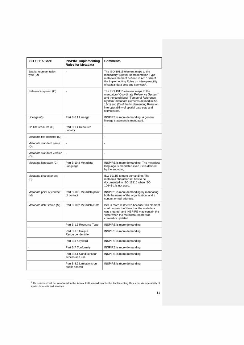
ISO 19115 Core INSPIRE Implementing Rules for Metadata
Comments
Spatial representation type (O)
- The ISO 19115 element maps to the mandatory “Spatial Representation Type” metadata element defined in Art. 13(6) of the Implementing Rules on interoperability of spatial data sets and services5.
Reference system (O) - The ISO 19115 element maps to the mandatory “Coordinate Reference System” and the conditional “Temporal Reference System” metadata elements defined in Art. 13(1) and (2) of the Implementing Rules on interoperability of spatial data sets and services set.
Lineage (O) Part B 6.1 Lineage INSPIRE is more demanding. A general lineage statement is mandated.
On-line resource (O) Part B 1.4 Resource Locator
-
Metadata file identifier (O) - -
Metadata standard name (O)
- -
Metadata standard version (O)
- -
Metadata language (C) Part B 10.3 Metadata Language
INSPIRE is more demanding. The metadata language is mandated even if it is defined by the encoding.
Metadata character set (C)
- ISO 19115 is more demanding. The metadata character set has to be documented in ISO 19115 when ISO 10646-1 is not used.
Metadata point of contact (M)
Part B 10.1 Metadata point of contact
INSPIRE is more demanding by mandating both the name of the organisation, and a contact e-mail address.
Metadata date stamp (M) Part B 10.2 Metadata Date ISO is more restrictive because this element shall contain the “date that the metadata was created” and INSPIRE may contain the “date when the metadata record was created or updated
- Part B 1.3 Resource Type INSPIRE is more demanding
Part B 1.5 Unique Resource Identifier
INSPIRE is more demanding
Part B 3 Keyword INSPIRE is more demanding
- Part B 7 Conformity INSPIRE is more demanding
- Part B 8.1 Conditions for access and use
INSPIRE is more demanding
- Part B 8.2 Limitations on public access
INSPIRE is more demanding
5 This element will be introduced in the Annex II+III amendment to the Implementing Rules on interoperability of
spatial data sets and services.
12
1.1.2 Services The table below compares the core requirements of ISO 19115 (see Table 3 in 6.5 of ISO 19115:2003) to the requirements of INSPIRE for services as defined in the Implementing Rules for metadata. The greyed lines correspond to core metadata elements not applicable to services.
ISO 19115 Core INSPIRE Comments
Dataset title (M) Part B 1.1 Resource Title -
Dataset reference date (M)
Part B 5 Temporal Reference
ISO 19115 is more demanding. Despite its name, this ISO 19115 Core metadata element applies to services. A reference date of the service (date of publication, revision or creation …) is mandated.
Dataset responsible party (O)
Part B 9 Responsible organisation
-
Geographic location of the dataset (C)
- See INSPIRE Geographic Bounding Box
- Part B 4.1 Geographic Bounding Box
The Geographic Bounding Box is handled in ISO 19119 with a different metadata element from the one corresponding to “Geographic location of the dataset”
Dataset language (M) - Not applicable to services
Dataset character set (C) - Not applicable to services
Dataset topic category (M) - Not applicable to services
Spatial resolution of the dataset (O)
Part B 6.2 Spatial Resolution
In the current version of ISO 19119, it is not possible to express the restriction of a service concerning the spatial resolution
Abstract describing the dataset (M)
Part B 1.2 Resource abstract
-
Distribution format (O) - -
Additional extent information for the dataset (O)
- -
Spatial representation type (O)
- -
Reference system (O) - -
Lineage (O) - -
On-line resource (O) Part B 1.4 Resource Locator
-
Metadata file identifier (O) - -
Metadata standard name (O)
- -
Metadata standard version (O)
- -
Metadata language (C) Part B 10.3 Metadata Language
INSPIRE is more demanding. The metadata language is mandated.
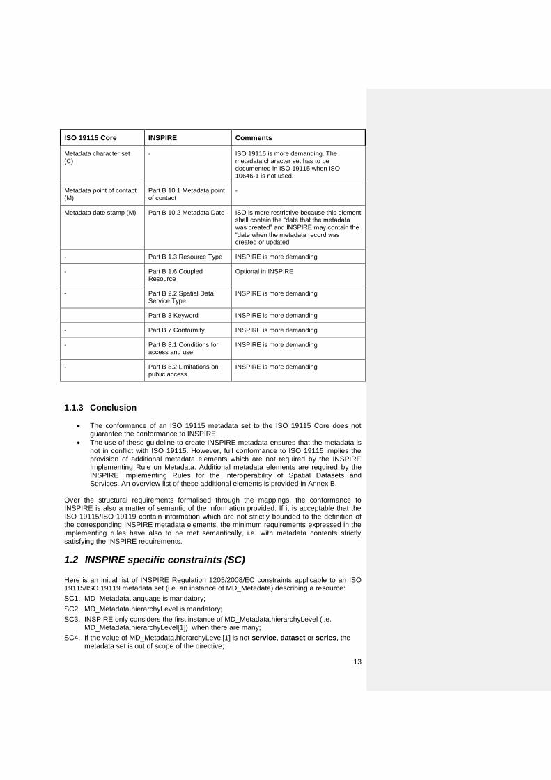
13
ISO 19115 Core INSPIRE Comments
Metadata character set (C)
- ISO 19115 is more demanding. The metadata character set has to be documented in ISO 19115 when ISO 10646-1 is not used.
Metadata point of contact (M)
Part B 10.1 Metadata point of contact
-
Metadata date stamp (M) Part B 10.2 Metadata Date ISO is more restrictive because this element shall contain the “date that the metadata was created” and INSPIRE may contain the “date when the metadata record was created or updated
- Part B 1.3 Resource Type INSPIRE is more demanding
- Part B 1.6 Coupled Resource
Optional in INSPIRE
- Part B 2.2 Spatial Data Service Type
INSPIRE is more demanding
Part B 3 Keyword INSPIRE is more demanding
- Part B 7 Conformity INSPIRE is more demanding
- Part B 8.1 Conditions for access and use
INSPIRE is more demanding
- Part B 8.2 Limitations on public access
INSPIRE is more demanding
1.1.3 Conclusion
The conformance of an ISO 19115 metadata set to the ISO 19115 Core does not guarantee the conformance to INSPIRE;
The use of these guideline to create INSPIRE metadata ensures that the metadata is not in conflict with ISO 19115. However, full conformance to ISO 19115 implies the provision of additional metadata elements which are not required by the INSPIRE Implementing Rule on Metadata. Additional metadata elements are required by the INSPIRE Implementing Rules for the Interoperability of Spatial Datasets and Services. An overview list of these additional elements is provided in Annex B.
Over the structural requirements formalised through the mappings, the conformance to INSPIRE is also a matter of semantic of the information provided. If it is acceptable that the ISO 19115/ISO 19119 contain information which are not strictly bounded to the definition of the corresponding INSPIRE metadata elements, the minimum requirements expressed in the implementing rules have also to be met semantically, i.e. with metadata contents strictly satisfying the INSPIRE requirements.
1.2 INSPIRE specific constraints (SC) Here is an initial list of INSPIRE Regulation 1205/2008/EC constraints applicable to an ISO 19115/ISO 19119 metadata set (i.e. an instance of MD_Metadata) describing a resource:
SC1. MD_Metadata.language is mandatory;
SC2. MD_Metadata.hierarchyLevel is mandatory;
SC3. INSPIRE only considers the first instance of MD_Metadata.hierarchyLevel (i.e. MD_Metadata.hierarchyLevel[1]) when there are many;
SC4. If the value of MD_Metadata.hierarchyLevel[1] is not service, dataset or series, the metadata set is out of scope of the directive;
14
SC5. When there are many instances of MD_Metadata.identificationInfo, only the first one (i.e. MD_Metadata.identificationInfo[1]) concerns the current INSPIRE Resource;
SC6. INSPIRE only considers the instance of MD_Metadata.dataQualityInfo applicable to the whole resource;
SC7. There shall not be more than one instance of MD_Metadata.identificationInfo[1].MD_Identification.citation.CI_Citation.date declared as a creation date (i.e. CI_Date.dateType having the creation value);
SC8. MD_Metadata.identificationInfo[1].MD_DataIdentification.citation.CI_Citation.identifier is mandatory for metadata sets related to spatial dataset and spatial dataset series;
SC9. The data type of MD_Metadata.identificationInfo.MD_DataIdentification.language is the codelist LanguageCode from ISO/TS 19139;
SC10. There is at least one instance of MD_Metadata.identificationInfo[1].MD_DataIdentification.extent defining the geographic location of the resource as a geographic bounding box (i.e. an instance of EX_GeographicBoundingBox or one of its subclasses).
SC11. MD_Metadata.identificationInfo[1].SV_ServiceIdentification.operatesOn shall be instantiated by reference
SC12. There shall be at least one instance of MD_Metadata.identificationInfo[1].MD_Identification.resourceConstraints
SC13. The coordinates of the bounding boxes (instance of EX_GeographicBoundingBox) shall be expressed in any geodetic coordinate reference system with the Greenwich Prime Meridian
SC14. For datasets and series: MD_Metadata.identificationInfo[1].MD_DataIdentification.pointOfContact[1].CI_ResponsibleParty.organisationName and MD_Metadata.identificationInfo[1].MD_DataIdentification.pointOfContact[1].CI_ResponsibleParty.contactInfo.CI_Contact.address.CI_Address.electronicMailAddress are mandatory. For services these elements are also mandatory but they are referred as follows: MD_Metadata.identificationInfo[1].SV_ServiceIdentification.pointOfContact[1].CI_ResponsibleParty.organisationName and MD_Metadata.identificationInfo[1].SV_ServiceIdentification.pointOfContact[1].CI_ResponsibleParty.contactInfo.CI_Contact.address.CI_Address.electronicMailAddress.
SC15. MD_Metadata.contact[1].CI_ResponsibleParty.organisationName and MD_Metadata.contact[1].CI_ResponsibleParty.contactInfo.CI_Contact.address.CI_Address.electronicMailAddress are mandatory.
SC16. The value of MD_Metadata.contact[1].CI_ResponsibleParty.role.CI_RoleCode shall be pointOfContact.
SC17. For datasets and series at least one keyword of GEMET thesaurus shall be documented using MD_Metadata.identificationInfo[1].MD_DataIdentification.descriptiveKeywords.
SC18. For services at least one keyword of Part D.4 of Commission Regulation (EC) No. 1205/2008 shall be documented using MD_Metadata.identificationInfo[1].SV_ServiceIdentification.descriptiveKeywords
1.3 Extensions
1.3.1 Spatial data service type For spatial data service types, the INSPIRE Metadata Regulation 1205/2008/EC mandate the use of the value domain of Part D 3. This information is handled using the serviceType attribute (See 3.2.22.3.2) of the class SV_ServiceIdentification (See ISO 19119). The Table below defines the values of the serviceType property. In brackets are the language neutral names to be used.
SPATIAL DATA SERVICE TYPE
15
SPATIAL DATA SERVICE TYPE
Discovery Service (discovery)
View Service (view)
Download Service (download)
Transformation Service (transformation)
Invoke Spatial Data Service (invoke)
Other Services (other)
1.3.2 Classification of spatial data services For classification of spatial data services, the Implementing Rules mandate the use of the value domain of Part D 4 of Regulation 1205/2008/EC. In order to ensure a language independent expression of the classification of spatial data services, the language neutral name is to be used as the value of the ISO 19115 keywords (See 3.32.4).
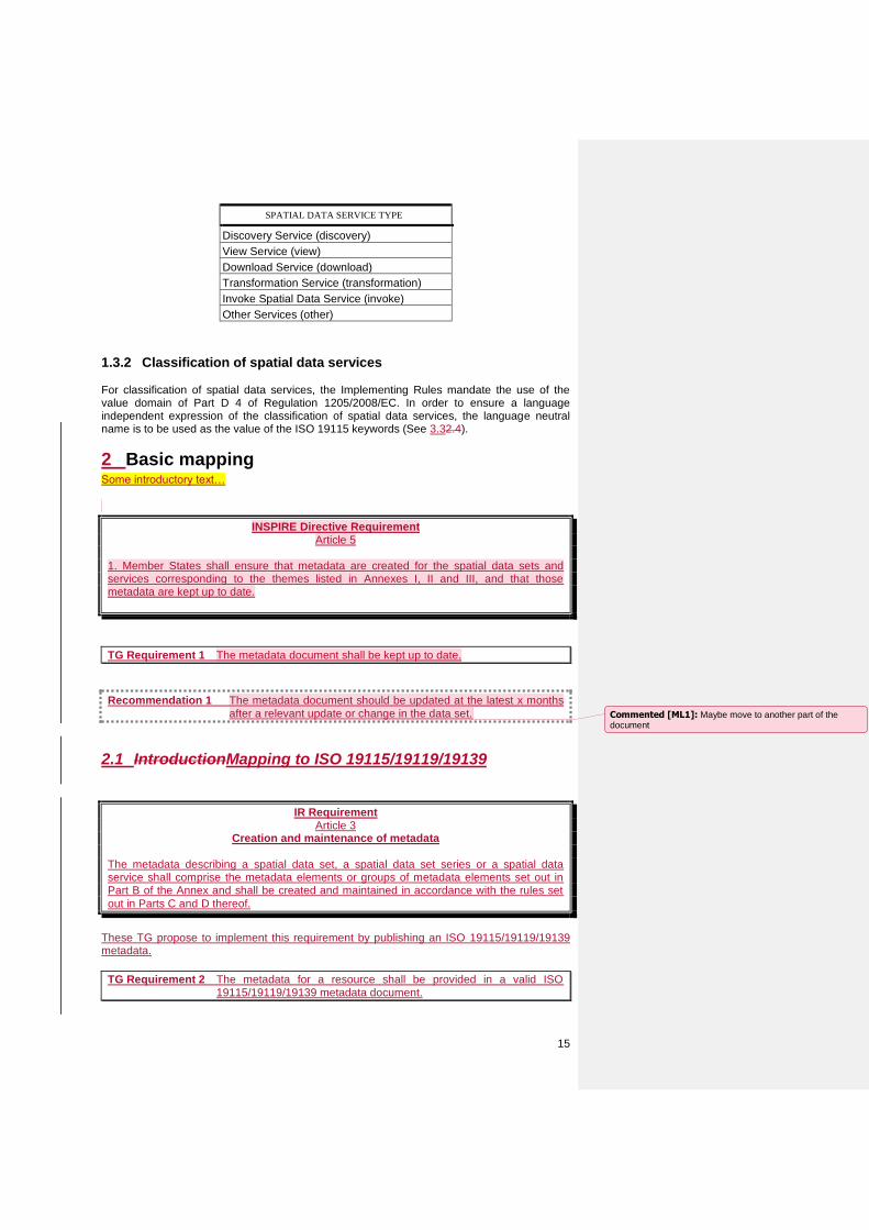
2 Basic mapping Some introductory text…
INSPIRE Directive Requirement Article 5
1. Member States shall ensure that metadata are created for the spatial data sets and services corresponding to the themes listed in Annexes I, II and III, and that those metadata are kept up to date.
TG Requirement 1 The metadata document shall be kept up to date.
Recommendation 1 The metadata document should be updated at the latest x months after a relevant update or change in the data set.
2.1 IntroductionMapping to ISO 19115/19119/19139
IR Requirement Article 3
Creation and maintenance of metadata The metadata describing a spatial data set, a spatial data set series or a spatial data service shall comprise the metadata elements or groups of metadata elements set out in Part B of the Annex and shall be created and maintained in accordance with the rules set
out in Parts C and D thereof.
These TG propose to implement this requirement by publishing an ISO 19115/19119/19139 metadata.
TG Requirement 2 The metadata for a resource shall be provided in a valid ISO 19115/19119/19139 metadata document.
Commented [ML1]: Maybe move to another part of the document
16
1.3.32.1.1 ISO Schemas Location
Official ISO schemas (ISO AP or ISO 19139) are currently found in two separate locations: 1) ISO repository for public available standards. The ISO 19139 schemas can be found here: http://standards.iso.org/ittf/PubliclyAvailableStandards/ISO_19139_Schemas/ Date of schemas: 2007-08-11. 2.) OGC Schema repository. The ISO 19139 schemas are located here: http://schemas.opengis.net/iso/19139/20070417/ Date of schemas: 2007-04-17. and here: http://schemas.opengis.net/iso/19139/20060504/ Date of schemas: 2006-06-04. ISO AP schemas are located here: http://schemas.opengis.net/csw/2.0.2/profiles/apiso/ Date of schemas: 2007-07-19. The ISO AP schemas are bound to http://schemas.opengis.net/iso/19139/20060504/ The difference in the schemas located in the OGC repository is the GML version. The version dated "2007-04-17" uses GML 3.2.1, the version dated "2006-06-04" use GML 3.2.0. The version "2006-06-04" provides gml in a separate directory (/gml) whereas the version "2007-04-17" directly refers to http://schemas.opengis.net/gml/3.2.1/. The major difference is that GML 3.2.0 schemas are defined in the namespace http://www.opengis.net/gml whereas GML 3.2.1 schemas are defined in the namespace http://www.opengis.net/gml/3.2. The schemas located in the ISO repository for public available standards are comparable to OGC schemas located here: http://schemas.opengis.net/iso/19139/20070417/. In conclusion: To Validate XML against ISO AP 1.0: http://schemas.opengis.net/csw/2.0.2/profiles/apiso/1.0.0/apiso.xsd To Validate XML against ISO 19139 with GML 3.2.0: http://schemas.opengis.net/iso/19139/20060504/gmd/gmd.xsd To Validate XML against ISO 19139 with GML 3.2.1: http://standards.iso.org/ittf/PubliclyAvailableStandards/ISO_19139_Schemas/gmd/gmd.xsd or http://schemas.opengis.net/iso/19139/20070417/gmd/gmd.xsd
2.2 Requirements for metadata elements
IR Requirement Annex - Part C
Instructions on multiplicity and conditions of the metadata elements
The metadata describing a resource shall comprise, as regards a spatial data set or a spatial data set series, the metadata elements or groups of metadata elements listed in Table 1 and, as regards a spatial data set service, the metadata elements or groups of
metadata elements listed in Table 2.
TG Requirement 3 The ISO 19115/19119/19139 metadata document shall include all the required elements defined in chapter 3 and fulfill the the mapping rules defined in these TGs.
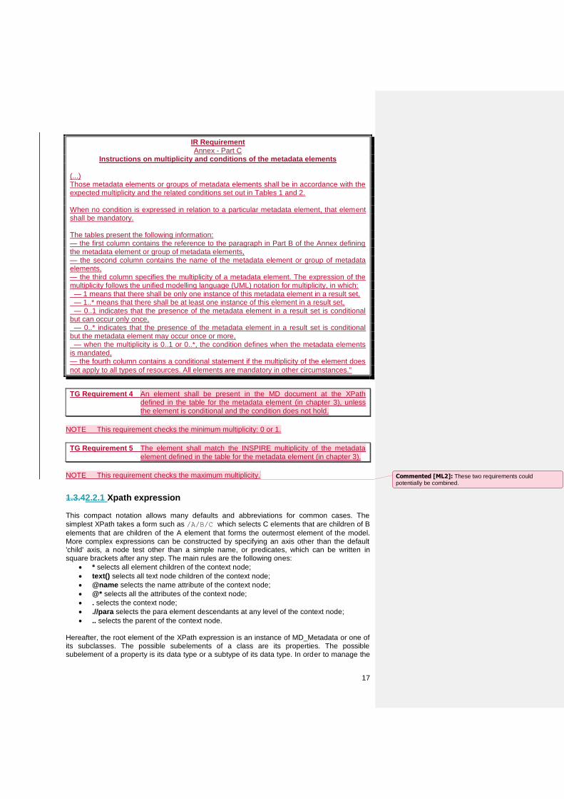
17
IR Requirement Annex - Part C
Instructions on multiplicity and conditions of the metadata elements
(...) Those metadata elements or groups of metadata elements shall be in accordance with the expected multiplicity and the related conditions set out in Tables 1 and 2. When no condition is expressed in relation to a particular metadata element, that element shall be mandatory. The tables present the following information: — the first column contains the reference to the paragraph in Part B of the Annex defining the metadata element or group of metadata elements, — the second column contains the name of the metadata element or group of metadata elements, — the third column specifies the multiplicity of a metadata element. The expression of the multiplicity follows the unified modelling language (UML) notation for multiplicity, in which: — 1 means that there shall be only one instance of this metadata element in a result set, — 1..* means that there shall be at least one instance of this element in a result set, — 0..1 indicates that the presence of the metadata element in a result set is conditional but can occur only once, — 0..* indicates that the presence of the metadata element in a result set is conditional but the metadata element may occur once or more, — when the multiplicity is 0..1 or 0..*, the condition defines when the metadata elements is mandated, — the fourth column contains a conditional statement if the multiplicity of the element does
not apply to all types of resources. All elements are mandatory in other circumstances."
TG Requirement 4 An element shall be present in the MD document at the XPath defined in the table for the metadata element (in chapter 3), unless the element is conditional and the condition does not hold.
NOTE This requirement checks the minimum multiplicity: 0 or 1.
TG Requirement 5 The element shall match the INSPIRE multiplicity of the metadata element defined in the table for the metadata element (in chapter 3).
NOTE This requirement checks the maximum multiplicity.
1.3.42.2.1 Xpath expression This compact notation allows many defaults and abbreviations for common cases. The
simplest XPath takes a form such as /A/B/C which selects C elements that are children of B
elements that are children of the A element that forms the outermost element of the model. More complex expressions can be constructed by specifying an axis other than the default 'child' axis, a node test other than a simple name, or predicates, which can be written in square brackets after any step. The main rules are the following ones:
* selects all element children of the context node;
text() selects all text node children of the context node;
@name selects the name attribute of the context node;
@* selects all the attributes of the context node;
. selects the context node;
.//para selects the para element descendants at any level of the context node;
.. selects the parent of the context node. Hereafter, the root element of the XPath expression is an instance of MD_Metadata or one of its subclasses. The possible subelements of a class are its properties. The possible subelement of a property is its data type or a subtype of its data type. In order to manage the
Commented [ML2]: These two requirements could potentially be combined.
18
polymorphism, the XPath expression deals with the data type in a generic way (e.g., property_element_name/*/datatype_property_name).
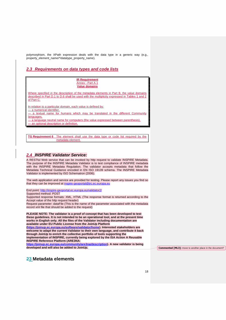
2.3 Requirements on data types and code lists
IR Requirement Annex - Part A.1 Value domains
Where specified in the description of the metadata elements in Part B, the value domains described in Part D.1 to D.6 shall be used with the multiplicity expressed in Tables 1 and 2 of Part C. In relation to a particular domain, each value is defined by: — a numerical identifier, — a textual name for humans which may be translated in the different Community languages, — a language neutral name for computers (the value expressed between parenthesis),
— an optional description or definition.
TG Requirement 6 The element shall use the data type or code list required by the metadata element.
2.4 INSPIRE Validator Service: A RESTful Web service that can be invoked by http request to validate INSPIRE Metadata. The purpose of the INSPIRE Metadata Validator is to test compliance of INSPIRE metadata with the INSPIRE Metadata Regulation. The validator accepts metadata that follow the Metadata Technical Guidance encoded in EN ISO 19139 schema. The INSPIRE Metadata Validator is implemented by ISO Schematron (2006). The web application and service are provided for testing. Please report any issues you find so that they can be improved at [email protected] End point: http://inspire-geoportal.ec.europa.eu/validator2/ Supported method: POST Supported response formats: XML, HTML (The response format is returned according to the Accept value of the http request header) Request parameter: dataFile (This is the name of the parameter associated with the metadata record xml file that should be added to the request)
PLEASE NOTE: The validator is a proof of concept that has been developed to test these guidelines. It is not intended to be an operational tool, and at the present time works in English only. All the files of the Validator including documentation are available under EU Public License from the JoinUp Platform (https://joinup.ec.europa.eu/software/validator/home). Interested stakeholders are welcome to adapt the current Validator to their own language, and contribute it back through JoinUp to enrich the collective portfolio of tools supporting the implementation of INSPIRE, currently being explored by the ISA Action A Reusable INSPIRE Reference Platform (ARE3NA: https://joinup.ec.europa.eu/community/are3na/description). A new validator is being developed and will also be added to JoinUp.
23 Metadata elements
Commented [ML3]: move to another place in the document?
19
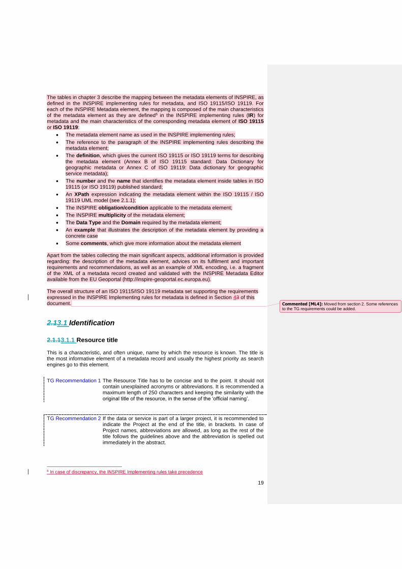
The tables in chapter 3 describe the mapping between the metadata elements of INSPIRE, as defined in the INSPIRE implementing rules for metadata, and ISO 19115/ISO 19119. For each of the INSPIRE Metadata element, the mapping is composed of the main characteristics of the metadata element as they are defined6 in the INSPIRE implementing rules (IR) for metadata and the main characteristics of the corresponding metadata element of ISO 19115 or ISO 19119:
The metadata element name as used in the INSPIRE implementing rules;
The reference to the paragraph of the INSPIRE implementing rules describing the metadata element;
The definition, which gives the current ISO 19115 or ISO 19119 terms for describing the metadata element (Annex B of ISO 19115 standard: Data Dictionary for geographic metadata or Annex C of ISO 19119: Data dictionary for geographic service metadata);
The number and the name that identifies the metadata element inside tables in ISO 19115 (or ISO 19119) published standard;
An XPath expression indicating the metadata element within the ISO 19115 / ISO 19119 UML model (see 2.1.1);
The INSPIRE obligation/condition applicable to the metadata element;
The INSPIRE multiplicity of the metadata element;
The Data Type and the Domain required by the metadata element;
An example that illustrates the description of the metadata element by providing a concrete case
Some comments, which give more information about the metadata element Apart from the tables collecting the main significant aspects, additional information is provided regarding: the description of the metadata element, advices on its fulfilment and important requirements and recommendations, as well as an example of XML encoding, i.e. a fragment of the XML of a metadata record created and validated with the INSPIRE Metadata Editor available from the EU Geoportal (http://inspire-geoportal.ec.europa.eu). The overall structure of an ISO 19115/ISO 19119 metadata set supporting the requirements expressed in the INSPIRE Implementing rules for metadata is defined in Section 43 of this document.
2.13.1 Identification
2.1.13.1.1 Resource title This is a characteristic, and often unique, name by which the resource is known. The title is the most informative element of a metadata record and usually the highest priority as search engines go to this element.
TG Recommendation 1 The Resource Title has to be concise and to the point. It should not contain unexplained acronyms or abbreviations. It is recommended a maximum length of 250 characters and keeping the similarity with the original title of the resource, in the sense of the ‘official naming’.
TG Recommendation 2 If the data or service is part of a larger project, it is recommended to indicate the Project at the end of the title, in brackets. In case of Project names, abbreviations are allowed, as long as the rest of the title follows the guidelines above and the abbreviation is spelled out immediately in the abstract.
6 In case of discrepancy, the INSPIRE Implementing rules take precedence
Commented [ML4]: Moved from section 2. Some references to the TG requirements could be added.
20
Metadata element name Resource title
Reference Part B 1.1
Definition Name by which the cited resource is known
ISO 19115 number and name 360. title
ISO/TS 19139 path identificationInfo[1]/*/citation/*/title
INSPIRE obligation / condition Mandatory
INSPIRE multiplicity [1]
Data type (and ISO 19115 no.) CharacterString
Domain Free text
Example SPI: Standardized Precipitation Index
Comments
Example of XML encoding: <gmd:MD_Metadata …
...
<gmd:identificationInfo>
<gmd:MD_DataIdentification>
<gmd:citation>
<gmd:CI_Citation>
<gmd:title>
<gco:CharacterString>SPI: Standardized
Precipitation Index</gco:CharacterString>
</gmd:title>
</gmd:CI_Citation>
</gmd:citation>
</gmd:MD_DataIdentification>
</gmd:identificationInfo>
...
</gmd:MD_Metadata>
2.1.23.1.2 Resource abstract This is a brief narrative summary of the content of the resource. The abstract provides a clear and concise statement that enables the reader to understand the content of the data or service
Metadata element name Resource abstract
Reference Part B 1.2
Definition Brief narrative summary of the content of the resource(s)
ISO 19115 number and name 25. abstract
ISO/TS 19139 path identificationInfo[1]/*/abstract
INSPIRE obligation / condition Mandatory
INSPIRE multiplicity [1]
Data type (and ISO 19115 no.) CharacterString
Domain Free text
21
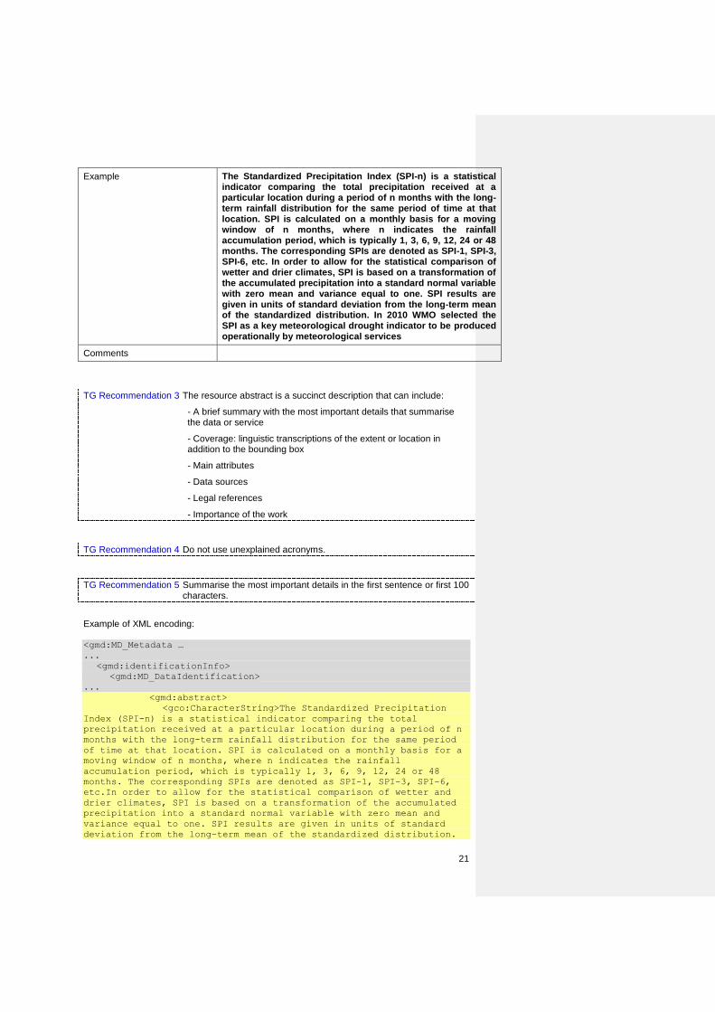
Example The Standardized Precipitation Index (SPI-n) is a statistical indicator comparing the total precipitation received at a particular location during a period of n months with the long-term rainfall distribution for the same period of time at that location. SPI is calculated on a monthly basis for a moving window of n months, where n indicates the rainfall accumulation period, which is typically 1, 3, 6, 9, 12, 24 or 48 months. The corresponding SPIs are denoted as SPI-1, SPI-3, SPI-6, etc. In order to allow for the statistical comparison of wetter and drier climates, SPI is based on a transformation of the accumulated precipitation into a standard normal variable with zero mean and variance equal to one. SPI results are given in units of standard deviation from the long-term mean of the standardized distribution. In 2010 WMO selected the SPI as a key meteorological drought indicator to be produced operationally by meteorological services
Comments
TG Recommendation 3 The resource abstract is a succinct description that can include:
- A brief summary with the most important details that summarise the data or service
- Coverage: linguistic transcriptions of the extent or location in addition to the bounding box
- Main attributes
- Data sources
- Legal references
- Importance of the work
TG Recommendation 4 Do not use unexplained acronyms.
TG Recommendation 5 Summarise the most important details in the first sentence or first 100 characters.
Example of XML encoding: <gmd:MD_Metadata …
...
<gmd:identificationInfo>
<gmd:MD_DataIdentification>
...
<gmd:abstract>
<gco:CharacterString>The Standardized Precipitation
Index (SPI-n) is a statistical indicator comparing the total
precipitation received at a particular location during a period of n
months with the long-term rainfall distribution for the same period
of time at that location. SPI is calculated on a monthly basis for a
moving window of n months, where n indicates the rainfall
accumulation period, which is typically 1, 3, 6, 9, 12, 24 or 48
months. The corresponding SPIs are denoted as SPI-1, SPI-3, SPI-6,
etc.In order to allow for the statistical comparison of wetter and
drier climates, SPI is based on a transformation of the accumulated
precipitation into a standard normal variable with zero mean and
variance equal to one. SPI results are given in units of standard
deviation from the long-term mean of the standardized distribution.
22
In 2010 WMO selected the SPI as a key meteorological drought
indicator to be produced operationally by meteorological services.
</gco:CharacterString>
</gmd:abstract>
...
</gmd:MD_DataIdentification>
</gmd:identificationInfo>
...
</gmd:MD_Metadata>
2.1.33.1.3 Resource Type This is the type of resource being described by the metadata and it is filled in with a value from a classification of the resource based on its scope. The choice of Resource Type will be probably the first decision made by the user and it will define the metadata elements that should be filled.
Metadata element name Resource type
Reference Part B 1.3
Definition Scope to which metadata applies
ISO 19115 number and name 6. hierarchyLevel
ISO/TS 19139 path hierarchyLevel
INSPIRE obligation / condition Mandatory
INSPIRE multiplicity [1]
Data type (and ISO 19115 no.) MD_ScopeCode
Domain CodeList (see annex B.5.25 of ISO 19115)
Example dataset
Comments
NOTE The hierarchyLevel property is not mandated by ISO 19115 but is mandated for is mandated for conformance to the INSPIRE Metadata Regulation 1205/2008/EC (See SC2 in 1.2). NOTE The values of MD_ScopeCode in the scope of the INSPIRE Directive (See SC4 in Directive (See SC4 in 1.2) are: - dataset for spatial datasets; - series for spatial dataset series; - service for spatial data services
TG Recommendation 6 The choice between the values should follow these recommendations
- dataset: is an identifiable data that can be accessed separately. A dataset can be a part of a whole (series) or a segregate resource
- series: is a collection of resources or related datasets that share the same product specification
- service: technologies providing availability and access to spatial information, for example, web map services, web feature services, web coverage services, web processing services, catalogue web services, etc
Commented [ML5]: Covered by TG requirement 4 and 5.
Commented [ML6]: Deviations from ISO 191xx (SCx) could also be high-lighted using a different style.
Formatted: Normal
Commented [ML7]: Covered by TG requirement 6.
23
Example of XML encoding: <gmd:MD_Metadata …
...
<gmd:hierarchyLevel>
<gmd:MD_ScopeCode
codeList="http://standards.iso.org/ittf/PubliclyAvailableStandards/IS
O_19139_Schemas/resources/codelist/gmxCodelists.xml#MD_ScopeCode"
codeListValue="dataset">dataset</gmd:MD_ScopeCode>
</gmd:hierarchyLevel>
...
</gmd:MD_Metadata>
2.1.43.1.4 Resource locator
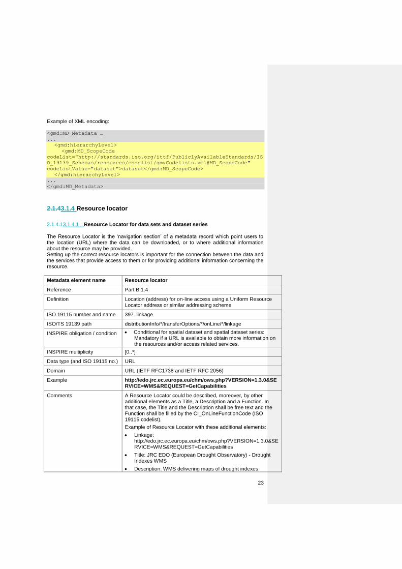
2.1.4.13.1.4.1 Resource Locator for data sets and dataset series The Resource Locator is the ‘navigation section’ of a metadata record which point users to the location (URL) where the data can be downloaded, or to where additional information about the resource may be provided. Setting up the correct resource locators is important for the connection between the data and the services that provide access to them or for providing additional information concerning the resource.
Metadata element name Resource locator
Reference Part B 1.4
Definition Location (address) for on-line access using a Uniform Resource Locator address or similar addressing scheme
ISO 19115 number and name 397. linkage
ISO/TS 19139 path distributionInfo/*/transferOptions/*/onLine/*/linkage
INSPIRE obligation / condition Conditional for spatial dataset and spatial dataset series: Mandatory if a URL is available to obtain more information on the resources and/or access related services.
INSPIRE multiplicity [0..*]
Data type (and ISO 19115 no.) URL
Domain URL (IETF RFC1738 and IETF RFC 2056)
Example http://edo.jrc.ec.europa.eu/chm/ows.php?VERSION=1.3.0&SERVICE=WMS&REQUEST=GetCapabilities
Comments A Resource Locator could be described, moreover, by other additional elements as a Title, a Description and a Function. In that case, the Title and the Description shall be free text and the Function shall be filled by the CI_OnLineFunctionCode (ISO 19115 codelist).
Example of Resource Locator with these additional elements:
Linkage: http://edo.jrc.ec.europa.eu/chm/ows.php?VERSION=1.3.0&SERVICE=WMS&REQUEST=GetCapabilities
Title: JRC EDO (European Drought Observatory) - Drought Indexes WMS
Description: WMS delivering maps of drought indexes
24
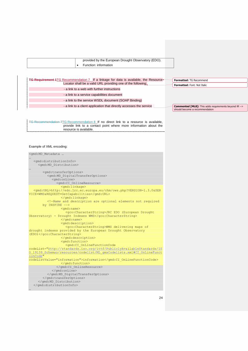
provided by the European Drought Observatory (EDO).
Function: information
TG Requirement 1TG Recommendation 7 If a linkage for data is available, the Resource Locator shall be a valid URL providing one of the following:
- a link to a web with further instructions
- a link to a service capabilities document
- a link to the service WSDL document (SOAP Binding)
- a link to a client application that directly accesses the service
TG Recommendation 7TG Recommendation 8 If no direct link to a resource is available, provide link to a contact point where more information about the resource is available.
Example of XML encoding: <gmd:MD_Metadata …
…
<gmd:distributionInfo>
<gmd:MD_Distribution>
…
<gmd:transferOptions>
<gmd:MD_DigitalTransferOptions>
<gmd:onLine>
<gmd:CI_OnlineResource>
<gmd:linkage>
<gmd:URL>http://edo.jrc.ec.europa.eu/chm/ows.php?VERSION=1.3.0&SER
VICE=WMS&REQUEST=GetCapabilities</gmd:URL>
</gmd:linkage>
<!—Name and description are optional elements not required
by INSPIRE -->
<gmd:name>
<gco:CharacterString>JRC EDO (European Drought
Observatory) - Drought Indexes WMS</gco:CharacterString>
</gmd:name>
<gmd:description>
<gco:CharacterString>WMS delivering maps of
drought indexes provided by the European Drought Observatory
(EDO)</gco:CharacterString>
</gmd:description>
<gmd:function>
<gmd:CI_OnLineFunctionCode
codeList="http://standards.iso.org/ittf/PubliclyAvailableStandards/IS
O_19139_Schemas/resources/codelist/ML_gmxCodelists.xml#CI_OnLineFunct
ionCode"
codeListValue="information">information</gmd:CI_OnLineFunctionCode>
</gmd:function>
</gmd:CI_OnlineResource>
</gmd:onLine>
</gmd:MD_DigitalTransferOptions>
</gmd:transferOptions>
</gmd:MD_Distribution>
</gmd:distributionInfo>
…
Formatted: TG Recommend
Formatted: Font: Not Italic
Commented [ML8]: This adds requirements beyond IR --> should become a recommendation
25
</gmd:MD_Metadata>
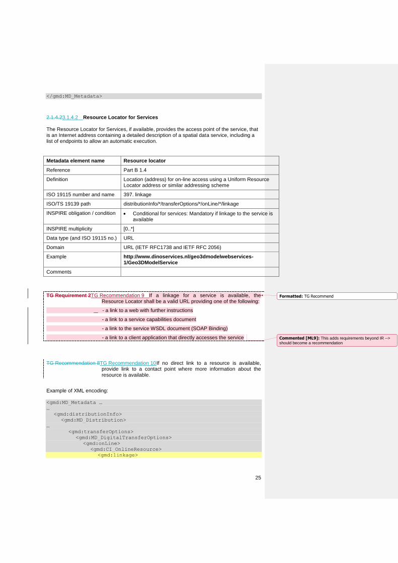
2.1.4.23.1.4.2 Resource Locator for Services The Resource Locator for Services, if available, provides the access point of the service, that is an Internet address containing a detailed description of a spatial data service, including a list of endpoints to allow an automatic execution.
Metadata element name Resource locator
Reference Part B 1.4
Definition Location (address) for on-line access using a Uniform Resource Locator address or similar addressing scheme
ISO 19115 number and name 397. linkage
ISO/TS 19139 path distributionInfo/*/transferOptions/*/onLine/*/linkage
INSPIRE obligation / condition Conditional for services: Mandatory if linkage to the service is available
INSPIRE multiplicity [0..*]
Data type (and ISO 19115 no.) URL
Domain URL (IETF RFC1738 and IETF RFC 2056)
Example http://www.dinoservices.nl/geo3dmodelwebservices-1/Geo3DModelService
Comments
TG Requirement 2TG Recommendation 9 If a linkage for a service is available, the Resource Locator shall be a valid URL providing one of the following:
- a link to a web with further instructions
- a link to a service capabilities document
- a link to the service WSDL document (SOAP Binding)
- a link to a client application that directly accesses the service
TG Recommendation 8TG Recommendation 10 If no direct link to a resource is available, provide link to a contact point where more information about the resource is available.
Example of XML encoding: <gmd:MD_Metadata …
…
<gmd:distributionInfo>
<gmd:MD_Distribution>
…
<gmd:transferOptions>
<gmd:MD_DigitalTransferOptions>
<gmd:onLine>
<gmd:CI_OnlineResource>
<gmd:linkage>
Formatted: TG Recommend
Commented [ML9]: This adds requirements beyond IR --> should become a recommendation
26
<gmd:URL>
http://www.dinoservices.nl/geo3dmodelwebservices-1/Geo3DModelService
/</gmd:URL>
</gmd:linkage>
</gmd:CI_OnlineResource>
</gmd:onLine>
</gmd:MD_DigitalTransferOptions>
</gmd:transferOptions>
</gmd:MD_Distribution>
</gmd:distributionInfo>
…
</gmd:MD_Metadata>
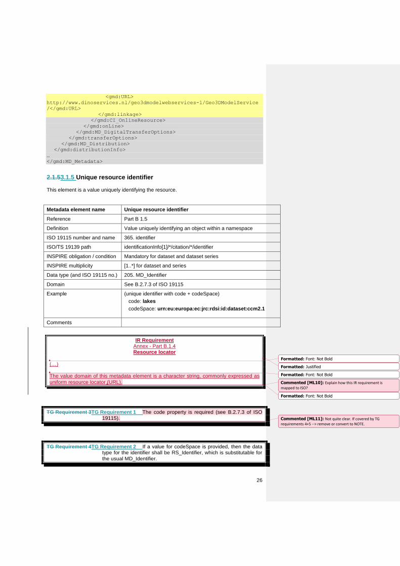
2.1.53.1.5 Unique resource identifier This element is a value uniquely identifying the resource.
Metadata element name Unique resource identifier
Reference Part B 1.5
Definition Value uniquely identifying an object within a namespace
ISO 19115 number and name 365. identifier
ISO/TS 19139 path identificationInfo[1]/*/citation/*/identifier
INSPIRE obligation / condition Mandatory for dataset and dataset series
INSPIRE multiplicity [1..*] for dataset and series
Data type (and ISO 19115 no.) 205. MD_Identifier
Domain See B.2.7.3 of ISO 19115
Example (unique identifier with code + codeSpace)
code: lakes
codeSpace: urn:eu:europa:ec:jrc:rdsi:id:dataset:ccm2.1
Comments
IR Requirement Annex - Part B.1.4 Resource locator
(…) The value domain of this metadata element is a character string, commonly expressed as
uniform resource locator (URL).
TG Requirement 3TG Requirement 1 The code property is required (see B.2.7.3 of ISO 19115).
TG Requirement 4TG Requirement 2 If a value for codeSpace is provided, then the data type for the identifier shall be RS_Identifier, which is substitutable for the usual MD_Identifier.
Formatted: Font: Not Bold
Formatted: Justified
Formatted: Font: Not Bold
Formatted: Font: Not Bold
Commented [ML10]: Explain how this IR requirement is mapped to ISO?
Commented [ML11]: Not quite clear. If covered by TG requirements 4+5 --> remove or convert to NOTE.