inspector’s report 06s.ja0040
TRANSCRIPT
06S.JA0040 Inspector’s Report Page 1 of 141
Inspector’s Report
06S.JA0040.
Development
Dublin Mountain Visitor Centre and all
associated works.
Location Townlands of Montpelier, Killakee and
Jamestown, South Dublin.
Planning Authority South Dublin County Council.
Applicant South Dublin County Council.
Type of Application Section 175(3), Planning and
Development Act 2000 (as amended).
Submissions/Observations See Appendices.
Date of Site Inspection 26th August 2017, 6th January 2018,
25th January 2018, 6th November
2018, 18th November 2018.
Inspector Ciara Kellett.
06S.JA0040 Inspector’s Report Page 2 of 141
Contents
1.0 Introduction .......................................................................................................... 3
2.0 Site Location and Description .............................................................................. 3
3.0 Proposed Development ....................................................................................... 6
4.0 Planning History ................................................................................................. 10
5.0 Policy Context .................................................................................................... 12
6.0 Submissions following initial lodgement ............................................................. 23
7.0 Request for Further Information ......................................................................... 33
8.0 Oral Hearing ...................................................................................................... 49
9.0 Assessment ....................................................................................................... 52
10.0 Planning Assessment .................................................................................. 53
11.0 Environmental Impact Assessment ............................................................. 73
12.0 Appropriate Assessment ........................................................................... 120
13.0 Conclusion ................................................................................................ 131
14.0 Recommendation ...................................................................................... 132
15.0 Reasons and Considerations .................................................................... 132
Appendix 1 ............................................................................................................. 138
Appendix 2 ............................................................................................................. 140
06S.JA0040 Inspector’s Report Page 3 of 141
1.0 Introduction
This is an application for development approval submitted to An Bord Pleanála (the
Board) under Section 175(3) of the Planning and Development Act 2000, as
amended. Applications under Section 175(3) are made by Local Authorities when the
authority proposes to carry out development within its functional area, in respect of
which an Environmental Impact Assessment Report (EIAR) has been prepared.
Under the provisions of Article 120(3)(b) of the Planning and Development
Regulations 2001, as amended, South Dublin County Council sought a
determination from the Board as to whether or not the proposal would be likely to
give rise to significant effects on the environment and thereby require the preparation
of an Environmental Impact Statement (EIS)1. The Board decided on 8th May 2017 to
direct the Council to prepare an EIS.
An Environmental Impact Assessment Report (EIAR) accompanies this application.
2.0 Site Location and Description
The application site is stated as being c.152Ha within the foothills of the Dublin
Mountains on Coillte owned land. The site is bisected by the R115 Road in a north-
south direction (known as the Killakee Road at this location). To the west of the
R115 Road lies Montpelier Hill and the area known as the Hellfire Forest, and the
land to the east of the road is known as Massy’s Wood2.
The R115 Road links Rathfarnham with Killakee, Glencree and Sally Gap in County
Wicklow running south through the Dublin and Wicklow Mountains and climbing
steadily uphill from Rathfarnham. The R115 meets the R113 Road at a junction north
of the site. The R113 runs north-west of the site towards the Ballycullen Road and is
known as Gunny Hill. The 60kph speed limit applies in this area and there are no
public footpaths or cycle lanes. The area is not served by public transport and the
R115 is particularly steep where it bisects the subject site.
1 This application was submitted after 16th May 2017, the date for transposition of Directive 2014/52/EU amending the 2011
EIA Directive. The Directive was transposed into Irish Legislation on 1st September 2018. An EIAR was submitted with the application. 2 Various spellings of the names of the areas (Montpelier, Killakee, Massy’s) are used throughout the documentation
submitted, as well as on maps.
06S.JA0040 Inspector’s Report Page 4 of 141
Hellfire Forest
2.3.1. The Hellfire forest to the west of the R115 is stated as being 105Ha in extent and is
an actively managed commercial coniferous forest. It is located on Montpelier Hill
which is one of the northern hills of the Dublin Mountains. There is one entrance to
the forest from the R115 via a barrier-controlled access. It has restricted opening
hours between 08.00 – 17.00 October to March, and 07.00 – 21.00 April to
September.
2.3.2. There is an existing car park to the north of the entrance which is stated as holding
75-80 cars. The parking spaces are not clearly marked out resulting in haphazard
parking. On busy days parking can overspill onto the R115 on the west side of the
road. This overspill parking can lead to difficulty for two cars to pass. It is stated that
the over-mature conifer plantation at the car park will be subject to wind throw and is
not sustainable and is therefore due to be felled.
2.3.3. From the entrance to the car park which is at a level of 250m AOD, the site rises
steeply to the summit of Montpelier Hill at 383m AOD. There are a number of forest
tracks (both pedestrian and vehicular) which lead up to the summit where the ruins
of the hunting lodge known as the Hellfire Club lie.
2.3.4. On the most direct pedestrian route up to the Hellfire Club, there is a large boulder in
the centre of the track which is indicated as a ‘standing stone’. It is noted as having
been knocked over onto its side in recent years, making it somewhat
indistinguishable.
2.3.5. From the top of the hill and on the tracks up, there are long distance panoramic
views to the north and east of Dublin City and Bay. There has been recent clear
felling of the forest to the east. There are still large mostly conifer plantations on the
hill which limit views to the south and west.
2.3.6. The Hellfire Club ruin is located in a clearing at the top of the hill. The building is a
Protected Structure (RPS Ref. 388) and listed in the National Inventory of
Architectural Heritage (NIAH Ref. 11220022). It is noted as being constructed in
1725 (although this date differs from the description provided by the NIAH). The
NIAH describes it as ‘Detached five-bay single-storey-over-basement former hunting
lodge on hill summit, built c.1740, burnt soon after, with vaulted stone roof repair,
now derelict. Projecting porch / gallery with arched window to front, between plain

06S.JA0040 Inspector’s Report Page 5 of 141
openings in main elevation. Two wings with small rooms and sloping stone roofs,
and projecting shelter walls. Projecting wing to rear with small semi-circular window.
Internal rooms with fireplaces, arched doorways and niches, and connecting gallery.
Robbed megalithic tomb and triangulation survey pillar nearby’.
2.3.7. The NIAH further notes the infamous history of the building and states that the
building ‘has an undeniably foreboding presence, and the later stone vaulted roof
repair is outstanding in its coarseness’.
2.3.8. The original staircase is missing and has been replaced in the recent past with a
concrete staircase with welded metal balustrade.
2.3.9. There are clear signs of anti-social behaviour which is damaging the building. There
is graffiti on the walls, debris and litter left lying around and evidence of fires having
been lit in the interior.
2.3.10. To the south of the Hellfire Club are the remains of two passage tombs
(Neolithic/Megalithic) which are recorded in the Record of Monuments and Places.
Massy’s Wood
2.4.1. To the east of the R115 lies Massy’s wood which is stated as being 47Ha. The
principle entrance to the woods lies to the north of the entrance to the Hellfire forest.
There is no parking provided in the woods at this point and it is likely that people
park in the Hellfire car park and walk across the road, or park on the R115 outside.
There are two other access points to Massy’s wood at Rockbrook to the north-east
and Cruagh to the south-east where the Dublin Mountains Way passes the site.
Neither access point has car park facilities but there is a parking spot near the
Rockbrook entrance.
2.4.2. Pedestrian access from the R115 is via a gate which leads into the woods and is
along the last remaining unpaved section of the Old Military Road (Protected
Structure Ref. 385). Massy’s wood is part of the demesne of the former Killakee
House which was demolished in 1941. The woodlands are now managed as a mixed
woodland predominantly for recreational purposes. There are a number of older
specimen trees from the original demesne, such as Giant Sequoia, Monkey Puzzle
and West Himalayan Spruce trees.

06S.JA0040 Inspector’s Report Page 6 of 141
2.4.3. The landscape character of Massy’s wood contrasts significantly with the Hellfire
forest. The Hellfire forest is at a greater elevation, is exposed and provides long
distance views. Massy’s wood is enclosed with smaller tracks and trails and forms a
valley of a watercourse, known throughout the documentation and submissions by
various names including the Glendoo Brook, Jamestown Stream and Cruagh Brook.
It flows south to north and is a tributary of the Owendoher River. The watercourse is
crossed by a number of stone bridges in various states of repair. These bridges as
well as the walled gardens form part of the Protected Structure RPS Ref. 384.
2.4.4. The remains of three linked walled gardens lie to the east of the Glendoo Brook in a
dilapidated state but with walls relatively intact with archways and opes adding to the
ambience of the woods. The walled gardens are terraced to take account of the drop
in ground level. The features include a gate lodge, ice house, and a stone well. The
walled gardens once contained an attractive set of glasshouses (noted as being
designed by Richard Turner).
2.4.5. Apart from the car park at Hellfire forest there are no facilities, other than some
signage.
2.4.6. The Steward’s House or Killakee House as variously named throughout the
documentation is partly a Protected Structure located alongside the R115 just north
of the car park serving the Hellfire forest.
Appendix A includes maps and photographs.
3.0 Proposed Development
Description of Development
3.1.1. The site of the proposed development of the Dublin Mountains Visitor Centre
(DMVC) is Coillte’s Hellfire and Massy’s wood forest properties (totalling c.152Ha) in
the townlands of Montpelier, Killakee and Jamestown in South Dublin. Development
is also proposed along stretches of the R115 and R113 regional roads connecting
the site to the urban areas of Woodstown and Ballycullen to the north.
3.1.2. At a high level the proposed development involves: (a) changes to the landscape of
the site including the trails; (b) conservation works to the architectural heritage
features and interpretation of the heritage resources; (c) development of visitor
06S.JA0040 Inspector’s Report Page 7 of 141
facilities, parking, and services for the facilities, and (d) changes to the roads
accessing the site, and provision of a shuttle service to the site. In addition to these
physical developments, an operational management plan is proposed to facilitate the
envisaged increase in visitor numbers and usage of the site. The increase in visitor
numbers is expected to rise from the current c.100,000 to 300,000 visitors per year
over a 10-year period.
3.1.3. The public notices describe the development as including:
(a) The conversion of 26Ha of Coillte’s Hellfire forest property from productive
conifer forest to mixed deciduous woodland for use primarily as amenity open
space;
(b) Modifications, including new sections of trail, and upgrade of the existing
network of walking and equestrian trails throughout the Hellfire and Massy’s
wood forest properties;
(c) Construction of a ‘tree canopy walk’/pedestrian bridge over the R115 to link
the trail networks of the two properties, with a ‘bridge house’ at the Hellfire
end of the bridge;
(d) Conservation works to the Hellfire Club Building (South Dublin Record of
Protected Structures Ref. 388) and the architectural heritage of the Massy’s
wood property including the walled garden (part of South Dublin Record of
Protected Structures Ref. 384);
(e) Installation of heritage interpretation signage along the network of trails;
(f) Construction of a new parking area for 275 no. cars (including 14 no. disabled
spaces) and five coach spaces to replace the existing parking area on the
Hellfire forest property;
(g) Construction of a visitor centre comprising two buildings (one single storey
and one two-storey) side-by-side at an elevation of c.300m on the Hellfire
forest property, with a combined gross floor area of 980sq.m, accommodating
the following uses/spaces: audio-visual/exhibition facility (101sq.m), education
room (55sq.m), café with seating area (175sq.m), servery (36sq.m) and
kitchen (60sq.m), rambler’s lounge (43sq.m), retail (45sq.m), kiosk (27sq.m),
06S.JA0040 Inspector’s Report Page 8 of 141
toilets (66sq.m), facility management offices (55sq.m), and associated
reception, circulation, plant and storage spaces;
(h) Construction of a standalone electricity substation (23sq.m);
(i) Installation of a new watermain line and sewage pipe under the R115 from the
Hellfire property to the existing watermain and public sewer network;
(j) Construction of a network of swales and ponds for attenuation of surface run-
off, and a culvert beneath the R115 to channel overflow of surface water into
the Glendoo Brook;
(k) Modifications to the existing entrance to the Hellfire forest property;
(l) Installation of new fences along sections of the Hellfire property boundary;
(m)All ancillary works and landscaping on the Hellfire and Massy’s wood
properties.
It is further noted that it is proposed to make modifications to the stretches of the
R115 and R113 roads connecting the site to the urban area to the north, including
the provision of a footpath (minimum 1.5m width) and an advisory cycle lane (1.5m
width), and the retention of a carriageway of sufficient width for two-way traffic
except at one location where a single lane traffic shuttle is proposed. It is noted that
the proposed modifications to the roads do not require encroachment into adjoining
private lands but do require localised widening of the R115 by 1.2m into Massy’s
wood property for a stretch of c.100m.
The public notices also make reference to the fact that an Environmental Impact
Assessment Report (EIAR) has been prepared in respect of the proposed
development.
3.1.4. A number of documents, as well as the EIAR, were submitted with the application,
including: Architectural, Engineering and Landscape Drawings, Photomontages –
daytime and night-time views, Design Report, Planning Statement, Tree Survey
Report, Engineering Report, Screening Report for Appropriate Assessment, Outline
Construction and Traffic Management Plan, Transport Impact Assessment,
Mechanical and Electrical Report, Business Plan Report, and an Operational
Management Plan.

06S.JA0040 Inspector’s Report Page 9 of 141
Further Information Amendments
3.2.1. Following the initial request for Further Information, the applicant made some
amendments to the proposal. The exhibition and education facilities are now open to
all visitors for no fee. It was clarified that lighting will be turned off on closure of the
facility and departure of staff. The previously proposed LED lighting of the tree
canopy pedestrian bridge is omitted, and the Operational Management Plan is
updated.
3.2.2. It is noted that the overall landscape management intention is the conversion over
time of the north and east slopes of Montpelier to a new permanent mixed woodland
of predominantly native species. As part of the Red Squirrel Management Plan it is
planned to increase the proportion of conifers in new woodland areas and retain
conifers that do not need removal to facilitate development or for other immediate
reasons.
3.2.3. A second request for further information was issued and will be discussed below.
However, no amendments to the design were made at that stage.
Environmental Impact Statement Direction from the Board
Under the provisions of Article 120(3)(b) of the Planning and Development Act 2000,
as amended, South Dublin County Council sought a determination from the Board as
to whether or not its proposal to carry out the visitor centre development would be
likely to give rise to significant effects on the environment and thereby require the
preparation of an Environmental Impact Statement (EIS)3.
The Board decided on the 9th May 2017 to direct the Local Authority to prepare an
EIS in respect of the proposed development for the following Reasons and
Considerations:
Having regard to the scale and nature of the proposed development, to its
location in a sensitive but highly frequented landscape south of the Dublin
built up area, to the prevalence of artefacts of cultural, historical and
archaeological heritage throughout the general area and to the ecology of the
3 This application was submitted after 16th May 2017, the date for transposition of Directive 2014/52/EU amending the 2011
EIA Directive which requires that an Environmental Impact Assessment Report (EIAR) is submitted by the applicant.

06S.JA0040 Inspector’s Report Page 10 of 141
area the Board considered a full and proper consideration of all the possible
significant effects on the environment of the proposed amenity development
and the potential for mitigation of these required that an environmental impact
assessment process be undertaken. Therefore, it is considered that the
preparation of an environmental impact statement is required.
In deciding not to accept the Inspector’s recommendation not to direct that an
environmental impact statement be undertaken the Board noted the
Inspector’s view that the historical and archaeological features of the lands
had proved to be resilient to date notwithstanding the numbers of visitors to
the area. However, the Board considered that the proposed development is
such that further significant additional numbers of visitors will be encouraged
to use the facilities provided and it is deemed appropriate that the effect of
these, and other, impacts be properly assessed.
4.0 Planning History
On the site
There have been no planning applications for development of the subject site. Its use
as a commercial forest and recreation use is long standing.
Other permissions of note
In the vicinity, there have been two planning applications associated with the
Protected Structure of Stewards/Killakee House. In summary:
• ABP Ref. 239038, SDCC Reg. Ref.10A/0032: The Board granted permission
in October 2011 for redevelopment of Killakee House and old stable buildings.
The works involve extensive conservation works to the main building, in order
to use the structure as a single residential unit. The works also involve the
conversion of the original stable buildings into three number holiday home
residential units. Council decision was to grant subject to conditions,
permission for single-storey extensions to the west, south and east of the
Dower House and to refuse permission for conversion of the original stable
building into three number holiday home residential units.

06S.JA0040 Inspector’s Report Page 11 of 141
The Board having regard to the planning history of the site, to the zoning
objective for the site, to the Architectural Heritage Protection Guidelines for
Planning Authorities and to the pattern of development in the area, considered
that, subject to compliance with the conditions, the proposed development
would not seriously injure the amenities of the area or of property in the
vicinity, would not have a serious detrimental impact on the character or
setting of these Protected Structures, would not be prejudicial to public health
and would be acceptable in terms of traffic safety and convenience. In
deciding not to accept the Inspector’s recommendation to refuse permission
for the renovation of the stables to three holiday units, the Board had regard
to the planning history of the site, including its former use as a restaurant with
associated traffic, and to the note on the Board Direction on file Ref. 230837
where the Board accepted change of use of the stables to three holiday
accommodation units, and to the Architectural Heritage Protection Guidelines
for Planning Authorities where it is recognised that a change of use may be
the best way to prolong the life of a protected structure by keeping it in active
use, if it is not possible to maintain it in its original use.
This permission has not been implemented and has subsequently expired.
• ABP Ref.230837, SDCC Reg. Ref. SD08A/0411: The Board decided to
refuse permission in March 2009 for the redevelopment of Killakee House and
old stable buildings. The works proposed the construction of a two-storey
glazed atrium structure to the south-western side, and a first-floor terrace to
the southern end of the return building to the main house which is to be used
as a single dwelling unit. The works will also involve the conversion of the
original stable buildings into three number holiday home residential units.
The reasons and considerations for refusing permission included: The
proposed works would include the demolition of buildings to the rear of the
main house and a historic freestanding stone shed, the insertion of multiple
openings that would be unsympathetic to the existing fenestration in Killakee
and Dower Houses and the old stable buildings, and the addition of an atrium
to Dower House that would overwhelm its rear elevation. The proposed works
would interfere with the original proportions and spatial relationship of the
06S.JA0040 Inspector’s Report Page 12 of 141
associated structures on the site and variously would fail to conserve and
respect the essential character of these buildings.
The Direction included the following note as referred to in decision ABP Ref.
239038: The Board considered that proposals for holiday lettings would be
acceptable as part of an overall tourist related project on the site.
5.0 Policy Context
National Planning Framework
5.1.1. The Department of Housing, Planning and Local Government, on behalf of the
Government, has prepared a National Planning Framework called Project Ireland
2040. The National Planning Framework (NPF), is a planning framework to guide
development and investment over the coming years. The companion to this
document is the National Development Plan, a ten-year strategy for public capital
investment of almost €116 Billion.
5.1.2. The NPF seeks to enhance amenities and heritage. This includes amenities in rural
areas, such as national and forest parks, activity-based tourism and trails such as
greenways, blueways and peatways4.
5.1.3. With respect to our heritage, the NPF states the following5:
Our national parks and nature reserves are also key natural assets that offer
potential to further optimise the visitor experience of state owned lands,
through delivery of quality outdoor activity infrastructure and essential
ancillary facilities.
5.1.4. National Policy Objective 60 states:
Conserve and enhance the rich qualities of natural and cultural heritage of
Ireland in a manner appropriate to their significance.
5.1.5. National Policy Objective 62 states:
Identify and strengthen the value of greenbelts and green spaces at a regional
and city scale, to enable enhanced connectivity to wider strategic networks,
4 Page 15 of the NPF 5 Page 126 of the NPF
06S.JA0040 Inspector’s Report Page 13 of 141
prevent coalescence of settlements and to allow for the long-term strategic
expansion of urban areas.
5.1.6. National Strategic Outcome 7 refers to Enhanced Amenities and Heritage. Of
relevance:
Open up our heritage estates to public access, where possible.
Invest in and enable access to recreational facilities, including trails networks,
designed and delivered with a strong emphasis on conservation, allowing the
protection and preservation of our most fragile environments and providing a
wellbeing benefit for all.
Regional Planning Guidelines for the Greater Dublin Area 2010 – 2022.
5.2.1. Chapter 5 of the Guidelines refers to Rural Development, chapter 7 to Green
Infrastructure, Heritage and the Environment, and chapter 8 refers to Social
Infrastructure and Sustainable Communities.
5.2.2. Section 5.4 refers to the Rural Economy. It states that ‘Peri-urban areas and green
belt zoned lands across the fringe of metropolitan Dublin represent a particular type
of rural area which can exploit markets through offerings in specialised green
oriented activities, rural tourism and leisure for both international and local markets
alongside more traditional rural activities capitalising on strong connectivity to urban
populations and markets’. Section 5.4.2 notes that rural tourism can play a strong
role in stimulating rural economies. Equally it is stated that ‘Alongside this it is critical
to ensure that increasing pressures of commercialisation and development do not
serve to undermine rural ecosystems, landscapes and conservation areas thus
losing what makes such destinations attractive and special places to visit’.
Strategic Policy and Recommendation RR5 states:
Needs of leisure and rural tourism be addressed in a multi-disciplinary manner
in high pressure locations, taking into account natural, economic, social and
cultural policy objectives and plans. Balance is required between the need to
preserve the natural environment; the needs of modern farming and also
making the countryside and natural areas accessible to those who wish to

06S.JA0040 Inspector’s Report Page 14 of 141
avail of it. Feasibility studies and best scientific evidence can be utilised to
ensure that this balance is achieved.
5.2.3. Section 7.2 refers to Built Heritage which includes Archaeological and Architectural
Heritage. Strategic Recommendation GIR11 seeks:
To protect the intrinsic natural, built and cultural heritage of the GDA whilst
ensuring that any future development of tourist and recreational uses are
facilitated in a manner which complements and protects the intrinsic heritage
features of the region.
5.2.4. Key Regional Assets identified in the Guidelines include the Dublin/Wicklow
Mountains. Table 12 states the aim is: To provide an overview of environmental and
cultural resources and identification of strategic priority elements, areas and routes
for inclusion in GI development within the Greater Dublin Area.
An example of a reference project refers to the Dublin Mountains Partnership’s
Strategic Plan for Development of Outdoor Recreation (2007-2017).
5.2.5. Access Management is referred to. It is stated that ‘It is important for a number of
environmentally sensitive locations that access does not result in unlimited access,
but rather ‘managed access’ where appropriate. This should also be supported by
transport modes such as secure and direct pedestrian and cycle routes and public
transport provision’.
5.2.6. Section 8.5 refers to Leisure and Recreation. Strategic Recommendation SIR11
states:
The importance of managing and enhancing recreational facilities, including
publicly owned lands associated with regionally important assets (such as the
Dublin Mountains) is recognised and should be supported by the relevant
bodies in line with environmental compatibilities in association with plans
and/or measures to protect important habitats within or proximate to these
locations.
South Dublin County Development Plan 2016 – 2022
5.3.1. The site is located within the administrative area of South Dublin County Council and
is subject to the policies and objectives of the County Development Plan. Chapter 4

06S.JA0040 Inspector’s Report Page 15 of 141
refers to Economic Development and Tourism, Chapter 6 to Transport & Mobility,
Chapter 8 to Green Infrastructure, Chapter 9 to Heritage, Conservation &
Landscapes, and Chapter 11 to Implementation.
5.3.2. Section 4.5.0 of Chapter 4 refers to Tourism and Leisure. It states: ‘South Dublin
County has a range of natural, cultural and built heritage resources of outstanding
merit and the South Dublin Tourism Strategy 2015 identifies a range of actions to
develop and present these assets to the market. Through the boost provided by
Destination Dublin: A Collective Strategy for Tourism Growth to 2020 (Growth Dublin
Taskforce), and by collaborating with other parts of Dublin, South Dublin can develop
a distinctive range of tourism products that will complement those of other parts of
Dublin and generate substantial socio-economic benefits for the County’.
Policy ET 5 Tourism Infrastructure states:
It is the policy of the Council to support the development of a sustainable
tourism industry that maximises the recreational and tourism potential of the
County, through the implementation of the South Dublin Tourism Strategy
2015.
ET5 Objective 3:
To support the development of a visitor facility in or adjacent to the High
Amenity – Dublin Mountains zone (HA-DM), subject to an appropriate scale of
development having regard to the pertaining environmental conditions and
sensitivities, scenic amenity and availability of services.
ET5 Objective 4:
To support the development of an outdoor pursuits centre in or adjacent to
lands designated with Zoning Objective High Amenity – Dublin Mountains
(HA-DM), subject to an appropriate scale of development having regard to the
pertaining environmental conditions and sensitivities, scenic amenity and
availability of services.
ET 6 Policy for Greenways, Trails and Loops includes ET6 Objective 1 which seeks:
To support and facilitate the development of an integrated network of
Greenways and Trails, including blueways/water trails, along suitable

06S.JA0040 Inspector’s Report Page 16 of 141
corridors, including the River Liffey, Dublin Mountains Way, Grand Canal,
River Dodder and Slade Valley.
ET 7 refers to Leisure Activities including ET7 Objective 1:
To promote the active use of managed forests for tourism and leisure related
activities subject to an appropriate scale of development having regard to the
pertaining environmental conditions and sensitivities, scenic amenity and
availability of services.
5.3.3. Chapter 6 refers to Transport & Mobility. TM Policy 1 Overarching states: It is the
policy of the Council to promote the sustainable development of the County through
the creation of an integrated transport network that services the needs of
communities and businesses.
TM3 refers to Walking and Cycling. TM3 Objective 1 seeks:
To create a comprehensive and legible County-wide network of cycling and
walking routes that link communities to key destinations, amenities and leisure
activities with reference to the policies and objectives contained in Chapter 9
(Heritage, Conservation and Landscape) particularly those that relate to
Public Rights of Way and Permissive Access Routes.
Table 6.6 identifies the upgrade of the R115 in the medium to long term ‘To enhance
pedestrian and cycling facilities and exploit the tourist potential of the route’.
5.3.4. Chapter 8 refers to Green Infrastructure. G Policy 1 Overarching states:
It is the policy of the Council to protect, enhance and further develop a
multifunctional Green Infrastructure network by building an interconnected
network of parks, open spaces, hedgerows, grasslands, protected areas, and
rivers and streams that provide a shared space for amenity and recreation,
biodiversity protection, flood management and adaptation to climate change.
With respect to Public Open Space and Landscape Setting G Policy 4 states:
It is the policy of the Council to provide a hierarchy of high quality and multi-
functional public parks and open spaces.
5.3.5. Chapter 9 refers to Heritage, Conservation & Landscapes. HCL1 Objective 1 seeks:

06S.JA0040 Inspector’s Report Page 17 of 141
To protect, conserve and enhance natural, built and cultural heritage features
and restrict development that would have a significant negative impact on
these assets.
HCL3 Objective 3 seeks:
To address dereliction and encourage the rehabilitation, renovation,
appropriate use and re-use of Protected Structures.
With respect to Views and Prospects, HCL8 Objective 1 seeks:
To protect, preserve and improve Views and Prospects of special amenity,
historic or cultural value or interest including rural, river valley, mountain, hill,
coastal, upland and urban views and prospects that are visible from prominent
public places.
Table 9.2 lists Prospects to be Preserved and Protected. Montpelier Hill is listed in
the table.
Section 9.2.2 specifically refers to the Dublin Mountains. It states: ‘The Dublin
Mountains and associated uplands occupy the southern side of the County and
extend into the adjoining counties of Dun Laoghaire-Rathdown and Wicklow. The
diverse topography and landcover of the Dublin Mountains includes areas of natural
beauty and ecological importance (including 3 of the County’s Natura 2000 Sites)
and is a key element of the County’s Green Infrastructure network. The mountains
also offer significant recreational and amenity value, with popular orienteering
courses, climbing areas and walking, running, hiking and mountain bike trails’.
HCL Policy 9 Dublin Mountains states:
It is the policy of the Council to protect and enhance the visual, recreational,
environmental, ecological, geological, archaeological and amenity value of the
Dublin Mountains, as a key element of the County’s Green Infrastructure
network.
HCL Objective 1 seeks:
To restrict development within areas designated with Zoning Objective ‘HA –
DM’ (To protect and enhance the outstanding natural character of the Dublin
Mountains Area) and to ensure that new development is related to the area’s
06S.JA0040 Inspector’s Report Page 18 of 141
amenity potential or to its use for agriculture, mountain or hill farming and is
designed and sited to minimise environmental and visual impacts.
HCL9 Objective 5 seeks:
To support the re-routing of the Dublin Mountains Way from public roads and
to improve access to publicly owned lands in the upland area.
Table 9.3 identifies the three designated sites in the County. Site Code 001209
Glenasmole Valley SAC, Site Code 002122 Wicklow Mountains SAC and Site Code
004040 Wicklow Mountains SPA.
HCL16 Objective 3 seeks:
To promote and facilitate the continued development of the Dublin Mountains
Way and the Wicklow Way in association with the Dublin Mountains
Partnership, particularly Permissive Access Routes that provide access to
regional and local networks of walking, running, hiking and mountain bike
trails and other recreational facilities. The routing of new trails and rerouting of
existing trails off public roads is encouraged.
HCL16 Objective 5 seeks:
To bring mountain amenities closer to residential communities by promoting
the establishment of a network of formal footpaths, off-road paths and
cycleways that facilitate casual walkers and cyclists.
5.3.6. Chapter 11 refers to Implementation. The site is located mainly in the HA-DM High
Amenity Dublin Mountains zoning. Part of the site is within the RU Rural zoning. The
objective of the HA-DM zoning is ‘To protect and enhance the outstanding natural
character’. The objective of the RU zoning is ‘To protect and improve rural amenity
and to provide for the development of agriculture of the Dublin Mountains Area’.
Table 11.12 defines what uses are permitted in principle and what uses are open for
consideration in the HA-DM zoning. Car Parks are permitted in principle below the
350m contour and for small-scale amenity or recreational purposes only. Open for
Consideration uses include ‘Cultural Use’ and ‘Recreational Use’ directly linked to
the heritage and amenity value of the Dublin Mountains. ‘Restaurant/Café’ and ‘Shop
– Local’ are open for consideration if they are within existing premises and not

06S.JA0040 Inspector’s Report Page 19 of 141
permitted above the 350m contour. Listed as not being permitted is ‘Outdoor
Entertainment Park’, ‘Shop – Neighbourhood’ and ‘Social Club’.
Table 11.16 defines what uses are permitted in RU zoning. ‘Open Space’ is
permitted in principle. ‘Car Parks’ for small-scale amenity or recreational purposes
only are open for consideration. Restaurant/Café are open for consideration without
the caveat requiring them to be located in existing premises.
5.3.7. Schedule 1 of the Plan is the Record of Monuments and Places. DU025-001 is listed
as ‘Mountpelier’ and noted as being passage tombs (2). DU025-022 is listed as a
Wedge Tomb in Killakee.
5.3.8. Schedule 2 is the Record of Protected Structures. RPS no.384 is noted as being
Buildings and Features Associated With Former Kilakee House, Including Former
Gardens, Bridges and Walls, and RPS no.385 is noted as being Original Military
Road Remains, both in Lord Massey’s Woods, Kilakee. RPS no.388 is noted as Two
Passage Tombs, Dwelling (Ruin) (RM) in Hell Fire Club, Stone Structure At Top Of
Mountpelier.
South Dublin Landscape Character Assessment 2015
5.4.1. The area is located within the Landscape Character Area (LCA) identified as the
River Dodder and Glenasmole Valley. It is noted that A mosaic of habitats are
present in this LCA increasing overall biodiversity; landuse is primarily agricultural
with rough grazing on the uplands and improved, enclosed pasture on the lower
elevations and river valley floor. Coniferous forestry plantations are present more on
the western area adjoining the Athgoe and Saggart Hills LCA.
5.4.2. It is stated that the ‘most notorious’ site in this LCA is probably the Hellfire Club and
it notes that Killakee, Massy and Cobbe estates were the major landholding estates
within this LCA.
5.4.3. It is stated that ‘The LCA is overall in very good condition. The variety of landscape
features and elements that contribute to character are well maintained and intact; the
long history of human activity and settlement in this area and particularly the
retention of prehistoric features increase its value as a landscape character area. Its
highly attractive character and diversity of scenic qualities is appreciated by the
06S.JA0040 Inspector’s Report Page 20 of 141
many recreational uses and it functions as an area of county and/or regional
significance for recreational uses’.
5.4.4. Mitigation measures listed include:
1. Continued agricultural activities should be encouraged.
2. Requirements that coniferous plantations should be managed in sympathy with
the landscape include siting, coupe formation (not crudely geometric), harvesting
(not clear felling), species mix (conifer /broadleaf mix where feasible).
3. Existing woodlands, shelterbelts and copses should be preserved and renewed.
4. Inappropriate developments (including commercial scale wind energy), and other
developments that would be highly visible and intrusive should not be permitted.
Their impact on the unique character of the landscape would be significant and give
rise to negative impacts on landscape character and visual amenity.
5. Access routes for pedestrian, cyclists and other recreational users including
tourists should be enhanced taking cognisance of ecological needs to facilitate their
comfort, safety, and enjoyment.
6. Access to selected historical and archaeological resources should be developed
as feasible, and should include provision of suitable signage e.g. Piperstown.
7. Provide for a network of ecological corridors to provide both landscape functions,
contribute to green infrastructure and enhance overall landscape character.
8. The vernacular style of siting structures into the landform and use of local granite
stone and rough plaster contributes significantly to landscape character and integrity
and use of same should be encouraged.
9. Opportunity for environmental education should be exploited.
10. Enhancement of laybys and viewing points to increase their attractiveness by
using native hedgerows and local granite as landscaping materials where possible.
11. Consider extension of Wicklow National Park to southern part of this LCA.
5.4.5. It concludes that the combination of overall landscape sensitivity (high) with overall
landscape value (high) = a capacity assessment of negligible. It further describes
negligible: Key Characteristics of the landscape are highly vulnerable to

06S.JA0040 Inspector’s Report Page 21 of 141
development. Development would result in a significant change in Landscape
character and should be avoided if possible.
South Dublin Tourism Strategy 2015
5.5.1. Policy ET 5 Tourism Infrastructure of the Development Plan states that it is the policy
of the Council to support the development of a sustainable tourism industry that
maximises the recreational and tourism potential of the County, through the
implementation of the South Dublin Tourism Strategy 2015.
5.5.2. The South Dublin Tourism Strategy states that the County’s principal resource with
potential for development for tourism are the Dublin Mountains, strongly supported
by the waterways, parks, built and traditional cultural heritage, towns and villages.
The principal recommendation is the creation of a Dublin Mountains Park Flagship
Project.
5.5.3. Section 3.1 identifies the principal recommendation being the creation of a Dublin
Mountains Park Flagship Project. Section 3.1.1 refers to the Dublin Mountain
Orientation and Interpretation Centre – Flagship Project. It states6:
The ideal location should be selected with excellent panoramic views over
Dublin Bay, through elevated viewing locations. Potential sites could include
locations at Killakee Mountain or Montpelier Hill or another suitable location.
5.5.4. With regard to the centre it is stated:
Detailed proposals for the Centre, its location and design, will be the guided
by appropriate environmental assessments and a project masterplan but from
a tourism amenity perspective a viewing point, visitor information and
facilities, and high quality interpretation should be regarded as the
cornerstones for the Centre.
Dun Laoghaire Rathdown County Development Plan 2016 - 2022
5.6.1. Chapter 4 of the DLRCC Plan addresses Green Strategy.
6 Page 29 of the South Dublin Tourism Strategy

06S.JA0040 Inspector’s Report Page 22 of 141
Policy LHB13: Dublin Mountains Strategic Plan: It is Council policy to
support the vision and objectives of the Dublin Mountains Strategic Plan for
Development of Outdoor Recreation (2007- 2017) including the continued
development and enhancement of the Dublin Mountains Way and its rerouting
off public roads wherever possible.
It is stated that DLRCC are part of the Dublin Mountain Partnership (DMP). A
Specific Local Objective no. 35 states:
Through the Council’s membership of the Dublin Mountains Partnership
(DMP), to improve the recreation potential of the public lands in the Dublin
Mountains, including the provision of a Dublin Mountains Interpretive Centre.
Wicklow County Council Development Plan 2016 – 2022
5.7.1. Chapter 7 of the Wicklow County Council Plan refers to Tourism and Recreation. A
number of objectives are listed including T3:
To generally require tourism and recreation related developments to locate
within existing towns and villages, except where the nature of the activity
proposed renders this unfeasible or undesirable. Within existing towns and
villages, the Planning Authority will promote and facilitate the development of
tourist related uses at appropriate sites. In all cases, the applicant must
submit a robust assessment setting out the sustainability of any proposal with
respect to economic, environmental and social sustainability, as defined
herein.
And T5:
The Planning Authority recognises that certain tourist facilities that are located
in rural areas may be provided as stand alone development, and that ancillary
uses (e.g. club house, café, restaurant, shop etc) may be required in order to
ensure the long term viability of the tourist facility. Additional uses will only be
permitted in cases where the additional use is integrated with and connected
to the primary use of the site as a tourist facility, and in cases where the
Planning Authority is satisfied that the additional use is ancillary to the primary
use of the site as a tourist facility. The additional use shall be located adjacent

06S.JA0040 Inspector’s Report Page 23 of 141
to the tourist facility, and avail of shared infrastructure and services, insofar as
possible.
Natural Heritage Designations
The following Natura sites are located within 15km of the subject site:
• Glenasmole Valley SAC (Site Code 001209)
• Wicklow Mountains SAC (Site Code 002122)
• Wicklow Mountains SPA (Site Code 004040)
• South Dublin Bay and River Tolka Estuary SPA (Site Code 004024)
• South Dublin Bay SAC (Site Code 000210)
• Knocksink Wood SAC (Site Code 000725)
6.0 Submissions following initial lodgement
Prescribed Bodies
Of the prescribed bodies notified, submissions have been received from:
6.1.1. An Taisce
• An Taisce welcome enhanced public recreational access to the Dublin and
Wicklow Mountains in particular to create improved walking routes, and the
proposal to open the area around the Hellfire Club by the removal of trees.
Any proposal should be part of an overall strategy for the Dublin and Wicklow
mountain area.
• It is stated that there is no evidence that the proposal has been discussed or
agreed with elected representatives of DLRCC, DCC or WCC.
• They have a number of concerns relating to the Visitor Centre. They are of the
opinion that it should be via adaptive re-use of the old Steward’s House rather
than building a new structure which would affect the views and prospects from
the hill and from below. Should the new structure proceed it should be
situated lower on the hill.

06S.JA0040 Inspector’s Report Page 24 of 141
• Reference zoning and objective for “High Amenity – Dublin Mountains”. A
Restaurant/Café and Shop-Local are open for consideration if in existing
premises. Refer to other alternatives such as Stewards House.
• Recommend bridge is omitted – netting would be needed and it would draw
many people into Massy’s Wood. A pedestrian crossing above the point of car
access would be preferable.
• Reference to access and shuttle bus. A service from the city centre should be
provided and a connection to the Dublin Mountains Way.
• Proposals for management are poor, relying on volunteers is uncertain and
risky.
6.1.2. Department of Culture, Heritage and the Gaeltacht
Archaeology
• Notes 6 Recorded Monuments in location and recommends 5 conditions.
Built Heritage
• Welcome minimum interference with the structures. Query how electricity is
being supplied.
• States that it is unclear if any conservation works are proposed on the two
tombs.
• Makes recommendations regarding a detailed conservation survey, lighting
installation, and surface finish around the Hellfire Club and tombs to be
agreed.
Nature Conservation
• Notes no bird survey carried out – so it is not clear whether Merlins nest on
the site or not (QI for Wicklow Mountains SPA).
• Issue of cumulative impact on nearby Glenasmole Valley SAC, and Wicklow
Mountains SAC and SPA needs to be assessed.
• Refers to Red Squirrels and states that a Red Squirrel Management Plan
should be drawn up. Makes reference to Pine Martens, Bats, Hedgerows,
Birds, Badgers, Flora and Habitats, Glendoo Brook, Deer and Vegetation

06S.JA0040 Inspector’s Report Page 25 of 141
Clearance. This submission was specifically referred to with respect to Further
Information request (see below).
• State An Bord Pleanála should satisfy itself that the Construction
Management Plan is adequate.
6.1.3. Fáilte Ireland
• Fáilte Ireland is supportive of proposal.
• A new brand “Dublin – A Breath of Fresh Air” was launched in late 2015. This
proposal has significant potential to deliver on this.
• Outdoor activity tourism and walking and hiking continue to grow in popularity
globally – proposal would provide a key outdoor experience in Ireland.
6.1.4. Inland Fisheries Ireland
• Notes site is within catchment of the Owendoher River – a tributary of the
Dodder and is the most important nursery and recruitment tributary in the
Dodder system. Vital to note that salmonid water constraints apply to any
development.
Submissions from observers
A significant number of submissions have been received from observers including
Public Representatives, Organisations and Community Groups and individuals. For
ease of reading, the submissions have been arranged by topic. The full list of names
of observers are included in Appendix 1 of this report.
Zoning and Policy Compliance
• Restaurant/Café are open for consideration subject to two conditions that
require them to be located within existing premises and below the 350m
contour line. This implies they are not permitted under this zoning. There are
other alternatives that offer a good view such as Ticknock/Orlagh/Glencree
and all are existing buildings.
• ET5 objective 3 refers to appropriate scale of facility – this is not appropriate.
• Proposal to attract 300,000 visitors is at odds with the high amenity zoning.
06S.JA0040 Inspector’s Report Page 26 of 141
• All access to the proposal passes through RU zoned lands – proposal fails to
meet the Council’s objective for rural zoned areas.
• Under the zoning objective, offices are not permitted yet DMP are to have
their headquarters here. Car parking is limited to small scale.
• Justification in planning terms is based on a county wide consideration,
whereas for a project of this scale a regional approach should be adopted.
• Planning Authority who adopted the Development Plan are now trying to
argue why they should be allowed to breach their own Development Plan
zoning.
• The proposal is excessive in scale to a level that would amount to a material
contravention of the County Development Plan. The car park will not be
serving what can be described as a ‘small scale amenity or recreational
facility’ – the car parking must therefore be seen as a contravention of the
zoning objective.
• Definition of a recreational facility would permit only the ramblers lounge – no
other element of the visitor centre conforms to this definition.
• The scale of the restaurant/café cannot be viewed as being ancillary to the
overall development. The applicant is trying to create a destination café that
will generate significant levels of trips as set out in the Business Plan.
Objectives of the Proposal
• Objectives of the proposal are unclear and ambiguous.
• Neither Hellfire Club or Massy’s Wood would benefit from enhancing the
visitor experience – manmade attempts to achieve this could detract from the
experience of both facilities.
• EIAR states that the development is intended in part to act as a catalyst for
private sector amenity and tourism related development.
• Rationale for development is based on developing a tourist attraction. As it is
a Council-led proposal it should have a stronger social purpose to make a
meaningful contribution to the health and wellbeing of the local population.
06S.JA0040 Inspector’s Report Page 27 of 141
• The corporate events focus in the Business Plan is not appropriate given the
public investment in the facility and is not needed as there are many other
establishments offering such services.
• Concerns with a lack of physical ‘wow’ factor to support the Hellfire Club story
– it is not an iconic structure and the proposed development does not seem to
uplift an assortment of experiences into ‘Flagship’ status. The tours go further
south to where the real scenic attractions are.
• The management of the restaurant and interpretative facilities will be handed
over to a commercially run concern with no remit to keep the environment in
better condition.
Alternatives
• Alternatives have not been properly considered. Site selection process was
too narrow with some sites ignored.
• A proper EIAR should consider alternatives that would manage the growth in
visitor numbers and possible need to provide facilities to accommodate this
growth but not create a recreational hub at this location. The alternative would
not be a ‘do-nothing option’ but rather a ‘management option’. It is normal
practice to adopt a Woodland Management Plan – no such option is
considered in the EIAR.
• Orlagh House was put on the market in 2016. Purchase by SDCC was
dismissed on the grounds that it did not comply with their vision. A single
parcel of land divides Orlagh from the Coillte lands. The owner of this land
was never approached. The current owner of Orlagh House has secured such
access. Orlagh offers an existing building, access to the Hellfire Club and a
bus link via the 15 and 15b to the city centre and spectacular views.
• Stewards House was in use for several decades as a successful restaurant.
This could be linked by path/ramp to the car park.
• A modest extension to the car park and picnic facilities are required not the
subject proposal.

06S.JA0040 Inspector’s Report Page 28 of 141
Ecology
• The EIAR is deficient in respect of ecology. The mapping of birds and
mammal life is either non-existent or vague. Surveying is inadequate.
• Surveys were conducted outside of the optimal period.
• A privately commissioned bat survey was conducted in 2010 for Killakee
House.
• The reference to “minor losses of habitat” is not backed up by adequate
assessment.
• There is no clear ecological provision for the protection and enhancement of
flora and fauna with up to 200,000 more people per annum expected.
Archaeology
• EIAR states that the site has significant potential and is considered
comparable to some world heritage sites.
• Places such as Newgrange and Mullaghmore have interpretive centres some
distance away from the actual site.
• It is acknowledged that damage will be done at the site – it has the potential to
threaten valuable archaeological and cultural heritage.
• Further monuments have been reported subsequent to the EIAR.
• The site has degraded under Coillte management. The Standing Stone was
upright in a publication in 2006, it is now in a horizontal position having been
knocked by forest machinery.
• The military road will be partially destroyed by the insertion of a culvert.
Landscape and Visual Impact
• Proposal would significantly change prospects from as far away as Howth, but
more dramatically from areas such as Three Rock, Tibradden, Rathfarnham,
Cruagh.
• Prospects from Killakee Road would be altered significantly with the proposed
sky bridge.
06S.JA0040 Inspector’s Report Page 29 of 141
• The sky bridge represents an urban style of architecture. It is visually alien in
the area. The introduction of Corten Steel is at total odds with the sylvan
setting of the forest.
• Montpelier Hill is identified as a Prospect to be preserved and protected.
Proposal breaches the Development Plan with respect to views. Contrary to
previously commissioned reports such as the Landscape Character
Assessment which states that capacity of the River Dodder and Glenasmole
Valley to absorb more development is negligible.
Traffic and Roads
• Issues with adequate access for local landowners, emergency services and
farmers.
• Unclear if parking is being charged or if it will be free.
• Inadequate details about how the single lane traffic will be managed.
Contraflow system is unworkable engineering solution.
• No traffic counts have been submitted for either of the two areas SDCC wish
to convert to single lane traffic – gross oversight.
• Roads are not suitable and can be lethal on frosty days.
• Plans to put in a footpath and cycle lane will narrow the road further and
compound problems.
• Do not consider it appropriate that part of the original Massy’s estate wall
should be interfered with as it is proposed to widen the road.
• Substantial local housing developments are proposed which will also have an
additional impact on traffic congestion and road safety. This increase has not
been taken into account.
• Current proposal completely ignores the Council’s own previous view of what
could be sustained on these roads in terms of traffic volume.
• A bigger car park is needed.
• Small scale development on Killakee Road has been refused permission by
the Council for development on a substandard rural road network.
06S.JA0040 Inspector’s Report Page 30 of 141
• The modal split is wholly unrealistic and failure to achieve this modal split
would result in a parking demand above the 227-270 spaces referred to in the
EIAR.
• There is no information on the costs of the shuttle bus which has clear
implications for usage. People will not drive to Tallaght, pay for parking there
and then pay for a shuttle bus
• Number of current visitors is questionable. Unclear how the figure of 100,000
current visitors was arrived at.
• Is public lighting proposed along Killakee road with the new footpath etc?
Amenities
• Professional dog walkers use the area and let dogs off the lead – this will only
get worse with increase in numbers.
• An additional 500m of fencing is proposed adjacent to landowner and 1500m
of trail is parallel to land which increases the potential for more trespass, litter
and vandalism.
• The proposal fails to protect the demesne heritage of Killakee House at
Massy’s Woods.
• There will be noise issues which will impact adjacent dwellings.
• The proposed development will destroy an amenity that has been enjoyed by
generations.
• Proposed conversion of woods into a tourist facility with buildings, car parking,
multiple new paths, signage, security cameras and the road bridge would
greatly diminish the amenity value for the primary user.
• The “wow factor” of views over Dublin already exists – a café is not needed to
provide this.
• EIAR suggests horse riding occurs in Massy’s Wood – it does not and it is
forbidden. Horses would cause significant damage to the fragile ecosystem.
• Given the limited archaeological and historical interest attached to the
location, the proposal is over development.

06S.JA0040 Inspector’s Report Page 31 of 141
• 6000 people have signed a petition to drop the proposed development7.
• Development that is acceptable to people includes: improvements to car park,
widen car park entrance, improve trails, use Stewards House or Orlagh House
for restaurant, better bus services from city and Tallaght, and enhance fragile
eco system of Massy’s Wood.
• By reason of visitor numbers, necessary supporting infrastructure, traffic
generation and general level of activity the proposal will seriously damage the
area. Development will change a rural amenity into an urban generated tourist
facility.
Services
• The installation of water and foul sewer will open up the entire area for
development.
• There are significant erosion issues at a number of points along Owendoher
river – any plans to increase level of water flowing through the river will have a
negative impact on the stone bridge, a protected structure.
• Proposal to run pipes involves incursion by heavy digging machinery through
a wide swathe of woodland and will put additional strain on the tributaries of
the Dodder.
• There are five wells and a spring adjacent to the car park which will be
negatively impacted.
Consultation
• Consider there has been very little consultation with local landowners and
farmers. Meetings held were poorly advertised and many adjoining
landowners have never been formally written to.
• An objector holds a photographic archive of the Massy Estate (formerly
Killakee Demesne) from 1900 – 1914 and has informed the applicant. The
applicant has not sought this information.
7 It was stated that this figure had risen to 20,000 at the oral hearing
06S.JA0040 Inspector’s Report Page 32 of 141
Business Case
• There are numerous contradictions of what the actual objective of the
proposal is within the Business Plan.
• The proposed level of visitors compares with Powerscourt Estate. It is clearly
out of scale for the rural area with no support infrastructure – business case
does not support this.
• The site has no real public good/interpretative value – it is primarily a
restaurant. It does not provide the same unique heritage value and ease of
access that sites such as Powerscourt, Glendalough and Bru na Boinne offer.
• The retention of access to the mountains as a “public good” is undermined by
the statement that educational events and facilities will be a source of
revenue.
• The Business Plan is too optimistic – it is suggested that the project will be
self-financing in three years.
• An assessment of damage to local businesses has not been carried out in the
EIAR – for example, the existing coffee shop at Timbertrove across the road.
Environmental Impact Assessment Report (EIAR) – General
• There is no reference to farmers or active farming and the impact of 300,000
visitors on littering, trespass, dog control, etc.
• EIAR was poorly conducted without due scientific consideration given to the
ecosystem and wildlife – only 2 days were dedicated to assess the
environment – a year long investigation should have taken place.
• The EIAR is incomplete, inaccurate and unprofessional.
• Insufficient attention is given in the EIAR to the difference between the Hellfire
Forest and Massy’s Wood. Most visitors visit the Hellfire Club. It is proposed
to link the two with the pedestrian bridge which is likely to lead to a significant
increase in visitor numbers to Massy’s Wood. The increase in visitor numbers
to Massy’s Wood could be five or six fold, which is a concern because of the
fragile nature of Massy’s Wood.
06S.JA0040 Inspector’s Report Page 33 of 141
• The application does not include any comprehensive analysis of the historic
landscape including the designed landscape of the Massy estate in Chapters
11 and 12.
Maintenance of the facility
• Issue of anti-social behaviour and vandalism is known and has not been
addressed in any discernible way with current level of visitors.
• The privatisation of publicly funded semi-state Coillte lands – this enterprise
would set a precedent for private interests to develop land in the mountains.
• Object to the lack of clarity re the management and maintenance of the
woodland areas.
• Large stands of conifers are growing all over the site and will be harvested –
there will be large machines and log carrying trucks – dangers to visitors.
• Very little in the Operational Management Plan and the EIAR about how trails,
the forest environment and recreational activity will be managed on a day to
day basis.
• The Management Steering Group should make every effort to secure
connection between the site and the Dublin Mountain Way.
7.0 Request for Further Information
Request
7.1.1. The Board requested Further Information in relation to the proposed development on
9th October 2017. The applicant was requested to in particular respond to the
comments made by the Department of Culture, Heritage and the Gaeltacht, and was
provided an opportunity to respond to comments made by the observers.
7.1.2. The applicant responded on the 30th November 2017. The response was considered
significant and the applicant was requested to re-advertise the fact that significant
information had been submitted to the Board, and to provide an opportunity for the
public to comment on the Further Information submitted.

06S.JA0040 Inspector’s Report Page 34 of 141
7.1.3. Each of the items requested under Further Information are addressed in the
following format: The specific request is summarised; the response of the applicant
is summarised; and, the comments made by observers with respect to that response
are summarised for ease of reading. This is dealt with in section 7.2 to 7.6 below.
7.1.4. Where submissions have repeated initial concerns as already outlined in Section 6
above, and not directly related to the applicant’s response to the Further Information
request, they are not repeated below.
Appropriate Assessment
7.2.1. Request summary: 1. No bird surveys have been carried out - not clear if there is
potential for ex-situ impacts on the conservation qualifying interests of the nearby
designated sites; 2. Address potential for cumulative impacts on the designated
sites.
Applicant’s Response
• Proposal includes clearance of small areas of conifer plantation next to the
existing car park and on Montpelier Hill. These areas are unlikely to support
nesting sites because of the current level of disturbance. The site does not
provide suitable nesting habitat for Peregrine (cliffs and tall buildings). Merlin
may nest in conifer plantations, however given there are vast areas of heath
and blanket bog (preferential nesting habitat of Merlins) the conifer plantations
are unlikely to provide an important nesting resource for the species.
Mitigation measures will be employed prior to construction to identify nesting
birds.
• The DMVC links directly to a spur of the Dublin Mountain Way. The Dublin
Mountain Way does not enter either the Wicklow Mountains SAC or SPA. The
Dublin Mountain Way does come close to the sites in Cruagh Woods,
however it is on well-established trails and within existing conifer plantations.
The Dublin Mountain Way does enter the Glenasmole Valley SAC, at the top
of the upper reservoir, where it follows the maintenance road along the
eastern side of the reservoir, but the protected rare grassland habitats and
petrifying springs occur on farmland and are not accessible to the public. It is
06S.JA0040 Inspector’s Report Page 35 of 141
anticipated that there will be an increase in visitors as a result of the DMVC,
however impacts on the Natura 2000 sites are not anticipated to occur.
• Surveys of walkers were carried out. Based on the results, a threefold
increase in numbers visiting the Hellfire Club would lead to an increase of
visitors linking to the Dublin Mountain Way from Massy’s Wood. However, this
is not considered significant.
Observers’ comments
• The Department of Culture, Heritage and the Gaeltacht state that the
preferred nesting location of Merlins in the Dublin and Wicklow mountains is in
trees and not in heath and blanket bog. Refer to a publication of 2005 which
indicates that of the 25 nesting sites only two were not in trees, and birds
were site faithful. Remain of the view that a survey of the trees for nesting
merlins should have been carried out and that it should now be carried out in
2018. Remain of the view that the reasons for not doing a more detailed flora
and habitat survey at the correct time is not in line with best practice and a
complete list of plants could not have been recorded.
• Other observers consider that the applicant has not addressed the issue of
cumulative impact.
• There were no additional surveys undertaken. It is of concern that details of
transect routes were not kept.
• Applicant did not conduct an Appropriate Assessment. Applicant has failed to
exclude the possibility of significant effects on Natura 2000 sites at screening
stage as they have provided no hard evidence upon which such a stance
could be grounded. The applicant should have employed the precautionary
principle.
• Query the applicant’s statement that the rare grasslands habitat of the
Glenasmole Valley SAC are located on farmland and are not accessible to the
public. No such statement is recorded in the Site Synopsis – the applicant
cannot simply state as fact a statement for which there is no empirical basis.

06S.JA0040 Inspector’s Report Page 36 of 141
• There remains insufficient site-specific data on usage of the proposed
development by bird species, insufficient detail on impacts during construction
and insufficient detail on nesting merlins.
Red squirrel
7.3.1. Request: The applicant was requested to provide a red squirrel conservation
management plan.
Applicant’s Response:
• The woodlands provide important habitat for Red Squirrel. The over mature
plantation at the car park will be subject to wind throw in the future and is not
sustainable. Landscaping strategy proposes planting on eastern side of
Montpelier Hill which is currently scrub and clear-fell, with native broadleaved
and coniferous trees. The area on the top of Montpelier Hill will be converted
to mixed broadleaf woodland over time. Large areas of coniferous woodland
on the southern side will be left intact. There will be a medium-term impact on
Red Squirrel. A Draft Red Squirrel Conservation Management Plan has been
produced and submitted with the response.
Observers’ comments:
• The Department of Culture, Heritage and the Gaeltacht welcome the red
squirrel conservation management plan, however consider the removal of
conifers is counterproductive. Refer to “All Ireland Species Action Plan Red
Squirrel”. Note Section 5.1.1 relates to ensuring the needs of red squirrels are
taken into account in planning applications.
• Red squirrel is to be sacrificed to make way for a commercial development.
• The use of rope bridges is inadequately explained.
• Ongoing studies once the development has taken place are not adequate.
• There is no mention of the human impact on the squirrel population.
• The Annual Review is without detail that would be required to give the Board
comfort that a clear, detailed strategy is in place to mitigate for habitat loss for
the red squirrel.

06S.JA0040 Inspector’s Report Page 37 of 141
Pine Marten
7.4.1. Request: The applicant was requested to address the presence of Pine Martens in
light of its likely role in controlling grey squirrels.
Applicant’s Response:
• A visual recording of a Pine Marten was made during a bat survey. No dens
were recorded. They are elusive and unlikely to be affected by the project due
to existing disturbance by people and dogs. The development will only be
open during daylight hours. The Red Squirrel Conservation Management Plan
will address enhancements for Pine Marten as a form of Grey Squirrel control.
Observers’ comments:
• The Department of Culture, Heritage and the Gaeltacht welcome the fact that
the red squirrel conservation management plan deals with the pine martins
and their habitat.
• Observers consider the failure to include Pine Martens as a KER remains a
concern.
Bats
7.5.1. Request: The applicant was requested to address the bat survey.
Applicant’s Response:
• The mixed broadleaf and conifer woodlands of Massy’s Wood offer good
quality habitat for bats which are likely to be present in the area. The sites of
the proposed building and car park were surveyed over two nights. The main
impact of the project on bats was considered to be disturbance or destruction
of trees with bat potential close to the site of the proposed car park/visitor
centre. Following construction, broadleaved woodland and new ponds will
have a positive impact on bats. Although Myotis species and Brown long-
eared bats may be present in Massy’s Wood, surveys were not undertaken
because their presence if confirmed, would be inconsequential as there would
be no negative impacts on the foraging habitat. A preliminary roost inspection
was undertaken, and the structures were deemed to have no potential to
06S.JA0040 Inspector’s Report Page 38 of 141
support roosting bats. A pre-construction survey will be carried out to identify
any changes.
• The only exterior lighting proposed is in the car park, and between the car
park and the visitor centre building, which will be in the form of low level
bollard mounted lighting and will remain on at night long enough to allow the
staff reach the car park safely. The visitor centre will operate during daylight
hours only, therefore light spill will not impact wildlife.
Observers’ comments:
• The Department of Culture, Heritage and the Gaeltacht welcome the fact that
the tree canopy will no longer have lighting and that all lighting will be turned
off at night.
• Observers consider bat survey remains inadequate.
• The approach proposed by the applicant to carry out pre-construction surveys
and deal with impacts at that stage is not in accordance with the EIA Directive
and case law.
Other
7.6.1. Request: The applicant was requested to comment on reference to hedgerows,
birds, badgers, Flora and Habitat, Glendoo Brook, Deer, Vegetation clearance, Deer
and Construction Management Plan.
Applicant’s Response:
• Hedgerows: There will be no impact on the existing boundary hedgerows.
• Birds: The potential impact on the Conservation Objectives of the Wicklow
Mountain SPA are dealt with in response to Appropriate Assessment above.
• Badgers: Two badger setts classified as ‘inactive’ were identified during
walkover surveys. This status can change over time. The EIAR states that a
‘pre-construction’ survey will be undertaken and if any sett is identified that
could be impacted by the project, a licence will be sought.
• Flora and Habitat: It is considered that the habitat survey, even outside the
optimum vegetation survey season, was sufficient in characterising the area.

06S.JA0040 Inspector’s Report Page 39 of 141
• Glendoo Brook: There will be no in-stream works undertaken. Protective and
enhancement measures are proposed.
• Deer: Coillte currently puts hunting licences on its lands out to tender. It is
considered a health and safety risk to erect high seats and deer lawns for
shooting deer on site, and it would be more appropriate to concentrate deer
control in areas outside these publicly accessible lands.
• Vegetation Clearance: Approximately 15% of the planting will consist of
shrubs and small trees predominantly as boundary treatment around the site.
The areas of scrub and immature woodland too close to the existing car park
will be cleared to create open glades.
• Construction Management Plan: An invasive species survey will be
undertaken as part of pre-construction surveys. Two proposed locations for
temporary site compounds are identified in the Draft CMP. The construction
and operation will follow the construction phase mitigation guidelines.
Observers’ comments not previously referred:
• Hedgerows: It remains unclear whether the proposed new footpaths along the
approach roads will result in impacts to hedgerows and if there is lighting.
• Flora and Habitat: Flora and habitat survey outside the optimum season is not
in line with best practice.
• Observers do not consider a two-day survey satisfactory.
• Existence of legal protections to mammals and birds dictates that the
disturbance of such species should be avoided having regard to alternatives
available such as Orlagh House and Stewards House.
• The ecologists did not use methodologically sound techniques for assessing
flora and fauna. Each KER merits a detailed report.
• The presence of rare bryophytes in Massy’s Wood is just one example of why
the overall woodland unit is of high ecological value and warrants more
attention than is currently paid in the EIAR. Habitat surveys were not in
accordance with good practice.

06S.JA0040 Inspector’s Report Page 40 of 141
• Glendoo Brook: The Department of Culture, Heritage and the Gaeltacht
remain of the view that baseline surveys of water quality should be carried out
prior to construction and then annually as per the proposal.
• Deer: The Department of Culture, Heritage and the Gaeltacht understand that
deer culling in these areas has been restricted to two or three specialists. The
correct assessment for deer has not been carried out.
• Vegetation Clearance: The Department of Culture, Heritage and the Gaeltacht
state vegetation should not be cleared during the bird nesting season. A
condition should be appended that any area of cleared vegetation is replaced
for nesting birds into the future.
Additional response to Biodiversity issues, EIAR Chapter 6
7.7.1. The applicant provides a response to questions raised in the submissions regarding
Chapter 6 of the EIAR, Biodiversity and addresses them in a themed manner. For
ease of reading, where responses to submissions overlap with responses provided
above they are not repeated below.
Applicant’s Response:
Impacts to Fauna:
• The Tree Report was not used in determining which trees had potential to
support roosting bats.
• Red Squirrel: The mapping of feeding signs was considered superfluous. Red
squirrels are present throughout the site. The population of red squirrel in the
area of connected woodlands in South Dublin is of county importance.
Population within the site boundary forms only a small part of this and that is
the rationale behind assigning a Local Importance (Higher Value) to the Red
Squirrel at the site. The location of the artificial dreys will be determined by the
contractor’s ecologist prior to construction. The number of rope bridges to
allow squirrels cross the road safely will also be determined by the ecologist.
• Pine Marten: The Pine Marten sighting was not mapped as the species is
highly mobile and considered to be present throughout the area.

06S.JA0040 Inspector’s Report Page 41 of 141
• Birds: The species at the site are common and widespread in Ireland and the
site does not support significant populations.
• Common Lizard: The edges of the conifer plantations do not provide good
quality habitat for Common Lizard.
• Smooth Newt: No specific features that could provide winter refuges were
identified, therefore no mitigation for winter refuges is proposed.
Distinction between Hellfire Forest and Massy’s Wood:
• The ecological impacts and mitigation measures for the two sites are
differentiated throughout Chapter 6 of the EIAR.
Observers’ comments
• Impacts on biodiversity have not been identified, described, evaluated and
mitigated for the following: installation of the surface water pipe and culvert
under the R115 to channel water into the Glendoo Brook; construction works
associated with the footpath and foul water/drain alongside the R115; the
widening of the road; works down to the suburban fringe; tree loss alongside
the roads; installation of concrete base for the treetop walk; impact of
construction of swales and 6 ponds; land-take for compounds; works required
to the stone footbridge, walled gardens and other structures in terms of loss of
flora and disturbance of birds and bats; impacts of habitat loss; bat roosts in
Stewards House; and tree survey described as a preliminary assessment
only.
Hydrology
Applicant’s submission:
• Surface Water: Surface water is currently directed eastward flowing through
Massy’s Estate into the Glendoo Brook. The new drainage only caters for the
new hardstanding areas which account for less than 1% of the site area.
There is no cleaning mechanism in place from the car park currently. A petrol
interceptor and attenuation ponds are proposed which will improve the quality
of water entering the Glendoo and subsequently the Owendoher and the
Dodder.

06S.JA0040 Inspector’s Report Page 42 of 141
• Drainage: There is no significant drainage works proposed in Massy’s Wood.
There are no plans to culvert the Glendoo Brook.
• Wastewater Treatment: The proposed foul sewer is 150mm diameter which is
the smallest pipe allowed underneath a trafficked area. This was deliberately
chosen to prevent future development.
Observers’ comments:
• An observer considers that concerns are heightened with the insertion of a
petro-chemical interceptor. Ultimate disposal of the surface water is unclear
due to contradictory information.
• No ecological surveys were undertaken of Glendoo Brook to establish its
value. Given that this is the receiving watercourse for the surface water run-off
it would be necessary to establish the quality of the stream for baseline
monitoring.
• There are no drawings or maps detailing the works underneath the Military
Road.
Archaeology, Architectural Heritage & Conservation:
Applicant’s submission:
• Notes that the Department of Culture, Heritage and the Gaeltacht approves of
the proposed maintenance works.
• Location of Building: The location of the visitor centre is downhill and away
from known/recorded monuments. The alternatives put forward (Orlagh, the
former Stewards/Killakee House etc.) are in separate private ownership and
not part of Coillte lands.
• Proposed stair within the Hellfire Club: There is an existing concrete stair and
iron railing within the building which was installed by Coillte in the mid-20th
century. The replacement was initially considered as it would reverse the
unsympathetic intervention, but it was ultimately decided to replace the
handrail only.

06S.JA0040 Inspector’s Report Page 43 of 141
• Proposed lighting at Hellfire Club: Internal lighting will be discrete and
installed to highlight potential hazards.
• Proposed paths around two passage tombs: The findings of the three
archaeological (Jackman) reports were taken into account. Many of the other
proposed paths are on existing routes. The direct path up to the Hellfire Club
from the car park is well worn. The proposed path will serve to prevent further
damage. Focussing trails on existing routes will reduce wear and tear from
walkers elsewhere.
• Proposed Road widening: The road is to be widened on the eastern side of
the R115 away from Montpelier Hill.
• Designed or Demesne Landscape of Massy’s Wood: The proposals do not
include any works to the demesne’s architectural features, other than carrying
out repair works to prevent further deterioration.
• Impact on 6 registered National Monument sites and potential sites: Note is
made of the Department’s recommended conditions.
• Long-term Monitoring and Maintenance: Each of the sites will be checked at
regular intervals for wear and tear.
Observers’ comments:
• Observers state that it remains of deep concern that other less ecologically
and archaeologically precious sites have been rejected for the siting of a
visitor centre and restaurant. To propose damaging flora and fauna for the
sake of “exceptional views” would do a huge disservice to the people of
Dublin and beyond.
• The proposed operational level of monitoring and management is inadequate
for what is intended to be a heritage based education resource of national
significance.
• The planned development and significant extra footfall will potentially lead to
further erosion and damage.
• This is an important cultural landscape and has not been fully surveyed,
documented and understood.

06S.JA0040 Inspector’s Report Page 44 of 141
• The lack of any proper historical survey of the Killakee site that would identify
surviving traces of the original demesne is a key omission.
• There has been a lack of engagement with local history groups.
Landscape and Visual
Applicant’s submission:
• Landscape Theme: Address specific submissions. Consider that all of the
infrastructural items will be within and beneath new woodland cover with no
visual impact beyond the site as it matures. With respect to fencing, a drawing
indicates a 1.8m high paladin fence to be erected along boundaries with
adjacent private residences. Elsewhere existing boundaries will be retained
and repaired where necessary.
• Visual Impact Theme: Trees near the existing car park have reached their
critical height. Removal of trees in the short term will have an adverse effect
on visual and landscape amenity, but landscape proposals seek to re-
establish broadleaved woodland and shrubs to screen parking terraces.
• Visitors centre is only visible in View A4 (approaches on the Forest Road). In
general, the visitors centre will be difficult to see within the site. In some Zone
B and C views the visitor centre is visible. Visibility and prominence does not
imply an effect that is adverse. There are other structures of scale and
prominence in the receiving environment. The key issue is their
appropriateness.
• Tree Bridge: Only visible along a short stretch of the R115. Due to the density
of tree cover even in winter, screening will be significant. The corten steel
material blends particularly well with the rusts and browns of autumn and
winter. No protective steel cage is proposed. The tree bridge is also a
practical solution to reducing pedestrian traffic across the R115.
• Other landscape/visual related themes: The direct route up to the Hellfire Club
is clearly a well-trodden desire line. It is proposed to intervene to actively
manage the route, reinforcing the surface and constructing a stepped route
where gradients demand it. In places corten steel risers are proposed,

06S.JA0040 Inspector’s Report Page 45 of 141
elsewhere stone and timber risers are more appropriate. Known
archaeological features can be protected and subsurface features will be
protected through arresting ongoing erosion.
• The landscape design of Montpelier Hill proposes to recreate the historic
beech woods.
• Equestrian Trails: Equestrian access to Coillte forests is by licence only.
• Antisocial Behaviour: It is well established that the solution to antisocial
behaviour is increased presence of visitors and users ensuring passive
surveillance.
Observers’ comments:
• Continued concerns with night lighting and the intrusive building on the
landscape. Trees planted will take decades to reach an effective height and
cover and trees of this type will have no screening value in winter. Lighting is
always cumulative.
• Disagree with the applicant’s assertions regarding adverse visual impacts.
• Proposal is contradictory to the Landscape Character Assessment prepared
for the Council with respect to Area 4 – Dodder and Glenasmole Valley.
Roads, Transportation and Traffic Impact
Applicant Submission:
• Note that the Further Information request did not raise any issues about
transport and access to the site. The conclusions of the TIA are restated.
Observers’ comments:
• An Taisce state that the visitor centre will undoubtedly lead to an increase in
traffic which will make it a more dangerous environment for cyclists.
• A sensible traffic management plan and further information regarding
construction and operational phases are essential. Have no confidence in
SDCC about ongoing management of the DMVC and surrounds.

06S.JA0040 Inspector’s Report Page 46 of 141
• The existing road forms part of the original military road and is of historic
significance. The road is unsuitable to carry the projected volumes of traffic
and its character will change from a rural road to a suburban access road.
Policy Compliance
Applicant’s submission:
• The applicant restates the principle and the policy support for the
development.
• The land use zoning objectives which includes a caveat for café/restaurants in
the HA-DM zoning are referred to, and the number of submissions that stated
that the development is contrary to the zoning. The applicant states that there
is a misunderstanding of the development and the County Development Plan.
Section 11.1.1 of the Plan is referred which states that the tables “are for
guidance purposes only. Development proposals will also be assessed
against the policies, objectives, standards and criteria set out in the Plan”.
Consider that proposal is compliant with, and supported by, a wide range of
policies.
• Applicant submits that the multiple objectives are complementary. They
recognise that the site is highly valued by existing residents and users –
submit that the current users will not be adversely affected. The higher
volume of use is an objective of policy from national to local level. It is
reiterated that access is free. It is stated that better access to the extra-urban
landscape must be developed to offer the growing urban population access to
open space.
Observers’ comments:
• It is accepted that some measures are necessary to accommodate the
increase in visitor numbers. Management problems arising from increased
visitor numbers can be addressed with a policy of woodland management that
would not make the area into an international tourist attraction. Such a
realistic alternative to the proposed development should have been
considered in the EIAR.
06S.JA0040 Inspector’s Report Page 47 of 141
• The proposal serves two separate objectives: (i) to manage an increase in
visitor numbers, and (ii) to create a recreational hub to attract tourists. While
the need to manage increase in numbers is accepted, the objective to create
a visitor hub for international visitors is not.
• The Development Plan has not included this development project as a
development plan objective at this location. Objective ET5.3 does not state a
location. The relevant maps do not show an objective to develop an
international tourist facility. Thus, the proposal is not in accordance with the
Plan, because a project of this scale should be indicated as a development
plan objective.
• Request regarding the zoning is dismissed on the basis that the zoning is for
guidance only – suggesting zoning does not apply to the Council.
• Reference is made to a number of planning applications refused by the
Council due to the HA-DM and RU zoning.
• The proposal effectively turns Montpelier Hill into a suburban park without
regard for its impact on the neighbouring farmland, and the zoning obligation
to ‘protect, improve and develop agriculture’.
• There is no statement of support from the Planning Department or Heritage
Officer.
• The restaurant is a primary element of the visitor centre designed to attract
visitors to the site – it is not an ancillary use within the visitor centre. It is in
complete contravention of zoning policies.
Operational Management
Applicant’s submission:
• Applicant restates that it is proposed to establish a bespoke management
structure for the development. An updated Operational Management Plan
accompanies the response.
Observers’ comments:

06S.JA0040 Inspector’s Report Page 48 of 141
• Query the potential of the shuttle bus to achieve the numbers suggested. The
ability of the site to link with other wider tourism attractions such as
Glendalough, Powerscourt and Avoca must be questioned. There is no basis
for the development to attract such numbers.
Development Concept and Design
Applicant’s submission:
• The applicant restates the Site Selection and Alternatives process.
Observers’ comments:
• An Taisce comment that the applicant has not made any substantive
comment on the submission from the owner of the Stewards House, which
they consider reinforce their earlier submission as to why the Stewards House
has the potential to be used as the interpretive centre and restaurant, rather
than building a new structure on the hillside.
• Consider the applicant did not reconsider the Stewards House when the
development was halved in size which is about the size of the buildings at the
Stewards House. Observers note that a café already exists in Timbertrove
across the road.
• It is noted that at places like Newgrange and Mullaghmore interpretative
centres are placed some distance away from the actual site.
Consultations
Applicant’s response:
• Consultations held are restated.
Observers’ comments:
• An Observer states that 12,000 people have signed a petition requesting that
SDCC drop the proposal.
06S.JA0040 Inspector’s Report Page 49 of 141
Second Request for Further Information
7.16.1. Following the response to the Further Information request, it was deemed that a Bird
Survey of the area was required to assist the Board to carry out an Appropriate
Assessment.
7.16.2. The applicant carried out the survey and states that no evidence of Merlins breeding
on Montpelier Hill were recorded during the 2018 breeding season. The conclusion
was reached on the basis that no confirmed Merlin plucking posts or suitable nests
were identified during the walkover survey and no Merlin were recorded during the
vantage point surveys. Four other species of raptors were recorded during the
survey and there was no evidence of these species breeding within the site. Two
other species mentioned in the Site Synopsis (although not Qualifying Interests) are
Ring Ouzel and Red Grouse. These species were not recorded during the surveys.
7.16.3. The applicant also addressed the query regarding clear felling of the forest and
potential impact on Red Squirrels. It is stated that over time the conifers on the entire
site will be clear-felled with consequential and sudden impacts on red squirrels. The
current proposal aims to maintain continuous cover forest (CCF) long term and is
less severe than such clear fell operations.
7.16.4. It is restated that the conifer trees at the car park are over-mature and are now at
risk of wind-throw which can result in full failure in high winds. Irrespective of the
proposal some intervention and clearance is inevitable. The Red Squirrel
Management Plan addresses many actions to support the red squirrel and control
the grey squirrel numbers. Site management and planting proposals will be adjusted
to ensure refuges of coniferous areas are retained or created within the overall
planting scheme, and where clear-felling is not immediately required for siteworks or
safety reasons existing conifers will be retained to provide continuity of habitat.
8.0 Oral Hearing
An oral hearing in respect of the proposed development commenced at 11.00m on
Tuesday 20th November at the Gresham Hotel, O’Connell Street, Dublin 1. It ran for
three days in the hotel and a further three days in the offices of An Bord Pleanála, 64
Marlborough Street, Dublin 1, finishing at 1.30pm on Tuesday 27th November. A

06S.JA0040 Inspector’s Report Page 50 of 141
recording of the hearing is available at the Board’s offices. It comprises the formal
record of the hearing.
The following parties made oral submissions or made themselves available to
answer questions at the hearing:
The Applicant:
• Dermot Flanagan, Senior Counsel – Introduction (submission nos. 14, 15, 31)
• Paul Keogh of Paul Keogh Architects – Design Lead for the project provided a
project overview, and a response to design issues raised in submissions.
(submission nos. 1, 1a, 2).
• Eamonn Prenter, Cunnane Stratton Reynolds Ltd. Town Planning Consultants
and Landscape Architects. Project overview in full planning context, and
response to submissions (submission no. 3, 30, 30a).
• Julia Crimmins, Archaeologist, Cathal Crimmins Architects, archaeology and
related aspects (submission no. 4).
• Patrick O’Shea, Ecology and Biodiversity issues, Roughan & O’Donovan
Consulting Engineers (submission no. 5).
• Seamus MacGearailt, Transport and Engineering issues, Roughan &
O’Donovan (submission nos. 6, 6A).
Elected Representatives:
• Gino Kenny, TD (submission no.7).
• Colm Brophy, TD.
Individuals/groups:
• Patrick Leonard An Taisce (Submission no.8).
• NPWS – Linda Patton and Terry Doherty
• Angela O’Donoghue (Submission no.9)
• Anna Collins (Submission no. 10)
• Angela O’Donoghue on behalf of Concerned Residents of Killakee
(Submission no.11)

06S.JA0040 Inspector’s Report Page 51 of 141
• Aisling Howard on behalf of Deirdre Cronin (Submission no.12)
• Peter Sweetman and John Kenny on behalf of Friends of Massy’s Woods
(Submission no.13)
• Elizabeth Davidson
• Frank Doyle (Submission no.16, 16a)
• John O’Sullivan on behalf of Dermot Deering & others (Submission no.17)
• Fergal McLaughlin on behalf of Keep Ireland Open (submission no.18)
• Alan Edge on behalf of Sean Keir Moriarty (submission no.19, 19a)
• Michael McCarthy (submission no.20, 32)
• John Lawlor (submission no.21)
• Angela O’Donoghue on behalf of Seamus Murphy (submission no.22)
• Rodney Senior (submission no.23)
• Richard White on behalf of Save the Hellfire Group (submission no.24)
• Anthony Marston on behalf of Save the Hellfire Group (submission no. 25)
• David Stanley (submission no.26)
• Philip Gallagher on behalf of Bohernabreena Irish Farmers Association
(submission no.27)
• Angela O’Donoghue & Others (submission no.28, 29a, 29b, 29c)
Documents submitted to the Board in the course of the hearing are attached to this
report (submission nos. 1 to 32). Key points raised by the parties to the hearing are
summarised in the assessment below, under the main subject headings.
06S.JA0040 Inspector’s Report Page 52 of 141
9.0 Assessment
Having regard to the requirements of the Planning and Development Act, 2000 as
amended, this assessment is divided into three main parts, planning assessment,
environmental impact assessment and appropriate assessment. In each
assessment, where necessary, I refer to the issues raised by all parties, made either
to the Board in response to the application, submissions received following
advertisement of further information, or at the oral hearing.
9.1.1. There is an inevitable overlap between the assessments, for example, with matters
raised falling within both the planning assessment and the environmental impact
assessment. In the interest of brevity, matters are not repeated but such overlaps
are indicated in subsequent sections of the report.
06S.JA0040 Inspector’s Report Page 53 of 141
10.0 Planning Assessment
Introduction
10.1.1. I have read the planning application for the proposed development and all of the
observations that have been submitted to the Board in respect of it. I have also
heard all of the submissions made at the oral hearing and I have inspected the site
and the surrounding areas. Having regard to this, the key issues arising in respect of
the planning assessment are listed below. As stated above, many of the matters
raised by parties are also relevant under the environmental impact assessment. For
the sake of clarity, Biodiversity, Landscape and Visual Impact, Traffic and
Transportation and Cultural Heritage are addressed under the relevant heading of
the Environmental Impact Assessment in Section 11.
10.1.2. Each section of the assessment is structured to guide the Board to the relevant
section of the EIAR relating to the particular topic (where applicable), the policies
and objectives of the Development Plan and other plans (where applicable), and the
issues raised in the submissions or at the oral hearing and the applicant’s response
(where applicable). The key planning issues are as follows:
• Principle of Development
• Design of main elements
• Residential Amenities
• Services
• Validity of the application
• Consultation
Principle of Development
10.2.1. The issue of the principle of the development of a tourism facility in this location is
raised in nearly all of the observers’ submissions and was the focus of much
discussion at the oral hearing. There is disagreement between the parties in terms of
what is considered to be supported by the policies of the South Dublin County
Development Plan 2016 – 2022 (the Plan), and what is being proposed by the
06S.JA0040 Inspector’s Report Page 54 of 141
applicant. Fundamentally, almost all the observers do not agree that the Plan
supports the development of a visitor centre of the scale proposed, including a
restaurant and shop nor in the location proposed.
10.2.2. The Hellfire forest and Massy’s wood are a clearly loved and cherished amenity used
regularly by the local residents of South County Dublin and beyond. There is
widespread support for improvements to the car parking facilities and access to the
site. The number of visitors is increasing and causing overspill of the car parking
onto the R115 road, which is leading to increased dangers for pedestrians and
cyclists. Therefore, improvements to these facilities are welcomed for the most part
by many of the observers. As stated at the oral hearing by the applicant, and which I
agree with, the option of ‘do nothing’, having regard to the ever-increasing numbers
of visitors, is not appropriate.
10.2.3. It is the scale and location of the visitor centre proposed, the inclusion of a shop and
restaurant, and the numbers of visitors expected which are at the heart of the issue.
From a policy perspective it is clear that a visitor centre or facility is supported in the
South Dublin County Development Plan. ET5 Objective 3 of the Plan seeks:
To support the development of a visitor facility in or adjacent to the High
Amenity – Dublin Mountains zone (HA-DM), subject to an appropriate scale of
development having regard to the pertaining environmental conditions and
sensitivities, scenic amenity and availability of services.
What is clear having regard to the above, is that the facility is to be of an appropriate
scale of development, specifics as to what the visitor facility comprises of are lacking
and no specific location has been identified, other than ‘in or adjacent to the High
Amenity - Dublin Mountain zone’. I have concerns that this objective does not refer to
the visitor facility being of a scale to attract international visitors or treble the number
of visitors from c.100,000 to c.300,000 per annum within 10 years as is expected by
the applicant. While ‘appropriate scale’ is not defined, the subject site can be
deemed to have sensitive environmental conditions, scenic amenity and is lacking in
availability of services as referred to in the objective.
10.2.4. Notwithstanding this, it is appropriate to look at other objectives at a local, regional
and national level. The Development Plan Policy ET 5 Tourism Infrastructure states

06S.JA0040 Inspector’s Report Page 55 of 141
the Council will support the development of tourism through the implementation of
the South Dublin Tourism Strategy 2015.
10.2.5. The South Dublin Tourism Strategy 2015 is more definitive in what is required for the
creation of what it terms is a Dublin Mountains Park Flagship Project8. It is stated
that the Dublin Mountains Park will be underpinned by a ‘Flagship’ development and
states The ideal location should be selected with excellent panoramic views over
Dublin Bay, through elevated viewing locations. Potential sites could include
locations at Killakee Mountain or Montpelier Hill or another suitable location. (my
emphasis)
10.2.6. It is further stated that detailed proposals for the centre will be guided by appropriate
environmental assessments but from a tourism amenity perspective a viewing point,
visitor information and facilities, and high quality interpretation should be regarded as
the cornerstones for the Centre. Thus, the concept of a centre or facility providing
visitor information and facilities as proposed by the subject project could be
considered to comply with the requirements of the South Dublin Tourism Strategy
2015, which is listed as an objective of the Development Plan to be supported.
10.2.7. Other Development Plan policies seek to promote the active use of managed forests
for tourism and leisure related activities and all are subject to appropriate
environmental assessment.
10.2.8. At a national level, the National Planning Framework (NPF) considers ‘Enhanced
Amenities and Heritage’ as National Strategic Outcome 7. In respect of this
development, of note is ‘Invest in and enable access to recreational facilities,
including trails networks, designed and delivered with a strong emphasis on
conservation, allowing the protection and preservation of our most fragile
environments and providing a wellbeing benefit for all’.
10.2.9. At a regional level Strategic Policy and Recommendation RR5 of the Regional
Planning Guidelines notes that the ‘Needs of leisure and rural tourism be addressed
in a multi-disciplinary manner in high pressure locations, taking into account natural,
economic, social and cultural policy objectives and plans. Balance is required
between the need to preserve the natural environment; the needs of modern farming
and also making the countryside and natural areas accessible to those who wish to
8 See section 5.5 above
06S.JA0040 Inspector’s Report Page 56 of 141
avail of it. Feasibility studies and best scientific evidence can be utilised to ensure
that this balance is achieved’.
10.2.10. Thus, it is clear that at national, regional and local level, policies and
objectives seek to improve and promote access to recreational trails, heritage
amenities and managed forests. However, balance must be struck to preserve the
natural environment and natural areas and to protect and preserve that which makes
it worth visiting in the first place.
10.2.11. At the oral hearing the applicant stated that the Development Plan was not
specific about location because it was considered that detailed and appropriate
environmental assessments would have to be conducted to conclude that a
particular site was suitable. This is appropriate however, I have concerns that the
location for a ‘Flagship’ project of the scale proposed was not specifically identified in
the Development Plan, nor was a specific local objective identified on any map,
providing clarity to the public.
10.2.12. However, while assessment of environmental and scenic issues is required
for compliance with the supportive policies, I am satisfied that the principle of the
development of a visitor centre, to act as a Flagship Project, in or adjacent to the
Dublin Mountains is supported by the Plan. This leads onto the next consideration
with respect to the principle of development – zoning.
Zoning
10.2.13. The proposed location for the entire project is on land with two zoning
designations. The majority of the site is zoned HA-DM ‘High Amenity - Dublin
Mountains’. Part of Massy’s wood is zoned ‘RU – rural’. The objective of the HA-DM
zoning is To protect and enhance the outstanding natural character of the Dublin
Mountains Area. The objective of the RU zoning is To protect and improve rural
amenity and to provide for the development of agriculture of the Dublin Mountains
Area.
10.2.14. Table 11.12 is the Land Use Zoning Matrix in the Plan which provides
guidance on what uses are permitted in principle and what uses are open for
consideration in the HA-DM zoning. Car Parks are permitted in principle below the
350m contour and only for small-scale amenity or recreational purposes. Open for
Consideration uses include ‘Cultural Use’ and ‘Recreational Use’ directly linked to
06S.JA0040 Inspector’s Report Page 57 of 141
the heritage and amenity value of the Dublin Mountains. ‘Restaurant/Café’ and ‘Shop
– Local’ are open for consideration if they are within existing premises and not
permitted above the 350m contour. Listed as not being permitted is ‘Outdoor
Entertainment Park’, ‘Shop – Neighbourhood’ and ‘Social Club’. I note, and it was
referred to in the applicant’s documents and repeated many times by the applicant
during the oral hearing, that the Land Use Zoning Tables are to provide guidance in
relation to the general appropriateness of particular development types or land
uses9.
10.2.15. It could be argued that there is a conflict with the proposed development and
the land use zoning matrix. I will address the ‘Planning Unit’ argument below.
However, according to the land use zoning matrix, restaurants, cafes and shops are
not open for consideration unless they are in existing premises. The proposed visitor
centre is a new building and it could be argued that the uses proposed of a
restaurant and shop (inter alia) in a new building are simply not permitted.
10.2.16. The zoning issue was discussed at length in written submissions and at the
oral hearing. A number of observers were concerned at how they perceived the
Council addressed this issue. It was stated that the Council were setting aside their
own Development Plan requirements, when a number of the observers were refused
planning permission for small scale developments, such as houses, on zoning
grounds.
10.2.17. I note that in addition to issues with restaurants and cafes etc., car parking is
also a use permitted subject to it being for small-scale amenity or recreational
purposes only. I do not consider parking for c.270 cars and 5 coaches to be small
scale parking, albeit there is a relatively large car park (c.75/80 spaces) already in
existence and as stated at the oral hearing this proposed car park could be
construed as being an extension to the existing car park. Having regard to the fact
that a ‘do nothing’ option is not appropriate, I consider that because a large car park
at this location is a well-established use, the proposed car park extension is
acceptable in this location and in compliance with the zoning.
10.2.18. With respect to the restaurant and shop the applicant states that the proposal
should be seen within the context of the overall Development Plan policies and
9 Section 11.1.1 of the South Dublin County Development Plan 2016 - 2022
06S.JA0040 Inspector’s Report Page 58 of 141
objectives, which in their opinion support the development of a visitor centre. The
applicant stated that the restaurant and shop are ancillary uses to the visitor centre.
It was submitted that they would not exist as standalone developments if the overall
concept of the visitor centre was not supported – i.e. it is entirely reliant on the visitor
centre, will share the same hours as the visitor centre and is therefore ancillary to the
visitor centre.
10.2.19. In the statement of evidence read by a member of the applicant’s consultants
attending the oral hearing there was reference to the ‘Grow Dublin Task Force’,
which sought to revitalise the tourism industry in Dublin and this task force was
endorsed by the Minister for Transport, Tourism and Sport. A recommendation of the
task force was to focus on Dublin Mountains and Dublin Bay as Dublin’s
underutilised heritage assets. It was further stated that South Dublin County Council
responded to this by launching their own Tourism Strategy with the development of
an Interpretation Centre and Outdoor Pursuits Centre in the Dublin Mountains as a
priority. While I fully concur and accept that all documents clearly state support for a
visitor centre, nowhere is it stated what an ‘interpretative centre’ or a ‘visitor facility’
specifically entails. This must be considered in light of the land-use zoning matrix
and the specific caveat with respect to restaurants in existing premises.
10.2.20. I am of the opinion that due to the scale of the restaurant, servery and kitchen
area, which comprises approximately one-third of the overall area, it will be a draw in
itself and a destination in its own right. Within the documentation submitted by the
applicant and mentioned numerous times at the oral hearing, the ‘wow factor’ of a
facility in this location with large glazing and providing views over Dublin would act
as a draw. I do not accept that in the absence of a restaurant that the number of
visitors would treble as proposed, simply because there was an education or
ramblers lodge, or toilet facilities provided. It was queried many times in submissions
and at the oral hearing what exactly the site provides without the restaurant. It was
stated that the site has limited draw compared to other well-known sites such as
further into the Wicklow Mountains, Newgrange, Powerscourt estate etc. The view
and other nearby amenities already exist (such as Timbertrove café across the road)
and attract c.100,000 visitors per annum. The added draw of a restaurant with views
over Dublin City and Bay in my opinion is required to increase the numbers threefold.

06S.JA0040 Inspector’s Report Page 59 of 141
10.2.21. What is unclear is why the Land Use zoning matrix caveat ‘within existing
premises’ was not removed or at least modified in the drafting of the 2016
Development Plan. The same caveat was included in the 2010 Development Plan. I
note that the concept of a visitor facility has been discussed since 2007 and the
South Dublin Tourism Strategy was published in 2015. It was open to the Council to
seek to have this caveat removed or amended if the concept of a visitor centre was
intended to include a restaurant and shop. Due to its inclusion, it has caused
concern and confusion – almost every observer considered this to be a conflict.
10.2.22. I requested information at the oral hearing with respect to the Council’s
discussions about the preparation of the 2016 Development Plan. I queried if the
potential issue with the zoning matrix and the subject proposal was ever discussed
or was perceived to be an issue at any time during the preparation of the 2016 Plan.
A satisfactory answer at the oral hearing was not forthcoming. No Planning Officer or
any other person from the Planning Authority or the Council made themselves known
at any stage during the oral hearing. During the course of the oral hearing the
Planning Authority’s views were sought by the consultants who attended the hearing
on their behalf. Following consultations with Planning staff of the Council, the
consultants stated that the ‘carry forward’ from the 2010 Plan to the 2016 Plan was
to ensure that ‘retail’ and ‘restaurant’ developments be limited to existing premises,
following consideration of the requirement to protect any existing and designated
retail centres. It was further stated that it was never intended to prevent the provision
of ancillary retail and café floorspace in any proposed visitor centre within the HA-
DM zoning. However, I would query what, or indeed where ‘designated retail centres’
already exist within the extremely sensitive HA-DM zoning that need protecting.
Moreover, there was no mention of protecting existing restaurants in the HA-DM
zoning.
10.2.23. The applicants argued that the visitor centre should be considered a single
planning unit. I accept that given the scale of the shop, it is ancillary to the use of the
visitor centre. To consider the restaurant as ancillary to the visitor centre or part of a
single planning unit is a finely balanced decision. As noted previously I am of the
opinion that the restaurant will act as a draw in itself.
10.2.24. I have reviewed a number of other visitor centres and in particular note the
information provided by the applicant in response to the Further Information request.

06S.JA0040 Inspector’s Report Page 60 of 141
The applicant advised that the Feasibility Study for the proposal included an analysis
of equivalent tourism/visitor facilities elsewhere in Dublin and Ireland. It is stated that
the study included analysis of these facilities’ constituent parts. A list is provided of
similar facilities and in particular information relating to café/restaurants is included
therein. It is considered that the restaurant is comparable in scale to those of the
Irish National Heritage Park in Co. Wexford (café sits 95), the Skellig Experience
Visitor Centre in Co. Kerry (café sits 70), Ceide Fields in Co. Mayo (café sites 75),
Lough Boora Discovery Park, Co. Offaly (café sits 70), Glenveagh National Park, Co.
Donegal (café sits 100), and Round Tower Clondalkin (café sits 50). Having regard
to this information, I am satisfied that a restaurant or café is a normal feature of a
visitor centre regardless of the other tourism/heritage offer provided by the site. As
the policies clearly support the development of a visitor centre, I accept that
restaurants, cafes and shops will be part of the planning unit of a visitor centre and
am satisfied that the caveat does not apply in this instance.
10.2.25. To conclude, I am of the opinion that the principle of a visitor centre in or
adjacent to the Dublin Mountains is clearly supported in the Development Plan.
While I have concerns with the applicant’s objective to attract c.300,000 people per
annum and the lack of a specific local objective or a point on the Development Plan
map, I am satisfied that Montpelier Hill is identified in policy documents as a potential
location for a visitor centre, and as outlined above with respect to other facilities in
Ireland, I accept that a café/restaurant is a standard constituent part of visitor centres
elsewhere and is therefore acceptable.
Design of main elements
10.3.1. The design of the proposal is considered with respect to the ‘new’ structural items. I
address the conservation works to the Hellfire Club ruin, and the walled gardens in
the Environmental Impact Assessment section of this Report.
10.3.2. I have broken the project up into its main constituent parts: the Visitor Centre,
Treetop bridge, trails, footpaths, cycle lanes and car parking, and address each
separately.

06S.JA0040 Inspector’s Report Page 61 of 141
Visitor Centre
10.3.3. The Visitor Centre is the most notable ‘new’ structural element of the proposal. It is
proposed to construct two buildings side-by-side which are built into the slope of the
site. The two-storey building is located to the front/east to avail of the views and
comprises of the restaurant. Uses within the two buildings are listed in Table 3.1 of
the EIAR. The overall floor area is stated as being 980sq.m of which c.310sq.m is
associated with the café/restaurant element.
10.3.4. With respect to design, it is stated that the buildings will be clad in a combination of
stone and timber with a green roof. The building to the east incorporating the
restaurant has a large window stated as being 36m x 2.3m high across its east
façade to provide the views. The outside area between the two buildings is
envisaged as a landscaped area with seating and a network of steps and ramps
connecting both buildings. The building has been designed to meet the Nearly Zero-
Energy Buildings (NZEB).
10.3.5. In terms of the overall design, I consider that the building design is acceptable. It has
taken account of the site-specific location and its woodland context. I address the
visual impact below but in terms of its design, I am satisfied that it will not seriously
injure the amenities of the immediate area and would not detract to an undue degree
from the rural character of the area.
Treetop structure, bridge and canopy
10.3.6. The treetop bridge connecting the Hellfire side of the development to Massy’s wood
is described as being 330 metres long following a winding route with a fall of 1:20
crossing over the R115, with a clearance of 6.4m over the road level. The width of
the deck is 2.5m and the balustrades are 1.2m high with hardwood handles and
balusters of corten (rust coloured steel). The bridge support columns have a
diameter of 250mm and are of corten steel.
10.3.7. A number of the observers were of the view that some sort of netting or cage would
be required to enclose the bridge as it crosses the R115, and others considered that
it would present an alien form of development within a woodland setting.
10.3.8. The bridge is proposed to provide a safe crossing as well as being a tourist attraction
in itself. It is stated that the bridge will likely encourage more people to go into
Massy’s woods than would normally be the case. It is stated that the route of the

06S.JA0040 Inspector’s Report Page 62 of 141
bridge has been designed to avoid interference with any of the actual trees, however
pruning of branches will be required.
10.3.9. At the oral hearing it was clarified that there will be a pedestrian crossing at road
level just at the entrance to the car park as illustrated on the engineering drawing
DR-C-0001. It was clarified that the works on the roads are as per the Engineering
drawings and not the Architects drawings. I would recommend that this crossing is a
condition should permission be approved, as not all visitors will want to use the
treetop bridge to access Massy’s woods and it will not provide quick access to the
woods. There will be two accesses to Massy’s woods at road level – the existing
access opposite the Stewards house and a new access point will be made into the
woods at the pedestrian crossing which will be opposite the entrance into the Hellfire
car park.
10.3.10. With respect to the design of the bridge there were many objections to the use
of corten steel, as well as the principle of the bridge. I consider the overall design
and use of materials to be interesting, but I have concerns with the principle of a
treetop bridge in this location. In the first instance it is adding a new element into the
area. While the same could be said for the visitor centre, this bridge will be a very
visible element in the immediate locality and secondly it will potentially result in an
impact on Massy’s woods that has not been assessed.
10.3.11. It will no doubt encourage more people into Massy’s woods. I accept that the
bridge would be an interesting tourist attraction and add to the amenities and draw of
the area. However, I am not satisfied that the full impact of the bridge on the ecology
of the area, and in particular the ecology at treetop level has been fully assessed.
There was much discussion about squirrels and bats at the oral hearing and I
consider the introduction of this bridge, providing people access to the treetops, will
have a negative effect on the ecology of the area. Very little surveying has been
carried out in Massy’s woods and I particularly consider that the impact of the
structure on the fragile environment of Massy’s has not been assessed, nor has the
impact of a significant increase in the numbers of people (more than the overall
threefold to the general area, due to the much lower numbers that currently access
Massy’s woods) has not been properly assessed.

06S.JA0040 Inspector’s Report Page 63 of 141
10.3.12. I have concerns that despite the design team’s intent, for safety purposes
both for vehicles and pedestrians under the bridge (possibly due to anti-social
behaviour) as well as users of the bridge, some sort of cover is likely to be required
at a future point which will undermine the aesthetics of the proposal.
10.3.13. There are suitable alternatives to enable people safely cross the road such as
the pedestrian crossing referred to above. As such, should the Board consider
approving the proposal I would recommend that this element is omitted. I am
satisfied that it is not a reason for refusal of the overall development as it can be
omitted without affecting the other elements should the Board wish to consider
approving the proposal.
Trails, Footpaths and Cycle Lanes
10.3.14. For the most part existing trails are being improved as part of the project.
While I will address archaeology below in the environmental section, there were
many concerns expressed about the impact on subsurface or unknown archaeology.
I am satisfied that with the approach proposed by the applicant with respect to the
trails, there will be minimal impact on archaeology. With particular regard to the
direct path up to the Hellfire Club which passes the overturned standing stone, I am
satisfied that this is a well-worn trail and is in need of improvements. The
improvements proposed are minimal and necessary in my opinion for safety
purposes. With appropriate conditions as discussed further in archaeology below, I
am satisfied that the proposed works are acceptable.
10.3.15. The rerouting of the trail in Massy’s wood away from the Glendoo brook will
improve the situation there for the stream, albeit there is no baseline monitoring to
enable future confirmation that this is the case.
10.3.16. The EIAR states that it is proposed to cater for the existing use of the site for
horse riding by the development of dedicated equestrian trails. There was some
debate at the oral hearing about this issue with many people expressing concerns
with the impact horse riding would have on the area. It was stated that there are
licences for local equestrian centres to use the Hellfire forest, but horses are
forbidden in Massy’s woods. At the oral hearing the proposed bridleway in Massy’s
woods shown on the landscape drawings was discussed, and there was debate
about the width of the trail at certain pinch points. Further concerns arise with the

06S.JA0040 Inspector’s Report Page 64 of 141
increased numbers of people in Massy’s woods and the conflict with the introduction
of horses. I agree that the introduction of horses and people into Massy’s woods has
not been properly assessed and continue to have ecological concerns which will be
further addressed elsewhere in this report.
10.3.17. To conclude on the trails, I am satisfied that the improvements proposed to
existing well-worn trails are acceptable. I am equally satisfied that the new
pedestrian trails will provide other options for users of the amenities and the
improvements of the trail at Glendoo Brook will have a positive effect on the stream. I
have concerns with the introduction of a bridleway into Massy’s wood and do not
consider that this has been adequately assessed. I would recommend that if the
Board are minded to approve the proposal the bridleway is omitted.
10.3.18. With respect to footpaths and cycle lanes external to the site, I consider these
to be a significant planning gain and public good. These are addressed further below
under the environmental assessment of transport, however, the proposal will connect
the site to the closest urban areas via pedestrian and cycle links.
10.3.19. The footpaths and cycle lanes are designed to meet the relevant TII standards
and will make the site a walkable 1.5 – 2km from the nearest urban areas and more
importantly within reasonable reach of public transport modes. As noted I consider
these features to be a significant planning gain.
Car Park
10.3.20. The car park just inside the entrance to the Hellfire forest currently caters for
c.75 to 80 cars. The parking appears to be haphazard and it regularly overflows onto
the R115 road outside. In fact, on my most recent site visit on the 18th November
2018, there were 23 cars parked over double yellow lines on the R115 at mid-
morning.
10.3.21. It is proposed to provide three parallel tiers of parking, the lowest of which is
approximately in the position of the existing parking area, with the two upper tiers
stepping into the hillside. It is proposed to provide low level bollard-type lighting
which will be turned off when staff leave at night and gates are locked.
10.3.22. The applicant states that the existing trees near the car park are over mature
and will be subject to wind throw. They will need to be felled or managed regardless

06S.JA0040 Inspector’s Report Page 65 of 141
of the outcome of this project. It was clarified that any trees that can be retained will
be to assist with the screening of the parking.
10.3.23. The works proposed to the car park and the addition of extra spaces is for the
most part welcomed by all parties. The issue of parking on the R115 is considered
unacceptable and dangerous for pedestrians and cyclists alike. While the numbers of
spaces proposed within the car park were debated i.e. some parties considered that
there are too few or too many proposed, it is acknowledged that the current situation
is untenable.
10.3.24. The additional hard surface of the new roads serving each tier will be drained
via a series of interconnected swales and ponds. The parking spaces will be
surfaced in ‘grasscrete’ or similar.
10.3.25. Having regard to the photomontages supplied by the applicant and from my
site visits I am satisfied with the design of the car park. I am of the view that it will not
be intrusive or cause a seriously negative visual impact.
Conclusion
10.3.26. With the exception of the treetop bridge and the bridleway in Massy’s, I
consider the design of the built elements of the proposal to be acceptable and will
not seriously injure the visual or residential amenities of the area.
Residential Amenities
10.4.1. The impact of the development and in particular the threefold increase in visitors on
local residential amenities was an issue raised by local landowners, farmers and
residents. Much concern was raised about the anti-social behaviour, litter, dogs, dog
walkers and trespassing currently being experienced, particularly by adjoining
landowners. Fears were expressed with the potential impact of up to 300,000 visitors
per year when it is felt their current concerns with the situation were not being
addressed. This was reiterated by many local farmers and the IFA at the oral
hearing.
10.4.2. A 2m high palisade fence is being proposed (or an alternative design subject to
agreement with neighbouring landowners) along the shared boundaries of properties
06S.JA0040 Inspector’s Report Page 66 of 141
to the north-east and south-east. Additional signage is proposed where trespassing
has historically taken place.
10.4.3. At the oral hearing the applicant responded to concerns indicating that with the
improvement in trails and signage, as well as increased passive surveillance and on-
site presence of staff, the negative issues experienced by local farmers are likely to
reduce.
10.4.4. I have sympathy for the local landowners and farmers who clearly feel their concerns
have been ignored to date, and who are very concerned at the prospect of the
increase in footfall. However, I am of the opinion that the area will become more
‘managed’ and there will be a staff presence on the site. I consider that if the Board
are of a mind to approve the proposal a liaison officer should be appointed, both
during construction and operation.
10.4.5. Many local residents and users of the amenities expressed concern with the overall
increase in numbers expected. It was stated that the area will lose its appeal, i.e.
what makes it unique in the first place (in particular Massy’s woods) is the quiet,
tranquil nature of the woods. Bringing thousands of tourists into the area will result in
the loss of that tranquillity and the very essence of Massy’s woods. I have sympathy
for that point of view and do agree that Massy’s woods in particular, will see far more
than a threefold increase in numbers currently, stated as being only c.20,000 per
annum of the 100,000 per annum to the area. As noted above, I have significant
concerns that the impact of the increase in visitors has not been properly assessed.
While the impact of the physical works has been assessed, the indirect impacts of
the increase in the population visiting the area on the fragile ecosystem of the area
has not.
10.4.6. In conclusion, in terms of amenities, it is clear that policies and objectives at national,
regional, and local level support increasing the numbers of visitors to the Dublin
Mountains. I am of the opinion that with or without this project, the numbers will
increase, albeit the numbers stopping off at the Hellfire may not rise threefold in the
absence of this project. Thus, amenities in terms of a reduction in the tranquillity of
the woods will be impacted, but I do not consider that this is a reason for refusing
approval of the project.
06S.JA0040 Inspector’s Report Page 67 of 141
Services
10.5.1. The visitor centre will be supplied with public mains water and public wastewater
facilities. There are no public supplies in this locality currently.
10.5.2. The closest existing watermain is located at the intersection of the R115 and the
R113, i.e. at the Gunny Hill junction. A new connection into the existing 4” UPVC
pipe and c.1.5km of 150mm pipe will be required along the R115 and up the eastern
face of the Montpelier Hill to bring water up to the visitor centre.
10.5.3. A new foul sewer line will be run to the closest existing public foul sewer at Hunters
Meadow at the bottom of Gunny Hill. A 150mm sewer will connect to that existing
line and will be c.2.5km long.
10.5.4. Concerns were expressed that the provision of a new foul sewer pipe could open up
the area for further development. The Council confirmed that the smallest allowable
pipe is being installed to reduce any potential of the pipe being used as a connection
point for large scale development.
10.5.5. I acknowledge that there will be a level of disruption with the construction of the
services, as well as the construction of the footpaths on the public roads. However,
this is temporary, and I note that the expected overall construction timeline is 15
months. I am satisfied that the use of a small 150mm diameter pipe will not open up
the area for further residential development, as well as having regard to the 2016
Development Plan policies and objectives.
10.5.6. The disposal of surface water was raised as a concern by many observers. The site
falls into the Rockbrook Catchment under the EU Water Framework Directive. The
overall status of the Rockbrook Catchment is Moderate and the overall risk is 2a
(Probably Not At Risk). Rainfall currently runs off Montpelier Hill easterly to the R115
road and to the north of Massy’s woods catchment area. The site is not served by
any surface water drainage system. It is proposed to construct a new surface water
drainage system to collect run-off from roads, roofs and other hardstanding areas. A
system of swales, ponds and streams will collect and transfer the water into a larger
pond located next to the entrance of the site. This will connect to a Hydrobrake
manhole which will limit the outflow. The Hydrobrake will discharge through a
culverted/piped connection under the R115 road and flow into the Glendoo Brook.
06S.JA0040 Inspector’s Report Page 68 of 141
10.5.7. At the oral hearing the issue of Stewards House being a former restaurant was
raised. It would seem that this restaurant was served by a septic tank that is visible,
but within what appears to be private lands on the Massy’s wood side of the road. It
was suggested that if Stewards House was converted back into a restaurant, there
would be no need for the additional pipework or the possibility of opening up the area
for further development due to the existence of the foul sewer pipe. However, trial
holes dug by the applicant indicate that the ground is not suitable for a proprietary
waste treatment system, albeit trials were on Montpelier and not in Massy’s woods.
Moreover, it is preferable to connect the visitor centre to a mains system.
10.5.8. I am satisfied that the new services will not have a negative adverse effect on the
area. I am of the view that the foul sewer connection will not open up the area for
large scale development. However, I note that no submission from Irish Water was
sought or received. The surface water system proposed will improve the current
situation whereby surface water flows out on to the R115 road before dispersing in
Massy’s wood.
10.5.9. Other services such as electricity are addressed in the Mechanical and Electrical
Report accompanying the application. The visitor centre is designed with the
maximum amount of renewable energy systems designed to meet the Nearly Zero-
Energy Buildings (NZEB) standards required for new buildings owned and occupied
by public authorities after December 2013.
10.5.10. In conclusion, I am satisfied that the addition of services will not result in a
negative impact on the amenities and the construction of the services will be carried
out in accordance with the construction management plan to minimise
inconvenience.
Validity of the Application
10.6.1. At the oral hearing two points were made with respect to the validity of the
application before the Board. The first was with respect to the status of the applicant
to submit a planning application under Section 175 of the P&D Act, and the second
was a question over land ownership.

06S.JA0040 Inspector’s Report Page 69 of 141
10.6.2. The legal standing of the applicant to lodge this application was queried. This
application has been lodged under Section 175(3) of the P&D Act. For the
convenience of the Board I have included the relevant section of the act below:
175.—(1) Where development belonging to a class of development, identified
for the purposes of section 176, is proposed to be carried out—
(a) by a local authority that is a planning authority, whether in its capacity as a
planning authority or in any other capacity, or
(b) by some other person on behalf of, or jointly or in partnership with, such a
local authority, pursuant to a contract entered into by that local authority
whether in its capacity as a planning authority or in any other capacity, within
the functional area of the local authority concerned (hereafter in this section
referred to as “proposed development”), the local authority shall prepare, or
cause to be prepared, an environmental impact assessment report in respect
thereof.
(2) Proposed development in respect of which an environmental impact
assessment report has been prepared in accordance with subsection (1) shall
not be carried out unless the Board has approved it with or without
modifications.
(3) Where an environmental impact assessment report has been prepared
pursuant to subsection (1), the local authority shall apply to the Board for
approval.
10.6.3. The Foreword of the applicant’s Design Statement notes that the proposal is a joint
development proposal by South Dublin County Council, Coillte and the Dublin
Mountain Partnership (DMP). The Planning Statement also identifies that various
Consultants have prepared the application on behalf of South Dublin County Council
and its partners, Coillte and the DMP.
10.6.4. The observers queried who the applicant actually was. The land on which the project
is proposed is owned by Coillte (albeit see below). A letter of consent is submitted
with the application from Coillte dated 24th July 2017. One of the observers
commented that the ‘Memorandum of Understanding’ between Coillte and South
Dublin County Council is out of date and therefore there is a question over the
validity of the application.

06S.JA0040 Inspector’s Report Page 70 of 141
10.6.5. The MOU is signed 5th August 2016 and it is stated that it will expire one calendar
year from the date of signing. I queried this MOU at the oral hearing and if a new
MOU had been entered into between the parties, since the MOU is clearly out of
date at this stage. However, as noted above a consent letter from Coillte has been
submitted with the application, as is required under Article 22 of the Planning and
Development Regulations. I am satisfied that the letter of consent from the
landowner accompanying the application is in compliance with the Planning and
Development Regulations.
10.6.6. Thus, while the MOU may be out of date, for the purposes of compliance with the
P&D Act and Regulations and having regard to the letter of consent, I am satisfied
that the application is valid in terms of legal consent to apply for permission.
Moreover, I note that the public notices all state that the applicant is South Dublin
County Council.
10.6.7. The other point raised noted the fact that the DMP is referred to as a joint partner.
The Planning Statement refers to the DMP being a partner and notes that the DMP
was set up in May 2008 with the aim of improving the recreational experience for
users of the Dublin Mountains, whilst recognising the constraints of various
landowners. It further notes that partner organisations involved are Coillte, SDCC,
Dun Laoghaire Rathdown County Council, Dublin City Council, NPWS and the
Dublin Mountains Initiative as an umbrella group representing the recreation users of
the Dublin Mountains. At the oral hearing the NPWS representatives stated that they
were individually unaware of the NPWS being an applicant or a partner.
10.6.8. While it is unclear what support was provided by the DMP for the project, I am
satisfied that the proposal has been lodged by South Dublin County Council under
Section 175 of the P&D Act and the Council have demonstrated sufficiency of
interest to seek approval for the project.
10.6.9. At the oral hearing one of the observers queried the ownership of a small parcel of
land on the Massy’s woods side of the R115. The observer claimed as well as
owning Stewards House that he owns land in Massy’s woods, and that Coillte have
overstated their ownership. Evidence of land ownership produced at the hearing
included a copy of an OSI map marked with land ownership that had been part of an
earlier planning application to South Dublin County Council (SD10A/0032), and
06S.JA0040 Inspector’s Report Page 71 of 141
ultimately determined by the Board (PL06S.239038)10. This parcel of land would
appear to bound the pinch point along Massy’s wood where the applicant intends to
move part of the wall to widen the road.
10.6.10. While the ownership of this parcel of land is questioned, I am satisfied that the
works proposed in this area are of a minor nature and alternative arrangements can
be made (such as a single shuttle arrangement). If the land is not under the
ownership of Coillte, and third-party consent is not forthcoming to carry out the
works, it will not have a seriously detrimental impact on the overall project.
10.6.11. Thus, while there remains a question regarding the land ownership of a small
parcel of land I am satisfied that it is not sufficient reason to invalidate the
application. In my opinion the works proposed are of a minor nature and the project
could proceed in the absence of permission to carry out the works along the wall.
Consultations
10.7.1. The consultations held by the applicant with the general public as well as local
landowners was queried by the observers. A lot of observers were of the opinion that
there was too little consultation and many emails/phone calls/letters were left
unanswered by the applicant.
10.7.2. Numerous open days and other meetings were held by the applicant during the
course of the preparation of the planning application. Notwithstanding this, I am
satisfied that the applicant has complied with the requirements of the various
directives and is in compliance with the legislation with respect to consultations, in
respect of the application now before the Board.
Overall conclusion of Planning Assessment
10.8.1. The decision on planning grounds to approve or refuse this application is a very
finely balanced decision for the Board. As noted above, I have concerns with the lack
of a specific local objective within the Development Plan or on maps for the location
of the visitor centre. I also have concerns with the lack of detail of what constitutes a
visitor centre throughout the Development Plan. This concern is highlighted by the
10 See submission 22 of oral hearing

06S.JA0040 Inspector’s Report Page 72 of 141
caveat in the Land Use Zoning Matrix seeking to limit restaurants, cafes and shops
to locate within existing premises.
10.8.2. However, I acknowledge that there is policy support at a national, regional and local
level for increasing access to the Dublin Mountains. The South Dublin Tourism
Strategy which is supported by the Development Plan refers to a Flagship Project for
the Dublin Mountains with panoramic views and identifies Montpelier Hill as a
possible location. Furthermore, I draw the Board’s attention to a variety of other
visitor centres around the country – all of them include a restaurant, so having regard
to this, I am satisfied that the concept of a restaurant being part of what constitutes a
visitor centre is not a new one.
10.8.3. The applicant seeks to increase the numbers visiting the area threefold from
c.100,000 to 300,000, albeit this figure is not identified in any policy documents. I do
not believe that in the absence of a restaurant that this figure will be achieved – as
stated at the hearing and referred to by many observers, there is insufficient draw to
attract these numbers in the absence of a restaurant. There are many other options
for international and domestic tourists to travel further into the Dublin/Wicklow
mountains that are easier to get to and are already well-established tourist
attractions, as well as providing equally good if not better views, more impressive
heritage attractions and amenities, e.g. Powerscourt estate, Glendalough etc.
10.8.4. However, I consider that a ‘do nothing’ option is not appropriate in current
circumstances. The area is very popular, and no doubt will continue to attract
increasing numbers of visitors. There are minimal facilities and the car park regularly
fills causing an overflow of parking onto the R115. This is unsafe and potentially
dangerous for pedestrians crossing between Hellfire Forest and Massy’s woods. In
that light, the car park is welcomed by most observers and will be a planning gain for
visitors and users of the amenities. Moreover, the proposal includes a significant
planning gain in respect of the public footpaths and cycle lanes to the nearest urban
areas and therefore public transport nodes which are included as part of the
proposal.
10.8.5. In conclusion, and on balance I consider the proposal to be in accordance with the
tourism and leisure policies and objectives of plans at national, regional and local
level and to provide overall a public good.

06S.JA0040 Inspector’s Report Page 73 of 141
11.0 Environmental Impact Assessment
Introduction
11.1.1. This section of the report comprises an environmental impact assessment of the
proposed development. Some of the matters considered have already been
addressed in the Planning Assessment above. This section of the report should
therefore be read, where necessary, in conjunction with relevant sections of the
Planning Assessment.
11.1.2. The Environmental Impact Assessment Report (EIAR) accompanying the application
has been prepared by Cunnane Stratton Reynolds and is presented in the grouped
format in one bound document. The Non-Technical Summary (NTS) is set out as a
separate chapter which is required to provide a summary of the EIAR in non-
technical language. Volume 2 of the EIAR is included to the rear of the document
which includes maps and appendices where appropriate.
11.1.3. This application was submitted after 16th May 2017, the date for transposition of
Directive 2014/52/EU amending the 2011 EIA Directive therefore, having regard to
the provisions of Circular Letter PL1/2017, the subject application falls within the
scope of the amending 2014 EIA Directive (Directive 2014/52/EU). It does not
however, fall within the scope of the European Union (Planning and Development)
(Environmental Impact Assessment) Regulations 2018, as the application was
lodged prior to these regulations coming into effect on the 1st of September 2018. It
is proposed to apply the requirements of Directive 2014/52/EU herein.
11.1.4. As is required under Article 3(1) of the amending Directive, the EIAR describes and
assesses the direct and indirect significant effects of the project on the following
factors: (a) population and human health; (b) biodiversity with particular attention to
the species and habitats protected under Directive 92/43/EEC and Directive
2009/147/EC; (c) land, soil, water, air and climate; (d) material assets, cultural
heritage and the landscape. It also considers the interaction between the factors
referred to in points (a) to (d). Article 3(2) includes a requirement that the expected
effects derived from the vulnerability of the project to major accidents and / or
disasters that are relevant to the project concerned are considered. The EIAR does
not explicitly address this issue. However, given the nature and scale of the project,
06S.JA0040 Inspector’s Report Page 74 of 141
it is not likely to be one which would be vulnerable to a major accident and / or
disaster, or would of itself create such an accident and the likelihood of an
occurrence and the magnitude of such an occurrence would both be low. In that
regard, such effects could not be significant and where there is a possibility of such
minor occurrences these are addressed throughout the EIAR. Overall, I am satisfied
that any further assessment of the expected effects deriving from the vulnerability of
the project to risks of major accidents and / or disasters including those which might
be caused by climate change are not required for the project type concerned.
11.1.5. I have carried out an examination of the information presented by the applicant,
including the EIAR, the responses to the two Further Information requests, and the
submissions made during the course of the application and during the oral hearing. A
summary of the results of the submissions made by the prescribed bodies and
observers, including submissions received following the request for Further
Information and those submissions made at the oral hearing which was held over 6
days, has been set out at Section 6, 7, and 8 of this report. The main issues raised
specific to EIA can be summarised as follows:
• Potential impact on Biodiversity
• Potential impact of a threefold increase in numbers accessing the area and
the nearby designated sites
• Potential impact of additional traffic to the area
• Potential visual impact
• Potential impact on cultural heritage
These issues are addressed below under the relevant headings, and as appropriate
in the reasoned conclusion and recommendation.
I am satisfied that the EIAR has been prepared by competent experts11 to ensure its
completeness and quality, and that the information contained in the EIAR and
supplementary information provided by the developer is up to date, adequately
identifies and describes the direct and indirect effects of the proposed development
on the environment, (albeit I have some concerns with respect to Biodiversity) and
11 A list of the experts who prepared each chapter and their relevant qualifications and experience was provided at the oral
hearing.

06S.JA0040 Inspector’s Report Page 75 of 141
complies with article 94 of the Planning and Development Regulations 2000, as
amended.
11.1.6. Chapter 1 refers to EIA screening and the obligation to prepare the EIAR with
reference to the direction from the Board. It provides information in relation to the EU
Directive 2014/52/EU which is an amendment of Directive 2011/92/EU. The Planning
Process and EIA Scoping are addressed.
11.1.7. Chapter 2 provides an overview of the application site, the wider receiving
environment, and the planning policy context and the support for the proposal at
national, regional, and county level.
11.1.8. Chapter 3 refers to the proposed development and provides an overview of the
Development Objectives. A full development description is provided including
Landscape Development, Trails including tree canopy walk/bridge, Heritage
Interpretation, Conservation works to Protected Structures, Visitor centre, Expansion
of parking area, Drainage, Services, Modifications to surrounding roads,
Management and maintenance of facilities, Staffing, Opening hours, Proposed
shuttle bus from Tallaght, and Construction Management.
Alternatives
11.2.1. Chapter 4 addresses the alternatives considered. Article 5(1)(d) of the 2014 EIA
Directive requires:
(d) a description of the reasonable alternatives studied by the developer,
which are relevant to the project and its specific characteristics, and an
indication of the main reasons for the option chosen, taking into account the
effects of the project on the environment;
Annex (IV) (Information for the EIAR) provides more detail on ‘reasonable
alternatives’:
2. A description of the reasonable alternatives (for example in terms of project
design, technology, location, size and scale) studied by the developer, which
are relevant to the proposed project and its specific characteristics, and an
indication of the main reasons for selecting the chosen option, including a
comparison of the environmental effects.

06S.JA0040 Inspector’s Report Page 76 of 141
11.2.2. A Feasibility Study was carried out in 2015. It focussed on 6 alternative sites as well
as the ‘do nothing’ scenario. An indication of the main reasons for selecting the
subject site is provided. Similarly, an indication of the main reasons for not selecting
the alternative sites are provided.
11.2.3. Table 4.1 within the chapter provides a comparison of potential environmental effects
of alternative site options (Hellfire and Massy’s, Steward’s House, Featherbed and
Cruagh) under the headings of: Population and Human Health, Biodiversity, Soils,
Geology and Hydrogeology, Water and Hydrology, Air Quality and Climate, Noise
and Vibration, Landscape and Visual Resources, Archaeology and Cultural Heritage
and Architectural Heritage, Material Assets – Forestry, and Roads, Traffic and
Transportation.
11.2.4. It is noted that other issues, as well as environmental were considered in the 2015
Feasibility Study, including: The development objectives of SDCC, Coillte and the
DMP; Tourism and economic policy at national, regional and local level; Relevant
planning policy at national, regional and local level; and, Existing patterns of access
to, and use of, the Dublin Mountains for recreation.
The result of the process was the selection of the combined Hellfire and Massy’s
wood sites.
11.2.5. Reference is made to Orlagh House and the report prepared with respect to its
potential to support and consolidate the tourism offer in the vicinity. It was
considered that the property presents a different opportunity to that envisaged by
SDCC, and its purchase and development would involve expenditure on aspects that
are not a priority for the project partners, and some of the key development
objectives could not be met.
11.2.6. Design, layout and activity alternatives were considered. It is noted that over the
process the characteristics of the proposals have evolved and reduced, with
numerous decisions taken. The key alternatives with respect to access, visitor centre
building (e.g. reduction in size from 2,000sq.m to 1,000sq.m and opening hours), foul
and surface water drainage, activities, architectural conservation and interpretation,
and landscape development were considered.
11.2.7. The alternative options considered by the applicant were raised by numerous
observers. Concerns raised included lack of alternative sites considered at a regional
06S.JA0040 Inspector’s Report Page 77 of 141
level – i.e. no other options outside of the South Dublin County Council area were
considered, as well as numerous references to the option of Orlagh House and
Stewards House and the vacant ‘Total Fitness’ centre at Ticknock. Other observers
queried why a Woodland Management Plan was not considered as an alternative.
11.2.8. One of the observers is the owner of the Stewards House. Stewards House is the
house along the R115 just north of the entrance to the Hellfire car park and sharing a
boundary with the subject site. Stewards House is also known as Killakee House and
is part of a Protected Structure. The Protected Structure refers to the stables, tower
and gates only, but the house is within the curtilage of the aforementioned items.
The observer states that a restaurant was operated for over 30 years from the
house. It was suggested in the observer’s submission that Killakee (Stewards)
House be incorporated into the development. It dates from 1765 and has links to the
Hellfire Club. It was further suggested that the house could accommodate the
restaurant facility and open well beyond the opening hours of the centre.
11.2.9. At the oral hearing it was stated on behalf of the observer and owner of Stewards
House that the applicant never visited Stewards House or contacted the owner. An
Taisce raised concerns with the rejection of Stewards House and in particular when
the development was halved to its current size, that no further assessment of
Stewards House was carried out.
11.2.10. I do agree that the lack of alternatives considered outside of the South Dublin
County Council administrative area is noteworthy, considering the expected threefold
increase in numbers. One of the project’s objectives is to optimise the potential of the
Dublin Mountains as a recreation and tourism destination. Considering the Dublin
Mountains cross over other administrative jurisdictions, it would have been useful to
have considered locations outside of the Council’s own area, however I accept that
the applicant is South Dublin County Council and therefore areas within its own
jurisdiction were considered.
11.2.11. When consideration is given to the caveat for restaurants and shops ‘within
existing premises’ discussed in Section 10.2 above with respect to the land use
zoning matrix, it could be, and was argued that the alternative offered in particular by
Stewards House to house the restaurant element is important.

06S.JA0040 Inspector’s Report Page 78 of 141
11.2.12. There are references to other similar facilities both within the applicant’s
Design Statement and as discussed at the oral hearing. Sliabh Gullion in particular
was mentioned on numerous occasion. The Design Statement refers to the
Wordsworth Centre in Grasmere in England, Sliabh Gullion Visitor Centre in Co.
Armagh, and Rosmuc Visitor Centre in Co. Galway. While I have not visited the first
two sites, the images provided in the Design Statement indicate that the visitor
centres are located within existing buildings.
11.2.13. However, I accept that reasonable alternatives were considered, and this
location was deemed to be the most appropriate for a range of considerations
including environmental. It was restated by the applicant at the oral hearing that the
proposed site was chosen for reasons of ownership, use, access, environment,
planning, views, landscape, heritage and the Hellfire Club. I accept that Stewards
House does not provide the panoramic views which are considered to be a feature of
an ‘ideal location’ for a Flagship project as noted in the South Dublin Tourism
Strategy 2015.
11.2.14. The consideration of alternatives is an information requirement of Annex IV of
the EIA Directive, and the single most effective means of avoiding significant
environmental effects. Having regard to this requirement and its purpose (i.e.
avoidance of significant environmental effect), I am satisfied that the consideration of
alternatives is adequate.
Consultations
11.3.1. Details of the consultation entered into by the applicant as part of the preparation of
the application and EIAR are set out in the Design Statement and are considered
adequate. I am satisfied that the participation of the public has been effective, and
the application has been made accessible to the public by electronic and hard copy
means with adequate timelines afforded for submissions.
11.3.2. In conclusion, I am satisfied that the information provided is reasonable and
sufficient to allow the Board to reach a reasoned conclusion on the significant effect
of the project on the environment, taking into account current knowledge and
methods of assessment. Overall, I am satisfied that the information contained in the
EIAR is up to date, complies with the provisions of Article 3, 5 and Annex IV of EU
06S.JA0040 Inspector’s Report Page 79 of 141
Directive 2014/52/EU amending Directive 2011/92/EU. The content and scope of the
EIAR is considered acceptable and in compliance with the requirement of Articles 94
(content of EIAR) and 111 (adequacy of EIAR content) of the Planning and
Development Regulations, 2001 (as amended) and the provisions of the new
amending Directive, albeit I have concerns with Biodiversity which are addressed
below.
Likely Significant Direct and Indirect Effects
The likely significant indirect effects of the development are considered under the
following headings, after those set out in Article 3 of the EIA Directive 2014/52/EU:
• population and human health;
• biodiversity, with particular attention to species and habitats protected under
Directive 92/43/EEC and Directive 2009/147/EC;
• land, soil, water, air and climate;
• material assets, cultural heritage and the landscape;
• the interaction between the factors referred to in points (a) to (d).
11.4.1. My assessment is based on the information provided by the applicant, including the
EIAR, the response to further information requests and the additional material
presented at the oral hearing, in addition to the submissions made in the course of
the application and during the oral hearing by the prescribed bodies and observers.
11.4.2. Chapter 5 – 15: Chapter 5 addresses Population and Human Health, Chapter 6
considers Biodiversity, Chapter 7 considers Soils, Geology and Hydrogeology,
Chapter 8 Water and Hydrology, Chapter 9 Air Quality, Climate, Noise and Vibration,
Chapter 10 Landscape and Visual Resources, Chapter 11 Archaeology and Cultural
Heritage, Chapter 12 Architectural Heritage, Chapter 13 Material Assets – Forestry,
and Chapter 14 Material Assets – Roads, Traffic and Transportation. Chapter 15
considers Interactions.
Each of the above chapters are considered in detail below, with respect to the
relevant heading of the Directive.
06S.JA0040 Inspector’s Report Page 80 of 141
Population and Human Health
11.5.1. The likely significant effects of the proposed development on the population and
human health are addressed in Chapter 5 of the EIAR. The main areas examined
are the socio-economic context of the receiving environment, and potential impacts
on amenity, accommodation, employment, health and safety, and traffic congestion.
11.5.2. Existing land uses within a 2km buffer were considered. Address points were
analysed to determine the number of businesses, schools and residents. CSO
census data from 2011 and 2016 was analysed. Tourism information and findings
from Fáilte Ireland were considered.
11.5.3. Potential impacts during the construction and operational phases were considered.
11.5.4. Mitigation measures are proposed, including preparation of an Outline Construction
and Traffic Management Plan during construction, and an Operational Management
Plan has been submitted for management of the proposed development during the
operation phase.
11.5.5. Predicted and residual impacts are addressed. It is considered that there are no
significant negative impacts predicted to arise during construction. It is considered
that the measures proposed will improve the operation and quality/condition of the
site as a recreation and heritage appreciation facility, improve access to the site, and
improve the management and condition of cultural and natural heritage resources on
the site despite increased visitor usage, with a moderate positive impact on local
receptors during operation.
11.5.6. It is noted that the development will be considered by some as the spoiling, and
over-use of a highly valued landscape, but it is considered that the significance of
these effects perceived/experienced as negative will vary depending on the receptor.
11.5.7. With respect to health it is considered that there will be benefits accruing from an
enhanced facility and improved amenities. This will be of benefit to the health and
wellbeing of the local population and the Dublin region. I am satisfied that the minor
increase in traffic, noise etc. will not have a significantly large effect on the local
population. Traffic and noise are considered further below under the relevant section.
11.5.8. As noted above in Section 10.4 and as raised many times at the oral hearing a
number of adjacent landowners and farmers expressed concern with the potential
06S.JA0040 Inspector’s Report Page 81 of 141
increase in anti-social behaviour, litter, trespassing and dogs roaming onto their land.
It was considered that this would have a negative impact on their lands and
amenities. I am satisfied that with boundary fencing proposed, as well as the
increased site management proposed that there will not be a significantly adverse
effect on the local population.
11.5.9. Cumulative impacts have been addressed. No other projects or plans have been
identified which would result in significant negative cumulative impacts.
11.5.10. I have considered all of the written and oral submissions made in relation to
population and human health. I am satisfied that potential effects would be avoided,
managed and mitigated by the measures which form part of the proposed scheme,
the proposed mitigation measures and through suitable conditions. I am therefore
satisfied that the proposed development would not have any unacceptable direct,
indirect or cumulative effects on population and human health.
Biodiversity
11.6.1. Chapter 6 examines the ecology of the area and assesses the potential impact of the
proposal on Biodiversity. Biodiversity was the main focus of the two Further
Information requests issued by the Board. The Board is advised that the application
is accompanied by a Natura Impact Statement Screening Report. It is stated that this
chapter quantifies the potential impacts on identified Key Ecological Receptors and
prescribes mitigation measures required to avoid and reduce any likely significant
effects.
11.6.2. The zone of influence was defined as a 2km buffer around lands encompassing the
proposed development. The study area is defined by the ecological features likely to
occur within an effects distance which is considered to be 50m buffer of the
development boundary, and also includes species specific survey buffer zones.
Examples referred to are derogation limits for Badger and Red Squirrel.
11.6.3. Habitat surveys and surveys of watercourses were undertaken. Glendoo Brook flows
through Massy’s Wood and is a tributary of Owendoher River which discharges into
the River Dodder. A bat suitability assessment was undertaken including a dusk and
dawn survey. A badger, otter, red squirrel and other mammal surveys were
undertaken.

06S.JA0040 Inspector’s Report Page 82 of 141
11.6.4. The National Biodiversity Ireland Database (NBDC) listed Invasive Alien Species
within the hectad including Japanese Knotweed. One species, Rhododendron, was
recorded in the study area as well as Himalayan Honeysuckle, Cherry Laurel and
Snowberry were identified.
11.6.5. Evidence of red squirrel, otter, bats, and badgers was recorded and as such, these
animals were considered Key Ecological Receptors (KER). Other mammals were
considered such as stoat, Irish Hare and hedgehog but are not considered key
receptors. Initially bird surveys were considered not to be required because walkover
surveys did not indicate significant populations of birds of conservation concern.
However, following the second request for further information, a bird survey was
carried out which found no evidence of merlin breeding on Montpelier Hill. The
applicant concluded that merlin do not breed within the site of the proposed Dublin
Mountain Visitor Centre.
11.6.6. Lamprey and salmonids in Glendoo Brook are considered Key Ecological Receptors,
as are the ponds and invasive alien plant species and treelines and hedgerows.
11.6.7. In terms of potential impact, reference is made to the AA Screening (addressed
below) which concludes that the proposal will not be likely to have significant effects
on the conservation objectives of a European Site. The Glenasmole Valley SAC (Site
Code 001209) is not considered a Key Ecological Receptor in its own right, having
regard to the nature of the works in combination with proximity and lack of
hydrological connectivity.
11.6.8. The site is not located within a European Designated site. Table 6.13 identifies that
there are 3 sites within a 5km radius – Glenasmole Valley SAC (Site Code 001209),
Wicklow Mountains SAC (Site Code 002122) and Wicklow Mountains SPA (Site
Code 004040). I would also draw the Board’s attention to the fact that there are a
number of other designated sites within 15km of the site (normally the radius
chosen). This is addressed further in Section 12 of my report below.
11.6.9. Potential impacts are identified including habitat loss, habitat fragmentation, run-off
of pollutants (also addressed in Chapter 8 of the EIAR), and disturbance of fauna, as
well as the spread of invasive species. Potential impacts on Key Ecological
Receptors are listed during construction and operational phases in Table 6.16.
06S.JA0040 Inspector’s Report Page 83 of 141
11.6.10. General mitigation measures include mitigation by avoidance and by design,
as well as specific mitigation measures. Specific mitigation measures for Key
Ecological Receptors are identified during construction and operation, including pre-
construction surveys, and an annual review for 5 years of all Key Ecological
Receptors by an Ecologist on behalf of the management steering group, and as
necessary after 5 years. It is noted that one red squirrel drey will be destroyed as a
result of the proposed development. To compensate, three artificial dreys will be
erected.
11.6.11. With respect to the re-routed trail near Glendoo Brook, an estate-type railing
is proposed to restrict access to the steeper sections of the banks and access will be
deterred in other areas by placing logs along the edge of the path. It is proposed to
implement a habitat enhancement programme in the stream corridor including the
removal of invasive alien species within 10m of the stream.
11.6.12. An assessment of potential cumulative impacts with other developments was
carried out. At the oral hearing a table was produced assessing the likelihood of
significant effects on European sites arising from the combination of the proposed
development with other plans and included the Dodder Greenway.
11.6.13. It concludes that the only likely significant residual effect on Biodiversity is a
medium-term effect on Red Squirrel which is significant at local level which arises
from the impacts of habitat loss and fragmentation. It is noted that felling of trees
near the car park would take place irrespective of the project and planting of native
and conifer tree species will over time provide replacement habitat for the Red
Squirrel. It is considered that there are no other residual effects likely to be
significant at local, county, national or international level.
Assessment
11.6.14. The richness of the area for flora and fauna was pointed out in many of the
submissions and took up a large portion of time at the oral hearing. The amount of
surveying time was discussed at length and most observers were of the opinion that
insufficient surveying had been carried out, nor had the surveying taken place at the
optimum time of the year. Red squirrels, pine martens and habitats were of most
concern. I intend to look at the various species and habitats in turn and assess the
impact of the project on each.
06S.JA0040 Inspector’s Report Page 84 of 141
Red Squirrel
11.6.15. The clear-felling of 26Ha of conifer forestry was raised as well as the fact that
coniferous woodland is not attractive to grey squirrels, thus giving red squirrels
competitive advantage. It was stated that the impact on the red squirrel habitat is
potentially arising from two elements – the removal of the coniferous woodland to
accommodate the parking area as this could sever tree cover links, and the long-
term management plan to convert forest areas from almost entirely coniferous crop
species to predominantly native broadleaved woodland for amenity purposes. The
applicant explained that overtime the entire site will be clear-felled with
consequential and sudden impacts on the red squirrel population. It was added that
the current proposal is less severe. It was stated in the documentation that the trees
near the car park have been left in place long past normal harvesting time and are
now at risk of wind throw. It was clarified that irrespective of this project some
interference and clearance is inevitable.
11.6.16. The EIAR states that a red squirrel survey was undertaken to establish if they
were present in the study area. It notes that a drey was recorded during the initial
search and was subject to a survey of 3 hours of direct observation on 7th June 2017
and two red squirrels were observed. The Red Squirrel Conservation Management
Plan submitted at Further Information stage, and the appendix to the EIAR provided
additional information in terms of surveying, adding that squirrel surveys were
conducted in November 2016 and February 2017 also. It is concluded that the entire
study area is suitable habitat and therefore red squirrels are included as a Key
Ecological Receptor (KER). The red squirrel was considered of Local Importance
(Higher Value).
11.6.17. The drey will be lost due to the construction of the proposed development as
well as the loss of trees making the red squirrel vulnerable to predation and reduce
the food availability. Mitigation measures proposed include the erection of three
artificial dreys and the construction of rope bridges across the R115 road. At the oral
hearing it was clarified that the intent is to place two rope bridges across the R115
road.
11.6.18. The response to the Further Information request included a draft Red Squirrel
Conservation Management Plan. As part of the response to the second Further
06S.JA0040 Inspector’s Report Page 85 of 141
Information request, the landscape proposals are referred to and it is stated that the
proposals will be enhanced to favour the red squirrel. The proposal includes
increasing the proportion of conifers in new woodland areas and to retain conifers
that do not need removal to avoid habitat severance.
11.6.19. A number of observers provided evidence of the existence of other dreys
throughout the area including photo evidence of other dreys in Massy’s woods. I
accept that there may be many other dreys throughout the study area and given the
passage of time, more dreys since surveying may exist. I note that the EIAR
proposes to conduct a pre-construction survey.
11.6.20. At the oral hearing the applicant stated that the design of the car park was
arranged to avoid the drey. This would appear to contradict the EIAR Table 6.16
which notes there will be loss of a drey, as well as the Further Information response
which notes that a derogation licence will be sought to destroy one drey.
11.6.21. It is inevitable that the drey will be destroyed either as part of this project or
due to the need to clear-fell the car park trees as they are over-mature. I note the
mitigation measures proposed. However, I have concerns with the lack of surveying,
particularly in Massy’s wood, which I will address further below under Bats.
11.6.22. As discussed in the Planning Assessment above, I am not satisfied that the
applicant has adequately considered the ecological impacts of the treetop bridge,
caused by both the presence of the bridge itself, the numbers crossing among the
treetops and any lighting associated with it (albeit at Further Information stage it was
stated that lighting is to be omitted, however I consider that for safety purposes some
form of lighting will be required). I am recommending that should the Board consider
approval, this element is omitted.
Bats
11.6.23. The EIAR states that a Bat Suitability Assessment of 9 trees was conducted
involving a visual assessment and categorisation of highly suitable features on trees
capable of supporting roosting bats. Two trees with moderate to high potential to
support a bat roost were subject to one dusk emergence and one dawn re-entry
survey on 30th May and 7th June 2017. I consider this surveying to be limited in
scope and time. However, the EIAR notes that it is likely that both roosts and
important habitat features for commuting and foraging occur within the study area.
06S.JA0040 Inspector’s Report Page 86 of 141
Bats are valued as Local Importance (Higher Value). Construction may lead to
impacts including the loss of bat roosts and a reduction in habitat quality.
11.6.24. Pre-felling surveys of trees as having moderate or high potential for roosting
bats will be conducted. At the oral hearing it was confirmed that surveying of all trees
for felling will be conducted. Observers noted that there may be bat roosts in the
Hellfire club and/or the walls of the walled garden. It was noted that they should be
surveyed before any works begin. The applicant contends that the structures were
deemed to have no potential to support bat roosts and that a pre-construction survey
will be carried out to identify any changes. Observers considered that the structures
provide numerous crevices and voids in the structures that could be used by bats
particularly during hibernation.
11.6.25. I accept that there is minimal ‘construction’ in Massy’s woods proposed and
am satisfied that there will not be a significantly negative impact on Massy’s woods
in terms of ‘development’. I do however, have concerns with the lack of baseline
survey data and the numbers of people now proposed to visit Massy’s woods as a
result of the new visitor centre, as well as proposed new/improved trails. While the
overall project area is proposed to have a threefold increase in visitor numbers, the
increase in numbers visiting Massy’s woods is going to be significantly in excess of
that, as it is acknowledged that it is not frequented by as many people that visit the
Hellfire forest currently. Many observers queried the ‘carrying capacity’ of Massy’s
woods. While there are proposals to monitor annually all KERs for 5 years, in the
absence of baseline data it will be difficult to assess the impact. Quite simply, I am
not satisfied that the substantial increase in visitor numbers has been adequately
assessed. The assessment focussed on the works area as would be normal, but with
respect to this project, the key change, particularly in Massy’s woods, is the
increased footfall, introduction of horses, new/improved trails, disturbance and
general human being presence in the woods.
11.6.26. With respect to light spill, it was stated that the visitor centre will only operate
during daylight hours and lighting design will incorporate measures to minimise light
spillage and disturbance for bats.
11.6.27. As noted there is limited surveying for bats which means it will be difficult to
conduct meaningful monitoring surveying during the operational phase. This was
06S.JA0040 Inspector’s Report Page 87 of 141
addressed at the hearing. It was confirmed that since the lodgement of the
application, no additional surveying for any flora or fauna has been conducted.
Notwithstanding this, I consider that a pre-construction survey should be carried out
by an appropriate ecologist. For clarity I consider that all trees that are within the
derogation zone should be included in the pre-construction survey. I am of the view
that should the Board consider approval a condition to this effect should be applied.
Moreover and again for clarity, I consider it appropriate that a condition requiring
monitoring is also attached albeit the difficulties the lack of baseline monitoring
causes.
Pine Martens
11.6.28. The EIAR did not specifically identify pine marten as a KER. It was included
alongside Irish Hare, Hedgehog etc. One pine marten was recorded during the bat
survey. It was considered that the development will not impact significantly on this
species. Observers questioned why pine martens were not a KER considering their
important role with respect to red squirrels.
11.6.29. The applicant at Further Information stage stated that pine martens are
unlikely to be affected by the project as a result of existing disturbance by people
and dogs. The NPWS in their submission welcomed the fact that the Red Squirrel
Conservation Management Plan deals with pine martens and that their natural
habitat will be enhanced.
11.6.30. At the oral hearing the status of pine martens was discussed. Local farmers
provided evidence of pine martens in the area. In the statement provided by the
applicant’s ecologist at the oral hearing, it was stated that pine marten can be
considered a Key Ecological Receptor of County Importance as it is likely that there
are fewer than 100 pine martens in Co. Dublin.
Otter
11.6.31. One otter spraint was recorded along the Glendoo Brook. No potential or
confirmed resting or breeding places of otter were recorded within 150m of works.
However, it was considered that otter are present and are included as a KER. Otter
are considered to be of Local Importance (Higher Value). Otter surveys will be
carried out pre-construction. No likely significant effects are predicted.

06S.JA0040 Inspector’s Report Page 88 of 141
11.6.32. Of note, otters are a qualifying interest for the Wicklow Mountains SAC. As
stated above I have concerns with the lack of baseline monitoring and surveying.
Badgers
11.6.33. The Further Information response clarifies that two setts were identified during
the walkover surveys. Both setts were classified as inactive and outside the footprint
of the proposed works. A pre-construction badger survey will be carried out and a
licence will be sought if required. The setts will need to be monitored for badger
activity in advance of any vegetation clearance or construction works. No likely
significant effects on this KER are predicted.
Birds
11.6.34. The lack of information with respect to birds in the EIAR and AA was of
significant concern. The applicant states that the multidisciplinary walkover survey
did not identify habitats that would likely support significant populations of birds of
conservation concern and as such, further detailed breeding or wintering bird
surveys were not conducted by the applicant. Having regard to the site’s proximity to
the Wicklow Mountain SPA (Site Code 004040), the lack of data was considered to
be unacceptable and the applicant was requested to provide more information with
respect to birds.
11.6.35. In response to the request the applicant stated that Merlins (QI for the SPA)
prefer to nest in heath and blanket bog and therefore conifer plantations are unlikely
to provide an important nesting resource for this species. This was not an acceptable
answer as research into Merlins within the Wicklow Mountains12 showed that of 25
nesting sites only two were not in trees. The applicant was requested to specifically
carry out a bird survey. This was conducted in the summer months of 2018 and the
applicant concluded that there was no evidence of Merlins breeding on Montpelier
Hill. This finding is addressed further in Section 12 of this report.
11.6.36. I am not satisfied that sufficient surveying of the area has been carried out
and that the potential impact on merlins has been fully assessed. This will be
addressed further below as part of the Appropriate Assessment.
12 As referred to by NPWS and observers

06S.JA0040 Inspector’s Report Page 89 of 141
Glendoo Brook
11.6.37. There are no instream works proposed. A realignment of the trail that passes
near the stream will move the trail away from the bank of the stream which will
reduce erosion. Surface water run-off from Montpelier hill will be drained into a
number of attenuation ponds which will then be carried under Military Road in a
culvert which will flow into an open drain in Massy’s wood.
11.6.38. Concerns were expressed with the fact that surface water will drain into
Glendoo Brook. It was however explained that this is no different to the current
situation, but having regard to the addition of a petro-chemical interceptor the
situation will be improved. At Further Information stage the applicant confirmed
monitoring of the stream will be undertaken prior to construction and thereafter
annually during the operation phase. What that monitoring prior to construction
involves is unclear nor is there information provided as to what parameters will be
measured.
11.6.39. I am of the opinion that as this is a receiving watercourse for the surface water
run-off from the entire development, it is necessary to establish the quality of the
stream through chemical and freshwater invertebrate sampling upstream and
downstream of the proposed discharge point. I consider a condition to this effect
should be attached if the Board are of a mind to approve. The applicant has
committed to monitoring in the EIAR and annually post operation of the proposal.
Hedgerows and Trees
11.6.40. As noted elsewhere c.26Ha of forestry is to be felled and replaced with a
mixture of broadleaved native species and some conifers (as part of the red squirrel
management plan) for amenity purposes. It was clarified at the oral hearing that
there will be a net gain in woodland habitat with the planting of c.3 hectares of
woodland on the eastern side of Montpelier hill on clear-fell, and c.3 hectares of
woodland on what is currently conifer plantation and scrub near the top of the hill.
11.6.41. The plans to move Massy’s wood wall inside the woods for 100m was
discussed at the hearing. It was queried if these works would result in the loss of any
trees inside Massy’s woods. The applicant confirmed that there would be no loss of
trees.

06S.JA0040 Inspector’s Report Page 90 of 141
11.6.42. It was queried if there would be any tree or hedgerow loss as a result of the
works on the public roads. The tree survey report did not include an assessment of
the habitats alongside the roads. It was confirmed that there will be no loss of trees
and no public lighting along the new footpaths.
11.6.43. Potential tree loss or damage during the construction of the treetop bridge
was discussed. As noted above, I consider this element should be omitted. However,
if the Board do not agree, I would recommend that conditions are attached to ensure
that there will be no loss of trees as a result. This potential loss or damage has not
been assessed, nor has the impact of high numbers of people crossing over the
bridge and walking among the treetops been assessed.
Habitats
11.6.44. Detailed habitat surveys were conducted in December 2016. The EIAR notes
that this is outside the recognised optimum period for vegetation and habitat surveys,
i.e. April to September. The applicant considers that the habitats present could be
identified accurately as being woodland and felled woodland which dominate the
study area. It is considered that much of the area to be lost to buildings, car parks
etc. is of low conservation value and if unmitigated not considered to be of ecological
significance. Treelines and hedgerows which support important ecological corridors
were considered to be a KER.
11.6.45. A number of observers expressed concern with the timing of the habitat
surveys and queried the applicant’s rationale. It was also considered that the true
ecological value of the woodland habitats has been underrepresented. One observer
considers that habitats listed under Annex I of the Habitats Directive have been
overlooked including dry heath habitat and at least two areas of calcareous springs
likely to have affinity to Petrifying springs with tufa formation.
11.6.46. The same observer notes that other habitats such as bryophytes are recorded
in the zone of influence, but it is unclear if these species actually occur within the
zone as some may be hectad records, or if there is any potential impact.
11.6.47. The applicant responded stating that the habitat survey even outside the
optimum vegetation survey season was sufficient to characterise the area. It was
further stated that given the location, nature and scale of the works no impact on rare
06S.JA0040 Inspector’s Report Page 91 of 141
or protected bryophytes is anticipated. This was not accepted by the observer who
continued to be of the opinion that there is insufficient site-specific data on habitats.
11.6.48. At the oral hearing the applicant restated that while the survey was outside
the optimum period, two days were sufficient to walk the entire site and establish the
habitats and protected species present. The two days to walk the entire site was
queried by observers at the oral hearing and I agree that this would indeed be
difficult to do. Having regard to the significant increase in numbers of people and
having regard to the qualifying interests of the two adjacent SACs (habitats), I am not
satisfied that the full impact of the proposal on the habitats of the area has been
assessed. Furthermore, I am of the opinion that the introduction of bridleways into
Massy’s woods has not been assessed with respect to the impact of horses on the
habitats therein.
Invasive species
11.6.49. An invasive species management plan will be developed by the contractor. I
consider this acceptable and a condition can be appended should the Board
consider approval.
Conclusion
11.6.50. Almost all observers as well as the prescribed bodies referred to concerns
with Biodiversity. I have concerns with the threefold increase in numbers visiting the
site on the biodiversity of the area and I do not concur with the applicant that there is
sufficient information to determine that there will not be a significant effect. I accept
that the numbers of visitors will continue to rise in a ‘do nothing’ scenario, however
without the draw of the visitor centre and the restaurant, that number is unlikely to
increase threefold or in such a relatively short timeframe.
11.6.51. I have concerns with the baseline monitoring and surveying. Due to the limited
surveying carried out on habitats and species, I am not satisfied that effects,
significant or otherwise of the project, have been assessed. I accept that the physical
works are on a small portion of the overall total site area but as noted above, there
will be a significant increase in footfall that has not been adequately assessed in my
opinion, particularly in relation to Massy’s woods. In addition, the project before the
Board includes the replacement over time of 26Ha of conifer plantation which has
not been adequately assessed or evaluated in terms of the impact on certain species
06S.JA0040 Inspector’s Report Page 92 of 141
including Merlin. I acknowledge that this area is outside of the SPA, and likely to be
clear-felled overtime regardless, but over the course of the application it has been
highlighted and accepted by all parties that Merlin prefer nesting in conifers in these
mountains and this aspect is before the Board for approval. Having regard to the
limited surveying carried out (one day a month during the nesting season of 2018)
and the accepted difficulties of surveying Merlin, I am not satisfied that it has been
adequately demonstrated that there will not be an ex-situ effect, significant or
otherwise on the Qualifying Interest of the Wicklow Mountains SPA.
11.6.52. From observations during my site visits and based on information on file,
there is a lower number of visitors currently accessing Massy’s woods. As noted
elsewhere there will be significantly in excess of a threefold increase in the numbers
visiting Massy’s woods due to improved access, trails and encouragement of use.
Due to the limited surveying carried out, I am not satisfied that the full impacts on this
environment (both habitat and species) have been adequately assessed and
therefore properly mitigated (if required).
11.6.53. There has been limited assessment of the impact of the increased footfall on
the Natura 2000 sites. At the oral hearing the applicant stated this was considered
not to be significant. Data on expected numbers using this new facility and car park
as a starting point to the Dublin Mountain Way and subsequently entering into the
Wicklow Mountains SAC and SPA or the Glenasmole Valley SAC, and therefore the
effect significant or otherwise, is absent. I am of the view that the proposal will
potentially attract a significant number of walkers to the Natura 2000 sites which
have not been assessed in terms of potential degradation of the fragile habitats and
therefore may require mitigation measures. Therefore, I have concerns with the
cumulative effect on the designated sites. This is addressed further in Section 12
below.
11.6.54. While the applicant contends that minimal physical works are being
conducted, having regard to the surveying, I am not satisfied that there will not be a
significant adverse effect on the biodiversity of the area. A number of the KERs are
protected under the Wildlife Act and are therefore protected under Irish legislation.
11.6.55. In conclusion, I am not satisfied that the development would not result in
disturbance and impacts to the biodiversity of the area. Specifically:
06S.JA0040 Inspector’s Report Page 93 of 141
• The impact of a significant increase in visitors in particular on the fragile
environment of Massy’s woods,
• The impact on qualifying interests of the Wicklow Mountains SPA, i.e. merlins
whose preference is to nest in conifers, due to the replacement of 26Ha of
conifer plantation to mixed deciduous and conifer woodland for use primarily
as amenity open space, and
• The cumulative impacts on the adjacent Natura 2000 sites due to the potential
increase in footfall to those sites.
In my opinion, it cannot be concluded that the development will not have negative
impacts on the ecology, biodiversity, flora and fauna of the area.
11.6.56. I have considered all of the written and oral submissions made in relation to
biodiversity, flora and fauna, in addition to those specifically identified in this section
of the report. I am not satisfied that the potential impacts have been appropriately
addressed in terms of the application and the information submitted by the applicant,
and that no significant adverse effect is likely to arise.
Land and Soil
11.7.1. Land and Soil are addressed in Chapter 7: Soils, Geology and Hydrogeology. It is
noted that 6 no. trial pits have been assessed. The site is located in the Kilcullen
GWB. The main aquifer lithology of the mountainous area is granite derived till with
some smaller areas of peat and is expected to have low permeability.
11.7.2. The construction of the new visitor centre, car park, circulation roads and trails and
paths will result in a new hardstanding of c.12,000sq.m within the site. It is proposed
that excavated material from the eastern side will be reused on the western sections
to provide a level surface for the proposed construction.
11.7.3. Potential impacts during construction are identified. The development will include
excavation of materials for foundations, disturbance of top soil and subsoil to enable
levelling of the site, deliveries of imported engineering fill, crushed stone, and
concrete etc. There are no predicted significant impacts arising from the proposed
development due to the relatively small scale and temporary nature of the
construction and expected use of temporary facilities.
06S.JA0040 Inspector’s Report Page 94 of 141
11.7.4. During operation, potential risks to soils and groundwater includes accidental
spillage and foul and surface leakage.
11.7.5. Mitigation during construction includes avoidance and reduction of the volume of
excavated material as a key consideration. The visitor centre has been designed as
split level to suit the steep topography and new circulation roads and parking tiers
match the ground levels where possible. The foul and drainage lines are located
below the access road.
11.7.6. During operation, all new drainage will be pressure tested prior to being made
operational.
11.7.7. With respect to land-take, as noted in Chapter 6 (Biodiversity), the proposed
development will be temporarily fenced off at the outset of the construction phase to
avoid potential for unnecessary loss of habitat outside of the construction footprint.
11.7.8. I have considered all of the written and oral submissions made in relation to land and
soil. I am satisfied that they have been appropriately addressed in terms of the
application and the information submitted by the applicant and that no significant
adverse direct, indirect or cumulative effects on land and soil are likely to arise.
Water
11.8.1. Water and Hydrology are addressed in Chapter 8 of the EIAR. Surface water run-off
is directed eastwards, following the slope of the hill to the Killakee Road before
flowing into Glendoo Brook.
11.8.2. The site falls into the Rockbrook Catchment under the EU Water Framework
Directive which is part of the Owendoher and River Dodder catchment. The stream
to the east of Massy’s Woods is known as Glendoo Brook and travels north for
c.3km before discharging into the Owendoher River. The EPA sampling indicates
clean waters for the Owendoher River.
11.8.3. Surface water run-off from the proposed development will be collected and stored on
site prior to being discharged to an open stream to the east of the site. Ponds,
swales and streams will be used to reduce flow and store the run-off. Permeable
paving is proposed for the car park. Following the request for Further Information the
applicant confirmed that the proposed drainage system only caters for the new

06S.JA0040 Inspector’s Report Page 95 of 141
hardstanding areas of the development. It was also confirmed that there are no plans
to culvert a section of the Glendoo Brook.
11.8.4. Water and wastewater mains will be brought to the site.
11.8.5. Potential impacts during construction are identified including accidental spillage, foul
waste from contractors, increase in hard standing areas etc. There are no predicted
significant impacts arising due to the relatively small scale and temporary nature of
construction activities. Operational phase potential risks include accidental spillages
and foul and surface water discharging to ground through leakage. I note that a
petrol interceptor will be installed which will result in an improvement to the current
situation whereby the surface water flows freely into the Glendoo Brook. As noted
elsewhere I am concerned with the lack of baseline monitoring data and in this
instance in Glendoo Brook. However, I note that the applicant has committed to
doing pre and post monitoring and should the Board consider approval, I recommend
a condition to this effect is appended with respect to what monitoring entails.
11.8.6. I have considered all of the written and oral submissions made in relation to water. I
am satisfied that they have been appropriately addressed in terms of the application
and that no significant adverse direct, indirect or cumulative effects on water and
hydrology are likely to arise.
Air Quality, Climate, Noise and Vibration
11.9.1. Chapter 9 considers Air, Noise and Vibration. With respect to Air, reference is made
to the UK Design Manual for Roads and Bridges (DMRB). It considers that roads
meeting one or more of certain criteria can be defined as being ‘affected’ by the
proposal and should be included in a local air quality assessment. Five criteria are
referred to, including: Road realignment change of 5 metres or more, HGV flow
changes by 200 vehicles per day or more, etc. It is considered that the proposed
development does not fall into the criteria listed and is considered not to have a
significant impact on local air quality and therefore no detailed study is required.
11.9.2. In terms of the existing noise climate along the R115 Killakee Road, it is dominated
by road traffic.
11.9.3. Potential impacts of the proposal during construction and operation are detailed. It is
considered that there will be a small increase in general traffic noise during
06S.JA0040 Inspector’s Report Page 96 of 141
construction, but this is considered negligible. There may be noise and air impacts
from the construction work which may lead to an increase in dust.
11.9.4. During the operational phase, it is expected that the additional traffic is expected to
have a negligible impact on the noise environment. In the event of a ‘do nothing’
scenario, it is expected that the traffic volume will rise.
11.9.5. Mitigation measures include use of standard construction practices, noise and
vibration monitoring at key receptors and limiting construction hours as well as the
building levels being chosen to prevent significant rock and ground excavation.
11.9.6. Change in operational traffic volume is not considered to have a significant impact on
air quality, therefore no remedial measures are proposed. Similarly, the proposed
development will have a negligible impact on the existing noise environment and no
mitigation measures are proposed. In the event the development does not proceed,
it is still predicted that traffic will rise in the area.
11.9.7. It is predicted that future traffic volumes are not expected to increase the existing
noise level by any noticeable amount. There is no significant change to the existing
environment and monitoring during the construction phase is proposed at key
receptors. No cumulative impacts are predicted to the air and noise environment.
11.9.8. The impact on climate change has not been specifically addressed in the EIAR.
However, having regard to the improvements in alternative modes of transport
offered by the development of footpaths and cycle lanes, as well as the shuttle bus,
and the energy efficiency of the building, I consider that there will not be a significant
effect on the climate.
11.9.9. I have considered all of the written and oral submissions made in relation to Air and
Climate in addition to those specifically identified in this section of the report. I am
satisfied that they have been appropriately addressed in terms of the application and
the information submitted by the applicant at the oral hearing and that no significant
adverse effect is likely to arise. I am therefore satisfied that no significant adverse
direct, indirect or cumulative effects on air quality and climate are likely to arise.
06S.JA0040 Inspector’s Report Page 97 of 141
Material Assets: Landscape
11.10.1. Landscape and Visual Resources are addressed in Chapter 10 of the EIAR.
The policies and objectives for the landscape in the South Dublin County
Development Plan are referenced. It is noted that the Landscape Character Area
(LCA) consists of the mountains and uplands of South Dublin and is called the
Dodder and Glenasmole LCA. Characteristics are noted as being highly scenic and
distinctive glacial valley and important archaeological clusters including Neolithic and
Bronze Age cluster at Piperstown. The extent is noted as being the western
boundary of the regional road R114 to foothills around Bohernabreena to Oldcourt.
Montpelier Hill is listed as a view and prospect in Table 9.1 of the LCA.
11.10.2. Dublin City Plan, Dun Laoghaire - Rathdown County Development Plan and
the Dublin Mountain Partnership Strategic Plan are addressed.
11.10.3. Figures 1-5 are included in Volume 2 of the EIAR with respect to the proposed
development. The character of both areas (Hellfire Wood and Massy’s Wood) are
described, as well as their recreation and amenity use. It is noted that both woods
are representative of the forested upland landscape of South County Dublin. It is
noted that the Hellfire Wood is an upland working coniferous forest, and Massy’s
Wood is a broadleaved forest. Both have a significant concentration of landscape
and visual amenity resources and recreational use, typical of a Dublin Mountain High
Amenity Area.
11.10.4. Potential impacts and effects are described including: Landscape and visual
impacts of the access and car-parking improvements/expansion; impact of the
construction of the new visitor centre buildings; impact of trail developments; impact
of tree canopy walk/bridge; impacts as a result of enhanced presentation of
archaeological and cultural features; impacts as a result of the managed change on
the north-east slopes of Montpelier Hill from coniferous forest to broadleaved
woodland over time; and, impact of night time lighting around the visitor centre.
11.10.5. Remedial and mitigation measures are described for both the Hellfire Forest
and Massy’s Wood.
11.10.6. The Hellfire Forest mitigation includes: planting predominantly broadleaved
forest landscape over a 10 year period, albeit this was amended during the course of
the application; management of woodland to enhance panoramic views; restoration
06S.JA0040 Inspector’s Report Page 98 of 141
of the legibility of the Hellfire Club; planting to screen site infrastructure and integrate
the built environment; sensitive and simple presentation of site heritage and culture;
trails to follow existing routes; and existing uses will be maintained and enhanced.
11.10.7. Massy’s Wood interventions will be minimal. Existing trails will be improved,
and new trails will be provided to manage access through the site, sensitive heritage
features will be retained including the walled gardens, represented as a conserved
and legible ruin.
11.10.8. It is stated that as all of these objectives are intended to sensitively and
suitably enhance the existing biodiversity, ecological health, access, appearance and
architectural/archaeological heritage of the woodland, no remedial or mitigation
measures are proposed.
11.10.9. In terms of predicted landscape impact and effects, Montpelier Hill is
classified as being of Medium Sensitivity and Massy’s Wood is High Sensitivity. It is
considered that the magnitude of landscape change is Low, and Massy’s Wood
should be regarded as Negligible. The significance of the Landscape Change is Low
to Moderate. The Quality of Landscape Change is Beneficial – “improves landscape
quality and character, fits with the scale, landform and pattern and enables the
restoration of valued characteristic features or repairs/removes damage caused by
existing land uses”.
11.10.10. In terms of visual impacts and effects an assessment of numerous viewpoints
was carried out. A range of viewpoints were selected, classified as being Within the
Site, Site Environs and Middle Distance Views, and Long Distance Views. A Zone of
Theoretical Visibility is provided.
11.10.11. 8 no. viewpoints and photomontages were provided within the site, 9 no.
within the local environs and middle distance, and 13 no. distant views. A night time
assessment was carried out – 5 no. viewpoints and photomontages were provided.
11.10.12. It is considered that landscape and visual effects have been mitigated
throughout the design development process through site selection, materials
selection and extensive landscape development to create a new and long-term
context / amenity for the new centre. It is stated that any unresolved visual impacts
that may arise post construction or through the lifetime of the project can be

06S.JA0040 Inspector’s Report Page 99 of 141
addressed through further planting of native trees. No cumulative effects have been
identified.
Assessment
11.10.13. The landscape and visual impact of the proposal has been referred to in
almost every submission and was the focus of a lot of discussion at the oral hearing.
Concern was expressed at the impact on the landscape and the visual effect from as
far away as Howth.
11.10.14. The LCA lists 11 mitigation measures for this Landscape Character Area.
Support for improving access to tourists, pedestrians and cyclists is singled out as
well as access to historical and archaeological features. Inappropriate development
such as commercial scale windfarms should not be permitted and “developments
that would be highly visible and intrusive should not be permitted. Their impact on
the unique character of the landscape would be significant and give rise to negative
impacts on landscape character and visual amenity.”
11.10.15. The visitor centre buildings, treetop bridge and the car park will be the main
change in the landscape. The Hellfire Club ruin will be more prominent from far afield
due to the removal of the conifers, but this is a well-established focal point in the
landscape and thus will be seen as reinstatement of its prominence. There is no plan
to add lights to the building other than internal low-level lighting for safety reasons
which will be turned off at night. I am satisfied that the reinstatement of the
prominence of the ruin will be seen as having a positive effect on the landscape of
the area.
11.10.16. The visitor centre buildings are designed to read as one building when viewed
from a distance. They will be situated at a level of 300 metres above sea level and
are set into the hill. The buildings have linear, rectangular plan form and flat green
roofs. The buildings are proposed to be clad in a combination of stone and timber.
11.10.17. Having regard to the photomontages supplied by the applicant and having
viewed the proposed site of the buildings from numerous locations, I am of the
opinion that the buildings will be partially seen as a new structure from a number of
mid and long-distance views. The photomontages include images of the
development after 1, 5 and 15 years from various locations. There are a number of
images provided from cul-de-sac roads where there will be visibility and clearly a
06S.JA0040 Inspector’s Report Page 100 of 141
change in the landscape. My main concern however is with views from the local
regional roads and some of the mid-range views, rather than views from private
dwellings or cul-de-sac roads. Notwithstanding this while there may be views of the
buildings this does not equate to a seriously negative effect on the landscape.
11.10.18. There are other structures of scale in the general environment, including
Orlagh House and some large private dwellings. I agree with the applicants in this
respect; visibility and prominence does not imply an effect that is adverse. I note that
the mitigation measures for this Landscape Character Area state that developments
which are highly visible and intrusive should not be permitted. The concern is
whether this development is highly visible and intrusive.
11.10.19. With respect to scenic views and prospects, Map 11 and 11A of the
Development Plan indicates that the R115 to the south of the entrance to the car
park is a significant view, as is the road to the south-west of the Hellfire forest,
serving Friarstown. I am satisfied that the visitor centre will not be visible as one
travels on these routes. Cruagh Road south of Massy’s wood is also a protected
view.
11.10.20. Map 10 of the Development Plan indicates that the R113 road which serves
Mount Venus cemetery is also a significant view as well as the R115 up to the
junction with Gunny Hill.
11.10.21. I draw the Board’s attention to the photomontage image B08 which is taken
from outside Mount Venus Cemetery. Similarly, photomontage B04 which is taken
from Cruagh Road. While the development is visible, I am satisfied that it is not
‘highly’ visible or ‘intrusive’. It is set into the landform and as the trees mature, it will
become less visible from those protected views. I am satisfied that it is not prominent
in the landscape or set atop the hill leading to prominent views.
11.10.22. I have addressed the treetop canopy bridge elsewhere in this report. I am not
satisfied that it is acceptable for ecological reasons. However, I also have concerns
with its visibility and impact on the local views around the R115. Moreover, I am of
the opinion that this proposal will introduce an alien form of development into the
sensitive area of Massy’s Wood and across the R115.
11.10.23. In conclusion, the LCA for the River Dodder and Glenasmole Valley
Landscape considers that the key characteristics of the landscape are highly

06S.JA0040 Inspector’s Report Page 101 of 141
vulnerable to development and that development which would result in a significant
change in landscape character should be avoided if possible. Having regard to its
scale, I do not consider that the visitor centre would result in a significant change in
the landscape. I am satisfied that the visitor centre building itself will not have a
significant impact on the amenities of the area or the protected views.
11.10.24. I have considered all of the written and oral submissions made in relation to
Landscape. I am of the opinion that with the omission of the treetop bridge any
impact would be avoided, managed and mitigated by the measures which form part
of the proposed scheme, and through the measures outlined in the EIAR and that no
further significant adverse direct, indirect or cumulative effects on Landscape are
likely to arise.
Material Assets: Cultural Heritage - Archaeology
11.11.1. Chapter 11 of the EIAR considers Archaeology and Cultural Heritage. It is
noted that there are six National Monuments within the Hellfire Forest and Massy’s
Wood. These include two Neolithic passage-tombs which were said to have been
largely demolished for construction of the Hellfire Club.
11.11.2. It is stated that the Hellfire Archaeology Project is being carried out on a
phased basis and is funded by South Dublin County Council. Three of the four
phases have been completed as of July 2017. It was noted at the oral hearing that
further work has just been completed, however this was not presented at the
hearing. Art on two small boulders are a strong indicator that the site is a passage
tomb as megalithic art is found almost exclusively on passage graves in Ireland. The
discovery of this work provides hope that more may be discovered in the 18th
Century Hellfire building. Post mediaeval artefacts were also uncovered.
11.11.3. It is stated that apart from undulations in the terrain and boulders in the
vicinity there are few visible above-ground traces of the cairn that once covered the
tomb. Recent excavations suggest this site is of high archaeological significance.
11.11.4. The Hellfire building itself is noted as the ruins of an 18th Century hunting
lodge. A standing stone is located c.385m to the east and downslope of the Hellfire
Club. The standing stone is noted as having fallen over and prone to
06S.JA0040 Inspector’s Report Page 102 of 141
graffiti/vandalism. An enclosure also exists and is situated to the east of the standing
stone.
11.11.5. A Wedge Tomb lies in Massy’s Wood which is one of five known wedge
tombs recorded in the Dublin Uplands.
11.11.6. A 1950s photo is included which is a pre-plantation aerial photograph and has
been annotated. Known and registered monuments are circled as well as features of
archaeological potential.
11.11.7. The wider Dublin area is considered as part of the existing environment as
well as folklore with respect to the area, in particular the Hellfire Club.
11.11.8. The potential impacts are identified. Levelling works include the excavation of
the car park and visitor centre as well as laying pipes for water and waste. The visitor
centre and car park are located in areas where there may be archaeological features
which may be directly impacted. Removal of trees and upgrade of trails may impact
on known and potential archaeological features.
11.11.9. During operation, increased use of the site may result in increased
disturbance to heritage features. It is stated that the features have proven resilient to
access over time. The resources are predicted to be better managed and in better
condition as a result of the development over time.
11.11.10. In terms of mitigation, it is stated that a minimal intervention approach has
been adopted. It is not proposed to restore any of the monuments. However, where
features or potential features are likely to be impacted, archaeological monitoring
and test excavations will be carried out. Information recovered from these
excavations will be incorporated into the exhibition along with information gathered
from archaeological excavations at the Hellfire Club in 2015 and 2016.
11.11.11. Predicted impacts state that the project is geared towards protecting the site
and the public good and will highlight, interpret and facilitate access to archaeology,
architecture and folklore of the site and its significance within the wider Dublin
mountains.
11.11.12. With respect to residual impact and monitoring, it is noted that the increase in
visitor traffic has the potential to result in wear and tear although improved trails and
annual inspection will take place. Inspections of the site are to be carried out during

06S.JA0040 Inspector’s Report Page 103 of 141
the operational phase in order to identify any conservation issues or residual impacts
that arise from increased visitor numbers. The development will improve the
protection of archaeological resources.
11.11.13. Wear and tear at monuments would be considered a cumulative impact. It is
hoped that the project will reduce graffiti on site and annual inspections are
proposed.
Assessment
11.11.14. A large number of submissions expressed concerns with the potential impact
on the archaeology of the area and it was raised many times at the oral hearing.
Many observers commented on the potential for ‘unknown’ subsurface archaeology
to be impacted by the project. The importance of the site was discussed at the oral
hearing and there were concerns that significant damage may be done and
questions were raised about using LIDAR technology.
11.11.15. I am of the view that the passage tombs have proven resilient to date to the
numbers of visitors. Moreover, the works proposed include a new trail around the
tombs. At the moment visitors can walk all over the tombs. The new trail will
encourage visitors to travel around the tombs and signage will be provided to enable
visitors to interpret the tombs which I consider will reduce potential impact with the
increased numbers expected. The trail around the tombs was considered to be
completely inappropriate by many observers and was notably referred to at the
hearing by one observer.
11.11.16. With respect to the physical works proposed at the location of the car park,
the visitor centre and new trails, I consider that this can be addressed by applying
standard conditions with respect to the potential for subsurface and unknown
archaeology. I do not accept that a full LiDAR survey of the entire area (152 Ha) is
required specifically for this project. I agree that it would be beneficial to carry out
further investigation of the area, as initial indications are that it is on a par with Bru
Na Boinne, Carrowkeel and Stonehenge which were mentioned by applicant and
observers alike.
11.11.17. However, this project is not interfering physically with areas that have not
experienced interference previously by tree plantations. The applicant stated Sitka
Spruce is not a native species and the ground preparation involves deep ploughing
06S.JA0040 Inspector’s Report Page 104 of 141
and digging of drainage trenches which would have resulted in significant below
ground disturbance. The applicant stated that the author of the 1998 Guidelines for
Archaeology within Forest Plantations noted that archaeology beneath such forest
plantations was probably severely damaged as a result. The site has experienced at
least two cycles of trenching, planting and felling. The applicant considers that the
proposal will minimise further disturbance and will protect subsurface features from
further damage. In reference to the proposed paths around the two tombs following
revision at Further Information stage, the paths and signage will be located further
out from the three recorded monuments while still allowing them to be appreciated.
11.11.18. The standing stone on the direct route up to the Hellfire club is currently on its
side. It is not planned to reinstate the stone into its correct position.
11.11.19. Signage to help visitors interpret the various items on the Sites and
Monuments Records and on the Record of Protected Structures is being added to
highlight, interpret and facilitate access to the archaeology of the site. I consider this
to be a welcome addition and to the benefit of the visitors of the area.
11.11.20. I have considered all of the written and oral submissions made in relation to
Archaeology and Cultural Heritage. I am satisfied that they have been appropriately
addressed in terms of the application and the information submitted by the applicant.
I am satisfied that the identified impacts on archaeology would be avoided, managed
and mitigated through the measures outlined in the EIAR and that no further
significant adverse direct, indirect or cumulative effects on archaeology are likely to
arise.
Material Assets: Cultural Heritage: Architectural Heritage
11.12.1. Chapter 12 of the EIAR considers Architectural Heritage. The history of the
Hellfire building is described and noted as being on the National Inventory of
Architectural Heritage (NIAH Ref. 11220022) as well as being on the Sites and
Monuments Record and listed as a Protected Structure.
11.12.2. The Military Road is described. It is noted that a short stretch c.0.75km runs
up through Massy’s Wood with the original cobble stones.
11.12.3. Massy’s Walled Gardens are described. It is noted that although many
sections are covered in ivy, the walls are largely intact. The Gothic Lodge, ice house

06S.JA0040 Inspector’s Report Page 105 of 141
and other structures are described. It is stated that there are at least 12 bridges in
Massy’s Wood.
11.12.4. Buildings within 1km of the site are noted, including Killakee House (also
known as Steward’s House), Carthy’s Castle, Piperstown Bridge and vernacular
cottages.
11.12.5. The development proposes minimal intervention. The works are noted as
being largely confined to repairs and the removal of vegetation.
11.12.6. Potential impacts are described. Certain works are necessary for health and
safety reasons including replacing the existing stairs in the Hellfire Club (although it
was subsequently clarified that the stairs are not being replaced – only the metal
balustrade is being repaired). Increased wear and tear due to increased visitor
numbers is a potential impact.
11.12.7. Remedial and mitigation measures include all structures being inspected on
an annual basis to assess their condition and address issues.
11.12.8. It is noted that clearing of some of the trees will restore the silhouette of the
Hellfire Club when viewed from the city and the north. During construction, predicted
impacts include the widening of the R115 along Massy’s Wood which will impact the
estate boundary wall and the setting of the gothic lodge but not the lodge itself.
11.12.9. Residual impact and proposed monitoring refer to inspections which are to be
carried out on an ongoing basis, particularly in relation to a number of trees which
are located to the north wall of the walled gardens.
11.12.10. Safety and access issues have to be considered. The condition of many of the
sites in the surrounding areas is a cause for concern and the maintenance is outside
the control of various stakeholders. Gaining access to sites is not guaranteed as
many sites are on private land and there will be issues of right of way
11.12.11. The effects are an improved condition and protection of architectural heritage.
Assessment
11.12.12. A large number of submissions expressed concerns with the potential impact
on the architectural heritage of the area and it was raised many times at the oral
hearing. With respect to the works on the Hellfire Club ruins, I am satisfied that the
approach proposed by the Council is appropriate. Minimum intervention with the ruin

06S.JA0040 Inspector’s Report Page 106 of 141
is proposed to protect the structure and improve visitor safety. The applicant
confirmed that the works to the stairs simply involve repairs to the balustrade. Low
level lighting is proposed internally which will be turned off at night. It is not proposed
to restrict access to the building as it has proven resilient to visitor access in the
past.
11.12.13. Different opinions were expressed in relation to the works on the walled
gardens in Massy’s woods. It is proposed to conserve the walled gardens as a ruin
with minimal intervention to protect the integrity of the structure and reveal the
structure and spaces to visitors. The main physical intervention is the proposed
widening of the R115 in places for a section of 100m along the Massy’s wood wall
boundary, but there will be no works to the gothic gate lodge near the entrance.
11.12.14. I am satisfied that the proposed plan to carry out minimal conservation and
repair works to the fabric of the Hellfire Club, and the plans to expose and reveal the
walled gardens to visitors are to be welcomed. The works proposed are fully
supported by policies and objectives of the Development Plan, such as HCL3
Objective 2 and HCL3 Objective 3 (see Section 5.3 above for detail). I consider that
a condition should be appended requiring that the section of the wall of Massy’s
wood, which is to be moved to enable the road to be widened, is reinstated reusing
as much of the materials as possible.
11.12.15. I have considered all of the written and oral submissions made in relation to
Architecture and Cultural Heritage. I am satisfied that they have been appropriately
addressed in terms of the application and the information submitted by the applicant.
I am satisfied that the identified impacts on Architecture and Cultural Heritage would
be avoided, managed and mitigated through the measures outlined in the EIAR and
that no further significant adverse direct, indirect or cumulative effects on Cultural
Heritage are likely to arise.
Material Assets: Forestry.
11.13.1. It is stated that the proposed development will take place on a site currently
used for timber production. Forestry as a material asset, was included in the EIAR
and is addressed in Chapter 13. The forests are noted as very diverse, ranging from
commercial plantations to native woodlands of all ages. The areas can be roughly

06S.JA0040 Inspector’s Report Page 107 of 141
divided into two types: amenity to the east (Massy’s Wood), and timber production
forests to the west (Hellfire Wood).
11.13.2. It is not projected to carry out many large operations that are going to greatly
affect Massy Wood’s significance. The western section of the Hellfire Wood will
continue to be managed as a commercial conifer plantation. The eastern section will
undergo a phased plan of conversion from coniferous forest into a predominantly
broadleaved woodland, albeit this was amended throughout the course of the
application having regard to the Red Squirrel Management Plan.
11.13.3. The area is split into 9 sub-compartments and the existing environment
described.
11.13.4. Under potential impacts, reference is made to the Forestry Act 2014, which
states that when forests are cut down they need to be replanted. If replanting is not
going to occur, then replacement lands may need to be planted instead. It is stated
that where an area is going to be used for recreation there is scope to forego
replanting rules. With clearing of trees, the remaining forest can sometimes be
disturbed. Some of the walking tracks should be designed and built so that timber
lorries can use them and some tracks particularly around the perimeter of the Hellfire
should be a fire line also. The management of gorse, scrub clearance and a fire
management plan was completed.
11.13.5. Mitigation refers to the road maintenance, and that thinning and clear-felling
will need to be organised during winter months when visitor numbers are lower.
Pedestrian diversions can be installed off paths. Residual impacts are not addressed
in the EIAR.
11.13.6. I have considered all of the written and oral submissions made in relation to
this material asset, in addition to those specifically identified in this section of the
report. I am satisfied that adverse impacts would be avoided, managed and
mitigated by the measures which form part of the proposed scheme, the proposed
mitigation measures and through suitable conditions.
11.13.7. I am, therefore, satisfied that the proposed development would not have any
unacceptable direct or indirect or cumulative effects in terms of forestry.
06S.JA0040 Inspector’s Report Page 108 of 141
Material Assets: Roads, Traffic and Transportation
11.14.1. Chapter 14 of the EIAR summarises the Transport Impact Assessment. Am
outline Construction and Traffic Management Plan accompanies the application
documentation.
11.14.2. The existing environment is detailed and the R115 is noted as one of the
primary access routes to the mountains. It is noted that there is no footpath along the
road. Another local road, Gunny Hill, provides a 1km link from the R115 Killakee
Road to Ballycullen Road. Three traffic access routes are available from the city.
Public transport is available reasonably near the site, but the lack of footpaths
renders these services effectively inaccessible.
11.14.3. Traffic surveys were carried out across four Coillte sites. It demonstrates that
the Hellfire forest site is visited fairly consistently all year with the busiest months
being May and October. Weekly traffic flows at the car park range between 600 and
2,700 vehicles with an average of 2,000 vehicles per week. It is noted that overspill
from the car park onto the R115 does occur.
11.14.4. The development is described and includes reference to the shuttle bus from
Tallaght LUAS stop, which will also will serve a Park and Ride facility at Tallaght
Stadium. There are 400 spaces at the stadium site. It is noted that the stadium
parking is only used occasionally and will therefore be available most of the time.
Car park monitoring and Variable Message Signs (VMS) are proposed to actively
manage the car parking.
11.14.5. Footpaths are proposed along two existing roads. It is highlighted that there
will be no road widening into adjoining privately owned lands. It is noted that there
are 2 locations where there is not enough space for the footpaths, along Killakee
Road opposite the Steward’s House, and on the Killakee Road between the
junctions at Mount Venus Road and Gunny Hill. It is proposed to encroach on
Massy’s Wood near Steward’s House and install a single lane traffic shuttle at the
other pinch point.
11.14.6. The proposed tree canopy bridge will overcome the severance between the
two sites which causes some people to park on the road at the entrance to Massy’s
Wood. In the future people can use the new car park and safely cross the new bridge
to Massy’s Wood. Improvements to the existing road layout for cyclists are proposed.

06S.JA0040 Inspector’s Report Page 109 of 141
11.14.7. In terms of potential impact, it is noted that the site is almost exclusively
accessed by private car. As new visitors will include international tourists, there will
be a reliance on public transport which has informed the shuttle bus requirements.
Car parking is estimated to require 275 spaces.
11.14.8. No remedial or mitigation measures will be required for roads, traffic and
transportation. The predicted impact will be small and can be accommodated by the
existing road network. No cumulative impacts will arise as other developments are
severely restricted under planning policies for the area.
Assessment
11.14.9. Almost all of the observers made comments about the transport and
increased traffic associated with the proposal. The comments ranged from concern
with the physical changes proposed to the adjoining roads, to queries about how
realistic the shuttle bus proposal is, to concern with the actual amount of traffic that
will be added onto the surrounding roads. I have assessed each concern below.
Footpaths and Cycle Lanes
11.14.10. With respect to the physical changes to the public roads proposed, I consider
that the addition of footpaths and cycle lanes will be of great benefit to the residents
and visitors to the area and a significant ‘planning gain’ and a positive environmental
impact. It was confirmed at the oral hearing that there will not be public lighting along
the routes. It was further confirmed that removal of trees or hedgerows will not be
required.
11.14.11. There were mixed views on the part of observers. Concerns were expressed
about the pinch points and how a single lane shuttle would operate. Furthermore, it
was queried why a section of Massy’s wood wall was being removed to widen the
road and why the footpath was not simply rerouted to the far side of the wall. It was
clarified that the footpath runs along the west side of the road and I consider it would
be inappropriate to expect people to cross back and forth.
11.14.12. Safety concerns were raised by many, in particular for cyclists due to the
increase in vehicular traffic numbers expected. I am satisfied that the modifications
proposed will greatly enhance the safety of pedestrians and cyclists. It is likely that
the numbers of cyclists will continue to grow, regardless of this project, as the Dublin
Mountain Way and the Fáilte Ireland plans attract more people. These pedestrian
06S.JA0040 Inspector’s Report Page 110 of 141
and cycling improvements are to be welcomed in my view and are very much a
‘public good’ and positive impact resulting from this project.
11.14.13. I am of the opinion that these new facilities will greatly improve access and
encourage more users to avail of alternative modes of transport from the adjacent
urban areas. It is a significant improvement and a clear benefit of this project and in
my view will enhance the safety of all visitors.
Pinch Points
11.14.14. As noted above, there are two pinch points identified. The first is opposite
Stewards House. It is proposed to widen the road on the eastern side by 1.2m into
Massy’s wood to accommodate a 1.8m wide footpath on the western side. The
applicant confirmed that the wall would be reinstated, and that the gothic gate lodge
near the entrance would not be affected. I am satisfied that a suitable condition
requiring the wall to be reinstated reusing the materials, stones etc. will not
compromise Massy’s wood. However as raised at the oral hearing, the ownership of
this land on Massy’s wood was queried. The owner of the Stewards House claims
that he is the owner of this piece of land and has not provided consent for any works.
This is addressed further in Section 10 above. Notwithstanding these concerns, I am
satisfied that the works proposed along the road are acceptable.
11.14.15. The second pinch point lies on the R115 between the Gunny Hill and Mount
Venus junctions. There is a 90m section where the road is 5.2m wide and there is
only a verge of 0.5m on the western side. It is necessary to narrow the road by 1m to
4.2m to accommodate a footpath. This requires a single lane traffic shuttle. There
was much discussion of the impact on traffic and delays both in submissions and at
the oral hearing. I noted on my site visits that as a result of cars parking on the R115
outside Massy’s woods, an informal single lane shuttle arrangement already exists,
albeit not at this particular area. With cars parked on the R115 it is not possible for
two cars to pass. Indeed, on my most recent site visit I counted 23 cars parked along
the road outside the entrance to Massy’s woods. Therefore, this arrangement is
already informally in use and I am satisfied that this type of set-up, particularly over
narrow bridges, is a common occurrence throughout the country. Moreover, it will
serve to reduce traffic speed in the area. I do not accept that this is an unworkable
engineering solution as stated by a number of the observers.

06S.JA0040 Inspector’s Report Page 111 of 141
Pedestrian Crossings
11.14.16. The Architects and the Engineering drawings are not consistent with respect
to pedestrian crossing locations. Engineering Drawing ZO-00-DR-C-0001 indicates a
crossing just outside the entrance to Massy’s wood. This does not appear on the
Architect’s Drawings. It was clarified at the oral hearing that the crossing is proposed
in this location and it was stated that the works on the public roads are as per the
Engineering drawings. As noted above, I am of the opinion that the treetop canopy
should be omitted from the development if the Board are of a mind to approve the
proposal. As such, I consider that a pedestrian crossing is required in this location
and would recommend a condition to that effect for the avoidance of doubt.
11.14.17. I note that a gate is proposed in Massy’s wood wall immediately across the
road from the entrance to the car park, which will result in people crossing the road
at this location. The importance of the pedestrian crossing at this point is highlighted
as this is clearly the quickest route from the car park into Massy’s wood.
Capacity of car park proposed
11.14.18. The Transport Impact Assessment (TIA) states that there were surveys
undertaken by Coillte over a 21-month period. Vehicles were counted, and the
number of visitors estimated based on a factor of 2.5 which was established from
data at two other Coillte sites. Table 4.1 of the TIA indicates that 42,000 vehicles per
year accessed the Hellfire which results in 105,000 annual visitors. Thus, this is the
base figure used and where the figure of c.100,000 annual visitors currently
accessing the site has been derived from, as noted in the EIAR and elsewhere in the
planning documentation. The TIA further notes that the Hellfire forest is visited fairly
consistently all year round with the busiest months being May and October. The
detail around busiest days and hours has been assessed in the TIA. Weekends are
unsurprisingly the busiest, with Sunday accounting for 30% of weekly visits. Traffic
counts were done on the roads outside the site at the Killakee/Gunny Hill junction
and at the Hellfire entrance.
11.14.19. An assessment of the expected threefold increase in visitors per annum was
carried out. It is noted that the development will be targeted at a larger tourist market
which is expected to increase the trips during the mid-week periods. Weekend
demand is expected to double on average, and duration of visits are expected to

06S.JA0040 Inspector’s Report Page 112 of 141
increase to 4 hours due to the expanded range of activities. Table 5.1 of the TIA
indicates the mode shares expected in two scenarios of the different types of visitors,
i.e. domestic amenity, domestic tourist and international tourist. Based on this
information the number of car parking spaces required was derived. A maximum of
270 and a minimum of 227 are the number of spaces required based on the two
scenarios. Thus, the car parking number of 275 was arrived at and the provision of 5
coach spaces is proposed.
11.14.20. At the oral hearing the number of visitors currently using the area on an
annual basis was questioned which would affect the car parking numbers proposed.
There does appear to be discrepancy with the 100,000 number, because elsewhere
in the documentation it was stated that 50,000 people visit Hellfire and 20,000
people visit Massy’s totalling 70,000.
11.14.21. With respect to coaches, it was stated that the tourist/domestic coaches will
only be midi coaches because large coaches will simply not be able to access the
entrance. This was not clear in the documentation initially. Regardless I have
concerns with how this could be policed. While it is clear that the Tallaght shuttle bus
proposed is midi, there is nothing to prevent large tourist coaches attempting to
access the site and causing difficulties with traffic backing up along the road, albeit it
is presumed that tourist operators will quickly learn the difficulties associated with
large coaches and revert to midi coaches or simply bypass the site altogether.
11.14.22. Having regard to this with respect to overall tourist visitor numbers and mode
of access, and the possible discrepancy with the existing numbers, it is difficult to
assess the accuracy of the parking numbers. I also have concerns with the success
of the proposed shuttle bus. However, based on the information before me, I
consider that the car park numbers are acceptable.
Shuttle bus service
11.14.23. A shuttle bus is proposed to operate from Tallaght LUAS stop and Public
Transport Hub at Tallaght Town Centre. The proposed route is 7.5km long via
Oldbawn and Ballycullen. It will also serve a proposed Park and Ride facility at
Tallaght Stadium which is owned by South Dublin County Council and will link with
the terminus of the No.15 Bus route at Woodstown. The service is expected to
operate 7 days a week with a frequency of 15 to 30 minutes. A licence will be

06S.JA0040 Inspector’s Report Page 113 of 141
required from the NTA. It is stated that marketing for the DMVC will actively promote
the Park and Ride Service. References to other similar services such as that
provided in Snowdonia were made.
11.14.24. A number of observers were sceptical of the figures and percentages of
visitors expected to use the shuttle bus, and they therefore called into question the
traffic numbers predicted. I have concerns with the success of the shuttle bus too, as
I consider it is a cumbersome addition to most journeys planned by domestic
amenity, as well as domestic and international tourist visitors. I accept that
international tourists will most likely arrive by tourist coach or avail of the shuttle bus,
however expecting local visitors to travel to Tallaght (by LUAS or private car) and
then get into a shuttle bus which will be charged for seems optimistic. I note that the
shuttle bus demand is based on scenario B which assumes that 25% of domestic
amenity visitors will avail of public transport options.
11.14.25. At the oral hearing it was stated that if the shuttle bus is not a success then
the numbers visiting will not be as high as expected. It was explained that promotion
of visiting the Dublin Mountains will be included as part of a ‘city break in Dublin’ for
tourists. It is considered unlikely that ‘city break’ visitors will hire a car, and therefore
if there is no public transport option, they simply will not come. I accept this argument
but consider that the number of domestic amenity visitors expected to use the shuttle
bus or other public transport options at 25% is still high. Thus, while I have concerns
with the success of the shuttle bus, I am satisfied that in the event of its lack of
success, it is unlikely to result in a significant increase in the cars travelling to the site
– tourist visitors (domestic and international) will simply not come.
11.14.26. As noted in the submissions, a direct route from the city centre would seem to
be a more appealing option. It was stated at the hearing by the applicant and briefly
referred to in the EIAR that tourist operators may avail of the new facilities and
provide an offer to the Hellfire Club (such as Paddy Wagon tours) direct from the city
centre.
11.14.27. In conclusion, while I have significant concerns with the shuttle bus success, I
consider that in the event of its failure, it is unlikely to result in more cars than
already predicted. International and domestic tourist visitors are simply unlikely to
travel to the site.

06S.JA0040 Inspector’s Report Page 114 of 141
Traffic Impact Analysis
11.14.28. The expected volume of traffic in the area was raised by many observers. It
was stated that the traffic is already excessive in this area at rush hour as the road is
used as a ‘rat-run’. Furthermore, it was stated that it will be subject to an increase in
traffic volume as a result of the new housing being constructed. A number of
observers stated that they have been refused planning permission for dwellings in
the locality based on issues relating to traffic and the rural nature of the roads.
11.14.29. Following the traffic counts, the TIA states that the peak demand at the Gunny
Hill/Killakee Road junction is approximately 20% of the capacity, and it is expected
that the junction will easily cater for the level of traffic increase expected. Peak traffic
on Killakee road will increase from 244 vehicles per hour by 54, to approximately 300
vehicles per hour which is an additional 23%. At the Gunny Hill junction, the peak
hour traffic movements will increase from 373 to 427 vehicles per hour (+14%) which
is not considered to be a material impact on the capacity of the priority junction.
11.14.30. The projected peak period traffic flow in and out of the car park is estimated
as 165 vehicles per hour which is an increase of 54 vehicles per hour. This is a 50%
increase compared to the 111 vehicles recorded on Sunday 4th June 2017. The TIA
expects the threefold increase to be more evenly spread over the week as most of
the growth is expected to be tourists and as such, there will also be a significant
mode share by bus/coach. The increased traffic flow is not expected to be
proportional to the total increase in visitor numbers.
11.14.31. At the oral hearing, the numbers and assumptions made were robustly argued
by the observers. The applicant explained that given the nature of the proposal it is
unlikely to conflict with peak hour traffic. A reference to the recent Edmondstown
Road closure was made. This caused a significant amount of traffic to reroute
around to the R115 adding to difficulties at rush hour, but this has since been
resolved by the Council.
11.14.32. The additional traffic will be outside of peak hours mid-week. I accept that at
weekends the amount of traffic will increase and there may be some inconvenience
experienced by locals. However, I am of the view that with or without this project,
traffic is likely to increase. At a national, regional and local level, access to the Dublin
Mountains is being encouraged. A ‘do nothing’ option will simply lead to further

06S.JA0040 Inspector’s Report Page 115 of 141
frustration and overspill parking on the R115 which will continue to be a hazard and
a safety issue.
11.14.33. This project provides improvements for alternative modes of transport. It is
currently unsafe in my opinion for pedestrians to walk from the nearest urban centres
to the site. During all my site visits the numbers of cyclists in both directions heading
up towards the Wicklow Mountains, as well as back towards the city was high and
noticeable. This project will provide a footpath down the R115 to meet with the
existing footpath, thereby providing an option from Rathfarnham, and a footpath
down Gunny Hill towards Woodstown, making the site safe to access and within a
manageable 1.5 – 2km distance on foot. The advisory cycle lane will provide a
much-needed improvement in this area. As noted above, the numbers visiting this
area and beyond are going to increase regardless, and this project is providing a
safer means for alternative modes of transport.
Conclusion
11.14.34. The traffic and transport issues were raised by nearly all observers. During
construction traffic will be managed by implementing the Construction and Traffic
Management Plan. At the oral hearing many raised concerns with the capacity of the
roads to take this additional traffic. I am satisfied that there will not be a conflict
between leisure visitors and rush hours, which was a concern of observers. Of note
was the statement made by the applicant at the oral hearing that the access was not
capable of taking a large coach, and thus it is likely that there will not be a conflict
with large coaches, cyclists and pedestrians in this area. I accept that the roads are
narrow and steep, however, I am of the view that a ‘do nothing’ option is not
appropriate. The cars will continue to park on the roadside, continuing to cause a
traffic hazard; the numbers of visitors will rise regardless of this project, albeit
unlikely to be threefold; and without improvements to the footpaths and cycle lanes
there will be no encouragement for alternative modes of transport. It could be argued
that there is still no need for the actual visitor centre and that improvements to the
car park and public roads, as well as a Woodland Management Plan, are all that are
required. However, this is not currently before the Board as the proposed
development to be considered.

06S.JA0040 Inspector’s Report Page 116 of 141
11.14.35. I have considered all of the written and oral submissions made in relation to
traffic and transport. I am satisfied that any impact would be avoided, managed and
mitigated by the measures which form part of the proposed scheme, and through the
measures outlined in the EIAR and that no further significant adverse direct, indirect
or cumulative effects on traffic and transport are likely to arise.
Interactions
11.15.1. It is noted that only topics that could be reasonably linked have been
examined. Table 15.1 of the EIAR identifies the main interactions between
environmental topics both during construction and operational phase.
11.15.2. It is noted that the potential for significant interactions, cumulative impact and
indirect impacts was considered throughout the design process and preparation of
the EIAR. Where potential was identified, such interactions and impacts were
addressed in the baseline and impact assessment chapter for each of the relevant
topics in the chapters 5- 14.
11.15.3. Potential interaction between each topic is discussed in detail. The potential
for any other projects to contribute cumulatively to the impacts from this project was
considered during the preparation of the EIAR. No other plans or projects have been
identified which would result in significant negative cumulative impacts.
11.15.4. Section 6.11 and 6.12 of the Guidelines for Planning Authorities and An Bord
Pleanála on carrying out Environmental Impact Assessment (August 2018) sets out
guidance regarding cumulative effects. This states:
“Effects are not to be considered in isolation but cumulatively i.e. when they
are added to other effects. A single effect on its own may not be significant in
terms of impact on the environment but, when considered together with other
effects, may have a significant impact on the environment. Also, a single
effect which may, on its own, have a significant effect, may have a reduced
and insignificant impact when combined with other effects.
The Directive requires that EIAR describes the cumulation of effects.
Cumulative effects may arise from:
• The interaction between the various impacts within a single project.
06S.JA0040 Inspector’s Report Page 117 of 141
• The interaction between all of the different existing and/or approved
projects in the same area as the proposed project.”
11.15.5. I consider that the development, cumulatively with other developments, is not
likely to have significant effects, particularly in light of the zoning policies for the area.
However, I have also considered the interrelationships between factors and whether
these might as a whole affect the environment, even though the effects may be
acceptable when considered on an individual basis.
11.15.6. In particular, the potential arises for the increased usage of the site for
recreation by human beings (as intended by the project) to have an effect on other
environmental aspects. The EIAR states that it is not predicted that there will be
significant negative impacts from increased usage of the site. It notes that it is
expected that most users will stay on the trails network which will remain largely the
same in extent so that the area of disturbance by human presence will not expand
significantly although footfall in affected areas (the trails) will. I have concerns that
the true impact of the numbers of visitors has not been adequately assessed or
considered in the EIAR and the increase in human population (footfall) and the
introduction of bridleways and new/improved trails in Massy’s woods on biodiversity
both within the site and the cumulative effect on the nearby designated sites has not
been adequately assessed.
Reasoned Conclusion on the Significant Effects
11.16.1. Having regard to the examination of environmental information contained
above, and in particular to the EIAR and supplementary information provided by the
applicant, and the submissions from observers and prescribed bodies in the course
of the application including submissions made to the oral hearing, it is considered
that the main significant direct and indirect effects of the proposed development on
the environment are as follows:
• Biodiversity: Impacts to habitats and species could arise during construction of
the visitor centre, car park and other structural elements due to disturbance and
loss of habitat. These impacts will be mitigated following measures outlined in
the Construction Management Plan and specific mitigation measures for Key
Ecological Receptors. With respect to operation, I am not satisfied that the
06S.JA0040 Inspector’s Report Page 118 of 141
potential impacts have been adequately assessed with respect to the impact of
the increase in footfall on the environment, the introduction of horses into
Massy’s woods, the impact of the replacement of 26 Hectares of conifer
plantation for amenity purposes on the qualifying interests of the adjacent SPA
and the cumulative impact of the increasing numbers of visitors on the nearby
designated sites. I am not satisfied that the information submitted by the
applicant enables the Board to conclude that there will not be a significant effect
on the biodiversity of the area.
• Population and Human Health: Impacts on amenities of local landowners due
to increases in the numbers of people potentially trespassing will be mitigated
by the installation of additional fencing and the increased presence of
management staff.
• Material Assets, Landscape and Visual Impact: Impacts on the landscape
and impacts on protected views have been mitigated with the design of the
visitor centre and the car park as well as the landscape strategy. The visual
impact of the treetop canopy can be avoided with the omission of this element
of the proposal.
• Material Assets, Cultural Heritage: Impacts on the archaeology and
architecture of the area have been mitigated by the minimal interference
approach on the existing structures and the improvements of existing trails.
Potential impacts as a result of the new structures and trails will be mitigated by
monitoring and test excavations.
• Material Assets, Traffic and Transportation: Impacts during construction will
be mitigated by the implementation of a Construction and Traffic Management
Plan. Impacts during operation will be mitigated by improvement in access to
the site for other sustainable modes of transport, as well as an increase in the
car parking availability thereby avoiding the need to park on the external road.
11.16.2. In conclusion, the EIAR has considered that the main direct and indirect
effects of the proposed development on the environment would be primarily
mitigated by environmental management measures. I am not satisfied however, that
following mitigation, no residual negative impacts on the environment would remain
06S.JA0040 Inspector’s Report Page 119 of 141
as a result of the proposed scheme with respect to biodiversity. The proposed
development may, therefore, have an unacceptable effect on the environment.
06S.JA0040 Inspector’s Report Page 120 of 141
12.0 Appropriate Assessment
Introduction
12.1.1. Article 6(3) of the Habitats Directive (Council Directive 92/43/EEC of 21 May 1992 on
the conservation of natural habitats and of wild fauna and flora) requires that any
plan or project not directly related to the management of a European site of nature
conservation interest (i.e. a Special Area of Conservation or a Special Protection
Area), but likely to have significant effect on it, individually or in combination with
other plans and projects, shall be subject to appropriate assessment, for its
implications for the site. Further, it provides that the competent authority shall agree
to the plan or project only after having ascertained that it will not adversely affect the
integrity of the site concerned.
12.1.2. The Habitats Directive has been transposed into Irish law by the Planning and
Development Act 2000, as amended, and the European Union (Birds and Natural
Habitats) Regulations 2011-2015.
12.1.3. Guidance on appropriate assessment is provided by the EU and the NPWS in the
following documents:
• Assessment of plans and projects significantly affecting Natura 2000 sites -
Methodological guidance on the provisions of Article 6(3) and (4) of the
Habitats Directive 92/43/EEC (EC, 2001).
• Appropriate Assessment of Plans and Projects in Ireland - Guidance for
Planning Authorities (DoEHLG, 2009)
12.1.4. Both documents provide guidance on screening for appropriate assessment and the
process of appropriate assessment itself.
12.1.5. An appropriate assessment screening report prepared by Roughan & O’Donovan
was submitted with the application and I refer to this document in my assessment
below, submissions received, as well as information on relevant European sites that
is available from the National Parks and Wildlife Service. Following the request for
Further Information, the applicants carried out a Bird Survey, which has also
informed my assessment.

06S.JA0040 Inspector’s Report Page 121 of 141
12.1.6. The screening report describes the site, and the proposed works, and identifies the
European sites within a 5km radius of the proposed works that have the potential to
be affected by the proposed development. A 5km buffer was chosen having regard
to the nature, size and location of the project, the sensitivities of the ecological
receptors and the potential for cumulative effects as well as the likely zone of impact
for the Project.
12.1.7. The report listed the qualifying interests and conservation objectives for each site
and identified the potential sources of direct or indirect impacts on these sites. The
report concludes that there is no potential for short-term or long-term interference
with the Glenasmole Valley SAC, the Wicklow Mountains SAC and the Wicklow
Mountains SPA or any other Natura 2000 site. The screening has determined that an
Appropriate Assessment of the project is not required as it can be excluded that the
project will not have a significant effect on the sites.
12.1.8. I follow the staged approach to screening for appropriate assessment as
recommended in both EU Guidance and by the Department of Environment,
Heritage and Local Government: -
1. Description of the plan or project and local site or plan area
characteristics.
2. Identification of relevant Natura 2000 sites and compilation of information
on their qualifying interests and conservation objectives.
3. Assessment of likely significant effects - direct, indirect and cumulative,
undertaken on the basis of available information.
4. Screening statement with conclusions.
Project Description and Site Characteristics
12.2.1. The proposed development is as described in the report above and in the application
documentation.

06S.JA0040 Inspector’s Report Page 122 of 141
Relevant Natura 2000 Sites, Qualifying Interests and Conservation Objectives
Three Natura Sites are identified as being within a 5km radius of the site within the
applicant’s Screening Report. For completeness I have listed other sites within 15km
of the site in the following table.
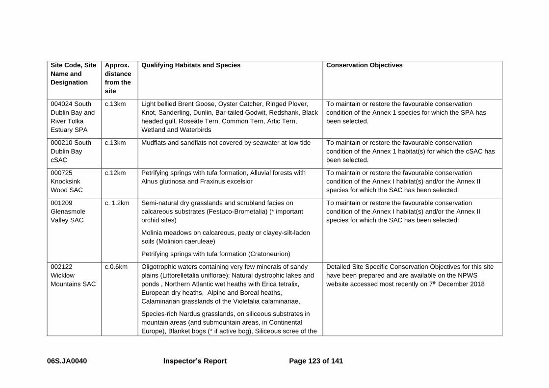
06S.JA0040 Inspector’s Report Page 123 of 141
Site Code, Site
Name and
Designation
Approx.
distance
from the
site
Qualifying Habitats and Species Conservation Objectives
004024 South
Dublin Bay and
River Tolka
Estuary SPA
c.13km Light bellied Brent Goose, Oyster Catcher, Ringed Plover,
Knot, Sanderling, Dunlin, Bar-tailed Godwit, Redshank, Black
headed gull, Roseate Tern, Common Tern, Artic Tern,
Wetland and Waterbirds
To maintain or restore the favourable conservation
condition of the Annex 1 species for which the SPA has
been selected.
000210 South
Dublin Bay
cSAC
c.13km Mudflats and sandflats not covered by seawater at low tide To maintain or restore the favourable conservation
condition of the Annex 1 habitat(s) for which the cSAC has
been selected.
000725
Knocksink
Wood SAC
c.12km Petrifying springs with tufa formation, Alluvial forests with
Alnus glutinosa and Fraxinus excelsior
To maintain or restore the favourable conservation
condition of the Annex I habitat(s) and/or the Annex II
species for which the SAC has been selected:
001209
Glenasmole
Valley SAC
c. 1.2km Semi-natural dry grasslands and scrubland facies on
calcareous substrates (Festuco-Brometalia) (* important
orchid sites)
Molinia meadows on calcareous, peaty or clayey-silt-laden
soils (Molinion caeruleae)
Petrifying springs with tufa formation (Cratoneurion)
To maintain or restore the favourable conservation
condition of the Annex I habitat(s) and/or the Annex II
species for which the SAC has been selected:
002122
Wicklow
Mountains SAC
c.0.6km Oligotrophic waters containing very few minerals of sandy
plains (Littorelletalia uniflorae); Natural dystrophic lakes and
ponds , Northern Atlantic wet heaths with Erica tetralix,
European dry heaths, Alpine and Boreal heaths,
Calaminarian grasslands of the Violetalia calaminariae,
Species-rich Nardus grasslands, on siliceous substrates in
mountain areas (and submountain areas, in Continental
Europe), Blanket bogs (* if active bog), Siliceous scree of the
Detailed Site Specific Conservation Objectives for this site
have been prepared and are available on the NPWS
website accessed most recently on 7th December 2018

06S.JA0040 Inspector’s Report Page 124 of 141
Site Code, Site
Name and
Designation
Approx.
distance
from the
site
Qualifying Habitats and Species Conservation Objectives
montane to snow levels (Androsacetalia alpinae and
Galeopsietalia ladani), Calcareous rocky slopes with
chasmophytic vegetation, Siliceous rocky slopes with
chasmophytic vegetation, Old sessile oak woods with Ilex
and Blechnum in the British Isles, Lutra lutra (Otter).
004040
Wicklow
Mountains SPA
c.0.9km Merlin, Peregrine Falcon To maintain or restore the favourable conservation
condition of the bird species listed as Special Conservation
Interests for this SPA

06S.JA0040 Inspector’s Report Page 125 of 141
Assessment of likely effects
12.4.1. The site is not within a designated site, thus there would be no direct effects from the
proposed development in terms of land-take or construction footprint. Each of the
designated sites are assessed below.
Wicklow Mountains SPA
12.4.2. This SPA is located to the south (c.900m) of the site area. Impacts of the
development on this site will, therefore, be indirect i.e. they will not arise as a result
of land-take or directly from construction (e.g. disturbance of habitats).
12.4.3. Table 4 of the Screening Report addresses the likely significant effects of the project
on the qualifying interests and each attribute.
12.4.4. Following the second request for Further Information the applicant carried out Bird
Surveys over the breeding season of 2018. No evidence of Merlin using the site for
nesting was found.
12.4.5. At the oral hearing there was much discussion regarding the numbers of Merlin in
the Dublin/Wicklow Mountains and the efficacy of the bird surveys carried out by the
applicant. The AA Screening Report on page 46 states that the population size in the
Wicklow Mountains SPA is c. 5 - 10 pairs13. The applicant’s response to the first
request for Further Information continued to state that Merlins prefer to nest in heath
and blanket bog and the conifer plantations are unlikely to provide an important
nesting resource for this species. Following this response by the applicant, the
NPWS observed that in fact out of 25 nesting sites only two were not in trees in the
Wicklow Mountains. As noted the applicant was requested to carry out a Bird Survey
in February 2018 to assist the Board assess the project. In the response to the Bird
Survey the report states that recent studies in Ireland have shown that Merlin now
have a strong preference for conifer plantations close to suitable hunting habitat and
that they usually nest in old nests of corvid species such as Hooded Crow and raise
one brood per year consisting of 3 – 5 chicks.
12.4.6. The efficacy of that survey was discussed at length at the hearing. An observer
made reference to the fact that the applicant, within their Bird Survey report in
13 The Wicklow Mountains SPA Site Synopsis appended to the AA Screening Report notes 9 pairs

06S.JA0040 Inspector’s Report Page 126 of 141
section 3.2, states that it is widely accepted that Merlin is difficult to survey. Having
regard to the fact that it is agreed by all parties that Merlin are difficult to survey, I
have concerns with one season of surveying and moreover the fact that the survey
was undertaken only once per month from April to July 2018.
12.4.7. As has been noted numerous times throughout this report, I am of the opinion that
the impact on the environment of a threefold increase in visitor numbers has not
been adequately assessed. The main focus of the applicant in my opinion was the
impact of the physical works and the small area of those works. There was
discussion at the oral hearing regarding the scientific papers that were quoted by the
applicant, whereby the applicant states that the findings of the papers indicate that
walkers were unlikely to have resulted in a decline in Merlin (Newtown et al, 1981
and Meek 1988). The observer argued that there are no such findings quoted in the
papers. The statement read out by the applicant’s ecologist at the oral hearing
indicated that the potential impacts that were examined included the impact of
increased numbers of visitors accessing the Natura 2000 sites from the proposed
development, as well as impacts on Merlin which potentially nest in the conifer
plantations on Montpelier Hill. However, this is not specifically addressed in the
Screening Report. The increase in visitor numbers to the area has the potential to
significantly increase human presence in the adjacent SPA which may cause
disturbance to birds. The replacement of 26Ha of conifer plantation, the agreed
preferred nesting site of Merlin in the Mountains, is part of the project before the
Board. Ex-situ impacts may occur and mitigation measures may be required which
have not been assessed.
12.4.8. Having regard to the above, I am not satisfied that the possibility of there being a
significant effect on the qualifying interests of the SPA can reasonably be excluded
and am of the opinion that a Stage 2 Appropriate Assessment must be carried out.
Glenasmole Valley SAC
12.4.9. This SAC is located to the west of the site area. Impacts of the development on this
site will, therefore, be indirect i.e. they will not arise as a result of land take or directly
from construction (e.g. disturbance of habitats). The works proposed are mostly on
the eastern side of Montpelier Hill and there are no hydrological links to this SAC.
06S.JA0040 Inspector’s Report Page 127 of 141
12.4.10. Table 2 of the Screening Report addresses the likely significant effects of the
project on each of the qualifying interests and each attribute. The applicant took into
account attributes and targets for the qualifying interests common in other SACs
already available. It is concluded that having regard to the fact that there is no land
take and the distance between the project and the qualifying features of the SAC,
there will not be a significant effect.
12.4.11. The Further Information request included a request for the applicant to
address the possibility of the proposed new visitor centre forming a starting point for
the Dublin Mountain Way and the potential issue of cumulative impacts on the
nearby Natura 2000 sites in terms of increase in visitor numbers. The applicant’s
response states that the Dublin Mountain Visitor Centre will link directly to a spur of
the Dublin Mountains Way. The spur currently circles Montpelier Hill and follows the
existing paths in Massy’s Woods where it follows the Glendoo Brook upstream to the
bend in the Cruagh Road where it joins the main trail of the Dublin Mountain Way. It
is further stated that the Dublin Mountain Way does not enter the Wicklow Mountains
SAC or SPA but does enter the Glenasmole Valley SAC at the top of the reservoir.
12.4.12. There are links from the Dublin Mountain Way which lead into the nearby
designated sites. Thus, I am not satisfied that the impact of increasing numbers of
visitors threefold has been assessed with respect to these sites and how they may
impact on the conservation objectives of the sites. With respect to the Glenasmole
Valley in particular, the applicant states that the Dublin Mountain Way does enter this
SAC but that the protected habitats occur on farmland and are not accessible to the
public. This is queried by observers who state that there is no basis for the statement
with respect to the qualifying interests occurring on farmland or in private ownership.
The observers state that no such statement is recorded in the site synopsis or any
publicly available information which I concur with.
12.4.13. The proposal is noted as being the ‘Flagship Project’ for the Dublin Mountains
area. It is an objective of the project to significantly increase the number of visitors
and I consider it likely that a significant number of visitors will use the visitor centre
as a new starting point for the Dublin Mountain Way. I consider it entirely feasible
that there will be an increase in numbers entering all the Natura 2000 sites including
the Glenasmole Valley SAC. While surveys were carried out as part of the Further
Information response by the applicant, there has been no assessment of the impact
06S.JA0040 Inspector’s Report Page 128 of 141
of that increase and the possibility of effects cannot reasonably be excluded having
regard to the precautionary principle. Mitigation measures may be required for all the
Natura 2000 sites. Clearly where mitigation measures may be required, these must
be assessed in a Stage 2 Appropriate Assessment.
12.4.14. Having regard to the above, I am not satisfied that the possibility of there
being a significant effect on the qualifying interests of the SAC can reasonably be
excluded and am of the opinion that a Stage 2 Appropriate Assessment must be
carried out.
Wicklow Mountains SAC
12.4.15. This SAC is located to the south of the site area. Impacts of the development
on this site will, therefore, be indirect i.e. they will not arise as a result of land take or
directly from construction (e.g. disturbance of adjoining habitats). There is a
hydrological pathway linking the application site to this European site, albeit the
application site is downstream.
12.4.16. Table 3 of the Screening Report addresses the likely significant effects of the
project on the qualifying interests and each attribute. At the time of preparation of the
Screening Report there were no specific site conservation objectives available. The
site-specific data was published on the 31st July 2017.
12.4.17. Notwithstanding the crossover in dates, the applicant took into account
attributes and targets for the qualifying interests common in other SACs already
available. The table lists the source for the data for each qualifying interest.
12.4.18. It is concluded that having regard to the fact that there is no land take and the
distance between the project and the qualifying feature of the SAC, there will not be
a significant effect.
12.4.19. As noted above for the Wicklow Mountains SPA and the Glenasmole Valley
SAC, I have concerns with respect to the increase in visitor numbers. Mitigation
measures may be required. Likely significant effects cannot be excluded having
regard to the precautionary principle and therefore a Stage 2 Appropriate
Assessment must be carried out.
06S.JA0040 Inspector’s Report Page 129 of 141
South Dublin Bay and River Tolka Estuary SPA
12.4.20. The SPA is located c.13km to the north-east of the site. This site is not
assessed within the Screening Report. The Glendoo Brook meets the Owendoher
River which is tributary of the River Dodder. The River Dodder enters Dublin Bay
adjacent to, but not within this SPA. Having regard to the distances involved and the
qualifying interests, I am satisfied that there are no pathways linking the application
site to this European site.
South Dublin Bay cSAC
12.4.21. The SAC is located c.13km to the north-east of the site. This site is not
assessed within the Screening Report. Having regard to the distances involved and
the qualifying interests, I am satisfied that there are no pathways linking the
application site to this European site.
Knocksink Wood SAC
12.4.22. This SAC is located c.12km to the south-east of the site. This site is not
assessed within the Screening Report. Having regard to the distances involved and
the qualifying interests, I am satisfied that there are no pathways linking the
application site to this European site.
Overall assessment of likely significant effects
12.5.1. The Screening Report submitted by the applicant concludes that no element of the
construction or operational phases of the proposed project has potential to affect the
Conservation Objectives of the Natura 2000 sites. However, based on the above, I
am not satisfied that the possibility of effects cannot reasonably be excluded having
regard to the precautionary principle.
12.5.2. The increase in visitor numbers to the area has the potential to significantly increase
human presence in the adjacent SPA which may cause disturbance to birds. The
replacement of 26Ha of conifer plantation, the agreed preferred nesting site of Merlin
in the Mountains, is part of the project before the Board. Ex-situ impacts may occur
and mitigation measures may be required which have not been assessed. While a
bird survey was carried out by the applicant, I am not satisfied having regard to the
agreed difficulties of surveying merlins by all parties, that the possibility of ex-situ

06S.JA0040 Inspector’s Report Page 130 of 141
impacts on merlins can reasonably be excluded based on that survey. I consider that
further surveying is necessary which may result in mitigation measures being
required and therefore a Stage 2 Appropriate Assessment is needed.
12.5.3. The threefold increase in visitor numbers and the resulting increase in footfall on the
three nearby European sites has not been adequately assessed and may require
mitigation measures. Therefore, a Stage 2 Appropriate Assessment is needed.
Screening Statement and Conclusions
On the basis of the information provided with the application and in the absence of a
Natura Impact Statement the Board cannot be satisfied that the proposed
development would not be likely to have a significant effect on European Sites
Glenasmole Valley SAC (Site Code 001209), Wicklow Mountains SAC (Site Code
002122), and Wicklow Mountains SPA (Site Code 004040) in view of the site’s
Conservation Objectives. In such circumstances the Board is precluded from
granting approval.
06S.JA0040 Inspector’s Report Page 131 of 141
13.0 Overall Conclusion
13.1.1. In conclusion, having regard to national, regional and local policies and objectives I
consider that the principle of the development of a visitor centre and a Dublin
Mountains ‘flagship’ facility is supported. This is the case particularly with respect to
the South Dublin Tourism Strategy 2015 which is an objective of the Development
Plan to be supported. A visitor facility with ‘panoramic views’ potentially located in
Montpelier Hill (or Killakee Mountain) is specifically referred to.
13.1.2. I consider that the project will address serious parking issues being experienced at
the site at the moment. I am of the opinion that a ‘do nothing’ approach is untenable
and that the project provides significant planning gain in terms of providing footpaths
and advisory cycle lanes down the R115 and Gunny Hill to the nearest urban areas
and various bus stops etc., as well as providing safe access to both amenities on
either side of the R115.
13.1.3. I am of the opinion that a restaurant is established as being part of a visitor centre
having regard to other similar facilities in the country. The restaurant will undoubtedly
be a draw and attract other visitors to the site including domestic and international
visitors who would normally bypass this site – which is one of the aims of the project.
There is a potential conflict in the Development Plan with the caveat in the Land Use
Zoning matrix which seeks to ensure restaurants are located within existing
premises. It could be argued that other alternatives exist, but these are not before
the Board and the applicant argues that they will not meet the full objectives of the
project.
13.1.4. I have significant concerns with the impact of the project on biodiversity both in terms
of the habitats and species on the site, and the potential impact on the nearby
designated sites. I am not satisfied that the potential impact has been adequately
assessed. Furthermore, I am of the opinion that a Stage 2 Natura Impact
Assessment is required to reasonably exclude the possibility of there being a
significant effect on the qualifying interests of the nearby Natura 2000 sites. I note
that rather than the Board refuse to approve the development, it is open to the Board
to request a Natura Impact Statement from the applicant at this stage as a Further
Information request, should the Board consider the proposal to be otherwise
acceptable.

06S.JA0040 Inspector’s Report Page 132 of 141
13.1.5. Should the Board accept this approach, I draw the Board’s attention to the other
aspects of the proposed development which I recommend should be the subject of
conditions, if the Board are minded to approve the proposal.
13.1.6. I have noted elsewhere in this document where and why I recommend conditions are
appropriate which would include: 1. Omission of the treetop bridge and canopy
walkway; 2. Omission of the bridleway in Massy’s woods; 3. Invasive species
management; 4. Appointment of liaison officer throughout the construction and
operational stage of the proposal; 5. Inclusion of the pedestrian crossing at the
entrance to the car park; 6. Archaeology monitoring for subsurface and unknown
archaeology; and 7. Ecological pre and post monitoring.
14.0 Recommendation
On the basis of the above assessment, I recommend that the Board REFUSE to
APPROVE the proposed development for the reasons and consideration set out
below.
15.0 Reasons and Considerations
In coming to its decision, the Board had regard to the following:
1. EU legislation including in particular Directive 92/43/EEC (Habitats Directive)
and Directive 79/409/EEC as amended by 2009/147/EC (Birds Directive)
which set the requirements for conservation of Natural Habitats and of Wild
Fauna and Flora throughout the European Union.
2. The relevant provisions of EU Directive 2014/52/EU amending Directive
2011/92/EU (EIA Directive) on the assessment of the effects of certain public
and private projects on the environment.
3. The Water Framework Directive (2000/60/EC).
4. National Policy including in particular:
• The National Planning Framework (NPF), 2018.
5. Regional Policy including in particular:
• Regional Planning Guidelines for the Greater Dublin Area 2010-2022.

06S.JA0040 Inspector’s Report Page 133 of 141
6. Local Planning Policy including in particular:
• The provisions of the South Dublin County Development Plan 2016-
2022.
7. The following matters:
• The likely consequences for the environment and the proper planning
and sustainable development of the area in which is it proposed to
carry out the proposed development and the likely significant effects of
the proposed development on European Sites.
• The conservation objectives, qualifying interests and special
conservation interests of the Wicklow Mountain SPA (Site Code
004040), Glenasmole Valley SAC (Site Code 001209), and the
Wicklow Mountains SAC (Site Code 002122)
• The documentation and submissions of the applicant, including the
environmental impact assessment report and associated
documentation submitted with the application, and the range of
mitigation and monitoring measures proposed.
• The submissions and observations made to An Bord Pleanála in
connection with the application and at the oral hearing.
• The nature and extent of the proposed development as set out in the
application for approval.
• The report and recommendation of the inspector including the
examination, analysis and evaluation undertaken in relation to
appropriate assessment screening and environmental impact
assessment.
Proper Planning and Sustainable Development
It is considered that the principle of the proposed development is acceptable and
would support the aim of encouraging access to the Dublin Mountains at a national
and regional level and support the development of a visitor facility in or adjacent to
the High Amenity – Dublin Mountains zone (HA-DM), as identified at a local level.
06S.JA0040 Inspector’s Report Page 134 of 141
Environmental Impact Assessment
15.2.1. The Board undertook an Environmental Impact Assessment of the proposed
development, taking into account:
• the nature, scale, location and extent of the proposed development,
• the Environmental Impact Assessment Report and associated documentation
submitted in support of the application,
• the submissions from the applicant, the observers and the prescribed bodies
in the course of the application, and
• the Inspector’s report.
15.2.2. The Board considered that the environmental impact assessment report, supported
by the documentation submitted by the applicant, notwithstanding concerns in
relation to Biodiversity, provided information which was reasonable and sufficient to
allow the Board to reach a reasoned conclusion on the significant effects of the
project on the environment, taking into account current knowledge and methods of
assessment and complies with the provisions of EU Directive 2014/52/EU amending
Directive 2011/92/EU and Section 172 of the Planning and Development Act (as
amended). The Board is satisfied that the information and data available and the
reasoned conclusion is up to date at the time of taking the decision.
15.2.3. The Board agreed with the summary and examination, set out in the Inspector’s
report, of the information contained in the environmental impact assessment report
and associated documentation submitted by the applicant and submissions made in
the course of the application. The Board is satisfied the Inspector’s report sets out
how these were addressed in the examination and recommendation and are
incorporated into the Boards decision.
Reasoned Conclusion on the Significant Effects
15.2.4. Having regard to the examination of environmental information contained above, to
the EIAR and supplementary information provided by the applicant, and the
submissions from the observers and prescribed bodies in the course of the
application including submissions made to the oral hearing, it is considered that the

06S.JA0040 Inspector’s Report Page 135 of 141
main significant direct and indirect effects of the proposed development in the
environment are as follows:
• Biodiversity: Impacts to habitats and species could arise during construction of
the physical works due to disturbance and loss of habitat. These impacts will be
mitigated following measures outlined in the Construction Management Plan
and specific mitigation measures for Key Ecological Receptors. With respect to
operation, the Board is not satisfied that the potential impacts have been
adequately assessed in particular to the impact of the increase in footfall on the
environment, the introduction of horses into Massy’s woods, the impact of the
replacement of 26Ha of conifer plantation on the qualifying interests of the
adjacent SPA and the cumulative impact of the increasing numbers of visitors
on the nearby designated sites. The Board is not satisfied that the information
submitted by the applicant enables the Board to conclude that there will not be a
significant effect on the biodiversity of the area. The proposed development
may, therefore, have a significant effect on the environment.
• Population and Human Health: The Board is satisfied that impacts on
amenities of local landowners due to increases in the numbers of people
potentially trespassing will be mitigated by the installation of additional fencing
and the increased presence of management staff.
• Material Assets, Landscape and Visual Impact: The Board is satisfied that
impacts on the landscape and impacts on protected views have been mitigated
with the design of the visitor centre and the car park as well as the landscape
strategy. The visual impact of the treetop canopy can be avoided with the
omission of this element of the proposal.
• Material Assets, Cultural Heritage: The Board is satisfied that impacts on the
archaeology and architecture of the area have been mitigated by the minimal
interference approach on the existing structures and the improvements of
existing trails. Potential impacts as a result of the new structures and trails will
be mitigated by monitoring and test excavations.
• Material Assets, Traffic and Transportation: The Board is satisfied that
impacts during construction will be mitigated by the implementation of a
Construction and Traffic Management Plan. Impacts during operation will be
mitigated by improvement in access to the site for other sustainable modes of

06S.JA0040 Inspector’s Report Page 136 of 141
transport, as well as an increase in the car parking availability thereby avoiding
the need to park on the external road.
The Board completed an environmental impact assessment in relation to the
proposed development. The EIAR has considered that the main direct and indirect
effects of the proposed development on the environment would be primarily
mitigated by environmental management measures. The Board is not satisfied
however, that following mitigation, no significant residual negative impacts on the
environment would remain as a result of the proposed scheme with respect to
biodiversity. The proposed development may, therefore, have an unacceptable effect
on the environment.
Appropriate Assessment:
The Board completed an Appropriate Assessment Screening exercise in relation to
the potential effects of the proposed development on European Sites, taking into
account the nature, scale and location of the proposed development, the Appropriate
Assessment Screening Report submitted with the application and the Inspector’s
report and submissions on file.
In completing the screening exercise, the Board adopted the report of the Inspector
and concluded that, on the basis of the information provided with the application and
in the absence of a Natura Impact Statement the Board cannot be satisfied that the
proposed development individually, or in combination with other plans or projects
would not be likely to have a significant effect on European Sites Glenasmole Valley
SAC (Site Code 001209), Wicklow Mountains SAC (Site Code 002122), and Wicklow
Mountains SPA (Site Code 004040) in view of the site’s Conservation Objectives.
Having regard to the nature and scale of the development, the increase in visitor
numbers to the area has the potential to significantly increase human presence in
the adjacent SPA which may cause disturbance to birds. The replacement of 26Ha
of conifer plantation, the agreed preferred nesting site of Merlin in the Dublin and
Wicklow Mountains, may result in ex-situ impacts and mitigation measures may be
required which have not been assessed. The increase in footfall in the adjacent
SACs has not been adequately assessed and may require mitigation measures.
06S.JA0040 Inspector’s Report Page 137 of 141
Therefore the Board cannot be satisfied that the proposed development would not
lead to adverse indirect effects on the conservation interests of the Wicklow
Mountain SPA (Site Code 004040) namely the merlin, and the habitats of the
Wicklow Mountain SAC (Site Code 002122) and the Glenasmole Valley SAC (Site
Code 001209) and there remains reasonable scientific doubt that there would be no
adverse effects.
In such circumstances the Board is precluded from granting approval and the
proposed development would, therefore, be contrary to the proper planning and
sustainable development of the area.
____________________________________ Ciara Kellett
Senior Planning Inspector
9th January 2019
06S.JA0040 Inspector’s Report Page 138 of 141
Appendix 1
Observers on initial application
Prescribed Bodies
1. Development Applications Unit
2. Fáilte Ireland
3. Inland Fisheries Ireland
4. An Taisce
Observers
1. Bohernabreena Branch of the Irish Farmers Association
2. Mary C. Booth
3. Cyril Boyd
4. Fiona Boyd
5. Richard Boyd Barrett and others
6. Michael Boyle
7. Ruth Brady
8. Eithne Brew and Aoife Bell-Brew
9. Colm Brophy
10. Patricia and Michael Campbell
11. Eithne Clarke
12. Peter Clarke
13. Paul Cleary
14. Anne Codd
15. Imelda Colgan
16. Anna and Dermot Collins
17. Concerned Residents of Killakee
18. Alison Couper
19. Deirdre Cronin
20. Lucy Cullen
21. Luke Daly
22. Leslie Davey
23. Andrew Davidson

06S.JA0040 Inspector’s Report Page 139 of 141
24. Elizabeth Davidson
25. Dermot Deering and others
26. Dodder Anglers Association Dublin
27. Frank Doyle
28. Francis Noel Duffy
29. Sylvia Ferguson
30. Michael Fewer
31. Nadine Fiebich and Fergal McVeigh
32. Friends of Massy’s Wood
33. Karen Gleeson
34. Niamh Gleeson
35. Germaine Gray
36. Selina Guinness
37. Killian Halpin
38. Clare and Niall Hamilton
39. Hellfire Massy Residents Association & Others
40. Dara Hogan
41. Niamh Hogan and others
42. Aisling, Pat and Jasmine Howard
43. Irish Georgian Society
44. Keep Ireland Open Ltd.
45. John Kelly
46. Roisin Kelly
47. Gerard Kennedy
48. Padraig Lambert
49. John Lawlor
50. Jeanette McCallion
51. Michael McCarthy
52. Anne McCluskey
53. Declan McKeever
54. David McMunn
55. Liam McNevin
56. Valerie Mercer
57. Margaret Merrigan-Feenan

06S.JA0040 Inspector’s Report Page 140 of 141
58. Phyllis Mitten
59. Patrick Molloy and others
60. Christopher Moriarty
61. Sean Keir Moriarty
62. Ivan Morrin
63. Mountaineering Ireland
64. Shay Murphy
65. Rachel Murray
66. Peter O’Clery
67. Angela O’Donoghue and others
68. Vincent O’Hagan
69. Breda O’Meara-Diamond
70. Niamh O’Reilly
71. Geraldine Quinn
72. Margaret and Brian Richardson
73. Elizabeth Ryan and others
74. Killian Schurmann
75. Hester Scott
76. Rodrey W. Senior
77. Terry Sommerville
78. South Dublin Conservation Society
79. David Stanley
Appendix 2
Observers on Further Information
Prescribed Bodies
1. Development Applications Unit
2. Fáilte Ireland
3. Transport Infrastructure Ireland
Observers

06S.JA0040 Inspector’s Report Page 141 of 141
1. Bohernabreena Branch of the IFA
2. Boyd Barrett, Richard and others
3. Eithne Brew and Aoife Bell-Brew
4. Eithne Clarke
5. Anna and Dermot Collins
6. Concerned Residents of Killakee
7. Gabriel Cooney
8. Alison Cooper
9. Deirdre Cronin
10. Andrew Davidson
11. Elizabeth Davidson
12. Dermot Deering and Others
13. Frank Doyle
14. Sylvia Ferguson
15. Friends of Massy’s woods
16. Selina Guinness
17. Hellfire Massy Residents Association & others
18. Aisling, Pat & Jasmine Howard
19. Keep Ireland Open Ltd.
20. John Lawlor
21. Declan McKeever
22. Sean Keir Moriarty
23. Peter O’Clery
24. Angela O’Donoghue & Others
25. Hester Scott
26. South Dublin Conservation Society
27. David Stanley
28. Michael Tierney