inspection date / by spm outfall summary report
TRANSCRIPT

OUTFALL SUMMARY REPORT
DISTRICT DEPARTMENT OF THE ENVIRONMENT / DC WATER
MS4 PROGRAMGIS Outfall / Photo ID # F-754
Inspection Date / By 12/14/2012
GPS Longitude -77.00269
GPS Latitude 38.94453
SPM
Access From Hawaii Ave NE
Horiz. Dist. to Receiving Stream
Flared End
0
Headwall
0
None
0
Security Gate 0
Facility Name Catholic University
Land Use Education
Outfall Bank Location
Pipe Diameter
Height
Pipe Material
Width
Property Type Private
Receiving Stream Name
Description of Repair Approach
Watershed Name
NOTES
INVENTORY INFORMATION
inches
feet
feet
Culvert Dimensions
End Structure
looking DS
feet
%
CONDITION / CRITICALITY ASSESSMENT
(1)
(2)
(3)
Downstream Bank Slope
PHOTOS
Status NOT AN OUTFALL
Assessment Comments
inlet
Total = Stream Bank / Pool x2 + Structure + CriticalityTotal Score 0
Horiz. Distance from Roadway
Vert. Distance from Roadway
feet
feet
Vert. Dist. to Receiving Stream feet
Stable
Excellent / Like New
Normal
Stream Bank / Pool 0
Stream Bank / Pool (x2) 0
Structure 0
Criticality 0
Repairs Recommended?
NO

OUTFALL SUMMARY REPORT
DISTRICT DEPARTMENT OF THE ENVIRONMENT / DC WATER
MS4 PROGRAMGIS Outfall / Photo ID # F-754
Inspection Date / By 12/14/2012
GPS Longitude -77.00269
GPS Latitude 38.94453
SPM
(4)
(6) (7)
(8) (9)
(5)

OUTFALL SUMMARY REPORT
DISTRICT DEPARTMENT OF THE ENVIRONMENT / DC WATER
MS4 PROGRAMGIS Outfall / Photo ID # F-755
Inspection Date / By 12/14/2012
GPS Longitude -77.00269
GPS Latitude 38.94449
SPM
Access From Hawaii Ave NE
Horiz. Dist. to Receiving Stream
Flared End
0
Headwall
0
None
0
Security Gate 0
Facility Name Catholic University
Land Use Education
Outfall Bank Location
Pipe Diameter
Height
Pipe Material
Width
Property Type Private
Receiving Stream Name
Description of Repair Approach
Watershed Name
NOTES
INVENTORY INFORMATION
inches
feet
feet
Culvert Dimensions
End Structure
looking DS
feet
%
CONDITION / CRITICALITY ASSESSMENT
(1)
(2)
(3)
Downstream Bank Slope
PHOTOS
Status UNABLE TO LOCATE
Assessment Comments
Total = Stream Bank / Pool x2 + Structure + CriticalityTotal Score 0
Horiz. Distance from Roadway
Vert. Distance from Roadway
feet
feet
Vert. Dist. to Receiving Stream feet
Stable
Excellent / Like New
Normal
Stream Bank / Pool 0
Stream Bank / Pool (x2) 0
Structure 0
Criticality 0
Repairs Recommended?
NO

OUTFALL SUMMARY REPORT
DISTRICT DEPARTMENT OF THE ENVIRONMENT / DC WATER
MS4 PROGRAMGIS Outfall / Photo ID # F-755
Inspection Date / By 12/14/2012
GPS Longitude -77.00269
GPS Latitude 38.94449
SPM
(4)
(6) (7)
(8) (9)
(5)

OUTFALL SUMMARY REPORT
DISTRICT DEPARTMENT OF THE ENVIRONMENT / DC WATER
MS4 PROGRAMGIS Outfall / Photo ID # F-758
Inspection Date / By 11/20/2012
GPS Longitude -76.91365
GPS Latitude 38.88964
SPM
Access From 61th St NE
Horiz. Dist. to Receiving Stream
Flared End
0
Headwall
0
None
0
Security Gate 0
Facility Name NA
Land Use Watts Branch
Outfall Bank Location Left
Pipe Diameter
Height
Pipe Material
Width
Property Type DC Parks & Rec
Receiving Stream Name Watts Branch
Description of Repair Approach
Watershed Name Anacostia
NOTES
INVENTORY INFORMATION
inches
feet
feet
Culvert Dimensions
End Structure
looking DS
feet
%
CONDITION / CRITICALITY ASSESSMENT
(1)
(2)
(3)
Downstream Bank Slope
PHOTOS
Status NOT AN OUTFALL
Assessment Comments
Total = Stream Bank / Pool x2 + Structure + CriticalityTotal Score 0
Not an outfall. Storm sewer pipe feeds into culvert that is titled F-535.
Horiz. Distance from Roadway
Vert. Distance from Roadway
feet
feet
Vert. Dist. to Receiving Stream feet
Stable
Excellent / Like New
Normal
Stream Bank / Pool 0
Stream Bank / Pool (x2) 0
Structure 0
Criticality 0
Repairs Recommended?
NO

OUTFALL SUMMARY REPORT
DISTRICT DEPARTMENT OF THE ENVIRONMENT / DC WATER
MS4 PROGRAMGIS Outfall / Photo ID # F-758
Inspection Date / By 11/20/2012
GPS Longitude -76.91365
GPS Latitude 38.88964
SPM
(4)
(6) (7)
(8) (9)
(5)

OUTFALL SUMMARY REPORT
DISTRICT DEPARTMENT OF THE ENVIRONMENT / DC WATER
MS4 PROGRAMGIS Outfall / Photo ID # F-759
Inspection Date / By 11/20/2012
GPS Longitude -76.91378
GPS Latitude 38.88979
SPM
Access From 61th St NE
Horiz. Dist. to Receiving Stream
Flared End
0
Headwall
0
None
0
Security Gate 0
Facility Name NA
Land Use Watts Branch
Outfall Bank Location
Pipe Diameter
Height
Pipe Material
Width
Property Type DC Parks & Rec
Receiving Stream Name Watts Branch
Description of Repair Approach
Watershed Name Anacostia
NOTES
INVENTORY INFORMATION
inches
feet
feet
Culvert Dimensions
End Structure
looking DS
feet
%
CONDITION / CRITICALITY ASSESSMENT
(1)
(2)
(3)
Downstream Bank Slope
PHOTOS
Status NOT AN OUTFALL
Assessment Comments
Total = Stream Bank / Pool x2 + Structure + CriticalityTotal Score 0
Not an outfall. Storm sewer pipe feeds into culvert which ends as the outfall titled F-535.
Horiz. Distance from Roadway
Vert. Distance from Roadway
feet
feet
Vert. Dist. to Receiving Stream feet
Stable
Excellent / Like New
Normal
Stream Bank / Pool 0
Stream Bank / Pool (x2) 0
Structure 0
Criticality 0
Repairs Recommended?
NO

OUTFALL SUMMARY REPORT
DISTRICT DEPARTMENT OF THE ENVIRONMENT / DC WATER
MS4 PROGRAMGIS Outfall / Photo ID # F-759
Inspection Date / By 11/20/2012
GPS Longitude -76.91378
GPS Latitude 38.88979
SPM
(4)
(6) (7)
(8) (9)
(5)

OUTFALL SUMMARY REPORT
DISTRICT DEPARTMENT OF THE ENVIRONMENT / DC WATER
MS4 PROGRAMGIS Outfall / Photo ID # F-760
Inspection Date / By 10/10/2012
GPS Longitude -77.00005
GPS Latitude 38.82212
SPM
Access From Southern Ave SE
Horiz. Dist. to Receiving Stream
Flared End
0
Headwall
1
None
0
Security Gate 0
Facility Name NA
Land Use NA
Outfall Bank Location Right
Pipe Diameter 12
Height
Pipe Material RCP
Width
Property Type DDOT
Receiving Stream Name Oxon Run
Description of Repair Approach
Watershed Name Anacostia
NOTES
INVENTORY INFORMATION
inches
feet
feet
Culvert Dimensions
End Structure
looking DS
feet
%
CONDITION / CRITICALITY ASSESSMENT
(1)
(2)
(3)
Downstream Bank Slope
PHOTOS
Status OUTFALL
Assessment Comments
Minor cracking of concrete channel wall above and around pipe.
Total = Stream Bank / Pool x2 + Structure + CriticalityTotal Score 1
Horiz. Distance from Roadway
Vert. Distance from Roadway
feet
feet
Vert. Dist. to Receiving Stream feet
Stable
Moderate
Normal
Stream Bank / Pool 0
Stream Bank / Pool (x2) 0
Structure 1
Criticality 0
Repairs Recommended?
NO

OUTFALL SUMMARY REPORT
DISTRICT DEPARTMENT OF THE ENVIRONMENT / DC WATER
MS4 PROGRAMGIS Outfall / Photo ID # F-760
Inspection Date / By 10/10/2012
GPS Longitude -77.00005
GPS Latitude 38.82212
SPM
(4)
(6) (7)
(8) (9)
(5)

OUTFALL SUMMARY REPORT
DISTRICT DEPARTMENT OF THE ENVIRONMENT / DC WATER
MS4 PROGRAMGIS Outfall / Photo ID # F-763
Inspection Date / By 10/10/2012
GPS Longitude -76.99908
GPS Latitude 38.82287
SPM
Access From Forrester St SE
Horiz. Dist. to Receiving Stream 0-10ft
Flared End
0
Headwall
1
None
0
Security Gate 0
Facility Name NA
Land Use Oxon Run Park
Outfall Bank Location Right
Pipe Diameter 12
Height
Pipe Material RCP
Width
Property Type DC Parks & Rec
Receiving Stream Name Oxon Run
Description of Repair Approach
Watershed Name Anacostia
NOTES
INVENTORY INFORMATION
inches
feet
feet
Culvert Dimensions
End Structure
looking DS
feet
%
CONDITION / CRITICALITY ASSESSMENT
(1)
(2)
(3)
Downstream Bank Slope
PHOTOS
Status OUTFALL
Assessment Comments
Total = Stream Bank / Pool x2 + Structure + CriticalityTotal Score 0
Horiz. Distance from Roadway
Vert. Distance from Roadway
feet
feet
Vert. Dist. to Receiving Stream feet
Stable
Excellent / Like New
Normal
Stream Bank / Pool 0
Stream Bank / Pool (x2) 0
Structure 0
Criticality 0
Repairs Recommended?
NO

OUTFALL SUMMARY REPORT
DISTRICT DEPARTMENT OF THE ENVIRONMENT / DC WATER
MS4 PROGRAMGIS Outfall / Photo ID # F-763
Inspection Date / By 10/10/2012
GPS Longitude -76.99908
GPS Latitude 38.82287
SPM
(4)
(6) (7)
(8) (9)
(5)

OUTFALL SUMMARY REPORT
DISTRICT DEPARTMENT OF THE ENVIRONMENT / DC WATER
MS4 PROGRAMGIS Outfall / Photo ID # F-764
Inspection Date / By 11/27/2012
GPS Longitude -76.95763
GPS Latitude 38.93079
SPM
Access From Bladensburg Rd (Md)
Horiz. Dist. to Receiving Stream
Flared End
0
Headwall
0
None
0
Security Gate 0
Facility Name NA
Land Use NA
Outfall Bank Location
Pipe Diameter
Height
Pipe Material
Width
Property Type NA
Receiving Stream Name
Description of Repair Approach
Watershed Name
NOTES
INVENTORY INFORMATION
inches
feet
feet
Culvert Dimensions
End Structure
looking DS
feet
%
CONDITION / CRITICALITY ASSESSMENT
(1)
(2)
(3)
Downstream Bank Slope
PHOTOS
Status NOT AN OUTFALL
Assessment Comments
Total = Stream Bank / Pool x2 + Structure + CriticalityTotal Score 0
Horiz. Distance from Roadway
Vert. Distance from Roadway
feet
feet
Vert. Dist. to Receiving Stream feet
Stable
Excellent / Like New
Normal
Stream Bank / Pool 0
Stream Bank / Pool (x2) 0
Structure 0
Criticality 0
Repairs Recommended?
NO

OUTFALL SUMMARY REPORT
DISTRICT DEPARTMENT OF THE ENVIRONMENT / DC WATER
MS4 PROGRAMGIS Outfall / Photo ID # F-764
Inspection Date / By 11/27/2012
GPS Longitude -76.95763
GPS Latitude 38.93079
SPM
(4)
(6) (7)
(8) (9)
(5)

OUTFALL SUMMARY REPORT
DISTRICT DEPARTMENT OF THE ENVIRONMENT / DC WATER
MS4 PROGRAMGIS Outfall / Photo ID # F-765
Inspection Date / By 11/19/2012
GPS Longitude -76.92666
GPS Latitude 38.89676
SPM
Access From Division Ave NE
Horiz. Dist. to Receiving Stream 20-30ft
Flared End
0
Headwall
1
None
0
Security Gate 0
Facility Name NA
Land Use Marvin Gaye Park
Outfall Bank Location Left
Pipe Diameter 54
Height
Pipe Material RCP
Width
Property Type DC Parks & Rec
Receiving Stream Name
Description of Repair Approach
N/A
Watershed Name
NOTES
INVENTORY INFORMATION
inches
feet
feet
Culvert Dimensions
End Structure
looking DS
feet
%
CONDITION / CRITICALITY ASSESSMENT
(1)
(2)
(3)
Downstream Bank Slope
PHOTOS
Status OUTFALL
Assessment Comments
Minor erosion behind head wall (left side).
Total = Stream Bank / Pool x2 + Structure + CriticalityTotal Score 1
Horiz. Distance from Roadway
Vert. Distance from Roadway
feet
feet
Vert. Dist. to Receiving Stream feet
Stable
Moderate
Normal
Stream Bank / Pool 0
Stream Bank / Pool (x2) 0
Structure 1
Criticality 0
Repairs Recommended?
NO

OUTFALL SUMMARY REPORT
DISTRICT DEPARTMENT OF THE ENVIRONMENT / DC WATER
MS4 PROGRAMGIS Outfall / Photo ID # F-765
Inspection Date / By 11/19/2012
GPS Longitude -76.92666
GPS Latitude 38.89676
SPM
(4)
(6) (7)
(8) (9)
(5)
OUTFALL SUMMARY REPORT
DISTRICT DEPARTMENT OF THE ENVIRONMENT / DC WATER
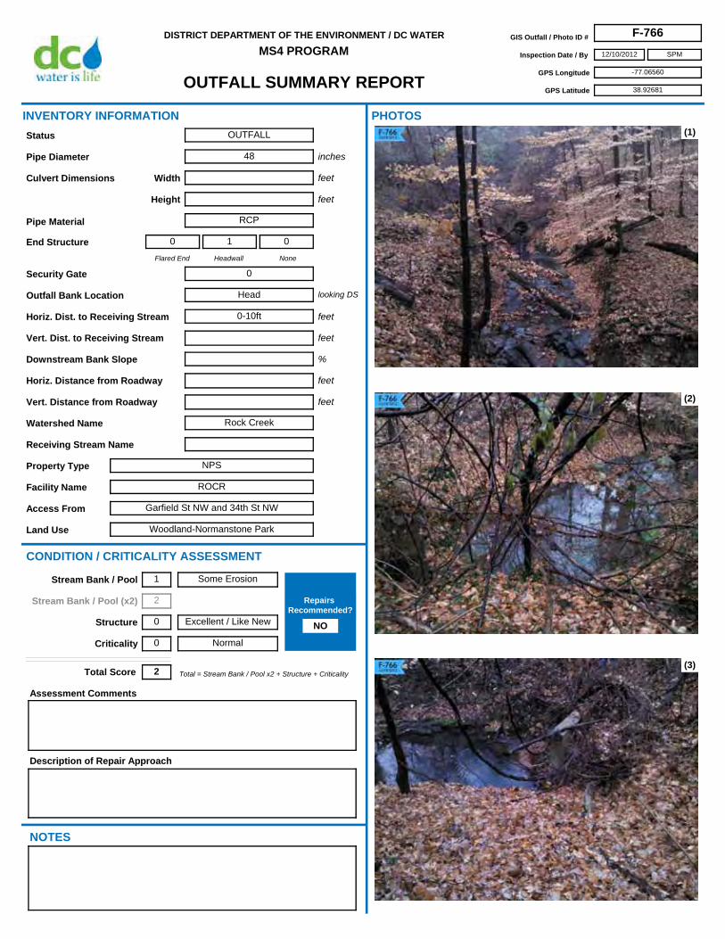
MS4 PROGRAMGIS Outfall / Photo ID # F-766
Inspection Date / By 12/10/2012
GPS Longitude -77.06560
GPS Latitude 38.92681
SPM
Access From Garfield St NW and 34th St NW
Horiz. Dist. to Receiving Stream 0-10ft
Flared End
0
Headwall
1
None
0
Security Gate 0
Facility Name ROCR
Land Use Woodland-Normanstone Park
Outfall Bank Location Head
Pipe Diameter 48
Height
Pipe Material RCP
Width
Property Type NPS
Receiving Stream Name
Description of Repair Approach
Watershed Name Rock Creek
NOTES
INVENTORY INFORMATION
inches
feet
feet
Culvert Dimensions
End Structure
looking DS
feet
%
CONDITION / CRITICALITY ASSESSMENT
(1)
(2)
(3)
Downstream Bank Slope
PHOTOS
Status OUTFALL
Assessment Comments
Total = Stream Bank / Pool x2 + Structure + CriticalityTotal Score 2
Horiz. Distance from Roadway
Vert. Distance from Roadway
feet
feet
Vert. Dist. to Receiving Stream feet
Some Erosion
Excellent / Like New
Normal
Stream Bank / Pool 1
Stream Bank / Pool (x2) 2
Structure 0
Criticality 0
Repairs Recommended?
NO

OUTFALL SUMMARY REPORT
DISTRICT DEPARTMENT OF THE ENVIRONMENT / DC WATER
MS4 PROGRAMGIS Outfall / Photo ID # F-766
Inspection Date / By 12/10/2012
GPS Longitude -77.06560
GPS Latitude 38.92681
SPM
(4)
(6) (7)
(8) (9)
(5)

OUTFALL SUMMARY REPORT
DISTRICT DEPARTMENT OF THE ENVIRONMENT / DC WATER
MS4 PROGRAMGIS Outfall / Photo ID # F-767
Inspection Date / By 12/12/2012
GPS Longitude -77.08354
GPS Latitude 38.92173
SPM
Access From New Mexico Ave NW
Horiz. Dist. to Receiving Stream
Flared End
0
Headwall
0
None
0
Security Gate 0
Facility Name ROCR
Land Use Glover Park
Outfall Bank Location
Pipe Diameter
Height
Pipe Material
Width
Property Type NPS
Receiving Stream Name
Description of Repair Approach
Watershed Name
NOTES
INVENTORY INFORMATION
inches
feet
feet
Culvert Dimensions
End Structure
looking DS
feet
%
CONDITION / CRITICALITY ASSESSMENT
(1)
(2)
(3)
Downstream Bank Slope
PHOTOS
Status NOT AN OUTFALL
Assessment Comments
Total = Stream Bank / Pool x2 + Structure + CriticalityTotal Score 0
Horiz. Distance from Roadway
Vert. Distance from Roadway
feet
feet
Vert. Dist. to Receiving Stream feet
Stable
Excellent / Like New
Normal
Stream Bank / Pool 0
Stream Bank / Pool (x2) 0
Structure 0
Criticality 0
Repairs Recommended?
NO

OUTFALL SUMMARY REPORT
DISTRICT DEPARTMENT OF THE ENVIRONMENT / DC WATER
MS4 PROGRAMGIS Outfall / Photo ID # F-767
Inspection Date / By 12/12/2012
GPS Longitude -77.08354
GPS Latitude 38.92173
SPM
(4)
(6) (7)
(8) (9)
(5)

OUTFALL SUMMARY REPORT
DISTRICT DEPARTMENT OF THE ENVIRONMENT / DC WATER
MS4 PROGRAMGIS Outfall / Photo ID # F-768
Inspection Date / By 12/11/2012
GPS Longitude -77.08260
GPS Latitude 38.92666
SPM
Access From New Mexico Ave NW
Horiz. Dist. to Receiving Stream
Flared End
0
Headwall
0
None
0
Security Gate 0
Facility Name ROCR
Land Use Glover Park
Outfall Bank Location
Pipe Diameter
Height
Pipe Material
Width
Property Type NPS
Receiving Stream Name
Description of Repair Approach
Watershed Name
NOTES
INVENTORY INFORMATION
inches
feet
feet
Culvert Dimensions
End Structure
looking DS
feet
%
CONDITION / CRITICALITY ASSESSMENT
(1)
(2)
(3)
Downstream Bank Slope
PHOTOS
Status NOT AN OUTFALL
Assessment Comments
Total = Stream Bank / Pool x2 + Structure + CriticalityTotal Score 0
Horiz. Distance from Roadway
Vert. Distance from Roadway
feet
feet
Vert. Dist. to Receiving Stream feet
Stable
Excellent / Like New
Normal
Stream Bank / Pool 0
Stream Bank / Pool (x2) 0
Structure 0
Criticality 0
Repairs Recommended?
NO

OUTFALL SUMMARY REPORT
DISTRICT DEPARTMENT OF THE ENVIRONMENT / DC WATER
MS4 PROGRAMGIS Outfall / Photo ID # F-768
Inspection Date / By 12/11/2012
GPS Longitude -77.08260
GPS Latitude 38.92666
SPM
(4)
(6) (7)
(8) (9)
(5)

OUTFALL SUMMARY REPORT
DISTRICT DEPARTMENT OF THE ENVIRONMENT / DC WATER
MS4 PROGRAMGIS Outfall / Photo ID # F-769
Inspection Date / By 12/11/2012
GPS Longitude -77.08103
GPS Latitude 38.93024
SPM
Access From Cathedral Dr NW
Horiz. Dist. to Receiving Stream
Flared End
0
Headwall
0
None
0
Security Gate 0
Facility Name ROCR
Land Use Glover Park
Outfall Bank Location
Pipe Diameter
Height
Pipe Material
Width
Property Type NPS
Receiving Stream Name
Description of Repair Approach
Watershed Name
NOTES
INVENTORY INFORMATION
inches
feet
feet
Culvert Dimensions
End Structure
looking DS
feet
%
CONDITION / CRITICALITY ASSESSMENT
(1)
(2)
(3)
Downstream Bank Slope
PHOTOS
Status UNABLE TO LOCATE
Assessment Comments
Total = Stream Bank / Pool x2 + Structure + CriticalityTotal Score 0
Horiz. Distance from Roadway
Vert. Distance from Roadway
feet
feet
Vert. Dist. to Receiving Stream feet
Stable
Excellent / Like New
Normal
Stream Bank / Pool 0
Stream Bank / Pool (x2) 0
Structure 0
Criticality 0
Repairs Recommended?
NO

OUTFALL SUMMARY REPORT
DISTRICT DEPARTMENT OF THE ENVIRONMENT / DC WATER
MS4 PROGRAMGIS Outfall / Photo ID # F-769
Inspection Date / By 12/11/2012
GPS Longitude -77.08103
GPS Latitude 38.93024
SPM
(4)
(6) (7)
(8) (9)
(5)

OUTFALL SUMMARY REPORT
DISTRICT DEPARTMENT OF THE ENVIRONMENT / DC WATER
MS4 PROGRAMGIS Outfall / Photo ID # F-770
Inspection Date / By 12/12/2012
GPS Longitude -77.05526
GPS Latitude 38.85819
SPM
Access From Ashby St NW
Horiz. Dist. to Receiving Stream
Flared End
0
Headwall
0
None
0
Security Gate 0
Facility Name NA
Land Use Palisades Recreational Park
Outfall Bank Location
Pipe Diameter
Height
Pipe Material
Width
Property Type DC Parks & Rec
Receiving Stream Name
Description of Repair Approach
Watershed Name
NOTES
INVENTORY INFORMATION
inches
feet
feet
Culvert Dimensions
End Structure
looking DS
feet
%
CONDITION / CRITICALITY ASSESSMENT
(1)
(2)
(3)
Downstream Bank Slope
PHOTOS
Status OUTFALL
Assessment Comments
Total = Stream Bank / Pool x2 + Structure + CriticalityTotal Score 1
Horiz. Distance from Roadway
Vert. Distance from Roadway
feet
feet
Vert. Dist. to Receiving Stream feet
Stable
Excellent / Like New
Important
Stream Bank / Pool 0
Stream Bank / Pool (x2) 0
Structure 0
Criticality 1
Repairs Recommended?
NO

OUTFALL SUMMARY REPORT
DISTRICT DEPARTMENT OF THE ENVIRONMENT / DC WATER
MS4 PROGRAMGIS Outfall / Photo ID # F-770
Inspection Date / By 12/12/2012
GPS Longitude -77.05526
GPS Latitude 38.85819
SPM
(4)
(6) (7)
(8) (9)
(5)

OUTFALL SUMMARY REPORT
DISTRICT DEPARTMENT OF THE ENVIRONMENT / DC WATER
MS4 PROGRAMGIS Outfall / Photo ID # F-771
Inspection Date / By 1/11/2013
GPS Longitude -76.94544
GPS Latitude 38.88609
SPM
Access From Valley Terrace SE
Horiz. Dist. to Receiving Stream
Flared End
0
Headwall
0
None
0
Security Gate 0
Facility Name NACE
Land Use Oxon Run Park
Outfall Bank Location
Pipe Diameter
Height
Pipe Material
Width
Property Type NPS
Receiving Stream Name
Description of Repair Approach
Watershed Name Anacostia
NOTES
INVENTORY INFORMATION
inches
feet
feet
Culvert Dimensions
End Structure
looking DS
feet
%
CONDITION / CRITICALITY ASSESSMENT
(1)
(2)
(3)
Downstream Bank Slope
PHOTOS
Status NOT AN OUTFALL
Assessment Comments
This is an inlet.
Total = Stream Bank / Pool x2 + Structure + CriticalityTotal Score 0
Horiz. Distance from Roadway
Vert. Distance from Roadway
feet
feet
Vert. Dist. to Receiving Stream feet
Stable
Excellent / Like New
Normal
Stream Bank / Pool 0
Stream Bank / Pool (x2) 0
Structure 0
Criticality 0
Repairs Recommended?
NO

OUTFALL SUMMARY REPORT
DISTRICT DEPARTMENT OF THE ENVIRONMENT / DC WATER
MS4 PROGRAMGIS Outfall / Photo ID # F-771
Inspection Date / By 1/11/2013
GPS Longitude -76.94544
GPS Latitude 38.88609
SPM
(4)
(6) (7)
(8) (9)
(5)

OUTFALL SUMMARY REPORT
DISTRICT DEPARTMENT OF THE ENVIRONMENT / DC WATER
MS4 PROGRAMGIS Outfall / Photo ID # F-773
Inspection Date / By 12/10/2012
GPS Longitude -77.05622
GPS Latitude 38.91971
SPM
Access From Normanstone Dr NW
Horiz. Dist. to Receiving Stream 0-10ft
Flared End
0
Headwall
0
None
1
Security Gate 0
Facility Name ROCR
Land Use Woodland-Normanstone Park
Outfall Bank Location Left
Pipe Diameter 24
Height
Pipe Material VCP
Width
Property Type NPS
Receiving Stream Name
Description of Repair Approach
Watershed Name Rock Creek
NOTES
INVENTORY INFORMATION
inches
feet
feet
Culvert Dimensions
End Structure
looking DS
feet
%
CONDITION / CRITICALITY ASSESSMENT
(1)
(2)
(3)
Downstream Bank Slope
PHOTOS
Status OUTFALL
Assessment Comments
Pipe broken on end, but has been this way since at least 1884 (dog tag present).
Total = Stream Bank / Pool x2 + Structure + CriticalityTotal Score 0
Horiz. Distance from Roadway
Vert. Distance from Roadway
feet
feet
Vert. Dist. to Receiving Stream feet
Stable
Excellent / Like New
Normal
Stream Bank / Pool 0
Stream Bank / Pool (x2) 0
Structure 0
Criticality 0
Repairs Recommended?
NO

OUTFALL SUMMARY REPORT
DISTRICT DEPARTMENT OF THE ENVIRONMENT / DC WATER
MS4 PROGRAMGIS Outfall / Photo ID # F-773
Inspection Date / By 12/10/2012
GPS Longitude -77.05622
GPS Latitude 38.91971
SPM
(4)
(6) (7)
(8) (9)
(5)

OUTFALL SUMMARY REPORT
DISTRICT DEPARTMENT OF THE ENVIRONMENT / DC WATER
MS4 PROGRAMGIS Outfall / Photo ID # F-774
Inspection Date / By 12/10/2012
GPS Longitude -77.05624
GPS Latitude 38.91982
SPM
Access From Normanstone Dr NW
Horiz. Dist. to Receiving Stream 0-10ft
Flared End
1
Headwall
0
None
0
Security Gate 0
Facility Name ROCR
Land Use Woodland-Normanstone Park
Outfall Bank Location Right
Pipe Diameter 24
Height
Pipe Material Clay
Width
Property Type NPS
Receiving Stream Name
Description of Repair Approach
Watershed Name Rock Creek
NOTES
INVENTORY INFORMATION
inches
feet
feet
Culvert Dimensions
End Structure
looking DS
feet
%
CONDITION / CRITICALITY ASSESSMENT
(1)
(2)
(3)
Downstream Bank Slope
PHOTOS
Status OUTFALL
Assessment Comments
broken piece downstream
Total = Stream Bank / Pool x2 + Structure + CriticalityTotal Score 1
Horiz. Distance from Roadway
Vert. Distance from Roadway
feet
feet
Vert. Dist. to Receiving Stream feet
Stable
Moderate
Normal
Stream Bank / Pool 0
Stream Bank / Pool (x2) 0
Structure 1
Criticality 0
Repairs Recommended?
NO

OUTFALL SUMMARY REPORT
DISTRICT DEPARTMENT OF THE ENVIRONMENT / DC WATER
MS4 PROGRAMGIS Outfall / Photo ID # F-774
Inspection Date / By 12/10/2012
GPS Longitude -77.05624
GPS Latitude 38.91982
SPM
(4)
(6) (7)
(8) (9)
(5)

OUTFALL SUMMARY REPORT
DISTRICT DEPARTMENT OF THE ENVIRONMENT / DC WATER
MS4 PROGRAMGIS Outfall / Photo ID # F-775
Inspection Date / By 12/10/2012
GPS Longitude -77.05643
GPS Latitude 38.91995
SPM
Access From Normanstone Dr NW
Horiz. Dist. to Receiving Stream 0-10ft
Flared End
0
Headwall
0
None
1
Security Gate 0
Facility Name ROCR
Land Use Woodland-Normanstone Park
Outfall Bank Location Right
Pipe Diameter 18
Height
Pipe Material VCP
Width
Property Type NPS
Receiving Stream Name
Description of Repair Approach
Remove broken pipe from stream.
Watershed Name Rock Creek
NOTES
INVENTORY INFORMATION
inches
feet
feet
Culvert Dimensions
End Structure
looking DS
feet
%
CONDITION / CRITICALITY ASSESSMENT
(1)
(2)
(3)
Downstream Bank Slope
PHOTOS
Status OUTFALL
Assessment Comments
Broken pipe in stream.
Total = Stream Bank / Pool x2 + Structure + CriticalityTotal Score 0
Horiz. Distance from Roadway
Vert. Distance from Roadway
feet
feet
Vert. Dist. to Receiving Stream feet
Stable
Excellent / Like New
Normal
Stream Bank / Pool 0
Stream Bank / Pool (x2) 0
Structure 0
Criticality 0
Repairs Recommended?
YES

OUTFALL SUMMARY REPORT
DISTRICT DEPARTMENT OF THE ENVIRONMENT / DC WATER
MS4 PROGRAMGIS Outfall / Photo ID # F-775
Inspection Date / By 12/10/2012
GPS Longitude -77.05643
GPS Latitude 38.91995
SPM
(4)
(6) (7)
(8) (9)
(5)

OUTFALL SUMMARY REPORT
DISTRICT DEPARTMENT OF THE ENVIRONMENT / DC WATER
MS4 PROGRAMGIS Outfall / Photo ID # F-776
Inspection Date / By 12/10/2012
GPS Longitude -77.05669
GPS Latitude 38.92022
SPM
Access From Normanstone Dr NW
Horiz. Dist. to Receiving Stream 0-10ft
Flared End
0
Headwall
0
None
1
Security Gate 0
Facility Name ROCR
Land Use Woodland-Normanstone Park
Outfall Bank Location Left
Pipe Diameter 21
Height
Pipe Material Plastic
Width
Property Type NPS
Receiving Stream Name
Description of Repair Approach
Watershed Name Rock Creek
NOTES
INVENTORY INFORMATION
inches
feet
feet
Culvert Dimensions
End Structure
looking DS
feet
%
CONDITION / CRITICALITY ASSESSMENT
(1)
(2)
(3)
Downstream Bank Slope
PHOTOS
Status OUTFALL
Assessment Comments
Total = Stream Bank / Pool x2 + Structure + CriticalityTotal Score 0
Horiz. Distance from Roadway
Vert. Distance from Roadway
feet
feet
Vert. Dist. to Receiving Stream feet
Stable
Excellent / Like New
Normal
Stream Bank / Pool 0
Stream Bank / Pool (x2) 0
Structure 0
Criticality 0
Repairs Recommended?
NO

OUTFALL SUMMARY REPORT
DISTRICT DEPARTMENT OF THE ENVIRONMENT / DC WATER
MS4 PROGRAMGIS Outfall / Photo ID # F-776
Inspection Date / By 12/10/2012
GPS Longitude -77.05669
GPS Latitude 38.92022
SPM
(4)
(6) (7)
(8) (9)
(5)

OUTFALL SUMMARY REPORT
DISTRICT DEPARTMENT OF THE ENVIRONMENT / DC WATER
MS4 PROGRAMGIS Outfall / Photo ID # F-777
Inspection Date / By 1/15/2013
GPS Longitude -77.05709
GPS Latitude 38.92041
SPM
Access From L St NW
Horiz. Dist. to Receiving Stream
Flared End
0
Headwall
0
None
0
Security Gate 0
Facility Name ROCR
Land Use Rock Creek Park
Outfall Bank Location
Pipe Diameter
Height
Pipe Material
Width
Property Type NPS
Receiving Stream Name
Description of Repair Approach
Watershed Name Rock Creek
NOTES
INVENTORY INFORMATION
inches
feet
feet
Culvert Dimensions
End Structure
looking DS
feet
%
CONDITION / CRITICALITY ASSESSMENT
(1)
(2)
(3)
Downstream Bank Slope
PHOTOS
Status NOT AN OUTFALL
Assessment Comments
Total = Stream Bank / Pool x2 + Structure + CriticalityTotal Score 0
Horiz. Distance from Roadway
Vert. Distance from Roadway
feet
feet
Vert. Dist. to Receiving Stream feet
Stable
Excellent / Like New
Normal
Stream Bank / Pool 0
Stream Bank / Pool (x2) 0
Structure 0
Criticality 0
Repairs Recommended?
NO

OUTFALL SUMMARY REPORT
DISTRICT DEPARTMENT OF THE ENVIRONMENT / DC WATER
MS4 PROGRAMGIS Outfall / Photo ID # F-777
Inspection Date / By 1/15/2013
GPS Longitude -77.05709
GPS Latitude 38.92041
SPM
(4)
(6) (7)
(8) (9)
(5)

OUTFALL SUMMARY REPORT
DISTRICT DEPARTMENT OF THE ENVIRONMENT / DC WATER
MS4 PROGRAMGIS Outfall / Photo ID # F-778
Inspection Date / By 12/13/2012
GPS Longitude -77.07180
GPS Latitude 38.90507
SPM
Access From Unable to Access by foot (Canal Rd NW)
Horiz. Dist. to Receiving Stream
Flared End
0
Headwall
0
None
0
Security Gate 0
Facility Name CHOH
Land Use Chesapeake & Ohio Canal
Outfall Bank Location
Pipe Diameter
Height
Pipe Material
Width
Property Type NPS
Receiving Stream Name
Description of Repair Approach
Watershed Name
NOTES
INVENTORY INFORMATION
inches
feet
feet
Culvert Dimensions
End Structure
looking DS
feet
%
CONDITION / CRITICALITY ASSESSMENT
(1)
(2)
(3)
Downstream Bank Slope
PHOTOS
Status UNABLE TO LOCATE
Assessment Comments
could be any of a number of protruding pipes on structure
Total = Stream Bank / Pool x2 + Structure + CriticalityTotal Score 0
Horiz. Distance from Roadway
Vert. Distance from Roadway
feet
feet
Vert. Dist. to Receiving Stream feet
Stable
Excellent / Like New
Normal
Stream Bank / Pool 0
Stream Bank / Pool (x2) 0
Structure 0
Criticality 0
Repairs Recommended?
NO

OUTFALL SUMMARY REPORT
DISTRICT DEPARTMENT OF THE ENVIRONMENT / DC WATER
MS4 PROGRAMGIS Outfall / Photo ID # F-778
Inspection Date / By 12/13/2012
GPS Longitude -77.07180
GPS Latitude 38.90507
SPM
(4)
(6) (7)
(8) (9)
(5)

OUTFALL SUMMARY REPORT
DISTRICT DEPARTMENT OF THE ENVIRONMENT / DC WATER
MS4 PROGRAMGIS Outfall / Photo ID # F-779
Inspection Date / By 12/13/2012
GPS Longitude -77.07227
GPS Latitude 38.90517
SPM
Access From Unable to Access by foot (Canal Rd NW)
Horiz. Dist. to Receiving Stream
Flared End
0
Headwall
0
None
0
Security Gate 0
Facility Name CHOH
Land Use Chesapeake & Ohio Canal
Outfall Bank Location
Pipe Diameter
Height
Pipe Material
Width
Property Type NPS
Receiving Stream Name
Description of Repair Approach
Watershed Name
NOTES
INVENTORY INFORMATION
inches
feet
feet
Culvert Dimensions
End Structure
looking DS
feet
%
CONDITION / CRITICALITY ASSESSMENT
(1)
(2)
(3)
Downstream Bank Slope
PHOTOS
Status UNABLE TO LOCATE
Assessment Comments
could be any of a number of protruding pipes on structure
Total = Stream Bank / Pool x2 + Structure + CriticalityTotal Score 0
Horiz. Distance from Roadway
Vert. Distance from Roadway
feet
feet
Vert. Dist. to Receiving Stream feet
Stable
Excellent / Like New
Normal
Stream Bank / Pool 0
Stream Bank / Pool (x2) 0
Structure 0
Criticality 0
Repairs Recommended?
NO

OUTFALL SUMMARY REPORT
DISTRICT DEPARTMENT OF THE ENVIRONMENT / DC WATER
MS4 PROGRAMGIS Outfall / Photo ID # F-779
Inspection Date / By 12/13/2012
GPS Longitude -77.07227
GPS Latitude 38.90517
SPM
(4)
(6) (7)
(8) (9)
(5)

OUTFALL SUMMARY REPORT
DISTRICT DEPARTMENT OF THE ENVIRONMENT / DC WATER
MS4 PROGRAMGIS Outfall / Photo ID # F-780
Inspection Date / By 12/10/2012
GPS Longitude -77.06325
GPS Latitude 38.92375
SPM
Access From Normanstone Dr NW
Horiz. Dist. to Receiving Stream
Flared End
0
Headwall
0
None
0
Security Gate 0
Facility Name ROCR
Land Use Woodland-Normanstone Park
Outfall Bank Location
Pipe Diameter
Height
Pipe Material
Width
Property Type NPS
Receiving Stream Name
Description of Repair Approach
Watershed Name
NOTES
INVENTORY INFORMATION
inches
feet
feet
Culvert Dimensions
End Structure
looking DS
feet
%
CONDITION / CRITICALITY ASSESSMENT
(1)
(2)
(3)
Downstream Bank Slope
PHOTOS
Status UNABLE TO LOCATE
Assessment Comments
Total = Stream Bank / Pool x2 + Structure + CriticalityTotal Score 0
Horiz. Distance from Roadway
Vert. Distance from Roadway
feet
feet
Vert. Dist. to Receiving Stream feet
Stable
Excellent / Like New
Normal
Stream Bank / Pool 0
Stream Bank / Pool (x2) 0
Structure 0
Criticality 0
Repairs Recommended?
NO

OUTFALL SUMMARY REPORT
DISTRICT DEPARTMENT OF THE ENVIRONMENT / DC WATER
MS4 PROGRAMGIS Outfall / Photo ID # F-780
Inspection Date / By 12/10/2012
GPS Longitude -77.06325
GPS Latitude 38.92375
SPM
(4)
(6) (7)
(8) (9)
(5)

OUTFALL SUMMARY REPORT
DISTRICT DEPARTMENT OF THE ENVIRONMENT / DC WATER
MS4 PROGRAMGIS Outfall / Photo ID # F-781
Inspection Date / By 12/10/2012
GPS Longitude -77.06414
GPS Latitude 38.91581
SPM
Access From Whitehaven St NW
Horiz. Dist. to Receiving Stream 20-30ft
Flared End
0
Headwall
0
None
1
Security Gate 0
Facility Name ROCR
Land Use Dumbarton Oaks Park
Outfall Bank Location Right
Pipe Diameter 12
Height
Pipe Material Plastic
Width
Property Type NPS
Receiving Stream Name
Description of Repair Approach
Watershed Name Rock Creek
NOTES
INVENTORY INFORMATION
inches
feet
feet
Culvert Dimensions
End Structure
looking DS
feet
%
CONDITION / CRITICALITY ASSESSMENT
(1)
(2)
(3)
Downstream Bank Slope
PHOTOS
Status OUTFALL
Assessment Comments
Total = Stream Bank / Pool x2 + Structure + CriticalityTotal Score 0
Horiz. Distance from Roadway
Vert. Distance from Roadway
feet
feet
Vert. Dist. to Receiving Stream feet
Stable
Excellent / Like New
Normal
Stream Bank / Pool 0
Stream Bank / Pool (x2) 0
Structure 0
Criticality 0
Repairs Recommended?
NO

OUTFALL SUMMARY REPORT
DISTRICT DEPARTMENT OF THE ENVIRONMENT / DC WATER
MS4 PROGRAMGIS Outfall / Photo ID # F-781
Inspection Date / By 12/10/2012
GPS Longitude -77.06414
GPS Latitude 38.91581
SPM
(4)
(6) (7)
(8) (9)
(5)

OUTFALL SUMMARY REPORT
DISTRICT DEPARTMENT OF THE ENVIRONMENT / DC WATER
MS4 PROGRAMGIS Outfall / Photo ID # F-782
Inspection Date / By 12/12/2012
GPS Longitude -77.09205
GPS Latitude 38.93163
SPM
Access From Foxhall Rd NW
Horiz. Dist. to Receiving Stream 0-10ft
Flared End
0
Headwall
1
None
0
Security Gate 0
Facility Name ROCR
Land Use Battery Kemble Park
Outfall Bank Location Head
Pipe Diameter 24
Height
Pipe Material Clay
Width
Property Type NPS
Receiving Stream Name
Description of Repair Approach
Watershed Name Rock Creek
NOTES
INVENTORY INFORMATION
inches
feet
feet
Culvert Dimensions
End Structure
looking DS
feet
%
CONDITION / CRITICALITY ASSESSMENT
(1)
(2)
(3)
Downstream Bank Slope
PHOTOS
Status OUTFALL
Assessment Comments
Not really an outfall; grate inlet is not functioning properly.
Total = Stream Bank / Pool x2 + Structure + CriticalityTotal Score 2
Horiz. Distance from Roadway
Vert. Distance from Roadway
feet
feet
Vert. Dist. to Receiving Stream feet
Stable
Poor
Normal
Stream Bank / Pool 0
Stream Bank / Pool (x2) 0
Structure 2
Criticality 0
Repairs Recommended?
NO

OUTFALL SUMMARY REPORT
DISTRICT DEPARTMENT OF THE ENVIRONMENT / DC WATER
MS4 PROGRAMGIS Outfall / Photo ID # F-782
Inspection Date / By 12/12/2012
GPS Longitude -77.09205
GPS Latitude 38.93163
SPM
(4)
(6) (7)
(8) (9)
(5)

OUTFALL SUMMARY REPORT
DISTRICT DEPARTMENT OF THE ENVIRONMENT / DC WATER
MS4 PROGRAMGIS Outfall / Photo ID # F-783
Inspection Date / By 12/3/2012
GPS Longitude -77.03857
GPS Latitude 38.98052
SPM
Access From Holly St NW
Horiz. Dist. to Receiving Stream 0-10ft
Flared End
0
Headwall
1
None
0
Security Gate 0
Facility Name ROCR
Land Use Rock Creek Park
Outfall Bank Location Right
Pipe Diameter 18
Height
Pipe Material RCP
Width
Property Type NPS
Receiving Stream Name Rock Creek
Description of Repair Approach
Watershed Name Rock Creek
NOTES
INVENTORY INFORMATION
inches
feet
feet
Culvert Dimensions
End Structure
looking DS
feet
%
CONDITION / CRITICALITY ASSESSMENT
(1)
(2)
(3)
Downstream Bank Slope
PHOTOS
Status OUTFALL
Assessment Comments
Total = Stream Bank / Pool x2 + Structure + CriticalityTotal Score 0
Horiz. Distance from Roadway
Vert. Distance from Roadway
feet
feet
Vert. Dist. to Receiving Stream feet
Stable
Excellent / Like New
Normal
Stream Bank / Pool 0
Stream Bank / Pool (x2) 0
Structure 0
Criticality 0
Repairs Recommended?
NO

OUTFALL SUMMARY REPORT
DISTRICT DEPARTMENT OF THE ENVIRONMENT / DC WATER
MS4 PROGRAMGIS Outfall / Photo ID # F-783
Inspection Date / By 12/3/2012
GPS Longitude -77.03857
GPS Latitude 38.98052
SPM
(4)
(6) (7)
(8) (9)
(5)

OUTFALL SUMMARY REPORT
DISTRICT DEPARTMENT OF THE ENVIRONMENT / DC WATER
MS4 PROGRAMGIS Outfall / Photo ID # F-784
Inspection Date / By 12/3/2012
GPS Longitude -77.03762
GPS Latitude 38.98075
SPM
Access From Holly St NW
Horiz. Dist. to Receiving Stream 0-10ft
Flared End
0
Headwall
1
None
0
Security Gate 0
Facility Name ROCR
Land Use Rock Creek Park
Outfall Bank Location Head
Pipe Diameter 15
Height
Pipe Material Concrete
Width
Property Type NPS
Receiving Stream Name Rock Creek
Description of Repair Approach
Watershed Name Rock Creek
NOTES
INVENTORY INFORMATION
inches
feet
feet
Culvert Dimensions
End Structure
looking DS
feet
%
CONDITION / CRITICALITY ASSESSMENT
(1)
(2)
(3)
Downstream Bank Slope
PHOTOS
Status OUTFALL
Assessment Comments
Total = Stream Bank / Pool x2 + Structure + CriticalityTotal Score 0
Horiz. Distance from Roadway
Vert. Distance from Roadway
feet
feet
Vert. Dist. to Receiving Stream feet
Stable
Excellent / Like New
Normal
Stream Bank / Pool 0
Stream Bank / Pool (x2) 0
Structure 0
Criticality 0
Repairs Recommended?
NO

OUTFALL SUMMARY REPORT
DISTRICT DEPARTMENT OF THE ENVIRONMENT / DC WATER
MS4 PROGRAMGIS Outfall / Photo ID # F-784
Inspection Date / By 12/3/2012
GPS Longitude -77.03762
GPS Latitude 38.98075
SPM
(4)
(6) (7)
(8) (9)
(5)

OUTFALL SUMMARY REPORT
DISTRICT DEPARTMENT OF THE ENVIRONMENT / DC WATER
MS4 PROGRAMGIS Outfall / Photo ID # F-785
Inspection Date / By 12/5/2012
GPS Longitude -77.04696
GPS Latitude 38.96589
SPM
Access From Beach Dr NW
Horiz. Dist. to Receiving Stream
Flared End
0
Headwall
0
None
0
Security Gate 0
Facility Name ROCR
Land Use Rock Creek Park
Outfall Bank Location
Pipe Diameter
Height
Pipe Material
Width
Property Type NPS
Receiving Stream Name
Description of Repair Approach
Watershed Name
NOTES
INVENTORY INFORMATION
inches
feet
feet
Culvert Dimensions
End Structure
looking DS
feet
%
CONDITION / CRITICALITY ASSESSMENT
(1)
(2)
(3)
Downstream Bank Slope
PHOTOS
Status UNABLE TO LOCATE
Assessment Comments
Total = Stream Bank / Pool x2 + Structure + CriticalityTotal Score 0
Horiz. Distance from Roadway
Vert. Distance from Roadway
feet
feet
Vert. Dist. to Receiving Stream feet
Stable
Excellent / Like New
Normal
Stream Bank / Pool 0
Stream Bank / Pool (x2) 0
Structure 0
Criticality 0
Repairs Recommended?
NO

OUTFALL SUMMARY REPORT
DISTRICT DEPARTMENT OF THE ENVIRONMENT / DC WATER
MS4 PROGRAMGIS Outfall / Photo ID # F-785
Inspection Date / By 12/5/2012
GPS Longitude -77.04696
GPS Latitude 38.96589
SPM
(4)
(6) (7)
(8) (9)
(5)

OUTFALL SUMMARY REPORT
DISTRICT DEPARTMENT OF THE ENVIRONMENT / DC WATER
MS4 PROGRAMGIS Outfall / Photo ID # F-786
Inspection Date / By 12/5/2012
GPS Longitude -77.03964
GPS Latitude 38.95924
SPM
Access From Morrow Dr NW
Horiz. Dist. to Receiving Stream >200
Flared End
1
Headwall
0
None
0
Security Gate 0
Facility Name ROCR
Land Use Rock Creek Park
Outfall Bank Location Left
Pipe Diameter 18
Height
Pipe Material
Width
Property Type NPS
Receiving Stream Name Rock Creek
Description of Repair Approach
Watershed Name Rock Creek
NOTES
INVENTORY INFORMATION
inches
feet
feet
Culvert Dimensions
End Structure
looking DS
feet
%
CONDITION / CRITICALITY ASSESSMENT
(1)
(2)
(3)
Downstream Bank Slope
PHOTOS
Status NOT AN OUTFALL
Assessment Comments
Connected to Morrow Rd which is NPS property, so not an MS4 outfall.
Total = Stream Bank / Pool x2 + Structure + CriticalityTotal Score 0
Horiz. Distance from Roadway
Vert. Distance from Roadway
feet
feet
Vert. Dist. to Receiving Stream feet
Stable
Excellent / Like New
Normal
Stream Bank / Pool 0
Stream Bank / Pool (x2) 0
Structure 0
Criticality 0
Repairs Recommended?
NO

OUTFALL SUMMARY REPORT
DISTRICT DEPARTMENT OF THE ENVIRONMENT / DC WATER
MS4 PROGRAMGIS Outfall / Photo ID # F-786
Inspection Date / By 12/5/2012
GPS Longitude -77.03964
GPS Latitude 38.95924
SPM
(4)
(6) (7)
(8) (9)
(5)

OUTFALL SUMMARY REPORT
DISTRICT DEPARTMENT OF THE ENVIRONMENT / DC WATER
MS4 PROGRAMGIS Outfall / Photo ID # F-787
Inspection Date / By 1/15/2013
GPS Longitude -77.03900
GPS Latitude 38.95984
SPM
Access From Beach Dr NW
Horiz. Dist. to Receiving Stream
Flared End
0
Headwall
0
None
0
Security Gate 0
Facility Name ROCR
Land Use Rock Creek Park
Outfall Bank Location
Pipe Diameter
Height
Pipe Material
Width
Property Type NPS
Receiving Stream Name
Description of Repair Approach
N/A
Watershed Name Rock Creek
NOTES
INVENTORY INFORMATION
inches
feet
feet
Culvert Dimensions
End Structure
looking DS
feet
%
CONDITION / CRITICALITY ASSESSMENT
(1)
(2)
(3)
Downstream Bank Slope
PHOTOS
Status NOT AN OUTFALL
Assessment Comments
This outfall belongs to NPS, so not an MS4 outfall.
Total = Stream Bank / Pool x2 + Structure + CriticalityTotal Score 5
Horiz. Distance from Roadway
Vert. Distance from Roadway
feet
feet
Vert. Dist. to Receiving Stream feet
Active Erosion
Moderate
Normal
Stream Bank / Pool 2
Stream Bank / Pool (x2) 4
Structure 1
Criticality 0
Repairs Recommended?
NO

OUTFALL SUMMARY REPORT
DISTRICT DEPARTMENT OF THE ENVIRONMENT / DC WATER
MS4 PROGRAMGIS Outfall / Photo ID # F-787
Inspection Date / By 1/15/2013
GPS Longitude -77.03900
GPS Latitude 38.95984
SPM
(4)
(6) (7)
(8) (9)
(5)

OUTFALL SUMMARY REPORT
DISTRICT DEPARTMENT OF THE ENVIRONMENT / DC WATER
MS4 PROGRAMGIS Outfall / Photo ID # F-788
Inspection Date / By 11/27/2012
GPS Longitude -76.95769
GPS Latitude 38.93304
SPM
Access From Oak Ln, Maryland
Horiz. Dist. to Receiving Stream 0-10ft
Flared End
0
Headwall
0
None
0
Security Gate 0
Facility Name NA
Land Use Railroad
Outfall Bank Location Head
Pipe Diameter unknown
Height
Pipe Material Unknown
Width
Property Type Railroad
Receiving Stream Name
Description of Repair Approach
Watershed Name
NOTES
INVENTORY INFORMATION
inches
feet
feet
Culvert Dimensions
End Structure
looking DS
feet
%
CONDITION / CRITICALITY ASSESSMENT
(1)
(2)
(3)
Downstream Bank Slope
PHOTOS
Status OUTFALL
Assessment Comments
Outfall discharge area is a garbage dump; pipe end is submerged. Pipe may come from lower parking lot of the white building on other side of railroad tracks.
Total = Stream Bank / Pool x2 + Structure + CriticalityTotal Score 1
Horiz. Distance from Roadway
Vert. Distance from Roadway
feet
feet
Vert. Dist. to Receiving Stream feet
Stable
Excellent / Like New
Important
Stream Bank / Pool 0
Stream Bank / Pool (x2) 0
Structure 0
Criticality 1
Repairs Recommended?
NO

OUTFALL SUMMARY REPORT
DISTRICT DEPARTMENT OF THE ENVIRONMENT / DC WATER
MS4 PROGRAMGIS Outfall / Photo ID # F-788
Inspection Date / By 11/27/2012
GPS Longitude -76.95769
GPS Latitude 38.93304
SPM
(4)
(6) (7)
(8) (9)
(5)
OUTFALL SUMMARY REPORT
DISTRICT DEPARTMENT OF THE ENVIRONMENT / DC WATER
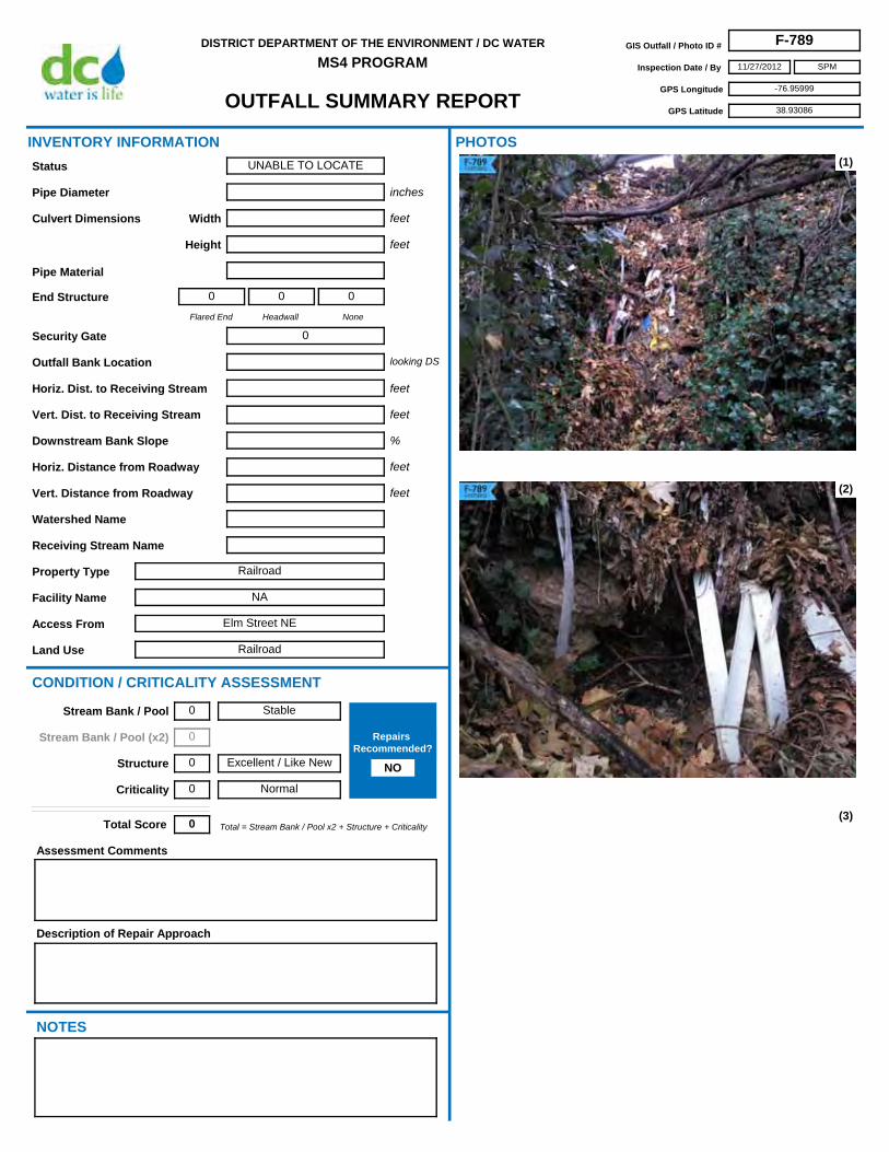
MS4 PROGRAMGIS Outfall / Photo ID # F-789
Inspection Date / By 11/27/2012
GPS Longitude -76.95999
GPS Latitude 38.93086
SPM
Access From Elm Street NE
Horiz. Dist. to Receiving Stream
Flared End
0
Headwall
0
None
0
Security Gate 0
Facility Name NA
Land Use Railroad
Outfall Bank Location
Pipe Diameter
Height
Pipe Material
Width
Property Type Railroad
Receiving Stream Name
Description of Repair Approach
Watershed Name
NOTES
INVENTORY INFORMATION
inches
feet
feet
Culvert Dimensions
End Structure
looking DS
feet
%
CONDITION / CRITICALITY ASSESSMENT
(1)
(2)
(3)
Downstream Bank Slope
PHOTOS
Status UNABLE TO LOCATE
Assessment Comments
Total = Stream Bank / Pool x2 + Structure + CriticalityTotal Score 0
Horiz. Distance from Roadway
Vert. Distance from Roadway
feet
feet
Vert. Dist. to Receiving Stream feet
Stable
Excellent / Like New
Normal
Stream Bank / Pool 0
Stream Bank / Pool (x2) 0
Structure 0
Criticality 0
Repairs Recommended?
NO

OUTFALL SUMMARY REPORT
DISTRICT DEPARTMENT OF THE ENVIRONMENT / DC WATER
MS4 PROGRAMGIS Outfall / Photo ID # F-789
Inspection Date / By 11/27/2012
GPS Longitude -76.95999
GPS Latitude 38.93086
SPM
(4)
(6) (7)
(8) (9)
(5)

OUTFALL SUMMARY REPORT
DISTRICT DEPARTMENT OF THE ENVIRONMENT / DC WATER
MS4 PROGRAMGIS Outfall / Photo ID # F-790
Inspection Date / By 1/21/2013
GPS Longitude -76.95306
GPS Latitude 38.91830
SPM
Access From Grant St NE
Horiz. Dist. to Receiving Stream
Flared End
0
Headwall
0
None
0
Security Gate 0
Facility Name NA
Land Use Watts Branch
Outfall Bank Location
Pipe Diameter
Height
Pipe Material
Width
Property Type DC Parks & Rec
Receiving Stream Name
Description of Repair Approach
Watershed Name
NOTES
INVENTORY INFORMATION
inches
feet
feet
Culvert Dimensions
End Structure
looking DS
feet
%
CONDITION / CRITICALITY ASSESSMENT
(1)
(2)
(3)
Downstream Bank Slope
PHOTOS
Status UNABLE TO LOCATE
Assessment Comments
Total = Stream Bank / Pool x2 + Structure + CriticalityTotal Score 0
Horiz. Distance from Roadway
Vert. Distance from Roadway
feet
feet
Vert. Dist. to Receiving Stream feet
Stable
Excellent / Like New
Normal
Stream Bank / Pool 0
Stream Bank / Pool (x2) 0
Structure 0
Criticality 0
Repairs Recommended?
NO

OUTFALL SUMMARY REPORT
DISTRICT DEPARTMENT OF THE ENVIRONMENT / DC WATER
MS4 PROGRAMGIS Outfall / Photo ID # F-790
Inspection Date / By 1/21/2013
GPS Longitude -76.95306
GPS Latitude 38.91830
SPM
(4)
(6) (7)
(8) (9)
(5)
OUTFALL SUMMARY REPORT
DISTRICT DEPARTMENT OF THE ENVIRONMENT / DC WATER
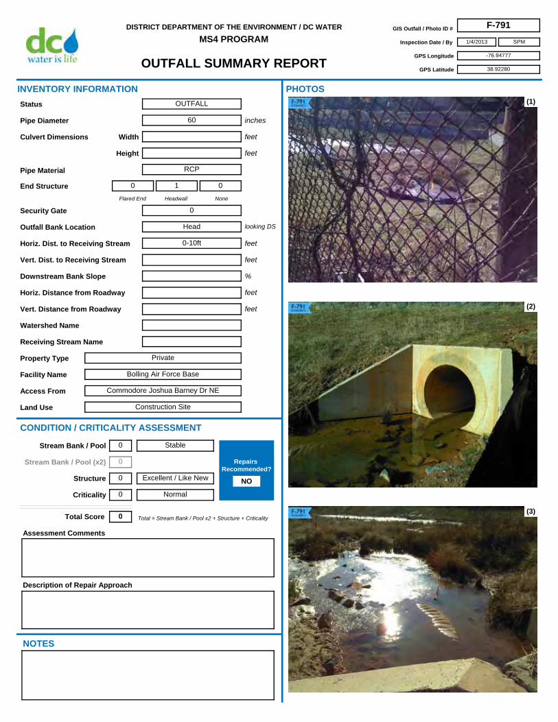
MS4 PROGRAMGIS Outfall / Photo ID # F-791
Inspection Date / By 1/4/2013
GPS Longitude -76.94777
GPS Latitude 38.92280
SPM
Access From Commodore Joshua Barney Dr NE
Horiz. Dist. to Receiving Stream 0-10ft
Flared End
0
Headwall
1
None
0
Security Gate 0
Facility Name Bolling Air Force Base
Land Use Construction Site
Outfall Bank Location Head
Pipe Diameter 60
Height
Pipe Material RCP
Width
Property Type Private
Receiving Stream Name
Description of Repair Approach
Watershed Name
NOTES
INVENTORY INFORMATION
inches
feet
feet
Culvert Dimensions
End Structure
looking DS
feet
%
CONDITION / CRITICALITY ASSESSMENT
(1)
(2)
(3)
Downstream Bank Slope
PHOTOS
Status OUTFALL
Assessment Comments
Total = Stream Bank / Pool x2 + Structure + CriticalityTotal Score 0
Horiz. Distance from Roadway
Vert. Distance from Roadway
feet
feet
Vert. Dist. to Receiving Stream feet
Stable
Excellent / Like New
Normal
Stream Bank / Pool 0
Stream Bank / Pool (x2) 0
Structure 0
Criticality 0
Repairs Recommended?
NO

OUTFALL SUMMARY REPORT
DISTRICT DEPARTMENT OF THE ENVIRONMENT / DC WATER
MS4 PROGRAMGIS Outfall / Photo ID # F-791
Inspection Date / By 1/4/2013
GPS Longitude -76.94777
GPS Latitude 38.92280
SPM
(4)
(6) (7)
(8) (9)
(5)

OUTFALL SUMMARY REPORT
DISTRICT DEPARTMENT OF THE ENVIRONMENT / DC WATER
MS4 PROGRAMGIS Outfall / Photo ID # F-792
Inspection Date / By 1/14/2013
GPS Longitude -76.94430
GPS Latitude 38.91792
SPM
Access From Forrester St SE
Horiz. Dist. to Receiving Stream
Flared End
0
Headwall
1
None
0
Security Gate 0
Facility Name NA
Land Use Oxon Run Park
Outfall Bank Location Left
Pipe Diameter 12 est
Height
Pipe Material RCP
Width
Property Type DC Parks & Rec
Receiving Stream Name Oxon Run
Description of Repair Approach
Watershed Name Anacostia
NOTES
INVENTORY INFORMATION
inches
feet
feet
Culvert Dimensions
End Structure
looking DS
feet
%
CONDITION / CRITICALITY ASSESSMENT
(1)
(2)
(3)
Downstream Bank Slope
PHOTOS
Status OUTFALL
Assessment Comments
Channel possibly caused by erosion down to drainage ditch.
Total = Stream Bank / Pool x2 + Structure + CriticalityTotal Score 2
Horiz. Distance from Roadway
Vert. Distance from Roadway
feet
feet
Vert. Dist. to Receiving Stream feet
Some Erosion
Excellent / Like New
Normal
Stream Bank / Pool 1
Stream Bank / Pool (x2) 2
Structure 0
Criticality 0
Repairs Recommended?
NO

OUTFALL SUMMARY REPORT
DISTRICT DEPARTMENT OF THE ENVIRONMENT / DC WATER
MS4 PROGRAMGIS Outfall / Photo ID # F-792
Inspection Date / By 1/14/2013
GPS Longitude -76.94430
GPS Latitude 38.91792
SPM
(4)
(6) (7)
(8) (9)
(5)

OUTFALL SUMMARY REPORT
DISTRICT DEPARTMENT OF THE ENVIRONMENT / DC WATER
MS4 PROGRAMGIS Outfall / Photo ID # F-793
Inspection Date / By 12/14/2012
GPS Longitude -76.95570
GPS Latitude 38.91631
SPM
Access From Springhouse Rd
Horiz. Dist. to Receiving Stream 0-10ft
Flared End
0
Headwall
0
None
1
Security Gate 0
Facility Name National Arboretum
Land Use Arboretum
Outfall Bank Location Head
Pipe Diameter 18
Height
Pipe Material Clay
Width
Property Type Government
Receiving Stream Name
Description of Repair Approach
Stream Restoration
Watershed Name Anacostia
NOTES
INVENTORY INFORMATION
inches
feet
feet
Culvert Dimensions
End Structure
looking DS
feet
%
CONDITION / CRITICALITY ASSESSMENT
(1)
(2)
(3)
Downstream Bank Slope
PHOTOS
Status OUTFALL
Assessment Comments
Erosion around pipe has caused large ravine. Total depth of ravine is approx 10 ft
Total = Stream Bank / Pool x2 + Structure + CriticalityTotal Score 6
Horiz. Distance from Roadway
Vert. Distance from Roadway
feet
feet
Vert. Dist. to Receiving Stream feet
Active Erosion
Poor
Normal
Stream Bank / Pool 2
Stream Bank / Pool (x2) 4
Structure 2
Criticality 0
Repairs Recommended?
YES

OUTFALL SUMMARY REPORT
DISTRICT DEPARTMENT OF THE ENVIRONMENT / DC WATER
MS4 PROGRAMGIS Outfall / Photo ID # F-793
Inspection Date / By 12/14/2012
GPS Longitude -76.95570
GPS Latitude 38.91631
SPM
(4)
(6) (7)
(8) (9)
(5)

OUTFALL SUMMARY REPORT
DISTRICT DEPARTMENT OF THE ENVIRONMENT / DC WATER
MS4 PROGRAMGIS Outfall / Photo ID # F-794
Inspection Date / By 12/14/2012
GPS Longitude -76.96189
GPS Latitude 38.91656
SPM
Access From Springhouse Rd
Horiz. Dist. to Receiving Stream 0-10ft
Flared End
0
Headwall
0
None
1
Security Gate 0
Facility Name National Arboretum
Land Use Arboretum
Outfall Bank Location Left
Pipe Diameter 10
Height
Pipe Material Clay
Width
Property Type Government
Receiving Stream Name Springhouse Branch
Description of Repair Approach
Stream Restoration
Watershed Name Anacostia
NOTES
INVENTORY INFORMATION
inches
feet
feet
Culvert Dimensions
End Structure
looking DS
feet
%
CONDITION / CRITICALITY ASSESSMENT
(1)
(2)
(3)
Downstream Bank Slope
PHOTOS
Status OUTFALL
Assessment Comments
Erosion has undermined pipe to the point of collapsing two sections.
Total = Stream Bank / Pool x2 + Structure + CriticalityTotal Score 4
Horiz. Distance from Roadway
Vert. Distance from Roadway
feet
feet
Vert. Dist. to Receiving Stream feet
Some Erosion
Poor
Normal
Stream Bank / Pool 1
Stream Bank / Pool (x2) 2
Structure 2
Criticality 0
Repairs Recommended?
YES

OUTFALL SUMMARY REPORT
DISTRICT DEPARTMENT OF THE ENVIRONMENT / DC WATER
MS4 PROGRAMGIS Outfall / Photo ID # F-794
Inspection Date / By 12/14/2012
GPS Longitude -76.96189
GPS Latitude 38.91656
SPM
(4)
(6) (7)
(8) (9)
(5)

OUTFALL SUMMARY REPORT
DISTRICT DEPARTMENT OF THE ENVIRONMENT / DC WATER
MS4 PROGRAMGIS Outfall / Photo ID # F-795
Inspection Date / By 11/20/2012
GPS Longitude -76.91342
GPS Latitude 38.89015
SPM
Access From 61th St NE
Horiz. Dist. to Receiving Stream
Flared End
0
Headwall
0
None
0
Security Gate 0
Facility Name NA
Land Use Watts Branch
Outfall Bank Location
Pipe Diameter
Height
Pipe Material
Width
Property Type DC Parks & Rec
Receiving Stream Name Watts Branch
Description of Repair Approach
Watershed Name Anacostia
NOTES
INVENTORY INFORMATION
inches
feet
feet
Culvert Dimensions
End Structure
looking DS
feet
%
CONDITION / CRITICALITY ASSESSMENT
(1)
(2)
(3)
Downstream Bank Slope
PHOTOS
Status NOT AN OUTFALL
Assessment Comments
Total = Stream Bank / Pool x2 + Structure + CriticalityTotal Score 0
Horiz. Distance from Roadway
Vert. Distance from Roadway
feet
feet
Vert. Dist. to Receiving Stream feet
Stable
Excellent / Like New
Normal
Stream Bank / Pool 0
Stream Bank / Pool (x2) 0
Structure 0
Criticality 0
Repairs Recommended?
NO

OUTFALL SUMMARY REPORT
DISTRICT DEPARTMENT OF THE ENVIRONMENT / DC WATER
MS4 PROGRAMGIS Outfall / Photo ID # F-795
Inspection Date / By 11/20/2012
GPS Longitude -76.91342
GPS Latitude 38.89015
SPM
(4)
(6) (7)
(8) (9)
(5)

OUTFALL SUMMARY REPORT
DISTRICT DEPARTMENT OF THE ENVIRONMENT / DC WATER
MS4 PROGRAMGIS Outfall / Photo ID # F-796
Inspection Date / By 2/1/2013
GPS Longitude -76.93606
GPS Latitude 38.89858
SPM
Access From 44th St NE
Horiz. Dist. to Receiving Stream
Flared End
0
Headwall
0
None
0
Security Gate 0
Facility Name NA
Land Use Watts Branch
Outfall Bank Location
Pipe Diameter
Height
Pipe Material
Width
Property Type DC Parks & Rec
Receiving Stream Name
Description of Repair Approach
Watershed Name
NOTES
INVENTORY INFORMATION
inches
feet
feet
Culvert Dimensions
End Structure
looking DS
feet
%
CONDITION / CRITICALITY ASSESSMENT
(1)
(2)
(3)
Downstream Bank Slope
PHOTOS
Status UNABLE TO LOCATE
Assessment Comments
Total = Stream Bank / Pool x2 + Structure + CriticalityTotal Score 0
Horiz. Distance from Roadway
Vert. Distance from Roadway
feet
feet
Vert. Dist. to Receiving Stream feet
Stable
Excellent / Like New
Normal
Stream Bank / Pool 0
Stream Bank / Pool (x2) 0
Structure 0
Criticality 0
Repairs Recommended?
NO

OUTFALL SUMMARY REPORT
DISTRICT DEPARTMENT OF THE ENVIRONMENT / DC WATER
MS4 PROGRAMGIS Outfall / Photo ID # F-796
Inspection Date / By 2/1/2013
GPS Longitude -76.93606
GPS Latitude 38.89858
SPM
(4)
(6) (7)
(8) (9)
(5)
OUTFALL SUMMARY REPORT
DISTRICT DEPARTMENT OF THE ENVIRONMENT / DC WATER
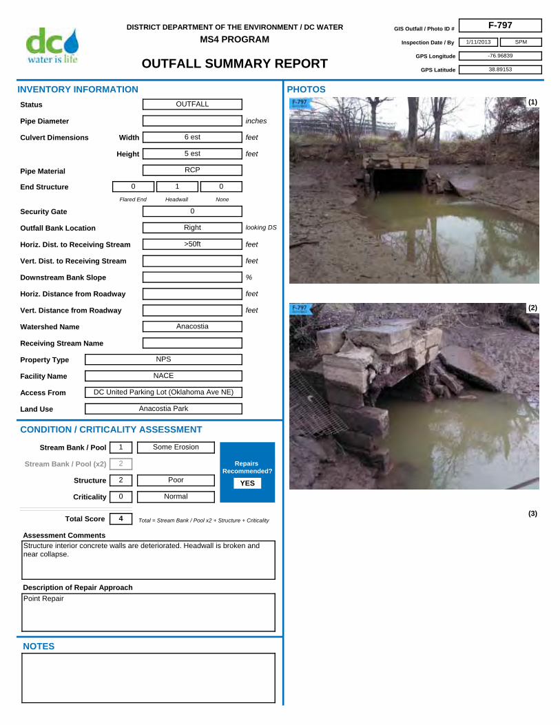
MS4 PROGRAMGIS Outfall / Photo ID # F-797
Inspection Date / By 1/11/2013
GPS Longitude -76.96839
GPS Latitude 38.89153
SPM
Access From DC United Parking Lot (Oklahoma Ave NE)
Horiz. Dist. to Receiving Stream >50ft
Flared End
0
Headwall
1
None
0
Security Gate 0
Facility Name NACE
Land Use Anacostia Park
Outfall Bank Location Right
Pipe Diameter
Height 5 est
Pipe Material RCP
Width 6 est
Property Type NPS
Receiving Stream Name
Description of Repair Approach
Point Repair
Watershed Name Anacostia
NOTES
INVENTORY INFORMATION
inches
feet
feet
Culvert Dimensions
End Structure
looking DS
feet
%
CONDITION / CRITICALITY ASSESSMENT
(1)
(2)
(3)
Downstream Bank Slope
PHOTOS
Status OUTFALL
Assessment Comments
Structure interior concrete walls are deteriorated. Headwall is broken and near collapse.
Total = Stream Bank / Pool x2 + Structure + CriticalityTotal Score 4
Horiz. Distance from Roadway
Vert. Distance from Roadway
feet
feet
Vert. Dist. to Receiving Stream feet
Some Erosion
Poor
Normal
Stream Bank / Pool 1
Stream Bank / Pool (x2) 2
Structure 2
Criticality 0
Repairs Recommended?
YES

OUTFALL SUMMARY REPORT
DISTRICT DEPARTMENT OF THE ENVIRONMENT / DC WATER
MS4 PROGRAMGIS Outfall / Photo ID # F-797
Inspection Date / By 1/11/2013
GPS Longitude -76.96839
GPS Latitude 38.89153
SPM
(4)
(6) (7)
(8) (9)
(5)

OUTFALL SUMMARY REPORT
DISTRICT DEPARTMENT OF THE ENVIRONMENT / DC WATER
MS4 PROGRAMGIS Outfall / Photo ID # F-798
Inspection Date / By 1/10/2013
GPS Longitude -76.95345
GPS Latitude 38.86619
SPM
Access From Alabama Ave SE
Horiz. Dist. to Receiving Stream 20-30ft
Flared End
0
Headwall
0
None
1
Security Gate 0
Facility Name NACE
Land Use Fort Davis Park
Outfall Bank Location Right
Pipe Diameter 24
Height
Pipe Material CMP
Width
Property Type NPS
Receiving Stream Name
Description of Repair Approach
Potential RSC
Watershed Name Anacostia
NOTES
INVENTORY INFORMATION
inches
feet
feet
Culvert Dimensions
End Structure
looking DS
feet
%
CONDITION / CRITICALITY ASSESSMENT
(1)
(2)
(3)
Downstream Bank Slope
PHOTOS
Status OUTFALL
Assessment Comments
Bottom of pipe is deteriorated. Severe downstream erosion.
Total = Stream Bank / Pool x2 + Structure + CriticalityTotal Score 6
Horiz. Distance from Roadway
Vert. Distance from Roadway
feet
feet
Vert. Dist. to Receiving Stream feet
Active Erosion
Poor
Normal
Stream Bank / Pool 2
Stream Bank / Pool (x2) 4
Structure 2
Criticality 0
Repairs Recommended?
YES

OUTFALL SUMMARY REPORT
DISTRICT DEPARTMENT OF THE ENVIRONMENT / DC WATER
MS4 PROGRAMGIS Outfall / Photo ID # F-798
Inspection Date / By 1/10/2013
GPS Longitude -76.95345
GPS Latitude 38.86619
SPM
(4)
(6) (7)
(8) (9)
(5)

OUTFALL SUMMARY REPORT
DISTRICT DEPARTMENT OF THE ENVIRONMENT / DC WATER
MS4 PROGRAMGIS Outfall / Photo ID # F-800
Inspection Date / By 1/15/2013
GPS Longitude -76.96301
GPS Latitude 38.88214
SPM
Access From E St SE and 32nd St SE
Horiz. Dist. to Receiving Stream 0-10ft
Flared End
0
Headwall
1
None
0
Security Gate 0
Facility Name NA
Land Use Green Space
Outfall Bank Location Head
Pipe Diameter 27
Height
Pipe Material RCP
Width
Property Type NA
Receiving Stream Name
Description of Repair Approach
Watershed Name
NOTES
INVENTORY INFORMATION
inches
feet
feet
Culvert Dimensions
End Structure
looking DS
feet
%
CONDITION / CRITICALITY ASSESSMENT
(1)
(2)
(3)
Downstream Bank Slope
PHOTOS
Status OUTFALL
Assessment Comments
Total = Stream Bank / Pool x2 + Structure + CriticalityTotal Score 0
Horiz. Distance from Roadway
Vert. Distance from Roadway
feet
feet
Vert. Dist. to Receiving Stream feet
Stable
Excellent / Like New
Normal
Stream Bank / Pool 0
Stream Bank / Pool (x2) 0
Structure 0
Criticality 0
Repairs Recommended?
NO

OUTFALL SUMMARY REPORT
DISTRICT DEPARTMENT OF THE ENVIRONMENT / DC WATER
MS4 PROGRAMGIS Outfall / Photo ID # F-800
Inspection Date / By 1/15/2013
GPS Longitude -76.96301
GPS Latitude 38.88214
SPM
(4)
(6) (7)
(8) (9)
(5)

OUTFALL SUMMARY REPORT
DISTRICT DEPARTMENT OF THE ENVIRONMENT / DC WATER
MS4 PROGRAMGIS Outfall / Photo ID # F-801
Inspection Date / By 1/21/2013
GPS Longitude -76.98948
GPS Latitude 38.84318
SPM
Access From Valley Ave SE
Horiz. Dist. to Receiving Stream
Flared End
0
Headwall
0
None
0
Security Gate 0
Facility Name NA
Land Use Oxon Run Park
Outfall Bank Location
Pipe Diameter
Height
Pipe Material
Width
Property Type DC Parks & Rec
Receiving Stream Name
Description of Repair Approach
Watershed Name
NOTES
INVENTORY INFORMATION
inches
feet
feet
Culvert Dimensions
End Structure
looking DS
feet
%
CONDITION / CRITICALITY ASSESSMENT
(1)
(2)
(3)
Downstream Bank Slope
PHOTOS
Status UNABLE TO LOCATE
Assessment Comments
Total = Stream Bank / Pool x2 + Structure + CriticalityTotal Score 0
Horiz. Distance from Roadway
Vert. Distance from Roadway
feet
feet
Vert. Dist. to Receiving Stream feet
Stable
Excellent / Like New
Normal
Stream Bank / Pool 0
Stream Bank / Pool (x2) 0
Structure 0
Criticality 0
Repairs Recommended?
NO

OUTFALL SUMMARY REPORT
DISTRICT DEPARTMENT OF THE ENVIRONMENT / DC WATER
MS4 PROGRAMGIS Outfall / Photo ID # F-801
Inspection Date / By 1/21/2013
GPS Longitude -76.98948
GPS Latitude 38.84318
SPM
(4)
(6) (7)
(8) (9)
(5)

OUTFALL SUMMARY REPORT
DISTRICT DEPARTMENT OF THE ENVIRONMENT / DC WATER
MS4 PROGRAMGIS Outfall / Photo ID # F-802
Inspection Date / By 1/21/2013
GPS Longitude -77.00220
GPS Latitude 38.83299
SPM
Access From 4th St SE
Horiz. Dist. to Receiving Stream
Flared End
0
Headwall
0
None
0
Security Gate 0
Facility Name NA
Land Use NA
Outfall Bank Location
Pipe Diameter
Height
Pipe Material
Width
Property Type NA
Receiving Stream Name
Description of Repair Approach
Watershed Name
NOTES
INVENTORY INFORMATION
inches
feet
feet
Culvert Dimensions
End Structure
looking DS
feet
%
CONDITION / CRITICALITY ASSESSMENT
(1)
(2)
(3)
Downstream Bank Slope
PHOTOS
Status UNABLE TO LOCATE
Assessment Comments
Total = Stream Bank / Pool x2 + Structure + CriticalityTotal Score 0
Horiz. Distance from Roadway
Vert. Distance from Roadway
feet
feet
Vert. Dist. to Receiving Stream feet
Stable
Excellent / Like New
Normal
Stream Bank / Pool 0
Stream Bank / Pool (x2) 0
Structure 0
Criticality 0
Repairs Recommended?
NO

OUTFALL SUMMARY REPORT
DISTRICT DEPARTMENT OF THE ENVIRONMENT / DC WATER
MS4 PROGRAMGIS Outfall / Photo ID # F-802
Inspection Date / By 1/21/2013
GPS Longitude -77.00220
GPS Latitude 38.83299
SPM
(4)
(6) (7)
(8) (9)
(5)
OUTFALL SUMMARY REPORT
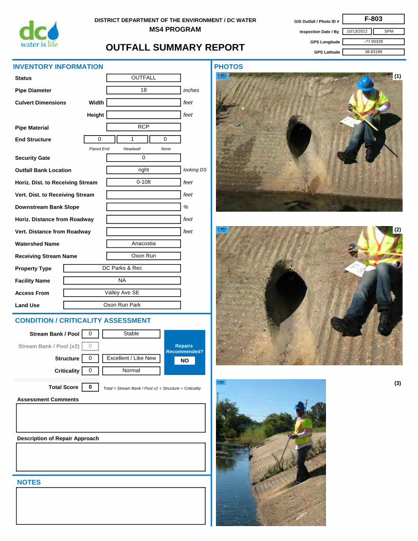
DISTRICT DEPARTMENT OF THE ENVIRONMENT / DC WATER
MS4 PROGRAMGIS Outfall / Photo ID # F-803
Inspection Date / By 10/13/2012
GPS Longitude -77.00328
GPS Latitude 38.83199
SPM
Access From Valley Ave SE
Horiz. Dist. to Receiving Stream 0-10ft
Flared End
0
Headwall
1
None
0
Security Gate 0
Facility Name NA
Land Use Oxon Run Park
Outfall Bank Location right
Pipe Diameter 18
Height
Pipe Material RCP
Width
Property Type DC Parks & Rec
Receiving Stream Name Oxon Run
Description of Repair Approach
Watershed Name Anacostia
NOTES
INVENTORY INFORMATION
inches
feet
feet
Culvert Dimensions
End Structure
looking DS
feet
%
CONDITION / CRITICALITY ASSESSMENT
(1)
(2)
(3)
Downstream Bank Slope
PHOTOS
Status OUTFALL
Assessment Comments
Total = Stream Bank / Pool x2 + Structure + CriticalityTotal Score 0
Horiz. Distance from Roadway
Vert. Distance from Roadway
feet
feet
Vert. Dist. to Receiving Stream feet
Stable
Excellent / Like New
Normal
Stream Bank / Pool 0
Stream Bank / Pool (x2) 0
Structure 0
Criticality 0
Repairs Recommended?
NO

OUTFALL SUMMARY REPORT
DISTRICT DEPARTMENT OF THE ENVIRONMENT / DC WATER
MS4 PROGRAMGIS Outfall / Photo ID # F-803
Inspection Date / By 10/13/2012
GPS Longitude -77.00328
GPS Latitude 38.83199
SPM
(4)
(6) (7)
(8) (9)
(5)

OUTFALL SUMMARY REPORT
DISTRICT DEPARTMENT OF THE ENVIRONMENT / DC WATER
MS4 PROGRAMGIS Outfall / Photo ID # F-804
Inspection Date / By 10/11/2012
GPS Longitude -77.00340
GPS Latitude 38.83139
SPM
Access From
Horiz. Dist. to Receiving Stream 0-10
Flared End
0
Headwall
0
None
0
Security Gate 0
Facility Name
Land Use Oxon Run Park
Outfall Bank Location left
Pipe Diameter 12
Height
Pipe Material RCP
Width
Property Type DC Parks & Rec
Receiving Stream Name Oxon Run
Description of Repair Approach
Watershed Name Anacostia
NOTES
INVENTORY INFORMATION
inches
feet
feet
Culvert Dimensions
End Structure
looking DS
feet
%
CONDITION / CRITICALITY ASSESSMENT
(1)
(2)
(3)
Downstream Bank Slope
PHOTOS
Status OUTFALL
Assessment Comments
Minor cracking in concrete headwall with roots growing in cracks.
Total = Stream Bank / Pool x2 + Structure + CriticalityTotal Score 1
Horiz. Distance from Roadway
Vert. Distance from Roadway
feet
feet
Vert. Dist. to Receiving Stream feet
Stable
Moderate
Normal
Stream Bank / Pool 0
Stream Bank / Pool (x2) 0
Structure 1
Criticality 0
Repairs Recommended?
NO

OUTFALL SUMMARY REPORT
DISTRICT DEPARTMENT OF THE ENVIRONMENT / DC WATER
MS4 PROGRAMGIS Outfall / Photo ID # F-804
Inspection Date / By 10/11/2012
GPS Longitude -77.00340
GPS Latitude 38.83139
SPM
(4)
(6) (7)
(8) (9)
(5)

OUTFALL SUMMARY REPORT
DISTRICT DEPARTMENT OF THE ENVIRONMENT / DC WATER
MS4 PROGRAMGIS Outfall / Photo ID # F-805
Inspection Date / By 2/6/2013
GPS Longitude -77.02647
GPS Latitude 38.88012
SPM
Access From BOAT
Horiz. Dist. to Receiving Stream
Flared End
0
Headwall
0
None
0
Security Gate 0
Facility Name Gangplank Marina
Land Use Marina
Outfall Bank Location
Pipe Diameter
Height
Pipe Material
Width
Property Type Private
Receiving Stream Name
Description of Repair Approach
Watershed Name
NOTES
INVENTORY INFORMATION
inches
feet
feet
Culvert Dimensions
End Structure
looking DS
feet
%
CONDITION / CRITICALITY ASSESSMENT
(1)
(2)
(3)
Downstream Bank Slope
PHOTOS
Status UNABLE TO LOCATE
Assessment Comments
Total = Stream Bank / Pool x2 + Structure + CriticalityTotal Score 0
Horiz. Distance from Roadway
Vert. Distance from Roadway
feet
feet
Vert. Dist. to Receiving Stream feet
Stable
Excellent / Like New
Normal
Stream Bank / Pool 0
Stream Bank / Pool (x2) 0
Structure 0
Criticality 0
Repairs Recommended?
NO

OUTFALL SUMMARY REPORT
DISTRICT DEPARTMENT OF THE ENVIRONMENT / DC WATER
MS4 PROGRAMGIS Outfall / Photo ID # F-805
Inspection Date / By 2/6/2013
GPS Longitude -77.02647
GPS Latitude 38.88012
SPM
(4)
(6) (7)
(8) (9)
(5)

OUTFALL SUMMARY REPORT
DISTRICT DEPARTMENT OF THE ENVIRONMENT / DC WATER
MS4 PROGRAMGIS Outfall / Photo ID # F-806
Inspection Date / By 12/10/2012
GPS Longitude -77.05674
GPS Latitude 38.91425
SPM
Access From Whitehaven St NW
Horiz. Dist. to Receiving Stream 0-10ft
Flared End
0
Headwall
0
None
0
Security Gate 0
Facility Name ROCR
Land Use Rock Creek Park
Outfall Bank Location Left
Pipe Diameter 6 est
Height
Pipe Material PVC
Width
Property Type NPS
Receiving Stream Name Rock Creek
Description of Repair Approach
Watershed Name Rock Creek
NOTES
INVENTORY INFORMATION
inches
feet
feet
Culvert Dimensions
End Structure
looking DS
feet
%
CONDITION / CRITICALITY ASSESSMENT
(1)
(2)
(3)
Downstream Bank Slope
PHOTOS
Status OUTFALL
Assessment Comments
Total = Stream Bank / Pool x2 + Structure + CriticalityTotal Score 0
Horiz. Distance from Roadway
Vert. Distance from Roadway
feet
feet
Vert. Dist. to Receiving Stream feet
Stable
Excellent / Like New
Normal
Stream Bank / Pool 0
Stream Bank / Pool (x2) 0
Structure 0
Criticality 0
Repairs Recommended?
NO

OUTFALL SUMMARY REPORT
DISTRICT DEPARTMENT OF THE ENVIRONMENT / DC WATER
MS4 PROGRAMGIS Outfall / Photo ID # F-806
Inspection Date / By 12/10/2012
GPS Longitude -77.05674
GPS Latitude 38.91425
SPM
(4)
(6) (7)
(8) (9)
(5)

OUTFALL SUMMARY REPORT
DISTRICT DEPARTMENT OF THE ENVIRONMENT / DC WATER
MS4 PROGRAMGIS Outfall / Photo ID # F-807
Inspection Date / By 11/28/2012
GPS Longitude -77.05792
GPS Latitude 38.95236
SPM
Access From Davenport St NW
Horiz. Dist. to Receiving Stream 0-10ft
Flared End
0
Headwall
0
None
1
Security Gate 0
Facility Name NA
Land Use Residential
Outfall Bank Location Head
Pipe Diameter 36
Height
Pipe Material CMP
Width
Property Type Private
Receiving Stream Name
Description of Repair Approach
Watershed Name
NOTES
INVENTORY INFORMATION
inches
feet
feet
Culvert Dimensions
End Structure
looking DS
feet
%
CONDITION / CRITICALITY ASSESSMENT
(1)
(2)
(3)
Downstream Bank Slope
PHOTOS
Status OUTFALL
Assessment Comments
Outfall pipe comes from underneath next house uphill.
Total = Stream Bank / Pool x2 + Structure + CriticalityTotal Score 0
Horiz. Distance from Roadway
Vert. Distance from Roadway
feet
feet
Vert. Dist. to Receiving Stream feet
Stable
Excellent / Like New
Normal
Stream Bank / Pool 0
Stream Bank / Pool (x2) 0
Structure 0
Criticality 0
Repairs Recommended?
NO

OUTFALL SUMMARY REPORT
DISTRICT DEPARTMENT OF THE ENVIRONMENT / DC WATER
MS4 PROGRAMGIS Outfall / Photo ID # F-807
Inspection Date / By 11/28/2012
GPS Longitude -77.05792
GPS Latitude 38.95236
SPM
(4)
(6) (7)
(8) (9)
(5)

OUTFALL SUMMARY REPORT
DISTRICT DEPARTMENT OF THE ENVIRONMENT / DC WATER
MS4 PROGRAMGIS Outfall / Photo ID # F-808
Inspection Date / By 11/28/2012
GPS Longitude -77.05716
GPS Latitude 38.95270
SPM
Access From Davenport St NW
Horiz. Dist. to Receiving Stream 0-10ft
Flared End
1
Headwall
0
None
0
Security Gate 0
Facility Name NA
Land Use Residential
Outfall Bank Location Left
Pipe Diameter 42
Height
Pipe Material RCP
Width
Property Type Private
Receiving Stream Name
Description of Repair Approach
Watershed Name
NOTES
INVENTORY INFORMATION
inches
feet
feet
Culvert Dimensions
End Structure
looking DS
feet
%
CONDITION / CRITICALITY ASSESSMENT
(1)
(2)
(3)
Downstream Bank Slope
PHOTOS
Status OUTFALL
Assessment Comments
Total = Stream Bank / Pool x2 + Structure + CriticalityTotal Score 0
Horiz. Distance from Roadway
Vert. Distance from Roadway
feet
feet
Vert. Dist. to Receiving Stream feet
Stable
Excellent / Like New
Normal
Stream Bank / Pool 0
Stream Bank / Pool (x2) 0
Structure 0
Criticality 0
Repairs Recommended?
NO

OUTFALL SUMMARY REPORT
DISTRICT DEPARTMENT OF THE ENVIRONMENT / DC WATER
MS4 PROGRAMGIS Outfall / Photo ID # F-808
Inspection Date / By 11/28/2012
GPS Longitude -77.05716
GPS Latitude 38.95270
SPM
(4)
(6) (7)
(8) (9)
(5)

OUTFALL SUMMARY REPORT
DISTRICT DEPARTMENT OF THE ENVIRONMENT / DC WATER
MS4 PROGRAMGIS Outfall / Photo ID # F-809
Inspection Date / By 2/5/2013
GPS Longitude -77.05637
GPS Latitude 38.89403
SPM
Access From BOAT
Horiz. Dist. to Receiving Stream 0-10ft
Flared End
0
Headwall
1
None
0
Security Gate 0
Facility Name NAMA
Land Use Rock Creek Park Trails
Outfall Bank Location Left
Pipe Diameter 36 est
Height
Pipe Material RCP
Width
Property Type NPS
Receiving Stream Name
Description of Repair Approach
Watershed Name
NOTES
INVENTORY INFORMATION
inches
feet
feet
Culvert Dimensions
End Structure
looking DS
feet
%
CONDITION / CRITICALITY ASSESSMENT
(1)
(2)
(3)
Downstream Bank Slope
PHOTOS
Status OUTFALL
Assessment Comments
Total = Stream Bank / Pool x2 + Structure + CriticalityTotal Score 0
Horiz. Distance from Roadway
Vert. Distance from Roadway
feet
feet
Vert. Dist. to Receiving Stream feet
Stable
Excellent / Like New
Normal
Stream Bank / Pool 0
Stream Bank / Pool (x2) 0
Structure 0
Criticality 0
Repairs Recommended?
NO

OUTFALL SUMMARY REPORT
DISTRICT DEPARTMENT OF THE ENVIRONMENT / DC WATER
MS4 PROGRAMGIS Outfall / Photo ID # F-809
Inspection Date / By 2/5/2013
GPS Longitude -77.05637
GPS Latitude 38.89403
SPM
(4)
(6) (7)
(8) (9)
(5)

OUTFALL SUMMARY REPORT
DISTRICT DEPARTMENT OF THE ENVIRONMENT / DC WATER
MS4 PROGRAMGIS Outfall / Photo ID # F-810
Inspection Date / By 12/7/2012
GPS Longitude -77.05445
GPS Latitude 38.93327
SPM
Access From Klingle Rd NW
Horiz. Dist. to Receiving Stream 0-10ft
Flared End
0
Headwall
0
None
1
Security Gate 0
Facility Name ROCR
Land Use Klingle Branch
Outfall Bank Location Right
Pipe Diameter 12
Height
Pipe Material RCP
Width
Property Type NPS
Receiving Stream Name
Description of Repair Approach
Watershed Name Rock Creek
NOTES
INVENTORY INFORMATION
inches
feet
feet
Culvert Dimensions
End Structure
looking DS
feet
%
CONDITION / CRITICALITY ASSESSMENT
(1)
(2)
(3)
Downstream Bank Slope
PHOTOS
Status OUTFALL
Assessment Comments
Total = Stream Bank / Pool x2 + Structure + CriticalityTotal Score 0
Horiz. Distance from Roadway
Vert. Distance from Roadway
feet
feet
Vert. Dist. to Receiving Stream feet
Stable
Excellent / Like New
Normal
Stream Bank / Pool 0
Stream Bank / Pool (x2) 0
Structure 0
Criticality 0
Repairs Recommended?
NO

OUTFALL SUMMARY REPORT
DISTRICT DEPARTMENT OF THE ENVIRONMENT / DC WATER
MS4 PROGRAMGIS Outfall / Photo ID # F-810
Inspection Date / By 12/7/2012
GPS Longitude -77.05445
GPS Latitude 38.93327
SPM
(4)
(6) (7)
(8) (9)
(5)

OUTFALL SUMMARY REPORT
DISTRICT DEPARTMENT OF THE ENVIRONMENT / DC WATER
MS4 PROGRAMGIS Outfall / Photo ID # F-811
Inspection Date / By 12/6/2012
GPS Longitude -77.05658
GPS Latitude 38.94623
SPM
Access From Audubon Terrace NW
Horiz. Dist. to Receiving Stream 20-30ft
Flared End
0
Headwall
0
None
1
Security Gate 0
Facility Name ROCR
Land Use Soapstone Valley
Outfall Bank Location Left
Pipe Diameter 24
Height
Pipe Material CMP
Width
Property Type NPS
Receiving Stream Name
Description of Repair Approach
Watershed Name Rock Creek
NOTES
INVENTORY INFORMATION
inches
feet
feet
Culvert Dimensions
End Structure
looking DS
feet
%
CONDITION / CRITICALITY ASSESSMENT
(1)
(2)
(3)
Downstream Bank Slope
PHOTOS
Status OUTFALL
Assessment Comments
CMP is rusted out at bottom.
Total = Stream Bank / Pool x2 + Structure + CriticalityTotal Score 2
Horiz. Distance from Roadway
Vert. Distance from Roadway
feet
feet
Vert. Dist. to Receiving Stream feet
Stable
Poor
Normal
Stream Bank / Pool 0
Stream Bank / Pool (x2) 0
Structure 2
Criticality 0
Repairs Recommended?
NO

OUTFALL SUMMARY REPORT
DISTRICT DEPARTMENT OF THE ENVIRONMENT / DC WATER
MS4 PROGRAMGIS Outfall / Photo ID # F-811
Inspection Date / By 12/6/2012
GPS Longitude -77.05658
GPS Latitude 38.94623
SPM
(4)
(6) (7)
(8) (9)
(5)

OUTFALL SUMMARY REPORT
DISTRICT DEPARTMENT OF THE ENVIRONMENT / DC WATER
MS4 PROGRAMGIS Outfall / Photo ID # F-812
Inspection Date / By 1/15/2013
GPS Longitude -77.04954
GPS Latitude 38.93363
SPM
Access From Porter St NW
Horiz. Dist. to Receiving Stream
Flared End
0
Headwall
0
None
0
Security Gate 0
Facility Name ROCR
Land Use Rock Creek Park
Outfall Bank Location
Pipe Diameter
Height
Pipe Material
Width
Property Type NPS
Receiving Stream Name
Description of Repair Approach
Watershed Name
NOTES
INVENTORY INFORMATION
inches
feet
feet
Culvert Dimensions
End Structure
looking DS
feet
%
CONDITION / CRITICALITY ASSESSMENT
(1)
(2)
(3)
Downstream Bank Slope
PHOTOS
Status UNABLE TO LOCATE
Assessment Comments
Total = Stream Bank / Pool x2 + Structure + CriticalityTotal Score 0
Horiz. Distance from Roadway
Vert. Distance from Roadway
feet
feet
Vert. Dist. to Receiving Stream feet
Stable
Excellent / Like New
Normal
Stream Bank / Pool 0
Stream Bank / Pool (x2) 0
Structure 0
Criticality 0
Repairs Recommended?
NO

OUTFALL SUMMARY REPORT
DISTRICT DEPARTMENT OF THE ENVIRONMENT / DC WATER
MS4 PROGRAMGIS Outfall / Photo ID # F-812
Inspection Date / By 1/15/2013
GPS Longitude -77.04954
GPS Latitude 38.93363
SPM
(4)
(6) (7)
(8) (9)
(5)

OUTFALL SUMMARY REPORT
DISTRICT DEPARTMENT OF THE ENVIRONMENT / DC WATER
MS4 PROGRAMGIS Outfall / Photo ID # F-813
Inspection Date / By 12/7/2012
GPS Longitude -77.03909
GPS Latitude 38.93713
SPM
Access From Piney Branch Pkwy NW
Horiz. Dist. to Receiving Stream 20-30ft
Flared End
0
Headwall
1
None
0
Security Gate 0
Facility Name ROCR
Land Use Piney Branch Park
Outfall Bank Location Left
Pipe Diameter 36 est
Height
Pipe Material Brick
Width
Property Type NPS
Receiving Stream Name Piney Branch
Description of Repair Approach
Watershed Name Rock Creek
NOTES
INVENTORY INFORMATION
inches
feet
feet
Culvert Dimensions
End Structure
looking DS
feet
%
CONDITION / CRITICALITY ASSESSMENT
(1)
(2)
(3)
Downstream Bank Slope
PHOTOS
Status OUTFALL
Assessment Comments
Total = Stream Bank / Pool x2 + Structure + CriticalityTotal Score 0
Horiz. Distance from Roadway
Vert. Distance from Roadway
feet
feet
Vert. Dist. to Receiving Stream feet
Stable
Excellent / Like New
Normal
Stream Bank / Pool 0
Stream Bank / Pool (x2) 0
Structure 0
Criticality 0
Repairs Recommended?
NO

OUTFALL SUMMARY REPORT
DISTRICT DEPARTMENT OF THE ENVIRONMENT / DC WATER
MS4 PROGRAMGIS Outfall / Photo ID # F-813
Inspection Date / By 12/7/2012
GPS Longitude -77.03909
GPS Latitude 38.93713
SPM
(4)
(6) (7)
(8) (9)
(5)

OUTFALL SUMMARY REPORT
DISTRICT DEPARTMENT OF THE ENVIRONMENT / DC WATER
MS4 PROGRAMGIS Outfall / Photo ID # F-814
Inspection Date / By 12/7/2012
GPS Longitude -77.05526
GPS Latitude 38.85819
SPM
Access From Piney Branch Pkwy NW
Horiz. Dist. to Receiving Stream 0-10ft
Flared End
0
Headwall
1
None
0
Security Gate 0
Facility Name ROCR
Land Use Piney Branch Park
Outfall Bank Location Left
Pipe Diameter 24 est
Height
Pipe Material Clay
Width
Property Type NPS
Receiving Stream Name Piney Branch
Description of Repair Approach
Watershed Name Rock Creek
NOTES
INVENTORY INFORMATION
inches
feet
feet
Culvert Dimensions
End Structure
looking DS
feet
%
CONDITION / CRITICALITY ASSESSMENT
(1)
(2)
(3)
Downstream Bank Slope
PHOTOS
Status OUTFALL
Assessment Comments
Double barrel pipes.
Total = Stream Bank / Pool x2 + Structure + CriticalityTotal Score 1
Horiz. Distance from Roadway
Vert. Distance from Roadway
feet
feet
Vert. Dist. to Receiving Stream feet
Stable
Moderate
Normal
Stream Bank / Pool 0
Stream Bank / Pool (x2) 0
Structure 1
Criticality 0
Repairs Recommended?
NO

OUTFALL SUMMARY REPORT
DISTRICT DEPARTMENT OF THE ENVIRONMENT / DC WATER
MS4 PROGRAMGIS Outfall / Photo ID # F-814
Inspection Date / By 12/7/2012
GPS Longitude -77.05526
GPS Latitude 38.85819
SPM
(4)
(6) (7)
(8) (9)
(5)

OUTFALL SUMMARY REPORT
DISTRICT DEPARTMENT OF THE ENVIRONMENT / DC WATER
MS4 PROGRAMGIS Outfall / Photo ID # F-815
Inspection Date / By 12/7/2012
GPS Longitude -77.04405
GPS Latitude 38.93609
SPM
Access From Piney Branch Pkwy NW
Horiz. Dist. to Receiving Stream
Flared End
0
Headwall
0
None
0
Security Gate 0
Facility Name ROCR
Land Use Piney Branch Park
Outfall Bank Location
Pipe Diameter
Height
Pipe Material
Width
Property Type NPS
Receiving Stream Name
Description of Repair Approach
Watershed Name
NOTES
INVENTORY INFORMATION
inches
feet
feet
Culvert Dimensions
End Structure
looking DS
feet
%
CONDITION / CRITICALITY ASSESSMENT
(1)
(2)
(3)
Downstream Bank Slope
PHOTOS
Status UNABLE TO LOCATE
Assessment Comments
Total = Stream Bank / Pool x2 + Structure + CriticalityTotal Score 0
Horiz. Distance from Roadway
Vert. Distance from Roadway
feet
feet
Vert. Dist. to Receiving Stream feet
Stable
Excellent / Like New
Normal
Stream Bank / Pool 0
Stream Bank / Pool (x2) 0
Structure 0
Criticality 0
Repairs Recommended?
NO

OUTFALL SUMMARY REPORT
DISTRICT DEPARTMENT OF THE ENVIRONMENT / DC WATER
MS4 PROGRAMGIS Outfall / Photo ID # F-815
Inspection Date / By 12/7/2012
GPS Longitude -77.04405
GPS Latitude 38.93609
SPM
(4)
(6) (7)
(8) (9)
(5)

OUTFALL SUMMARY REPORT
DISTRICT DEPARTMENT OF THE ENVIRONMENT / DC WATER
MS4 PROGRAMGIS Outfall / Photo ID # F-816
Inspection Date / By 12/5/2012
GPS Longitude -77.04161
GPS Latitude 38.96186
SPM
Access From Joyce Rd NW
Horiz. Dist. to Receiving Stream 0-10ft
Flared End
0
Headwall
1
None
0
Security Gate 0
Facility Name ROCR
Land Use Luzon Branch
Outfall Bank Location Right
Pipe Diameter 24
Height
Pipe Material RCP
Width
Property Type NPS
Receiving Stream Name
Description of Repair Approach
Watershed Name Rock Creek
NOTES
INVENTORY INFORMATION
inches
feet
feet
Culvert Dimensions
End Structure
looking DS
feet
%
CONDITION / CRITICALITY ASSESSMENT
(1)
(2)
(3)
Downstream Bank Slope
PHOTOS
Status OUTFALL
Assessment Comments
Minor erosion.
Total = Stream Bank / Pool x2 + Structure + CriticalityTotal Score 3
Horiz. Distance from Roadway
Vert. Distance from Roadway
feet
feet
Vert. Dist. to Receiving Stream feet
Some Erosion
Moderate
Normal
Stream Bank / Pool 1
Stream Bank / Pool (x2) 2
Structure 1
Criticality 0
Repairs Recommended?
NO

OUTFALL SUMMARY REPORT
DISTRICT DEPARTMENT OF THE ENVIRONMENT / DC WATER
MS4 PROGRAMGIS Outfall / Photo ID # F-816
Inspection Date / By 12/5/2012
GPS Longitude -77.04161
GPS Latitude 38.96186
SPM
(4)
(6) (7)
(8) (9)
(5)

OUTFALL SUMMARY REPORT
DISTRICT DEPARTMENT OF THE ENVIRONMENT / DC WATER
MS4 PROGRAMGIS Outfall / Photo ID # F-817
Inspection Date / By 1/15/2013
GPS Longitude -77.04057
GPS Latitude 38.98874
SPM
Access From Morrow Dr NW
Horiz. Dist. to Receiving Stream
Flared End
0
Headwall
0
None
0
Security Gate 0
Facility Name ROCR
Land Use Rock Creek Park
Outfall Bank Location
Pipe Diameter
Height
Pipe Material
Width
Property Type NPS
Receiving Stream Name
Description of Repair Approach
Watershed Name
NOTES
INVENTORY INFORMATION
inches
feet
feet
Culvert Dimensions
End Structure
looking DS
feet
%
CONDITION / CRITICALITY ASSESSMENT
(1)
(2)
(3)
Downstream Bank Slope
PHOTOS
Status UNABLE TO LOCATE
Assessment Comments
Total = Stream Bank / Pool x2 + Structure + CriticalityTotal Score 0
Horiz. Distance from Roadway
Vert. Distance from Roadway
feet
feet
Vert. Dist. to Receiving Stream feet
Stable
Excellent / Like New
Normal
Stream Bank / Pool 0
Stream Bank / Pool (x2) 0
Structure 0
Criticality 0
Repairs Recommended?
NO

OUTFALL SUMMARY REPORT
DISTRICT DEPARTMENT OF THE ENVIRONMENT / DC WATER
MS4 PROGRAMGIS Outfall / Photo ID # F-817
Inspection Date / By 1/15/2013
GPS Longitude -77.04057
GPS Latitude 38.98874
SPM
(4)
(6) (7)
(8) (9)
(5)

OUTFALL SUMMARY REPORT
DISTRICT DEPARTMENT OF THE ENVIRONMENT / DC WATER
MS4 PROGRAMGIS Outfall / Photo ID # F-818
Inspection Date / By 12/10/2012
GPS Longitude -77.04991
GPS Latitude 38.92169
SPM
Access From Beach Dr NW (Near Connecticut Ave NW Bridge
Horiz. Dist. to Receiving Stream
Flared End
0
Headwall
0
None
0
Security Gate 0
Facility Name ROCR
Land Use Rock Creek Park
Outfall Bank Location
Pipe Diameter
Height
Pipe Material
Width
Property Type NPS
Receiving Stream Name
Description of Repair Approach
Watershed Name
NOTES
INVENTORY INFORMATION
inches
feet
feet
Culvert Dimensions
End Structure
looking DS
feet
%
CONDITION / CRITICALITY ASSESSMENT
(1)
(2)
(3)
Downstream Bank Slope
PHOTOS
Status UNABLE TO LOCATE
Assessment Comments
Total = Stream Bank / Pool x2 + Structure + CriticalityTotal Score 0
Horiz. Distance from Roadway
Vert. Distance from Roadway
feet
feet
Vert. Dist. to Receiving Stream feet
Stable
Excellent / Like New
Normal
Stream Bank / Pool 0
Stream Bank / Pool (x2) 0
Structure 0
Criticality 0
Repairs Recommended?
NO

OUTFALL SUMMARY REPORT
DISTRICT DEPARTMENT OF THE ENVIRONMENT / DC WATER
MS4 PROGRAMGIS Outfall / Photo ID # F-818
Inspection Date / By 12/10/2012
GPS Longitude -77.04991
GPS Latitude 38.92169
SPM
(4)
(6) (7)
(8) (9)
(5)

OUTFALL SUMMARY REPORT
DISTRICT DEPARTMENT OF THE ENVIRONMENT / DC WATER
MS4 PROGRAMGIS Outfall / Photo ID # F-819
Inspection Date / By 12/12/2012
GPS Longitude -77.10146
GPS Latitude 38.92029
SPM
Access From Near Abner Cloud House (Canal Rd NW)
Horiz. Dist. to Receiving Stream
Flared End
0
Headwall
0
None
0
Security Gate 0
Facility Name CHOH
Land Use Chesapeake & Ohio Canal
Outfall Bank Location
Pipe Diameter
Height
Pipe Material
Width
Property Type NPS
Receiving Stream Name
Description of Repair Approach
Watershed Name
NOTES
INVENTORY INFORMATION
inches
feet
feet
Culvert Dimensions
End Structure
looking DS
feet
%
CONDITION / CRITICALITY ASSESSMENT
(1)
(2)
(3)
Downstream Bank Slope
PHOTOS
Status UNABLE TO LOCATE
Assessment Comments
Total = Stream Bank / Pool x2 + Structure + CriticalityTotal Score 0
Horiz. Distance from Roadway
Vert. Distance from Roadway
feet
feet
Vert. Dist. to Receiving Stream feet
Stable
Excellent / Like New
Normal
Stream Bank / Pool 0
Stream Bank / Pool (x2) 0
Structure 0
Criticality 0
Repairs Recommended?
NO

OUTFALL SUMMARY REPORT
DISTRICT DEPARTMENT OF THE ENVIRONMENT / DC WATER
MS4 PROGRAMGIS Outfall / Photo ID # F-819
Inspection Date / By 12/12/2012
GPS Longitude -77.10146
GPS Latitude 38.92029
SPM
(4)
(6) (7)
(8) (9)
(5)

OUTFALL SUMMARY REPORT
DISTRICT DEPARTMENT OF THE ENVIRONMENT / DC WATER
MS4 PROGRAMGIS Outfall / Photo ID # F-820
Inspection Date / By 12/11/2012
GPS Longitude -77.08233
GPS Latitude 38.92722
SPM
Access From New Mexico Ave NW
Horiz. Dist. to Receiving Stream
Flared End
0
Headwall
0
None
0
Security Gate 0
Facility Name ROCR
Land Use Glover Park
Outfall Bank Location
Pipe Diameter
Height
Pipe Material
Width
Property Type NPS
Receiving Stream Name
Description of Repair Approach
Watershed Name
NOTES
INVENTORY INFORMATION
inches
feet
feet
Culvert Dimensions
End Structure
looking DS
feet
%
CONDITION / CRITICALITY ASSESSMENT
(1)
(2)
(3)
Downstream Bank Slope
PHOTOS
Status NOT AN OUTFALL
Assessment Comments
Total = Stream Bank / Pool x2 + Structure + CriticalityTotal Score 0
Horiz. Distance from Roadway
Vert. Distance from Roadway
feet
feet
Vert. Dist. to Receiving Stream feet
Stable
Excellent / Like New
Normal
Stream Bank / Pool 0
Stream Bank / Pool (x2) 0
Structure 0
Criticality 0
Repairs Recommended?
NO

OUTFALL SUMMARY REPORT
DISTRICT DEPARTMENT OF THE ENVIRONMENT / DC WATER
MS4 PROGRAMGIS Outfall / Photo ID # F-820
Inspection Date / By 12/11/2012
GPS Longitude -77.08233
GPS Latitude 38.92722
SPM
(4)
(6) (7)
(8) (9)
(5)

OUTFALL SUMMARY REPORT
DISTRICT DEPARTMENT OF THE ENVIRONMENT / DC WATER
MS4 PROGRAMGIS Outfall / Photo ID # F-821
Inspection Date / By 12/3/2012
GPS Longitude -77.06262
GPS Latitude 38.97838
SPM
Access From Beech St NW
Horiz. Dist. to Receiving Stream 0-10ft
Flared End
0
Headwall
1
None
0
Security Gate 1
Facility Name ROCR
Land Use Pinehurst Park
Outfall Bank Location Head
Pipe Diameter 72 est
Height
Pipe Material Stone
Width
Property Type NPS
Receiving Stream Name Pinehurst Branch
Description of Repair Approach
Watershed Name Rock Creek
NOTES
INVENTORY INFORMATION
inches
feet
feet
Culvert Dimensions
End Structure
looking DS
feet
%
CONDITION / CRITICALITY ASSESSMENT
(1)
(2)
(3)
Downstream Bank Slope
PHOTOS
Status OUTFALL
Assessment Comments
Total = Stream Bank / Pool x2 + Structure + CriticalityTotal Score 0
Horiz. Distance from Roadway
Vert. Distance from Roadway
feet
feet
Vert. Dist. to Receiving Stream feet
Stable
Excellent / Like New
Normal
Stream Bank / Pool 0
Stream Bank / Pool (x2) 0
Structure 0
Criticality 0
Repairs Recommended?
NO

OUTFALL SUMMARY REPORT
DISTRICT DEPARTMENT OF THE ENVIRONMENT / DC WATER
MS4 PROGRAMGIS Outfall / Photo ID # F-821
Inspection Date / By 12/3/2012
GPS Longitude -77.06262
GPS Latitude 38.97838
SPM
(4)
(6) (7)
(8) (9)
(5)

OUTFALL SUMMARY REPORT
DISTRICT DEPARTMENT OF THE ENVIRONMENT / DC WATER
MS4 PROGRAMGIS Outfall / Photo ID # F-822
Inspection Date / By 1/10/2013
GPS Longitude -76.96760
GPS Latitude 38.86753
SPM
Access From Park Dr SE
Horiz. Dist. to Receiving Stream
Flared End
0
Headwall
0
None
0
Security Gate 0
Facility Name NACE
Land Use Fort Circle Park
Outfall Bank Location
Pipe Diameter
Height
Pipe Material
Width
Property Type NPS
Receiving Stream Name
Description of Repair Approach
Watershed Name
NOTES
INVENTORY INFORMATION
inches
feet
feet
Culvert Dimensions
End Structure
looking DS
feet
%
CONDITION / CRITICALITY ASSESSMENT
(1)
(2)
(3)
Downstream Bank Slope
PHOTOS
Status NOT AN OUTFALL
Assessment Comments
This is an inlet to a culvert.
Total = Stream Bank / Pool x2 + Structure + CriticalityTotal Score 0
Horiz. Distance from Roadway
Vert. Distance from Roadway
feet
feet
Vert. Dist. to Receiving Stream feet
Stable
Excellent / Like New
Normal
Stream Bank / Pool 0
Stream Bank / Pool (x2) 0
Structure 0
Criticality 0
Repairs Recommended?
NO

OUTFALL SUMMARY REPORT
DISTRICT DEPARTMENT OF THE ENVIRONMENT / DC WATER
MS4 PROGRAMGIS Outfall / Photo ID # F-822
Inspection Date / By 1/10/2013
GPS Longitude -76.96760
GPS Latitude 38.86753
SPM
(4)
(6) (7)
(8) (9)
(5)

OUTFALL SUMMARY REPORT
DISTRICT DEPARTMENT OF THE ENVIRONMENT / DC WATER
MS4 PROGRAMGIS Outfall / Photo ID # F-823
Inspection Date / By 11/14/2012
GPS Longitude -76.96567
GPS Latitude 38.86484
SPM
Access From Hilllcrest Dr SE
Horiz. Dist. to Receiving Stream
Flared End
0
Headwall
0
None
0
Security Gate 0
Facility Name NA
Land Use Alger Park
Outfall Bank Location
Pipe Diameter
Height
Pipe Material
Width
Property Type DC Parks & Rec
Receiving Stream Name Alger Park
Description of Repair Approach
Watershed Name Anacostia
NOTES
INVENTORY INFORMATION
inches
feet
feet
Culvert Dimensions
End Structure
looking DS
feet
%
CONDITION / CRITICALITY ASSESSMENT
(1)
(2)
(3)
Downstream Bank Slope
PHOTOS
Status NOT AN OUTFALL
Assessment Comments
Not an outfall. The GPS coordinate is the same as F-490 in GIS data.
Total = Stream Bank / Pool x2 + Structure + CriticalityTotal Score 0
Horiz. Distance from Roadway
Vert. Distance from Roadway
feet
feet
Vert. Dist. to Receiving Stream feet
Stable
Excellent / Like New
Normal
Stream Bank / Pool 0
Stream Bank / Pool (x2) 0
Structure 0
Criticality 0
Repairs Recommended?
NO

OUTFALL SUMMARY REPORT
DISTRICT DEPARTMENT OF THE ENVIRONMENT / DC WATER
MS4 PROGRAMGIS Outfall / Photo ID # F-823
Inspection Date / By 11/14/2012
GPS Longitude -76.96567
GPS Latitude 38.86484
SPM
(4)
(6) (7)
(8) (9)
(5)

OUTFALL SUMMARY REPORT
DISTRICT DEPARTMENT OF THE ENVIRONMENT / DC WATER
MS4 PROGRAMGIS Outfall / Photo ID # F-824
Inspection Date / By 1/14/2013
GPS Longitude -76.94022
GPS Latitude 38.90973
SPM
Access From Southern Ave SE
Horiz. Dist. to Receiving Stream
Flared End
0
Headwall
0
None
0
Security Gate 0
Facility Name NA
Land Use NA
Outfall Bank Location
Pipe Diameter
Height
Pipe Material
Width
Property Type DDOT
Receiving Stream Name
Description of Repair Approach
Watershed Name
NOTES
INVENTORY INFORMATION
inches
feet
feet
Culvert Dimensions
End Structure
looking DS
feet
%
CONDITION / CRITICALITY ASSESSMENT
(1)
(2)
(3)
Downstream Bank Slope
PHOTOS
Status UNABLE TO LOCATE
Assessment Comments
Total = Stream Bank / Pool x2 + Structure + CriticalityTotal Score 0
Horiz. Distance from Roadway
Vert. Distance from Roadway
feet
feet
Vert. Dist. to Receiving Stream feet
Stable
Excellent / Like New
Normal
Stream Bank / Pool 0
Stream Bank / Pool (x2) 0
Structure 0
Criticality 0
Repairs Recommended?
NO

OUTFALL SUMMARY REPORT
DISTRICT DEPARTMENT OF THE ENVIRONMENT / DC WATER
MS4 PROGRAMGIS Outfall / Photo ID # F-824
Inspection Date / By 1/14/2013
GPS Longitude -76.94022
GPS Latitude 38.90973
SPM
(4)
(6) (7)
(8) (9)
(5)

OUTFALL SUMMARY REPORT
DISTRICT DEPARTMENT OF THE ENVIRONMENT / DC WATER
MS4 PROGRAMGIS Outfall / Photo ID # F-825
Inspection Date / By 12/6/2012
GPS Longitude -77.05279
GPS Latitude 38.95051
SPM
Access From Broad Branch Rd NW
Horiz. Dist. to Receiving Stream 0-10ft
Flared End
0
Headwall
1
None
0
Security Gate 0
Facility Name ROCR
Land Use Broad Branch
Outfall Bank Location Right
Pipe Diameter 14
Height
Pipe Material CMP
Width
Property Type NPS
Receiving Stream Name
Description of Repair Approach
Watershed Name Rock Creek
NOTES
INVENTORY INFORMATION
inches
feet
feet
Culvert Dimensions
End Structure
looking DS
feet
%
CONDITION / CRITICALITY ASSESSMENT
(1)
(2)
(3)
Downstream Bank Slope
PHOTOS
Status OUTFALL
Assessment Comments
Total = Stream Bank / Pool x2 + Structure + CriticalityTotal Score 0
Horiz. Distance from Roadway
Vert. Distance from Roadway
feet
feet
Vert. Dist. to Receiving Stream feet
Stable
Excellent / Like New
Normal
Stream Bank / Pool 0
Stream Bank / Pool (x2) 0
Structure 0
Criticality 0
Repairs Recommended?
NO

OUTFALL SUMMARY REPORT
DISTRICT DEPARTMENT OF THE ENVIRONMENT / DC WATER
MS4 PROGRAMGIS Outfall / Photo ID # F-825
Inspection Date / By 12/6/2012
GPS Longitude -77.05279
GPS Latitude 38.95051
SPM
(4)
(6) (7)
(8) (9)
(5)

OUTFALL SUMMARY REPORT
DISTRICT DEPARTMENT OF THE ENVIRONMENT / DC WATER
MS4 PROGRAMGIS Outfall / Photo ID # F-826
Inspection Date / By 12/10/2012
GPS Longitude -77.05710
GPS Latitude 38.91832
SPM
Access From Whitehaven St NW
Horiz. Dist. to Receiving Stream 0-10ft
Flared End
0
Headwall
0
None
1
Security Gate 0
Facility Name ROCR
Land Use Rock Creek Park
Outfall Bank Location Left
Pipe Diameter 6 est
Height
Pipe Material Clay
Width
Property Type NPS
Receiving Stream Name
Description of Repair Approach
Watershed Name Rock Creek
NOTES
INVENTORY INFORMATION
inches
feet
feet
Culvert Dimensions
End Structure
looking DS
feet
%
CONDITION / CRITICALITY ASSESSMENT
(1)
(2)
(3)
Downstream Bank Slope
PHOTOS
Status UNABLE TO LOCATE
Assessment Comments
fully clogged. broken pipe slightly downstream
Total = Stream Bank / Pool x2 + Structure + CriticalityTotal Score 0
Horiz. Distance from Roadway
Vert. Distance from Roadway
feet
feet
Vert. Dist. to Receiving Stream feet
Stable
Excellent / Like New
Normal
Stream Bank / Pool 0
Stream Bank / Pool (x2) 0
Structure 0
Criticality 0
Repairs Recommended?
NO

OUTFALL SUMMARY REPORT
DISTRICT DEPARTMENT OF THE ENVIRONMENT / DC WATER
MS4 PROGRAMGIS Outfall / Photo ID # F-826
Inspection Date / By 12/10/2012
GPS Longitude -77.05710
GPS Latitude 38.91832
SPM
(4)
(6) (7)
(8) (9)
(5)

OUTFALL SUMMARY REPORT
DISTRICT DEPARTMENT OF THE ENVIRONMENT / DC WATER
MS4 PROGRAMGIS Outfall / Photo ID # F-827
Inspection Date / By 1/11/2013
GPS Longitude -76.97461
GPS Latitude 38.84283
SPM
Access From Valley Terrace SE
Horiz. Dist. to Receiving Stream 20-30ft
Flared End
0
Headwall
1
None
0
Security Gate 0
Facility Name NACE
Land Use Oxon Run Park
Outfall Bank Location Right
Pipe Diameter 30
Height
Pipe Material RCP
Width
Property Type NPS
Receiving Stream Name Oxon Run
Description of Repair Approach
Watershed Name Anacostia
NOTES
INVENTORY INFORMATION
inches
feet
feet
Culvert Dimensions
End Structure
looking DS
feet
%
CONDITION / CRITICALITY ASSESSMENT
(1)
(2)
(3)
Downstream Bank Slope
PHOTOS
Status OUTFALL
Assessment Comments
Severe upstream/downstream erosion.
Total = Stream Bank / Pool x2 + Structure + CriticalityTotal Score 0
Horiz. Distance from Roadway
Vert. Distance from Roadway
feet
feet
Vert. Dist. to Receiving Stream feet
Stable
Excellent / Like New
Normal
Stream Bank / Pool 0
Stream Bank / Pool (x2) 0
Structure 0
Criticality 0
Repairs Recommended?
NO

OUTFALL SUMMARY REPORT
DISTRICT DEPARTMENT OF THE ENVIRONMENT / DC WATER
MS4 PROGRAMGIS Outfall / Photo ID # F-827
Inspection Date / By 1/11/2013
GPS Longitude -76.97461
GPS Latitude 38.84283
SPM
(4)
(6) (7)
(8) (9)
(5)

OUTFALL SUMMARY REPORT
DISTRICT DEPARTMENT OF THE ENVIRONMENT / DC WATER
MS4 PROGRAMGIS Outfall / Photo ID # F-828
Inspection Date / By 2/6/2013
GPS Longitude -76.99964
GPS Latitude 38.86952
SPM
Access From BOAT
Horiz. Dist. to Receiving Stream 0-10ft
Flared End
0
Headwall
0
None
0
Security Gate 1
Facility Name NACE
Land Use Anacostia Park
Outfall Bank Location Left
Pipe Diameter 30 est
Height
Pipe Material RCP
Width
Property Type NPS
Receiving Stream Name
Description of Repair Approach
Watershed Name
NOTES
INVENTORY INFORMATION
inches
feet
feet
Culvert Dimensions
End Structure
looking DS
feet
%
CONDITION / CRITICALITY ASSESSMENT
(1)
(2)
(3)
Downstream Bank Slope
PHOTOS
Status OUTFALL
Assessment Comments
Total = Stream Bank / Pool x2 + Structure + CriticalityTotal Score 0
Horiz. Distance from Roadway
Vert. Distance from Roadway
feet
feet
Vert. Dist. to Receiving Stream feet
Stable
Excellent / Like New
Normal
Stream Bank / Pool 0
Stream Bank / Pool (x2) 0
Structure 0
Criticality 0
Repairs Recommended?
NO

OUTFALL SUMMARY REPORT
DISTRICT DEPARTMENT OF THE ENVIRONMENT / DC WATER
MS4 PROGRAMGIS Outfall / Photo ID # F-828
Inspection Date / By 2/6/2013
GPS Longitude -76.99964
GPS Latitude 38.86952
SPM
(4)
(6) (7)
(8) (9)
(5)

OUTFALL SUMMARY REPORT
DISTRICT DEPARTMENT OF THE ENVIRONMENT / DC WATER
MS4 PROGRAMGIS Outfall / Photo ID # F-829
Inspection Date / By 2/5/2013
GPS Longitude -77.00920
GPS Latitude 38.86688
SPM
Access From BOAT
Horiz. Dist. to Receiving Stream 0-10ft
Flared End
0
Headwall
0
None
1
Security Gate 0
Facility Name NA
Land Use Office Space
Outfall Bank Location Right
Pipe Diameter 12 est
Height
Pipe Material RCP
Width
Property Type Private
Receiving Stream Name
Description of Repair Approach
Watershed Name
NOTES
INVENTORY INFORMATION
inches
feet
feet
Culvert Dimensions
End Structure
looking DS
feet
%
CONDITION / CRITICALITY ASSESSMENT
(1)
(2)
(3)
Downstream Bank Slope
PHOTOS
Status OUTFALL
Assessment Comments
Total = Stream Bank / Pool x2 + Structure + CriticalityTotal Score 0
Horiz. Distance from Roadway
Vert. Distance from Roadway
feet
feet
Vert. Dist. to Receiving Stream feet
Stable
Excellent / Like New
Normal
Stream Bank / Pool 0
Stream Bank / Pool (x2) 0
Structure 0
Criticality 0
Repairs Recommended?
NO

OUTFALL SUMMARY REPORT
DISTRICT DEPARTMENT OF THE ENVIRONMENT / DC WATER
MS4 PROGRAMGIS Outfall / Photo ID # F-829
Inspection Date / By 2/5/2013
GPS Longitude -77.00920
GPS Latitude 38.86688
SPM
(4)
(6) (7)
(8) (9)
(5)

OUTFALL SUMMARY REPORT
DISTRICT DEPARTMENT OF THE ENVIRONMENT / DC WATER
MS4 PROGRAMGIS Outfall / Photo ID # F-830
Inspection Date / By 2/5/2013
GPS Longitude -77.00914
GPS Latitude 38.86690
SPM
Access From BOAT
Horiz. Dist. to Receiving Stream
Flared End
0
Headwall
0
None
0
Security Gate 0
Facility Name NA
Land Use Office Space
Outfall Bank Location
Pipe Diameter
Height
Pipe Material
Width
Property Type Private
Receiving Stream Name
Description of Repair Approach
Watershed Name
NOTES
INVENTORY INFORMATION
inches
feet
feet
Culvert Dimensions
End Structure
looking DS
feet
%
CONDITION / CRITICALITY ASSESSMENT
(1)
(2)
(3)
Downstream Bank Slope
PHOTOS
Status UNABLE TO LOCATE
Assessment Comments
Total = Stream Bank / Pool x2 + Structure + CriticalityTotal Score 0
Horiz. Distance from Roadway
Vert. Distance from Roadway
feet
feet
Vert. Dist. to Receiving Stream feet
Stable
Excellent / Like New
Normal
Stream Bank / Pool 0
Stream Bank / Pool (x2) 0
Structure 0
Criticality 0
Repairs Recommended?
NO

OUTFALL SUMMARY REPORT
DISTRICT DEPARTMENT OF THE ENVIRONMENT / DC WATER
MS4 PROGRAMGIS Outfall / Photo ID # F-830
Inspection Date / By 2/5/2013
GPS Longitude -77.00914
GPS Latitude 38.86690
SPM
(4)
(6) (7)
(8) (9)
(5)

OUTFALL SUMMARY REPORT
DISTRICT DEPARTMENT OF THE ENVIRONMENT / DC WATER
MS4 PROGRAMGIS Outfall / Photo ID # F-831
Inspection Date / By 2/6/2013
GPS Longitude -77.02406
GPS Latitude 38.87817
SPM
Access From BOAT
Horiz. Dist. to Receiving Stream 0-10ft
Flared End
0
Headwall
1
None
0
Security Gate 1
Facility Name Gangplank Marina
Land Use Marina
Outfall Bank Location Left
Pipe Diameter 12 est
Height
Pipe Material RCP
Width
Property Type Private
Receiving Stream Name
Description of Repair Approach
Watershed Name
NOTES
INVENTORY INFORMATION
inches
feet
feet
Culvert Dimensions
End Structure
looking DS
feet
%
CONDITION / CRITICALITY ASSESSMENT
(1)
(2)
(3)
Downstream Bank Slope
PHOTOS
Status OUTFALL
Assessment Comments
Total = Stream Bank / Pool x2 + Structure + CriticalityTotal Score 0
Horiz. Distance from Roadway
Vert. Distance from Roadway
feet
feet
Vert. Dist. to Receiving Stream feet
Stable
Excellent / Like New
Normal
Stream Bank / Pool 0
Stream Bank / Pool (x2) 0
Structure 0
Criticality 0
Repairs Recommended?
NO

OUTFALL SUMMARY REPORT
DISTRICT DEPARTMENT OF THE ENVIRONMENT / DC WATER
MS4 PROGRAMGIS Outfall / Photo ID # F-831
Inspection Date / By 2/6/2013
GPS Longitude -77.02406
GPS Latitude 38.87817
SPM
(4)
(6) (7)
(8) (9)
(5)

OUTFALL SUMMARY REPORT
DISTRICT DEPARTMENT OF THE ENVIRONMENT / DC WATER
MS4 PROGRAMGIS Outfall / Photo ID # F-840
Inspection Date / By 1/21/2013
GPS Longitude 0.00000
GPS Latitude 0.00000
SPM
Access From Hayes St NE
Horiz. Dist. to Receiving Stream
Flared End
0
Headwall
0
None
0
Security Gate 0
Facility Name NACE
Land Use Fort Circle Park
Outfall Bank Location
Pipe Diameter
Height
Pipe Material
Width
Property Type NPS
Receiving Stream Name
Description of Repair Approach
Watershed Name
NOTES
INVENTORY INFORMATION
inches
feet
feet
Culvert Dimensions
End Structure
looking DS
feet
%
CONDITION / CRITICALITY ASSESSMENT
(1)
(2)
(3)
Downstream Bank Slope
PHOTOS
Status UNABLE TO LOCATE
Assessment Comments
Total = Stream Bank / Pool x2 + Structure + CriticalityTotal Score 0
Horiz. Distance from Roadway
Vert. Distance from Roadway
feet
feet
Vert. Dist. to Receiving Stream feet
Stable
Excellent / Like New
Normal
Stream Bank / Pool 0
Stream Bank / Pool (x2) 0
Structure 0
Criticality 0
Repairs Recommended?
NO

OUTFALL SUMMARY REPORT
DISTRICT DEPARTMENT OF THE ENVIRONMENT / DC WATER
MS4 PROGRAMGIS Outfall / Photo ID # F-840
Inspection Date / By 1/21/2013
GPS Longitude 0.00000
GPS Latitude 0.00000
SPM
(4)
(6) (7)
(8) (9)
(5)

OUTFALL SUMMARY REPORT
DISTRICT DEPARTMENT OF THE ENVIRONMENT / DC WATER
MS4 PROGRAMGIS Outfall / Photo ID # F-849
Inspection Date / By 1/10/2013
GPS Longitude -76.96035
GPS Latitude 38.86654
SPM
Access From U St SE and 34th St SE
Horiz. Dist. to Receiving Stream 0-10ft
Flared End
0
Headwall
0
None
1
Security Gate 0
Facility Name NACE
Land Use Fort Circle Park
Outfall Bank Location Head
Pipe Diameter 16
Height
Pipe Material VCP
Width
Property Type NPS
Receiving Stream Name
Description of Repair Approach
Potential RSC
Watershed Name Anacostia
NOTES
INVENTORY INFORMATION
inches
feet
feet
Culvert Dimensions
End Structure
looking DS
feet
%
CONDITION / CRITICALITY ASSESSMENT
(1)
(2)
(3)
Downstream Bank Slope
PHOTOS
Status OUTFALL
Assessment Comments
Ravine erosion 5ft drop at outfall. Severe erosion caused a large ravine downstream. Pipe is clogged. Pipe joints are open and misaligned.
Total = Stream Bank / Pool x2 + Structure + CriticalityTotal Score 9
Horiz. Distance from Roadway
Vert. Distance from Roadway
feet
feet
Vert. Dist. to Receiving Stream feet
Severe Erosion
Very Poor
Normal
Stream Bank / Pool 3
Stream Bank / Pool (x2) 6
Structure 3
Criticality 0
Repairs Recommended?
YES

OUTFALL SUMMARY REPORT
DISTRICT DEPARTMENT OF THE ENVIRONMENT / DC WATER
MS4 PROGRAMGIS Outfall / Photo ID # F-849
Inspection Date / By 1/10/2013
GPS Longitude -76.96035
GPS Latitude 38.86654
SPM
(4)
(6) (7)
(8) (9)
(5)

OUTFALL SUMMARY REPORT
DISTRICT DEPARTMENT OF THE ENVIRONMENT / DC WATER
MS4 PROGRAMGIS Outfall / Photo ID # F-851
Inspection Date / By 11/8/2012
GPS Longitude -76.96723
GPS Latitude 38.84870
SPM
Access From Savannah St SE
Horiz. Dist. to Receiving Stream 0-10ft
Flared End
1
Headwall
0
None
1
Security Gate 0
Facility Name NA
Land Use Green Space
Outfall Bank Location Head
Pipe Diameter 29
Height
Pipe Material RCP
Width
Property Type NA
Receiving Stream Name
Description of Repair Approach
Watershed Name
NOTES
INVENTORY INFORMATION
inches
feet
feet
Culvert Dimensions
End Structure
looking DS
feet
%
CONDITION / CRITICALITY ASSESSMENT
(1)
(2)
(3)
Downstream Bank Slope
PHOTOS
Status OUTFALL
Assessment Comments
Total = Stream Bank / Pool x2 + Structure + CriticalityTotal Score 0
Horiz. Distance from Roadway
Vert. Distance from Roadway
feet
feet
Vert. Dist. to Receiving Stream feet
Stable
Excellent / Like New
Normal
Stream Bank / Pool 0
Stream Bank / Pool (x2) 0
Structure 0
Criticality 0
Repairs Recommended?
NO

OUTFALL SUMMARY REPORT
DISTRICT DEPARTMENT OF THE ENVIRONMENT / DC WATER
MS4 PROGRAMGIS Outfall / Photo ID # F-851
Inspection Date / By 11/8/2012
GPS Longitude -76.96723
GPS Latitude 38.84870
SPM
(4)
(6) (7)
(8) (9)
(5)

OUTFALL SUMMARY REPORT
DISTRICT DEPARTMENT OF THE ENVIRONMENT / DC WATER
MS4 PROGRAMGIS Outfall / Photo ID # F-852
Inspection Date / By 1/9/2013
GPS Longitude -77.10553
GPS Latitude 38.93940
SPM
Access From Little Falls Rd NW
Horiz. Dist. to Receiving Stream
Flared End
0
Headwall
0
None
1
Security Gate 0
Facility Name Dalecarlia Reservoir
Land Use Reservoir
Outfall Bank Location
Pipe Diameter 10
Height
Pipe Material CMP
Width
Property Type Government
Receiving Stream Name
Description of Repair Approach
Watershed Name
NOTES
INVENTORY INFORMATION
inches
feet
feet
Culvert Dimensions
End Structure
looking DS
feet
%
CONDITION / CRITICALITY ASSESSMENT
(1)
(2)
(3)
Downstream Bank Slope
PHOTOS
Status OUTFALL
Assessment Comments
Total = Stream Bank / Pool x2 + Structure + CriticalityTotal Score 0
Horiz. Distance from Roadway
Vert. Distance from Roadway
feet
feet
Vert. Dist. to Receiving Stream feet
Stable
Excellent / Like New
Normal
Stream Bank / Pool 0
Stream Bank / Pool (x2) 0
Structure 0
Criticality 0
Repairs Recommended?
NO

OUTFALL SUMMARY REPORT
DISTRICT DEPARTMENT OF THE ENVIRONMENT / DC WATER
MS4 PROGRAMGIS Outfall / Photo ID # F-852
Inspection Date / By 1/9/2013
GPS Longitude -77.10553
GPS Latitude 38.93940
SPM
(4)
(6) (7)
(8) (9)
(5)

OUTFALL SUMMARY REPORT
DISTRICT DEPARTMENT OF THE ENVIRONMENT / DC WATER
MS4 PROGRAMGIS Outfall / Photo ID # F-853
Inspection Date / By 12/11/2012
GPS Longitude -77.07920
GPS Latitude 38.94027
SPM
Access From 39th St NW
Horiz. Dist. to Receiving Stream 0-10ft
Flared End
0
Headwall
1
None
0
Security Gate 0
Facility Name ROCR
Land Use Glover Park
Outfall Bank Location Left
Pipe Diameter 24
Height
Pipe Material RCP
Width
Property Type NPS
Receiving Stream Name
Description of Repair Approach
Stream Restoration
Watershed Name Rock Creek
NOTES
INVENTORY INFORMATION
inches
feet
feet
Culvert Dimensions
End Structure
looking DS
feet
%
CONDITION / CRITICALITY ASSESSMENT
(1)
(2)
(3)
Downstream Bank Slope
PHOTOS
Status OUTFALL
Assessment Comments
Minor erosion under splash pad and around wingwalls. Severe downstream erosion; channel appears vertically stable now.
Total = Stream Bank / Pool x2 + Structure + CriticalityTotal Score 5
Horiz. Distance from Roadway
Vert. Distance from Roadway
feet
feet
Vert. Dist. to Receiving Stream feet
Active Erosion
Moderate
Normal
Stream Bank / Pool 2
Stream Bank / Pool (x2) 4
Structure 1
Criticality 0
Repairs Recommended?
YES

OUTFALL SUMMARY REPORT
DISTRICT DEPARTMENT OF THE ENVIRONMENT / DC WATER
MS4 PROGRAMGIS Outfall / Photo ID # F-853
Inspection Date / By 12/11/2012
GPS Longitude -77.07920
GPS Latitude 38.94027
SPM
(4)
(6) (7)
(8) (9)
(5)

OUTFALL SUMMARY REPORT
DISTRICT DEPARTMENT OF THE ENVIRONMENT / DC WATER
MS4 PROGRAMGIS Outfall / Photo ID # F-854
Inspection Date / By 11/28/2012
GPS Longitude -77.10332
GPS Latitude 38.92321
SPM
Access From Chain Bridge Rd NW
Horiz. Dist. to Receiving Stream 0-10ft
Flared End
0
Headwall
0
None
1
Security Gate 0
Facility Name NA
Land Use Single Family Residence
Outfall Bank Location Left
Pipe Diameter 12
Height
Pipe Material RCP
Width
Property Type Private
Receiving Stream Name
Description of Repair Approach
Watershed Name
NOTES
INVENTORY INFORMATION
inches
feet
feet
Culvert Dimensions
End Structure
looking DS
feet
%
CONDITION / CRITICALITY ASSESSMENT
(1)
(2)
(3)
Downstream Bank Slope
PHOTOS
Status OUTFALL
Assessment Comments
Total = Stream Bank / Pool x2 + Structure + CriticalityTotal Score 0
Horiz. Distance from Roadway
Vert. Distance from Roadway
feet
feet
Vert. Dist. to Receiving Stream feet
Stable
Excellent / Like New
Normal
Stream Bank / Pool 0
Stream Bank / Pool (x2) 0
Structure 0
Criticality 0
Repairs Recommended?
NO

OUTFALL SUMMARY REPORT
DISTRICT DEPARTMENT OF THE ENVIRONMENT / DC WATER
MS4 PROGRAMGIS Outfall / Photo ID # F-854
Inspection Date / By 11/28/2012
GPS Longitude -77.10332
GPS Latitude 38.92321
SPM
(4)
(6) (7)
(8) (9)
(5)

OUTFALL SUMMARY REPORT
DISTRICT DEPARTMENT OF THE ENVIRONMENT / DC WATER
MS4 PROGRAMGIS Outfall / Photo ID # F-855
Inspection Date / By 12/12/2012
GPS Longitude -77.08680
GPS Latitude 38.92243
SPM
Access From New Mexico Ave NW
Horiz. Dist. to Receiving Stream 0-10ft
Flared End
0
Headwall
0
None
1
Security Gate 0
Facility Name ROCR
Land Use Glover Park
Outfall Bank Location Head
Pipe Diameter 10
Height
Pipe Material Clay
Width
Property Type NPS
Receiving Stream Name
Description of Repair Approach
Potential RSC
Watershed Name
NOTES
INVENTORY INFORMATION
inches
feet
feet
Culvert Dimensions
End Structure
looking DS
feet
%
CONDITION / CRITICALITY ASSESSMENT
(1)
(2)
(3)
Downstream Bank Slope
PHOTOS
Status OUTFALL
Assessment Comments
Downstream erosion.
Total = Stream Bank / Pool x2 + Structure + CriticalityTotal Score 4
Horiz. Distance from Roadway
Vert. Distance from Roadway
feet
feet
Vert. Dist. to Receiving Stream feet
Active Erosion
Excellent / Like New
Normal
Stream Bank / Pool 2
Stream Bank / Pool (x2) 4
Structure 0
Criticality 0
Repairs Recommended?
YES

OUTFALL SUMMARY REPORT
DISTRICT DEPARTMENT OF THE ENVIRONMENT / DC WATER
MS4 PROGRAMGIS Outfall / Photo ID # F-855
Inspection Date / By 12/12/2012
GPS Longitude -77.08680
GPS Latitude 38.92243
SPM
(4)
(6) (7)
(8) (9)
(5)

OUTFALL SUMMARY REPORT
DISTRICT DEPARTMENT OF THE ENVIRONMENT / DC WATER
MS4 PROGRAMGIS Outfall / Photo ID # F-856
Inspection Date / By 12/13/2012
GPS Longitude -77.09821
GPS Latitude 38.91419
SPM
Access From Near Abner Cloud House (Canal Rd NW)
Horiz. Dist. to Receiving Stream 0-10ft
Flared End
0
Headwall
1
None
0
Security Gate 0
Facility Name CHOH
Land Use Chesapeake & Ohio Canal
Outfall Bank Location Left
Pipe Diameter 15
Height
Pipe Material VCP
Width
Property Type NPS
Receiving Stream Name
Description of Repair Approach
Watershed Name Canal
NOTES
INVENTORY INFORMATION
inches
feet
feet
Culvert Dimensions
End Structure
looking DS
feet
%
CONDITION / CRITICALITY ASSESSMENT
(1)
(2)
(3)
Downstream Bank Slope
PHOTOS
Status OUTFALL
Assessment Comments
Total = Stream Bank / Pool x2 + Structure + CriticalityTotal Score 2
Horiz. Distance from Roadway
Vert. Distance from Roadway
feet
feet
Vert. Dist. to Receiving Stream feet
Stable
Excellent / Like New
Critical
Stream Bank / Pool 0
Stream Bank / Pool (x2) 0
Structure 0
Criticality 2
Repairs Recommended?
NO

OUTFALL SUMMARY REPORT
DISTRICT DEPARTMENT OF THE ENVIRONMENT / DC WATER
MS4 PROGRAMGIS Outfall / Photo ID # F-856
Inspection Date / By 12/13/2012
GPS Longitude -77.09821
GPS Latitude 38.91419
SPM
(4)
(6) (7)
(8) (9)
(5)

OUTFALL SUMMARY REPORT
DISTRICT DEPARTMENT OF THE ENVIRONMENT / DC WATER
MS4 PROGRAMGIS Outfall / Photo ID # F-857
Inspection Date / By 12/13/2012
GPS Longitude -77.09916
GPS Latitude 38.91564
SPM
Access From Near Abner Cloud House (Canal Rd NW)
Horiz. Dist. to Receiving Stream 30-50ft
Flared End
0
Headwall
1
None
0
Security Gate 0
Facility Name CHOH
Land Use Chesapeake & Ohio Canal
Outfall Bank Location Left
Pipe Diameter 20
Height
Pipe Material RCP
Width
Property Type NPS
Receiving Stream Name Canal
Description of Repair Approach
Watershed Name
NOTES
INVENTORY INFORMATION
inches
feet
feet
Culvert Dimensions
End Structure
looking DS
feet
%
CONDITION / CRITICALITY ASSESSMENT
(1)
(2)
(3)
Downstream Bank Slope
PHOTOS
Status OUTFALL
Assessment Comments
Total = Stream Bank / Pool x2 + Structure + CriticalityTotal Score 2
Horiz. Distance from Roadway
Vert. Distance from Roadway
feet
feet
Vert. Dist. to Receiving Stream feet
Stable
Excellent / Like New
Critical
Stream Bank / Pool 0
Stream Bank / Pool (x2) 0
Structure 0
Criticality 2
Repairs Recommended?
NO

OUTFALL SUMMARY REPORT
DISTRICT DEPARTMENT OF THE ENVIRONMENT / DC WATER
MS4 PROGRAMGIS Outfall / Photo ID # F-857
Inspection Date / By 12/13/2012
GPS Longitude -77.09916
GPS Latitude 38.91564
SPM
(4)
(6) (7)
(8) (9)
(5)

OUTFALL SUMMARY REPORT
DISTRICT DEPARTMENT OF THE ENVIRONMENT / DC WATER
MS4 PROGRAMGIS Outfall / Photo ID # F-858
Inspection Date / By 12/13/2012
GPS Longitude -77.09843
GPS Latitude 38.91494
SPM
Access From Near Abner Cloud House (Canal Rd NW)
Horiz. Dist. to Receiving Stream 0-10ft
Flared End
0
Headwall
1
None
0
Security Gate 0
Facility Name CHOH
Land Use Chesapeake & Ohio Canal
Outfall Bank Location Left
Pipe Diameter 18
Height
Pipe Material RCP
Width
Property Type NPS
Receiving Stream Name
Description of Repair Approach
Watershed Name Canal
NOTES
INVENTORY INFORMATION
inches
feet
feet
Culvert Dimensions
End Structure
looking DS
feet
%
CONDITION / CRITICALITY ASSESSMENT
(1)
(2)
(3)
Downstream Bank Slope
PHOTOS
Status OUTFALL
Assessment Comments
Total = Stream Bank / Pool x2 + Structure + CriticalityTotal Score 2
Horiz. Distance from Roadway
Vert. Distance from Roadway
feet
feet
Vert. Dist. to Receiving Stream feet
Stable
Excellent / Like New
Critical
Stream Bank / Pool 0
Stream Bank / Pool (x2) 0
Structure 0
Criticality 2
Repairs Recommended?
NO

OUTFALL SUMMARY REPORT
DISTRICT DEPARTMENT OF THE ENVIRONMENT / DC WATER
MS4 PROGRAMGIS Outfall / Photo ID # F-858
Inspection Date / By 12/13/2012
GPS Longitude -77.09843
GPS Latitude 38.91494
SPM
(4)
(6) (7)
(8) (9)
(5)

OUTFALL SUMMARY REPORT
DISTRICT DEPARTMENT OF THE ENVIRONMENT / DC WATER
MS4 PROGRAMGIS Outfall / Photo ID # F-859
Inspection Date / By 12/13/2012
GPS Longitude -77.09757
GPS Latitude 38.91329
SPM
Access From Near Abner Cloud House (Canal Rd NW)
Horiz. Dist. to Receiving Stream 20-30ft
Flared End
0
Headwall
1
None
0
Security Gate 0
Facility Name CHOH
Land Use Chesapeake & Ohio Canal
Outfall Bank Location Left
Pipe Diameter 15
Height
Pipe Material RCP
Width
Property Type NPS
Receiving Stream Name Canal
Description of Repair Approach
Watershed Name
NOTES
INVENTORY INFORMATION
inches
feet
feet
Culvert Dimensions
End Structure
looking DS
feet
%
CONDITION / CRITICALITY ASSESSMENT
(1)
(2)
(3)
Downstream Bank Slope
PHOTOS
Status OUTFALL
Assessment Comments
Total = Stream Bank / Pool x2 + Structure + CriticalityTotal Score 2
Horiz. Distance from Roadway
Vert. Distance from Roadway
feet
feet
Vert. Dist. to Receiving Stream feet
Stable
Excellent / Like New
Critical
Stream Bank / Pool 0
Stream Bank / Pool (x2) 0
Structure 0
Criticality 2
Repairs Recommended?
NO

OUTFALL SUMMARY REPORT
DISTRICT DEPARTMENT OF THE ENVIRONMENT / DC WATER
MS4 PROGRAMGIS Outfall / Photo ID # F-859
Inspection Date / By 12/13/2012
GPS Longitude -77.09757
GPS Latitude 38.91329
SPM
(4)
(6) (7)
(8) (9)
(5)

OUTFALL SUMMARY REPORT
DISTRICT DEPARTMENT OF THE ENVIRONMENT / DC WATER
MS4 PROGRAMGIS Outfall / Photo ID # F-860
Inspection Date / By 12/12/2012
GPS Longitude -77.08561
GPS Latitude 38.91631
SPM
Access From New Mexico Ave NW
Horiz. Dist. to Receiving Stream 0-10ft
Flared End
0
Headwall
0
None
1
Security Gate 0
Facility Name ROCR
Land Use Glover Park
Outfall Bank Location Head
Pipe Diameter 18
Height
Pipe Material CMP
Width
Property Type NPS
Receiving Stream Name
Description of Repair Approach
Watershed Name Rock Creek
NOTES
INVENTORY INFORMATION
inches
feet
feet
Culvert Dimensions
End Structure
looking DS
feet
%
CONDITION / CRITICALITY ASSESSMENT
(1)
(2)
(3)
Downstream Bank Slope
PHOTOS
Status OUTFALL
Assessment Comments
Total = Stream Bank / Pool x2 + Structure + CriticalityTotal Score 0
Horiz. Distance from Roadway
Vert. Distance from Roadway
feet
feet
Vert. Dist. to Receiving Stream feet
Stable
Excellent / Like New
Normal
Stream Bank / Pool 0
Stream Bank / Pool (x2) 0
Structure 0
Criticality 0
Repairs Recommended?
NO

OUTFALL SUMMARY REPORT
DISTRICT DEPARTMENT OF THE ENVIRONMENT / DC WATER
MS4 PROGRAMGIS Outfall / Photo ID # F-860
Inspection Date / By 12/12/2012
GPS Longitude -77.08561
GPS Latitude 38.91631
SPM
(4)
(6) (7)
(8) (9)
(5)

OUTFALL SUMMARY REPORT
DISTRICT DEPARTMENT OF THE ENVIRONMENT / DC WATER
MS4 PROGRAMGIS Outfall / Photo ID # F-861
Inspection Date / By 12/10/2012
GPS Longitude -77.06642
GPS Latitude 38.91760
SPM
Access From Whitehaven St NW
Horiz. Dist. to Receiving Stream 0-10ft
Flared End
0
Headwall
1
None
0
Security Gate 0
Facility Name ROCR
Land Use Dumbarton Oaks Park
Outfall Bank Location Right
Pipe Diameter 18
Height
Pipe Material RCP
Width
Property Type NPS
Receiving Stream Name
Description of Repair Approach
Watershed Name Rock Creek
NOTES
INVENTORY INFORMATION
inches
feet
feet
Culvert Dimensions
End Structure
looking DS
feet
%
CONDITION / CRITICALITY ASSESSMENT
(1)
(2)
(3)
Downstream Bank Slope
PHOTOS
Status OUTFALL
Assessment Comments
Total = Stream Bank / Pool x2 + Structure + CriticalityTotal Score 0
Horiz. Distance from Roadway
Vert. Distance from Roadway
feet
feet
Vert. Dist. to Receiving Stream feet
Stable
Excellent / Like New
Normal
Stream Bank / Pool 0
Stream Bank / Pool (x2) 0
Structure 0
Criticality 0
Repairs Recommended?
NO

OUTFALL SUMMARY REPORT
DISTRICT DEPARTMENT OF THE ENVIRONMENT / DC WATER
MS4 PROGRAMGIS Outfall / Photo ID # F-861
Inspection Date / By 12/10/2012
GPS Longitude -77.06642
GPS Latitude 38.91760
SPM
(4)
(6) (7)
(8) (9)
(5)

OUTFALL SUMMARY REPORT
DISTRICT DEPARTMENT OF THE ENVIRONMENT / DC WATER
MS4 PROGRAMGIS Outfall / Photo ID # F-862
Inspection Date / By 12/10/2012
GPS Longitude -77.06523
GPS Latitude 38.91670
SPM
Access From Whitehaven St NW
Horiz. Dist. to Receiving Stream 0-10ft
Flared End
0
Headwall
1
None
0
Security Gate 0
Facility Name ROCR
Land Use Dumbarton Oaks Park
Outfall Bank Location Right
Pipe Diameter 12
Height
Pipe Material RCP
Width
Property Type NPS
Receiving Stream Name
Description of Repair Approach
Watershed Name Rock Creek
NOTES
INVENTORY INFORMATION
inches
feet
feet
Culvert Dimensions
End Structure
looking DS
feet
%
CONDITION / CRITICALITY ASSESSMENT
(1)
(2)
(3)
Downstream Bank Slope
PHOTOS
Status OUTFALL
Assessment Comments
Total = Stream Bank / Pool x2 + Structure + CriticalityTotal Score 0
Horiz. Distance from Roadway
Vert. Distance from Roadway
feet
feet
Vert. Dist. to Receiving Stream feet
Stable
Excellent / Like New
Normal
Stream Bank / Pool 0
Stream Bank / Pool (x2) 0
Structure 0
Criticality 0
Repairs Recommended?
NO

OUTFALL SUMMARY REPORT
DISTRICT DEPARTMENT OF THE ENVIRONMENT / DC WATER
MS4 PROGRAMGIS Outfall / Photo ID # F-862
Inspection Date / By 12/10/2012
GPS Longitude -77.06523
GPS Latitude 38.91670
SPM
(4)
(6) (7)
(8) (9)
(5)

OUTFALL SUMMARY REPORT
DISTRICT DEPARTMENT OF THE ENVIRONMENT / DC WATER
MS4 PROGRAMGIS Outfall / Photo ID # F-863
Inspection Date / By 12/5/2012
GPS Longitude -77.05567
GPS Latitude 38.97833
SPM
Access From Beech St NW
Horiz. Dist. to Receiving Stream >50ft
Flared End
0
Headwall
0
None
1
Security Gate 0
Facility Name ROCR
Land Use Pinehurst Park
Outfall Bank Location Left
Pipe Diameter 28
Height
Pipe Material CMP
Width
Property Type NPS
Receiving Stream Name Pinehurst Branch
Description of Repair Approach
Watershed Name Rock Creek
NOTES
INVENTORY INFORMATION
inches
feet
feet
Culvert Dimensions
End Structure
looking DS
feet
%
CONDITION / CRITICALITY ASSESSMENT
(1)
(2)
(3)
Downstream Bank Slope
PHOTOS
Status OUTFALL
Assessment Comments
Total = Stream Bank / Pool x2 + Structure + CriticalityTotal Score 0
Horiz. Distance from Roadway
Vert. Distance from Roadway
feet
feet
Vert. Dist. to Receiving Stream feet
Stable
Excellent / Like New
Normal
Stream Bank / Pool 0
Stream Bank / Pool (x2) 0
Structure 0
Criticality 0
Repairs Recommended?
NO

OUTFALL SUMMARY REPORT
DISTRICT DEPARTMENT OF THE ENVIRONMENT / DC WATER
MS4 PROGRAMGIS Outfall / Photo ID # F-863
Inspection Date / By 12/5/2012
GPS Longitude -77.05567
GPS Latitude 38.97833
SPM
(4)
(6) (7)
(8) (9)
(5)

OUTFALL SUMMARY REPORT
DISTRICT DEPARTMENT OF THE ENVIRONMENT / DC WATER
MS4 PROGRAMGIS Outfall / Photo ID # F-864
Inspection Date / By 12/6/2012
GPS Longitude -77.05298
GPS Latitude 38.97071
SPM
Access From Oregon Ave NW and Nebraska Ave NW
Horiz. Dist. to Receiving Stream 20-30ft
Flared End
0
Headwall
1
None
0
Security Gate 1
Facility Name ROCR
Land Use Rock Creek Park
Outfall Bank Location Head
Pipe Diameter 48
Height
Pipe Material Unknown
Width
Property Type NPS
Receiving Stream Name
Description of Repair Approach
Watershed Name Rock Creek
NOTES
INVENTORY INFORMATION
inches
feet
feet
Culvert Dimensions
End Structure
looking DS
feet
%
CONDITION / CRITICALITY ASSESSMENT
(1)
(2)
(3)
Downstream Bank Slope
PHOTOS
Status OUTFALL
Assessment Comments
Total = Stream Bank / Pool x2 + Structure + CriticalityTotal Score 2
Horiz. Distance from Roadway
Vert. Distance from Roadway
feet
feet
Vert. Dist. to Receiving Stream feet
Stable
Excellent / Like New
Critical
Stream Bank / Pool 0
Stream Bank / Pool (x2) 0
Structure 0
Criticality 2
Repairs Recommended?
NO

OUTFALL SUMMARY REPORT
DISTRICT DEPARTMENT OF THE ENVIRONMENT / DC WATER
MS4 PROGRAMGIS Outfall / Photo ID # F-864
Inspection Date / By 12/6/2012
GPS Longitude -77.05298
GPS Latitude 38.97071
SPM
(4)
(6) (7)
(8) (9)
(5)

OUTFALL SUMMARY REPORT
DISTRICT DEPARTMENT OF THE ENVIRONMENT / DC WATER
MS4 PROGRAMGIS Outfall / Photo ID # F-865
Inspection Date / By 12/3/2012
GPS Longitude -77.04445
GPS Latitude 38.99328
SPM
Access From E Beach Drive NW
Horiz. Dist. to Receiving Stream 0-10ft
Flared End
0
Headwall
1
None
0
Security Gate 0
Facility Name ROCR
Land Use Beach Parkway Park (Fenwick Branch)
Outfall Bank Location Right
Pipe Diameter 18
Height
Pipe Material RCP
Width
Property Type NPS
Receiving Stream Name Fenwick Branch
Description of Repair Approach
Stream Restoration
Watershed Name Rock Creek
NOTES
INVENTORY INFORMATION
inches
feet
feet
Culvert Dimensions
End Structure
looking DS
feet
%
CONDITION / CRITICALITY ASSESSMENT
(1)
(2)
(3)
Downstream Bank Slope
PHOTOS
Status OUTFALL
Assessment Comments
Located on Maryland side. Outfall structure has collapsed in stream.
Total = Stream Bank / Pool x2 + Structure + CriticalityTotal Score 6
Horiz. Distance from Roadway
Vert. Distance from Roadway
feet
feet
Vert. Dist. to Receiving Stream feet
Active Erosion
Poor
Normal
Stream Bank / Pool 2
Stream Bank / Pool (x2) 4
Structure 2
Criticality 0
Repairs Recommended?
YES

OUTFALL SUMMARY REPORT
DISTRICT DEPARTMENT OF THE ENVIRONMENT / DC WATER
MS4 PROGRAMGIS Outfall / Photo ID # F-865
Inspection Date / By 12/3/2012
GPS Longitude -77.04445
GPS Latitude 38.99328
SPM
(4)
(6) (7)
(8) (9)
(5)

OUTFALL SUMMARY REPORT
DISTRICT DEPARTMENT OF THE ENVIRONMENT / DC WATER
MS4 PROGRAMGIS Outfall / Photo ID # F-866
Inspection Date / By 12/3/2012
GPS Longitude -77.04348
GPS Latitude 38.98817
SPM
Access From E Beach Drive NW
Horiz. Dist. to Receiving Stream 20-30ft
Flared End
0
Headwall
0
None
1
Security Gate 0
Facility Name ROCR
Land Use Beach Parkway Park (Fenwick Branch)
Outfall Bank Location Right
Pipe Diameter 18
Height
Pipe Material CMP
Width
Property Type NPS
Receiving Stream Name Fenwick Branch
Description of Repair Approach
Watershed Name Rock Creek
NOTES
INVENTORY INFORMATION
inches
feet
feet
Culvert Dimensions
End Structure
looking DS
feet
%
CONDITION / CRITICALITY ASSESSMENT
(1)
(2)
(3)
Downstream Bank Slope
PHOTOS
Status OUTFALL
Assessment Comments
Total = Stream Bank / Pool x2 + Structure + CriticalityTotal Score 0
Horiz. Distance from Roadway
Vert. Distance from Roadway
feet
feet
Vert. Dist. to Receiving Stream feet
Stable
Excellent / Like New
Normal
Stream Bank / Pool 0
Stream Bank / Pool (x2) 0
Structure 0
Criticality 0
Repairs Recommended?
NO

OUTFALL SUMMARY REPORT
DISTRICT DEPARTMENT OF THE ENVIRONMENT / DC WATER
MS4 PROGRAMGIS Outfall / Photo ID # F-866
Inspection Date / By 12/3/2012
GPS Longitude -77.04348
GPS Latitude 38.98817
SPM
(4)
(6) (7)
(8) (9)
(5)

OUTFALL SUMMARY REPORT
DISTRICT DEPARTMENT OF THE ENVIRONMENT / DC WATER
MS4 PROGRAMGIS Outfall / Photo ID # F-867
Inspection Date / By 12/3/2012
GPS Longitude -77.05526
GPS Latitude 38.85819
SPM
Access From E Beach Drive NW
Horiz. Dist. to Receiving Stream 0-10ft
Flared End
0
Headwall
0
None
0
Security Gate 0
Facility Name ROCR
Land Use Beach Parkway Park (Fenwick Branch)
Outfall Bank Location Right
Pipe Diameter 18 est
Height
Pipe Material VCP
Width
Property Type NPS
Receiving Stream Name Fenwick Branch
Description of Repair Approach
Watershed Name Rock Creek
NOTES
INVENTORY INFORMATION
inches
feet
feet
Culvert Dimensions
End Structure
looking DS
feet
%
CONDITION / CRITICALITY ASSESSMENT
(1)
(2)
(3)
Downstream Bank Slope
PHOTOS
Status OUTFALL
Assessment Comments
DDOT is going to repair entire area due to collapsed culvert. Could not get close enough for detailed inspection.
Total = Stream Bank / Pool x2 + Structure + CriticalityTotal Score 2
Horiz. Distance from Roadway
Vert. Distance from Roadway
feet
feet
Vert. Dist. to Receiving Stream feet
Stable
Excellent / Like New
Critical
Stream Bank / Pool 0
Stream Bank / Pool (x2) 0
Structure 0
Criticality 2
Repairs Recommended?
NO

OUTFALL SUMMARY REPORT
DISTRICT DEPARTMENT OF THE ENVIRONMENT / DC WATER
MS4 PROGRAMGIS Outfall / Photo ID # F-867
Inspection Date / By 12/3/2012
GPS Longitude -77.05526
GPS Latitude 38.85819
SPM
(4)
(6) (7)
(8) (9)
(5)

OUTFALL SUMMARY REPORT
DISTRICT DEPARTMENT OF THE ENVIRONMENT / DC WATER
MS4 PROGRAMGIS Outfall / Photo ID # F-868
Inspection Date / By 12/3/2012
GPS Longitude -77.03955
GPS Latitude 38.98939
SPM
Access From N Portal Drive NW
Horiz. Dist. to Receiving Stream 0-10ft
Flared End
0
Headwall
0
None
1
Security Gate 0
Facility Name ROCR
Land Use North Portal Park
Outfall Bank Location Left
Pipe Diameter 18
Height
Pipe Material CMP
Width
Property Type NPS
Receiving Stream Name Rock Creek
Description of Repair Approach
Watershed Name Rock Creek
NOTES
INVENTORY INFORMATION
inches
feet
feet
Culvert Dimensions
End Structure
looking DS
feet
%
CONDITION / CRITICALITY ASSESSMENT
(1)
(2)
(3)
Downstream Bank Slope
PHOTOS
Status OUTFALL
Assessment Comments
Potentially already abandoned. Looks like used to flow at some point in time but is hard to tell if it is part of the natural stream.
Total = Stream Bank / Pool x2 + Structure + CriticalityTotal Score 0
Horiz. Distance from Roadway
Vert. Distance from Roadway
feet
feet
Vert. Dist. to Receiving Stream feet
Stable
Excellent / Like New
Normal
Stream Bank / Pool 0
Stream Bank / Pool (x2) 0
Structure 0
Criticality 0
Repairs Recommended?
NO

OUTFALL SUMMARY REPORT
DISTRICT DEPARTMENT OF THE ENVIRONMENT / DC WATER
MS4 PROGRAMGIS Outfall / Photo ID # F-868
Inspection Date / By 12/3/2012
GPS Longitude -77.03955
GPS Latitude 38.98939
SPM
(4)
(6) (7)
(8) (9)
(5)

OUTFALL SUMMARY REPORT
DISTRICT DEPARTMENT OF THE ENVIRONMENT / DC WATER
MS4 PROGRAMGIS Outfall / Photo ID # F-869
Inspection Date / By 12/3/2012
GPS Longitude -77.03985
GPS Latitude 38.98231
SPM
Access From Holly St NW
Horiz. Dist. to Receiving Stream 0-10ft
Flared End
0
Headwall
1
None
0
Security Gate 0
Facility Name ROCR
Land Use Rock Creek Park
Outfall Bank Location Left
Pipe Diameter 12
Height
Pipe Material Clay
Width
Property Type NPS
Receiving Stream Name Rock Creek
Description of Repair Approach
Watershed Name Rock Creek
NOTES
INVENTORY INFORMATION
inches
feet
feet
Culvert Dimensions
End Structure
looking DS
feet
%
CONDITION / CRITICALITY ASSESSMENT
(1)
(2)
(3)
Downstream Bank Slope
PHOTOS
Status OUTFALL
Assessment Comments
The small pipe in the headwall is likely a weep hole.
Total = Stream Bank / Pool x2 + Structure + CriticalityTotal Score 0
Horiz. Distance from Roadway
Vert. Distance from Roadway
feet
feet
Vert. Dist. to Receiving Stream feet
Stable
Excellent / Like New
Normal
Stream Bank / Pool 0
Stream Bank / Pool (x2) 0
Structure 0
Criticality 0
Repairs Recommended?
NO

OUTFALL SUMMARY REPORT
DISTRICT DEPARTMENT OF THE ENVIRONMENT / DC WATER
MS4 PROGRAMGIS Outfall / Photo ID # F-869
Inspection Date / By 12/3/2012
GPS Longitude -77.03985
GPS Latitude 38.98231
SPM
(4)
(6) (7)
(8) (9)
(5)
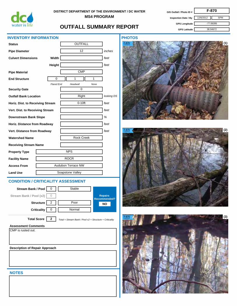
OUTFALL SUMMARY REPORT
DISTRICT DEPARTMENT OF THE ENVIRONMENT / DC WATER
MS4 PROGRAMGIS Outfall / Photo ID # F-870
Inspection Date / By 12/6/2012
GPS Longitude -77.06395
GPS Latitude 38.94672
SPM
Access From Audubon Terrace NW
Horiz. Dist. to Receiving Stream 0-10ft
Flared End
0
Headwall
1
None
1
Security Gate 0
Facility Name ROCR
Land Use Soapstone Valley
Outfall Bank Location Right
Pipe Diameter 12
Height
Pipe Material CMP
Width
Property Type NPS
Receiving Stream Name
Description of Repair Approach
Watershed Name Rock Creek
NOTES
INVENTORY INFORMATION
inches
feet
feet
Culvert Dimensions
End Structure
looking DS
feet
%
CONDITION / CRITICALITY ASSESSMENT
(1)
(2)
(3)
Downstream Bank Slope
PHOTOS
Status OUTFALL
Assessment Comments
CMP is rusted out.
Total = Stream Bank / Pool x2 + Structure + CriticalityTotal Score 2
Horiz. Distance from Roadway
Vert. Distance from Roadway
feet
feet
Vert. Dist. to Receiving Stream feet
Stable
Poor
Normal
Stream Bank / Pool 0
Stream Bank / Pool (x2) 0
Structure 2
Criticality 0
Repairs Recommended?
NO

OUTFALL SUMMARY REPORT
DISTRICT DEPARTMENT OF THE ENVIRONMENT / DC WATER
MS4 PROGRAMGIS Outfall / Photo ID # F-870
Inspection Date / By 12/6/2012
GPS Longitude -77.06395
GPS Latitude 38.94672
SPM
(4)
(6) (7)
(8) (9)
(5)

OUTFALL SUMMARY REPORT
DISTRICT DEPARTMENT OF THE ENVIRONMENT / DC WATER
MS4 PROGRAMGIS Outfall / Photo ID # F-871
Inspection Date / By 12/6/2012
GPS Longitude -77.05811
GPS Latitude 38.95645
SPM
Access From Broad Branch Rd NW
Horiz. Dist. to Receiving Stream 0-10ft
Flared End
0
Headwall
0
None
1
Security Gate 0
Facility Name ROCR
Land Use Broad Branch
Outfall Bank Location Right
Pipe Diameter 15
Height
Pipe Material CMP
Width
Property Type NPS
Receiving Stream Name Broad Branch
Description of Repair Approach
Watershed Name Rock Creek
NOTES
INVENTORY INFORMATION
inches
feet
feet
Culvert Dimensions
End Structure
looking DS
feet
%
CONDITION / CRITICALITY ASSESSMENT
(1)
(2)
(3)
Downstream Bank Slope
PHOTOS
Status OUTFALL
Assessment Comments
Pipe invert is rusted out in this CMP.
Total = Stream Bank / Pool x2 + Structure + CriticalityTotal Score 2
Horiz. Distance from Roadway
Vert. Distance from Roadway
feet
feet
Vert. Dist. to Receiving Stream feet
Stable
Poor
Normal
Stream Bank / Pool 0
Stream Bank / Pool (x2) 0
Structure 2
Criticality 0
Repairs Recommended?
NO

OUTFALL SUMMARY REPORT
DISTRICT DEPARTMENT OF THE ENVIRONMENT / DC WATER
MS4 PROGRAMGIS Outfall / Photo ID # F-871
Inspection Date / By 12/6/2012
GPS Longitude -77.05811
GPS Latitude 38.95645
SPM
(4)
(6) (7)
(8) (9)
(5)

OUTFALL SUMMARY REPORT
DISTRICT DEPARTMENT OF THE ENVIRONMENT / DC WATER
MS4 PROGRAMGIS Outfall / Photo ID # F-872
Inspection Date / By 12/6/2012
GPS Longitude -77.05820
GPS Latitude 38.95628
SPM
Access From Broad Branch Rd NW
Horiz. Dist. to Receiving Stream 0-10ft
Flared End
0
Headwall
0
None
0
Security Gate 0
Facility Name ROCR
Land Use Broad Branch
Outfall Bank Location Right
Pipe Diameter 24 est
Height
Pipe Material Clay
Width
Property Type NPS
Receiving Stream Name Broad Branch
Description of Repair Approach
Watershed Name Rock Creek
NOTES
INVENTORY INFORMATION
inches
feet
feet
Culvert Dimensions
End Structure
looking DS
feet
%
CONDITION / CRITICALITY ASSESSMENT
(1)
(2)
(3)
Downstream Bank Slope
PHOTOS
Status OUTFALL
Assessment Comments
Total = Stream Bank / Pool x2 + Structure + CriticalityTotal Score 1
Horiz. Distance from Roadway
Vert. Distance from Roadway
feet
feet
Vert. Dist. to Receiving Stream feet
Stable
Moderate
Normal
Stream Bank / Pool 0
Stream Bank / Pool (x2) 0
Structure 1
Criticality 0
Repairs Recommended?
NO

OUTFALL SUMMARY REPORT
DISTRICT DEPARTMENT OF THE ENVIRONMENT / DC WATER
MS4 PROGRAMGIS Outfall / Photo ID # F-872
Inspection Date / By 12/6/2012
GPS Longitude -77.05820
GPS Latitude 38.95628
SPM
(4)
(6) (7)
(8) (9)
(5)

OUTFALL SUMMARY REPORT
DISTRICT DEPARTMENT OF THE ENVIRONMENT / DC WATER
MS4 PROGRAMGIS Outfall / Photo ID # F-873
Inspection Date / By 12/6/2012
GPS Longitude -77.05474
GPS Latitude 38.95249
SPM
Access From Broad Branch Rd NW
Horiz. Dist. to Receiving Stream 0-10ft
Flared End
0
Headwall
0
None
1
Security Gate 0
Facility Name ROCR
Land Use Broad Branch
Outfall Bank Location Right
Pipe Diameter 14
Height
Pipe Material CMP
Width
Property Type NPS
Receiving Stream Name
Description of Repair Approach
Watershed Name Rock Creek
NOTES
INVENTORY INFORMATION
inches
feet
feet
Culvert Dimensions
End Structure
looking DS
feet
%
CONDITION / CRITICALITY ASSESSMENT
(1)
(2)
(3)
Downstream Bank Slope
PHOTOS
Status OUTFALL
Assessment Comments
Total = Stream Bank / Pool x2 + Structure + CriticalityTotal Score 0
Horiz. Distance from Roadway
Vert. Distance from Roadway
feet
feet
Vert. Dist. to Receiving Stream feet
Stable
Excellent / Like New
Normal
Stream Bank / Pool 0
Stream Bank / Pool (x2) 0
Structure 0
Criticality 0
Repairs Recommended?
NO

OUTFALL SUMMARY REPORT
DISTRICT DEPARTMENT OF THE ENVIRONMENT / DC WATER
MS4 PROGRAMGIS Outfall / Photo ID # F-873
Inspection Date / By 12/6/2012
GPS Longitude -77.05474
GPS Latitude 38.95249
SPM
(4)
(6) (7)
(8) (9)
(5)

OUTFALL SUMMARY REPORT
DISTRICT DEPARTMENT OF THE ENVIRONMENT / DC WATER
MS4 PROGRAMGIS Outfall / Photo ID # F-874
Inspection Date / By 12/6/2012
GPS Longitude -77.05740
GPS Latitude 38.95488
SPM
Access From Broad Branch Rd NW
Horiz. Dist. to Receiving Stream 20-30ft
Flared End
0
Headwall
0
None
1
Security Gate 0
Facility Name ROCR
Land Use Broad Branch
Outfall Bank Location Right
Pipe Diameter 15
Height
Pipe Material Clay
Width
Property Type NPS
Receiving Stream Name
Description of Repair Approach
Watershed Name Rock Creek
NOTES
INVENTORY INFORMATION
inches
feet
feet
Culvert Dimensions
End Structure
looking DS
feet
%
CONDITION / CRITICALITY ASSESSMENT
(1)
(2)
(3)
Downstream Bank Slope
PHOTOS
Status OUTFALL
Assessment Comments
Total = Stream Bank / Pool x2 + Structure + CriticalityTotal Score 1
Horiz. Distance from Roadway
Vert. Distance from Roadway
feet
feet
Vert. Dist. to Receiving Stream feet
Stable
Moderate
Normal
Stream Bank / Pool 0
Stream Bank / Pool (x2) 0
Structure 1
Criticality 0
Repairs Recommended?
NO

OUTFALL SUMMARY REPORT
DISTRICT DEPARTMENT OF THE ENVIRONMENT / DC WATER
MS4 PROGRAMGIS Outfall / Photo ID # F-874
Inspection Date / By 12/6/2012
GPS Longitude -77.05740
GPS Latitude 38.95488
SPM
(4)
(6) (7)
(8) (9)
(5)

OUTFALL SUMMARY REPORT
DISTRICT DEPARTMENT OF THE ENVIRONMENT / DC WATER
MS4 PROGRAMGIS Outfall / Photo ID # F-875
Inspection Date / By 12/6/2012
GPS Longitude -77.05259
GPS Latitude 38.95007
SPM
Access From Broad Branch Rd NW
Horiz. Dist. to Receiving Stream 0-10ft
Flared End
1
Headwall
0
None
0
Security Gate 0
Facility Name ROCR
Land Use Broad Branch
Outfall Bank Location Right
Pipe Diameter 12
Height
Pipe Material Clay
Width
Property Type NPS
Receiving Stream Name
Description of Repair Approach
Watershed Name Rock Creek
NOTES
INVENTORY INFORMATION
inches
feet
feet
Culvert Dimensions
End Structure
looking DS
feet
%
CONDITION / CRITICALITY ASSESSMENT
(1)
(2)
(3)
Downstream Bank Slope
PHOTOS
Status OUTFALL
Assessment Comments
Total = Stream Bank / Pool x2 + Structure + CriticalityTotal Score 0
Horiz. Distance from Roadway
Vert. Distance from Roadway
feet
feet
Vert. Dist. to Receiving Stream feet
Stable
Excellent / Like New
Normal
Stream Bank / Pool 0
Stream Bank / Pool (x2) 0
Structure 0
Criticality 0
Repairs Recommended?
NO

OUTFALL SUMMARY REPORT
DISTRICT DEPARTMENT OF THE ENVIRONMENT / DC WATER
MS4 PROGRAMGIS Outfall / Photo ID # F-875
Inspection Date / By 12/6/2012
GPS Longitude -77.05259
GPS Latitude 38.95007
SPM
(4)
(6) (7)
(8) (9)
(5)

OUTFALL SUMMARY REPORT
DISTRICT DEPARTMENT OF THE ENVIRONMENT / DC WATER
MS4 PROGRAMGIS Outfall / Photo ID # F-876
Inspection Date / By 12/6/2012
GPS Longitude -77.05142
GPS Latitude 38.94821
SPM
Access From Broad Branch Rd NW
Horiz. Dist. to Receiving Stream 0-10ft
Flared End
0
Headwall
0
None
1
Security Gate 0
Facility Name ROCR
Land Use Broad Branch
Outfall Bank Location Right
Pipe Diameter 18
Height
Pipe Material VCP
Width
Property Type NPS
Receiving Stream Name
Description of Repair Approach
Point Repair
Watershed Name Rock Creek
NOTES
INVENTORY INFORMATION
inches
feet
feet
Culvert Dimensions
End Structure
looking DS
feet
%
CONDITION / CRITICALITY ASSESSMENT
(1)
(2)
(3)
Downstream Bank Slope
PHOTOS
Status OUTFALL
Assessment Comments
Total = Stream Bank / Pool x2 + Structure + CriticalityTotal Score 4
Horiz. Distance from Roadway
Vert. Distance from Roadway
feet
feet
Vert. Dist. to Receiving Stream feet
Some Erosion
Poor
Normal
Stream Bank / Pool 1
Stream Bank / Pool (x2) 2
Structure 2
Criticality 0
Repairs Recommended?
YES

OUTFALL SUMMARY REPORT
DISTRICT DEPARTMENT OF THE ENVIRONMENT / DC WATER
MS4 PROGRAMGIS Outfall / Photo ID # F-876
Inspection Date / By 12/6/2012
GPS Longitude -77.05142
GPS Latitude 38.94821
SPM
(4)
(6) (7)
(8) (9)
(5)

OUTFALL SUMMARY REPORT
DISTRICT DEPARTMENT OF THE ENVIRONMENT / DC WATER
MS4 PROGRAMGIS Outfall / Photo ID # F-877
Inspection Date / By 12/6/2012
GPS Longitude -77.05175
GPS Latitude 38.94693
SPM
Access From Broad Branch Rd NW
Horiz. Dist. to Receiving Stream 0-10ft
Flared End
0
Headwall
0
None
1
Security Gate 0
Facility Name ROCR
Land Use Broad Branch
Outfall Bank Location Right
Pipe Diameter 15
Height
Pipe Material Clay
Width
Property Type NPS
Receiving Stream Name Broad Branch
Description of Repair Approach
Watershed Name Rock Creek
NOTES
INVENTORY INFORMATION
inches
feet
feet
Culvert Dimensions
End Structure
looking DS
feet
%
CONDITION / CRITICALITY ASSESSMENT
(1)
(2)
(3)
Downstream Bank Slope
PHOTOS
Status OUTFALL
Assessment Comments
Total = Stream Bank / Pool x2 + Structure + CriticalityTotal Score 0
Horiz. Distance from Roadway
Vert. Distance from Roadway
feet
feet
Vert. Dist. to Receiving Stream feet
Stable
Excellent / Like New
Normal
Stream Bank / Pool 0
Stream Bank / Pool (x2) 0
Structure 0
Criticality 0
Repairs Recommended?
NO

OUTFALL SUMMARY REPORT
DISTRICT DEPARTMENT OF THE ENVIRONMENT / DC WATER
MS4 PROGRAMGIS Outfall / Photo ID # F-877
Inspection Date / By 12/6/2012
GPS Longitude -77.05175
GPS Latitude 38.94693
SPM
(4)
(6) (7)
(8) (9)
(5)

OUTFALL SUMMARY REPORT
DISTRICT DEPARTMENT OF THE ENVIRONMENT / DC WATER
MS4 PROGRAMGIS Outfall / Photo ID # F-878
Inspection Date / By 11/28/2012
GPS Longitude -77.06825
GPS Latitude 38.91983
SPM
Access From Observatory Ln NW
Horiz. Dist. to Receiving Stream 0-10ft
Flared End
0
Headwall
1
None
0
Security Gate 0
Facility Name Naval Observatory
Land Use Military
Outfall Bank Location Head
Pipe Diameter 30
Height
Pipe Material Plastic
Width
Property Type Government
Receiving Stream Name
Description of Repair Approach
Watershed Name
NOTES
INVENTORY INFORMATION
inches
feet
feet
Culvert Dimensions
End Structure
looking DS
feet
%
CONDITION / CRITICALITY ASSESSMENT
(1)
(2)
(3)
Downstream Bank Slope
PHOTOS
Status OUTFALL
Assessment Comments
Total = Stream Bank / Pool x2 + Structure + CriticalityTotal Score 0
Horiz. Distance from Roadway
Vert. Distance from Roadway
feet
feet
Vert. Dist. to Receiving Stream feet
Stable
Excellent / Like New
Normal
Stream Bank / Pool 0
Stream Bank / Pool (x2) 0
Structure 0
Criticality 0
Repairs Recommended?
NO

OUTFALL SUMMARY REPORT
DISTRICT DEPARTMENT OF THE ENVIRONMENT / DC WATER
MS4 PROGRAMGIS Outfall / Photo ID # F-878
Inspection Date / By 11/28/2012
GPS Longitude -77.06825
GPS Latitude 38.91983
SPM
(4)
(6) (7)
(8) (9)
(5)

OUTFALL SUMMARY REPORT
DISTRICT DEPARTMENT OF THE ENVIRONMENT / DC WATER
MS4 PROGRAMGIS Outfall / Photo ID # F-880
Inspection Date / By 12/7/2012
GPS Longitude -77.05500
GPS Latitude 38.93239
SPM
Access From Klingle Rd NW
Horiz. Dist. to Receiving Stream 0-10ft
Flared End
0
Headwall
0
None
1
Security Gate 0
Facility Name ROCR
Land Use Klingle Branch
Outfall Bank Location Left
Pipe Diameter 18
Height
Pipe Material Clay
Width
Property Type NPS
Receiving Stream Name Klingle Branch
Description of Repair Approach
Watershed Name Rock Creek
NOTES
INVENTORY INFORMATION
inches
feet
feet
Culvert Dimensions
End Structure
looking DS
feet
%
CONDITION / CRITICALITY ASSESSMENT
(1)
(2)
(3)
Downstream Bank Slope
PHOTOS
Status OUTFALL
Assessment Comments
Total = Stream Bank / Pool x2 + Structure + CriticalityTotal Score 1
Horiz. Distance from Roadway
Vert. Distance from Roadway
feet
feet
Vert. Dist. to Receiving Stream feet
Stable
Moderate
Normal
Stream Bank / Pool 0
Stream Bank / Pool (x2) 0
Structure 1
Criticality 0
Repairs Recommended?
NO

OUTFALL SUMMARY REPORT
DISTRICT DEPARTMENT OF THE ENVIRONMENT / DC WATER
MS4 PROGRAMGIS Outfall / Photo ID # F-880
Inspection Date / By 12/7/2012
GPS Longitude -77.05500
GPS Latitude 38.93239
SPM
(4)
(6) (7)
(8) (9)
(5)

OUTFALL SUMMARY REPORT
DISTRICT DEPARTMENT OF THE ENVIRONMENT / DC WATER
MS4 PROGRAMGIS Outfall / Photo ID # F-881
Inspection Date / By 12/7/2012
GPS Longitude -77.04084
GPS Latitude 38.93644
SPM
Access From Piney Branch Pkwy NW
Horiz. Dist. to Receiving Stream 0-10ft
Flared End
0
Headwall
0
None
1
Security Gate 0
Facility Name ROCR
Land Use Piney Branch Park
Outfall Bank Location Left
Pipe Diameter 4
Height
Pipe Material Iron
Width
Property Type NPS
Receiving Stream Name
Description of Repair Approach
Watershed Name Rock Creek
NOTES
INVENTORY INFORMATION
inches
feet
feet
Culvert Dimensions
End Structure
looking DS
feet
%
CONDITION / CRITICALITY ASSESSMENT
(1)
(2)
(3)
Downstream Bank Slope
PHOTOS
Status OUTFALL
Assessment Comments
8 inch clay weep hole beside F-177.
Total = Stream Bank / Pool x2 + Structure + CriticalityTotal Score 0
Horiz. Distance from Roadway
Vert. Distance from Roadway
feet
feet
Vert. Dist. to Receiving Stream feet
Stable
Excellent / Like New
Normal
Stream Bank / Pool 0
Stream Bank / Pool (x2) 0
Structure 0
Criticality 0
Repairs Recommended?
NO

OUTFALL SUMMARY REPORT
DISTRICT DEPARTMENT OF THE ENVIRONMENT / DC WATER
MS4 PROGRAMGIS Outfall / Photo ID # F-881
Inspection Date / By 12/7/2012
GPS Longitude -77.04084
GPS Latitude 38.93644
SPM
(4)
(6) (7)
(8) (9)
(5)

OUTFALL SUMMARY REPORT
DISTRICT DEPARTMENT OF THE ENVIRONMENT / DC WATER
MS4 PROGRAMGIS Outfall / Photo ID # F-882
Inspection Date / By 12/10/2012
GPS Longitude -77.05902
GPS Latitude 38.91600
SPM
Access From Whitehaven St NW
Horiz. Dist. to Receiving Stream 0-10ft
Flared End
0
Headwall
0
None
1
Security Gate 0
Facility Name ROCR
Land Use Rock Creek Park
Outfall Bank Location Left
Pipe Diameter 6 est
Height
Pipe Material Iron
Width
Property Type NPS
Receiving Stream Name
Description of Repair Approach
Watershed Name Rock Creek
NOTES
INVENTORY INFORMATION
inches
feet
feet
Culvert Dimensions
End Structure
looking DS
feet
%
CONDITION / CRITICALITY ASSESSMENT
(1)
(2)
(3)
Downstream Bank Slope
PHOTOS
Status OUTFALL
Assessment Comments
Total = Stream Bank / Pool x2 + Structure + CriticalityTotal Score 0
Horiz. Distance from Roadway
Vert. Distance from Roadway
feet
feet
Vert. Dist. to Receiving Stream feet
Stable
Excellent / Like New
Normal
Stream Bank / Pool 0
Stream Bank / Pool (x2) 0
Structure 0
Criticality 0
Repairs Recommended?
NO

OUTFALL SUMMARY REPORT
DISTRICT DEPARTMENT OF THE ENVIRONMENT / DC WATER
MS4 PROGRAMGIS Outfall / Photo ID # F-882
Inspection Date / By 12/10/2012
GPS Longitude -77.05902
GPS Latitude 38.91600
SPM
(4)
(6) (7)
(8) (9)
(5)

OUTFALL SUMMARY REPORT
DISTRICT DEPARTMENT OF THE ENVIRONMENT / DC WATER
MS4 PROGRAMGIS Outfall / Photo ID # F-883
Inspection Date / By 12/10/2012
GPS Longitude -77.05591
GPS Latitude 38.90455
SPM
Access From L St NW
Horiz. Dist. to Receiving Stream 0-10ft
Flared End
0
Headwall
0
None
1
Security Gate 0
Facility Name ROCR
Land Use Rock Creek Park
Outfall Bank Location Right
Pipe Diameter 8 est
Height
Pipe Material Clay
Width
Property Type NPS
Receiving Stream Name
Description of Repair Approach
Watershed Name Rock Creek
NOTES
INVENTORY INFORMATION
inches
feet
feet
Culvert Dimensions
End Structure
looking DS
feet
%
CONDITION / CRITICALITY ASSESSMENT
(1)
(2)
(3)
Downstream Bank Slope
PHOTOS
Status OUTFALL
Assessment Comments
Total = Stream Bank / Pool x2 + Structure + CriticalityTotal Score 0
Horiz. Distance from Roadway
Vert. Distance from Roadway
feet
feet
Vert. Dist. to Receiving Stream feet
Stable
Excellent / Like New
Normal
Stream Bank / Pool 0
Stream Bank / Pool (x2) 0
Structure 0
Criticality 0
Repairs Recommended?
NO

OUTFALL SUMMARY REPORT
DISTRICT DEPARTMENT OF THE ENVIRONMENT / DC WATER
MS4 PROGRAMGIS Outfall / Photo ID # F-883
Inspection Date / By 12/10/2012
GPS Longitude -77.05591
GPS Latitude 38.90455
SPM
(4)
(6) (7)
(8) (9)
(5)

OUTFALL SUMMARY REPORT
DISTRICT DEPARTMENT OF THE ENVIRONMENT / DC WATER
MS4 PROGRAMGIS Outfall / Photo ID # F-884
Inspection Date / By 2/5/2013
GPS Longitude -77.05672
GPS Latitude 38.89693
SPM
Access From BOAT
Horiz. Dist. to Receiving Stream 0-10ft
Flared End
0
Headwall
1
None
0
Security Gate 0
Facility Name NAMA
Land Use Rock Creek Park Trails
Outfall Bank Location Left
Pipe Diameter 36 est
Height
Pipe Material RCP
Width
Property Type NPS
Receiving Stream Name
Description of Repair Approach
Watershed Name Rock Creek
NOTES
INVENTORY INFORMATION
inches
feet
feet
Culvert Dimensions
End Structure
looking DS
feet
%
CONDITION / CRITICALITY ASSESSMENT
(1)
(2)
(3)
Downstream Bank Slope
PHOTOS
Status OUTFALL
Assessment Comments
Stone falling off headwall.
Total = Stream Bank / Pool x2 + Structure + CriticalityTotal Score 1
Horiz. Distance from Roadway
Vert. Distance from Roadway
feet
feet
Vert. Dist. to Receiving Stream feet
Stable
Moderate
Normal
Stream Bank / Pool 0
Stream Bank / Pool (x2) 0
Structure 1
Criticality 0
Repairs Recommended?
NO

OUTFALL SUMMARY REPORT
DISTRICT DEPARTMENT OF THE ENVIRONMENT / DC WATER
MS4 PROGRAMGIS Outfall / Photo ID # F-884
Inspection Date / By 2/5/2013
GPS Longitude -77.05672
GPS Latitude 38.89693
SPM
(4)
(6) (7)
(8) (9)
(5)

OUTFALL SUMMARY REPORT
DISTRICT DEPARTMENT OF THE ENVIRONMENT / DC WATER
MS4 PROGRAMGIS Outfall / Photo ID # F-885
Inspection Date / By 1/7/2013
GPS Longitude -77.03985
GPS Latitude 38.88788
SPM
Access From Ohio Dr SW
Horiz. Dist. to Receiving Stream 0-10ft
Flared End
0
Headwall
1
None
0
Security Gate 0
Facility Name NACC/NAMA
Land Use Tidal Basin
Outfall Bank Location Head
Pipe Diameter
Height 2 est
Pipe Material Concrete
Width 2 est
Property Type NPS
Receiving Stream Name
Description of Repair Approach
Watershed Name
NOTES
INVENTORY INFORMATION
inches
feet
feet
Culvert Dimensions
End Structure
looking DS
feet
%
CONDITION / CRITICALITY ASSESSMENT
(1)
(2)
(3)
Downstream Bank Slope
PHOTOS
Status OUTFALL
Assessment Comments
Unable to access.
Total = Stream Bank / Pool x2 + Structure + CriticalityTotal Score 0
Horiz. Distance from Roadway
Vert. Distance from Roadway
feet
feet
Vert. Dist. to Receiving Stream feet
Stable
Excellent / Like New
Normal
Stream Bank / Pool 0
Stream Bank / Pool (x2) 0
Structure 0
Criticality 0
Repairs Recommended?
NO

OUTFALL SUMMARY REPORT
DISTRICT DEPARTMENT OF THE ENVIRONMENT / DC WATER
MS4 PROGRAMGIS Outfall / Photo ID # F-885
Inspection Date / By 1/7/2013
GPS Longitude -77.03985
GPS Latitude 38.88788
SPM
(4)
(6) (7)
(8) (9)
(5)

OUTFALL SUMMARY REPORT
DISTRICT DEPARTMENT OF THE ENVIRONMENT / DC WATER
MS4 PROGRAMGIS Outfall / Photo ID # F-886
Inspection Date / By 1/7/2013
GPS Longitude -77.04311
GPS Latitude 38.88636
SPM
Access From Ohio Dr SW
Horiz. Dist. to Receiving Stream 0-10ft
Flared End
0
Headwall
1
None
1
Security Gate 0
Facility Name NACC/NAMA
Land Use Tidal Basin
Outfall Bank Location Head
Pipe Diameter 8
Height
Pipe Material Clay
Width
Property Type NPS
Receiving Stream Name
Description of Repair Approach
Watershed Name
NOTES
INVENTORY INFORMATION
inches
feet
feet
Culvert Dimensions
End Structure
looking DS
feet
%
CONDITION / CRITICALITY ASSESSMENT
(1)
(2)
(3)
Downstream Bank Slope
PHOTOS
Status OUTFALL
Assessment Comments
Total = Stream Bank / Pool x2 + Structure + CriticalityTotal Score 0
Horiz. Distance from Roadway
Vert. Distance from Roadway
feet
feet
Vert. Dist. to Receiving Stream feet
Stable
Excellent / Like New
Normal
Stream Bank / Pool 0
Stream Bank / Pool (x2) 0
Structure 0
Criticality 0
Repairs Recommended?
NO

OUTFALL SUMMARY REPORT
DISTRICT DEPARTMENT OF THE ENVIRONMENT / DC WATER
MS4 PROGRAMGIS Outfall / Photo ID # F-886
Inspection Date / By 1/7/2013
GPS Longitude -77.04311
GPS Latitude 38.88636
SPM
(4)
(6) (7)
(8) (9)
(5)

OUTFALL SUMMARY REPORT
DISTRICT DEPARTMENT OF THE ENVIRONMENT / DC WATER
MS4 PROGRAMGIS Outfall / Photo ID # F-887
Inspection Date / By 2/5/2013
GPS Longitude -77.03721
GPS Latitude 38.87749
SPM
Access From BOAT
Horiz. Dist. to Receiving Stream 0-10ft
Flared End
0
Headwall
1
None
0
Security Gate 0
Facility Name NAMA
Land Use East Potomac Park
Outfall Bank Location Left
Pipe Diameter 12 est
Height
Pipe Material RCP
Width
Property Type NPS
Receiving Stream Name
Description of Repair Approach
Watershed Name
NOTES
INVENTORY INFORMATION
inches
feet
feet
Culvert Dimensions
End Structure
looking DS
feet
%
CONDITION / CRITICALITY ASSESSMENT
(1)
(2)
(3)
Downstream Bank Slope
PHOTOS
Status OUTFALL
Assessment Comments
Total = Stream Bank / Pool x2 + Structure + CriticalityTotal Score 2
Horiz. Distance from Roadway
Vert. Distance from Roadway
feet
feet
Vert. Dist. to Receiving Stream feet
Stable
Moderate
Important
Stream Bank / Pool 0
Stream Bank / Pool (x2) 0
Structure 1
Criticality 1
Repairs Recommended?
NO

OUTFALL SUMMARY REPORT
DISTRICT DEPARTMENT OF THE ENVIRONMENT / DC WATER
MS4 PROGRAMGIS Outfall / Photo ID # F-887
Inspection Date / By 2/5/2013
GPS Longitude -77.03721
GPS Latitude 38.87749
SPM
(4)
(6) (7)
(8) (9)
(5)

OUTFALL SUMMARY REPORT
DISTRICT DEPARTMENT OF THE ENVIRONMENT / DC WATER
MS4 PROGRAMGIS Outfall / Photo ID # F-888
Inspection Date / By 2/5/2013
GPS Longitude -77.03666
GPS Latitude 38.87693
SPM
Access From BOAT
Horiz. Dist. to Receiving Stream 0-10ft
Flared End
0
Headwall
1
None
0
Security Gate 0
Facility Name NAMA
Land Use East Potomac Park
Outfall Bank Location Left
Pipe Diameter 8
Height
Pipe Material CMP
Width
Property Type NPS
Receiving Stream Name
Description of Repair Approach
Watershed Name
NOTES
INVENTORY INFORMATION
inches
feet
feet
Culvert Dimensions
End Structure
looking DS
feet
%
CONDITION / CRITICALITY ASSESSMENT
(1)
(2)
(3)
Downstream Bank Slope
PHOTOS
Status OUTFALL
Assessment Comments
Total = Stream Bank / Pool x2 + Structure + CriticalityTotal Score 0
Horiz. Distance from Roadway
Vert. Distance from Roadway
feet
feet
Vert. Dist. to Receiving Stream feet
Stable
Excellent / Like New
Normal
Stream Bank / Pool 0
Stream Bank / Pool (x2) 0
Structure 0
Criticality 0
Repairs Recommended?
NO

OUTFALL SUMMARY REPORT
DISTRICT DEPARTMENT OF THE ENVIRONMENT / DC WATER
MS4 PROGRAMGIS Outfall / Photo ID # F-888
Inspection Date / By 2/5/2013
GPS Longitude -77.03666
GPS Latitude 38.87693
SPM
(4)
(6) (7)
(8) (9)
(5)
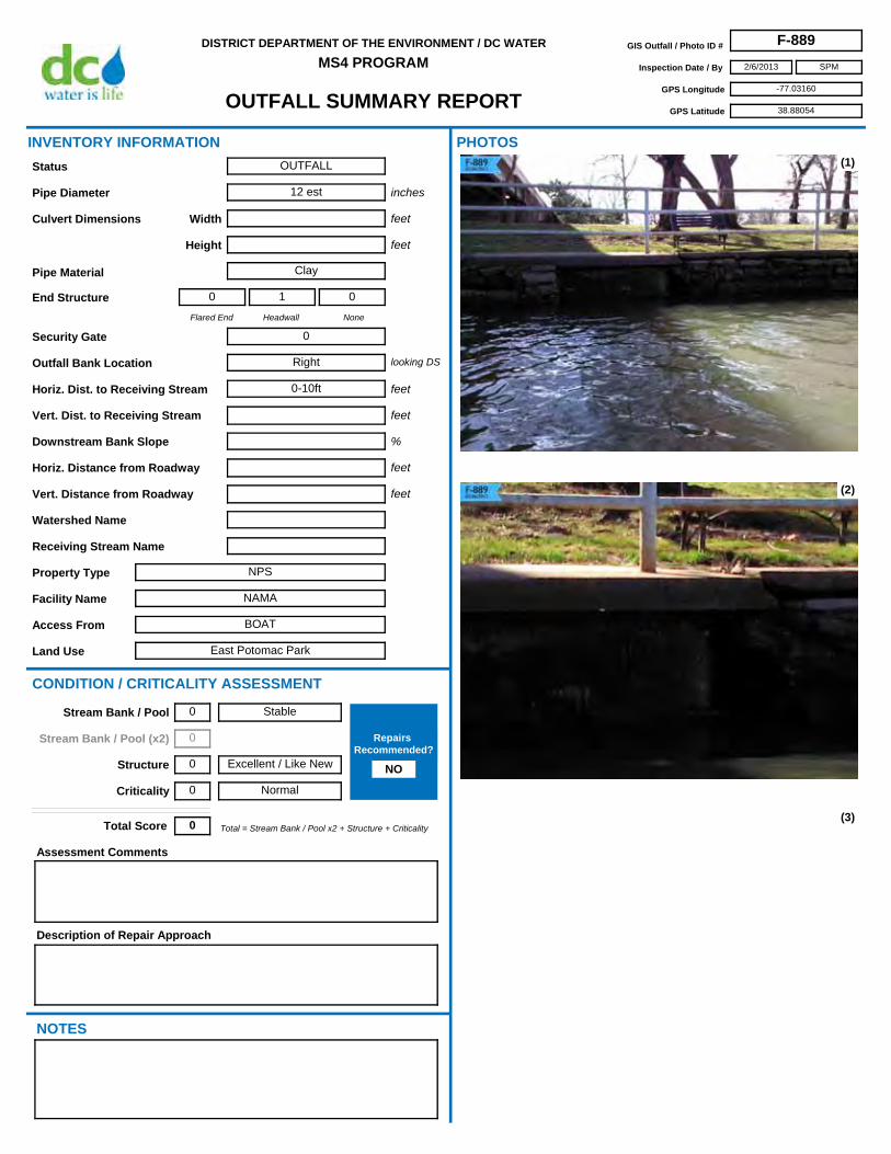
OUTFALL SUMMARY REPORT
DISTRICT DEPARTMENT OF THE ENVIRONMENT / DC WATER
MS4 PROGRAMGIS Outfall / Photo ID # F-889
Inspection Date / By 2/6/2013
GPS Longitude -77.03160
GPS Latitude 38.88054
SPM
Access From BOAT
Horiz. Dist. to Receiving Stream 0-10ft
Flared End
0
Headwall
1
None
0
Security Gate 0
Facility Name NAMA
Land Use East Potomac Park
Outfall Bank Location Right
Pipe Diameter 12 est
Height
Pipe Material Clay
Width
Property Type NPS
Receiving Stream Name
Description of Repair Approach
Watershed Name
NOTES
INVENTORY INFORMATION
inches
feet
feet
Culvert Dimensions
End Structure
looking DS
feet
%
CONDITION / CRITICALITY ASSESSMENT
(1)
(2)
(3)
Downstream Bank Slope
PHOTOS
Status OUTFALL
Assessment Comments
Total = Stream Bank / Pool x2 + Structure + CriticalityTotal Score 0
Horiz. Distance from Roadway
Vert. Distance from Roadway
feet
feet
Vert. Dist. to Receiving Stream feet
Stable
Excellent / Like New
Normal
Stream Bank / Pool 0
Stream Bank / Pool (x2) 0
Structure 0
Criticality 0
Repairs Recommended?
NO

OUTFALL SUMMARY REPORT
DISTRICT DEPARTMENT OF THE ENVIRONMENT / DC WATER
MS4 PROGRAMGIS Outfall / Photo ID # F-889
Inspection Date / By 2/6/2013
GPS Longitude -77.03160
GPS Latitude 38.88054
SPM
(4)
(6) (7)
(8) (9)
(5)

OUTFALL SUMMARY REPORT
DISTRICT DEPARTMENT OF THE ENVIRONMENT / DC WATER
MS4 PROGRAMGIS Outfall / Photo ID # F-890
Inspection Date / By 2/5/2013
GPS Longitude -77.03960
GPS Latitude 38.87896
SPM
Access From BOAT
Horiz. Dist. to Receiving Stream 0-10ft
Flared End
0
Headwall
1
None
0
Security Gate 0
Facility Name NAMA
Land Use East Potomac Park
Outfall Bank Location Left
Pipe Diameter 12
Height
Pipe Material RCP
Width
Property Type NPS
Receiving Stream Name
Description of Repair Approach
Watershed Name
NOTES
INVENTORY INFORMATION
inches
feet
feet
Culvert Dimensions
End Structure
looking DS
feet
%
CONDITION / CRITICALITY ASSESSMENT
(1)
(2)
(3)
Downstream Bank Slope
PHOTOS
Status OUTFALL
Assessment Comments
Stone missing from headwall.
Total = Stream Bank / Pool x2 + Structure + CriticalityTotal Score 1
Horiz. Distance from Roadway
Vert. Distance from Roadway
feet
feet
Vert. Dist. to Receiving Stream feet
Stable
Moderate
Normal
Stream Bank / Pool 0
Stream Bank / Pool (x2) 0
Structure 1
Criticality 0
Repairs Recommended?
NO

OUTFALL SUMMARY REPORT
DISTRICT DEPARTMENT OF THE ENVIRONMENT / DC WATER
MS4 PROGRAMGIS Outfall / Photo ID # F-890
Inspection Date / By 2/5/2013
GPS Longitude -77.03960
GPS Latitude 38.87896
SPM
(4)
(6) (7)
(8) (9)
(5)
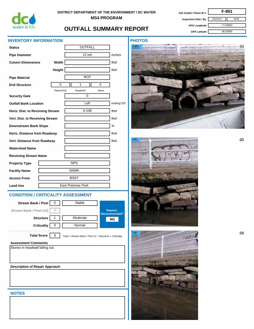
OUTFALL SUMMARY REPORT
DISTRICT DEPARTMENT OF THE ENVIRONMENT / DC WATER
MS4 PROGRAMGIS Outfall / Photo ID # F-891
Inspection Date / By 2/5/2013
GPS Longitude -77.03901
GPS Latitude 38.87850
SPM
Access From BOAT
Horiz. Dist. to Receiving Stream 0-10ft
Flared End
0
Headwall
1
None
0
Security Gate 0
Facility Name NAMA
Land Use East Potomac Park
Outfall Bank Location Left
Pipe Diameter 12 est
Height
Pipe Material RCP
Width
Property Type NPS
Receiving Stream Name
Description of Repair Approach
Watershed Name
NOTES
INVENTORY INFORMATION
inches
feet
feet
Culvert Dimensions
End Structure
looking DS
feet
%
CONDITION / CRITICALITY ASSESSMENT
(1)
(2)
(3)
Downstream Bank Slope
PHOTOS
Status OUTFALL
Assessment Comments
Stones in headwall falling out.
Total = Stream Bank / Pool x2 + Structure + CriticalityTotal Score 1
Horiz. Distance from Roadway
Vert. Distance from Roadway
feet
feet
Vert. Dist. to Receiving Stream feet
Stable
Moderate
Normal
Stream Bank / Pool 0
Stream Bank / Pool (x2) 0
Structure 1
Criticality 0
Repairs Recommended?
NO

OUTFALL SUMMARY REPORT
DISTRICT DEPARTMENT OF THE ENVIRONMENT / DC WATER
MS4 PROGRAMGIS Outfall / Photo ID # F-891
Inspection Date / By 2/5/2013
GPS Longitude -77.03901
GPS Latitude 38.87850
SPM
(4)
(6) (7)
(8) (9)
(5)

OUTFALL SUMMARY REPORT
DISTRICT DEPARTMENT OF THE ENVIRONMENT / DC WATER
MS4 PROGRAMGIS Outfall / Photo ID # F-892
Inspection Date / By 2/6/2013
GPS Longitude -77.02472
GPS Latitude 38.87864
SPM
Access From BOAT
Horiz. Dist. to Receiving Stream 0-10ft
Flared End
0
Headwall
1
None
0
Security Gate 1
Facility Name Gangplank Marina
Land Use Marina
Outfall Bank Location Left
Pipe Diameter 12 est
Height
Pipe Material RCP
Width
Property Type Private
Receiving Stream Name
Description of Repair Approach
Watershed Name
NOTES
INVENTORY INFORMATION
inches
feet
feet
Culvert Dimensions
End Structure
looking DS
feet
%
CONDITION / CRITICALITY ASSESSMENT
(1)
(2)
(3)
Downstream Bank Slope
PHOTOS
Status OUTFALL
Assessment Comments
Total = Stream Bank / Pool x2 + Structure + CriticalityTotal Score 0
Horiz. Distance from Roadway
Vert. Distance from Roadway
feet
feet
Vert. Dist. to Receiving Stream feet
Stable
Excellent / Like New
Normal
Stream Bank / Pool 0
Stream Bank / Pool (x2) 0
Structure 0
Criticality 0
Repairs Recommended?
NO

OUTFALL SUMMARY REPORT
DISTRICT DEPARTMENT OF THE ENVIRONMENT / DC WATER
MS4 PROGRAMGIS Outfall / Photo ID # F-892
Inspection Date / By 2/6/2013
GPS Longitude -77.02472
GPS Latitude 38.87864
SPM
(4)
(6) (7)
(8) (9)
(5)

OUTFALL SUMMARY REPORT
DISTRICT DEPARTMENT OF THE ENVIRONMENT / DC WATER
MS4 PROGRAMGIS Outfall / Photo ID # F-893
Inspection Date / By 2/6/2013
GPS Longitude -77.02545
GPS Latitude 38.87921
SPM
Access From BOAT
Horiz. Dist. to Receiving Stream 0-10ft
Flared End
0
Headwall
1
None
0
Security Gate 1
Facility Name Gangplank Marina
Land Use Marina
Outfall Bank Location Left
Pipe Diameter 12 est
Height
Pipe Material RCP
Width
Property Type Private
Receiving Stream Name
Description of Repair Approach
Watershed Name
NOTES
INVENTORY INFORMATION
inches
feet
feet
Culvert Dimensions
End Structure
looking DS
feet
%
CONDITION / CRITICALITY ASSESSMENT
(1)
(2)
(3)
Downstream Bank Slope
PHOTOS
Status OUTFALL
Assessment Comments
Total = Stream Bank / Pool x2 + Structure + CriticalityTotal Score 0
Horiz. Distance from Roadway
Vert. Distance from Roadway
feet
feet
Vert. Dist. to Receiving Stream feet
Stable
Excellent / Like New
Normal
Stream Bank / Pool 0
Stream Bank / Pool (x2) 0
Structure 0
Criticality 0
Repairs Recommended?
NO

OUTFALL SUMMARY REPORT
DISTRICT DEPARTMENT OF THE ENVIRONMENT / DC WATER
MS4 PROGRAMGIS Outfall / Photo ID # F-893
Inspection Date / By 2/6/2013
GPS Longitude -77.02545
GPS Latitude 38.87921
SPM
(4)
(6) (7)
(8) (9)
(5)

OUTFALL SUMMARY REPORT
DISTRICT DEPARTMENT OF THE ENVIRONMENT / DC WATER
MS4 PROGRAMGIS Outfall / Photo ID # F-894
Inspection Date / By 1/11/2013
GPS Longitude -76.98315
GPS Latitude 38.84041
SPM
Access From DC United Parking Lot (Oklahoma Ave NE)
Horiz. Dist. to Receiving Stream 0-10ft
Flared End
0
Headwall
0
None
1
Security Gate 0
Facility Name NACE
Land Use Anacostia Park
Outfall Bank Location Left
Pipe Diameter 12
Height
Pipe Material VCP
Width
Property Type NPS
Receiving Stream Name
Description of Repair Approach
Watershed Name Anacostia
NOTES
INVENTORY INFORMATION
inches
feet
feet
Culvert Dimensions
End Structure
looking DS
feet
%
CONDITION / CRITICALITY ASSESSMENT
(1)
(2)
(3)
Downstream Bank Slope
PHOTOS
Status OUTFALL
Assessment Comments
Broken pipe downstream. May be abandoned broken SS. Severe erosion upstream and downstream.
Total = Stream Bank / Pool x2 + Structure + CriticalityTotal Score 3
Horiz. Distance from Roadway
Vert. Distance from Roadway
feet
feet
Vert. Dist. to Receiving Stream feet
Some Erosion
Moderate
Normal
Stream Bank / Pool 1
Stream Bank / Pool (x2) 2
Structure 1
Criticality 0
Repairs Recommended?
NO

OUTFALL SUMMARY REPORT
DISTRICT DEPARTMENT OF THE ENVIRONMENT / DC WATER
MS4 PROGRAMGIS Outfall / Photo ID # F-894
Inspection Date / By 1/11/2013
GPS Longitude -76.98315
GPS Latitude 38.84041
SPM
(4)
(6) (7)
(8) (9)
(5)
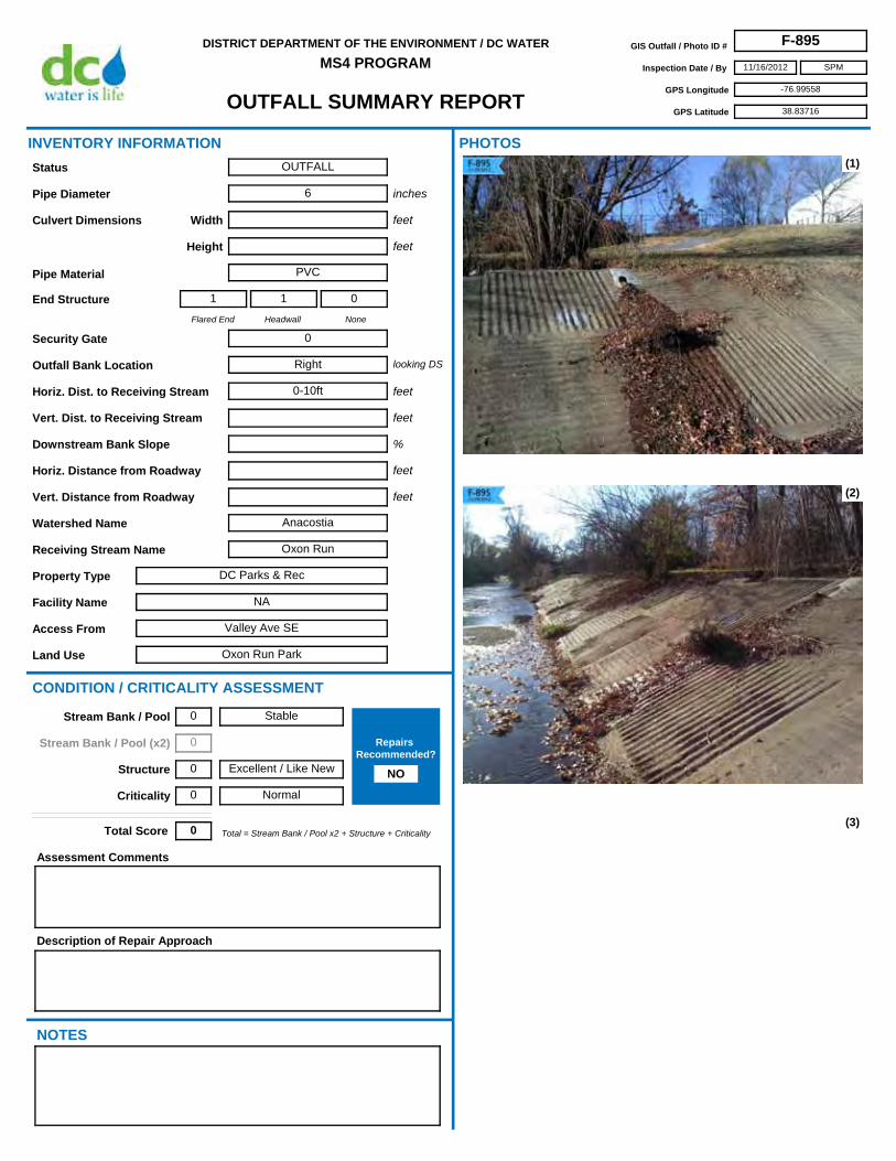
OUTFALL SUMMARY REPORT
DISTRICT DEPARTMENT OF THE ENVIRONMENT / DC WATER
MS4 PROGRAMGIS Outfall / Photo ID # F-895
Inspection Date / By 11/16/2012
GPS Longitude -76.99558
GPS Latitude 38.83716
SPM
Access From Valley Ave SE
Horiz. Dist. to Receiving Stream 0-10ft
Flared End
1
Headwall
1
None
0
Security Gate 0
Facility Name NA
Land Use Oxon Run Park
Outfall Bank Location Right
Pipe Diameter 6
Height
Pipe Material PVC
Width
Property Type DC Parks & Rec
Receiving Stream Name Oxon Run
Description of Repair Approach
Watershed Name Anacostia
NOTES
INVENTORY INFORMATION
inches
feet
feet
Culvert Dimensions
End Structure
looking DS
feet
%
CONDITION / CRITICALITY ASSESSMENT
(1)
(2)
(3)
Downstream Bank Slope
PHOTOS
Status OUTFALL
Assessment Comments
Total = Stream Bank / Pool x2 + Structure + CriticalityTotal Score 0
Horiz. Distance from Roadway
Vert. Distance from Roadway
feet
feet
Vert. Dist. to Receiving Stream feet
Stable
Excellent / Like New
Normal
Stream Bank / Pool 0
Stream Bank / Pool (x2) 0
Structure 0
Criticality 0
Repairs Recommended?
NO

OUTFALL SUMMARY REPORT
DISTRICT DEPARTMENT OF THE ENVIRONMENT / DC WATER
MS4 PROGRAMGIS Outfall / Photo ID # F-895
Inspection Date / By 11/16/2012
GPS Longitude -76.99558
GPS Latitude 38.83716
SPM
(4)
(6) (7)
(8) (9)
(5)

OUTFALL SUMMARY REPORT
DISTRICT DEPARTMENT OF THE ENVIRONMENT / DC WATER
MS4 PROGRAMGIS Outfall / Photo ID # F-896
Inspection Date / By 11/16/2012
GPS Longitude -76.99732
GPS Latitude 38.83616
SPM
Access From Valley Ave SE
Horiz. Dist. to Receiving Stream 0-10ft
Flared End
1
Headwall
0
None
0
Security Gate 0
Facility Name NA
Land Use Oxon Run Park
Outfall Bank Location Right
Pipe Diameter 18
Height
Pipe Material RCP
Width
Property Type DC Parks & Rec
Receiving Stream Name Oxon Run
Description of Repair Approach
Watershed Name Anacostia
NOTES
INVENTORY INFORMATION
inches
feet
feet
Culvert Dimensions
End Structure
looking DS
feet
%
CONDITION / CRITICALITY ASSESSMENT
(1)
(2)
(3)
Downstream Bank Slope
PHOTOS
Status OUTFALL
Assessment Comments
Total = Stream Bank / Pool x2 + Structure + CriticalityTotal Score 0
Horiz. Distance from Roadway
Vert. Distance from Roadway
feet
feet
Vert. Dist. to Receiving Stream feet
Stable
Excellent / Like New
Normal
Stream Bank / Pool 0
Stream Bank / Pool (x2) 0
Structure 0
Criticality 0
Repairs Recommended?
NO

OUTFALL SUMMARY REPORT
DISTRICT DEPARTMENT OF THE ENVIRONMENT / DC WATER
MS4 PROGRAMGIS Outfall / Photo ID # F-896
Inspection Date / By 11/16/2012
GPS Longitude -76.99732
GPS Latitude 38.83616
SPM
(4)
(6) (7)
(8) (9)
(5)

OUTFALL SUMMARY REPORT
DISTRICT DEPARTMENT OF THE ENVIRONMENT / DC WATER
MS4 PROGRAMGIS Outfall / Photo ID # F-897
Inspection Date / By 11/16/2012
GPS Longitude -76.99260
GPS Latitude 38.83780
SPM
Access From Valley Ave SE
Horiz. Dist. to Receiving Stream 0-10ft
Flared End
0
Headwall
0
None
1
Security Gate 0
Facility Name NA
Land Use Oxon Run Park
Outfall Bank Location Right
Pipe Diameter 8
Height
Pipe Material Plastic
Width
Property Type DC Parks & Rec
Receiving Stream Name Oxon Run
Description of Repair Approach
Watershed Name Anacostia
NOTES
INVENTORY INFORMATION
inches
feet
feet
Culvert Dimensions
End Structure
looking DS
feet
%
CONDITION / CRITICALITY ASSESSMENT
(1)
(2)
(3)
Downstream Bank Slope
PHOTOS
Status OUTFALL
Assessment Comments
Total = Stream Bank / Pool x2 + Structure + CriticalityTotal Score 0
Horiz. Distance from Roadway
Vert. Distance from Roadway
feet
feet
Vert. Dist. to Receiving Stream feet
Stable
Excellent / Like New
Normal
Stream Bank / Pool 0
Stream Bank / Pool (x2) 0
Structure 0
Criticality 0
Repairs Recommended?
NO

OUTFALL SUMMARY REPORT
DISTRICT DEPARTMENT OF THE ENVIRONMENT / DC WATER
MS4 PROGRAMGIS Outfall / Photo ID # F-897
Inspection Date / By 11/16/2012
GPS Longitude -76.99260
GPS Latitude 38.83780
SPM
(4)
(6) (7)
(8) (9)
(5)

OUTFALL SUMMARY REPORT
DISTRICT DEPARTMENT OF THE ENVIRONMENT / DC WATER
MS4 PROGRAMGIS Outfall / Photo ID # F-898
Inspection Date / By 11/16/2012
GPS Longitude -76.99340
GPS Latitude 38.83739
SPM
Access From Valley Ave SE
Horiz. Dist. to Receiving Stream 0-10ft
Flared End
0
Headwall
1
None
0
Security Gate 0
Facility Name NA
Land Use Oxon Run Park
Outfall Bank Location Left
Pipe Diameter 18
Height
Pipe Material RCP
Width
Property Type DC Parks & Rec
Receiving Stream Name Oxon Run
Description of Repair Approach
Watershed Name Anacostia
NOTES
INVENTORY INFORMATION
inches
feet
feet
Culvert Dimensions
End Structure
looking DS
feet
%
CONDITION / CRITICALITY ASSESSMENT
(1)
(2)
(3)
Downstream Bank Slope
PHOTOS
Status OUTFALL
Assessment Comments
Total = Stream Bank / Pool x2 + Structure + CriticalityTotal Score 0
Horiz. Distance from Roadway
Vert. Distance from Roadway
feet
feet
Vert. Dist. to Receiving Stream feet
Stable
Excellent / Like New
Normal
Stream Bank / Pool 0
Stream Bank / Pool (x2) 0
Structure 0
Criticality 0
Repairs Recommended?
NO

OUTFALL SUMMARY REPORT
DISTRICT DEPARTMENT OF THE ENVIRONMENT / DC WATER
MS4 PROGRAMGIS Outfall / Photo ID # F-898
Inspection Date / By 11/16/2012
GPS Longitude -76.99340
GPS Latitude 38.83739
SPM
(4)
(6) (7)
(8) (9)
(5)
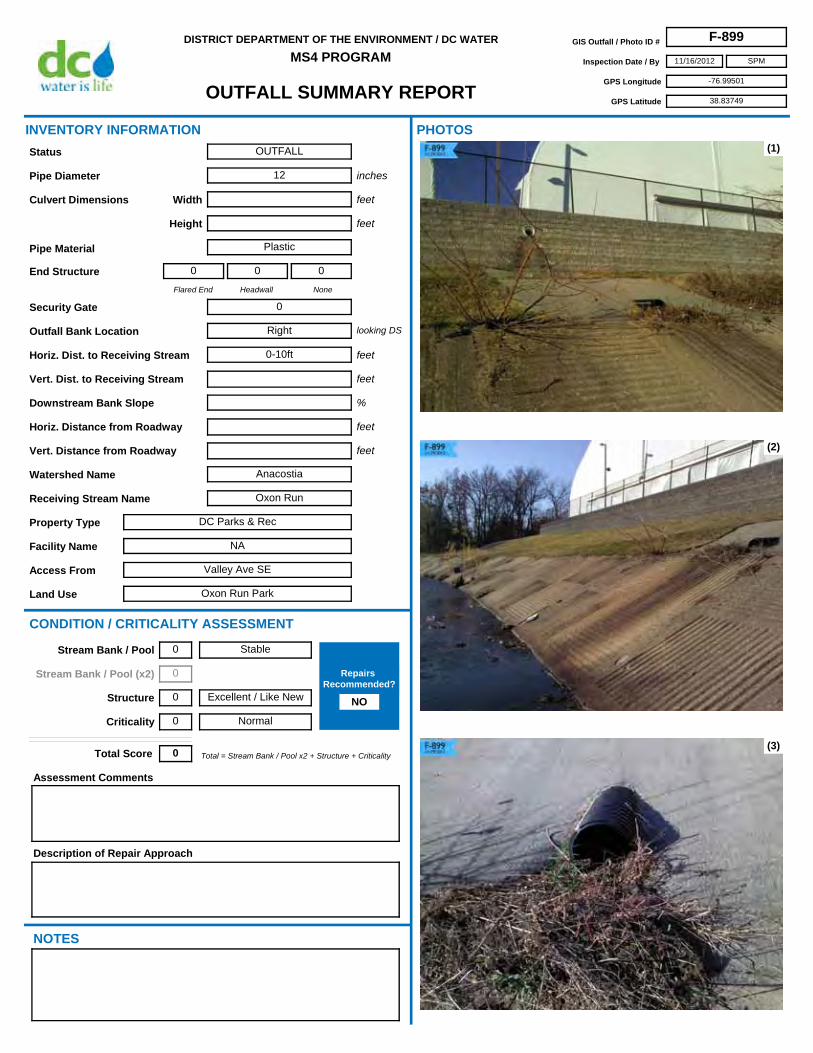
OUTFALL SUMMARY REPORT
DISTRICT DEPARTMENT OF THE ENVIRONMENT / DC WATER
MS4 PROGRAMGIS Outfall / Photo ID # F-899
Inspection Date / By 11/16/2012
GPS Longitude -76.99501
GPS Latitude 38.83749
SPM
Access From Valley Ave SE
Horiz. Dist. to Receiving Stream 0-10ft
Flared End
0
Headwall
0
None
0
Security Gate 0
Facility Name NA
Land Use Oxon Run Park
Outfall Bank Location Right
Pipe Diameter 12
Height
Pipe Material Plastic
Width
Property Type DC Parks & Rec
Receiving Stream Name Oxon Run
Description of Repair Approach
Watershed Name Anacostia
NOTES
INVENTORY INFORMATION
inches
feet
feet
Culvert Dimensions
End Structure
looking DS
feet
%
CONDITION / CRITICALITY ASSESSMENT
(1)
(2)
(3)
Downstream Bank Slope
PHOTOS
Status OUTFALL
Assessment Comments
Total = Stream Bank / Pool x2 + Structure + CriticalityTotal Score 0
Horiz. Distance from Roadway
Vert. Distance from Roadway
feet
feet
Vert. Dist. to Receiving Stream feet
Stable
Excellent / Like New
Normal
Stream Bank / Pool 0
Stream Bank / Pool (x2) 0
Structure 0
Criticality 0
Repairs Recommended?
NO

OUTFALL SUMMARY REPORT
DISTRICT DEPARTMENT OF THE ENVIRONMENT / DC WATER
MS4 PROGRAMGIS Outfall / Photo ID # F-899
Inspection Date / By 11/16/2012
GPS Longitude -76.99501
GPS Latitude 38.83749
SPM
(4)
(6) (7)
(8) (9)
(5)

OUTFALL SUMMARY REPORT
DISTRICT DEPARTMENT OF THE ENVIRONMENT / DC WATER
MS4 PROGRAMGIS Outfall / Photo ID # F-900
Inspection Date / By 10/11/2012
GPS Longitude -77.00444
GPS Latitude 38.82333
SPM
Access From Forrester St SE
Horiz. Dist. to Receiving Stream 0-10ft
Flared End
0
Headwall
1
None
0
Security Gate 0
Facility Name NA
Land Use Oxon Run Park
Outfall Bank Location left
Pipe Diameter 24
Height
Pipe Material RCP
Width
Property Type DC Parks & Rec
Receiving Stream Name Oxon Run
Description of Repair Approach
Watershed Name Anacostia
NOTES
INVENTORY INFORMATION
inches
feet
feet
Culvert Dimensions
End Structure
looking DS
feet
%
CONDITION / CRITICALITY ASSESSMENT
(1)
(2)
(3)
Downstream Bank Slope
PHOTOS
Status OUTFALL
Assessment Comments
Total = Stream Bank / Pool x2 + Structure + CriticalityTotal Score 0
Horiz. Distance from Roadway
Vert. Distance from Roadway
feet
feet
Vert. Dist. to Receiving Stream feet
Stable
Excellent / Like New
Normal
Stream Bank / Pool 0
Stream Bank / Pool (x2) 0
Structure 0
Criticality 0
Repairs Recommended?
NO

OUTFALL SUMMARY REPORT
DISTRICT DEPARTMENT OF THE ENVIRONMENT / DC WATER
MS4 PROGRAMGIS Outfall / Photo ID # F-900
Inspection Date / By 10/11/2012
GPS Longitude -77.00444
GPS Latitude 38.82333
SPM
(4)
(6) (7)
(8) (9)
(5)

OUTFALL SUMMARY REPORT
DISTRICT DEPARTMENT OF THE ENVIRONMENT / DC WATER
MS4 PROGRAMGIS Outfall / Photo ID # F-901
Inspection Date / By 2/4/2013
GPS Longitude -77.02647
GPS Latitude 38.82843
SPM
Access From BOAT
Horiz. Dist. to Receiving Stream 0-10ft
Flared End
0
Headwall
1
None
0
Security Gate 0
Facility Name Bolling Air Force Base
Land Use Military
Outfall Bank Location Left
Pipe Diameter 36 est
Height
Pipe Material RCP
Width
Property Type Government
Receiving Stream Name
Description of Repair Approach
Watershed Name
NOTES
INVENTORY INFORMATION
inches
feet
feet
Culvert Dimensions
End Structure
looking DS
feet
%
CONDITION / CRITICALITY ASSESSMENT
(1)
(2)
(3)
Downstream Bank Slope
PHOTOS
Status OUTFALL
Assessment Comments
Total = Stream Bank / Pool x2 + Structure + CriticalityTotal Score 0
Horiz. Distance from Roadway
Vert. Distance from Roadway
feet
feet
Vert. Dist. to Receiving Stream feet
Stable
Excellent / Like New
Normal
Stream Bank / Pool 0
Stream Bank / Pool (x2) 0
Structure 0
Criticality 0
Repairs Recommended?
NO

OUTFALL SUMMARY REPORT
DISTRICT DEPARTMENT OF THE ENVIRONMENT / DC WATER
MS4 PROGRAMGIS Outfall / Photo ID # F-901
Inspection Date / By 2/4/2013
GPS Longitude -77.02647
GPS Latitude 38.82843
SPM
(4)
(6) (7)
(8) (9)
(5)

OUTFALL SUMMARY REPORT
DISTRICT DEPARTMENT OF THE ENVIRONMENT / DC WATER
MS4 PROGRAMGIS Outfall / Photo ID # F-902
Inspection Date / By 2/4/2013
GPS Longitude -77.02646
GPS Latitude 38.82851
SPM
Access From BOAT
Horiz. Dist. to Receiving Stream 0-10ft
Flared End
0
Headwall
1
None
0
Security Gate 0
Facility Name Bolling Air Force Base
Land Use Military
Outfall Bank Location Left
Pipe Diameter 36 est
Height
Pipe Material RCP
Width
Property Type Government
Receiving Stream Name
Description of Repair Approach
Watershed Name
NOTES
INVENTORY INFORMATION
inches
feet
feet
Culvert Dimensions
End Structure
looking DS
feet
%
CONDITION / CRITICALITY ASSESSMENT
(1)
(2)
(3)
Downstream Bank Slope
PHOTOS
Status OUTFALL
Assessment Comments
Total = Stream Bank / Pool x2 + Structure + CriticalityTotal Score 0
Horiz. Distance from Roadway
Vert. Distance from Roadway
feet
feet
Vert. Dist. to Receiving Stream feet
Stable
Excellent / Like New
Normal
Stream Bank / Pool 0
Stream Bank / Pool (x2) 0
Structure 0
Criticality 0
Repairs Recommended?
NO

OUTFALL SUMMARY REPORT
DISTRICT DEPARTMENT OF THE ENVIRONMENT / DC WATER
MS4 PROGRAMGIS Outfall / Photo ID # F-902
Inspection Date / By 2/4/2013
GPS Longitude -77.02646
GPS Latitude 38.82851
SPM
(4)
(6) (7)
(8) (9)
(5)

OUTFALL SUMMARY REPORT
DISTRICT DEPARTMENT OF THE ENVIRONMENT / DC WATER
MS4 PROGRAMGIS Outfall / Photo ID # F-903
Inspection Date / By 2/4/2013
GPS Longitude -77.02653
GPS Latitude 38.82878
SPM
Access From BOAT
Horiz. Dist. to Receiving Stream 0-10ft
Flared End
1
Headwall
0
None
0
Security Gate 1
Facility Name Bolling Air Force Base
Land Use Military
Outfall Bank Location Left
Pipe Diameter 18 est
Height
Pipe Material RCP
Width
Property Type Government
Receiving Stream Name
Description of Repair Approach
Watershed Name
NOTES
INVENTORY INFORMATION
inches
feet
feet
Culvert Dimensions
End Structure
looking DS
feet
%
CONDITION / CRITICALITY ASSESSMENT
(1)
(2)
(3)
Downstream Bank Slope
PHOTOS
Status OUTFALL
Assessment Comments
Total = Stream Bank / Pool x2 + Structure + CriticalityTotal Score 0
Horiz. Distance from Roadway
Vert. Distance from Roadway
feet
feet
Vert. Dist. to Receiving Stream feet
Stable
Excellent / Like New
Normal
Stream Bank / Pool 0
Stream Bank / Pool (x2) 0
Structure 0
Criticality 0
Repairs Recommended?
NO

OUTFALL SUMMARY REPORT
DISTRICT DEPARTMENT OF THE ENVIRONMENT / DC WATER
MS4 PROGRAMGIS Outfall / Photo ID # F-903
Inspection Date / By 2/4/2013
GPS Longitude -77.02653
GPS Latitude 38.82878
SPM
(4)
(6) (7)
(8) (9)
(5)

OUTFALL SUMMARY REPORT
DISTRICT DEPARTMENT OF THE ENVIRONMENT / DC WATER
MS4 PROGRAMGIS Outfall / Photo ID # F-904
Inspection Date / By 2/4/2013
GPS Longitude -77.02567
GPS Latitude 38.83126
SPM
Access From BOAT
Horiz. Dist. to Receiving Stream 0-10ft
Flared End
0
Headwall
0
None
1
Security Gate 0
Facility Name Bolling Air Force Base
Land Use Military
Outfall Bank Location Left
Pipe Diameter 24 est
Height
Pipe Material RCP
Width
Property Type Government
Receiving Stream Name
Description of Repair Approach
Watershed Name
NOTES
INVENTORY INFORMATION
inches
feet
feet
Culvert Dimensions
End Structure
looking DS
feet
%
CONDITION / CRITICALITY ASSESSMENT
(1)
(2)
(3)
Downstream Bank Slope
PHOTOS
Status OUTFALL
Assessment Comments
minor tree debris
Total = Stream Bank / Pool x2 + Structure + CriticalityTotal Score 0
Horiz. Distance from Roadway
Vert. Distance from Roadway
feet
feet
Vert. Dist. to Receiving Stream feet
Stable
Excellent / Like New
Normal
Stream Bank / Pool 0
Stream Bank / Pool (x2) 0
Structure 0
Criticality 0
Repairs Recommended?
NO

OUTFALL SUMMARY REPORT
DISTRICT DEPARTMENT OF THE ENVIRONMENT / DC WATER
MS4 PROGRAMGIS Outfall / Photo ID # F-904
Inspection Date / By 2/4/2013
GPS Longitude -77.02567
GPS Latitude 38.83126
SPM
(4)
(6) (7)
(8) (9)
(5)

OUTFALL SUMMARY REPORT
DISTRICT DEPARTMENT OF THE ENVIRONMENT / DC WATER
MS4 PROGRAMGIS Outfall / Photo ID # F-905
Inspection Date / By 2/5/2013
GPS Longitude -77.05526
GPS Latitude 38.85819
SPM
Access From BOAT
Horiz. Dist. to Receiving Stream
Flared End
0
Headwall
0
None
0
Security Gate 0
Facility Name Bolling Air Force Base
Land Use Military
Outfall Bank Location
Pipe Diameter 60 est
Height
Pipe Material RCP
Width
Property Type Government
Receiving Stream Name
Description of Repair Approach
Watershed Name
NOTES
INVENTORY INFORMATION
inches
feet
feet
Culvert Dimensions
End Structure
looking DS
feet
%
CONDITION / CRITICALITY ASSESSMENT
(1)
(2)
(3)
Downstream Bank Slope
PHOTOS
Status OUTFALL
Assessment Comments
Total = Stream Bank / Pool x2 + Structure + CriticalityTotal Score 0
Horiz. Distance from Roadway
Vert. Distance from Roadway
feet
feet
Vert. Dist. to Receiving Stream feet
Stable
Excellent / Like New
Normal
Stream Bank / Pool 0
Stream Bank / Pool (x2) 0
Structure 0
Criticality 0
Repairs Recommended?
NO

OUTFALL SUMMARY REPORT
DISTRICT DEPARTMENT OF THE ENVIRONMENT / DC WATER
MS4 PROGRAMGIS Outfall / Photo ID # F-905
Inspection Date / By 2/5/2013
GPS Longitude -77.05526
GPS Latitude 38.85819
SPM
(4)
(6) (7)
(8) (9)
(5)

OUTFALL SUMMARY REPORT
DISTRICT DEPARTMENT OF THE ENVIRONMENT / DC WATER
MS4 PROGRAMGIS Outfall / Photo ID # F-906
Inspection Date / By 2/4/2013
GPS Longitude -77.02364
GPS Latitude 38.83845
SPM
Access From BOAT
Horiz. Dist. to Receiving Stream 0-10ft
Flared End
0
Headwall
0
None
1
Security Gate 1
Facility Name Bolling Air Force Base
Land Use Military
Outfall Bank Location Left
Pipe Diameter 18 est
Height
Pipe Material RCP
Width
Property Type Government
Receiving Stream Name
Description of Repair Approach
Watershed Name
NOTES
INVENTORY INFORMATION
inches
feet
feet
Culvert Dimensions
End Structure
looking DS
feet
%
CONDITION / CRITICALITY ASSESSMENT
(1)
(2)
(3)
Downstream Bank Slope
PHOTOS
Status OUTFALL
Assessment Comments
Total = Stream Bank / Pool x2 + Structure + CriticalityTotal Score 0
Horiz. Distance from Roadway
Vert. Distance from Roadway
feet
feet
Vert. Dist. to Receiving Stream feet
Stable
Excellent / Like New
Normal
Stream Bank / Pool 0
Stream Bank / Pool (x2) 0
Structure 0
Criticality 0
Repairs Recommended?
NO

OUTFALL SUMMARY REPORT
DISTRICT DEPARTMENT OF THE ENVIRONMENT / DC WATER
MS4 PROGRAMGIS Outfall / Photo ID # F-906
Inspection Date / By 2/4/2013
GPS Longitude -77.02364
GPS Latitude 38.83845
SPM
(4)
(6) (7)
(8) (9)
(5)

OUTFALL SUMMARY REPORT
DISTRICT DEPARTMENT OF THE ENVIRONMENT / DC WATER
MS4 PROGRAMGIS Outfall / Photo ID # F-907
Inspection Date / By 2/4/2013
GPS Longitude -77.02352
GPS Latitude 38.83916
SPM
Access From BOAT
Horiz. Dist. to Receiving Stream 0-10ft
Flared End
1
Headwall
0
None
0
Security Gate 1
Facility Name Bolling Air Force Base
Land Use Military
Outfall Bank Location Left
Pipe Diameter 18 est
Height
Pipe Material RCP
Width
Property Type Government
Receiving Stream Name
Description of Repair Approach
Watershed Name
NOTES
INVENTORY INFORMATION
inches
feet
feet
Culvert Dimensions
End Structure
looking DS
feet
%
CONDITION / CRITICALITY ASSESSMENT
(1)
(2)
(3)
Downstream Bank Slope
PHOTOS
Status OUTFALL
Assessment Comments
Total = Stream Bank / Pool x2 + Structure + CriticalityTotal Score 0
Horiz. Distance from Roadway
Vert. Distance from Roadway
feet
feet
Vert. Dist. to Receiving Stream feet
Stable
Excellent / Like New
Normal
Stream Bank / Pool 0
Stream Bank / Pool (x2) 0
Structure 0
Criticality 0
Repairs Recommended?
NO

OUTFALL SUMMARY REPORT
DISTRICT DEPARTMENT OF THE ENVIRONMENT / DC WATER
MS4 PROGRAMGIS Outfall / Photo ID # F-907
Inspection Date / By 2/4/2013
GPS Longitude -77.02352
GPS Latitude 38.83916
SPM
(4)
(6) (7)
(8) (9)
(5)

OUTFALL SUMMARY REPORT
DISTRICT DEPARTMENT OF THE ENVIRONMENT / DC WATER
MS4 PROGRAMGIS Outfall / Photo ID # F-908
Inspection Date / By 2/4/2013
GPS Longitude -77.02091
GPS Latitude 38.84715
SPM
Access From BOAT
Horiz. Dist. to Receiving Stream 0-10ft
Flared End
1
Headwall
0
None
0
Security Gate 1
Facility Name Bolling Air Force Base
Land Use Military
Outfall Bank Location Left
Pipe Diameter 12 est
Height
Pipe Material RCP
Width
Property Type Government
Receiving Stream Name
Description of Repair Approach
Watershed Name
NOTES
INVENTORY INFORMATION
inches
feet
feet
Culvert Dimensions
End Structure
looking DS
feet
%
CONDITION / CRITICALITY ASSESSMENT
(1)
(2)
(3)
Downstream Bank Slope
PHOTOS
Status OUTFALL
Assessment Comments
Total = Stream Bank / Pool x2 + Structure + CriticalityTotal Score 0
Horiz. Distance from Roadway
Vert. Distance from Roadway
feet
feet
Vert. Dist. to Receiving Stream feet
Stable
Excellent / Like New
Normal
Stream Bank / Pool 0
Stream Bank / Pool (x2) 0
Structure 0
Criticality 0
Repairs Recommended?
NO

OUTFALL SUMMARY REPORT
DISTRICT DEPARTMENT OF THE ENVIRONMENT / DC WATER
MS4 PROGRAMGIS Outfall / Photo ID # F-908
Inspection Date / By 2/4/2013
GPS Longitude -77.02091
GPS Latitude 38.84715
SPM
(4)
(6) (7)
(8) (9)
(5)

OUTFALL SUMMARY REPORT
DISTRICT DEPARTMENT OF THE ENVIRONMENT / DC WATER
MS4 PROGRAMGIS Outfall / Photo ID # F-909
Inspection Date / By 2/4/2013
GPS Longitude -77.02246
GPS Latitude 38.84253
SPM
Access From BOAT
Horiz. Dist. to Receiving Stream 0-10ft
Flared End
1
Headwall
0
None
0
Security Gate 0
Facility Name Bolling Air Force Base
Land Use Military
Outfall Bank Location Left
Pipe Diameter 18 est
Height
Pipe Material RCP
Width
Property Type Government
Receiving Stream Name
Description of Repair Approach
Watershed Name
NOTES
INVENTORY INFORMATION
inches
feet
feet
Culvert Dimensions
End Structure
looking DS
feet
%
CONDITION / CRITICALITY ASSESSMENT
(1)
(2)
(3)
Downstream Bank Slope
PHOTOS
Status OUTFALL
Assessment Comments
Total = Stream Bank / Pool x2 + Structure + CriticalityTotal Score 0
Horiz. Distance from Roadway
Vert. Distance from Roadway
feet
feet
Vert. Dist. to Receiving Stream feet
Stable
Excellent / Like New
Normal
Stream Bank / Pool 0
Stream Bank / Pool (x2) 0
Structure 0
Criticality 0
Repairs Recommended?
NO

OUTFALL SUMMARY REPORT
DISTRICT DEPARTMENT OF THE ENVIRONMENT / DC WATER
MS4 PROGRAMGIS Outfall / Photo ID # F-909
Inspection Date / By 2/4/2013
GPS Longitude -77.02246
GPS Latitude 38.84253
SPM
(4)
(6) (7)
(8) (9)
(5)

OUTFALL SUMMARY REPORT
DISTRICT DEPARTMENT OF THE ENVIRONMENT / DC WATER
MS4 PROGRAMGIS Outfall / Photo ID # F-910
Inspection Date / By 2/4/2013
GPS Longitude -77.02234
GPS Latitude 38.84303
SPM
Access From BOAT
Horiz. Dist. to Receiving Stream 0-10ft
Flared End
1
Headwall
0
None
0
Security Gate 0
Facility Name Bolling Air Force Base
Land Use Military
Outfall Bank Location Left
Pipe Diameter 24 est
Height
Pipe Material RCP
Width
Property Type Government
Receiving Stream Name
Description of Repair Approach
Watershed Name
NOTES
INVENTORY INFORMATION
inches
feet
feet
Culvert Dimensions
End Structure
looking DS
feet
%
CONDITION / CRITICALITY ASSESSMENT
(1)
(2)
(3)
Downstream Bank Slope
PHOTOS
Status OUTFALL
Assessment Comments
Total = Stream Bank / Pool x2 + Structure + CriticalityTotal Score 0
Horiz. Distance from Roadway
Vert. Distance from Roadway
feet
feet
Vert. Dist. to Receiving Stream feet
Stable
Excellent / Like New
Normal
Stream Bank / Pool 0
Stream Bank / Pool (x2) 0
Structure 0
Criticality 0
Repairs Recommended?
NO

OUTFALL SUMMARY REPORT
DISTRICT DEPARTMENT OF THE ENVIRONMENT / DC WATER
MS4 PROGRAMGIS Outfall / Photo ID # F-910
Inspection Date / By 2/4/2013
GPS Longitude -77.02234
GPS Latitude 38.84303
SPM
(4)
(6) (7)
(8) (9)
(5)

OUTFALL SUMMARY REPORT
DISTRICT DEPARTMENT OF THE ENVIRONMENT / DC WATER
MS4 PROGRAMGIS Outfall / Photo ID # F-912
Inspection Date / By 10/10/2012
GPS Longitude -77.05526
GPS Latitude 38.85819
SPM
Access From I-295 Onramp/Offramp Near Blue Plains WWTP
Horiz. Dist. to Receiving Stream 0-10ft
Flared End
0
Headwall
1
None
0
Security Gate 0
Facility Name I-295
Land Use Onramp/ Offramp
Outfall Bank Location Head
Pipe Diameter 33
Height
Pipe Material RCP
Width
Property Type DDOT
Receiving Stream Name
Description of Repair Approach
Watershed Name
NOTES
INVENTORY INFORMATION
inches
feet
feet
Culvert Dimensions
End Structure
looking DS
feet
%
CONDITION / CRITICALITY ASSESSMENT
(1)
(2)
(3)
Downstream Bank Slope
PHOTOS
Status OUTFALL
Assessment Comments
Total = Stream Bank / Pool x2 + Structure + CriticalityTotal Score 0
Horiz. Distance from Roadway
Vert. Distance from Roadway
feet
feet
Vert. Dist. to Receiving Stream feet
Stable
Excellent / Like New
Normal
Stream Bank / Pool 0
Stream Bank / Pool (x2) 0
Structure 0
Criticality 0
Repairs Recommended?
NO

OUTFALL SUMMARY REPORT
DISTRICT DEPARTMENT OF THE ENVIRONMENT / DC WATER
MS4 PROGRAMGIS Outfall / Photo ID # F-912
Inspection Date / By 10/10/2012
GPS Longitude -77.05526
GPS Latitude 38.85819
SPM
(4)
(6) (7)
(8) (9)
(5)

OUTFALL SUMMARY REPORT
DISTRICT DEPARTMENT OF THE ENVIRONMENT / DC WATER
MS4 PROGRAMGIS Outfall / Photo ID # F-913
Inspection Date / By 10/10/2012
GPS Longitude -77.01635
GPS Latitude 38.82287
SPM
Access From I-295 Onramp/Offramp Near Blue Plains WWTP
Horiz. Dist. to Receiving Stream 0-10ft
Flared End
0
Headwall
0
None
0
Security Gate 0
Facility Name I-295
Land Use Onramp/ Offramp
Outfall Bank Location Right
Pipe Diameter 8
Height
Pipe Material RCP
Width
Property Type DDOT
Receiving Stream Name
Description of Repair Approach
Watershed Name Anacostia
NOTES
INVENTORY INFORMATION
inches
feet
feet
Culvert Dimensions
End Structure
looking DS
feet
%
CONDITION / CRITICALITY ASSESSMENT
(1)
(2)
(3)
Downstream Bank Slope
PHOTOS
Status OUTFALL
Assessment Comments
Total = Stream Bank / Pool x2 + Structure + CriticalityTotal Score 0
Horiz. Distance from Roadway
Vert. Distance from Roadway
feet
feet
Vert. Dist. to Receiving Stream feet
Stable
Excellent / Like New
Normal
Stream Bank / Pool 0
Stream Bank / Pool (x2) 0
Structure 0
Criticality 0
Repairs Recommended?
NO

OUTFALL SUMMARY REPORT
DISTRICT DEPARTMENT OF THE ENVIRONMENT / DC WATER
MS4 PROGRAMGIS Outfall / Photo ID # F-913
Inspection Date / By 10/10/2012
GPS Longitude -77.01635
GPS Latitude 38.82287
SPM
(4)
(6) (7)
(8) (9)
(5)

OUTFALL SUMMARY REPORT
DISTRICT DEPARTMENT OF THE ENVIRONMENT / DC WATER
MS4 PROGRAMGIS Outfall / Photo ID # F-914
Inspection Date / By 12/5/2012
GPS Longitude -77.04021
GPS Latitude 38.97268
SPM
Access From Sherill Dr NW
Horiz. Dist. to Receiving Stream 0-10ft
Flared End
0
Headwall
1
None
0
Security Gate 0
Facility Name ROCR
Land Use Rock Creek Park
Outfall Bank Location Left
Pipe Diameter 36 all barrels
Height
Pipe Material Plastic
Width
Property Type NPS
Receiving Stream Name Rock Creek
Description of Repair Approach
Watershed Name Rock Creek
NOTES
INVENTORY INFORMATION
inches
feet
feet
Culvert Dimensions
End Structure
looking DS
feet
%
CONDITION / CRITICALITY ASSESSMENT
(1)
(2)
(3)
Downstream Bank Slope
PHOTOS
Status OUTFALL
Assessment Comments
Triple pipe.
Total = Stream Bank / Pool x2 + Structure + CriticalityTotal Score 0
Horiz. Distance from Roadway
Vert. Distance from Roadway
feet
feet
Vert. Dist. to Receiving Stream feet
Stable
Excellent / Like New
Normal
Stream Bank / Pool 0
Stream Bank / Pool (x2) 0
Structure 0
Criticality 0
Repairs Recommended?
NO

OUTFALL SUMMARY REPORT
DISTRICT DEPARTMENT OF THE ENVIRONMENT / DC WATER
MS4 PROGRAMGIS Outfall / Photo ID # F-914
Inspection Date / By 12/5/2012
GPS Longitude -77.04021
GPS Latitude 38.97268
SPM
(4)
(6) (7)
(8) (9)
(5)

OUTFALL SUMMARY REPORT
DISTRICT DEPARTMENT OF THE ENVIRONMENT / DC WATER
MS4 PROGRAMGIS Outfall / Photo ID # F-915
Inspection Date / By 12/5/2012
GPS Longitude -77.03913
GPS Latitude 38.96328
SPM
Access From Joyce Rd NW
Horiz. Dist. to Receiving Stream 20-30ft
Flared End
0
Headwall
1
None
0
Security Gate 0
Facility Name ROCR
Land Use Luzon Branch
Outfall Bank Location Right
Pipe Diameter 18
Height
Pipe Material Concrete
Width
Property Type NPS
Receiving Stream Name
Description of Repair Approach
Watershed Name Rock Creek
NOTES
INVENTORY INFORMATION
inches
feet
feet
Culvert Dimensions
End Structure
looking DS
feet
%
CONDITION / CRITICALITY ASSESSMENT
(1)
(2)
(3)
Downstream Bank Slope
PHOTOS
Status OUTFALL
Assessment Comments
Minor erosion under pipe invert.
Total = Stream Bank / Pool x2 + Structure + CriticalityTotal Score 1
Horiz. Distance from Roadway
Vert. Distance from Roadway
feet
feet
Vert. Dist. to Receiving Stream feet
Stable
Moderate
Normal
Stream Bank / Pool 0
Stream Bank / Pool (x2) 0
Structure 1
Criticality 0
Repairs Recommended?
NO

OUTFALL SUMMARY REPORT
DISTRICT DEPARTMENT OF THE ENVIRONMENT / DC WATER
MS4 PROGRAMGIS Outfall / Photo ID # F-915
Inspection Date / By 12/5/2012
GPS Longitude -77.03913
GPS Latitude 38.96328
SPM
(4)
(6) (7)
(8) (9)
(5)

OUTFALL SUMMARY REPORT
DISTRICT DEPARTMENT OF THE ENVIRONMENT / DC WATER
MS4 PROGRAMGIS Outfall / Photo ID # F-916
Inspection Date / By 12/5/2012
GPS Longitude -77.03673
GPS Latitude 38.96505
SPM
Access From Joyce Rd NW
Horiz. Dist. to Receiving Stream 0-10ft
Flared End
0
Headwall
1
None
0
Security Gate 0
Facility Name ROCR
Land Use Luzon Branch
Outfall Bank Location Left
Pipe Diameter 15
Height
Pipe Material Clay
Width
Property Type NPS
Receiving Stream Name Rock Creek
Description of Repair Approach
Watershed Name Rock Creek
NOTES
INVENTORY INFORMATION
inches
feet
feet
Culvert Dimensions
End Structure
looking DS
feet
%
CONDITION / CRITICALITY ASSESSMENT
(1)
(2)
(3)
Downstream Bank Slope
PHOTOS
Status OUTFALL
Assessment Comments
See F-366.
Total = Stream Bank / Pool x2 + Structure + CriticalityTotal Score 0
Horiz. Distance from Roadway
Vert. Distance from Roadway
feet
feet
Vert. Dist. to Receiving Stream feet
Stable
Excellent / Like New
Normal
Stream Bank / Pool 0
Stream Bank / Pool (x2) 0
Structure 0
Criticality 0
Repairs Recommended?
NO

OUTFALL SUMMARY REPORT
DISTRICT DEPARTMENT OF THE ENVIRONMENT / DC WATER
MS4 PROGRAMGIS Outfall / Photo ID # F-916
Inspection Date / By 12/5/2012
GPS Longitude -77.03673
GPS Latitude 38.96505
SPM
(4)
(6) (7)
(8) (9)
(5)

OUTFALL SUMMARY REPORT
DISTRICT DEPARTMENT OF THE ENVIRONMENT / DC WATER
MS4 PROGRAMGIS Outfall / Photo ID # F-917
Inspection Date / By 12/5/2012
GPS Longitude -77.03671
GPS Latitude 38.96504
SPM
Access From Joyce Rd NW
Horiz. Dist. to Receiving Stream 0-10ft
Flared End
0
Headwall
1
None
0
Security Gate 0
Facility Name ROCR
Land Use Luzon Branch
Outfall Bank Location Right
Pipe Diameter 15
Height
Pipe Material Clay
Width
Property Type NPS
Receiving Stream Name Rock Creek
Description of Repair Approach
Watershed Name Rock Creek
NOTES
INVENTORY INFORMATION
inches
feet
feet
Culvert Dimensions
End Structure
looking DS
feet
%
CONDITION / CRITICALITY ASSESSMENT
(1)
(2)
(3)
Downstream Bank Slope
PHOTOS
Status OUTFALL
Assessment Comments
Pipe cracked at invert. See F-366.
Total = Stream Bank / Pool x2 + Structure + CriticalityTotal Score 0
Horiz. Distance from Roadway
Vert. Distance from Roadway
feet
feet
Vert. Dist. to Receiving Stream feet
Stable
Excellent / Like New
Normal
Stream Bank / Pool 0
Stream Bank / Pool (x2) 0
Structure 0
Criticality 0
Repairs Recommended?
NO

OUTFALL SUMMARY REPORT
DISTRICT DEPARTMENT OF THE ENVIRONMENT / DC WATER
MS4 PROGRAMGIS Outfall / Photo ID # F-917
Inspection Date / By 12/5/2012
GPS Longitude -77.03671
GPS Latitude 38.96504
SPM
(4)
(6) (7)
(8) (9)
(5)

OUTFALL SUMMARY REPORT
DISTRICT DEPARTMENT OF THE ENVIRONMENT / DC WATER
MS4 PROGRAMGIS Outfall / Photo ID # F-918
Inspection Date / By 2/5/2013
GPS Longitude -77.03378
GPS Latitude 38.87472
SPM
Access From BOAT
Horiz. Dist. to Receiving Stream 0-10ft
Flared End
0
Headwall
1
None
0
Security Gate 0
Facility Name NAMA
Land Use East Potomac Park
Outfall Bank Location Left
Pipe Diameter 8 est
Height
Pipe Material Clay
Width
Property Type NPS
Receiving Stream Name
Description of Repair Approach
Watershed Name
NOTES
INVENTORY INFORMATION
inches
feet
feet
Culvert Dimensions
End Structure
looking DS
feet
%
CONDITION / CRITICALITY ASSESSMENT
(1)
(2)
(3)
Downstream Bank Slope
PHOTOS
Status OUTFALL
Assessment Comments
Total = Stream Bank / Pool x2 + Structure + CriticalityTotal Score 0
Horiz. Distance from Roadway
Vert. Distance from Roadway
feet
feet
Vert. Dist. to Receiving Stream feet
Stable
Excellent / Like New
Normal
Stream Bank / Pool 0
Stream Bank / Pool (x2) 0
Structure 0
Criticality 0
Repairs Recommended?
NO

OUTFALL SUMMARY REPORT
DISTRICT DEPARTMENT OF THE ENVIRONMENT / DC WATER
MS4 PROGRAMGIS Outfall / Photo ID # F-918
Inspection Date / By 2/5/2013
GPS Longitude -77.03378
GPS Latitude 38.87472
SPM
(4)
(6) (7)
(8) (9)
(5)

OUTFALL SUMMARY REPORT
DISTRICT DEPARTMENT OF THE ENVIRONMENT / DC WATER
MS4 PROGRAMGIS Outfall / Photo ID # F-919
Inspection Date / By 1/10/2013
GPS Longitude -76.97256
GPS Latitude 38.85884
SPM
Access From Ainger Pl SE
Horiz. Dist. to Receiving Stream 0-10ft
Flared End
0
Headwall
1
None
0
Security Gate 0
Facility Name NACE
Land Use Battery Ricketts
Outfall Bank Location Head
Pipe Diameter 36
Height
Pipe Material RCP
Width
Property Type NPS
Receiving Stream Name
Description of Repair Approach
Watershed Name
NOTES
INVENTORY INFORMATION
inches
feet
feet
Culvert Dimensions
End Structure
looking DS
feet
%
CONDITION / CRITICALITY ASSESSMENT
(1)
(2)
(3)
Downstream Bank Slope
PHOTOS
Status OUTFALL
Assessment Comments
Probably does not drain from DC property.
Total = Stream Bank / Pool x2 + Structure + CriticalityTotal Score 0
Horiz. Distance from Roadway
Vert. Distance from Roadway
feet
feet
Vert. Dist. to Receiving Stream feet
Stable
Excellent / Like New
Normal
Stream Bank / Pool 0
Stream Bank / Pool (x2) 0
Structure 0
Criticality 0
Repairs Recommended?
NO

OUTFALL SUMMARY REPORT
DISTRICT DEPARTMENT OF THE ENVIRONMENT / DC WATER
MS4 PROGRAMGIS Outfall / Photo ID # F-919
Inspection Date / By 1/10/2013
GPS Longitude -76.97256
GPS Latitude 38.85884
SPM
(4)
(6) (7)
(8) (9)
(5)

OUTFALL SUMMARY REPORT
DISTRICT DEPARTMENT OF THE ENVIRONMENT / DC WATER
MS4 PROGRAMGIS Outfall / Photo ID # F-920
Inspection Date / By 11/14/2012
GPS Longitude -76.97531
GPS Latitude 38.86355
SPM
Access From Good Hope Rd SE
Horiz. Dist. to Receiving Stream 0-10ft
Flared End
0
Headwall
1
None
0
Security Gate 0
Facility Name NA
Land Use Green Space
Outfall Bank Location Head
Pipe Diameter 15
Height
Pipe Material RCP
Width
Property Type NA
Receiving Stream Name
Description of Repair Approach
Watershed Name
NOTES
INVENTORY INFORMATION
inches
feet
feet
Culvert Dimensions
End Structure
looking DS
feet
%
CONDITION / CRITICALITY ASSESSMENT
(1)
(2)
(3)
Downstream Bank Slope
PHOTOS
Status OUTFALL
Assessment Comments
Total = Stream Bank / Pool x2 + Structure + CriticalityTotal Score 0
Horiz. Distance from Roadway
Vert. Distance from Roadway
feet
feet
Vert. Dist. to Receiving Stream feet
Stable
Excellent / Like New
Normal
Stream Bank / Pool 0
Stream Bank / Pool (x2) 0
Structure 0
Criticality 0
Repairs Recommended?
NO

OUTFALL SUMMARY REPORT
DISTRICT DEPARTMENT OF THE ENVIRONMENT / DC WATER
MS4 PROGRAMGIS Outfall / Photo ID # F-920
Inspection Date / By 11/14/2012
GPS Longitude -76.97531
GPS Latitude 38.86355
SPM
(4)
(6) (7)
(8) (9)
(5)

OUTFALL SUMMARY REPORT
DISTRICT DEPARTMENT OF THE ENVIRONMENT / DC WATER
MS4 PROGRAMGIS Outfall / Photo ID # F-921
Inspection Date / By 1/29/2013
GPS Longitude -76.97709
GPS Latitude 38.87596
SPM
Access From BOAT
Horiz. Dist. to Receiving Stream 0-10ft
Flared End
0
Headwall
1
None
0
Security Gate 0
Facility Name NACE
Land Use Anacostia Park
Outfall Bank Location Left
Pipe Diameter 24 est
Height
Pipe Material RCP
Width
Property Type NPS
Receiving Stream Name
Description of Repair Approach
Watershed Name Anacostia
NOTES
INVENTORY INFORMATION
inches
feet
feet
Culvert Dimensions
End Structure
looking DS
feet
%
CONDITION / CRITICALITY ASSESSMENT
(1)
(2)
(3)
Downstream Bank Slope
PHOTOS
Status OUTFALL
Assessment Comments
Total = Stream Bank / Pool x2 + Structure + CriticalityTotal Score 0
Horiz. Distance from Roadway
Vert. Distance from Roadway
feet
feet
Vert. Dist. to Receiving Stream feet
Stable
Excellent / Like New
Normal
Stream Bank / Pool 0
Stream Bank / Pool (x2) 0
Structure 0
Criticality 0
Repairs Recommended?
NO

OUTFALL SUMMARY REPORT
DISTRICT DEPARTMENT OF THE ENVIRONMENT / DC WATER
MS4 PROGRAMGIS Outfall / Photo ID # F-921
Inspection Date / By 1/29/2013
GPS Longitude -76.97709
GPS Latitude 38.87596
SPM
(4)
(6) (7)
(8) (9)
(5)

OUTFALL SUMMARY REPORT
DISTRICT DEPARTMENT OF THE ENVIRONMENT / DC WATER
MS4 PROGRAMGIS Outfall / Photo ID # F-922
Inspection Date / By 1/29/2013
GPS Longitude -76.97759
GPS Latitude 38.87592
SPM
Access From BOAT
Horiz. Dist. to Receiving Stream 0-10ft
Flared End
0
Headwall
1
None
0
Security Gate 0
Facility Name NACE
Land Use Anacostia Park
Outfall Bank Location Left
Pipe Diameter 18
Height
Pipe Material RCP
Width
Property Type NPS
Receiving Stream Name
Description of Repair Approach
Watershed Name Anacostia
NOTES
INVENTORY INFORMATION
inches
feet
feet
Culvert Dimensions
End Structure
looking DS
feet
%
CONDITION / CRITICALITY ASSESSMENT
(1)
(2)
(3)
Downstream Bank Slope
PHOTOS
Status OUTFALL
Assessment Comments
Total = Stream Bank / Pool x2 + Structure + CriticalityTotal Score 0
Horiz. Distance from Roadway
Vert. Distance from Roadway
feet
feet
Vert. Dist. to Receiving Stream feet
Stable
Excellent / Like New
Normal
Stream Bank / Pool 0
Stream Bank / Pool (x2) 0
Structure 0
Criticality 0
Repairs Recommended?
NO

OUTFALL SUMMARY REPORT
DISTRICT DEPARTMENT OF THE ENVIRONMENT / DC WATER
MS4 PROGRAMGIS Outfall / Photo ID # F-922
Inspection Date / By 1/29/2013
GPS Longitude -76.97759
GPS Latitude 38.87592
SPM
(4)
(6) (7)
(8) (9)
(5)

OUTFALL SUMMARY REPORT
DISTRICT DEPARTMENT OF THE ENVIRONMENT / DC WATER
MS4 PROGRAMGIS Outfall / Photo ID # F-923
Inspection Date / By 1/29/2013
GPS Longitude -76.97352
GPS Latitude 38.87712
SPM
Access From BOAT
Horiz. Dist. to Receiving Stream
Flared End
0
Headwall
0
None
0
Security Gate 0
Facility Name NACE
Land Use Anacostia Park
Outfall Bank Location
Pipe Diameter unknown
Height
Pipe Material Unknown
Width
Property Type NPS
Receiving Stream Name
Description of Repair Approach
Watershed Name Anacostia
NOTES
INVENTORY INFORMATION
inches
feet
feet
Culvert Dimensions
End Structure
looking DS
feet
%
CONDITION / CRITICALITY ASSESSMENT
(1)
(2)
(3)
Downstream Bank Slope
PHOTOS
Status OUTFALL
Assessment Comments
Pipe clogged with debris; unable to measure.
Total = Stream Bank / Pool x2 + Structure + CriticalityTotal Score 0
Horiz. Distance from Roadway
Vert. Distance from Roadway
feet
feet
Vert. Dist. to Receiving Stream feet
Stable
Excellent / Like New
Normal
Stream Bank / Pool 0
Stream Bank / Pool (x2) 0
Structure 0
Criticality 0
Repairs Recommended?
NO

OUTFALL SUMMARY REPORT
DISTRICT DEPARTMENT OF THE ENVIRONMENT / DC WATER
MS4 PROGRAMGIS Outfall / Photo ID # F-923
Inspection Date / By 1/29/2013
GPS Longitude -76.97352
GPS Latitude 38.87712
SPM
(4)
(6) (7)
(8) (9)
(5)

OUTFALL SUMMARY REPORT
DISTRICT DEPARTMENT OF THE ENVIRONMENT / DC WATER
MS4 PROGRAMGIS Outfall / Photo ID # F-924
Inspection Date / By 1/29/2013
GPS Longitude -76.97424
GPS Latitude 38.87689
SPM
Access From BOAT
Horiz. Dist. to Receiving Stream 0-10ft
Flared End
0
Headwall
0
None
0
Security Gate 0
Facility Name NACE
Land Use Anacostia Park
Outfall Bank Location Left
Pipe Diameter 15
Height
Pipe Material RCP
Width
Property Type NPS
Receiving Stream Name
Description of Repair Approach
Watershed Name Anacostia
NOTES
INVENTORY INFORMATION
inches
feet
feet
Culvert Dimensions
End Structure
looking DS
feet
%
CONDITION / CRITICALITY ASSESSMENT
(1)
(2)
(3)
Downstream Bank Slope
PHOTOS
Status OUTFALL
Assessment Comments
Unable to access.
Total = Stream Bank / Pool x2 + Structure + CriticalityTotal Score 0
Horiz. Distance from Roadway
Vert. Distance from Roadway
feet
feet
Vert. Dist. to Receiving Stream feet
Stable
Excellent / Like New
Normal
Stream Bank / Pool 0
Stream Bank / Pool (x2) 0
Structure 0
Criticality 0
Repairs Recommended?
NO

OUTFALL SUMMARY REPORT
DISTRICT DEPARTMENT OF THE ENVIRONMENT / DC WATER
MS4 PROGRAMGIS Outfall / Photo ID # F-924
Inspection Date / By 1/29/2013
GPS Longitude -76.97424
GPS Latitude 38.87689
SPM
(4)
(6) (7)
(8) (9)
(5)

OUTFALL SUMMARY REPORT
DISTRICT DEPARTMENT OF THE ENVIRONMENT / DC WATER
MS4 PROGRAMGIS Outfall / Photo ID # F-925
Inspection Date / By 1/29/2013
GPS Longitude -76.97865
GPS Latitude 38.87553
SPM
Access From BOAT
Horiz. Dist. to Receiving Stream 0-10ft
Flared End
0
Headwall
1
None
0
Security Gate 0
Facility Name NACE
Land Use Anacostia Park
Outfall Bank Location Left
Pipe Diameter 18
Height
Pipe Material RCP
Width
Property Type NPS
Receiving Stream Name
Description of Repair Approach
Watershed Name Anacostia
NOTES
INVENTORY INFORMATION
inches
feet
feet
Culvert Dimensions
End Structure
looking DS
feet
%
CONDITION / CRITICALITY ASSESSMENT
(1)
(2)
(3)
Downstream Bank Slope
PHOTOS
Status OUTFALL
Assessment Comments
Headwall stones fallen out.
Total = Stream Bank / Pool x2 + Structure + CriticalityTotal Score 1
Horiz. Distance from Roadway
Vert. Distance from Roadway
feet
feet
Vert. Dist. to Receiving Stream feet
Stable
Moderate
Normal
Stream Bank / Pool 0
Stream Bank / Pool (x2) 0
Structure 1
Criticality 0
Repairs Recommended?
NO

OUTFALL SUMMARY REPORT
DISTRICT DEPARTMENT OF THE ENVIRONMENT / DC WATER
MS4 PROGRAMGIS Outfall / Photo ID # F-925
Inspection Date / By 1/29/2013
GPS Longitude -76.97865
GPS Latitude 38.87553
SPM
(4)
(6) (7)
(8) (9)
(5)

OUTFALL SUMMARY REPORT
DISTRICT DEPARTMENT OF THE ENVIRONMENT / DC WATER
MS4 PROGRAMGIS Outfall / Photo ID # F-926
Inspection Date / By 1/29/2013
GPS Longitude -76.97877
GPS Latitude 38.87548
SPM
Access From BOAT
Horiz. Dist. to Receiving Stream 0-10ft
Flared End
0
Headwall
1
None
0
Security Gate 0
Facility Name NACE
Land Use Anacostia Park
Outfall Bank Location Left
Pipe Diameter 18
Height
Pipe Material RCP
Width
Property Type NPS
Receiving Stream Name
Description of Repair Approach
Watershed Name
NOTES
INVENTORY INFORMATION
inches
feet
feet
Culvert Dimensions
End Structure
looking DS
feet
%
CONDITION / CRITICALITY ASSESSMENT
(1)
(2)
(3)
Downstream Bank Slope
PHOTOS
Status OUTFALL
Assessment Comments
headwall stones fallen out
Total = Stream Bank / Pool x2 + Structure + CriticalityTotal Score 1
Horiz. Distance from Roadway
Vert. Distance from Roadway
feet
feet
Vert. Dist. to Receiving Stream feet
Stable
Moderate
Normal
Stream Bank / Pool 0
Stream Bank / Pool (x2) 0
Structure 1
Criticality 0
Repairs Recommended?
NO

OUTFALL SUMMARY REPORT
DISTRICT DEPARTMENT OF THE ENVIRONMENT / DC WATER
MS4 PROGRAMGIS Outfall / Photo ID # F-926
Inspection Date / By 1/29/2013
GPS Longitude -76.97877
GPS Latitude 38.87548
SPM
(4)
(6) (7)
(8) (9)
(5)

OUTFALL SUMMARY REPORT
DISTRICT DEPARTMENT OF THE ENVIRONMENT / DC WATER
MS4 PROGRAMGIS Outfall / Photo ID # F-927
Inspection Date / By 1/29/2013
GPS Longitude -76.97935
GPS Latitude 38.87532
SPM
Access From BOAT
Horiz. Dist. to Receiving Stream 0-10ft
Flared End
0
Headwall
1
None
0
Security Gate 0
Facility Name NACE
Land Use Anacostia Park
Outfall Bank Location Left
Pipe Diameter 18
Height
Pipe Material RCP
Width
Property Type NPS
Receiving Stream Name
Description of Repair Approach
Watershed Name Anacostia
NOTES
INVENTORY INFORMATION
inches
feet
feet
Culvert Dimensions
End Structure
looking DS
feet
%
CONDITION / CRITICALITY ASSESSMENT
(1)
(2)
(3)
Downstream Bank Slope
PHOTOS
Status OUTFALL
Assessment Comments
Total = Stream Bank / Pool x2 + Structure + CriticalityTotal Score 0
Horiz. Distance from Roadway
Vert. Distance from Roadway
feet
feet
Vert. Dist. to Receiving Stream feet
Stable
Excellent / Like New
Normal
Stream Bank / Pool 0
Stream Bank / Pool (x2) 0
Structure 0
Criticality 0
Repairs Recommended?
NO

OUTFALL SUMMARY REPORT
DISTRICT DEPARTMENT OF THE ENVIRONMENT / DC WATER
MS4 PROGRAMGIS Outfall / Photo ID # F-927
Inspection Date / By 1/29/2013
GPS Longitude -76.97935
GPS Latitude 38.87532
SPM
(4)
(6) (7)
(8) (9)
(5)

OUTFALL SUMMARY REPORT
DISTRICT DEPARTMENT OF THE ENVIRONMENT / DC WATER
MS4 PROGRAMGIS Outfall / Photo ID # F-928
Inspection Date / By 1/29/2013
GPS Longitude -76.97961
GPS Latitude 38.87525
SPM
Access From BOAT
Horiz. Dist. to Receiving Stream 0-10ft
Flared End
0
Headwall
1
None
0
Security Gate 0
Facility Name NACE
Land Use Anacostia Park
Outfall Bank Location Left
Pipe Diameter 12
Height
Pipe Material RCP
Width
Property Type NPS
Receiving Stream Name
Description of Repair Approach
Watershed Name Anacostia
NOTES
INVENTORY INFORMATION
inches
feet
feet
Culvert Dimensions
End Structure
looking DS
feet
%
CONDITION / CRITICALITY ASSESSMENT
(1)
(2)
(3)
Downstream Bank Slope
PHOTOS
Status OUTFALL
Assessment Comments
Headwall stones fallen out.
Total = Stream Bank / Pool x2 + Structure + CriticalityTotal Score 1
Horiz. Distance from Roadway
Vert. Distance from Roadway
feet
feet
Vert. Dist. to Receiving Stream feet
Stable
Moderate
Normal
Stream Bank / Pool 0
Stream Bank / Pool (x2) 0
Structure 1
Criticality 0
Repairs Recommended?
NO

OUTFALL SUMMARY REPORT
DISTRICT DEPARTMENT OF THE ENVIRONMENT / DC WATER
MS4 PROGRAMGIS Outfall / Photo ID # F-928
Inspection Date / By 1/29/2013
GPS Longitude -76.97961
GPS Latitude 38.87525
SPM
(4)
(6) (7)
(8) (9)
(5)
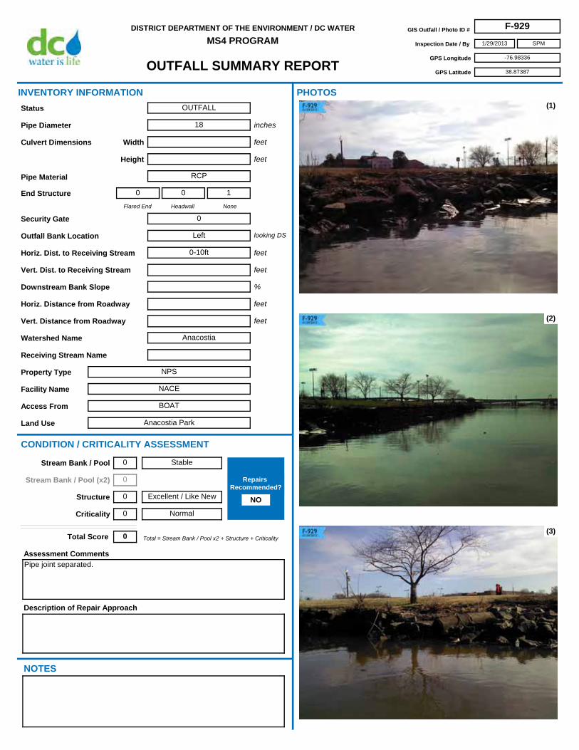
OUTFALL SUMMARY REPORT
DISTRICT DEPARTMENT OF THE ENVIRONMENT / DC WATER
MS4 PROGRAMGIS Outfall / Photo ID # F-929
Inspection Date / By 1/29/2013
GPS Longitude -76.98336
GPS Latitude 38.87387
SPM
Access From BOAT
Horiz. Dist. to Receiving Stream 0-10ft
Flared End
0
Headwall
0
None
1
Security Gate 0
Facility Name NACE
Land Use Anacostia Park
Outfall Bank Location Left
Pipe Diameter 18
Height
Pipe Material RCP
Width
Property Type NPS
Receiving Stream Name
Description of Repair Approach
Watershed Name Anacostia
NOTES
INVENTORY INFORMATION
inches
feet
feet
Culvert Dimensions
End Structure
looking DS
feet
%
CONDITION / CRITICALITY ASSESSMENT
(1)
(2)
(3)
Downstream Bank Slope
PHOTOS
Status OUTFALL
Assessment Comments
Pipe joint separated.
Total = Stream Bank / Pool x2 + Structure + CriticalityTotal Score 0
Horiz. Distance from Roadway
Vert. Distance from Roadway
feet
feet
Vert. Dist. to Receiving Stream feet
Stable
Excellent / Like New
Normal
Stream Bank / Pool 0
Stream Bank / Pool (x2) 0
Structure 0
Criticality 0
Repairs Recommended?
NO

OUTFALL SUMMARY REPORT
DISTRICT DEPARTMENT OF THE ENVIRONMENT / DC WATER
MS4 PROGRAMGIS Outfall / Photo ID # F-929
Inspection Date / By 1/29/2013
GPS Longitude -76.98336
GPS Latitude 38.87387
SPM
(4)
(6) (7)
(8) (9)
(5)

OUTFALL SUMMARY REPORT
DISTRICT DEPARTMENT OF THE ENVIRONMENT / DC WATER
MS4 PROGRAMGIS Outfall / Photo ID # F-930
Inspection Date / By 1/4/2013
GPS Longitude -77.00012
GPS Latitude 38.84903
SPM
Access From Branch Ave SE
Horiz. Dist. to Receiving Stream >50ft
Flared End
1
Headwall
0
None
0
Security Gate 0
Facility Name NA
Land Use Single Family Residence
Outfall Bank Location
Pipe Diameter 12
Height
Pipe Material RCP
Width
Property Type Residential
Receiving Stream Name
Description of Repair Approach
Potential RSC
Watershed Name
NOTES
INVENTORY INFORMATION
inches
feet
feet
Culvert Dimensions
End Structure
looking DS
feet
%
CONDITION / CRITICALITY ASSESSMENT
(1)
(2)
(3)
Downstream Bank Slope
PHOTOS
Status OUTFALL
Assessment Comments
Significant erosion formed a ravine down the hillside on other side of erosion control barrier.May want to perform inspection of downstream channel to see if repair is needed.
Total = Stream Bank / Pool x2 + Structure + CriticalityTotal Score 4
Horiz. Distance from Roadway
Vert. Distance from Roadway
feet
feet
Vert. Dist. to Receiving Stream feet
Active Erosion
Excellent / Like New
Normal
Stream Bank / Pool 2
Stream Bank / Pool (x2) 4
Structure 0
Criticality 0
Repairs Recommended?
NO

OUTFALL SUMMARY REPORT
DISTRICT DEPARTMENT OF THE ENVIRONMENT / DC WATER
MS4 PROGRAMGIS Outfall / Photo ID # F-930
Inspection Date / By 1/4/2013
GPS Longitude -77.00012
GPS Latitude 38.84903
SPM
(4)
(6) (7)
(8) (9)
(5)

OUTFALL SUMMARY REPORT
DISTRICT DEPARTMENT OF THE ENVIRONMENT / DC WATER
MS4 PROGRAMGIS Outfall / Photo ID # F-931
Inspection Date / By 2/5/2013
GPS Longitude -77.00580
GPS Latitude 38.87129
SPM
Access From BOAT
Horiz. Dist. to Receiving Stream 0-10ft
Flared End
0
Headwall
1
None
0
Security Gate 1
Facility Name NA
Land Use Diamond Teague Park
Outfall Bank Location Right
Pipe Diameter 24 est
Height
Pipe Material Unknown
Width
Property Type DC Parks & Rec
Receiving Stream Name
Description of Repair Approach
Watershed Name
NOTES
INVENTORY INFORMATION
inches
feet
feet
Culvert Dimensions
End Structure
looking DS
feet
%
CONDITION / CRITICALITY ASSESSMENT
(1)
(2)
(3)
Downstream Bank Slope
PHOTOS
Status OUTFALL
Assessment Comments
Total = Stream Bank / Pool x2 + Structure + CriticalityTotal Score 0
Horiz. Distance from Roadway
Vert. Distance from Roadway
feet
feet
Vert. Dist. to Receiving Stream feet
Stable
Excellent / Like New
Normal
Stream Bank / Pool 0
Stream Bank / Pool (x2) 0
Structure 0
Criticality 0
Repairs Recommended?
NO

OUTFALL SUMMARY REPORT
DISTRICT DEPARTMENT OF THE ENVIRONMENT / DC WATER
MS4 PROGRAMGIS Outfall / Photo ID # F-931
Inspection Date / By 2/5/2013
GPS Longitude -77.00580
GPS Latitude 38.87129
SPM
(4)
(6) (7)
(8) (9)
(5)

OUTFALL SUMMARY REPORT
DISTRICT DEPARTMENT OF THE ENVIRONMENT / DC WATER
MS4 PROGRAMGIS Outfall / Photo ID # F-932
Inspection Date / By 2/5/2013
GPS Longitude -77.00589
GPS Latitude 38.87134
SPM
Access From BOAT
Horiz. Dist. to Receiving Stream 0-10ft
Flared End
0
Headwall
1
None
0
Security Gate 1
Facility Name NA
Land Use Diamond Teague Park
Outfall Bank Location Right
Pipe Diameter 30 est
Height
Pipe Material RCP
Width
Property Type DC Parks & Rec
Receiving Stream Name
Description of Repair Approach
Watershed Name
NOTES
INVENTORY INFORMATION
inches
feet
feet
Culvert Dimensions
End Structure
looking DS
feet
%
CONDITION / CRITICALITY ASSESSMENT
(1)
(2)
(3)
Downstream Bank Slope
PHOTOS
Status OUTFALL
Assessment Comments
Total = Stream Bank / Pool x2 + Structure + CriticalityTotal Score 0
Horiz. Distance from Roadway
Vert. Distance from Roadway
feet
feet
Vert. Dist. to Receiving Stream feet
Stable
Excellent / Like New
Normal
Stream Bank / Pool 0
Stream Bank / Pool (x2) 0
Structure 0
Criticality 0
Repairs Recommended?
NO

OUTFALL SUMMARY REPORT
DISTRICT DEPARTMENT OF THE ENVIRONMENT / DC WATER
MS4 PROGRAMGIS Outfall / Photo ID # F-932
Inspection Date / By 2/5/2013
GPS Longitude -77.00589
GPS Latitude 38.87134
SPM
(4)
(6) (7)
(8) (9)
(5)

OUTFALL SUMMARY REPORT
DISTRICT DEPARTMENT OF THE ENVIRONMENT / DC WATER
MS4 PROGRAMGIS Outfall / Photo ID # F-933
Inspection Date / By 2/5/2013
GPS Longitude -77.00589
GPS Latitude 38.87118
SPM
Access From BOAT
Horiz. Dist. to Receiving Stream 0-10ft
Flared End
0
Headwall
1
None
0
Security Gate 1
Facility Name NA
Land Use Diamond Teague Park
Outfall Bank Location Right
Pipe Diameter
Height 72 est
Pipe Material RCP
Width 72 est
Property Type DC Parks & Rec
Receiving Stream Name
Description of Repair Approach
Watershed Name
NOTES
INVENTORY INFORMATION
inches
feet
feet
Culvert Dimensions
End Structure
looking DS
feet
%
CONDITION / CRITICALITY ASSESSMENT
(1)
(2)
(3)
Downstream Bank Slope
PHOTOS
Status OUTFALL
Assessment Comments
Total = Stream Bank / Pool x2 + Structure + CriticalityTotal Score 0
Horiz. Distance from Roadway
Vert. Distance from Roadway
feet
feet
Vert. Dist. to Receiving Stream feet
Stable
Excellent / Like New
Normal
Stream Bank / Pool 0
Stream Bank / Pool (x2) 0
Structure 0
Criticality 0
Repairs Recommended?
NO

OUTFALL SUMMARY REPORT
DISTRICT DEPARTMENT OF THE ENVIRONMENT / DC WATER
MS4 PROGRAMGIS Outfall / Photo ID # F-933
Inspection Date / By 2/5/2013
GPS Longitude -77.00589
GPS Latitude 38.87118
SPM
(4)
(6) (7)
(8) (9)
(5)

OUTFALL SUMMARY REPORT
DISTRICT DEPARTMENT OF THE ENVIRONMENT / DC WATER
MS4 PROGRAMGIS Outfall / Photo ID # F-934
Inspection Date / By 1/10/2013
GPS Longitude -76.95454
GPS Latitude 38.86659
SPM
Access From U St SE and 34th St SE
Horiz. Dist. to Receiving Stream 0-10ft
Flared End
0
Headwall
1
None
0
Security Gate 0
Facility Name NACE
Land Use Fort Circle Park
Outfall Bank Location Right
Pipe Diameter 16
Height
Pipe Material RCP
Width
Property Type NPS
Receiving Stream Name
Description of Repair Approach
Potential RSC
Watershed Name Anacostia
NOTES
INVENTORY INFORMATION
inches
feet
feet
Culvert Dimensions
End Structure
looking DS
feet
%
CONDITION / CRITICALITY ASSESSMENT
(1)
(2)
(3)
Downstream Bank Slope
PHOTOS
Status OUTFALL
Assessment Comments
Outfall has been repaired in the recent past. Severe erosion remains a problem downstream.
Total = Stream Bank / Pool x2 + Structure + CriticalityTotal Score 6
Horiz. Distance from Roadway
Vert. Distance from Roadway
feet
feet
Vert. Dist. to Receiving Stream feet
Severe Erosion
Excellent / Like New
Normal
Stream Bank / Pool 3
Stream Bank / Pool (x2) 6
Structure 0
Criticality 0
Repairs Recommended?
YES

OUTFALL SUMMARY REPORT
DISTRICT DEPARTMENT OF THE ENVIRONMENT / DC WATER
MS4 PROGRAMGIS Outfall / Photo ID # F-934
Inspection Date / By 1/10/2013
GPS Longitude -76.95454
GPS Latitude 38.86659
SPM
(4)
(6) (7)
(8) (9)
(5)

OUTFALL SUMMARY REPORT
DISTRICT DEPARTMENT OF THE ENVIRONMENT / DC WATER
MS4 PROGRAMGIS Outfall / Photo ID # F-935
Inspection Date / By 12/18/2012
GPS Longitude -76.95305
GPS Latitude 38.91818
SPM
Access From New York Ave NE
Horiz. Dist. to Receiving Stream 0-10ft
Flared End
0
Headwall
1
None
0
Security Gate 1
Facility Name NA
Land Use Constructed Wetland
Outfall Bank Location Head
Pipe Diameter 60
Height
Pipe Material RCP
Width
Property Type DDOT
Receiving Stream Name
Description of Repair Approach
Watershed Name
NOTES
INVENTORY INFORMATION
inches
feet
feet
Culvert Dimensions
End Structure
looking DS
feet
%
CONDITION / CRITICALITY ASSESSMENT
(1)
(2)
(3)
Downstream Bank Slope
PHOTOS
Status OUTFALL
Assessment Comments
Total = Stream Bank / Pool x2 + Structure + CriticalityTotal Score 0
Horiz. Distance from Roadway
Vert. Distance from Roadway
feet
feet
Vert. Dist. to Receiving Stream feet
Stable
Excellent / Like New
Normal
Stream Bank / Pool 0
Stream Bank / Pool (x2) 0
Structure 0
Criticality 0
Repairs Recommended?
NO

OUTFALL SUMMARY REPORT
DISTRICT DEPARTMENT OF THE ENVIRONMENT / DC WATER
MS4 PROGRAMGIS Outfall / Photo ID # F-935
Inspection Date / By 12/18/2012
GPS Longitude -76.95305
GPS Latitude 38.91818
SPM
(4)
(6) (7)
(8) (9)
(5)

OUTFALL SUMMARY REPORT
DISTRICT DEPARTMENT OF THE ENVIRONMENT / DC WATER
MS4 PROGRAMGIS Outfall / Photo ID # F-936
Inspection Date / By 12/18/2012
GPS Longitude -76.95275
GPS Latitude 38.91798
SPM
Access From New York Ave NE
Horiz. Dist. to Receiving Stream 0-10ft
Flared End
0
Headwall
1
None
0
Security Gate 0
Facility Name NA
Land Use Constructed Wetland
Outfall Bank Location Head
Pipe Diameter 20
Height
Pipe Material RCP
Width
Property Type DDOT
Receiving Stream Name
Description of Repair Approach
Watershed Name
NOTES
INVENTORY INFORMATION
inches
feet
feet
Culvert Dimensions
End Structure
looking DS
feet
%
CONDITION / CRITICALITY ASSESSMENT
(1)
(2)
(3)
Downstream Bank Slope
PHOTOS
Status OUTFALL
Assessment Comments
Total = Stream Bank / Pool x2 + Structure + CriticalityTotal Score 0
Horiz. Distance from Roadway
Vert. Distance from Roadway
feet
feet
Vert. Dist. to Receiving Stream feet
Stable
Excellent / Like New
Normal
Stream Bank / Pool 0
Stream Bank / Pool (x2) 0
Structure 0
Criticality 0
Repairs Recommended?
NO

OUTFALL SUMMARY REPORT
DISTRICT DEPARTMENT OF THE ENVIRONMENT / DC WATER
MS4 PROGRAMGIS Outfall / Photo ID # F-936
Inspection Date / By 12/18/2012
GPS Longitude -76.95275
GPS Latitude 38.91798
SPM
(4)
(6) (7)
(8) (9)
(5)

OUTFALL SUMMARY REPORT
DISTRICT DEPARTMENT OF THE ENVIRONMENT / DC WATER
MS4 PROGRAMGIS Outfall / Photo ID # F-938
Inspection Date / By 12/14/2012
GPS Longitude -76.96655
GPS Latitude 38.92167
SPM
Access From Hickey Ln NE
Horiz. Dist. to Receiving Stream 0-10ft
Flared End
0
Headwall
1
None
0
Security Gate 0
Facility Name National Arboretum
Land Use Arboretum
Outfall Bank Location Right
Pipe Diameter 8
Height
Pipe Material PVC
Width
Property Type Government
Receiving Stream Name
Description of Repair Approach
Watershed Name Anacostia
NOTES
INVENTORY INFORMATION
inches
feet
feet
Culvert Dimensions
End Structure
looking DS
feet
%
CONDITION / CRITICALITY ASSESSMENT
(1)
(2)
(3)
Downstream Bank Slope
PHOTOS
Status OUTFALL
Assessment Comments
Total = Stream Bank / Pool x2 + Structure + CriticalityTotal Score 0
Horiz. Distance from Roadway
Vert. Distance from Roadway
feet
feet
Vert. Dist. to Receiving Stream feet
Stable
Excellent / Like New
Normal
Stream Bank / Pool 0
Stream Bank / Pool (x2) 0
Structure 0
Criticality 0
Repairs Recommended?
NO

OUTFALL SUMMARY REPORT
DISTRICT DEPARTMENT OF THE ENVIRONMENT / DC WATER
MS4 PROGRAMGIS Outfall / Photo ID # F-938
Inspection Date / By 12/14/2012
GPS Longitude -76.96655
GPS Latitude 38.92167
SPM
(4)
(6) (7)
(8) (9)
(5)
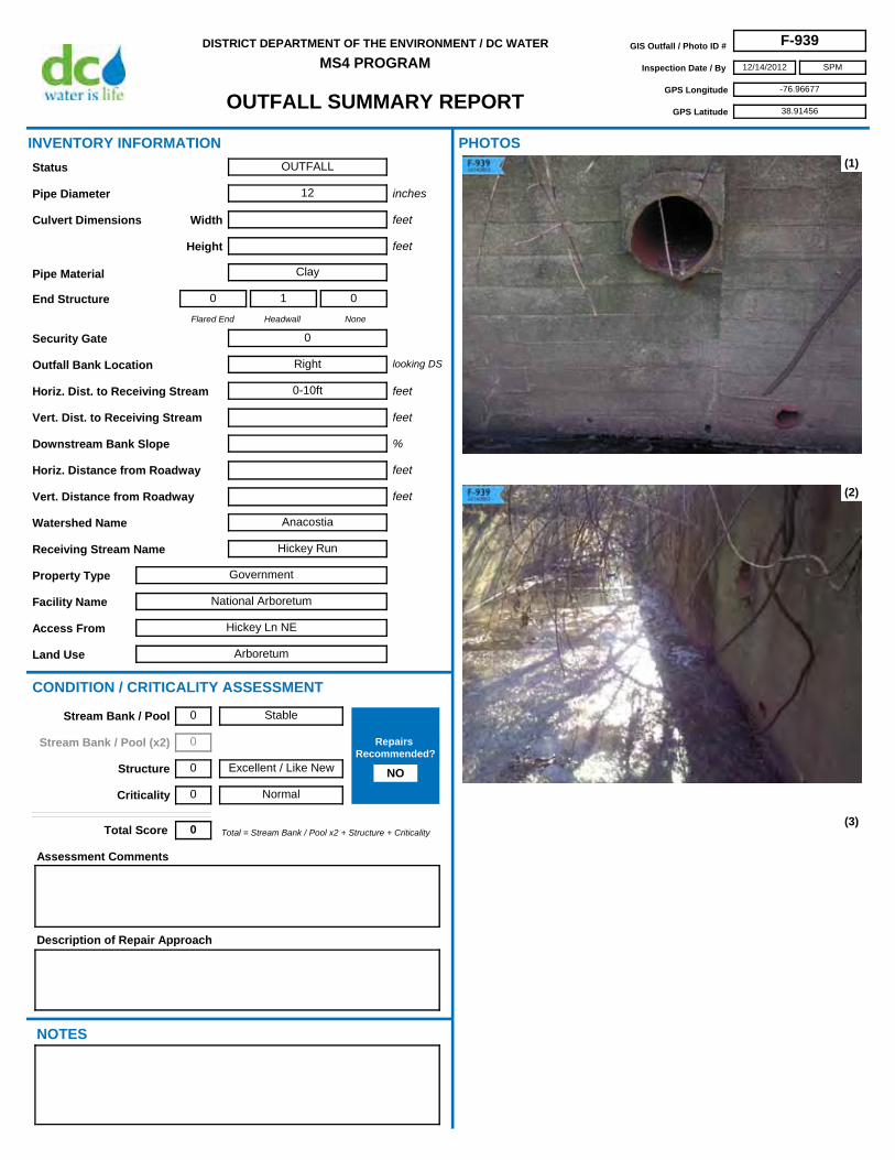
OUTFALL SUMMARY REPORT
DISTRICT DEPARTMENT OF THE ENVIRONMENT / DC WATER
MS4 PROGRAMGIS Outfall / Photo ID # F-939
Inspection Date / By 12/14/2012
GPS Longitude -76.96677
GPS Latitude 38.91456
SPM
Access From Hickey Ln NE
Horiz. Dist. to Receiving Stream 0-10ft
Flared End
0
Headwall
1
None
0
Security Gate 0
Facility Name National Arboretum
Land Use Arboretum
Outfall Bank Location Right
Pipe Diameter 12
Height
Pipe Material Clay
Width
Property Type Government
Receiving Stream Name Hickey Run
Description of Repair Approach
Watershed Name Anacostia
NOTES
INVENTORY INFORMATION
inches
feet
feet
Culvert Dimensions
End Structure
looking DS
feet
%
CONDITION / CRITICALITY ASSESSMENT
(1)
(2)
(3)
Downstream Bank Slope
PHOTOS
Status OUTFALL
Assessment Comments
Total = Stream Bank / Pool x2 + Structure + CriticalityTotal Score 0
Horiz. Distance from Roadway
Vert. Distance from Roadway
feet
feet
Vert. Dist. to Receiving Stream feet
Stable
Excellent / Like New
Normal
Stream Bank / Pool 0
Stream Bank / Pool (x2) 0
Structure 0
Criticality 0
Repairs Recommended?
NO

OUTFALL SUMMARY REPORT
DISTRICT DEPARTMENT OF THE ENVIRONMENT / DC WATER
MS4 PROGRAMGIS Outfall / Photo ID # F-939
Inspection Date / By 12/14/2012
GPS Longitude -76.96677
GPS Latitude 38.91456
SPM
(4)
(6) (7)
(8) (9)
(5)
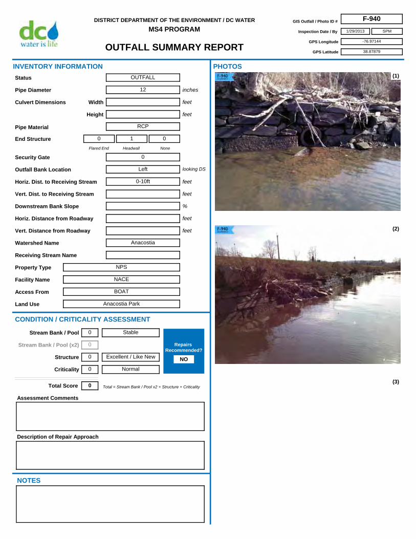
OUTFALL SUMMARY REPORT
DISTRICT DEPARTMENT OF THE ENVIRONMENT / DC WATER
MS4 PROGRAMGIS Outfall / Photo ID # F-940
Inspection Date / By 1/29/2013
GPS Longitude -76.97144
GPS Latitude 38.87879
SPM
Access From BOAT
Horiz. Dist. to Receiving Stream 0-10ft
Flared End
0
Headwall
1
None
0
Security Gate 0
Facility Name NACE
Land Use Anacostia Park
Outfall Bank Location Left
Pipe Diameter 12
Height
Pipe Material RCP
Width
Property Type NPS
Receiving Stream Name
Description of Repair Approach
Watershed Name Anacostia
NOTES
INVENTORY INFORMATION
inches
feet
feet
Culvert Dimensions
End Structure
looking DS
feet
%
CONDITION / CRITICALITY ASSESSMENT
(1)
(2)
(3)
Downstream Bank Slope
PHOTOS
Status OUTFALL
Assessment Comments
Total = Stream Bank / Pool x2 + Structure + CriticalityTotal Score 0
Horiz. Distance from Roadway
Vert. Distance from Roadway
feet
feet
Vert. Dist. to Receiving Stream feet
Stable
Excellent / Like New
Normal
Stream Bank / Pool 0
Stream Bank / Pool (x2) 0
Structure 0
Criticality 0
Repairs Recommended?
NO

OUTFALL SUMMARY REPORT
DISTRICT DEPARTMENT OF THE ENVIRONMENT / DC WATER
MS4 PROGRAMGIS Outfall / Photo ID # F-940
Inspection Date / By 1/29/2013
GPS Longitude -76.97144
GPS Latitude 38.87879
SPM
(4)
(6) (7)
(8) (9)
(5)

OUTFALL SUMMARY REPORT
DISTRICT DEPARTMENT OF THE ENVIRONMENT / DC WATER
MS4 PROGRAMGIS Outfall / Photo ID # F-941
Inspection Date / By 1/29/2013
GPS Longitude -76.97142
GPS Latitude 38.87871
SPM
Access From BOAT
Horiz. Dist. to Receiving Stream 0-10ft
Flared End
0
Headwall
1
None
0
Security Gate 0
Facility Name NACE
Land Use Anacostia Park
Outfall Bank Location Left
Pipe Diameter 8 est
Height
Pipe Material RCP
Width
Property Type NPS
Receiving Stream Name
Description of Repair Approach
Watershed Name Anacostia
NOTES
INVENTORY INFORMATION
inches
feet
feet
Culvert Dimensions
End Structure
looking DS
feet
%
CONDITION / CRITICALITY ASSESSMENT
(1)
(2)
(3)
Downstream Bank Slope
PHOTOS
Status OUTFALL
Assessment Comments
Total = Stream Bank / Pool x2 + Structure + CriticalityTotal Score 0
Horiz. Distance from Roadway
Vert. Distance from Roadway
feet
feet
Vert. Dist. to Receiving Stream feet
Stable
Excellent / Like New
Normal
Stream Bank / Pool 0
Stream Bank / Pool (x2) 0
Structure 0
Criticality 0
Repairs Recommended?
NO

OUTFALL SUMMARY REPORT
DISTRICT DEPARTMENT OF THE ENVIRONMENT / DC WATER
MS4 PROGRAMGIS Outfall / Photo ID # F-941
Inspection Date / By 1/29/2013
GPS Longitude -76.97142
GPS Latitude 38.87871
SPM
(4)
(6) (7)
(8) (9)
(5)

OUTFALL SUMMARY REPORT
DISTRICT DEPARTMENT OF THE ENVIRONMENT / DC WATER
MS4 PROGRAMGIS Outfall / Photo ID # F-942
Inspection Date / By 1/29/2013
GPS Longitude -76.97151
GPS Latitude 38.87865
SPM
Access From BOAT
Horiz. Dist. to Receiving Stream 0-10ft
Flared End
0
Headwall
1
None
1
Security Gate 0
Facility Name NACE
Land Use Anacostia Park
Outfall Bank Location Left
Pipe Diameter 36
Height
Pipe Material RCP
Width
Property Type NPS
Receiving Stream Name
Description of Repair Approach
Watershed Name Anacostia
NOTES
INVENTORY INFORMATION
inches
feet
feet
Culvert Dimensions
End Structure
looking DS
feet
%
CONDITION / CRITICALITY ASSESSMENT
(1)
(2)
(3)
Downstream Bank Slope
PHOTOS
Status OUTFALL
Assessment Comments
Total = Stream Bank / Pool x2 + Structure + CriticalityTotal Score 0
Horiz. Distance from Roadway
Vert. Distance from Roadway
feet
feet
Vert. Dist. to Receiving Stream feet
Stable
Excellent / Like New
Normal
Stream Bank / Pool 0
Stream Bank / Pool (x2) 0
Structure 0
Criticality 0
Repairs Recommended?
NO

OUTFALL SUMMARY REPORT
DISTRICT DEPARTMENT OF THE ENVIRONMENT / DC WATER
MS4 PROGRAMGIS Outfall / Photo ID # F-942
Inspection Date / By 1/29/2013
GPS Longitude -76.97151
GPS Latitude 38.87865
SPM
(4)
(6) (7)
(8) (9)
(5)

OUTFALL SUMMARY REPORT
DISTRICT DEPARTMENT OF THE ENVIRONMENT / DC WATER
MS4 PROGRAMGIS Outfall / Photo ID # F-943
Inspection Date / By 11/20/2012
GPS Longitude -76.91586
GPS Latitude 38.89179
SPM
Access From 59th St NE
Horiz. Dist. to Receiving Stream 20-30ft
Flared End
0
Headwall
1
None
1
Security Gate 0
Facility Name NA
Land Use Watts Branch
Outfall Bank Location Left
Pipe Diameter 12
Height
Pipe Material CMP
Width
Property Type DC Parks & Rec
Receiving Stream Name Watts Branch
Description of Repair Approach
Watershed Name Anacostia
NOTES
INVENTORY INFORMATION
inches
feet
feet
Culvert Dimensions
End Structure
looking DS
feet
%
CONDITION / CRITICALITY ASSESSMENT
(1)
(2)
(3)
Downstream Bank Slope
PHOTOS
Status OUTFALL
Assessment Comments
CMP is corroded at invert. Storm manhole directly upstream is open and may be a public safety concern.
Total = Stream Bank / Pool x2 + Structure + CriticalityTotal Score 3
Horiz. Distance from Roadway
Vert. Distance from Roadway
feet
feet
Vert. Dist. to Receiving Stream feet
Stable
Moderate
Critical
Stream Bank / Pool 0
Stream Bank / Pool (x2) 0
Structure 1
Criticality 2
Repairs Recommended?
YES

OUTFALL SUMMARY REPORT
DISTRICT DEPARTMENT OF THE ENVIRONMENT / DC WATER
MS4 PROGRAMGIS Outfall / Photo ID # F-943
Inspection Date / By 11/20/2012
GPS Longitude -76.91586
GPS Latitude 38.89179
SPM
(4)
(6) (7)
(8) (9)
(5)

OUTFALL SUMMARY REPORT
DISTRICT DEPARTMENT OF THE ENVIRONMENT / DC WATER
MS4 PROGRAMGIS Outfall / Photo ID # F-944
Inspection Date / By 2/6/2013
GPS Longitude -76.99250
GPS Latitude 38.86879
SPM
Access From BOAT
Horiz. Dist. to Receiving Stream 0-10ft
Flared End
0
Headwall
0
None
1
Security Gate 0
Facility Name NACE
Land Use Anacostia Park
Outfall Bank Location Left
Pipe Diameter 12 est
Height
Pipe Material RCP
Width
Property Type NPS
Receiving Stream Name
Description of Repair Approach
Watershed Name Anacostia
NOTES
INVENTORY INFORMATION
inches
feet
feet
Culvert Dimensions
End Structure
looking DS
feet
%
CONDITION / CRITICALITY ASSESSMENT
(1)
(2)
(3)
Downstream Bank Slope
PHOTOS
Status OUTFALL
Assessment Comments
Headwall broken; pipe joint separated.
Total = Stream Bank / Pool x2 + Structure + CriticalityTotal Score 2
Horiz. Distance from Roadway
Vert. Distance from Roadway
feet
feet
Vert. Dist. to Receiving Stream feet
Stable
Poor
Normal
Stream Bank / Pool 0
Stream Bank / Pool (x2) 0
Structure 2
Criticality 0
Repairs Recommended?
NO

OUTFALL SUMMARY REPORT
DISTRICT DEPARTMENT OF THE ENVIRONMENT / DC WATER
MS4 PROGRAMGIS Outfall / Photo ID # F-944
Inspection Date / By 2/6/2013
GPS Longitude -76.99250
GPS Latitude 38.86879
SPM
(4)
(6) (7)
(8) (9)
(5)

OUTFALL SUMMARY REPORT
DISTRICT DEPARTMENT OF THE ENVIRONMENT / DC WATER
MS4 PROGRAMGIS Outfall / Photo ID # F-945
Inspection Date / By 2/6/2013
GPS Longitude -76.99298
GPS Latitude 38.86870
SPM
Access From BOAT
Horiz. Dist. to Receiving Stream 0-10ft
Flared End
0
Headwall
0
None
1
Security Gate 0
Facility Name NACE
Land Use Anacostia Park
Outfall Bank Location Left
Pipe Diameter 10 est
Height
Pipe Material RCP
Width
Property Type NPS
Receiving Stream Name
Description of Repair Approach
Watershed Name Anacostia
NOTES
INVENTORY INFORMATION
inches
feet
feet
Culvert Dimensions
End Structure
looking DS
feet
%
CONDITION / CRITICALITY ASSESSMENT
(1)
(2)
(3)
Downstream Bank Slope
PHOTOS
Status OUTFALL
Assessment Comments
Total = Stream Bank / Pool x2 + Structure + CriticalityTotal Score 0
Horiz. Distance from Roadway
Vert. Distance from Roadway
feet
feet
Vert. Dist. to Receiving Stream feet
Stable
Excellent / Like New
Normal
Stream Bank / Pool 0
Stream Bank / Pool (x2) 0
Structure 0
Criticality 0
Repairs Recommended?
NO

OUTFALL SUMMARY REPORT
DISTRICT DEPARTMENT OF THE ENVIRONMENT / DC WATER
MS4 PROGRAMGIS Outfall / Photo ID # F-945
Inspection Date / By 2/6/2013
GPS Longitude -76.99298
GPS Latitude 38.86870
SPM
(4)
(6) (7)
(8) (9)
(5)
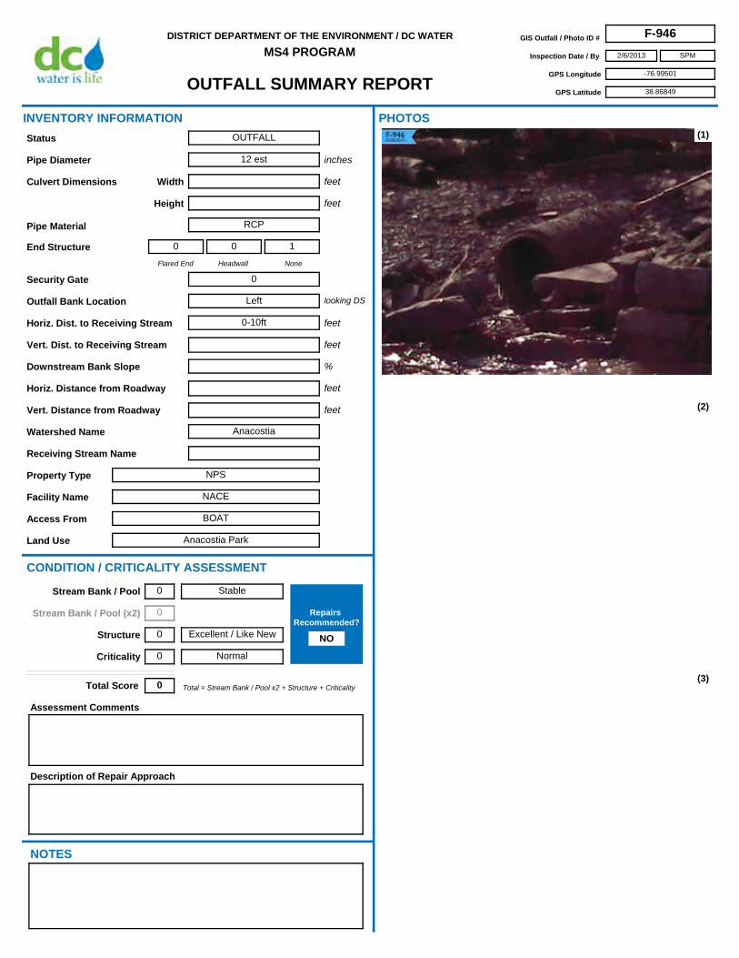
OUTFALL SUMMARY REPORT
DISTRICT DEPARTMENT OF THE ENVIRONMENT / DC WATER
MS4 PROGRAMGIS Outfall / Photo ID # F-946
Inspection Date / By 2/6/2013
GPS Longitude -76.99501
GPS Latitude 38.86849
SPM
Access From BOAT
Horiz. Dist. to Receiving Stream 0-10ft
Flared End
0
Headwall
0
None
1
Security Gate 0
Facility Name NACE
Land Use Anacostia Park
Outfall Bank Location Left
Pipe Diameter 12 est
Height
Pipe Material RCP
Width
Property Type NPS
Receiving Stream Name
Description of Repair Approach
Watershed Name Anacostia
NOTES
INVENTORY INFORMATION
inches
feet
feet
Culvert Dimensions
End Structure
looking DS
feet
%
CONDITION / CRITICALITY ASSESSMENT
(1)
(2)
(3)
Downstream Bank Slope
PHOTOS
Status OUTFALL
Assessment Comments
Total = Stream Bank / Pool x2 + Structure + CriticalityTotal Score 0
Horiz. Distance from Roadway
Vert. Distance from Roadway
feet
feet
Vert. Dist. to Receiving Stream feet
Stable
Excellent / Like New
Normal
Stream Bank / Pool 0
Stream Bank / Pool (x2) 0
Structure 0
Criticality 0
Repairs Recommended?
NO

OUTFALL SUMMARY REPORT
DISTRICT DEPARTMENT OF THE ENVIRONMENT / DC WATER
MS4 PROGRAMGIS Outfall / Photo ID # F-946
Inspection Date / By 2/6/2013
GPS Longitude -76.99501
GPS Latitude 38.86849
SPM
(4)
(6) (7)
(8) (9)
(5)

OUTFALL SUMMARY REPORT
DISTRICT DEPARTMENT OF THE ENVIRONMENT / DC WATER
MS4 PROGRAMGIS Outfall / Photo ID # F-947
Inspection Date / By 1/14/2013
GPS Longitude -76.94899
GPS Latitude 38.90646
SPM
Access From Jay St NE
Horiz. Dist. to Receiving Stream 20-30ft
Flared End
0
Headwall
0
None
1
Security Gate 0
Facility Name NACE
Land Use Fort Circle Park
Outfall Bank Location Head
Pipe Diameter 24
Height
Pipe Material CMP
Width
Property Type NPS
Receiving Stream Name
Description of Repair Approach
Watershed Name
NOTES
INVENTORY INFORMATION
inches
feet
feet
Culvert Dimensions
End Structure
looking DS
feet
%
CONDITION / CRITICALITY ASSESSMENT
(1)
(2)
(3)
Downstream Bank Slope
PHOTOS
Status OUTFALL
Assessment Comments
half filled with sedimemt
Total = Stream Bank / Pool x2 + Structure + CriticalityTotal Score 0
Horiz. Distance from Roadway
Vert. Distance from Roadway
feet
feet
Vert. Dist. to Receiving Stream feet
Stable
Excellent / Like New
Normal
Stream Bank / Pool 0
Stream Bank / Pool (x2) 0
Structure 0
Criticality 0
Repairs Recommended?
NO

OUTFALL SUMMARY REPORT
DISTRICT DEPARTMENT OF THE ENVIRONMENT / DC WATER
MS4 PROGRAMGIS Outfall / Photo ID # F-947
Inspection Date / By 1/14/2013
GPS Longitude -76.94899
GPS Latitude 38.90646
SPM
(4)
(6) (7)
(8) (9)
(5)

OUTFALL SUMMARY REPORT
DISTRICT DEPARTMENT OF THE ENVIRONMENT / DC WATER
MS4 PROGRAMGIS Outfall / Photo ID # F-948
Inspection Date / By 1/14/2013
GPS Longitude -76.94925
GPS Latitude 38.90695
SPM
Access From Hayes St NE
Horiz. Dist. to Receiving Stream 0-10ft
Flared End
0
Headwall
0
None
1
Security Gate 0
Facility Name NACE
Land Use Fort Circle Park
Outfall Bank Location Right
Pipe Diameter 18
Height
Pipe Material RCP
Width
Property Type NPS
Receiving Stream Name
Description of Repair Approach
Watershed Name Anacostia
NOTES
INVENTORY INFORMATION
inches
feet
feet
Culvert Dimensions
End Structure
looking DS
feet
%
CONDITION / CRITICALITY ASSESSMENT
(1)
(2)
(3)
Downstream Bank Slope
PHOTOS
Status OUTFALL
Assessment Comments
Total = Stream Bank / Pool x2 + Structure + CriticalityTotal Score 0
Horiz. Distance from Roadway
Vert. Distance from Roadway
feet
feet
Vert. Dist. to Receiving Stream feet
Stable
Excellent / Like New
Normal
Stream Bank / Pool 0
Stream Bank / Pool (x2) 0
Structure 0
Criticality 0
Repairs Recommended?
NO

OUTFALL SUMMARY REPORT
DISTRICT DEPARTMENT OF THE ENVIRONMENT / DC WATER
MS4 PROGRAMGIS Outfall / Photo ID # F-948
Inspection Date / By 1/14/2013
GPS Longitude -76.94925
GPS Latitude 38.90695
SPM
(4)
(6) (7)
(8) (9)
(5)
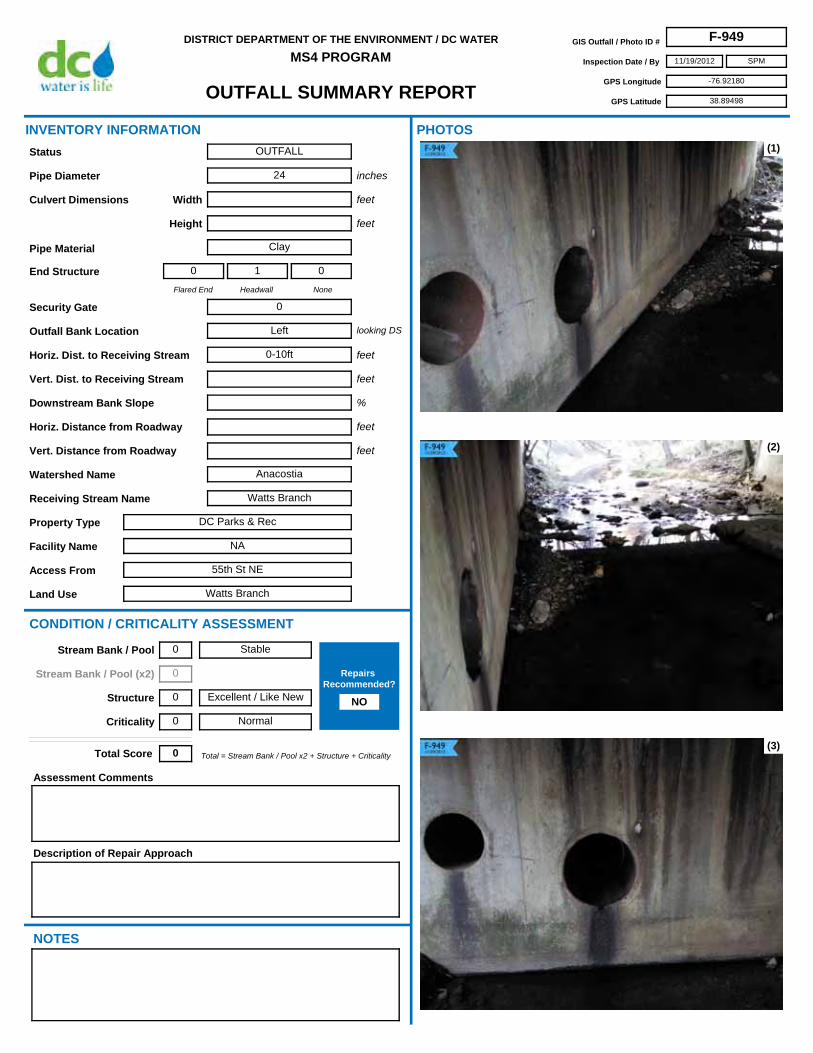
OUTFALL SUMMARY REPORT
DISTRICT DEPARTMENT OF THE ENVIRONMENT / DC WATER
MS4 PROGRAMGIS Outfall / Photo ID # F-949
Inspection Date / By 11/19/2012
GPS Longitude -76.92180
GPS Latitude 38.89498
SPM
Access From 55th St NE
Horiz. Dist. to Receiving Stream 0-10ft
Flared End
0
Headwall
1
None
0
Security Gate 0
Facility Name NA
Land Use Watts Branch
Outfall Bank Location Left
Pipe Diameter 24
Height
Pipe Material Clay
Width
Property Type DC Parks & Rec
Receiving Stream Name Watts Branch
Description of Repair Approach
Watershed Name Anacostia
NOTES
INVENTORY INFORMATION
inches
feet
feet
Culvert Dimensions
End Structure
looking DS
feet
%
CONDITION / CRITICALITY ASSESSMENT
(1)
(2)
(3)
Downstream Bank Slope
PHOTOS
Status OUTFALL
Assessment Comments
Total = Stream Bank / Pool x2 + Structure + CriticalityTotal Score 0
Horiz. Distance from Roadway
Vert. Distance from Roadway
feet
feet
Vert. Dist. to Receiving Stream feet
Stable
Excellent / Like New
Normal
Stream Bank / Pool 0
Stream Bank / Pool (x2) 0
Structure 0
Criticality 0
Repairs Recommended?
NO

OUTFALL SUMMARY REPORT
DISTRICT DEPARTMENT OF THE ENVIRONMENT / DC WATER
MS4 PROGRAMGIS Outfall / Photo ID # F-949
Inspection Date / By 11/19/2012
GPS Longitude -76.92180
GPS Latitude 38.89498
SPM
(4)
(6) (7)
(8) (9)
(5)

OUTFALL SUMMARY REPORT
DISTRICT DEPARTMENT OF THE ENVIRONMENT / DC WATER
MS4 PROGRAMGIS Outfall / Photo ID # F-950
Inspection Date / By 11/20/2012
GPS Longitude -76.92115
GPS Latitude 38.89457
SPM
Access From 55th St NE
Horiz. Dist. to Receiving Stream 0-10ft
Flared End
0
Headwall
1
None
0
Security Gate 0
Facility Name NA
Land Use Watts Branch
Outfall Bank Location Left
Pipe Diameter 8
Height
Pipe Material Clay
Width
Property Type DC Parks & Rec
Receiving Stream Name Watts Branch
Description of Repair Approach
Watershed Name Anacostia
NOTES
INVENTORY INFORMATION
inches
feet
feet
Culvert Dimensions
End Structure
looking DS
feet
%
CONDITION / CRITICALITY ASSESSMENT
(1)
(2)
(3)
Downstream Bank Slope
PHOTOS
Status OUTFALL
Assessment Comments
Broken pipe and cracked headwall.
Total = Stream Bank / Pool x2 + Structure + CriticalityTotal Score 1
Horiz. Distance from Roadway
Vert. Distance from Roadway
feet
feet
Vert. Dist. to Receiving Stream feet
Stable
Moderate
Normal
Stream Bank / Pool 0
Stream Bank / Pool (x2) 0
Structure 1
Criticality 0
Repairs Recommended?
NO
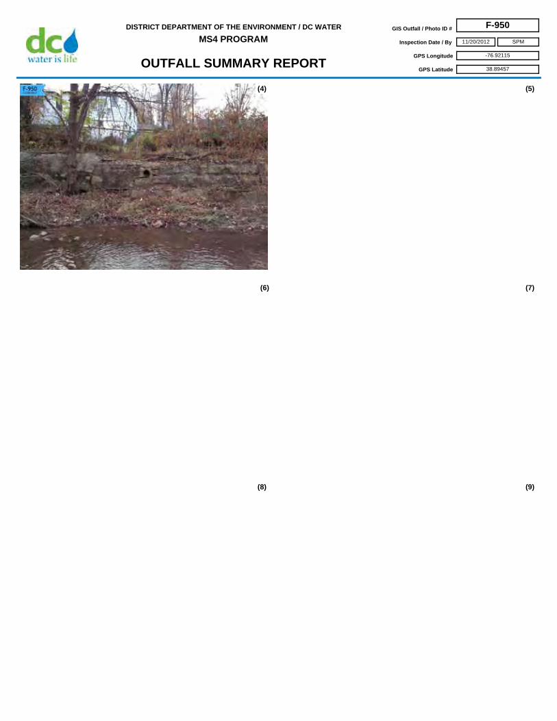
OUTFALL SUMMARY REPORT
DISTRICT DEPARTMENT OF THE ENVIRONMENT / DC WATER
MS4 PROGRAMGIS Outfall / Photo ID # F-950
Inspection Date / By 11/20/2012
GPS Longitude -76.92115
GPS Latitude 38.89457
SPM
(4)
(6) (7)
(8) (9)
(5)
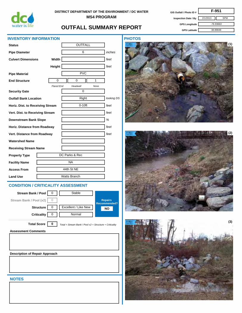
OUTFALL SUMMARY REPORT
DISTRICT DEPARTMENT OF THE ENVIRONMENT / DC WATER
MS4 PROGRAMGIS Outfall / Photo ID # F-951
Inspection Date / By 2/1/2013
GPS Longitude -76.93663
GPS Latitude 38.89848
SPM
Access From 44th St NE
Horiz. Dist. to Receiving Stream 0-10ft
Flared End
0
Headwall
0
None
1
Security Gate 0
Facility Name NA
Land Use Watts Branch
Outfall Bank Location Right
Pipe Diameter 6
Height
Pipe Material PVC
Width
Property Type DC Parks & Rec
Receiving Stream Name
Description of Repair Approach
Watershed Name
NOTES
INVENTORY INFORMATION
inches
feet
feet
Culvert Dimensions
End Structure
looking DS
feet
%
CONDITION / CRITICALITY ASSESSMENT
(1)
(2)
(3)
Downstream Bank Slope
PHOTOS
Status OUTFALL
Assessment Comments
Total = Stream Bank / Pool x2 + Structure + CriticalityTotal Score 0
Horiz. Distance from Roadway
Vert. Distance from Roadway
feet
feet
Vert. Dist. to Receiving Stream feet
Stable
Excellent / Like New
Normal
Stream Bank / Pool 0
Stream Bank / Pool (x2) 0
Structure 0
Criticality 0
Repairs Recommended?
NO

OUTFALL SUMMARY REPORT
DISTRICT DEPARTMENT OF THE ENVIRONMENT / DC WATER
MS4 PROGRAMGIS Outfall / Photo ID # F-951
Inspection Date / By 2/1/2013
GPS Longitude -76.93663
GPS Latitude 38.89848
SPM
(4)
(6) (7)
(8) (9)
(5)
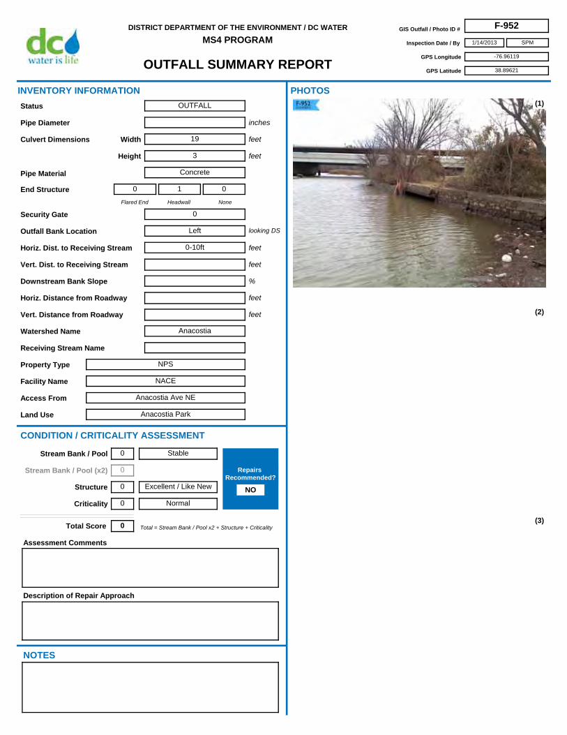
OUTFALL SUMMARY REPORT
DISTRICT DEPARTMENT OF THE ENVIRONMENT / DC WATER
MS4 PROGRAMGIS Outfall / Photo ID # F-952
Inspection Date / By 1/14/2013
GPS Longitude -76.96119
GPS Latitude 38.89621
SPM
Access From Anacostia Ave NE
Horiz. Dist. to Receiving Stream 0-10ft
Flared End
0
Headwall
1
None
0
Security Gate 0
Facility Name NACE
Land Use Anacostia Park
Outfall Bank Location Left
Pipe Diameter
Height 3
Pipe Material Concrete
Width 19
Property Type NPS
Receiving Stream Name
Description of Repair Approach
Watershed Name Anacostia
NOTES
INVENTORY INFORMATION
inches
feet
feet
Culvert Dimensions
End Structure
looking DS
feet
%
CONDITION / CRITICALITY ASSESSMENT
(1)
(2)
(3)
Downstream Bank Slope
PHOTOS
Status OUTFALL
Assessment Comments
Total = Stream Bank / Pool x2 + Structure + CriticalityTotal Score 0
Horiz. Distance from Roadway
Vert. Distance from Roadway
feet
feet
Vert. Dist. to Receiving Stream feet
Stable
Excellent / Like New
Normal
Stream Bank / Pool 0
Stream Bank / Pool (x2) 0
Structure 0
Criticality 0
Repairs Recommended?
NO

OUTFALL SUMMARY REPORT
DISTRICT DEPARTMENT OF THE ENVIRONMENT / DC WATER
MS4 PROGRAMGIS Outfall / Photo ID # F-952
Inspection Date / By 1/14/2013
GPS Longitude -76.96119
GPS Latitude 38.89621
SPM
(4)
(6) (7)
(8) (9)
(5)

OUTFALL SUMMARY REPORT
DISTRICT DEPARTMENT OF THE ENVIRONMENT / DC WATER
MS4 PROGRAMGIS Outfall / Photo ID # F-953
Inspection Date / By 12/18/2012
GPS Longitude -76.95312
GPS Latitude 38.91826
SPM
Access From New York Ave NE
Horiz. Dist. to Receiving Stream 0-10ft
Flared End
0
Headwall
1
None
0
Security Gate 1
Facility Name NA
Land Use Constructed Wetland
Outfall Bank Location Head
Pipe Diameter 60
Height
Pipe Material RCP
Width
Property Type DDOT
Receiving Stream Name
Description of Repair Approach
Watershed Name
NOTES
INVENTORY INFORMATION
inches
feet
feet
Culvert Dimensions
End Structure
looking DS
feet
%
CONDITION / CRITICALITY ASSESSMENT
(1)
(2)
(3)
Downstream Bank Slope
PHOTOS
Status OUTFALL
Assessment Comments
Total = Stream Bank / Pool x2 + Structure + CriticalityTotal Score 0
Horiz. Distance from Roadway
Vert. Distance from Roadway
feet
feet
Vert. Dist. to Receiving Stream feet
Stable
Excellent / Like New
Normal
Stream Bank / Pool 0
Stream Bank / Pool (x2) 0
Structure 0
Criticality 0
Repairs Recommended?
NO

OUTFALL SUMMARY REPORT
DISTRICT DEPARTMENT OF THE ENVIRONMENT / DC WATER
MS4 PROGRAMGIS Outfall / Photo ID # F-953
Inspection Date / By 12/18/2012
GPS Longitude -76.95312
GPS Latitude 38.91826
SPM
(4)
(6) (7)
(8) (9)
(5)

OUTFALL SUMMARY REPORT
DISTRICT DEPARTMENT OF THE ENVIRONMENT / DC WATER
MS4 PROGRAMGIS Outfall / Photo ID # F-954
Inspection Date / By 12/18/2012
GPS Longitude -76.95240
GPS Latitude 38.91806
SPM
Access From New York Ave NE
Horiz. Dist. to Receiving Stream 0-10ft
Flared End
0
Headwall
1
None
0
Security Gate 0
Facility Name NA
Land Use Constructed Wetland
Outfall Bank Location Head
Pipe Diameter 30
Height
Pipe Material RCP
Width
Property Type DDOT
Receiving Stream Name
Description of Repair Approach
Point Repair
Watershed Name
NOTES
INVENTORY INFORMATION
inches
feet
feet
Culvert Dimensions
End Structure
looking DS
feet
%
CONDITION / CRITICALITY ASSESSMENT
(1)
(2)
(3)
Downstream Bank Slope
PHOTOS
Status OUTFALL
Assessment Comments
30" deep erosion under outfall headwall. - Notify DDOT of repairs needed?
Total = Stream Bank / Pool x2 + Structure + CriticalityTotal Score 5
Horiz. Distance from Roadway
Vert. Distance from Roadway
feet
feet
Vert. Dist. to Receiving Stream feet
Active Erosion
Moderate
Normal
Stream Bank / Pool 2
Stream Bank / Pool (x2) 4
Structure 1
Criticality 0
Repairs Recommended?
YES

OUTFALL SUMMARY REPORT
DISTRICT DEPARTMENT OF THE ENVIRONMENT / DC WATER
MS4 PROGRAMGIS Outfall / Photo ID # F-954
Inspection Date / By 12/18/2012
GPS Longitude -76.95240
GPS Latitude 38.91806
SPM
(4)
(6) (7)
(8) (9)
(5)

OUTFALL SUMMARY REPORT
DISTRICT DEPARTMENT OF THE ENVIRONMENT / DC WATER
MS4 PROGRAMGIS Outfall / Photo ID # F-955
Inspection Date / By 11/27/2012
GPS Longitude -76.94477
GPS Latitude 38.90165
SPM
Access From Jay St NE
Horiz. Dist. to Receiving Stream 0-10ft
Flared End
0
Headwall
1
None
0
Security Gate 0
Facility Name NA
Land Use Watts Branch
Outfall Bank Location Right
Pipe Diameter 16
Height
Pipe Material VCP
Width
Property Type DDOT
Receiving Stream Name Watts Branch
Description of Repair Approach
Watershed Name Anacostia
NOTES
INVENTORY INFORMATION
inches
feet
feet
Culvert Dimensions
End Structure
looking DS
feet
%
CONDITION / CRITICALITY ASSESSMENT
(1)
(2)
(3)
Downstream Bank Slope
PHOTOS
Status OUTFALL
Assessment Comments
Total = Stream Bank / Pool x2 + Structure + CriticalityTotal Score 0
Horiz. Distance from Roadway
Vert. Distance from Roadway
feet
feet
Vert. Dist. to Receiving Stream feet
Stable
Excellent / Like New
Normal
Stream Bank / Pool 0
Stream Bank / Pool (x2) 0
Structure 0
Criticality 0
Repairs Recommended?
NO

OUTFALL SUMMARY REPORT
DISTRICT DEPARTMENT OF THE ENVIRONMENT / DC WATER
MS4 PROGRAMGIS Outfall / Photo ID # F-955
Inspection Date / By 11/27/2012
GPS Longitude -76.94477
GPS Latitude 38.90165
SPM
(4)
(6) (7)
(8) (9)
(5)

OUTFALL SUMMARY REPORT
DISTRICT DEPARTMENT OF THE ENVIRONMENT / DC WATER
MS4 PROGRAMGIS Outfall / Photo ID # F-956
Inspection Date / By 2/1/2013
GPS Longitude -76.94095
GPS Latitude 38.89979
SPM
Access From Hayes St NE
Horiz. Dist. to Receiving Stream 0-10ft
Flared End
0
Headwall
1
None
0
Security Gate 0
Facility Name NA
Land Use Watts Branch
Outfall Bank Location Right
Pipe Diameter 15
Height
Pipe Material RCP
Width
Property Type DC Parks & Rec
Receiving Stream Name Watts Branch
Description of Repair Approach
Watershed Name Anacostia
NOTES
INVENTORY INFORMATION
inches
feet
feet
Culvert Dimensions
End Structure
looking DS
feet
%
CONDITION / CRITICALITY ASSESSMENT
(1)
(2)
(3)
Downstream Bank Slope
PHOTOS
Status OUTFALL
Assessment Comments
Total = Stream Bank / Pool x2 + Structure + CriticalityTotal Score 0
Horiz. Distance from Roadway
Vert. Distance from Roadway
feet
feet
Vert. Dist. to Receiving Stream feet
Stable
Excellent / Like New
Normal
Stream Bank / Pool 0
Stream Bank / Pool (x2) 0
Structure 0
Criticality 0
Repairs Recommended?
NO

OUTFALL SUMMARY REPORT
DISTRICT DEPARTMENT OF THE ENVIRONMENT / DC WATER
MS4 PROGRAMGIS Outfall / Photo ID # F-956
Inspection Date / By 2/1/2013
GPS Longitude -76.94095
GPS Latitude 38.89979
SPM
(4)
(6) (7)
(8) (9)
(5)

OUTFALL SUMMARY REPORT
DISTRICT DEPARTMENT OF THE ENVIRONMENT / DC WATER
MS4 PROGRAMGIS Outfall / Photo ID # F-957
Inspection Date / By 2/1/2013
GPS Longitude -76.94127
GPS Latitude 38.90009
SPM
Access From Hayes St NE
Horiz. Dist. to Receiving Stream 0-10ft
Flared End
0
Headwall
0
None
1
Security Gate 0
Facility Name NA
Land Use Watts Branch
Outfall Bank Location Left
Pipe Diameter 16
Height
Pipe Material RCP
Width
Property Type DC Parks & Rec
Receiving Stream Name Watts Branch
Description of Repair Approach
Watershed Name Anacostia
NOTES
INVENTORY INFORMATION
inches
feet
feet
Culvert Dimensions
End Structure
looking DS
feet
%
CONDITION / CRITICALITY ASSESSMENT
(1)
(2)
(3)
Downstream Bank Slope
PHOTOS
Status OUTFALL
Assessment Comments
Total = Stream Bank / Pool x2 + Structure + CriticalityTotal Score 0
Horiz. Distance from Roadway
Vert. Distance from Roadway
feet
feet
Vert. Dist. to Receiving Stream feet
Stable
Excellent / Like New
Normal
Stream Bank / Pool 0
Stream Bank / Pool (x2) 0
Structure 0
Criticality 0
Repairs Recommended?
NO
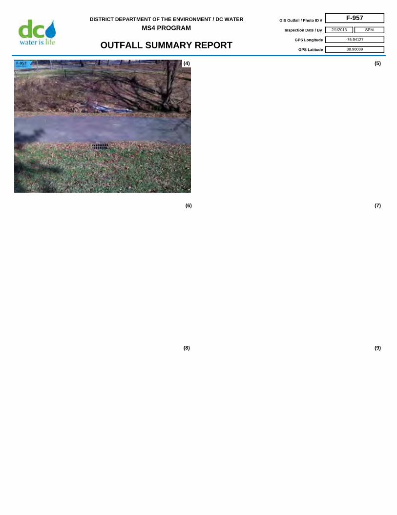
OUTFALL SUMMARY REPORT
DISTRICT DEPARTMENT OF THE ENVIRONMENT / DC WATER
MS4 PROGRAMGIS Outfall / Photo ID # F-957
Inspection Date / By 2/1/2013
GPS Longitude -76.94127
GPS Latitude 38.90009
SPM
(4)
(6) (7)
(8) (9)
(5)

OUTFALL SUMMARY REPORT
DISTRICT DEPARTMENT OF THE ENVIRONMENT / DC WATER
MS4 PROGRAMGIS Outfall / Photo ID # F-958
Inspection Date / By 2/1/2013
GPS Longitude -76.94110
GPS Latitude 38.89985
SPM
Access From Hayes St NE
Horiz. Dist. to Receiving Stream 0-10ft
Flared End
0
Headwall
1
None
0
Security Gate 0
Facility Name NA
Land Use Watts Branch
Outfall Bank Location Left
Pipe Diameter 16
Height
Pipe Material RCP
Width
Property Type DC Parks & Rec
Receiving Stream Name Watts Branch
Description of Repair Approach
Watershed Name Anacostia
NOTES
INVENTORY INFORMATION
inches
feet
feet
Culvert Dimensions
End Structure
looking DS
feet
%
CONDITION / CRITICALITY ASSESSMENT
(1)
(2)
(3)
Downstream Bank Slope
PHOTOS
Status OUTFALL
Assessment Comments
very clogged. open joint.
Total = Stream Bank / Pool x2 + Structure + CriticalityTotal Score 0
Horiz. Distance from Roadway
Vert. Distance from Roadway
feet
feet
Vert. Dist. to Receiving Stream feet
Stable
Excellent / Like New
Normal
Stream Bank / Pool 0
Stream Bank / Pool (x2) 0
Structure 0
Criticality 0
Repairs Recommended?
NO

OUTFALL SUMMARY REPORT
DISTRICT DEPARTMENT OF THE ENVIRONMENT / DC WATER
MS4 PROGRAMGIS Outfall / Photo ID # F-958
Inspection Date / By 2/1/2013
GPS Longitude -76.94110
GPS Latitude 38.89985
SPM
(4)
(6) (7)
(8) (9)
(5)
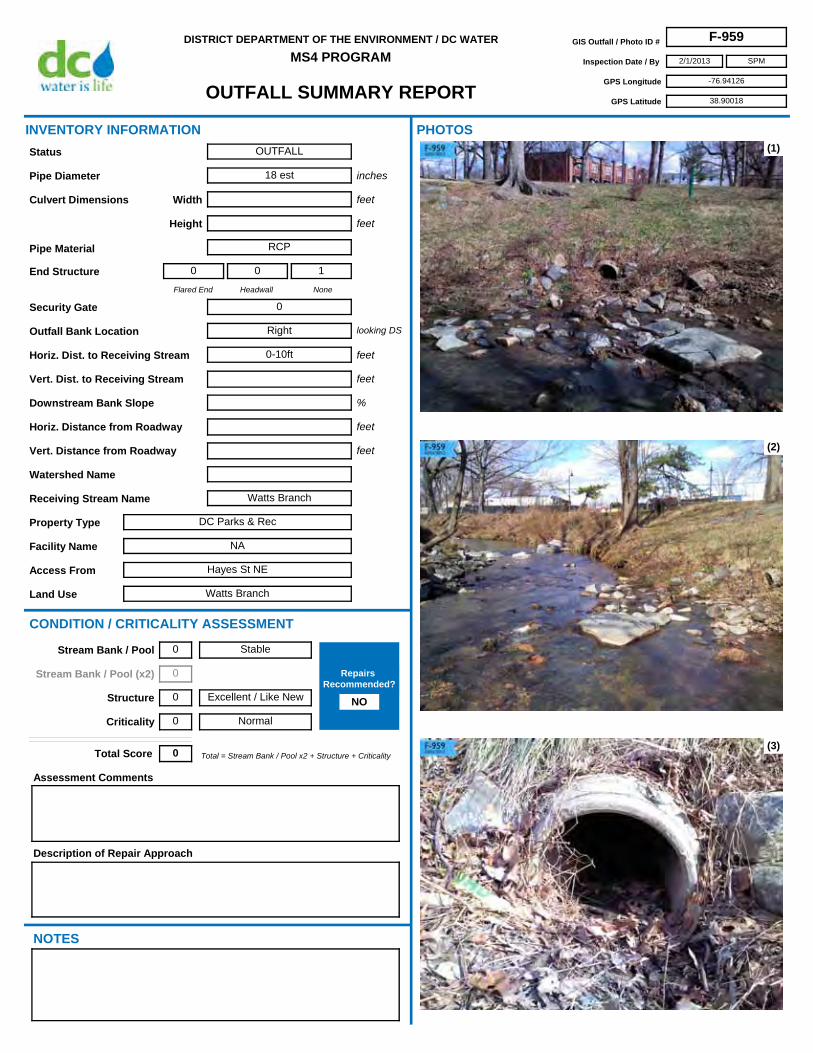
OUTFALL SUMMARY REPORT
DISTRICT DEPARTMENT OF THE ENVIRONMENT / DC WATER
MS4 PROGRAMGIS Outfall / Photo ID # F-959
Inspection Date / By 2/1/2013
GPS Longitude -76.94126
GPS Latitude 38.90018
SPM
Access From Hayes St NE
Horiz. Dist. to Receiving Stream 0-10ft
Flared End
0
Headwall
0
None
1
Security Gate 0
Facility Name NA
Land Use Watts Branch
Outfall Bank Location Right
Pipe Diameter 18 est
Height
Pipe Material RCP
Width
Property Type DC Parks & Rec
Receiving Stream Name Watts Branch
Description of Repair Approach
Watershed Name
NOTES
INVENTORY INFORMATION
inches
feet
feet
Culvert Dimensions
End Structure
looking DS
feet
%
CONDITION / CRITICALITY ASSESSMENT
(1)
(2)
(3)
Downstream Bank Slope
PHOTOS
Status OUTFALL
Assessment Comments
Total = Stream Bank / Pool x2 + Structure + CriticalityTotal Score 0
Horiz. Distance from Roadway
Vert. Distance from Roadway
feet
feet
Vert. Dist. to Receiving Stream feet
Stable
Excellent / Like New
Normal
Stream Bank / Pool 0
Stream Bank / Pool (x2) 0
Structure 0
Criticality 0
Repairs Recommended?
NO

OUTFALL SUMMARY REPORT
DISTRICT DEPARTMENT OF THE ENVIRONMENT / DC WATER
MS4 PROGRAMGIS Outfall / Photo ID # F-959
Inspection Date / By 2/1/2013
GPS Longitude -76.94126
GPS Latitude 38.90018
SPM
(4)
(6) (7)
(8) (9)
(5)

OUTFALL SUMMARY REPORT
DISTRICT DEPARTMENT OF THE ENVIRONMENT / DC WATER
MS4 PROGRAMGIS Outfall / Photo ID # F-960
Inspection Date / By 10/11/2012
GPS Longitude -77.00469
GPS Latitude 38.82625
SPM
Access From South Capitol St. SE and Elmira St SE
Horiz. Dist. to Receiving Stream 0-10ft
Flared End
0
Headwall
1
None
0
Security Gate 0
Facility Name NA
Land Use Oxon Run Park
Outfall Bank Location Right
Pipe Diameter 18
Height
Pipe Material RCP
Width
Property Type DC Parks & Rec
Receiving Stream Name Oxon Run
Description of Repair Approach
Watershed Name Anacostia
NOTES
INVENTORY INFORMATION
inches
feet
feet
Culvert Dimensions
End Structure
looking DS
feet
%
CONDITION / CRITICALITY ASSESSMENT
(1)
(2)
(3)
Downstream Bank Slope
PHOTOS
Status OUTFALL
Assessment Comments
Total = Stream Bank / Pool x2 + Structure + CriticalityTotal Score 0
Horiz. Distance from Roadway
Vert. Distance from Roadway
feet
feet
Vert. Dist. to Receiving Stream feet
Stable
Excellent / Like New
Normal
Stream Bank / Pool 0
Stream Bank / Pool (x2) 0
Structure 0
Criticality 0
Repairs Recommended?
NO

OUTFALL SUMMARY REPORT
DISTRICT DEPARTMENT OF THE ENVIRONMENT / DC WATER
MS4 PROGRAMGIS Outfall / Photo ID # F-960
Inspection Date / By 10/11/2012
GPS Longitude -77.00469
GPS Latitude 38.82625
SPM
(4)
(6) (7)
(8) (9)
(5)

OUTFALL SUMMARY REPORT
DISTRICT DEPARTMENT OF THE ENVIRONMENT / DC WATER
MS4 PROGRAMGIS Outfall / Photo ID # F-961
Inspection Date / By 2/5/2013
GPS Longitude -77.01547
GPS Latitude 38.86205
SPM
Access From BOAT
Horiz. Dist. to Receiving Stream 0-10ft
Flared End
0
Headwall
1
None
0
Security Gate 0
Facility Name Fort McNair
Land Use Military
Outfall Bank Location Right
Pipe Diameter 18 est
Height
Pipe Material Clay
Width
Property Type Government
Receiving Stream Name
Description of Repair Approach
Watershed Name
NOTES
INVENTORY INFORMATION
inches
feet
feet
Culvert Dimensions
End Structure
looking DS
feet
%
CONDITION / CRITICALITY ASSESSMENT
(1)
(2)
(3)
Downstream Bank Slope
PHOTOS
Status OUTFALL
Assessment Comments
Total = Stream Bank / Pool x2 + Structure + CriticalityTotal Score 0
Horiz. Distance from Roadway
Vert. Distance from Roadway
feet
feet
Vert. Dist. to Receiving Stream feet
Stable
Excellent / Like New
Normal
Stream Bank / Pool 0
Stream Bank / Pool (x2) 0
Structure 0
Criticality 0
Repairs Recommended?
no

OUTFALL SUMMARY REPORT
DISTRICT DEPARTMENT OF THE ENVIRONMENT / DC WATER
MS4 PROGRAMGIS Outfall / Photo ID # F-961
Inspection Date / By 2/5/2013
GPS Longitude -77.01547
GPS Latitude 38.86205
SPM
(4)
(6) (7)
(8) (9)
(5)

OUTFALL SUMMARY REPORT
DISTRICT DEPARTMENT OF THE ENVIRONMENT / DC WATER
MS4 PROGRAMGIS Outfall / Photo ID # F-962
Inspection Date / By 2/5/2013
GPS Longitude -77.01533
GPS Latitude 38.86207
SPM
Access From BOAT
Horiz. Dist. to Receiving Stream 0-10ft
Flared End
0
Headwall
1
None
0
Security Gate 0
Facility Name Fort McNair
Land Use Military
Outfall Bank Location Right
Pipe Diameter unknown
Height
Pipe Material Clay
Width
Property Type Government
Receiving Stream Name
Description of Repair Approach
Watershed Name
NOTES
INVENTORY INFORMATION
inches
feet
feet
Culvert Dimensions
End Structure
looking DS
feet
%
CONDITION / CRITICALITY ASSESSMENT
(1)
(2)
(3)
Downstream Bank Slope
PHOTOS
Status OUTFALL
Assessment Comments
Total = Stream Bank / Pool x2 + Structure + CriticalityTotal Score 0
Horiz. Distance from Roadway
Vert. Distance from Roadway
feet
feet
Vert. Dist. to Receiving Stream feet
Stable
Excellent / Like New
Normal
Stream Bank / Pool 0
Stream Bank / Pool (x2) 0
Structure 0
Criticality 0
Repairs Recommended?
NO

OUTFALL SUMMARY REPORT
DISTRICT DEPARTMENT OF THE ENVIRONMENT / DC WATER
MS4 PROGRAMGIS Outfall / Photo ID # F-962
Inspection Date / By 2/5/2013
GPS Longitude -77.01533
GPS Latitude 38.86207
SPM
(4)
(6) (7)
(8) (9)
(5)

OUTFALL SUMMARY REPORT
DISTRICT DEPARTMENT OF THE ENVIRONMENT / DC WATER
MS4 PROGRAMGIS Outfall / Photo ID # F-963
Inspection Date / By 2/6/2013
GPS Longitude -77.01706
GPS Latitude 38.86126
SPM
Access From BOAT
Horiz. Dist. to Receiving Stream 0-10ft
Flared End
0
Headwall
1
None
1
Security Gate 0
Facility Name Fort McNair
Land Use Military
Outfall Bank Location Right
Pipe Diameter 10 est
Height
Pipe Material Clay
Width
Property Type Government
Receiving Stream Name
Description of Repair Approach
Watershed Name
NOTES
INVENTORY INFORMATION
inches
feet
feet
Culvert Dimensions
End Structure
looking DS
feet
%
CONDITION / CRITICALITY ASSESSMENT
(1)
(2)
(3)
Downstream Bank Slope
PHOTOS
Status OUTFALL
Assessment Comments
Total = Stream Bank / Pool x2 + Structure + CriticalityTotal Score 0
Horiz. Distance from Roadway
Vert. Distance from Roadway
feet
feet
Vert. Dist. to Receiving Stream feet
Stable
Excellent / Like New
Normal
Stream Bank / Pool 0
Stream Bank / Pool (x2) 0
Structure 0
Criticality 0
Repairs Recommended?
NO

OUTFALL SUMMARY REPORT
DISTRICT DEPARTMENT OF THE ENVIRONMENT / DC WATER
MS4 PROGRAMGIS Outfall / Photo ID # F-963
Inspection Date / By 2/6/2013
GPS Longitude -77.01706
GPS Latitude 38.86126
SPM
(4)
(6) (7)
(8) (9)
(5)

OUTFALL SUMMARY REPORT
DISTRICT DEPARTMENT OF THE ENVIRONMENT / DC WATER
MS4 PROGRAMGIS Outfall / Photo ID # F-964
Inspection Date / By 11/19/2012
GPS Longitude -76.92474
GPS Latitude 38.89576
SPM
Access From Division Ave NE
Horiz. Dist. to Receiving Stream 0-10ft
Flared End
0
Headwall
0
None
1
Security Gate 0
Facility Name NA
Land Use Marvin Gaye Park
Outfall Bank Location Right
Pipe Diameter ?
Height
Pipe Material RCP
Width
Property Type DC Parks & Rec
Receiving Stream Name
Description of Repair Approach
Watershed Name
NOTES
INVENTORY INFORMATION
inches
feet
feet
Culvert Dimensions
End Structure
looking DS
feet
%
CONDITION / CRITICALITY ASSESSMENT
(1)
(2)
(3)
Downstream Bank Slope
PHOTOS
Status OUTFALL
Assessment Comments
Did not measure pipe diameter.
Total = Stream Bank / Pool x2 + Structure + CriticalityTotal Score 0
Horiz. Distance from Roadway
Vert. Distance from Roadway
feet
feet
Vert. Dist. to Receiving Stream feet
Stable
Excellent / Like New
Normal
Stream Bank / Pool 0
Stream Bank / Pool (x2) 0
Structure 0
Criticality 0
Repairs Recommended?
NO

OUTFALL SUMMARY REPORT
DISTRICT DEPARTMENT OF THE ENVIRONMENT / DC WATER
MS4 PROGRAMGIS Outfall / Photo ID # F-964
Inspection Date / By 11/19/2012
GPS Longitude -76.92474
GPS Latitude 38.89576
SPM
(4)
(6) (7)
(8) (9)
(5)

OUTFALL SUMMARY REPORT
DISTRICT DEPARTMENT OF THE ENVIRONMENT / DC WATER
MS4 PROGRAMGIS Outfall / Photo ID # F-965
Inspection Date / By 12/11/2012
GPS Longitude -77.08267
GPS Latitude 38.92721
SPM
Access From New Mexico Ave NW
Horiz. Dist. to Receiving Stream 0-10ft
Flared End
0
Headwall
0
None
1
Security Gate 1
Facility Name ROCR
Land Use Glover Park
Outfall Bank Location Head
Pipe Diameter 36
Height
Pipe Material RCP
Width
Property Type NPS
Receiving Stream Name
Description of Repair Approach
Watershed Name Rock Creek
NOTES
INVENTORY INFORMATION
inches
feet
feet
Culvert Dimensions
End Structure
looking DS
feet
%
CONDITION / CRITICALITY ASSESSMENT
(1)
(2)
(3)
Downstream Bank Slope
PHOTOS
Status OUTFALL
Assessment Comments
Total = Stream Bank / Pool x2 + Structure + CriticalityTotal Score 0
Horiz. Distance from Roadway
Vert. Distance from Roadway
feet
feet
Vert. Dist. to Receiving Stream feet
Stable
Excellent / Like New
Normal
Stream Bank / Pool 0
Stream Bank / Pool (x2) 0
Structure 0
Criticality 0
Repairs Recommended?
NO

OUTFALL SUMMARY REPORT
DISTRICT DEPARTMENT OF THE ENVIRONMENT / DC WATER
MS4 PROGRAMGIS Outfall / Photo ID # F-965
Inspection Date / By 12/11/2012
GPS Longitude -77.08267
GPS Latitude 38.92721
SPM
(4)
(6) (7)
(8) (9)
(5)

OUTFALL SUMMARY REPORT
DISTRICT DEPARTMENT OF THE ENVIRONMENT / DC WATER
MS4 PROGRAMGIS Outfall / Photo ID # F-966
Inspection Date / By 11/28/2012
GPS Longitude -77.09956
GPS Latitude 38.94563
SPM
Access From 50th Pl NW
Horiz. Dist. to Receiving Stream 0-10ft
Flared End
0
Headwall
1
None
0
Security Gate 0
Facility Name NA
Land Use Single Family Residence
Outfall Bank Location Right
Pipe Diameter 28
Height
Pipe Material RCP
Width
Property Type Private
Receiving Stream Name
Description of Repair Approach
Watershed Name
NOTES
INVENTORY INFORMATION
inches
feet
feet
Culvert Dimensions
End Structure
looking DS
feet
%
CONDITION / CRITICALITY ASSESSMENT
(1)
(2)
(3)
Downstream Bank Slope
PHOTOS
Status OUTFALL
Assessment Comments
Minor erosion behind headwall (right side).
Total = Stream Bank / Pool x2 + Structure + CriticalityTotal Score 2
Horiz. Distance from Roadway
Vert. Distance from Roadway
feet
feet
Vert. Dist. to Receiving Stream feet
Some Erosion
Excellent / Like New
Normal
Stream Bank / Pool 1
Stream Bank / Pool (x2) 2
Structure 0
Criticality 0
Repairs Recommended?
NO

OUTFALL SUMMARY REPORT
DISTRICT DEPARTMENT OF THE ENVIRONMENT / DC WATER
MS4 PROGRAMGIS Outfall / Photo ID # F-966
Inspection Date / By 11/28/2012
GPS Longitude -77.09956
GPS Latitude 38.94563
SPM
(4)
(6) (7)
(8) (9)
(5)

OUTFALL SUMMARY REPORT
DISTRICT DEPARTMENT OF THE ENVIRONMENT / DC WATER
MS4 PROGRAMGIS Outfall / Photo ID # F-967
Inspection Date / By 2/6/2013
GPS Longitude -76.98394
GPS Latitude 38.87349
SPM
Access From BOAT
Horiz. Dist. to Receiving Stream 0-10ft
Flared End
0
Headwall
1
None
0
Security Gate 0
Facility Name NACE
Land Use Anacostia Park
Outfall Bank Location Left
Pipe Diameter 8 est
Height
Pipe Material Clay
Width
Property Type NPS
Receiving Stream Name
Description of Repair Approach
Watershed Name Anacostia
NOTES
INVENTORY INFORMATION
inches
feet
feet
Culvert Dimensions
End Structure
looking DS
feet
%
CONDITION / CRITICALITY ASSESSMENT
(1)
(2)
(3)
Downstream Bank Slope
PHOTOS
Status OUTFALL
Assessment Comments
Total = Stream Bank / Pool x2 + Structure + CriticalityTotal Score 0
Horiz. Distance from Roadway
Vert. Distance from Roadway
feet
feet
Vert. Dist. to Receiving Stream feet
Stable
Excellent / Like New
Normal
Stream Bank / Pool 0
Stream Bank / Pool (x2) 0
Structure 0
Criticality 0
Repairs Recommended?
NO

OUTFALL SUMMARY REPORT
DISTRICT DEPARTMENT OF THE ENVIRONMENT / DC WATER
MS4 PROGRAMGIS Outfall / Photo ID # F-967
Inspection Date / By 2/6/2013
GPS Longitude -76.98394
GPS Latitude 38.87349
SPM
(4)
(6) (7)
(8) (9)
(5)

OUTFALL SUMMARY REPORT
DISTRICT DEPARTMENT OF THE ENVIRONMENT / DC WATER
MS4 PROGRAMGIS Outfall / Photo ID # F-968
Inspection Date / By 12/13/2012
GPS Longitude -77.07347
GPS Latitude 38.90474
SPM
Access From Unable to Access by foot (Canal Rd NW)
Horiz. Dist. to Receiving Stream 20-30ft
Flared End
0
Headwall
0
None
0
Security Gate 0
Facility Name CHOH
Land Use Chesapeake & Ohio Canal
Outfall Bank Location Left
Pipe Diameter
Height 2 est
Pipe Material Unknown
Width 2 est
Property Type NPS
Receiving Stream Name Canal
Description of Repair Approach
Watershed Name
NOTES
INVENTORY INFORMATION
inches
feet
feet
Culvert Dimensions
End Structure
looking DS
feet
%
CONDITION / CRITICALITY ASSESSMENT
(1)
(2)
(3)
Downstream Bank Slope
PHOTOS
Status OUTFALL
Assessment Comments
Unable to get close enough for a detailed inspection.
Total = Stream Bank / Pool x2 + Structure + CriticalityTotal Score 2
Horiz. Distance from Roadway
Vert. Distance from Roadway
feet
feet
Vert. Dist. to Receiving Stream feet
Stable
Excellent / Like New
Critical
Stream Bank / Pool 0
Stream Bank / Pool (x2) 0
Structure 0
Criticality 2
Repairs Recommended?
NO

OUTFALL SUMMARY REPORT
DISTRICT DEPARTMENT OF THE ENVIRONMENT / DC WATER
MS4 PROGRAMGIS Outfall / Photo ID # F-968
Inspection Date / By 12/13/2012
GPS Longitude -77.07347
GPS Latitude 38.90474
SPM
(4)
(6) (7)
(8) (9)
(5)

OUTFALL SUMMARY REPORT
DISTRICT DEPARTMENT OF THE ENVIRONMENT / DC WATER
MS4 PROGRAMGIS Outfall / Photo ID # F-969
Inspection Date / By 12/7/2012
GPS Longitude -77.04720
GPS Latitude 38.93574
SPM
Access From Piney Branch Pkwy NW
Horiz. Dist. to Receiving Stream 20-30ft
Flared End
1
Headwall
1
None
0
Security Gate 0
Facility Name ROCR
Land Use Piney Branch Park
Outfall Bank Location Left
Pipe Diameter 15
Height
Pipe Material RCP
Width
Property Type NPS
Receiving Stream Name Piney Branch
Description of Repair Approach
Watershed Name Rock Creek
NOTES
INVENTORY INFORMATION
inches
feet
feet
Culvert Dimensions
End Structure
looking DS
feet
%
CONDITION / CRITICALITY ASSESSMENT
(1)
(2)
(3)
Downstream Bank Slope
PHOTOS
Status OUTFALL
Assessment Comments
Total = Stream Bank / Pool x2 + Structure + CriticalityTotal Score 1
Horiz. Distance from Roadway
Vert. Distance from Roadway
feet
feet
Vert. Dist. to Receiving Stream feet
Stable
Excellent / Like New
Important
Stream Bank / Pool 0
Stream Bank / Pool (x2) 0
Structure 0
Criticality 1
Repairs Recommended?
NO

OUTFALL SUMMARY REPORT
DISTRICT DEPARTMENT OF THE ENVIRONMENT / DC WATER
MS4 PROGRAMGIS Outfall / Photo ID # F-969
Inspection Date / By 12/7/2012
GPS Longitude -77.04720
GPS Latitude 38.93574
SPM
(4)
(6) (7)
(8) (9)
(5)

OUTFALL SUMMARY REPORT
DISTRICT DEPARTMENT OF THE ENVIRONMENT / DC WATER
MS4 PROGRAMGIS Outfall / Photo ID # F-970
Inspection Date / By 12/12/2012
GPS Longitude -77.11174
GPS Latitude 38.92998
SPM
Access From Chain Bridge Rd NW and Canal Rd NW
Horiz. Dist. to Receiving Stream 20-30ft
Flared End
0
Headwall
1
None
0
Security Gate 0
Facility Name CHOH
Land Use Chesapeake & Ohio Canal
Outfall Bank Location Left
Pipe Diameter 12
Height
Pipe Material Clay
Width
Property Type NPS
Receiving Stream Name Canal
Description of Repair Approach
Watershed Name
NOTES
INVENTORY INFORMATION
inches
feet
feet
Culvert Dimensions
End Structure
looking DS
feet
%
CONDITION / CRITICALITY ASSESSMENT
(1)
(2)
(3)
Downstream Bank Slope
PHOTOS
Status OUTFALL
Assessment Comments
Total = Stream Bank / Pool x2 + Structure + CriticalityTotal Score 2
Horiz. Distance from Roadway
Vert. Distance from Roadway
feet
feet
Vert. Dist. to Receiving Stream feet
Stable
Excellent / Like New
Critical
Stream Bank / Pool 0
Stream Bank / Pool (x2) 0
Structure 0
Criticality 2
Repairs Recommended?
NO

OUTFALL SUMMARY REPORT
DISTRICT DEPARTMENT OF THE ENVIRONMENT / DC WATER
MS4 PROGRAMGIS Outfall / Photo ID # F-970
Inspection Date / By 12/12/2012
GPS Longitude -77.11174
GPS Latitude 38.92998
SPM
(4)
(6) (7)
(8) (9)
(5)
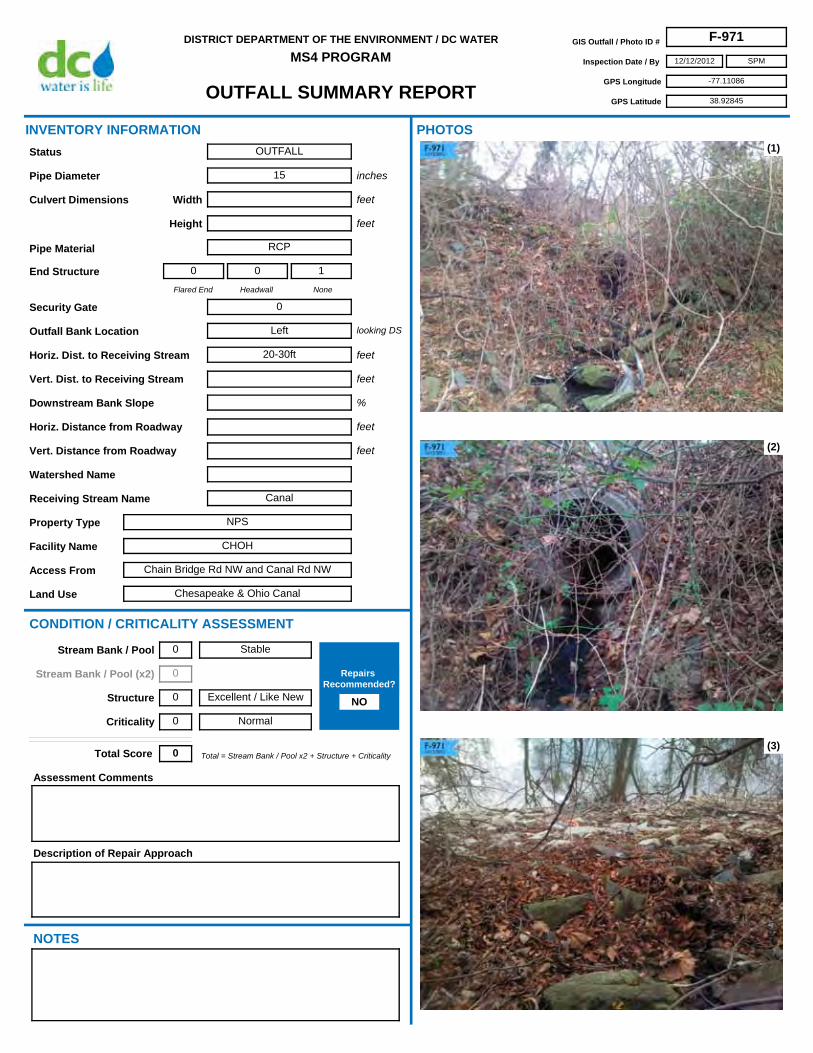
OUTFALL SUMMARY REPORT
DISTRICT DEPARTMENT OF THE ENVIRONMENT / DC WATER
MS4 PROGRAMGIS Outfall / Photo ID # F-971
Inspection Date / By 12/12/2012
GPS Longitude -77.11086
GPS Latitude 38.92845
SPM
Access From Chain Bridge Rd NW and Canal Rd NW
Horiz. Dist. to Receiving Stream 20-30ft
Flared End
0
Headwall
0
None
1
Security Gate 0
Facility Name CHOH
Land Use Chesapeake & Ohio Canal
Outfall Bank Location Left
Pipe Diameter 15
Height
Pipe Material RCP
Width
Property Type NPS
Receiving Stream Name Canal
Description of Repair Approach
Watershed Name
NOTES
INVENTORY INFORMATION
inches
feet
feet
Culvert Dimensions
End Structure
looking DS
feet
%
CONDITION / CRITICALITY ASSESSMENT
(1)
(2)
(3)
Downstream Bank Slope
PHOTOS
Status OUTFALL
Assessment Comments
Total = Stream Bank / Pool x2 + Structure + CriticalityTotal Score 0
Horiz. Distance from Roadway
Vert. Distance from Roadway
feet
feet
Vert. Dist. to Receiving Stream feet
Stable
Excellent / Like New
Normal
Stream Bank / Pool 0
Stream Bank / Pool (x2) 0
Structure 0
Criticality 0
Repairs Recommended?
NO

OUTFALL SUMMARY REPORT
DISTRICT DEPARTMENT OF THE ENVIRONMENT / DC WATER
MS4 PROGRAMGIS Outfall / Photo ID # F-971
Inspection Date / By 12/12/2012
GPS Longitude -77.11086
GPS Latitude 38.92845
SPM
(4)
(6) (7)
(8) (9)
(5)

OUTFALL SUMMARY REPORT
DISTRICT DEPARTMENT OF THE ENVIRONMENT / DC WATER
MS4 PROGRAMGIS Outfall / Photo ID # F-972
Inspection Date / By 2/5/2013
GPS Longitude -77.05526
GPS Latitude 38.85819
SPM
Access From BOAT
Horiz. Dist. to Receiving Stream
Flared End
0
Headwall
0
None
0
Security Gate 0
Facility Name CHOH
Land Use Chesapeake & Ohio Canal
Outfall Bank Location
Pipe Diameter unknown
Height
Pipe Material Unknown
Width
Property Type NPS
Receiving Stream Name
Description of Repair Approach
Watershed Name
NOTES
INVENTORY INFORMATION
inches
feet
feet
Culvert Dimensions
End Structure
looking DS
feet
%
CONDITION / CRITICALITY ASSESSMENT
(1)
(2)
(3)
Downstream Bank Slope
PHOTOS
Status OUTFALL
Assessment Comments
Total = Stream Bank / Pool x2 + Structure + CriticalityTotal Score 0
Horiz. Distance from Roadway
Vert. Distance from Roadway
feet
feet
Vert. Dist. to Receiving Stream feet
Stable
Excellent / Like New
Normal
Stream Bank / Pool 0
Stream Bank / Pool (x2) 0
Structure 0
Criticality 0
Repairs Recommended?
NO

OUTFALL SUMMARY REPORT
DISTRICT DEPARTMENT OF THE ENVIRONMENT / DC WATER
MS4 PROGRAMGIS Outfall / Photo ID # F-972
Inspection Date / By 2/5/2013
GPS Longitude -77.05526
GPS Latitude 38.85819
SPM
(4)
(6) (7)
(8) (9)
(5)

OUTFALL SUMMARY REPORT
DISTRICT DEPARTMENT OF THE ENVIRONMENT / DC WATER
MS4 PROGRAMGIS Outfall / Photo ID # F-973
Inspection Date / By 12/13/2012
GPS Longitude -77.07961
GPS Latitude 38.90569
SPM
Access From Near Abner Cloud House (Canal Rd NW)
Horiz. Dist. to Receiving Stream 30-50ft
Flared End
0
Headwall
1
None
0
Security Gate 0
Facility Name CHOH
Land Use Chesapeake & Ohio Canal
Outfall Bank Location Left
Pipe Diameter 16
Height
Pipe Material VCP
Width
Property Type NPS
Receiving Stream Name Canal
Description of Repair Approach
Watershed Name
NOTES
INVENTORY INFORMATION
inches
feet
feet
Culvert Dimensions
End Structure
looking DS
feet
%
CONDITION / CRITICALITY ASSESSMENT
(1)
(2)
(3)
Downstream Bank Slope
PHOTOS
Status OUTFALL
Assessment Comments
Total = Stream Bank / Pool x2 + Structure + CriticalityTotal Score 2
Horiz. Distance from Roadway
Vert. Distance from Roadway
feet
feet
Vert. Dist. to Receiving Stream feet
Stable
Excellent / Like New
Critical
Stream Bank / Pool 0
Stream Bank / Pool (x2) 0
Structure 0
Criticality 2
Repairs Recommended?
NO

OUTFALL SUMMARY REPORT
DISTRICT DEPARTMENT OF THE ENVIRONMENT / DC WATER
MS4 PROGRAMGIS Outfall / Photo ID # F-973
Inspection Date / By 12/13/2012
GPS Longitude -77.07961
GPS Latitude 38.90569
SPM
(4)
(6) (7)
(8) (9)
(5)

OUTFALL SUMMARY REPORT
DISTRICT DEPARTMENT OF THE ENVIRONMENT / DC WATER
MS4 PROGRAMGIS Outfall / Photo ID # F-974
Inspection Date / By 12/13/2012
GPS Longitude -77.07864
GPS Latitude 38.90580
SPM
Access From Near Abner Cloud House (Canal Rd NW)
Horiz. Dist. to Receiving Stream 0-10ft
Flared End
0
Headwall
1
None
0
Security Gate 0
Facility Name CHOH
Land Use Chesapeake & Ohio Canal
Outfall Bank Location Left
Pipe Diameter 15
Height
Pipe Material RCP
Width
Property Type NPS
Receiving Stream Name
Description of Repair Approach
Watershed Name Canal
NOTES
INVENTORY INFORMATION
inches
feet
feet
Culvert Dimensions
End Structure
looking DS
feet
%
CONDITION / CRITICALITY ASSESSMENT
(1)
(2)
(3)
Downstream Bank Slope
PHOTOS
Status OUTFALL
Assessment Comments
Total = Stream Bank / Pool x2 + Structure + CriticalityTotal Score 0
Horiz. Distance from Roadway
Vert. Distance from Roadway
feet
feet
Vert. Dist. to Receiving Stream feet
Stable
Excellent / Like New
Normal
Stream Bank / Pool 0
Stream Bank / Pool (x2) 0
Structure 0
Criticality 0
Repairs Recommended?
NO

OUTFALL SUMMARY REPORT
DISTRICT DEPARTMENT OF THE ENVIRONMENT / DC WATER
MS4 PROGRAMGIS Outfall / Photo ID # F-974
Inspection Date / By 12/13/2012
GPS Longitude -77.07864
GPS Latitude 38.90580
SPM
(4)
(6) (7)
(8) (9)
(5)

OUTFALL SUMMARY REPORT
DISTRICT DEPARTMENT OF THE ENVIRONMENT / DC WATER
MS4 PROGRAMGIS Outfall / Photo ID # F-975
Inspection Date / By 12/13/2012
GPS Longitude -77.07850
GPS Latitude 38.90586
SPM
Access From Near Abner Cloud House (Canal Rd NW)
Horiz. Dist. to Receiving Stream 20-30ft
Flared End
0
Headwall
1
None
0
Security Gate 0
Facility Name CHOH
Land Use Chesapeake & Ohio Canal
Outfall Bank Location Left
Pipe Diameter 12
Height
Pipe Material Clay
Width
Property Type NPS
Receiving Stream Name
Description of Repair Approach
Watershed Name Canal
NOTES
INVENTORY INFORMATION
inches
feet
feet
Culvert Dimensions
End Structure
looking DS
feet
%
CONDITION / CRITICALITY ASSESSMENT
(1)
(2)
(3)
Downstream Bank Slope
PHOTOS
Status OUTFALL
Assessment Comments
Total = Stream Bank / Pool x2 + Structure + CriticalityTotal Score 0
Horiz. Distance from Roadway
Vert. Distance from Roadway
feet
feet
Vert. Dist. to Receiving Stream feet
Stable
Excellent / Like New
Normal
Stream Bank / Pool 0
Stream Bank / Pool (x2) 0
Structure 0
Criticality 0
Repairs Recommended?
NO

OUTFALL SUMMARY REPORT
DISTRICT DEPARTMENT OF THE ENVIRONMENT / DC WATER
MS4 PROGRAMGIS Outfall / Photo ID # F-975
Inspection Date / By 12/13/2012
GPS Longitude -77.07850
GPS Latitude 38.90586
SPM
(4)
(6) (7)
(8) (9)
(5)

OUTFALL SUMMARY REPORT
DISTRICT DEPARTMENT OF THE ENVIRONMENT / DC WATER
MS4 PROGRAMGIS Outfall / Photo ID # F-976
Inspection Date / By 12/13/2012
GPS Longitude -77.07768
GPS Latitude 38.90579
SPM
Access From Near Abner Cloud House (Canal Rd NW)
Horiz. Dist. to Receiving Stream 20-30ft
Flared End
0
Headwall
1
None
0
Security Gate 0
Facility Name CHOH
Land Use Chesapeake & Ohio Canal
Outfall Bank Location Left
Pipe Diameter 6
Height
Pipe Material Clay
Width
Property Type NPS
Receiving Stream Name Canal
Description of Repair Approach
Watershed Name
NOTES
INVENTORY INFORMATION
inches
feet
feet
Culvert Dimensions
End Structure
looking DS
feet
%
CONDITION / CRITICALITY ASSESSMENT
(1)
(2)
(3)
Downstream Bank Slope
PHOTOS
Status OUTFALL
Assessment Comments
May be a weep hole.
Total = Stream Bank / Pool x2 + Structure + CriticalityTotal Score 2
Horiz. Distance from Roadway
Vert. Distance from Roadway
feet
feet
Vert. Dist. to Receiving Stream feet
Stable
Excellent / Like New
Critical
Stream Bank / Pool 0
Stream Bank / Pool (x2) 0
Structure 0
Criticality 2
Repairs Recommended?
NO

OUTFALL SUMMARY REPORT
DISTRICT DEPARTMENT OF THE ENVIRONMENT / DC WATER
MS4 PROGRAMGIS Outfall / Photo ID # F-976
Inspection Date / By 12/13/2012
GPS Longitude -77.07768
GPS Latitude 38.90579
SPM
(4)
(6) (7)
(8) (9)
(5)

OUTFALL SUMMARY REPORT
DISTRICT DEPARTMENT OF THE ENVIRONMENT / DC WATER
MS4 PROGRAMGIS Outfall / Photo ID # F-977
Inspection Date / By 1/7/2013
GPS Longitude -77.03543
GPS Latitude 38.88503
SPM
Access From Ohio Dr SW
Horiz. Dist. to Receiving Stream
Flared End
0
Headwall
1
None
0
Security Gate 0
Facility Name NACC/NAMA
Land Use Tidal Basin
Outfall Bank Location
Pipe Diameter 18
Height
Pipe Material VCP
Width
Property Type NPS
Receiving Stream Name
Description of Repair Approach
Watershed Name
NOTES
INVENTORY INFORMATION
inches
feet
feet
Culvert Dimensions
End Structure
looking DS
feet
%
CONDITION / CRITICALITY ASSESSMENT
(1)
(2)
(3)
Downstream Bank Slope
PHOTOS
Status OUTFALL
Assessment Comments
Total = Stream Bank / Pool x2 + Structure + CriticalityTotal Score 0
Horiz. Distance from Roadway
Vert. Distance from Roadway
feet
feet
Vert. Dist. to Receiving Stream feet
Stable
Excellent / Like New
Normal
Stream Bank / Pool 0
Stream Bank / Pool (x2) 0
Structure 0
Criticality 0
Repairs Recommended?
NO

OUTFALL SUMMARY REPORT
DISTRICT DEPARTMENT OF THE ENVIRONMENT / DC WATER
MS4 PROGRAMGIS Outfall / Photo ID # F-977
Inspection Date / By 1/7/2013
GPS Longitude -77.03543
GPS Latitude 38.88503
SPM
(4)
(6) (7)
(8) (9)
(5)

OUTFALL SUMMARY REPORT
DISTRICT DEPARTMENT OF THE ENVIRONMENT / DC WATER
MS4 PROGRAMGIS Outfall / Photo ID # F-978
Inspection Date / By 1/9/2013
GPS Longitude -77.10300
GPS Latitude 38.94598
SPM
Access From Warren Pl NW
Horiz. Dist. to Receiving Stream 0-10ft
Flared End
0
Headwall
1
None
0
Security Gate 0
Facility Name NA
Land Use Right of Way
Outfall Bank Location Left
Pipe Diameter 16
Height
Pipe Material RCP
Width
Property Type DDOT
Receiving Stream Name
Description of Repair Approach
Watershed Name
NOTES
INVENTORY INFORMATION
inches
feet
feet
Culvert Dimensions
End Structure
looking DS
feet
%
CONDITION / CRITICALITY ASSESSMENT
(1)
(2)
(3)
Downstream Bank Slope
PHOTOS
Status OUTFALL
Assessment Comments
Total = Stream Bank / Pool x2 + Structure + CriticalityTotal Score 0
Horiz. Distance from Roadway
Vert. Distance from Roadway
feet
feet
Vert. Dist. to Receiving Stream feet
Stable
Excellent / Like New
Normal
Stream Bank / Pool 0
Stream Bank / Pool (x2) 0
Structure 0
Criticality 0
Repairs Recommended?
NO

OUTFALL SUMMARY REPORT
DISTRICT DEPARTMENT OF THE ENVIRONMENT / DC WATER
MS4 PROGRAMGIS Outfall / Photo ID # F-978
Inspection Date / By 1/9/2013
GPS Longitude -77.10300
GPS Latitude 38.94598
SPM
(4)
(6) (7)
(8) (9)
(5)

OUTFALL SUMMARY REPORT
DISTRICT DEPARTMENT OF THE ENVIRONMENT / DC WATER
MS4 PROGRAMGIS Outfall / Photo ID # F-979
Inspection Date / By 11/20/2012
GPS Longitude -76.91837
GPS Latitude 38.89373
SPM
Access From 55th St NE
Horiz. Dist. to Receiving Stream 0-10ft
Flared End
1
Headwall
0
None
0
Security Gate 0
Facility Name NA
Land Use Watts Branch
Outfall Bank Location Left
Pipe Diameter 12
Height
Pipe Material CMP
Width
Property Type DC Parks & Rec
Receiving Stream Name Watts Branch
Description of Repair Approach
Watershed Name Anacostia
NOTES
INVENTORY INFORMATION
inches
feet
feet
Culvert Dimensions
End Structure
looking DS
feet
%
CONDITION / CRITICALITY ASSESSMENT
(1)
(2)
(3)
Downstream Bank Slope
PHOTOS
Status OUTFALL
Assessment Comments
Total = Stream Bank / Pool x2 + Structure + CriticalityTotal Score 0
Horiz. Distance from Roadway
Vert. Distance from Roadway
feet
feet
Vert. Dist. to Receiving Stream feet
Stable
Excellent / Like New
Normal
Stream Bank / Pool 0
Stream Bank / Pool (x2) 0
Structure 0
Criticality 0
Repairs Recommended?
NO

OUTFALL SUMMARY REPORT
DISTRICT DEPARTMENT OF THE ENVIRONMENT / DC WATER
MS4 PROGRAMGIS Outfall / Photo ID # F-979
Inspection Date / By 11/20/2012
GPS Longitude -76.91837
GPS Latitude 38.89373
SPM
(4)
(6) (7)
(8) (9)
(5)

OUTFALL SUMMARY REPORT
DISTRICT DEPARTMENT OF THE ENVIRONMENT / DC WATER
MS4 PROGRAMGIS Outfall / Photo ID # F-980
Inspection Date / By 11/20/2012
GPS Longitude -76.91824
GPS Latitude 38.89338
SPM
Access From 55th St NE
Horiz. Dist. to Receiving Stream 0-10ft
Flared End
1
Headwall
0
None
0
Security Gate 0
Facility Name NA
Land Use Watts Branch
Outfall Bank Location Left
Pipe Diameter 18
Height
Pipe Material CMP
Width
Property Type DC Parks & Rec
Receiving Stream Name Watts Branch
Description of Repair Approach
Watershed Name Anacostia
NOTES
INVENTORY INFORMATION
inches
feet
feet
Culvert Dimensions
End Structure
looking DS
feet
%
CONDITION / CRITICALITY ASSESSMENT
(1)
(2)
(3)
Downstream Bank Slope
PHOTOS
Status OUTFALL
Assessment Comments
Total = Stream Bank / Pool x2 + Structure + CriticalityTotal Score 0
Horiz. Distance from Roadway
Vert. Distance from Roadway
feet
feet
Vert. Dist. to Receiving Stream feet
Stable
Excellent / Like New
Normal
Stream Bank / Pool 0
Stream Bank / Pool (x2) 0
Structure 0
Criticality 0
Repairs Recommended?
NO

OUTFALL SUMMARY REPORT
DISTRICT DEPARTMENT OF THE ENVIRONMENT / DC WATER
MS4 PROGRAMGIS Outfall / Photo ID # F-980
Inspection Date / By 11/20/2012
GPS Longitude -76.91824
GPS Latitude 38.89338
SPM
(4)
(6) (7)
(8) (9)
(5)

OUTFALL SUMMARY REPORT
DISTRICT DEPARTMENT OF THE ENVIRONMENT / DC WATER
MS4 PROGRAMGIS Outfall / Photo ID # F-981
Inspection Date / By 11/20/2012
GPS Longitude -76.91803
GPS Latitude 38.89314
SPM
Access From 55th St NE
Horiz. Dist. to Receiving Stream 0-10ft
Flared End
0
Headwall
0
None
1
Security Gate 0
Facility Name NA
Land Use Watts Branch
Outfall Bank Location Left
Pipe Diameter 12
Height
Pipe Material CMP
Width
Property Type DC Parks & Rec
Receiving Stream Name Watts Branch
Description of Repair Approach
Watershed Name Anacostia
NOTES
INVENTORY INFORMATION
inches
feet
feet
Culvert Dimensions
End Structure
looking DS
feet
%
CONDITION / CRITICALITY ASSESSMENT
(1)
(2)
(3)
Downstream Bank Slope
PHOTOS
Status OUTFALL
Assessment Comments
Deteriorated CMP in non-critical area.
Total = Stream Bank / Pool x2 + Structure + CriticalityTotal Score 2
Horiz. Distance from Roadway
Vert. Distance from Roadway
feet
feet
Vert. Dist. to Receiving Stream feet
Stable
Poor
Normal
Stream Bank / Pool 0
Stream Bank / Pool (x2) 0
Structure 2
Criticality 0
Repairs Recommended?
NO

OUTFALL SUMMARY REPORT
DISTRICT DEPARTMENT OF THE ENVIRONMENT / DC WATER
MS4 PROGRAMGIS Outfall / Photo ID # F-981
Inspection Date / By 11/20/2012
GPS Longitude -76.91803
GPS Latitude 38.89314
SPM
(4)
(6) (7)
(8) (9)
(5)

OUTFALL SUMMARY REPORT
DISTRICT DEPARTMENT OF THE ENVIRONMENT / DC WATER
MS4 PROGRAMGIS Outfall / Photo ID # F-982
Inspection Date / By 11/27/2012
GPS Longitude -76.94462
GPS Latitude 38.90155
SPM
Access From Jay St NE
Horiz. Dist. to Receiving Stream 0-10ft
Flared End
0
Headwall
1
None
0
Security Gate 0
Facility Name NA
Land Use Watts Branch
Outfall Bank Location Right
Pipe Diameter 16
Height
Pipe Material VCP
Width
Property Type DDOT
Receiving Stream Name Watts Branch
Description of Repair Approach
Watershed Name Anacostia
NOTES
INVENTORY INFORMATION
inches
feet
feet
Culvert Dimensions
End Structure
looking DS
feet
%
CONDITION / CRITICALITY ASSESSMENT
(1)
(2)
(3)
Downstream Bank Slope
PHOTOS
Status OUTFALL
Assessment Comments
Total = Stream Bank / Pool x2 + Structure + CriticalityTotal Score 0
Horiz. Distance from Roadway
Vert. Distance from Roadway
feet
feet
Vert. Dist. to Receiving Stream feet
Stable
Excellent / Like New
Normal
Stream Bank / Pool 0
Stream Bank / Pool (x2) 0
Structure 0
Criticality 0
Repairs Recommended?
NO

OUTFALL SUMMARY REPORT
DISTRICT DEPARTMENT OF THE ENVIRONMENT / DC WATER
MS4 PROGRAMGIS Outfall / Photo ID # F-982
Inspection Date / By 11/27/2012
GPS Longitude -76.94462
GPS Latitude 38.90155
SPM
(4)
(6) (7)
(8) (9)
(5)

OUTFALL SUMMARY REPORT
DISTRICT DEPARTMENT OF THE ENVIRONMENT / DC WATER
MS4 PROGRAMGIS Outfall / Photo ID # F-983
Inspection Date / By 11/27/2012
GPS Longitude -76.94446
GPS Latitude 38.90242
SPM
Access From Jay St NE
Horiz. Dist. to Receiving Stream 0-10ft
Flared End
0
Headwall
1
None
0
Security Gate 0
Facility Name NA
Land Use Watts Branch
Outfall Bank Location Left
Pipe Diameter 16
Height
Pipe Material RCP
Width
Property Type DDOT
Receiving Stream Name Watts Branch
Description of Repair Approach
Watershed Name Anacostia
NOTES
INVENTORY INFORMATION
inches
feet
feet
Culvert Dimensions
End Structure
looking DS
feet
%
CONDITION / CRITICALITY ASSESSMENT
(1)
(2)
(3)
Downstream Bank Slope
PHOTOS
Status OUTFALL
Assessment Comments
Total = Stream Bank / Pool x2 + Structure + CriticalityTotal Score 0
Horiz. Distance from Roadway
Vert. Distance from Roadway
feet
feet
Vert. Dist. to Receiving Stream feet
Stable
Excellent / Like New
Normal
Stream Bank / Pool 0
Stream Bank / Pool (x2) 0
Structure 0
Criticality 0
Repairs Recommended?
NO

OUTFALL SUMMARY REPORT
DISTRICT DEPARTMENT OF THE ENVIRONMENT / DC WATER
MS4 PROGRAMGIS Outfall / Photo ID # F-983
Inspection Date / By 11/27/2012
GPS Longitude -76.94446
GPS Latitude 38.90242
SPM
(4)
(6) (7)
(8) (9)
(5)

OUTFALL SUMMARY REPORT
DISTRICT DEPARTMENT OF THE ENVIRONMENT / DC WATER
MS4 PROGRAMGIS Outfall / Photo ID # F-984
Inspection Date / By 10/10/2012
GPS Longitude -77.00028
GPS Latitude 38.81972
SPM
Access From Southern Ave SE
Horiz. Dist. to Receiving Stream 0-10ft
Flared End
0
Headwall
1
None
0
Security Gate 0
Facility Name NA
Land Use NA
Outfall Bank Location Right
Pipe Diameter 24
Height
Pipe Material RCP
Width
Property Type DDOT
Receiving Stream Name Oxon Run
Description of Repair Approach
Watershed Name Anacostia
NOTES
INVENTORY INFORMATION
inches
feet
feet
Culvert Dimensions
End Structure
looking DS
feet
%
CONDITION / CRITICALITY ASSESSMENT
(1)
(2)
(3)
Downstream Bank Slope
PHOTOS
Status OUTFALL
Assessment Comments
Total = Stream Bank / Pool x2 + Structure + CriticalityTotal Score 0
Horiz. Distance from Roadway
Vert. Distance from Roadway
feet
feet
Vert. Dist. to Receiving Stream feet
Stable
Excellent / Like New
Normal
Stream Bank / Pool 0
Stream Bank / Pool (x2) 0
Structure 0
Criticality 0
Repairs Recommended?
NO

OUTFALL SUMMARY REPORT
DISTRICT DEPARTMENT OF THE ENVIRONMENT / DC WATER
MS4 PROGRAMGIS Outfall / Photo ID # F-984
Inspection Date / By 10/10/2012
GPS Longitude -77.00028
GPS Latitude 38.81972
SPM
(4)
(6) (7)
(8) (9)
(5)
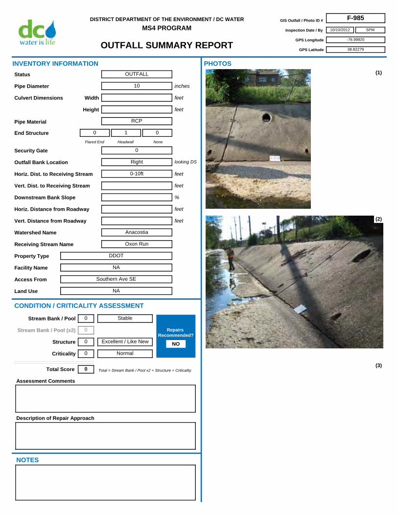
OUTFALL SUMMARY REPORT
DISTRICT DEPARTMENT OF THE ENVIRONMENT / DC WATER
MS4 PROGRAMGIS Outfall / Photo ID # F-985
Inspection Date / By 10/10/2012
GPS Longitude -76.99920
GPS Latitude 38.82279
SPM
Access From Southern Ave SE
Horiz. Dist. to Receiving Stream 0-10ft
Flared End
0
Headwall
1
None
0
Security Gate 0
Facility Name NA
Land Use NA
Outfall Bank Location Right
Pipe Diameter 10
Height
Pipe Material RCP
Width
Property Type DDOT
Receiving Stream Name Oxon Run
Description of Repair Approach
Watershed Name Anacostia
NOTES
INVENTORY INFORMATION
inches
feet
feet
Culvert Dimensions
End Structure
looking DS
feet
%
CONDITION / CRITICALITY ASSESSMENT
(1)
(2)
(3)
Downstream Bank Slope
PHOTOS
Status OUTFALL
Assessment Comments
Total = Stream Bank / Pool x2 + Structure + CriticalityTotal Score 0
Horiz. Distance from Roadway
Vert. Distance from Roadway
feet
feet
Vert. Dist. to Receiving Stream feet
Stable
Excellent / Like New
Normal
Stream Bank / Pool 0
Stream Bank / Pool (x2) 0
Structure 0
Criticality 0
Repairs Recommended?
NO

OUTFALL SUMMARY REPORT
DISTRICT DEPARTMENT OF THE ENVIRONMENT / DC WATER
MS4 PROGRAMGIS Outfall / Photo ID # F-985
Inspection Date / By 10/10/2012
GPS Longitude -76.99920
GPS Latitude 38.82279
SPM
(4)
(6) (7)
(8) (9)
(5)

OUTFALL SUMMARY REPORT
DISTRICT DEPARTMENT OF THE ENVIRONMENT / DC WATER
MS4 PROGRAMGIS Outfall / Photo ID # F-986
Inspection Date / By 12/10/2012
GPS Longitude -77.06562
GPS Latitude 38.92687
SPM
Access From Garfield St NW and 34th St NW
Horiz. Dist. to Receiving Stream
Flared End
1
Headwall
0
None
0
Security Gate 0
Facility Name ROCR
Land Use Woodland-Normanstone Park
Outfall Bank Location Right
Pipe Diameter 24
Height
Pipe Material VCP
Width
Property Type NPS
Receiving Stream Name
Description of Repair Approach
Watershed Name Rock Creek
NOTES
INVENTORY INFORMATION
inches
feet
feet
Culvert Dimensions
End Structure
looking DS
feet
%
CONDITION / CRITICALITY ASSESSMENT
(1)
(2)
(3)
Downstream Bank Slope
PHOTOS
Status OUTFALL
Assessment Comments
Total = Stream Bank / Pool x2 + Structure + CriticalityTotal Score 2
Horiz. Distance from Roadway
Vert. Distance from Roadway
feet
feet
Vert. Dist. to Receiving Stream feet
Some Erosion
Excellent / Like New
Normal
Stream Bank / Pool 1
Stream Bank / Pool (x2) 2
Structure 0
Criticality 0
Repairs Recommended?
NO

OUTFALL SUMMARY REPORT
DISTRICT DEPARTMENT OF THE ENVIRONMENT / DC WATER
MS4 PROGRAMGIS Outfall / Photo ID # F-986
Inspection Date / By 12/10/2012
GPS Longitude -77.06562
GPS Latitude 38.92687
SPM
(4)
(6) (7)
(8) (9)
(5)

OUTFALL SUMMARY REPORT
DISTRICT DEPARTMENT OF THE ENVIRONMENT / DC WATER
MS4 PROGRAMGIS Outfall / Photo ID # F-987
Inspection Date / By 1/4/2013
GPS Longitude -76.95225
GPS Latitude 38.92393
SPM
Access From McGuire Ave SE
Horiz. Dist. to Receiving Stream 0-10ft
Flared End
1
Headwall
0
None
0
Security Gate 0
Facility Name Bolling Air Force Base
Land Use Construction Site
Outfall Bank Location Head
Pipe Diameter 48
Height
Pipe Material RCP
Width
Property Type Government
Receiving Stream Name
Description of Repair Approach
Watershed Name
NOTES
INVENTORY INFORMATION
inches
feet
feet
Culvert Dimensions
End Structure
looking DS
feet
%
CONDITION / CRITICALITY ASSESSMENT
(1)
(2)
(3)
Downstream Bank Slope
PHOTOS
Status OUTFALL
Assessment Comments
Total = Stream Bank / Pool x2 + Structure + CriticalityTotal Score 0
Horiz. Distance from Roadway
Vert. Distance from Roadway
feet
feet
Vert. Dist. to Receiving Stream feet
Stable
Excellent / Like New
Normal
Stream Bank / Pool 0
Stream Bank / Pool (x2) 0
Structure 0
Criticality 0
Repairs Recommended?
NO

OUTFALL SUMMARY REPORT
DISTRICT DEPARTMENT OF THE ENVIRONMENT / DC WATER
MS4 PROGRAMGIS Outfall / Photo ID # F-987
Inspection Date / By 1/4/2013
GPS Longitude -76.95225
GPS Latitude 38.92393
SPM
(4)
(6) (7)
(8) (9)
(5)
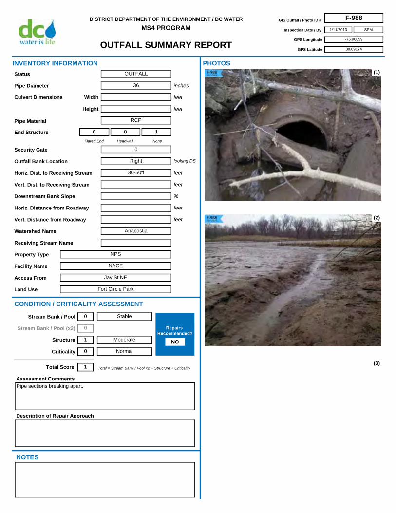
OUTFALL SUMMARY REPORT
DISTRICT DEPARTMENT OF THE ENVIRONMENT / DC WATER
MS4 PROGRAMGIS Outfall / Photo ID # F-988
Inspection Date / By 1/11/2013
GPS Longitude -76.96859
GPS Latitude 38.89174
SPM
Access From Jay St NE
Horiz. Dist. to Receiving Stream 30-50ft
Flared End
0
Headwall
0
None
1
Security Gate 0
Facility Name NACE
Land Use Fort Circle Park
Outfall Bank Location Right
Pipe Diameter 36
Height
Pipe Material RCP
Width
Property Type NPS
Receiving Stream Name
Description of Repair Approach
Watershed Name Anacostia
NOTES
INVENTORY INFORMATION
inches
feet
feet
Culvert Dimensions
End Structure
looking DS
feet
%
CONDITION / CRITICALITY ASSESSMENT
(1)
(2)
(3)
Downstream Bank Slope
PHOTOS
Status OUTFALL
Assessment Comments
Pipe sections breaking apart.
Total = Stream Bank / Pool x2 + Structure + CriticalityTotal Score 1
Horiz. Distance from Roadway
Vert. Distance from Roadway
feet
feet
Vert. Dist. to Receiving Stream feet
Stable
Moderate
Normal
Stream Bank / Pool 0
Stream Bank / Pool (x2) 0
Structure 1
Criticality 0
Repairs Recommended?
NO

OUTFALL SUMMARY REPORT
DISTRICT DEPARTMENT OF THE ENVIRONMENT / DC WATER
MS4 PROGRAMGIS Outfall / Photo ID # F-988
Inspection Date / By 1/11/2013
GPS Longitude -76.96859
GPS Latitude 38.89174
SPM
(4)
(6) (7)
(8) (9)
(5)

OUTFALL SUMMARY REPORT
DISTRICT DEPARTMENT OF THE ENVIRONMENT / DC WATER
MS4 PROGRAMGIS Outfall / Photo ID # F-989
Inspection Date / By 12/10/2012
GPS Longitude -77.05704
GPS Latitude 38.91425
SPM
Access From Whitehaven St NW
Horiz. Dist. to Receiving Stream 0-10ft
Flared End
0
Headwall
1
None
0
Security Gate 0
Facility Name ROCR
Land Use Rock Creek Park
Outfall Bank Location Right
Pipe Diameter
Height 13
Pipe Material Brick
Width 28
Property Type NPS
Receiving Stream Name
Description of Repair Approach
Watershed Name Rock Creek
NOTES
INVENTORY INFORMATION
inches
feet
feet
Culvert Dimensions
End Structure
looking DS
feet
%
CONDITION / CRITICALITY ASSESSMENT
(1)
(2)
(3)
Downstream Bank Slope
PHOTOS
Status OUTFALL
Assessment Comments
Looks like top of culvert is timber framed.
Total = Stream Bank / Pool x2 + Structure + CriticalityTotal Score 1
Horiz. Distance from Roadway
Vert. Distance from Roadway
feet
feet
Vert. Dist. to Receiving Stream feet
Stable
Excellent / Like New
Important
Stream Bank / Pool 0
Stream Bank / Pool (x2) 0
Structure 0
Criticality 1
Repairs Recommended?
NO

OUTFALL SUMMARY REPORT
DISTRICT DEPARTMENT OF THE ENVIRONMENT / DC WATER
MS4 PROGRAMGIS Outfall / Photo ID # F-989
Inspection Date / By 12/10/2012
GPS Longitude -77.05704
GPS Latitude 38.91425
SPM
(4)
(6) (7)
(8) (9)
(5)

OUTFALL SUMMARY REPORT
DISTRICT DEPARTMENT OF THE ENVIRONMENT / DC WATER
MS4 PROGRAMGIS Outfall / Photo ID # F-990
Inspection Date / By 12/7/2012
GPS Longitude -77.03867
GPS Latitude 38.93737
SPM
Access From Piney Branch Pkwy NW
Horiz. Dist. to Receiving Stream 0-10ft
Flared End
0
Headwall
1
None
0
Security Gate 0
Facility Name ROCR
Land Use Piney Branch Park
Outfall Bank Location Left
Pipe Diameter 8 est
Height
Pipe Material Iron
Width
Property Type NPS
Receiving Stream Name
Description of Repair Approach
Watershed Name Rock Creek
NOTES
INVENTORY INFORMATION
inches
feet
feet
Culvert Dimensions
End Structure
looking DS
feet
%
CONDITION / CRITICALITY ASSESSMENT
(1)
(2)
(3)
Downstream Bank Slope
PHOTOS
Status OUTFALL
Assessment Comments
Total = Stream Bank / Pool x2 + Structure + CriticalityTotal Score 0
Horiz. Distance from Roadway
Vert. Distance from Roadway
feet
feet
Vert. Dist. to Receiving Stream feet
Stable
Excellent / Like New
Normal
Stream Bank / Pool 0
Stream Bank / Pool (x2) 0
Structure 0
Criticality 0
Repairs Recommended?
NO

OUTFALL SUMMARY REPORT
DISTRICT DEPARTMENT OF THE ENVIRONMENT / DC WATER
MS4 PROGRAMGIS Outfall / Photo ID # F-990
Inspection Date / By 12/7/2012
GPS Longitude -77.03867
GPS Latitude 38.93737
SPM
(4)
(6) (7)
(8) (9)
(5)

OUTFALL SUMMARY REPORT
DISTRICT DEPARTMENT OF THE ENVIRONMENT / DC WATER
MS4 PROGRAMGIS Outfall / Photo ID # F-991
Inspection Date / By 12/10/2012
GPS Longitude -77.05779
GPS Latitude 38.91801
SPM
Access From Whitehaven St NW
Horiz. Dist. to Receiving Stream 0-10ft
Flared End
0
Headwall
0
None
1
Security Gate 0
Facility Name ROCR
Land Use Rock Creek Park
Outfall Bank Location Left
Pipe Diameter 8 est
Height
Pipe Material Plastic
Width
Property Type NPS
Receiving Stream Name
Description of Repair Approach
Watershed Name
NOTES
INVENTORY INFORMATION
inches
feet
feet
Culvert Dimensions
End Structure
looking DS
feet
%
CONDITION / CRITICALITY ASSESSMENT
(1)
(2)
(3)
Downstream Bank Slope
PHOTOS
Status OUTFALL
Assessment Comments
Total = Stream Bank / Pool x2 + Structure + CriticalityTotal Score 0
Horiz. Distance from Roadway
Vert. Distance from Roadway
feet
feet
Vert. Dist. to Receiving Stream feet
Stable
Excellent / Like New
Normal
Stream Bank / Pool 0
Stream Bank / Pool (x2) 0
Structure 0
Criticality 0
Repairs Recommended?
NO

OUTFALL SUMMARY REPORT
DISTRICT DEPARTMENT OF THE ENVIRONMENT / DC WATER
MS4 PROGRAMGIS Outfall / Photo ID # F-991
Inspection Date / By 12/10/2012
GPS Longitude -77.05779
GPS Latitude 38.91801
SPM
(4)
(6) (7)
(8) (9)
(5)

OUTFALL SUMMARY REPORT
DISTRICT DEPARTMENT OF THE ENVIRONMENT / DC WATER
MS4 PROGRAMGIS Outfall / Photo ID # F-992
Inspection Date / By 11/19/2012
GPS Longitude -76.93226
GPS Latitude 38.89805
SPM
Access From 49th St NE
Horiz. Dist. to Receiving Stream 0-10ft
Flared End
0
Headwall
1
None
0
Security Gate 0
Facility Name NA
Land Use Watts Branch Park
Outfall Bank Location Left
Pipe Diameter
Height 4.5
Pipe Material Concrete
Width unknown
Property Type DC Parks & Rec
Receiving Stream Name Watts Branch
Description of Repair Approach
N/A
Watershed Name Anacostia
NOTES
INVENTORY INFORMATION
inches
feet
feet
Culvert Dimensions
End Structure
looking DS
feet
%
CONDITION / CRITICALITY ASSESSMENT
(1)
(2)
(3)
Downstream Bank Slope
PHOTOS
Status OUTFALL
Assessment Comments
Double box culvert; unable to measure widths.
Total = Stream Bank / Pool x2 + Structure + CriticalityTotal Score 0
Larger pipe outside smaller (see F-614)
Horiz. Distance from Roadway
Vert. Distance from Roadway
feet
feet
Vert. Dist. to Receiving Stream feet
Stable
Excellent / Like New
Normal
Stream Bank / Pool 0
Stream Bank / Pool (x2) 0
Structure 0
Criticality 0
Repairs Recommended?
NO

OUTFALL SUMMARY REPORT
DISTRICT DEPARTMENT OF THE ENVIRONMENT / DC WATER
MS4 PROGRAMGIS Outfall / Photo ID # F-992
Inspection Date / By 11/19/2012
GPS Longitude -76.93226
GPS Latitude 38.89805
SPM
(4)
(6) (7)
(8) (9)
(5)

OUTFALL SUMMARY REPORT
DISTRICT DEPARTMENT OF THE ENVIRONMENT / DC WATER
MS4 PROGRAMGIS Outfall / Photo ID # F-993
Inspection Date / By 12/12/2012
GPS Longitude -77.09583
GPS Latitude 38.92313
SPM
Access From 49th St NW
Horiz. Dist. to Receiving Stream >50ft
Flared End
0
Headwall
0
None
1
Security Gate 0
Facility Name ROCR
Land Use Battery Kemble Park
Outfall Bank Location Left
Pipe Diameter 36
Height
Pipe Material CMP
Width
Property Type NPS
Receiving Stream Name
Description of Repair Approach
Watershed Name Rock Creek
NOTES
INVENTORY INFORMATION
inches
feet
feet
Culvert Dimensions
End Structure
looking DS
feet
%
CONDITION / CRITICALITY ASSESSMENT
(1)
(2)
(3)
Downstream Bank Slope
PHOTOS
Status OUTFALL
Assessment Comments
Total = Stream Bank / Pool x2 + Structure + CriticalityTotal Score 0
Horiz. Distance from Roadway
Vert. Distance from Roadway
feet
feet
Vert. Dist. to Receiving Stream feet
Stable
Excellent / Like New
Normal
Stream Bank / Pool 0
Stream Bank / Pool (x2) 0
Structure 0
Criticality 0
Repairs Recommended?
NO
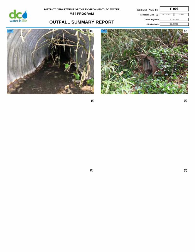
OUTFALL SUMMARY REPORT
DISTRICT DEPARTMENT OF THE ENVIRONMENT / DC WATER
MS4 PROGRAMGIS Outfall / Photo ID # F-993
Inspection Date / By 12/12/2012
GPS Longitude -77.09583
GPS Latitude 38.92313
SPM
(4)
(6) (7)
(8) (9)
(5)

OUTFALL SUMMARY REPORT
DISTRICT DEPARTMENT OF THE ENVIRONMENT / DC WATER
MS4 PROGRAMGIS Outfall / Photo ID # F-994
Inspection Date / By 12/5/2012
GPS Longitude -77.03672
GPS Latitude 38.96505
Access From Joyce Rd NW
Horiz. Dist. to Receiving Stream 0-10ft
Flared End
0
Headwall
1
None
0
Security Gate 1
Facility Name ROCR
Land Use Luzon Branch
Outfall Bank Location Head (Right)
Pipe Diameter
Height 84
Pipe Material Concrete
Width 84
Property Type NPS
Receiving Stream Name
Description of Repair Approach
Watershed Name Rock Creek
NOTES
INVENTORY INFORMATION
inches
feet
feet
Culvert Dimensions
End Structure
looking DS
feet
%
CONDITION / CRITICALITY ASSESSMENT
(1)
(2)
(3)
Downstream Bank Slope
PHOTOS
Status OUTFALL
Assessment Comments
Double outfall (see F-366); broken wingwall (left) and cracked spillway.
Total = Stream Bank / Pool x2 + Structure + CriticalityTotal Score 1
Horiz. Distance from Roadway
Vert. Distance from Roadway
feet
feet
Vert. Dist. to Receiving Stream feet
Stable
Moderate
Normal
Stream Bank / Pool 0
Stream Bank / Pool (x2) 0
Structure 1
Criticality 0
Repairs Recommended?
NO

OUTFALL SUMMARY REPORT
DISTRICT DEPARTMENT OF THE ENVIRONMENT / DC WATER
MS4 PROGRAMGIS Outfall / Photo ID # F-994
Inspection Date / By 12/5/2012
GPS Longitude -77.03672
GPS Latitude 38.96505
(4)
(6) (7)
(8) (9)
(5)

OUTFALL SUMMARY REPORT
DISTRICT DEPARTMENT OF THE ENVIRONMENT / DC WATER
MS4 PROGRAMGIS Outfall / Photo ID # F-996
Inspection Date / By 5/15/2013
GPS Longitude -77.05324
GPS Latitude 38.97035
Access From Oregon Ave NW and Nebraska Ave NW
Horiz. Dist. to Receiving Stream 0-10ft
Flared End
1
Headwall
1
None
0
Security Gate 1
Facility Name ROCR
Land Use Rock Creek Park
Outfall Bank Location Head (center)
Pipe Diameter
Height 60
Pipe Material Unknown
Width 60
Property Type NPS
Receiving Stream Name
Description of Repair Approach
Watershed Name Rock Creek
NOTES
INVENTORY INFORMATION
inches
feet
feet
Culvert Dimensions
End Structure
looking DS
feet
%
CONDITION / CRITICALITY ASSESSMENT
(1)
(2)
(3)
Downstream Bank Slope
PHOTOS
Status OUTFALL
Assessment Comments
Total = Stream Bank / Pool x2 + Structure + CriticalityTotal Score 3
Horiz. Distance from Roadway 80
Vert. Distance from Roadway
feet
feet
Vert. Dist. to Receiving Stream feet
Stable
Moderate
Critical
Stream Bank / Pool 0
Stream Bank / Pool (x2) 0
Structure 1
Criticality 2
Repairs Recommended?
NO

OUTFALL SUMMARY REPORT
DISTRICT DEPARTMENT OF THE ENVIRONMENT / DC WATER
MS4 PROGRAMGIS Outfall / Photo ID # F-996
Inspection Date / By 5/15/2013
GPS Longitude -77.05324
GPS Latitude 38.97035
(4)
(6) (7)
(8) (9)
(5)