initial advice statement for - the department of state ... · initial advice statement for surat...
TRANSCRIPT


Initial Advice Statement for Surat Basin Rail Pty Ltd 19 November 2007 Reference : Submitted Revision 1

Document Control
Document ID: HR63-1-REPT-0006
Rev No Date Revision Details Typist Author Verifier Legal Approver
A 25/10/07 Draft for Comment CJ JC OW AS AM
O 19/11/07 Final CJ JC OW AS AM
A person using Connell Hatch documents or data accepts the risk of: a) Using the documents or data in electronic form without requesting and checking them for accuracy against the original hard copy version. b) Using the documents or data for any purpose not agreed to in writing by Connell Hatch.
Providing management and consulting services for infrastructure in the mining and industrial sectors throughout Australia, New Zealand and the Pacific.
A joint venture between Connell Wagner Pty Ltd ABN 54 005 139 873 and Hatch Associates Pty Ltd ABN 59 008 630 500


EXPLANATORY STATEMENT
Important Things You Should Know About This Report
Exclusive Use • This report has been prepared by Connell Hatch at the request of Surat Basin Rail Pty Ltd ABN 55 122 652 as
agent for the Surat Basin Rail Joint Venture (“Client”) exclusively for the use of its Client; and • The basis of Connell Hatch’s engagement by the Client is that Connell Hatch’s liability, whether under the law of
contract, tort, statute, equity or otherwise, is limited as set out in the terms of the Consultancy Services Agreement.
Third Parties • This Report is being released to certain third parties other than the Client (each such third party recipient, a
“Report Addressee”, and collectively “Report Addressees”) contingent upon each such Report Addressee’s entering into a Report Release Agreement and the acceptance of the following understandings, and such Report Addressee’s use or review of the Report shall constitute its legal agreement to be bound by the following understandings: i) Neither the Connell Hatch nor any of its affiliates makes any representations or warranties, express or implied, to
Report Addressees regarding the Report and does not warrant nor guarantee any specific conclusions, results or other outcomes. Connell Hatch accepts no responsibility for damages, expenses, losses or claims of the Report Addressees, jointly or severally, or any other third party resulting from decisions made (or not made) or actions based (or not based) on this Report and each Report Addressee shall waive and release any and all claims it may have against Connell Hatch arising in whole or in part out of the release of the report to it;
ii) Neither Connell Hatch nor any of its affiliates shall have any liability to Report Addressees, jointly or severally, nor any other third person for furnishing the Report or for any action taken or decision made by the Report Addressees, jointly or severally, or any other third person in purported reliance on the Report, including its decision to participate in or abstain from participating in any Project financing; and
iii) Neither Connell Hatch nor any of its affiliates shall have any liability to Report Addressees, jointly or severally or any other third person for failing to furnish any other information now or in the future known to or in possession of Connell Hatch or its affiliates or have any obligation to update or supplement any of the Report or otherwise provide the Report Addressees or any other third person with any additional information.
• The report is a report scoped in accordance with instructions given by or on behalf of Client. The report may not address issues which would need to be addressed with a third party if that party’s particular circumstances, requirements and experience with such reports were known and may make assumptions about matters of which a third party is not aware; and
• Connell Hatch therefore does not assume responsibility for the use of the report by any third party and the use of the report by any third party is at the risk of that party.
Providing management and consulting services for infrastructure in the mining and industrial sectors throughout Australia, New Zealand and the Pacific.
A joint venture between Connell Wagner Pty Ltd ABN 54 005 139 873 and Hatch Associates Pty Ltd ABN 59 008 630 500

Limits on Investigation and Information • This report contains the professional opinion of Connell Hatch as to the matters set out herein, using its
professional judgment and acting in accordance with the standard of care and skill normally exercised by professional engineers providing similar services in comparable locations. Except as set out in the Consultancy Agreement, no other express or implied warranty is made as to the professional advice contained in this report;
• Parts of the report are based on information provided to Connell Hatch by other parties. Pursuant to clause 5.3 of the Consultancy Agreement, and unless expressly stated otherwise, the information that has been provided to Connell Hatch has not been independently verified by Connell Hatch to be accurate, complete or adequate; and
• Connell Hatch takes no responsibility and disclaims all liability whatsoever for any loss or damage that the Client may suffer resulting from any conclusions based on information provided to Connell Hatch, except to the extent that the loss or damage arises from a breach by Connell Hatch of any of its obligations under the Consultancy Agreement (including without limitation clauses 1.1 and 5.3) or to the extent that Connell Hatch expressly indicates in the report that it has verified the information to its satisfaction.
Limits on Cost Indications • Since Connell Hatch has no control over the cost of labour, materials, equipment or services furnished by others,
or over contractors' methods of determining prices, or over competitive bidding or market conditions, any indication of costs is made on the basis of Connell Hatch’s experience and qualifications and represents its best judgment as an experienced and qualified professional consultant, familiar with the relevant industry, but Connell Hatch cannot and does not guarantee that proposals, bids or actual construction costs will not vary from cost indications given.
No Comment on Commercial Feasibility • The findings, observations and conclusions expressed by Connell Hatch are not, and should not be considered
as, an opinion concerning the commercial feasibility of the property or asset.
General If the reader should become aware of any inaccuracy in or change to any of the facts, findings or assumptions made either in Connell Hatch’s report or elsewhere, the reader should inform Connell Hatch so that it can assess its significance and review its comments and recommendations. Nothing in this report shall be read or applied so as to purport to exclude, restrict or modify, or have the effect of excluding, restricting or modifying the application of all or any of the provisions of the Trade Practices Act 1974 or any other legislation which by law cannot be excluded, restricted or modified. This report shall be read as a whole and sections should not be read or relied upon out of context. This explanatory statement must accompany every copy of this report.
Providing management and consulting services for infrastructure in the mining and industrial sectors throughout Australia, New Zealand and the Pacific.
A joint venture between Connell Wagner Pty Ltd ABN 54 005 139 873 and Hatch Associates Pty Ltd ABN 59 008 630 500

Initial Advice Statement for Surat Basin Rail Pty Ltd
Contents Section Page
1. Introduction 1 1.1 Background 1 1.2 Purpose and Scope of this Initial Advice Statement 1 1.3 The Proponent 1
2. Need for the Project 2 2.1 Overview 2 2.2 Export Coal Markets 3 2.3 Route Selection 3 2.4 ‘Do Nothing’ Option 3
3. Project Description 5 3.1 Corridor Location 5 3.2 Outline of the Proposal 5 3.3 Impact on Relevant Infrastructure 5 3.4 Workforce 6 3.5 Capital Cost and Milestones 6
4. Existing Environment 7 4.1 Land Use 7 4.2 Topography, Soils and Geology 9 4.2.1 Topography 9 4.2.2 Geology 9 4.2.3 Soils 10 4.3 Hydrology and Water Quality 10 4.4 Ecology 11 4.4.1 Significant Areas 11 4.4.2 Significant Commonwealth Flora Communities 12 4.4.3 Significant Flora Species 17 4.4.4 State and Commonwealth Significant Fauna Species 18 4.4.5 Declared Weeds 18 4.5 Air and Noise 18 4.6 Visual Amenity 19 4.7 Traffic and Transport 19 4.8 Cultural Heritage and Native Title 19 4.8.1 Native Title 19 4.8.2 Indigenous Cultural Heritage 19 4.8.3 European Cultural Heritage 20 4.9 Socio-Economic 20
5. Potential Environmental Impacts 22 5.1 Land Use 22 5.2 Topography, Soils and Geology 22 5.3 Hydrology and Water Quality 22 5.4 Ecology 23 5.5 Air Quality 24 5.6 Noise and Vibration 24 5.7 Visual Amenity 24 5.8 Traffic and Transport 24 5.9 Cultural Heritage 25
HR63-1-REPT-0006 ⏐ 19 NOVEMBER 2007 ⏐ REVISION 0 ⏐PAGE I

Initial Advice Statement for Surat Basin Rail Pty Ltd
5.10 Socio-Economic 25
6. Environmental and Risk Management 27 6.1 Project Environmental Management 27 6.2 Environmental Design Report 27 6.3 Construction Environmental Management Plan 27 6.4 Hazard, Risk, Health and Safety Issues 27 6.5 Waste Management 28
7. Complexity of Local, State and Commonwealth Requirements 29 7.1 Overview 29 7.2 Commonwealth Approvals 29 7.3 State Approvals 29 7.4 Local Planning Schemes 30
8. Conclusions 32
9. References 33
Appendix A Proposed Wandoan to Banana Rail Corridor
Appendix B Land Tenure Data Topography Geology Soils Dawson and Fitzroy River Systems Dawson Catchment Mining Leases and Coal Resource Areas Regional Ecosystem Map
Appendix C EPBC Protected Matters Search Results
Appendix D Cultural Heritage and Native Title
Appendix E Listed Threatened Flora and Fauna Species Tables
HR63-1-REPT-0006 ⏐ 19 NOVEMBER 2007 ⏐ REVISION 0 ⏐PAGE II

Initial Advice Statement for Surat Basin Rail Pty Ltd
Abbreviations
ASS Acid Sulfate Soils ATEC Australian Transport and Energy Corridor (Dawson Valley Railway) PTY LTD CPM Connell Hatch, Parsons Brinckerhoff, Maunsell AECOM – the Project Team CLR Contaminated Land Register DECC NSW Department of Environment and Climate Change DEWR Commonwealth Department of the Environment and Water Resources DLGP Department of Local Government and Planning EDR Environmental Design Report EIS Environmental Impact Statement EMP Environmental Management Plan EMR Environmental Management Register EPA Queensland Environmental Protection Agency EPBC Act Commonwealth Environment Protection and Biodiversity Conservation Act 1999 GIS Geographical Information System GBRMPA Great Barrier Reef Marine Park Authority GBRWHA Great Barrier Reef World Heritage Area IAS Initial Advice Statement mADH Metres in Australian Height Datum (height above sea level) MCA Multi Criteria Analysis NCA Queensland Nature Conservation Act 1992 NRW Queensland Department of Natural Resources and Water QR Queensland Rail RE Regional Ecosystem SBR Surat Basin Railway SRTM NASA Shuttle Radar Topographic Mission ToR Terms of Reference VMA Queensland Vegetation Management Act 1999
HR63-1-REPT-0006 ⏐ 19 NOVEMBER 2007 ⏐ REVISION 0 ⏐PAGE III

Initial Advice Statement for Surat Basin Rail Pty Ltd
Executive Summary This Initial Advice Statement (IAS) introduces the proposed Surat Basin Rail (SBR) Project, to augment Queensland’s rail network by providing an open access, multi-user freight railway between the Western Railway and Moura Railway Systems in southern and central Queensland. The SBR is approximately 210km in length and starts at a point on the Western Railway System near Wandoan, travels north towards Cracow and joins the Moura Railway System near Banana. The Figure below shows the location of the SBR. Development of the SBR maximises the potential of mining in the region, which contains large potential resources of thermal coal, liquid petroleum gas, natural gas, coal seam methane gas, crude oil, gold and iron ore. The SBR is a key strategic development which will have significant implications for transport infrastructure and port linkages and is critical to enhancing the export capacity of the rail network to meet requirements for the export of thermal and coking coal and freight in particular. A number of corridor studies have been undertaken that considered joining the existing rail network. As part of the current investigations, these previous alignments were reviewed to determine their feasibility and potential impacts given present day conditions. The Dawson Valley corridor was identified as least constrained and most cost effective. The Dawson Valley corridor was adopted as the base case. A number of potential alignments were generated within this corridor and assessed through a Multi Criteria Assessment process to determine the preferred least cost and least impact alignment. The preferred alignment is presented in the Figure below. The preferred alignment follows a north-south alignment and is generally parallel to the major roads of the region. The alignment potentially crosses two State controlled roads and approximately 25 local roads, 25 local access tracks occupational crossings and 5 stock route crossings. The alignment avoids urban areas where possible and passes mostly through sparsely populated areas that are predominantly cleared for cattle grazing and breeding. Given the separation from sensitive receivers, the impacts of construction and operational noise, vibration and air quality are expected to be generally low. These issues will be investigated further during the EIS, with particular attention to potential impacts associated with noise and coal dust on residents near Wandoan and Banana. The topography along the alignment is gently undulating in the south between Wandoan and the Gilbert Range, with steep sandstone ridges and deeply incised gullies through the Gilbert Range and is generally flatter north of Cracow. Thin strips of remnant vegetation occur along creek lines, and a large area of contiguous vegetation occurs across the Gilbert Range near Cracow. The alignment avoids urban communities and rural areas that are higher density, known mineral resource areas, mining leases and irrigated cropping. The SBR is wholly located within the Dawson River catchment and avoids the proposed Nathan Dam. The majority of creeks in the study area are ephemeral and areas of cracking clay soils occur along alluvial deposits.
HR63-1-REPT-0006 ⏐ 19 NOVEMBER 2007 ⏐ REVISION 0 ⏐PAGE IV

Initial Advice Statement for Surat Basin Rail Pty Ltd
The SBR occurs within the Brigalow Belt Bioregion. Regional ecosystem mapping shows that the alignment crosses small sections of Commonwealth and State listed endangered and of concern communities. The current alignment has been optimised to avoid larger sections of remnant vegetation with conservation significance. Further refinements to the alignment will be made following more detailed ecological investigations undertaken during the preparation of the EIS. A search of the Aboriginal and Torres Strait Islander Cultural Heritage Database and the Queensland Heritage Register was undertaken for the study area. The proposed alignment does not impact any
HR63-1-REPT-0006 ⏐ 19 NOVEMBER 2007 ⏐ REVISION 0 ⏐PAGE V

Initial Advice Statement for Surat Basin Rail Pty Ltd
known Indigenous or non-indigenous cultural heritage sites, however, further field investigations will be undertaken during the preparation of the EIS. Whilst preliminary investigations have not revealed any significant environmental constraints that would suggest the Project is fatally flawed. It is expected that the Project will have major significant flow-on benefits for the local, regional and state economies. The Proponent for the Project is the Surat Basin Rail Pty Ltd, as an agent for and on behalf of the Surat Basin Rail Joint Venture; a consortium comprising ATEC (Dawson Valley Railway) Pty Ltd, IFM DVR Project Pty Ltd, QR Surat Basin Pty Ltd, Xstrata Coal Surat Basin Rail Pty Ltd and Anglo Coal Australia Pty Ltd. The Consortium was formed specifically to investigate the economic feasibility of developing the railway with the intention of bringing the Project to financial close after mid-2009. The Proponent is seeking designation of the Project as a Significant Project under s26 of the State Development and Public Works Organisation Act 1971 in accordance with the requirements of the Exclusive Mandate granted to the Surat Basin Rail Joint Venture by the Queensland Government in July 2007. This IAS has been prepared to provide information to the Coordinator-General to make this designation. In assessing if this IAS meets the requirements for Significant Project status, the Coordinator-General must have consideration for one of more of the following in accordance with Section 27 of the State Development and Public Works Organisation Act 1971; detailed information about the Project and the proponent, employment opportunities, capital expenditure, relevant legislation and planning schemes, potential environmental impacts and the strategic significance of the Project. Details that address these criteria are contained in the IAS that follows.
HR63-1-REPT-0006 ⏐ 19 NOVEMBER 2007 ⏐ REVISION 0 ⏐PAGE VI

Initial Advice Statement for Surat Basin Rail Pty Ltd
1. Introduction This initial advice statement (IAS) provides information in accordance with Section 27 of the State Development and Public Works Organisation Act 1971, to the Coordinator General for consideration as to whether the proposed Surat Basin Rail Project should be declared a significant project under section 26(1)(a) of that Act. 1.1 Background This statement introduces a proposal to augment Queensland’s rail network by providing an open access, multi-user freight railway between the Western Railway and Moura Railway Systems in southern and central Queensland. Sometimes referred to as the “Southern Missing Link”, the proposed section of railway starts at a point on the Western Railway System (near the township of Wandoan, located 230km west of Toowoomba) and joins the Moura Railway System (near the township of Banana, located 130km west of Gladstone). A corridor of interest has been identified and is shown on the Locality Map at Appendix A. This rail corridor is referred to in this report as the Surat Basin Railway (SBR). The SBR will travel through an area known as the Surat Basin that contains significant retrievable coal reserves. Currently at least eight coal mines are proposed for this resource area with a combined capacity of more than four billion tonnes of thermal coal. Connell Hatch, Parsons Brinkerhoff and Maunsell AECOM (CPM) have been commissioned to undertake concept engineering and preliminary environmental assessment of this proposal. 1.2 Purpose and Scope of this Initial Advice Statement This IAS has been prepared to provide information to: • Assist the Coordinator-General to make a decision as to whether this Project should be declared a
‘significant project’; • Enable stakeholders to determine the nature and level of their interest in the Project; and • Enable the preparation of Terms of Reference (ToR) for an Environmental Impact Statement (EIS)
to be undertaken, assuming the Project is declared a ‘significant project’ requiring an EIS. 1.3 The Proponent The Proponent for the SBR is the Surat Basin Rail Pty Ltd, as an agent for and on behalf of the Surat Basin Rail Joint Venture; a consortium comprising ATEC (Dawson Valley Railway) Pty Ltd, IFM DVR Project Pty Ltd, QR Surat Basin Pty Ltd, Xstrata Coal Surat Basin Rail Pty Ltd and Anglo Coal Australia Pty Ltd. The Consortium was formed specifically to investigate the economic feasibility of developing the railway with the intention of bringing the Project to financial close after mid-2009. In December 2006 the Queensland Government awarded a Novated Conditional Exclusive Mandate to the Consortium for the development of the SBR. In July 2007 the conditions subsequently were satisfied and the mandate became unconditional. Surat Basin Rail Pty Ltd was established in December 2006 as the agent for the Surat Basin Rail Joint Venture, with the intent that, among other things, the joint venture parties will work together to develop, to financial close, an open access multi-user freight railway between the Western and Moura Railway Systems.
HR63-1-REPT-0006 ⏐ 19 NOVEMBER 2007 ⏐ REVISION 0 ⏐PAGE 1

Initial Advice Statement for Surat Basin Rail Pty Ltd
2. Need for the Project 2.1 Overview Queensland is Australia’s fastest growing state, with a strong emphasis on exports, particularly from the natural resources sector. Industries within this sector (rural and mining) are important contributors to growth within the Queensland economy, accounting for around $23.7 billion in 2005/2006 (Department of Mines and Energy, 2006). These industries are typically regionally based. As a result, all of Queensland’s ports, except Brisbane, are net exporters and many, such as the port facilities at Hay Point and Dalrymple Bay, are dedicated solely to exports. The ongoing strength in Queensland’s major trading partners supported strong overseas mineral exports in 2005/2006. In particular, over recent years there has been considerable growth in coal exports, which has further driven Queensland’s overall economic performance. A significant flow-on effect from strong economic growth is increased freight movement. Queensland has experienced massive growth in its rail freight task over the past five years, supporting the strong export performance for bulk commodities, particularly coal. By 2005/2006, investment in infrastructure to service growing population and export requirements became the major driver for economic growth in Queensland. The freight task for Queensland is expected to more than double within ten years, with growth at a much faster rate than population growth. With increasing demand for coal and freight, there is a requirement for additional supporting infrastructure. The provision of the SBR, between the existing Western Railway and Moura Railway Systems in southern and central Queensland, has been identified as critical to enhancing the export capacity of the rail network to meet requirements for the export of thermal and coking coal and potentially other future products from the region. There are many benefits that would emerge from the completion of the SBR. These benefits would accrue to different sectors of the Queensland economy but include: • Economic – the completion of the SBR would support and enhance the development of coal
fields in the Surat Basin which will yield an estimated capacity in excess of four billion tonnes of high quality thermal coal;
• System-wide – the construction of the SBR would enable deferral of expensive infrastructure augmentations elsewhere (such as duplication of components of the Toowoomba – Brisbane railway line);
• Deferral of coal and freight trains from the Brisbane urban network may allow additional passenger capacity to be developed;
• Regional communities - the development of the SBR would provide opportunities for jobs growth and community development within the South West and Central regions;
• Maximising the potential of mining in the region - given the presence of reserves of resources such as liquid petroleum gas, natural gas, coal seam methane gas and crude oil that are generally not available throughout the rest of Queensland, the SBR is a key strategic development which will have significant implications for transport infrastructure and port linkages;
• Reducing road infrastructure damage and maintenance requirements – ensuring there is an efficient alternative to road freight transport would reduce the increasing pressure on western highway systems and reduce the need for maintenance of roads due to damage by heavy road freight; and
• Strategic Port development – increasing the product demand for increased port capacity will support further infrastructure and product handling improvements at Gladstone Port.
HR63-1-REPT-0006 ⏐ 19 NOVEMBER 2007 ⏐ REVISION 0 ⏐PAGE 2

Initial Advice Statement for Surat Basin Rail Pty Ltd
2.2 Export Coal Markets Coal remains Queensland’s most important export commodity, and the State continues to receive strong benefits through financial returns, increasing employment opportunities and regional development from this sector of the economy. The Surat Basin and surrounding coal basins have substantial coal reserves of predominantly thermal coal which occur at relatively shallow depths and are therefore suitable for large-scale open cut mining. Mining development to date has been restricted to feeding local power stations (Tarong, Millmerran and Kogan Creek) and export has been hampered by lack of suitable port infrastructure, an efficient rail link to a port, and the market/price for steaming coal. The commerciality of these deposits is improving as world demand for sea-borne traded coal continues to increase. The SBR has been identified as key infrastructure required to facilitate the development of these vast resources. Recent coal demand forecasts indicate that there is substantial global demand for thermal coal as located in the Surat Basin. According to international coal forecasts, this level of demand is expected to continue for the foreseeable future, particularly from China and India. The Wandoan mine was declared a ‘significant project’ by the Coordinator-General in March 2007. The mine, operated by Xstrata Coal, could potentially be the first developed in the Surat Basin, with other deposits near Taroom and Wandoan also having development potential in the medium to longer term. These developments are subject to appropriate environmental assessment and regulatory approvals processes. Current and future coal mines in the southern Surat and upper Clarence-Moreton Basins, as well as other freight on the South Western Rail System also have potential to utilise the SBR if the track south of Wandoan is adequately upgraded. Railings on the Moura system are expected to increase significantly in line with production at operating mines, mines currently under construction and planned future mines. 2.3 Route Selection A number of corridor studies have been undertaken that considered augmenting the existing rail network. This included an alignment for the Brigalow Joint Venture (GHD 1981), prior to the declaration of the Precipice National Park. Consideration was also given to an alignment between Wandoan via Theodore to the existing Moura mine, with the route located close to the Taroom coal deposits (QR 1996). A more recent high-level study was completed and this identified a more eastern route that passes close to Cracow and joins the existing Moura coal railway near Banana (Maunsell 2005). As part of the current investigations, these previous alignments were reviewed to determine their feasibility and potential impacts given present day conditions. This review identified significant environmental and cost constraints with alignments passing through Precipice National Park and the inundation area for the proposed Nathan Dam. The Dawson Valley corridor was identified as least constrained and most cost effective. To develop a preferred route within the Dawson Valley, an alignment generation and optimisation process was undertaken. A number of potential alignments were generated using 12D and Quantm software, giving consideration to environmental and cost constraints. A total of 11 northern and 14 southern alignments were assessed through a Multi Criteria Assessment (MCA) process to determine the preferred least cost and least impact alignment. Cost, revenue, social, environmental, engineering and operational factors were considered in the MCA process in determining a preferred alignment. This alignment is presented in this IAS. This alignment will be assessed through the EIS process during for Stages 2 and 3 of the Project and will be refined further during detailed design. 2.4 ‘Do Nothing’ Option The proposed SBR will facilitate the development of the considerable coal reserves located within the Surat Basin, satisfying demand from export markets. Without the SBR, further development of in excess of four billion tonnes of coal within the Surat Basin is unlikely to be economically viable in comparison to other transport options. Therefore, if it is considered desirable that the Projects such as
HR63-1-REPT-0006 ⏐ 19 NOVEMBER 2007 ⏐ REVISION 0 ⏐PAGE 3

Initial Advice Statement for Surat Basin Rail Pty Ltd
those proposed for Wandoan and Taroom are to proceed, then it is also desirable that the assessment of the SBR proceed without delay. The development of the SBR has potential to be part of the freight chain from Melbourne to Gladstone. In addition, the SBR could reduce the freight and coal load through the urban network, facilitating additional passenger capacity. Without development of the SBR it is more difficult to address existing and future capacity constraints in the urban passenger network.
HR63-1-REPT-0006 ⏐ 19 NOVEMBER 2007 ⏐ REVISION 0 ⏐PAGE 4

Initial Advice Statement for Surat Basin Rail Pty Ltd
3. Project Description 3.1 Corridor Location The proposed rail alignment covers a distance of approximately 210km, between the townships of Wandoan in the south and Banana in the north. The exact position of the rail will be subject to further refinement during the EIS process, however, this IAS considers a corridor approximately 1km in width as shown in Appendix A. 3.2 Outline of the Proposal The proposal involves the construction of approximately 210km of greenfield railway between Wandoan and Banana. The corridor largely follows existing road reserves, most notably the Leichhardt Highway, Nathan Road and Cracow-Theodore Road. Several short alternative alignments are also being investigated and will be considered further in the EIS. These alternative sections include alternative passings of Wandoan to the west and east of the township, and an alternative crossing of the Gilbert Range to the west of the preferred alignment. The Locality Map at Appendix A shows the proposed corridor and alternative sections. The works are to include, but not limited to, vehicle access and construction tracks, passing loops, culverts and bridges, borrow pits, signalling and communications and track maintenance depot. The Proponent has identified three potential operating scenarios on the SBR. The scenario’s are:
• Narrow gauge coal railway; • Narrow gauge coal / freight railway; and • Dual gauge coal / freight railway.
The railway is likely to initially consist of single track with passing loops at approximately 25km intervals that will be able to accommodate trains approximately 2.4km in length. Provision for additional trackage and rolling stock configurations is also envisaged in the longer term. Although initially the railway is likely to run diesel hauled trains, provision will be made for future electrification if it becomes economically viable. The width of rail corridor required will depend on the operating scenario selected, and the width of formation required for construction and operation (dependent on the height and slope of embankments or cuttings). It is anticipated that for the majority of the length of the railway that the corridor will be approximately 60m wide, with wider sections at passing loops and deep cuttings and embankments. Provision may also be made for the running of other services through the rail corridor. Discussions with relevant stakeholders and associated risk and design implications will be considered more in the EIS phase of the Project. 3.3 Impact on Relevant Infrastructure Design solutions will be required to address the range of impacts on relevant infrastructure. This will include interactions of the Project with existing roads and services. The Project will impact on existing roads (as outlined in Section 5.8) and services including:
• Crossings of the Leichhardt Highway (near Wandoan) and Eidsvold-Theodore Road; • Crossings of numerous local roads, access points and stock routes; and • Crossings of various Telstra and Ergon service alignments.
The Project will require the design and construction of bridges, underpasses and diversions and realignments to accommodate these services. The SBR may require limited additional infrastructure and upgrades to existing infrastructure. In particular the operation of the SBR may require augmentation of the existing power supply to support signalling and other rail operations. Further infrastructure impacts may occur as a result of the demand for water during construction.
HR63-1-REPT-0006 ⏐ 19 NOVEMBER 2007 ⏐ REVISION 0 ⏐PAGE 5

Initial Advice Statement for Surat Basin Rail Pty Ltd
Investigations will need to be undertaken during subsequent stages of the study to quantify water requirements and find solutions that may be acceptable to the community. Off-site services may also be required to support construction activities. This may include provision of temporary housing to accommodate the construction workforce. An assessment will be undertaken during the preparation of the EIS to determine housing needs during the construction and determine the possible temporary locations for the construction workforce. Given the length of the proposed rail (210km), a number of work-camps are likely to be required at appropriate locations. These work-camps will be supported by accommodation and services available in the nearby communities. The construction site and any proposed temporary accommodation and other off-site facilities will require supporting infrastructure. This may include: • Provision of temporary access and service roads; • Additional electricity or other power supply such as natural gas; • Provision of water, sewerage treatment and disposal and stormwater management. Details of the infrastructure requirements will be determined during the EIS process. 3.4 Workforce It is intended that the SBR construction will be undertaken with multiple work fronts and require a workforce currently estimated at an average of 400-600 personnel over a duration of approximately two and a half years. Additional smaller teams may be required for areas involving specialised construction techniques including bridging through the Gilbert Range and at other river crossings. Further details on construction and operational phases of the Project will be determined during the preparation of the EIS. This will include:
• The numbers to be employed on-site for the construction and operational phases of the Project;
• The source of the workforce and the effect on the local and state labour markets; and • The occupational groupings of the workforce.
The construction phase of the Project is expected to provide opportunities for local employment, for example manual labour positions, plant operators and hire, catering supplies, transport and courier services, fencing services and waste management subcontracts. Equipment installation and track welding tend to be highly specialised activities; however, recruitment practices may provide opportunities for appropriately qualified personnel in the local area. In addition to direct employment opportunities during construction, further employment opportunities could arise from vehicle hire and maintenance requirements, general fabrication activities and provision of campsite infrastructure. An assessment will be made of the additional demand for housing of various types which may arise to accommodate the expected workforce during the construction and operational phases of the project. This will need to be assessed in terms of the capacity of existing housing stock, including rental stock and the opportunities for the provision of temporary housing. 3.5 Capital Cost and Milestones The capital cost of the Project will be determined during subsequent stages of the Project, but preliminary estimates have put the expected capital costs in the range of approximately $800-1000 million. Feasibility, preliminary design and environmental investigations are anticipated to be completed to achieve financial close after mid-2009. Following financial close a decision as to whether the Project proceeds to construction will then be made. HR63-1-REPT-0006 ⏐ 19 NOVEMBER 2007 ⏐ REVISION 0 ⏐PAGE 6

Initial Advice Statement for Surat Basin Rail Pty Ltd
4. Existing Environment 4.1 Land Use The SBR links the railway lines between Wandoan and Banana in an area generally referred to as the Dawson Valley in southern central Queensland. The Gilbert Range dominates the central and western parts of the study area, while the Auburn Range forms the eastern boundary of the study area. The Dawson River runs through the valley from the south-west of the study area, north-east through Taroom up to the site of the proposed Nathan Dam (just south of the narrowest gap between the mountainous areas of the study area). The proposed dam area and catchment are located within the Dawson Valley. From the Nathan Dam site, the Dawson River travels north through Theodore, and continues in a general parallel direction beside the existing railway extending north from Theodore. The study area is generally bordered by the Warrego Highway to the south and the Dawson Highway to the north. Both of these roads run in a general east-west direction. Linking these two roads is the Leichhardt Highway, which is an important connection between many of the communities in the study area. Currently, railway lines exist from the north of the study area to Theodore, and from the south of the study area to Wandoan. The existing communities in the study area are discussed in the socio-economic section. Cattle grazing and breeding activities have historically made up the vast majority of the land uses in the study area. However, more recently, agricultural pursuits have developed to include irrigated cropping (such as cotton, wheat and sorghum), and dryland cropping in the low-lying, more productive black soils around Taroom and Theodore. These agricultural pursuits are reflected in the relatively small land parcel sizes surrounding these two townships compared with the other townships in the study area. The mining industry has a growing influence over the Dawson Valley. Coal mines are operating at Moura and Theodore, with plans for initiating mining at Wandoan. In addition, the township of Cracow based around an operating gold mine. The alignment avoids urban communities and rural areas that are higher density, higher intensity areas and areas used for irrigated cropping. The alignment passes around the township of Wandoan in the south and continues north alongside Nathan Road. The SBR heads towards the township of Cracow, before passing approximately 15km east of Theodore. Theodore provides numerous social services, and boasts a strong irrigated cropping sector. The alignment continues alongside the Leichhardt Highway to join the existing rail line west of Banana. The corridor generally traverses large holdings (freehold and leasehold) of cleared land used for primary production (see Land Tenure Map of Appendix B). It is important to note that the major townships throughout the study area are avoided by the SBR. Land uses throughout the study area are of a rural nature, with concentrations of services and social infrastructure located at the major towns of Moura, Taroom and Theodore with the smaller towns of Wandoan, Cracow and Banana providing a handful of services. Vegetation occurs along some roads and creeks that cross the corridor with the most significant vegetation occurring across the Gilbert Range, about halfway along the corridor. Nevertheless, the majority of the corridor lies in cleared land used for grazing or rain fed crops (see Figure 4.1). Remaining remnant vegetation is generally limited to riparian corridors along creek lines (see Figure 4.2), regrowth within and adjacent to road reserves and the relatively undisturbed Gilbert Range area, south of Cracow. As described in Section 3.1, the corridor largely follows existing road reserves, most notably the Leichhardt Highway, Nathan Road and Cracow-Theodore Road. Significantly the corridor avoids the
HR63-1-REPT-0006 ⏐ 19 NOVEMBER 2007 ⏐ REVISION 0 ⏐PAGE 7

Initial Advice Statement for Surat Basin Rail Pty Ltd
major communities of the study area, the Bowen Basin coal measures that extend south to Theodore and the mineral lease areas located around Cracow.
Figure 4-1 Typical view of the study area – cleared grazing and agricultural lands
HR63-1-REPT-0006 ⏐ 19 NOVEMBER 2007 ⏐ REVISION 0 ⏐PAGE 8

Initial Advice Statement for Surat Basin Rail Pty Ltd
Figure 4-2 Typical view of riparian vegetation – Poplar open woodland 4.2 Topography, Soils and Geology An appraisal of the soils and geology of the study area has been undertaken exclusively as a desktop based assessment. The tools used in this analysis consist of GIS datasets relevant to the study area including CSIRO Soils mapping, NASA Shuttle Radar Topographic Mission (SRTM) topography data and Queensland Geological data from the Department of Natural Resources and Water. 4.2.1 Topography The topography is gently undulating in the south between Wandoan and the Gilbert Range, with extensive cut and fill sections up to 15m deep required for the construction of the railway. The Gilbert Range runs east-west and is the dominating topographic feature, with the proposed corridor traversing approximately 10km of the range. The range is characterised by mixed Eucalypt woodlands on steep sandstone ridges and deeply incised gullies. From the Gilbert Range until Theodore the topography remains gently undulating with much broader slopes or valleys and reduced cut and fill volumes. Between Theodore and Banana, the topography in the proposed corridor is relatively flat. The alignment crosses numerous gullies ranging from deeply to moderately incise. At Wandoan, the elevation is approximately 245m AHD. Elevation climbs to approximately 320m AHD as the proposed corridor crosses the Gilbert Range. The elevation decreases to approximately 200m AHD just north of the Gilbert Range, before levelling out at 155m AHD and continuing toward Banana at a relatively static elevation. Refer to Topography Figure at Appendix B. 4.2.2 Geology The Surat Basin is an incratonic sag, formed by sedimentation in the Jurassic to Cretaceous periods following the cessation of continental plate rifting. Given the period and means of formation, the area of interest is dominated by Jurassic to Cretaceous fluvial, lacustrine and marginal marine sediments, as well as significant coal-bearing successions. The Nebine Ridge boarders the Basin to the west, whilst the Kumbarilla Ridge divides the Surat Basin from the Clarence-Moreton Basin to the east. The SBR from Wandoan to Spring Creek traverses three main starigraphic units, namely the Birkhead Formation, Hutton Sandstone Group and the Evergreen Formation. These early to mid-Jurassic units consist of labile to sublabile sandstone, argillaceous sandstone, quartzose sandstone, carbonaceous shale and calcareous shales. The Birkhead Formation of the Injune Creek Group is also known to consist of some coal measures, over which mining leases have been taken out in the Wandoan area. The SBR to the north of Spring Creek is proposed to traverse topographically variable land, associated with the western edge of the Aurburn Range. This section of the alignment overlies early to late-Permian stratigraphic units including the Baralaba Coal Measures, Camboon Andesite, the Gyranda Subgroup of the Blackwater Group and the Barfield Formation of the Black Creek Group. These units consist largely of mudstones, siltstones, sandstones and lithic arenites. The Baralaba Coal Measures of the Blackwater Group have been identified as a significant coal resource along the relatively flat Dawson River flood plain from the proposed Nathan Dam to Banana. As such, a significant number of mining leases have been approved overlying this stratigraphic unit. Geological mapping of the Surat Basin shows quaternary alluvial deposits distributed throughout the area. Such deposits are closely associated with the intense network of streams and creeks within the area of interest (see Geology Figure in Appendix B).
HR63-1-REPT-0006 ⏐ 19 NOVEMBER 2007 ⏐ REVISION 0 ⏐PAGE 9

Initial Advice Statement for Surat Basin Rail Pty Ltd
4.2.3 Soils The CSIRO Atlas of Australian Soils for the study area provided general descriptions of the soils. GIS analysis of the CSIRO data overlaying the study area indicated that the Project corridor intercepts a range of soil types, including loamy to sandy duplex soils, uniform clays, sands and loams and friable earths with gradational profiles. Soils intercepted by the Project corridor are shown in the Soils Map at Appendix B. Black vertosols, or Black Earths, are one of the most fertile and highly productive soil types in Australia. Such soils are commonly found overlying alluvial and coalluvial deposits, derived from basic igneous rocks, lithic sandstones and shales. Such soils are accordingly found closely associated with the Dawson River flood plain and the alluvial deposits of other streams and creeks in the study area. Vertosols are clay soils (>35% clay) with shrink-swell properties which cause deep and wide cracking, as well as slickensides. As a consequence, vertosols are susceptible to erosion when situated on steep slopes, as presented by topography of the Gilbert Range, or in environments where exposed to high intensity rainfall. This shrink-swell characteristic of black vertosols poses a problem when attempting to establish foundations during the construction of buildings, roads and rail lines. The distribution of other soil types found within the corridor of interest is largely dependent on localised topographical features. Soils situated on the steep slopes and elevated regions of the proposed rail alignment consist of shallow, stony, sandy loams. Soils situated on more gently undulating terrain, to the north of the proposed Nathan Dam, typically include deep uniform clays and sandy clay loams.
Acid Sulfate Soils Deposits of acid sulfate soils (ASS) are commonly found less than five meters above sea level, particularly in low-lying coastal areas. It is unlikely given local topography and distance from coastal environments that significant bodies of ASS will be present within the proposed rail corridor.
Contaminated Soils Contaminated soils associated with agricultural activities could potentially occur along the proposed corridor. A search of the Environmental Management Register (EMR) and Contaminated Land Register (CLR) will be undertaken as part of more detailed studies undertaken during preparation of the EIS. Where potentially contaminating activities are located and identified, preliminary site investigations will be undertaken to determine the extent of contamination and to establish an appropriate management approach. 4.3 Hydrology and Water Quality All of the study area is located within the Dawson River catchment contained within the Fitzroy River basin (see Major River Catchments Map at Appendix B). The Dawson River catchment encompasses an area of approximately 50,000km2 and represents 35% of the Fitzroy River Basin. The Dawson River initially flows east from the Carnarvon Ranges through Nathan Gorge at Adopted Middle Thread Distance (AMTD) of 307.2km near Taroom, where it flows north until it merges with the Mackenzie River near Duaringa and continues downstream to merge with the Fitzroy River. The Fitzroy River delta, located approximately 40km southeast of Rockhampton, is located approximately 400km downstream of the study area. The EPA in its Queensland Waterways Bulletin in April 2001 defined a number of sub catchments for the Dawson River catchment based on the location of NRW water quality monitoring stations. The proposed alignment commences in the Beckers sub catchment in the north then traverses the Woodleigh, Theodore, Delusion and Glebe sub-catchments as it moves southwards, ending in the Theodore sub-catchment in the south. The SBR crosses a number of perennial and ephemeral water courses that all flow east to west to discharge into the Dawson River. These include Bald Top Creek, Banana Creek, Boam Creek, Bottle
HR63-1-REPT-0006 ⏐ 19 NOVEMBER 2007 ⏐ REVISION 0 ⏐PAGE 10

Initial Advice Statement for Surat Basin Rail Pty Ltd
Tree Creek, Branch Creek, Castle Creek, Lonesome Creek, Novo Gully, One Mile Creek, and Sixpenny Creek. The majority of these creeks are clay based, with limited riparian vegetation. Some creeks are, however, bordered by strips of remnant vegetation. Creeks within the Gilbert Range are gravel/sand based and may contain pools of semi-permanent water. These creeks are generally in good condition, with intact riparian vegetation. The most significant contributor to water quality in these sub catchments is land use runoff, mostly from grazing disturbance. There are no significant industrial point sources of emissions into waterways in the study area. The proposed Nathan Dam on the Dawson River, downstream from Taroom would create an 880,000Ml storage reservoir. The southern half of the proposed alignment traverses the catchment of the proposed dam, crossing numerous creeks which flow to the resultant lake (Rivers and Creeks Map at Appendix B). EPA Wetland Map Version 1 for the local area shows the majority of the water bodies are classified as riverine systems (wetlands and deepwater habitats contained within a channel). Some areas are mapped as lacustrine systems (wetlands and deepwater habitats situated in topographic depression or a dammed river channel. These include areas where emergent perennial vegetation has less than 30% areal coverage and the water body exceed 8ha) and palustrine systems (wetlands dominated by persistent emergent vegetation or where water in the deepest part of the basin is less than 2m, active wave formed shores or bedrock features are lacking). 4.4 Ecology Ecological investigations to date have included a review of relevant reports, databases and mapping, and a preliminary field investigation. The desktop investigation included a review of the Dawson Valley Railway Preliminary Environmental and Land Use Assessment (Maunsell, 2005). Database and mapping sources reviewed included:
• Environmental Protection Agency, Regional Ecosystem Database V5; • Environmental Protection Agency, Koala Habitat Area Map; • Environmental Protection Agency, Wildlife Online Database; • Regional Vegetation Management Code for Coastal Bioregions; • HERBRECS database search; and • Commonwealth Department of the Environment and Water Resources (DEWR), EPBC
Protected Matters Search. Detailed reviews of State and Commonwealth flora and fauna databases were undertaken for the corridor and surrounding area were supplemented with previous field work undertaken for the ATEC/Maunsell 2005 report. Previous field work was aimed at providing a high level validation of vegetation mapping and establishing the presence/absence of preferred habitats of fauna species listed under Commonwealth and/or State legislation. A precautionary approach was adopted to ensure that any protected species potentially impacted by the proposed railway were identified and addressed. 4.4.1 Significant Areas A Protected Matters Report under the Environmental Protection and Biodiversity Conservation Act 1999 (EPBC Act) was obtained for the study area from the DEWR website (Appendix C). For the purposes of the EPBC Protected Matters Search the study area is defined by the coordinates outlined in Table 4-1: Table 4-1 Coordinates for Protected Matters Search
Latitude Longitude location point degrees minutes seconds degrees minutes seconds NW point 24 30 23.19 149 55 37.72 SE point 26 10 0.60 150 19 42.36
HR63-1-REPT-0006 ⏐ 19 NOVEMBER 2007 ⏐ REVISION 0 ⏐PAGE 11

Initial Advice Statement for Surat Basin Rail Pty Ltd
No World Heritage Areas are located within the study area, however the Dawson River is located approximately 400km upstream of waters of International, National and State significance including (see Major River Catchments Map at Appendix B):
• Great Barrier Reef World Heritage Area (GBRWHA) which encompasses an area of approximately 348,000km2, extending from the low water mark of the mainland and including all islands, internal Queensland waters and Sea and Submerged Lands Act 1973 exclusions; and
• Great Barrier Reef Marine Park (Marine Park), which extends from the mean low water mark out toward the 200 nautical mile Economic Exclusion Zone, but excludes Queensland owned islands, internal waters of Queensland and exclusions under the Seas and Submerged Lands Act 1973. The Marine Park is legislated by the Queensland government under the Marine Parks Act 2004, Marine Parks Regulation 2006 and Marine Parks (Great Barrier Reef Coast) Zoning Plan 2004.
The nearest wetlands of international significance (Ramsar listed) sites are the Narran Lake Nature Reserve situated approximately 460km southwest in the north west of New South Wales, and the Shoalwater and Corio Bays Area, located in Livingstone Shire in Queensland approximately 220km to the north. Catchments within the study area do not flow to these wetlands. 4.4.2 Significant Commonwealth Flora Communities The EPBC Protected Matters Search identified four listed ecological communities as being potentially present in the general vicinity of the proposed works. These listed communities and the results of desktop and field investigation are shown in Table 4-2 Table 4-2 Significant Commonwealth Flora Communities
Threatened Flora Community
EPBC Act Status
Habitat Association Likely Occurrence
Bluegrass (Dichanthium spp.) dominant grasslands of the Brigalow Belt Bioregions (North and South)
Endangered Grasslands dominated by Bluegrass (Dichanthium spp.) occur over a broad geographic range in Queensland including the Brigalow Belt (North and South), the Desert Uplands and the Gulf Plains. However, species composition of these grasslands is strongly influenced by soil type and accordingly displays a high degree of variation across their national distribution. Widespread in eastern and central Australia. Where it occurs throughout Queensland and New South Wales, it is readily eaten by stock and is considered one of the most productive native grasses. This grass is susceptible to frosts. D. sericeum prefers heavier clay soils or areas that capture a lot of moisture.
The presence of Bluegrass communities was confirmed through regional ecosystem (RE) mapping and field visits.
Brigalow (Acacia harpophylla dominant and co-dominant)
Endangered The Brigalow Belt is characterised by Brigalow (Acacia harpophylla) forest and woodland on clay soils however Brigalow ecosystems are not predominant through the entire region and large areas are characterised by a range of ecosystems (Sattler and Williams 1999).
Brigalow (Acacia harpophylla dominant and co-dominant) is identified by the Protected Matters Search and its presence is confirmed through RE mapping and preliminary field investigations.
HR63-1-REPT-0006 ⏐ 19 NOVEMBER 2007 ⏐ REVISION 0 ⏐PAGE 12

Initial Advice Statement for Surat Basin Rail Pty Ltd
Threatened Flora Community
EPBC Act Status
Habitat Association Likely Occurrence
Semi-evergreen vine thickets of the Brigalow Belt (North and South) and Nandewar Bioregions
Endangered The ecological community known as Semi-evergreen Vine Thicket is a form of dry rainforest. Semi-evergreen Vine Thicket is found on sites on deep loamy, high nutrient soils derived from basalt or other volcanic rocks, which are relatively less fire prone than surrounding areas, with average annual rainfall of 750mm.
Semi-evergreen vine thickets of the Brigalow Belt (North and South) and Nandewar Bioregions, is identified by the Protected Matters Search and its presence is confirmed through RE mapping and preliminary field investigations.
The community of native species dependent on natural discharge of groundwater from the Great Artesian Basin
Endangered The ecological community is naturally rare. The springs are characterised by mounds of sediment and salts deposited as water evaporates (Ponder 1986, 1999) or may be depressions. Unique aquatic invertebrate, vertebrate and plant communities occupy the springs. Where artesian water emerges at the surface through fault lines in the overlying rock, mounds form from salts and sediments as the water evaporates. These occur at the edges of the Great Artesian Basin. Most occur in Queensland and South Australia and a few occur in the Mulga Lands, Darling Riverine Plains and Cobar Peneplain Bioregions of New South Wales.
The presence of Great Artesian Basin dependent communities was not confirmed through RE mapping or field visits. It is unlikely that these communities will be impacted by the proposed alignment.
Regional Ecosystem Mapping Regional ecosystem mapping has been compiled by the Queensland Herbarium and is an important tool for the EPA in assessing the environmental impacts of developments. The term ‘regional ecosystems’ refers to vegetation communities in a bioregion that are consistently associated with a particular combination of landform, soil and geology. The system of mapping involves examining satellite imagery, geology, landform and soils maps. Regional ecosystems (REs) are classified in one of three categories that denotes their conservation status under the Queensland Vegetation Management Act 1999 (VMA). These categories are shown in Table 4-3. Table 4-3 QLD Regional Ecosystem Classification
RE Classification Characteristics of Classification Endangered
Less than 10% of the pre-clearing extent remains, or 10-30% of the pre-clearing extent remains (but the area of remnant vegetation is less than 10,000ha) or if the community is considered rare (i.e. less than 10,000ha in Queensland) and subject to threatening processes.
Of Concern
10% to 30% of the RE type left undisturbed or more than 30% of the pre-clearing extent remains (but the area of remnant vegetation is less than 10,000ha).
Not of Concern
30% of the pre-clearing extent remains and the area of remnant vegetation is more than 10,000ha.
The status of an RE is gazetted under the VMA. The purpose of the VMA is:
• To regulate the clearing of remnant and other protected vegetation; • To maintain ecological processes; • To reduce greenhouse gas emissions; • To prevent land degradation; and
HR63-1-REPT-0006 ⏐ 19 NOVEMBER 2007 ⏐ REVISION 0 ⏐PAGE 13

Initial Advice Statement for Surat Basin Rail Pty Ltd
• To prevent the loss of biodiversity. The majority of the alignment lies in cleared grazing lands, with some ‘not of concern’ REs and small sections of ‘of concern’ and ‘endangered’ Res impacted. Based on field investigations, most REs mapped as occurring were present and correctly identified. In several locations however, the vegetation communities within the roadside reserve were of a sufficient size and structure to be classed as remnant vegetation, but were not mapped. A large section of ‘not of concern’ vegetation occurs through the Gilbert Range. This vegetation comprises mixed woodland of Eucalyptus and Corymbia species with a dense shrub layer dominated by diverse Acacia species. Areas of ‘of concern’ vegetation were found to exist along many of the creek lines. The alignment was found to intersect several REs listed as ‘endangered’ under the VMA and EPBC Act (refer Table 4-4). These REs comprise Brigalow and Semi-evergreen vine thicket (Plates 4-5), and are generally small in size (refer Regional Ecosystem Map at Appendix B). Table 4-4 presents all of the REs intersected by the proposed corridor, along with their conservation status under the VMA and EPBC Act. Table 4-4 Significant Regional Ecosystems along the Alignment
RE Code Description VMA Status
EPBC Act Status
11.10.13a Eucalyptus cloeziana ± E. melanoleuca ± E. bunites ± E. sphaerocarpa woodland to open-forest.
Not of concern
11.10.3 Acacia catenulata or A. shirleyi open forest on coarse-grained sedimentary rocks. Crests and scarps
Not of concern
11.10.7 Eucalyptus crebra woodland on coarse-grained sedimentary rocks Not of concern
11.10.9 Callitris glaucophylla woodland on coarse-grained sedimentary rocks Not of concern
11.12.1 Eucalyptus crebra woodland on igneous rocks Not of concern
11.12.17 Eucalyptus populnea woodland on igneous rocks. Colluvial lower slopes Endangered
11.12..2 Eucalyptus melanophloia woodland on igneous rocks Not of concern
11.12..20 Corymbia spp., Eucalyptus baileyana, E. dura, E. exserta woodland on igneous rocks. Hills Of concern
11.12..21 Acacia harpophylla open forest on igneous rocks. Colluvial lower slopes Endangered Endangered
11.12..2c Dichanthium grassland ± scattered Eucalyptus melanophloia, E. orgadophila or Corymbia erythrophloia.
Not of concern
11.3.2 Eucalyptus populnea woodland on alluvial plains Of concern
11.3.21 Dichanthium sericeum and/or Astrebla spp. grassland on alluvial plains. Cracking clay soils Endangered Endangered
11.3.25 Eucalyptus tereticornis or E. camaldulensis woodland fringing drainage lines
Not of concern
11.3.27b Sedgelands on marine clay plains Not of concern
11.3.4 Eucalyptus tereticornis and/or Eucalyptus spp. tall woodland on alluvial plains Of concern
11.3.6 Eucalyptus melanophloia woodland on alluvial plains Not of concern
11.7.6 Corymbia citriodora or Eucalyptus crebra woodland on lateritic duricrust Not of concern
11.9.1 Acacia harpophylla-Eucalyptus cambageana open forest to woodland on fine-grained sedimentary rocks Endangered Endangered
11.9.10 Acacia harpophylla, Eucalyptus populnea open forest on fine-grained sedimentary rocks Of concern
11.9.12 Dichanthium sericeum grassland with clumps of Acacia harpophylla on fine-grained sedimentary rocks Endangered Endangered
HR63-1-REPT-0006 ⏐ 19 NOVEMBER 2007 ⏐ REVISION 0 ⏐PAGE 14

Initial Advice Statement for Surat Basin Rail Pty Ltd
RE Code Description VMA EPBC Act Status Status
11.9.2 Eucalyptus melanophloia ± E. orgadophila woodland on fine-grained sedimentary rocks
Not of concern
11.9.3 Dichanthium spp., Astrebla spp. grassland on fine-grained sedimentary rocks
Not of concern
11.9.4a Semi-evergreen vine thicket on fine grained sedimentary rocks Endangered Endangered 11.9.4b Semi-evergreen vine thicket on fine grained sedimentary rocks Endangered Endangered
11.9.5 Acacia harpophylla and/or Casuarina cristata open forest on fine-grained sedimentary rocks Endangered Endangered
11.9.7 Eucalyptus populnea, Eremophila mitchellii shrubby woodland on fine-grained sedimentary rocks Of concern
Figure 4-3 Eucalypt woodland with cypress in the Gilbert Range area
HR63-1-REPT-0006 ⏐ 19 NOVEMBER 2007 ⏐ REVISION 0 ⏐PAGE 15

Initial Advice Statement for Surat Basin Rail Pty Ltd
Figure 4-4 Section of Semi-evergreen vine thicket found in the study area
Figure 4-5 Area of Brigalow found in the road reserve of the Leichhardt Highway
HR63-1-REPT-0006 ⏐ 19 NOVEMBER 2007 ⏐ REVISION 0 ⏐PAGE 16

Initial Advice Statement for Surat Basin Rail Pty Ltd
4.4.3 Significant Flora Species The EPBC Protected Matters and QLD Wildlife Online searches identified threatened flora species as potentially occurring in the general vicinity of the proposed works. The HERBRECS database is maintained by the Queensland Herbarium (Environmental Protection Agency) and lists plant specimens collected and catalogued with the Herbarium. The accuracy of this data is variable with accuracy limitations approximately 16km2. Therefore this data can only be considered as indicative of a species occurrence in an area. Table 9-1Table 9-1 presents listed threatened species potentially occurring in the vicinity of the proposed corridor. A total of 4,132 specimens were found in the Queensland Herbarium HERBRECS database in the region. Of these, there were 1,368 different species - 213 were introduced and 38 species were afforded conservation status. The Wildlife Online Database is maintained by the Environmental Protection Agency (EPA) and lists wildlife sightings and listings of plants, mammals, birds, reptiles, amphibians, freshwater fish, marine cartilaginous fish and butterflies found in Queensland. The database notes the conservation status of wildlife under the Nature Conservation Act 1992 (NCA), status under the EPBC Act and significance status. Five Wildlife Online database searches encompassing the proposed alignment with a buffer of 25km were conducted to establish if any confirmed recordings of threatened species had occurred within or in close proximity to the proposed corridor. Table 9-1 (at Appendix E) summarises the threatened flora species were recorded for the area searched. A number of threatened plant species may potentially inhabit the REs present within the study area. The following REs may contain the following species: • RE11.10.13a - Habitat for species with restricted and disjunct distributions including Eucalyptus
suffulgens and Corymbia bunites. Habitat for several rare and threatened plant taxa, including Wahlenbergia islensis and Eucalyptus rubiginosa;
• RE11.10.3 - Habitat for rare and threatened flora species including Acacia deuteroneura, A. lauta, A. wardellii and Bertya calycina;
• RE11.12.20 - A centre of endemism in the Burnett Pastoral District. Habitat for rare and threatened flora species including Acacia porcata, A. eremophiloides, A. grandifolia, Macrozamia crassifolia, Leptospermum venustum, Newcastelia velutina, Bertya sp. (Beeron Holding P.I. Forster +PIF5753), Corymbia petalophylla, Grevillea singuliflora, Eucalyptus petalophylla, E. corynodes, E. pachycalyx subsp. waajensis, Notelaea pungens and Triplarina bancroftii;
• RE11.3.2 - Habitat for rare and threatened flora species including Homopholis belsonii; • RE11.3.25 - Habitat for rare and threatened flora species including Eucalyptus raveretiana.
Shown to be associated with high fauna species richness in the Taroom area (Venz et al. 2002). Within parts of the Fitzroy catchment, this RE is known habitat for the rare and threatened freshwater turtle Rheodytes leukops. Known to be important habitat for other riparian freshwater turtle species;
• RE11.3.27 - Habitat for a diverse range of fauna species (Venz et al. 2002) particularly birds. Hydrocharis dubia is a vulnerable water plant that occasionally occurs in this RE. The rare and threatened Aponogeton queenslandicus may occur in examples of this RE on heavy clays;
• RE11.3.4 - Habitat for rare and threatened flora species including Eucalyptus raveretiana in sub regions 12 and 17; and
• 11.9.4 - Habitat for rare and threatened flora species including Cadellia pentastylis.
HR63-1-REPT-0006 ⏐ 19 NOVEMBER 2007 ⏐ REVISION 0 ⏐PAGE 17
Initial Advice Statement for Surat Basin Rail Pty Ltd
Incidental sightings of two species (Livistona nitida and Acacia calantha) occurred during preliminary field investigations. Livistona nitida was observed to be fairly common along Oxtail and Delusion Creeks and Acacia calantha was observed to be relatively common within the understory of the mixed eucalypt woodland occurring along Gilbert Range. No other listed threatened flora species were observed. More detailed field investigations will be undertaken during the EIS phase of the Project. Based upon the above information, the likelihood of finding these species within the study area is described as ‘high’, ‘moderate’ or ‘low’. ‘High’ indicates the species’ habitat is present within the study area and the species has been previously recorded in the study area. ‘Moderate’ indicates the species’ habitat is present however the species has not been recorded within the study area. ‘Low’ indicates the species’ habitat is not present and no previous sightings of the species have been recorded in the study area. 4.4.4 State and Commonwealth Significant Fauna Species The EPBC Protected Matters Search identified listed threatened fauna species as potentially occurring in the general vicinity of the proposed works. A search of the Wildlife Online database was also undertaken to determine the occurrence of actual recorded sightings of species listed under the NCA and those federally listed species (refer Table 9-2 at Appendix E). The likelihood of finding these species within the study area is described as ‘high’, ‘moderate’ or ‘low’. ‘High’ indicates the species’ habitat is present along the alignment and the species has been previously recorded. ‘Moderate’ indicates the species’ habitat is present however the species has not been recorded along the alignment but has been recorded locally. ‘Low’ indicates the species’ habitat is not present and no previous sightings of the species have been recorded in the locally. The EPBC Protected Matters Search identified listed migratory species may occur within the general vicinity of the proposed works (refer Table 9-3 at Appendix E). 4.4.5 Declared Weeds Four species of weeds were encountered during the field survey that are listed under the Queensland Land Protection (Pest and Stock Route Management) Act 2002. These were the Class 1 species of Mimosa Bush (Acacia farnesia) and Class 2 species Mother of Millions (Bryophyllum sp.), Prickly Pear (Opuntia stricta), Velvety Tree Pear (Opuntia tomentosa) and Parthenium (Parthenium hystophorus). All four species occur only as occasional species at sites where they were recorded. Prickly Pear was the most commonly encountered weed species and occurred as an occasional species at most sites. Parthenium only has a scattered occurrence on black soil plains within the area. There are three classes of declared plants under the Land Protection (Pest and Stock Route Management) Act 2002. These plants are targeted for control because they have, or could have, serious economic, environmental or social impacts. Landowners must take reasonable steps to keep land free of Class 1 and 2 pests. 4.5 Air and Noise The nearest Bureau of Meteorology weather station is located at the Brigalow Research Station close to the centre of the study area at latitude 24.84°S and longitude 149.80°E and an elevation of 168mAHD. The site has recorded daily weather data since 1965. The region has a hot semi-arid climate (mean annual temperature 21.8°C) with a dry season in winter and a wet season in the summer half of the year, with a mean annual rainfall of 705mm. Winds are generally of low velocity (less than 10km/hr) with the prevailing wind direction from the north and north-east in the spring and summer and mainly from the south-east in autumn and winter. No EPA air quality monitoring stations are located close to the study area. The nearest monitoring station is located closer to Gladstone. In the absence of this data, assumptions need to be made based on known regional sources of pollutants. It is likely that the air quality of the region can be described as
HR63-1-REPT-0006 ⏐ 19 NOVEMBER 2007 ⏐ REVISION 0 ⏐PAGE 18

Initial Advice Statement for Surat Basin Rail Pty Ltd
good, as there are no significant point sources of anthropogenic pollution. Local air quality issues are likely to be dust during dry and windy conditions and impacts of regional bushfires when they occur. Noise levels are likely to vary across the study area with the noise environment typical of low density / low intensity rural uses. Areas close to main roads such as the Leichhardt Highway are likely to experience higher ambient noise levels, although traffic volumes on these roads are generally low. Background noise levels in the whole study are expected to be low. There are very few rural homesteads within 500m of the corridor, with several houses closer at the townships of Wandoan and Banana. 4.6 Visual Amenity An initial assessment of the landscapes associated with the SBR would suggest a division of the alignment into three parts (see Topography Map at appendix B):
• Wandoan to Spring Creek – comprising gently to steeply undulating terrain associated with the outliers that trend east to west from the Auburn Range and which may result in a more elevated alignment and in some locations perhaps significant construction works to provide the vertical and horizontal alignments required for the freight and coal line;
• Cracow environs – comprising sections of spectacular landscapes associated with the rock formations (particularly vertical sections of sandstones and siltstones), the intense network of steeply incised creek valleys and sandy creeks and associated vegetation (including communities of Livistonia nitida or Cabbage Tree Palm); and
• Cracow–Theodore Road to Banana – comprising the flat, black soils plains of the Dawson River that have been cleared for agricultural purposes, predominantly cattle grazing and breeding.
These visual landscapes are mostly consistent with typical rural landscapes of central Queensland, with undulating terrain and expansive paddocks intersected by strips of vegetation. Landforms associated with the Gilbert Range and Aurburn Range provide dramatic exception to this, providing rugged vegetated terrain, deeply incised creeks and gullies and sandstone cliffs. The sandstone cliffs and gullies present some scenic grandeur from certain vantage points. 4.7 Traffic and Transport The rail alignment follows a north-south alignment and is generally parallel to the major roads of the region. The alignment potentially crosses two State controlled roads; the Eidsvold-Theodore Road near Cracow and the Leichhardt Highway just north of Wandoan. In addition to this the alignment crosses approximately 25 local roads, 25 occupational crossings and 5 stock route crossings. Numerous occupational crossings are also likely to be required to provide access for landholders to their properties along the route. 4.8 Cultural Heritage and Native Title 4.8.1 Native Title Aboriginal cultural heritage is separate to native title. As with non-Aboriginal heritage values, Aboriginal cultural heritage can exist on an area regardless of the nature of land tenure. The existence of Aboriginal cultural heritage in an area does not mean that native title exists over that area. Several Native Title Claims exist over portions of the alignment and include claims by the Wulli Wulli, Gangulu and Iman groups, but no Native Title Determinations have been handed down (Cultural Heritage and Native Title Map at Appendix D). 4.8.2 Indigenous Cultural Heritage Section 23(1) of the Aboriginal Cultural Heritage Act 2003 states that a person who carries out an activity must take all reasonable and practicable measures to ensure the activity does not harm Aboriginal cultural heritage. This is referred to as the Cultural Heritage Duty of Care. These guidelines
HR63-1-REPT-0006 ⏐ 19 NOVEMBER 2007 ⏐ REVISION 0 ⏐PAGE 19
Initial Advice Statement for Surat Basin Rail Pty Ltd
recognise that it is unlikely that Aboriginal cultural heritage will be harmed if the area has been previously subject to significant ground disturbance. A search of the Aboriginal and Torres Strait Islander Cultural Heritage Database maintained by the EPA was conducted for the study area. The location of Indigenous cultural heritage artefacts recorded in the database is shown on the Cultural Heritage and Native Title Map in Appendix D. There are very few artefacts located within the study area except in the vicinity of Cracow where a number of studies have been undertaken for the gold mine. As the majority of the alignment is cleared agricultural land on plains without permanent water, it is unlikely that many artefacts would be found in these regions. In the vicinity of Cracow and the Gilbert Range there are significant areas of remnant vegetation and semi-permanent water. This area is more likely to present artefacts and have Indigenous cultural heritage values. Based on information provided by the NRW Interactive Resource and Tenure Mapping Tool (accessed 3 September 2007), the Gurang Land Council is the Aboriginal Representative for the study area. 4.8.3 European Cultural Heritage A search of the Queensland Heritage Register maintained by the EPA (2006 data) was undertaken. The Queensland Heritage Register is maintained by the Queensland Heritage Council under the Queensland Heritage Act 1992 and contains a list of places, trees, natural formations, and buildings of cultural heritage significance. No sites listed on the register occur close to the corridor (Cultural Heritage and Native Title Map at Appendix D). 4.9 Socio-Economic A description of land uses throughout the Dawson Valley is provided in Section 4.1. Reference was made to the road, rail and a number of communities within the study area. It was noted that the alignment avoids the major communities and agricultural activities in the study area. The townships and communities within the study area have historically grown on the back of the early agricultural industries in the area. Increasingly at present, some communities are also being influenced by the mining industry and have experienced significant local demand for housing and local services. The communities within the study area include: Wandoan (approximately 450 residents) The town of Wandoan is within the Taroom Shire, and is located south of Taroom, along the Leichhardt Highway and at the southern end of the SBR. The town is essentially a service centre, providing support for the surrounding cattle, wheat, sorghum and timber industries. Wandoan is a major cattle trucking centre, and is a convenient stop for travellers between Miles and Taroom. A variety of social infrastructure, services, clubs and associations are based in Wandoan for the community within and around the township. Taroom (approximately 650 residents) Situated on the Dawson River, approximately 40km west of the SBR, the town of Taroom is one of two towns located in the Taroom Shire (the other being Wandoan). The area is renowned for high quality beef cattle, prime hard wheat, other grain crops and forestry products. A range of services are offered in Taroom, and there are numerous clubs and organisations based in the town. Cracow (approximately 120 residents) Once a larger and prosperous community, Cracow (located approximately 4km east of the proposed alignment, is now only a fraction of the size it was during its boom years when Golden Plateau NL Company operated the gold mine (between 1936 and 1976). The community was given a lease of life when the mine was reopened in 2003. The town has a limited range of services including a community centre, Rural Fire Brigade, an outpatients clinic, tennis courts and facilities associated with the Newcrest Mine operation. While the Cracow Hotel is a central focus for the community, other historic buildings remain vacant.
HR63-1-REPT-0006 ⏐ 19 NOVEMBER 2007 ⏐ REVISION 0 ⏐PAGE 20
Initial Advice Statement for Surat Basin Rail Pty Ltd
Theodore (approximately 500 residents) Located on the Dawson River, approximately 15km west of the SBR, Theodore is an important service centre for the irrigation and agricultural industries for the surrounding areas. Cotton is the major irrigated crop in the area, and dryland crops include wheat, sorghum and mung beans. These cropping activities utilise the low-lying nature of the land in and around Theodore which is characterised by black, fertile soils. The sizes of properties surrounding Theodore are reflective of its extensive crop production, with a considerably higher number of smaller parcels compared with many other towns throughout the SBR study area. A sawmill and numerous cattle breeding studs are also located in Theodore. Compared with surrounding rural towns, Theodore provides a relatively wide range of services, including a branch of the Banana Shire Library, police, ambulance and fire brigade services, hospital, SES support group, an early childhood centre, prep school, and state school. Theodore also has a retirement village, dental clinic, medical centre and youth centre, and numerous sport and recreation clubs and associations. Three churches are located in Theodore (Catholic, Anglican and Uniting), and there is also a St Vincent de Paul Society. Moura (approximately 1800 residents) Moura is a town located approximately west of Banana, and 17km west of the SBR. The town has a diverse industry base – it is a major cattle centre, and also produces coal, cotton, wheat, sorghum, sunflower and grain. Located in Moura are the Queensland Cotton Gin, the Queensland Ammonium Nitrate Plant, and the Moura Coal Mine. Social infrastructure within Moura services the outlying industries, and includes a branch of the shire library, Government Agency, Shire Council branch, police, ambulance and fire and rescue services, and SES. Moura has a kindergarten, special education service, state primary and high schools, respite centre, childcare centre, dental clinic, hospital, retirement village, veterinary clinic, and a medical centre. A range of community organisations, arts groups, sport and recreation clubs are based in Moura. In addition, the town has five churches (Anglican, Lutheran, Baptist, Catholic and Uniting). Banana (approximately 600 residents) Located at the junction of the Dawson and Leichhardt Highways (at the northern end of the SBR) the town of Banana is a small, historic town with a large base of cattle grazing, breeding and fattening activities. Grain production is also prevalent in the area. The town of Banana is the naming basis of the Banana Shire Council, which comprises 11 towns in total – of which Biloela is the administrative centre. Banana contains a number of services, reflective of the town’s relatively large population. These services include a post office, rural fire brigade, mobile library, state primary school, sports committee, and model aero club. A Uniting Church is also located in Banana. Situated in between the townships of the study area, there are also many small communities associated with the rural areas throughout the Dawson Valley. These communities do not contain services or social infrastructure, however they are an important part of the social fabric of the study area. Many of the rural properties throughout the study area are characterised by land uses of low intensity, and development of low density. The SBR alignment directly affects approximately 192 properties, implicating approximately 94 separate landowners. These properties are predominantly of a low intensity rural nature.
HR63-1-REPT-0006 ⏐ 19 NOVEMBER 2007 ⏐ REVISION 0 ⏐PAGE 21

Initial Advice Statement for Surat Basin Rail Pty Ltd
5. Potential Environmental Impacts 5.1 Land Use Development of the SBR has potential to impact on land use capability by reducing effective property sizes. It is not expected that the lot sizes would be reduced to a size that makes pastoral uses unviable, although existing farm infrastructure may need to be modified as access to watering points or yards may be altered. The degree to which each property is impacted upon by the proposed railway will be assessed during the EIS. The EIS process will include further consultation with landholders and the wider community to better understand these impacts and develop appropriate mitigation measures. Land identified as Good Quality Agricultural Land (DPI, DHLGP, 1993) that supports State Planning Policy 1/92: Development and the Conservation of Agricultural Land will also be identified in the EIS. 5.2 Topography, Soils and Geology The construction of the Project has the potential to impact on topographical and landform features within the Project corridor predominantly through changes to the visual landscape as a result of cut and fill activities and the construction of engineered landforms such as embankments. The construction and operation of the Project have the potential to impact on the geotechnical stability within the Project corridor as a result of cut and fill activities within the Project corridor during construction and the long term stability of the landforms during operation of the railway. Appropriate detailed geotechnical investigations will be required for the extent of the Project corridor in order to adequately assess the geotechnical stability of the preferred alignment option for construction and operation of the railway. During construction and operation of the SBR there is potential for significant impact to soils resulting from disturbance and exposure of subsurface soils vulnerable to accelerated erosion, dispersivity and/or salinity due to their physical and chemical characteristics. Soils of particular concern for management and stability will be reactive cracking clay soils, dispersive, erosion prone soils and saline soils within the proposed disturbance footprint, especially on steep slopes and/or exposed through deep cutting activities during earthworks and exposed surfaces within incised gully features. Significant ground improvement measures are likely to be required to mitigate areas where geotechnically unsuitable materials occur in the surface and subsurface materials underlying the Project corridor including the reactive dark cracking clays to mitigate potential impacts to corridor infrastructure and subsurface stability. 5.3 Hydrology and Water Quality The construction and operation of the Project have the potential to negatively impact on the existing water quality. Direct and indirect impacts may also occur to these waterways, as well as waterways in the vicinity of the proposed corridor. Potential pollutants may include hazardous and chemical substances (for example, hydrocarbons from oil spills, solvents, cement slurry, wash waters and coolants) and litter may be generated, particularly during the construction phase if an effective waste management strategy is not adopted.
HR63-1-REPT-0006 ⏐ 19 NOVEMBER 2007 ⏐ REVISION 0 ⏐PAGE 22

Initial Advice Statement for Surat Basin Rail Pty Ltd
During construction and operational phases of the SBR, potential sources of surface water contamination must be managed appropriately. Potential deleterious impact upon water quality may arise from: • Sediment from disturbed soils entering waterways, including the disturbance of in-stream
sediments; • Pesticides from adjoining rural lands; • Hydrocarbon and other chemical leaks and small scale spills from storage areas and vehicles; • Discharges from temporary sewerage and site facilities; and • Storage and disposal of waste materials.
While erosion and sediment control measures will be required to be implemented during construction along the length of the railway, particular consideration will need to be given to the southern half of the alignment, as this area drains to the proposed Nathan dam. The Project is likely to be constructed with a suitable flood immunity (eg Q100) thus providing a similar level of operational performance to other new rail networks. The design and construction of bridges and culverts will need to consider hydraulic constraints of local and regional impacts and ensure that there are no adverse offsite impacts. The EMPs for the construction and operation phases will include impact mitigation measures to ensure compliance with relevant guidelines and the EMP(Construction) will include a water quality monitoring program to ensure impacts during construction are kept within guidelines. 5.4 Ecology Construction of the SBR will involve the clearing of vegetation within the rail corridor. The width of clearing will vary depending on the construction footprint; the width of embankment and cuttings, access tracks, drainage structures, fencing, other rail infrastructure, consideration of maintenance and safety etc. This clearing of vegetation may have direct impacts that include loss of flora and fauna habitat, restriction of fauna movement across the tracks, restriction of vegetative dispersal and propagation across the tracks, edge effects and alteration of the microclimate where vegetation communities are impacted. The review of flora databases suggests that there are a number of rare and threatened flora species that have ranges or habitats that may occur across the proposed alignment. Field investigations confirmed the presence of Livistona nitida and Acacia calantha. It is unlikely that all individual specimens could be avoided during construction. Several regional ecosystems listed as endangered and of concern under the VMA and EPBC Act may be impacted by construction. A condition of clearing approval will require the offset of these areas of vegetation in a manner consistent with the Regional Vegetation Management Code for Brigalow Belt and New England Tablelands Bioregions 20 November 2006 and the Policy for Vegetation Management Offsets 23 August 2007. This will require that there is no long-term net loss of these communities. The clearing application and appropriate offsets will be negotiated prior to the construction phase of the Project. Although the route generation and selection process undertaken by CPM aimed to minimise environmental impacts, further refinement of the route during detailed design will be undertaken to reduce impacts further. For example, creek crossings will be optimised to minimise riparian impacts and to obtain the best alignment. Appropriate mitigation measures will be developed in the EIS phase of the Project after detailed ecological investigations have been undertaken. Appropriate mitigation measures are likely to include:
• Minimising the width of clearing to that necessary for construction and maintenance; • Developing an offset strategy where appropriate; • Developing a species management plan for listed threatened species where appropriate;
HR63-1-REPT-0006 ⏐ 19 NOVEMBER 2007 ⏐ REVISION 0 ⏐PAGE 23

Initial Advice Statement for Surat Basin Rail Pty Ltd
• Having a registered spotter catcher present during clearing works in key areas; • Developing a weed management plan for declared weeds; and • Developing a rehabilitation management plan (especially for riparian vegetation).
5.5 Air Quality During construction the main air quality impacts are likely to be associated with dust generated during earthworks and movement of vehicles over exposed surfaces. Dust generation will be most significant during dry and windy conditions, which occur mainly during winter months. Exhaust emissions from vehicles and plant quickly dissipate, and there is likely to have a negligible impact on the local airshed. During operation of the railway exhaust emissions from locomotives will be generated. Coal dust from uncovered coal wagons may also be generated and may be of concern to nearby residents. Studies by other parties, are currently underway to investigate the effectiveness of covering wagons. If available, the outputs from these studies will be investigated during the EIS process. Potential impacts associated with the Wandoan township and other sensitive receivers will be investigated further in the EIS. Given the large distances to homesteads and other sensitive receptors, it is unlikely that dust or exhaust emissions generation will have a significant impact, however, this will be investigated in more detail in the EIS. The EMP(Construction) will contain measures to minimise the generation of dust during construction activities. 5.6 Noise and Vibration During construction noise will be generated by construction vehicles and equipment along the corridor, at borrow pits and other sources of fill and ballast, and at campsites. During operation noise will be generated by locomotives and the movement of trains through wheel/track interactions, shunting and loading operations. Noise generated from maintenance operations is likely to be minimal, as these activities will occur relatively infrequently. Given the small number of homesteads along the corridor and distance to these and other sensitive receivers, noise impacts associated with construction and operation are expected to be low, however, noise modelling will be undertaken during the EIS to determine impacts and appropriate mitigation measures, particularly for areas such as adjacent Wandoan and near any homesteads potentially impacted. During construction noise impacts will be managed through the EMP(Construction). Design measures will be implemented to mitigate operational noise levels with the aim of complying with relevant operational noise criteria. 5.7 Visual Amenity The proposed railway will cause a visual change to the landscape; however, the proposed rail link is spatially removed from townships and major roads. It is unlikely that the development would have significant impact on the visual amenity of the area relative to human population. Further visual assessment investigations will need to be undertaken during the planning phase of the Project. 5.8 Traffic and Transport At this stage it is intended that the corridor will only cross the Leichhardt Highway and Nathan Road once. These crossings will be grade separated and meet relevant safety and design parameters. The corridor will also remain on the eastern side of these roads where possible. Design of the railway will need to incorporate numerous local road crossings and occupational crossings. These crossings will be designed in consultation with impacted stakeholders and meet relevant design criteria.
HR63-1-REPT-0006 ⏐ 19 NOVEMBER 2007 ⏐ REVISION 0 ⏐PAGE 24

Initial Advice Statement for Surat Basin Rail Pty Ltd
Construction of the railway will lead to increased construction traffic on local roads and may require temporary closure or diversion of local roads, stock routes and occupational crossings. Any road closures or alternative access arrangements will be developed in consultation with potentially impacted stakeholders. There will be some increased traffic during operation of the railway as a result of maintenance crews and operational staff. It is anticipated that these impacts will be minimised through use of access tracks constructed within the rail corridor where appropriate. A detailed traffic study will be undertaken during the EIS to determine what types of crossings are most appropriate in terms of safety, operations and cost. Crossings of other roads and occupational crossings will abide by appropriate design criteria. The exact nature and location of crossings will be investigated further during the EIS and incorporate the results of consultation with impacted stakeholders. 5.9 Cultural Heritage Construction of the SBR is likely to impact areas with cultural heritage significance. Activities undertaken during the construction of the proposed rail in cleared agricultural land may be generally classified as Category 4 and Category 5 under the Duty of Care Guidelines of the Aboriginal Cultural Heritage Act 2003. Although a cultural heritage assessment is a statutory requirement for sections of the study area covered by Category 5 of the Duty of Care Guidelines, it is recommended that the entire study area is subject to such an assessment. During the EIS consultation with relevant Traditional Owner groups will be undertaken and a Cultural Heritage Management Plan or a voluntary Cultural Heritage Agreement will be prepared in accordance with the Aboriginal Cultural Heritage Act 2003. Although no sites listed on the Queensland Heritage Register occur within the study area, field investigations will be undertaken during the EIS to determine if there are any locally significant sites with European cultural heritage values. 5.10 Socio-Economic Local socio-economic impacts will occur mainly during the construction phase, although there is likely to be a small ongoing direct impact associated with routine infrastructure maintenance. The majority of the socio-economic impacts will be positive and regional in nature, with continued strengthening of investment in the development of Wandoan supply infrastructure. The SBR will have significant positive flow-on effects for the Queensland export coal industry and the regional communities that support the industry. The potential social impacts and economic benefits will be further assessed in the EIS through the implementation of a Community Engagement Plan. The Plan outlines the approach to deliver a relationship focussed engagement process, working collaboratively with key stakeholders and community.
HR63-1-REPT-0006 ⏐ 19 NOVEMBER 2007 ⏐ REVISION 0 ⏐PAGE 25

Initial Advice Statement for Surat Basin Rail Pty Ltd
This plan considers: • The background and situation analysis for the Project; • Recognises existing and potential issues; • Identifies relevant stakeholders; and • Outlines a strategic approach that will build trust within the community, promoting long-term
Project success. Outputs from the engagement process will be used to refine the route during the EIS and develop design solutions to minimise landholder impacts.
HR63-1-REPT-0006 ⏐ 19 NOVEMBER 2007 ⏐ REVISION 0 ⏐PAGE 26

Initial Advice Statement for Surat Basin Rail Pty Ltd
6. Environmental and Risk Management 6.1 Project Environmental Management The environmental impacts and risks associated with the Project will be in part managed by the development and implementation of an Environmental Management Plan (EMP) for the planning {EMP(P)} construction {EMP(C)} and operation {EMP(O)} phases of the Project. This will allow necessary planning to ensure all reasonable measures are taken to protect environmental values during the design, construction and operation phases of the Project. The purpose of an EMP is to detail the actions and procedures to be carried out during the Project in order to mitigate adverse, and enhance beneficial environmental and social impacts. The EMP will address proposed environmental safeguards and control measures and establish the framework to ensure they are implemented. This is achieved by specifying the monitoring, reporting and auditing requirements, including responsibilities, timing and format in order to meet the necessary performance criteria. 6.2 Environmental Design Report An Environmental Design Report (EDR) will be undertaken during the detailed design phase of the Project to ensure environmental issues presented in the EMP(P) have been addressed in design where appropriate and to ensure other issues carry through to the EMP(C) and the EMP(O). The EDR also ensures that relevant issues are addressed in contractor documentation. 6.3 Construction Environmental Management Plan The EMP(C) ensures that environmental safeguards outlined in the EMP(P), taken from detailed environmental assessments, are enacted in a timely and appropriate manner. Design and construction measures are identified to ensure that all reasonable measures are taken during the construction phase of the Project to minimise potential environmental impacts. The EMP(C) details performance objectives, actions and procedures to be carried out during the construction phase of the Project to minimise potential environmental impacts. The EMP(C) defines the environmental issues and risks associated with construction by addressing:
• Environmental responsibilities; • Environmental site induction; • Environmental monitoring; • Environmental reporting; • Environmental incident management procedures; • Environmental audits; and • Environmental management plans for each environmental element.
6.4 Hazard, Risk, Health and Safety Issues There are a number of potential hazards and risks associated with construction and operation of the SBR. To enable effective risk management, a formal risk assessment will be conducted and will follow the methodology outlined in the Australian Standard AS4360 Risk Assessment. The risk assessment process comprises the following:
• Establishing the context; • Identifying the risks; • Analysing the risks; • Evaluating the risks; and • Treating the risks.
HR63-1-REPT-0006 ⏐ 19 NOVEMBER 2007 ⏐ REVISION 0 ⏐PAGE 27

Initial Advice Statement for Surat Basin Rail Pty Ltd
6.5 Waste Management Construction and demolition waste, along with domestic waste will be generated during both the construction and operational phases of the Project. Appropriate waste management strategies will be developed for maximising the recycling of as much waste as practicable, and appropriately disposing of the rest. The waste management strategy would be developed within the context of an overall sustainability strategy for the Project.
HR63-1-REPT-0006 ⏐ 19 NOVEMBER 2007 ⏐ REVISION 0 ⏐PAGE 28
Initial Advice Statement for Surat Basin Rail Pty Ltd
7. Complexity of Local, State and Commonwealth Requirements
7.1 Overview This section describes the Project approval framework and the relevant legislation to be addressed by the Proponent, and considers the Project within a broader development process. Due to the location, scale and nature of the Project there will be a need for various approvals from Commonwealth, State and local government. The likely approvals required for the Project are outlined below. 7.2 Commonwealth Approvals Environment Protection and Biodiversity Conservation Act 1999 The EPBC Act establishes the requirement for the approval by the Commonwealth for actions that have, or are likely to have a significant impact on matters of national environmental significance. The Act identifies seven matters of national environmental significance:
• World Heritage properties; • National heritage places; • Wetlands of international importance (Ramsar wetlands); • Threatened species and ecological communities; • Migratory species; • Commonwealth marine areas; and • Nuclear actions (including uranium mining).
While the Project is unlikely to have a significant impact on a matter of national environmental significance, a referral will be submitted to the DEWR for a determination as to whether the Project is a Controlled Action. 7.3 State Approvals The Proponent is seeking designation of the Project as a Significant Project under s26 of the State Development and Public Works Organisation Act 1971 in accordance with the requirements of the Mandate. Part 4 of the Act sets out the requirements for the environmental assessment and public review of the EIS. The Coordinator-General will manage the EIS process for the Project.
HR63-1-REPT-0006 ⏐ 19 NOVEMBER 2007 ⏐ REVISION 0 ⏐PAGE 29

Initial Advice Statement for Surat Basin Rail Pty Ltd
The following table presents which sections of this IAS address the requirements of Section 27 of the SDPWOA. SDPWOA Section Criteria Where the criteria is addressed in the
IAS
Section 27(a)
“detailed information about the project given by the proponent in an initial advice statement”
Chapter 3
Section 27(b)
“relevant planning schemes or policy frameworks, including those of a relevant local government or of the State or the Commonwealth”
Chapter 7
Section 27(c) “the project’s potential effect on relevant infrastructure”
Chapter 2, 3.5 and 5.8
Section 27(d)
“the employment opportunities that will be provided by the project”
Chapter 3.3
Section 27(e) “the potential environmental effects of the project”
Chapters 4 to 6
Section 27(f)
“the complexity of local, State and Commonwealth requirements for the project”
Chapter 7
Section 27(g)
“the level of investment necessary for the proponent to carry out the project’
Chapter 3.4
Section 27(h)
“the strategic significance of the project to the locality, region or the State”
Chapter 2
7.4 Local Planning Schemes Consideration will need to be given to relevant local planning schemes for both Taroom and Banana Shire Councils. From 15 March 2008 Division 1 of Taroom Shire Council will be amalgamated with Banana Shire Council and Division 2 of Taroom Shire Council will be amalgamated into Dalby Regional Council. Functionally there will be no difference to the Project, as it will be the responsibility of the new councils to administer the old planning schemes. These new schemes will need to consider anticipated population growth, changes to land use as well as potential opportunities that may occur as a result of proposed developments in the region.
HR63-1-REPT-0006 ⏐ 19 NOVEMBER 2007 ⏐ REVISION 0 ⏐PAGE 30

Initial Advice Statement for Surat Basin Rail Pty Ltd
Other Legislative Requirements Other legislation and associated approvals that may apply to the Project includes:
• Vegetation Management Act 1999 (Clearing permit and associated offsets under the Policy for Vegetation Management Offsets 23 August 2007 and as assessed against the Regional Vegetation Management Code for Brigalow Belt and New England Tablelands Bioregions 20 November 2006);
• Integrated Planning Act 1997; • Aboriginal Cultural Heritage Act 2003; • Water Act 2000 (Riverine Protection Permit, or self assessment against sections 49, 50 and 51
of the Water Regulation 2002 and the GUIDELINE – Activities in a watercourse, lake or spring carried out by an entity);
• Environmental Protection Act 1994 and Environmental and Other Legislation Amendment Act 1997;
• State Planning Policies (including SPP 1/92 Development and the Conservation of Agricultural Land, and SPP 1/03: Mitigating the Adverse Impacts of Flood, Bushfire and Landslide); and
• Local Government Act 1993. Codes and Standards There are also codes, policies and standards that may be relevant to the Project, including: Environmentally Relevant Activities (including extracting rock or other material); and Environmental Protection Policies (including Noise, Air, Water and Waste).
HR63-1-REPT-0006 ⏐ 19 NOVEMBER 2007 ⏐ REVISION 0 ⏐PAGE 31

Initial Advice Statement for Surat Basin Rail Pty Ltd
8. Conclusions The SBR will facilitate the development of coal mines within the Surat Basin that are known to contain more than four billion tonnes of thermal coal. This mining development will have significant flow-on effects for both the regional and state economies. Preliminary investigations have not revealed any significant environmental constraints that would preclude the development of the project. In assessing if this IAS meets the requirements for Significant Project status, the Coordinator-General must have consideration for one of more of the following in accordance with Section 27 of the State Development and Public Works Organisation Act 1971; detailed information about the Project and the proponent, employment opportunities, capital expenditure, relevant legislation and planning schemes, potential environmental impacts and the strategic significance of the Project. This IAS has addressed these requirements.
HR63-1-REPT-0006 ⏐ 19 NOVEMBER 2007 ⏐ REVISION 0 ⏐PAGE 32

Initial Advice Statement for Surat Basin Rail Pty Ltd
9. References Australian Bureau of Statistics (2006) National Regional Profile – Banana Statistical Local Area Australian Bureau of Statistics (2006) National Regional Profile – Taroom Statistical Local Area Bureau of Meteorology (2007) Monthly Climate Statistics – Brigalow Research Station Commonwealth Department of the Environment and Water Resources, Protected Matters Search Tool (accessed 1 September 2007) Department of Mines and Energy (2006) Queensland mining and petroleum industries 2006 - Exploration, operations and developments Maunsell AECOM (2005) Dawson Valley Railway Preliminary Environmental and Land Use Assessment, for ATEC Ministerial Media Statement, 12 July 2007, Southern Missing Link another step closer; Beattie Natural Resources and Water (2005) Queensland Geological Mapping (polygonised vector) Data - Regional and 1:100 000 Sheet areas - January 2005 Natural Resources and Water (2006) Regional Vegetation Management Code for Brigalow Belt and New England Tablelands Bioregions 20 November 2006 Natural Resources and Water (2007) Interactive resource and tenure maps, http://www.nrw.qld.gov.au/science/geoscience/tenure_maps.html (as accessed 10 August 2007) Natural Resources and Water (2007) Policy for Vegetation Management Offsets 23 August 2007. Planning Information and Forecasting Unit (2007) Population and Housing Fact Sheet – Taroom Shire, Department of Local Government, Planning, Sport and Recreation. QASSIT Ahern CR, Ahern MR and Powell B (1998) Guidelines for Sampling and Analysis of Lowland Acid Sulfate Soils (ASS) in Queensland Queensland Planning Information and Forecasting Unit (2007) Population and Housing Fact Sheet – Banana Shire, Department of Local Government, Planning, Sport and Recreation.
HR63-1-REPT-0006 ⏐ 19 NOVEMBER 2007 ⏐ REVISION 0 ⏐PAGE 33

Initial Advice Statement for Surat Basin Rail Pty Ltd
Appendix A Proposed Wandoan to Banana Rail Corridor

Initial Advice Statement for Surat Basin Rail Pty Ltd
HR63-1-REPT-0006 ⏐ 19 NOVEMBER 2007 ⏐ REVISION 0 ⏐PAGE I
Initial Advice Statement for Surat Basin Rail Pty Ltd
Appendix B Land Tenure Data Topography Geology Soils Dawson and Fitzroy River Systems Dawson Catchment Mining Leases and Coal Resource Areas Regional Ecosystem Map

Initial Advice Statement for Surat Basin Rail Pty Ltd
HR63-1-REPT-0006 ⏐ 19 NOVEMBER 2007 ⏐ REVISION 0 ⏐PAGE I

Initial Advice Statement for Surat Basin Rail Pty Ltd
Appendix C EPBC Protected Matters Search Results

Initial Advice Statement for Surat Basin Rail Pty Ltd
HR63-1-REPT-0006 ⏐ 19 NOVEMBER 2007 ⏐ REVISION 0 ⏐PAGE I

Initial Advice Statement for Surat Basin Rail Pty Ltd
Appendix D Cultural Heritage and Native Title

Initial Advice Statement for Surat Basin Rail Pty Ltd
Appendix E Listed Threatened Flora and Fauna Species Tables
HR63-1-REPT-0006 ⏐ 19 NOVEMBER 2007 ⏐ REVISION 0 ⏐PAGE I

Initial Advice Statement for Surat Basin Rail Pty Ltd
Table 9-1 Commonwealth and State Threatened Flora Species and their likely occurrence Threatened Species
Status Habitat Association Likely Occurrence (Low / Moderate / High)
Flora Acacia curranii - Curly-bark Wattle
Vulnerable (EPBC)
Grows most often on rocky outcrops of isolated hills and ranges (Pickard 1995a). Soils are variable between the different centers of distribution (Pickard 1995a,b,c) This species forms groves (Pedley 1978; Stanley & Ross 1983; Pedley 1987). In Qld, the plant occurs in patches in very species-rich heathy scrub (Pickard 1995a). In Gurulmundi, it occurs on deeply weathered sandstone forming red sandy soils (Pickard 1995c). The soil is stony with patches of deep sand and little evidence of rock outcrop near the patches (Pickard 1995b). The species occurs in widely scattered thickets in patches of diverse heath scrub with emergent trees (Pickard 1995c).
Low Species is not present in regional ecosystems traversed by corridor, nor is present in Wildlife Online records or HERBRECS database.
Arthraxon hispidus - Hairy-joint Grass
Vulnerable (EPBC) Vulnerable (NCA)
Moisture and shade-loving grass, found in or on the edges of rainforest and in wet eucalypt forest, often near creeks or swamps.
Moderate Species is not present in regional ecosystems traversed by corridor however it is present in Wildlife Online records and HERBRECS database.
Bulbophyllum globuliforme - Miniature Moss-orchid
Vulnerable (EPBC)
This species is epiphytic, favouring subtropical rainforest, warm temperate rainforest, dry rainforest, wet sclerophyll forests.
Low Species is not present in regional ecosystems traversed by corridor, nor is present in Wildlife Online records or HERBRECS database.
Cadellia pentastylis - Ooline
Vulnerable (EPBC) Vulnerable (NCA)
The Ooline community is an unusual and distinctive forest community with the canopy dominated by the tree Ooline (Cadellia pentastylis). Other canopy species include White Box (Eucalyptus albens), Ironbarks (E. beyeriana and E. melanophloia), Dirty Gum (E. chloroclada), Narrow-leaved Grey Box (E. pilligaensis), Green Mallee (E. viridis) and White Cypress Pine (Callitris glaucophylla). The understorey is made up of a range of shrubs such as Wattles and grasses. Usually occurs on undulating terrain on a variety of soil types, between 300-450m altitude.
High Species is present in regional ecosystems traversed by corridor, and is also present on Wildlife Online database and HERBRECS database.
Calytrix gurulmundensis
Vulnerable (EPBC)
A restricted occurrence north west of Toowoomba, Queensland. C.gurulmundensis is a small to medium shrub between 0.5 and 1.5 metres high. The large, star-shaped flowers are 15 - 20 mm in diameter and have cream petals with a bright yellow centre. In common with most Calytrix species, a feature of the flowers is the "awns" or fine hairs which extend from the calyx lobes beyond the petals. Flowering time is likely to be late winter to spring.
Moderate Species is not present in regional ecosystems traversed by the corridor, nor is present on the Wildlife Online record. It is however present on the HERBRECS database.
HR63-1-REPT-0006 ⏐ 19 NOVEMBER 2007 ⏐ REVISION 0 ⏐PAGE II

Initial Advice Statement for Surat Basin Rail Pty Ltd
Threatened Species
Status Habitat Association Likely Occurrence (Low / Moderate / High)
Commersonia sp. Cadarga (G.P.Guymer 1642)
Vulnerable (EPBC)
Recorded from north of Chinchilla on stony ridges in eucalypt forest (Stanley & Ross 1986)
Low Species is not present in regional ecosystems traversed by corridor, nor is present in Wildlife Online records or HERBRECS database.
Cossinia australiana - Cossinia
Endangered (EPBC)
Small tree up to 7m tall. Lowland rainforest, depauperate rainforest relics. Found on volcanic soil in the Wide Bay district (Stanley and Ross 1983).
Low Species is not present in regional ecosystems traversed by corridor, nor is present in Wildlife Online records or HERBRECS database.
Denhamia parvifolia
Vulnerable (EPBC)
Burnett and Darling Downs districts (Stanley & Ross 1986)
Low Species is not present in regional ecosystems traversed by corridor, nor is present in Wildlife Online records or HERBRECS database.
Dichanthium queenslandicum - King Blue-grass
Vulnerable (EPBC)
Recorded from south-east Queensland , central-east Queensland, and northern-central Queensland (DEWR, 2007)
High Species is present in regional ecosystems traversed by corridor, and is also present on Wildlife Online database and HERBRECS database.
Digitaria porrecta - Finger Panic Grass
Endangered (EPBC)
Flowering season is summer or late summer from mid-January to late February, with seeds maturing and falling from the plant soon after. Native grassland, woodlands or open forest with a grassy understorey, on richer soils. Often found along roadsides and travelling stock routes where there is light grazing and occasional fire. Digitaria porrecta is a perennial tussock-forming grass that can vegetatively reproduce. Fire, livestock grazing and trampling, and physical disturbance of habitat by road and farm machinery are types of disturbances known to occur in Digitaria porrecta sites. Field observations indicate that the grass does continue to persist in such habitats but the effect of the disturbances on the long term capability of the species to maintain a viable population is unknown. The total number of Digitaria porrecta individuals in the wild is estimated at over 200 000 plants. Plants have been recorded as occurring occasionally and frequently in populations.
Low Species is not present in regional ecosystems traversed by corridor, nor is present in Wildlife Online records or HERBRECS database.
HR63-1-REPT-0006 ⏐ 19 NOVEMBER 2007 ⏐ REVISION 0 ⏐PAGE III

Initial Advice Statement for Surat Basin Rail Pty Ltd
Threatened Species
Status Habitat Association Likely Occurrence (Low / Moderate / High)
Diuris sheaffiana - Tricolour Diuris
Vulnerable (EPBC)
Associated species include Callitris glaucophylla, Eucalyptus populnea, Eucalyptus intertexta, Ironbark and Acacia shrubland. The understorey is often grassy with herbaceous plants such as Bulbine species. Flowers from September to November or generally spring. The species is a tuberous, deciduous terrestrial orchid and the flowers have a pleasant, light sweet scent. Disturbance regimes are not known, although the species is usually recorded from disturbed habitats. The Pine Donkey Orchid grows in sclerophyll forest among grass, often with native Cypress Pine (Callitris spp.). It is found in sandy soils, either on flats or small rises. Also recorded from a red earth soil in a Bimble Box community. Usually recorded as common and locally frequent in populations, however only one or two plants have also been observed at sites. The species has been noted as growing in large colonies.
Low Species is not present in regional ecosystems traversed by corridor, nor is present in Wildlife Online records or HERBRECS database.
Eriocaulon carsonii - Salt Pipewort, Button Grass
Endangered (EPBC) Endangered (NCA)
Grows in running water and forms dense mats in wet soil around shallow springs. The species is an endemic of active or flowing artesian mound springs on the margins of the Great Artesian Basin. Mound springs are natural outlets of the Basin, associated with fractures and fault lines, often having mounds of various sizes. Accumulated evaporite and mud deposits form mounds 1 to 10 metres high and 2 to 100+ metres in diameter. The faults provide direct access for the artesian water to reach the surface. These landforms are probably one of the rarest habitats in Australia. Originally restricted to a single mound at Peery Lake in NSW, in an area of many mounds. More recently the plant has spread to adjacent mounds, indicating that the plant can survive for long periods as a small population and then spontaneously expand. The population structure of Eriocaulon carsonii changed after fencing at Elizabeth Springs in Qld, with large numbers of small immature plants replaced by a smaller number of larger plants.
Moderate Species is not present in regional ecosystems traversed by corridor however it is present in Wildlife Online records and HERBRECS database.
Eucalyptus beaniana
Vulnerable (EPBC)
Recorded from two regions of south-east Queensland.
Moderate Species is not present in regional ecosystems traversed by the corridor, nor is present on the Wildlife Online record. It is however present on the HERBRECS database.
HR63-1-REPT-0006 ⏐ 19 NOVEMBER 2007 ⏐ REVISION 0 ⏐PAGE IV

Initial Advice Statement for Surat Basin Rail Pty Ltd
Threatened Species
Status Habitat Association Likely Occurrence (Low / Moderate / High)
Homopholis belsonii
Vulnerable (EPBC)
Known from near Gurulmundi and between Miles and Roma (Stanley & Ross 1989).
Moderate Species is not present in regional ecosystems traversed by the corridor, nor is present on the Wildlife Online record. It is however present on the HERBRECS database.
Homoranthus decumbens
Vulnerable (EPBC)
Known from Barakula State Forest (EPA, 2006). Moderate Species is not present in regional ecosystems traversed by the corridor, nor is present on the Wildlife Online record. It is however present on the HERBRECS database.
Pterostylis cobarensis - Cobar Greenhood Orchid
Vulnerable (EPBC)
Habitats are eucalypt woodlands, open mallee or Callitris shrublands on low stony ridges and slopes in skeletal sandy-loam soils. Associated species include Eucalyptus morrisii, E. viridis, E. intertexta, E. vicina, Callitris glaucophylla, Geijera parviflora, Casuarina cristata, Acacia doratoxylon, Senna spp. and Eremophila spp. Flowers from September to November. Vegetative reproduction is not common in this group of Greenhoods, but some species may form more than one dropper annually. Plants are deciduous and die back to the large, underground tubers after seed release. New rosettes are produced following soaking autumn and winter rains. Pollinated by the males of small gnats which are attracted to the flower by some pseudosexual perfume. The group includes some of the most drought tolerant orchids in Australia. Survival strategies include the large tuberoids which store moisture, the overlapping rosette leaves which trap moisture and direct it to the root zone, and the tendency to grow in sites of litter accumulation and near rocks where run-off is concentrated. Pterostylis cobarensis occurs as frequent to abundant plants sometimes occasional) in usually very localised populations.
Low Species is not present in regional ecosystems traversed by corridor, nor is present in Wildlife Online records or HERBRECS database.
Quassia bidwillii - Quassia
Vulnerable (EPBC)
This species is a small shrub or tree to about six metres in height, with red fruit and red flowers, it occurs from Gympie to Mackay. It occurs in rainforest communities, or on the margins of these communities. HERBRECS records it in a wide variety of locations ranging from brigalow woodland communities to closed heathlands and rainforests.
Low Species is not present in regional ecosystems traversed by corridor, nor is present in Wildlife Online records or HERBRECS database.
HR63-1-REPT-0006 ⏐ 19 NOVEMBER 2007 ⏐ REVISION 0 ⏐PAGE V

Initial Advice Statement for Surat Basin Rail Pty Ltd
Threatened Species
Status Habitat Association Likely Occurrence (Low / Moderate / High)
Stemmacantha australis - Austral Cornflower, Native Thistle
Vulnerable (EPBC)
This species is found in woodlands or grasslands on clay or basalt derived clay loams. It is found in association with Eucalyptus crebra, E. tereticornis and Themeda trianda. S. australis competes poorly and prefers situations where grass competition has been reduced by fire or other forms of disturbance.
Moderate Species is not present in regional ecosystems traversed by the corridor, nor is present on the Wildlife Online record. It is however present on the HERBRECS database.
Trymalium minutiflorum
Vulnerable (EPBC)
Recorded in south-east Queensland. Low Species is not present in regional ecosystems traversed by corridor, nor is present in Wildlife Online records or HERBRECS database.
Xerothamnella herbacea
Endangered (EPBC)
Known from two regions in south-east Queensland.
Moderate Species is not present in regional ecosystems traversed by the corridor, nor is present on the Wildlife Online record. It is however present on the HERBRECS database.
Myriophyllum artesium
Endangered (NCA)
Recorded 175km north-east of Longreach in Aramac Shire. Found in spring wetlands.
Moderate Species is not present in regional ecosystems traversed by corridor however it is present in Wildlife Online records and HERBRECS database.
Wahlenbergia islensis
Rare (NCA) Known from the Canarvon Ranges (EPA, 2006). Can be found in dry Eucalypt forests on sandy and stony soils (Queensland Museum, 2003).
Moderate Species is not present in regional ecosystems traversed by corridor however it is present in Wildlife Online records and HERBRECS database.
Leucopogon grandiflorus
Rare (NCA) Recorded from Central Queensland Sandstone Belt, in dry eucalypt forest (EPA, 2007).
Moderate Species is not present in regional ecosystems traversed by corridor however it is present in Wildlife Online records and HERBRECS database.
Bertya pedicellata
Rare (NCA) This species is known only from Mt Ernest, within Mt Barney National Park, in the Moreton district of south-eastern Queensland (BRI; Halford & Henderson 2002). The population is estimated to number a few hundred plants (D.Halford 2001, pers. comm.). This species grows on skeletal sandy loam soils derived from rhyolite on steep rocky slopes and rock pavements in heath or open eucalypt forest with heath understorey (BRI; Halford & Henderson 2002).
Moderate Species is not present in regional ecosystems traversed by corridor however it is present in Wildlife Online records and HERBRECS database.
HR63-1-REPT-0006 ⏐ 19 NOVEMBER 2007 ⏐ REVISION 0 ⏐PAGE VI

Initial Advice Statement for Surat Basin Rail Pty Ltd
Threatened Species
Status Habitat Association Likely Occurrence (Low / Moderate / High)
Acacia calantha
Rare (NCA) Restricted to the Dawson River basin near Cracow, Qld. Grows in shallow soil on lower slopes of steep sandstone hills, in eucalypt woodland and open forest (Flora of Australia Volumes 11A (2001), 11B (2001) and 12 (1998).
High Observed during field investigations and species is not present in regional ecosystems traversed by corridor however it is present in Wildlife Online records and HERBRECS database.
Macarthuria ephedroides
Rare (NCA) Located in rocky sandstone hills, moderately common in small patches. From Central Queensland.
Moderate Species is not present in regional ecosystems traversed by corridor however it is present in Wildlife Online records and HERBRECS database.
Calytrix islensis Rare (NCA) Queensland. Isla Gorge, c. 30 km SW of Theodore, lat. 25°09' S., long. 149°57' E., 28 Sept. 1968, Everist 8040 (BRI, holo.; CANB, MEL, iso.)
Moderate Species is not present in regional ecosystems traversed by corridor however it is present in Wildlife Online records and HERBRECS database.
Eucalyptus rubiginosa
Rare (NCA) Scattered distribution in south-eastern Queensland including Isla Gorge National Park, near Robinson Gorge and Barakula State Forest (Brooker & Kleinig 2004).
Moderate Species is not present in regional ecosystems traversed by corridor however it is present in Wildlife Online records and HERBRECS database.
Eucalyptus pachycalyx subsp. waajensis
Endangered (NCA)
Recorded from the Burnett Pastoral District. May be associated with Corymbia spp., Eucalyptus baileyana, E. dura, E. exserta woodland on igneous rocks. Hills (EPA, 2007).
Moderate Species is not present in regional ecosystems traversed by corridor however it is present in Wildlife Online records and HERBRECS database.
Babingtonia brachypoda
Rare (NCA) A shrub to 4m high, found in a few sites in Queensland - Rolleston, Woorabinda, Theodore.
Moderate Species is not present in regional ecosystems traversed by corridor however it is present in Wildlife Online records and HERBRECS database.
Notelaea pungens
Rare (NCA) Recorded from the Burnett Pastoral District. May be associated with Corymbia spp., Eucalyptus baileyana, E. dura, E. exserta woodland on igneous rocks. Hills (EPA, 2007).
Moderate Species is not present in regional ecosystems traversed by corridor however it is present in Wildlife Online records and HERBRECS database.
Cryptandra ciliata
Rare (NCA) Known from the Gurulmundi area (EPA, 2006). Moderate Species is not present in regional ecosystems traversed by corridor however it is present in Wildlife Online records and HERBRECS database.
HR63-1-REPT-0006 ⏐ 19 NOVEMBER 2007 ⏐ REVISION 0 ⏐PAGE VII

Initial Advice Statement for Surat Basin Rail Pty Ltd
Threatened Species
Status Habitat Association Likely Occurrence (Low / Moderate / High)
Livistona nitida Rare (NCA) Is known as the Carnarvon Fan Palm and is a member of the Arecaceae family (previously known as Palmae). As the common name indicates this species grows in Carnarvon National Park in central Queensland. It is common in the Carnarvon and nearby Isla Gorges where it grows along stream banks and on rocky escarpments. The Carnarvon Fan Palm grows into a tall tree with fronds up to 4.5 metres long. The fronds form a stiff, open crown. The copious, glossy, black fruits are about two centimetres in diameter. Livistona nitida has taken to cultivation in coastal and inland areas.
High Observed during field investigations and species is not present in regional ecosystems traversed by corridor however it is present in Wildlife Online records and HERBRECS database.
Gossypium sturtianum - Sturt's Desert Rose
Rare (NCA) Occurs in the arid interior throughout the Northern Territory, Western Australia, South Australia, Queensland, New South Wales and Victoria. G. sturtianum occurs naturally in sandy or gravelly soils along dry creek beds, watercourses, gorges or rocky slopes. Although well adapted to hot dry climates, G. sturtianum will grow in humid areas given ample drainage and sun exposure.
Moderate Species is not present in regional ecosystems traversed by corridor however it is present in Wildlife Online records and HERBRECS database.
Leionema obtusifolium
Rare (NCA) Recorded from south-east Queensland (DEWR, 2007). Found in open forest complex often with Corymbia trachyphloia, C. citriodora, Eucalyptus crebra, E. fibrosa subsp. fibrosa on quartzose sandstone (EPA, 2007).
Moderate Species is not present in regional ecosystems traversed by the corridor, nor is present on the HERBRECS database . It is however present on the Wildlife Online database.
Acacia curranii - Curly-bark Wattle
Vulnerable (EPBC)
Grows most often on rocky outcrops of isolated hills and ranges (Pickard 1995a). Soils are variable between the different centres of distribution (Pickard 1995a,b,c) This species forms groves (Pedley 1978; Stanley & Ross 1983; Pedley 1987). In Qld, the plant occurs in patches in very species-rich heathy scrub (Pickard 1995a). In Gurulmundi, it occurs on deeply weathered sandstone forming red sandy soils (Pickard 1995c). The soil is stony with patches of deep sand and little evidence of rock outcrop near the patches (Pickard 1995b). The species occurs in widely scattered thickets in patches of diverse heath scrub with emergent trees (Pickard 1995c).
Moderate
Arthraxon hispidus - Hairy-joint Grass
Vulnerable (EPBC) Vulnerable (NCA)
Moisture and shade-loving grass, found in or on the edges of rainforest and in wet eucalypt forest, often near creeks or swamps.
Moderate
Bulbophyllum globuliforme - Miniature Moss-orchid
Vulnerable (EPBC)
This species is epiphytic, favouring subtropical rainforest, warm temperate rainforest, dry rainforest, wet sclerophyll forests.
Low
HR63-1-REPT-0006 ⏐ 19 NOVEMBER 2007 ⏐ REVISION 0 ⏐PAGE VIII

Initial Advice Statement for Surat Basin Rail Pty Ltd
Threatened Species
Status Habitat Association Likely Occurrence (Low / Moderate / High)
Cadellia pentastylis - Ooline
Vulnerable (EPBC) Vulnerable (NCA)
The Ooline community is an unusual and distinctive forest community with the canopy dominated by the tree Ooline (Cadellia pentastylis). Other canopy species include White Box (Eucalyptus albens), Ironbarks (E. beyeriana and E. melanophloia), Dirty Gum (E. chloroclada), Narrow-leaved Grey Box (E. pilligaensis), Green Mallee (E. viridis) and White Cypress Pine (Callitris glaucophylla). The understorey is made up of a range of shrubs such as Wattles and grasses. Usually occurs on undulating terrain on a variety of soil types, between 300-450 m altitude.
Moderate This species has been recorded locally with HERBRECS and Wildlife Online datasets.
Calytrix gurulmundensis
Vulnerable (EPBC)
A restricted occurrence north west of Toowoomba, Queensland. C.gurulmundensis is a small to medium shrub between 0.5 and 1.5 metres high. The large, star-shaped flowers are 15 - 20 mm in diameter and have cream petals with a bright yellow centre. In common with most Calytrix species, a feature of the flowers is the "awns" or fine hairs which extend from the calyx lobes beyond the petals. Flowering time is likely to be late winter to spring.
Moderate Identified as occurring locally. Within HERBRECS.
Commersonia sp. Cadarga (G.P.Guymer 1642)
Vulnerable (EPBC)
Recorded from north of Chinchilla on stony ridges in eucalypt forest (Stanley & Ross 1986)
Low
Cossinia australiana - Cossinia
Endangered (EPBC)
Small tree up to 7m tall. Lowland rainforest, depauperate rainforest relics. Found on volcanic soil in the Wide Bay district (Stanley and Ross 1983).
Low
Denhamia parvifolia
Vulnerable (EPBC)
Burnett and Darling Downs districts (Stanley & Ross 1986)
Low
Dichanthium queenslandicum - King Blue-grass
Vulnerable (EPBC)
Recorded from south-east Queensland , central-east Queensland, and northern-central Queensland (DEW, 2007)
High Known to occur within the Black soil landscapes traversed by the proposed alignment.
HR63-1-REPT-0006 ⏐ 19 NOVEMBER 2007 ⏐ REVISION 0 ⏐PAGE IX

Initial Advice Statement for Surat Basin Rail Pty Ltd
Threatened Species
Status Habitat Association Likely Occurrence (Low / Moderate / High)
Digitaria porrecta - Finger Panic Grass
Endangered (EPBC)
Flowering season is summer or late summer from mid-January to late February, with seeds maturing and falling from the plant soon after. Native grassland, woodlands or open forest with a grassy understorey, on richer soils. Often found along roadsides and travelling stock routes where there is light grazing and occasional fire. Digitaria porrecta is a perennial tussock-forming grass that can vegetatively reproduce. Fire, livestock grazing and trampling, and physical disturbance of habitat by road and farm machinery are types of disturbances known to occur in Digitaria porrecta sites. Field observations indicate that the grass does continue to persist in such habitats but the effect of the disturbances on the long term capability of the species to maintain a viable population is unknown. The total number of Digitaria porrecta individuals in the wild is estimated at over 200 000 plants. Plants have been recorded as occurring occasionally and frequently in populations.
Moderate
Diuris sheaffiana - Tricolour Diuris
Vulnerable (EPBC)
Associated species include Callitris glaucophylla, Eucalyptus populnea, Eucalyptus intertexta, Ironbark and Acacia shrubland. The understorey is often grassy with herbaceous plants such as Bulbine species. Flowers from September to November or generally spring. The species is a tuberous, deciduous terrestrial orchid and the flowers have a pleasant, light sweet scent. Disturbance regimes are not known, although the species is usually recorded from disturbed habitats. The Pine Donkey Orchid grows in sclerophyll forest among grass, often with native Cypress Pine (Callitris spp.). It is found in sandy soils, either on flats or small rises. Also recorded from a red earth soil in a Bimble Box community. Usually recorded as common and locally frequent in populations, however only one or two plants have also been observed at sites. The species has been noted as growing in large colonies.
Moderate
HR63-1-REPT-0006 ⏐ 19 NOVEMBER 2007 ⏐ REVISION 0 ⏐PAGE X

Initial Advice Statement for Surat Basin Rail Pty Ltd
Threatened Species
Status Habitat Association Likely Occurrence (Low / Moderate / High)
Eriocaulon carsonii - Salt Pipewort, Button Grass
Endangered (EPBC) Endangered (NCA)
Grows in running water and forms dense mats in wet soil around shallow springs. The species is an endemic of active or flowing artesian mound springs on the margins of the Great Artesian Basin. Mound springs are natural outlets of the Basin, associated with fractures and fault lines, often having mounds of various sizes. Accumulated evaporite and mud deposits form mounds 1 to 10 metres high and 2 to 100+ metres in diameter. The faults provide direct access for the artesian water to reach the surface. These landforms are probably one of the rarest habitats in Australia. Originally restricted to a single mound at Peery Lake in NSW, in an area of many mounds. More recently the plant has spread to adjacent mounds, indicating that the plant can survive for long periods as a small population and then spontaneously expand. The population structure of Eriocaulon carsonii changed after fencing at Elizabeth Springs in Qld, with large numbers of small immature plants replaced by a smaller number of larger plants.
Low
Eucalyptus beaniana
Vulnerable (EPBC)
Recorded from two regions of south-east Queensland.
Moderate
Homopholis belsonii
Vulnerable (EPBC)
Known from near Gurulmundi and between Miles and Roma (Stanley & Ross 1989).
Moderate
Homoranthus decumbens
Vulnerable (EPBC)
Known from Barakula State Forest (EPA, 2006). Moderate
HR63-1-REPT-0006 ⏐ 19 NOVEMBER 2007 ⏐ REVISION 0 ⏐PAGE XI

Initial Advice Statement for Surat Basin Rail Pty Ltd
Threatened Species
Status Habitat Association Likely Occurrence (Low / Moderate / High)
Pterostylis cobarensis - Cobar Greenhood Orchid
Vulnerable (EPBC)
Habitats are eucalypt woodlands, open mallee or Callitris shrublands on low stony ridges and slopes in skeletal sandy-loam soils. Associated species include Eucalyptus morrisii, E. viridis, E. intertexta, E. vicina, Callitris glaucophylla, Geijera parviflora, Casuarina cristata, Acacia doratoxylon, Senna spp. and Eremophila spp. Flowers from September to November. Vegetative reproduction is not common in this group of Greenhoods, but some species may form more than one dropper annually. Plants are deciduous and die back to the large, underground tubers after seed release. New rosettes are produced following soaking autumn and winter rains. Pollinated by the males of small gnats which are attracted to the flower by some pseudosexual perfume. The group includes some of the most drought tolerant orchids in Australia. Survival strategies include the large tuberoids which store moisture, the overlapping rosette leaves which trap moisture and direct it to the root zone, and the tendency to grow in sites of litter accumulation and near rocks where run-off is concentrated. Pterostylis cobarensis occurs as frequent to abundant plants sometimes occasional) in usually very localised populations.
Moderate
Quassia bidwillii - Quassia
Vulnerable (EPBC)
This species is a small shrub or tree to about six metres in height, with red fruit and red flowers, it occurs from Gympie to Mackay. It occurs in rainforest communities, or on the margins of these communities. HERBRECS records it in a wide variety of locations ranging from brigalow woodland communities to closed heathlands and rainforests.
Low
Stemmacantha australis - Austral Cornflower, Native Thistle
Vulnerable (EPBC)
This species is found in woodlands or grasslands on clay or basalt derived clay loams. It is found in association with Eucalyptus crebra, E. tereticornis and Themeda trianda. S. australis competes poorly and prefers situations where grass competition has been reduced by fire or other forms of disturbance.
Low -
Trymalium minutiflorum
Vulnerable (EPBC)
Recorded in south-east Queensland. Low
Xerothamnella herbacea
Endangered (EPBC)
Known from two regions in south-east Queensland.
Low
Myriophyllum artesium
Endangered (NCA)
Recorded 175km north-east of Longreach in Aramac Shire. Found in spring wetlands.
Low
Wahlenbergia islensis
Rare (NCA) Known from the Canarvon Ranges (EPA, 2006). Can be found in dry Eucalypt forests on sandy and stony soils (Queensland Museum, 2003).
Moderate
Leucopogon grandiflorus
Rare (NCA) Recorded from Central Queensland Sandstone Belt, in dry eucalypt forest (EPA, 2007).
Moderate
HR63-1-REPT-0006 ⏐ 19 NOVEMBER 2007 ⏐ REVISION 0 ⏐PAGE XII
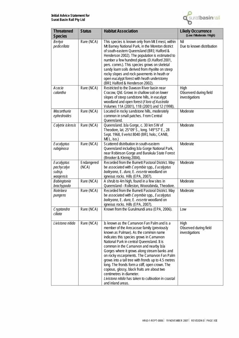
Initial Advice Statement for Surat Basin Rail Pty Ltd
Threatened Species
Status Habitat Association Likely Occurrence (Low / Moderate / High)
Bertya pedicellata
Rare (NCA) This species is known only from Mt Ernest, within Mt Barney National Park, in the Moreton district of south-eastern Queensland (BRI; Halford & Henderson 2002). The population is estimated to number a few hundred plants (D.Halford 2001, pers. comm.). This species grows on skeletal sandy loam soils derived from rhyolite on steep rocky slopes and rock pavements in heath or open eucalypt forest with heath understorey (BRI; Halford & Henderson 2002).
Nil Due to known distribution
Acacia calantha
Rare (NCA) Restricted to the Dawson River basin near Cracow, Qld. Grows in shallow soil on lower slopes of steep sandstone hills, in eucalypt woodland and open forest (Flora of Australia Volumes 11A (2001), 11B (2001) and 12 (1998).
High Observerd during field investigations
Macarthuria ephedroides
Rare (NCA) Located in rocky sandstone hills, moderately common in small patches. From Central Queensland.
Moderate
Calytrix islensis Rare (NCA) Queensland. Isla Gorge, c. 30 km SW of Theodore, lat. 25°09' S., long. 149°57' E., 28 Sept. 1968, Everist 8040 (BRI, holo.; CANB, MEL, iso.)
Moderate
Eucalyptus rubiginosa
Rare (NCA) Scattered distribution in south-eastern Queensland including Isla Gorge National Park, near Robinson Gorge and Barakula State Forest (Brooker & Kleinig 2004).
Moderate
Eucalyptus pachycalyx subsp. waajensis
Endangered (NCA)
Recorded from the Burnett Pastoral District. May be associated with Corymbia spp., Eucalyptus baileyana, E. dura, E. exserta woodland on igneous rocks. Hills (EPA, 2007).
Moderate
Babingtonia brachypoda
Rare (NCA) A shrub to 4m high, found in a few sites in Queensland - Rolleston, Woorabinda, Theodore.
Moderate
Notelaea pungens
Rare (NCA) Recorded from the Burnett Pastoral District. May be associated with Corymbia spp., Eucalyptus baileyana, E. dura, E. exserta woodland on igneous rocks. Hills (EPA, 2007).
Moderate
Cryptandra ciliata
Rare (NCA) Known from the Gurulmundi area (EPA, 2006). Low
Livistona nitida Rare (NCA) Is known as the Carnarvon Fan Palm and is a member of the Arecaceae family (previously known as Palmae). As the common name indicates this species grows in Carnarvon National Park in central Queensland. It is common in the Carnarvon and nearby Isla Gorges where it grows along stream banks and on rocky escarpments. The Carnarvon Fan Palm grows into a tall tree with fronds up to 4.5 metres long. The fronds form a stiff, open crown. The copious, glossy, black fruits are about two centimetres in diameter. Livistona nitida has taken to cultivation in coastal and inland areas.
High Observed during field investigations
HR63-1-REPT-0006 ⏐ 19 NOVEMBER 2007 ⏐ REVISION 0 ⏐PAGE XIII

Initial Advice Statement for Surat Basin Rail Pty Ltd
Threatened Species
Status Habitat Association Likely Occurrence (Low / Moderate / High)
Gossypium sturtianum - Sturt's Desert Rose
Rare (NCA) Occurs in the arid interior throughout the Northern Territory, Western Australia, South Australia, Queensland, New South Wales and Victoria. G. sturtianum occurs naturally in sandy or gravelly soils along dry creek beds, watercourses, gorges or rocky slopes. Although well adapted to hot dry climates, G. sturtianum will grow in humid areas given ample drainage and sun exposure.
Moderate
Leionema obtusifolium
Rare (NCA) Recorded from south-east Queensland (DEWR, 2007). Found in open forest complex often with Corymbia trachyphloia, C. citriodora, Eucalyptus crebra, E. fibrosa subsp. fibrosa on quartzose sandstone (EPA, 2007).
Moderate
Table 9-2 State and Commonwealth Significant Fauna Species
Threatened Species
Status Habitat Association Likely Occurrence (Low / Moderate / High)
Threatened Avifauna Erythrotriorchis radiatus - Red Goshawk
Vulnerable (EPBC)
Open forest and woodland near water, rainforest edges (Pizzey and Knight 1999). Need large areas of habitat because of low population densities and large home ranges. Breeding pairs use the same territories year after year (Marchant and Higgins 1993)
Low-Moderate. Suitable habitat within and adjacent to study area. Three known records of this species within study area.
Geophaps scripta scripta - Squatter Pigeon (southern)
Vulnerable (EPBC) Vulnerable (NCA)
Woodlands/grasslands. Prefer areas of sandy soil dissected by low gravely ridges, which have the shortest cover of grasses. Nearly always found near permanent water (Marchant and Higgins 1993)
Moderate-High. Suitable habitat within and adjacent to study area. One observation was made during field inspections. The Wildlife Online records.
Lathamus discolor - Swift Parrot
Endangered (EPBC)
They inhabit dry open, box–ironbark forests and woodlands. The swift parrot breeds in Tasmania and migrates to mainland Australia in autumn. During winter they are semi-nomadic foraging in flowering eucalypts predominately in Victoria and New South Wales. Small numbers are regularly recorded in the Australian Capital Territory. Birds have been recorded in South Australia and southern Queensland in some years (EPA 2007).
Low Surat Basin is on the fringe of their usual migratory range. Some suitable habitat exists within study area. No observations or Wildlife Online records of this species.
Neochmia ruficauda ruficauda - Star Finch (eastern), Star Finch (southern)
Endangered (EPBC) Endangered (NCA)
The star finch inhabits tall grass and reed beds associated with swamps and watercourses. It may also be found in grassy woodlands, open forests and mangroves. The condition of this habitat varies according to season, grazing pressure and fire. It is partly conserved in conservation reserves but is threatened elsewhere. (EPA 2007).
Low Some suitable habitat may occur within study area, however no field observations made or Wildlife Online records of this species.
HR63-1-REPT-0006 ⏐ 19 NOVEMBER 2007 ⏐ REVISION 0 ⏐PAGE XIV

Initial Advice Statement for Surat Basin Rail Pty Ltd
Threatened Species
Status Habitat Association Likely Occurrence (Low / Moderate / High)
Rostratula australis - Australian Painted Snipe
Vulnerable (EPBC)
Freshwater (occasionally brackish) wetlands. Mostly south east Australia. Possibly part-migratory moving north into Queensland in summer (Marchant and Higgins, 1993).
Moderate High Study area is within species range. Species observed twice in field inspections and three Wildlife Online records exist within study area.
Turnix melanogaster - Black-breasted Button-quail
Vulnerable (EPBC) Vulnerable (NCA)
In dry rainforest, vine scrub and Lantana thickets, the Black-breasted Button-quail is considered a rare vagrant, especially in the southern part of its range (Marchant & Higgins 1993). Semi-evergreen vine thickets.
Moderate Study area is within normal distribution range and areas along the proposed alignment constitute suitable habitat for this species, however no field observations have been made during surveys. Three Wildlife Online records exist within study area.
Lophoictinia isura – Square-tailed kite
Rare (NCA)
The Square-tailed Kite typically inhabits the coastal forested and wooded lands of tropical and temperate Australia (Marchant & Higgins 1993). The species may be recorded inland along timbered watercourses, although individuals are absent from waterless desert (Debus & Czechura 1989).
Moderate Suitable habitat exists within study area. Three Wildlife Online records exist for this species within the study area.
Nettapus coromandelianus - Cotton pygmy-goose
Rare (NCA) The Cotton Pygmy-goose is an almost entirely aquatic species. Preferred habitat is deep freshwater lagoons, swamps and dams, particularly those with waterlilies or other floating vegetation, such as hydrilla, ceratophyllum, vallisneria, najas, lemna and chara (Marchant & Higgins 1990). The species tends to avoid running water where deep–water vegetation cannot grow (Beruldsen 1977).
Moderate Suitable habitat exists within study area. Three Wildlife Online records exist for study area.
Ephippiorhynchus asiaticus – Black-necked stork
Rare (NCA) Inhabits permanent freshwater wetlands including margins of billabongs, swamps, shallow floodwaters, and adjacent grasslands and savannah woodlands; can also be found occasionally on inter-tidal shorelines, mangrove margins and estuaries. Feeds in shallow, still water on a variety of prey including fish, frogs, eels, turtles, crabs and snakes (DECC NSW 2007).
Moderate Suitable habitat exists within study area. Three Wildlife Online records exist for this species within the study area.
Falco hypoleucos – Grey falcon
Rare (NCA) Usually restricted to shrubland, grassland and wooded watercourses of arid and semi-arid regions, although it is occasionally found in open woodlands near the coast. Also occurs near wetlands where surface water attracts prey. Preys primarily on birds, especially parrots and pigeons, using high-speed chases and stoops; reptiles and mammals are also taken. Like other falcons it utilises old nests of other birds of prey and ravens, usually high in a living eucalypt near water or a watercourse.
Low-Moderate. Limited suitable habitat exists throughout the study area, however three Wildlife Online records exist.
HR63-1-REPT-0006 ⏐ 19 NOVEMBER 2007 ⏐ REVISION 0 ⏐PAGE XV

Initial Advice Statement for Surat Basin Rail Pty Ltd
Threatened Species
Status Habitat Association Likely Occurrence (Low / Moderate / High)
Threatened Mammals Chalinolobus dwyeri - Large-eared Pied Bat, Large Pied Bat
Vulnerable (EPBC)
Roosts in caves (near their entrances), crevices in cliffs, old mine workings and in the disused, bottle-shaped mud nests of the Fairy Martin (Hirundo ariel), frequenting low to mid-elevation dry open forest and woodland close to these features. Found in well-timbered areas containing gullies.
High Suitable habitat may exist in caves in the Dawson ranges and other areas of remnant vegetation. No Wildlife Online records for this species within study area.
Dasyurus hallucatus - Northern Quoll
Endangered (EPBC)
Range of open woodland and open forest types preferring rocky areas. Within Queensland a number of fragmented populations, including dense populations within Mackay-Whitsunday areas (EPA 2007).
Moderate Suitable habitat occurs within study area. Two Wildlife Online records exist for this species within study area.
Hipposideros semoni - Semon's Leaf-nosed Bat, Greater Wart-nosed Horseshoe-bat
Endangered (EPBC)
The habitat used for foraging include rainforest and savannah woodland (EPA 2007).
Low Normal distribution is more northern than the study area however isolated pockets may exist however unlikely. Some suitable habitat may exist within study area. No Wildlife Online records exist for this species within study area.Species not identified within Taroom or Banana local government areas.
Nyctophilus timoriensis (South-eastern form) - Eastern Long-eared Bat
Vulnerable (EPBC)
Forages in tall eucalypt forests of south-west Western Australia, and mallee, open savannah and open woodland in other areas. Occurs in Callitris/ironbark/box open forest and Buloke woodland in southern Queensland (EPA 2007).
Moderate Suitable habitat occurs within study area. Three Wildlife Online records exist for this species within the study area.
Chalinolobus picatus – Little pied bat
Rare (NCA) Occurs in dry open forest, open woodland, mulga woodlands, chenopod shrublands, cypress-pine forest, mallee, Bimbil box. Roosts in caves, rock outcrops, mine shafts, tunnels, tree hollows and buildings. Can tolerate high temperatures and dryness but need access to nearby open water. Feeds on moths and possibly other flying invertebrates.
Moderate-High. Suitable habitat occurs within study area. Three Wildlife Online records exist for this species within the study area.
HR63-1-REPT-0006 ⏐ 19 NOVEMBER 2007 ⏐ REVISION 0 ⏐PAGE XVI

Initial Advice Statement for Surat Basin Rail Pty Ltd
Threatened Species
Status Habitat Association Likely Occurrence (Low / Moderate / High)
Ray-finned fishes Maccullochella peelii peelii - Murray Cod, Cod, Goodoo
Vulnerable (EPBC)
The Murray Cod occurs naturally in the waterways of the Murray-Darling Basin (ACT, SA, NSW and Vic) and is known to live in a wide range of warm water habitats that range from clear, rocky streams to slow flowing turbid rivers and billabongs. The upper reaches of the Murray and Murrumbidgee Rivers are considered too cold to contain suitable habitat.
Low. The Dawson River system is isolated from the Murray River system. The Surat basin is outside the normal range of this species. No Wildlife Online records for this species within study area.
Reptiles Denisonia maculata - Ornamental Snake
Vulnerable (EPBC)
Occurs in Brigalow (Acacia harpophylla) woodland growing on clay and sandy soils, riverside woodland, and open forest growing on natural levees (Shine 1983; Cogger et al. 1993). Shows a preference for moist areas (Wilson & Knowles 1988). One site in Brigalow woodland near Nebo had ample ground cover in the form of fallen timber, thick Carissa ovata bushes and small tussock grasses. Snakes at this site were only found in the vicinity of a complex of flooded gilgai, and were not located in nearby riparian and floodplain woodland. The gilgai had an abundance of frog prey (A.Melzer 2001 pers. comm.).
High Suitable habitat occurs within study area and is within normal distribution range of this species. Two field observations during survey and three Wildlife Online records exist for this species within the study area.
Egernia rugosa - Yakka Skink
Vulnerable (EPBC)
Open dry sclerophyll forest or woodland and rocky areas where it lives in communal burrow complexes, often under heaped dead timber, and in deep rock crevices; often uses rabbit warrens and has also been recorded under shearing sheds and other rural buildings. Its presence may be recognised by communal defecation site (Wilson 2005; Cogger 1992).
High Suitable habitat exists within study area. Two observations of this species made during field survey and three Wildlife Online records exist.
Furina dunmalli - Dunmall's Snake
Vulnerable (EPBC) Vulnerable (NCA)
Occurs in the Brigalow Belt region in the south-eastern interior of Qld (McDonald et al. 1991; Cogger et al. 1993). Most records are from sites between 200 and 500 m above sea level (Cogger et al. 1993). Known from very few localities; including Archokoora, Oakey, Miles, Glenmorgan, Wallaville, Gladstone, Lake Broadwater, Mount Archer, Exhibition Range NP, roadside reserves between Inglewood and Texas, Rosedale, and Yeppoon (Covacevich et al. 1988; McDonald et al. 1991; Cogger et al. 1993; Covacevich et al. 1996a).
Moderate-High. Suitable habitat exists within study area. Three Wildlife Online records exist for this species within the study area.
HR63-1-REPT-0006 ⏐ 19 NOVEMBER 2007 ⏐ REVISION 0 ⏐PAGE XVII

Initial Advice Statement for Surat Basin Rail Pty Ltd
Threatened Species
Status Habitat Association Likely Occurrence (Low / Moderate / High)
Paradelma orientalis - Brigalow Scaly-foot
Vulnerable (EPBC) Vulnerable (NCA)
This lizard is found in a wide variety of open forest habitats on several soil types (Schultz & Eyre 1997; Tremul 2000). In some areas lizards are found in remnant Brigalow (Acacia harpophylla) woodland with sparse tussock grasses on grey cracking clay soils (Cogger et al. 1993). In Eena SF the species occurs in Eucalyptus crebra and E. microcarpa open forest with a dense subcanopy of Callitris columellaris and Allocasuarina luehamannii on loose sandy clay substrate, and in A. luehamannii closed forest with widely scattered E. crebra emergents on a similar substrate (Schultz & Eyre 1997). Specimens have been found on a sandstone rise in dry sclerophyll forest in Dunmore SF; in Corymbia maculata and E. crebra open forest in Barakula SF; and in mixed species open woodland with a Triodia mitchelli dominated ground layer in the Chesterton Range near Charleville (S. Wilson, D. Hannah and C. Dollery in Schultz & Eyre 1997).
High Suitable habitat exists within study area. Species observed twice during field survey and three Wildlife Online records exist for this species within the study area.
Rheodytes leukops - Fitzroy Tortoise
Vulnerable (EPBC) Vulnerable (NCA)
This aquatic tortoise was first described in 1980 and is only found in the Fitzroy River and its tributaries, centred on Rockhampton in eastern central Queensland. It favours areas of creeks and rivers that have clear, shallow, and fast-flowing water with a gravel, rock or sand substrate.
Moderate-High. Within Dawson-Fitzroy river system.
Anomalopus brevicollis – Short-necked work skink
Rare (NCA) The species occurs in seasonally dry, semi-evergreen vine thickets (Greer and Cogger, 1985); moist, complex notophyll vine forest (Anonymous, 1976; Broadbent and Clark, 1976), and open sclerophyll forest (G. Gow, in Greer and Cogger, 1985).
High Suitable habitat exists within study area. Species observed twice during field survey and three Wildlife Online records exist for this species within the study area.
Acanthophis antarcticus – Common death adder
Rare (NCA) Forests and woodlands, grasslands, heath. Covering itself with leaves makes it inconspicuous and it lies coiled in ambush, twitching its yellowish grub-like tail close to its head as a lure.
High Suitable habitat exists within study area. Species observed twice during field survey and three Wildlife Online records exist for this species within the study area.
HR63-1-REPT-0006 ⏐ 19 NOVEMBER 2007 ⏐ REVISION 0 ⏐PAGE XVIII

Initial Advice Statement for Surat Basin Rail Pty Ltd
Threatened Species
Status Habitat Association Likely Occurrence (Low / Moderate / High)
Snails/Slugs/Invertebrates Adclarkia dawsonensis - Boggomoss Snail, Dawson Valley Snail
Critically Endangered (EPBC)
The Dawson Valley is found within the Brigalow Belt of eastern Queensland. Much of this area has been cleared for agriculture, but some of the Brigalow (Acacia harpophylla) still remains as dry open forests and woodland, with scattered pockets of semi-evergreen vine thickets dominated by the narrow-leaved bottle tree (Brachychiton rupestre) (Johnson 1984). The area is sub-humid, with a rainfall of 600-700 mm annually (Stanisic 1996). This environment is far too harsh for many land snails, and they are dependent on oases of moist habitat found scattered within it (Bishop 1981). Field surveys suggest that the Boggomoss Snail is confined to the alluvial flats and riparian environments between Taroom and Theodore. Much of the soil here is a well-drained brown/grey loam and clay derived from basalt. Most of this habitat has been cleared for farming and little original vegetation remains (Clarke & Spier 2003). At the site on the Dawson River near Taroom, remnant alluvial habitat is associated with a series of unconnected boggomosses. A boggomoss is a small peat bog that is formed by water from underlying aquifers of the Great Artesian Basin being pushed to the surface through mound springs. The Boggomoss Snail survives on one of these. These moist habitats are dominated by water-tolerant species, such as Coolibah trees (Eucalyptus coolibah), sedges and ferns. These isolated fragments occur scattered throughout the landscape. However, the vegetation on each boggomoss is different (J. Stanisic pers. comm. in Clarke & Spier 2003). This type of environment produces a lot of litter and debris, within which the snails live (Stanisic 1996). At the Isla-Delusion site, A. dawsonensis is found in a small patch of riparian habitat in a stock and water reserve. Here the vegetation is dominated by forest red gum (Eucalyptus tereticornis), palm trees (Livistona sp.) and sandpaper fig (Ficus sp.) (Clarke & Spier 2003).
Low Known only from two populations between Theodore and Taroom. No boggomosses or aquifers were observed on the railway corridor. No field observations or Wildlife Online records for this species within the study area.
Jalmenus evagoras eubulus - Imperial Hairstreak (Northern Subspecies)
Vulnerable (EPBC)
Brigalow forest is the principal vegetation community associated with this butterfly, and the preferred food plant of the larvae is brigalow.
High Suitable habitat exists within study area. Three Wildlife Online records exist for this species within the study area.
Table 9-3 Migratory Threatened Species
Threatened Species
Status Habitat Association Likely Occurrence (Low / Moderate / High)
Migratory Terrestrial Species
Haliaeetus leucogaster - White-bellied
Migratory CAMBA
White-bellied Sea-Eagles are a common sight in coastal and near coastal areas of Australia. Birds form permanent pairs that inhabit territories
Moderate Recorded on Wildlife Online Database
HR63-1-REPT-0006 ⏐ 19 NOVEMBER 2007 ⏐ REVISION 0 ⏐PAGE XIX

Initial Advice Statement for Surat Basin Rail Pty Ltd
Threatened Species
Status Habitat Association Likely Occurrence (Low / Moderate / High)
Sea-Eagle
throughout the year. Their loud "goose-like" honking call is a familiar sound, particularly during the breeding season. Birds are normally seen, perched high in a tree, or soaring over waterways and adjacent land (Olsen 1993).
Hirundapus caudacutus - White-throated Needletail
Migratory CAMBA JAMBA
White-throated Needletails often occur in large numbers over eastern and northern Australia. They arrive in Australia from their breeding grounds in the northern hemisphere in about October each year and leave somewhere between May and August (Pizzey 1997).
Moderate Recorded on Wildlife Online Database
Hirundo rustica - Barn Swallow
Migratory CAMBA JAMBA
Prefers disturbed open agricultural areas and open urban areas for forage and roost. Can often be sighted perching on wires and fences (Simpson & Day 2004). Coastal areas; aerial over open country. Non-breeding migrant during northern hemisphere winter (Flegg 2002; Pizzey and Knight 2003).
Low No Wildlife Online records
Merops ornatus - Rainbow Bee-eater
Migratory JAMBA
Rainbow bee-eaters are a common species and can be found during the summer in un-forested areas in most of southern Australia and Tasmania. They migrate north during the winter into northern Australia, New Guinea, and some of the southern islands of Indonesia.
Moderate Recorded on Wildlife Online Database
Monarcha melanopsis - Black-faced Monarch
Migratory The Black-faced Monarch is found in rainforests, eucalypt woodlands, coastal scrub and damp gullies. It may be found in more open woodland when migrating.
Low No Wildlife Online records
Myiagra cyanoleuca - Satin Flycatcher
Migratory The Satin Flycatcher is found in tall forests, preferring wetter habitats such as heavily forested gullies, but not rainforests.
Moderate Recorded on Wildlife Online Database
Rhipidura rufifrons - Rufous Fantail
Migratory The Rufous Fantail is found in rainforest, dense wet forests, swamp woodlands and mangroves, preferring deep shade, and is often seen close to the ground. During migration, it may be found in more open habitats or urban areas.
Moderate Recorded on Wildlife Online Database
Migratory Wetland Birds Ardea alba - Great Egret, White Egret
Migratory CAMBA JAMBA
Freshwater wetlands and intertidal mudflats. Nests colonially in trees.
Moderate Recorded on Wildlife Online Database
Ardea ibis - Cattle Egret
Migratory CAMBA JAMBA
Freshwater wetlands and adjoining pasture areas. Nests colonially in melaleuca forests.
Moderate Recorded on Wildlife Online Database
Gallinago hardwickii - Latham's Snipe, Japanese Snipe
Migratory CAMBA JAMBA
Soft wet ground or shallow water with tussocks and other green or dead growth to scrub or open woodland; samphire areas on saltmarshes and mangrove fringes. Although it doesn’t breed in Australia, it is a regular summer migrant with its stronghold in south east Queensland to southern South Australia (Pizzey and Knight, 1999).
Low No Wildlife Online records
Nettapus coromandelianus albipennis - Australian Cotton Pygmy-
Migratory Large numbers can be seen on Ross River Dam, this area is probably one of the most important sites for this rare species. Deep lagoons, swamps and dams. Rare to eastern coastal QLD. From Cape Melville to the NSW border.
Low No Wildlife Online records
HR63-1-REPT-0006 ⏐ 19 NOVEMBER 2007 ⏐ REVISION 0 ⏐PAGE XX

Initial Advice Statement for Surat Basin Rail Pty Ltd
Threatened Species
Status Habitat Association Likely Occurrence (Low / Moderate / High)
goose Nettapus coromandelianus albipennis is endemic, only recorded in Australia (Natural Assets Database 2007). Deeper freshwater swamps, lagoons, dams with waterlilies and other semi emergent water plants mainly in eastern Queensland. Nesting sites are high in hollow tree near water with breeding November to April. Species is locally dispersive in dry season (Pizzey & Knight, 1999).
Numenius minutus - Little Curlew, Little Whimbrel
Migratory CAMBA JAMBA
Often in large flocks in northern Australia. Prefers open plains, grasslands, sports fields, parklands, mudflats, and cleared agricultural areas (Simpson & Day 2004). Open short grasslands not necessarily close to water and tidal mudflats (Flegg 2002).
Low No Wildlife Online records
Rostratula benghalensis s. lat. - Painted Snipe
Migratory CAMBA
Prefers marshes with moderate cover (Simpson & Day 2004). Freshwater (occasionally brackish) wetlands. Mostly south east Australia. Possibly part-migratory moving north into Queensland in summer (Marchant and Higgins, 1993)
Low No Wildlife Online records
Migratory Marine Birds Apus pacificus - Fork-tailed Swift
Migratory CAMBA JAMBA
Aerial over coasts, urban areas and arid areas (Simpson & Day 2004).
Moderate Recorded on Wildlife Online Database
Ardea alba - Great Egret, White Egret
Migratory CAMBA JAMBA
Freshwater wetlands and intertidal mudflats. Nests colonially in trees.
Moderate Recorded on Wildlife Online Database
Ardea ibis - Cattle Egret
Migratory CAMBA JAMBA
Freshwater wetlands and adjoining pasture areas. Nests colonially in melaleuca forests.
Moderate Recorded on Wildlife Online Database
Migratory Marine Reptiles Crocodylus porosus - Estuarine Crocodile, Salt-water Crocodile
Migratory
Coastal rivers, swamps, estuaries and open sea north of about Rockhampton (Wilson 2005).
Low No Wildlife Online records
HR63-1-REPT-0006 ⏐ 19 NOVEMBER 2007 ⏐ REVISION 0 ⏐PAGE XXI