influence of traffic and transportation...
TRANSCRIPT

INFLUENCE OF TRAFFIC AND TRANSPORTATION CHARACTERISTICS
OVER ROAD SURFACE TEMPERATURE (RST)
JAMAL AIMI BIN JAMALUDIN
A dissertation submitted in partial fulfilment of the
requirements for the award of the degree of
Master of Science (Transport Planning)
Faculty of Built Environment
Universiti Teknologi Malaysia
JANUARY 2012

iii
buat mama, bapak, juaini, fiqah, nini dan aisyah
dan keluarga besar yang kusayangi
allahyarham datukku yang amatku sayang
terima kasih buat semua mereka yang sentiasa mendoakanaku

iv
ACKNOWLEDGEMENT
All praise toward The Almighty God
To Whom I pray, all my efforts, and my will towards You..
All praises to ALLAH s.w.t. that I finally managed to accomplish this
dissertation as part of my Master Program. My deepest appreciation towards Dr.
Muhammad Zaly Shah Bin Muhammad Hussein who had effortlessly sharing his
knowledge, tolerantly consulting, understanding, becoming one of my mentors and
continuously inspired me to become a better person within these years, and my deep
appreciation towards Dr. Nafisa binti Hosni, as my Internal Reader.
Thank you also to those who had been helping me in the faculty and
department, especially Mrs. Normah Kasimon, Mrs. Marlia, Mrs. Rokiah, Dr. Nazri,
Dr. Rafee, Dr. Nooraini, and, Dr. Norsiah whose had truly been helpful, and to my
teachers, since I was 6th
years old and those in Ahris Yaakup Laboratory, and
Logistic and Transport Laboratory in the Faculty of Built Environment. Thanks to
Mr. Farhan Ahmad who had provided me with much needed traffic count data of
Johor State. Last but not least, my special mentions for Miss Khadijah Shaharuddin,
Dr. Foziah Johar, Hafiz Ahris, and Nuralina Ahris, who had been cheering and
supporting me all these years during my study in Universiti Teknologi Malaysia.
Above all, thank you to my mother; Noor Rihan Yaakub, father; Jamaludin
Hamid, my siblings; Juaini Amalina, Jamiatul Afiqah, Jannatul Afni and Aisyah
Jurhani, my grandparents, my large family and to myself. Thank you so much for
everything. I am a person I am due to all of you, who had always been there,
enlighting my sole existence.
v
ABSTRACT
Global warming phenomenon had urged scholars to study various factors that
may contribute toward escalating pattern of urban temperature. Among the sector
that is a significant contributor, is transportation sector. In previous studies, road
surface had been identified as one of urban element that has among of the highest
average surface temperature in urban area. Therefore, this research aims to identify
and investigate various factors that may influence road surface temperature (RST)
intensity in urban area. After review over tens of previous studies related to RST,
traffic volume, vehicle type, road hierarchy, and, road density were selected as the
independent variables to be examined. By processing Landsat +ETM 7 thermal band
data to acquire RST in the selected area (Iskandar Malaysia), and utilizing spatial
analysis capability of geographical information system (GIS), linear regression
model of each identified variable was constructed, and then compared. Results of this
research showed that traffic volume does have positive relationship toward RST
intensity with R2 value of 0.411. This study also indicates that different type of
vehicle, would have different influence or relationship with RST value with most of
them are positive. Road density however, had no significant relationship toward RST
value. This study had successfully showed that satellite remote sensing and GIS may
be used to analyse relationship between RST and various traffic characteristics.
However, several improvements to this study, such requirement for temperature‟s
ground truthing process, still need to be address.

vi
ABSTRAK
Fenomena pemanasan global telah memangkin para pengkaji untuk mengkaji
pelbagai faktor yang mungkin menyumbang kepada peingkatan suhu kawasan
bandar. Antara sektor yang menjadi penyumbang utama kepada fenomena itu ialah
sektor pengangkutan. Dalam kajian-kajian terdahulu, permukaan jalan telah
dikenalpasti sebagai salah satu elemen bandar yang mempunyai purata suhu
permukaan paling tinggi. Justeru itu, kajian ini bermatlamat untuk mengenal pasti
dan mengkaji pelbagai faktor yang mungkin mempengaruhi intensiti suhu permukaan
jalan atau juga lebih dikenali sebagai road surface temperature (RST). Berdasarkan
kajian ilmiah terhadap penyelidikan-penyelidikan yang telah dilakukan terdahulu,
isipadu trafik, jenis kenderaan, heirarki jalan, dan kepadatan jaringan jalan raya telah
dipilih sebagai pemboleh ubah tidak bersandar untuk diuji dalam kajian ini. Dengan
memanipulasi data litupan terma pada satelit Landsat +ETM7 bagi mendapatkan
suhu permukaan kawasan pilihan (Iskandar Malaysia), dan keupayaan analisis
reruang sistem maklumat geografi atau geographical information system (GIS),
model regresi linear untuk setiap pemboleh ubah yang telah dikenal pasti, dibina, dan
dibandingbezakan. Hasil kajian ini menunjukkan bahawa isipadu trafik mempunyai
hubungan positif terhadap intensiti RST dengan nilai R2 sebanyak 0.411. Malahan,
analisis kajian ini juga menunjukkan bahawa jenis kenderaan yang berbeza,
mempunyai pengaruh dan hubungan yang berbeza dengan RST, di mana
kebanyakkannya adalah positif. Walaubagaimanapun, faktor kepadatan jalan raya
tidak menunjukkan sebarang hubungan yang signifikan ke atas nilai RST. Secara
keseluruhannya, kajian ini berjaya membuktikan penggunaan penderiaan jauh dan
GIS mampu untuk menganalisa hubung kait antara RST dengan beberapa ciri trafik
di bandar. Namun begitu, beberapa penambahbaikan, seperti keperluan untuk
melakukan prosedur pengesahan suhu di tapak, masih perlu diberikan perhatian.
vii
TABLE OF CONTENTS
ACKNOWLEDGEMENT iv
ABSTRACT v
ABSTRAK vi
TABLE OF CONTENTS vii
LIST OF TABLES x
LIST OF FIGURES xi
GLOSSARY OF TERMS xiii
LIST OF APPENDICES xiv
1 INTRODUCTION & RESEARCH FRAMEWORK 15
1.1 Background of Problem 15
1.2 Problem Statement 19
1.3 Research Objectives 21
1.4 Research Questions 21
1.5 Research Hypothesis 22
1.6 Theoretical Framework 22
1.7 Scope of Research 23
1.8 Research Assumptions 24
1.9 Limitations of Research 24
1.10 Significant and Expected Contributions of Research 25
1.11 Research Design 27
1.12 Chapter Outlines 28
1.13 Chapter Summary 30
viii
2 ROAD SURFACE TeMPERATURE (RST), TRAFFIC &
TRANSPORTATION CHARACTERISTIC 31
2.1 Road Surface Temperature and Method of Measurement 31
2.2 Road Surface Temperature & Its Influencing Factors 32
2.3 Traffic and Transportation Related Attributes 34
2.3.1 Traffic Volume & Road Surface Temperature 34
2.3.2 Traffic Flow, Speed & Road Surface Temperature 36
2.3.3 Road Type, Hierarchy, Orientation and Surface Material 38
2.3.4 Vehicles Type Composure & Road Surface Temperature 40
2.4 Emerging Technology & Method in Road Climatology 40
2.5 Chapter Summary 44
3 RESEARCH DATA, AND METHODOLOGY 45
3.1 Research Data, Software and Spatial Database 45
3.2 Processing the Landsat +ETM 7 Satellite Data to Extract Surface
Temperature 47
3.3 Extracting Road Surface Temperature (RST) by using ArcGIS 9.3.
48
3.4 Traffic Count Data 49
3.5 Analysis of Road Hierarchy over Road Surface Temperature 50
3.6 Traffic Volume and Composure Effect towards Road Surface
Temperature Analysis 52
3.7 Chapter Summary 55
4 ANALYSIS, FINDING AND DISCUSSION 56
4.1 Road Surface Temperature Distribution in Iskandar Malaysia 56
4.1.1 Road Surface Temperature Distribution and Road Density
in Iskandar Malaysia 59
4.2 Road Hierarchy and Road Surface Temperature 60
4.3 Traffic Volume, Traffic Composure and Road Surface Temperature
63

ix
4.3.1 Overall Average Road Surface Distribution based on Traffic
Count Point 63
4.3.2 16 Hours Traffic Volume and Road Surface Temperature 64
4.3.3 Peak Hour Traffic Volume and Road Surface Temperature
65
4.3.4 Traffic Composition and Road Surface Temperature 66
4.4 Application of Satellite Thermal Remote Sensing over Road
Surface Temperature Measurement 68
4.5 Chapter Summary 70
5 CONCLUSIONS AND SUGGESTIONS 72
5.1 Research Issue, Framework and Methodology 72
5.2 Findings, Results and Conclusion 73
5.3 Suggestions 74
REFERENCES 75
A ASSORTED DATA FOR EACH TRAFFIC COUNT POINT 80

x
LIST OF TABLES
TABLE NO. TITLE PAGE
Table 2-1 Parameters that influence urban road temperature. 33
Table 2-2 Variation in material and thermal properties of the ordinal
classified road construction profile in Britian. 39
Table 3-1 Data attributes, type and source of data in database created for
conducting analysis. 46
Table 4-1 Type of road analysis and average RST based on road hierarchy. 61

xi
LIST OF FIGURES
FIGURE NO. TITLE PAGE
Figure 1-1 Global energy consumption based on sector. 16
Figure 1-2 Increasing average temperature in Iskandar Malaysia Region for
the period of 1969-2009 25
Figure 1-3 Research Methodology and Design. 27
Figure 2-1 Schematic illustration of the impact of traffic on road surface
temperatures. 35
Figure 2-2 Thermal mapping by using advance remote sensing camera
mounted on vehicle to detect road surface temperature. 42
Figure 2-3 Thermal mapping using remote sensing camera that detect RST at
point based from high building. 42
Figure 3-1 Research Methodology and Flow 45
Figure 3-2 The interface of ENVI 4.7 software used to process Landsat data.47
Figure 3-3 ENVI 4.7 Landsat Calibration Tool and Band Math Tools used to
extract surface temperature by applying inverse Planck Formula. 48
Figure 3-4 Iskandar Malaysia surface temperature as it is in ArcGIS
environment after extracted from Landsat +ETM 7 48
Figure 3-5 Traffic count location and traffic volume data in Hihgway Planning
Unit‟s database. 49
Figure 3-6 Road surface temperature (RST) as had been extracted in ArcGIS
and traffic count point (green triangles), were digitized based on
data from Highway Planning Unit. 50
Figure 3-7 Workflow model for Analysis of Road Hierarchy over Road
Surface Temperature in ArcGIS‟s environment. 51

xii
Figure 3-8 Road network and hierarchy as had been identified in Iskandar
Malaysia GIS database. 51
Figure 3-9 14 digitized traffic count points and road surface temperature
distribution. 52
Figure 3-10 100m and 200m buffer around the traffic count points were develop
to calculate average road surface temperature of each point. 53
Figure 3-11 Workflow for Analysis of Traffic Volume and Traffic Composure
against Road Surface Temperature. 54
Figure 3-12 Temperature and traffic volume and composure data digitized in
ArcGIS for pre-analysis stage. 54
Figure 4-1 Road surface temperature distribution across Iskandar Malaysia. 57
Figure 4-2 Landuse distribution in Iskandar Malaysia on 2008. 58
Figure 4-3 Road Density over Average Road Surface Temperature. 59
Figure 4-4 Road density in Iskandar Malaysia. 60
Figure 4-5 Road surface temperature distribution based on type. 61
Figure 4-6 Road hierarchy and type in Iskandar Malasyia. 62
Figure 4-7 Average RST in traffic count checkpoints. 64
Figure 4-8 16 hours traffic volume correlation with RST. 65
Figure 4-9 Correlation between peak hour traffic volume an RST. 66
Figure 4-10 Relationship between various type s of vehicle and RST. 67
xiii
GLOSSARY OF TERMS
RST - Road Surface Temperature
UHI - Urban Heat Island
UST - Urban Surface Temperature
RAT - Road Ambient/Atmosphere Temperature
RPT - Road Pavement Temperature
GIS - Geographical Information System
xiv
LIST OF APPENDICES
APPENDIX TITLE PAGE
A Assorted Data For Each Traffic Count Point 80
CHAPTER 1
1 INTRODUCTION & RESEARCH FRAMEWORK
This research entitles “Influence of Traffic and Transportation Characteristic
over Road Surface Temperature (RST)”. The Introduction Chapter will describe the
purpose of conducting this research, as well as the background issue that leading
toward this research. Along with that, the research objectives, research questions,
research design, grounded theory, hypothesises, scopes and research limitations are
also outlined in this chapter.
1.1 Background of Problem
In cities of developing countries, growing number of traffic is a major
concern. To accommodate such increase, more roads and highway were built each
year, causing urban temperature to become warmer. Increasing number of on-road
vehicle and newly constructed roadways contributed toward soaring urban road
temperature, thus, increase urban area temperature. Road temperature is often
measured in three different levels; on surface level, or known as road surface
temperature (RST), at atmosphere level or better known as road ambient temperature
(RAT) and inside road pavement, which known as Road Pavement Temperature
(RPT).
In temperate countries which experienced winter, RST, RAT and RPT
forecasting are vital for safety reason; to minimize road icing phenomena that may
16
cause road‟s surface slipperiness. However, in tropical countries which are located
nearer to the equator, and experiencing hot climate throughout years, the
characteristics and study on dispersion of RST and RAT is often neglected, although
they significantly contribute toward urban heat agglomeration which is an important
factor to create comfortable walking environment for pedestrian. Thus, it is very
important for us to study factors that contribute toward increasing pattern of road
temperature, so we could create better walking environment for pedestrian and
reduce urban temperature.
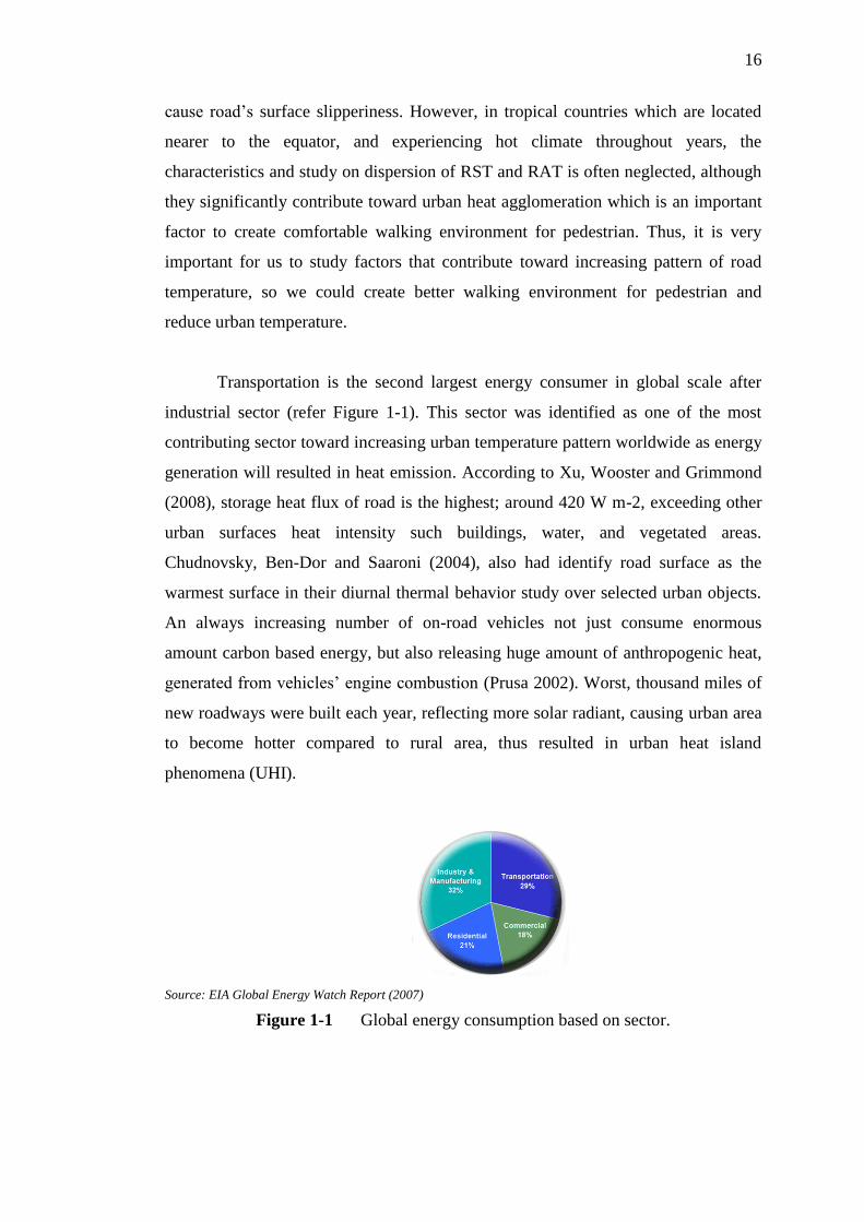
Transportation is the second largest energy consumer in global scale after
industrial sector (refer Figure 1-1). This sector was identified as one of the most
contributing sector toward increasing urban temperature pattern worldwide as energy
generation will resulted in heat emission. According to Xu, Wooster and Grimmond
(2008), storage heat flux of road is the highest; around 420 W m-2, exceeding other
urban surfaces heat intensity such buildings, water, and vegetated areas.
Chudnovsky, Ben-Dor and Saaroni (2004), also had identify road surface as the
warmest surface in their diurnal thermal behavior study over selected urban objects.
An always increasing number of on-road vehicles not just consume enormous
amount carbon based energy, but also releasing huge amount of anthropogenic heat,
generated from vehicles‟ engine combustion (Prusa 2002). Worst, thousand miles of
new roadways were built each year, reflecting more solar radiant, causing urban area
to become hotter compared to rural area, thus resulted in urban heat island
phenomena (UHI).
Source: EIA Global Energy Watch Report (2007)
Figure 1-1 Global energy consumption based on sector.

17
High RST and RAT contribute much toward increasing pattern of urban
temperature. In a case for a tropical country like Malaysia, which majority of
development in urban area are located along main transportation corridors, it is very
important for us to investigate deeper the characteristics of road temperature as it
may infectiously increase surrounding temperature and lead toward the UHI
phenomena and global warming phenomena. Although there had been several
scholars emphasized of the significant influence of traffic or transportation
infrastructure characteristics over road temperature (Chapman & Thornes 2011;
Chapman & Thornes 2005; Kalthoff et al. 2005; Prusa et al. 2002; Chapman,
Thornes & Bradley 2001; Gustavsson, Bogren & Green, 2001), and the effect of
transportation characteristic over global warming phenomena either directly or
indirectly (Uherek et al. 2010; Unger, Shindell & Wang 2009; Akisawa & Kaya
1998; Imaseki 1998), characteristic of urban road temperature remain unaddressed or
less addressed by scholars, especially in tropical countries.
Studies related to UHI phenomena had been extensively done by scholars all
around the world, such by Henry et al. (1989); Casselles et al. (1991); Gallo and
Owen (1998); Voogt and Oke (2003); and Jusuf et al. (2007). While in Malaysia, the
UHI issue had also been widely addressed such by Shaharuddin, Noorazuan, and
Yaakob. (2008), Kubota and Ossen (2008), and, Takeuchi, Noorazuan and Thei
(2010). In most of these UHI researches, satellite remote sensing data had been
widely use to acquire surface thermal distribution and land cover data. All of this
researches studied on spatial distribution of urban temperature based on various land
uses and land cover in general, without giving special nor detail attention to spatial
temperature distribution of a specific land use, respectively, transportation related
land use.
As global warming had become a global issue increasing in significant, it is
very important for researchers to study every single elements that contributed toward
escalating urban temperature. Especially when it related to a sector which is second
largest energy consumer and heat polluters in the world; transport related sectors
such on-road heat pollution. By looking at details urban characteristics such as traffic
volume, number of road lanes, road pavement materials, road alignment, number of
junction, road density, urban density, building intensity, sky-view factor, abundant of

18
green area, topography, distance from city centre, and distance from shoreline, for
each road stretch, we could study the profile and nature of road temperature in
tropical countries better. Thus, later, enable us to identify appropriate mitigation
actions to counter situation that resulting toward high road temperature condition,
and reduce probability of significant heat pollution in urban area that may lead
toward global warming. This type of research is known as “Research on Road
Climate, or Road Climatology”.
High road temperature in urban area has several impacts either toward urban
microclimate, environment, ecology, economy, dwellers‟ health level and also their
psychology. Most of them are cyclic and chained effects. Heat pollution from
roadways and traffic are making urban area to become hotter, and contribute in
higher urban energy usage for air conditioning, and higher carbon dioxide emission,
thus cause alteration of natural urban climate which later causes irregular heavy rain,
flash flood, irregular fruit seasons and spread of deceases.
Walking is the most sustainable mode to travel and the most important mode
of travel that were used by every single people. Warm roadside areas are also not
preferable for pedestrian to walk in urban area. High heat pollution along our road
stretch will discourage walking activities, as there are feelings of uncomfortableness,
especially in hot climate tropical countries. This condition is not helping toward
promoting sustainable urban transport system. Additionally, warm surface water that
flow beside roadway may also change the water temperature of river and lake where
the water flow, thus affected the thermal balance within the aquatic ecosystem. As a
result aquatic life such plankton; which is main diet for small fish, will not be able to
breed, while algae will also be affected due to hydro thermal change.
Extreme heat pollution from transport infrastructure in urban area also may
affect human psychology. Hot condition will affect enzyme in human body, and
cause the feeling of uncomfortableness. Whenever a human live in an uncomfortable
environment polluted by heat, they are unable to neither operate nor think in
optimum level and exposed to certain type of illnesses such dehydration and
hallucination. More than that, abundant of urban heat pollution, may increase risk of
death due to heat wave (Huang, Zhou & Cadenasso 2011).

19
For all the above reasons, studies related to characteristics of road
temperature need to be done thoroughly. Questions such as what cause high road
temperature? Why road temperature does is high in certain areas? What type of
transportation related characteristic resulted in higher road temperature? What traffic
characteristics that influenced high road temperature? Are vital to be answered in
order for us to understand more, issues related to road temperature in tropical urban.
For then, we could understand better the transportation and traffic characteristic that
may result toward higher road temperature, thus, mitigation actions can be executed.
1.2 Problem Statement
Little researches had been done to anticipated traffic related factors that
contribute toward urban road temperature characteristics. Maybe due to difficulty to
gather temperature data and traffic related data, and, difficulty to analyze the
significant of traffic and transport related characteristics such as had been state by
Prusa et al. (2002); and Shou (1990, cited in Chapman, Thornes & Bradley 2001).
This situation is not favaourable, as roadways connected every single entities in an
urban area, and because of that, road temperature, may influence urban climate as a
whole.
More than that, through literature reviews, study related to road temperature
in tropical country had yet to be published. Thus, urgency to come out with research
of road temperature in tropical cities, emerged, due to the known important or chain
effects of high road temperature toward urban microclimate, environment, economy
and dwellers. Above all, the main question of this issue arises; what are the most
significant factors that contribute toward road temperature trend in tropical
countries? In context of this research, does transportation related attributes such
traffic volume, type of vehicles, road hierarchy, road segment or alignment (straight,
junction, and corner), speed and even road density; affect road temperature intensity
or distribution? There are also question related to whether really traffic
characteristics such traffic volume, type of vehicle and traffic speed do affect road
temperature?
20
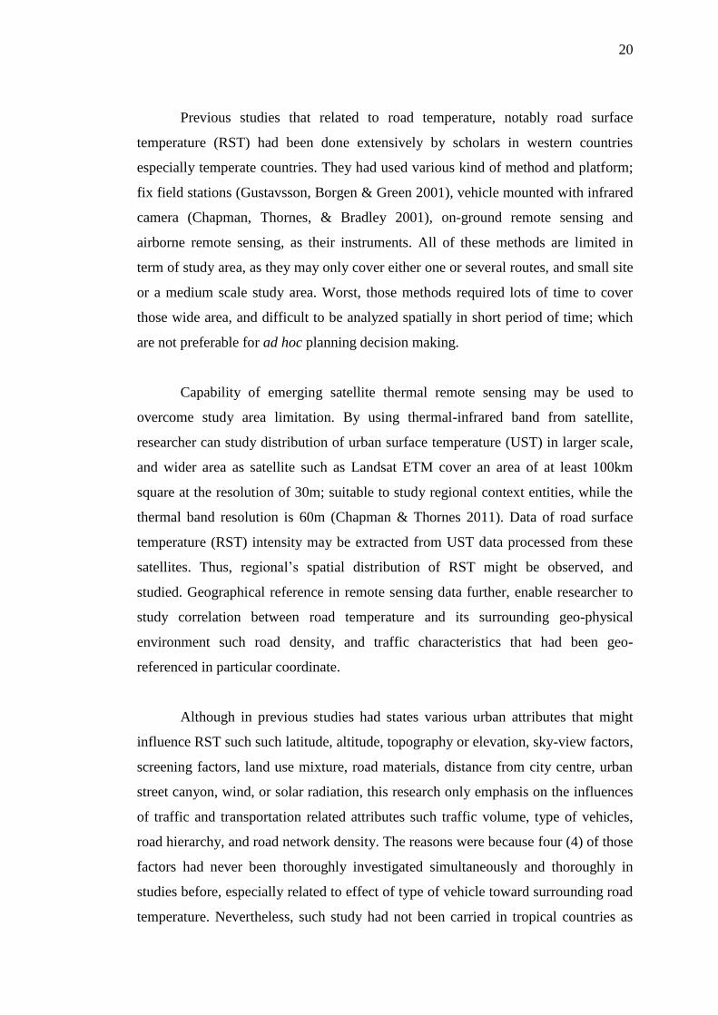
Previous studies that related to road temperature, notably road surface
temperature (RST) had been done extensively by scholars in western countries
especially temperate countries. They had used various kind of method and platform;
fix field stations (Gustavsson, Borgen & Green 2001), vehicle mounted with infrared
camera (Chapman, Thornes, & Bradley 2001), on-ground remote sensing and
airborne remote sensing, as their instruments. All of these methods are limited in
term of study area, as they may only cover either one or several routes, and small site
or a medium scale study area. Worst, those methods required lots of time to cover
those wide area, and difficult to be analyzed spatially in short period of time; which
are not preferable for ad hoc planning decision making.
Capability of emerging satellite thermal remote sensing may be used to
overcome study area limitation. By using thermal-infrared band from satellite,
researcher can study distribution of urban surface temperature (UST) in larger scale,
and wider area as satellite such as Landsat ETM cover an area of at least 100km
square at the resolution of 30m; suitable to study regional context entities, while the
thermal band resolution is 60m (Chapman & Thornes 2011). Data of road surface
temperature (RST) intensity may be extracted from UST data processed from these
satellites. Thus, regional‟s spatial distribution of RST might be observed, and
studied. Geographical reference in remote sensing data further, enable researcher to
study correlation between road temperature and its surrounding geo-physical
environment such road density, and traffic characteristics that had been geo-
referenced in particular coordinate.
Although in previous studies had states various urban attributes that might
influence RST such such latitude, altitude, topography or elevation, sky-view factors,
screening factors, land use mixture, road materials, distance from city centre, urban
street canyon, wind, or solar radiation, this research only emphasis on the influences
of traffic and transportation related attributes such traffic volume, type of vehicles,
road hierarchy, and road network density. The reasons were because four (4) of those
factors had never been thoroughly investigated simultaneously and thoroughly in
studies before, especially related to effect of type of vehicle toward surrounding road
temperature. Nevertheless, such study had not been carried in tropical countries as
21
far as literature review of this research was concerned. It is vital to look at these
factors simultaneously in a study, as their effects on surrounding temperature may
differ, if different site or time is used to investigate them.
1.3 Research Objectives
This research aimed to study influences of various traffic and transportation
characteristics toward intensity of road surface temperature (RST) by combining the
used of ready traffic data and remote sensing method. Following are the objectives of
this study:
1. Extracting Iskandar Malaysia road surface temperature (RST) data from
Landsat +ETM 7 satellite platform and producing the RST distribution map.
2. Evaluating effect of road density on RST intensity.
3. Comparing different road hierarchy effect over road temperature distribution.
4. To evaluate effect of higher traffic volume towards road temperature.
5. To study the influence of different vehicle composure toward RST
characteristic.
6. Evaluating capability of satellite thermal remote sensing data on RST related
research.
1.4 Research Questions
The main question of this research is how traffic and transportation
characteristics influence distribution and intensity of road surface temperature (RST)
in tropical urban area. Following are the main questions that are addressed by this
research:
1. What is the RST distribution pattern in Iskandar Malaysia?
2. Does RST may be influenced by road density?
3. Does road hierarchy have any significant over road temperature?
4. Does higher traffic volume result in higher road temperature?
22
5. Does different type of vehicle or different traffic composition affect RST
characteristics?
6. May RST extracted from satellite data be used to explain correlation between
road surrounding temperature and traffic characteristic?
1.5 Research Hypothesis
Main research hypothesis of this study is road surface temperature (RST) do
influenced by different traffic and transport characteristics, and also by its
surrounding urban features. Listed are other hypothesizes used in this research:
1. Higher road density favorably resulted in higher RST intensity.
2. Road of higher hierarchy should have higher average RST compared to those
roads that are lower in the hierarchy as they cater more traffic volume.
3. Higher traffic volume should result in higher average temperature value as
amount of heat released by vehicles increase.
4. Different type of vehicle may release different magnitude of heat, thus they
also may have effect on differing temperature surrounding a route.
5. More heavy vehicles resulted in higher temperature.
1.6 Theoretical Framework
This research is conduct based on theory that larger number of vehicle and
denser road surface with in city will result in higher surrounding temperature in
urban area (Farmer & Tonkinson 1989, cited in Gustavsson, Bogren & Green 2001;
Surgue et al. 1983, cited in Prusa et al. 2002). Heat pollution caused by
transportation activities, will affected its adjacent area temperature. According to
Zeroth Law of Thermodynamic, heat will be transferred from a system that has
higher heat volume to a system that has lower heat volume, until a condition which
known as thermal equilibrium is achieve.

23
The amount of heat in a system maybe measure by temperature. In thermal
equilibrium condition, heat will only stop to move once temperature of a particular
area and its adjacent area are equal. In other words, high road temperature that cause
by larger traffic movement in a route, will end up increasing temperature of its
surrounding area in Euclidean direction.
Several scholars had study influence of traffic or transportation infrastructure
characteristics over road temperature. Researcher such as Chapman and Thornes
(2011); Chapman and Thornes (2005); Kalthoff et al. (2005); Prusa et al. (2002),
Chapman, Thornes and Bradley (2001); Gustavsson, Bogren and Green (2001), had
validate the correlation between characteristic such traffic volume, street canyon,
screening factor and material of road surface. Thus, based on their findings and
conclusions, theoretical frameworks for this study were constructed. Further
discussion over this framework was elaborated in second chapter of this dissertation.
1.7 Scope of Research
The main scope of this research is to investigate only the characteristic of
urban road temperature in term of road surface temperature (RST) and giving focus
only on the traffic and transportation related attributes influence. The followings are
scope of this research:
1. This research only analyzed road surface temperature of transportation
features, and traffic data for year 2008 within Iskandar Malaysia‟s boundary.
2. The RST data use is based on earth surface temperature extracted from
Landsat +ETM 7 satellite taken on 11 October 2008.
3. Traffic volume data used was based on the Highway Planning Unit, Malaysia
Public Work Department traffic survey conducted on October 2008.
4. This study will cover only roads as it was, in the Iskandar Malaysia
geographical information system (GIS) database of year 2008. And so does
other spatial data used for this research such administration boundary,
landuses and road characteristic.
24
5. This study only looked at factors of:
i. Road hierarchy
ii. Traffic volume
iii. Type of vehicle
iv. Road density
1.8 Research Assumptions
Researcher assumed that there was no influence by other urban features over
road surface temperature (RST), except for tested urban transportation and traffic
related characteristics in this research. The following are other supplementary
assumptions used in this research:
1. Researcher assumed that satellite thermal data used for this study were
acquired on the same date (day) on year 2008 with the following data:
a. Traffic count data from the Highway Planning Unit, Public Work
Department were taken on the same date and time such the satellite
data.
b. The several traffic count data at particular location, does represent
traffic characteristic in the studied area.
c. All spatial data within the Iskandar Malaysia geographical
information system (GIS) were true on the same date as traffic count
and the day satellite thermal data was acquired.
2. All other factors such as wind, air temperature, urban density, green area,
altitude, distance from coast line, and solar radiance, factor is equal all around
the study area or did not influence the RST.
1.9 Limitations of Research
This research‟s design, analysis methodology, and results were based on
several limitations as listed below:
1. The accuracy of calculated road surface temperature (RST) was based on
RMS error and resolution of the used Landsat ETM+ 7 data which are less
than 1.000 and resolution of 30m for spectral band, and 60m for thermal
25
band. However this shortcoming was overcome through interpolation and
area‟s temperature average method.
2. Traffic related data is only based on traffic survey data on specific points in
selected routes by Public Work Department of Malaysia.
3. Difficulty to obtain satellite thermal data and traffic survey data for exactly
the same date to be compared in this study.
1.10 Significant and Expected Contributions of Research
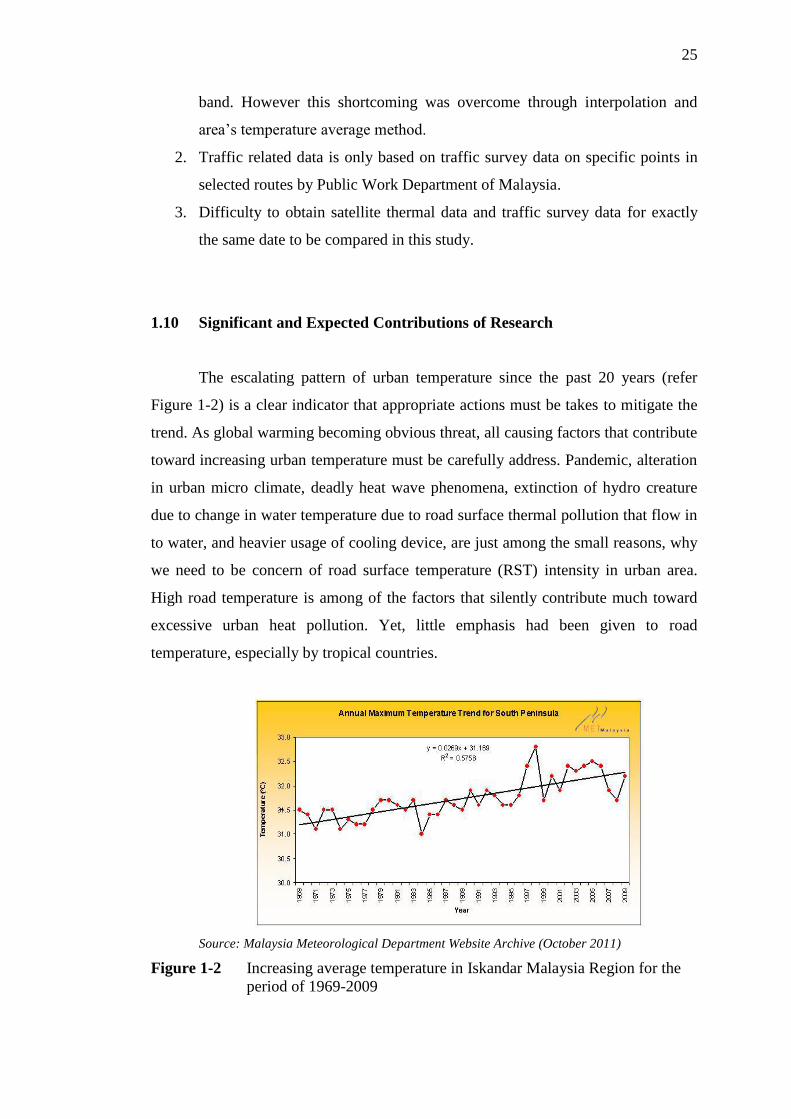
The escalating pattern of urban temperature since the past 20 years (refer
Figure 1-2) is a clear indicator that appropriate actions must be takes to mitigate the
trend. As global warming becoming obvious threat, all causing factors that contribute
toward increasing urban temperature must be carefully address. Pandemic, alteration
in urban micro climate, deadly heat wave phenomena, extinction of hydro creature
due to change in water temperature due to road surface thermal pollution that flow in
to water, and heavier usage of cooling device, are just among the small reasons, why
we need to be concern of road surface temperature (RST) intensity in urban area.
High road temperature is among of the factors that silently contribute much toward
excessive urban heat pollution. Yet, little emphasis had been given to road
temperature, especially by tropical countries.
Source: Malaysia Meteorological Department Website Archive (October 2011)
Figure 1-2 Increasing average temperature in Iskandar Malaysia Region for the
period of 1969-2009

26
This research will ensure deeper understanding that lay before high urban
temperature, especially related to characteristic and distribution pattern of road
temperature in urban area. Understanding related to road temperature and influence
of several urban features; building density, building intensity, agglomeration of road
network, preservation of green area, and traffic volume, will allow transportation
planner and urban designers to better understand this phenomena by identifying the
road temperature pattern, characteristic, inter spatial relationship and distribution,
based on transportation, traffic and urban geographic characteristic. Thus, enable
transport planners and decision makers to take appropriate mitigation actions
whenever they plan future urban development or expansion, especially urban-
regional transportation planning.
Transport planner would used findings of this researches to disaggregate
traffic according to class in better manners, while urban planner might align road
network and road stretch accordingly, so that thermal pollution causes by roadways
in urban area would have minimum impact on urban residents. While ecologist or
environmentalist would anticipate the area which will have high RST, to outline
mitigation action so that thermally polluted water from road area will not directly
flow into our river, and destabilize the whole river ecosystem. All of these will in the
end lead to a better urban environment that is less affected by road based heat
pollution, thus create a more sustainable cities in tropic country.
Finding of the most significant factors that influence RST also will pioneer
the development of a road climate model specific for the use of cities in tropical
countries, especially in hot spots area and area that had been identified by the model
to be in intense temperature condition due to road related characteristics.. That model
will enlighten and assist transportation planner and urban planner to plan our
roadways, transportation system and other urban features so that road temperature in
our cities will not be that high, and not becoming an environmental, health, and
economic threat toward urban populations.
In other hand, emerging new technology of thermoelectric-photovoltaic (TE-
PV) to nurturer electricity from road heat energy, will require extensive study on
road temperature characteristic and distribution. This TE-PV technology capitalizes

27
on heat waste from road surface and vehicle engine combustion, to generate
electricity (Zhang & Chau 2011). As tropic countries usually exposed to all year of
intense sun light, it is the best location for energy harvesting using of thermoelectric-
photovoltaic method, which are renewable energy, not based on carbon and
sustainable. Availability of a good road temperature model will help determining
best location to harvest energy based on road heat waste, along tropical countries‟
roadways.
1.11 Research Design
This research started by reviewing previous studies that had been made by
researchers, in order to identify possible factors that might influence road
temperature characteristics, especially transportation and traffic related
characteristics. These identified factors were then studied based on their overlying
theory and previous research results and suggestions. Based on those literature and
theories reviews, all the factors related to transportation and traffic which have
significant toward road temperature characteristics in tropical countries were
retrieved, to be tested.
Figure 1-3 Research Methodology and Design.
The road surface temperature (RST) data retrieved from Landsat ETM+ 7
satellite by using ENVI remote sensing software and utilizing the mathematical
28
Planck model developed by NASA which explained further in methodology chapter.
The satellite thermal data was used to study the road temperature profile of different
route, and to compare the different profile road temperature based on different traffic
and transportation characteristics.
The used of spatial analysis capability in GIS was utilized to investigate
influence or correlation between road surface temperature (RST), against listed
transport and traffic attributes. Each of four (4) identified variables or factors that
might influence road temperature intensity were then tested by using linear
regression model and comparison analysis. By this method, correlation and influence
of each traffic characteristic; volume, vehicle type, road‟s density and road‟s
hierarchy were identified.
1.12 Chapter Outlines
This written dissertation will consist of five (5) main components; i)
Introduction and Research Framework, ii) Literature Reviews, iii) Research
Methodology, iv) Findings, Analysis & Discussions, and v) Research Summary.
Part 1 – Introduction and Research Framework
This chapter is a guiding chapter throughout this whole research, outlining
the whole aim and objectives of this research and method use to carry out this
research in general. This introduction chapter highlighted the issue of high road
surface temperature (RST) in tropical country and relation with global warming
phenomena and UHI phenomena, and other related problem cause by this issue. Thus
significant of this whole research was explained. This chapter will also include basic
literature reviews of previous study and theory related to road temperature,
assumptions used, scopes and limitations of this study, significant of this study and
research design for this whole study.

29
Part 2 – Literature Review
Second part of this research is the literature reviews. This chapter will focus
on the overlaying theories related and influencing factors that contribute toward road
temperature characteristics, defined by scholars. This chapter will also discuss on the
issues arise by researchers in their studies of road temperature characteristic, with
emphasis on method that they used, data that had been manipulated, and result that
they had obtained from those previous studies.
Part 3 – Methodology
This chapter explained methods used in this research, especially specific
methods used to study each factor that contributed toward road surface temperature
characteristics and distribution. This segment also further described and elucidated
on the data acquired, software or tools used to evaluate, steps and model used in
analyzing significant of each tested factors, and, method used, to produce listed
comparison and analysis earlier.
Part 4 – Findings, Analysis & Discussions
The fourth part of this written dissertation will discuss all the analysis done
based on listed method and given objectives of this research. Each analysis findings
were discussed, elaborated and explained thoroughly based on analysis outcome. The
chapter was concluded with summary of analysis and finding that reflected this
research‟s questions.
Part 5 – Research Summary
The last chapter of this thesis will provide summary for this whole research.
Starting from the emerging issue, to research aim and frameworks, summary of
literature review of previous studies, methods used, discussion of results and
findings, and discussion related to the road temperature characteristic. This chapter
also explained all the shortcomings of this study, and suggestions of possible
increments for future researches.
30
1.13 Chapter Summary
Road temperature study is relatively a new study, especially in Malaysia.
However, due to escalating global and urban temperature and vehicles number each
year, study related to road temperature is vital. Factors that contribute toward high
road temperature in urban area should be investigating, thus, mitigation action to
reduce urban, especially road temperature in the future might be planned and taken.
For that reason, this research is significant. In the nest chapter, researcher
thoroughly listed, describe, explain and discuss, several studies done by scholars
especially related to traffic and transportation characteristics, thus overlaying and
further explain the overlaying framework of this whole research.

REFERENCES
Akisawa, A & Kaya, Y 1998, „Two model analyses of the urban structure of minimal
transportation energy consumption‟, Applied Energy, 61, 25-39.
Bogren, J, Gustavsson, T 1991, „Nocturnal air and road surface temperature
variations in complex terrain‟, International Journal of Climatology, 11, 443-
550.
Bouris, D, Theodosiou, T, Rados, K, Makrogianni, M, Koutsoukos, K & Goulas, A
2010, „Thermographic measurement and numerical weather forecast along a
highway road surface‟, Meteorological Applications, 17, 474-484.
Caselles, V, Garcia, MJ, Melia, J, & Cueava, AJ 1991, „Analysis of the heat island
effect of the city of Valencia, Spain through air temperature transits ad
NOAA satellite data‟, Theoretical and Applied Climatology, 43, 195-203.
Chapman, L, Thornes, JE, & Bradley, AV 2001a, „Modelling of road surface
temperature from a geographical parameter database. Part 1: Statistical‟,
Meteorological Application, 8, 409-419.
Chapman, L, Thornes, JE & Bradley, AV 2001b, „Modelling of road surface
temperature from a geographical parameter database. Part 2: Numerical‟,
Meteorological Application, 8, 421-436.
Chapman, L, Thornes, JE & Bradley, AV 2005, „The influence of traffic on road
surface temperatures: implications for thermal mapping studies‟,
Meteorological Application, 12, 371-380.
76
Chapman, L & Thornes, JE 2006, „A geomatics-based road surface temperature
prediction model‟, Science of Total Environment, 360, 68-80.
Chapman, L & Thornes, JE 2011, „What spatial resolution do we need for a route
based road weather decision support system?‟, Theory Application
Climatology, 104, 551-559.
Chudnovsky, A, Ben-Dor, E, & Saaroni, H 2004,„Diurnal thermal behavior of
selected urban objects using remote sensing measurement‟, Energy and
Buildings, 36, 1063-1074.
Gallo, KP, & Owen, TW 1999, „Satellite based adjustments for uran heat island
temperature bias‟, Journal of Applied Meteorology, 38, 806-813.
Graham, E 1993, „The urban heat island of Dublin city during the summer months‟,
Ir. Geogr., 26, 45-57.
Gustavsson, T 1990, „Road Variation in Road Surface Temperature due to
Topography and Wind‟, Theoretical & Applied Climatology, 41, 227-236.
Gustavsson, T 1999, „Thermal Mapping – a technique for road climatological
studies‟, Meteorology Application, 6, 385-394.
Gustavsson, T, Borgen, J & Green, C 2001, „Road Climate in Cities: A study of the
Stockholm Area, South-East Sweden‟, Meteorological Application, 8, 481-
489.
Henry, JA, Dicks, SE, Wetterqvist, OF & Roguski, SJ 1989,‟Comparison of satellite,
ground-based, and modelling techniques for analyzing the urban heat island‟,
Photographic Engineering of Remote Sensing, 55, 69-76.
Huang, G, Zhou, W & Cadenasso, MI 2011, „Is everyone hot in the city? Spatial
pattern of land surface temperatures, land cover and neighborhood

77
socioeconomic characteristics in Baltimore, MD‟, Journal of Environmental
Management, 93, 1753-1759.
Imaseki, T 1998, „Japanese Automotive Transportation Sector‟s Impact upon Global
Warming‟, Applied Energy, Vol. 59, No. 2-3, 175-185.
Jusuf, SK, Wong, NH, Hagen, E, Anggoro, R, Hong, Y 2007, „The influence of land
use on urban heat island in Singapore‟, Habitat International, 31, 232-242.
Kalthoff, N, Baumer, D, Corsmeier, U, Kohler, M. & Vogel, B 2005, „Vehicle-
induced turbulence near a motorway‟, Atmospheric Environment, 39, 5737-
5749.
Kondo, J & Okusa, N 1990, „A simple numerical prediction model of nocturnal
cooling in a basin with various topographic parameters‟, Journal of Applied
Meteorology. 29, 604-619.
Kubota, T, & Ossen, DR 2008, „Spatial characteristic of urban heat island in Johor
Bahru‟, Journal of Faculty Built Environment, n. vol..
Kruger, EL, Minella, FO & Rasia, F 2010, „Impact of urban geometry on outdoor
thermal comfort and ir quality from field measurement in Curitiba, Brazil‟,
Building and Environment, n.vol., 1-14.
Parameter, BS, Thornes, JE, 1986, „The use of a computer model to predict the
formation of ice on road surfaces‟, Res Rep-Transp Road Res Lab, 71, 1-19.
Prusa, JM, Segal, M., Temeyer, BR, Gallus, WA & Takle, ES 2002, „Conceptual and
scaling evaluation of vehicle traffic thermal effects on snow/ice covered
roads‟, J. Appl. Meteorol. 41: 1225–1240.
Postgard, U 2000, „The effect of weather changes on air and road surface
temperatures‟, Proceeding of the 10th
SIRWEC Conference. pg. 103-110. 22-
24 March 2000, Davos, Switzerland.

78
Shaharuddin, A, Noorazuan, MH & Yaakob, MJ 2009, „Fenomena Pulau Haba
Bandar dan isu alam sekitar di bandaraya Kuala Lumpur‟, GEOGRAFIA
Online Malaysia Journal of Society and Space 5, 3, 57-67.
Shao, J, Lister, PJ, Hart, GD & Pearson, HB 1996, „Thermal mapping – reliability
and repeatability‟, Proceeding of 8th
International Road Weather Conference,
Birmingham, SIRWEC, n. date, 235-242.
Shashua-Bar, L & Hoffman, ME 2003, „Geometry aspect in passive cooling of
canyon streets with trees‟, Energy and Buildings, 35, 61-68.
Thornes, JE 1991, „Thermal mapping and road –weather information systems for
highway engineers‟, In: Perry, AH, Symons,LJ, (eds.), Highway
Meteorology. London: E & FN Spon, 39-67.
Takeuchi, W, Noorazuan, H & Thet, KM 2010, „Application of remote sensing and
GIS for monitoring urban heat island in Kuala Lumpur metropolitan area‟,
Proceeding for Map Asia 2010 & ISG 2010. 26-28 July, 2010. Kuala
Lumpur.
Uherek, E, Halenka, T, Borken-Kleefeld, J, Balkanski, Y, Berntsen, T, Borrego, C,
Gauss, M, Hoor, P, Juda-Rezler, K, Lelieveld, J, Melas, D, Rypdal, K, &
Schmid, S 2010, „Transport impacts on atmosphere and climate: Land
Transport‟, Atmospheric Environment, 44, 4772-4816.
Unger, N, Shindell, DT & Wang, JS 2009, „Climate foreseeing by the on-road
transportation and power generation sectors‟, Atmospheric Environment, 43,
3077-3085.
Voogt, JA & Oke, TR 2003, „Thermal remote sensing of urban climates‟, Remote
Sensing of Environment, 86, 370-384.
79
World Meteorological Organization, 1997, „Road Meteorological Observations‟
(R.E.W. Pettifer and J. Terpstra). Instruments and Observing Methods Report
No. 61, WMO/TD No. 842, Geneva.
Xu, W, Wooster, MJ & Grimmond, CSB 2008, „Modelling of urban sensible heat
flux at multiple spatial scales: A demonstration using airborne hyperspectral
imagery of Shanghai and a temperature–emissivity separation approach‟,
Remote Sensing of Environment, 112, 3493-3510.
Xie, X, Huang, Z, Wang, J & Xie, Z 2005, „Thermal effects on vehicle emission
dispersion in an urban street canyon‟, Transportation Research Part D, 10,
197-212.
Zhang, X & Chau, KT 2011, „An automotive thermoelectric-photovoltaic hybrid
energy system using maximum power point tracking‟, Energy Conversion
and Management, 52, 641-647.