influence of local soil conditions on ground response and ... · the influence of different...
TRANSCRIPT

1
Influence of Local Soil Conditions on Ground Response and Damage Pattern Due to Earthquake
Dr. Abdul Samad Khan
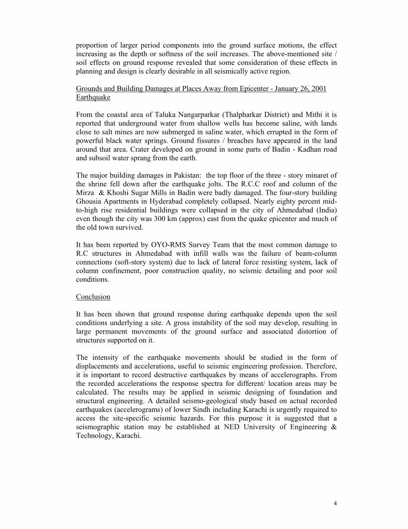
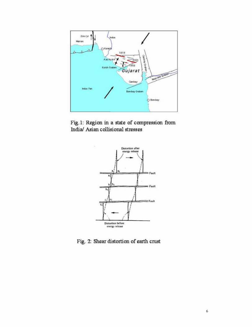
Introduction The Earthquake of January 26, 2001 of magnitude 7.6 on Richter scale has resulted in more than 25,000 fatalities and wide spread damage in India and South- East lower part of Sindh, Pakistan. The Intensity of this earthquake was felt from severe to minor near the epicenter and areas within 400 km radius. It has been reported that severe damage has occurred to mid to high-rise buildings in the city of Ahmedabad (300 km East of the epicenter) whereas no damage was reported in the city of Karachi although it lie approximately the same distance (North-West of the epicenter). Wide spread liquefaction and lateral spreading of soils have been reported in Rann of Kutch (India) and in many part of the South -East Sindh (Badin, Taluka Mithi, Taluka Nangarparkar of Tharparkar). Several feet wide craters appeared / developed on and around Badin - Kadhan road. The ground vibration resulting from an earthquake is due to the upward transmission of the stress wave from rock (fault rupture) to the softer soil layer(s). These stress waves are body waves, which reach the surface at an angle depending upon the distance of the surface point from the epicenter or point on the surface over the origin. These body waves may generate two other surface waves, which are confined, to elastic-half-space and are known as "Raleigh wave" and "love wave". The seismograph may also record the ground motions of these waves, which are complex in nature. Based on theories, documented informations for January, 2001 earthquake and published research work on earthquakes, the author has tried to demonstrate the effect of local soil conditions on earth ground-motion / shaking (response) and damage patterns due to such ground shaking. The Mechanism for Earthquake, January 26, 2001 Triggering Rocks in the region are primarily Jurassic to cretaceous age sedimentary and volcanic rocks. The earthquakes in India and Pakistan are the result of the compression thrust of Eurasian Plate with Indian Plate. The neotectonic geology of Kutch (Malik et. al 2000) consists of a series of folds and faults with a general WNW/ESE trend. The region is still in a state of compression from India / Asian collision stresses (Fig .1) When for some mechanical reason a fault is prevented from continuing its normal relative displacement, first a distortion takes place with the accumulation of potential energy as indicated in the Fig. 2 by the dashed line. When the ultimate frictional resistance of the rock at the fault is reached, the potential energy stored is suddenly released into kinetic energy, giving rise to seismic motion producing waves that travel in all directions. The rock previously distorted has the tendency to spring back to approximately the positions (a1-a1), (b1-b1.)…. as shown in Fig. 2. The kinetic energy

2
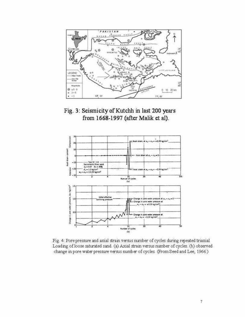
of the waves is dissipated in the earth crust with distance from the source and its magnitude is registered at various intensities at the locations through which the body waves pass. It is also possible that multiple total reflections within the upper layer in the Bhuj area might have generated a surface waves called "Love waves". In the opinion of the author these are the waves, which have resulted in damages to building in Bhuj area and Ahmedabad city. Fig. 3 shows some of the faults mapped by Malik et al 2000. The Kutch region appears to be one area where above-normal seismicity rates exist. It will be interesting to discover whether a correspondingly higher than normal strain-rate prevails in the region and if so why? The Allah Bund fault is close to eastern boarder and if this fault extends westward due to tectonic movement than it has serious consequences for earthquake hazard in Karachi. Location and Data Related to Fault
INDIA USGS Latitude 23.31° N 23.36° N Longitude 70.41° E 70.34° E Focus 22 km 23.6 km Magnitude 7.7 7.6 Duration 45 Seconds 45 Seconds
It is surmise that the rupture occurred on a pre-existing fault although researchers found no direct evidence of such a fault on the place of rupture (NSF - SCEC Survey Team). Liquefaction and Ground Deformation One of the major causes of destruction during an earthquake is the failure of the ground surface. The ground may fail due to fissures, abnormal or unequal settlement or complete loss of shear strength of soil. A loose saturated sand deposit when subjected to vibration (or cyclic loading) tends to compact and decrease in volume. If drainage is unable to occur, the pore water pressure increases. Fig.4 shows a typical set of results from Seed and Lee (1966) for repeated load triaxial test. The pressure had been building up during the first eight cycles & in the ninth cycle the pore pressure become equal to the confining stress so that the lateral effective stress dropped to zero. Based on the effective stress principle the shearing strength of saturated sand is given by shearing strength equation, φστ tan)( un−= During longer shaking of loose saturated sand deposit, increase pore Pressure (u) become equal to the overburden stresses (σ n) and the ground lost its complete shearing strength resulting in settlements and tilting of structures. Loss of strength during cyclic loading occurs in clays also but loss of strength does not occur until after very large strains have already developed.

3
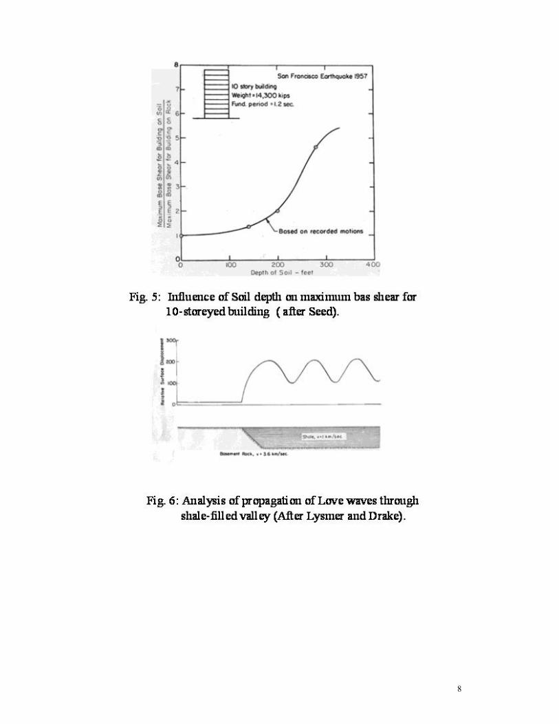
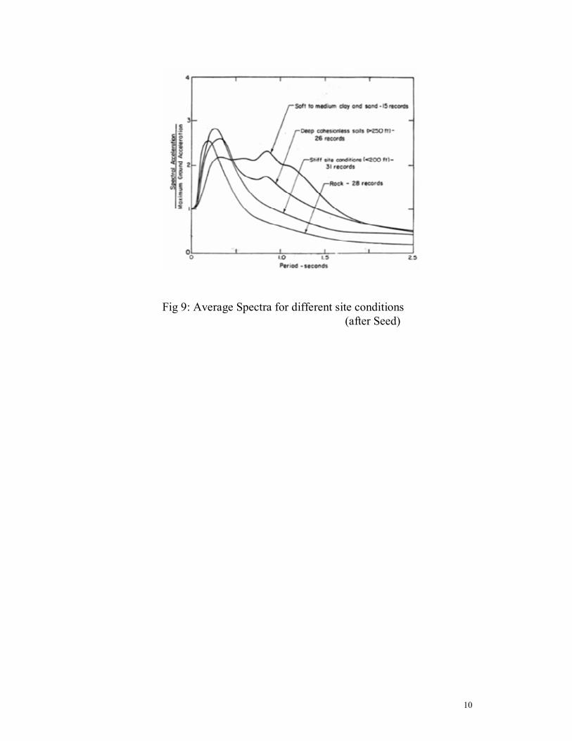
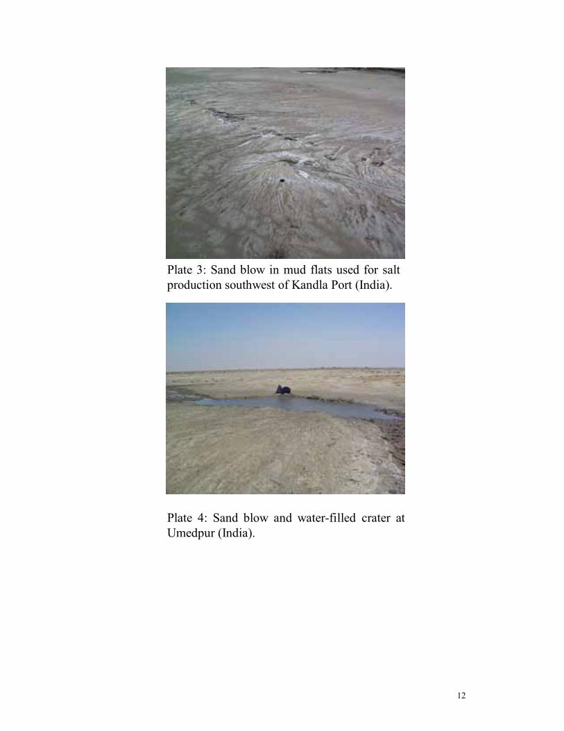
Liquefaction features which include lateral spreads, sand blows, sand blow craters for the earthquake in coastal areas of Run of Kutch and Sindh are shown in Plate 1 through plate 6 for comparison purposes. In many parts of the coastal district of Sindh, several feet wide craters also appeared on ground as in India. At a number of places subsoil water sprang from the earth. It appears that no earthquake have ever hit this part as powerfully as it did on January 26, 2001? Effects of Local Geology and Soil Conditions on Ground Response In the preceding section it is shown that a particular sandy soil under certain conditions lost its strength. MacMurdo (1823) in describing the effects of the earthquake near the Run of Kutch in 1819 noted that, "Buildings situated on rock were not by any means so much affected by the earthquake as those whose foundations did not reach to the bottom of the soil" Kanai et al (1959) in Japan have shown that during small earthquakes, the ground surface accelerations on soil deposit are usually considerably higher than those occurring on adjacent rock exposures. In the 1957 San Francisco Earthquake, recording of ground motions were made at several locations within the city. Using these recorded motions as a basis for analysis, Seed (1977) has shown that the maximum base shear for a typical. 10-storey building located at each of the recording sites varied by several hundred percent, from relatively low values for sites underlain by rock or shallow soils to much higher values at sites underlain by about 300 ft of clay & sand as shown in Fig. 5. The influence of different geologic conditions along the travel paths for seismic waves could also be investigated analytically. The results of such a study by Lysmer and Drake of the variations in amplitudes of Love waves at the surface of a rock formation with a structural discontinuity represented by a shale- filled valley. The computed surface amplitudes of the motions are shown in the Fig .6, the marked change in amplitudes and the irregular amplification of the motions along the surface of the shale are readily apparent. The ground motion near the surface of a soil deposit is mostly attributed to the upward propagation of shear wave from the under lying rock (S-wave, 3050-3660 (m/sec) or “rock like” layer (soft rocks, shear velocity 762 - 915 m/sec). Seed et at (1969) have shown that the rock like material may not exhibit the characteristic associated with hard base. Hence, for arriving at a solution of the nature of ground motion at or near the ground surface, one needs to know some aspects of the earthquake - induced motion in the rock or rock like materials. The most important of these are duration of the earthquake, predominant period of acceleration and maximum amplitude of motion. Using the results of other researchers, Seed et al (1969) developed chart (Fig. 7) for the average predominant period of accelerations for various earthquake magnitude as plotted against the distance from the causative fault. They also provided another chart (Fig. 8) with average values of maximum acceleration for various magnitudes of earthquakes and distances from the causative faults. A normalized average spectrum for different sites conditions based on statistical analysis of over hundred real recorded earthquake accerlograms is shown in Fig.9 (after Seed). It is readily apparent that soil introduced a significantly larger
4
proportion of larger period components into the ground surface motions, the effect increasing as the depth or softness of the soil increases. The above-mentioned site / soil effects on ground response revealed that some consideration of these effects in planning and design is clearly desirable in all seismically active region. Grounds and Building Damages at Places Away from Epicenter - January 26, 2001 Earthquake From the coastal area of Taluka Nangarparkar (Thalpharkar District) and Mithi it is reported that underground water from shallow wells has become saline, with lands close to salt mines are now submerged in saline water, which errupted in the form of powerful black water springs. Ground fissures / breaches have appeared in the land around that area. Crater developed on ground in some parts of Badin - Kadhan road and subsoil water sprang from the earth. The major building damages in Pakistan: the top floor of the three - story minaret of the shrine fell down after the earthquake jolts. The R.C.C roof and column of the Mirza & Khoshi Sugar Mills in Badin were badly damaged. The four-story building Ghousia Apartments in Hyderabad completely collapsed. Nearly eighty percent mid-to-high rise residential buildings were collapsed in the city of Ahmedabad (India) even though the city was 300 km (approx) east from the quake epicenter and much of the old town survived. It has been reported by OYO-RMS Survey Team that the most common damage to R.C structures in Ahmedabad with infill walls was the failure of beam-column connections (soft-story system) due to lack of lateral force resisting system, lack of column confinement, poor construction quality, no seismic detailing and poor soil conditions. Conclusion It has been shown that ground response during earthquake depends upon the soil conditions underlying a site. A gross instability of the soil may develop, resulting in large permanent movements of the ground surface and associated distortion of structures supported on it. The intensity of the earthquake movements should be studied in the form of displacements and accelerations, useful to seismic engineering profession. Therefore, it is important to record destructive earthquakes by means of accelerographs. From the recorded accelerations the response spectra for different/ location areas may be calculated. The results may be applied in seismic designing of foundation and structural engineering. A detailed seismo-geological study based on actual recorded earthquakes (accelerograms) of lower Sindh including Karachi is urgently required to access the site-specific seismic hazards. For this purpose it is suggested that a seismographic station may be established at NED University of Engineering & Technology, Karachi.

5
References Kanai, K., Tanaka, T. and Yoshizawa S. (1959) "Comparative Studies of Earthquake Motions on the Ground and Underground (Multiple Reflection Problem". Bulletin of the Earthquake Research Institute, Vol. 37, Part 1, March, PP 53-38. MacMurdo, J (1823), Paper, Relating to the Earthquake which Occurred in India in 1819, Trans. Literary Soc. Bombay 3,90-116. Malik J. N, Sohoni P.S, Merh, S.S and Karanth R.V (2000), Proceeding of the Hokudan International Symposium and School on Active Faulting Okumera K, Goto, H. & Takada, K. eds 2000. Seed, H. B., K.L. Lee, 1966 "Liquefaction of Saturated Sands During Cyclic Loading," Proc ASCE, Vol. 92, No SM 6, PP 105-134. Seed, H.B., Idriss, I.H, and Kiefer, F.W (1969)." Characteristics of Rock Motion During Earthquakes", Jour. of the Soil Mechanics and Foundations Division, ASCE, 9 (SM-5), P 1204. Seed, H.B (1977), "Practical Seismic Design of Structures, Seminar, Structures Group, Metropolitan Section, ASCE, N.Y.
6
7
8

9
Fig. 7: Predominent period for maximum rock acceleration (after Seed et al.)
Fig. 8: Variation of maximum acceleration with earthquake magnitudand distance from causative fault. ( after Seed et al)
10
Fig 9: Average Spectra for different site conditions(after Seed)

11
Plate 1: Badin- Kadhan road (5 km away from Kadhan): Craters in the earth are clearly visible (Pakistan).
Plate 2: Badin-Kadhan road (5km away from Kadhan): Sugar cane lands were devastated by large earth fissures (Pakistan).
12
Plate 3: Sand blow in mud flats used for salt production southwest of Kandla Port (India).
Plate 4: Sand blow and water-filled crater at Umedpur (India).

13
Plate 5: Badin-Kadhan road: 5 km away fromKadhan. Earth fissured and the black top road vanished under silt that erupted along with water from the ground (Pakistan).
Plate 6: Zone of ground fissures and cracks at village south of Manfara (India).