influence of hydrothermal venting on water column...
TRANSCRIPT

ORIGINAL
Influence of hydrothermal venting on water column propertiesin the crater of the Kolumbo submarine volcano, Santorinivolcanic field (Greece)
Maria E. Christopoulou1 & Theo J. Mertzimekis2 & Paraskevi Nomikou1 &
Dimitrios Papanikolaou1 & Steven Carey3 & Manolis Mandalakis4
Received: 2 July 2015 /Accepted: 13 November 2015 /Published online: 19 November 2015# Springer-Verlag Berlin Heidelberg 2015
Abstract The Kolumbo submarine volcano, located 7 kmnortheast of the island of Santorini, is part of Santorini’s vol-canic complex in the south Aegean Sea, Greece. Kolumbo’slast eruption was in 1650 AD. However, a unique and activehydrothermal vent field has been revealed in the northern partof its crater floor during an oceanographic survey by remotelyoperated vehicles (ROVs) in 2006. In the present study,conductivity-temperature-depth (CTD) data collected byROV Hercules during three oceanographic surveys onboardE/V Nautilus in 2010 and 2011 have served to investigate thedistribution of physicochemical properties in the water col-umn, as well as their behavior directly over the hydrothermalfield. Additional CTD measurements were carried out in vol-canic cone 3 (VC3) along the same volcanic chain but located3 km northeast of Kolumbo where no hydrothermal activityhas been detected to date. CTD profiles exhibit pronouncedanomalies directly above the active vents on Kolumbo’s craterfloor. In contrast, VC3 data revealed no such anomalies, es-sentially resembling open-sea (background) conditions. Steepincreases of temperature (e.g., from 16 to 19 °C) and conduc-tivity near the maximum depth (504 m) inside Kolumbo’s
cone show marked spatiotemporal correlation. Vertical distri-butions of CTD signatures suggest a strong connection toKolumbo’s morphology, with four distinct zones identified(open sea, turbid flow, invariable state, hydrothermal ventfield). Additionally, overlaying the near-seafloor temperaturemeasurements on an X–Y coordinate grid generates a detailed2D distribution of the hydrothermal vent field and clarifies theinfluence of fluid discharges in its formation.
Introduction
Hydrothermal systems act as a bridge from the Earth’smantle to the ocean, cooling the mantle by supplying heatfrom the Earth’s interior to the deep ocean, and transferringchemical species such as metals and gases from the crust tothe water column. They also provide the energy source fora variety of deep-sea chemosynthetic life forms rangingfrom bacteria to mussels and shrimps (Walter et al. 2010).More than 300 sites of hydrothermal activity and seafloormineralization are known on the ocean floor, in the vicinityof mid-ocean ridges (65%), back-arc basins (22%), subma-rine volcanic arcs (12%), and intraplate volcanoes (1%;Baker and German 2004; Hannington et al. 2005). Seafloorhydrothermal venting is one of the oldest and most impor-tant ore-forming processes on Earth, and has producedsome of the largest economic ore deposits mined to date(Hannington et al. 2005).
Along the Hellenic Arc of the Aegean Sea, active vol-canism is produced by the north–northeasterly subductionof East Mediterranean crust beneath the European plate(McKenzie 1970; Le Pichon and Angelier 1979;Papanikolaou 1993), with main volcanic centers both on-shore (Methana–Poros, Milos, Santorini, Kos, Nisyros;Fytikas et al . 1976, 1984; Livanos et al . 2013;
* Theo J. [email protected]
1 Faculty of Geology and Geoenvironment, University of Athens,Zografou Campus, 15784 Athens, Greece
2 Faculty of Physics, University of Athens, Zografou Campus,15784 Athens, Greece
3 Graduate School of Oceanography, The University of Rhode Island,Narragansett, RI 02882, USA
4 Institute of Marine Biology, Biotechnology and Aquaculture,Hellenic Centre for Marine Research, Gournes Pediados,P.O. Box 2214, 71003 Heraklion, Greece
Geo-Mar Lett (2016) 36:15–24DOI 10.1007/s00367-015-0429-z

Megalovasilis and Godelitsas 2015) and offshore(Nomikou et al. 2013, and references therein). Hydrother-mal activity at relatively high temperatures (up to 220 °C)occurs at the Kolumbo volcano (Sigurdsson et al. 2006;Carey et al. 2011; Kilias et al. 2013), 7 km NE of theisland of Santorini, whereas lower-temperature ventinghas been documented in the Santorini caldera around theKameni islands (Sigurdsson et al. 2006; Nomikou et al.2013) and in the area southeast of Milos (Varnavas andCronan 2005; Camilli et al. 2007). On Methana (Pavlakiset al. 1990) and Nisyros (Hunziker and Marini 2005;Nomikou et al. 2013), hydrothermal activity seems to belimited to the coastal areas (hot springs) without deeperoffshore sites.
Conductivity, temperature and depth (CTD) measure-ments have been used routinely to track traces of subma-rine hydrothermal activity in the overlying water column(e.g., Baker et al. 1993, 1994; German and Von Damm2004; Stewart 2008; Millero 2013) and, when combinedwith CO2 emission data, to monitor natural hazards andprovide risk assessment (e.g., Kusakabe et al. 2000;Brewer 2013; Smart et al. 2013). To date, however, andto the best of the authors’ knowledge, there are no re-ports of successful CTD probe deployment at depth with-in active submarine volcanoes. In fact, close interrela-tions between deep water column properties and conegeomorphology would not be surprising. In analogousdata on active submarine mud volcanoes, Dupré et al.(2014) tracked remarkably constant temperatures of ca.42 °C down to 0.5 km depth in the Cheops mud volcanoof the Menes caldera of the Nile deep-sea fan, consider-ably exceeding the temperature of overlying ambientwaters.
Within this context, the E/V Nautilus carried out threeoceanographic cruises in the Santorini–Kolumbo volcanicfield during the summers of 2010 and 2011. In situ CTDmeasurements were conducted together with remotely-operated vehicle (ROV) explorations of the seafloor. Watercolumn characteristics above the Kolumbo crater and es-pecially in the bottom 20 m above the active Kolumbohydrothermal field at ~500 m depth have as yet not beeninvestigated by means of ROV-deployed CTD probes. Thispaper reports on real-time monitoring of conductivity, tem-perature and salinity, with improved resolution comparedto sampling with rosettes, and detailed 3D mapping ofthese physicochemical parameters characterizing hydro-thermal discharge on the floor of the Kolumbo crater. Fur-thermore, comparative data are presented for open-sea con-ditions and a neighboring non-active volcanic cone, i.e.,volcanic cone 3 (VC3). The results are interpreted withinthe context of fluid and gas inputs, the density relations ofvarious fluid components, and the geomorphological con-trol on mixing with ambient seawater.
Physical setting and former work
Kolumbo is the largest submarine volcano of a series of atleast 19 volcanic cones of the Kolumbo volcanic chaintrending NE off Santorini (Fig. 1) in the extensional,fault-bounded Anhydros Basin (Nomikou et al. 2012,2013). It is about 3 km in diameter, with a circular summitcrater 1.7 km across, a 500 m deep crater floor, and steepvertical inner slopes (Table 1). Along the southwest rim ofthe crater, the water depth shallows to only 18 m, but theaverage depth of the rim is ~150 m and defines acompletely enclosed crater (Nomikou 2004). Kolumbolast erupted explosively in 1650 AD, causing 70 fatalitieson the nearby island of Santorini (Fouqué 1879; Nomikouet al. 2013), and remains the most active volcano of thesouth Aegean Sea.
In 2006, ROV explorations in the northern part ofKolumbo’s crater floor revealed an extensive Bdiffusiveflow^-style hydrothermal vent field, the Kolumbo hydro-thermal field at depths between 492 and 504 m, comprisingdominantly active and inactive sulfide-sulfate structures(Fig. 2) in the form of vertical spires and pinnacles,mounds and flanges (Sigurdsson et al. 2006; Carey et al.2011, 2013; Kilias et al. 2013). Gas samples collected fromthe vents have shown that pure gaseous CO2 is dischargedtogether with clear fluids at temperatures reaching 220 °C(Carey et al. 2013). Acoustic imaging of the ascendingbubbles suggests that the gas is being dissolved into sea-water within ~10–12 m above the crater floor (500 m be-low sea level; Roman et al. 2012; Smart et al. 2013). Dis-solution of the gas likely causes local increases in waterdensity, resulting in CO2 sequestration within the enclosedcrater and the accumulation of acidic seawater. This is animportant observation, as carbon dioxide is known to bethe key player in controlling acidity in seawaters via dis-solution of carbonates (Craig and Turekian 1980; Milleroet al. 2002; Orr et al. 2005), and is supported by the lack ofmacrofauna at the Kolumbo hydrothermal vents, the occur-rence of carbonate-poor sediment in the crater, and pHvalues as low as 5.0 in water samples (Carey et al. 2013;Kilias et al. 2013).
Buildup of CO2-rich water in the bowl-shaped crater ofKolumbo may be producing conditions analogous to someAfrican volcanic lakes (Lake Monoun and Lake Nyos, Cam-eroon; Carey et al. 2013). Similarities and differences betweenKolumbo and Lake Nyos, where overturn of gas-rich bottomwaters led to abrupt releases of CO2 at the surface with fatalresults, were reported by Brewer (2013). The active hydro-thermal vents in lakes Nyos and Monoun were studied bymeans of vertical CTD measurements (Kusakabe et al.2000). The same methodology has been employed to monitorseveral active submarine volcanoes around the world, provid-ing insights into the processes governing the activity of the
16 Geo-Mar Lett (2016) 36:15–24

vents (e.g., Cheminée et al. 1991; de Ronde et al. 2007;Resing et al. 2009; Fraile-Nuez et al. 2012; López et al.2012; Santana-Casiano et al. 2013).
The inactive volcanic cone 3 (VC3) is located almost3 km northeast of Kolumbo, along the same volcanicchain and with very similar geological features. It ex-hibits a symmetrical, well-defined crater with walls upto tens of meters in height (Table 1). The smooth craterfloor (290 m depth) has a diameter of ~200 m and ismostly covered with fine-grained brownish gray sediment(Nomikou et al. 2012).
Materials and methods
Three oceanographic cruises were conducted aboard E/VNautilus along the Kolumbo volcanic chain during August2010 (NA007), October 2010 (NA011), and September2011 (NA014) as part of a collaborative project between theGraduate School of Oceanography at the University of RhodeIsland (URI–USA), the Department of Geology &Geoenv i r onmen t o f t h e Un i ve r s i t y o f A then s(UOAGREECE), the Institute for Exploration (IFE–USA),
Table 1 General features of Kolumbo and volcanic cone 3 (VC3),extracted from Nomikou et al. (2012)
Kolumbo VC3
Basic features Crater Symmetric,circular shaper,presence of crater
Summit latitude 36°31′25′′N 36°32′36′′N
Summit longitude 25°29′10′′E 25°31′00′′E
Height (m) 482 115
Shallowest point bsl (m) –18 –235
Basal contour (m) –504 –350
Basal diameter (m) 7,000 1,017
Fig. 2 An image of the bottom of Kolumbo’s crater with the outgassingChampagne vent, captured by ROV Hercules while simultaneouslycarrying out CTD measurements reported in this article. ArrowTemperature probe
Fig. 1 Modified synthetic topographic map of the southern Aegean Seacombining onshore and offshore data from recent oceanographic surveysby Nomikou et al. (2014). Inset Simplified map of the present-day
geodynamic structure of the Hellenic Arc, showing the modern Aegeanvolcanic arc developed behind the Hellenic trench, the Peloponnese–Crete island arc and the Cretan back-arc basin
Geo-Mar Lett (2016) 36:15–24 17
and the Institute of Geology andMineral Exploration (IGME–GREECE; Phillips et al. 2011). All data used in this studywere collected from the Anhydros Basin northeast of Santori-ni, where the Kolumbo volcanic chain is found.
Measurements were performed mainly in the hydrothermalvent field in the northeastern part of the Kolumbo crater andnearby volcanic cones. E/V Nautilus is equipped with theROVs Hercules and Argus, which are state-of-the-art deep-sea robotic vehicles capable of exploring depths reaching 4,000 m. Each ROV has two manipulator arms, 1,200 Wattlamps, and a suite of high-definition cameras and sensors(Fig. 2) that receive electrical power from the surface througha fiber-optic cable, which also transmits data and videos. TheROV Hercules carried out in situ CTD measurements using apre-calibrated SeaBird FastCAT 49Plus CTD instrument at a16 Hz sampling rate (Cruise Log 2011).
The initial accuracy of the temperature sensor is of theorder of ±0.002 °C, while its typical stability is ±0.0002 °C
per month. The initial accuracy of the conductivity sensoris ±0.0003 S/m per month, its typical stability being 0.003S/m per year. The accuracy of the pressure sensor is ±0.1%of full-scale range, with stability of 0.05% of full-scalerange per year (SeaBird Electronics Inc. 2013). CTD-equipped Hercules continuously monitored the vent fieldin the northeastern part of the crater. Since this was thefirst time a ROV was performing CTD measurements inKolumbo’s crater, several full depth profiles were run atspecific X–Y grid coordinates (Fig. 1). Where intense hy-drothermal activity was observed near the bottom (occa-sionally assisted by cameras), the ROV was positioned ~1m above the vent to monitor activity over a period of 1–2h. The ROV then travelled around the vent source at fixeddepths (502–504 m) to map the CTD distributions in thenear vicinity. The offline analysis of CTD data was per-formed using open-source software customized to particularneeds.
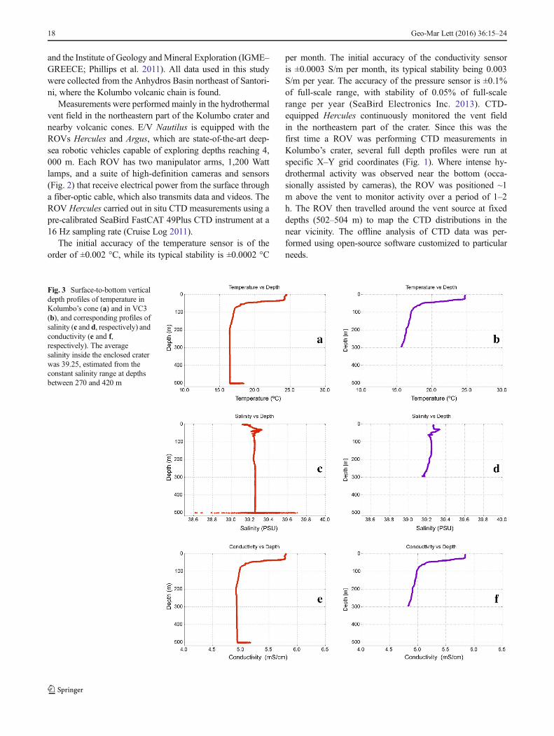
Fig. 3 Surface-to-bottom verticaldepth profiles of temperature inKolumbo’s cone (a) and in VC3(b), and corresponding profiles ofsalinity (c and d, respectively) andconductivity (e and f,respectively). The averagesalinity inside the enclosed craterwas 39.25, estimated from theconstant salinity range at depthsbetween 270 and 420 m
18 Geo-Mar Lett (2016) 36:15–24
Results
Water column spatial variations
Day/night fluctuations in water column vertical CTD profileswere insignificant during the present study campaigns, espe-cially at depths exceeding ~80 m. Moreover, weather condi-tions remained stable throughout the time periods reportedhere. The ROV hovered just above the hydrothermal ventsat the crater bottom, with maximum deviations of about 2–3m in the vertical direction. It is important to note that, despitetrying to maintain the ROVas steady as possible, the turbulentascending plumes resulted in some movement of the vehicle.
Selected surface-to-bottom CTD profiles from inside theKolumbo crater are shown for the time period between21:00–22:00 hours on 31 July 2010 in Fig. 3a, c, e, withcorresponding data for cone VC3 between 11:00–12:00 hours
on 29 July 2010 in Fig. 3b, d, f. The data reveal strong changesin CTD values near the bottom at ~500m in Kolumbo’s activevent field (cf. activity was first detected by visual observa-tion). This contrasts with the overall steady profiles observedfrom just above this depth to ~250m.Moreover, the KolumboCTD profiles differ substantially from the VC3 profiles, wherethe values continue decreasing down to the bottom, with noanomalies on the crater floor. The CTD anomalies recorded atthe Kolumbo site are consistent with the known effects of (1)hydrothermal fluids outflowing from vents worldwide(Alendal and Drange 2001), and (2) upward-moving gas bub-bles 99%-rich in CO2 at the present study site (Carey et al.2013).
Above the Kolumbo crater, temperatures decrease no-ticeably from 24 °C in surface waters, to 17 °C at 80 mdepth (Fig. 3a). Warmer surface waters are to be expectedin the Aegean Sea during summer, typically around 26 °C
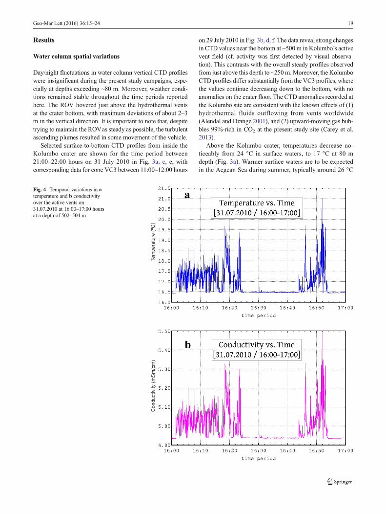
Fig. 4 Temporal variations in atemperature and b conductivityover the active vents on31.07.2010 at 16:00–17:00 hoursat a depth of 502–504 m
Geo-Mar Lett (2016) 36:15–24 19

(Poulos et al. 1997; Nittis et al. 2001; Siokou-Frangouet al. 2002). A narrow zone of steep temperature decreasefollows, marking the thermocline (17.5–16.5 °C). From80 m down to ~230 m, a slight decrease in temperatureis observed. From 230 m to 497 m, the values are constantat ~16 °C. At ~500 m depth, the sharp increase to 19 °Ccan be attributed to heat influx from the hydrothermalvent field (see above). The VC3 profile (Fig. 3b) is onlypartly similar to that of Kolumbo: higher temperatures of~24 °C from the surface to ~20 m, a decrease in temper-ature between 20 m and 80 m (17 °C; cf. thermocline),slight but steady decrease in temperature between 80 mand 290 m, and absence of temperature anomaly at thecrater floor, the latter being the main difference with re-spect to Kolumbo.
For the Kolumbo crater, salinity near the surface rangesbetween 39.00 and 39.40 PSU (Fig. 3c), similar to earlierreports for the south Aegean Sea (Poulos et al. 1997; Roetheret al. 2007). The thermocline has a slight decrease in salinity,as does the zone from 80 to 230 m. From 230 to ~497 m, thevalues are relatively constant and average 39.25 PSU. Pro-nounced deviations from this average value occur at 500 mdepth, ranging from nearly 38.60 to as much as 39.70 PSU. Atthe VC3 site, there is no evidence of such a bottom salinityanomaly (Fig. 3d).
Variations in conductivity are directly correlated withsalinity, since the calibrated CTD probe uses a one-to-one correspondence formula to estimate salinity fromconductivity (Millero 2013). For Kolumbo’s crater, con-ductivity values are high in surface waters (5.70 mS/
cm), followed by a sharp decrease to 4.90 mS/cm downto ca. 80 m, then a slight anomaly (Fig. 3e). In deeperwaters, values remain rather constant down to justabove the crater floor where, at 500 m depth, they in-crease steeply from 4.90 to 5.20 mS/cm. Data for theVC3 site (Fig. 3f) depict high conductivity values nearthe surface, a pronounced decrease from 20 to 80 m,followed by a slight and steady decrease down to thebottom of the cone.
Water column temporal variations
In the Kolumbo crater, temporal variations in CTD param-eters were examined over time intervals spanning 1 h.Figure 4a depicts a typical dataset for temperature moni-tored from 16.00–17.00 hours on 31 July 2010 near thecrater floor and above the vents. The data display a seriesof warm water pulses peaking at approx. 16:20 hours(19.5 °C), followed by a second series peaking soon after16.50 hours (21 °C). These pulses are mirrored by corre-sponding changes in conductivity over this time interval(Fig. 4b).
Isotherm spatial distribution
In Fig. 5, the isotherm spatial distribution in the Kolumbohydrothermal vent field is presented for the depth range497–504 m. Temperatures range from 16 to 19 °C. Thehighest values (~18–19 °C) earmark sites with active vents.Earlier measurements using a temperature probe placed
Fig. 5 Temperature distributionover the hydrothermal vent field.Increased values of 19 °C (darkred) are restricted to the activevents. This indicates temperaturedecrease upon contact with colderseawater. Solid contour linesSpots of similar temperature.Dashed line Borders of focusedROV deployment duringmonitoring above the vents,guided by optical observation (seealso Fig. 2)
20 Geo-Mar Lett (2016) 36:15–24

exactly at the source of outflowing vent fluids revealed max-imum temperatures exceeding 220 °C (Carey et al. 2013).Discernible thermal anomalies extend up to 40 m beyond themost active vents, despite temperature decreasing strongly dueto mixing at the crater floor. This type of thermal distributionmap is potentially important for assessing total thermal fluxfrom a vent field and identifying the relative strengths of in-dividual vent sites.
Link with Kolumbo geomorphology
Inspection of the CTD profiles reveals distinct subdivi-sions in the vertical temperature and salinity patterns inthe water column over the Kolumbo volcano (Fig. 3),which can be correlated to the general morphology ofthe volcano (Fig. 6). The rim of the crater has an in-clined circular shape ranging from a depth of 18 to 150m below the sea surface (Nomikou 2004). In the near-surface zone (0–20 m), significant variations in physico-chemical parameters would be expected because of sen-sitivity to weather conditions impacting at various tem-poral scales and involving, for example, sunlight flux (cf.day/night temperature variability), and open-water circu-lation patterns governed by winds and currents. At great-er depths reaching about 80 m below the surface, suchtemporal variations would be reduced in magnitude,thereby promoting the formation and maintenance of atypical thermocline (Fig. 6).
The 80–230 m zone would be characterized by increasedwater turbidity. Thus, the uneven morphology of the rim (seeabove) would force water masses to be deflected, resulting inincreased turbulent entrainment of sediment, etc. The enclosedenvironment of the crater would trap water masses at the levelof the sill depth (~150 m), resulting in a well-mixed, stablewater column. Indeed, the temperature is constant at 16.5 °C,and salinity is also extremely stable.
In the crater at depths greater than 250 m, the water columnis strongly loaded with reddish-orange and white particles thatmost likely are Fe-rich flocculent fragments of microbial matsdispersed by rising plume fluids (Carey et al. 2011; Kiliaset al. 2013). The fact that the crater walls are nearly vertical(Nomikou et al. 2013, 2014) would enhance the isolation ofwater masses inside the crater and reduce interaction withsurface currents. Indeed, this part of the crater shows virtuallyconstant depth profiles for all CTD parameters (Fig. 6).
The situation is somewhat similar in the VC3 cone, althoughthere appears to be more water exchange in the lower parts ofthe VC3 crater, as shown by the slight gradient in temperatureand salinity with depth at the deepest levels (Fig. 3). In view ofKolumbo’s morphology alone, it would be expected that well-mixed conditions would extend to deeper levels. However, atKolumbo the activity of the hydrothermal vent field near thecrater floor has resulted in clear temperature and salinity pertur-bations over a relatively narrow depth range. To the best of theauthors’ knowledge, this is the first time such a correlationbetween water column signatures and geomorphology has beenreported for an active submarine volcano.
Fig. 6 Conceptual diagramshowing the correlation betweenthe vertical temperature profileand cone morphology of theactive Kolumbo submarinevolcano. Four distinct zones areidentified: light blue layer 0–70 mopen-sea conditions, green layer80–230 m turbid flow, light greenlayer 230–497 m constant values,yellow layer 497–504 mhydrothermal vent. Forcomparison, the insets showtemperature depth profiles for aopen-sea (background) conditionsand b VC3 (inactive cone)
Geo-Mar Lett (2016) 36:15–24 21

Discussion and conclusions
A highly dynamic, submarine volcano such as Kolumbo isexpected to offer unique opportunities to explore extreme con-ditions. Indeed, Kolumbo is the most active known source ofhydrothermal activity in the Aegean Sea, and its proximity to ahistorical and also tourist hotspot—the volcanic island of San-torini—makes its detailed exploration imperative. The ROV-based campaign investigating the volcanic cones NE of San-torini, of which Kolumbo is the largest and most active, is acrucial step in that direction.
Vertical profiles of temperature, conductivity, and salinityrecorded in Kolumbo’s enclosed crater by CTD probesmounted on ROV Hercules have shed light on the physico-chemical conditions existing in this rather isolated cone,complementing geomorphologic assessments based on visualobservations, acoustics, etc. In the active hydrothermal ventfield discovered about a decade ago in the northern part of thecrater (Sigurdsson et al. 2006; Carey et al. 2011), the temper-ature and conductivity profiles reported in the present studyare overall consistent with earlier CTD measurements in theAegean Sea (Nittis et al. 2001; Siokou-Frangou et al. 2002;Roether et al. 2007). This is also true for the CTD profilescollected at the neighboring, inactive cone VC3, representingreference open-sea conditions (Fig. 6). However, descent ofthe ROV to the bottom of Kolumbo’s crater and over theactive vents revealed CTD signatures that deviate significantlyfrom those recorded at shallower depths at this site. The steadyconditions observed at depths of about 230–497 m, wheresteep walls form a narrow, isolated environment, are abruptlyreplaced by strong spatiotemporal variations in water columnproperties at the crater bottom (500 m), which can be directlycorrelated with observed vent activity (based on, for example,visual inspection).
An intriguing observation is the occurrence of salinityvalues both below and above the background values on thecrater floor (Fig. 3c), in a narrow depth interval from 497 to504 m where hot fluids are being discharged from the hydro-thermal vent field (cf. associated thermal anomaly, Fig. 3a).Because salinity is derived directly from conductivity mea-surements, there must be some agent in the hydrothermalfluids that contributes to both decreased and increased con-ductivity. Low conductivity can be related to the presence ofabundant CO2 bubbles in the water column directly over theactive vents (Carey et al. 2013). Inclusion of bubbles in thefluids being passed through the CTD probe would cause areduction in the conductivity of the fluid, and an associateddecrease in calculated salinity (personal information fromSea-Bird CTD manufacturer). On the other hand, higher conduc-tivity could be caused by (1) mixing of acidic hydrothermalvent fluids with background seawater, leading to low pH so-lutions with enhanced conductivity, or (2) venting of salinehydrothermal fluids produced by phase separation at depth
beneath the vent system (e.g., Bischoff and Rosenbauer1987). Future geochemical analyses would be pivotal in clar-ifying this aspect.
The findings of the present study call for further explora-tion and long-term monitoring of the Kolumbo crater andsimilar settings. One open question is whether the correlationobserved between CTD signatures and the geomorphology ofthe inner cone is a general feature of submarine hydrothermalvent fields, rather than a local feature. Moreover, regular mon-itoring is considered necessary to provide confirmation of thetemporal and spatial correlation between temperature and con-ductivity at longer timescales. In addition, the reconstructionof the thermal field near the bottom of the crater just above theactive vents seems promising as a method to locate thermalsources in similar environments, especially in cases wherevisual or other inspection techniques are limited. Amongstothers, future work should focus on repeating CTD profilingof Kolumbo to obtain more information on the dynamic con-ditions created by the Kolumbo hydrothermal field, but alsoon expanding our knowledge on other locations in the crater,currently unknown in terms of their hydrothermal activity.
Acknowledgements This work was supported by the Institute for Ex-ploration (IFE–USA) and the collaborative project BNew Frontiers in theOcean Exploration^ in 2010 and 2011. The officers and crew of the E/VNautilus are gratefully acknowledged for their expertise in handling thefieldwork. Thanks go also to Dr. Katherine Croff Bell, Vice President ofthe Ocean Exploration Trust for her important contribution during thecruises. This paper benefitted significantly from discussions with Prof.S. Kilias and Dr. S.L. Walker. TJM would like to thank Mr. I. Livanos forassistance in creating the isobath distributions. We are grateful to ananonymous reviewer and the journal editors for their comments that vast-ly improved the quality of the paper.
Compliance with ethical standards
Conflict of interest The authors declare that there is no conflict ofinterest with third parties.
References
Alendal G, Drange H (2001) Two-phase, near-field modeling of purpose-fully released CO2 in the ocean. J Geophys Res 106:1085–1096.doi:10.1029/1999JC000290
Baker ET, German CR (2004) On the global distribution of hydrothermalvent fields. Am Geophys Union Geophys Monogr Ser 148:245–266. doi:10.1029/148GM10
Baker ET, Massoth GJ, Walker SL, Embley RW (1993) A method forquantitatively estimating diffuse and discrete hydrothermal dis-charge. Earth Planet Sci Lett 118:235–249. doi:10.1016/0012-821X(93)90170-E
Baker ET, Feely RA, Mottl MLJ, Sansone FT, Wheat CG, Resing JA,Lupton JE (1994) Hydrothermal plumes along the East Pacific Rise,8°40’ to 11°50’N: plume distribution and relationship to the appar-ent magmatic budget. Earth Planet Sci Lett 128:1–17. doi:10.1016/0012-821X(94)90022-1
22 Geo-Mar Lett (2016) 36:15–24
Bischoff J, Rosenbauer R (1987) Phase separation in seafloor geothermalsystems; an experimental study of the effects onmetal transport. AmJ Sci 287:953–978. doi:10.2475/ajs.287.10.953
Brewer P (2013) A different ocean acidification hazard: the Kolumbosubmarine volcano example. Geology 41:1039–1040. doi:10.1130/focus092013.1
Camilli R, Sakellariou D, Foley B, Anagnostou C,Malios A, Bingham B,Eustice R, Goudreau J (2007) Investigation of hydrothermal vents inthe Aegean Sea using an integrated mass spectrometer and acousticnavigation system onboard a human occupied submersible. RapportCommission International pour l’exploration scientifique de la MerMéditerranée 38
Carey S, Bell Croff K, Nomikou P, Vougioukalakis G, Roman C, CantnerK, Bejelou K, Bourbouli M, Martin J (2011) Exploration of theKolumbo volcanic rift zone. Oceanography 24(1 suppl):24–25.doi:10.5670/oceanog.24.1.supplement
Carey S, Nomikou P, Croff Bell K, Lilley M, Lupton J, Roman C,Stathopoulou E, Bejelou K, Ballard R (2013) CO2 degassing fromhydrothermal vents at Kolumbo submarine volcano, Greece, and theaccumulation of acidic crater water. Geology 41:1035–1038. doi:10.1130/G34286.1
Cheminée JL, Stoffers P, McMurtry G, RichnowH, Puteanus D, SedwickP (1991) Gas-rich submarine exhalations during the 1989 eruptionof Macdonald Seamount. Earth Planet Sci Lett 107:318–327. doi:10.1016/0012-821X(91)90079-W
Craig H, Turekian K (1980) The GEOSECS program: 1976-1979. EarthPlanet Sci Lett 49:263–265. doi:10.1016/0012-821X(80)90071-0
Cruise Log (2011) Santorini, Kolumbo and Nisyros Projects (NA007 &NA011) State file Nos. 2010-022& 2010-064. Tech rep, Institute forExploration, Ocean Exploration Trust & URI Center for OceanExploration
de Ronde CEJ, Baker E, Massoth G, Lupton J, Wright I, Sparks R,Bannister S, Reyners M, Walker S, Greene R, Ishibashi J, FaureK, Resing J, Lebon G (2007) Submarine hydrothermal activityalong the mid-Kermadec Arc, New Zealand: large-scale effects onventing. Geochem Geophys Geosyst 8, Q07007. doi:10.1029/2006GC001495
Dupré S, Mascle J, Foucher J-P, Harmegnies F, Woodside J, Pierre C(2014) Warm brine lakes in craters of active mud volcanoes,Menes caldera off NW Egypt: evidence for deep-rooted thermogen-ic processes. Geo-Mar Lett 34:153–168. doi:10.1007/s00367-014-0367-1
Fouqué F (1879) Santorin et ses éruptions. Masson, ParisFraile-Nuez E, González-Dávila M, Santana-Casiano J, Arístegui J,
Alonso-González I, Hernández-León S, Blanco M, Rodríguez-Santana A, Hernández-Guerra A, Gelado-Caballero M, Eugenio F,Marcello J, de Armas D, Dominguez-Yanes J, Montero M, LaetschD, Vélez-Belchi P, Ramos A, Ariza A, Comas-Rodríguez I, Benitez-Barrios V (2012) The submarine volcano eruption at the island of ElHierro: physical-chemical perturbation and biological response. SciRep 2:486. doi:10.1038/srep00486
Fytikas M, Giuliani O, Innocenti F, Marinelli G, Mazzuoli R (1976)Geochronological data on recent magmatism of the Aegean Sea.Tectonophysics 31:T29–T34. doi:10.1016/0040-1951(76)90161-X
Fytikas M, Innocenti F, Manetti P, Peccerillo A, Mazzuoli R, Villari L(1984) Tertiary to quaternary evolution of volcanism in the Aegeanregion. Geol Soc Lond, Spec Publ 17:687–699. doi:10.1144/GSL.SP.1984.017.01.55
German C, Von DammK (2004) Hydrothermal processes. In: Holland H,Turekian K, Elderfield H (eds) Treatise on geochemistry, vol 6, Theoceans and marine geochemistry. Elsevier, Amsterdam, pp 181–222
Hannington M, de Ronde C, Petersen S (2005) Sea-floor tectonics andsubmarine hydrothermal systems. In: Hedenquist JW, ThompsonJFH, Goldfarb RJ, Richards JP (eds) Economic geology 100th an-niversary volume. Society of Economic Geologists, Littleton, CO,pp 111–141
Hunziker J, Marini LE (eds) (2005) The geology, geochemistry and evo-lution of Nisyros volcano (Greece): implications for the volcanichazards. Mémoires de Géologie, vol 44. Section des Sciences de laTerre, Université de Lausanne
Kilias SP, Nomikou P, Papanikolaou D, Polymenakou P, Godelitsas A,Argyraki A, Carey S, Gamaletsos P, Mertzimekis T, Stathopoulou E,Goettlicher J, Steininger R, Betzelou K, Livanos I, Christakis C,Croff Bell K, Scoullos M (2013) New insights into hydrothermalvent processes in the unique shallow-submarine arc-volcano,Kolumbo (Santorini), Greece. Sci Rep 3:2421. doi:10.1038/srep02421
KusakabeM, Tanyileke G,McCord S, Schladow S (2000) Recent pH andCO2 profiles at Lakes Nyos and Monoun, Cameroon: implicationsfor the degassing strategy and its numerical simulation. J VolcanolGeotherm Res 97:241–260. doi:10.1016/S0377-0273(99)00170-5
Livanos I, Nomikou P, Papanikolaou D, Rousakis G (2013) The volcanicdebris avalanche on the SE submarine slope of Nisyros volcano,Greece: geophysical exploration and implications for subaerial erup-tion history. Geo-Mar Lett 33:419–431. doi:10.1007/s00367-013-0338-y
López C, Blanco MJ, Abella R, Brenes B, Cabrera Rodríguez VM,Casas B, Domínguez-Cerdenã I, Felpeto A, de Villalta MF, delFresno C, Garcia O, Garcia-Arias M, Garcia-Cañada L, GomisMoreno A, González-Alonso E, Guzmán Pérez J, Iribarren I,López-Diaz R, Luengo-Oroz N, Meletlidis S, Moreno M,Moure D, de Pablo J, Rodero C, Romero E, Sainz-Maza S,Sentre Domingo M, Torres P, Trigo P, Villasante-Marcos V(2012) Monitoring the volcanic unrest of El Hierro (CanaryIslands) before the onset of the 2011–2012 submarine eruption.Geophys Res Lett 39, L13303. doi:10.1029/2012GL051846
McKenzie D (1970) Plate tectonics of the Mediterranean region. Nature226:239–243. doi:10.1038/226239a0
Megalovasilis P, Godelitsas A (2015) Hydrothermal influence on near-shore sediments of Kos Island, Aegean Sea. Geo-Mar Lett 35:77–89. doi:10.1007/s00367-014-0393-z
Millero F (2013) Chemical oceanography, 4th edn. CRC Press, BocaRaton
Millero F, Pierrot D, Lee K, Wanninkhof R, Feely R, Sabine C, Key R,Takahashi T (2002) Dissociation constants for carbonic acid deter-mined from field measurements. Deep-Sea Res I Oceanogr Res Pap49:1705–1723. doi:10.1016/S0967-0637(02)00093-6
Nittis K, Zervakis V, Perivoliotis L, Papadopoulos A, Chronis G (2001)Operational monitoring and forecasting in the Aegean Sea: systemlimitations and forecasting skill evaluation. Mar Pollut Bull 43:154–163. doi:10.1016/S0025-326X(01)00055-8
Nomikou P (2004) Santorini and Nisyros: similarities and differencesbetween the two calderas of the modern Aegean Volcanic Arc. In:Briand F (ed) CIESM 2004. Human records of recent geologicalevolution in the Mediterranean Basin - historical and archaeologicalevidence, vol 24. CIESM, Monaco, pp 103–108
Nomikou P, Carey S, Papanikolaou D, Bell KC, Sakellariou D, AlexandriM, BejelouK (2012) Submarine volcanoes of the Kolumbo volcaniczone NE of Santorini Caldera, Greece. Glob Planet Change 90–91:135–151. doi:10.1016/j.gloplacha.2012.01.001
Nomikou P, Papanikolaou D, Alexandri M, Sakellariou D, RousakisG (2013) Submarine volcanoes along the Aegean volcanic arc.Tectonophysics 597–598:123–146. doi:10.1016/j.tecto.2012.10.001
Nomikou P, Carey S, Bell K, Papanikolaou D, Bejelou K, Cantner K,Sakellariou D, Perros I (2014) Tsunami hazard risk of a future vol-canic eruption of Kolumbo submarine volcano, NE of SantoriniCaldera, Greece. Nat Hazards 72:1375–1390. doi:10.1007/s11069-012-0405-0
Orr JC, Fabry VJ, Aumont O, Bopp L, Doney SC, Feely RA,Gnanadesikan A, Gruber N, Ishida A, Joos F, Key RM, LindsayK, Maier-Reimer E, Matear R, Monfray P, Mouchet A, Najjar RG,
Geo-Mar Lett (2016) 36:15–24 23
Plattner GK, Rodgers KB, Sabine CL, Sarmiento JL, Schlitzer R,Slater RD, Totterdell IJ, Weirig MF, Yamanaka Y, Yool A (2005)Anthropogenic ocean acidification over the twenty-first century andits impact on calcifying organisms. Nature 437:681–686. doi:10.1038/nature04095
Papanikolaou D (1993) Geotectonic evolution of the Aegean. Bull GeolSoc Greece 27:33–48
Pavlakis P, Lykoussis V, Papanikolaou D, Chronis G (1990) Discovery ofa new submarine volcano in the western Saronic Gulf: thePaphsanias Volcano. Bull Geol Soc Greece 24:59–70
Phillips B, Newman J, Gregory T (2011) E/V Nautilus vehicles.Oceanography 24(1 suppl):9. doi:10.5670/oceanog.24.1.supplement
Le Pichon X, Angelier J (1979) The Hellenic arc and trench system: a keyto the neotectonic evolution of the eastern Mediterranean area.Tectonophysics 60:1–42. doi:10.1016/0040-1951(79)90131-8
Poulos S, Drakopoulos P, Collins M (1997) Seasonal variability in seasurface oceanographic conditions in the Aegean Sea (EasternMediterranean): an overview. J Mar Syst 13:225–244. doi:10.1016/S0924-7963(96)00113-3
Resing JA, Baker ET, Lupton JE, Walker SL, Butterfield DA, MassothGJ, Nakamura K-i (2009) Chemistry of hydrothermal plumes abovesubmarine volcanoes of the Mariana Arc. Geochem GeophysGeosyst 10, Q02009. doi:10.1029/2008GC002141
Roether W, Klein B, Manca BB, Theocharis A, Kioroglou S (2007)Transient Eastern Mediterranean deep waters in response to themassive dense-water output of the Aegean Sea. In: The 1990sProgress in Oceanography 74:540–571. doi:10.1016/j.pocean.2007.03.001
Roman C, Inglis G, Vaughn JI, Smart C, Douillard B, Williams S (2012)The development of high-resolution seafloor mapping techniques.Oceanography 25:42–45. doi:10.5670/oceanog.2011.supplement.01
Santana-Casiano JM, González-Dávila M, Fraile-Nuez E, de Armas D,González AG, Domínguez-Yanes JF, Escánez J (2013) The naturalocean acidification and fertilization event caused by the submarineeruption of El Hierro. Sci Rep 3:1140. doi:10.1038/srep01140
SeaBird Electronics Inc (2013) Seabird FastCAT 49Plus. Users Manual.SeaBird Electronics Inc., Bellevue
Sigurdsson H, Carey S, Alexandri M, Vougioukalakis G, Croff K, RomanC, Sakellariou D, Anagnostou C, Rousakis G, Ioakim C, Gogou A,Ballas D, Misaridis T, Nomikou P (2006) Marine investigations ofGreece’s Santorini volcanic field. Eos, Trans Am Geophys Union87. doi:10.1029/eost2006EO34
Siokou-Frangou I, Bianchi M, Christaki U, Christou E, Giannakourou A,Gotsis O, Ignatiades L, Pagou K, Pitta P, Psarra S, SouvermezoglouE, Wambeke FV, Zervakis V (2002) Carbon flow in the planktonicfood web along a gradient of oligotrophy in the Aegean Sea(Mediterranean Sea). J Mar Syst 33–34:335–353. doi:10.1016/S0924-7963(02)00065-9
Smart CJ, Roman C, Carey SN (2013) Detection of diffuse seafloorventing using structured light imaging. Geochem GeophysGeosyst 14:4743–4757. doi:10.1002/ggge.20280
Stewart RH (2008) Introduction to physical oceanography. Texas A&MUniversity, College Station
Varnavas S, Cronan D (2005) Submarine hydrothermal activity offSantorini and Milos in the Central Hellenic Volcanic Arc: a synthe-sis. Chem Geol 224:40–54. doi:10.1016/j.chemgeo.2005.07.013
Walter M, Mertens C, Stöber U, German CR, Yoerger DR, Sültenfuß J,Rhein M, Melchert B, Baker ET (2010) Rapid dispersal of a hydro-thermal plume by turbulent mixing. Deep-Sea Res I Oceanogr ResPap 57:931–945. doi:10.1016/j.dsr.2010.04.010
24 Geo-Mar Lett (2016) 36:15–24