infield trip report “toward building regional...
TRANSCRIPT

NATIONAL WORKSHOP
G REGIONAL PLATFORM FOR DISASTER
SK REDUCTION IN ASIA
Tsunami and Disaster Mitigation Research CeJl. Tgk Abdul Rahman, Gp. Pie, KecamatanMeuraxa, Banda Aceh.
Provinsi Aceh, Indonesia.
Telp:0651 8052009, Fax:0651 8052168
IN
“TOWARD BUILD DISASTER
17 - 22 December 2015
Prepared By:
Suhada Arief, M.Eng
Ibnu Rusydy, M.Sc
Tsunami and Disaster Mitigation Research Centre (TDMRCJl. Tgk Abdul Rahman, Gp. Pie, KecamatanMeuraxa, Banda Aceh.
0651 8052168, Email: [email protected]
“TOWARD BUILDING REGIONAL PLATFORM F
FIELD TRIP REPORT
TDMRC )

1
Day 1 (17th December 2015): Visits to the Crisis Security and Management
Research Center (CSMRC), Kagawa University.
Our trip started at 07.30 am from the hotel, which was accompanied by Mr. Akihiro
Kameda. From kyoto to Okayama using Shinkansen trains within 220 km for 2 hours, then
move the electric trains to Kagawa prefecturewithin 85 km for 1 hour. We arrived at
Takamatsu Kagawa around 12.30pm, and Dr. Naomi Hosoda joins us the trip. Kagawa
Located on the island of Shikoku, the smallest prefecture ofJapan. Kagawa is well known
for its udon noodles, which are named after theprefecture's old name Sanuki. Prefectural
capital is Takamatsu.
Picture 1. Route Map from Kyoto to Kagawa Prefecture (Basemap: Google Earth)
Picture 2. 7 Partisipant from Indonesia, Malaysia, Japan and Philipines visits
KagawaPrefecture (Mr. Akihiro who took the photograph)

2
After lunch udon noodles, we went to the University of Kagawa. The purpose of the
trip was to study the activity of the Crisis and Security Management Research Center
(CSMRC) Kagawa university and share experiences related to disaster between Japan,
Malaysia, Indonesia, and Philippines.We met representatives of CSMRC is;
1. Profesor Dr. Eng. Wataru SHIRAKI, Director of CSMRC2. Profesor Dr. Eng. Syuichi HASEGAWA (President of Japan Society for Engineering Geology)
3. Profesor Dr. Masanobu HAGIIKE
4. Profesor Dr. (Eng.) Hotoshi INOMO
5. Dr. Kyosuke Takahashi.
The Crisis and Security Management Research Center was established in April
2008. It aims to contribute to the safetyand security of Local communities by developing
advanced academic, technological and educational research projects forprotecting human
lives and property against man-made disasters such as terrorism, accidents, and crime, as well
as naturaldisasters such as earthquakes, tsunami, storm surge, and flooding.The Center has
two divisions, the Education and Research Division, and the Local Partnership Division.
Each divisionhas four research projects:
a. Education and Research Division
1. Creation of Security Science / Health Care Crisis Management / Hazards
2. Disasters Digital Archive
b. Disaster Prevention Competency (Local Partnership Division)
3. Emergency Management / Risk Assessment / Support for the Business
Continuity Plan (BCP)
4. Establishment of a Center for Excellence in Disaster Prevention Research

3
Picture 3. lunch Udon Noodles
Picture 4. Engineering Facultyof Kagawa University
Picture 5.Opening Remark by Profesor Dr. Eng. Wataru SHIRAKI
(Director of CSMRC)

4
After meeting with representatives csmcr, we are invited to demonstrate the
earthquake simulation equipment for the school. Inside a room 6x10m, there is a set of props
simulation animation. Widescreen television that gives audible and visual animation of the
conditions in the classroom when the earthquake happened, in front of the television there are
chairs and tables which protective helmets are available at school tables.
Picture 6. Earthquake Simulation Equipment for the School
Picture 7. Protective Helmets are Available at School Desk

5
Participants sit in a chair and simulate as if it were an earthquake. At the time of the
earthquake happening, the students take cover under a table, after the shock is completed, the
students use a helmet andgo out from the classroom. If there are students who pass out, then
the teacher called the ambulance and provided first aid.
Picture 8. Participants tried a simulation
Picture 9. Partisipantstake cover under a table during earthquake
happening
Picture 10. The coach evaluatesour simulation

6
Picture 11. Participants use a special helmet for the earthquake
Picture 12. First aid
Picture 13. Foto Session with CSMRC member team

7
Day 2 (18th December 2015): Visits Hiroshima Peace Memorial Museum,
Hiroshima Prefektur.
Today after breakfast, we were invited to visit Hiroshima Prefecture. Thanks to Dr.
Naomi Hosoda, who have accompanied us during avisitin Kagawa Prefecture. We visited the
famous museum of the “Hiroshima Peace Memorial Museum”.From Kagawa to Okayama
using electric trains within 85 km for 1 hour, then move the Shinkansen trains to Hiroshima
prefecturewithin 143 km for 1 hour. We arrived at Hiroshima Museumat 10.30am.
Picture 14. Route Map from Kagawa – Hiroshima – Kyoto (Basemap: Google Earth)
Picture 15. Hiroshima Peace Memorial Museum

8
Historically, Hiroshima was one the two cities that the United States of America
bombed with an Atomic Bombat 8:15am, August 6th, 1945. The explosion wiped out 90
percent of the city and immediately killed 80,000 people andtens of thousands more would
later die of radiation exposure.
Picture 16. Before and After Bombing an Atomic Bomb
When entered into the early part of the museum directly served by the explosion of
the atomic bomb.The bomb exploded at 8:15am on August 6th, 1945. They know the exact
time it exploded because many watches were found in the ruined that were all stopped at
8:15am.
Picture 17. Mushroom cloud after bombed Picture 18. Pocket Watch Donated by Kazuwo
Nikawa

9
A Lot of material witnesses can be seen in this museum asFemale student's uniform,
wooden sandal, lunch box, water bottle, wallet, school badge, company badge, a sheet of
tickets, hat, bag, sewing notebook,cloth bag, tricycle, metal helmet,belongings of junior high
students.
Picture 19. Female student's uniform
Picture 20. Wooden sandal
Picture 21. Tricycle
Picture 22. Belongings of junior high students.

10
Shortly after the atomic bomb exploded, heat rays emitted by the radiation, reaches
3000-4000 Celsius for 3 seconds, burn human skin as far as 3.5 kilometers from the
hypocenter. Almost all died within a few days. The hard materials will be covered by bumps
because directly exposed to the heat rays, which briefly melted the surface.
Picture 23. Intens heat rays charred the clothes Picture 24. The roof covered by bumps
In conjunction with heat rays also generating a powerful blast. Pressing down with a
force of 19 tons per square meter. All wooden buildings within 3,5 kilometers were crushed.
Thousands of victims were crushed to death under toppled houses. Window glass shattered
by the blast flew through the air at tremendous speeds.
Picture 25. This beam supported the ceiling of the
top floor, it was broken by the powerful blast
Picture 26. Fused lump of small bottle

11
30 minutes after the explosion, the dust and soot blown into the sky over Hiroshima
began falling as rain. This rain fell as far as 29 kilometers from the hypocenter, dropping
radioactive soot and dirt that had been blown into the air.The dust and soot became
radioactive, mixed with water vapor in the air.
Picture 27. White wall stained by black rain
Picture 28. Backpack and shirt stained by black
rain
The most heart-breaking stories of the bombing are that of Sadako Sasaki. Two
years old at the time of the bombing, she was only2 km away from the hypocenter when it
exploded. She survived the bomb with little injury. However, nine years later, she began
developing purple skin rashes and was eventually diagnosed with leukemia.A friend came to
visit her in the hospital and told her of a Japanese legend that if someone folds 1,000 paper
cranes, he or she will be granted life and healing from the gods. So Sadako began working
day and night to fold as many paper cranes as she could. However, she was only able to fold
about 600 before she became too weak and lost the battle to her disease.Her story inspired so
many children in Hiroshima that the locals finished her project and buried her with 1,000

12
paper cranes. The legend continues to live on, and thousands of paper cranes are still being
mailed toHiroshima every day. There is a Children’s Peace Monument in the Hiroshima
Peace Park commemorating Sadako’s efforts, and there are glass cases full of these cranes.
Inside the museum, many exhibits presented in a neutral way were shocking. We all
felt the emotions, sadness, anger, guilty, empathy. We had the opportunity to listen to a
“hibakusha” talk about they harrowing experience and detail of life after survival.
Picture 29. Paper Cranes Folded by Sadako
Picture 30. The Children’s Peace Monument in
Hiroshima’s Peace Park

13
Another iconic monument associated with the Hiroshima bombing is the Atomic
Bomb Dome (Genbaku Dome). The building near by the bomb’s hypocenter that remained
standing after the explosion.
Picture 31. Atomic Bomb Dome before bombing is the
Hiroshima Prefectural Commercial Exhibition Hall
(http://stevenglassman.com)
Picture 32. Atomic Bomb Dome after bombing
(http://wgresearch.org/)
Picture 33. Atomic Bomb Dome remained standing

14
We had to spend our day in Hiroshima in a peaceful environment really emphasized
the importance of the Park, Museum, and the concept of peace to the city of Hiroshima.
When we arrived at Atomic Bomb Dome, our group was completely in speechless at the
thought of the sheer destruction that had occurred due to the atomic bomb. The memorials
outside had a positive and uplifting message. We Declare A PEACE DECLARATION.
“Offering our heartfelt prayers for the peaceful repose of the A-bomb victims, we
express as well our gratitude to the hibakusha and all our predecessors who worked so hard
throughout their lives to rebuild Hiroshima and abolish nuclear weapons. Finally, we appeal
to the people of the world: renew your determination. Let us work together with all our might
for the abolition of nuclear weapons and the realization of lasting world peace.”
Picture 34. From the deepest from our heart, JSPS Workshop participants from Indonesia, Malaysia, the
Philippines and Japan Declare Peace Declaration

Day 3 (19th December 2015): Observation of the Great East Japan Earthquake
disaster area.
On The 19th Desember 2015 in theearly morning, the teams move to Sendai by
airplane. The departure from Itami Osaka airport by Japan Airlines to Sendai Airport. In
Sendai airport, the teams were pick up by Prof. Jun Oyane from Senshu University. The first
place visited was Arahama district. At Arahama districs, the teams passed through the
Arahama Elementary School. The Arahama Elementary School was a school that saved the
people from thetsunami. Picture 49 shown the people who saved and evacuated to the school
and the present condition of the school.
Picture 35. The people evacuated to the school during thetsunami (city.sendai.jp, 2015) and the present
condition of the school.
The secondfield visit was Arahama Tsunami Monument, at this area the teams can
see and imaging how big the tsunami destroyed the city and killed many Arahama peoples. In
the monument, there are a lot of tsunami victim names and beside it, there is a cenotaph built
to people who want pray to tsunami victims.
Picture 36. The names of tsunami victims in wall of tsunami monument, a Cenotaph and
concrete foundations of buildings.
After visited the Arahama Tsunami Monument, Prof. Jun Oyane carried the teams to
Ishinomaki hill side. This hill saved many Ishinomaki people when tsunami occurred, from 15

the top of the hill we can saw how flat land near coastal area become dangerous zone to
people to live. On the top of the hill many tsunami survivors saw their own house, building,
car and family swept away by thetsunami.
Picture 37. View from hill side of Ishinomaki
From the top of the hill, the teams going down to the flat area by Prof. Jun’s car.
This flat planned to be a park zone and people prohibite to build ahouse in this area. The
fourth place visited by teams onthefirst day in Sendai was New Sea Wall in coastal line near
Nobiru Station. This Sea wall built by the government to protect people form atsunami.
According to local government plans, vulnerable areas will be protected by an outer wall
positioned in the ocean, then a taller wall at the edge of the coast. The land behind will be
reserved for commercial properties, with a raised road – another line of defence against
tsunamis – situated in front of residential areas.
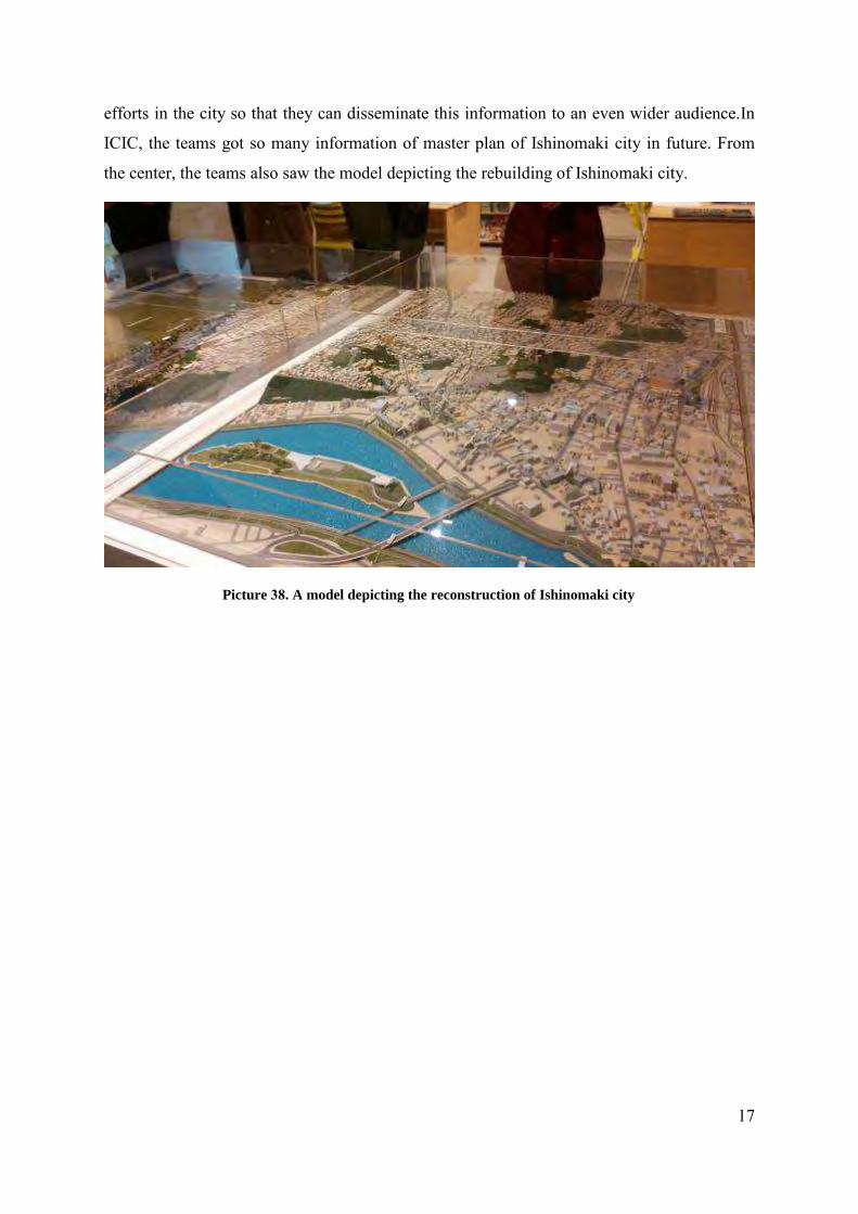
Before taking a dinner, teams visited the The Ishinomaki Community and Info
Center (ICIC). At this visit, Dr. Eng. Akira Miyasada accompanied the teams, and he was the
Director of Machi-Communication NPO. ICIC is a facility designed to inform & educate both
local residents and visitors from further afield about the progress of ongoing reconstruction
16
17
efforts in the city so that they can disseminate this information to an even wider audience.In
ICIC, the teams got so many information of master plan of Ishinomaki city in future. From
the center, the teams also saw the model depicting the rebuilding of Ishinomaki city.
Picture 38. A model depicting the reconstruction of Ishinomaki city

18
Day 4. (20th December 2015): Observation of the Great East Japan Earthquake disaster area second day.
After spend the night in Japan traditional hotel, in the morning, the teams went to
Watanoha relocation area. In this area, the teams saw the typical of houses that build by
thevictim of thetsunami.
Picture 39. The typical of tsunami victim houses in Watanoha District
After visited the relocation area of tsunami victims, the teams continue to see the
development progress in econimical factor. The teams visited the fish processing factory in
Onagawa that rebuilds after march tsunami. This factorybecomes the spirit of Onagawa to
build back better. This factory also as the evidence of Onagawa people main municipal
building plan “Stay, return and come to live in Onagawa”.
Picture 40. Fish Processing Factory in Onagawa Districtand the sampel of product

19
From the fist processing factory, the teams went to higher tsunami inundation area in
Onagawa. We visited Onagawa hospital car park where the tsunami hit the hospital even
though the hospital took place onhigher ground. This area becomes the high tsunami
inundation due to the area stand in the narrow valley. This narrow valley will increase the
amplitude of tsunami because there are decreasing the width of water volume.
Picture 41. A view from the Onagawa hospital when the teams visited the area
Namita Village was the next trip after visited the Onagawa hospital. Namita villager
has two time experiences of thetsunami. From the interview with the community leader of
Namita village, he said that the old generation of Namita village has experienced Chili
tsunami. From the experiences, they haveestablished the evacuation zone to safe they life
from any tsunami. Now, this village was abandoned village but they they built the community
information center near the village. In community center, they also tried to make analocal
product, they used the slate (metamorphic rock) that sources in hill side of the village and
used it to make some souvenir and sell it to the visitor who came to the village. This souvenir
became one the attraction to attract anoutsider, and it will give benefit to the tsunami victim
in Namita village.

20
Picture 42. Interview withthelocal community in Namita village and the slate souvenir.
After visited Namita village and did some interview with local people, the teams had
another opportunity to interview with tsunami victim in Ogatsu village. In Ogatsu village, we
meet a young man who tells the story how he and his family survived from the tsunami.
Before thetsunami, he and his family and all people in Ogatsu village haveemergency plan
for atsunami. They also built the evacuation road and evacuation zone and higher area. After
theearthquake in April 2011, all villager escape to evacuation zone but the high of tsunami
reach the evacuation zone. Some people killed by in the area that they predicted as a safety
area, but the high of thetsunami at this time is unpredicted.
Picture 43. Interviewing with the victim of thetsunami in Ogatsu Village.

21
After theinterview this young man, we visited they old man tsunami victim who still
buildhis own house in effected area as shown in figure 57.His house was the historicalhouses,
and he want to keep this old house stand in thesame place even though in tsunami effected
area. Another reason why he want to build the house in the affected area is he want toshow to
another villager that they village still available to stay and build back better.
From the Ogatsu village, the team continues to visit the Okawa Elementary School.
There are many sadness stories in this elementary school because there are many students
killed by thetsunami and their body still missing. From the previous tsunami hazard map, this
school predicted stand in safety area from thetsunami. Because of this map, the students and
the teachers in this school did not escape to thehigher area beside the school. The tsunami
2011, just unpredictable, the students and the teacher who very courageous stand in safety
place were killed by thetsunami and many of their body did not found until now. In every
April 11, the people around the school conducted searching process of tsunami victim body
in the swarm area.
Picture 44. The Okawa Elementary School

22
Day 4 (21st December 2015): Visits Tokyo Fire Department Life Safty Learning
Center.
Before heading to Tokyo Fire Department, wegotoAsakusa (Sensō-ji). Asakusa is on
the north-east fringe of central Tokyo, at the eastern end of the Tokyo Metro Ginza Line
subway, approximately one mile east of the major Ueno railway/subway
interchange.Therewe boughta lot ofsouvenirsforour familyinIndonesia.
Picture 45. Asakusa
After atiredshopping at Asakusa, wecontinue to visitHonjo Life safety Learning
Center (Emergency Preparedness Center),here we can learn about how to prepare and be safe
in emergencies. Most popular attraction is watching a 3D earthquake movie, experience a
magnitude 7 earthquake, escape from burning building, smoke-filled apartment, home
appliancesthat have beenan adaptation tothe earthquake.
Picture 46. In front of Honjo Life safety Learning Center

23
Picture 47. Fire due toshort-circuitfrom the
electricchoke Picture 48. Earthquake simulation mechine
Picture 49. Food stocksforemergencies Picture 50. Home appliancesthat have beenan
adaptation tothe earthquake excampel for
wheellockingcabinets.
This is the last day of our trip. tomorrow morning we will return to Indonesia.
Thanks to the Japanese government has provided an opportunity to learn about the disaster
that happened in Japanthrough the Japan Society for The Promotion of Science
(JSPS)program.

24
LESSON LEARNED
There are so many lessons that can be learned on this activities, there are,
1. Visits to the Crisis Security and Management Research Center (CSMRC) Kagawa
University, made us understand how to contribute to the safety and security of Local
communities by developing advanced academic, technological and educational
research.
2. Nuclear technology is very useful, but if misused would be a source of disaster, so let
us work together with all our might for to elimination of nuclear weapons.
3. From Great East Japan earthquake and tsunami of 2011, we learned that many people
died because this disaster beyond scientific prediction. Many people in Miyagi
Prefecture assume they stand in safety place were swept away and killed by the
tsunami.
4. Mitigation and prevention approved have to initiate from people and government to
build back better. The re-building process should consider the next tsunami in future.
5. Miyagi Prefecture people have experienced many tsunamis, and this tsunami will
make their city become a resilient city.