indus water treaty: a geo political study
TRANSCRIPT
Indus Water Treaty: A Geo Political Study
THESIS
Submitted to the University of Kashmirfor the Award of the degree of
DOCTOR OF PHILOSOPHYIn
HISTORY
By
Raja Nazakat Ali
Under the Joint Supervision of
Prof. G.M. Khawaja Prof. Gulshan Majeed
UNESCO Madanjeet SinghINSTITUTE OF KASHMIR STUDIES
UNIVERSITY OF KASHMIRHAZRATBAL, SRINAGAR-190006
NAAC- Accredited Grade “A”2013

INSTITUTE OF KASHMIR STUDIESUniversity of Kashmir HAZRATBAL,
Srinagar–190006NAAC Accredited Grade “A”
Certificate
Certified that the present research work entitled Indus Water Treaty: A Geo
Political Study, submitted by Raja Nazakat Ali through the UNESCO
Madanjeet Singh Institute of Kashmir Studies (UMIKS) for the award of
the degree of Doctor of Philosophy in the discipline of History is an original
piece of research work. This research work has not been submitted fully or
partially elsewhere for the award of any other degree to the best of our
knowledge.
We recommend that the thesis be placed before the examiners for evaluation
for the award of the degree of Doctor of Philosophy.
Supervisiors
Prof. G.M.Khawaja(Supersisor)
Prof. Gull Mohd Wani
Prof. Gulshan Majeed(Co-supersisor)
Director

DECLARATION
I, Raja Nazakat Ali hereby declare that the thesis entitled Indus Water Treaty: A
Geo Political Study is submitted to the University of Kashmir through the UNESCO
Madanjeet Singh Institute of Kashmir Studies in partial requirement for the award
of Ph.D degree. It is genuine piece of research work conducted under the supervision
of Prof. G. M. Khawaja and Prof. Gulshan Majeed. This work does not contain
any piracy and has not been submitted to any other institution for any other
course/degree.
Raja Nazakat Ali

Dedicated to My Parents for their Love

Acknowledgements
All Praises be to Allah, The Most Compassionate and The Most Merciful.
On the completion of this research work, it gives me immense pleasure to
express my heartfelt gratitude to all those who have helped and encouraged me all the
way throughout the course of this research work.
First and foremost I want to thank my supervisors Professor Gulshan Majeed
and Professor G. M. Khawaja whose constant guidance and valued support enabled
me to complete this work. This work would not have been completed without their
encouragement and support. I am very thankful for their valuable guidelines, support
and timely suggestions propel my work. The gratitude I owe to them is deep and
sincere.
I am sincerely thankful to the Vice Chancellor, University of Kashmir, Prof.
Talat Ahmad for the interest and concern has shown for my work; I can never forget
the his words of encouragement and support. My thanks are also due to Prof. Gul
Mohd Wani, Director UNESCO Madanjeet Singh Institute of Kashmir Studies
(UMIKS) for the pains he took to help me to complete the thesis in time.
It is a pleasure to pay tribute to Madanjeet Singh (April 16, 1924-January 6,
2013) who provided me the opportunity and material means to full fill my academic
dream in Kashmir through the UNESCO Madanjeet Singh Institute of Kashmir
Studies (UMIKS).
I am very thankful to the South Asia Foundation (SAF) for giving me a
scholarship which made me enable to fulfill my research needs.
I express my gratitude to Professor Riyaz Punjabi, former Director of the
UMIKS. His care and support enabled me to complete this work. I must appreciate the
guidelines and encouragements shown by Professor Muhammad Ashraf Wani, (Dean
Faculty of Social Sciences) and Professor Shakil Ramshoo, in carrying out my
research work.
My special thanks go to my teachers Prof. Muhammad Ashraf Qureshi (d.
February 2, 2012) and Prof. Muhammad Yousuf Bukhari, Prof. Nusrat Nisar, Prof.
Khawaja Shakeel Ahmad, Dr. Khawaja Zahid Aziz, Dr. Syed Ali Raza and Dr.
Asghar Iqbal for their valuable input, support and encouragement.
I would like to thank my friends, Mr. Rafiq Ahmad Jaral and M. Sabir Thakar,
who lent themselves freely for me in the completion of this work. Credit is due to my
friends Mr. Passang Sherpa, Mr. Parsad Dharmasena, and Mr. Saifullah Reshi, Mr.

Mahmood-UL-Hassan Wani, Mr. Khursheed Ahmed Wani, Mr. Sameer Ahmed Bhat,
Ms. Nadia Mehar Din, Ms. Sanjeevi Manthrirathne, Ms. Sakeena Rathar, Ms. Mudasir
Amin, Mr. Javid Ahmed, Mr. Gaurav Bhattarai and Mr. Khan Touseef Osman.
I am thankful to Mr. Parvez Ahmed Pala, Mr. Arshad Hussain Bhat, Mr, Sajad
Ahmed Wani, Mr. Asif Ahmed, Mr. Alson Rasool, and Mr. Sajad Ahmed Padar, for
their timely support and also for making my stay in the hostel comfortable. I am
thankful to my roommates Mr. Riyaz Ahmed Mir and Mr. Zahoor Ahmed Itoo for
their valuable support. I should be falling in my duty if I do not mention the necessary
guidance, help and encouragement provided to me by the members and staff members
of Gani Kashmiri Research Scholars Inn. Mr. Javeed Ahmed deserves my sincere
thanks too, for moral support where I needed.
I am highly thankful to the staff members of Alama Iqbal Library, University
of Kashmir and other departmental libraries of, UMIKS, History, Political Science,
and Jammu University Library, Jammu. I am also thankful to the libraries of Pakistan
namely University of the Punjab Library Lahore, Government College University
(Lahore), Punjab Public Library (Lahore), International Water Management Institute
Library Lahore, Indus Water Commission Library Lahore, Water Management
Training Institute Library (Lahore), Quaid-I-Azam University Library (Islamabad),
Indus River System Authority Library (Islamabad), AJK Assembly Library
(Muzaffarabad), AJK University Library (Muzaffarabad).
I am greatly thankful to Professor Gulshan Majeed and his wife Madam
Nighat Parveen for their affection and attention, I received without much deserving it
and I will never forget their encouragement and love which made me feel at home in
Srinagar (Kashmir).
Lastly but not the least, I am indebted to my mother, father, sisters and
brothers for their love and encouragement and who initiated me into the challenging
world of academics. I am grateful to my brothers, Raja Muhammad Asif and Raja
Tahir Nawaz as they are the pillars of strength upon which my life is built. Heartfelt
thanks to the whole of my beloved family, which has been a source of joy and solace
for me all through the entire career.
Concluding with this thought, that more I reflect and go back on my past, the
more vividly do I feel my limitations and weaknesses, but I nevertheless endeavoured
to develop my potential and find appropriate means to actualize it.
This acknowledgment will be incomplete if I will not acknowledge the writers
from whose writings I have benefited most.
Raja Nazakat Ali

Abbreviations
ABBREVIATIONS
ADB
AF
BCM
CBDC
CBM
CENTO
BRBLC
IBDF
COA
CWC
ICA
ICOLD
IGBM
ILA
ILC
ICJ
IRSA
IWI
J&K
JKPDC
MAF
MOU
NE
NHPC
NWFP
Asian Development Bank
Acre Feet
Billion Cubic Meter
Central Bari Doab Canal
Confidence Building Measure
Central Treaty Organization
Bambanwali Ravi Bedian Link Canal
Indus Basin Development Fund
Court Of Arbitration
Central Water Commission
Irrigated Crop Area
International Commission On Large Dams
Indus, Ganges, Brahmaputra and Mehgna
International Law Association
International Law Commission
International Court of Justice
Indus River System Authority
Indus Water Treaty
Jammu and Kashmir
Jammu and Kashmir Power Development Corporation
Million Acres Feet
Memorandum Of Understanding
Neutral Expert
National Hydro Power Corporation
North West Frontier Province
Abbreviations
PIC
PPC
ROR
SAARC
SEATO
UBDC
UN
UNDESA
UNDP
USA
TVA
WAPDA
Permanent Indus Commission
Punjab Partition Committee
Run-Of-River Project
South Asian Association for Regional Cooperation
South East Asia Treaty Organization
Upper Bari Doab
United Nations
United Nations Department of Economic and Social Affairs
United Nations Development Projects
United States of America
Tennessee Valley Authority
Water and Power Development Authority
WB World Bank

CONTENTS
Chapter No. Chapters Page No.
Certificate
Declaration
Acknowledgement
Abbreviations
Abstract i-ii
1. Introduction 1-28
1.1. Relevance of the Study
1.2. Research Method and Sources of Data
1.3. Literature Review
8
9
10
2. Water Conflicts in South Asian Sub-Continent 29-46
2.1. Geo-Political Overview of South Asian Sub-Continent
2.2. Water Resources of South Asian Sub-Continent
2.3. Water Disputes between various Countries of South
Asian Sub-Continent
2.3.1. Water dispute between India and Pakistan
2.3.2. Water dispute between India and Nepal
2.3.2.1.a. Origin of the dispute
2.3.2.1.b. History and factors leading to the treaty:
2.3.2.1.c. The Mahakali Integrated Treaty, 1996
2.3.3. Water dispute between India and Bangladesh
2.3.3.1.a. Origin of the dispute
2.3.3.1.b. Attempts to settle the dispute
2.3.4. Cooperation between Bhutan and India over
Water
Conclusion
29
32
34
35
36
36
36
38
40
40
42
44
46
3. Geographical Profile of Indus Basin 47-70
3.1. Location of Indus Basin
3.2. Physiography of Indus Basin
3.3. The Indus River
3.4. The Jhelum River
3.5. The Chenab River
47
48
49
53
57

3.6. The Ravi River
3.7. The Beas River
3.8. The Sutlej River
3.9. The Kabul River
3.10. Climate of the Indus Basin
Conclusion
59
60
61
63
64
69
4. Historical Background of the Indus Water Treaty 71-104
4.1. Water Resource Development in the Indus Basin: A
Historical Perspective
4.1.2. Water resource development in the Indus Basin
during Sultanate period
4.1.3. Water resource development in the Indus Basin
during British period
4.2. Origin of Water Dispute over the Indus Basin
4.3. Development of Water Disputes in Pre-Partition Period
4.3.1. Punjab-Sindh dispute over water
4.4. Dispute over the Construction of Bhakra Project
4.4.1. Issues involved in shaping the water dispute
4.5. Independence and the Creation of Two Countries
4.5.1. Immediate Consequences of Partition
4.5.2. New geopolitical boundary across the Indus Basin
4.6. Water Dispute and Negotiation Process from 1947 to
1950
4.7. External Intervention for Water Dispute Management
4.7.1. David Lilienthal suggestions for water dispute
management
4.7.2. Role of World Bank in water dispute management
4.7.3. Road to the settlement of the dispute
Conclusion
71
73
76
79
80
80
82
84
84
85
87
87
95
95
96
97
102
5. Indus Water Treaty: From Conciliation to Confrontation 105-140
5.1. The Indus Water Treaty 1960
5.1.1. Provisions Regarding Eastern Rivers
5.1.2. Provisions Regarding Western Rivers
105
108
109

5.1.3. Provisions Regarding Eastern and Western Rivers
5.1.4. Principles of Cooperation between the Parties
5.1.5. Dispute resolution mechanism and Permanent
Indus Commission
5.1.6. Principle of financial provision and Indus Basin
Development Fund
5.2. Implications of the Indus Water Treaty
5.2.1. Development of Indus Basin in India
5.2.2. Development of Indus Basin in Pakistan
5.3. Negative Implications of the Indus Water Treaty
5.4. Confrontation over the Use of Indus Rivers Water
5.4.1. Existing Disputes over the Share of Indus Basin
after the Treaty
5.4.1.1. The Tulbul Navigation Project (Wullar
Barrage) Dispute
5.4.2. The Baglihar Project Dispute
5.4.3. The Kishanganga Project Dispute
5.5. Reasons for Differences over Projects
5.6. Kashmiri concerns over projects on the Western rivers
5.7. Water Conflict and India-Pakistan Relations
Conclusion
109
110
111
112
114
114
116
118
120
120
122
124
128
134
135
136
140
6. Jammu and Kashmir vis-à-vis Indus Water Treaty 141-174
6.1. Introduction of Jammu and Kashmir State
6.2. Indus Water Treaty and J&K State Perspective
6.3. Hydropower Sector
6.3.1. Issues and Challenges for Generating Hydropower
Potential
6.4. Irrigation
6.5. Utilisation of Water Resources in Azad Kashmir (AK) or
Pakistan Administrated Kashmir (PAK)
6.5.1. Mangla Dam and its consequences
6.5.2. Mangla dam and rights over water as a source of
tension between Islamabad and Muzaffarabad
141
142
146
147
154
161
163
165

6.6. Water Rights of the State of Jammu and Kashmir
6.7. International Water Law/Conventions and Rights of
J&K State
6.8. Regional Disparity
Conclusion
166
170
171
173
7. Indus Water Treaty and its relevance to
Water Management Principles
175-194
7.1. Introduction
7.2. Indus Water Treaty and its relevance to other
internationally recognised rules, conventions and
treaties/agreements
Conclusion
7.3. Contemporary Issues and Challenges to the Treaty
7.3.1. Decreasing quantity of water and the issue of
climate change
7.3.2. Differences over Water Utilisation
7.3.3. Claims from Jammu and Kashmir
7.3.4. Pressures from Outside
7.3.4.1. Kabul River Problem
7.3.4.2. Chinese Question
7.4. Way Forward
7.4.1. Joint endeavours in environmental studies
7.4.2. Internal Water Management
7.4.3. Indus Basin Development Organization
7.4.4. Peacemaking Initiatives over Indus through Track
II diplomacy
7.4.5. Joint Management of the Indus Basin
175
176
185
186
186
187
188
188
188
189
190
190
191
191
92
193
8. Conclusion 195-200
Bibliography 201-210
Appendices i-xx
(a) Indus Water Treaty
(b) Water Conflict Chronology 1947 to 1960
(c) Water Conflict Chronology 1960 to 2010

Abstract
i
outh Asian sub-continent is a geographical unit sharing three major river basins
viz. the Indus, the Ganges and the Brahmaputra, buttressing the social, cultural,
economic and political fabric of the lives of some 1.6 billion people. Complex
orientations of the rivers and competition for water have however construed grave
disputes among the riparian states of the region. Albeit many Memorandum of
Understanding (MoU) and treaties such as, the Indus Water Treaty the Mahakali
Treaty and the Ganges Treaty were signed to resolve the water disputes. However the
recent years have witnessed a fierce competition over water resources that has
emerged as a medium for articulating perilous territorial, political, economic and
hydrological disputes.
The present study Indus Water Treaty: A Geo Political Study, deals with the
comprehensive analysis of Indus Water Treaty through its historical, geographical,
political and economic perspective qualitatively.
The present work endeavours to locate the water dispute between India and
Pakistan, in the aftermath of partition, in its history, and tries to understand the
relevance and strength of the major arguments put forward by the parties concerned in
their defence. Water has almost always been a bone of contention among the
shareholders. The examination of the genesis of the dispute leads us to the British
colonial interests to develop Punjab as the food bowl of India and creating a canal
system to boost agricultural sector. But the difference in the supply of water which the
riparians received, created disputes over share of water.
Most of the conflicts were resolved through mutual understanding, but in
1947, the partition of canals created the international water dispute between India and
Pakistan. To resolve this issue, numbers of agreements were signed, meeting the
claims of the countries involved, to share water, which in turn provided some basis for
dealing with the issue; but the issue remained unresolved for some time and attracted
the attention of the international community. In 1951, David Lilienthal visited the
sub-continent and offered a negotiation through the donor agencies to resolve the
S
Abstract
ii
conflict. Subsequently, negotiations were carried through the good office of the World
Bank. Finally, after 9 years of discussions and conciliatory approach by the parties
concerned, a landmark agreement—the Indus Water Treaty—was signed in 1960 with
the help of the World Bank.
The treaty sets out a framework to utilize the water of Indus Basin. As per the
statutes of the treaty, Pakistan shall receive unrestricted use of water of the Western
Rivers including the Indus, the Chenab and the Jhelum, while India shall use all the
water of the Eastern Rivers—the Ravi, the Sutlej and the Beas. The Indus Water
Treaty is one of the exceptional treaties of the world signed under the aegis of the
World Bank that provided financial and technical assistance for durable peace and
harmony in sub-continent through donor countries. Any reflection on other
transboundary water management principles shows that it is an exemplary water
conflict agreement which provided an exemplary mechanism for transboundary water
conflict management.
The treaty worked reasonably well despite the strained political relationship
between the two countries. But for the last two decades the treaty has fundamentally
come under stress on water utilization. The treaty is in difficulty due to the simple
reasons of uncertain climatic pattern, population growth and economic development,
more and more energy needs, increase in irrigated areas and amidst calls for its
modification.
The present work has also incorporated the dissenting voices from both India
and Pakistan, which depict the dissatisfaction with the Indus Water Treaty and
demands for its modification. The study also highlights the presumed restrictions
placed by the Indus Water Treaty on the Western Rivers which are supposed to
deprive Jammu and Kashmir State of its genuine water benefits by way of
hydroelectric power and irrigation as the upper riparian state.

Chapter - 1
Introduction

Chapter - 1 Introduction
1
istory is witness to the fact that civilizations have evolved around and/or across
the rivers. The earliest civilizations, such as Mesopotamia, Egypt and Indus
evolved and were nourished along the banks of the Tigris, the Euphrates, the Nile and
the Indus River. These rivers have served as catalysts for cooperation between nations.
Unfortunately, the scarcity of water in all the respective regions, previously served by
these rivers, has turned the coin to the other side, i.e. from cooperation to
confrontation. These basins have become the bone of contention for many a nations,
especially to those in the arid regions and contributed to their instability and mutual
distrust. The increasing demand and thereby competition for shared water has led to
many international conflicts, political instability and even acute violence in some
regions.
Water conflict is not a new phenomenon, even in the ancient times there are
many examples of inter-state conflicts over water. The earliest known inter-state
conflict over water took place around 2500—2350 BCE between the Sumerian states
of Lagash and Umma along the Tigris River.1 There are many other instances of direct
and indirect conflicts over water. But from the last century water became a contentious
issue and a source of acute conflicts. Many scholars are of the opinion that increasing
demand, decreasing quantity and climatic variability, causing scarcity of water, may
lead to acute water conflicts and so may intensify political debates among the users. In
addition to this, Peter H. Glick (1993) contended that as we approach the twenty first-
century, water and water-supply systems are increasingly becoming objectives of
military action, the instruments of war and silent elements of interstate politics. As
1 The dispute over the ‘Gu-edena’ a region of Urlama, King of Lagash (2450- 2400 B.C.E) divertedwater from this region to boundary canals, drying up boundary ditches to deprive Umma of water.His son King II cuts the water supply to Girsu, a city of Umma. Therefore, a dispute occurredbetween the two states of Lagash and Umma. (Peter H. Gleick, Water Conflict Chronology”,Pacific Institute for Studies in Development, Environment, and Security, (November 2009):1,<http//www.worldwater.org/conflict/> (accessed August 21, 2010).
H
Chapter - 1 Introduction
2
human population grows, lifestyle changes, and with it, the demand for fresh water
and climatic variability make water supply and demand problematic and uncertain.2
Presently there are about 263 transboundary lakes and rivers which cross the
international frontiers, covering one-half of the land of the globe and affecting about
40 percent of the world's population.3 The world’s population is increasing by about
eighty millions per year, thereby increasing fresh water demand of about 64 billion
cubic metres annually.4 Usually water scarcity arises when a country’s annual water
supply dips below seventeen hundred cubic metres per person. When this reaches a
level between seventeen hundred and one thousand cubic metres occasional water
scarcity is likely to occur.5 In such a situation the scarcity of water is becoming the
cause of dispute among users, especially on shared river basins.6 It is pertinent to
mention here that both India and Pakistan are dependent on shared rivers and are fast
approaching to the status of water scarce countries. Both the countries per capita water
availability is estimated to decrease to less than one thousand and seven hundred cubic
metres per person by 2025 respectively.7
Disputes over water arise when a stakeholder of the shared water system
attempts to utilise its share of already decreasing water supply and the other members
are likely to respond desperately. At the same time, any effort by upstream countries to
store the river water or otherwise control its onward flow is almost sure to produce
concern and hostility with and among the downstream states.8 This geographical fact
has led to many geopolitical disputes over shared waters of the Nile, the Jordan, and
2 Peter H. Gleick, “Water and Conflict: Fresh Water Resource and International Security,” Journalof International Security Vol. 18, no.1 (1993):79.
3 Aaron. T Wolf, et al., “International River Basins of the World.” Journal of Water ResourcesDevelopment, Vol. 15, no 4 (December 1999): 387-427.
4 The United Nations World Water Development Report 3: Water in a Changing World, (UnitedKingdom, 2009): 29. <http://www.unesco.org/new/en/natural-sciences/environment/water/wwap/wwdr/wwdr3-2009/> (accessed March 13, 2012).
5 Paul J. Smith and Charles H. Gross, “Water and Conflict in Asia,” A Seminar Report, Asia-Pacific Centr for Security Studies (APCSS), (September 17, 1999): 1. <http://www.apcss.or g/Publications/Report_Water&Conflict_99.html/> (accessed March 2, 2012).
6 Ramaswami R. Iyer, Towards Water Wisdom: Limits, Justice, Harmony (New Delhi, SagePublications, 2007), 18.
7 Shaheen Akhtar. S, “Emerging Challenges to Indus Waters Treaty: Issues of Compliance andTransboundary Impacts of Indian hydro projects On the Western Rivers,” (Islamabad: Institute ofRegional Studies, 2010).
8 Sandra L. Postel, Aaron T. Wolf, “Dehydrating Conflict.” Journal of Foreign Policy, no. 126(September 2001): 60-67. <http://www.Globalpolicy.org/component/content/article/198/ 40343html/> (accessed March 5, 2011).

Chapter - 1 Introduction
3
the Euphrates rivers in the Middle East; the Indus, the Ganges, and the Brahmaputra
rivers in the South Asian Sub-Continent. The South and South East Asian countries
like China, India, Pakistan and Bangladesh are heavily dependent on fresh water
supply for subsistence. Since the demand is more than the supply in this region, it
creates national and international disputes over the utilisation of water.
On the other hand, there is also an impressive history of water dispute
resolution and a good number of scholars, policymakers and politicians summarise
that water is also a catalysts for cooperation, as number of transboundary rivers have
favoured cooperation over conflicts. It is true that water is becoming a scarce resource,
but it does not mean that scarcity always leads to disputes. Political motivation,
economic development and the role of inter-regional and intra-regional institutions
could play a significant role to resolve the water disputes between users.9 Most of the
water disputes are negotiable, though few have witnessed sharp conflicts during the
last five decades in the world. As per the report of United Nations Department of
Economic and Social Affairs (UNDESA), 157 treaties and agreements were negotiated
and inked, 10among which the Indus Water Treaty, signed between India and Pakistan,
is one of the best examples of water conflict resolution.11
South Asian sub-continent comprises countries of Afghanistan, Bangladesh,
Bhutan, India, Nepal and Pakistan, (also called as the countries of the Himalayan
block).12 It is a region of both abundance and scarcity of water. In terms of water
abundance, the region is fed by the Hindu Kush-Himalayan mountain system, which
constitutes one of the largest storehouses of fresh water in the world. The four major
river systems including, the Indus, the Ganges, the Brahmaputra and the Mehgna,
originate from the Hindu-Kush Himalayan mountain system. Flowing through
9 The Indus Basin dispute resolution is an example to support this view, where above mentionedactors were actively involved to resolve the water dispute. Similarly, the Mahakali Treaty betweenIndia and Nepal and Ganges Treaty between India and Bangladesh has also enriched the history ofdispute resolution in the sub-continent.
10 Transboundary Waters, International Decade for Action “Water for Life 2005-2015” UnitedNations Department of Economic and Social Affairs (UNDESA).<http://www.un.org/waterforlifedecade/transboundarywaters.shtml/> (accessed August 3, 2012).
11 A. Carius, G. D. Dabelko, and A. T. Wolf, “Water Conflict and Cooperation,” (1998). <http://int.wilsoncenter.dev6.fayze2.com/sites/default/files/CariusDabelkoWolf.pdf/>(acessed March 21,2010).
12 Salman M. A Salman and Kishor Uprety, Conflict and Cooperation on South Asia’s InternationalRivers: A legal Perspective (Washington D.C: The World Bank, 2003), 5.

Chapter - 1 Introduction
4
different regions and valleys such as the Indus Valley, Damoder Valley, and Kashmir
Valley, etc., water from these rivers is available in plenty to the inhabitants. But in
terms of water scarcity, there are some regions such as deserts of the Rajasthan in
India, Cholistan and Thar Desert in Pakistan which face severest water scarcity.
Meanwhile, on developmental lines, these four major river systems traversing different
states present a challenge of water management as the interests of the states are at
variance.
The water resource is a key to agriculture, hydropower, and other economic
activities in South Asia elsewhere. As economies grow, the lifestyle of people
typically begins to include an overuse of water, and people’s good living standard
intensifies the demand for water. When there is a negative relation between the
demand and supply, conflict over sharing of water is certain, and a situation like this
calls for judicious management. Geographically, South Asian countries are spread
over unique landscapes and are dependent upon transboundary shared rivers. The
transboundary rivers and their utilisation present geopolitical challenges for
management. In the past, the management of traversing rivers in the region has been
remained a conflicting issue. Various disputes occurred between the stakeholders over
the utilisation of shared rivers which resulted some agreements and treaties, such as
Indus Water Treaty, Mahakali Treaty and Ganges Treaty.
The Indus River with its five tributaries is one of the great river systems of the
world, which remained an important source for agriculture development. Since times
immemorial, good irrigation techniques have been practised to produce sufficient
agricultural production on the alluvial plain of the Indus River, which also nurtured the
later empires within the Indus Valley.
The development of water received considerable attention when Delhi
Sultanate was established. Different methods and techniques were introduced to
develop new irrigation system and to enhance agricultural yield. Later, the Mughal
emperors also developed the Indus Basin with new horizons. Large canal systems,
weirs, and tanks were developed to provide the water supply to agricultural lands.
Extensive integrated and perennial canal systems were put into practice in the Mughal
time.
Chapter - 1 Introduction
5
The sophisticated change started when British Business Company (East India
Company) settled in the sub-continent. With the start of British rule, the British
administration implemented several schemes to utilise the wealth of waters of the
Indus Basin to produce surplus agriculture and to increase their revenue.13 In order to
achieve this, vast canal structure was laid in the middle of 18th century, through local
and provincial bodies.14
However, being attracted to the production and revenue resulting from
agricultural lands, provincial bodies came to compete for share of water for irrigation
which led to the disputes at inter-state and intra-state level. There various disputes
occurred between Punjab and Sindh over the share of water from Sutlej and Beas
rivers, but a number of meetings and commissions set up by Central Government,
couldn’t find a resolution, as agriculture lands and irrigation system were expanding,
population was growing leading to increase in demand for water. Before the provinces
could reach a final agreement India was partitioned in 1947 into two states of India
and Pakistan.
In 1947, after the creation of two independent states of India and Pakistan,
problems arose over the utilisation of canals and water resources. The boundary line,
known as the Redcliff line, cut off the Indus canal system from head-works. Many of
the canal head-works such as Upper Bari Doab Canal (UBDC) and Sutlej Valley Canal
remained in India (East Punjab) while the lands being irrigated by their waters fell in
Pakistan (West Punjab). India as upstream user of the three eastern rivers claimed
sovereign riparian rights and stopped water supply to Pakistan in 1948, which
engendered the water dispute between India and Pakistan.
In December 1947, an inter-dominion agreement was made between India and
Pakistan to maintain the supply of water to Pakistani canals. However, with the expiry
of the agreement on March 31, 1948 the East Punjab shut-off the water supply to West
Punjab which fuelled excessive degree of animosities between the two nations.
Pakistan protested against the stoppage of water which eventually led to an Interim
13 Lahore Irrigation Department: Managing Irrigation for Environmentally Sustainable Agriculturein Pakistan, Case Study of the Punjab, Report no. 12 (Lahore: Irrigation Department, 1998): 2.
14 Salman M. A Salman and Kishor Uprety, Conflict and Cooperation on South Asia’s InternationalRivers: A legal Perspective (Washington D.C: The World Bank, 2003), 38.

Chapter - 1 Introduction
6
Agreement on May 4, 1948 and both countries agreed to recognize and respect the
each other’s needs for water. Though the agreement was not considered as the
permanent solution, it still provided some temporary basis for dealing further with the
vexed problem. The agreement fell apart when both the countries could not resolve
their differences over Sutlej River. Pakistan as a lower riparian, challenged the
agreement, in a bid to secure its rights it said that the aforementioned agreement was
signed under duress and called for the equal apportionment of all common waters by
the involvement of International Court of Justice.15 But India opted to resolve the
dispute by mutual understanding instead of taking recourse to the third party
involvement. However, discussion over the share of water reached a deadlock by the
end of 1950.
In 1951, David Lilienthal, visited India and Pakistan, and suggested some
mechanism to manage the Indus Basin by joint control.16 It was after David
Lilienthal’s suggestions17 that the World Bank decided to offer the negotiation to
resolve the dispute between the two countries. The negotiation started in 1951
between the two countries under the supervision of the World Bank which lasted for
almost nine years until an agreement, the “Indus Water Treaty” was formally signed
on 19 September 1960. The treaty was inked by Jawaharlal Nehru, the Prime Minister
of India, Muhammad Ayub Khan, the President of Pakistan, and W.A.B. Iliff of the
World Bank.18
As per the treaty, the use of the western rivers, namely the Indus, the Chenab
and the Jhelum, was assigned to Pakistan, with a provision for limited volume of
water from these rivers for India’s consumption,19 while the waters of the eastern
rivers, the Ravi, the Sutlej and the Beas, which constitute 19 percent of the overall
15 Asit K. Biswas, “Indus Water Treaty: the Negotiation Process,” Journal of Water InternationalVol. 17 (1992): 203.
16 Aloys Arthur Michel, The Indus Rivers: A Study of the Effects of Partition (London: YaleUniversity Press, 1967), 222-23
17 (i) The whole Indus Basin must be developed as a unit—designed, built and operated as a unit asin the seven-state TVA system back in the United States;
(ii) International financing be arranged, perhaps by the World Bank, to fund the work and Indusengineering corporation be founded;
(iii) Representatives are included from both countries as well as from the World Bank;(iv) Greater storage facilities and cooperative management be implemented.
18 Shaista Tabassum, River Water Sharing Problem between India and Pakistan: Case Study of IndusWater Treaty (Colombo: Regional Centre for Strategic Studies, 2004), 24-25.
19 Indus Water Treaty 1960, Article III
Chapter - 1 Introduction
7
supply of the Indus Basin, was exclusively available for India.20 Among other
components, the treaty also included a dispute-resolution mechanism that relies
primarily on bilateral mechanisms; it also possesses a provision for comprehensive
external apparatus, in case agreement could not be reached bilaterally. The treaty
provided a transitional period of ten years to enable Pakistan to undertake the
replacement of works on Western Rivers, through the international financial
assistance. The financial assistance made by the World Bank, which was received
from some of the friendly countries, and India also facilitated the agreement.
The Indus Waters Treaty is widely considered one of important water treaties
of the world. The World Bank thus helped the Twine countries to work as far as
possible in an environment of peace and harmony. The World Bank being a signatory
to the treaty made commitments of its own for tasks specified in Article V and X as
well as Annexures F, G and H.21 The treaty is unusual in three dimensions: its origin,
the water allocation mechanism and its integration of previously established norms in
customary international water law.22 Hence, the treaty and its water sharing
mechanism have been appreciated, despite 50 years of experience—surviving in bitter
political relations including three armed conflicts between the two countries.
Although the treaty has been an emblem for maintaining water dispute, but
past one and half decades are evidence that the treaty has been under stress. The
simple reason is the altered necessities of the two countries. The treaty allows India to
tape water for run-of-the river projects, on western rivers—Chenab, Jhelum and
Indus. However, India has constructed many projects on western rivers, which
Pakistan claims to be the violation of the treaty and considers it a threat to her
economic security. India says that the construction is endorsed by the treaty and all
projects are within the limitations of the treaty’s criteria.
The Indus Water Treaty is considered by large number of experts as one of the
best examples of cooperation, but it is often criticized by the public of India and
Pakistan as the unfair deal of the treaty is unfair. Critics in Pakistan argue that the
20 Indus Water Treaty1960, Article, II.21 Indus Water Treaty 1960, (see in appendix a).22 Mary Miner et al, “Water Sharing between India and Pakistan: a Critical Evaluation of the Indus
Water Treaty,” Journal of Water International Vol. 34, no. 2 (June 2009): 206.
Chapter - 1 Introduction
8
country has lost its three eastern rivers to India. Whereas, critics in India argue that the
Indus Water Treaty is in favour of Pakistan as it gives eastern rivers to India, which
contain only 20 percent of the basin flow and three major western rivers to Pakistan
which contain 80 percent water of the basin. Apart from the common opinion, the
reaction of media, academicians and farmer communities from both the sides raise
their figures against the Indus Water Treaty.
The three Western Rivers of the Indus basin flow through the disputed State of
Jammu and Kashmir.23 This is also one of the causes of concern which questions the
integrity of the treaty, because the restrictions placed by the treaty on the western
rivers make the State virtually impossible to be benefitted to a large extent by way of
hydropower generation and irrigation. The Jammu and Kashmir Government has
raised strong voice against the treaty as it does not take care of the interests of the
State. The treaty was agreed upon by both the parties keeping their own interests in
view without considering the interest of the people of the State; it has divested Jammu
and Kashmir of its inherent rights over its own water resources. Perhaps the Indus
Water Treaty has become one of the reasons behind the alienation of people who feel
betrayed by the signatories of the treaty.
1.1. Relevance of the Study
Since the partition of India and Pakistan, water is a focal point between the two
countries, more notably for Pakistan, for its high dependency on water. As a lower
riparian nation Pakistan is more sensitive to water issues. This sensitivity is the main
reason for its confrontation with India on various issues. In this connection the present
study tries to go through the genesis of water dispute between the two countries, and
follows the subsequent development to draw profitable conclusion. It further sees how
the water dispute was settled under the ages of the World Bank and the Indus Water
Treaty signed.
The study also looks into the water developments after the Indus Water Treaty,
and also examines the contemporary issues to the treaty which occurred from various
reasons. The study is a significant step to contribute in the way of water dispute
23 Total area of divided State of J&K is about 84,471 Square miles, of which 39,160 Square miles areIndian Administrated, 33,513 Square miles are Pakistan Administrated and 11,798 Square milesare under Chin’s occupation.

Chapter - 1 Introduction
9
resolution vis-à-vis Indus Water Treaty. It is also pertinent to know the nature of water
disputes in the region, and develop appropriate arguments and approach to harness the
water resources which meets the aspirations of main stake holders of the Indus Basin.
1.2. Research Method and Sources of Data
The present study is based on qualitative information and research methods and tools
for the study. Qualitative research consists of methods and techniques which cannot be
quantified; lack of quantification may be due to the small sample or unique
occurrences. It is more related to the phenomenon in perspective. Qualitative research
has largely been accepted by a number of scholars and treated as and considered the
best to examine at hand. It has many types of methods such as observations and
interviewing and content analysis which i have tried to adopt in my thesis.
The study examines the Indus Water Treaty between India and Pakistan. To
achieve the objectives of the study, data and information were collected from both
primary and secondary sources. Primary information were collected from the different
offices including discussion with various historians, geographers, economists, political
scientists and water resource experts working on issue.
Secondary sources of information collected from published and unpublished
books, research reports, journals, articles and leading international and national
newspapers. Most of the secondary information was collected from various libraries
such as University of the Punjab (Lahore), Punjab Public Library (Lahore), Quaid-I-
Azam University Library (Islamabad), Azad Jammu and Kashmir University Library
(Muzaffarabad), AJK Assembly Library (Muzaffarabad), Department of Kashmir
Studies Library (University of the Punjab), International Water Management Institute
Library (Lahore). In India various libraries have been consulted for collection of data
which includes Panjab University (Chandigarh), Punjabi University (Patiala) and in
Jammu and Kashmir State, University of Kashmir (including various departmental
libraries) Sher-e-Kashmir Agriculture University, and Jammu University Library. The
data and information collected from the different sources were analysed and presented
in a logical and systematic manner. This research work has been written in a very
simple and lucid style and is presumed to make the study comprehensive and
understandable.

Chapter - 1 Introduction
10
1.3. Literature Review
The present work deals with the Indus Water Treaty between India and Pakistan, with
the main objective of understanding the problem through published, unpublished
literature regarding the research topic, “Indus Water Treaty: A Geo Political Study”
Although, there is a good amount of research works published on international river
basins and water conflicts but our effort will entail to review the relevant literature
over the topic, which comprise:
Text and reference books.
Research papers, published in National and International journals.
National and International newspapers and magazines.
Doctoral thesis, dissertations and reports.
Speeches and public opinions on issue.
Books
N.D. Gulhati,
Indus Water Treaty: An Exercise in International Mediation (Bombay: Allied
Publishers, 1973) the book deals comprehensively with Indus water basin, its history,
physical feature, climate of the basin and importance of the water for India and
Pakistan, disputes over share of water in pre treaty era, settlement of dispute through
third party mediation, satisfaction and dissatisfaction of two countries, water laws and
regional politics over water. The writer highlights the importance and development of
Indus Basin through systematic contemplation. Talking on the partition and water
dispute between India and Pakistan, he claims Sir Cyril Red Cliff boundary line has
left many yet uncompromised disputes between the two new born states, of these
water is one of the contentious disputes. He further provides detailed accounts of the
Indus Basin negotiations, describing how India and Pakistani engineers with World
Bank facilitator, developed an enormously complex plan for parallel energy
production infrastructures. N.D Gulhati in his conclusion appreciates the abilities of
the parties to frame the issue as a technical problem, which enabled those who, “speak

Chapter - 1 Introduction
11
the language of the joint management of the rivers”, to make progress where
politicians could not.
Bashir A. Malik,
Indus Water Treaty in Retrospect (Lahore: Brite Books, 2005) the book deals
comprehensively with the geographical settings, climate, water flow, irrigation, and
distribution of water and canal system. In its introductory part, the author praises the
Pak Punjab irrigation system as not only greatest but unique too. The author however,
laments the effects of partition and the impact of Indus Water Treaty. The Indus water
system, which subsequently came up, suffered by weak management and so
aggravated the problems of the people concerned. Hence he calls it a sick system. The
author raises his finger against partition of Punjab and Bengal Provinces as not part of
the original plan and also on the manner in which partition was so hurriedly done in
mere 73 days.
The author highlights the Indus Water Treaty which despite all its tall and
pious promises and projections proves a bane than anything of bliss for Pakistan. The
author states that the Treaty was meant for regional peace and settlement of Kashmir
issue, but has since taken tens of thousands of lives of Kashmiris. The book fails to
provide details how this treaty was going to settle Kashmir issue or how it was going
to bring regional peace without giving them genuine share of their water resources.
The author has not mentioned the losses suffered by Jammu and Kashmir because of
Indus Water Treaty. However, this book provides useful knowledge on the topic but
lacks in exhaustive and dispassionate treatment.
R. K. Arora,
The Indus Water Treaty Regime (New Delhi: Mohit Publications, 2007) the author
records that the dispute on the Indus waters began long before the independence of
India and Pakistan. The dispute started in the form of inter-state differences between
the Punjab, Sind, Bahawalpur and Bikaner. In 1947, after the partition of India, the
dispute became an international issue and was exacerbated by the fact that the
political boundary between the two countries was drawn right across the Indus basin.
The author emphasises that although the original treaty called for cooperation in the
planning and development of the river, requiring joint planning but each of the states

Chapter - 1 Introduction
12
utilizes its water resources individually and there is no basin-wide joint management
of the Indus.
According to the author the present root of the problem, lies in the lack of
harmony between the interests of Pakistan and Jammu and Kashmir. On the one hand,
Pakistan needs to build dams to divert water flows to Punjab and Sindh; on the other
hand, J&K needs to come out of the Indus Water Treaty to improve its own irrigation,
hydro-electricity and employment prospects. The author confuses the readers as if
Jammu and Kashmir is an independent entity having direct conflict with Pakistan or if
it was a party to the Treaty. The author has not discussed the implications of this
treaty on J&K as he has discussed other issues like Chenab Formula and its effects if
signed.
The author talks about the alternative approach to the Indus Water Treaty issue,
which could be an integrated development plan for the conservation of the Indus Basin
and if jointly developed by both the countries, it would address the political
dimensions of the conflict in J&K. The author also highlights the contradictions as
well as vagueness of International Law.
Aloys Arthur Michel,
The Indus Rivers: A Study of the Effects of Partition (Yale University Press: 1967)
Michel’s book which consists of about 350 pages presents a comprehensive but
definitive discussion on the development of Indus Basin. He starts with the
development of irrigation infrastructure in the Indus Basin and claims that the
agriculture had a significant impact in shaping the economy. Especially the writer has
focused his intentions to explore the development during of British Government in
India. To support the economy, the Britishers constructed worlds’ extensive and
largest canal system in the Indus Basin. Therefore, they achieved valuable output from
the Indus plain. The author depicts agriculture development in the Indus plain and
designed engineering capabilities, led industrial growth and economic prospects all
over the sub-continent. In this process provinces and state bodies were side by side
with government, shaped the agriculture economy. The book serves admirably to
introduce the reader with the Indus Basin and developments and problems within it
prior to the Indus Water Treaty.

Chapter - 1 Introduction
13
In this book the writer unfolds the sad story of partition and its consequences
on two nations. The partition has disrupted well managed irrigation network, created
political and mental borders among the people involved. He depicts the post-partition
developments in very lucid manner but he did not give any proposal for future.
According to author, the location and topography of Indus Basin with its endowments
of soil make it so complex for any writer to predict future solutions because the Indus
Basin spread over the four countries which make it too difficult for any person to draw
definitive conclusion. The integrated canal system of unpartioned country had made it
too difficult to be divided between the two countries.
In regard to water dispute between India and Pakistan, the writer has brought
abundant measures, perceptiveness, sympathies and carefulness, to examine the
problem of water resources in the Indus Basin. Especially Michel’s documentation of
Pakistan’s difficult bargaining position on the Indus basin plan, his examination of
inter-regional disputes over water and his analysis of the political issues involved in
Indus Basin is remarkable. He is probably proud of the immense contribution of his
own countrymen the vital intervention of David Lilienthal, and by Eugene Black and
the World Bank; the seemingly inexhaustible generosity of the United States
Government and the high attainments of her engineers and technicians who were fully
involved during negotiations process. Moreover, he writes that, the conclusion of the
Indus water Treaty because the negotiations were “for water, rather than land or ego”
and were conducted, “in some secrecy by fair minded parties with a common vision”.
The book contributes sufficient knowledge on the topic but does not gives thorough
view of the subject especially on post Treaty development and their implications for
international water law.
Shaista Tabassum,
River Water Sharing Problem between India and Pakistan; Case Study of Indus
Water Treaty (Colombo: Regional Centre for Strategic Studies, 2004) deals with
the river water sharing issue between India and Pakistan. It describes the origin of the
problem and the gradual development of the issue. It also sees how the issue was
chalked later by India and Pakistan with World Bank mediation and concisely looks
into the irrigation system constructed after the treaty with the water sharing issue

Chapter - 1 Introduction
14
which arose after the signing of the treaty. Although it deals with the topic yet it lacks
required details and analysis of the facts. Moreover, it neither covers the international
water law and dispute resolution mechanism nor the current issue on water ratio
between India and Pakistan.
Trilochin Upreti,
International Watercourses Law and Its Application in South Asia (Kathmandu:
Pairavi Prakashan Publishers, 2006) presents a comprehensive review of the
revolution of water law over the century. While doing so, the author has also
attempted to outline the positive and negative aspect of international treaties on
boundary and Trans-boundary Rivers around the world. In this book, the author has
cited a profusion of examples of water disputes across the world and the way they
were attempted to be resolved. After doing a critical analysis of the four doctrines of
international water law viz, territorial sovereignty, territorial integrity, prior
appropriation and equitable utilization, he has considered the last doctrine as the best
one for it has wider acceptance among the international community. He is an ardent
supporter of the principal of equitable utilization as it would help to serve the interest
of the riparian states and resolve their disputes in a reconciliatory manner.
The concept of equity and the emerging concept of equitable utilization of
shared natural resources have been dealt with at length, citing judicature of the
international court of justice. The reader will get an opportunity to be acquainted with
numerous international treaties on water sharing, based on the principal of the
equitable utilization.
The book also elaborates the water availability and its potential uses in South
Asia for the economic development and environmental sustainability of the region. It
attempts to outline the problem and suggest the equitable utilization of rivers as
solution to them. Although it deals with water in details, yet it does not deal with Indus
water dispute, treaty and its legal implications.

Chapter - 1 Introduction
15
Salman M. A. Salman and Kishor Uprety,
Conflict and Cooperation on South Asia’s International Rivers: A legal
Perspectives, (Washington D.C: The World Bank, 2003) the book shares a
perspective that the shared rivers have become a focal point of conflict, as well as
catalysts for cooperation. This argument is true about South Asian sub-continent.
Some twenty major rivers run through it and the three largest basins, those of the
Indus, the Ganges, the Brahmaputra, affect not only the countries of sub-continent
(Bangladesh, Bhutan, India, Nepal and Pakistan) but China as well. Sharp seasonal
variations, such as monsoons, draughts and floods occurring in the territory of some
countries add to the difficulty of finding equitable and durable water sharing
arrangements in the other countries too.
The authors focus on the hydro politics of four countries of South Asian sub-
continent Bangladesh, India, Nepal and Pakistan. It also discusses the problems these
countries have encountered as riparian of international rivers and how they have
addressed them. In particular the study reviews the treaty management governing the
Indus basin, the Gangs river basin, the Kosi river basin and the Mahakali river basins.
Each of these treaties is dealt in-depth; special attention is paid to the main
problems of the treaties. The author has sought to address Indus water dispute with
respect to Ganges, and an integrated approach to water resource management for India
and Nepal. With respect to the Kosi, Gandak and the Mahakali rivers; the authors
review treaty experience and offer observation on bilateralism and multilateralism,
third party intervention, water rights and benefits, institutional arrangements and
dispute resolution. They conclude by stressing the importance of cooperation
throughout treaty making process.
Research Papers
P .D. Clift,
“A Brief History of Indus River,” Journal of Geological Society of London, (2002)
presents a brief historical review of Indus River, its course and scattered drainage from
Tibet to Arabian Sea. It also has examines the geological evolution of Indus River at
various stages and evaluates the old course of the Indus River and discusses how it has

Chapter - 1 Introduction
16
changed its course due to morphological and geological conditions. The writer
explains that the seasonal floods of the Indus River and its tributaries formed the land
and development of agriculture in the basin. Talking on the significance of its water
for the region, the author claims, that the Indus River is a main vehicle for millions of
people who directly or indirectly are dependent on its waters. The wide emerging issue
of its drainage are serious challenge for food security, its drainage system and ecology.
Although, this paper deals with geological history of Indus River but also gives
knowledge on its history from Indus Valley Civilization and its economic importance.
By this study we are able to understand the history of Indus River and importance of
its water. The writer has not discussed any dispute over its water or Indus water
Treaty.
Mary Miner, Gauri Patankar, Shama Gamkhar David J. Eaton and Lyndon B,
“Water Sharing between India and Pakistan: A Critical Evaluation of the Indus
Water Treaty.” Journal of Water International Vol. 34, no. 2 (June 2009)
discusses the Pakistan-India water conflict experience in the context of other
international shared river conflicts. Therefore, they suggest Pakistan and India should
coordinate and resolve issues rather than deferring them, for the benefit of both
nations. They also reveal that India and Pakistan can prevent future conflicts on Indus
River in the light of its historic and economic importance and their past experience.
The writers have done a good analysis of treaty relationship with international
water laws and treaties. Therefore, they suggest both countries to face common issues
together. The writers have made critical analysis of treaty in light of other trans-
boundary water principles and highlight that treaty does not provide mechanism to
address the future issues out of climatic changes, economic development, and
population growth. Therefore, both countries have to adopt emerging norms of trans-
boundary water laws. Finally the paper suggests the way forward for both parties to
modify or scrap and renegotiate the treaty. In order to resolve the dispute, the authors
have exemplified US-Mexico and Jordon-Israel water treaties to overcome the
conflicts and develop water resources of Indus Basin.
Moreover a little effort has been made to explore the impact of Indus Water
Treaty on Jammu and Kashmir State especially on its power sector. The provided data
Chapter - 1 Introduction
17
regarding power scenario in J&K is proving susceptible to authenticity because
probably it does not explore the adverse impact of Indus Water Treaty on energy crisis
of the state. Further this work minutely gives us the perceptions of the people of J&K
regarding treaty but they have not suggested to which extent people of J&K can play
role in the peace building measures of India-Pakistan in the context of water conflict.
Ramaswami R. Iyer,
“Indus Water Treaty: A Different View,” Journal of Economic and Political
Weekly, Vol. 40, no. 29 (July 2005): 3140-44, the author starts from the history of
water conflict between India and Pakistan which resulted in the Indus Water Treaty.
The writer says if in 1960, there had not been the treaty between the two countries they
would have been locked in a water war. Therefore, he claims that the treaty was a good
achievement to prevent both countries from war. Also both the countries’ adherence to
the treaty proved it a successful means of co-operation. Ramaswamy Iyer has stated
that as per the growing demand of water and large scale water development within
India and Pakistan there is a lot of dissatisfaction with the treaty. Talking about the
technicalities of the treaty, he says that the treaty is highly technical and it is difficult
to understand it even for Indus Water Commissioners.
The writer proclaims that if the joint management of Indus basin as one unit is
not conceivable, then both countries should share water from each tributary of the
basin. He has criticized the idea of B.G Varghese’s IWT II, which was suggested on
the foundations of existing treaty. Iyer has objected Varghese’s idea on the these basis:
(a) the Permanent Indus Commission has failed to promote better relations between
the two parties, (b) differences over water utilization have weakened every hope for
cooperation, (c) large water development projects have been made after existing treaty,
hence it is impossible for two countries to compromise on it, (d) also the water
distribution is not fair. His suggestion is in favour of new treaty. Talking on the rights
of Kashmiris over their water Iyer has presented views and concerns of Kashmiris but
in short. He argues that by giving western rivers to Pakistan the state of J&K has
suffered much but the writer has overlooked the facts. Although the author claims to
present a different view on the treaty and contemporary issues but, he has not covered

Chapter - 1 Introduction
18
the topic comprehensively. Over all, the paper has enough scope for research on the
topic and we have drafted many ideas for present study.
Hamir K. Sahni,
“The Politics of Water in South Asia: The Case of the Indus Waters Treaty” in
SAIS Review, Volume 26, no. 2, Summer-Fall (2006): 153-165
In this article the author fully complements the success of Indus Water Treaty despite
three wars and continuous rivalry between India and Pakistan. Because of water
scarcity due to climate change and other factors, conflicts emerged between them from
time to time and are poising a big challenge to the functionality of the treaty. To get
out of this quagmire, the author suggests the third party mediation (USA). The author
tries to justify third party mediation taking clue from the World Bank’s role for
signing the original Indus Water Treaty. There are clear indicators that U.S.
intervention at this stage will work. The successful U.S. intervention in the recent
Kargil conflict serves as a valuable precedent. The United States played an active role
in mediation to defuse the crisis, and India raised no objections to third-party
intervention in this case.
The biggest security threat in the region, and an impediment to regional
collaboration, is the territorial dispute over Jammu and Kashmir-the main cause of the
conflict between India and Pakistan. In order to find a constructive solution, it will be
necessary to move away from the political realm-where a tradition of distrust and the
desire for prestige complicate matters-into the economic sphere, where immense
potential for cooperation exists. Because of the lack of trust among the two main
parties, this will require some third-party intervention aiming to depoliticize the issue.
As per author the United States can play a direct role here-and, in the process, also
achieve its own policy goals. It is important, therefore, that the current disagreement
over the violation of the treaty is resolved quickly so that it serves as a model for
peaceful relations rather than an obstacle to cooperation. As Stephen P. Cohen has
observed, “The Indus Waters Treaty is a model for future regional cooperation,
especially on energy, environmental concerns, and even the management of the
region’s impressive water resources.”

Chapter - 1 Introduction
19
The author laments that due to the significance of water resources, these
disputes becomes politicized. The main risk to stability in the region is the Indo-Pak
dispute over Jammu and Kashmir. Increased cooperation between India and Pakistan
would promote regional stability, help control the nuclear arms race, and make an end
to the Kashmir conflict more likely.
The Indus river system has a direct impact on the state of Jammu & Kashmir,
especially on its economic sectors. The Kashmir Valley, which is the main source of
the dispute between India and Pakistan, has been affected by the IWT. There is a
growing realization that the economic dimension is a crucial element in reaching a
resolution in Kashmir, which would lead in turn to a more open and stable South Asia.
Addressing water and power limitations will be an important element of economic
development in the state of J&K. The western rivers of the Indus River system, which
according to the treaty are for Pakistan’s exclusive use, flow through J&K. As a result,
these waters cannot be used for irrigation and power generation. The author suggests
minor amendments in the Treaty in order to benefit both the counties as well as J&K
directly. The treaty can serve as a model to encourage joint projects that can harness
more resources and use them more effectively.
The author has not mentioned what sort of adjustments she is talking about in
order to pacify the stakeholders of the Indus River Basin Treaty. There should be a
clear cut policy, a framework which would suggest a way to bring changes in the
original Treaty.
Peter H. Gleick,
Water Conflict Chronology, (Pacific Institute for Studies in Development,
Environment, and Security, November 2009) Peter H. Glick emphasizes the
empirical evidence that shows conflict potential of the water sharing issues between
the riparian states in the basins; even if they have entered into formal cooperative
agreements. Glick maintains a conflict chronology database detailing 203 events
stretching way back to 3000 BC. He identifies six categories or type of water conflicts
(given below), some of them overlapping, that form basis of the conflict;
Military Tool: “state actors” where water resources or water systems themselves
are used by a nation or state, as a weapon during a military action.

Chapter - 1 Introduction
20
Political Tool: “state and non-state actors”, where water resources, or water
system themselves, are used by a nation, state, or non-state actors for a political
goal.
Terrorism: “non-state- actors”, where water resources, or water systems, are
targets or tools of violence or coercion by non-state actors.
Military Target: “state actors” where water resource systems are direct target of
military actions by nations or states.
Development Disputes: “state and non-state- actors” where water resources or
water system are a major source of contention and dispute in the context of
economic and social development.
Peter H. Glick’s interpretation is useful to judge the nature of water conflict
between India and Pakistan and on the basis of this interpretation Jermy Allouche has
drafted the chronology of water conflict and has judged the nature of water disputes
from 1947-1960. However, the same pattern has been applied in this work to prepare
the chronology and to judge the nature of water dispute between India and Pakistan
from 1960-2012. The study is useful for our work, but lacks many a dimensional
parameters.
Muhammad Tariq,
“Pakistan-India Relations: Implementations of Indus Water Treaty: A Pakistan
Narrative” Journal of Pakistan Institute of Legislative and Transparency
(PILDAT) (2010) starts with historical background of India-Pakistan water dispute
and circumstances that have led to Indus Water Treaty. Therefore, in connection with
Indus Water Treaty, he elaborates on satisfactions and dissatisfactions of both parties
on treaty. Moreover, in this monograph, the writer has focused on Pakistan’s water
development on western rivers and claims that Pakistan has achieved massive goals in
water development after signing the Indus Water Treaty. In the next section, he
describes the history of water conflict between India-Nepal and India-Bangladesh and
circumstances which led the countries to sign respective treaties.
Further, he talks about the contemporary issues and relations over water, and
warns that India’s recent inter linking river project will be a cause of serious tension

Chapter - 1 Introduction
21
with its neighbour especially for Bangladesh. In this connection also he has mentioned
the views of Indian Defence Institute that too has warned, if India could not manage its
linking river project well, it will lead to increased conflicts and bad political relations
in the region. The writer discusses some international water laws in the context of
India and Pakistan water distribution and utilization mechanism, but does not cover the
topic exhaustively. In the final section he highlights the Pakistan’s fears and concerns
and opines that India’s construction of projects on western rivers is serious issue for
Pakistani economy and it will effect adversely the relations between the two countries.
The writer further discusses some issues which can be addressed bilaterally and
also suggests that some issues are common to both India and Pakistan, which can be
resolved jointly. The writer suggests about some serious issues that can be resolved
with the help of international agencies but for this countries will have to show
devotion and interest. Though, the author is dealing with India Pakistan Water conflict,
relations and some contemporary issues, he does not provide sufficient information on
the topic. The writer has not taken into consideration the concerns of the people of
Jammu and Kashmiri state.
Shaheen Akhtar,
“Emerging Challenges to Indus Waters Treaty: Issues of Compliance and
Transboundary Impacts of Indian hydro projects On the Western Rivers”
Institute of Regional Studies, Islamabad, (2010), starts from the position that water
has become a serious contentious issue between India and Pakistan certain reasons
which are related to Indus Basin water. The author highlights the importance of Indus
basin especially for Pakistan and says the water of Indus basin is a main vehicle of
Pakistan’s economy and millions of inhabitants are directly or indirectly dependent on
it. The author says the partition of British India left number of disputes between the
two new born states. Out of which water and Kashmir disputes are the main cause of
distress between India and Pakistan.
The author concentrates only on water dispute and describes the history of
water dispute comprehensively, its negotiation process and role of World Bank which
has led to Indus Water Treaty in 1960. The author argues that Indus Water Treaty has
survived many ups and downs in the relations between the two countries, but from the

Chapter - 1 Introduction
22
last two decades the treaty has come under strain mainly due to India’s construction of
dams on western rivers.
In regard to construction of dams on western rivers, the writer claims that India
is violating the Indus Water Treaty and its projects have great impact on Pakistan
economy, ecology and security. The author expresses his apprehension that India’s
actions may lead to fierce competition between two the countries and perhaps could
become a cause violent conflict.
In the final section of the paper, the writer looks into the ways for promotion of
peace by joint ventures by two countries. She says there are some common issues
which demand work together, i.e. climatic change, environmental degradation, riparian
states issues etc. She also of the view that about fifty years ago Indus Water Treaty
was signed in different political situation and it should be renegotiated with current
political and economic scenario. The paper gives us information on the topic but does
not discuss issues in any unique manner; all these issues are commonly discussed in
various papers.
Emma Condon, Patrick Hillmann, Justin King, Katharine Lang and Alison Patz,
“Resource Disputes in South Asia: Water Scarcity and the Potential for Interstate
Conflict,” (Madison: University of Wisconsin Madison, 2009) talk on South Asian
Water conflicts. In this report the authors examine conflicts and agreements over water
in South Asia and they highlight the significance of water for development of South
Asian countries. Further, talking on the importance of water they have pointed out why
water is becoming a source of conflicts between the countries of South Asia. Also they
have explored that the decreasing quantity and mismanagement of water within the
region.
The writers argue that the gap between supply and demand of water is breeding
conflicts among shareholders. By integrating political, economic and climatic trends,
the report highlights the areas of concern and outline probable developments.
Emphasizing upon Indus Water Treaty they have explored how regional peace and
stability is threatened by on-going water conflict between the two countries.

Chapter - 1 Introduction
23
The report is divided into four components. First summarises the history and
status of major water disputes between India and its three neighbours Pakistan,
Bangladesh and Nepal. Section two forecasts trend in water demand by analysing the
expected growth pattern in domestic, agricultural and industrial use. It also examines
the probable effect of climate change on the projected water supply in each major
South Asian river system. Section third extrapolates from current trend to forecast the
likelihood, location and magnitude of conflicts about water in South Asia.
Section four presents opportunity of analysis in which strategies apply to
manage the water the conflicts within South Asian region. Finally, the report assesses
the several policies and measures that South Asia might employ to mitigate water
shortage and conflicts likely to accompany them, external intervention may play an
important role in these efforts.
Asit K. Biswas,
“Indus Water Treaty: the Negotiation Process,” Journal of Water International
Vol. 17 (1992) provides a historical overview on Indus water dispute and negotiation
process that resulted in the Indus water treaty between India and Pakistan. In the
introductory part of his paper the author starts from the genesis of water conflicts
between countries and illustrates that the scarcity of water is a cause of water conflicts.
Before speaking on Indus water dispute he gives a historical outline of the importance,
development and needs of Indus water; he further discusses the occurrence of water
disputes before partition of British India.
The writer talks on partition of India into new states of India-Pakistan, and
explains the genesis of dispute between two new states immediately after the partition.
Further he elaborates the whole scene of water conflict from 1947 to 1960 and
negotiation process which resulted in the Indus Water Treaty. In the final section of
the paper he has analysed the active role of World Bank during negotiation process.
The writer states that the critical role of third party (World Bank) was impartial
and constructive for maintaining peace between two countries. It was possible only
keen interest of Eugene Black and without the leadership and financial assistance of
the World Bank, India and Pakistan could not have signed treaty within a short period.
The writer suggests that the third party’s mediation is effective in resolving the
Chapter - 1 Introduction
24
disputes. The paper deals with the water dispute between the two countries and the
role of the World Bank. However, it does not cover the contemporary issues and
challenges to the treaty.
F.A Shaheen, M.H. Wani, S.A. Wani and S.A. Saraf,
“Sustaining Energy and Food Security in Transboundary River System: Case of
Indus Basin,” (Srinagar: Sher-e-Kashmir University of Agricultural Science and
Technology, 2005) the paper highlights that as a consequence of the Indus Water
Treaty, the J&K state is unable to manage its economy as restrictions placed by the
treaty have haunted economic possibilities in the state. The authors claim had the state
allowed to increase its area under irrigation by one Lakh acres had the state had the
freedom to harness its available water resources, the state could achieve significant
development. Further, the writers have explored that economic development in
Kashmir and claim the treaty has hindered the agricultural development as it allows
only 40 percent of the cultivatable land can be irrigated though irrigation schemes. The
authors also claim that 25 per cent of population of the state is living without
electricity. Due to restrictions placed by the treaty J&K’s power generation capacity
has also affected by the restrictions placed by the treaty. In concluding remarks the
writer state the Indus Water Treaty has badly hit the Jammu and Kashmir State
economy.
Erin Blankenship
“Kashmiri Water: Good Enough for Peace,” Paper Presented in Pugwash
Conference at Islamabad Pakistan, (2009) the writer starts from the history of
Kashmir conflict and claims that it is one of the violent conflicts between two
countries and has potential of destroying the political relations and peace of the region;
India and Pakistan have experienced three wars over it. He says due to conflict more
than 50000, people have lost their lives and also economic development of the
Kashmir has severely been affected. Further, he explains, apart from the political
issues, in near future the water could become another grave issue between India-
Pakistan and Jammu and Kashmir.
The writer highlights the significance of water in human life and countries’
development. He warns that the decreasing quantity of water is becoming a severe

Chapter - 1 Introduction
25
threat for countries’ development and stability especially within trans-boundary river
basins. The author warns that in South Asia water quantity is decreasing rapidly and
demand is increasing at high level and says this situation can be a cause of serious
tensions between South Asian countries especially between India and Pakistan and it
will likely contribute to inter-state and intra-state water conflicts. He presents the
statistical analysis of India-Pakistan water quantity and warns there is a huge gap
between water availability and population growth rate. If the situation remains as it is,
decreasing quantity of water is likely to promote political, even armed conflict
between India and Pakistan. In this part the writer also explains negotiation process
which resulted in the Indus Water Treaty and explains that in fact by signing of the
treaty both countries have finished long standing dispute. But current needs and
demand for water have weakened the Indus Water Treaty and water of Indus has
become a matter of life and death for India and Pakistan, where no one is ready to
compromise on it.
Huge stock of water of the Indus Basin originates from Kashmir therefore, in
this paper the author describes the potential of J&K water and says J&K has become
important place for India and Pakistan because of its water resources. Further talking
on the right of Kashmiris over water, he highlights that water is the main source for
Kashmir’s economy which can develop agriculture, power sector and other allied
sectors. Moreover the writer emphasises the awareness of Kashmiris on Indus Water
Treaty and its negative consequences on J&K state. He opines if both the countries
will allow J&K to tape its water resources as per requirements, the state could easily
develop its agriculture, power sector and allied sectors. And also people of state will
manage the on-going conflict in the state. There are some views on joint management
of Indus basin therefore he also proclaims about the joint management of Indus basin
between two countries also would help to open the ways for good relations between
two countries and optimum chances for development including J&K state.
In the last section of the paper the writer addresses the relationship between
international water laws and trans-boundary treaties. He defines that basin
communities have developed rich history of cooperation especially talking about Indus
water treaty. He praises its principles of co-operation and transparency. The author
says that the redrafting of the treaty is possible by willingness of two countries but the

Chapter - 1 Introduction
26
two countries are not doing so for fear of losing the ground. Also by signing the Indus
Water Treaty both countries have protected their interests, therefore they are not
willing to abrogate or redraft the treaty. Meanwhile, he warns if India and Pakistan are
not willing to renegotiate the treaty, the demands of Kashmiris will gradually increase.
This study gives us useful information on the topic especially on the view point of
Kashmiris on Indus Water Treaty. Although the author discusses the views of Kashmir
on treaty, yet he does not make clear certain facts about the losses incurred by the
treaty. He has discussed the international water laws but has not mentioned under
which laws J&K can demand their water rights from the countries concerned. This
study is useful for present research and provides significant information on the topic.
Muhammad Siyad,
“Helsinki Rules and Indus Water Treaty” Journal of Himalayan and Central
Asian Studies New Delhi Vol. 9 no. 3 (2005) the research paper comprises four parts,
part first deals with the brief history of Indus Water Treaty and its main principles, and
has claimed that the Indus Water Treaty was remarkable achievement to prevent water
conflict between India and Pakistan. Meanwhile, he has depicted that the Indus Water
Treaty is a complex agreement with comprehensive articles.
Talking on the dispute resolution mechanism of the treaty he highlights the
duties and responsibilities of Permanent Indus Commission (PIC) and states that it was
a good achievement that Indus Water Treaty has established the post PIC for peace
and maintenance of two countries. In this connection he emphasizes three steps of
water dispute settlements through Permanent Indus Commission (PIC), Neutral
Experts (NE) and Court of Arbitration (CoA), and opined that this principle of dispute
settlement in Indus Water Treaty has enough scope for maintaining peace and also it
has guided various water laws to adopt this provision. The paper elaborates that the
Indus Water Treaty has maintained relations of two countries through meetings of
PICs. Apart from India-Pakistan discussion on water the writer highlights the growing
concerns of Kashmiri society over the Indus Water Treaty and he claims the Indus
Water Treaty has severely disturbed the J&K state economic sectors especially power
sector.

Chapter - 1 Introduction
27
In second part he has explained the history and certain aspects of Baglihar
dispute and stated that Baglihar has political, economic and technical aspects. He
highlights the Pakistan’s objections on various projects on western rivers especially
over Baglihar. Its technicalities, cause of dispute, both countries security concern,
Pakistan’s hydrological and economical point of view and India’s response over
objections.
Part third focuses on the UN conventions on non-navigational uses of water
and describes the relationship of Indus Water Treaty with UN conventions, and its
provisions for peaceful settlements of disputes. The writer claims that during the
settlement of Baglihar dispute the World Bank has applied the norms of emerging laws
which were not taken into account at the time of signing of the Treaty. In connection
with some disputes, he has presented a brief sketch of Helsinki Rules but not
thoroughly, writer says if we take the example of Helsinki Rules the Indus basin
should be treated as single unit. He has revealed the distribution of water between two
countries and stated that allocation of water was not fair and his indirect point is that
India is a loser at treaty.
The writer has justified the fact through statistic data of India’s dependent
population and area on water, but he has not specified which states of India are
dependent on Indus river basin. In fourth part write has elaborated the principle of not
to cause significant harm and material injury. However, he claims that Baglihar project
has no significant harm to lower riparian Pakistan, and claims that the Indus water
Treaty allows India to construct run-of- river projects on western rivers. Therefore, it
is not violating this provision.
Finally the author argues that the treaty is a complex agreement in both
substantial and procedural ways, though it deals with the issues of water allocation and
flow of water. In relations with water management principles he has argued that IWT
is a successful instance of water conflict management and appreciated the mechanism
of dispute settlement, role of PIC and role of NE especially in Baglihar dispute. He
opines, in case of renegotiation or redrafting of the treaty both countries have option to
adopt emerging norms of internationally recognized water management principles.
Water related issue between two countries should be resolved through bilateral
approach rather than third parties mediation. The writer has discusses the Baglihar
Chapter - 1 Introduction
28
dispute, yet he does not cover the full technical, political, economic and legal aspects
of dispute. He has presents the views of Kashmiri society over treaty but not cover
them entirely. Overall this paper provides us valuable information on the topic of
treaty and its relations with internationally recognized water management principles.
Though some Newspapers, Periodicals Journals, Magazines, Booklets,
Pamphlets and the statements published by governmental and Non-governmental
organizations etc. are informative but they are not exhaustive. Whereas other books
and journals do not cover all the aspects of the topic as some books have detailed
historical perspective some talk about the contents of the treaty while some others
elaborate upon current developments/infringements of the treaty only and have
sketchy view of the background.

Chapter - 2
Water Conflicts in South Asian Sub-
Continent
Chapter - 2 Water Disputes in South Asian Sub-Continent
29
he present chapter is an attempt to examine the water disputes in the sub-
continent, the treaties signed, difficulties encountered and a critical
understanding of the solutions put forth with a special emphasis on the Indus Water
Treaty.
2.1. Geo-Political Overview of South Asian Sub-Continent
South Asia is a macro-geographical region wherein various countries in close
geographical proximity share certain commonality of interests. These interests could
incorporate a whole gamut of historical, geographical, economic, political, social and
cultural aspects.1 In fact it is a region where geography, history, politics and culture
are truly intertwined and a realm of one of the oldest civilizations in the world where
people from all races and religions have coexisted over a long period of time. This
mosaic of different cultures has given it a unique identity that is unparalleled
anywhere else in the world.
The appellations, South Asia and the Indian sub-continent are same. The area
was usually referred to as British Indian Empire prior to 1947. Most geographers,
such as Sir Dudley Stamp2 called it the Indian sub-continent because of its separation
from the rest of the Asian landmass by a continuous barrier of mountains in the
north.3 This region is well defined by the South Asian Association for Regional
Cooperation (SAARC) formed in 1985 and included the countries—Afghanistan,
Bangladesh, Bhutan, India, Maldives, Nepal, Pakistan and Sri Lanka. Following the
conception of the SAARC, very little has been actually done to promote the
mechanism for collective cooperation in the sub-continent. History has bequeathed it
with great socio-cultural identity whose roots are deep in soil of this region. The
1 Monica Bhanot, “Challenges to Regional Cooperation in South Asia: A New Perspective,” Journalof Peace and Conflict, Issue 2-3 (August, 1999):5.
2 Duddly Stamp, 1898 to 1966 was a geologist by training who spent most of his career in thegeography department of London School of Economics.
3 Nitasha Malhotra, “South-Asia Political and Economic Region,” (n d): 2-4. <http://www.ags.geography.du.ac.in/Study%20Materials.../Nitasha%20Malhotra2/> (accessed June 26, 2011).
T

Chapter - 2 Water Disputes in South Asian Sub-Continent
30
recorded history of the region reveals that the region has also been familiar with
enormous conflicts and cooperation throughout of its civilizational history.
Geographically, it is well defined and distinct geographical region with
diversified physiographic characteristics and diverse flora and fauna. This vast region
is sandwiched between the great mountain chains and the Indian Ocean.4 In the north
and northeast it is surrounded by mighty Himalayan mountain ranges, while in the
north-west by the Karakorum, the Hindu Kush and Makran ranges. In the east it is
enclosed by Purvanchal Hills and Bay of Bengal, while in the south it penetrates into
the Indian Ocean and in the south-west by Arabian Sea. It sprawls over an area of
about 4,48,000 Km2 (17,29,738 square miles) or 10 percent of the continent.
Geomorphologically South-Asian sub-continent exhibits a vast mosaic of snowcapped
mountains, arid deserts, plateaus, fertile plains, dense forests and islands. This
resourceful region is surrounded by the three water bodies—the Bay of Bengal, the
Indian Ocean and the Arabian Sea and is well connected by the sea routes. These
water bodies play a significant role in economic development and poverty alleviation
in the region.
Politically the entire South-Asian region has witnessed convulsive politics in
the last six decades with exception of India. While, the India has managed to keep its
democracy alive, the other nations within the region have experimented on and off
with democratic processes. In the absence of a democratic form of governance in
South-Asia the political issues are overtaken by the politics of confrontation. The
roots of conflict among the people of this region can be traced from the ancient
civilizations and old empires.5 The causes are mainly religious, linguistic, castes,
ethnic and economic disparities and uneven resource distribution.
Another cause of political turbulence is mutual suspicion and mistrust and a
lack of confidence in each other’s motives and intentions. South Asia has a population
tightly packed in urban as well as in rural areas, with alarming average of 580 people
per square miles. The region contains over 1.6 million people which are one-fifth of
4 R.P. Anand, South Asia: In Search of a Regional Identity (New Delhi: Banyan Publications, 1991),1.
5 B. H. Farmer, An Introduction to South Asia (London: Rutledge Press, 1993), 1.
Chapter - 2 Water Disputes in South Asian Sub-Continent
31
the world’s combined population.6 With high growth rate of population and scarcity
of resources collectively creates opportunities for socio-political and economic
instability resulting into conflicts.
In terms of economic development and regional economic cooperation, South
Asia offers very attractive prospects due to its natural and energy resources and the
potential for cheap hydro-electric power. While the whole world has developed inter-
dependent structures to promote regional prosperity, but South Asia sub-continent is
stymied in this regard due to various conflicts amongst its states and nations.
Secondly, this region is one of poorest regions in the world and is home of
approximately 40 percent of the world’s poor population. More than 500 million
people of this region are living below the Absolute Poverty Line (Absolute poverty is
the absence of enough resources to secure basic life necessities). It is the region with
the highest human deprivation, wherein 260 million people lack access to basic health
facilities, 337 million people are without safe drinking water and 400 million people
go hungry every day.7
Nations of South Asian sub-continent are understood as a single geographical
unit which shares three major river basins viz. the Indus, the Ganges and the
Brahmaputra. These rivers are the largest single economic resource of this region,
especially when considered in conjunction with the population. Although, great
mountain chains of the region are the largest fresh water house in the world, many
experts believe, the biggest constraint on the future growth of the world’s economy is
not the would be shortage of oil but water. As regard sub-continent all the countries
are mainly agrarian and their agriculture is dependent on the use of river water. It is
also the key to their hydropower and industrialization. However, owing to the rapid
growth of industrialization, agricultural development and domestic usage, water
resources are declining rapidly which in turn give way to political, economic and
regional conflicts.
6 Adil Najam, “The Environmental Challenge to Human Security in South Asia,” in South Asia in
the World, Problem Solving Perspective on Security, Sustainable Development and Good
Governance, ed. Ramesh Thakur and Oddny Wiggen (New York: United Nation University Press,
2004), 234.7 Ibid.

Chapter - 2 Water Disputes in South Asian Sub-Continent
32
2.2. Water Resources of South Asian Sub-Continent
South Asia is a region of both abundance and scarcity of water. It is fed by the Hindu
Kush and Himalayan mountain system which is one of the largest storehouses of fresh
water in the world. As per the report of World Bank there are 20 rivers originating
from this mountain chain. Out of total, the four major rivers are the Indus, the Ganges,
the Brahmaputra and the Barak (Mehgna), also known as IGBM basin. The Indus
River takes a westward course towards the Arabian Sea while the Ganges and the
Brahmaputra make a journey towards the Bay of Bengal east of the sub-continent.8
These rivers extend over six South-Asian countries viz. Bangladesh, Bhutan,
India, Nepal, Pakistan and China. These four river systems drain an area about
2773700 km2 stretching over about 3000 km2 in east-west direction and 800 square
km in north-south direction. The IGBM basin has immense water resources with an
overall runoff excess of 1500 billion cubic meters per year.9 The Brahmaputra river
system carries the highest volume of water with 585 billion cubic meters per year
followed by the Ganges and the Indus with 525 billion cubic meters and 181 billion
cubic meters respectively.10 The Indus drains the territories of India and Pakistan
while the Ganges, the Brahmaputra and the Mehgna drain Bhutan, Nepal India, and
Bangladesh some parts of China as well. The basins of these rivers conclude the rest
of the two, Myanmar and Afghanistan.
8 Richa Singh, “Transboundary Water Politics and Conflicts in South Asia: Towards Water forPeace,” (New Delhi: Centre For Democracy and Social Action, n. d). http://www.Indiaenvironmentportal.org.in/files/water.Final.pdf/ (accessed April, 2011): 2.
9 Bandhyopadhyay, J. and Gyawali, D. “Himalayan Water Resources: Ecological and PoliticalAspects of Managements,” Mountain Research and Development 14 (1) (1994): 1-24.
10 Maniruzaman Miah et al, “Water Sharing Conflict between Countries and Approach to Resolvingthem,” WASA Project Report, Vol. 3 (Honolulu: 2003):4.<http://www.ippan.org.np/library/scandoc/MISC-003.pdf/>(accessed March 4, 2011).

Chapter - 2 Water Disputes in South Asian Sub-Continent
33
Table 1: Sharing of South Asian Sub-Continent River Basins
Basin NameTotal basin
area( in sq km)
Country name with sharing area(in sq km)
Indus 1,138,800 Pakistan 597,700
India 381600
China 76,200
Afghanistan 72,100
Chinese controlled
claimed by India
9,600
Indian controlled claimed
by China
1,600
Nepal 10
Ganges- Brahmaputra-
Mehgna
1,634,900 India 948,400
China 321,300
Nepal 147,400
Bangladesh 107,100
Bhutan 39,900
Myanmar 80
Source: Asia: International River Basin Register: Transboundary Freshwater Dispute, August 2002.
The distribution of water is a serious issue all over the world. The major conflicts are
accruing over some of the mightiest rivers where 40 percent world’s population lives
on rivers crossing through several countries i.e. the Nile, the Tigris, the Euphrates the
Brahmaputra and the Indus. When these rivers flow in an arid region, there is a
heightened risk of inter-state and intra-state conflict between upstream and
downstream countries.11 Each upstream and downstream country wants to use
maximum water from shared rivers. Thus the distribution and utilization for water
from shared rivers is a main cause of disputes between upper riparian and lower
11 South Asia's Water Strategic Comments, <http://www.informaworld.Com/smpp/title~content =t724921302/> (accessed March 2, 2010).

Chapter - 2 Water Disputes in South Asian Sub-Continent
34
riparian countries. In fact this problem is one of the major causes of strained
relationship among the users.
2.3. Water Disputes between various Countries of South Asian Sub-
Continent
South Asia sub-continent is such region where geo-political entity provides a base for
conflicts. Since major economic activity is agriculture and water being the most
important determinant of agriculture and also for other activities. However, water is
most crucial element of South Asian sub-continent has fuelled a lot heated discussion
and conflicts among the countries of the region. Water disputes are not a new issue in
South Asian sub-continent, even prior to independence there were water disputes
among and between provinces and princely states.
Cooperation and negotiating resolution to early disputes on the Indus Basin began as
early as 1874, when Britain and Indian Maharajas agreed on the percentage of water
each would receive from the Hathmatee Basin for irrigation purposes. At the time, the
British and the Maharaja of Edur agreed to the construction of the weir, and the
British agreed to pay for damages if the sites were flooded. In 1892, the State of Jind
and the British government agreed to allocate water for irrigation in exchange for
payment. The only problem with the above agreements was that the Indian parties had
little, or no choice, in the matter since they were much weaker than their British
counterparts. Such power asymmetry characterized much, or all, of the negotiations
that took place during the pre-partition period.12 After the partition this issue
deepened consequently. Disputes over control and use of transboundary water sent
ripples across the countries in the region.13 The case of water dispute between India
and Pakistan over the use of Indus Basin rivers, between India and Nepal over the use
of Mahakali River and between India and Bangladesh over the use of Ganges River
are the causes of intense and strained relationship between concerned nations.
12 Salman M. A Salman and Kishor Uprety, Conflict and Cooperation on South Asia’s InternationalRivers: A legal Perspective (Washington D.C: The World Bank, 2003), 64.
13 Richa Singh, “Transboundary Water Politics and Conflicts in South Asia: Towards Water forPeace,” (New Delhi: Centre for Democracy and Social Action, n. d) <http://www.Indiaenvironmentportal.org.in/files/water.Final.pdf/> (accessed April, 2011), 4.

Chapter - 2 Water Disputes in South Asian Sub-Continent
35
The partition resulted in redrawing of map which marked a boundary line
between new born states. The restructuring of map was based on religion not
geography which led to the imbalance of water share. Geographically the head-works
of transboundary rivers lie with India having command to use water for its high
demanding sectors. This led to spark conflicts over sharing water between upper
riparian and lower riparian countries. A brief compendious of water disputes between
various countries is given below.
2.3.1. Water dispute between India and Pakistan
The partition of Punjab etched a hard border between India and Pakistan and cuts the
Indus river system and disrupted its well managed integrated irrigation canals
network.14 Many of the canals were served from their headwork’s fell in India, while
the land being irrigated by their waters fell in Pakistan, which led to dispute
immediately after partition of 1947.
The Indus River system was the main source of irrigation for Pakistan’s
agricultural land. But after partition the source of the river of Indus remained with
India which became insecurity for Pakistan.15 India asserted that Pakistan being a
lower riparian country could not claim any property rights on the river water of the
Indian Punjab. But Pakistan argued with strong principle of international water law
that all the co-riparian countries had an equal right to the share of water in proportion
to area, population and agricultural utilization. Thus, a strong hostility had risen over
the water use after partition. To resolve this issue an inter-dominion agreement was
signed between India and Pakistan in 1948 to serve as an ad-hoc agreement for
considering both sides’ claims to share water. The negotiation process was continued
for twelve years until a landmark agreement—the Indus Water Treaty was signed on
19 September 1960 under the auspices of the World Bank.16 Since the focus of
research is the Indus Water Treaty, the detailed account of it will be presented in a
separate chapter.
14 N.D. Gulhati, Indus Water Treaty: An Exercise in International Mediation (Bombay: AlliedPublishers, 1973), 50.
15 Richa Singh, “Transboundary Water Politics and Conflicts in South Asia: Towards Water forPeace,” (New Delhi: Centre for Democracy and Social Action, n. d) <http://www.Indiaenvironmentportal.org.in/files/water.Final.pdf/> (accessed April, 2011): 5.
16 Karthykeyan Deepa, Centre for Asian Studies, Chennai, India (n d): (accessed March 7, 2011).

Chapter - 2 Water Disputes in South Asian Sub-Continent
36
2.3.2. Water dispute between India and Nepal
2.3.2.1.a. Origin of the dispute: The history of water dispute between India and
Nepal is long standing. There are about 6000 rivers and streams in Nepal17 but shares
with India a total of 264 tributaries and rivers which all form a major part of Ganges
system. The origin of conflict between the two countries is over the Mahakali River
(Sarda River in India) an important tributary of Ganges River. The use of the
Mahakali River to demarcate border between the Nepal and India, and is the source of
dispute between the two countries. In fact, the very origin of the river is a source of
contention, the Kalapani region which encompasses an area of about 400 km2 is
recognized as an internationally disputed border region.18 It occupies 13percent of the
Ganges Basin and supplies almost 47 percent of its water.19
Nepal is landlocked country, having vast water resources for hydropower.
Such statements as “water is to Nepal as oil is to the Arab is becoming a strong slogan
and hints at the sentiments of the Nepalis about water”. The first Hydel studies
conducted in Nepal in 1960 indicates its potential at 83,000 MW, but due to unstable
economic situation Nepal could not utilise and manage its huge hydropower potential
within the country. On the other hand India’s rapid industrial growth is willing to buy
the peak power produced from Nepal.20 The potential for water resource development
between the two countries gained significant value. In achieving this, numbers of
bilateral agreements were enacted with India for joint development of water resource
project.
2.3.2.1.b. History and factors leading to the treaty: The recorded history of water
dispute between India and Nepal became active since British time over the sharing of
Mahakali River. Mahakali is not just a tributary of Ganges but also demarcates the
boundary line between India and Nepal. In geographical context of Mahakali, Nepal
remained an upper riparian country while India is lower riparian country.
17 Trilochin Upreti, International Watercourses Law and Its Application in South Asia, (Kathmandu:Pairavi Prakashan Publishers, 2006), 180.
18 The World Feedback, Central Intelligence Agency, <http://www.cia.gov/> (accessed March 3,2010).
19 Fiona et al, “Natural Resources Security in South Asia: Nepal’s Water,” (2007): 143.20 Surya P. Subedi, “Hydro-diplomacy in South Asia: The Conclusion of the Mahakali and Ganges
River Treaties,” The American Journal of International Law, Vol. 93, no. 4 (1999): 953-962.

Chapter - 2 Water Disputes in South Asian Sub-Continent
37
In 1816, during the time of British East India Company, an issue came up over
the use of Mahakali between British Government and Kingdom of Nepal. It was
resolved by signing of Sugali Treaty between two countries. At the time of this treaty
Mahakali River was officially declared as a border river between India and Nepal. But
it was most unfortunate for Nepal Kingdom that the British did not mention feeding
tributary of Mahakali in the treaty. Therefore, origin and border of Mahakali remained
disputed.21
With the growth of agricultural development in India, the British government
began planning to construct Sarda Barrage on Mahakali River (excluding head water)
to provide irrigation water for northern Indian states especially for Utter Pradesh.
Keeping this in mind British Government in India negotiated the first bilateral Sarda
Agreement for sharing irrigational water with the Kingdom of Nepal in 1920. The
main provisions of this document are:
Table 2: Sarda Treaty between British Government and Nepal Kingdom
India receives: Nepal receives:
Land exchange 4000 acres, east bank of
Mahakali
4000 acres of forestland
Water transfer (dry season) Not limited 4 m> 3/ s
Water transfer (wet
season)
Not limited 13-28.34m>3/s
Cash N/A 50,000 Rs
Sources: The Mahakali Treaty India and Nepal, (2009): 3-4.
As a result of this treaty Nepal kingdom agreed to exchange 4,000 acres of
land of the eastern bank of the Mahakali to India for the construction of Sarda Barrage
in exchange with 4,000 forestland areas as well as cash amount of 50,000. One
exclusive point goes in favour of India which helped it to construct Banbasa Dam
across the Sarda River. Furthermore this treaty allows Nepal to withdraw 4.25 cumecs
of water in dry season and 13 cumecs in wet season, which could be increased to
21 Salman M.A Salman, “Hydro-Politics in South Asia: a Comparative Analysis of the Mahakali andGanges Treaties,” (1999).
Chapter - 2 Water Disputes in South Asian Sub-Continent
38
28.34 cumecs if water were available. In this treaty no volume of water was specified
for India, it was limited only by the scale of the technology, it was able to utilize.
The treaty shows India’s claim as a lower riparian country and its “equitable”
rights to the use of international transboundary rivers according to international laws
and practices. India also claims that it has rights to use water in accordance with its
needs for water. Therefore the dispute over the quantum of water continued to exist
for long time with different agreements and challenges from 1920 to 1996 until the
Mahakali Treaty.
In between 1920 to 1996, various agreements were signed between India and
Nepal which include Kosi Agreement of 1954,22 revised in 1966,23 Gandak Project
Agreement, 1959, Karnali river project 1968, etc. But the land mark treaty was inked
in 1996, known as Mahakali Treaty. The description of Mahakali is given as follows:
2.3.2.1.c. The Mahakali Integrated Treaty, 1996: Mahakali treaty deals with
integrated development of Mahakali River which took notice of Sarda barrage
dispute, Thanakpur barrage controversy and Panchswar project. It is a great
achievement for development of principle over sharing water. The treaty was signed
on 12 February 1996 in New Delhi by Dr. Prakash Chandra Lohani, Minister for
External Affairs Government of Nepal and Mr. Pranab Mukherijee Minister for
Foreign Affairs Minister for External Affairs Government of India.24
Trilochin Upreti, water resource expert from Nepal is of the view that As a
result of this treaty Nepal water rights were recognized for the first time; furthermore
it also gave equal status to Nepal over sharing of water with India.25 The main
provisions of this treaty given are below:
22 The Kosi Agreement was signed on 25 April 1954, but soon after its conclusion it was severelycriticized by the opposition political parties of Nepal. But the agreement did not benefit Nepal,neither in terms of power share nor in terms of territorial rights, etc.
23 To address the Neplais discontent, Mr. K.L. Rao the then Indian Minister for Power and Irrigationvisited Nepal in 1962. He discussed the issue with some sections and therefore both the countriesagreed to sign another agreement in 1966, which was on the basis of 1954 agreement. By signingof the 1966 agreement, water development in India gained valuable inputs also the agreementmarked history of good relationship between the two countries.
24 Treaty between His Majesty’s Government of Nepal and the Government of India Concerning theIntegrated Development of the Mahakali Barrage including Sarada Barrage, Tanakpur Barrage andPancheshwar Project.
25 Upreti, International Watercourses Law and Its Application in South Asia (Kathmandu: PairaviPrakashan Publishers, 2006), 193.

Chapter - 2 Water Disputes in South Asian Sub-Continent
39
The treaty recognizes the Mahakali as a boundary river on major stretch
between the two countries:
Sarada Barrage: Nepal to have the right to the supply of 1,000 cusecs of water
from the Sarada Barrage in the wet Season (May 15 to October 15), and 150
cusecs in the dry season (October 16 to May 14). India is required to maintain
a flow of no less than 350 cusecs downstream of Sarda Barrage in the
Mahakali River to maintain and protect the river system.
Thanakpur Barrage: Nepal to continue having sovereignty over the land (2.9
hectare) needed for building the eastern afflux bund, as well as a hectare of the
poundage area. In exchange Nepal has, free of cost, 1,000 cusecs of water in
the wet season and 300 cusecs in the dry season, and 70 million Kwhrs of
electricity (as against the earlier agreed figure of 20 million Kwhrs from the
Thanakpur power station, with transmission line to its border. Half the
incremental power generated at Thanakpur after augmentation of river flows
with the commissioning of the Panchswar dam, to be supplied to Nepal at half
the operational and any additional cost. India also constructs an all-weather
road connecting the Thanakpur barrage to Nepal's East-West Highway,
including bridges en route. There is provision for the supply of 350 cusecs of
water for the irrigation of Dodhara Chandni area.
Panchswar Project: A joint Indo-Nepal hydroelectric project on Mahakali
River on the basis of a 50:50 cost benefit split, which remains the most
controversial part of the treaty.
Setting up of Joint Indo-Nepal Mahakali River Commission.26
After intensive hard work both the countries agreed to resolve water issue by
Mahakali well drafted document. This treaty was drafted in the light of equality and
needs of two countries.
Nepal is weaker than India, but it is standing at equal position with India on
water sharing and also the India was willing to join hands with Nepal. It was possible
26 Treaty between His Majesty’s Government of Nepal and the Government of India Concerning theIntegrated Development of the Mahakali Barrage including Sarada Barrage, Tanakpur Barrage andPancheshwar Project.

Chapter - 2 Water Disputes in South Asian Sub-Continent
40
only by Mahakali treaty which has given equal rights to both the countries in term of
power generation, irrigation, usage of water as per seasonal variations; a Joint River
Commission was established for maintaining relations vis-à-vis water. It is also
somewhat flexible for both parties as per their demand. In present era of
industrialization, globalisation, and rapid climatic changes this flexibility is benefiting
both the parties. It is also providing better solution with growing water demand by
encouraging the coordination between the two countries.
2.3.3. Water dispute between India and Bangladesh
Water dispute between India and Bangladesh is almost as old as the partition of the
sub-continent. Division of India in 1947 was neither on the basis of geographical lines
nor on the basis of cultural differences. It was, as it looks now, arbitrary and political
in nature though taking into account the religious belongingness of the people at two
extremities of India. The western division came to be known as East Pakistan which
subsequently became into Bangladesh 1971. The dispute over the waters flowing
naturally into Bangladesh (1971 East Pakistan) erupted on the India’s running plan to
divert the water of Ganges River to augment its Hugli River, which Pakistan
vehemently opposed and demanded for equal share of Ganges River water.
2.3.3.1. a. Origin of the dispute: The history of water dispute between India and East
Pakistan (now Bangladesh) dates back to 1951, which emerged over the sharing of
water of the Ganges River,27when India decided to construct a barrage known as
Faraka across the Ganges River in West Bengal about 10 miles above the border of
old East Pakistan (Present Bangladesh), to divert the water of Ganges into the Hugli
River. Hugli was main channel of Ganges River until 12th century A.D, after which
the river began to change the course towards the east, into channel known as Padma.
As a result of this morphological change Hugli channel dried up over the time. Hence,
it created a sense of panic both amongst the British administrators and Indians who
saw the Calcutta port as symbol of India. Therefore, a need was felt to design a
solution to sustain the navigability of the river concerned and flush the Hugli River
channel through the diversion of Ganges River. Consequently, in 1850, Sir Arthur
27 Sadique A Gill, “Water Politics in South Asia,” Journal of South Asian Studies Vol. 20, no.1(2005): 21.
Chapter - 2 Water Disputes in South Asian Sub-Continent
41
Cotton, the Harcourt Vernon, the Stevenson Moor and Sir William Wilcocks
recommended a barrage at Faraka across the Ganges River.28
The main purpose of Faraka barrage was to flush the Hugli River channel and
keep the port of Calcutta navigable and improve drainage, sanitation and supply of
water for industrial use in metropolitan city of Calcutta.29 Calcutta is one of the most
important commercial cities since British rule in India and it remained an operational
Centre of east India Company, because it was near the sea. It is also an important
gateway for two Himalayan states Nepal and Bhutan.30
In 1961, Indian government released Man Singh expert report regarding
Faraka Barrage. The report brought out detailed estimates of the building up of silt on
the river Hugli and consequences of deterioration for the port city of Calcutta.
Therefore, its final decision to go ahead with Faraka barrage and Indian government
termed it the “project” for the preservation of the port of Calcutta Port.
The construction of barrage became a major source of tension, mistrust and
apprehension between the two countries. The barrage greatly affected the ecology and
economy of (then) Pakistan. Because of the diversion of water at Faraka, the (then)
East Pakistan faced shortage of water for agriculture and heavy siltation over time
filled up the river bed. As a result navigation got hampered, production of fish got
depleted and also cause of creating ecological imbalance and perpetual occurrences of
flood due to the release of excess water at Faraka during the monsoon season.31
Pakistan considered the fearful diversion of water and its impact on irrigation
in what was the known as East Pakistan and therefore opposed the construction of
dam. Pakistan raised the doubts about the technicalities of the Faraka barrage and
lodged formal protest with India for its damaging effect. In spite of Pakistan’s
continued protest against the barrage India began the construction in 1961 completed
it in 1971, and commissioned the project on 21 April 1975. Total length of the barrage
28 Ben Crow, et al., Sharing the Politics and Technology of the River Development (New Delhi: SagePublications, 1995): 26-54.
29 B.H. Farmer, An Introduction to South Asia, 85.30 Anik Bhaduri and E. B. Barberi, “Water Transfer and International River Basin Cooperative
Management: the Case of Ganges,” (USA: University of Wyoming: Department of Economics andFinance, 2003): 6.
31Farmer, An Introduction to South Asia, 86.

Chapter - 2 Water Disputes in South Asian Sub-Continent
42
is about 2,240 meters and it was designed to divert up to 40, 000 cubic feet of water
per second (cusec) from the Ganges to the Hugli. From 1961 to 1971 sharing of
Ganges River water remained an issue between India and Pakistan.32
2.3.3.1.b. Attempts to settle the dispute: During 1951-1971 several meetings were
held between India and Pakistan, however no agreement took place. There were four
technical exchanges held in 1961to1968 and also five meetings held at secretarial
level between 1968 to1970, but no negotiation achieved.33With the establishment of
East Pakistan (Bangladesh), new issues emerged between Bangladesh and India over
the distribution of water resources.
In 1972, both countries agreed to establish a joint river commission and
several rounds of negotiations were held but all in vain. Failure by the two nations to
resolve the issue peacefully led Bangladesh to raise the issue of Ganges water sharing
in the United Nations General Assembly session in 1976. Confronting adverse
international opinion, India finally signed an ad-hoc agreement for 5 years on Ganges
water sharing in 1977.
The basic principles of 1977 agreement included dividing the lean period
water flow from January 1 to May 31 into 15 slots having ten days each. The sharing
was supposed to be on the basis of 75percent of the dependable flow at Faraka from
1948 to 1973 and the sharing proportion of Bangladesh and India was 60:40
respectively with a minimum flow of 34,500 for Bangladesh and 20,500 cusec for
India. In case of a decrease in flow at Faraka under extreme situations, Bangladesh
was guaranteed with 80 percent of its share during each of the periods.
The 1977 Agreement expired in 1982 and India refused to extend it. The then
military ruler General Ershad succumbed to mounting Indian pressure and signed a
Memorandum of Understanding (MOU) scrapping the 1977 agreement where the
interest of Bangladesh was compromised and the guarantee clause was excluded. The
32 Varghese, Water Conflicts in South Asia, Studies in Conflict & Terrorism, 6.33 Yeadul Islam, “Hydro-politics: a Techno-Political Tangle in South Asia,” (n d): 1-3.
<http://www.dscsc.mil.bd/upload/mirpur_papers/3/Yeadul%2520Islam.pdf/> (accessed July 2,
2011).

Chapter - 2 Water Disputes in South Asian Sub-Continent
43
MOU signed in 1982 expired in 1985.34 After 14 years, an agreement between
Bangladesh and India on Sharing the Ganges water “Ganges Water Sharing Treaty”
was signed on 12 December 1996.
Table 3: Water Allocation in the 1996 Ganges Treaty
Flow at Faraka barrage Share of India Share of Bangladesh
75,000 cusecs 40,000 cusecs Balance of flow
70,000 to 75,000 cusecs Balance of flow 35,000 cusecs
50,000 to 70,000 cusecs 50% 50%
50,000 cusecs Both countries will enter into immediate consultation to
make adjustment on emergency basis.
Source: Ben Crow et al, 2000.
Under this treaty a new formula for sharing the Ganges water at Faraka
Barrage during dry season was established. It was guaranteed that below Faraka
Barrage the water is not to be reduced further except for “reasonable use” in a limited
quantity. This was also determined that the amount of water to be released by India to
Bangladesh at Faraka would be for a period of 30 years. The new formula to share the
water was:
In case the Ganges flow at Faraka is 70,000 Cubic feet or less, both countries
are to receive 50 percent with a flow between 70,000 and 75,000 Cusecs, Bangladesh
receives 35,000 Cusecs and India receives the rest; with a flow of more than 75,000
Cusecs India receives 40,000 Cusecs and Bangladesh receives the balance.35In the
new Agreement, one more provision was designed about the flow of water. It was said
that if the flow is below 50,000 Cusecs, the sharing arrangements are to be reviewed
after every five years and if no adjustment are made then India has to release 90
34 Anik Bhaduri and E.B. Barberi, “Water Transfer and International River Basin CooperativeManagement: the Case of Ganges,” (USA: University of Wyoming: Department of Economics andFinance, 2003): 6.
35 <http://www/southasianmedia.net/profile/india/india-interstatconflicts 1.cfm/> (accessed, 2 March2011).

Chapter - 2 Water Disputes in South Asian Sub-Continent
44
percent of Bangladesh’s share. Another major feature of this treaty is that it is called,
a 30 years Water Sharing Treaty.36
The treaty has been made after discussions and negotiation of 35 years
between the two countries. At that time, experts had thought that treaty will open new
space to invest in long term sustainable projects and it will give opportunity to
develop the two countries.
Apart from Ganges river issue there are also issue of sharing and management
on other rivers namely Teesta on which a river sharing agreement has become a
source of urgency as both India and Bangladesh have barrage on the river and are
beginning to develop irrigation in their respective command.37Similarly the
construction of Tipaimukh Dam on Barak River has attracted a lot of controversy
between the two states. These few more complex issues on the sharing of the Ganges
River can be summarized in the words of Binayak Ray.
“Ray traces the problem of water-sharing between the two neighbours to three
factors: one real, second perceived and third practical. First, the Indo-Bangladesh
river basin has the largest concentration of world’s poorest population with a high
rural population density, making water an extremely sensitive political issue. Second,
Bangladesh being the smaller neighbour often treats India with mistrust, making it
difficult to conduct discussion on common interest issues in good faith. Third, the
large number of riparian countries involved in the processes of multilateral diplomacy
and negotiation further entrenches the difficulties involved in arriving at an agreement
and complicates the processes.”38
2.3.4. Cooperation between Bhutan and India over Water
Bhutan and India have recorded good history of cooperation over the share of water in
South Asian sub-continent. Bhutan a landlocked country is endowed with rich water
resources. It has four major rivers viz the Drangme Chu, the Puna Tsang Chu, the
36 Imran Khalid, “Bangladesh Water Concern,” Journal of South Asian Studies, Vol. 25, no.1(January-June 2010): 82-83.
37 Ramaswami Iyer, “Conflict Resolution: Three River Treaties,” Journal of Economic and PoliticalWeekly, Vol. 34 (June 1999): 1514.
38 Deepa Karthykeyan, “Conflict and Cooperation on Trans-Boundary Waters in South Asia,” Paperfor Presentation at Pondicherry University, India.

Chapter - 2 Water Disputes in South Asian Sub-Continent
45
Wang Chu and the Amo Chu. All these rivers join the Brahmaputra River39 in India,
which enters Bangladesh where it joins the Ganges River and together meet their final
destination in the Bay of Bengal.
Bhutan is a mountainous country which has only 26000 hectares of irrigated
land.40 However, because of the narrowness of the valley and its mountainous nature
makes the utilisation of water remained under utilised for irrigation therefore, the
water of these rivers is being exploited only for generation of hydropower. Estimated
hydropower potential of the Bhutan is about 30, 000 MW,41 which is one third of the
Nepal’s estimated power potential. Most of the identified power potential is based on
run-of-the river projects. For Bhutan the hydroelectricity is the main source of
revenue generation and overall socio-economic development of the country,42
contributing 22 percent of the GDP.43 Since, 1949, Bhutan and India have entered
enacted number of bilateral agreements such as Indo-Bhutan Friendship Treaty of
1949, Indo-Bhutan Treaty of 1972 and Indo-Bhutan Treaty of 1995. By signing these
agreements both the countries have developed good history of mutual understanding
and cooperation in the region.
Unlike other countries of the region there is no dispute between Bhutan and
India over the utilisation of shared water. To exploit the huge power potential in
Bhutan, both the countries have signed some agreements such as Indo-Bhutan
Agreement on Chukka Hydroelectric Project (1974). Currently installed hydropower
capacity amounts to approximately 1,488 MW with a large amount exported to India,
which results in substantial revenue generation for Bhutan.44 For exploiting the
hydropower potential, India also provides financial and technical assistance. India in
return benefits from hydroelectricity generated from projects to meet its increasing
39 The Brahmaputra River is known as Tsangpo or Yarlung Zangbo in China, Brahmaputra in Indiaand Jamuna in Bangladesh.
40 Asma Yaqoob, “International River Waters in South Asia: Source of Conflict or Cooperation,”(Pakistan: Institute of Regional Studies Islamabad, n. d): 130.
41 Sonam Tshering, “Hydropower—Key to Sustainable, Socio-Economic Development of Bhutan,”Paper Presented at the United Nations Symposium on Hydropower and Sustainable Development,27–29 October, Beijing, China (2004): 1. <http://www.un.org/esa/sustdev/sdissues/energy/op/hydro tsheringbhutan.pdf>(accessed March 22, 2012).
42 Asit K. Biswas, “Water and regional development,” i n Asit K Biswas, Unver, O. & Tortajada, C.(Eds), WaterasaFocusforRegional Development (New Delhi: Oxford University Press, 2004): 1–13.
43 Asian Development Bank Report (2010)44 M. Mizanur Rahman and Olli Varis, “Integrated Water Management of the Brahmaputra Basin:
Perspective and Hope for Regional Development,” Natural Resource Forum, 33 (2009): 67.

Chapter - 2 Water Disputes in South Asian Sub-Continent
46
energy demand. In spite of a number of conflicts over water between the countries of
the region, India and Bhutan have developed mutual cooperation and common vision
to achieve maximum benefits from the rivers.
Conclusion
South Asian sub-continent, which is home to one sixth of world population, is
one of the conflict-ridden regions in the world. The roots of conflicts among the
countries of South Asia sub-continent are deep in the soil of this region. Number of
problems have been traced which are at the base of conflicts. The water disputes in
South Asian sub-continent deal with the complex orientation of the rivers of the
region that cut across a number of countries in the region complemented by a tense
and uncompromising geo-political situation amongst the fellow riparian countries
brings out strategic role played by water in the region.
Historically, the roots of water disputes among the South Asian sub-continent
countries are in the British times. After the partition, the division and sharing rights
over flowing water between newly created nations engendered conflicts at political
level which fortunately culminated in the land mark agreements, treaties and
memorandums of understanding for peaceful solution such as the Indus Water Treaty,
the Mahakali Water Treaty and the Ganges Water Treaty. After signing of these
mutual agreements the countries concerned maximized their benefits by way of
harnessing the resources of the region. Considerable progress has been made in the
field of water development and in maintaining relations. Though some critical debates
have taken place on aforementioned agreements but by the active participation of
regional organization and mutual understanding among shareholders, these issues
could be addressed in the light of past experience.

Chapter – 3
Geographical Profile of Indus Basin

Chapter - 3 Geographical Profile of Indus Basin
47
he present chapter is an attempt to study the Geographical profile of Indus
Basin. Indus River Basin is a vast sprawl in South Asia; topographically the
basin is pretty diverse with high mountain ranges, valleys, plateaus, alluvial plains,
deep gorges, flood plains, waterfalls and deltas. A detailed account of location,
tributaries and climatic conditions of Indus basin is given below.
3.1. Location of Indus Basin
The Indus Basin is one of the largest river basins in Asia with a catchment area of
about 3,64,700 square miles, extending over four South Asian countries i.e. China,
India, Afghanistan and Pakistan. The major portion of basin lies in Pakistan which is
about 2,04300 square miles followed by India 95,300 of which 69,300 lies in Jammu
& Kashmir, while 65,100 square miles collectively is shared by China and
Afghanistan presented in table 1.1
Geographically, the Indus basin is bounded on the east by the great Himalaya,
on the north by the Karakorum Range, on the west by the Suleiman and Kirthar
ranges and the south by the Arabian Sea. The basin is situated between 23º 59´ 07″ to
35º 51´ 33″ North latitude and 67º 24´ 41″ to 80° 10 43 East longitude.2 The mean
average of the annual flow of basin is about 168.6 million acres feet. Most of this
flow, around 69 percent originates from India and its administrated Jammu and
Kashmir State, while 19 percent from Pakistan and 12 percent shares Afghanistan and
China collectively.3 The flow of the Indus is more than two times that of the Nile,
three times that of the Tigris and the Euphrates combined, and ten times the annual
flow of Colorado River.4
1 Shahzad Nazir, Water Resource of Pakistan and their Utilization (Lahore: Miraj Din Press, 1993),3-4.
2 <www.htt//pcpc.nic/.in/oldwebsite/chap/4.pdf/>. (accessed April 5, 2010).3 A. N Khosla, “Development of the Indus River System: An Engineering Approach,” India
Quarterly, Vol. XIV, no. 3 (1958): 233-253.4 Recent History of Indus River, The Nation, Lahore, December 5, 1987.
T

Chapter - 3 Geographical Profile of Indus Basin
48
Table 1: Catchment Area of Indus River System (in Square Miles)
Name of
CountriesIndus % Jhelum % Chenab % Ravi % Sutlej % Beas % Total %
Pakistan 158078 62.5 10188 47.7 13469 51.7 11333 71.9 11232 27.6 ---- ....... 204300 56
India -- -- 1735 6.7 4408 28.1 12138 29.6 7719 100 26000 8
Jammu &
Kashmir
47298 18.4 11171 52.3 10831 41.6 ---- ---- ---- ....... 69300 19
Afghanistan 29200 11.5 ---- ---- ---- ---- ---- ....... 29200 8
Tibet 18062 7.6 ---- ---- ---- 17838 42.8 ---- ...... 35900 9
Total 252638 100 21359 100 26035 100 15741 100 41208 100 7719 100 364700 100
Source: After Shahzad Nazir, Water Resource of Pakistan and their Utilization (Lahore: Miraj DinPress, 1993), 3-4.
3.2. Physiography of Indus Basin
The Indus Basin is characterised by diversified relief features. It has all the majestic
high mountain ranges of the sub-continent, surprising valleys, deep gorges, rugged
plateaus and the alluvial plains. The Indus basin is divided into two physiographic
divisions i.e. Upper Basin and lower Basin. Upper basin is mainly dominated with
rugged and high mountains including the cold desert regions of Tibet and Ladakh
while the Lower basin is dominated by the alluvial plains of Punjab and Sindh
(Pakistan).
3.2.1. Upper Basin (Mountainous Belt)
The upper Indus Basin is occupied by the glaciated and barren majestic high
mountains of the Himalayas- the Karakoram, the Hindu Kush, the Siwalik, the
Suleiman and the Kirthar ranges. These high mountain ranges are abode of the
world’s largest glacier barring the Polar Regions which are the main source of inflow
of the Indus River system. These mountain ranges protect the plain from the cold
winds from the north. At same time these ranges avert the monsoon rains from Indian
Ocean from escaping into Central Asia.

Chapter - 3 Geographical Profile of Indus Basin
49
3.2.2. Lower Indus Basin (Alluvial Plain)
The alluvial plain is formed by the deposition of Indus River and its tributaries. The
alluvial plain of Indus basin covers an area of 207,200 square kilometres.5Swelling of
Indus and its tributaries causes floods during rainy season and deposits its fertile
sediments over the lower basin in Punjab and Sindh Plain. According to Michal the
Indus plain not only as “one of the homogenous physiographic region on earth” but
“as one vast and fairly homogenous aquifer, a sort of vast sponges, capable of
absorbing runoff from the foot hills as well as rainfall, seepage from the rivers and
canals that across them, and of transmitting this subterranean flow downslope to the
Arabian Sea.6
Indus Basin comprises main stem of Indus River and its five major left bank
tributaries i.e. Jhelum, Chenab, Beas, Sutlej and Zanskar and right bank tributaries are
Shyok, Gilgit and the Kabul River.
A detailed account of Indus River and its tributaries
3.3. The Indus River
The Indus River is one of the mighty rivers in the world. It happens to be a blessing
for the sub-continent for its geographical, economic and historical value. In ancient
times the Indus was Great River after Ganges in terms of cultural and commercial
importance for the region. The discovery of an advance civilisation, ‘the Indus Valley
Civilization’ on its banks, has increased the interests in the history of the river.
It originates from a spring called Sinh-Kha Bab (the mouth of lion) near the
Manasarowar Lake in Tibet. Gerard considers the source of longest and principle
stream of Indus is at the north of the Kailash.7 Etymologically, the name Indus, which
is a late appellation for the river, given by the Greeks, is derived from the Sanskrit
word “Sindhu” meaning “Ocean” because of its ferocious flow, sky reaching waves,
sea like vastness, depth and volume. The Aryans compared it with an ocean.8 It is the
only river that can claim to have the unique distinction of being identified with a five
5 Shahzad Nazir, Water Resource of Pakistan and their Utilization 8.6 Aloys Arthur Michel, The Indus Rivers: A Study of the Effects of Partition (London: Yale
University Press, 1967), 30.7 Alexander Gerard, Account of Koonawar in the Himalaya (London: 1841), 134.8 K.S. Gulia, Discovering Himalaya Vol. II (New Delhi: Isha Book House, 2007), 139-43.

Chapter - 3 Geographical Profile of Indus Basin
50
thousand years old civilisation, culture and traditions, of the people. The people living
across it were called Sindhu-Putras or Hindus since the Greek pronounced it Sinthus9
and Latin Sindus, Pliny writes Indus in Sindhus appellatus.10 Indus (Sindhu) roar is
described in the Rig Vedas as like:
“His roar is lifted up to heaven above the earth; he put forth endless vigour
with flash of light, even as cows with milk rush to their calves, so other
river roar into Sindhu. As a warrior king leads other warriors, so does
Sindhu lead other rivers.”11
The Indus River is one of the world’s largest rivers. Its length about 2900
kilometres, and its source lies at an elevation of 18000 feet above mean sea levels, 31º
20´north latitude and 80º 20´east longitudes. The source of Indus River is enveloped
by the black clouds covered by the snow and ice sheets. It is a barren, steep and
bitterly cold region. From its source the Indus runs through North Western direction
to Tuzee Gung, joined on left by Eekung Choo (river of Gartope)12 Then 120 miles
below united stream is called Sikh-Kha-Bab. 7 km down Chinese Territory and River
Indus passes through La Ganskil pass enter Mooztagh.13
Indus River, from its source passes through stony valley, across the high
plateau of Tibet, and take north westerly bend and make the shape of sickle close to
the mountain, the first battle between river and mountain starts here, turning to the
north it drop sharply and digging in to the rock.14Traversing about 500 miles in a
north westerly direction through the high plateau of Ladakh, various small tributaries
pour down from the Karakorum Range to join the Indus. Shyok, the first right bank
principal tributary join the Indus near Skardu at an elevation of about 2740 metres.
Subsequently, the Indus River circumvents to the northern flank of Nanga Parbat,
Harmosh Massif where it first turns to north along with Raikot fault where Gilgit
9 Burnes Alexander Travels into Bukhara, 11-23.10 Ibid.11 Sadique A. Gill, “Indus River and the Irrigation System in Pakistan,” Journal of South Asian
Studies Vol. 20, no. 2 (2005): 2-4.12 Moorcraft, A Journey to Lake Manasarovar in Un-Des, Asiatic Society Xii, 440-450 and
Alexander Gerard, Account of Koonawur in Himalya, (London, 1841).13 Burnes Alexander Travels into Bukhara, 11-23.14 Alexander Cunningham, Ladakh Physical, Statistical and Historical (Srinagar: Gulshan
Publishers, 1997), 83-86.

Chapter - 3 Geographical Profile of Indus Basin
51
River join the Indus River at an elevation of 1515 metres.15 After confluence with
river Gilgit the river (Indus) flows generally in south-westerly direction through
mountainous tract. Beyond Durband it receives water of a small flashy stream Siran
near Tarbela, which drains alluvial land of Mansehra, Abbotabad and a part of
Haripur. The mountainous length of Indus River is 1035 miles from its source to
Attock.16Near Attock its biggest western tributary the Kabul River contributes it,
which originates from the Hindu-Kush range. Further below Attock some small
tributaries join the Indus and increase its volume.17
At about 7 miles above Jinnah Barrage a small river Soan joins the Indus
River; below Jinnah barrage it receives the waters of Korum, Gomal, and Zoab River.
Then the Indus pursues southerly direction through the plain of Punjab till
Panjnad.18In Muzaffargarh district it receives the water of five rivers of Punjab, the
Jhelum, the Chenab, the Ravi, the Beas and the Sutlej.19 After receiving the water of
the Punjab Rivers, the Indus River becomes larger and wide while flowing through
Sindh.
The Indus River spreads over a large chunk of catchment area with numerous
right and left bank tributaries feeding a significant volume of water. A compendium
account of tributaries and main features are given below.
3.3.1. The Shyok River
The Shyok River is a principle mountain tributary of Indus River rising from the
Karakorum Mountain across Khardungla.20 Flowing over a length of 400 miles with
catchment area of about 13000 sq miles, the Shyok River joins the Indus at village
Keri 40 km from Skardu town. The mean annual runoff of Shyok is measured about
10.7 km³.21 From its source to the vicinity of Sassar, it flows in south westerly
direction over 60 miles. Then at Mandlik it takes south easterly course and after
15 Asif Inam et al, “The Geographical, Geological and Oceanographic Setting of the Indus River,”John Wiley & Sons, Ltd (2007): 334.
16 Gazetteer of the Peshawar District (Lahore: Punjab Government Press, 1898): 5.17 Gazetteer of the Attock District, Vol. XXIX-A, (Lahore: Punjab Government Press, 1930): 15-16.18 Nazir Ahmed, Ground Water Resource of Pakistan (Lahore: Gulbarg), 2-5.19 Sir James Doue M. A. K. C .S.I, The Punjab, North-West Frontier Province and Kashmir (New
Delhi: D. K Publishers) 36-39.20 Alexander Cunningham, Ladakh Physical, Statistical and Historical, 89.21 K.S. Gulia, Discovering Himalaya Vol. II, 144.

Chapter - 3 Geographical Profile of Indus Basin
52
crossing the town of Shyok which gives its name to the Stream it flow towards-south.
A short distance above the great north western bend, the Shyok receives the water of
Chang stream across Disket Town, and after the bend it receive the water of Long
Koma Stream coming from the south east. Near Hundar, the river receives the water
of Nubra, a 100 miles long stream from right. Beyond this point it pursues the same
direction to its confluence with Indus at Kiri. Total course of the river is about 220
miles. The River Shyok is best known as Tibetan tributary of Indus River. Its famous
valley leads to Karakorum Pass which has always been the connecting passage
between Kashmir and central Asia.22
3.3.2. The Gilgit River
The Gilgit River is another principle tributary of Indus River rising from Karakorum
and Hindukush ranges. It is formed by the two streams-the Yasin and the Parrasot
joining above Roshan. Running over a length of 25 miles in an easterly direction, it
joins Chatter Kun stream at Gakuch. Then to the Gilgit town its course is east-south-
east for twenty miles and after this the river receives the water of joint tributaries of
Hunza-Nagar River. Further 30 miles the river continuously flows in the same
direction to its junction with Indus River near from right the Makpon-i-Shang Rong.
After confluence with these streams the volume of Indus is increased.23 The total
length of the river Gilgit is about 180 miles with the catchment area of about 10,000
sq miles. The annual runoff is estimated about 8.9 km³.
There are some other small tributaries which feed the Indus River are, The
Shigur River, The Zanskar River, The Dras River, The Astor River, The Haro River,
The Siran River, etc.
The Indus River remained a main source of economy, since time immemorial
and its water has been used to develop the agriculture and to support the people. Since
partition of India, Pakistan is a main user of Indus River. Its importance was
considerably reduced for India after the Indus Water Treaty 1960. In order to utilise as
per the Indian perspective the permissible quantity of water, some power projects and
irrigation network have also been constructed by India in the Ladakh region. The
22 Ibid., 149.23 Alexander Cunningham, Ladakh Physical, Statistical and Historical, 90.

Chapter - 3 Geographical Profile of Indus Basin
53
power projects include, Iqbal 4 MW, Summor 1 MW, Hunder 0.40 MW, Bazgo 0.30
MW, Igo-Marcelloung 3MW, Marpachoo 0.75 MW, Haftal 1 MW, Satakana 4 MW24
and two major project Nemo-Bazgo 45 MW and Chutak 44MW are in operational
stage but Pakistan has raised some objections, as these projects do not confirm the
criteria of the Indus Water Treaty.
The Indus River is vital to Pakistan’s economy and it provides water for
irrigation, hydropower, fisheries and other recreational purposes. Pakistan’s largest
hydropower project Tarbela dam has been constructed on Indus River, which
generates about 3478 MW electricity. Besides this, various major and minor
hydroelectric projects, such as Warsak Dam 240 MW, Chashma 180 MW, Ghazi
Brotha 1450, Mallakand III 81 MW, Khan Khawar 72 MW, and Allai Khawar 174
MW have been constructed on Indus River. Apart from these power projects, various
barrages such as Tounsa Barrage, Jinnah Barrage, Guddu Barrage, Sukkur Barrage
and Kotri Barrage provide regular water supply for agriculture.
3.4. The Jhelum River
Jhelum River is the important left bank tributary of Indus River and has been named
differently through ages. In Sanskrit literature it is called, ‘Vitasta.’ Greeks called it
‘Hydaspes.’ The Ptolemy called it, ‘Bidaspes.’ The Muslim historians gave it the
name of ‘Behat.’25 Jhelum, known generally as Veth by the inhabitant of the valley of
Kashmir which it drains and adds to its glory and history earliest found its mention
among Greeks who called it Hydaspas or Bidaspes (Ptolemy), Persian scholars
mention it as Behat (B and V are interchangeable). The river flows through the town
24 Jammu and Kashmir State Power Development Department (JKPDD) (2011).25 Alberuni, Kitab-ul-Hind Vol. I, English Translation by Edward C. Sachav (New Delhi: D.K
Publishers, 1910), 259, and see also Vigne, Travels In Ladakh, Iskardo Vol. II, (London: 1842),181.Vitasta: Vitasta is the Sanskritized form of Veth, the river of Kashmir and its other name isJhelum.Hydaspes: The ending in the Hydaspes is undoubtedly due to the influence of numerous Persiannames known to Greeks which end in-s (Old Persian Aspa).Behat: Bidaspes is the most exact phonetic reproduction. V and B are interchangeable in almost allthe Indo-European languages particularly Indo- Iranian character. It is evident from Ptolemy’sPunjab river names that he did not take his nomenclature directly or indirectly from the historiansof Alexander, but from independent sources. (Cunningham, Sir Gen. A, The Ancient Geography ofKashmir (Jhelum: Pak Kashmir Publications, 1990), 109-10.

Chapter - 3 Geographical Profile of Indus Basin
54
of Jhelum in Punjab and takes its present name Jhelum.26The river originates as
crystal clear water from Verinag spring at the piedmont of Pir Panchal range at an
altitude of about 2832 meters above sea level. However, some historians consider
Veth-i-Votir in Kund to be its source. Initially the river flows in a north-westerly
direction for about 80 kilometres before entering Srinagar city. The river flows
through the middle of Srinagar city for a length of about 23 kilometres and then 45
kilometres downstream of the city to empty itself in the Wullar Lake.27
For a short distance of 20 miles from Wullar Lake to Baramulla, it moves
along a somewhat southerly track. From Baramulla to Muzaffarabad for a distance of
80 miles it flows along the Jhelum valley road where it is joined by Kishanganga
River and bending towards the south, the river takes south-ward course and is joined
by the river Kunar between Muzaffarabad and Kohala. Further downstream of Mangla
Dam, it moves towards south and then west-ward up to Khushab. After Khushab the
river flows in southerly direction till confluence with river Chenab at Trimmu, Jhang
(Pakistan). It serpentines over a length of about 510 miles with catchment area of
about 21359 square miles out of which 11,171 square miles lies in Jammu and
Kashmir and rest of 10,188 lies with Pakistan.28
The River Jhelum with number of tributaries which include, Lidder and and
Kishanganga and Poonch are briefly discussed:
3.4.1. The Lidder River
Lidder is one of the largest tributary of river Jhelum. Lidder is name given to the
combined waters emerging from four sources; Sheshnag, Tarsar and Marsar (in the
Phak Sonamarg), Varidas mountains and Gopabari from Kolahoi glacier. It is fed by
two streams, these streams unite at Pahalgam. The western branch, after receiving the
Lidderwat-an upland torrent from Tarsar, flows for thirty kilometres before it merges
with the East Lidder. The latter collects the snow-melt water from the Sheshnag and
travels a course of about 24 km before reaching Pahalgam.29After Pahalgam the
26 Gazetteer of Kashmir and Ladakh (India: Government Press, 1890): 405.27 Moonis Raza, Aijazuddin Ahmad, and Ali Muhammad, The Valley of Kashmir, A Geographical
Interpretation (New Delhi: Vikas Publishing House, 1978), 4.528 India, Jammu and Kashmir Urban Sector Development Project (Asian Development Bank, 2006).29 The Valley of Kashmir, A Geographical Interpretation, 39.

Chapter - 3 Geographical Profile of Indus Basin
55
Lidder passes through a narrow valley and joins the Jhelum between Khanabal and
Gur. Its length is 76 km and total catchment area is about 1400 sq miles.30
3.4.2. The Kishanganga (Neelum) River
The river Kishanganga is also known as Neelum Dariya31 (in Pakistan) with a total
length of 288 km. It is the major tributary of river Jhelum. Its source is fed by glaciers
high above the Sindh Valley. The waters from Vishnav Sar and Prang Sar also join it
near source. It moves down Telel, Burzabal and Gurez creating water shed between
two Kashmir and augments the waters of Jhelum at Domail in Muzaffarabad.32 The
Kishanganga River is main source of irrigation in Neelum Valley of Pakistan
Administrated Kashmir and flowing through deep gorges the river also offers
opportunities for hydropower generation.
3.4.3. The Poonch River
River Poonch is the left bank tributary of Jhelum River which drains through the
Poonch valley of Indian administrated Kashmir. It rises from the lake Nandansar. It is
the watershed between Pir Panchal and Ratan Panchal close to the Poonch town and
receives the water from a north stream from Koteli near Rajouri. Initially the river
takes westerly course between Ratan Panchal range and the Poonch valley where it
takes south-westerly course to confluence with Jhelum at Tangrot near Mangla. The
total length of the river is about 140 miles from its source to confluence with
Jhelum.33
There are many other small tributaries of Jhelum River, which are: The Vishav
River, Sandran, Bringi, Aripath, The Pohru River, The Dodhganga River, Sasra,
Harwan, Shaliganga, Sukhnag, Ningli, Madhumati, Aripal, Watalara, and Erin, The
Sind River and The Kunhar River.
The River Jhelum and its tributaries play significant role in the economic
development of the Kashmir Valley. Over the centuries the River Jhelum remained
very close to the people and their economy. Its value lies in the canals, lakes and
30 Jammu and Kashmir Srinagar: Department of Irrigation and Flood Control (Srinagar: 2009).31 The River Kishanganga is named Neelum Darya in Pakistan Administrated Kashmir, due to its
crystal clear water or due to the precious stone “Ruby” that is largely found in Neelum Valley.32 Gulshan Majeed, Kashmir to Central Asia (Srinagar: Jay Kay Book Shop, 2007), 2133 Alexander Cunningham, Ladakh Physical, Statistical and Historical, 117.

Chapter - 3 Geographical Profile of Indus Basin
56
streams. Thus, economic activities such as fishing and boating are mainly dependent
on River Jhelum and its tributaries. A large numbers of fishermen are engaged in this
profession and derive their livelihood however, exact number is not available.
Similarly, the River also provides livelihood to boatmen. According to the economic
survey for 2006-07 there were 3970 registered boats plying on its water engaging
9230 persons.34 There are also a large numbers of unregistered boatmen engaged in it.
From the earlier times in Kashmir Valley boats are used to carry the goods and
passengers, later vehicle revolution has reduced the scope. Though, the river boating
is meagre, but this fact cannot be denied that it provides livelihood to a large number
of population.
The River Jhelum and its major tributaries offer good scope for generating
hydroelectricity. It has been estimated at 3560 MWs but only 750 MWs potential has
been harnessed so far.35 The reason behind is that, an agreement was signed between
India and Pakistan which has limited the scope for hydro-power generation and for
other purposes. Another sector where River Jhelum plays significant role in shaping
the economy of the Kashmir, is irrigation network.
In the Kashmir Valley various major and minor irrigation schemes have been
in operation. The agreement between two countries has too limited the scope for
irrigation in Jhelum basin, only a quantum of water is allowed to be utilised without
creating any storage/dam, and also the agreement has fixed the agricultural area which
cannot be exceeded. (see in chapter 6). The river offers great scope for developmental
activities, if its water utilised fully without restrictions, it would uplift the economic
development. However, to utilise the permissible quantity of water the J&K State has
constructed some run-of-the river projects such as, Uri Power Project 480 MW,
Lower Jhelum Project 105 MW, USHP-II Kangan 105 MW, USHP-I 22.60 MW,
Ganderbal 15 MW, Pahalgam 3 MW, Karnah 2 MW, Athwatoo 10 MW, Brenwar 7.5
MW.36
The Jhelum River too is pivotal to the economic security of Pakistan. Its water
feed the agriculture lands of Punjab (Pakistan) and various barrages and irrigation
34 Jammu and Kashmir State, Digest of Statistic, (2006-07).35 Jammu and Kashmir State Hydroelectric Project Development Policy, (2011)36 Jammu and Kashmir State Power Development Department (JKPDD) (2011).

Chapter - 3 Geographical Profile of Indus Basin
57
canals have been built on it. Also considerable amount of electricity is being
generated on the river, which boosts the industrial sectors of the country. One mega
project Mangla dam which is dependent on the water of river Jhelum stand
constructed on it. The Mangla project meets the 20 percent electricity needs of
Pakistan. The irrigation canals include the Upper Jhelum and the Lower Jhelum,
mainly dependent on its water. The Jhelum River is critical to the Pakistan economy
and various socio-economic activities are dependent on it.
3.5. The Chenab River
The river Chenab is one of the largest tributary of Indus basin. The Chenab River
originates in the Kulu and Kangra districts of Himachal Pradesh State of India. The
name Chenab appended to the combined streams coming from two sources and
directions much below their confluence. One of the streams is Chandra (Moon) and
another Bhaga (Luck) also Snraj Bhaga. Chandra emerges from a lake where as
Bhaga joins it near Tandi. Both rivers are of equal magnitude and are jointly called
Chandra-Bhaga. Ptolemy referred to Chenab in his travelogues as ‘Sandabal’. Greek
historians during Alexander’s time named it Asikni (the dark).37 In Athar Veda the
name of Asikni also has been mentioned in connection with cure of white leprosy.38
These two streams confluence at Tandi in Himachal Pradesh, metres and make a giant
river known as Chenab.
The total length of the river is about 847 miles; the total catchment area of this
river is about 26,035 square miles of which 13469 miles (52 percent) lie in Pakistan,
10831 miles (42.5 percent) in Jammu and Kashmir State, 1735 miles (6.5 percent) in
Himachal Pradesh (India).39
After the confluence at Tandi (Himachal Pradesh) it enters Pangi valley of
Chamba district near Bhujind and leaves the district at Sansari Nallah to enter Podar
valley of Kashmir. The river is fed by innumerable tributaries from its headwaters and
gains immense power and momentum on entering Jammu and Kashmir region above
37 Alexander Cunningham, Ladakh Physical, Statistical and Historical, 118.38 P.K. Kaul, Antiquities of the Chenab Valley in Jammu (New Delhi: Eastern Book Linkers, 2001),
2.39 Shahzad Nazir, Water Resource of Pakistan and their Utilization, (Lahore: Miraj Din Press, 2011),
6.

Chapter - 3 Geographical Profile of Indus Basin
58
Kishtwar. From Kishtwar, the Chenab follows south westerly direction for Doda,
through deep gorges along the northern base of the Pir Panchal range. Then it pursues
westerly direction towards the fort of Riyasi upto to Akhnoor. The total length of the
river between Chandra-Bhaga confluences to Akhnoor is about 410 Kilometres. Due
to the mountainous terrain of the Chenab valley and deep gorges the river is
insignificant for irrigation and cultivation.40
The river enters Pakistan through Sialkot district, near Dewara village of
Marala at 32º 40´ N latitudes and 76º 29´ E longitudes. From Pakistan border the river
pursues the south-west direction and is joined by the Jhelum River a little above
Trimmu. Forty miles below Trimmu the River Ravi joins it. Thus meandering all
along its course in Punjab with other tributaries it makes a junction with Sutlej River,
the combined rivers now are called Punjnad and about 40 miles below Punjnad it
meets with Indus River at Mithankot.
3.5.1. The Tawi River
The Tawi River is a main left bank tributary of the Chenab River. It originates from
the lapse of Kali Kundi glacier in Kalaish range, at an altitude of 14500 feet above the
mean sea level. In its Upper course it drains Doda valley that penetrate deep into the
East for about 64 km from Chennai.41 It flows to north westerly direction towards
Chenani for about 45 km. In upper part it collects the water of some small streams.
From Chennai it turns to south-west for a distance of 24 km through a deep valley.
Near Udhampur the river pursues southerly direction. On the right bank, the river
receives the water of Burmin, Sulah Khad and Dudar on right bank and Ramna
Garwali Khad on the left side and flows through westerly direction. After flowing
towards west the river reaches the town of Jammu and finally empties into Chenab
River. From source to confluence with Chenab River, the Tawi River has a total
length of about 70 miles and its catchment area is about 2168km, falls in the district
of Doda, Udhampur and Jammu. There are other small tributaries of Chenab River
such as the Minawar Tawi, The Marao-Wardwan and The Ans River which increase
the volume of water in Chenab River.
40 S.A. Qazi, Geography of India with Special References to J&K (New Delhi: APH PublishingCompany, 2000), 218.
41 S.A. Qazi, Geography of India with Special References to J&K, 218.

Chapter - 3 Geographical Profile of Indus Basin
59
Above discussion on Chenab Basin demonstrates that the river originates
from Himachal Pradesh and enters into J&K then flows into Pakistan. Various large
and small tributaries constitute the River Chenab and thereby increase the volume of
water, which mostly originates from J&K. The river is important for riparian states
and its water is being used for socio-economic development. Flowing through
mountainous courses the river offers great scope for hydro-power. In order to utilise
the power potentialities of the river, the J&K Government has estimated about 10336
MW producing capacity.
However, the state is able to harness only 1560MW, which comes from these
projects Baglihar-I 450 MW, Chenani-I 23.30MW, Chenani-II 2 MW Chenani-I
7.50MW, Salal 690MW, Dulhasti 390MW. Also there are some other projects, which
are under construction. Only run-of-the river projects under Indus Water Treaty could
be developed for generating hydro-power. In spite of this, substantial development
has been made on the river. Though flowing through mountainous course the river is
not feasible for irrigation but when it flows through the plain areas of Jammu province
(J&K), the river plays important role for irrigation. Various small and large canals
have been constructed.
Apart from the upper riparian state, the lower riparian Pakistan is too
benefitting from the river. Being agrarian country, the river Chenab plays significant
role to boost its economy. Considerable amount of electricity is being generated from
the river and large numbers of irrigation canals have been developed to meet the
requirements of agricultural lands.
3.6. The Ravi River
The Ravi River is smallest river of the Punjab and all other transboundary rivers of
India Pakistan.42 Same as other Himalayan rivers, the Ravi River is also pronounced
with different names. In Sanskrit literature it is known as, ‘Iravati’. In Vedic literature
42 Alexander Cunningham, Ladakh Physical, Statistical and Historical, 122.

Chapter - 3 Geographical Profile of Indus Basin
60
it is called, ‘Parushni’, ‘Hydraotes’ in Greeks,43 and in India it is known as the river of
Lahore.44
The Ravi River is formed by three principal streams which are the Ravi
Proper, the Budhil and the Nai, which makes a triple junction below Wulas in the
Chamba Valley. The right bank tributaries of the Ravi are the Budhil, Tundahan,
Beljedi, Saho and Siul; and its left bank tributary worth mentioning is Chirchind Nala.
Flowing in north westerly direction from its source, it drains between the Pir Panchal
and Dhauladhar range through narrow valleys and enter the Chamba district of
Himachal Pradesh.45 After passing through the Chamba district it leaves the Himalaya
at Basoli and traverse close to Kathua.46 It makes a sudden westerly bend and enters
the Punjab plain near Madhopur. Some distance below Madhopur it demarks
boundary between the two Punjabs (West in Pakistan & East in India)47. In plain area
of westerly Punjab (Pakistan) it takes a south-westerly direction passing through
Lahore and Chichawatni and falls into Chenab below Sardarpur.48
Flowing over a length of 658 miles it joins the Chenab River at Trimb
(Pakistan). Its total catchment area is about 1,5741 square miles out of which 4,408
square miles (29 percent) lies in India and 1,1333 square miles (71 percent) lies in
Pakistan.49
3.7. The Beas River
The Beas River is the eastern tributary of Indus river system. Vedic, (Ajirkiya),
Sanskrit, (Vipasa).50 It rises from the Pir Panchal range at the head of Kulu Valley
(Rohtang Pass). The river flows through the Kullu Valley and Larji village and
receives the water of two tributaries the Sainji and the Tirthan. South of Larji the river
43 Bimala Churn Law, “Rivers of India: Historico-Geographical Sketch,” Calcutta GeographicalSociety Publication, no.6, (1944):13-14.
44 K. S. Gulia, Discovering Himalaya Vol. II, 122-134.45 Water Resource Management for Himachal Pradesh (Himachal: Himachal Pradesh Government,
2006).46 Ali Mohammad Mir, Geography of Jammu, A Regional Analysis (New Delhi: Dilpreet Publishing
House, 2002), 18.47 G. S. Gosal, “Physical Geography of Punjab,” (India: Chandigarh University): 5.48 Cunningham, Ladakh Physical, Statistical and Historical, 123.49 Shahzad Nazir, Water Resource of Pakistan and their Utilization, 5.50 Its Sanskrit name is ‘Vipasa’ from which the Greeks made “Hypasis” and “Bibasis”. The common
name of “Byasis” derived from the small pool at the source of the river which is called “VyasRikhi” or “Vyasa Rishi” (Alexander Cunningham, Ladakh Physical, Statistical and Historical, 24.

Chapter - 3 Geographical Profile of Indus Basin
61
Beas flows through Mandi and passes through undulating tract of South Kangra
Valley and completes the hill journey and it enters into the Punjab plain near Mirthal.
Before flowing into Pakistan the Beas River joins Sutlej River at Hariki Patan of
India.
The length of the river Beas from its source to confluence with river Sutlej is
about 278 miles and its total catchment area is about 7,719 square miles which
(100%) lies in India.51 Most of the tributaries of Beas River are snow fed and playing
a significant role in its volume. The northern and eastern tributaries of the Beas are
perennial and snow fed, while Southern are seasonal.52 At Pandoh in Mandi district
the water of the Beas have been diverted through a big tunnel to join the Sutlej. The
river provides the water to the Punjab (India) for irrigation and power generation.53
The important settlement on the bank of Beas River is Kullu, Mandi, Bajaura,
Pandoh, Sujanpur Tihra, Nadaun and Dehra-Gopipur. Some other tributaries of River
Beas are, The Ban Ganga River, The Chakki River, The Gaj Khad River, The Uhl
River and The Luni River.
3.8. The Sutlej River
The Sutlej (the elephant river) is indeed the major stream of Indus basin, and is the
largest and longest of all the Punjab Rivers. Name is “Satudra” which was described
in Vedas as, “flowing in a hundred channels.”54 It was called “Hesudros” and
“Zaradros” by the ancient Greek historian, the common names throughout hills are
“Satludr” or Satrudr, and Sutlej.55 Sutlej is known to the inhabitant of the land through
which it passes by various epithets and names. It is variously called Long Ke
Sumedrung and Satudra. (Satodra becomes among classical writers Zadudra and
Hesudra).56
51 Shahzad Nazir, Water Resource of Pakistan and their Utilization, 3-4.52 Water Resource Management for Himachal Pradesh (Himachal: Himachal Pradesh Government,
2006).53 Water Resource Management for Himachal Pradesh (Himachal: Himachal Pradesh Government,
2006).54 K.S. Gulia, Discovering Himalaya Vol. II, 127.55 Alexander Cunningham, Ladakh Physical, Statistical and Historical, 125-127.56 Renal James, Memories of a Map of Hindustan (London: 1788), 83, and Lloyed and Gerard,
Narrative of a Journey From Caunpur to the Boorendo Pass in the Himalaya Mountains andAccount of an attempt to Penetrate by Bekhur to Garoo and Lake Manosarovar ed, Lloyed,(London: 1840), 161.

Chapter - 3 Geographical Profile of Indus Basin
62
Sutlej River rises from the vicinity Manosarwar Lake in Tibet. After
originating the vicinity of Manosarwar Lake the river follows north westerly direction
along the Kalaish Mountain before entering the Shipki La and beyond it the river
takes its way through mountain and hilly topography till it enters the Nangal. It leaves
Himachal Pradesh and enters into the plains of Punjab at Bhhakra; the world's highest
gravity dam (Bhhakra Dam) has been constructed on this river. The river pierces
through hilly tract and enters into the plains Punjab where it takes a sharp west-ward
turn and joins the river Beas at Harika Patten in east Punjab. Then it adopts the south
westerly course and marked the boundary between east and west Punjab from
Ferozpur to Fazilka about 75 miles. Further the course of the river is south westerly
direction till confluence with joint waters of Trimab (Jhelum, Chenab and Ravi). The
meeting point of the combined Sutlej, Beas, Ravi, Jhelum and Chenab is called
Panjnud. Below 44 miles to Panjad, the combined waters of five rivers join the Indus
River at Mithankot in west Punjab (Pakistan).57
The river Sutlej flows with the length of 1012 miles through hilly and plain
areas of Tibet (China), India and Pakistan. Its total catchment area is about 41208
square miles out of which 17838 square miles (44 percent) share with China, 12138
square miles (30 percent) lies in India, 11232 square miles (28 percent) falls in
Pakistan.58 The upper tracts of the Sutlej basin are under a permanent snow cover and
its snow fed tributaries carry a significant volume of water which fluctuates
seasonally.
The Punjab (in India and Pakistan) owes a lot of its prosperity to the Sutlej
River. Various mega and small projects have been constructed by both the countries
concerned. Among all projects, one mega project the Bhakra dam constructed by
India over the Sutlej River provides the hydroelectricity and water for irrigation.
Various large and small canals have been constructed which include the Nangal
Barrage canal originates at Nangal, the Sirhind and the Bist Doab canal starting from
Ropar, the Sirhind feeder and Rajasthan canal with their sources at Harike and the
Bikaner canal with its headwork at Hussainwala. The prominent human settlements
57 Water Resource Management for Himachal Pradesh (Himachal: Himachal Pradesh Government,2006).
58 Shahzad Nazir, Water Resource of Pakistan and Their Utilization, 1-4.

Chapter - 3 Geographical Profile of Indus Basin
63
that are situated on the banks of the Sutlej River are Namgia, Kalpa, Rampur,
Tattapani, Suni and Bilaspur. Pakistan is also a stakeholder of the Sutlej River but its
importance has considerably reduced for Pakistan because of the 1960 Indus Water
Treaty.
3.9. The Kabul River
The Kabul (ancient Kophes), and in Sanskrit ‘Kubha’ is one of the important
international trans-border river of Afghanistan and Pakistan. It is a major tributary of
Indus River.59 It rises from Sri-i-Chashma 12 miles east of Unai Pass in Sanglakh
Range which supports its extreme head at 34º 17´north latitude and 68º 14´ east
longitude at an elevation of about 8,400 feet west of the Kabul city.60 From the source
it traverses 45 miles above Kabul city and join by the Logar River which rises from
the Ghazni in Gul Koh range. After confluence with Logar River the Kabul River
becomes a rapid stream with great volume of water. About 40 miles below Kabul city
it receives the water of Panjshir River 12 miles past it is joined by Tagao River from
north. Twenty miles below the Tagao, the Kabul River receives the water of united
streams of the Alingar River and Alishang River at Balabagh that drain Kafristan
where Surkh River joins it from south. It is joined by the Kunar River (also known
Lama River) a few miles below Jalalabad. Thence it pursues the course through deep
gorges of Mohamand hills until it emerges the Peshawar plain at Michni. About one
mile below at Warsak the river is divided in two branches the Northern branch is
known Adezai and Southern branch is called the Hajizai. These branches rejoin at
(Dobandee) Garhi Momin and carry with the water of Lundai (Swat River) from north
and Bara River from south respectively. It merges with Indus River 40 miles above
Attock.61 Kabul River receives the whole drainage of the mountain lying between
Kabul and Peshawar as well as that of Kafiristan, Chitral, Panjkora, Swat and the
neighbouring regions. The water of Kabul River is frequently used for irrigation
59 G.R. Lashkaripour, “Water Resource Management in Kabul River Basin, Eastern Afghanistan,”Journal of Springer Science Media (2007): 2.
60 Gazetteer of Peshawar District (Lahore: Punjab Government Press, 1897-98): 8.61 Gazetteer of Peshawar District (Lahore: Punjab Government Press, 1897-98): 6.

Chapter - 3 Geographical Profile of Indus Basin
64
purposes. The volume of water is more than ample to meet all possible demand. The
river is also navigable by boats, but it is not much used for river traffic.62
The total length of the river is about 435 miles of which 348 flows in
Afghanistan and rest in Pakistan.63 The Kabul River has the largest flow of all of
Afghanistan’s rivers. But it irrigates only a limited area because there is little land
suitable for agriculture in Afghanistan and most part of the basin lies among hills and
rocks64.
3.10. Climate of the Indus Basin
As climate is an important geographical factor regulating the water runoff of Indus
Basin, a separate section has been devoted to the study of climate. The climate of the
study area is controlled by two giant wind systems: western disturbances and
monsoon. Climate is a complex phenomenon with no physical boundaries over the
globe. It is a result of interplay between various processes and scales of motions. On
the basis of geographical location the study area is divided into two sub regions: the
upper Indus basin and the lower Indus basin. The former is predominantly influenced
by western disturbances65 while the later is influenced by monsoon wind system
originating from the Arabian Sea during the summer season.
The average temperature of the Indus basin is measured as 19.6 ºC. As the
Indus basin sprawl over a vast stretch with a great variation in climatic conditions that
ranges from Tundra in source region to Tropical humid near its out flow. An average
monthly temperature of the selected sites of the Indus basin has been evaluated on the
basis of available data represented in the table (1) which reveals that the highest
temperature has been recorded during the month of June, July, and August which is
27.5 ºC, 27.3 ºC and 27.8 ºC respectively, while the lowest temperature has been
recorded in the month of January 8 ºC.
62 Ibid.63 G.R. Lashkaripour, et al, Water Resource Management in Kabul River Basin, Eastern
Afghanistan,” Journal of Springer Science Media (2007): 2.64 Masood Ahmed and Mahwash Wasiq, “Water Resource Development in Northern Afghanistan and
Its Implications for Amu Darya Basin,” World Bank Working Paper No 36 (June 2004): 14-15,<http://waterwiki.net/WB_2004_-_Water_Resource_Development_in_No 36/> (accessed, April 4,2010).
65 Archer, D. R., and Fowler, H. J. “Spatial and Temporal Variations in Precipitation in the UpperIndus Basin, Global Teleconnections and Hydrological Implications,” Journal of Hydrology andEarth System Science 8, (2004): 47-61.

Chapter - 3 Geographical Profile of Indus Basin
65
Table 1: Average Monthly temperature of Indus Basin in degree Celsius
Sample Site Jan Feb March April May June July Aug. Sep. Oct Nov. Dec.
Av.Annual
Temp.
Lahassa 1.7 2.6 4.4 8.3 12.4 15.8 15.8 15.5 13.6 8.9 5.5 -0.7 8.6
Leh -8.4 -5.5 0.5 5.6 9.9 13.9 17.4 17 13.1 22.6 0.6 -0.7 7.2
Gilgit 3.3 7.2 11.6 16.6 20.5 24.7 27.4 26.7 22.1 15.9 11.9 0.2 15.7
Srinagar 1.3 3.4 8.4 13.3 17.5 21.7 24.2 23.7 20.55 13.8 7.8 3.2 13.3
Islamabad 10.1 12.1 16.9 22.5 27.5 31.2 29.6 28.4 27.5 22.4 16.4 11.5 21.4
Jammu 13.2 15.7 20.1 26.1 31.4 33.3 30.1 29 28.3 25.1 19.8 14.9 23.9
Shimla 5.2 6.2 10.2 14.9 18.5 19.7 18.1 17.3 16.5 14.3 10.5 7.6 13.5
Amritsar 11.5 14.1 18.9 20.0 30 32.3 30.4 29.7 25 17.8 17.8 12.8 21.7
Jhelum 12.3 14.6 19.5 25.3 30.5 31.2 30.8 30.1 29 24.8 18.7 13.6 23.4
D. I Khan 12.2 14.7 19.9 26 30.9 34.1 32.7 31.9 30.2 25.3 19.1 13.6 24.2
Multan 12.7 15.4 21 27.5 32.4 35.4 33.9 33 31.5 26.4 19.7 14.1 25.8
Nawabshah 15.7 17.9 23.7 29.4 34.5 35.4 34 32.4 31.1 27.6 21.9 16.4 26.6
Karachi 18.1 20.2 24.5 28.3 30.5 31.3 30.2 38.9 28.9 27.8 23.9 19.5 26.8
Quetta 3.7 6 11.5 16.5 20.9 25.6 27.9 36.3 21.1 14.6 9.1 5.5 16.5
Av. Temp.
Of Basin8.0 10.3 15.1 20.1 24.1 27.5 27.3 27.8 24.2 20.5 14.5 9.4 19.6
Sources: Pakistan Statistical year book, 2009, (compiled by researcher on the basis of data provided byMeteorological Department)

Chapter - 3 Geographical Profile of Indus Basin
66
Table 2: Average Monthly Rainfall of Indus Basin in mm
Sample Site Jan Feb March April May June July Aug. Sep. Oct Nov. Dec.
Av.Annual
rainfall
Laahasa 1 1 3 6 28 71 117 121 69 9 2 1 35.7
Leh 11.8 8.6 11.9 6.5 6.5 4.3 15.7 19.5 12.2 7.1 2.9 8.0 9.5
Srinagar 62.2 71.4 101.1 90.7 68.2 36.3 54.3 64.6 35.4 330.9 19.7 41.4 81.5
Gilgit 4.0 6.0 12.6 23.0 25.3 6.1 15.6 15.5 6.5 8.4 1.8 4.1 10.7
Islamabad 56.1 73.5 89.8 61.8 39.2 62.2 267.0 309.9 98.22 29.3 17.8 37.3 95.7
Jammu 60.7 62.8 59.9 35.7 225.6 72.7 349.6 1319.1 139.8 23.8 10.3 33.0 199.4
Shimla 57.9 64.2 62.1 46.1 62.8 161.1 419.0 385.9 205.9 38.5 12.0 23.2 128.2
Amritsar 28.3 29.2 34.8 19.3 19.6 51.7 224.7 174.5 94.6 21.3 5.7 14.6 59.8
Jhelum 33.8 50.0 60.5 36.6 31.8 51.9 237.3 221.2 77.7 12.2 9.9 30.4 71.1
D. I. Khan 10.0 17.5 34.8 21.7 17.2 14.4 60.8 57.5 17.6 4.8 2.1 10.4 22.4
Multan 7.2 9.5 19.5 12.9 9.8 12.3 61.3 32.6 10.8 1.7 2.3 6.9 15.5
Nawabshah 1.6 1.9 3.1 1.4 8.3 51.8 45.4 10.4 2.9 22.9 1.5 2.7 12.8
Karachi 6.0 9.8 11.7 4.4 0.0 5.5 85.5 67.4 19.9 1.0 1.8 4.4 11.5
Quetta 56.7 49.0 55.0 28.3 6.0 1.1 12.7 12.1 0.3 3.9 55.3 30.5 25.5
Av. Rainfall
Of Basin28.3 32.4 39.9 28.1 39.1 43.0 140.4 200.8 56.4 36.7 10.3 17.7 56.14
Sources: Pakistan Statistical Year Book, 2009.

Chapter - 3 Geographical Profile of Indus Basin
67
Thus, the monthly temperature anomalies show that the upper basin has cold
climatic condition. Albeit the upper Indus basin remains under the snow cover
throughout the year, but it receive low rainfall of 48.9 mm. Most of its area comes
under the cold desert of Ladakh which is rain shadow area. The table 3 represent the
average monthly temperature of the upper Indus basin which reveals that the average
annual temperature of upper basin is 12.4 ºC that indicates the upper Indus basin is
dominated by the temperate climatic conditions throughout the year.
The table further shows that the highest temperature was recorded in the month
of the August i.e. 22.7 ºC whereas in the month of January the temperature dips down
to 1.1 ºC. The Table 4 shows the maximum rainfall is recorded in the month of July. It
is owing to the prevailing of monsoon winds whereas the lowest rainfall is received in
the month of November i.e. 15.6mm. The upper Indus basin is highly mountainous
region and contains the greatest area of perennial glacial ice outside the polar region
2200 km² area cover by winter snow.66 The flow of the in the river is heavily
dependent of Himalayan snow cover and seasonal rainfall. About 80 percent of water
for Upper Indus Rivers comes from Himalayan glaciers67. Also the climate of the
Upper Indus is influenced by the disposition and elevation of mountain ranges the
monsoon, which brings significant rainfall on the southern margin, penetrates
infrequently across the Himalayan mountain divide.68 Precipitation in the trans-
Himalayan Karakoram and Hindu Kush ranges primarily occurs as snow in winter as
the result of westerly disturbances.
66 H. J. Fowler, “Conflicting Signals of Climatic Change in the Upper Indus Basin,” Journal ofClimate, Vol. 19 (2006): 42-77. <http://www.staff.ncl.ac.uk/h.j.fowler/fowler&archerJC2006.pdf/>(accessed June 7, 2011).
67 Salman M. A Salman and K. Uprety, “Conflict and Cooperation on South Asia's InternationalRivers: a Legal Perspective,” (World Bank: 2002): 37,
68 D. R. Archer, “Sustainability of Water Resource Management in the Indus Basin under Changingon Socio Economic Condition,” (2010) <http://www.hydrol-earth-syst-sci-disuss.net/7/2010/hessd728292010/> (accessed, March 4, 2011).
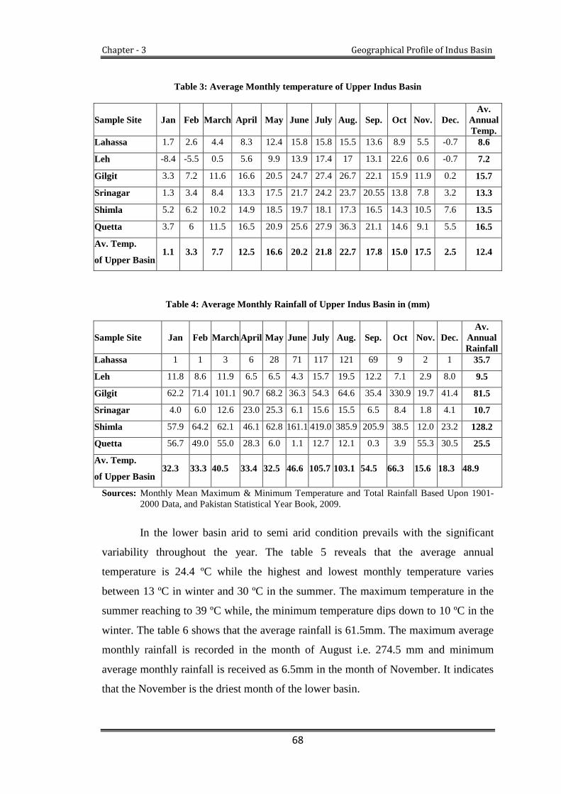
Chapter - 3 Geographical Profile of Indus Basin
68
Table 3: Average Monthly temperature of Upper Indus Basin
Sample Site Jan Feb March April May June July Aug. Sep. Oct Nov. Dec.Av.
AnnualTemp.
Lahassa 1.7 2.6 4.4 8.3 12.4 15.8 15.8 15.5 13.6 8.9 5.5 -0.7 8.6
Leh -8.4 -5.5 0.5 5.6 9.9 13.9 17.4 17 13.1 22.6 0.6 -0.7 7.2
Gilgit 3.3 7.2 11.6 16.6 20.5 24.7 27.4 26.7 22.1 15.9 11.9 0.2 15.7
Srinagar 1.3 3.4 8.4 13.3 17.5 21.7 24.2 23.7 20.55 13.8 7.8 3.2 13.3
Shimla 5.2 6.2 10.2 14.9 18.5 19.7 18.1 17.3 16.5 14.3 10.5 7.6 13.5
Quetta 3.7 6 11.5 16.5 20.9 25.6 27.9 36.3 21.1 14.6 9.1 5.5 16.5
Av. Temp.
of Upper Basin1.1 3.3 7.7 12.5 16.6 20.2 21.8 22.7 17.8 15.0 17.5 2.5 12.4
Table 4: Average Monthly Rainfall of Upper Indus Basin in (mm)
Sample Site Jan Feb March April May June July Aug. Sep. Oct Nov. Dec.Av.
AnnualRainfall
Lahassa 1 1 3 6 28 71 117 121 69 9 2 1 35.7
Leh 11.8 8.6 11.9 6.5 6.5 4.3 15.7 19.5 12.2 7.1 2.9 8.0 9.5
Gilgit 62.2 71.4 101.1 90.7 68.2 36.3 54.3 64.6 35.4 330.9 19.7 41.4 81.5
Srinagar 4.0 6.0 12.6 23.0 25.3 6.1 15.6 15.5 6.5 8.4 1.8 4.1 10.7
Shimla 57.9 64.2 62.1 46.1 62.8 161.1 419.0 385.9 205.9 38.5 12.0 23.2 128.2
Quetta 56.7 49.0 55.0 28.3 6.0 1.1 12.7 12.1 0.3 3.9 55.3 30.5 25.5
Av. Temp.
of Upper Basin32.3 33.3 40.5 33.4 32.5 46.6 105.7 103.1 54.5 66.3 15.6 18.3 48.9
Sources: Monthly Mean Maximum & Minimum Temperature and Total Rainfall Based Upon 1901-2000 Data, and Pakistan Statistical Year Book, 2009.
In the lower basin arid to semi arid condition prevails with the significant
variability throughout the year. The table 5 reveals that the average annual
temperature is 24.4 ºC while the highest and lowest monthly temperature varies
between 13 ºC in winter and 30 ºC in the summer. The maximum temperature in the
summer reaching to 39 ºC while, the minimum temperature dips down to 10 ºC in the
winter. The table 6 shows that the average rainfall is 61.5mm. The maximum average
monthly rainfall is recorded in the month of August i.e. 274.5 mm and minimum
average monthly rainfall is received as 6.5mm in the month of November. It indicates
that the November is the driest month of the lower basin.
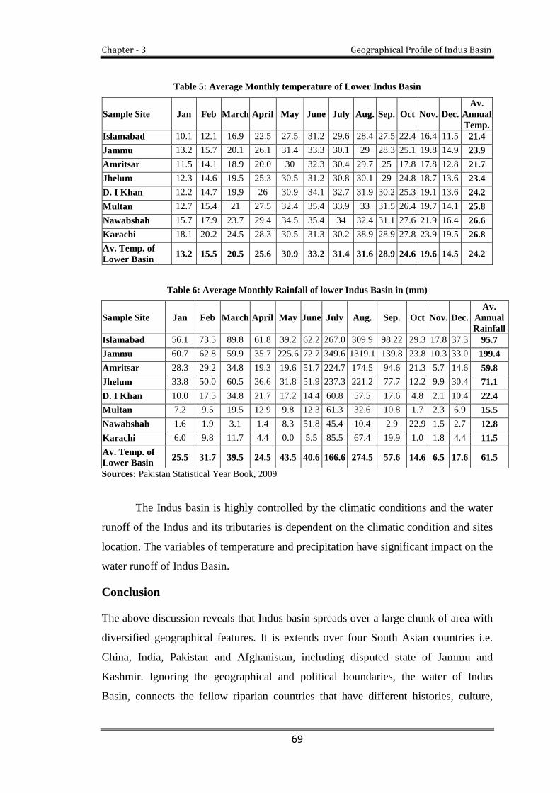
Chapter - 3 Geographical Profile of Indus Basin
69
Table 5: Average Monthly temperature of Lower Indus Basin
Sample Site Jan Feb March April May June July Aug. Sep. Oct Nov. Dec.Av.
AnnualTemp.
Islamabad 10.1 12.1 16.9 22.5 27.5 31.2 29.6 28.4 27.5 22.4 16.4 11.5 21.4
Jammu 13.2 15.7 20.1 26.1 31.4 33.3 30.1 29 28.3 25.1 19.8 14.9 23.9
Amritsar 11.5 14.1 18.9 20.0 30 32.3 30.4 29.7 25 17.8 17.8 12.8 21.7
Jhelum 12.3 14.6 19.5 25.3 30.5 31.2 30.8 30.1 29 24.8 18.7 13.6 23.4
D. I Khan 12.2 14.7 19.9 26 30.9 34.1 32.7 31.9 30.2 25.3 19.1 13.6 24.2
Multan 12.7 15.4 21 27.5 32.4 35.4 33.9 33 31.5 26.4 19.7 14.1 25.8
Nawabshah 15.7 17.9 23.7 29.4 34.5 35.4 34 32.4 31.1 27.6 21.9 16.4 26.6
Karachi 18.1 20.2 24.5 28.3 30.5 31.3 30.2 38.9 28.9 27.8 23.9 19.5 26.8
Av. Temp. ofLower Basin
13.2 15.5 20.5 25.6 30.9 33.2 31.4 31.6 28.9 24.6 19.6 14.5 24.2
Table 6: Average Monthly Rainfall of lower Indus Basin in (mm)
Sample Site Jan Feb March April May June July Aug. Sep. Oct Nov. Dec.Av.
AnnualRainfall
Islamabad 56.1 73.5 89.8 61.8 39.2 62.2 267.0 309.9 98.22 29.3 17.8 37.3 95.7
Jammu 60.7 62.8 59.9 35.7 225.6 72.7 349.6 1319.1 139.8 23.8 10.3 33.0 199.4
Amritsar 28.3 29.2 34.8 19.3 19.6 51.7 224.7 174.5 94.6 21.3 5.7 14.6 59.8
Jhelum 33.8 50.0 60.5 36.6 31.8 51.9 237.3 221.2 77.7 12.2 9.9 30.4 71.1
D. I Khan 10.0 17.5 34.8 21.7 17.2 14.4 60.8 57.5 17.6 4.8 2.1 10.4 22.4
Multan 7.2 9.5 19.5 12.9 9.8 12.3 61.3 32.6 10.8 1.7 2.3 6.9 15.5
Nawabshah 1.6 1.9 3.1 1.4 8.3 51.8 45.4 10.4 2.9 22.9 1.5 2.7 12.8
Karachi 6.0 9.8 11.7 4.4 0.0 5.5 85.5 67.4 19.9 1.0 1.8 4.4 11.5
Av. Temp. ofLower Basin
25.5 31.7 39.5 24.5 43.5 40.6 166.6 274.5 57.6 14.6 6.5 17.6 61.5
Sources: Pakistan Statistical Year Book, 2009
The Indus basin is highly controlled by the climatic conditions and the water
runoff of the Indus and its tributaries is dependent on the climatic condition and sites
location. The variables of temperature and precipitation have significant impact on the
water runoff of Indus Basin.
Conclusion
The above discussion reveals that Indus basin spreads over a large chunk of area with
diversified geographical features. It is extends over four South Asian countries i.e.
China, India, Pakistan and Afghanistan, including disputed state of Jammu and
Kashmir. Ignoring the geographical and political boundaries, the water of Indus
Basin, connects the fellow riparian countries that have different histories, culture,

Chapter - 3 Geographical Profile of Indus Basin
70
political system and economic development and different types of conflicting and
cooperative history. However, India and Pakistan are the main utiliser of the Indus
Basin. Millions of people of are directly or indirectly dependent on the water of Indus
Basin which plays important role for socio-economic development of both the
countries. Large numbers of population of two countries drive their livelihood from
the Indus Basin. Apart from India and Pakistan, the Indus Basin is also a blessing for
the J&K State. A large amount of population derives their livelihood from the
tributaries of Indus rivers basin by way of agriculture, hydroelectricity, fisheries,
tourism and river transportation.
The Indus Basin is divided into two sub basins the Upper Indus basin and the
lower Indus basin. Climatic condition of the basin plays significant role in the water
runoff the basin. The lower basin is a single climatic division with arid to semi-arid
climatic conditions and receives maximum rainfall from summer monsoon. These
monsoon rains increase the flow of Indus basin from the summer until autumn. While
the upper basin covers the mountainous belt that mainly lies under snow and glaciers.
These glaciers and snow cover peaks of the upper basin and plays a significant role in
water discharge of the Indus Basin. Since the present work is concerned with the
‘Indus Water Treaty: A Geo Political Study’ it is important to have a detailed
overview of the geographical setting of the basin which construct a solid base for the
evaluation of Indus Water Treaty justifiably. The above discussion also reveals that
the rivers flowing through J&K contribute significant volume of water to the Indus
river system.

Chapter - 4
Historical Background of the Indus
Water Treaty

Chapter - 4 Historical background of the Indus Water Treaty
71
he present chapter explores the history of major development in the Indus Basin
and the various water related disputes between the shareholders before partition.
This is followed by the event of partition, creation of the two countries and dispute
over the share of water. It further explores the role of external parties (World Bank)
for helping settle the growing dispute and subsequent formulation of Indus Water
Treaty.
4.1. Water Resource Development in the Indus Basin: A Historical
Perspective
Indus River Basin one of the largest river basins in the world, comprises the main
Indus River and its tributaries. It is mainly shared by India and Pakistan; out of about
190 million people 72 percent Pakistan and 23 percent Indian live in Indus Basin.1
These people are mainly dependent on agriculture and water of Indus Basin Rivers
which play significant role in the development of their agriculture. The river is
blessing for Indo-Pak inhabitants.
Indus and many of its tributaries get usually large flow of waters during
summers because of the melting snow in their high reaches. It is the period when rains
usually follow and the silt which these rivers carry is rich in alluvial and makes the
riverine tracks very fertile and productive. Hence the lands across Indus and its
tributaries considered among the most productive lands throughout the sub-continent
are also considered as vital to the socio-economic development of the region. The
Indus River once hosted the mighty civilization the Indus Valley Civilization along its
banks. The Indus Civilization one of the first major human settlements in the sub-
continent, discovered in 1921-22 dates back to 3500 BCE.
1 A. N. Laghari, D. Vanham and W. Rauch, “The Indus Basin in the Framework of Current andFuture Water Resource Management,” Hydel Earth Systems Vol. 8 (2011): 2263-2288.
T

Chapter - 4 Historical background of the Indus Water Treaty
72
The Indus Valley Civilization, now called Harappan Civilization was spread
over a large area than thought earlier. It encompassed an area from Sutkagen Dor in
Baluchistan (Pakistan) in the western end to the Alamgir Pur in Utter Pradesh (India),
a long distance of 1600 km in between. Its northern peripheries included Munda in
Jammu and Kashmir and Diamabad in Maharashtra in the south, again a long distance
of 1400 km in between. The bases of this civilization were mainly agriculture and
animal husbandry.
The evidence supports the view that it was well settled civilization and
agriculture was the mainstay of the people. The evidence has further revealed that
Indus River was the main reason behind their economic development and agricultural
prosperity.2 To enhance the agricultural production, excellent irrigation and water
management system was practiced along the Indus River.3 There is some evidence
coming from some sites of Harappa Civilization which allude to the practice of canal
irrigation. The rain water was used for irrigation purposes by storing it and
channelizing it. Even spill over water is also used for irrigation purposes. H.T.
Lambrcik in his book, Sind before the Muslim Conquest, History of Sindh, writes “the
whole operation involves an absolute minimum skill, labour and aid of
implementing”.4 The people of Indus Valley Civilization were in know of the
advantages and techniques of harnessing the inundated Indus. Cultivation of crops
such as wheat, barley and peas were generally sown in spring. Surplus food
production on a regular basis in the Indus plain attracted non-agrarian communities
such as, traders artisans who along with the rulers have made a significant
contribution to knowledge of pottery, grain storage, agriculture, irrigation and food
preservation.5
Subsequent to the ruin of Indus Valley Civilization, later ruling dynasties like
Shakes, Pallavas and Pandyas also paid due attention to the development of the Indus
Basin. Earlier development of water courses continued with new energy and
2 Rita P. Wright, The Ancient Indus: Urbanism, Economy and Society (New York: CambridgeUniversity Press, 2010), 1-16.
3 J. M. Kenoyer, Ancient Cities of the Indus Valley Civilization (Karachi: Oxford University Press,1998), 6.
4 H.T. Lambrcik, Sind before the Muslim Conquest: History of Sind Series Vol. II (Hyderabad:Sindh Adabi Board, 1973).
5 Jean Fairly, The Lion River: the Indus (Lahore: Brother Publisher, 1993), 175.

Chapter - 4 Historical background of the Indus Water Treaty
73
techniques. Water supply and sanitation system were well managed according to the
norms. The infrastructures of dams and dikes were enlarged and developed for
agriculture and irrigation purposes.6
4.1.2. Water resource development in the Indus Basin during Sultanate period
When the Arabs conquered the Sindh in the 8th century they too embraced the
techniques of water development from previous dynasties. They settled a good
agricultural society in the Indus plain. Owing to the needs and demands of the
agricultural land, the Muslim rulers focused their attention on the development of a
good canal system.7
In order to harness the full advantages of land and agriculture, the water
development was once again promoted when Delhi Sultanate was established. With
the expansion of the empire, growing population needed more food and this led to
more agriculture activities. The Sultans dealt with water development as an exigent
issue for the prosperity of the region. The climate of Punjab plain is very hot and the
land surrounding the Indus River and its tributaries is mostly arid. Therefore, there
was a dire need to provide water to plain areas by artificial sources. Thus, the Sultans
constructed water reservoirs and lakes. These sources were utilized for both irrigation
and drinking purposes.8
The first multi-purpose lake that provided clean drinking water was
constructed by Sultan Iltumish in the 12th century. Soon afterwards, Sultan Feroz
Shah Tughlaq (1351-1388) constructed Western Yamuna Canal (1355), to take water
from the Yamuna River to his hunting ground in Hissar (Haryana).9 This canal was
extended by the Mughal rulers.10 Over the same period different methods and
techniques were introduced to enhance the agricultural productivity and development
6 Subash G Shinde, “History of Irrigation in India,” National Level Conference on WaterManagement Scenario 2025: Problems Issues and Challenges, (n d): 5.<http//www.Vpmthane.org/publication-wms/WMScenario%202025.pdf/> (accessed December 5, 2011).
7 Jean Fairly, The Lion River: the Indus, 207.
8 Aloys Arthur Michel, The Indus Rivers: A Study of the Effects of Partition (London: Yale
University Press, 1967), 49-50.9 Sadique A. Gill, “Indus River and the Irrigation System in Pakistan,” Journal of South Asian
Studies Vol. 20, no. 2 (2005): 7.
10 Iqtidar Hussain Siddiqui, Authority and Kingship under Sultans of Delhi: Thirteenth-Fourteenth
Centuries, (New Delhi: Manohar Publishers, 2006), 260.

Chapter - 4 Historical background of the Indus Water Treaty
74
of irrigation systems. Certain policies were implemented to encourage the farmers.
Emperor Muhammad Bin Tughlaq encouraged the farmers to build their own rain
water wells and harvesting systems. Thus the farmers of Punjab plain were able to
cultivate two seasonal crops in a year—Kharif11 and Rabi.12
Babar, the founder of Mughal dynasty, defeated the last ruler of the Delhi
Sultanate and became the first Mughal Emperor in 1526.13 The development of water
took new priority again. The land of Punjab during the Mughals comprised of five
Doabs.14 The first Doab or the-Bai Jallandhar Doab was spread between the Sutlej and
the Beas; the Bari Doab formed the area between the Beas and the Ravi, the Richna
Doab covered the area between the Ravi and the Chenab; Chaj Doab lay between the
Chenab and the Jhelum River and the last one Sind Sagar Doab stretched between the
Indus River and the Jhelum River.15
The Mughals developed and improved their irrigation system, road and
communication network, constructed wells and Baolis (water tank), which were
ideally spaced at three-mile intervals on all roads.16 Babarnamah gives a detailed
description of the prevalent modes of irrigation practices in India during Mughal rule.
Mughals constructed a perennial17canal system with permanent head-works. The
perennial canal system used to supply water to cultivable land throughout the year.18
Emperor Akbar (1556-1605), renovated the Yamuna Canal in 1568 which was built
by the Sultan Feroz Shah Tughlaq in 1351. Soon afterwards, Emperor Jahangir (1605-
1627), built a similar type of (perennial) canal in the seventeenth century from the
Ravi River to a garden on the other bank of the river from Lahore. His son, the next
Emperor Shah Jahan (1628-1658), built a canal from the Ravi River to provide water
to the Shalamar garden of Lahore. Later on, the Sikhs in 19th century carried out an
11 Kharif Crops: These crops are grown in the beginning of rainy season in May and June and
harvested by September and October. These crops are also called summer season crops.
12 Rabi Crops: These crops are grown in winter season in October and November and harvested by
March and April. These crops are also called winter season crops.
13 Fairly, The Lion River: the Indus, 206.
14 Doab is a Persian word made up of two words-'do' meaning two and 'ab' meaning water, “doab” isa tract of land lying between two rivers flowing in the same direction.
15 Michel, The Indus Rivers: A Study of the Effects of Partition, 42.
16 Ibid., 49.17 Perennial canals system is able to utilize the water even the reduced winter flow of the rivers.
18 Siddiqui, Authority and Kingship under Sultans of Delhi: Thirteenth-Fourteenth Centuries, 262.
Chapter - 4 Historical background of the Indus Water Treaty
75
extension of this canal in Amritsar (Punjab) and filled the tank at their sacred Golden
Temple.19
In 1707, the Mughal irrigation system was most enlarged and extensive, as
much as the Valley of Indus had never seen before. Of the Mughals, Emperor
Aurangzeb (1658-1707), is credited with having taken an interest in developing lakes,
tanks, and canals for the development of agriculture and among his famous canal
works were the western Yamuna Canal, Halsi Canal, Shah Nehr Canal and a series of
other inundation canals.20 Mughal rulers, being lovers of gardens, built some canals
not only for irrigation but also to provide water to the parks and gardens of the
Mughal royalty.21 From the early sixteenth century onward, ground water of the Indus
plain is extensively used for agricultural and irrigation activities. Dug Wells and
Karez (underground water canals) were often constructed after the sixteenth century.
These methods of irrigation are heavily in practice in the Indus plain in the present
times as well.
Many of the canals in the Indus plain were also built by the Kalhora dynasty
(1701-1783) and the subsequent Talpur dynasty (1783-1843) in Sindh province. The
Kalhoras had built the 10-mile long Nurwah Canal, the inundation canal of Begari, 2-
mile long Shah-JI-car and 20-mile long Date-Ji-Kur Canal, which are now merged in
Warah Canal (constructed during British rule). Though the Kalhoras did not have a
sound knowledge of hydraulic engineering, but their irrigation system was managed
more efficiently.22 As a result of these developments, a large tract of barren and
unoccupied land in Sindh was converted into fertile and productive one.
Foregoing paragraphs bring into our minds a picture of the Indus River, its
tributaries and how they played a pivotal role in shaping the economies of all ruling
dynasties. Since time memorial various methods and techniques were practiced to
utilize the water from the Indus river system in the best manner. Proper management
and regular availability of water provided an aid in flourishing the agriculture which
19 Jean Fairly, The Lion River: the Indus, 207.
20 Inundation canals have no control at the off-take point and need the river to be in high flood. Thislimits the operating period, which begins between May and early July and goes on through to theend of September or early October.
21 Lahore: Managing Irrigation for Environmentally Sustainable Agriculture in Pakistan, Case Studyof the Punjab, Irrigation Department Lahore, Report no. 12 (1998): 13.
22 Ibid.,

Chapter - 4 Historical background of the Indus Water Treaty
76
thereby became the mainstay of the people and main source of revenue. However, all
ruling dynasties dealt with the management of water and agriculture as an existential
issue.
4.1.3. Water resource development in the Indus Basin during British period
The Battle of Plassey in 1757 is generally considered the dawn of Colonial rule in
India. The East India Company led by Robert Clive dethroned the Nawab of Bengal
and presented himself as a key player in Indian politics. After the Battle of Buxar in
1765, the company expanded its control over Bengal, Orissa and Bihar. With the
death of the Tipo Sultan in 1799, most part of South India came under direct or
indirect control of the British East India Company. Subsequently, the colonial rule got
strengthened and it took over the sub-continent completely by the third Anglo-
Maratha war of 1818. Soon afterward, the British East India Company conquered the
Punjab in Anglo-Sikh war of 1849 by overcoming Maharaja Ranjit Singh’s
successors.23 Eventually, after the fall of Punjab, except for the remaining Princely
States, all of India came under the direct or indirect rule of the British and the British
East India Company.24
When the British Government settled in Punjab, it initiated different programs
to regularize yield from the agriculture, which was at the time the main source of
revenue. Thus, several schemes of canals were launched to utilize the wealth of
waters of the Indus basin in the best possible ways.
In the beginning, the Britishers had no problem with in irrigation system, as it
was already there for the sophisticated agricultural system. Moreover, the amount of
water for irrigation was plenty because of regular rainfall. To develop the irrigation
system on modern lines, they surveyed the perennial, non-perennial canal, the
inundation canals and Mughal works. Meanwhile, they sent their engineers to
Mediterranean countries to gain advanced knowledge of water management. The
engineers then applied their knowledge and experience of water management in the
23 Eric Stokes, “The First Century of British Colonial Rule in India: Social Revolution or SocialStagnation?” (Feb. 1973): 136-160. Oxford University Press on behalf of The Past and PresentSociety. <http://www.jstor.org/page/info/about/policies/terms.jsp/> (accessed 14 September 2011).
24 Michel, The Indus Rivers: A Study of the Effects of Partition, 57.

Chapter - 4 Historical background of the Indus Water Treaty
77
sub-continent.25 The British interest in developing the water resources Indus Basin
was closely related with plans for large-scale agriculture production in the sub-
continent which subsequently would be boost the British Empire.
Under the colonial policy of the British, a number of dams and dikes were
built across the Indus River and its five tributaries. The preference was given to the
reclamation of large barren and unoccupied wastelands and transforming them into
productive land. There were a well-developed canal command areas or colonies,
which cultivated a variety of crops, such as cotton, rice, wheat, barley, sugarcane
among others.
New colonies and towns were established. The British administration from
1860 to 1947 made large investments in the Indus Basin irrigation system, making it
the largest contiguous irrigation system in the world, with a command area of roughly
20 million hectares and annual irrigation capacity of more than 12 million hectares.26
The conversion of vast desert land into one of the leading agricultural regions in Asia
was the excellent engineering achievement of the colonial rule.
From the middle of the 19th century onward, various new irrigation canals
were constructed gradually to provide water for the highlands between five doubles.
The concept of construction was entirely new, introducing perennial and rotational
canal system in the Indus Basin. Inundation canals were converted into perennial
canals in Punjab and Sindh.
Among the first new works in 1859, the Upper Bari Doab Canal (UBDC) from
Ravi River was constructed with nineteenth century enthusiasm and confidence. This
project had triggered political confrontation between Punjab and Sindh, when Sindh
as lower riparian objected that the project has potential threats to its agriculture and
economy. The confrontation between Punjab and Sindh could be thought of as the
first instance of water dispute in the Indus Basin.27
25 Jean Fairly, The Lion River: the Indus, 207-08.
26 Ashok Swain, Environmental Cooperation in South Asia, eds. Ken Conca and Geoffrey D.Dabelko (Washington, D.C: Woodrow Wilson Press, 2002), 66.
27 Rasool Bux Palijo, Sindh-Punjab Water dispute 1859-2003 (Sindh: Centre For Peace and CivilSociety, 2011): 9-10.

Chapter - 4 Historical background of the Indus Water Treaty
78
Next to the Upper Bari Doab Canal, the second major work was Sirhind
Canal, constructed in 1872, to protect the existing precarious cultivation of about a
million acres of land in Punjab and neighbouring princely states. In 1878, a severe
famine hit north India, and the Government of British India was concerned about the
need for greater food production, and then the British authorities determined that the
Indus plain should be developed as the granary of India.28 To meet the emerging
challenges, various irrigation schemes were introduced with the help of local
governments. This initiative had a great significance in achieving maximum food
production.
Over the same period, the British administration and engineers had devoted
themselves to consider the Indus Basin as a whole and for the first time a new
concept, entirely original at that time, was adopted. The link canal system was put
into practice to fill one river using the waters of another river. The Jhelum River was
connected by canal to the Chenab River and then Chenab River to Ravi River.29
Simultaneously, the Colonial irrigation system was undertaken in two steps. Firstly,
the existing canals were renovated while in the second step, inundation canals were
developed into perennial canals. Thus, Punjab became the main area of canal building
and extension activity30
In 1867, the position of Inspector General of irrigation offices was created to
look after the irrigation development, which paid considerable attention in the
expansion of irrigation network.31 From 1876 to 1885, about thirteen major canals
were constructed that include Khanwah, Katora and Gray Canal on Sutlej River, the
Para and Sohag Canal on Ravi River.32
In 1892, a major link canal, the Lower Chenab Canal, was constructed to bring
water to wasteland between the Chenab and Ravi rivers. In addition to this, the work
on the Lower Jhelum Canal was undertaken in 1901 to provide water to the wasteland
between the Jhelum and Chenab rivers. Construction of such a huge irrigation
28 Michel, The Indus Rivers: A Study of the Effects of Partition, 74.
29 Gulhati, Indus Water Treaty: An Exercise in International Mediation, 43.30 Siddiqui, Authority and Kingship under Sultans of Delhi: Thirteenth-Fourteenth Centuries, 26331 Asit K. Biswas, “Indus Water Treaty: the Negotiation Process.” Journal of Water International,
(1992): 202.
32 Siddiqui, Authority and Kingship under Sultans of Delhi: Thirteenth-Fourteenth Centuries, 263.
Chapter - 4 Historical background of the Indus Water Treaty
79
network was the result of excellent engineering works. By these developments, the
barren and unoccupied land transformed into productive lands. The colonial rule had
not only given the Indus Basin the most extensive irrigation system in the world but
also developed modern techniques and formulae now used in the irrigation system,
which provide the framework for achieving maximum production.
Punjab and Sindh were not only provinces to benefit from the irrigation
network; it was also considerably expanded in neighbouring provinces. In North West
Frontier Province (NWFP), the Lower Swat Canal 1885, the Kabul River Canal 1892
and two other canals were constructed and came into operation in 1907 and 1914
respectively. Limited canal system was constructed in J&K state, which includes the
Ranbir and the Partap Canal from Chenab River and non-perennial Kashmir Canal
from the Ravi River. Small hydroelectric plant was also set up in Jammu upstream of
the Madhopur on the Ravi River.33 Renovation of Shahkul Canal in Kashmir Valley
and construction of Mahora hydroelectric plant in Baramulla district of Kashmir was
also carried out in the same period.
4.2. Origin of Water Dispute over the Indus Basin
As Britishers were on the mission of exploiting more and more from their colonies,
they had developed tools and mechanism to develop the production of raw materials
for their industrial growth. For this purpose, they introduced a large-scale
development and management of water resources of the sub-continent. The objectives
were to exploit the maximum agricultural potential and enhance the European
industrial growth and market. To achieve these goals, the regional and the local
administration played a pivotal role in the identification of feasible water projects.
Meanwhile, the management of developed water resources was handed over to
provincial departments.
The provincial department as the custodian of the water promised to provide
the water to every region. But, the physical integration of the canal system and
scattered population made the development of water resource an issue of
confrontation among provinces and states. These conflicts were mostly reflected by
the conflicting demands of the regional, provincial and state levels and resulted in
33 Ibid.

Chapter - 4 Historical background of the Indus Water Treaty
80
water conflicts. Consequently, these water conflicts stirred up socio-political conflicts
in the post-colonial era.34
Another reason of water conflicts between provinces and states was that the
lack of storage facilities for expanding irrigated lands and some drawbacks of the
developed canal system built during the British period as it widened the gap between
upstream and downstream provinces over water distribution. The production and
revenue that was being generated from irrigated lands was attracted to provincial
bodies, for which they wished to continue the development of their own irrigable
land. As the work progressed, provinces and regional bodies came to compete for the
allocation of water, which resulted in conflicts over water allocation.
4.3. Development of Water Disputes in Pre-Partition Period
4.3.1. Punjab-Sindh dispute over water: The annals of Indus Basin records the fact
that before the British colonial rule, water of Indus Basin was not seen as a source of
conflict. It was only in the mid of the 19th century under the British colonial rule that
the availability of Indus Basin water became really an issue between Punjab and the
princely states of Bahawalpur and Bikaner. Bahawalpur State, as a lower riparian of
Punjab and Bikaner, objected to any withdrawal of water from Sutlej and Beas River
by Punjab and Bikaner state, which affected the inundation canals of Bahawalpur.
This dispute was resolved by mutual understanding, followed by an agreement which
was signed in 1920 between Punjab and the princely states of Bahawalpur and
Bikaner. It was the first agreement over the sharing of Indus Basin and is known as
the Sutlej Valley Tripartite Agreement.35 The settlement of disputes and subsequent
agreement had opened up ways for future projects in the Indus Basin, especially for
Sutlej Valley Canal Project.
The Bombay Government (Sindh was part of Bombay presidency till 1935)
also objected to Punjab’s withdrawal of water, which affected the irrigation system in
Sindh. Therefore, it has submitted its complaint against Punjab to the Central
Government of India. This case was important for two parties as it was related to their
economic prosperity. The Central Government tried to do justice but found it
34 Zaigham Habib, “Water Issues and Politics in Pakistan,” Journal of South Asia Free MediaAssociation, Lahore Pakistan (n d): 1.
35 Bashir A. Malik, Indus Water Treaty in Retrospect, (Lahore: Brite Books, 2005), 293-94.

Chapter - 4 Historical background of the Indus Water Treaty
81
complex, problematic, and thereby, referred it to the Secretary of State for India in
London to find a solution of the problem. The Secretary of State had used the
authority to settle the conflicts by an executive order. He did it and sanctioned Sutlej
Valley Project in Punjab and Sukkar Projects in Sindh, after holding discussions with
interested sections.36
Sindh’s Sukkar project was submitted to the Secretary of State in 1920 and it
was approved in 1923. The construction started in 1923 and it became operational in
1932. As the immediate result of this project, almost 7.5 million acres of cultivable
lands were brought under irrigation.37 When the Secretary of State for India
sanctioned Sukkar project to Sindh, as against this, Punjab had three more projects in
its proposal. But, the decision on these projects was to be taken after accurate
availability of rivers flow discharge data. In 1921, Government of India appointed
“Indus Discharge Committee” to observe the daily flow of rivers at different places.
Punjab and Sindh were also directed to cooperate with the Committee regarding the
collection of data. Finally, the Committee had prepared its report following
recommendations for the Haveli Project in Punjab.38
During this period, Punjab had put forward the proposal of Thal Project, which
was strongly opposed by Bombay Government. The case was again referred to the
Secretary of State for approval but the Bombay Government raised voice against it,
because this was detrimental to the lower riparian Sindh. Because of this, the project
was not taken into consideration by the Secretary of State. The Punjab was not happy
about the rejection of its project, and repeatedly insisted on its approval.
Subsequently, the Government of India was compelled to constitute an eight member
committee under the Chief Engineer of UP, Mr. Anderson.39
As per the recommendations of the 1935 Anderson Committee, there should
be no fresh withdrawals of water by the upper riparian Punjab, which may be
detrimental to the other riparian states or may affect not only the existence but also
the future rights of such riparian over the water of the Indus river system40 Though the
36 B.A. Malik, Indus Water Treaty in Retrospect, 294.
37 Michel, The Indus Rivers: A Study of the Effects of Partition, 110.38 B.A. Malik, Indus Water Treaty in Retrospect, 294-95.39 Palijo, Sindh-Punjab Water Dispute 1859-200, 12-14.40 Ibid., 12.
Chapter - 4 Historical background of the Indus Water Treaty
82
project remained a source of political confrontation, the Secretary of State for India
resolved it in a constructive manner.
This dispute was not the last one over the share of Indus Basin water. Punjab
as upper riparian with already substantial command area wanted to increase its
irrigated areas through the building of canals and dams from the Indus River and its
tributaries. It had started the construction of another project (Bhakra project) on Sutlej
River, which became a major cause of dispute between Punjab and Sindh.
4.4. Dispute over the Construction of Bhakra Project
This dispute was related to the possible prejudicial effect of the Bhakra project on the
Sutlej River, contemplated by Punjab on Sind’s inundation canals.41 The construction
of the project on the Sutlej River by Punjab could have affected the irrigation system
in Sindh. Therefore, the Sindh, alarmed by the cumulative impact of several new
irrigation schemes through the Bhakra project, complained to the Governor General of
India about the Bhakra project.
Sindh’s second complaint was over the Thal and Haveli projects, which would
create a serious shortage of water at Sukkar in lean months and also affect the proper
working of the irrigation channels and Barrages in Sindh.42 During 1930s, the sub-
continent witnessed political upheaval, which resulted in the separation of Burma
from India. To resolve the emerging political disorder, Government of India Act was
enacted in 1935 and various reforms were introduced, e.g. greater autonomy was
awarded to the provinces. As a result of this award, Sindh was separated from
Bombay presidency which represented the culmination of provincial autonomy not
only in irrigation related issues but in most areas of economic planning and overall
development.
Under the same Act, water was put under provincial jurisdiction with a clause
to Governor General’s intervention in case of dispute between provinces or princely
states.43 However, the Governor General set up a special Commission is known as the
41 R.K. Arora, The Indus Water Treaty Regime, (New Delhi: Mohit Publications, 2007), 176.42 Arthur Michel, The Indus Rivers: A Study of the Effects of Partition, 131.
43 Sections 130 to 134 in the 1935 Act dealt with the problem of “interference with water supplies”.The provisions led down that provinces or princely states could complain to the Governor Generalof India, if their interests were prejudicially affected in the water supplies from a natural source,

Chapter - 4 Historical background of the Indus Water Treaty
83
“The Rau Commission” (also known as Indus Commission) on September 11, 1941,
under the chair of Justice B.N. Ra, then the judge of the Calcutta High court and two
Chief Engineers from Utter Pradesh and Madras. The Commission submitted its
report in July 1942.44
After a careful consideration, the Commission members opined that the
withdrawal of water by Punjab would probably cause physical damage to the
inundation canals in Sindh, especially in the month of September. Therefore, the
Commission made some specific recommendations on the sharing of Indus river
system water.45 It also recommended that Punjab had to give RS. 2 Crores for
building two barrages in Sindh at Guddu and Kotri; and would not take any action on
the proposed project up to October 1945, which was, however, rejected by Punjab,
whereas Sindh was not too satisfied with the decision of settling the financial issue.
Hence, the outcomes of the commission were neither accepted by Punjab nor Sindh.
Consequently, both parties appealed to the Central Government for a better
solution. Actually, this was referred to London as the last resort; the Central
Government of India advised the Chief Engineers of two provinces (Punjab and
Sindh) to hold meetings informally between 1943 and 1945 for mutual agreement.
They prepared a draft agreement on 28 September 1945, but it was again rejected by
both the provinces and the dispute remained unresolved for the next couple of years.
In 1947, it was referred to the Secretary of State in London for the verdict. Thus, the
issue lingered until the Indian Independence Act of July 1947 was passed, creating
two independent dominions of India and Pakistan.46 However, due to the partition of
the sub-continent and its political ramifications, the water dispute remained
unresolved.
due to the action of another province or princely state. If the Governor General considered that theissues involved were of sufficient importance, he was required to appoint a commission toinvestigate the matter and to report to him. After considering the report he was to give a decisionhe deemed proper. In effect, this arrangement provided for binding arbitration: in the end, theGovernor General of India could theoretically impose his decision.
44 Malik, Indus Water Treaty in Retrospect, 295.
45 Report of the Indian Commission Simla, Vol. 1 (1967): 319.
46 B.A. Malik, Indus Water Treaty in Retrospect, 160-61.

Chapter - 4 Historical background of the Indus Water Treaty
84
4.4.1. Issues involved in shaping the water dispute
A recapitulation of disputes in the Indus Basin would bring out some issues that
engendered the peace and harmony between the provinces during the British Rule
between provinces:
From 1920 to 1945 there was a lack of storage facilities along the Indus Basin,
due to which water could not be stored, and flowed unutilized. It was the lack
of storage facilities which increased the tension between upstream and
downstream provinces, since water supply was not available throughout the
year to meet requirements of irrigation. These problems could have been
solved through technical solution, such as by the construction of storage.
The existing canal system was not enough to meet the requirements for
increasing population in the basin, as new areas were being converted, all the
time to under agricultural lands, which increased the demand for irrigation
water and maximised the chances for conflicts;
Another issue which increased the rivalries over share of water was the
revenue generated from agricultural land. Provincial bodies wanted to retain
generated their provinces because it was a main source of provincial economy.
They wished to develop land and water resources without taking into account
the needs and demands of other provinces, which consequently resulted in
conflicts and hostilities.
Water from the canals had a significant role in achieving the maximum
agricultural production. However, the complex structure of the canal system
and the idea of equal distribution made water a political issue between
provinces.
4.5. Independence and the Creation of Two Countries
The Indian subcontinent is the home to various ethnic and religious groups (including
two dominant groups Hindu and Muslim). The common features of these groups were
brotherhood, unity and patriotism. After the war of 1857, these various groups got
united and struggled together for independence from the British yoke. Initially, both
the groups were fighting against colonial rule under the banner of ‘Congress Party’

Chapter - 4 Historical background of the Indus Water Treaty
85
formed in 1885, a party that included all Indians without any bias to any specific
religious group or community. However, during the early decades of the 20th century,
the disappointed section of Muslims refused to accept the Congress as an inclusive
party, accusing it of being a cover for Hindu dominance. The political groups other
than Congress, claiming to represent various religious or ethnic communities opened
their own fronts against the colonizers.
The Muslim League was established in 1906, to represent the Muslim
grievances, demanded separate electorates which would safeguard Muslim interests.
In 1935 the pressure for independence mounted, and the Government of India Act was
approved. The decision facilitated self-rule at the provincial level. In essence, the
1935 Act led to the termination of the British Rule and eventually paved way to the
partition of British India into the independent states of Pakistan and India which
became a reality on 14 and 15 August 1947 respectively.
4.5.1. Immediate Consequences of Partition
India and Pakistan attained independence from colonial rule in a remarkably peaceful
manner when Britain relinquished its almost 200 year rule in the sub-continent, and
handed over the land to the political leaders of Congress and Muslim League.47
Against the peaceful transfer of authority, few political decisions altered the course of
history in dramatic fashion. The partition turned out to be highly painful. Right from
1947 till now, the people of sub-continent have been suffering from post-traumatic
problems and the message given by partition is unbearable and horrible. The hasty
British departure along with the unimaginative surgical partition of the Punjab created
many complex issues for the successor nations of British India.48
Poorly handled partition and the violent mass migration of people exacerbated
the tensions between the two leading nations of the subcontinent to decades of
conflict. Most of Hindus, Muslims and Sikhs were unconcerned and indifferent with
47 Gulhati, Indus Water Treaty: An Exercise in International Mediation, 52, and also see AyeshaJalal, Democracy and Authoritarianism in South Asia: A Comparative and Historical Perspective(UK: Cambridge University Press, 1995), 9.
48 Parvez Iqbal Cheema, The Politics of the Punjab Boundary Award, University of Heidelberg:South Asia Institute department of Political Science, (September 2000):1.<http://www.archiv.ub.uni-heidelberg.de/volltextserver/volltexte//hpsacp1.pdf/> (accessed August 5, 2010).

Chapter - 4 Historical background of the Indus Water Treaty
86
these newly created geographical entities.49 They were needlessly caught up in the fire
of religious hatred. Many were dragged out of their homes, others drifted from one
place to another because of fear, panic and sense of hopelessness. The Congress and
the Muslim League had no empathy for a vast number of people who were committed
neither to Hindu homeland nor to Dar-al Islam. They had no destination to reach and
no marriage to pursue. They were unsure whether Lahore or Gurdaspur would be in
India or Pakistan.50
A massive mass movement took place after the partition, accompanied by
outbreaks of inter-communal violence. It is estimated that nearly 15 million people
migrated to areas which they believed safe and secure and in which their religion was
dominant. In addition, the sectarian violence within newly created India and Pakistan
caused social and economic upheavals. The displacement of people escaping from this
violence disrupted food production in Punjab--the breadbasket of India—just as there
were millions of refugees to cater. The tragedy of partition separated 400,000,000
people from each other and created the basis for subsequent India-Pakistan tension.51
It has also led to a number of disputes over certain parts of the sub-continent, which
continued till date. The violence not only disrupted cultivation but also destroyed
irrigation channels. On the traumatic story of partition Aloys Arthur Michel stated;
“on the face of it, it would certainly seem that the partition could have
been accomplished in a less hasty manner; that the boundaries could
have been drawn more carefully had six months been allowed instead of
six weeks; that the boundary award could have been published before,
rather than after independence was proclaimed; that the Indian Army
and Civilian Service could have been separated into Hindu-Sikh and
Muslim elements before rather than during the transfer of power; that
sufficient safeguards for the population could have been organised; that
in particular the Punjab Boundary Force, in size and deposition, could
have been less inadequate for its monumental task; and that the transfer
of power and population might have been made during the autumn or
49 Gulhati, Indus Water Treaty: An Exercise in International Mediation, 50-53.
50 Mushirul Hassan, Legacy of a Divided Nation (New Delhi: Oxford University Press, 1997), 128-129.
51 Gulhati, Indus Water Treaty: An Exercise in International Mediation, 49.

Chapter - 4 Historical background of the Indus Water Treaty
87
spring fallow period rather than in the heat, rain, and mud of late
summer, with the untended crops going to waste in the field”.52
4.5.2 New geopolitical boundary across the Indus Basin
The new geopolitical boundary between India and Pakistan which ran right through
Punjab etched a hard border, cutting the Indus River system and disrupted its well-
managed integrated irrigation canal network.53 The geography of the partition was
such that the diversion structure of the canal system was located in India, while the
distribution network was in Pakistan. Many of the canal head-works, such as of the
Upper Bari Doab Canal, and the Sutlej Valley Canals fell in India, while the land
being irrigated by their water fell in Pakistan.
Hence, the partitioning of the canal network created a dispute between the two
countries over the right to the use of Indus Basin water.54 Even before the partition of
India and Pakistan, the Indus water created problem between states of British India,
but most of the disputes were resolved by executive order of the Central Government
of India. The dispute over water became international in its character only after the
demarcation of new political boundary, which increased hostilities and exacerbated
the tension between the two nations.
4.6. Water Dispute and Negotiation Process from 1947 to 1950
In fact, when the British Parliament passed the Indian Independence Act on 18 July,
1947, the boundary line that divided Punjab between the two countries did not provide
the mechanism for the continuation of water supply, so drawing a boundary line
between the two countries was a difficult task. The Boundary Line Commission
realized that the issue was problematic by the existence of the canal system and the
high dependency of agriculture upon canal water.55 Thus, the nature of the integrated
canal system exacerbated the difficulties in deciding the new boundary. In this
situation, Redcliff contacted the leaders of both countries—Jawaharlal Nehru and
Muhammad Ali Jinnah—with the idea that the Punjab irrigation system should be a
52 Michel, The Indus Rivers: A Study of the Effects of Partition, 4.
53 Gulhati, Indus Water Treaty: An Exercise in International Mediation, 50.54 Shaista Tabassum, River Water Sharing Problem between India and Pakistan: Case Study of Indus
Water Treaty (Colombo: Regional Centre for Strategic Studies, 2004): 9-10.
55 Gulhati, Indus Water Treaty: An Exercise in International Mediation, 57.

Chapter - 4 Historical background of the Indus Water Treaty
88
joint venture run by both countries. However, Redcliff was rewarded for his
suggestion by a joint Hindu-Muslim rebut. Muhammad Ali Jinnah told him to get on
with his job and stated that he would rather have Pakistan desert than fertile fields
watered by the courtesy of Hindus. Jawaharlal Nehru curtly informed him that what
India did with India’s rivers was India’s internal affair. Both leaders were obviously
furious with him and hinted that he was playing politics.56
Redcliff was well aware about the need for joint control of canal head-works,
but could not do more than hope for joint India-Pakistan control of a head-works.
Meanwhile, when the state of Bahawalpur and Bikaner asked Redcliff to take into
account their rights in the canals and head-works located in Punjab, he refused to
consider this question. Redcliff pointed out that the division of the Province did not
affect the rights of private property.57
In order to resolve the India-Pakistan issues, numbers of committees were set
up including “Committee B.” The Committee B was constituted by the Government
of India and entrusted to make arrangements for the division of the water of Indus
Rivers between the two countries. Both governments were required to place their
problems regarding the distribution of water before the Committee B. The report of
the Committee B came up before the Punjab Partition Committee, (Chaired by the
Governor of Punjab and consisting of equal representation of East Punjab and West
Punjab). The Partition Committee accepted the points on which committee B was in
agreement, “that the pre-partition shares of West Punjab and East Punjab in the canal
waters would be maintained.” But Partition Committee, like Committee B, was unable
to agree on the valuation of the canal system. Therefore, finally, the Punjab Partition
Committee decided to refer the case to the Arbitral Tribunal.58
This Tribunal was headed by the Chief Justice of India, Sir Patrick Spense and
its tenure was up to 31st March 1948. Disputes and difficulties between two countries
56 Michel, The Indus Rivers: A Study of the Effects of Partition, 164.57 Gulhati, Indus Water Treaty: An Exercise in International Mediation, 73.58 Muhammad Ali Choudhury, The Emergence of ‘Pakistan (Lahore: Research Society of Pakistan,
1989), 318.

Chapter - 4 Historical background of the Indus Water Treaty
89
over the division of assets or liabilities formed by the partition could, therefore, be
placed before the Tribunal until December 1947.59
In regards to the distribution of water, there are two different views: N.D
Gulhati is of the view that by 30 November 1947, five issues had been placed before
the Arbitral Tribunal, which was formed by the partition of Punjab. All these issues
referred to the financial adjustments needed for: (1) the irrigation system; (2) the
crown waste lands; (3) irrigated forest plantations; (4) seigniorage charges for canal
use in transporting water around the Indus Basin; and (5) the general ratio for
calculating the financial adjustment needed. With the Chairman's permission, West
Punjab submitted its claim to the Mandi hydroelectric plant, on 22 December 1947.60
Contrary to this, Muhammad Ali states that the most vital national interest (Water)
was not put forward in the Arbitral Tribunal, because of the agreement reached by
Committee B and the Punjab Partition Committee that the pre-partition shares of
water would be maintained.61
The Dispute arose between East Punjab and West Punjab over the
continuation of water supply from the Ferozepur head-works (in East Punjab) to the
UBDC (West Punjab). When the East Punjab (India), as an upstream user of the three
eastern rivers, claimed that the property rights in the waters of East Punjab’s rivers are
vested in itself and the West Punjab (Pakistan) could not make a claim on those
waters as of right (under the Punjab partition-appointed Assets and liabilities Order,
1947, and the Arbitral Award of Property rights). In contrast, the west Punjab’s
standpoint was that the Arbitral Award protected its rights and also as per the
International Law and justice, the West Punjab has rights to the waters of Eastern
Rivers.62
The real problem behind this spiralling dispute was that, out of 26 million
acres of land irrigated annually by Indus Basin river canal system, 21 million acres
and ten canals remained in Pakistan and 5 million acres of land and only two canals in
India. Most of the developed canal system and the famous canal colonies, the granary
59 Palijo, Sindh-Punjab Water Dispute 1859-200, 22.60 Gulhati, Indus Water Treaty: An Exercise in International Mediation, 49.61 Muhammad Ali Choudhury, The Emergence of ‘Pakistan, 318.62 Tabassum, River Water Sharing Problem between India and Pakistan: Case Study of Indus Water
Treaty, 10.

Chapter - 4 Historical background of the Indus Water Treaty
90
of the Punjab was in West Punjab (Pakistan).63 India, as the upper riparian, wanted to
develop new irrigation facilities for it’s those lands which were not under irrigation,
while Pakistan wanted to maintain the existing supply for its developed canal
network.
According to Michel (1967), dispute aroused between East and West Punjab
when monsoon flows receded in the autumn of 1947. To resolve it, the chief engineers
of East and West Punjab met and signed “Standstill Agreement,” on 18 December
1947, which froze water allocations allowing discharges from head-works on the
Upper Bari Doab Canal (UBDC), the Dipalpore Canal and the Bahawalpur Canal
system.64 This Standstill Agreement was to continue until 31 March, 1948, and it was
stipulated that a further agreement for any period subsequent to the aforementioned
date could be negotiated. Both the parties agreed to the Standstill Agreement with the
hope that any solution to the problem would be found within the functioning period of
aforesaid agreement, but either deliberately or circumstantially West Punjab did not
take any initiative until 31 March, 1948, the date of expiry of the agreement.65
A full-blown water conflict was reported on 1st April, 1948 when East Punjab
discontinued the delivery of water from the Ferozepur head-works to Dipalpore Canal
and two main branches of the UBDC, within its territory and there was a clamor in
Pakistan. In the absence of any formal water agreement with West Punjab, the East
Punjab acquired legal rights in the use of water of eastern rivers.66
The shutting off of the canal’s water in west Punjab (Pakistan) marked
strained political relations between the two countries. However, to resolve this
dispute, the East Punjab invited the Chief Engineers of West Punjab to meet their East
Punjab counterparts at the province’s new headquarters in Simla on 15 April, 1948, to
renegotiate resumption of the water supply. Subsequently, Standstill Agreement was
signed on 18 April, 1948.67
63 J.S. Mehta, “The Indus Water Treaty: A Case Study in Resolution of an International River BasinConflict,” Natural Resources Forum Vol. 12 (1988): 70-74.
64 Michel, The Indus Rivers: A Study of the Effects of Partition, 195.
65 Asit K. Biswas, “Indus Water Treaty: the Negotiation Process,” Journal of Water International,(1992): 203.
66 Gulhati, Indus Water Treaty: An Exercise in International Mediation, 63.
67 Ibid., 60.

Chapter - 4 Historical background of the Indus Water Treaty
91
India’s action, shutting-off the canal’s water to West Punjab in the sowing
season of the wheat crop, affected 1.7 million acres of cultivable land in Pakistan and
threatened the loss of about one million tons of wheat output. Moreover, the city of
Lahore was deprived of its municipal water, and the distribution of power supply from
the Mandi Hydroelectric scheme was cut off.68 Gulhati, the Designee Engineer to the
Indus Water Treaty, he admitted that the effect of water stoppage made “some
irrigation channels near Lahore became dry.”69 Some opinions about India’s action at
time some are as follows:
India as upper riparian claimed its sovereign rights on UBDC;
It intended to create pressure on Pakistan to withdraw from Kashmir;
It endeavoured to demonstrate Pakistan’s dependence on India in the hope of
forcing reconciliation.70
Another interpretation is that the shutting-off the canals was taken by the East
Punjab without the consent of the Central Government of India.71
The Indian standpoint is recounted by Gulhati, who is of the view that under
the British Rule most of the expansion and modernisation that occurred in the
irrigation system took place in the territory that later went to West Punjab. East
Punjab, formed after partition, regarded this as an injustice, especially as any future
development would now need expensive storage facilities. Using the 1941 census, it
claimed there were 21 million people in Indian Punjab and 25 million in Pakistani
Punjab, yet out of 105,000 km2 irrigated annually in the Indus Basin less than
20percent or 21,000 km2 was in East Punjab territory. Therefore, East Punjab wanted
to correct the situation by establishing its own claim to the water of Eastern Rivers.72
68 Kaiser Bengali, "Water Management under Constraints: The Need for a Paradigm Shift", inMichael Kugelman, Robert M. Hathaway, ed, Running on Empty: Pakistan’s Water Crisis",Woodrow Wilson International Center for Scholars, (2009): 46.
69 Gulhati, Indus Water Treaty: An Exercise in International Mediation, 60.70 Michel, The Indus Rivers: A Study of the Effects of Partition, 195.
71 R. K. Arora, The Indus Water Treaty Regime, 53.72 Gulhati, Indus Water Treaty: An Exercise in International Mediation, 59.

Chapter - 4 Historical background of the Indus Water Treaty
92
Whatsoever the motive of East Punjab, this incident precipitated the formal
dispute and created animosity between the two countries,73 and also destroyed the
hopes (joint control of head-works) expressed by Redcliff.
Following the incident of 1st April, 1948, Pakistan dispatched a ministerial
delegation to New Delhi for resumption of water supply. As a result, an Inter-
Dominion Agreement was signed on 4 May, 1948, in New Delhi, which is also known
as Delhi Agreement. It was signed by the Prime Minister of India, Jawaharlal Nehru,
Indian Minister for Irrigation-East Punjab, Srawan Singh, and from Pakistan, Minister
for Finance, Ghulam Muhammad, and Ministers for West Punjab including Sardar
Shoukat, Hayat Khan and Mumtaz Daultana, signed the agreement.74
This reconciliation provided a temporary agreement requiring East Punjab
(India) to release sufficient waters to Central Bari Doab Canal (CDBC) and the
Dipalpore Canal until West Punjab (Pakistan) developed alternative water resources.
In Delhi Agreement, it was also decided that Pakistan, in return, would make annual
payments to India for the cost of transporting water through canals in East Punjab,
and give its share of any maintenance costs, which is to be deposited in the reserve
Bank of India.75 Both East and West Punjab agreed to settle the issue by in spirit of
goodwill: “The position existent at the time of partition will not be disturbed and
water shall be divided equally”.76
Though both countries agreed at the time of the agreement and since India was
in control of a head-works, Pakistan’s motive were to secure the ownership of
waters77 and it later expressed in a note dated 16 June, 1949, calling for ‘equitable
apportionment of all common waters’ and suggested turning jurisdiction of the case
over to the International Court of Justice.78
73 Asit K. Biswas, “Indus Water Treaty: the Negotiation Process,” Journal of Water International,(1992): 203.
74 Palijo, Sindh-Punjab Water Dispute 1859-200, 31-32.75 Michel, The Indus Rivers: A Study of the Effects of Partition, 202.
76 Asit K. Biswas, “Indus Water Treaty: the Negotiation Process,” Journal of Water International,(1992): 203.
77 Tabassum, River Water Sharing Problem between India and Pakistan: Case Study of Indus WaterTreaty, 12.
78 Palijo, Sindh-Punjab Water Dispute 1859-2003, 31-32.

Chapter - 4 Historical background of the Indus Water Treaty
93
The shutting-off canal water in 1948 inflicted heavy damage on the Pakistan’s
Kharif crops, fodder plantation and livestock, and hence, it anticipated that the Court
would not refuse its rights on the waters of the Eastern Rivers.79 But, India suggested
that a committee consisting of three members be nominated by each side to resolve
their differences before turning the problem over to International Court of Justice.
India also wished that the 1948 Inter-Dominion Agreement be made as permanent.80
Pakistan rejected these suggestions altogether. The difference persisted and the
deadlock also continued without any resolution. Meanwhile, the water supply
continued according to the Agreement of 4 May, 1948, and Pakistan was regularly
paying the seigniorage charges to India.81
Again competition over water reached to head-on when Pakistan started the
construction of irrigation channels from the Sutlej River to connect Dipalapur Canal,
where it is upstream of India. But India as lower stream protested on Pakistan’s new
construction on the basis that bypassing would be detrimental to its canal network.82 It
was the only point where geographical location of the canals was in favour of
Pakistan, but realising the weakness of its geographical location, India started the
construction of Harike Barrage upstream of Pakistan to safeguard upstream diversions
proposed in the Pakistani project.
Subsequently, series of telegrams were exchanged between Zafrulla Khan the
Pakistani Minister for Foreign Affairs and Jawaharlal Nehru the Indian Prime
Minister. Pakistan’s point was that the digging of canals is a precautionary measure
against East Punjab (India) shutting-off the water supply in future to Dipalpur Canal
to West Punjab. While the Indian representative replied that the diversion of water
from the Sutlej River upstream of Ferozepur would endanger the safety of the
Ferozepur headworks, which could be damaged as a result. Therefore, India warned
that it would take retaliatory action, and dig a channel further upstream of Pakistan's
channel.83
79 Firoz Khan Noon, From Memory, (1969), 263, c.f. Rasool Bux Palijo, Sindh-Punjab Water dispute1859-2003 (Sindh: Centre for Peace and Civil Society, 2011): 31-32.
80 Michel, The Indus Rivers: A Study of the Effects of Partition, 219.81 Gulhati, Indus Water Treaty: An Exercise in International Mediation, 82-84.82 Ibid., 71.83 Gulhati, Indus Water Treaty: An Exercise in International Mediation, 71.

Chapter - 4 Historical background of the Indus Water Treaty
94
Apart from this project, both the countries started construction of new projects
in the Indus river basin; while as Pakistan was constructing new irrigation schemes on
Chenab, Indus and Ravi rivers, India was also started construction of some projects
the Sutlej, Beas and Ravi rivers. Among India’s projects, Bhakra dam project was a
major which was earlier feared to deprive Pakistan of water supply; the project was
large enough to store the entire Sutlej River.84 Consequently, the construction of
projects increased hostilities and led high tension between the two countries over the
share of water. To resolve it, a meeting was called in Lahore which headed by
Zafrulla Khan from Pakistan and N. Gopalaswami Ayyangar from India but the
meeting achieved no result and the difference remained persistent.85
From July 1950 onward, Pakistan stopped depositing the amount (which was
fixed in the agreement of 4 May 1948) and stated that this amount would be paid only
after this dispute is taken to the International Court of Justice or UN Security Council
or any other international organisation. Pakistan also rejected the 4 May, 1948,
Agreement and stated that the agreement was accepted under ‘compulsion’ and signed
under ‘duress’86 and it had given notice of its termination. To this claim, India replied
that there was no question of ‘duress’ and in fact this agreement was one of the
happiest agreement that arrived in a friendly, cooperative atmosphere, and no one then
or for long afterwards ever raised the complaints, which has recently been made by
Pakistan.87
From the early 1950, discussions over share of water reached a deadlock due
to various differences between two countries, and there was no communication on the
water dispute for a long time. This stalemate stayed up to the year 1951. The
communication restarted when both parties accepted the offer of the World Bank’s
good office at the end of 1951. In fact, the World Bank was involved in the water
84 Choudhury, The Emergence of ‘Pakistan, 324, and also see Michel, The Indus Rivers: A Study ofthe Effects of Partition,206,
85 Michel, The Indus Rivers: A Study of the Effects of Partition, 206 and Gulhati, Indus Water Treaty:An Exercise in International Mediation, 72.
86 Asit K. Biswas, “Indus Water Treaty: the Negotiation Process,” Journal of Water International,(1992): 204.
87 “No-War Declaration and Canal Water Distribution: Correspondence between Prime Ministers ofPakistan and India” Government of Pakistan Ministry of Foreign Affairs and Common WealthRelations, (Karachi, n.d): 22-29, cited by Tabassum, Water Sharing Problem between India andPakistan: Case Study of Indus Water Treaty, 13, and also see Gulhati, Indus Water Treaty: AnExercise in International Mediation, 80.
Chapter - 4 Historical background of the Indus Water Treaty
95
dispute between the two countries over Sutlej River dispute in 1949, but its nature of
involvement changed in 1951 when David Lilienthal visited the sub-continent and
presented his principles over the sharing of Indus Basin.
4.7. External Intervention for Water Dispute Management
4.7.1. David Lilienthal suggestions for water dispute management
The standoff in negotiation over water dispute could have continued for a much
longer time if David A. Lilienthal, the former Chairman of Tennessee Valley
Authority (TVA)88 had not visited India at the invitation of Indian Prime Minister,
Jawaharlal Nehru, as a personal guest. He visited India as a functionary of the World
Bank to write some articles for Collier’s Magazine and to bring peace in the sub-
continent through unified development of the Indus River system possibly in line of
TVA as in the United States of America (USA). However, Malik (2005)89 is of the
view that his real motive was to serve an important strategic mission for his country,
i.e. to bring India closer to the U.S. and to prevent it from falling to the then
communist bloc.90
During his first visit to the sub-continent, he did not visit Pakistan but it was
Walter Lippmann, a renowned American Journalist, on whose advice Lilienthal
visited Pakistan. During his sojourn in Pakistan, he met Prime Minister Liaqat Ali
Khan and discussed many issues with him including Kashmir. While in India, he
discussed with Jawaharlal Nehru about Indo-U.S relations in the context of the lack of
the understanding and friendliness.91
He visited some projects in Indus Basin and discussed with engineers at work
about the disputes related to the development and use of Indus water. Mr. Lilienthal
was of the view that if the water issue is referred to the International Court, (as
Pakistan had already invoked) it might protect Pakistan’s rights, but the decision of
the court would not be adequate for maintaining peace and sufficient food for the
88 The Tennessee Valley Authority (TVA) was created in 1933 which is a federal corporation with alimited geographic mission, is authorized to build dams and other projects, and to manage theTennessee River, which drains parts of seven states. The TVA also owns and operates coal andnuclear power plants. (For the home page of the Tennessee Valley Authority, see www.tva.gov)
89 B. A. Malik is a hydrologist of Pakistan and worked as Chief Technical Advisor of United NationsOrganizations (UNO).
90 B.A. Malik, Indus Water Treaty in Retrospect, 161.
91 Ibid.

Chapter - 4 Historical background of the Indus Water Treaty
96
people of the Indus Basin. 92 On the other hand, he remained busy in long discussions
with the leaderships of both the countries. Meanwhile, David Lilienthal envisioned
that the Tennessee Valley Authority water management system could have helped in
the development of Indus Basin for the betterment of both the countries. On his return
to the U.S., Lilienthal published an article on August 4, 1951 and proposed some
suggestions:
The whole Indus Basin must be developed as a unit—designed, built and
operated as a unit as in the seven-state TVA system back in the United States;
International financing be arranged, perhaps by the World Bank, to fund the
work and Indus engineering corporation be founded;
Representatives are included from both countries as well as from the World
Bank;
Greater storage facilities and cooperative management be implemented.93
The David Lilienthal proposal was based on joint management of the Indus Basin
which would be helpful for the future development of the Indus Basin irrigation
system.
The article was read by Lilienthal’s close friend David Eugene R. Black, the
then president of the World Bank, who reacted enthusiastically and called him for his
recommendations. Lilienthal suggested that Black should write directly to the leaders
of two countries.
4.7.2. Role of World Bank in water dispute management
World Bank accepted the suggestion of Lilienthal and subsequently Mr. Eugene R.
Black invited the leaders of both countries for negotiation. Contrary to what was
anticipated, both India and Pakistan accepted mediation from the good office of the
World Bank. Black explicitly outlined “essential principles” that might be followed
for conflict resolution in a letter:
The Indus Basin had enough water for both countries:
92 Tabassum, River Water Sharing Problem between India and Pakistan: Case Study of Indus WaterTreaty, 14.
93 Michel, The Indus Rivers: A Study of the Effects of Partition, 222.

Chapter - 4 Historical background of the Indus Water Treaty
97
In resolving the Sutlej river dispute, the basin would be treated as a single unit
and all the rivers were to be discussed;
The negotiations would put aside past grievances and retain a technical rather
than a political focus.94
4.7.3. Road to the settlement of the dispute
The first meeting of the Working Party included Indian and Pakistani engineers, along
with a team from the Bank, as envisioned by Eugene Black, met in Washington at
World Bank Headquarter in May 1952. The stated agenda was to prepare an outline
for a programme, including a list of possible technical measures to increase the
available supplies of Indus water for economic development. After three weeks of an
intensive discussion, a draft was agreed to, whose points included:
determination of total water supplies, divided by catchment and use;
determination of the water requirements of cultivable irrigable areas in each
country;
calculation of data and surveys are necessary, as requested by both sides;
preparation of cost estimates and a construction schedule of new engineering
work which might be included in a comprehensive plan.
Notably, the parties requested that any data from either side would be
collected and verified when possible, but the acceptance of the data, or the inclusion
of any topic for study, would not be committed to either side to its relevance or
materiality.95
In the next two meetings in Karachi in 1952 and in Delhi in 1953, the two
countries were unable to agree on any common approach for dealing with the waters
of the Indus Basin. However, the protracted differences between the two parties were
sufficient for the World Bank to ask the Indian and Pakistani delegations to prepare
their own plans.
94 Undala Alam. Z, “Questioning the Water Wars Rational: A Case Study of the Indus WaterTreaty,” The Geographical Journal, Vol. 68, no. 4 (2002): 342. <http://www.jstor.org/stable/3451476/> (accessed September 3, 2011).
95 Aaron T. Wolf, “Case Study of Transboundary Dispute Resolution: the Indus Water Treaty,”(n.d): 6.

Chapter - 4 Historical background of the Indus Water Treaty
98
After field trips for data collection, both countries submitted their plans to the
World Bank on 6 October, 1953, and each country mostly agreed with the supplies
available for irrigation, but differed largely on how these supplies should be allocated.
(Table 1) The Indian proposal allocated 29 Million Acre Feet (MAF)96 per year to
India and 90 MAF to Pakistan, totalling 119 MAF=1233.48 million cubic meters. The
Pakistani proposal, in contrast, allocated 15.5 MAF to India and for herself 102.5
MAF, for a total of 118 MAF.
Table 1: Water allocations from Indus Negotiations, in Maf/Year 1
Plan India Pakistan
Initial Indian 29.0 MAF 90.0 MAF
Initial Pakistani 15.5 MAF 102.5 MAF
Revised Indian All of the eastern rivers and 7%
of the western rivers
None of the eastern rivers and
93% of the western rivers
Revised
Pakistani
30% of the eastern rivers and
none of the western rivers
70% of the eastern rivers and
93% of the western rivers
Bank Proposal Entire flow of the eastern rivers 2 Entire flow of the western
rivers 3
Initial estimates of supplies available differed slightly, with the Indian Plan
totalling 119 MAF and the Pakistani Plan arrives at 118 MAF. The “Eastern Rivers”
consist of the Ravi, Beas, and Sutlej tributaries; the “Western Rivers” comprise of the
Indus, Jhelum, and Chenab. India would agree to continue to supply Pakistan with its
historic withdrawals from these rivers for a transitional period to be agreed upon,
which would be based on time necessary to complete Pakistani link canals to replace
supplies from eastern rivers. The only exception would be an “insignificant” amount
of flow from the Jhelum, used at the time in Kashmir. The two sides were persuaded
to adjust their initial proposals to some extent, but the modified proposals of each side
still had too much difference to overcome.97
The modified Indian plan called for all of the eastern rivers (Ravi, Beas, and
Sutlej) and 7 percent of the western rivers (Indus, Jhelum and Chenab) to be allocated
to India, while Pakistan would be allocated the remainder or 93 percent of the western
96 MAF=million acre-feet. 1 acre-foot=1235 m3. Asit K. Biswas (1992) Alam (2002) and Salman(2005).
97 Michel, The Indus Rivers: A Study of the Effects of Partition, 224.

Chapter - 4 Historical background of the Indus Water Treaty
99
rivers. The modified Pakistani plan called for 30 percent of the eastern rivers to be
allocated to India, while 70 percent of the eastern rivers and all of the western rivers
would go to Pakistan. Under these circumstances, the World Bank concluded on 5
February, 1954, that without any new developments, there would be no prospect of
further progress in the working party. The World Bank then came up with its own
proposal that had the concurrence of the engineering consultants, and therefore, was
put forward with the full support of the management of the Bank.
The World Bank proposal called for the entire flow of the eastern rivers (the
Ravi, the Sutlej and the Beas) to be allocated to India and all the western rivers (the
Jhelum, the Chenab and the Indus) with the exception of a small amount from the
Jhelum presently used in Kashmir to be allocated to Pakistan. According to the
proposal, the two sides would agree to a transition period while Pakistan would
complete link canals dividing the watershed, during which period India would
continue to allow Pakistan’s historic use of water from the Ravi, Beas and Sutlej
River.
Pakistan felt the 1954 plan left insufficient water to meet its needs. Politically,
Pakistan could not afford to give away water, since it was devoid of the finances to
build storage facilities unilaterally. Thus, it refused the 1954 plan and at the same
time, a combination of the complex geographical infrastructure of canals, the
projected financial concerns from the potential loss of the eastern rivers, and political
instability within the country made Pakistan cautious in its negotiations.98
Pakistan persuaded the World Bank to accede to its requirements for the
construction of the most compulsory storage facilities sidelined by the 1954 plan
which was in need of an amendment in the light of 1956 Aide Memories—envisaging
the storage facility on western rivers. India was, in no case in mode of acceding to any
further financial obligation in favour of Pakistan.99 Hence, it tried to retain the
discussion over the issue around 1954 plan which it had obligingly acceded to.
Separate discussions were held at many levels on various interconnected issues.
Pakistan needed technical assistance;
98 B.A. Malik, Indus Water Treaty in Retrospect, 160-161.99 Undala Alam. Z, “Questioning the Water Wars Rational: A Case Study of the Indus Water
Treaty,” The Geographical Journal, Vol. 68, no. 4 (2002): 342.

Chapter - 4 Historical background of the Indus Water Treaty
100
It needed finance for any super structure build up;
It needed time to meet the various requirements for a near profitable solution
but it needed and needed most immediately a continuous flow of water for its
waters starved lands in the West Punjab.
India had the necessary technical know-how, financial position and/or the reputation
to meet its goal ranges of water requirements. The western rivers all fell in Kashmir,
under dispute between the two countries, contesting for water. It was the time when
India was finding itself under acute pressure over the Kashmir from UNO and in
general and America and his close allies in Europe in particular.100 India was not
much convinced over the Kashmir remaining its integral part for long.101
Separate discussion were held at many level on various interconnected issues
Pakistan needed technical assistance; it needed finance for any super structure build
up; it needed time to meet the various requirements for a near profitable solution but it
needed and needed most immediately a continuous flow of water for its waters
starved lands in the west Punjab. Taming of the Sindh, for the present, was a far cry.
From 1stApril, 1955 to 31st March 1960, (save a period between) 1st October
1957 to 30 September 1958, many ad-hoc agreements were signed to ease the
situation. Under such agreement India reluctantly and with strong conditions agreed to
help Pakistan with water for a specified period and in a specified quantity in a year.
Pertinent to mention, the period of no-negotiation from 1st October 1958 to 30
September could have created havoc in Pakistan but the rain in Kashmir which
subsequently flooded Pakistan gave it some relief with a pain to negotiate surplus
water.102
The political instability, economic deterioration and alienation of the people
(s) of Pakistan encouraged its military to take over the power and dismiss existing
political institutions. The new military ruler Field Marshal Muhammad Ayub Khan,
claimed legitimacy on the promises to rectify the law and order situation in Pakistan,
100 After the partition of the sub-continent into India and Pakistan, Kashmir became a focal point ofpolitical bargaining between the two countries which was actually supported by their allies.Especially in 1954, after joining SEATO and CENTO Pakistan was supported by America andBritain while India began to draw closer to the Soviet Union, which emerged as a supplier ofeconomic assistance to it and supported India’s position on Kashmir.
101 B.A. Malik, B.A. Malik, Indus Water Treaty in Retrospect, 162.102 Tabassum, River Water Sharing Problem between India and Pakistan: Case Study of Indus Water
Treaty, 19.

Chapter - 4 Historical background of the Indus Water Treaty
101
put its economy on wheels and solve the pending disputes with India—more
importantly and was considered a huge impediment in the agriculture development of
Punjab.
India’s stand was clear and found by the “technical mediating power” on water
more practical and pragmatic, at that particular time, and hence offered to Pakistan
with the commitment of appropriate financial and technical assistance. The India had
by its political and practical action already divided the Indus Basin system into two—
the Eastern under its possession and the Western Indus river system, out of India’s
control. The World Body (World Bank) gave legitimacy to what had already, virtually
happened after, convincing Pakistan on the postponement of its political issues with
India. Pakistan well understood its economic gains and accepted the division of rivers
as an only alternative feasible and pragmatic solution.
India had earlier understood the importance of its Punjab Rivers and their
future utility for its developmental purposes. Western rivers were of less utility for it;
both for east Punjab which was going to be the food basket of India in future and for
its water starved region Rajasthan. India had already discussed the possibilities of
extending eastern rivers (Sutlej, Ravi and Beas) to feed its Yumna Canal (In future)
and to desert lands of Rajasthan.
So India gave Pakistan what Pakistan was, already without much-ado
receiving of bought prosperity for its Punjab and a life for its future water strategy.
Pakistan was to accept under duress as it later accepted the basic basin division plan
of 1954. While political parties were opposed to it the formers of west Punjab were
getting impatient for want of water.103 Pakistan was promised suitable funds and
technical know-how by the negotiators in to realize its present position and
requirements. The plan not only promised to it the help for the construction of the
distribution system and linking of canals but also much needed electricity for its
future.104
The articles and newspapers write-ups of the period in Pakistan could easily be
divided into politically motivated and economic oriented ones. The East Pakistan, too
103 G.W. Choudhury, Pakistan’s Relations with India: 1947-1966 (London: Pall Mall Press Ltd,1968), 166.
104 Tabassum, River Water Sharing Problem between India and Pakistan: Case Study of Indus WaterTreaty, 19-20.

Chapter - 4 Historical background of the Indus Water Treaty
102
had a (potential) water sharing problem with India, therefore, the Pakistan had limited
options. The needs of Indian Punjab could not be ignored. India had unilaterally taken
many water rechanneling projects in hand. And Pakistan Military ruler Ayub Khan
took the advice of his economic advisors and agreed to 1954 plan, (four years after) in
October 1958 and to 1956 Aide-Memories in December 1958.
It was in October 1958 when Pakistan unconditionally accepted the 1954 plan
(the division of the basin) and the 1956 Adie-Memoire (storage facilities on the
Western Rivers in December 1958). Though India had already favoured 1954 plan but
to settle various modalities and supplementary debates and questions it took two more
years to draft the final version of treaty ready to be signed by the parties concerned.
Karachi; the capital city of undivided Pakistan was destined to play host for this much
publicized and bilaterally debated Indus Water Treaty. The treaty was signed in 1960
by Prime Minister of India Jawaharlal Nehru (1947-1964), the President of Pakistan
Muhammd Ayub Khan (1958-1970) and from the World Bank W. A. Liff.
The treaty left Pakistan in the independent possession of its Western Rivers
and India with the Eastern ones—of Beas and Ravi Sutlej. The mediators took least
notice of amount of land to be irrigated or under irrigation in the two countries or the
amount of water which the concerned rivers contained or the countries demanded. It
was a compromise to ease the situation and let the two countries initiate their practical
arrangements for the appropriate water management under their possession.
Conclusion
The society of Indian Sub-continent is the evolution of various social and cultural
conglomerates which prevailed here from pre and Neolithic times with an evidence
for its agrarian basis. Given the availability of water, fertilized soil because of the
alluvial sedimentation and other natural conditions made agriculture as the main stay
of the people. Though the Harappan civilization speaks about the trading and some
limited pastoral activity but husbandry remained the central activity. There is an
evidence for grid form ploughing which allows double-crop sowing and water
management, not only to retain the spillover water and harvesting of rain water but
also for channelling for water. Indus banks were generally left for forestation. During
and in the post Harappan period, the revenue from land and agriculture produce

Chapter - 4 Historical background of the Indus Water Treaty
103
contributed significantly to the coffers of the authorities—whether chief or rajas.
Most of the irrigation related works of minor nature such as repairs or laying out the
water channels and de-siltification was carried out at local level through voluntarily
contribution of labour. The major works were sponsored by the state in order to keep
its subjects at least at a sustenance level, in increase its revenue returns and make its
presence felt in the concerned areas and help feed the urban population on the crops
produced by the ruler community.
In the later history, we often mention of official responsible for water related
issues and sort of revenue collector on the canal water meant for irrigation. Mughals
(1526-1758) called this officer Mir Bahri or (Mir-ãb). There are number of incidents
reported by the chronicles regarding water disputes and subsequent interventions by
the states.
British colonizers were a thorough going trading community. Their politics
revolved around their urge to earn more and more profits with least investments.
Towards their end they introduced a number of crops (like Nile) which though
detrimental to the concerned lands, were nevertheless more profitable. However, their
appetite for more profit and to gain political advantages they helped to develop on
most elaborate irrigation system in the Indus Basin. The distribution of the population
concerned and location of the villages was much that gave rise to many a misgiving
and disputes over the first priority on the use of water. Sindh, Bahawalpur, Bikaner
and Punjab bilaterally contested the water.
The partition of India was finally done in a manner least respectful to the
humans to be directly affected by it. Most important issue were passed on to the new
regimes, unresolved. Water sharing between the two countries was such an issue. A
basically economic and problem was soon allowed to accumulate all kinds of political
dimensions. India had its own compulsions. East Punjab needed water to restart its
agriculture sector but was devoid of necessary infrastructure of canals. West Punjab
had the infrastructure of canals intact but the headwaters were within East Punjab
India.
The partition of India was finally done in a manner least respectful to the
humans to be directly affected by it. Most important issue were passed on to the new
regimes, unresolved. Water sharing between the two countries was such an issue. A

Chapter - 4 Historical background of the Indus Water Treaty
104
basically on economic and problem was soon allowed to accumulate all kinds of
political dimensions. India had its own compulsions. East Punjab needed water to
restart its agriculture sector but was devoid of necessary infrastructure of canals. West
Punjab had the infrastructure of canals intact but the headwaters were within East
Punjab India.
Though India and Pakistan had no water dispute at the time of partition in
August 1947, things were to change in 1948 when the international boundary between
India and Pakistan cut across the hitherto irrigation system of Punjab, originally
designed as one hydrological unit, in two parts. This division engendered the
confrontation between the two countries. Pakistan struggled to safeguard its lower
riparian rights, whereas India claimed the rights of the upper riparian over the water
of the Indus Basin. Competition over share of water led to strong animosity between
the two countries. Therefore, to come to a resolution of this dispute, a number of
agreements and Memorandum of Understanding were signed between East and West
Punjab. They did provide some mechanisms for dispute settlement, but no permanent
solution was found. It was only in 1951 that the international community intervened
to resolve this dispute, under the ages of the World Bank which resulted an agreement
of the Indus Water Treaty 1960.

Chapter - 5
Indus Water Treaty: From
Conciliation to Confrontation
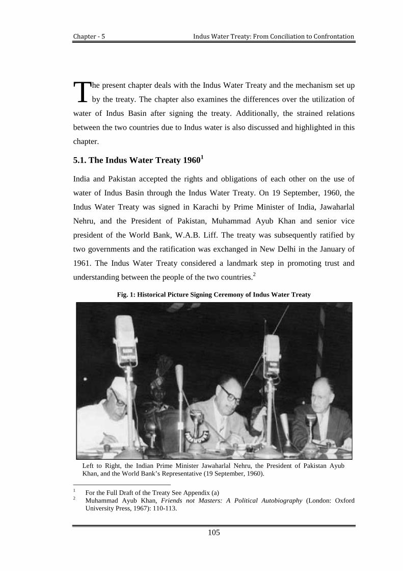
Chapter - 5 Indus Water Treaty: From Conciliation to Confrontation
105
he present chapter deals with the Indus Water Treaty and the mechanism set up
by the treaty. The chapter also examines the differences over the utilization of
water of Indus Basin after signing the treaty. Additionally, the strained relations
between the two countries due to Indus water is also discussed and highlighted in this
chapter.
5.1. The Indus Water Treaty 19601
India and Pakistan accepted the rights and obligations of each other on the use of
water of Indus Basin through the Indus Water Treaty. On 19 September, 1960, the
Indus Water Treaty was signed in Karachi by Prime Minister of India, Jawaharlal
Nehru, and the President of Pakistan, Muhammad Ayub Khan and senior vice
president of the World Bank, W.A.B. Liff. The treaty was subsequently ratified by
two governments and the ratification was exchanged in New Delhi in the January of
1961. The Indus Water Treaty considered a landmark step in promoting trust and
understanding between the people of the two countries.2
Fig. 1: Historical Picture Signing Ceremony of Indus Water Treaty
Left to Right, the Indian Prime Minister Jawaharlal Nehru, the President of Pakistan AyubKhan, and the World Bank’s Representative (19 September, 1960).
1 For the Full Draft of the Treaty See Appendix (a)2 Muhammad Ayub Khan, Friends not Masters: A Political Autobiography (London: Oxford
University Press, 1967): 110-113.
T
Chapter - 5 Indus Water Treaty: From Conciliation to Confrontation
106
Apart from Indus Water Treaty, three other agreements were signed in 1960.
The first agreement was related to the establishment of an Indus Basin Development
Fund (IBDF) of $ 894 million. Out of the total, $ 640 was contributed by friendly
countries, such as Australia, Canada, West Germany, New Zealand, the United
Kingdom and the United States. The IBDF agreement was signed between Pakistan
and aforementioned friendly countries. To facilitate the agreement, India also
contributed $ 174 million, and $ 80 million was given from the proceeds of the World
Bank loan to Pakistan.3 The fund was mainly collected for the transfer of
infrastructure and construction of replacement works on western rivers.4 The second
agreement was signed between Pakistan and the World Bank for a loan of $ 90
million. The last agreement covered a loan of $ 70 million from the US Development
Loan Fund.5
The Indus Water Treaty addressed both the technical and financial concerns of
each side and included a timeline for transition. It was retroactive from 1 April, 1960.
3 Shaista Tabassum, River Water Sharing Problem between India and Pakistan: Case Study of IndusWater Treaty (Colombo: Regional Centre for Strategic Studies, 2004), 29.
4 Mary Miner et al, “Water Sharing between India and Pakistan: a Critical Evaluation of the IndusWater Treaty” Journal of Water International Vol. 34, no. 2 (June 2009): 205.
5 Tabassum, River Water Sharing Problem between India and Pakistan: Case Study of Indus WaterTreaty, 29-30

Chapter - 5 Indus Water Treaty: From Conciliation to Confrontation
107
Table 1: Articles and 8 appendices of Indus Water Treaty, which are titled as:
Contents of the Treaty
Article I Definitions
Article II Provisions regarding Eastern Rivers
Article III Provisions regarding Western Rivers
Article IV Provisions regarding Easter Rivers and Western Rivers
Article V Financial Provisions
Article VI Exchange of Data
Article VII Future Cooperation
Article VIII Permanent Indus Commission
Article IX Settlement of Differences and Disputes
Article X Emergency Provisions
Article XI General Provisions
Article XII Final Provisions
Annexure A Exchange of Notes between Government of India and
Government of Pakistan
Annexure B Agricultural Use by Pakistan from certain tributaries of the
Ravi
Annexure C Agricultural Use by India from the Western Rivers
Annexure D Generation of Hydroelectric Power by India on the Western
Rivers
Annexure E Storage of Waters by India on Western Rivers
Annexure F Neutral Expert
Annexure G Court of Arbitration
Annexure H Transitional Arrangements
The treaty contains twelve Articles covering 79 paragraphs and eight detailed
Annexes.
The basic aim of the treaty is to increase the amount of water available to the
both parties and to distribute the water resources of the Indus Basin equitably to

Chapter - 5 Indus Water Treaty: From Conciliation to Confrontation
108
them. It is indeed a comprehensive treaty in view of its objectives.6 It is based on the
simple distribution of the rivers and not the base of quantity of waters. This unique
division of the Indus system has eradicated the very disturbances and conflicting
demands that would have followed the equitable distribution of water. Another unique
feature of the treaty is that it is the only international water treaty co-signed by a third
party. This third party was the World Bank, which mediated the original dispute over
the Indus Basin and assisted the two parties in reaching an agreement.7 Furthermore,
the Indus Basin dispute settlement was not just only an agreement but also tried to
change the history of water dispute into history of cooperation and peace.
The Indus Water Treaty was not only a novel and original document to
enhance the availability of water between the parties to the treaty (India and Pakistan),
but also has conciliated the differences over the rights of water usage. Prior to the
treaty, both countries were demanding their water share by interpreting water laws of
“absolute rights” and “historic use”. The Indus Water Treaty tried to find a better
solution that was driven by the principles of water engineering and economics rather
than legal principles.8 The treaty instead of dividing the waters of the rivers, divided
the rivers between the two parties, which gave them independent control and
regulation of supplies within their territories,9 subjected to limited use of water of the
rivers allocated to the other party. Some of the main principles of the treaty are:
5.1.1. Provisions Regarding Eastern Rivers
(I) All the waters of the Eastern Rivers shall be available for unrestricted use in
India.
(II) Except for domestic and non-consumptive uses, Pakistan shall be under an
obligation to let flow, and shall not permit any interference with the waters of
6 R.K. Arora, The Indus Water Treaty Regime (New Delhi: Mohit Publications, 2007), 9.7 Salman M A Salman, “The Baglihar Differences and its Resolution Process-a-Triumph for the
Indus Water Treaty,” World Bank Paper no. 8448 (2007):106-10.8 Muhammad Tariq, “The Indus Waters Treaty and Emerging Water Management Issues in
Pakistan, in Problems and Politics of Water Sharing and Management in Pakistan,” Islamabad:Policy Research Institute. (n.d): 87.
9 Salman M. A Salman and Kishor Uprety, Conflict and Cooperation on South Asia’s InternationalRivers: A legal Perspectives, (Washington D.C: The World Bank, 2003), 48.

Chapter - 5 Indus Water Treaty: From Conciliation to Confrontation
109
the Sutlej main and Ravi main in the reaches where these rivers flow in
Pakistan and have not yet finally crossed into Pakistan.
(III) All the waters, while flowing in Pakistan, if any, tributary which, in its natural
course, joins the Sutlej main or the Ravi main after these rivers have finally
crossed into Pakistan shall be available for the unrestricted use of Pakistan.
5.1.2. Provisions Regarding Western Rivers
(I) Pakistan shall receive for unrestricted use all those waters of the Western
Rivers.
(II) India shall be under an obligation to let flow all the waters of the Western Rivers,
and shall not permit any interference with these waters, except for the following
uses, restricted (except as provided in item (c) (ii) of Paragraph 5 of Annexure c)
in the case of each of the rivers, The Indus, The Jhelum and The Chenab, to the
drainage basin thereof.
(a) Domestic Use;
(b) Non-Consumptive Use;
(c) Agricultural Use, as set out in Annexure C; and
(d) Generation of hydroelectric power, as set out in Annexure
D (see Appendix 2)
5.1.3. Provisions Regarding Eastern and Western Rivers
(I) Pakistan shall use its best endeavors to construct and bring into operation a
system of works that will accomplish the replacement from the Western
Rivers (and other sources of) the water supplies for irrigation canals in
Pakistan, which on 15th August, 1947, where dependent water supplies from
the eastern rivers.
(II) The use of the natural channels of the rivers for the discharge of flood or other
excess waters shall be free and not subject to limitation by either party or
neither party shall have any claim against the other in respect of any damage
caused by such use.
Chapter - 5 Indus Water Treaty: From Conciliation to Confrontation
110
(III) Each Party declares its limitation to prevent, as far as practicable, undue
pollution of the waters and agrees to ensure that, before any sewage or
industrial waste, it will be treated, where necessary, in such manner as not
materially to affect those uses.
5.1.4. Principles of Cooperation between the Parties
Indus Water Treaty recognises the interests of both the countries in the optimum
development of rivers, and to that effect, calls for cooperation and collaboration
between the two countries. Article VI and the Article VII of the treaty deal with the
“exchange of data” and the clause of “future cooperation” (see appendix 1).
Further, the Article VII clearly anticipates future cooperation that both the
parties did recognize that they have a common interest in the optimum development
of the rivers, and to that end, they declare their intention to cooperate, by mutual
agreement, to the fullest possible extent. The Article further elaborates on the
cooperation in the field of engineering works on the rivers. (See in appendix Article
VII (2). However, the Article has encountered a number of problems and challenges
from the both sides in term of its interpretation and implementations.
As per the terms and conditions of the treaty, data regarding the daily flow and
utilisation of the water of the rivers is to be exchanged regularly. This includes (a)
daily (or as observed or estimated less frequently) gauge and discharge data relating to
flow of the rivers at all observation sites, (b) daily extractions for or releases from
reservoirs, (c) daily withdrawals at the heads of all canals operated by government or
by a government agency (hereinafter in this Article called canals), including link
canals, (d) daily escapades from all canals, including link canals, and (e) daily
deliveries from link canals.10 The data is to be exchanged on monthly basis, but when
“necessary for operational purpose,” it shall be exchanged daily or less frequently as
may be requested.11 In addition, if any party “requests the supply of any data relating
to the hydrology of the rivers, or to canal or reservoir operation connected with the
rivers or to any provisions of this treaty, it shall be furnished.”12
10 Indus Water Treaty 1960, Article VI, (1) a, b, c, d, e.11 Indus Water Treaty 1960, Article VI (1).12 Indus Water Treaty 1960, Article VI (2).

Chapter - 5 Indus Water Treaty: From Conciliation to Confrontation
111
5.1.5. Dispute resolution mechanism and Permanent Indus Commission
The principle of cooperation advocates that all states in an international watercourse
should seek a settlement of the disputes by peaceful means in case states concerned
cannot reach agreement by negotiation. The Indus Water Treaty (Article IX,
Annexure F and Annexure G), articulates the mechanism for dispute resolution. The
“questions” are to be decided by the Permanent Indus Commission (PIC),
“differences” to be settled by Neutral Experts (NE) and “disputes” to be settled by the
International Court of Arbitration (ICA). It is important to note that the applicable law
for the ICA is to be followed within the framework of Indus Water Treaty itself.
Firstly, the case is tried in the institution of PIC, if the Commission fails to settle. The
case will be extradited to the Neutral Expert and if the case remains unresolved again,
it will be solved in the International Court of Arbitration.13
The Indus Water Treaty has established the institution of the Permanent Indus
Commission (PIC) under the Article VIII (see appendix). A Permanent Indus
Commission consisting of two commissioners (one appointed by India and another
from Pakistan) was to establish and maintain cooperative arrangements for the
implementation of the Indus Treaty. The commissioners should ordinarily be high-
ranking engineers, especially competent in the field of hydrology and water use. The
basic objectives of the Commission was to promote cooperation between the parties in
the development of the waters of the rivers, and in particular, to study matters referred
to it for help, resolve questions concerning the interpretation or application of the
treaty and to make tours of inspection. The commissioners have to meet regularly
once a year in India and Pakistan alternately and submit reports to respective
governments before 1st June every year or shall also meet when requested by either
commissioner.14
On the other hand, there are also some measures of dissatisfaction, which have
been noted about the role of the Commission. As some are of the view, the treaty has
mandated the Commission with a complex system of dispute settlement and the
Commission appears to be heavily biased towards dispute settlement and monitoring
system. The unresolved disputes and debates over the share of water of Indus Basin
13 Indus Water Treaty 1960, Article IX.14 Indus Water Treaty 1960, Article VIII.

Chapter - 5 Indus Water Treaty: From Conciliation to Confrontation
112
witnesses that the Commission has been ineffectual in its role.15 It can be understood
by revision of disputes after treaty (see existing dispute).
5.1.6. Principle of financial provision and Indus Basin Development Fund
With the purpose of maintaining everlasting peace and future development in the
Indus Basin, the treaty established the Indus Basin Development Fund. The main
objective of this fund was to construct head-works and canals from the Western
Rivers and other sources of water for irrigation canals in Pakistan, which, on 15th
August, 1947, were dependent on water supplies from the Eastern Rivers. In order to
carry out these works, the World Bank had been instrumental in the creation of an
Indus Basin Development Fund.16
To facilitate the IDBF the financial contribution was made available by
friendly countries and the World Bank itself. All these countries agreed to support
development in the Indus Basin, which was estimated at about $900 million and India
was committed to provide $174 million (£62 million) in 10 installments.17 In fact, the
Indus Water Treaty was a billion dollar investment made possible because of the
personal and sustained interest of Eugene Black, who was the moving spirit in its
creation.
The programme for construction work in Pakistan included eight link canals
that are nearly 400 miles long for transferring water from the Western Rivers to areas
formerly dependent on the Eastern Rivers, two storage dams, Mangla on the Jhelum
and the Tarbela on the Indus River, 2,500 tube wells and other works to integrate the
Western Rivers and canal system.18 The Indus settlement also envisaged the
construction of a storage dam on the Beas River in India which, together with the
Bhakra Dam on the Sutlej and the Rajasthan Canal, was meant for irrigation to new
areas in India. But these works did not come within the scope of the Indus Basin
Development Fund.
15 Iftikhar Hakim, The Indus Water Treaty: An Institutional Mechanism for Addressing RegionalDisparity (United Kingdom: VDM Verlag Dr. Muller Publishing House LTD, 2010), 6-7.
16 Salman M. A Salman and Kishor Uprety, Conflict and Cooperation on South Asia’s InternationalRivers: A legal Perspectives (Washington D.C: The World Bank, 2003), 80.
17 N.D. Gulhati, Indus Water Treaty: An Exercise in International Mediation (Bombay: AlliedPublishers, 1973), 308.
18 G.W Choudhury, Pakistan’s Relations With India: 1947-1966 (London: Pall Mall Press Ltd, 1968),166.

Chapter - 5 Indus Water Treaty: From Conciliation to Confrontation
113
In the context of the administration of the Indus Basin, the World Bank played
an active and constructive role and therefore, its reputation due to its role in resolving
the dispute, granting loans to both countries, has been exceptionally important in this
dispute. The World Bank did not have any political power but its ability to bring
together several countries with the financial commitment was a generous third-party
inducement to the successful resolution of the dispute. The resolution of the dispute
implies that the critical role of third party in facilitating the agreement is important in
conflict resolution.19
However, one quarter of the Pakistan society criticizes the role of the World
Bank, on the presumption that the funds allocated by the World bodies were
insufficient and indirectly favored India. More notably, the well-known Pakistani
water resource expert B. A Malik (2005), is of the view the Bank extended its special
favor to India both in granting funds and waters from western rivers. The Bank went
out of its way to offer to India $56 million against its needs of $33 million. As against
this generosity Pakistan was given only $60 million with which Pakistan could hardly
manage to build its link canals only. Moreover, the Bank allowed India to carry its
projects by its own indigenous resources, whereas in Pakistan almost all water
projects were carried out by foreign consultants, which returned all foreign assistance
in the form of services, equipment and supplies.20
Furthermore, The World Bank has, inadvertently put Pakistan in a highly
precarious situation, it has, in the final analysis of Indus Water Treaty, made it
(Pakistan) to surrender its rights on the rivers, which it was, traditionally using for
various consumption purposes and other wise, in favour of India. India got the
sovereign rights over three rivers. It has, absolutely no obligations to Pakistan,
carrying out its present and structuring its future plans on the waters concerned. While
as India, in Kashmir retains its upper riparian rights on the western rivers comprising
Indus Jhelum and Chenab with specific conditions and some obligations to Pakistan.
The conditions to be observed by India are such that can be state of art technology and
intelligent or diluted or rendered in effective. Pakistan can, at the most, with its
19 Asit K. Biswas, “Indus Water Treaty: the Negotiation Process,” Journal of Water International,(1992): 203.
20 Bashir A. Malik, Indus Water Treaty in Retrospect (Lahore: Brite Books, 2005), 176-77.

Chapter - 5 Indus Water Treaty: From Conciliation to Confrontation
114
arguments, only delay the inevitable. But this is, only the half of the story—an half,
which still has something to rejoice, for Pakistan.21
5.2. Implications of the Indus Water Treaty
The Indus Water Treaty has successfully ended a decade-long water dispute, which
had been a major cause of tension between the two countries since partition. It was
appreciated by the international community and considered as a good example of
water conflict management. The immediate result of the treaty was that the Indus
Basin became politically and economically viable for two countries. It has opened
new ways for independent development of the water of the Indus Basin.22 Some are
also of the view, had the Indus Treaty not been in place, water dispute would have
remained a contentious issue in the political arena between the two countries and the
subsequent development might have been wholly or partially withheld.23
5.2.1. Development of Indus Basin in India
During partition, both India and Pakistan are agricultural economies, water formed an
integral part of their economy. There was a dire need to develop good infrastructures
to provide irrigation facilities to those agricultural areas which were uncultivated
before partition. India, as an upper riparian country wanted to develop its irrigation
facilities in these areas and Pakistan as the lower riparian also needed sufficient water
supply for its own irrigation and agriculture.
In 1960, by the signing of the treaty, India has been able to expand her
irrigation system. The Article III of the treaty facilitates India to unrestricted harness
the water from eastern rivers for any purposes. Immediately after the treaty, a major
step was taken by India to construct interlinking canal projects from the Ravi, Beas
and Sutlej rivers through the diversion of the rivers. The interlinking canal system
increased the irrigated command area, which brought a green revolution in the Indus
Basin states and made the country self-sufficient in food production.24 India
21 Discussion with Professor Gulshan Majeed on April 26, 2012.22 Gulhati, Indus Water Treaty: An Exercise in International Mediation, 338-4923 J.S. Mehta, “The Indus Water Treaty: A Case Study in Resolution of an International River Basin
Conflict,” Natural Resources Forum Vol. 12 (1988): 69.24 A. K. Jain, and Raj Kumar, “Water Management Issues- Punjab, North-West India,” (March
2007): 1, paper presented at Indo-US Workshop on Innovative E-technologies for DistanceEducation and Extension/Outreach for Efficient Water Management, ICRISAT,

Chapter - 5 Indus Water Treaty: From Conciliation to Confrontation
115
implemented various other new schemes, such as the Upper Bari Doab Canal, the
Sirhind Canal and the Rajasthan Canal system and the gigantic Indra Gandhi Canal
Project. The canal system is connected with the Bhakra Nangal, Pong and Harike
barrage. The Bhakra and Nangal dams were constructed on the Sutlej River while the
Harike barrage has been constructed at the confluence of Beas and Sutlej rivers to
provide supply to Rajasthan and Ferozpur feeders.25
The Bhakra Nangal project was designed to provide irrigation to some 1.46
million hectares in Punjab, Haryana, Chandigarh and Rajasthan. The construction of
the project has enlarged India’s irrigation efficiencies which led to the growth of
agriculture in Punjab, Haryana and Chandigarh and Rajasthan. From 1960 onward,
the project has added an irrigated area of 6.8 million hectares over 35 years.
Moreover, the production of rice and wheat in the Bhakra command area in 1996-97
was eight times as much as 1960-61 figures. Moreover, after the treaty, entire Indian
part of the Indus Basin, large and small projects, led to the growth of irrigated area
that was estimated 22 million hectares in 1947 to 55 million hectares in 2000.26 Of
late, a third major storage project—the Thein dam—was built on the Ravi River,
which has a potential to provide eight million acre feet of water to Rajahstan and Thar
Desert. This project has transformed desert with a swathe of greenery running north-
south along the Pakistan border.27
While as the treaty permits India to increase her power potentialities from the
Ravi, Beas and Sutlej River, the development of hydropower potential in the Indus
Basin has become a priority for the Indian Government over the past few decades.
From 1960 onward, India has achieved steady growth in power potential on three
eastern rivers. The total estimated power potential of the Indian side basin is measured
as 19988 MW at 60 per cent load factor. Out of total 190 schemes in the Indus Basin,
35 schemes are in operation with installed capacity of 3715 MW and 14 schemes with
Patancheru/Hyderabad, India.<http://akicbifasufl.edu/upload/proceedings/jainakwatermanagement.pdf/> (accessed November 24, 2012).
25 Gulhati, Indus Water Treaty: An Exercise in International Mediation, 357.26 India: Report on Economic Impact of Interlinking of Rivers Programme, National Council of
Applied Economic Research, India, April (2008): Xiii. <http://www.indiaenvironmentportal.org.in/files/99. pdf/> (accessed 26 November 2012)
27 Maniruzaman Miah et al, “Water Sharing Conflict between Countries and Approach to Resolvingthem,” WASA Project Report, Vol. 3 (Honolulu: 2003): 44. <http://www.ippan.org.np/library/scandoc/MISC-003.pdf/>(accessed March 4, 2011).

Chapter - 5 Indus Water Treaty: From Conciliation to Confrontation
116
5626 MW potential is likely to be commissioned in the near future. Furthermore, 32
schemes that remain to be developed, account for nearly 28 per cent of the assessed
potential of the basin.28
Taking advantage of the various sections of the treaty India has earnestly
initiated well designed futuristic planes for the Indus basin. India has developed
many hydro-power projects in Jammu & Kashmir State like Salal, Dulhasti, Uri,
Baglihar etc. India is also entitled to develop irrigation schemes in its territory to
enhance the regional development in terms of agricultural areas through western
rivers.29
5.2.2. Development of Indus Basin in Pakistan
The treaty granted independent share of water to Pakistan from western rivers and
assured permanent water supply because its large canals used to get water from
eastern rivers before 1947. In 1961, with the ratification of the treaty, the Indus Basin
Development Fund (IBDF) became effective and Pakistan was able to develop
world’s largest hydraulic works in the country. In fact, the IBDF caused the green
light in Pakistan.30
After the treaty was signed, Pakistan secured her water supply through the
diversion of three western rivers to meet requirements of irrigation canals that were
dependent on eastern rivers before partition. Several immense link canals were built
after the treaty. The biggest link canals are the Chashma-Jhelum link canal, the Haveli
canal, and the Sindhani-Mailsi-Bahawalpur canals. The other link canals are the
Rasul-Qadirabad link canal, the Qadirabad-Balloki canal, the Balloki-Sulemanki
canal, Trimmu-Sindhani, Sindhani-Mailsi canal and the Taunsa-Panjnad canal.31
Financial aid through World Bank helped Pakistan to build massive storage
projects to ensure her electricity needs and water availability for irrigation during
critical sowing seasons. The mega projects include Mangla dam on Jhelum River,
Tarbela dam and Jinnah dam on Indus River along with various canals and tube wells.
28 Central Water Commission of India, <http://wrmin.nic.in/index3.asp?sslid=287&subsublinkid=706&langid1> (accessed November 26, 2012).
29 Indus Water Treaty 1960, Article III (2)30 Gulhati, Indus Water Treaty: An Exercise in International Mediation, 348-50.31 Tabassum, River Water Sharing Problem between India and Pakistan: Case Study of Indus Water
Treaty, 30.

Chapter - 5 Indus Water Treaty: From Conciliation to Confrontation
117
These projects provide cheap and clean hydroelectricity to boost up the industrial and
irrigation requirements for the country. In the post-treaty period, Pakistan has
constructed other 19 barrages or head-works and 43 major canals with a total
conveyance length of 57 000 km on western rivers.32 These various projects meet the
irrigation requirements of 40 million acres irrigated land and provide the fresh water
supply to the population of 172 million besides sharing aggregate energy at 33.07
percent.33 Over all, the irrigation system which is lies in the Indus Basin of Pakistan
serve an area of 8.88 hectares,34 and it is continuously increasing with significant
agriculture out puts.
In 1947, at the time of independence, the total installed power potential of the
country was only 60 MW for its 31.5 million people, which in 1958, increased to 119
MW. Power infrastructure gained momentum immediately after the treaty. The 1000
MW Mangla and 3478 MW Tarbela dams were completed to meet the increasing
demands of the growing population, and Pakistan’s installed power potential is
continuously increasing. Presently 35 major and medium hydropower projects are in
operation in Punjab, Khyber-Pakhtunkhawa (KPK) and 84 small hydel projects are in
operation with less than 2 MW installed capacity on the Indus River and its tributaries
at Gilgit Baltistan.35
In Pakistan, the massive development in water infrastructure subsequent to the
treaty has resulted in economic growth and green revolution. Even the treaty has
provided employment opportunities in different sectors. For instance, Water and
Power Development Authority (WAPADA), which is the largest civilian employer,
was set up as a direct consequence of the treaty with international financial and
technical assistance. The foreign technical assistance proved helpful for introducing
water management know-how, irrigation development and construction of dams to
Pakistani engineers.
32 Asif Inam et al., The Geographical, Geological and Oceanographic Setting of the Indus River,John Wiley & Sons, Ltd, (2007): 339.
33 Power Generation, Water and Power Development Authority, Government of Pakistan.<http//www.wapda.gov.pk/htmls/pgeneration-hydelpower.asp/>(accessed 26 November 29, 2012).
34 Sadique A. Gill, “Indus River and the Irrigation System in Pakistan,” Journal of South AsianStudies, University of the Punjab Lahore Vol. 20, no. 2 (2005):15.
35 Islamabad: Government of Pakistan, “Hydropower Resources of Pakistan,” Annual Report ofPrivate Power and Infrastructure Board (2011): 1-2.

Chapter - 5 Indus Water Treaty: From Conciliation to Confrontation
118
India and Pakistan are agro based countries; growth of irrigated areas in the
Indus Basin provided a boost to the agricultural economies of the two countries.
Though the political relations between the two countries are strained, the signing of
the treaty has removed some basic related obstructions in the economic development
in the countries concerned. They are now pursuing their own interests independently,
which has made the Indus Basin a highly developed river basin of the regions serving
the largest section of humanity. Development of gigantic projects across the Indus and
its historical tributaries enabled both the countries to revolutionise their economies.
5.3. Negative Implications of the Indus Water Treaty
Despite being appreciated in different quarters, the treaty has drawn flaks from
different sections of society as well. The common opinion shared in both the countries
is that the distribution of water under the treaty is unfair. Most of the Indians are of
the view that the allocation of 80 per cent of the Indus water to Pakistan and 20
percent to India is unjustifiable and unfair.36 There are also some opinions that the
treaty imposed a heavy financial burden on the country, as it does not permit to utilise
the full potentialities of the three western rivers to India.37 Number of Indian scholars
such as S.K. Grag,38 K. Warikoo39, B.R. Chauhan40 and M.S. Menon41 is of the view
that on the basis of population, drainage area and cultivated lands, India should have
been given a 42.8 percent share of the Indus Basin but the treaty was generous 80
percent in Pakistan and 20 percent in India. Hence, the treaty gives a false impression
of the water distribution of the Indus Basin.
The Indus Water Treaty was neither envisaged nor implemented to help in
equitable distribution of water. It was based on the de-facto possession of the rivers.
India was immediately left with independent possession of so called eastern rivers—
36 Ramaswami R. Iyer, “Indus Water Treaty: A Different View,” Journal of Economic and PoliticalWeekly, Vol. 40, no.29 (July 2005): 3140.
37 Tabassum, Water Sharing Problem between India and Pakistan: Case Study of Indus WaterTreaty, 31.
38 S.K. Grag, Hydrology and Water Resources Engineering (New Delhi: Khana Publications, n. d)39 K. Warikoo, Indus Water Treaty: View from Kashmir”, Journal of Himalayan and Central Asian
Studies Vol. 9, no.3 (2005).40 B.R. Chauhan, Settlement of the International and Inter-State Water Disputes in India (Bombay:
N.M. Tripathi Pvt/Ltd, 1992), 91.41 M.S Menon, “Indus Water Sharing Issues and Cooperation,” The Hindu, (June 19 2005)

Chapter - 5 Indus Water Treaty: From Conciliation to Confrontation
119
Beas, Ravi and Sutlej, while Pakistan though in sovereign position to exploit and
manage amount of water (Jhelum, Chenab and Indus) flowing through its portion of
land had share a meagre amount of water with India (in Kashmir) as it upper riparian
right. It was compromise which India was itself campaigning for. Indus Water Treaty
also ignores the water rights of a region on the basis of any historical usage of water it
is, the absence of any plausible, possible and acceptable alternative a just and
pragmatic solution. Furthermore, it needs be understood that Pakistan has to negotiate
its position on the water given to it by the treaty (geography in fact) with two upper
riparian countries, Afghanistan and China (Tibet). Had India to share its three eastern
rivers with Pakistan it would have been deprived of the progress it has made in
agriculture sector in Punjab.
In this particular case, neither the quality nor quantity of land under the usage
of the waters, nor the number of people living in that region, and nor any
consideration for any future demands on water was made basis for the division of the
basin. Raising these questions now is to play to the psyche of certain sections of the
society—who thrive on the hatred of the opposed country--; it is to play to respective
vote bank.42
On the other hand, large sections of the Pakistani society opined, the territories
that went to India during partition were historically used less than 10 percent of the
Indus waters, and the treaty was generous to India in giving it 20 per cent of the water
of Indus Basin. Secondly, Pakistan’s worry was that India’s hold in Kashmir enables
it to deprive of the water flow of the Jhelum and Chenab rivers which are the major
sources of Pakistan’s water supply.43 But the treaty in a major way gave some
satisfaction and security to its water supply as long as India is in possession of
Kashmir.
The treaty under study was not intended to solve and by its very formulation
could not have had solved all the issues for all the times. It was an arrangement to
42 It is a journalistic nay a political way of looking into the things. Most of the writers raising thesekinds of questions now have, as is evident by the general review of their articles, nothingsubstantial to say. Major portion of their articles on Indus Water Treaty are run of the mill stuff.
43 G.W. Choudhury, Pakistan’s Relations with India: 1947-1966 (London: Pall Mall Press Ltd,1968), 168.

Chapter - 5 Indus Water Treaty: From Conciliation to Confrontation
120
bring two countries together, enter a compromise and work for better future and
developmental avenues. Now the treaty has come under strain from various quarters
for various reasons. While as demographic changes and decreasing water availability,
demand more judicious approach to treaty. Some new parties (China, Jammu and
Kashmir and Afghanistan) claiming their rights as upper riparian or mid riparian
countries have entered into the space till now exclusively claimed by India and
Pakistan.
Apart from Indian and Pakistani perspectives, one of the major issues attached
to the treaty is that it has led to a regional disparity (see in chapter 6) and discontent.
In Jammu and Kashmir State, the treaty is perceived as discriminatory. Common view
of Kashmiris about the treaty is that while signing the treaty both the countries
overlooked the water rights of Kashmir. There are also a lot of current discussions on
the treaty at political fronts in the state of J&K. Even on 2 March, 2003, the state
legislature passed a resolution against the treaty and demanded an instant review of
the treaty.
5.4. Confrontation over the Use of Indus Rivers Water
In 1960, the Indus Water Treaty was signed with the spirit of cooperation which
ended a decade-long water dispute between the two countries. To resolve the dispute
permanently, conflicting demands and claims was put aside, the rivers were divided,
financial arrangements were made and technical assistances were provided. In fact,
the division of the rivers provides substantial development to both the countries. The
large scales of works in the Indus Basin have been taken place without any
interference. But now, with the increasing rate population and accelerating demands
for water in both the countries, the water dispute again occurring with new
perspectives. The treaty which took a decade of intensive hard work to resolve the
dispute is now in the clutch and controversies due to a different set of challenges.
The following section examines the existing disputes and confrontation between the
two countries over water.
5.4.1. Existing Disputes over the Share of Indus Basin after the Treaty
The Article III (2) (d) of the Indus Water Treaty allows India to utilise the water of
western rivers for (i) domestic use, (ii) non-consumptive use, (iii) agriculture use (iv)

Chapter - 5 Indus Water Treaty: From Conciliation to Confrontation
121
generation of hydroelectric power from run-of-the river projects.44On the hand it is
also subjected in the treaty that such utilisation should not cause of damage for lower
riparian Pakistan.
For the generation of hydroelectric power on western rivers of India, the treaty
has different provisions in its Annexure D. Part 3 which defines that any hydroelectric
power project constructed on western rivers by India after the signing of the treaty
shall be a run-of- the river project that develops power without live storage as an
integral part of the plant except for pondage and surcharge storage.45 The maximum
pondage46 in the operating pool47 is allowed to reach a level that is twice as much as
the pondage required for firm power.48
To utilise the permitted water from western rivers, India has planned to
construct some projects on the western rivers which are often opposed by Pakistan as
the violation of the treaty. Pakistan feels that the Indian projects do not follow the
technicalities laid down in the treaty, while India uses permissive clause of the treaty
to justify its rights over projects.
The first controversy that aroused in the aftermath of the treaty was in 1970
over Salal Project on Chenab River. Pakistan objected to the design as well as the
storage capacity of the project. The issue was formally taken up in 1975 when the two
countries stated their negotiation over the project. In 1975, Pakistan’s Minister for
Foreign affairs visited India and discussed the issue with his counterpart. Therefore,
India provided the required information to Pakistan that bridged the gap of many
aspects related to the project, but certain fundamental issues remained unresolved.
When several subsequent meetings failed to produce any outcome, Pakistan
moved to appoint the neutral expert to settle the issue. But India tried to settle the
issue by mutual understanding rather than by third party involvement. Discussion
44 Indus Water Treaty 1960, Article III (2).45 Surcharge Storage; means uncontrollable storage occupying space above full pondage level
(Indus Water Treaty Article III (2) (d)[e]46 Pondage; means “Live Storage of only sufficient magnitude to meet fluctuations in the discharge
of the turbines arising from variations in the daily and the weekly loads of the plant” (Indus WaterTreaty Article III (2) (d) [c]
47 Operating Pools; means the storage capacity between dead storage level and full pondage level”(Indus Water Treaty Article III (2) (d) [f]
48 Firm Power; means the hydro-electric power corresponding to the minimum mean discharge atthe site of a plant. (Indus Water Treaty Article III (2)(d) [i]

Chapter - 5 Indus Water Treaty: From Conciliation to Confrontation
122
again started at the political level between the two countries and after prolonged
discussions by both the Commissioners, and later on at governmental level, the
dispute was resolved with some alterations. Following an agreement was signed on 14
April 1978.
Salal Project dispute was not the last in the series. The other projects including
the Tulbul Navigation Project (Wullar Barrage), Baglihar, Kishanganga Nemo-Bazgo,
Chutak, Dumkhar and Bursar, are also under controversy mainly due to conflicting
approaches from the both sides.
5.4.1.1. The Tulbul Navigation Project (Wullar Barrage) Dispute
The Wullar Project was proposed to be built at the mouth of Wullar Lake in
Baramulla district of Kashmir Valley. The original Indian plan was to construct a
barrage of 139 meters long and 12 meters wide with maximum storage capacity of
300,000 acre feet (AF). The basic objective of the project was to increase the flow of
water in the Jhelum River during the lean season to make it navigable. The project
was envisaged in 1980 and the work began in 1984, but Pakistan raised the objection
on the ground objected that the project allegedly violates the provisions of the treaty.

Chapter - 5 Indus Water Treaty: From Conciliation to Confrontation
123
5.4.1.1.a. Pakistani Perspective on Wullar Project: Pakistan objected that the
project’s storage capacity violates the Article I (15) [b]49 of the treaty, which barred
both parties to create man-made obstruction that may cause changes in the daily flow
of the rivers. Further, Pakistan claimed that the Article III (4)50 of the treaty
specifically prohibits India from creating any storage or constructing any storage
works on western rivers. While as per the Annexure E (8) sub-paragraph (h)51 of the
Indus Water Treaty, India is entitled to construct an ‘incidental storage work’ on
western rivers on its side, but storage capacity should not exceed more than 10,000
acre feet. Tulbul project’s storage is more than 300,000 acre feet, which is more than
thirty times as the permitted capacity. 52 Some more apprehensions of Pakistan over
the project are:
The project would adversely affect the triple canal project, Upper Chenab
Canal, Upper Jhelum Canal and Lower Bari Doab Canal;
Construction of the project would enable India to control Jhelum River during
the winter season;
Mangla Dam would be adversely affected by construction of Wullar Project;
The project seems to be a security threat to Pakistan’s sovereignty.
5.4.1.1.b. The Indian perspective over Wullar Project: India, on the other hand,
claims that the project would neither increase the permitted storage capacity nor will
interfere with downstream flows. Its purpose is only to improve the navigation over
the Jhelum River during lean period (winter months); to connect Baramulla with
Srinagar, as it does not violate the norms of the treaty. India also argues that 90 per
cent of this project would be beneficial to Pakistan, i. e. it would increase the power
49 Any man-made obstruction to their flow which causes a change in the volume (within the practicalrange of measurement) of the daily flow of the waters: Provided however that an obstruction whichinvolves only an insignificant and incidental change in the volume of the daily flow, for example,fluctuations due to afflux caused by bridge piers or a temporary by-pass, etc., shall not be deemedto be an interference with the waters. (Indus Water Treaty, Article I (15) [b])
50 Except as provided in Annexures D and E, India shall not store any water of, or construct anystorage works on, the Western Rivers. (Indus Water Treaty article III (4)
51 Storage incidental to a barrage on the Jhelum main or on the Chenab main not exceeding 10,000acre-feet, (Indus Water Treaty 1960, Annexure E (8) [h]
52 F.A Shaheen et al., “Sustaining Energy and Food Security in Transboundary River System: Caseof Indus Basin,” (Srinagar: Sher-e-Kashmir University of Agricultural Science and Technology2005).

Chapter - 5 Indus Water Treaty: From Conciliation to Confrontation
124
generation capacity of Mangla Dam and would increase the efficiency of irrigation
network in Pakistan during critical period as well.
5.4.1.1.c. On-going discussion over Wullar Project: In 1986 Pakistan referred the
Wullar Project dispute to Indus Water Commission, but after one year the
Commission recorded its failure to resolve it. Subsequently, India stopped the
construction and Pakistan did not take the case in the International Court of
Arbitration. From 1986-91, the two sides have held 13 rounds of talks to settle the
dispute, but dispute remained unresolved. At 1991, both the parties reached to sign an
agreement but the differences could not be resolved due to Pakistan’s apprehensions.
During the subsequent data exchange process, India agreed to keep 6.2 meters of the
barrage ungated with a crest level of 1574.90m (5167 feet), and would forego the
storage capacity of 300,000 acre feet. In return, the water level in the Barrage would
be allowed to attain the full operational level of 5177.90 acre feet. However, in
February 1992, Pakistan added another condition that India should not construct the
390 MW Kishanganga hydropower project, but India refused to accept this
condition.53 Following 18 years of stalemates did not produce any results and the
differences in the project persisted. As disputes dominated Indo-Pak talks and
discussions at political forefronts in 1999 at Lahore, the Agra Summit of 2001,
secretary-level talks of 2011, but not much development has been achieved yet.
The present status of talks over the project manifests that it has been
politicized. Though the Indus Water Commission has authority to settle the disputes
but assorted political understandings along with political distrust, security issues and
growing demand for water and increasing energy needs in two countries are
hindrances to reach any consensus.
5.4.2. The Baglihar Project Dispute
The Baglihar project was the major issue between the two countries that went to
neutral experts for determining on technical “questions” raised by Pakistan. The
dispute over the Baglihar project emerged in 1999, when Pakistan challenged the
53 Shaheen Akhtar, “Emerging Challenges to Indus Waters Treaty: Issues of Compliance andTransboundary Impacts of Indian hydro projects On the Western Rivers,” (Islamabad: Institute ofRegional Studies, 2010).

Chapter - 5 Indus Water Treaty: From Conciliation to Confrontation
125
design of the project under the Article IX (1)54 of the treaty. Pakistan’s objections
were related to pondage level, gate spillway, under-sluices, level of intake tunnels,
and height of gates and elevation of tunnels. Pakistan’s main concerns were that the
project is the violation of the treaty. The gated structure of the project would result in
a loss of 7000 to 8000 cusecs of water a day.55 Further, the project gives India a
strategic leverage to manipulate the flow of river during any critical situation.56
An aerial view of Baglihar dam after completion
The project has incurred Pakistan’s concerns from economic, strategic and
political perspectives. Discussions and the deliberations started only after India
provided the required information in 2002, and thereafter, it started the construction of
the project which was opposed by Pakistan. Hence, the issue has stirred intense
54 Indus Water Treaty, Article IX (1), Any question which arises between the Parties concerning theinterpretation or application of this Treaty or the existence of any fact which, if established, mightconstitute a breach of this Treaty shall first be examined by the Commission, which will endeavourto resolve the question by agreement.
55 Khaleeq Kiani, “Pakistan Wants Neutral Expert on Baglihar Dam: Meeting with India begins inIslamabad,” Dawn News, (January 17, 2004).
56 Arshad H. Abbasi, “Indus Water Treaty between Pakistan and India,” Pakistan Institute ofLegislative Development and Transparency (PILDAT) (2012):12-13.<http//www.pildat.org.pk />(accessed, October 22, 2012).

Chapter - 5 Indus Water Treaty: From Conciliation to Confrontation
126
political debates from both sides. During the discussion, the design of the project
remained a major concern between the parties. Pakistan insisted that India should stop
working on the project, but India refused to accept it. Consequently, Pakistan sent its
“questions” over the project to India under Article IX (1) of the treaty as:
The project appeared to be capable of raising the water level artificially
beyond the full pondage level specified in the design and would contravene
the provisions of Paragraph 8 (a) of Annex D of the treaty;
The pondage in the operating pool being 37.722 million cubic metres exceeds
twice the pondage of water level;
The site was suitable for an ungated spillway, and therefore, a gated spillway
should not have been provided. This was in contravention of Paragraph 8 (e)
of Annex D;
The intake for the turbine had not been located at the highest level as required,
as referred to in Paragraph 8 (f) of Annex D to the treaty.57
5.4.2.1. Indian reply to Pakistan’s Objections
the Baglihar was not a violation of the treaty;
the project was a run-of-the river project;
the storage called poundage was necessary to meet the fluctuations in the
discharge of the turbines;
the project will not disrupt the flow of the Chenab River and the water will
ultimately go to Pakistan;
India stated that the removal of gates would mean the end of the project.58
The “questions” and “differences” over the project imply that one party
deemed the project as the violation of the treaty, while the other party assessed the
project within the parameters of the treaty. Since Commissioners level talks over the
57 Syed Shahid Husain, “Pakistan's Perspective: The Baglihar Project, South Asian Journal, (April-June, 2005). <http://www.southasianmedia.net/Magazine/Journal/8_baglihar_project.htm/>(accessed April 17, 2011).
58 “Indus Water Treaty and Baglihar Project: Relevance of International Watercourses Law,”Economic and Political Weekly (July 16, 2005).
Chapter - 5 Indus Water Treaty: From Conciliation to Confrontation
127
project remained unsuccessful, the World Bank intervened eventually and appointed a
neutral expert to resolve the dispute.
The neutral expert, Professor Raymond Lafitte59of Switzerland, classified
Pakistan’s objections while delivering the verdict for minor design changes including
the reduction of the dam’s height of 1.5 meters. The neutral expert did not question
the right of India to construct the project and did not even call the project a “dispute”
between the two countries, but considered it as “differences”. The neutral expert
required India to make some changes but Pakistan was not satisfied with the verdict,
as the expert did not consider much of Pakistan’s objections.60
It is important to note that the neutral expert set a precedence to be followed in
future if the need for interpretation of the treaty arises. The expert applied the Vienna
Convention on the laws of treaties (1969) and referred to the latest bulletin of the
International Commission on Large Dams (ICOLD)61 rules of science and the state of
the art practices. The need to incorporate state of the art knowledge of science in the
interpretation of the treaty was emphasized by Raymond Lafitte. The decision of the
court on Baglihar Project was made while using emerging knowledge of hydraulic,
environment science, climate change and contemporary research on dams.62 The
judgment of the court, which is set as precedence and an integral part of the treaty,
stated that the rights and obligations of both the parties should be read in light of
technical norms and noble standards.63
The Baglihar dispute was settled by the third party intervention but relations
between two countries again became hostile over the project when water was to be
filled in the dam. According to the provision of the treaty, a minimum flow of 55,000
cusecs has to be maintained above Merala and it should be filled during the period
between June 21 and August 31. Pakistan claimed that the filling was not done in the
59 Raymond Laffitte is a professor at the Swiss Federal Institute of Technology in Lausanne,Chairman of the Committee on Governance of Dam Projects of the International Commission onLarge Dams (ICOLD). ICOLD is in favour of large dams
60 B.G. Verghese, Water Security in South Asia, (February 2011), c.f. “Reimaging the Indus,”(2011):15.
61 The Commission was established in 1928, India, Pakistan both are the members of ICOLD62 Arshad H. Abbasi, “Indus Water Treaty between Pakistan and India,” Journal of Pakistan Institute
of Legislative Development and Transparency (PILDAT) (2012):12-13.<http//www.pildat.org.pk/> (accessed, October 22, 2012).
63 Ibid.

Chapter - 5 Indus Water Treaty: From Conciliation to Confrontation
128
stipulated period. Hence, the filling of the dam has made colossal damage to the
country’s agriculture sector in downstream areas of the Chenab River.64 India replied
that the filling of the dam was done on time stipulated in the treaty.65
Pakistan demanded compensation from India for its losses incurred at the time
when the dam was filled. India insisted that it had not violated the treaty and refused
Pakistan’s claim. Therefore, a lot of discussions were held between the two countries,
even pitching top leaderships in both countries. Finally, differences over the filling of
Baglihar dam were resolved in 2010 at a meeting of the PICs in the spirit of co-
operation and goodwill.
5.4.3. The Kishanganga Project Dispute
The Kishanganga Project is another project being constructed by India over the
Kishanganga River at Gurez. The project’s power generation capacity is about 330
MW and the height is about 75 meters. It is located about 160 km upstream of
Muzaffarabad (Pakistan Administrated Kashmir Capital). The project involves the
diversion of Kishanganga (Neelum River in Muzaffarabad) through a 23 km long
tunnel into the Madumati Nala, which will empty into the Wullar Lake, through
which the Jhelum River flows. Pakistan is of the view that the diversion of the
Kishanganga River will reduce the flow of 140,000 million acres feet of water to the
Neelum Valley in Pakistan Administrated Kashmir.
64 Shaheen Akhtar, “Emerging Challenges to Indus Waters Treaty: Issues of Compliance andTransboundary Impacts of Indian hydro projects On the Western Rivers,” (Islamabad: Institute ofRegional Studies, 2010).
65 Ramaswami R. Iyer, “Indus Water Treaty: A Different View,” Journal of Economic and PoliticalWeekly, Vol. 40, no 29 (July 2005): 3140.
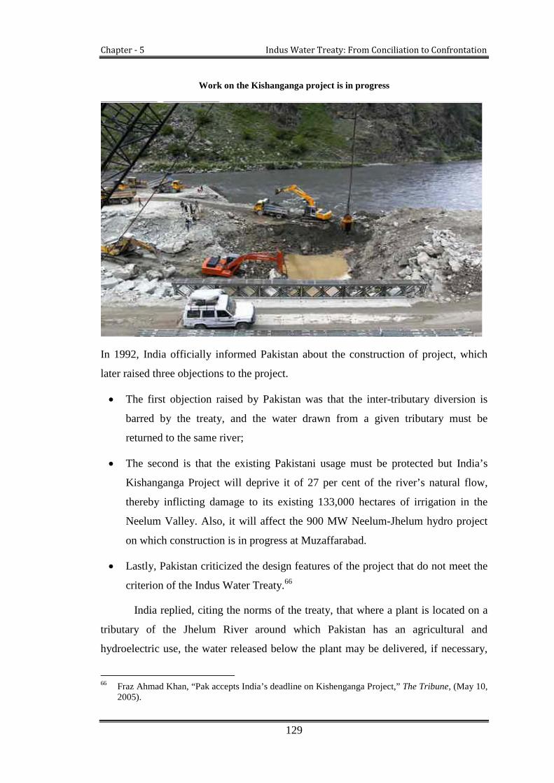
Chapter - 5 Indus Water Treaty: From Conciliation to Confrontation
129
Work on the Kishanganga project is in progress
In 1992, India officially informed Pakistan about the construction of project, which
later raised three objections to the project.
The first objection raised by Pakistan was that the inter-tributary diversion is
barred by the treaty, and the water drawn from a given tributary must be
returned to the same river;
The second is that the existing Pakistani usage must be protected but India’s
Kishanganga Project will deprive it of 27 per cent of the river’s natural flow,
thereby inflicting damage to its existing 133,000 hectares of irrigation in the
Neelum Valley. Also, it will affect the 900 MW Neelum-Jhelum hydro project
on which construction is in progress at Muzaffarabad.
Lastly, Pakistan criticized the design features of the project that do not meet the
criterion of the Indus Water Treaty.66
India replied, citing the norms of the treaty, that where a plant is located on a
tributary of the Jhelum River around which Pakistan has an agricultural and
hydroelectric use, the water released below the plant may be delivered, if necessary,
66 Fraz Ahmad Khan, “Pak accepts India’s deadline on Kishenganga Project,” The Tribune, (May 10,2005).

Chapter - 5 Indus Water Treaty: From Conciliation to Confrontation
130
into another tributary but only to the extent that the then existing agricultural use or
hydro-electric use by Pakistan on the former tributary would not be adversely
affected. To justify its claim, India stated that inter-tributary diversions in the Jhelum
basin are permitted and only “the then existing” agricultural and hydroelectric uses
shall be protected.67
The construction of the project has created a new issue for heated discussions
at different levels after the Baglihar project. The Indus Commission held a number of
meetings to console the parties, but due to different approaches, interpretation of and
perspectives on the treaty text, the dispute remained unresolved. Essentially, growing
needs for water by both the countries and competitive behaviours have affected the
discussions at every level.
5.4.3.1. Pakistani apprehensions over the project: Pakistan further objected to the
project on the ground of diversion of water through the tunnel, since:
The project will have an adverse effect on Neelum-Jhelum link project that
Pakistan initiated in 1988.
Secondly, diversion of the water of the Kishanganga River to Jhelum would ruin
the Neelum Valley in Pakistan and also that the project do not confirm to design
criteria (a)68, (c)69, (e)70, (f) and (g)71 mentioned in Paragraph 11 of Annexure E
to the treaty.
In Pakistan it is also feared that the project could reduce Pakistan’s total water
availability from 154 million acre feet (MAF) to about 140 MAF, a shortage of
about 8-9 per cent.
67 B.G. Verghese, Political Fuss over the Indus, The Tribune, (May 24, 2005).68 The Storage Work shall not be capable of raising artificially the water level in the reservoir higher
than the designed Full Reservoir Level except to the extent necessary for Flood Storage, if any,specified in the design.
69 The volume between the Full Reservoir Level and the Dead Storage Level of any reservoir shallnot exceed the Conservation Storage Capacity specified in the design.
70 Outlets or other works of sufficient capacity shall be provided to deliver into the river downstreamthe flow of the river received upstream of the Storage Work, except during freshets or floods.These outlets or works shall be located at the highest level consistent with sound and economicaldesign and with satisfactory operation of the Storage Work.
71 If a power plant is incorporated in the Storage Work, the intakes for the turbines shall be located atthe highest level consistent with satisfactory and economical construction and operation of theplant and with customary and accepted practice of design for the designated range of the plant'soperation. (Indus Water Treaty Draft, 1960)

Chapter - 5 Indus Water Treaty: From Conciliation to Confrontation
131
Further, it the project would reduce the energy generation of Neelum Jhelum
hydro project by about 16 per cent amounting to an annual loss of Rs. 5 billion
at the current rates.72
It is also feared to reduce the flow of water in the River Jhelum by 27 per cent.
5.4.3.2. Indian perspective on the project: The response of India has always been
that the water of the Kishanganga River will ultimately go to Pakistan and there
would be no serious damage in lower stream areas of Pakistan administrated Kashmir.
Also India’s assessment is that the diversion of water through tunnel into the Jhelum
would help Pakistan to generate more electricity in Mangla and Neelum Jhelum
projects during winter season.
Pakistan has rejected all assessments and appraisals by India regarding the
project. However, the dispute has figured on the agenda of talks even at the time and
now between the Commissioners. As the Commission level discussion did not arrive
at any settlement, the dispute has been referred to the International Court of
Arbitration as instructed in the treaty, because the dispute involves techniques as well
as legal issues. Hence, the decision of the International Court of Arbitration about the
Kishanganga dispute is awaited.
5.4.3.3. On-going discussions on the dispute: A series of talks were held between
the parties at various levels to resolve “differences” and “dispute” attached to the use
of Kishanganga River, but talks remained unresolved and problematic. Pakistan has
frequently criticised the project as the violation of the treaty, and therefore, in April
2006, India offered to modify the project and submitted a revised plan in July 2006. In
the revised plan, India agreed to convert the storage and power generation project into
a run-of-the-river project and construct poundage in accordance with the treaty. But
again Pakistan rejected the plan mentioning that the project still has objectionable
aspects.73 Later Pakistan communicated these objections to India in a detailed report,
while the contention of India has been that the waters will ultimately go to Pakistan.
72 Nausheen Wasi, “India Pakistan Dialogue on Conflict Resolution and Peace Building,” NewDelhi: Institute of Peace and Conflict Studies, (2009): 3.
73 Ibid.

Chapter - 5 Indus Water Treaty: From Conciliation to Confrontation
132
Contemplating the disputes over the use of Indus Basin, it could be concluded
that it is the second time in the past ten years that the dispute over the utilization of
water is referred to the third party for resolution. The Kishanganga dispute assumes a
greater significance because Pakistan is also trying to construct its own project—the
Neelum-Jhelum hydroelectric project—on the Pakistani side of the Neelum River
(Kishanganga). The Indus Water Treaty states that the country that completes its
project first will secure priority rights to the river. Hence, both countries are in contest
to complete their respective projects as soon as possible without considering the
objections and apprehensions of each other. There have been major delays in the
construction of the projects on both sides of the border, because of the dispute and the
issue of water-sharing between India and Pakistan is spiralling.
There are also some other hydroelectric projects which are seen in the light of
controversy between India and Pakistan. These include Dul Hasti, Uri II, Chutak,
Nimoo-Bazgo, Dumkhar, Ratle and Sawlakote Project etc. Aforementioned projects,
objected to by Pakistan, have added new dimensions to the disputes attached to
economic, security and strategic importance, but some are alien to the provisions of
the treaty.
In the following table and figure, an attempt has been made to list out the
chronology of water-related conflicts in the Indus Basin following the signing of the
treaty. At the same time, the table and figure help us to understand the nature and
intensity of water conflicts between the two countries and highlight how the two
countries are engaged in different types of water-related conflicts (see appendix C).

Chapter - 5 Indus Water Treaty: From Conciliation to Confrontation
133
Fig. 1: The nature of water conflicts in the Indus Basin after the treaty
The figure displays the conflicts over water between the two countries since the
signing of the treaty. 80% is about water control, while 20% is about water allocation.
Control of water from western rivers has received considerable attention from both
the sides. It is because of the construction of the projects on western rivers, Pakistan
fears that India is exercising “hydro hegemony”74 on these projects and it will use
these projects as a bargaining tool with Pakistan to settle other related issues. To what
extent these interpretations are valid but the growing concerns of the parties leading
fierce competition over water.
The outcomes of the on-going disputes have broader implications not only for
future water development but also about India-Pakistan relations. The Indus Treaty
has served both the countries and stood with the test of time, but the growing
economies of both countries and the energy needs are nurturing a different set of
challenges. Multiplying problems related to acute water supply have also put on
serious burdens on the Indus Basin Rivers. Exploitation of water with the last drops
means the violation of the treaty. Under such an adverse situation, the Indus Water
Commissioners are also under pressure from respective governments as they have
failed to forge any final decision over certain disputes.
74 “Hydro hegemony is hegemony at the river-basin level, achieved through water resource controlstrategies such as resource, capture, integration and containment” (Zeiton and Warner, 2006a:1)

Chapter - 5 Indus Water Treaty: From Conciliation to Confrontation
134
5.5. Reasons for Differences over Projects
It is usually easier to understand how the “questions,” “differences” and “disputes”
attached to these projects aroused. To be precise, they appeared on the scene from
different approaches to and differing interpretations of various provisions of the main
text of the treaty.
Some issues regarding the technicalities of the treaty are not acceptable to both
parties. For instance, the Article III (4)75 of the treaty barred India in building
any storage on the western rivers, except a limited utilisation that has been
specified in Annexure D and E of the treaty, and also specifies technical
conditions relating to engineering structures and features, such as live storage,
dead storage, limits on raising artificially, the water level in the operating pool,
poundage levels, crest level of the gates, location of intakes for the turbines, and
so on.76 One party claims to be in full conformity with the criteria laid down in
the treaty on these, while the other party says that this is not the case.
The Indus Treaty is a highly technical treaty as compared to other treaties in the
region. The dense technicalities allow ample opportunities for differences and
have made it difficult to understand for engineers and even to Indus Water
Commissioners.77
Some experts are of the view that the Indus Water Treaty carried out a surgery
of the Indus Basin into two as eastern and western group of rivers. Though both
countries are highly dependent on each other for cooperation and development
of the basin, but the division of the basin has reduced the level of cooperation
between the two countries.
Environmental issues like climate change have not been covered in the treaty.
Pakistan, as lower riparian has apprehensions over the projects on the western
rivers and considers them as the existential threat to her inhabitants, as stored water
75 The Article III (4) of the Indus Water Treaty states: except as provided in Annexures D and E,India shall not store any water of, or construct any storage works on, the western rivers. (see morein Annexure D and E)
76 Ramaswami R. Iyer, “Indus Water Treaty: A Different View,” Journal of Economic and PoliticalWeekly, Vol. 40, no 29 (July 2005): 3141.
77 Ramaswami R. Iyer, Towards Water Wisdom: Limits, Justice, Harmony (India: Sage Publications,2007)70-80.

Chapter - 5 Indus Water Treaty: From Conciliation to Confrontation
135
can flush out the land and property. Secondly, Pakistan is afraid that these projects
will reduce the water flow in critical times, especially during the sowing seasons. On
the other hand, India’s concern is to improve its energy efficiencies and economy, for
which it is endeavouring to utilise the full power potentialities. Its booming economy,
waves of globalization, overwhelming urbanization push India to generate more and
more electricity from hydropower projects on Himalayan Rivers.78 Its peak power
demand in the year 2007-08 was 108,886 MW, while the peak power demand met
was 90,793 MW; there was a shortage of 18,093 MW or 16.6 percent of peak
demand. The projects on western rivers are a crucial part of India’s plan to close that
gap. The hydro power sector is also an attractive revenue earner for Himalayan states,
which are underdeveloped in the industrial sector as compared to other states.
Therefore, the exploitation of hydro power from Himalayan Rivers is the only source
to boost their industrial sector.79 But in reply to Pakistan’s apprehensions on western
rivers, Indian position is that it is not violating the spirit of the treaty. Secondly,
Pakistan’s security fears are misconceived as India cannot flood Pakistan without
flooding it first.
5.6. Kashmiri Concerns over Projects on the Western rivers
Quite apart from Indian and Pakistani questions and apprehensions, the projects on
western rivers in Indian administrated Kashmir need to focus on the human security
values of the people of Jammu and Kashmir, because, some projects on western rivers
are being constructed by the J&K Government to boost the state’s economy and for
the welfare of the people. But the treaty between India and Pakistan has inflicted
heavy financial loss to Kashmiris, as in the case of Baglihar Project, which has
estimated that the state of J&K has to incur the loss of Rs 265 Crore annually because
of the treaty and the total losses are over Rs 3325 Crore on Chenab basin.80
The common view in Kashmir is that Pakistan's opposition to the development
of hydropower under the Baglihar project has sidelined hopes and aspirations of the
78 Reimaging the Indus, (2011): 15-17, Report Published by the Observer Research Foundation NewDelhi and Lahore University of Management Science.<http/www. orfonline.org/> (accessed 26September 2012).
79 Ibid., 17, and see also Mary Miner et al, “Water Sharing between India and Pakistan: a CriticalEvaluation of the Indus Water Treaty” Journal of Water International Vol. 34, no, 2 (June 2009):209.
80 M. Ali, IWT hurting JK’s interests. Greater Kashmir, (13 June, 2012).

Chapter - 5 Indus Water Treaty: From Conciliation to Confrontation
136
Kashmiris. With the construction of Baglihar and Kishanganga hydroelectric power
projects by India, the rights of Kashmiris on these projects have been brought to the
center of the Indus water issue. In case of both these power projects, pressure from the
people and polity of J&K state is an important factor to look at.81
While India and Pakistan have cooperated over the Indus Basin since 1960,
recent disagreements over projects on the western rivers have posed serious
challenges to future development of the parties. Though the treaty has the potential to
resolve technical issues but these issues are so politicized with the passage of time on
security and economic grounds, resulting out of political liaisons between India,
Pakistan and Jammu and Kashmir. Therefore, to resolve these issues, a triangle and
deeper look is crucial to take into account future aspirations of all the parties.
5.7. Water Conflict and India-Pakistan Relations
As far as India and Pakistan are concerned, no two countries in the world have so
much in common as these. Both countries have similar cultural roots, linguistic
similarities and shared economic system. However, since independence they have
continuously been in a state of undeclared war with uncompromised issues, especially
over water. The idea of sharing water is historically constructed, emotionally
stimulating, and politically divisive. Though water is technically not a core issue
between the two countries, differences over the use of water of the rivers is a core
issue.82 In recent years, utilization of water has become an issue that is gaining
prominence in the bilateral relationship between India and Pakistan.
In 1960, both governments agreed to sign the Indus Water Treaty, but public
reaction to the treaty was very different. People in Pakistan criticised the loss of three
eastern rivers to India, although Pakistan received a huge amount of financial aid in
lieu of this loss even though this loss imposed heavy financial and ecological
81 Reconsidering the Indus Waters Treaty: The Baglihar Dam Dispute, J&K Insights, (January,2005).<.http://www.jammukashmir.com/insights/insight.2005.0101a.html/>(accessed 17 May,201 0)
82 Ramaswami R. Iyer, India’s Water Relation With her Neighbours (Stimson Center WashingtonDC: 2008): 3.

Chapter - 5 Indus Water Treaty: From Conciliation to Confrontation
137
penalties upon Pakistan.83 In 1964, opposition parties of the countries attacked on
President Ayub Khan, and used the termed as “selling” the historical rights of the
country over the common rivers.84 While in India, the public often criticised the loss
of its three western rivers to Pakistan and the treaty makes it impossible for India to
utilise the full power potentialities on three western rivers.85
Media, academicians, and different groups of society and agricultural
communities from both sides opposed the Indus Water Treaty. Even for opposition
members of both the governments, the Indus Water Treaty is suspicious and unfair.
The water experts from the both countries are also not happy with the treaty. This has
eventually led to the politicisation of the water issue within both countries, and
thereby, creating an immense pressure on respective governments.
It is not difficult to understand the changing tone of political relations
between the two countries vis-à-vis water. It can be understood by revision of recent
projects being executed by India on western rivers, which are severely criticised by
Pakistan. The treaty has survived various external and internal threats which were
related to the two countries political relationships,86 but recent years have marked
strained relations vis-à-vis water and therefore the Indus Water Treaty has come under
the strains, mainly due to construction of hydroelectric projects, including the Salal,
Baglihar, Wullar Barrage, (Tulbul Navigation) the Kishanganga, the Nemo-Bazgo.
Not all of them are sans disputes and are deemed as controversial projects.87
On the other hand, Indian experts have expressed frustration over long delays
in approval of these projects due to Pakistani objections, and about 27 projects on the
western rivers have been questioned by Pakistan. Indian analysts and media are of the
view that the provision of neutral experts should be the last option and not the
recourse for each and every project that India proposes. The reference does cost time,
83 Germy Allouche, “Water Nationalism: An Explanation of the Past Present Conflicts in CentralAsia, The Middle East and The Indian Sub-Continent,” (University of Genève: Unpublished Ph.DThesis, 2005).
84 G.W Choudhury, Pakistan’s Relations with India: 1947-1966 (London: Pall Mall Press Ltd, 1968),169.
85 B.G. Verghese, It’s time for Indus-II, The Tribune Chandigarh, (25 May, 2005).86 Ramaswami R. Iyer, “Indus Water Treaty: A Different View,” Journal of Economic and Political
Weekly, Vol. 40, no 29 (July 2005): 3141.87 Richa Singh, Transboundary Water Politics and Conflicts in South Asia: Toward ‘Water for Peace,
Centre for Democracy and Social Action New Delhi (n d): 10.

Chapter - 5 Indus Water Treaty: From Conciliation to Confrontation
138
money and efforts, in terms of delaying the projects, thereby increasing the cost of not
only construction but also related expenditures in not making use of the hydro
potential.88
Moreover, Pakistan argued that India’s line of action on the riparian issue
hardly warrants a high degree of trust in good neighbourliness. In addition, the
political mobilization on dam construction on the western rivers has stimulated anti-
Indian sentiments among farmer associations, military consortium, politicians, and
fundamentalist groups in Pakistan. From a security point of view, some strategic
analysts in Pakistan are of the view that the Indian intentions are directed towards
flooding Pakistan during tensions and that flood waters could destroy Pakistani
defenses. Pakistan has also certain economic and defensive apprehension on the
construction of projects, especially on Jhelum and Chenab River.
In 2008, after filing of the Baglihar project and subsequent reduction of the
water flow in Pakistan, the project has drawn serious concerns and gained critical
currency among the countries’ political circles. With regard to Wullar Barrage, it has
also incurred political and strategic voices from Pakistan, as it fears that with the
construction of the Wullar Barrage in Indian administrated Kashmir (IAK), India
could close the gate of Wullar Barrage during a warlike situation, enhancing the
ability of Indian troops to enter Pakistan.89 The project is also frequently criticized in
farming communities.
The difficulties in interpretations of the treaty can be attributed to political
motives rather than to differences over technical and engineering aspects of water
management. Some non-state actors, especially radical extremist groups from two
countries have their vested interests in the complex issue of water sharing and the
treaty. Some are of the view that if the gap between water availability and
requirements widens, terrorist operations and recruitment in the region will increase.90
88 Suba Chandran, “Indus Waters Governance-II: From ‘Letter and Spirit’ to ‘Letter vs Spirit”, NewDelhi: Institute of Peace and Conflict Studies (IPCS), 3193, (19 July 2010).
89 Shaheen Akhtar, “Emerging Challenges to Indus Waters Treaty: Issues of Compliance andTransboundary Impacts of Indian hydro projects On the Western Rivers,” (Islamabad: Institute ofRegional Studies, 2010).
90 S. Waslekar, The Final Settlement: Restructuring India-Pakistan Relations, (Mumbai: StrategicForesight Group, 2005):54-62.

Chapter - 5 Indus Water Treaty: From Conciliation to Confrontation
139
Given the present political atmosphere viz-a-viz water, it seems that water has
gained a critical value within the two countries and none of the parties are ready to
compromise. It seems that the temperament of the political systems, interests of non-
state actors and the regional political atmosphere determine the state of affairs of
India-Pakistan conflict over water. Indo-Pak water relations can be well understood
taking into consideration the statement of President Asif Ali Zardari in the
Washington post. According to Asif Ali Zardari,
“The water crisis in Pakistan is directly linked to relations with India. Its
relations with India could prevent an environmental upheaval in South
Asian region, but failure to do so could fuel the fires of discontent that may
lead to extremism and terrorism”.91
The Indus water dispute is overtly linked with Jammu and Kashmir, (a disputed
territory) where the major rivers of disputed water originate. It is quite vividly
expressed by the US Assistant Secretary of State, George McGhee, in his letter to
David Lilienthal, in 1951.
“A settlement of the canal waters question would signify those basic
reversals of policy by the governments of both India and Pakistan without
which there can be no political rapprochement. Thus, the canal waters
question is not only a functional problem, but also a political one linked to
the Kashmir dispute”.92
In 1960, it was hoped that the resolution of water dispute would pave the way for
resolving the Kashmir dispute.93 At the time of signing of the treaty, Jawaharlal Nehru
the Indian Prime Minister, before coming to Pakistan expressed in the Indian
parliament that he was ready to resolve any issue including Kashmir. Similar views
and hopes were also expressed by Pakistani President Ayub Khan.94 Hitherto, three
wars has been fought between India and Pakistan over Kashmir, but the dispute still
remains unresolved and problematic. Until and unless the Kashmir issue is settled,
both countries will not be able to develop good relations in the future. If the countries
91 “Assef fears war with India over Water,” The News, Islamabad (January 3, 2010).92 Letter from US Assistant Secretary of State to David Lilienthal, (August 7, 1951).93 Muhammad Ayub Khan, Friends not Masters: A Political Autobiography, 113.94 G.W. Choudhury, Pakistan’s Relations with India: 1947-1966 (London: Pall Mall Press Ltd,
1968), 167.

Chapter - 5 Indus Water Treaty: From Conciliation to Confrontation
140
came up with an agreement to settle the Kashmir dispute, nothing will prevent them
from building good relationships.
Conclusion
To resolve water disputes, a landmark step was taken in 1960 when Indus Water
Treaty was signed as a major bridge of cooperation and understanding between the
two countries. The Indus Water Treaty is a comprehensive yet complex treaty which
involves varying degrees of political and technical processes and is confined to two of
the five riparian states of the Indus Basin. It has withstood the test of time, but today it
has come under stress because of different sets of challenges.
The utilisation of water remained the bone of contention between the two
countries and has widened the trust gap. In recent years, the differences over
utilisation of water became so grave that the Indus Water Treaty was in the clutches
of controversy between the two, especially over share and quantity of water and
differences about certain projects. Tulbul, Baglihar and Kishanganga, Dulhasti,
Bursar, Nemo-Bazgo projects have posed serious challenges to India, Pakistan and to
the Indus Water Treaty itself. These projects have also intensified the possibility for
future conflicts at various levels.
Given the present circumstances and discussions over utilisation of water, it
seems that the treaty has limited the ability of both countries to manage and utilise
water resources in efficient manner. It appears that finding solutions in terms of water
utilisation beyond the treaty is the best and viable option for both the countries.
Hence, it can be suggested that initiated of meaningful steps are inevitable to resolve
the issue of water management and utilisation cutting across the emotional and
political boundaries for peace and harmony of the region, as the responsible nations of
the South Asian sub-continent.

Chapter - 6
Jammu and Kashmir vis-à-vis Indus
Water Treaty

Chapter - 6 Jammu and Kashmir State vis-à-vis Indus Water Treaty
141
he chapter explores the Indus Water Treaty from Jammu and Kashmir (J&K)
perspective and tries to highlight various issues directly or indirectly connected
with the same. The chapter focuses on issues like hydropower generation
potentialities, difficulties, irrigation-related issues, the rights of the J&K State as per
International Conventions, and lastly, the regional disparity that have arisen as an off-
shoot of the treaty.
6.1. Introduction of Jammu and Kashmir State (J&K)1
The J&K State a landlocked territory, lies in the northern part of the Indian sub-
continent and is surrounded by snow-capped high mountain chains of Himalaya and
Karakoram. It spreads over 2, 22, 236 Square kilometers, divided between three
countries, i.e. Indian Administrated Kashmir, Pakistan Administrated Kashmir, and
China controlled part, which known as Aksai-Chin. One-third of the area is
administrated by Pakistan and two-third is administrated by India and rest is under the
control of China.
The State of Jammu and Kashmir is bounded on the northeast by the Uygur
Autonomous Region of Sinkiang and Tibet (Peoples Republic of China); it is
surrounded by the Indian states of Himachal Pradesh and Punjab on the South, on the
northwest by Afghanistan and on the west by Pakistan.2 By virtue of its important
geographical location and richness of its renewable resources, especially water, the
State has great political, strategic and economic importance. Water is the most
important resource of the State, which is governed by the Indus Water Treaty signed
between India and Pakistan.
1 In this chapter the researcher refers to the area under India’s control simply as ‘J&K’ or ‘IndianAdministrated Kashmir’ (IAK) and the area under Pakistan’s control as ‘Azad Kashmir’ or‘Pakistan Administrated Kashmir (PAK). These terms do not imply in any way politicalboundaries of Jammu and Kashmir, as most of the scholars have been using the same terms forthese areas. India calls the territory under Pakistan control as ‘Pakistan Occupied Kashmir’ (POK)and Pakistan calls the territory under India’s control as ‘Indian Occupied Kashmir’ (IOK), but theresearcher has not used any of these terms in this work.
2 Mushtaqur Rahman, Divided Kashmir: Old Problems, New Opportunities for India, Pakistan, andthe Kashmiri People, (Boulder: Lynne Rienner, 1996), 17.
T

Chapter - 6 Jammu and Kashmir State vis-à-vis Indus Water Treaty
142
6.2. Indus Water Treaty and J&K State Perspective
The disputed status of Jammu and Kashmir State3 has given rise to many other
disputes including the sharing of water resources. Many of scholars are of from India
and Pakistan are of the view that its water resource has become one of the reasons
behind the dispute.4 Geographically the State is a land-lock and has no significant
renewable resources other than water and forest. In fact, nature has endowed unending
supply of water resources, which is the backbone of the State’s economy. The water
bodies of the State have an enormous economic potential in hydro power generation,
irrigation to enhance the agriculture, and lakes and ponds for healthy growth of
tourism.
However, the potential of these rivers has not been adequately harnessed
because of inadequacy of funds and political instability in the region. Secondly, the
Indus Water Treaty has imposed restrictions on J&K, and hence the State cannot
exploit its water resources without the prior approval of the Indus Commission. All
these factors taken together have resulted in an economic backwardness of the State.
In the past five decades, no study has been done to quantify the impacts of the treaty
on the State. Talking on the Indus Water Treaty Professor Gulshan Majeed is of the
opinion that while India and Pakistan had to share the resources and assets as per the
principles and conditions of the partition, they bartered, what actually did not belonged
to them, in lieu of East Punjab rivers, to safe-guard the interests of Punjab. The
proverbial “poor Kashmiri” was again taken unawares and far granted. The then Prime
Minister of Kashmir even congratulated in his “innocence” the two countries for
enacting an agreement, which had a potential to virtually hamper any water related
development in the State of Jammu and Kashmir.5
3 (See in Chapter 1 Introduction, Supra note 23).4 Both India and Pakistan considered Kashmir absolutely vital to their strategic, economic and
defence requirements. (A. Z. Hilali, “Historical Developments of the Kashmir Problem andPakistan’s Policy After September 11 2001 (2004), <http://samgov.tr/wpcontent/uploads/2012/01/6.-A.Z.-Hilali.pdf/> (accessed 5 March, 2012)Pakistani scholars explain that Kashmir is vital to the country’s economy because it is the source ofmost of the rivers flowing into Pakistan. Among the various disputes related to Kashmir betweenIndia and Pakistan is the construction of dams in Jammu and Kashmir State, which will allow Indiathe control over Pakistan’s irrigation and water sources. Human Rights Watch Report, Vol. 18, no.12 (c) (2006):25. <http://www.hrw.org/reports/2006/pa kistan0906/> (accessed August 13, 2012).
5 Gulshan Majeed, “Indus Water Treaty Dissention and Agreement,” (March 2011).

Chapter - 6 Jammu and Kashmir State vis-à-vis Indus Water Treaty
143
Water resource has crucial economic importance to every region for
sustainable development and poverty alleviation. Its role in the developmental process
for every region has linked to human rights. In fact, this view is largely discussed,
appreciated and recognised by the international community. So far J&K state is
concerned; the people of the J&K State are also very much concerned about the use of
water resources and its role in the development process of the State.6 In recent years
some economists have raised this issue at the State level and masses are displaying
their concerns and angst against the negative consequences of the treaty on the State’s
economy.
The Indus Water Treaty was the first bilateral approach to initiate the cordial
relations between the two countries, and it was well-received in both the countries. As
per the rule and spirit of the treaty, India and Pakistan have constructed various dams
and barrages on Eastern and Western rivers respectively. It is admirable that both
countries have protected their water rights through a bilaterally signed treaty. But
unfortunately, the leaderships in Srinagar and Muzaffarabad have failed to safeguard
the water rights of their respective divisions.7 The three major rivers of the Indus
Basin—Jhelum, Chenab and Indus—flow through Jammu and Kashmir State. But
under the provision of Indus Water Treaty, the State of Jammu and Kashmir has to
seek permission from the Indus Water Commission before any water development
program is initiated regarding these rivers.8 This implies that the treaty which was
carried out in the best interests of both the nations has, however, limited the State in its
use of water resources affecting the developmental process of the State. Conforming to
the criteria of the treaty, the State cannot fully exploit the water potentialities of the
Indus, Jhelum and Chenab rivers.9
6 In J&K many water resource experts, economists, scholars and member from different walks ofsociety are of the view that water resources are main sources of economy. Exploitation of the waterresources would likely to give green light to J&K
7 The perennial power crisis Kashmiris have a right to be compensated for the exploitation of theirRivers by both the neighbouring countries, Concern, (2012):209.<http://www.Greaterkashmir .com />
8 Sinha. R, “Transboundary Disputes: Two Neighbours and a Treaty,” Journal of Economic&Political Weekly, (2006), <http://www.epw.org.in/showArticles/>(accessed 20 June 2011).
9 Wajahat Habibullah, “The Political Economy of the Kashmir Conflict Opportunities for EconomicPeace Building and for U.S. Policy” Special Report, no, 121 (June 2004), United States Institute ofPeace, <http//www.usip.org.com.> (accessed 8 April, 2013).

Chapter - 6 Jammu and Kashmir State vis-à-vis Indus Water Treaty
144
The average annual flow of the rivers of Indus system is presented in table 1
and figure 1. The table shows that three western rivers flowing through J&K
contribute a huge volume to the Indus river system, which is estimated at
approximately 135 MAF (80%) of the total water flow. But, the State has been
restricted to utilise its own water resources for fulfilling its requirements. Only a
limited utilization of water is permitted for any development purposes, which can be
easily understood from the table 2.
Table 1: Average annual flow of the Indus river system
Eastern Rivers Western Rivers Total
41 BCM (33 MAF) 20% 166 BCM (135 MAF) 80% 207 BCM (168 MAF)
Source: IWT 1960 draft
Fig. 1: Water Distribution Chart
Three Western Rivers of the Indus Basin make the State of Jammu and
Kashmir an upper riparian. The modus-operandi of the treaty defines the utilisation of
water in J&K as: the State can use only a small quantum of water from the Indus,
Chenab and Jhelum for power generation and irrigation purposes. It cannot build
reservoirs or dams on these rivers to store water for irrigation and hydroelectric power

Chapter - 6 Jammu and Kashmir State vis-à-vis Indus Water Treaty
145
(except “run-of-the-river projects”) without the prior approval of the Indus
Commission.10
The treaty places restrictions on the storage capacity of the State on the western
rivers as is shown in table 2. The table illustrates that J&K can store only 0.40 million
acre feet (MAF) water from the Indus River in Ladakh, 1.50 MAF from the Jhelum
River in Kashmir Valley and 1.70 MAF from the Chenab River in Jammu. Taking into
consideration the currently assessed and harnessed hydro-potential, the treaty does not
allow J&K to generate more than 10 percent of its hydropower and irrigate more than
40 percent land from western rivers.11 As a result, the J&K State annually bears a loss
of 60 billion Indian rupees (US$1. 3 billion) due to the restrictions of the treaty.12
The study reveals that the total permitted storage on western rivers is not
enough to meet the requirements of the State. Even five decades after the signing of
this treaty, no storage facility has been constructed on western rivers. The details of
the storage permitted in India from western rivers are shown in Annexure E, Article III
(4) of the treaty. Moreover, as per Annexure E of the Indus Water Treaty, the
aggregate storage capacity of all single purpose and multi-purpose reservoirs which
may be constructed by India after the Effective Date shall not exceed the following:
Table 2: Storage Permitted to India from Western Rivers
River System
Conservation Storage CapacityFlood Storage Capacity
(MAFGeneral StorageCapacity (MAF)
Power StorageCapacity (MAF)
The Indus 0.25 0.15 Nil
The Jhelum(Excluding the Jhelum main) 0.50 0.25 0.75
The Jhelum MainNil Nil
As provided in Paragraph 9of Annexure E to the Treaty
The Chenab(Excluding the Chenab Main)
0.50 0.60 Nil
The Chenab Main Nil 0.60 Nil
Source: Indus Water Treaty 1960.
10 Sinha, R, “Transboundary Disputes: Two Neighbours and a Treaty,” Journal of Economic andPolitical Weekly, (2006), <http://www.epw.org.in/showArticles/>(accessed June 20, 2011).
11 Athar Parvaiz, india/Pakistan: Indus Water Treaty Agitates Kashmiris (2088) <http://www.ipsnews.net/200810/india-pakistan-indus-water-treaty-agitates-kashmiris/> (accessed June 16, 2013
12 Haroon Mirani, Race to the death over Kashmir waters, Asia Times, (2009), c.f. Shakil A.Romshoo, Indus River Basin Common Concerns and the Roadmap to Resolution, (New Delhi:Centre for Dialogue and Reconciliation, 2012): 22.

Chapter - 6 Jammu and Kashmir State vis-à-vis Indus Water Treaty
146
There are some requirements to the above storage allocations to India:
General storage can be used for any purpose including generation of electricity;
The power storage, under the third column may also be used for non-
consumptive or domestic use, except flood control or protection;
The power storage capacity on the Chenab may be increased by decreasing the
corresponding amounts in the main rivers of Jhelum and Chenab.13
6.3. Hydropower Sector
With the rapid growth of population, urbanisation and industrial growth, electricity
demand has increased in J&K. The hydropower resource is a crucial means to meet the
increasing demands and support economic growth. In fact, the requirements of power
and its availability have been recognized as the surest index for the State’s overall
development. Compared to hydropower generation, thermal generation cannot be a
solution to meet the increasing energy needs of the State, as it is mountainous and
land-locked and at the same time is located away from the pitheads.14 On the other
hand, the J&K State is not rich in the non-renewable sources of fossil fuels, which
could be used for energy generation, but there are huge renewable sources of energy,
especially water resources which can meet the demand. The three main rivers flowing
through J&K State—the Indus and its tributaries, the Jhelum and its tributaries and the
Chenab and its tributaries—offer a tremendous scope for generation of power through
hydroelectric plants, which could be a defining factor in the developmental process of
the State.
Since hydro-power is an intense need for industrialisation and development, if
there is an availability of resources for exploitation in the State, it should be utilised
for optimum benefits. Such optimal exploitation of the available resources of the State
would meet the State’s demand to boom the overall economy. Further, by harnessing
the total estimated power potential of the State, it may prove helpful for bringing peace
and stability to the crisis-ridden State. Meanwhile, number of experts are also of the
13 Indus Water Treaty 196014 S.C. Sud, “Optimising Hydel Development in Chenab Basin” Journal of Himalayan and Central
Asian Studies, New Delhi Vol. 9, no. 3 (2005): 27.

Chapter - 6 Jammu and Kashmir State vis-à-vis Indus Water Treaty
147
view that power potential of the disputed territory could help to metamorphose the
valley of death and destruction to a center of excellence and engineering.
6.3.1. Issues and Challenges for Generating Hydropower Potential
The State has managed to generate around 2500 MW of hydro-power that comes out
about 12 percent of the estimated power potential. The treaty does not allow the State
to construct storage reservoirs on the three western rivers except run-of-river projects.
The total harnessed power potential is on the basis of “run-of-river”15 schemes with
some small “live storage”16 capacity on three Western Rivers. These types of projects
not only increase the construction cost but also adversely affects the cost-effectiveness
of power generation from these projects and generation capacity. Comparatively, the
run-of-the-river projects using small head-falls are reported to be about 75 percent
higher in cost than those hydel projects using high head-falls.17 These high cost
projects generate electricity much below their installed capacity. For instance, run-of-
the-river Uri Hydel Project, which was built at the cost of more than US $ 800 million,
is producing only 200 MW in winter as against the 480 MW installed capacity.18
Commenting on these situations, the former Managing Director for J&K Power
Development Corporation (JKPDC), Javid Shahmiri, stated that “considering that the
hydro potential of the State is about 20,000 MW, annual energy loss works out to
60,000 million units valuing Rs. 12,000 Crores.”19
Flowing through the territory of J&K State, the Chenab River has more power
potential (shown in figure 2) than others, but there is no effective storage on the
Chenab main up to Kishtwar. Three major projects Salal, Dulhasti and Baglihar along
with some other small projects are in operation. But the storage capacity of the Salal
hydro-power project on the Chenab River has got reduced due to sedimentation. The
other projects, such as Baglihar with storage of 0.3MAF, Dulhasti 0.007 MAF on the
15 “Run-of-River Plant” means a hydro-electric plant that develops power without live Storage as anintegral part of the plant, except for poundage and surcharge Storage. (Indus Water Treaty 1960)[article III(2) g]
16 “Live Storage” means all Storage above Dead Storage level. (Indus Water Treaty 1960), [articleIII(2) b]
17 Dost Mohammad and A .S. Bhat, Problems of Power Sector Development (New Delhi: GayanPublishing House, 2002), 175.
18 Ibid.19 Javid Shahmiri, Indus Water Treaty J&K Perspective, (2010): 7, article presented in New Delhi on
India-Pakistan Water Dialogue, <http://www.greaterkashmir.com/> (accessed April 6, 2011).
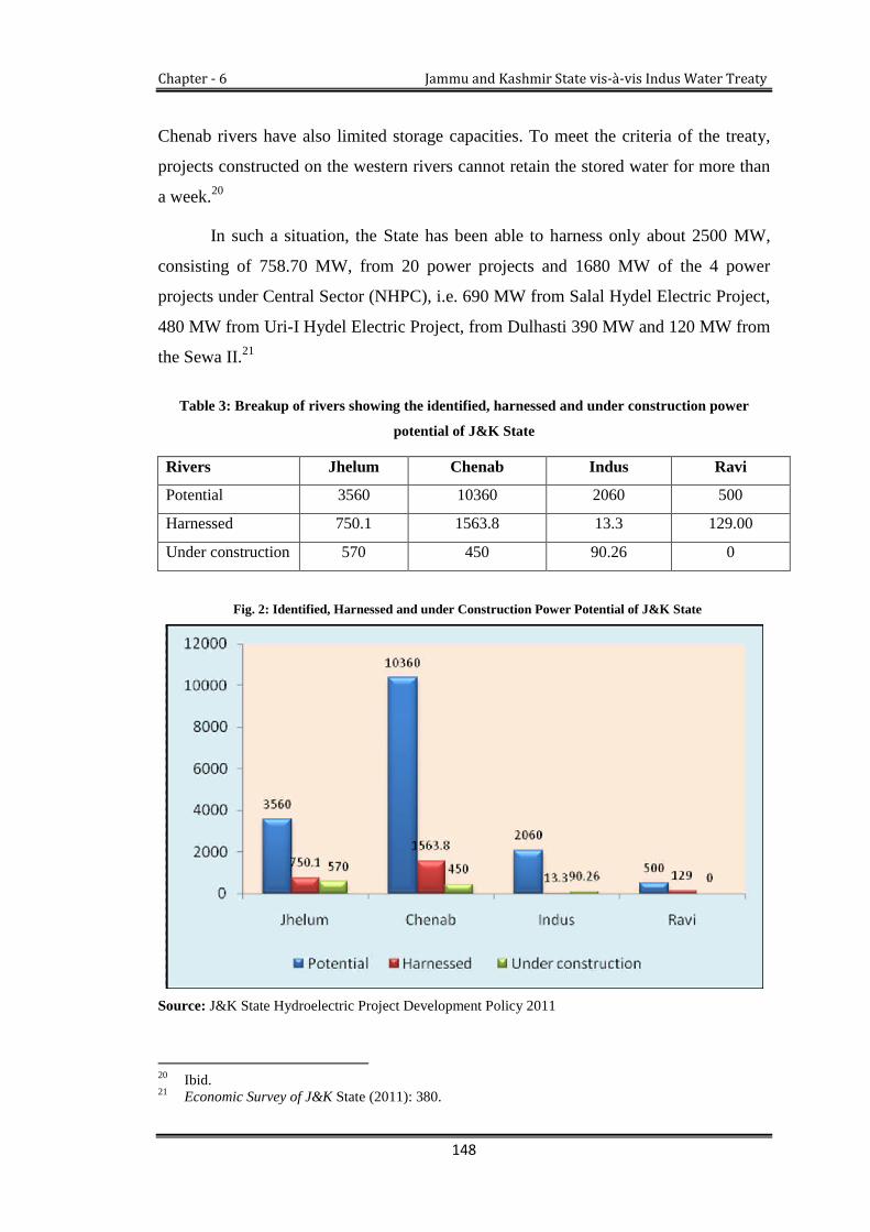
Chapter - 6 Jammu and Kashmir State vis-à-vis Indus Water Treaty
148
Chenab rivers have also limited storage capacities. To meet the criteria of the treaty,
projects constructed on the western rivers cannot retain the stored water for more than
a week.20
In such a situation, the State has been able to harness only about 2500 MW,
consisting of 758.70 MW, from 20 power projects and 1680 MW of the 4 power
projects under Central Sector (NHPC), i.e. 690 MW from Salal Hydel Electric Project,
480 MW from Uri-I Hydel Electric Project, from Dulhasti 390 MW and 120 MW from
the Sewa II.21
Table 3: Breakup of rivers showing the identified, harnessed and under construction power
potential of J&K State
Rivers Jhelum Chenab Indus Ravi
Potential 3560 10360 2060 500
Harnessed 750.1 1563.8 13.3 129.00
Under construction 570 450 90.26 0
Fig. 2: Identified, Harnessed and under Construction Power Potential of J&K State
Source: J&K State Hydroelectric Project Development Policy 2011
20 Ibid.21 Economic Survey of J&K State (2011): 380.

Chapter - 6 Jammu and Kashmir State vis-à-vis Indus Water Treaty
149
The analysis of table 3 and figure 2 show that JKPDC and NHPC collectively
generates a total of 2456.20 MW of hydroelectricity, mainly from the three Western
Rivers. The table and figure also show that the actual power potential of the Jhelum,
Chenab, Indus and Ravi rivers are 3560 MW, 10360, 2060 and 500 MW respectively,
whereas, the potential exploited from these river basins is 750.1MW, 1563.8MW,
13.3MW, and 129 MW respectively.
The table further demonstrates that 570 MW on Jhelum, 450 MW on Chenab,
and 90.26 MW on Indus River are under construction and the Chenab River has the
highest power potential but only 15.09 percent of this has been harnessed so far.
Similarly only 0.0064 percent of Indus River and 21.07 percent of Jhelum River have
been harnessed.
To the pertaining question, namely why this huge potential has remained
unexploited, the common opinions shared by some experts hint at the restrictions
placed by the treaty. The State, for any water development on these rivers, needs prior
approval of the Indus Commission, due to which development processes are being
affected.22 Moreover, some are of the view that as the permitted storage capacity on
the Western Rivers for generating 3500 MW electricity is uncertain, the question of
20,000 MW potential appears impossible. Even the much-anticipated 3,500 MW
potential looks impossible sometimes, because Pakistan has serious objections to all
big projects in J&K, considering them as a violation of the treaty.23
Against Pakistan’s objections on projects, there is a growing resentment in
J&K and people are vehemently demanding for the modification of the treaty.24 If, in
any case, India and Pakistan agree to modify the treaty as per the demands and
interests of J&K, it would probably ensure greater benefits and open up several
avenues for unrestrained development in the State of Jammu & Kashmir. It can
22 F.A Shaheen et al., “Sustaining Energy and Food Security in Transboundary River System: Case ofIndus Basin,” Sher-e-Kashmir University of Agricultural Science and Technology, Srinagar,Jammu and Kashmir (2005).
23 Iftikhar Hakim, The Indus Water Treaty: An Institutional Mechanism for Addressing RegionalDisparity (United Kingdom: VDM Verlag Dr. Muller Publishing House, 2010), 23.
24 S. Chandran, Harnessing The Indus Waters: Perspectives From India, Institute of Peace andConflict Studies, New Delhi, Issue Brief, 122 (September 2009). <http://www.ipcs.org/pdffile/issue/IB129-Ploughshares-Suba.pdf/> (accessed March 29, 2012)
Chapter - 6 Jammu and Kashmir State vis-à-vis Indus Water Treaty
150
improve the potential of hydroelectricity sector and storage facilities can be
developed;
pave the way for industrialisation of the State;
improve the irrigation facilities, which in turn, would boost agricultural growth
and create employment opportunities.25
Even the amount of harnessed power is not benefiting the State’s inhabitants.
The shortage of power continues to haunt the State and is a constraint to the
development, especially to the growing sectors of industry, agriculture and tourism. In
the past fifty years of the signing of the Indus Water Treaty, there has been a sizeable
increase in the population. From 1951, the population of J&K has increased from 32,
53,852 to 1, 25, 48, 926, which resulted in a big leap in demand for electricity. 26 But
Indus Water Treaty is still standing on the same foot right from 1960. It has neither
changed according to the increasing demands of the State nor has its scope been
adjusted for the growing population.27 The Indus water treaty does debar any upper
riparian state to develop run-of the river projects constructed within its set parameters.
If state government fails to develop any such prospect causes need to be looked
somewhere else. The most of our failures are attributable to our for inaction and in the
failed attempts to convince Government of India on the rights and need of the state.
The inefficient distribution system, faulty electricity revenue collection process,
misuse of power and continued power pilfereation and thought, too, contribute to its
deficiency in the state. More importantly, state needs to win over the confidence of
non state actors make them participate in the developmental sector more particularly in
the power sector.
The climate is another factor which is affecting the State’s power potential.
Being a mountainous State, major rivers and their tributaries are snow fed; the water
flow in different rivers gets depleted during the winter season (from September to
February). Thus, the installed capacity of power projects in J&K dips from 25 percent
to 30 percent, and therefore, the State is obliged to run the high cost gas-based
25 S. Waslekar, The Final Settlement: Restructuring India-Pakistan Relations, 54-62.26 Riyaz Punjabi, “Indus Waters Treaty Human Security vs. Military Security” Journal of Peace and
Conflict Studies, New Delhi Vol, 11, Issue 4 (2004).27 Dost Mohammad and A. S. Bhat, Problems of Power Sector Development, 175.

Chapter - 6 Jammu and Kashmir State vis-à-vis Indus Water Treaty
151
generation units and import electricity from the Central Government of India.28 It is
time that the rivers are fast becoming water deficit due to various causes; more
important being the climate changes but the State cannot be exonerated on the pretext
for faulty in sufficient water facility in the state. The state is utilising its water far
below its actual availability.
Referring to a recent analysis by the State Government, due to the decreasing
flow of three rivers, the power generation capacity went down below 50 percent. For
example, the Baglihar project has a potential to generate 100 Lac units of electricity,
but due to decline in water flow, its generating capacity has decreased from 100 Lac
units to 66 Lac units. Similarly, the other major projects have collective potential to
generate 26 Lac units of electricity, but due to decline in water flow, it has been
reduced to 19 Lac.29 To bridge the electricity gap, the State is purchasing electricity
from other Indian states at higher price and for the last three decades the trend
continues. The shortage of power has hampered the growth of industry and commerce
in the State.30 Meanwhile, the State’s power demand is estimated to increase to 2,700
MW in 2012–13 and 5,500 MW by 2025–26.31
To justify climate change and its impact on Kashmir water, a report recently
published by Professor Shakil A Romshoo, Department of Geology and Earth
Sciences, University of Kashmir, can be taken into account. According to Shakil A
Romshoo, for the past two decades, water of Jhelum River and its tributaries has
considerably reduced and climate change has posed a serious threat to the
developmental process.32
If the entire power potential of the State is to be utilised, the power generation
can be run as a separate industry on commercial lines and the State can sell surplus
power to other Indian states and neighbouring Pakistan as well. This would,
undoubtedly, boost the State’s economy and help to attain self-reliance. To meet the
28 Ibid.29 Beyond the Indus Treaty: A Perspective on Kashmir’s “Power” Woe, 2012.30 Dost Mohammad and Bhat, Problems of Power Sector Development, 173.31 IDSA Comment, February 2, 2012, Beyond the Indus Water Treaty: A Perspective on Kashmir’s
“Power” Woes.32 Shakil A Romshoo, Indus River Basin Common Concerns and the Roadmap to Resolution, (New
Delhi: Centre for Dialogue and Reconciliation, 2012).
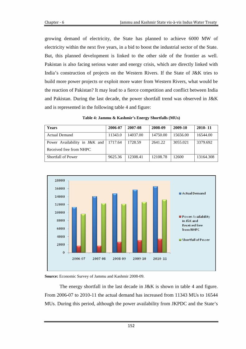
Chapter - 6 Jammu and Kashmir State vis-à-vis Indus Water Treaty
152
growing demand of electricity, the State has planned to achieve 6000 MW of
electricity within the next five years, in a bid to boost the industrial sector of the State.
But, this planned development is linked to the other side of the frontier as well.
Pakistan is also facing serious water and energy crisis, which are directly linked with
India’s construction of projects on the Western Rivers. If the State of J&K tries to
build more power projects or exploit more water from Western Rivers, what would be
the reaction of Pakistan? It may lead to a fierce competition and conflict between India
and Pakistan. During the last decade, the power shortfall trend was observed in J&K
and is represented in the following table 4 and figure:
Table 4: Jammu & Kashmir’s Energy Shortfalls (MUs)
Years 2006-07 2007-08 2008-09 2009-10 2010- 11
Actual Demand 11343.0 14037.00 14750.00 15656.00 16544.00
Power Availability in J&K and
Received free from NHPC
1717.64 1728.59 2641.22 3055.021 3379.692
Shortfall of Power 9625.36 12308.41 12108.78 12600 13164.308
Source: Economic Survey of Jammu and Kashmir 2008-09.
The energy shortfall in the last decade in J&K is shown in table 4 and figure.
From 2006-07 to 2010-11 the actual demand has increased from 11343 MUs to 16544
MUs. During this period, although the power availability from JKPDC and the State’s

Chapter - 6 Jammu and Kashmir State vis-à-vis Indus Water Treaty
153
share from NHPC run power projects has increased from 1717.64 MUs to 3379.692
MUs, falls short of the actual demand. This has created a wide chasm between the
demand and supply. In order to bridge this gap, the State government is purchasing
power from the Central sector, yet the requirements remain unfulfilled.
Table 5: Power Purchased from outside of the State (in Lac Kwhs)
Source: Jammu and Kashmir Digest of Statistic 2008-09.
Table 5, while highlighting figures for the last decade, shows that, except in
2007-08, there was a continuous increase in power purchases from 1999-00 to 2008-
09. These figures have almost doubled over the years. It means that the State has to
pay a huge amount for power purchases from other States. For example, the total
Years Power Purchased
1999-00 43466.90
2001-02 49894.80
2003-04 62327.00
2004-05 65666.50
2005-06 71920.00
2006-07 82170.00
2007-08 78734.07
2008-09 78734.07 (P)
Chapter - 6 Jammu and Kashmir State vis-à-vis Indus Water Treaty
154
expenditure on the import of power during 1996-97 was Rs. 400 crores, which could
install a generating capacity of 150 MW project in the State,33 and this amount is
increasing year after year. As far as the central projects are concerned, the State is
receiving only 12 percent free power as royalty from these projects.34 This 12 percent
royalty is not enough to meet the growing demand of the State. On the other hand, to
meet the energy requirements, the State spends a huge amount of Rs 2,000 Crores on
purchasing power, around one third of the State’s annual plan budget.
The State Government and other sections of society have raised objections to
projects executed by the NHPC. According to them thus, projects are neither
benefiting the State in power supply nor in terms of employment opportunities to an
expected extent. It is quite undesirable that projects, such as Salal, Dulhasti and Uri
have been built in Kashmir but electricity generated from these projects is utilised
elsewhere in India. Still 25 percent population of J&K has no access to electricity and
the remaining proportion of the population relying on episodic electricity, which is
often cut off for hours in winters.35
If the State had been allowed to utilise its water resources freely, the State
could have been able to produce the increased amount of electricity within the State
and the huge amount of money which it has to pay for purchasing the power outside
the State could have been invested for other developmental purposes that might result
in overall growth of the State’s economy. Also, because of its abundant water
resources, it could have been able to generate surplus electricity, which it could have
exported to neighbouring States providing additional revenue to the State.
6.4. Irrigation
Irrigation is one of the significant inputs accomplishing sustained agricultural growth
and reducing inequality and poverty. The irrigation network has a potential to sustain
industrial growth through agricultural productivity, employment and income
generation through command area and watershed management. Irrigation is the lifeline
33 Dost Muhammad and A. S. Bhat, Towards Understanding the Kashmir Crisis, 182.34 Ibid., 174.35 Athar Parvaiz, “Water Wager: India and Pakistan are locking Horns over dam projects in a race to
secure priority water rights on the Indus River” (2011), <http://www.Chinadialogue.net/article/show/single/en/4176/> (accessed February 2, 2012)

Chapter - 6 Jammu and Kashmir State vis-à-vis Indus Water Treaty
155
for an economy and its people, as the major chunk of population of J&K State lives in
rural areas and is dependent on agriculture for their livelihood. If we look into the
annals of Kashmir, irrigation development started long ago during the reign of
Lalitaditya, the great ruler of Kashmir, when a remarkable irrigation system was
developed which survived for centuries.
Although, presently, the Government of J&K has a well-established
department of irrigation which looks after the irrigation system, the utilisation of water
for irrigation purposes is guided by the Indus Water Treaty. The irrigation department
is not free to utilise the water for required irrigation. In fact, the Indus Water Treaty
has imposed some restrictions on State’s water utilisation. The State cannot fully
exploit the irrigation potential of the Indus, Jhelum and Chenab rivers. Nonetheless,
the official commentator of irrigation department of J&K said that the treaty has
offered a great scope for irrigation development in the State, but the State has not been
able to harness even a bit of that and opined if the State irrigation department would
utilise permissible water for irrigation purposes, the agriculture produce would
increase to more than its double, and the State would become self-sufficient in food
grains production.36
Irrigation potential in J&K has been assessed at 1358 thousand hectares, which
includes 250 thousand hectares to be developed through major and medium Irrigation
and 1108 thousand hectares through minor irrigation. However, till the end of the 10th
Plan, the State has been able to create a total potential of 677.66 thousand hectares
through major and medium surface water schemes, out of which, only 580.61 thousand
hectares are being utilised. The minister for Flood Control and Irrigation of J&K
Stated that the J&K State government is going to start construction of the canal on the
Ravi River in Jammu Province, which would provide water to 1,33,000 Kanals barren
land and will produce 2,66,000 tons food grains and also facilitate 7 Lac inhabitants.
At present, in J&K, there are 22 major, 534 medium and 235 minor irrigation
schemes in operation which provides irrigation to the State through the Indus, Jhelum,
Chenab and the Ravi Rivers.37 Besides these projects, 14 medium and 13 renovation
projects are also under construction. There are some proposed projects pending in J&K
36 Greater Kashmir, (May 13, 2012), <http://www.greaterkashmir.com/> (accessed May 13, 2012)37 Economic Survey of J&K, (2011).11

Chapter - 6 Jammu and Kashmir State vis-à-vis Indus Water Treaty
156
which needs permission from the Indus Water Treaty commission, as F.A Shaheen in
his research paper stated that the State of J&K has 12 new irrigation projects which are
pending for want of permission from the Indus Water Treaty commission.38 But the
department of irrigation and flood control counter claims that the entire scheme has
been completed and three new proposed schemes are now pending with the
Commission.39
As of the effective date when the treaty was signed on April 1, 1960, India was
irrigating an area of 6.42 Lac acres of the Western Rivers and under the treaty, India
was entitled to irrigate an additional irrigated cropped area (ICA) of 7.01 Lac acres
(total of 13.43 Lac acres). India is permitted to irrigate the whole area of the western
rivers as per the treaty, which is illustrated in Table 6.
Table 6: Irrigation Entitlement to India from Western Rivers
Name of river The Indus The Jhelum The Chenab Total
Irrigated Cropped
Area (ICA) in acres
70,000 4,00,000 2,31,000 7,01,000
Source: IWT 1960 draft. Includes 6000 Acres outside the drainage basin of the Chenab
A restriction has, however, been put on India that to India can release water
from the conservation storage as stipulated in Annexure E of the treaty, the new areas
developed by withdrawals from river flow shall not exceed 270,000 acres of the ICA
(Jhelum 150,000, Indus 70,000 and Chenab 50,000).40
The State in 1955-56 could irrigate 277.00 thousand hectares by canals, 1.00
hectares by tanks, 3.00 hectares by wells and 9.00 hectares by other sources. Against
this backdrop, in 2007-08, the State could irrigate only 285.78 thousand hectares by
canals, 4.22, hectares by tanks, 0.99 hectares by wells and 17.00, thousand hectares by
other sources. It shows that for a period of almost 53 years, there has been a negligible
increase of 17.99 thousand hectares in the total cropped area from all sources.
38 F.A Shaheen et al., Sustaining Energy and Food Security in Transboundary River System: Case ofIndus Basin, Sher-e-Kashmir University of Agricultural Science and Technology, Srinagar, India.
39 Information Collected from the Irrigation Department of J&K Srinagar, (1 February, 2012).40 Indus Water Treaty 1960.

Chapter - 6 Jammu and Kashmir State vis-à-vis Indus Water Treaty
157
Therefore, the present sources of irrigation are not enough to meet the water demands
of increasing agricultural areas of the State.
As per the economic survey, the State is lacking in irrigation infrastructure.
Out of the total area under cultivation, 58 percent is rain fed which depends upon the
vagaries of climatic conditions.41 Therefore, the rain fed land is unable to yield
optimum production because it is highly dependent on the climatic patterns. From the
last few years the climatic trend has changed drastically, which impacts the agriculture
and hence results in low agricultural production. These changes demand adequate
irrigation infrastructure and storage facilities, so that maximum production target
could be achieved in the State. But the Indus Water Treaty restricts the State to harness
water for mega irrigation projects. Thus, the treaty acts as a bottleneck in the irrigation
development which affects the agricultural productivity of the State.
The treaty has fixed basin-wise irrigated cropped area in J&K. It cannot be
legally extended. The additional permitted quantity of water for irrigation purposes has
also been fixed. The State is permitted to store only 0.05 MAF water under general
storage on Jhelum and Chenab basins. However, this water cannot be stored in the
Jhelum main or Chenab main but, in various streams that form the tributaries of these
rivers. For every new irrigation scheme which the State aspires to develop, it has to
seek permission from the Indus Commission.
Table 7: Breakup of Maximum Permissible Limits for Irrigation on Western Rivers (ICA)42 and
Achieved ICA
RiverBasin
ICApermissible as
on theeffective date(1-4-1960) (in
Acres)
Additional ICA
permissible (in
Acres)
Net ICApermissib
le (inAcre)
TotalAchieved
ICA in 2008(Acres)
Total AchievedICA in 2009-10
(Acres)
Percentageof Growth
Indus 42,179 70,000 1,12,179 51175 51536 +0.71
Jhelum 5,17,909 1,50,000 6,67,909 633002 6,33,002 +0.22
Chenab 82,389 50,000 1,32, 389 99068 99014 -0.05
Total 9,12,477 7,81,847 7,83,552 0.22
Sources: Indus Water Treaty 1960 and Financial Commission of Revenue, J&K State (February 2012)
41 Economic Survey of J&K, (2011): 160.42 ICA (Irrigated Cropped Area): means the total area under irrigation in a year, the same area being
continued twice if it bears different crops in Kharif and Rabi. Source IWT Draft 1960, Annexure C,Article III (2).

Chapter - 6 Jammu and Kashmir State vis-à-vis Indus Water Treaty
158
Table 7 demonstrates that the Indus Water Treaty provides a gross irrigated
area of 9, 12,477 acres for J&K. But, still the legally provided irrigated cropped area
has not been achieved fully since 1960. The total irrigated cropped area in 2009-10
was 7, 83, 552 acres, which shows only a slight growth of 0.22 percent over the
previous year (2008). This indicates that about 1, 28, 925 acres are yet to be irrigated
as per the dictates of the treaty. The Indus Water Treaty has also permitted separate
irrigation facilities on each river basin according to population density and physical
condition of the area. For instance, in Ladakh the Indus Water Treaty provides a gross
irrigated area of 1, 12,179 acres (45397 hectares) from the Indus River and its
tributaries. The total cultivable area in Ladakh region is only 71540 acres (28953
hectares). Therefore, all the cultivable area of Ladakh region can be brought under
irrigation within the parameters of the treaty, but the provisions cannot be fully utilised
as the cultivable area is limited.
In the Jhelum Basin, the irrigated cropped area on the effective date when the
treaty signed was 5,17,909 acres (209544 hectares). The additional cropped area
permissible, without any storage as per the treaty, works out to be 6,67,909 acres
(267163 hectares), out of which 6,33,002 acres (2,56,172 hectares) has already been
achieved in 2010. The net irrigated area is estimated to be 4,79,621 acres (1,94,400
hectares) with irrigation intensity being about 1.36. To enhance the irrigation facilities
and thereby maximum agriculture production the state government introduces different
methods and techniques. The large number of surface water schemes, lift irrigation
schemes, dug wells; shallow tube-wells have also been developed.
The table 7 makes it clear that the maximum permitted cropped area of the
Jhelum basin has almost been exceeded. It is also evident that on the Jhelum basin in
Kashmir Valley, there is no scope for further irrigation. However, to achieve the
permissible irrigated cropped area of 9, 17,909 acres (3, 71,473 hectares), (i.e. ICA as
was irrigated on the effective date plus the ICA permitted under the Indus Water
Treaty), it is apparent that the future projects in the Jhelum Basin ought to be stored
based projects, from where the releases as per the provisions of Indus Water Treaty
can be made for further irrigation. But, keeping in mind the vulnerability of Pakistan,

Chapter - 6 Jammu and Kashmir State vis-à-vis Indus Water Treaty
159
it is also possible that if India exercises its right to store 1.5 MAF on Jhelum, River43 it
may become a cause of conflict between the two countries.
The Jammu region is mostly irrigated by the river Chenab and its tributaries.
The main sources of irrigation are canals, tube-wells, shallow tube-wells, tanks and
springs. Thus, a large number of minor canal networks have been made in the hilly
areas of the Chenab basin. There are about 5777 minor irrigation schemes—surface
flow (1847), surface lift (94), Deep tube wells (20), Shallow tube wells (1371) and
Bumbies (2445). It is obvious that minor irrigation schemes have played a significant
role in the development of irrigated agriculture in Jammu region. Also, in plain areas
of Jammu, two major canals namely Ranbir canal and Partab canal were constructed
way back during 1903-04 which irrigate a vast track of land on either side of the river
Chenab. From 1979-80, the Tawi River has also been harnessed by 40,070 hectares
irrigated area in 2010. There are some restrictions placed by the treaty for expanding
the irrigation area without creating storages.
The above analysis shows that irrigation facilities in the State have been mostly
covered in the additional area permissible without releases from the storage, except
Indus sub basin where the agricultural cropped area is quite limited and there is no
large scope for further irrigation. Creation of storage projects in Jhelum and Chenab
basin is, therefore, important for the release of water and achieving the additional
irrigation in Jhelum and Chenab sub-basins. Hence, the additional ICA that can be
developed with annual releases from conservation storage is shown in the following
(table 8).
43 The storage on Jhelum basin will reduce the water flow for Mangla Dam and Pakistan will beunable to fill the proposed 40 feet height of the dam. Also the storage of 1.5 MAF for irrigation inIndian Administered Kashmir on Jhelum basin will affect the ongoing Neelum-Jhelum Project inPakistan Administered Kashmir. (Subrahmanyam Sridhar, The Indus Water Treaty, (n .d) <http://www.bharat-rakshak.com/SRR/Volume13/sridhar.html/>( accessed march 11, 2012)

Chapter - 6 Jammu and Kashmir State vis-à-vis Indus Water Treaty
160
Table 8: Breakup of Additional Cropped Area on Western Rivers (in Acres)
River basin Area in acres
Indus Nil
Jhelum 2, 50, 000
Chenab 1,75,000
Total 4,25,000
Source: Indus Water Treaty, 1960.
Table 8 depicts that 4, 25,000 acres of additional irrigated area can be
developed by way of conservation storage on two rivers, viz. Jhelum and Chenab.
However, as per the survey conducted by Central Water Commission India (CWC)
and the J&K State Government, the scope of development of storage in the Jhelum is
quite limited. It is about less than 0.1 MAF. In the Chenab River basin, the scope of
storage is very limited except Bursar hydroelectric project. To enhance the irrigation
potentialities, the State government has started the construction of Bursar project,
which would be the first of its kind in its capacity to harness the irrigation potential by
the storage of water.44 But, storage on the Western Rivers seems to be a cause of
conflict and tension between the two countries. To provide evidence to this fact soon
after the construction of Bursar Project45 and building of artificial lake on Tawi River,
Pakistan raised objections, considering them as the violation of treaty. These disputes
highlight the fact that the treaty has failed to safeguard the rights of both parties in the
way they were stipulated in the treaty. The treaty also proved a handicap for the State
of J&K by affecting the growth and development of the State in power and agriculture
44 Greater Kashmir (May 12, 2012), <http://www.greaterkashmir.com/>,(accessed May 12, 2012).45 The storage on Chenab basin has become a cause of conflict between India and Pakistan. For
instance the construction of Bursar project on Marusudar River (Chenab tributary) for irrigation and1020 MWs’ power generation is a controversy between two countries. Pakistan objected that theBursar Dam is the biggest project among a host of others being built by India on two major rivers –Jhelum and Chenab, with a generation capacity of 1,020MW and a height of 252ft. According toPakistan these specifications will be in gross violation of the treaty and will block 2.2MAF of waterto Pakistan, however the Indian government has not confirmed the design and has stated that it willgive Pakistan notice 6 months before it starts construction or work as is stipulated in theIWT.(Gitanjali Bakshi and Sahiba Trivedi, the Indus equation (2011), 27, Published by StrategicForesight Group: Mumbai)

Chapter - 6 Jammu and Kashmir State vis-à-vis Indus Water Treaty
161
6.5. Utilisation of Water Resources in Azad Kashmir (AK) or Pakistan
Administrated Kashmir (PAK)
Situated between the longitude of 730-750 and 330-360, Azad Kashmir comprises an
area of 5134 Sq. Miles (13297 Square Kilometers). Topographically, AK is mainly
mountainous, with small valleys and stretches of plains. It is a region which has
considerable water resources that are beneficial for small irrigation schemes to
enhance the agriculture on barren and plateau types of lands and for the tourism
development through small artificial lakes. Even though Jhelum, Neelum and Poonch
rivers flowing through the State offer a good scope for generating hydro power that
could fuel the economic growth, the AK Government has not been able to harness the
optimum benefits of these water resources for the economic and human development
of the State, because the region is financially dependent on Pakistan which allocates
the funds to AK through the Kashmir Council. It is estimated that AK has the hydro-
power capacity of about 5,000 to 7,170 MW.
The Azad Jammu and Kashmir Hydro Electric Board (AJKHEB), established
in 1989 by the Government of Azad Kashmir, estimated hydroelectricity potential at
around 4635 MW (in some estimates the AK has 5,000 to 7,170 MW potential). But,
AJKHEB has been able to harness only 40.9 MW (a critical barrier to the area’s
growth and development) as shown in table 10. The board has completed the 1.6 MW
Kathai, 2 MW Kundel Shahi, 2 MW Leepa and 30.4 MW Jagran hydel power
projects.46
46 AJK Hydro Electric Board Muzaffarabad, (2012)

Chapter - 6 Jammu and Kashmir State vis-à-vis Indus Water Treaty
162
Table 9: Identified and Harnessed Power Potential (in MW)
Total Identified
potential MW
Power Availability
(MW)
Power Demand
(MW)
Power Shortfall
(MW)
4635 40.9 430 389.1
Source: AJK HEB Muzaffarabad 2012.
The table and figure illustrate that the State has 4635 MW power potential but
it has been able to harness only 40.9 MW, which is much less than the current power
demands of 430 MW. There is a big gap between demand and the availability of
power. Thus, the region is facing 389.1 MW shortage of power. To bridge the power
shortage gap, the AK Government is purchasing power from WAPADA, whose
electricity tariffs are RS 4.25 a unit in AK as compared to Rs.2.85 a unit in Pakistan.47
Theses extra electricity tariffs put a heavy financial burden on the Government of AK
and its people.
Despite having abundant water resources, why is AK not able to harness
sufficient electricity for its own uses and for the development of the region. There are
47 Shabir Choudhry, “Mangla Dam upraising and suffering of local Kashmiris and if we spoke aboutPakistan?” UN Sub Commission on the Protection and Promotion of Human Rights, PaperPresented in Seminar, Organised by the World Council for Peace, Geneva, (28 July-15 August2003).

Chapter - 6 Jammu and Kashmir State vis-à-vis Indus Water Treaty
163
two reasons: Firstly, due to the financial dependency on Pakistan, the AK Government
is unable to construct any mega projects which could generate surplus electricity.
Secondly, by the signing of the Indus Water Treaty, water resources are largely
allocated to Pakistan which has constructed various projects in downstream to AK
including the mega project Mangla. Therefore, it is usually difficult for AK to tap its
water resources to a large extent independently.
The Indus Water Treaty is not only unfavorable for Indian Administrated
Kashmir, but it is also disadvantageous for Pakistan Administrated Kashmir, because
the treaty has deprived the regions to utilise their resources independently.
6.5.1. Mangla Dam and its consequences
The Mangla dam is a direct result of the Indus Water Treaty through which Pakistan
generates 1000 MW electricity. But the project has not given much benefit to the
people of AK. When the dam was first built in 1967, around 300,000 people were
displaced in order to meet the water and energy needs and were promised of generous
compensation from Pakistan.
Although the displaced people claimed that the Mangla dam is a glaring
example of their sacrifices for Pakistan, the role of beneficiary has remained unfair
towards the people of AK, especially to the inhabitants of Mirpur district. On 3
October, 1957 at the time of the construction of dam, Pakistan assured to the United
Nations (UN) that the Mangla dam project was being carried out in cooperation with
AK Government. It was informed to the UN that the project would greatly strengthen
the economy of AK and would, in no way, adversely affect the existing interests.48
However, C. Snedden (2013), highlihts that only Pakistan and Pakistanis are the main
beneficiaries of the Mangla dam in terms of irrigation and cheap electricity, as the dam
is Pakistan’s second largest source of electricity after Tarbela and major water storage
facility for Punjab’s irrigation system.49 Mangla is thus critical to the success of the
Pakistani economy as a whole. Yet, despite the great benefits it has brought to
48 Syed Nazir Gilani, “Baglihar Dispute: A Kashmiri Perspective” Journal of Himalayan and CentralAsian Studies Vol. 9, no, 3 (2005): 44.
49 Christopher Snedden, Kashmir: the Unwritten History, (India: Harper Collins Publishers, 2013):180-84.
Chapter - 6 Jammu and Kashmir State vis-à-vis Indus Water Treaty
164
everyone in Pakistan proper, those unfortunate enough to live immediately upstream
of the dam have had to bear the brunt of its environmental costs.50
Also, from an economic point of view, the project can be considered as
disadvantageous to Azad Kashmir. To justify this fact, it is pertinent to mention here
that the most fertile land of AK, agriculture, business, markets, towns, transportations
and communications were adversely affected by the project. Till 2003, the
Government of Pakistan did not pay any royalty to the concerned State for using its
territory for the construction of the project, despite the allocation of significant
revenue resulting from the dam, which is about RS. 7 billion annually. For the last four
decades, the project has made significant contributions to Pakistan’s economy, which
is roughly estimated at about Rs. 280 billion. Since its inauguration in 1968, it has a
power generation capacity of 1000 MW, which fulfills 20 percent of the total
electricity needs of Pakistan. Nevertheless, the WAPADA officials claimed that they
paid considerable amount which is about R.S 50 billion for affected people via
respective governments.51
From 2003, the Pakistan Government regularly started compensating AK, but
in comparison to other provinces, AK received very insufficient compensation, i. e,
only 15 paisa per unit, whereas other provinces of Pakistan are receiving 70 Paisa per
unit.52 Azad Kashmir is yet to get its Rs120 billion outstanding amounts from
Islamabad, whereas other provinces of Pakistan, such as Khyber-Pakhtunkhwa was
recently paid Rs120 billion for Tarbela, Punjab was paid Rs 28 billion for Ghazi
Barotha and Balochistan was paid Rs120 billion for Sui Gas.53 Such discriminatory
treatment and denial of rights from beneficiaries of Mangla has widened the trust gap
between Islamabad and Muzaffarabad. C. Snedden (2013), in his book the “The
Unwritten History of Kashmir” is of the view that had Azad Kashmir received
reasonable revenues from hydroelectricity generated by the Mangla dam and had
50 Roger Ballard, “The Kashmir Crisis: A View from Mirpur.” Journal of Economic and PoliticalWeekly (Mumbai: 1991):513-517.
51 Pakistan Observer, AJK apex court to take up compensation issue, Islamabad, (August 23, 2011),<http://pakobserver.net/detailnews.asp?id=110433/> (accessed, June 22, 2012).
52 Ibid.53 Zulfiqar Abbasi, Why Azad Kashmir Lags, The News Islamabad, (August 17, 2011),
<http://www.thenews.com.pk/Todays-News-9-63238-Why-Azad-Kashmir-lags/> (accessed May12, 2013)

Chapter - 6 Jammu and Kashmir State vis-à-vis Indus Water Treaty
165
Pakistan kept its promises, the Azad Kashmir today would have been economically
prosperous and independent of Islamabad.54
There are some other view that if Azad Kashmir could get control over its
hydro resources and develop its own projects within the region, it would not only
fulfill local requirements but also boost up the economy by selling surplus power in
Pakistan. It would release AK from the financial dependency on Pakistan and also
revolutionise the entire economy.
6.5.2. Mangla dam and rights over water as a source of tension between
Islamabad and Muzaffarabad
Mangla dam, which affects the waters of AK, is a continuous source of tension
between Muzaffarabad and Islamabad. The construction of dam has dislocated the
well-off Mirpuris community, which felt a sense of wrongfulness and economic
exploitation by Pakistan.55 Hence, the debate over Mangla dam plays an important role
in shaping up the discontent of Mirpuris with Pakistan. Over the same issue, not only
Mirpuris displayed their angst but the entire AK is agitated because electricity
generated from the project and the revenue obtained from the same are not beneficial
to local people, which have eventually brought all Kashmiris together. Also, this
situation actually possesses a socio-political challenge to the local government and
Pakistan too.
Pakistan’s main concern over the Mangla dam is that its construction is a direct
result of the Indus Water Treaty of 1960 with India wherein the World Bank had acted
as guarantor. But the people of Azad Kashmir in general and the Mirpuris in particular
are of the view that water is their natural resource that has been exploited by the
Pakistan without any regard to the rights of Kashmiris. “Arabs have the oil, the Baloch
have minerals and Kashmir has water.”56 Pakistan uses their water, even generates
electricity from the region, which is utilised in Pakistan rather than in their region
resulting in acute electricity shortage in the region concerned. In spite of generating
1,000 MW from the Mangla dam, the region gets 5-10 hours episodic electricity per
54 Christopher. Snedden, Kashmir: the Unwritten History, 180-84.55 Human Rights Watch Report, Vol. 18, no. 12 (c) (2006):25. <http://www.hrw.org/reports/2006/pa
kistan0906/> (accessed August 13, 2012).56 Ibid.,

Chapter - 6 Jammu and Kashmir State vis-à-vis Indus Water Treaty
166
day (though the Azad Kashmir has low electricity demand), and the electricity tariffs
are higher than Pakistan’s other provinces, which reflects the discriminatory attitude of
WAPAD and Pakistani authorities.
In Azad Kashmir, various vehement protests are being launched demanding the
Pakistan Government to stop the exploitation of AK through WAPADA and return
projects controlled by WAPADA. They have strong discontentment over water and
electricity shortfall, which is being highlighted by local newspapers persistently. The
Azad Kashmir political leadership has also echoed its voices against such
exploitations. Neither Pakistan’s power Development Corporation nor the Pakistan
Government has shown any contemplative move on this issue. As a result, there has
been a trust gap between Islamabad and Muzaffarabad over the dam and water rights.
6.6. Water Rights of the State of Jammu and Kashmir
With the signing of the Indus Water Treaty, India and Pakistan began a new chapter in
bilateral relations, which in turn, maintained peace and protected their water rights.
However, a large section of Kashmiri society claims that the two countries hardly
showed any concerns to the rights and interests of the State of Jammu and Kashmir.
The United Nations (UN) has defined water as “public good”. But, during the
mediation process of the Indus Water Treaty, the World Bank appointees overlooked
the question of ‘public good’ and water situation in the State of J&K. The decision
over state resources was taken into consideration without any proper consultation with
the J&K State.57 It was not a deliberate omission on the part of World Bank. It wanted
to make both the countries realize the need for cooperation and compromise. No
compromise, anywhere and under any condition is every just or equal for the parties
concerned; compromise is an opportunity to stem the further rot and utilize the time
and energy thus saved to build and manage one’s resources. Indus water Treaty did
exactly the same.58
At present, the State of J&K is raising questions over Indus Water Treaty and
its unjustified water distribution system. Pakistan has received the water resources
(western rivers) from the disputed territory to safeguard its own interests. In the same
57 Syed Nazir Gilani, “Baglihar Dispute: A Kashmiri Perspective,” Journal of Himalayan and CentralAsian Studies Vol. 9, no. 3 (2005): 42.
58 Discussion with Professor Gulshan Majeed on January 5, 2012.

Chapter - 6 Jammu and Kashmir State vis-à-vis Indus Water Treaty
167
manner, India, for its northern States, sacrificed the rights of J&K by entrusting
western rivers to Pakistan. In this way, both India and Pakistan agreed upon the
disputed waters of Kashmir in order to attain their control over eastern and western
rivers for the development of their respective states by promoting irrigation facilities
and agriculture and by fulfilling their energy needs at the cost of the rights of J&K
State.
So far as India is concerned with regard to the waters of the State, the Central
Government of India has no right to take any exclusive decision on the State’s
resources without prior consultation with the State. According to the Indian
Constitution, water is a state subject and states have the exclusive power to regulate
their water supplies, irrigation and hydropower infrastructure. List II of the Seventh
Schedule of Indian Constitution, states:
“Water is basically a State subject and the union comes in only in the case
of inter-state river water dispute.59
The States must be consulted and their agreement must be obtained before any treaty,
which affects the interest of those states, is signed with an external power. It is clear
from Article 246 (3), which States:
“Subject to clauses (1) and (2), the Legislature of any State has exclusive
power to make laws of such State or any part thereof with respect to any of
the matters enumerated in List II in the Seventh Schedule (in this
Constitution referred to as the “State List”).60
However, recently, the Chief Minister of West Bengal, Mamta Banerjee, rejected the
water agreement with Bangladesh on the ground that the agreement is not paying
attention to the rights and interests of West Bengal. The Chief Minister, in order to
protect water rights of West Bengal, denied accepting the interim Teesta River water
sharing deal between New Delhi and Dhaka. Her views were that the Teesta agreement
is not in unison with the interests and considerations of the State. Subsequently, Delhi
cancelled the proposed Teesta Water Sharing Deal with Bangladesh. The Central
59 Article 262 (1), 1) Parliament may by law provide for the adjudication of any dispute or complaintwith respect to the use, distribution or control of the waters of, or in, any inter-State river or rivervalley. (India Constitution Article 262 (1)
60 India Constitution Article 246 (3)

Chapter - 6 Jammu and Kashmir State vis-à-vis Indus Water Treaty
168
Government of India decided that nothing will be done without the consultation of
West Bengal.61
In case of J&K, the Central Government has not consulted the State
Government while signing the Indus Water Treaty with Pakistan and ignored the
State’s subject list by overlooking its constitutional rule, while in other states the
Central Government has not encroached on the rights. The Indian Constitution does
not allow any undue interference in the water resources of the State except disputes
between the states as per Article 262 (1) of the Indian Constitution. In addition, in the
case of J&K, the Center-State relations are governed by Article 370 of the Indian
Constitution, which gives “Special Status” to J&K, limiting the legislative powers of
the Central Government in making laws for the State except on entries in the
Instrument of Accession or in consultation with the Government of the State.62
At the time of the signing of the treaty, there was no strong objection raised by
the State against the treaty. It was because at that time J&K was a political naiveté and
there was no prominent political figure except Sheikh Abdullah who could have raised
objection but, he was behind the bars.63
As far as Azad Kashmir is concerned, Pakistan has also failed to address the
water rights of Azad Kashmir. The Indian Constitution reads water as a state issue. In
Pakistan, the situation is quite similar. According to Pakistan Constitution, water is a
provincial subject, and provinces of Pakistan have rights to protect their water rights.
The Pakistan Water and Development Act of 1958 provided unified and coordinated
development of water and power resources. However, each province of Pakistan has
61 The Daily Star News, (September 5, 2011).<http://www.thedailystar.net/newDesign/lates_news.php?nid=32060/> (accessed June 3, 2012).
62 The power of Parliament to make laws for the said State shall be limited to:-(i) those matters in the Union List and the Concurrent List which, in consultation with theGovernment of the State, are declared by the President to correspond to matters specified in theInstrument of Accession governing the accession of the State to the Dominion of India as thematters with respect to which the Dominion Legislature may make laws for that State; (article 370(b) of the Indian Constitution)
63 In the Kashmir conspiracy case Sheikh Abdullah and twenty five others, ten of whom where inhiding or in Pakistan, were charged with conspiracy to overawe by force and show of force the dulyconstituted government of the state of Jammu and Kashmir, with object of overthrowing it andfacilitating an annexation of the state’s territory by Pakistan. Sheikh Abdullah the former PrimeMinister of the state was dismissed and detained under the state preventive detention act on August9, 1953. He was released in January 1958, but rearrested in April 1958 for allegedly makinginflammatory speeches. (Anand, A. S, The Constitution of Jammu and Kashmir: Its Developmentand Comments, (New Delhi: Universal Law Publishing Company, 2006), 78-79.

Chapter - 6 Jammu and Kashmir State vis-à-vis Indus Water Treaty
169
its own department, which looks after the management of water resources. But the
Azad Kashmir (free Kashmir) is still neither a sovereign state nor a province of
Pakistan. The region is politically integrated with Pakistan under the United Nations
resolution. Therefore, the Azad Kashmir has been treated in many respect as the
dministrated units of Pakistan but it has not any Constitutional rights and power as
enjoyed similar to the provinces of Pakistan.64 As far water rights of AK are
concerned. The water rights of Azad Kashmir are not defined in the Constitution of
Pakistan. The Azad Kashmir Interim Act of 1974 gives authority to Kashmir Council
over State’s natural assets water, ecological sites and minerals.65 But the Council
failed to protect the water rights of Azad Kashmir as could be gleaned from the 1991
Water Distribution Accord.
Azad Kashmir is unique by situated to Pakistan. The mutual relations remain
unspecified and undefined in the face of inconsistent theoretical commitments and
quality of the practical involvements of the Pakistan in the affairs of Azad Kashmir. It
is neither the province of Pakistan nor a sovereign country. As is evident by the
examples given below:
The Pakistan power and distribution act provide unified and coordinated
development of water of power resources, it envisage, enacts creates revenues for
necessary funding and offers technical guidance for the future projects on its domain.
Furthermore, every Pakistan province has its own concerned department for the
management of water. But AK is deprived of any such facility because its status vis-à-
vis Pakistan is virtually undefined and the constitution of Pakistan has nothing to say
about the water rights of AK.66
The 1991 Water Distribution Accord, which justifies the water utilisation rights
of the provinces, ignores AK on the pretext that it is not the member of Idus River
System Authority (IRSA). Thus jeopardizing the water rights of the state. It is also
debarred from any water allocation programme under the water and apportioned
64 “Proposed Constitutional Ammendments in the Constitution of Islamic Republic of Pakistan 1973,for Emprovement of Azad Jammu and Kashmirand Gilgit Baltistan,” Publication Number 02-010(May, 2011). <http//www.pildat.org/> (accessed April 21, 2012).
65 See Azad Kashmir Council Legislative List66 AJK May not Allow WAPDA to Fill the Mangla Dam’ Dadyal online. (February 2010).
<http://www.dadyal-online.com/2010/ajk-may-not-allow-wapda-to-fill-mangla-dam/> (accessedMarch 3, 2011)

Chapter - 6 Jammu and Kashmir State vis-à-vis Indus Water Treaty
170
accord. Had AK been considered one of the province of Pakistan, it would have
enjoyed constitutional position to protect its water rights. Now had it been a sovereign
country then, international water law could have helped it defend its water
requirements. But AK is a looser on both the counts. When president of AK is made a
plea with the president of Pakistan for the withdrawal of water from Mangla dam, it
was simply ignored.67
6.7. International Water Law/Conventions and Rights of J&K State
Within the purview of international water management principles, there are various
provisions that regulate and manage the watercourses between and among the
watercourse States, such as the Helsinki Rules (1966) Article IV states:
Article VI stipulates, Each basin State is entitled, within its
territory, to a reasonable and equitable share in the beneficial uses
of the waters of an international drainage basin, 68 and the Article
VII defines,
a basin state may not be denied the present reasonable use of the
waters of an international drainage basin to reserve for a co-basin
State a future use of such waters. 69
The United Nations International Water Convention (UNIWC) (1997) Article V (1)
defines:
Watercourse States shall in their respective territories utilize an
international watercourse in an equitable and reasonable manner.
In particular, an international watercourse shall be used and
developed by watercourse States with a view to attaining optimal
and sustainable utilization thereof and benefits there from, taking
into account the interests of the watercourse States concerned,
67 Khaleeq Kiani, Summary for Use of Jhelum Water by AJK withdrawn, Daily Dawn 14 July, 2011and also see AJK’s demand for share of water to Center, Daily Kashmir Express, (August 25,2012). <http://www.dailykashmirexpress.com/index/>, (accessed August 25, 2012).
68 The Helsinki Rules (1966), Article IV.69 Ibid., Article VII.

Chapter - 6 Jammu and Kashmir State vis-à-vis Indus Water Treaty
171
consistent with adequate protection of the watercourse.70 and the
Berlin Rules (2004) Article 10 (1) states:
basin states have the right to participate in the management of
waters of an international drainage basin in an equitable,
reasonable, and sustainable manner.71
But above mentioned laws does not address disputed states’ rights and apply only to
independent sovereign states. There is no such mechanism to address the rights of the
Jammu and Kashmir either in the Indus Water Treaty or at the International level.72
Hence, the key parties of the treaty (India and Pakistan) shall consider the needs as
well as the future requirements of the State of Jammu and Kashmir. The responsibility
lies with New Delhi and Islamabad to accommodate the State’s interests by allowing
the State to utilise its water resources in the best possible manner. The people who
drafted the treaty did not keep an exit clause in it. However, Article XII of the treaty
provides a modification of the treaty and this is where the grievances of the people of
Jammu Kashmir can be addressed without prejudicing the greater interests of the India
and Pakistan.
6.8. Regional Disparity
As discussed above, despite being rich in water resources, Jammu and Kashmir State
has been unable to harness its water resources because of the restrictions placed by the
Indus Water treaty. This has led to the regional disparity as the State mostly has
meager resources other than water, agriculture and tourism—the latter two, too, being
dependent to a large extent upon the former. Secondly, the treaty has also added to this
disparity, as the State, since the inception of the treaty, remained in inaction both in
agricultural as well as in industrial development to a large extent.73
“In less than 120 years, Kashmir was twice reduced to a non-entity by a
political action taken by the parties who had no legal rights over the product they were
bargaining, in order to provide relief to a part of theirs Punjab as whole, considered to
be of much political value to them. In 1846, the Britishers, true to their character and
70 United Nations International Water Convention 1997, Article V (1).71 Berlin Rules, 2004, Article 10 (1).72 Iftikhar Hakim, The Indus Water Treaty: An Institutional Mechanism for Addressing Regional
Disparity (United Kingdom: VDM Verlag Dr. Muller Publishing House LTD, 2010), 16-18.73 Ibid., 62.

Chapter - 6 Jammu and Kashmir State vis-à-vis Indus Water Treaty
172
purpose of stay in India, sold Kashmir for a meager amount in lieu of war indemnity
imposed on Sikh rulers of Punjab. Kashmiri’s were taken unawares; they only heard
about it when Sheikh Mohi-ud-Din, the administrator of Kashmir, initially, refused
Gulab Singh’s army the entry to Kashmir. Gulab Singh had invested in every
Kashmiri, which they had to pay him back through corvee and the multiple tax
regimes. More near to our times, while India and Pakistan had to share the resources
and assets as per the principles and conditions of the partition, they again bartered,
what actually never belonged to them, in lieu of East Punjab rivers, to safe-guard the
interests of Punjab. The proverbialy poor Kashmiri was again taken unawares. Prime
Minister of Kashmir even congratulated the two countries for enacting an agreement
which virtually hampered any water related development in his state.
“The documents, statements, correspondences and newspaper write-ups of the
period are witness to the—one single concern, expressed by the leaders concerned, i.e.
the welfare of Punjab formers. Nobody denies the genuineness of the concern but at
what cost? The whole water issue was considered from the point of view of Punjab.
Kashmir, which was a political issue irrespective of the water issue, was only used as a
leverage. Right from the day one, the representatives from Punjab formed
significancant part of the negotiation process. Punjab irrigation ministers, bureaucrats
and water experts were consulted, their propositions, apprehensions and demands
considered, discussed and incorporated into the proposals sent to the parties
concerned. But never, not even indirectly was any Kashmiri connected with this water
resolution process. And when the highly discussed, highly hailed and highly
propagated Indus Water Treaty was inked, Jammu and Kashmir was the lone loser,
taken for granted and dumped. It is only now that Jammu and Kashmir people are
becoming aware of what has been done to them.
“The Jhelum (veith in Kashmir) remains simply an aesthetic pleasure to see it
pass through Srinagar, its economic value for the valley is negligible. Treaty with a
heavy heart offers it only small amount of water. The water oriented development is
neither considered feasible nor beyond the limitations set on it by the Treaty.
“More pertinent to mention is the fact that Kashmir was neither the British
colony, nor any way a part of India on the eve of its partition. It was, in whatever way

Chapter - 6 Jammu and Kashmir State vis-à-vis Indus Water Treaty
173
one qualifies it or attributes value to it, a partition of India, not the partition of an
independent state under a sovereign—his realitions with his subjects at that particular
historic moment notwithstanding. Yes as the riparian states, both India and Pakistan
have a right on the water but so has Kashmiri. Where is Kashmir’s right to be pleaced?
Both the Punjabs remain Punjab was the immediate beneficiary of the treaty. At one
stage Pakistan was made to pay seigniorage charges to East Punjab which vehemently
fought for its upper riparian rights and claimed the property right on the waters of East
Punjab river as vested in it.
“Pakistan also ignored the water property rights on the rivers flowing
Administrated Kashmir region on the pretext that the later is not part of Pakistan and
hence is unable to decide for it. But Most important dam of Pakistan is on the waters
of Azad Kashmir and on its territory but water and the electricity so produced goes to
Pakistan, which it sells back to the “AK” on higher prices. “No concession or
compensation is made to the administrated part in lieu of the water and the territory,
exploited by Pakistan for its own economic gains. Furthermore, there is hardly any
genuine consideration for the environment degrdetion set in by the protect run by and
for Pakistan.74
“The two Kashmir on either side of LoC, need to be provide with special
economic package and suitable technical and financial support to help them propely
manage their water and emerge as willing benefactors to the down stream regions
concerned. Otherwise a Kashmir proverb tells it all: “ghari gut ti meishdi choong”.
“Taking a lamp to mosque while leaving on’s home in utter darkness”.75
Conclusion
The water resources of Jammu and Kashmir (both sides of LoC) are means to meet the
electricity and agriculture demands of the State. The State of J&K is the foremost loser
as a result of the Indus Water Treaty as the treaty has surrendered the water resources
of the State to India and Pakistan. At the time of signing of the treaty both the
countries overlooked the basic human right of the people from politico-economic as
well as from legal perspectives. Hence, it is evident that the State of Jammu and
74 Gulshan Majeed, “Indus Water Treaty Dissention and Agreement,” (March 2011).75 Ibid.
Chapter - 6 Jammu and Kashmir State vis-à-vis Indus Water Treaty
174
Kashmir, in spite being the upstream area, has been affected due to restrictions placed
by the Indus Water Treaty. Therefore, the State has raised a strong voice against the
treaty, but no policy-maker from either side has contemplated their move on this issue.
At present, power potential in the State has been estimated to be around 20, 000 MW,
of which only 12 percent has been harnessed so far.
The ongoing power projects in the State are regarded as a core dispute between
India and Pakistan, thereby severely affecting the development of the State. Moreover,
the harnessed power potential is based on run-of-the river project, which cannot
produce optimum generation. These run-of-the-river projects cannot meet the growing
power demands of the State, resulting in shortage of power. Thus, the State is forced to
purchase power from outside, for which a major part of the State’s budget gets
exhausted, and therefore, it appears to be a serious obstacle for J&K’s economic
independence.
To conclude, the Indus Waters Treaty has handicapped the Jammu and
Kashmir State to harness the potentialities of this huge resource, as most of the water
is going waste or unutilised for want of construction of feasible projects. It is clear that
the treaty’s greatest achievement has been the fact that it is the only agreement that
withstood Indo-Pak hostility, but on the other hand, it has added to the economic woes
of the State of J&K. Hence, it is imperative for both New Delhi and Islamabad to
relook at the Indus Water Treaty with proper considerations to the Jammu Kashmir
State.
Chapter – 7
Indus Water Treaty and Its Relevance
to Water Management Principles

Chapter – 7 Indus Water Treaty and its Relevance to Water Management Principles
175
he chapter deals with Indus Water Treaty and its relationship with international
transboundary water management principles. In addition the chapter discusses
contemporary issues and challenges to the Treaty.
7.1. Introduction
There are almost 263 transboundary river basins and lakes in the world, covering
nearly half of the land surface, shared by two or more states.1 The increasing demand
and differences over the water utilization of these shared river basins have made them
a critical issue among users and have become the source of conflicts and rivalries. To
conciliate some of the grave conflicts, a need for laws and principles was felt.
Subsequently, some international organizations and scholarly institutions have made
tremendous efforts to resolve the water conflicts through legal processes. The Two
scholarly non-governmental organizations, the International Law Association (ILA)2
and the International Law Commission (ILC),3 have made major contributions to the
laws of international watercourses through adoption of a number of resolutions and
rules. Also the International Court of Justice (ICJ) can be regarded as an extensive
body of sorts. The major works of the ILA include the famous Helsinki Rules (1966),4
which in the 1997 UN International Watercourses Convention (UNICW)5 was
adopted and the Berlin Rules were issued in 2004.6
As per Helsinki Rules (1966) each Basin State is entitled to utilize the waters
of an international drainage basin within its territory to a reasonable and equitable
1 Transboundary Waters, International decade for action “Water for Life 2005-2015” United NationsDepartment of Economic and Social Affairs (UNDESA) <http://www.un.org/waterforlifedecade/transboundarywaters.shtml/> (accessed August 3, 2012).
2 International Law Association (ILA) is a body of voluntary body of scholars founded in 1873which has prepared principles on shared waters.
3 International Law Committee (ILC) is an official United Nations Organization whose job is tocodify and development of international laws and draft new treaties.
4 The 1966 Helsinki Rules define an “international drainage basin” as “a geographic area extendingover two or more States determined by the watershed limits of the water systems, including surfaceand underground waters, flowing into a common terminus.”
5 The United Nations Convention UNICW on non navigational uses of international watercourseswas adopted by UN General Assembly on 21 May 1997. A total 103 countries voted in favor of theconvention with 3 against (China, Burundi, and Turkey). It is note able that in South Asia, Nepal,and Bangladesh voted in favor of the convention while India and Pakistan abstained.
6 The Berlin Rules are quite comprehensive and detailed, consisting of 73 articles and 14 chapters.
T

Chapter – 7 Indus Water Treaty and its Relevance to Water Management Principles
176
share. The UNICW (1997) is based largely on the ILA work, particularly the Helsinki
Rules (1966). It aims at ensuring the utilization, development, conservation,
management and protection of international water courses (surface and ground
waters).
The Berlin Rules (2004) are applicable to the management of both national
and international waters. Therefore, it addresses various issues related to the
management of all waters in a unified, comprehensive and integrated manner. The
major distinction between Helsinki Rules (1966), UNICW (1997) and the Berlin rules
is that: the former two explain the right of each basin state to a reasonable and
equitable share while the later obliges each basin state to manage the waters of
national and international basins in an equitable and reasonable manner. The Berlin
Rules (2004) cover more issue than the Helsinki Rules (1966) and the UNICW
(1997).
Apart from the ILA and ILC the basin communities and organizations have
also made remarkable efforts for the development and management of internationally
shared river basins. On the basis of mutual brotherhood, these basin communities
have documented a rich history of cooperation on their mutually signed treaties.
Among all the mutually signed treaties, the Indus Water Treaty is one of the
exceptional ones, signed between India and Pakistan with the active role of World
Bank. Indeed, the World Bank is a signatory to the Indus Water Treaty and makes
commitments of its own for tasks specified in Article V7 and X8 as well as Annexure
F, G and H.9
7.2. Indus Water Treaty and its relevance to other internationally
recognised rules, conventions and treaties/agreements
The Indus Water Treaty is unusual in three dimensions: its origin, the water allocation
mechanism and its integration of previously established norms in customary
international water law.10In addition, the Indus Water Treaty is involved in various
7 Indus Water Treaty 1960, Article V, Financial Provisions.8 Indus Water Treaty 1960, Article X , Emergency Provision.9 Annexure F- Neutral Expert, Annexure G- Court of Arbitration and Annexure H- Transitional
Arrangements (for full detail see Indus Water Treaty draft)10 Mary Miner et al, “Water Sharing between India and Pakistan: a Critical Evaluation of the Indus
Water Treaty.” Journal of Water International Vol. 34, no. 2 (June 2009): 206.
Chapter – 7 Indus Water Treaty and its Relevance to Water Management Principles
177
legal processes and has adopted various rules and principles of water management in
its mechanism. Its successful mechanism has guided the water laws, conventions and
treaties. In the present work, an attempt has been made to analyze the relationship of
Indus Water Treaty with other international laws, conventions and treaties. The
following table summarizes the relevance of Indus Water Treaty principles with
internationally recognized water management principles.
It was not an easy task for India and Pakistan to maintain a cordial and
friendly relationship because of the Indus Basin dispute. However, Indus Water
Treaty has created the mechanism for development through transparency in exchange
of information and simple water distribution system. Consequently, Indus Water
Treaty has opened the ways of development between two countries. Indeed, it is a
unique one and successful instance of peace. However, both India and Pakistan
insisted in the Indus Water Treaty text that “nothing contained in this treaty shall be
construed by the Parties as in any way establishing a general principle of law or any
precedent.”11The International Water Law Association adopted the Indus Water
Treaty as context for its Helsinki Rules (1966)12 in the use of water of International
Rivers.13 As the Indus Water Treaty had been concluded six years earlier to the
Helsinki Rules (1966), the findings of the International Law Association could have
little effect on the course of the negotiations leading to this treaty or on the terms of
the settlement.14
The Indus river basin is sprawled over four sovereign countries, even
including the disputed state of Jammu and Kashmir. Unlike the International Water
Law15 Convention16 and principles, the Indus Water Treaty refused to take account of
11 Indus Water Treaty 1960, Article XI, (2).12 Helsinki Rules on the Uses of the Waters of International Rivers, in Report of the Fifty-Second
Conference of the International Law Association Held at Helsinki, 14-20 August 1966, 486 (1967)13 Mary Miner et al, “Water Sharing between India and Pakistan: a Critical Evaluation of the Indus
Water Treaty.” Journal of Water International Vol. 34, no. 2 (June 2009): 206.14 N.D. Gulhati, Indus Water Treaty: An Exercise in International Mediation (Bombay: Allied
Publishers, 1973), 329.15 Article II, of Helsinki Rules (1966) describes A "basin state" is a state the territory of which
includes a portion of an international drainage basin16 Article 2(C) of the UNICW (1997) articulates that “Watercourse State" means a state party to the
present convention in whose territory part of an international watercourse is situated, or a party
that is a regional economic integration organization, in the territory of one or more of whose
member states part of an international watercourse is situated.

Chapter – 7 Indus Water Treaty and its Relevance to Water Management Principles
178
the ‘drainage basin’ or ‘watercourse’ concept that considered the whole Indus Basin
as a unit. The World Bank put forward the idea of integrated management and the
river basin approach during the negotiations. The rivers were divided between two
states as eastern group and western group of rivers.
The principles of water distribution utilization were adopted in the Indus
Water Treaty to settle the grave dispute .i.e. “reasonable and equitable” utilization of
the water by both the countries. In fact, this mechanism has played a significant role
in the water development and maintaining peace and security in the region. However,
actual allocation of the water was not “equal” .i.e. an 80:20 percentage by Pakistan
and India respectively and was severely criticized in India on the ground of inequality.
This kind of division explains the predominantly political and economic, but not legal,
reasoning behind the treaty.17 The distribution is equitable based on needs, prior use,
and other considerations as spelled out in Article 5 of the UNICW (1997).18 Indian
water resource expert Ramaswamy Iyer has referred to the partitioning of water rights
as a “coda to the partitioning of the land” [in 1947] and some others have called it the
“unfinished business” of the sub-continent’s partition.19
17 Salman M. A Salman and Kishor Uprety, Conflict and Cooperation on South Asia’s InternationalRivers: A legal Perspectives (Washington D.C: The World Bank, 2003), 61.
18 Trilochin Upreti, International Watercourses Law and Its Application in South Asia (Kathmandu:Pairavi Prakashan Publishers, 2006), 62.
19 Ramaswamy Iyer “Indus Water Treaty: A Different View,” Journal of Economic and PoliticalWeekly Vol. 40, no. 29 (July 2005)
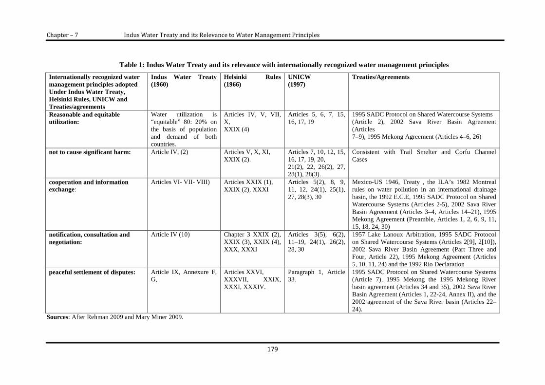
Chapter – 7 Indus Water Treaty and its Relevance to Water Management Principles
179
Table 1: Indus Water Treaty and its relevance with internationally recognized water management principles
Internationally recognized watermanagement principles adoptedUnder Indus Water Treaty,Helsinki Rules, UNICW andTreaties/agreements
Indus Water Treaty(1960)
Helsinki Rules(1966)
UNICW(1997)
Treaties/Agreements
Reasonable and equitableutilization:
Water utilization is“equitable” 80: 20% onthe basis of populationand demand of bothcountries.
Articles IV, V, VII,X,XXIX (4)
Articles 5, 6, 7, 15,16, 17, 19
1995 SADC Protocol on Shared Watercourse Systems(Article 2), 2002 Sava River Basin Agreement(Articles7–9), 1995 Mekong Agreement (Articles 4–6, 26)
not to cause significant harm: Article IV, (2) Articles V, X, XI,XXIX (2).
Articles 7, 10, 12, 15,16, 17, 19, 20,21(2), 22, 26(2), 27,28(1), 28(3).
Consistent with Trail Smelter and Corfu ChannelCases
cooperation and informationexchange:
Articles VI- VII- VIII) Articles XXIX (1),XXIX (2), XXXI
Articles 5(2), 8, 9,11, 12, 24(1), 25(1),27, 28(3), 30
Mexico-US 1946, Treaty , the ILA’s 1982 Montrealrules on water pollution in an international drainagebasin, the 1992 E.C.E, 1995 SADC Protocol on SharedWatercourse Systems (Articles 2-5), 2002 Sava RiverBasin Agreement (Articles 3–4, Articles 14–21), 1995Mekong Agreement (Preamble, Articles 1, 2, 6, 9, 11,15, 18, 24, 30)
notification, consultation andnegotiation:
Article IV (10) Chapter 3 XXIX (2),XXIX (3), XXIX (4),XXX, XXXI
Articles 3(5), 6(2),11–19, 24(1), 26(2),28, 30
1957 Lake Lanoux Arbitration, 1995 SADC Protocolon Shared Watercourse Systems (Articles 2[9], 2[10]),2002 Sava River Basin Agreement (Part Three andFour, Article 22), 1995 Mekong Agreement (Articles5, 10, 11, 24) and the 1992 Rio Declaration
peaceful settlement of disputes: Article IX, Annexure F,G,
Articles XXVI,XXXVII, XXIX,XXXI, XXXIV.
Paragraph 1, Article33.
1995 SADC Protocol on Shared Watercourse Systems(Article 7), 1995 Mekong the 1995 Mekong Riverbasin agreement (Articles 34 and 35), 2002 Sava RiverBasin Agreement (Articles 1, 22-24, Annex II), and the2002 agreement of the Sava River basin (Articles 22–24).
Sources: After Rehman 2009 and Mary Miner 2009.

Chapter - 7 Indus Water Treaty and its Relevance to Water Management Principles
180
Utilization of an international watercourse in an equitable and reasonable
manner within the meaning of Article 5 of the Helsinki Rules (1966) (see Rules) and
Article 5 of the UNICW (1997) requires taking into account all relevant factors and
circumstances, including:
The population dependent on the watercourse in each watercourse state.
The effects of the use or uses of the watercourses in one watercourse state on
other watercourse states;
Existing and potential uses of the watercourse;
Conservation, protection, development and economy of use of the water
resources and the costs of measures taken to that effect; and
The availability of alternatives, of comparable value, to a particular planned or
existing use.
The Article II and III of the Indus Water Treaty stipulate the distribution of
water between India and Pakistan and facilitate both countries to some sort of
territorial type of division, which was later adopted and defined in detail by the
UNICW (1997).20 Apart from the water distribution mechanism, the utilization of
water of Indus Basin was another difficult task for the two countries. But it was
properly managed by the division of the basin into two. The Indus Water Treaty has
refused to take account of the ‘drainage basin’ or ‘watercourse’ concept considering
the whole Indus a unit. Rather, the rivers were divided between the two states with
specified consumptive and non-consumptive utilization of water from two wings. The
concept of consumptive and non-consumptive use of water from eastern and western
rivers for India and Pakistan is consistent with the Lake Lanoux decision.21 In South
Asia, other treaties like Mahakali between India and Nepal, the Ganges between India
20 Muhammad Siyad, “Helsinki Rules and Indus Waters Treaty,” Journal of Himalayan and CentralAsian Studies Vol. 9, no.3 (2005): 81.
21 The arbitration is concerned with the rights and utilisation of water use of the waters of LakeLanoux between the French Government and the Spanish Government. (Lake Lanoux case (France- Spain), Award of 16 November 1957, 12 U.N. Rep. International Arbitration.
Chapter - 7 Indus Water Treaty and its Relevance to Water Management Principles
181
and Bangladesh specified the actualization of water share. In contrast, the Indus Water
Treaty does not provide the idea of sharing the water from a common river.22
On the international basins, it is a legal, political and moral responsibility of
every riparian state in an internationally shared basin to inform about the development
of basin either by building dams or by using the water for irrigation, which may cause
serious harm to other states’ interests and transboundary damages. The rule not to do
significant harm (sic utere)23 has been derived from the Roman law, which is
generally accepted by all basin communities as legal document. But generally these
principles are opposed by upper riparian states. However, these principles accepted by
both the countries and applied to ensure the rights of two countries. The Indus Water
Treaty Article IV, Section 2 admonition to avoid material damage to the other party
and it is consistent with the Trail Smelter and Corfu Channel cases.24 As Trail Smelter
arbitration depicts, under the principles of International Law, none of the states has
the right or permission to use its terrain in a way as to cause injury by the fumes in or
to the territory of another or the properties or persons therein, when the case is of
serious consequence and the damage is recognized by clear and convincing
evidence.25
Trail Smelter arbitration was appreciated and applied in various international
water laws, environment laws and agreements to protect the basin states from material
injury and significant harm, including human health. It is now considered as the part
of customary international laws. On the basis of its successful result, the World Bank
applied its mechanism in the Indus Water Treaty. The Indus Water Treaty Article IV
(2) states “each party agrees that any non-consumptive use made by it shall be so
made as not to materially change, on account of such use, the flow in any channel to
the prejudice of the uses on that channel by the other party under the provision of this
treaty. In executing any scheme of flood protection or flood control each party will
22 Maniruzaman Miah et al, “Water Sharing Conflict between Countries and Approach to ResolvingThem” WASA Project Report, Vol. 3 (2003): 53. <http://www.ippan.org.np/library/scandoc/MISC-003.pdf/> (accessed March 4, 2011).
23 The principle, no to do significant harm is identified with Roman law, sic utere tuo ut alienum nonladeas (so use your property as not to harm another).
24 Utton, A.E, “International Water Quality Law.” In: L. Teclaff and A.E. Utton, eds. Journal ofInternational Environmental Law (1975): 154.
25 Trilochin Upreti, International Watercourses Law and Its Application in South Asia (Kathmandu:Pairavi Prakashan Publishers, 2006), 62.

Chapter - 7 Indus Water Treaty and its Relevance to Water Management Principles
182
avoid, as far as practicable, any material damage to the other party, and any such
scheme carried out by India on the western rivers shall not involve any use of water or
any storage in addition to that provided under Article III” (see Article III of the Indus
Water Treaty)
Both India and Pakistan have accepted the principle of no significant harms to
protect their rights as the cause of material damage from any party.26 The Indus Water
Treaty states in Article IV (10) that “each party declares its intention to prevent, as far
as practicable, undue pollution of the rivers which might affect adverse uses similar in
nature to those to which the waters were put on the effective Date, and agrees to take
all reasonable measures to ensure that, before any sewage or industrial waste is
allowed to flow into the rivers, it will be treated, where necessary, in such manner as
not materially to affect those uses: provided that criterion of reasonableness shall be
customary practice in similar situations on the rivers”. Afterwards the ILA has applied
this Article in the Helsinki Rules (1966) of Chapter (3)27 on pollution prevention that
draws upon Indus Water Treaty. According to the Indus Water Treaty Article IV (11),
“the parties agree to adopt, as far as feasible, appropriate measures for the recovery,
and restoration to owners, timbers and other property floated or floating down the
rivers, subject to appropriate charges being paid by owners”. Allowance of non-
consumptive use for all parties on an international river provides a precedent for the
Helsinki Rules (1966) navigation and timber-floating proviso of chapter 5.
Restoration of peace and brotherhood is important and to achieve this there is
a need to develop some institutions which can keep societies closer and eager for
development. Therefore, to realize the importance of development, peace and
cooperation, the Indus Water Treaty provides some institutional mechanisms as well.
Both countries, in agreement, have established the institution of Permanent Indus
Commission (PIC) under the Article VIII, Article VI and Article VII of the Indus
Water Treaty. The commissioner has to be a high ranking engineer, especially
competent in the field of hydrology and water use. The responsibilities of PICs
include cooperative arrangements, management of the basin and information-sharing
26 In the draft of Indus Water Treaty, the word party was used for two countries India and Pakistan.27 As used in this chapter, the term "water pollution" refers to any detrimental change resulting from
human conduct in the natural composition, content, or quality of the waters of an internationaldrainage basin.
Chapter - 7 Indus Water Treaty and its Relevance to Water Management Principles
183
and regularly data exchange on Indus Basin. The PICs have to meet regularly once a
year in India or Pakistan and submit reports to respective governments before 1st June
every year. The post of PIC was inspired by the International Court of Joint
Commission (IJC) under the boundary water treaty between the US and Canada.28
The PICs have been instrumental in preventing the countries from engaging in
water war. The future cooperation and data exchange system on Indus Basin was
developed after the pattern of various agreements and treaties like the Mexico-US
1946 treaty relating to the utilization of the waters of Colorado and Tijuana rivers and
of the Rio Grande Rivers.29 These agreements have significant impact on the
evolution of the norms incorporated in the Indus Water Treaty, in particular the
procedure relating to dispute settlement process.30 The Indus Water Treaty Article VI
on data exchange, Article VIII (PIC) and Article IX (dispute settlement) provide
precedents for Helsinki Rules (1966) chapter 6 (International Law Association
1967).31 In addition to this, the obligation of data exchange and future cooperation has
been recognised in a variety of instruments like UNCIW (1997), the E.C.E (1992), the
Mekong Agreement (1995) and the Ganges Water Treaty (1996), establishing joint
bodies for the collection of data and exchange of notes.32
There is a hierarchy of jury which settles the “questions” “differences” and
“disputes” if any over water between two countries. The process has been addressed
in the Indus Water Treaty which is quite complex and time consuming. Firstly, the
case is tried in the institution of PIC; if the commissioners fail to settle, the case will
be extradited to a neutral expert and if the case still remains unresolved, it will be
solved in the international court of arbitration.
28 Muhammad Siyad, “Helsinki Rules and Indus Waters Treaty,” Journal of Himalayan and CentralAsian Studies Vol. 9, no.3 (2005): 83.
29 Mary Miner et al, “Water Sharing between India and Pakistan: a Critical Evaluation of the IndusWater Treaty” Journal of Water International Vol. 34, No. 2, (June 2009): 206.
30 V. G. Hedge, “Neutral Expert and Indus water Treaty,” Journal of Himalayan and Central AsianStudies Vol. 9, no.3 (2005): 53-55.
31 Mary Miner et al, “Water Sharing between India and Pakistan: a Critical Evaluation of the IndusWater Treaty” Journal of Water International Vol. 34, no. 2 (June 2009): 206.
32 Muhammad Siyad, “Helsinki Rules and Indus Water Treaty,” Journal of Himalayan and CentralAsian Studies Vol. 9, no.3 (2005): 60-88.

Chapter - 7 Indus Water Treaty and its Relevance to Water Management Principles
184
Process of Arbitration specified in the Indus Water Treaty
The principle of cooperation advocates that all states in an international
watercourse should seek a settlement of the disputes by peaceful means in case states
concerned cannot reach agreement by negotiation. The 1960 Indus Waters Treaty
(Article IX, Annexure F and Annexure G), articulates the mechanism for dispute
resolution. The “questions” to be decided by the PIC, “differences” to be settled by
Neutral Experts (NE) and “disputes” to be settled by Court of Arbitration (CoA).33
It is pertinent to note that any possible arbitration has to remain with the
framework of Indus Water Treaty.34 The principle of dispute settlements of Indus
Water Treaty has been recognised by most of the modern international conventions,
agreements and treaties, e.g. the Helsinki Rules (1966) (Article XXVII) and UNICW
(1997) (Paragraph 1, Article 33). It has also been incorporated in major treaties in
recent years; for instance, the Shared Watercourse Systems in the South African
Community Protocol (Article 7), the Mekong River Basin Agreement (1995),
33 The court of arbitration (CoA) is to consist of seven members, two arbitrators to be designated byeach of the parties, and the other three to be selected by agreement of the parties or, failing that, bydesignated individuals. The three neutral umpires are to be respectively a person qualified to bechairman of CoA, an engineer and an international lawyer. (Annexure G (4) of the Indus WaterTreaty 1960)
34 Indus Water Treaty 1960, Annexure G (2).
“
Disputesby the (ICA)
Differences addressed
by a Neutral Expert (NE)
Questions addressed by thePermanent Indus Commission (PIC)

Chapter - 7 Indus Water Treaty and its Relevance to Water Management Principles
185
(Articles 34 and 35), and the framework agreement of the Sava River Basin (2002)
(Articles 22-24).
Conclusion
A recapitulation of the foregoing discussion on the nature, history, implementation
and subsequent management procedures, allude to the efficacy of the Indus Water
Treaty. It involves various laws, agreements and treaties, as some of its principles
have been incorporated from previous agreements and some of Indus Water Treaty
principles have guided various laws made later, convention treaties and i.e. In
implementation, the Indus Water Treaty survived many ups and downs even though
bitter relations between India-Pakistan resulted in three major wars in 1965, 1971 and
1999. Its principles, friendly cooperation between two PICs and maintaining the rules
and regulations are also the result of two countries’ implementation on Indus Water
Treaty. It has faithfully served both the countries as a means of prevention of water-
related disputes. Nevertheless, some water experts have discussed the advantages and
disadvantages in Indus Water Treaty. For instance, it allows both countries to pursue
their individual interests, whilst ignoring the needs for cooperation in the field of
water development. On the other hand, it restricts cooperation on joint water
management measures. Therefore, too many issues related to water remain
unresolved.

Chapter - 7 Indus Water Treaty and its Relevance to Water Management Principles
186
7.3. Contemporary Issues and Challenges to the Treaty
The Indus Water Treaty has been largely considered as one of the satisfactory
agreements at its best endeavours to prevent water conflict between India and
Pakistan. However, despite its success, some contemporary challenges have weakened
the position of Indus Water Treaty and are also posing questions to its survival which
are:
7.3.1. Decreasing quantity of water and the issue of climate change
The decreasing quantity of water is posing a serious threat to India-Pakistan
development and also originating new areas of conflicts. In India, per capita water
availability has declined from 5000 cubic meters per capita per person in 1950 to
1800 cubic meters in 2005, and it has been expected that per capita per person water
availability will decrease below 1000 cubic metres by 2025.35 Similarly, water
availability in Pakistan per capita per person has been declining at an alarming rate
from 5000 cubic meters per capita per person in 1951 to about 1100 cubic metres
currently and it has been projected to less than 700 cubic metres by 2025.36
When we compare the availability of water in the countries concerned and the
increasing demand it looks certain that the countries are approaching to the status of
water scarce countries. And this situation is surely going to create serious socio-
economic tension, which if not handled with care and eye on future may translate in to
political crisis between the two countries. In addition to this, in March 2009, a
working group of United Nations (UN) has warned that the decreasing quantity of
water in India and Pakistan is fast emerging as a grave issue, and it may issue forth in
a serious political conflict.37 Hence, the Indus Water Treaty is also expected to face
intense pressure in near future.
Decreasing quantity of water, coupled with climate variability, contribute to
the cause of water scarcity. As a result of climate change, glaciers are melting at an
accelerating rate, rainfall pattern has totally changed and climate often pranks and as a
35 S. Waslekar, The Final Settlement: Reconstructing India-Pakistan Relations (Mumbai: StrategicForesight Group, 2005)
36 Shaheen Akhtar, “Emerging Challenges to Indus Waters Treaty: Issues of Compliance andTransboundary Impacts of Indian Hydro Projects on the Western Rivers,” (Islamabad: Institute ofRegional Studies, 2010).
37 Ibid.

Chapter - 7 Indus Water Treaty and its Relevance to Water Management Principles
187
result region faces either heavy rains or drought situation. Uncertain changes in
climate have become the cause of water stress in the South Asian river basins,
especially in the Indus Basin, heavily dependent upon Himalayan glaciers. Recent
studies on the Himalayan glaciers indicate the Himalayan glaciers will continue to
retreat over the next 50 years as a result of climate change. This will cause a shrinking
of glaciers, erratic snow patterns, erratic rainfall patterns, natural disasters and will
affect the flow patterns of the Himalayan Rivers, particularly affected will be in the
Indus river basin. There are some other causes of retreating glaciers, e.g. urbanization,
deforestation, pollution, heavy growth rate of population, etc. Further, the Himalayan
glaciers are threatened by the heavy militarization along the borders of the two
countries, burning fuels and transportation.
The Indus Water Treaty provisions do not take into account the effects of
climate changes in its mechanism. The provisions of the Treaty simply say that India
and Pakistan are obliged to let of rivers flow without any undue interference. The
contemporary water laws and conventions oblige to conserve, manage and protect
international water courses. But Indus Water Treaty does not speak on the issue of
handling water scarcity. Climate change and its impacts over water is a serious
concern, and it is imperative for the two countries to work together. If the issues
related to environment were not handled with institutional or technical mechanism, it
has the potential to aggravate the tension between the two countries and may create
further tensions for the Indus Water Treaty.
7.3.2. Differences over Water Utilisation
The Indus Water Treaty allows India to tape water for run-of-the river projects, on the
western rivers Chenab, Jhelum and Indus before entering into Pakistan. Therefore,
India has started construction of several run-of-the river projects on western rivers:
the Salal project, Baglihar project on the Chenab River, Kishanganga project and
Wullar barrage/Tulbul navigation project on Jhelum River and Nemo-bazgo project
on the Indus River. These projects are regarded as “core issues” between two
countries and are regarded by Pakistan as violation of the Treaty.
Pakistan feels that India’s construction of dams on western rivers is a
permanent threat to its economic security and sovereignty. The damming of western

Chapter - 7 Indus Water Treaty and its Relevance to Water Management Principles
188
rivers will be used for something other than power generation and India will use the
dams in an offensive manner by flooding key Pakistani terrains. However, India
maintains that the construction of projects is endorsed by the treaty and all projects
are within the limits and criteria of treaty and all these projects will operate as run-of-
river projects. However, differences over utilization and complex technicalities
involving the treaty are critical and complicate issues at many levels and it has
heightened the political and military tension between the two countries.
7.3.3. Claims from Jammu and Kashmir
As discussed earlier in detail, the people of J&K state, too, have their voice of descent
on the treaty. Their opinion is that the state is a rightful riparian of three western
rivers and by the signing of the treaty India and Pakistan have overlooked their
inherent water rights. Therefore, at present J&K state is pleading instant review of the
treaty.
7.3.4. Pressures from Outside
7.3.4.1. Kabul River Problem: Quite apart from India and Pakistan water dispute,
another geopolitical game has started in the Indus Basin that may hamper the relations
of the two countries, which, in near future, is likely to create problem for Indus Water
Treaty. The Kabul River is a tributary of Indus River system, which contributes
almost 15 percent of total water availability of Pakistan. Afghanistan is asking for its
rights and it has planned to build dams on Kabul River and its tributaries. Therefore,
the water experts predict that the dams across Kabul basin will reduce a good
percentage of water in Pakistan, which, as a result, will face acute water shortage for
its irrigation and power generation in North West Frontier Province (NWFP), and
Pakistan will have no water for the proposed Kalabagh Dam. India is financially and
technically supporting Afghanistan in water development on Kabul River. India’s
support to Afghanistan may cause a bad water relationship between the three
countries. Its support to Afghanistan is viewed critically and is seen as a water
weapon against Pakistan.38 In such a situation, if India helps Afghanistan to alter the
flow of Kabul River, perhaps Pakistan will try to persuade China to build projects on
India’s Rivers in Tibet. Therefore, this action will not only create an environment of
38 Threat of Water War, The Dawn News, (December 22, 2003). < http://www.dawn.com/>

Chapter - 7 Indus Water Treaty and its Relevance to Water Management Principles
189
water-war in the region but also pose a serious threat to India-Pakistan water
agreement.
7.3.4.2. Chinese Question: The Indus Treaty does not include all basin states of
Indus Basin—even the main source of the Indus River system is in China (Tibet).
However, at present China is asserting its water rights over Indus River. There are
some evidences that China has started construction of water projects in its territory.
One British writer ‘Albinia’39 has pointed out that China’s construction of dam at
Demchok on Indus River is in progress. The project has the capacity to generate 11
MWs hydroelectricity and it has also capacity to stop the flow of the Indus River to a
considerable extent.40 It is obvious that the development of such projects will reduce
the flow of Indus River and will destabilize the inhabitation in Punjab and Sindh
areas, which are heavily dependent on the river for irrigation and energy generation. It
needs to be remembered that out of about 190 million people, 72 percent Pakistani
and 23 percent Indian live in Indus Basin.41
For India, the dam would affect the Tibetan rivers, which provide energy and
irrigation for its large agrarian population and also that Gilgit-Baltistan will face a
water shortage and reduced power generation resource. For Pakistan, experts are of
the view that the construction of the project might cause serious damage to Pakistan’s
proposed Diamer and Bunji dams in Gilgit.42 However, it will certainly ensure that
India and Pakistan will speak in a single voice in future against Chinese projects in
this region. It is a matter of serious concern and the Chinese action will become a
conceivable challenge to Water Treaty. China’s claim is mainly on the basis of
geography of Indus River, not on the basis of dependency on River Indus. If it
disrupts the flow of Indus, probably a political conflict will start between China and
its lower riparian India and Pakistan. Consequently, Indus water will become the bone
of contention not only between India and Pakistan, which are already engaged in
water dispute, but will involve the whole region.
39 The author has written a book entitled “The Empire of Indus: The Story of a River”40 Senge H. S, China, Builds Dam on Indus River Near Ladakh, Journal of Defence Studies New
Delhi, <http://www.unop.org/downloads/228.pdf/> (accessed 20 March, 2013).41 A. N. Laghari, D. Vanham and W. Rauch, “The Indus Basin in the Framework of Current and
Future Water Resource Management,” Journal of Hydel Earth Systems Vol. 8 (2011): 2263-2288.42 H. S. China, “Builds Dam on Indus River Near Ladakh,” Journal of Defence Studies New
Delhi.<http://www.unop.org/downloads/228.pdf/> (accessed 20 March, 2013)

Chapter - 7 Indus Water Treaty and its Relevance to Water Management Principles
190
The foregoing discussion reveals that certain issues are endangering not only
to Indus Water Treaty but also Indo-Pak relations. Though the political climate
between Indo-Pak is not too good, but the above discussed issues are common to both.
Since water is an important determinant in boosting the economy of both the
countries, there is an intense need to maintain the Indus Basin to prevent future
disasters of water shortage and conflicts before the issue may get any graver.
7.4. Way Forward
The following section suggests some vistas of cooperation, so that any confrontation
may be sorted out by mutual understanding. Constructive measures such as Joint
endeavours in environmental studies, internal water management, Indus Basin
development organization, peacemaking initiatives over Indus Basin through Track II
diplomacy and joint management of the Indus Basin could be put into practice to
address the water related issue in the Indus Basin.
7.4.1. Joint endeavours in environmental studies
Environmental threats do not have any regard for political and regional boundaries.
During the last three decades the watersheds of the Indus Basin is badly degraded.43
To rehabilitate the water resources of the basin it is necessary to work together on
issues, such as climate change, water quality, shrinking of glaciers and ground water
usage. These issues are common to both the countries. Presently both are on the brink
of water scarcity issue as a result of climate change and rapidly shrinking of glaciers.
These issues are interrelated with population growth, urbanization and
industrialization. Both the countries can neither afford to ignore or disclaim their
responsibilities towards the environmental degradation in their territory and vicinity
they share the water and other natural gifts and have to share any environmental
damages if not attended in earnest. Even though the Treaty does not take into the
account these changes, the current situation underlines that the joint studies from New
Delhi and Islamabad should be carried out and some institutions should be established
to monitor these problems.
43 Arshad H. Abbasi, “Indus Water Treaty between Pakistan and India” (2012):12-13, Journal ofPakistan Institute of Legislative Development and Transparency (PILDAT). <http://www.pildat.org.pk/> (accessed October 22, 2012).

Chapter - 7 Indus Water Treaty and its Relevance to Water Management Principles
191
7.4.2. Internal Water Management
In both the countries water resources are mismanaged or ill governed due to inter-
state and regional politics. Especially in Pakistan due to its regional politics various
projects are pending and therefore the river water is mainly going unutilized and
unharnessed. It is a man-made disaster which baffles the politicians and begs for
immediate remedial course. The experts are apprehensive of a water war but regional
cooperation and associations on water and natural resource sharing could be a counter
for future military misadventure and would forge a unity more meaningful and
durable. If both the countries come together to manage the available resources
properly, they can avoid the issue of water scarcity and inter-state as well as intra-
state conflicts. In this regard, a paradigm shift can be made from ‘technocratic’ to
‘socio-economic’ point of view.
7.4.3. Indus Basin Development Organization
The Indus Water Treaty set up a permanent Post of Indus Commission, which has
been doing well within its parameters. But as of now, the situation has changed and
demands an expansion of its jurisdiction. The Indus Treaty and Indus Commission
deal only with the engineering problems, but certain projects have political, economic
and strategic leverage. Even if the Commission tries to resolve the disputes, pressures
from different sides hinder resolution. Hence, some disputes remained unresolved and
marked as failure of Indus Water Commission.
Some water resource experts from India and Pakistan are of the opinion that
another failure of Indus Commission is due to the division of the basin into two,
which reduced the level of cooperation between Indus commissioners, since both the
countries are highly inter-dependent on each other, but this division has limited the
scope for cooperation. Instead of PIC, there is a need to set up an independent Indus
Basin Development Organization, comprising by water resource experts, political
scientists, economists, and lawyers and specialists of sociological backgrounds. This
may also include experts from some renowned organizations, such as the World Bank,
Asian Development Bank (ADB) and United Nations Environment Programme
(UNEP).
Chapter - 7 Indus Water Treaty and its Relevance to Water Management Principles
192
The organizational functions would entail identifying short term and long term
supply capacity of the basin and its integrated development, creating techniques to
mitigate and adapt to the effects of climate change, setting up infrastructure and
coordinating the different technical agencies of both governments. This plan would
involve a creative solution to engage in issues concerning disputed state of Jammu
and Kashmir. Apart from India and Pakistan, both the countries should take
representatives from both sides of the divided state of Kashmir to address Kashmir
apprehensions and needs. This approach will not only bring societies closer but also
help to eradicate emerging disputes over water. Cooperation on water will gear the
wheels to a larger Indo-Pak peace process without burdening it with an overtly
political dimension.
7.4.4. Peacemaking Initiatives over Indus through Track II diplomacy
There is another positive factor that must be mentioned here: non-official or Track II
initiatives. In South Asian sub-continent as well as outside of the continent, this
process has generated much goodwill and helped to remove or mitigate
misunderstandings between riparian states. A similar approach can be applied in Indus
Basin to address the dispute through Track II initiatives.
Transboundary water development depends on the political, geographic,
economic and cultural cooperation. Indus Water Treaty has not only divided the basin
but also drew a historical, social and political curtain between the communities of
Indus basin. If both the countries work together to remove this curtain, the results will
be different and Indus will become a family.
In 1960, the Treaty was signed in a totally different set of political, economic,
demographic and ecological conditions. Now, there has been a phenomenal change in
all of these areas. Today both the countries politically more conscious and
understanding though still not, for warmly friendly as they were not in 1960. The
improvement in the political climate and the resumption of talks offer great hopes for
Track II initiatives. Through this initiative, historians, social scientists, water experts,
economists and agricultural scientists from both sides can contribute much more to
peace and better understanding.

Chapter - 7 Indus Water Treaty and its Relevance to Water Management Principles
193
7.4.5. Joint Management of the Indus Basin
The Indus Treaty carried out a division of the river system and it has divided the
rivers into two segments. The division of the rivers offers little scope for cooperation.
It also has divided the common interests of the two parties and affected the ecosystem
of Indus Basin as well, as they are pursuing individual interests without caring for the
degradation of watershed. Moreover, by this division, a large amount of hydro-
potential in the Indus Basin remains unexploited, because it is in disputed state, where
every project becomes a brunt of dispute between two countries.
Given the scenario of industrialization, it seems that this division of rivers into
two segments is not the best settlement for two countries for future development.
Instead of this division, both countries should jointly manage the entire basin ii an
integrated and holistic manner. A holistic approach to water resource recognizes the
interaction and economic linkages between water, land, the users, the environment
and infrastructure, and it is necessary to avoid the impending water crisis within the
basin.
Under the present circumstances, changing dynamics of the Indus River
system, high growth rate of population and growing needs for water, it seems unlikely
that the treaty will cater to the meal in near future by its mechanism. Experts in India
and Pakistan are already representing opposite points on the political compass, and
complain that the Treaty is out of date, that it obstructs rational exploitation of the
Indus Basin Rivers and that it ought at least to be revised if not entirely scrapped. To
simplify this, the Article XII (4) of the Indus Water Treaty states that the Treaty can
be terminated only by another Treaty.
Further The Article VII (I) of the Treaty states that the two parties recognize
that they have a common interest in the optimum development of the Rivers and calls
upon both sides to cooperate, by mutual accord, to the fullest possible extent, in
undertaking engineering works in the Rivers.” To prevent future upheaval, it is high
time for New Delhi and Islamabad to adopt a collaborative approach by initiating a
joint management of basin as one unit by revision of the treaty. By Joint management
the Indus Basin can better serve for economic development and prosperity of the
region. It has been proved in several parts of the world that joint development of

Chapter - 7 Indus Water Treaty and its Relevance to Water Management Principles
194
water resources could provide immense benefits to all riparian nations/states, e.g. the
Tennessee Valley Authority (USA), the Amazon (Latin America), the Columbia
(USA-Canada), the Mekong (four states of southeast Asia) are some examples of joint
management.

Chapter – 8
Conclusion

Chapter - 8 Conclusion
195
wing to the complex geographical setup of Indus Basin, hostilities between
India and Pakistan over river water utilization are soaring up, and if we look
into the priorities of concerned countries, different political agendas and ambitions
and geopolitical realities, concluding this study is a complex task, Hence, this
conclusion is limited to the comparative submission of issues, objections and
suggestions analyzed, observed and incorporated from India, Pakistan and Jammu and
Kashmir State in relations to Indus Water Treaty.
Indus river, a basic resource for and a powerful stimulant to economic
development of the shareholders has linked the riparian countries and as well as their
peoples together. On the other hand, its history reveals that it has been a ground of
disputes, between neighbours/provinces or states of Indus Basin for long. Fast
increasing population, expanding urbanization and fast growing needs for irrigation
water and power generation are putting ever increasing strains on the water of Indus
Basin Rivers. During the British rule, there was only one political issue, i.e. to get
independence from British rule, but after independence, the sub-continent faced more
grave geopolitical issues, which includes the distribution of Indus Basin water as well.
New geopolitical boundary etched the hard border and divided already
developed infrastructures like canals, which engendered bitterness between the two
newly emerged nations—India and Pakistan. The enmity between India and Pakistan
has its roots in the struggle to gain independence from Great Britain. The principal
fault line ran along religious divisions and placed Hindus against Muslims. The
process, by which the British partitioned the Indian sub-continent in 1947 into
independent into two independent countries, fuelled this animosity. Partition led to a
number of geographical, political and economic disputes between the countries; for
example, refugee property and division of assets etc. In particular, the issue of
Kashmir and distribution of water have persistently aggravated Indo-Pak relations and
in fact been constant sources of tension between the upper riparian India and lower
riparian Pakistan.
O

Chapter - 8 Conclusion
196
The dispute over the water of the Indus Basin between India and Pakistan is
notable not only for its size, significance and complexity but also in that it was
brought to conclusion by a comprehensive treaty. The dispute lasted for twelve years
from 1948 to 1960 but fortunately the World Bank’s intervention brought the parties
together and guided them towards a resolution. The resolution of dispute was made
with the landmark agreement of Indus Water Treaty. This monumental treaty was the
outcome of eight years of discussions and negotiations between the government of
India and Pakistan under the aegis of World Bank.
The water conflict between India and Pakistan was spiraling to its critical level
as the partition had left a legacy of enormous bitterness and complexities. So, it was
very difficult to deal with this grave issue and institutionalise peace between the two
countries. Agreements after agreements were being made but no permanent solution
could be reached. In 1952, the World Bank made an intervention with an intention to
facilitate negotiations between India and Pakistan. The World Bank-led negotiations
mainly focused on the concerned issue and all extraneous matters were kept away.
The World Bank nominated a group of engineers from both the countries to resolve
the dispute. In 1954, the World Bank put forward a proposal embodying the main
principles for dispute resolution. These principles have been accepted by both the
countries, eventually signing the agreed-upon Indus Water Treaty.
The Indus Water Treaty has its origin in an international water dispute that
could have led to a situation detrimental to both the parties had it remained
unresolved. However, the dispute on the use of waters of the Indus Basin had its
beginning during the British Empire between Punjab and Sindh (Bahawalpur and
Bikaner were also involved). But, with the partition of India in 1947, the water issue
became more serious as the new political boundary between India and Pakistan cut
across the Indus system of rivers and disrupted its well-managed, integrated irrigation
canals network. The geography of the partition was such that the headwaters of canals
remained mainly with India while the land being irrigated by these canals went to
Pakistan. Thus, the partitioning of the canal system has created dispute between the
two countries over the share of Indus Basin water. The water dispute erupted on 1st
April 1948 when East Punjab discontinued the delivery of water to West Punjab on
the expiry of the Standstill Agreement. This incident exacerbated hostilities between
Chapter - 8 Conclusion
197
the governments adding more fuel to the flames. To resolve this issue, agreements and
MOUs were signed but no permanent solution was found. Nevertheless, it paved a
way for the process of negotiations towards the final settlement until Indus Water
Treaty was signed in 1960 in culmination.
The process of negotiation was so difficult and complex that the two
governments virtually failed to negotiate mutually and were compelled to accept the
intervention of a third party. The intervention of World Bank’s good office at the end
of 1951 started a communication between the two countries over water utilization.
Intrinsically, the negotiation process was put on the right direction when David. A.
Lilienthal, former Chairman of Tennessee Valley Authority and a close friend of
Eugene R. Black, the then President of the World Bank, presented his principle
arguments over water sharing of Indus Basin.
The World Bank had earlier helped resolve such conflicts in the other parts of
the globe. It wanted to help both the countries with its experience and expertise.
Though the situation in sub-continent was complex but the solution had to be found—
as the two contesting parties remained adamant over their basic position, the third
party mediation became necessary. Subsequently, E.R. Black called both the parties
and explicitly outlined “essential principles” which ought to be followed for conflict
resolution. The principles were accepted by both the countries, and after intensive
discussions, modifications and negotiations, the trilateral Indus Water Treaty was
finally signed on 19 September 1960 between India and Pakistan, and the World Bank
was a signatory to the Treaty.
It could well be said in favour of World Bank that it addressed the water
dispute with a view to redress the grievances of the common masses residing on the
both sides of international border between India and Pakistan. World Bank ignored
the political implications of the treaty in the best interests of the people concerned.
The World Bank has not only provided technical assistance but also sufficient
financial support through Indus Basin Development Fund. The financial assistance
was gathered from friendly countries, which include Australia, Canada, Germany,
Italy, New Zeeland, the United Kingdom, the United States; India also contributed to
the fund raising. It was the magnanimity and constant efforts of the World Bank

Chapter - 8 Conclusion
198
which provided financial and technical assistance for the development of two
countries and its mediating role has been a successful instance of dispute resolution.
Also, the success of Indus Water Treaty would not have been possible without
the keen interest displayed by the then Prime Minister of India Jawaharlal Nehru and
President of Pakistan Muhammad Ayub Khan, sidelining all rivalries and joining table
for negotiation. They fostered congenial environment for the third party mediation.
However, there were also some criticisms within the two nations. The protracted and
complex negotiations were conducted between senior civil society servants,
professionals and engineers, minimising the chance of any hindrance in resolving the
water dispute. Though the treaty brought peace and harmony in the sub-continent, it
could not satisfy the entire spectrum of people and drew criticisms from both the
countries. In both countries, critics are of the view that the negotiation of the treaty
was faulty though such criticism is hardly taken into consideration when top
leaderships are involved.
The Indus Water Treaty is regarded as a major achievement as it has made
Indus Basin economically viable for the two countries. The treaty has terminated all
claims regarding the Harmon Doctrine and Historic Use and it effected the territorial
apportionment of the Indus River system. The three Western Rivers (the Indus, the
Jhelum and the Chenab) were allocated to Pakistan while the three Eastern Rivers,
(the Ravi, the Beas and the Sutlej) were given to India for their consumptive use
respectively.
The distribution of rivers is actually a territorial division and it does not
specify the quantity of water for parties. The treaty merely reaffirms the territorial
sovereignty of each state on the basis in the difference in water courses. It does not
modify the boundary between the two countries but traces a fictitious line, East-West,
which divides the basin and limits the sovereign rights of each states on half of the
river system and grants quasi-exclusive rights on the other half. In fact, it is neither a
territorial nor quantitative division, but a division that concerns only the use of the
water. This kind of division is predominantly political and economic, but not
according to prevailing water laws. Since the treaty was signed, the two parties have

Chapter - 8 Conclusion
199
to deal jointly with water administration and do not have the right to interfere in the
waters allocated to the other party.
The treaty established a permanent institution of Indus Commission to
maintain peace and cooperation between the parties. The Commission has so far
maintained peace despite the bitter political relations (three wars were fought between
India and Pakistan in 1965, 1971 and 1999). In this sense it can be claimed that the
treaty is a successful instance of peace and conflict resolution. It has faithfully served
as a means of prevention in water-related disputes. Nevertheless, the Commission has
failed to resolve certain issues. Large numbers of experts are of the view that the
Commission has been politicized, and as a result could not reach any effective
settlement on certain disputes.
Despite its success in water conflict resolution, there are some ambiguities in
the treaty. Indus River is flowing through four sovereign countries, viz. China, India,
Pakistan and Afghanistan, including the disputed State of Jammu and Kashmir. The
Indus Water Treaty protects only the rights and considerations of two countries,
neglecting the other stakeholders of the Indus Basin. However, other riparian states
including Jammu and Kashmir State are claiming their rights to a reasonable and
equitable share of the Indus River and its tributaries flowing through their territories.
It was not a deliberate omission on the part of the World Bank. It wanted to make
both the countries realize the need for cooperation and compromise. No compromise,
anywhere and under any condition is just or equal for the parties concerned;
compromise is an opportunity to stem the further rot and utilize the time and energy
thus saved to build and manage one’s resources. Indus water treaty did exactly the
same. Taming of waters under the respective possession and their management was
given utmost priority. However, Pakistan has to address new realities and negotiate
the demands of upper riparian shareholders of Indus, Jhelum and Kabul River sooner
the better.
The arbitration of treaty does not create a sound mechanism to address certain
issues, such as ground water use for two countries, changes in flow of water due to
climatic changes, changing domestic demand due to population increase or rainfall
variability and future developments. This shortcoming has created a serious chaos in
Chapter - 8 Conclusion
200
the sub-continent as both the countries are facing water stress due to high population
density, climate change and high water demand. The increasing water scarcity has led
to an intense water debate in India and Pakistan and the hawks on both sides are
talking about water wars or abrogation of the Treaty.
Any talk of deconstruction plans on Indus Water Treaty needs to be
supplemented with alternative construction plans, otherwise whole exercise may lead
to chaos and confusion. In the absence of an alternative scheme, the slogans for the
abrogation of the Treaty are simply meaningless. The demand for more water, in India
or Pakistan does not make the Indus Water Treaty irrelevant for the people concerned.
It has to be seen in broader perspective.
Whatever the truth value of the differences between the two countries are, they
have widened the trust gap between the two countries and catapulted the water issue
to the top of bilateral agenda, thereby making a core issue in Indo-Pakistan relations.
The reason is the lack of cooperation, distrust and poor political relationship. To
address these issues there is a high need to review the viability of Indus Water Treaty
as many experts from both India and Pakistan think that the treaty is outdated. It does
not allow for an optimum use of the Indus water resources, and therefore the treaty
should be relooked at and modified with one which lays emphasis on joint sharing
rather than territorial division of waters. This demands a common water vision by
India and Pakistan that will be based on the realization of the importance of the shared
rivers as being a natural resource that is integral to their survival.
Let India, Pakistan or any other country resist from using water as political
tool. It is, too, dangerous to handle it that way. Let’s keep the interests of the
humanity in view, not of a group, community or region. Water like, air, and sun, is a
shared property of the humanity, a gift of nature not to be vandalized for the political
reasons. New and innovative vistas of cooperation—inside and outside the treaty—
can be envisaged as discussed above.

Bibliography

Bibliography
201
A, Gen. Sir.
Cunningham.
The Ancient Geography of Kashmir. Jhelum: Pak Kashmir
Publications, 1990.
Alexander, Burnes. Travels into Bukhara. London: 1834, rep Lahore: Sangmeel
Publications, 1997.
Arora, R.K. The Indus Water Treaty Regime. New Delhi: Mohit
Publications, 2007.
Bhat A.S, and Dost
Mohammad.
Problems of Power Sector Development. New Delhi: Gayan
Publishing House, 2002.
Chandra, Bipan, et
al.
India’s Struggle for Independence 1857-1947. England:
Penguin Books, 1989.
Chauhan, B.R. Settlement of the International and Inter-State Water
Disputes in India. Bombay: N. M. Tripathi PVT/ Ltd, 1992.
Choudhury, G.W. Pakistan’s Relations with India: 1947-1966, London: Pall
Mall Press Ltd, 1968.
Choudhury,
Muhammad Ali.
The Emergence of ‘Pakistan. Lahore: Research Society of
Pakistan, 1989.
Cunningham,
Alexander.
Ladakh Physical, Statistical and Historical. Srinagar:
Gulshan Publishers, 1997.
Dolatyar, Mostafa. Water Politics in the Middle East A Context for Conflict or
Co-Operation. London: Macmillan Press, 2000.
Edited By T.V, Paul. The India Pakistan Conflict: A Enduring Rivaliry, New York:
Cambridge University Press.
Doue, Sir James. The Punjab, North-West Frontier Province and Kashmir.
New Delhi: D. K Publishers.
Fairly, Jean. The Lion River, the Indus. Lahore: Brother Publisher, 1993.
Farmer, B. H. An Introduction to South Asia. London: Rutledge Press,
1993.

Bibliography
202
Gulhati, N.D. Indus Water Treaty: An Exercise In International Mediation.
Bombay: Allied Publishers, 1973.
Gulia, K. S. Discovering Himalaya, Vol. II, New Delhi, Isha Book
House, 2007.
Gulshan Majeed. Kashmir to Central Asia. Srinagar: Jay Kay Book Shop,
2007.
Hakim, Iftikhar. The Indus Water Treaty: An Institutional Mechanism for
Addressing Regional Disparity. United Kingdom: VDM
Verlag Dr. Muller Publishing House LTD, 2010.
Hassan, Mushirul. Legacy of a Divided Nation. New Delhi: Oxford University
Press, 1997.
Iyer, R. Ramaswami. Towards Water Wisdom: Limits, Justice Harmony. New
Delhi: Sage Publications, 2007.
Jalal, Ayesha. Democracy and Authoritarianism in South Asia: A
Comparative and Historical Perspective, UK: Cambridge
University Press 1995.
Kaul, P.K. Antiquities of the Chenab Valley in Jammu. New Delhi:
Eastern Book Linkers, 2001.
Kenoyer, J. M. Ancient Cities of the Indus Valley Civilization. Karachi:
Oxford University Press, 1998.
Khan, A.R. Jammu Kashmir and Ladakh, Geographical Study. Srinagar:
Gulshan Publisher, 2001.
Khan, Muhammad
Ayub.
Friends not Masters: A Political Autobiography. London:
Oxford University Press, 1967.
Malik, Bashir. A. Indus Water Treaty in Retrospect. Lahore: Bright Book
Publishers, 2005.
Michel, Aloys
Arthur.
The Indus Rivers: A Study of the Effect of Partition. London:
Yale University Press, 1967.

Bibliography
203
Mir, Ali Mohammad. Geography of Jammu, A Regional Analysis. New Delhi:
Dilpreet Publishing House, 2002.
Mushtaqur, Rahman. Divided Kashmir: Old Problems, New Opportunities for
India, Pakistan, and the Kashmiri People, Boulder: Lynne
Rienner Publisher, 1996.
Najam, Adil. “The Environmental Challenge to Human Security in South
Asia,” in South Asia in the World, Problem Solving
Perspective on Security, Sustainable Development and Good
Governance, ed. Ramesh Thakur and Oddny Wiggen. New
York: United Nation University Press, 2004.
Nazir, Shahzad. Water Resource of Pakistan and their Utilization. Lahore:
Miraj Din Press, 1993.
Palijo Rasool Bux. Sindh-Punjab Water dispute 1859-2003. Sindh: Centre For
Peace and Civil Society, 2011.
Papers, A. Albenia. Empires of the Indus: the Story of a River, United Kingdom:
John Murray Publishers, 2008.
R Moonis, Ahmad
Aijazuddin, and
Muhammad Ali.
The Valley of Kashmir, A Geographical Interpretation. New
Delhi: Vikas Publishing House, 1978.
Salman, M.A.
Salman and Uprety
Kishor.
Conflict and Cooperation on South Asia’s International
Rivers: A Legal Perspectives, Washington D.C: The World
Bank, 2003.
Shakil, A Romshoo Indus River Basin Common Concerns and the Roadmap to
Resolution. New Delhi: Centre for Dialogue and
Reconciliation, 2012.
Siddiqui Iqtidar
Hussain.
Authority and Kingship Under Sultans of Delhi: Thirteenth-
Fourteenth Centuries. New Delhi: Manohar Publishers,
2006.

Bibliography
204
Singh, R. L. Geography of India with Special References to J&K. New
Delhi: APH Publishing Company, 2000.
Singh, R. L. A Physical Geography of India. India: 1971.
Snedden,
Christopher.
Kashmir: The Unwritten History. India: Harper Collins
Publishers, 2013.
Tabassum, Shaista. River Water Sharing Problem between India and Pakistan;
Case Study of Indus Water Treaty. Colombo: Regional
Centre for Strategic Studies, 2004.
Upreti, Trilochin. International Watercourses Law and Its Application In South
Asia. Kathmandu: Pairavi Prakashan Publishers, 2006.
Waslekar, S. The Final Settlement: Restructuring India-Pakistan
Relations. Mumbai: Strategic Foresight Group, 2005.
Wright, Rita P. The Ancient Indus: Urbanism, Economy and Society. New
York: Cambridge University Press, 2010.
Research Papers
Akhtar, S. “Emerging Challenges to Indus Waters Treaty: Issues of
Compliance and Transboundary Impacts of Indian Hydro
Projects on the Western Rivers.” Institute of Regional
Studies, Islamabad (2010).
Asma, Yaqoob. “International River Waters in South Asia: Source of
Conflict or Cooperation.” Institute of Regional Studies
Islamabad Pakistan (2010).
Bakshi, G. and
Trivedi, S.
“The Indus equation, Strategic Foresight Group.” India.
(2011).<http://www.strategicforesight.com/>(accessed
Januay 3, 2011)
Ballard, Roger. “The Kashmir Crisis: A View from Mirpur.” Journal of
Economic and Political Weekly (1991).
Bibliography
205
Bhanot, Monica. “Challenges to Regional Cooperation in South Asia: A New
Perspective.” Journal of Peace and Conflict, Issue 2-3
(August, 1999).
Biswas, Asit K. “Indus Water Treaty: the Negotiation Process.” Journal of
Water International (1992).
Blankenship, Erin. “Kashmiri Water: Good Enough for Peace.”(2009 http://ww
w.pugwash.org/report/tc/sa/kashmiri/water/html/> (accessed
August 5, 2011).
Chandran, D Suba. “Harnessing The Indus Waters: Perspectives From India,
Institute of Peace and Conflict Studies.” New Delhi, Issue
Brief, 122 (2009). <http://www.ipcs.org/pdffile/issue/IB129-
Ploughs hares-Suba.pdf/> (accessed March 29, 2012).
Crow, Ben and
Nirvikar Singh.
“Impediments and Innovation in International Rivers: The
Waters of South Asia,” World Development, 28, no.11
(2000).
Fowler, J. H. “Conflicting Signals of Climatic Change in the Upper Indus
Basin.” Journal of Climate Vol. 19 (2006).
Gilani, Syed Nazir. “Baglihar Dispute: A Kashmiri Perspective.” Journal of
Himalayan and Central Asian Studies Vol. 9, no.3 (2005).
Gill, Sadique A. “Indus River and the Irrigation System in Pakistan.” Journal
of South Asian Studies Vol. 20, no.1 (2005).
Gill, Sadique A. “Water Politics in South Asia.” Journal of South Asian
Studies Vol. 20, no.1 (2005).
Gleick, Peter. H. “Water and Conflict: Fresh Water Resource and International
Security.” Journal of International Security Vol. 18, no.1
(1993): 79-112.
Gleick, Peter. H. “Water Conflict Chronology.” Pacific Institute for Studies in
Development, Environment, and Security, (November 2009).
<http//www.worldwater.org/conflict/> (accessed August 21,
2010).

Bibliography
206
Habib, Zaigham. “Water Issues and Politics in Pakistan.” Journal of South
Asia Free Media Association (n d)
Habibullah, Wajahat. “The Political Economy of the Kashmir Conflict
Opportunities for Economic Peace Building and for U.S.
Policy.” Special Report, no. 121 (June 2004), United States
Institute of Peace. <http//www.usip.org.com/>(accessed 8
April, 2013).
Hedge, V. G. “Neutral Expert and Indus water Treaty,” Journal of
Himalayan and Central Asian Studies, New Delhi, Vol. 9,
no.3 (2005).
Hussaini, S. A and G.
R. Lashkaripour.
“Water Resource Management in Kabul River Basin, Eastern
Afghanistan.” Journal of Springer Science Media (2007).
<http://profdoc.um.ac.ir/paper-abstract-102636.html>
(accessed April 17 2011).
Imran, Khalid. “Bangladesh Water Concern,” Lahore: University of the
Punjab, Journal of South Asian Studies, Vol. 25, no.1
(January-June 2010)
Islam, Yeadul. “Hydro-politics: a Techno-Political Tangle in South Asia.”
(n).<http://www.Dscsc.mil.bd/upload/mirpurpapers/3/Yeadul
% 2520Islam.pdf> (accessed July 2, 2011).
Iyer, R. Ramaswami “Conflict Resolution: Three River Treaties.” Journal of
Economic and Political Weekly Vol. 34 (1999).
Iyer, R. Ramaswami. “Indus Water Treaty: A Different View.” Journal of
Economic and Political Weekly Vol. 40, no.29 (July 2005):
J, Smith and H.
Charles.
“Water and Conflict in Asia.” A Seminar Report, Asia-
Pacific Center for Security Studies (APCSS), Honolulu,
Hawaii, (September 17, 1999).<http://www.Apcss.org/P ubli
cations /ReportWater&Conflict99.html> (accessed March 2,
2011).

Bibliography
207
Javed, Tufail. “The World Bank and the Indus Basin Dispute,” Bckground-
1 Pakistan Horizon, Vol. 18, no.3 (1965).
Lamballe, Alain. “Water, Source Of Conflicts In South Asia.” Review Of
World Wars And Contemporary Conflicts (2007).
<http//:www.Svabhinava.Org/../Alainlamballe/Islamabad
peshawarquettaenglish/> (accessed November 14, 2011).
Law, Bimala Charun. “Rivers of India: Historico-Geographical Sketch,” Calcutta
Geographical Society Publication no.6 (1944)
Malhotra, Natasha. “South-Asia Political and Economic Region.” (n. d).
<http://www.ags.geography.du.ac.in/Study%20Materials.../N
itasha%20Malhotra2/> (accessed June 26, 2011).
Mehta, J.S. “The Indus Water Treaty: A Case Study in Resolution of an
International River Basin Conflict,” Natural Resources
Forum Vol. 12 (1988): 69-77.
Miner, Mary et al. “Water Sharing Between India and Pakistan: a Critical
Evaluation of the Indus Water Treaty.” Journal of Water
International Vol. 34, no.2 (2009).
Mizanur, Rahaman
Muhammad.
“Principles of Transboundary Water Resources Management
and Ganges Treaties: An Analysis,” Taylor & Francis,
journal of Water Resources Development, Vol. 25, no 1,
(March 2009): 159–173.
P, Sandra. L and
Wolf A. T.
K. K, R.
“Dehydrating Conflict.” Journal of Foreign Policy no.126
(September-October, 2001): 60-67.<http://www.jstor.org/pa
ge/info/about/policies/terms.jsp/>(accessedJanuary11, 2012).
“The Problem of the Indus and Its Tributaries: An
Alternative View,” Royal Institute of International Affairs
Vol. 14, no. 6 (Jun., 1958): 266-276,<http://www.Jstor
.org/stab le/40393886> (accessed: September 22, 2011).

Bibliography
208
R, Sinha. “Transboundary Water Disputes: Two Neighbours and a
Treaty.” journal of Economic and Political Weekly (2006).
Riyaz, Punjabi. “Indus Waters Treaty Human Security Vs. Military
Security.” New Delhi, Journal of Peace Studies Vol.11,
Issue, 4 (2004).<http//www.Icpsnet.org/description.php?ID
=332/> (accessed March 21, 2011).
Roshni, Chakarborty
et al.
“Sharing of River Water among India and Its Neighbours in
the 21st Century; War or Peace.” Journal of Water
International (2004).
Siyad, Muhammad. “Helsinki Rules and Indus Water Treaty.” Journal of
Himalayan and Central Asian Studies Vol. 9, no.3 (2005):
60-88.
Subedi, Surya P. “Hydro-diplomacy in South Asia: The conclusion of the
Mahakali and Ganges River Treaties.” The American Journal
of International Law Vol. 93, no. 4 (Oct1999): 953-962.
Sud, S.C. “Optimising Hydel Development in Chenab Basin.” Journal
of Himalayan and Central Asian Studies Vol. 9, no.3 (2005).
Warikoo, K. Indus Water Treaty: View from Kashmir”, Journal of
Himalayan and Central Asian Studies, New Delhi, Vol. 9,
no.3 (2005)
Wasi, Nausheen. “India Pakistan Dialogue on Conflict Resolution and Peace
Building.” Institute of Peace and Conflict Studies New Delhi,
(2009). <http://mercury.ethz.ch/serviceengine/Files/ISN/ 1 0
6802 /ipublicationdocumentsingledocument/e0af3329-7f07-
47bc-b897-ed1d5d0d568e/en/IB128-Ploughshares-Nausheen
.pdf/> (accessed February 12, 2011).
Wolf, A. T, Y. Shira
and Glordano.
“International Waters: Indicators for Identifying Basins at
Risks.” UNESCO, IHP, Technical Document in Hydrology,
(2001-2003).<http://unesdoc.unesco.org/images/0013/00133
3/133306e.pdf> (accessed 17 June 2012).

Bibliography
209
Wolf, A. T. “Water and Human Security.” Journal of Contemporary
Water Research and Education, Vol. 118, Issue.1 (2001).
<http://opensiuc.lib.siu.edu/cgi/viewcontent.cgi?article=1171
&context=jcwre> (accessed November 2, 2011).
Wolf, A. T. et al. “International River Basins of the World.” Journal of Water
Resources Development Vol. 15, no.4 (December 1999):
387-427.
Thesis
Allouche, Jermy. “Water Nationalism: An Explanation of the Past Present
Conflicts in Central Asia, The Middle East and The Indian
Sub-Continent.” Unpublished PhD Thesis. University of
Genève, 2005.
Z, Undala Alam. “Water Rationality: Mediating the Indus Water Treaty.”
Unpublished PhD thesis, University of Durham, 1998.
Newspapers
Indian Express, New Delhi, India
The Hindu, New Delhi, India
The Times of India, New Delhi, India
The Hindustan Time, New Delhi, India
Tribune, Chandigarh, India
The Dawn, Lahore, Pakistan
The Jang, Islamabad, Pakistan
The Nation, Lahore, Pakistan
The News, Islamabad, Pakistan

Bibliography
210
Daily Express, Lahore, Pakistan
Daily Reader, Srinagar, J&K
Greater Kashmir, Srinagar, J&K
Kashmir Times, Srinagar, J&K
Kashmir Uzma, Srinagar, J&K
Rising Kashmir, Srinagar, J&K
Daily Kashmir Express, Azad Kashmir

Appendices

Appendices
i
Appendix a
PREAMBLE
The Government of India and the Government of Pakistan, being equally desirous ofattaining the most complete and satisfactory utilisation of the waters of the Indus systemof rivers and recognising the need, therefore, of fixing and delimiting, in a spirit ofgoodwill and friendship, the rights and obligations of each in relation to the otherconcerning the use of these waters and of making provision for the settlement, in acooperative spirit, of all such questions as may hereafter arise in regard to theinterpretation or application of the provisions agreed upon herein, have resolved toconclude a Treaty in furtherance of these objectives, and for this purpose have named astheir plenipotentiaries:The Government of India:
Shri Jawaharlal Nehru,Prime Minister of India,
and
The Government of Pakistan:Field Marsha! Mohammad Ayub Khan, HP H.J.,
President of Pakistan;who, having communicated to each other their respective Full Powers and having found
them in good and due form, have agreed upon the following Articles and Annexures
Article I
DefinitionsAs used in this Treaty:
(1) The terms "Article" and""Annexure" mean respectively an Article of, and anAnnexure to, this Treaty. Except as otherwise indicated, references toParagraphs are to the paragraphs in the Article or in the Annexure in which thereference is made.
(2) The term "Tributary" of a river means any surface channel, whether incontinuous or intermittent flow and by whatever name called, whose waters inthe natural course would fall into that river, e.g. a tributary, a torrent, a naturaldrainage, an artificial drainage, a nadi, a nailah, a nai, a khad, a cho. The termalso includes any sub-tributary or branch or subsidiary channel, by whatevername called, whose waters, in the natural course, would directly or otherwiseflow into that surface channel.
(3) The term “The Indus,” “ The Jhelum,” “The Chenab,” “The Ravi,” “The Beas,”“The Sutlej,” means the named river (including Connecting Lakes, if any) andall its Tributaries: Provided however that(i) non of the rivers named above shall be deemed to be a Tributary;(ii) The Chenab shall be deemed to include the river Panjnad; and(iii) The river Chandra and the river Bhaga shall be deemed to be Tributaries
of The Chenab.(4) The term “Main” added after Indus, Jhelum, Chenab, Sutlej, Beas or Ravi

Appendices
ii
means the main stem of the named river excluding its Tributaries, but includingall channels and creeks of the main stem of that river and such ConnectingLakes as form part of the main stem itself. The Jhelum Main shall be deemed toextend up to Verinag, and the Chenab Main up to the confluence of the riverChandra and the river Bhaga.
(5) The term "Eastern Rivers" means The Sutlej, The Beas and The Ravi takentogether.
(6) The Term "Western Rivers" means The Indus, The Jhelum and The Chenabtaken together.
(7) The Term "the Rivers" means all the rivers, The Sutlej, The Beas, The Ravi,The Indus, The Jhelum and The Chenab.
(8) The term "Connecting Lake" means any lake which receives water from, oryields water to, any of the Rivers; but any lake which occasionally andirregularly receives only the spill of any of the Rivers and returns only thewhole or part of that spill is not a Connecting Lake.
(9) The term "Agricultural Use" means the use of water for irrigation, except forirrigation of household gardens and public recreational gardens.
(a) The term "Domestic Use" means the use of water for:
(b) drinking, washing, bathing, recreation, sanitation (including theconveyance and dilution of sewage and of industrial and other wastes),stock and poultry, and other like purposes;
(c) household and municipal purposes (including use for household gardensand public recreational gardens); and
(d) industrial purposes (including mining, milling and other like purposes);
but the term does not include Agricultural Use or use for the generation ofhydroelectric power.
(11) 'The term "Non-Consumptive Use" means any control or use of water fornavigation, floating of timber or other property, flood protection or floodcontrol, fishing or fish culture, wild life or other like beneficial purposes,provided that, exclusive of seepage and evaporation of water incidental to thecontrol or use, the water (undiminished in volume within the practical range ofmeasurement) remains in, or is returned to, the same river or its Tributaries; butthe term does not include Agricultural Use or use for the generation ofhydroelectric power.
(12) The term "Transition Period" means the period beginning and ending asprovided in Article II (6).
(13) The term "Bank" means the International Bank for Reconstruction andDevelopment.
(14) The term "Commissioner" means either of the Commissioners appointed underthe provisions of Article VII 1(1) and the term "Commission" means thePermanent Indus Commission constituted in accordance with Article VIII (3).
(15) The term "interference with the waters" means:
(a) Any act of withdrawal there from; or

Appendices
iii
(b) Any man-made obstruction to their flow which causes a change in thevolume (within the practical range of measurement) of the daily flow ofthe waters: Provided however that an obstruction which involves onlyan insignificant and incidental change in the volume of the daily flow,for example, fluctuations due to afflux caused by bridge piers or atemporary by-pass, etc., shall not be deemed to be an interference withthe waters.
(16) The term "Effective Date" means the date on which this Treaty takes effect inaccordance with the provisions of Article XII, that is, the first of April 1960.
Article IIProvisions Regarding Eastern Rivers(1) All the waters of the Eastern Rivers shall be available for the unrestricted use of
India, except as otherwise expressly provided in this Article.
(2) Except for Domestic Use and Non-Consumptive Use, Pakistan shall be under an
obligation to let flow, and shall not permit any interference with, the waters of the
Sutlej Main and the Ravi Main in the reaches where these rivers flow in Pakistan
and have not yet finally crossed into Pakistan. The points of final crossing are the
following: (a) near the new Hasta Bund upstream of Suleimanke in the case of
the Sutlej Main, and (b) about one and a half miles upstream of the syphon for
the B-R-B-D Link in the case of the Ravi Main.
(3) Except for Domestic Use, Non-Consumptive Use and Agricultural Use (asspecified in Annexure B), Pakistan shall be under an obligation to let flow, andshall not permit any interference with, the waters (while flowing in Pakistan) ofany Tributary which in its natural course joins the Sutlej Main or the Ravi Mainbefore these rivers have finally crossed into Pakistan.
(4) All the waters, while flowing in Pakistan, of any Tributary which, in its naturalcourse, joins the Sutlej Main or the Ravi Main after these rivers have finallycrossed into Pakistan shall be available for the unrestricted use of Pakistan:Provided however that this provision shall not be construed as giving Pakistanany claim or right to any releases by India in any such Tributary. If Pakistanshould deliver any of the waters of any such Tributary, which on the EffectiveDate joins the Ravi Main after this river has finally crossed into Pakistan, into areach of the Ravi Main upstream of this crossing, India shall not make use ofthese waters; each Party agrees to establish such discharge observation stationsand make such observations as may be necessary for the determination of thecomponent of water available for the use of Pakistan on account of the aforesaiddeliveries by Pakistan, and Pakistan agrees to meet the cost of establishing theaforesaid discharge observation stations and making the aforesaid observations.
(5) There shall be a Transition Period during which, to the extent specified inAnnexure H, India shall(i) limit its withdrawals for Agricultural Use,(ii) limit abstractions for storages, and(iii) make deliveries to Pakistan from the Eastern Rivers.
(6) The Transition Period shall begin on 1st April, 1960 and it shall end on 31st

Appendices
iv
March, 1970, or, if extended under the provisions of Part 8 of Annexure H, onthe date up to which it has been extended. In any event, whether o^ not thereplacement referred to in Article 1V(1) has been accomplished, the TransitionPeriod shall end not later than 31st March, 1973.
(7) If the Transition Period is extended beyond 31 March 1970, the provisions ofArticle V(5) shall apply.
(8) If the Transition Period is extended beyond 31st March 1970, the provisions ofParagraph (5) shall apply during the period of extension beyond 31st March,1970.
(9) During the Transition Period, Pakistan shall receive for un-restricted use thewaters of the Eastern Rivers which are to be released by India in accordancewith the provisions of Annexure H. After the end of the Transition Period,Pakistan shall have no claim or right to releases by India of any of the waters ofthe Eastern Rivers. In case there are any releases, Pakistan shall enjoy theunrestricted use of the waters so released after they have finally crossed intoPakistan: Provided that in the event that Pakistan makes any use of these waters,Pakistan shall not acquire any right whatsoever, by prescription or otherwise, toa continuance of such releases or such use.
ARTICLE IIIProvisions Regarding Western Rivers
(1) Pakistan shall receive for unrestricted use all those waters of the Western Riverswhich India is under obligation to let flow under the provisions of Paragraph (2).
(2) India shall be under an obligation to let flow all the waters of the Western Rivers, andshall not permit any interference with these waters, except for the following uses,restricted (except as provided in item (c) (ii) of Paragraph 5 of Annexure C) in thecase of each of the rivers, The Indus, The Jhelum and The Chenab, to the drainagebasin thereof.(a) Domestic Use;(b) Non-Consumptive Use;
(c) Agricultural Use, as set out in Annexure C; and
(d) Generation of hydro-electric power, as set out in Annexure D.
(3) Pakistan shall have the unrestricted use of all waters originating from sources otherthan the Eastern Rivers which are delivered by Pakistan into the Ravi or the Sutlej,and India shall not make use of these waters. Each Party agrees to establish suchdischarge observation stations and make such observations as may be considerednecessary by the Commission for the determination of the component of wateravailable for the use of Pakistan on account of the aforesaid deliveries byPakistan.
(4) Except as provided in Annexures D and E, India shall not store any water of, orconstruct any storage works on, the Western Rivers.

Appendices
v
ARTICLE IVProvisions Regarding Eastern Rivers and Western Rivers
(1) Pakistan shall use its best endeavours to construct and bring into operation, with dueregard to expedition and economy, that part of a system of works which willaccomplish the replacement, from the Western Rivers and other sources, of watersupplies for irrigation canals in Pakistan which, on 15th August 1947, weredependent on water supplies from the Eastern Rivers.
(2) Each Party agrees that any Non-Consumptive Use made by it shall be so made asnot to materially change, on account of such use, the flow in any channel to theprejudice of the uses on that channel by the other Party under the provisions of thisTreaty. In executing any scheme of flood protection or flood control each Party willavoid, as far as practicable, any material damage to the other Party, and any suchscheme carried out by India on the Western Rivers shall not involve any use ofwater or any storage in addition to that provided tinder: Article III.
(3) Nothing in this Treaty shall be construed as having the effect of preventing eitherParty from undertaking schemes of drainage, river training, conservation of soilagainst erosion and dredging, or from removal of stones, gravel or sand from thebeds of the Rivers: Provided that
(a) in executing any of the schemes mentioned above, each Party will avoid, asfar as practicable, any material damage to the other Party;
(b) any such scheme carried out by India on the Western Rivers shall notinvolve any use of water or any storage in addition to that provided underArticle III;
(c) except as provided in Paragraph (5) and Article VII (1)(b), India shall nottake any action to increase the catchment area, beyond the area on theEffective Date, of any natural or artificial drainage or drain which crossesinto Pakistan, and shall not undertake such construction or remodeling ofany drainage or drain which so crosses or falls into a drainage or drainwhich so crosses as might cause material damage in Pakistan or entail theconstruction of a new drain or enlargement of an existing drainage or drainin Pakistan; and
(d) should Pakistan desire to increase the catchment area, beyond the area onthe Effective Date, of any natural or artificial drainage or drain, whichreceives drainage waters from India, or, except in an emergency, to pour anywaters into it in excess of the quantities received by it as on the EffectiveDate, Pakistan shall, before undertaking any work for purposes, increase thecapacity of that drainage or drain to the extent necessary so as not to impairits efficacy for dealing with drainage waters received from India as on theEffective Date.
(4) Pakistan shall maintain in good order its portions 01 the drainages mentioned belowwith capacities not less than the capacities as on the Effective Date:-
(i) Hudiara Drain

Appendices
vi
(ii) Kasur Nala(iii) Salimshah Drain(iv) Fazilka Drain.
(5) If India finds it necessary that any of the drainages mentioned in Paragraph (4)should be deepened or widened in Pakistan, Pakistan agrees to undertake to do soas a work of public interest, provided India agrees to pay the cost of the deepeningor widening.
(6) Each Party will use its best endeavours to maintain the natural channels of theRivers, as on the Effective Date, in such condition as will as far as practicable, anyobstruction to the flow in these channels likely to material damage to the otherParty.
(7) Neither Party will take any action which would have the effect of diverting the RaviMain between Madhopur and Lahore, or the Sutlej Main between Harike andSuleimanke, from its natural channel between high banks.
(8) The use of the natural channels of the Rivers for the discharge of flood or otherexcess waters shall be free and not subject to limitation by either Party, or neitherParty shall have any claim against the other in respect of any damage caused bysuch use. Each Party agrees to communicate to the other Party, as far in advance aspracticable, any information it may have in regard to such extraordinary dischargesof water from reservoirs and flood flows as may affect the other Party.
(9) Each Party declares its intention to operate its storage dams, barrages and irrigationcanals in such manner, consistent with the normal operations of its hydraulicsystems, as to avoid, as far as feasible, material damage to the other Party.
(10) Each Party declares its intention to prevent, as far as practicable, undue pollution ofthe waters of the Rivers which might affect adversely uses similar in nature to thoseto which the waters were put on the Effective Date, and agrees to take all reasonablemeasures to ensure that, before any sewage or industrial waste is allowed to flowinto the Rivers, it will be treated, where necessary, in such manner as not materiallyto affect those uses: Provided that the criterion of reasonableness shall be thecustomary practice in similar situations on the Rivers.
(11) The Parties agree to adopt, as far as feasible, appropriate measures for the recovery,and restoration to owners, of timber and other property floated or floating down theRivers, subject to appropriate charges being paid by the owners.(12)The use ofwater for industrial purposes under Article II (2),II(3)and III (2) shall not exceed:
(a) in the case of an industrial process known on the Effective Date, suchquantum of use as was customary in that process on the Effective Date;
(b) in the case of an industrial process not known on the Effective Date:
(i) such quantum of use as was customary on the Effective Date in similar orin any way comparable industrial processes; or
(ii) if there was no industrial process on the Effective Date similar or in any

Appendices
vii
way comparable to the new process, such quantum of use as would nothave a substantially adverse effect on the other Party.
(13) Such part of any water withdrawn for Domestic Use under the provisions ofArticles II (3) and III (2) is subsequently applied to Agricultural Use shall beaccounted for as part of the Agricultural Use specified in Annexure B and AnnexureC respectively; each Party will use its best endeavours to return to the same river(directly or through one of its Tributaries) all water withdrawn there from forindustrial purposes and not consumed either in the industrial processes for which itwas withdrawn or in some other Domestic Use.
(14) In the event that either Party should develop a use of the waters of the Rivers whichis not in accordance with the provisions of this Treaty, that Party shall not acquireby reason of such use any right, by prescription or otherwise, to a continuance ofsuch use.
(15) Except as otherwise required by the express provisions of this Treaty, nothing inthis Treaty shall be construed as affecting existing territorial rights over the watersof any of the Rivers or the beds or banks thereof, or as affecting existing propertyrights under municipal law over such waters or beds or banks.
Article V
Financial Provisions
(1) In consideration of the fact that the purpose of part of the system of works referredto in Article IV(1) is the replacement from the Western Rivers and other sources, ofwater supplies for irrigation canals in Pakistan which, on 15th August 1947, weredependent on water supplies from the Eastern Rivers, India agrees to make a fixedcontribution of Pounds Sterling 62^, 060,000iowardsthe costs of these works. Theamount in Pounds Sterling of this contribution shall remain unchanged irrespectiveof any alteration in the par value of any currency.
(2) The sum of Pounds Sterling 62,060,000 specified in Paragraph (1) shall be paid inten equal annual installments on the 1sf of November of each year The first of suchannual installments shall be paid on 1st November 1960, or if the Treaty has notentered into force by that date, then within one month after the Treaty enters intoforce.
(3) Each of the installments specified in Paragraph (2) shall be paid to the Bank for thecredit of the Indus Basin Development Fund to be established and administered bythe Bank, and payment shall be made in Pounds Sterling, or in such other currencyor currencies as may from time to time be agreed between India and the Bank.
(4) The payments provided for under the provisions of Paragraph (3) shall be madewithout deduction or set-off on account of any financial claims of India on Pakistanarising otherwise than under the provisions of this Treaty: Provided that thisprovision shall in no way absolve Pakistan from the necessity of paying in otherways debts to India which may be outstanding against Pakistan.
(5) If, at the request of Pakistan, the Transition Period is extended in accordance withthe provisions of Article 11(6) and of Part 8 of Annexure H, the Bank shall

Appendices
viii
thereupon pay to India out of the Indus Basin Development Fund the appropriateamount specified in the Table below:-
TablePeriod of Aggregate
Extension of TransitionPaym Payment to India
Period
One year £Stg. 3,125,000
Two years £ Stg. 6,406,250
Three years £Stg. 9,850,000
(6) The provisions of Article IV(1) and Article V(1) shall not be construed asconferring upon India any right to participate in the decisions as to the system ofworks which Pakistan constructs pursuant to Article IV(1) or as constituting anassumption of any responsibility by India or as an agreement by India in regard tosuch works.
(7) Except for such payments as are specifically provided for in this Treaty, neitherParty shall be entitled to claim any payment for observance of the provisions of thisTreaty or to make any charge for water received from it by the other Party.
Article VIExchange of Data(1) The following data with respect to the flow in, and utilisation of the waters of, the
Rivers shall be exchanged regularly between the Parties:-(a) Daily (or as observed or estimated less frequently) gauge and discharge data
relating to flow of the Rivers at all observation sites.(b) Daily extractions for or releases from reservoirs.(c) Daily withdrawals at the heads of all canals operated by government or by a
government agency (hereinafter in this Article called canals), including linkcanals.
(d) Daily escapages from all canals, including link canals.(e) Daily deliveries from link canals.
These data shall be transmitted monthly by each Party to the other as soon as thedata for a calender month have been collected and tabulated, but not later than threemonths after the end of the month to which they relate: Provided that such of thedata specified above as are considered by either Party to be necessary foroperational purposes shall be supplied daily or at less frequent intervals, as may berequested. Should one Party request the supply of any of these data by telegram,telephone, or wireless, it shall reimburse the other Party for the cost oftransmission.
(2) If, in addition to the data specified in Paragraph (1) of this Article, either Partyrequests the supply of any data relating to the hydrology of the Rivers, or to canal orreservoir operation connected with the Rivers, or to any provisions of this Treaty,such data shall be supplied by the other Party to the extent that these are available.

Appendices
ix
Article VII
Future Co-operation
(1) The two Parties recognize that they have a common interest in the optimumdevelopment of the Rivers, and, to that end, they declare their intention toco-operate, by mutual agreement, to the fullest possible extent. In particular:-
(a) Each Party, to the extent it considers practicable and on agreement by theother Party to pay the costs to be incurred, will, at the request of the otherParty, set up or install such hydrologic observation stations within thedrainage basins of the Rivers, and set up or install such meteorologicalobservation stations relating thereto and carry out such observations thereat,as may be requested, and will supply the data so obtained.
(b) Each Party, to the extent it considers practicable and on agreement by theother Party to pay the costs to be incurred, will, at the request of the otherParty, carry out such new drainage works as may be required in connectionwith new drainage works of the other Party.
(c) At the request of either Party, the two Parties may, by mutual agreement,co-operate in undertaking engineering works on the Rivers.
The formal arrangements, in each case, shall be as agreed upon between theParties.
(2) If either Party plans to construct any engineering work which would causeinterference with the waters of any of the Rivers and which, in its opinion, wouldaffect the other Party materially, it shall notify the other Party of its plans and shallsupply such data relating to the work as may be available and as would enable theother Party to inform itself of the nature, magnitude and effect of the work. If awork would cause interference with the waters of any of the Rivers but would not,in the opinion of the Party planning it, affect the other Party materially, neverthelessthe Party planning the work shall, on request, supply the other Party with such dataregarding the nature, magnitude and effect, if any, of the work as may be available.
Article VIII
Permanent Indus Commission
(1) India and Pakistan shall each create a permanent post of Commissioner for IndusWaters, and shall appoint to this post, as often as a vacancy occurs, a person whoshould ordinarily be a high-ranking engineer competent in the field of hydrologyand water use. Unless either Government should decide to take up any particularquestion directly with the other Government, each Commissioner will be therepresentative of his Government for all matters arising out of this Treaty, and willserve as the regular channel of communication on all matters relating to theimplementation of the Treaty, and, in particular, with respect to(a) the furnishing or exchange of information of data provided for in the
Treaty; and
Appendices
x
(b) the giving of any notice or response to any notice provided for in the Treaty.(2) The status of each Commissioner and his duties and responsibilities towards his
Government will be determined by that Government.(3) The two Commissioners shall together form the Permanent Indus Commission.(4) The purpose and functions of the Commission shall be to establish and maintain
co-operative arrangements for the implementation of this Treaty, to promoteco-operation between the Parties in the development of the waters of the Riversand, in particular,
(a) to study and report to the two Governments on any problem relating to thedevelopment of the waters of the Rivers which may be jointly referred to theCommission by the two Governments: In the event that a reference is madeby one Government alone, the Commissioner of the other Government shallobtain the authorization of his Government before he proceeds to act on thereference;
(b) to make every effort to settle promptly, in accordance with the provisions ofArticle IX(1), any question arising there under;
(c) to undertake, once in every five years, a general tour of inspection of theRivers for ascertaining the facts connected with various developments andworks on the Rivers;
(d) to undertake promptly, at the request of either Commissioner, a tour ofinspection of such works or sites on the Rivers as may be considerednecessary by him for ascertaining the facts connected with those works orsites; and
(e) to take, during the Transition Period, such steps as may be necessary for theimplementation of the provisions of Annexure H.
(5) The Commission shall meet regularly at least once a year, alternately in India andPakistan. This regular annual meeting shall be held in November or in such othermonth as may be agreed upon between the Commissioners. The Commission shallalso meet when requested by either Commissioner.
(6) To enable the Commissioners to perform their functions in the Commission, eachGovernment agrees to accord to the Commissioner of the other Government thesame privileges and immunities as are accorded to representatives of membersStates to the principal and subsidiary organs of the United Nations under Sections11,12 and 13 of Article IV of the Convention on the Privileges and Immunities ofthe United Nations (dated 13th February, 1946) during the periods specified in thoseSections. It is understood and agreed that these privileges and immunities areaccorded to the Commissioners not for the personal benefit of the individualsthemselves but in order to safeguard the independent exercise of their functions inconnection with the Commission; consequently, the Government appointing theCommissioner not only has the right but is under a duty to waive the immunity ofits Commissioner in any case where, in the opinion of the appointing Government,the immunity would impede the course of justice and can be waived without

Appendices
xi
prejudice to the purpose for which the immunity is accorded.
(7) For the purposes of the inspections specified in Paragraph (4) (c) and (d), eachCommissioner may be accompanied by two advisers or assistants to whomappropriate facilities will be accorded.
(8) The Commission shall submit to the Government of India and to the Government ofPakistan, before the first of June of every year, a report on its work for the yearended on the preceding 31st of March, and may submit to the two Governmentsother reports at such times as it may think desirable.
(9) Each Government shall bear the expenses of its Commissioner and his ordinarystaff. The cost of any special staff required in connection with the work mentionedin Article VII (1) shall be borne as provided therein.
(10) The Commission shall determine its own procedures.
Article IX
Settlement of Differences and Disputes
(1) Any question which arises between the Parties concerning the interpretation orapplication of this Treaty or the existence of any fact which, if established, mightconstitute a breach of this Treaty shall first be examined by the Commission, whichwill endeavours to resolve the question by agreement.
(2) If the Commission does not reach agreement on any of the questions mentioned inParagraph (1), then a difference will be deemed to have arisen, which shall be dealtwith as follows:
(a) Any difference which, in the opinion of either Commissioners, falls withinthe provisions of Part 1 of Annexure F shall, at the request of eitherCommissioner, be dealt with by a Neutral Expert in accordance with theprovisions of Part 2 of Annexure F;
(b) If the difference does not come within the provisions of Paragraph (2) (a),or if a Neutral Expert, in accordance with the provisions of Paragraph 7 ofAnnexure F, has informed the Commission that, in his opinion, thedifference, or a part thereof, should be treated as a dispute, then a disputewill be deemed to have arisen which shall be settled in accordance with theprovisions of Paragraph (3), (4) and (5):
Provided that, at the discretion of the Commission, any difference mayeither be dealt with by a Neutral Expert in accordance with the provisions ofPart 2 of Annexure F or be deemed to be a dispute to be settled inaccordance with the provisions of Paragraph (3), (4) and (5), or may besettled in any other way agreed upon by the Commission.
(3) As soon as a dispute to be settled in accordance with this and the succeedingparagraphs of this Article has arisen, the Commission shall, at the request of eitherCommissioner, report the fact to the two Governments, as early as practicable,

Appendices
xii
stating in its report the points on which the Commission is in agreement and theissues in dispute, the views of each Commissioner on these issues and his reasonsthere for.
(4) Either Government may, following receipt of the report referred to in Paragraph(3), or if it comes to the conclusion that this report is being unduly delayed in theCommission, invite the other Government to resolve the dispute by agreement. Indoing so it shall state the names of its negotiators and their readiness to meet withthe negotiators to be appointed by the other Government at a time and place to beindicated by the other Government. To assist in these negotiations, the twoGovernments may agree to enlist the services of one or more mediators acceptableto them.
(5) A Court of Arbitration shall be established to resolve the dispute in the mannerprovided by Annexure G
(a) upon agreement between the Parties to do so; or J V
(b) at the request of either Party, if, after negotiations have begj" pursuant toParagraph (4), in its opinion the dispute is not iikH\ to be resolved bynegotiation or mediation; or
(c) at the request of either Party, if, after the expiry of one month followingreceipt by the other Government of the invitation referred to in Paragraph(4), that Party comes to the conclusion that the other Government is undulydelaying the negotiations.
(6) The provisions of Paragraph (3), (4) and (5) shall not apply to any difference while itis being dealt with by a Neutral Expert.
Article XEmergency ProvisionIf, at any time prior to 31st March, 1965, Pakistan should represent to the Bank that, becauseof the outbreak of large-scale international hostilities arising out of causes beyond thecontrol of Pakistan, it is unable to obtain from abroad the materials and equipmentnecessary for the completion, by 31st March 1973, of that part of the system of worksreferred to in Article IV(1) which relates to the replacement referred to therein, (hereinafterreferred to as the "replacement element") and if, after consideration of this representationin consultation with India, the Bank is of the opinion that
(a) these hostilities are on a scale of which the consequence is that Pakistan is unable toobtain in time such materials and equipment as must be procured from abroad forthe completion, by 31st March 1973, of the replacement element, and
(b) since the Effective Date, Pakistan has taken all reasonable steps to obtain the saidmaterials and equipment and, with such resources of materials and equipment ashave been available to Pakistan both from within Pakistan and from abroad, hascarried forward the construction of the replacement element with due diligence and
Appendices
xiii
all reasonable expedition,
the Bank shall immediately notify each of the Parties accordingly. The Partiesundertake, without prejudice to the provisions of Article Xll(3) and (4), that, onbeing so notified, they will forthwith consult together and enlist the good offices ofthe Bank in their consultation, with a view to reaching mutual agreement as towhether or not, in the light of all the circumstances then prevailing, anymodifications of the provisions of this Treaty are appropriate and advisable and, ifso, the nature and the extent of the modifications.
Article XIGeneral Provisions
(1) It is expressly understood that
(a) this Treaty governs the rights and obligations of each Party in relation to theother with respect only to the use of the waters of the Rivers and mattersincidental thereto; and
(b) nothing contained in this Treaty, and nothing arising out of the executionthereof, shall be construed as constituting a recognition or waiver (whethertacit, by implication or otherwise) of any rights or claims whatsoever ofeither of the Parties other than those rights or claims which are expresslyrecognized or waived in this Treaty.
Each of the Parties agrees that it will not invoke this Treaty, anythingcontained therein, or anything arising out of the execution thereof, insupport of any of its own rights or claims whatsoever or in disputing any ofthe rights or claims whatsoever of the other Party, other than those rights orclaims which are expressly recognized or waived in this Treaty.
(2) Nothing in this Treaty shall be construed by the Parties as in any way establishingany general principle of law or any precedent.
(3) The rights and obligations of each Party under the Treaty shall remain unaffectedby any provisions contained in, or by anything arising out of the execution of, anyagreement establishing the Indus Basin Development Fund.
Final Provisions(1) This Treaty consists of the Preamble, the Articles hereof and Annexures A to H
hereto, and may be cited as "The Indus Waters Treaty 1960".(2) This Treaty shall be ratified and the ratifications thereof shall be exchanged in
New Delhi. It shall enter into force upon the exchange of ratifications, and will thentake effect retrospectively from the first of April 1960.
(3) The provisions of this Treaty may from time to time be modified by a duly ratifiedtreaty concluded for that purpose between the two Governments.
(4) The provisions of this Treaty, or the provisions of this Treaty as modified under theprovisions of Paragraph (3), shall continue in force until terminated by a duly

Appendices
xiv
ratified treaty concluded for that purpose between the two Governments.
IN WITNESS WHEREOF the respective Plenipotentiaries have signed this Treaty andhave hereunto affixed their seals.Done in triplicate in English at Karachi on this Nineteenth day of September 1960.FOR THE GOVERNMENT OF INDIA:(Sd) Jawaharlal Nehru ……………………
FOR THE GOVERNMENT OF PAKISTAN:(Sd) Mohammad Ayub Khan …………….Field Marshal, HP., H.J.
FOR THE GOVERNMENT OF PAKISTAN:(Sd) Mohammad Ayub Khan………………….Field Marshal, HP., H.J.
FOR THE INTERNATIONAL BANK FOR RECONSTRUCTION AND DEVELOPMENT
for the purposes specified in Articles V and X and Annexures F, G and H:
(Sd) W.A. B. Iliff.

Appendices
xv
Appendix bChronology of Water Conflict from 1947 to 1960
Date Countries Event Nature ofConflict
Source
1947 India,-Pakistan
Disputes aroused regarding The exact location of theboundary between both countries. Two of those disputesrelated to the land, which was in close vicinity of, orformed a part of two canal headworks. One at Ferozepur,and other at Suliamanke. These dispute created localtension and there were occasional raids and at some keyplaces. Armies stood face to face across a barbed wirebarrage or some other obstruction. East Punjab cut offsupplies to every single Canal that crossed the boundaryline.
Borderdelineation
AndTerritorial
dispute
Gulhati,N.D.1973: 56
April 1,1948
India-(East Punjab)Pakistan- (WestPunjab)
East Punjab proclaimed that its determination not to restoreflow of these canals unless West Punjab recognised that ithad no rights to the water. Such recognition was notgiven and the canal remained closed. Resulting in acutedistress for farmers dependent upon them.
WaterOwnership
Fowler,F.J, 1955,
112
April-June 1948
East-Punjab WestPunjab
Pakistan began digging a canal to by-pass the Indianheadworks over the Deplore river. Pakistan defended itaction. As a precautionary measure. West Punjab indicatedTo east Punjab that if digging of the canal continued. Thegovernment of east Punjab would have to seriouslyconsider what action they should Take to protect theirvital interest. Pakistan Decided to stop the construction.
WaterControl
Laylin,J. G, 1960,
145

Appendices
xvi
May 1948 East Punjab WestPunjab
An East Punjab minister threatened that supplies of water toDeplore canal would be discontinued, If the exchange ofprisoners were not affected promptly. Pakistan complainedof non-supply of water to a few Minor canals. India repliedthat these had not been included in the Simla Agreement,which preceded and formed on the Basis of the May 1948,agreement.
WaterTool
Laylin. J. G,1960, 145
1950 India –Pakistan
Pakistan had never before asked for supply of water tothese channels since the agreement and Punjab (India) wasunder no Obligation to supply them with it.
WaterOwnership
Gulhati,N.D. 1973,
78.
August 19,1951-
India-Pakistan
Pakistan attacks Indian plan to divert vital water fromKashmir.
WaterAllocation
New YorkTimes
1952 India-Pakistan
India reduced the supply of water to Pakistan (despite the1952, agreement).
WaterAllocation
Choudhury.G.W
. 1968, 160
1953 India-Pakistan
Pakistan irrigation began to complaint that India was notsupplying the full quota of water it was Supposed to be.
WaterAllocation
AlamU.Z.1998,
121
1954 India-Pakistan
Opening of the Bhakra on July 8, 1954, Pakistan consideredthe action to be a serious violation of the agreement ofmarch 1952, and her Prime Minister was led to describe thediversion of waters from the Sutlej as a potential threat topeace.
WaterControl
The TimesJuly 12, 1954.
In Fowler
1954- 57 India-Pakistan
Provincial allocation of water to keep Pakistan going wereagreed with India, but India continued to interfere with orreduce the flow of water to Pakistan.
WaterAllocation
Choudhury.G.W.1968,
162
1955 India-Pakistan
Pakistan through their military picket interferes with therepair work being executed by India, making politicalclaims to the territory near the head works. It was until
Borderdelimitationand territorial
Gulhati,N.D.19731
93.

Appendices
xvii
about the tenth of march 1956, that work could proceed.Some days later Pakistan armed police opened the fire onIndian labour and India armed personal replied inself-defence. Cease fire was arranged on 19th March.
dispute
August1957.
India-Pakistan
India protested to the security council against the executionof the Mangla Dam project “as a further instance ofconsolidation by the Pakistan Government of its authorityover the Indian territory of Jammu and Kashmir” underillegal possession of Pakistan.
TerritorialDispute
Gulhati,N.D.
1973,226
March,1958
India-Pakistan
India through its Minister of irrigation and power servednotice that starting in 1962; it would withdrawal all thewater which would normally flow into Pakistan.
WaterAllocation
Laylin,1960,148.
1958 India-Pakistan
The Government Of Pakistan Accused India OfWithholding “Pakistan Share Of Historic Supplies OfWater From The Beas And The Sutlej Of 8th Of June, TheDawn 8th of June stated: “the Pakistan Government havedecided to declare emergency in the west wing” andinterpreted Indian action as an undeclared war.
WaterAllocation
Gulhati,N.D.19732
41.
Source:Jermy Allouche, 2005.

Appendices
xviii
(C)
Chronology of Water Conflict in the Indus Basin from 1960 to 2010
Date Countries Event Nature of Conflict Source
1965 India,Pakistan
India unilaterally stopped the flow of the eastern rivers (theRavi, the Beas and the Sutlej). Causing serious damage toPakistan harvest. It was only in January 1966, during and afterthe Tashkent Agreement that the three eastern tributaries werereleased again into the Indus.
WaterControl
Kulz. H.R1969-718
1965 India,
Pakistan
During the war of 1965 water was used as military tool. The
Indian troops destroyed the banks of water channels and
stopped the advance of the Pakistani military towards
Amritsar. Pakistan, army used the Bambanwala Ravi Bedian
(BRB) link canal in the Sialkot-Lahore sector as fortification of
its defenses.
Military Tool AlainLamballe
2007and MedhaBisht 2011
1968 India,Pakistan
In the 8th year of the treaty India started the construction of theSalal Project on the Chenab River. Under the terms of theTreaty, India submitted its plan to the Indus Commission forPakistan for approval in 1968. In 1974 Pakistan officiallyobjected to the design of Salal Project, arguing that it does notconfirm to the criteria for design of such hydroelectric projectslaid down in the treaty. After various discussions India agreedto make some changes in the design of the dam includingreducing the height. Following agreement was signed in April1978.
WaterControl
Nosheen,2009

Appendices
xix
1984 India,Pakistan
India started the construction of Tulbul Navigation Project(Wullar Barrage) near Baramulla on Jhelum river, with storagecapacity of 0.3 MAF and also planned power generation of 960MW. After so much resistance from Pakistan, construction wasstopped in 1987. Pakistan protested it as clear violation ofArticle I (II) and Article III (8) IWT. After various discussionsheld between the two parties; remains the oldest and longestlasting water dispute between India and Pakistan.
WaterControl
Rauf,2010
1988 India,Pakistan
The Kishanganga 330 MW hydroelectric Project effectsdiversion a considerable quantity of water of Kishanganga(Neelum) waters to Jhelum River. Causing reduction in themain Kishanganga (Neelum) waters and damaging ecology,economy and plans of Pakistan to harvest its waters. Hence,Pakistan protests the construction for it could reducePakistan’s total water availability from an estimated 154 MAFto about 140 MAF, a shortage of about 8-9 percent, is alsoexpected to reduce the flow of River Jhelum in Azad Kashmirby 27 percent, affecting power generation capacity by 1.6billion Neelum-Jhelum Hydroelectric Projects in Pakistan
WaterControl
DailyExpress
25,September
2011
1992 India,Pakistan
The Baglihar Hydropower Project on the Chenab River inDoda district divided into two phases has 900 MW ofelectricity installation capacity. The design of the damsubmitted to Pakistan (in 1992) Pakistan protested the damdesign, files a case in World Bank. Raymond Lafitte,appointed (2005) Neutral Expert who give his verdict inFebruary (2008) dismissing Pakistan objections and calling forreduction in dam height by 1.5m, called the dispute a manordifferences of opinion/un-understanding. Pakistan saw thewhole project as a Indian design to control the release of water
WaterReleasing andWater Control
Nosheen2009
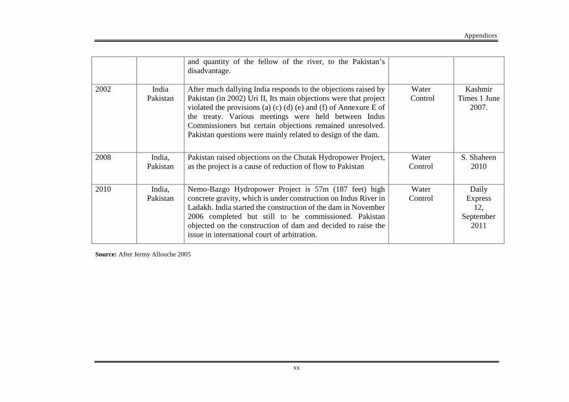
Appendices
xx
Source: After Jermy Allouche 2005
and quantity of the fellow of the river, to the Pakistan’sdisadvantage.
2002 IndiaPakistan
After much dallying India responds to the objections raised byPakistan (in 2002) Uri II, Its main objections were that projectviolated the provisions (a) (c) (d) (e) and (f) of Annexure E ofthe treaty. Various meetings were held between IndusCommissioners but certain objections remained unresolved.Pakistan questions were mainly related to design of the dam.
WaterControl
KashmirTimes 1 June
2007.
2008 India,Pakistan
Pakistan raised objections on the Chutak Hydropower Project,as the project is a cause of reduction of flow to Pakistan
WaterControl
S. Shaheen2010
2010 India,Pakistan
Nemo-Bazgo Hydropower Project is 57m (187 feet) highconcrete gravity, which is under construction on Indus River inLadakh. India started the construction of the dam in November2006 completed but still to be commissioned. Pakistanobjected on the construction of dam and decided to raise theissue in international court of arbitration.
WaterControl
DailyExpress
12,September
2011