indus basin water resources sustainabilitywaterinfo.net.pk/sites/default/files/knowledge... · ·...
TRANSCRIPT
HESSD7, 1883–1912, 2010
Indus basin waterresources
sustainability
D. R. Archer et al.
Title Page
Abstract Introduction
Conclusions References
Tables Figures
J I
J I
Back Close
Full Screen / Esc
Printer-friendly Version
Interactive Discussion
Hydrol. Earth Syst. Sci. Discuss., 7, 1883–1912, 2010www.hydrol-earth-syst-sci-discuss.net/7/1883/2010/© Author(s) 2010. This work is distributed underthe Creative Commons Attribution 3.0 License.
Hydrology andEarth System
SciencesDiscussions
This discussion paper is/has been under review for the journal Hydrology and EarthSystem Sciences (HESS). Please refer to the corresponding final paper in HESSif available.
Sustainability of water resourcesmanagement in the Indus Basin underchanging climatic and socio economicconditionsD. R. Archer1,2, N. Forsythe1, H. J. Fowler1, and S. M. Shah3
1Water Resource Systems Research Laboratory, School of Civil Engineering andGeosciences, Newcastle University, Newcastle, UK2JBA Consulting Engineers and Scientists, South Barn, Broughton Hall, Skipton, NorthYorkshire, BD23 3AE, UK3Centre of Excellence in Water Resources Engineering, University of Engineering andTechnology, G. T. Road, 54890, Lahore, Pakistan
Received: 25 February 2010 – Accepted: 1 March 2010 – Published: 15 March 2010
Correspondence to: D. R. Archer ([email protected])
Published by Copernicus Publications on behalf of the European Geosciences Union.
1883

HESSD7, 1883–1912, 2010
Indus basin waterresources
sustainability
D. R. Archer et al.
Title Page
Abstract Introduction
Conclusions References
Tables Figures
J I
J I
Back Close
Full Screen / Esc
Printer-friendly Version
Interactive Discussion
Abstract
Pakistan is highly dependent on water resources originating in the mountain sourcesof the upper Indus for irrigated agriculture which is the mainstay of its economy. Henceany change in available resources through climate change or socio-economic factorscould have a serious impact on food security and the environment. In terms of both ratio5
of withdrawals to runoff and per-capita water availability, Pakistan’s water resourcesare already highly stressed and will become increasingly so with projected populationchanges. Potential changes to supply through declining reservoir storage, the impactof waterlogging and salinity or over-abstraction of groundwater, or reallocations forenvironmental remediation of the Indus Delta or to meet domestic demands, will reduce10
water availability for irrigation.The impact of climate change on resources in the Upper Indus is considered in terms
of three hydrological regimes – a nival regime dependent on melting of winter snow,a glacial regime, and a rainfall regime dependent on concurrent rainfall. On the basisof historic trends in climate, most notably the decline in summer temperatures, there15
is no strong evidence in favour of marked reductions in water resources from any ofthe three regimes. Evidence for changes in trans-Himalayan glacier mass balance ismixed. Sustainability of water resources appears more threatened by socio-economicchanges than by climatic trends. Nevertheless, analysis and the understanding of thelinkage of climate, glaciology and runoff is still far from complete; recent past climate20
experience may not provide a reliable guide to the future.
1 Introduction
The Greek historian Herodotus (5th century BC) described Egypt as “the gift of theNile” and as “a land won by the Egyptians and given them by the Nile”. These re-marks could equally be applied to the relationship between Pakistan and the River25
Indus and its major tributaries, the Jhelum, Chenab, Ravi, Beas and Sutlej. The fertility
1884
HESSD7, 1883–1912, 2010
Indus basin waterresources
sustainability
D. R. Archer et al.
Title Page
Abstract Introduction
Conclusions References
Tables Figures
J I
J I
Back Close
Full Screen / Esc
Printer-friendly Version
Interactive Discussion
of the alluvial plains of Pakistan derives from sediments deposited over geological timeby the Indus from the high mountain ranges of the Himalaya-Karakoram-Hindu Kush(HKH). The continuing flow of water across the plains is largely derived from the samesource and provides the basis for irrigated agriculture which is the mainstay of Pak-istan’s economy. Mountain sources of flow in the Indus are vulnerable both to changes5
in temperature and precipitation as most of the runoff is derived from the melting ofseasonally accumulated snow and ice from glaciers. Hence changes in climate or theresulting accumulation of snow and ablation of glaciers in the upper reaches of the rivercould have serious consequences for the livelihoods not only of those engaged in theagricultural sector but for the economy as a whole.10
Concerns about the impact of climate change on the Indus, based on an assessmentof what might happen, given temperature changes in line with global climate changeprojections (Rees and Collins, 2005; Akhtar et al., 2008), have given rise to expec-tations of dramatic decreases in river flow (World Bank, 2005). Such concerns havebeen supported by reports of significant retreat and depletion of glacier volume across15
the HKH, for example in the eastern and central Himalaya (Hasnain, 1999; Shrestha etal., 2004). Rasul et al. (2008) report that snow and ice extent is now shrinking fasterthan ever on the HKH mountains as a whole.
However, the effects of climate change on glaciers and on river flow in the westernHKH are not yet clear. Fowler and Archer (2006) have shown that although mean20
annual temperatures are generally rising in line with the global average, summer tem-peratures (July to September), the key for glacial melt, have been falling at many valleystations in the Karakoram in the period 1961 to 2000. Hussain et al. (2005) showedsimilar temperature falls in both the monsoon and pre-monsoon (April–May) period forthe “high mountain region”. In addition, Archer and Fowler (2004) indicated that there25
have been significant increases in precipitation in the Upper Indus in both winter andsummer in the period 1961 to 1999. Reports on glacial mass balance by Hewitt (1998,2005) on the basis of extensive field experience over several decades also contrastwith reports elsewhere of shrinking glaciers. Hewitt (2005) notes that in the late 1990s
1885

HESSD7, 1883–1912, 2010
Indus basin waterresources
sustainability
D. R. Archer et al.
Title Page
Abstract Introduction
Conclusions References
Tables Figures
J I
J I
Back Close
Full Screen / Esc
Printer-friendly Version
Interactive Discussion
there was widespread evidence of glacier expansion mainly in high level glaciers in thecentral Karakoram. Exceptional numbers of glacier surges were also reported.
Such conflicting views on what changes have occurred in the climate and glaciersof the Upper Indus Basin have serious implications for future water management inPakistan and for the sustainability of water resources, through the resulting impact5
on downstream flows reaching the irrigated plains of the Punjab and Sindh. Climatechange impacts are considered in more detail later in this paper.
The relationship between climate change and water resources is of primary concernto human society. However, the relationship does not exist in isolation and is affectedby socio-economic and environmental conditions which influence the balance between10
supply and demand. It is necessary to consider also how freshwater resources havebeen, and will be, affected by changes in these non-climatic drivers (Bates et al., 2008).
2 Geographical and hydrological background
The River Indus rises on the Tibetan Plateau and in its passage through India andPakistan it drains the highest mountain ranges of the world (Fig. 1). The basin is15
sometimes referred to as the “Third Pole” and contains the greatest area of perennialice outside the Polar Regions (>20 000 km2); the area of winter snow cover is an orderof magnitude greater.
The climate of the Upper Indus is influenced by the disposition and height of moun-tain ranges; the monsoon, which brings significant rainfall on the southern margin,20
penetrates infrequently across the Himalayan mountain divide. Precipitation in thetrans-Himalayan Karakoram and Hindu Kush ranges primarily occurs as snow in winterand spring as the result of westerly disturbances. Even so, valley climate stations at el-evations below 2500 m a.s.l. record annual rainfalls of generally less than 200 mm, andthe maximum annual precipitation of over 1500 mm occurs at elevations over 5000 m25
(Wake,1989). Given the limited precipitation at low levels, the main hydrological ac-tivities of melt of seasonal snow and glaciers occur at elevations of over 4000 m and
1886

HESSD7, 1883–1912, 2010
Indus basin waterresources
sustainability
D. R. Archer et al.
Title Page
Abstract Introduction
Conclusions References
Tables Figures
J I
J I
Back Close
Full Screen / Esc
Printer-friendly Version
Interactive Discussion
contribute towards river runoff from March to September. A combined annual averagevolume of about 175 bcm (equivalent to an average discharge of 5550 m3 s−1) for allmajor rivers is discharged into the Indus plains.
A summer monsoon maximum occurs on the southern slopes of the Himalaya al-though winter totals are also enhanced with annual rainfall up to 1800 mm (Archer and5
Fowler, 2004). Southward from the foothills rainfall totals decline rapidly and much ofthe lower Indus receives an annual average total of less than 200 mm.
The arid and semi-arid environment of the plains does not provide a reliable basisfor rain-fed agriculture and, until the development of irrigation systems in the Britishcolonial era, the land, except in the immediate vicinity of river channels, was largely10
used for pastoralism. The Indus Basin Irrigation System (IBIS), comprising the majorstorage reservoirs of Tarbela on the Indus and Mangla on the Jhelum and a networkof barrages and canals, has now grown to be the largest integrated irrigation systemin the world. The irrigation command area of approximately 18 million hectares is 78%of Pakistan’s total cultivated area of 23 M hectares (Habib, 2004). The Indus River15
and its tributaries provide nearly 60% of the water utilized for irrigation. Much of theremainder is groundwater which is recharged by the rivers and by the leaking canalnetwork. Irrigated land accounts for 85% of all cereal grain production (mainly rice andwheat), all sugar production and most of the cotton production. Most people in ruraland urban Pakistan depend on groundwater for their drinking water. Of the major cities,20
only Karachi and Islamabad rely primarily on surface water sources.Pakistan’s agricultural sector is dominant in the economy of Pakistan. The sector not
only meets the food demand of the growing population but also provides the raw mate-rials for the industrial sector, notably cotton for the textile industry. The sector employsaround 45% of the total labour force of the country whilst the 67% of the population25
living in rural areas is linked directly or indirectly to agriculture for their livelihoods. Tex-tiles comprise 64% and food products 11% of total Pakistani exports; both are whollydependent on agriculture. The linkage between water resources, through irrigationdemand, to the economic wellbeing of the country is thus established.
1887

HESSD7, 1883–1912, 2010
Indus basin waterresources
sustainability
D. R. Archer et al.
Title Page
Abstract Introduction
Conclusions References
Tables Figures
J I
J I
Back Close
Full Screen / Esc
Printer-friendly Version
Interactive Discussion
The geopolitical situation of Pakistan has also had a profound effect on water re-sources development. Partition in 1947 divided the source rivers of the Indus Basinin India from irrigated land in Pakistan. The Indus Waters Treaty, eventually agreedin 1960, gave Pakistan the exclusive use of waters of the three western tributaries,the Indus, Jhelum and Chenab, and India the eastern rivers, Sutlej, Beas and Ravi to5
their entry point to Pakistan. An important element of the Treaty was the constructionof infrastructure which would enable Pakistan to continue supply to irrigated areas onthe eastern rivers. This included the two main storage dams, Mangla on the Jhelum,completed in 1967, and Tarbela on the Indus, commissioned in 1978, and the buildingof link canals from the western rivers to the east.10
The developments enabled an increase in the area under irrigation by 15 to 20%and a significant increase in cropping intensities. In particular, it allowed the transfer ofsurplus water from storage in the summer period to the spring. The spring (rabi) cropis mainly of wheat which is by far the most important crop in Pakistan with a plantedarea of over 8 million hectares and is the staple food for the majority of the population.15
Nevertheless, in many years home production is insufficient to meet demand and an-nual imports of more than 2 million tons of wheat have had to be made. Food securityis an important element in sustainability of water resources management.
3 Water stress – the supply demand balance
Water stress has typically been defined in two ways:20
1. As a ratio of withdrawals to long-term average annual runoff (Alcamo et al., 2003),or
2. In terms of per capita water availability (UNDP, UNEP, World Bank, and WRI,2000).
1888

HESSD7, 1883–1912, 2010
Indus basin waterresources
sustainability
D. R. Archer et al.
Title Page
Abstract Introduction
Conclusions References
Tables Figures
J I
J I
Back Close
Full Screen / Esc
Printer-friendly Version
Interactive Discussion
3.1 Ratio of withdrawals to runoff
In terms of ratio of withdrawals to runoff, water stress is defined to occur when theratio rises above 0.4. This threshold was used by a consortium of United Nationsorganizations (Raskin et al., 1997), by the World Water Council (Alcamo et al., 2000;Cosgrove and Rijsberman, 2000), and by Vorosmarty et al. (2000) as an approximate5
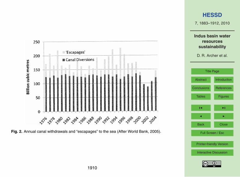
threshold of “high” or “severe” water stress.In the case of Pakistan, on average 73% of the flow from the Indus is abstracted
to the canal systems; already indicating a highly stressed system. Furthermore, inthe drought years such as occurred from 2000 to 2003, virtually the entire flow wasabstracted leaving only a trickle to support the ecology and to limit salt water intrusion10
on the lower river and to reach the Arabian Sea (World Bank, 2005) (Fig. 2).
3.2 Per capita water availability
Basins are also defined as being “water stressed” if they have a per capita water avail-ability below 1700 m3 per year (based on long-term average runoff) or as facing ‘waterscarcity’ when supplies drop below 1000 m3 per year. The use of per capita volume15
as an indicator of stress can be misleading as the requirement for irrigation which pre-dominates in Pakistan is far greater per capita than for domestic and industrial usetypical of developed countries; it also does not account for efficiency of use. Underthis definition the World Bank (2003, 2005) indicates that Pakistan has already fallenbelow the water stress threshold and will reach a condition of water scarcity by 2035.20
However, the World Bank estimate is based on a high value of available water (perhapsincluding groundwater) and a lower population than currently available estimates (UN,2009). Therefore, the current and projected situation could be more severe than theyhave estimated.
The use of population in the denominator – “per capita” water availability – highlights25
the key role of assumed rates of population growth in the changing status of the watersupply-demand balance. Population growth has been, and continues to be, high. From
1889

HESSD7, 1883–1912, 2010
Indus basin waterresources
sustainability
D. R. Archer et al.
Title Page
Abstract Introduction
Conclusions References
Tables Figures
J I
J I
Back Close
Full Screen / Esc
Printer-friendly Version
Interactive Discussion
a total of 40 million in 1950, Pakistan’s population grew to over 80 million in 1980 andto an estimated total of 185 million in 2010 (UN, 2009). Given this estimated populationtotal and an annual runoff volume of ∼175 bcm (the numerator), the per capita avail-ability has already dipped below the water scarcity level of 1000 m3/capita (Fig. 3). TheUN medium population estimates of 246 and 335 million for 2025 and 2050 result in5
per capita estimates of only 711 and 522 m3. The UN (2009) provides different popu-lation growth trajectories. For 2050 these range from a low estimate of 293 million toa high estimate of 459 million based on a fertility rate assumed constant at its currentlevel; these give per capita estimates of 599 m3 and 382 m3. Otherwise expressed,the population is rising and will continue to rise at approximately 4 million per year, ne-10
cessitating significant increases in food production and associated increases either inwater availability or efficiency of use.
4 Water stress – changes to available supply
Whilst the population, and thus demand for water, continues to rise, the supply is un-likely to increase. The World Bank (2005) describes as a “sobering fact” that “there is15
no feasible intervention which would enable Pakistan to mobilize appreciably more wa-ter than it now uses”. On the other hand, there are significant possibilities of reducedwater availability for irrigation due either to reduction or reallocation of flow. Examplesare:
1. decline of reservoir storage due to sedimentation20
2. increase in domestic and industrial demand with increasing urbanisation
3. increase in environmental flows
4. decreased groundwater resources
5. potential impact of climate change on mountain sources.
1890

HESSD7, 1883–1912, 2010
Indus basin waterresources
sustainability
D. R. Archer et al.
Title Page
Abstract Introduction
Conclusions References
Tables Figures
J I
J I
Back Close
Full Screen / Esc
Printer-friendly Version
Interactive Discussion
4.1 Reservoir sedimentation
Changes in reservoir storage, either reductions due to sedimentation or increases dueto the construction of new dams, do not change the overall volume of available wa-ter but they have serious consequences for the timing and the matching of flows toirrigation requirements and for hydropower production.5
The River Indus and its tributaries carry a very high sediment load which has se-riously affected the storage capacity of the two principal control dams, Tarbela andMangla, on the Indus and Jhelum. Sedimentation resulted in a reduction of 28% inthe initial capacity of 13.9 bcm of Tarbela by 2000 and the useful life of the dam is nowestimated to be 85 years (Asianics, 2000). Earlier estimates (Tams, 1997; Attewill et10
al., 1998) had indicated a more rapid rate of sedimentation and that the reservoir wouldlargely be filled with sediment by 2030. Similarly, the capacity of Mangla was reducedby 20% by 2007, although a current project to raise Mangla will soon restore the capac-ity to an amount greater than when originally constructed. Nevertheless, unless newstorage dams are built there will be a progressive reduction in active storage which will15
seriously limit the capacity to transfer surplus summer flow to the winter (wheat) cropand downstream irrigation will return to run-of-river management.
A particular problem for Tarbela is the advance of the sediment delta which is ap-proaching the dam’s intake tunnels to the hydroelectric power station which satisfiesnearly 20% of the country’s demand for electricity. If the sediment delta were to reach20
the intake tunnels to the power house, the situation would be irreversible resulting ina cessation of power production and the transfer of all irrigation releases to be madevia the spillways (Tate and Farquharson, 2000). Such a reduction in power capacitywould have implications not only for domestic users but also for alternative groundwa-ter sources of irrigation, dependent partly on electrical pumps.25
1891

HESSD7, 1883–1912, 2010
Indus basin waterresources
sustainability
D. R. Archer et al.
Title Page
Abstract Introduction
Conclusions References
Tables Figures
J I
J I
Back Close
Full Screen / Esc
Printer-friendly Version
Interactive Discussion
4.2 Increase in domestic and industrial demands
With an increase in population there will be an inevitable increase in domestic waterdemand which will be accelerated with increased urbanisation. Urban population hasgrown from 20 million in 1980 to 70 million in 2000 with an associated growth in manu-facturing industry. Although domestic demands are currently small in comparison with5
irrigation demands, the World Bank (2005) suggests that they are expected to growfrom 4% to 15% of aggregate water demand in the next twenty years. Both urban andrural domestic water supplies are mainly met from groundwater and locally aquifers arealready being drawn down rapidly, thus conflicting with abstractions for irrigation.
4.3 Increase in environmental flows10
Whilst there are many vulnerable ecosystems within the Indus Basin, including wet-lands, floodplains and riparian areas which have been or may be affected by upstreaminterventions, the main concern is for residual freshwater flows to the Indus delta. Thelower Indus has seen significant seawater intrusion up to 100 km upstream with re-sulting effects on riparian livelihoods and loss of biodiversity, including degradation of15
mangrove ecosystems, fish populations and the endangered Indus dolphin. Whereasa 1991 Water Accord between the provinces recognised the need for a residual flow tothe delta of 10 million acre feet (12.3 bcm), no formal policy or institutional mechanismhas yet been adopted to make environmental water allocations. There is a clear needfor such environmental allocations to be made not only for a minimum residual flow but20
also to provide a measure of flow variability that mimics the natural river regime (Richteret al., 1997). However, achieving a balance between environmental needs and ensur-ing food security through irrigation water use must also be addressed. Given the lowirrigation water productivity (see Sect. 6.3), additional environmental flows could morereadily be delivered by measurement and effective control and use of canal diversions25
than by blanket opposition to new dams on the upper Indus – which has typified theresponse of lower river users.
1892

HESSD7, 1883–1912, 2010
Indus basin waterresources
sustainability
D. R. Archer et al.
Title Page
Abstract Introduction
Conclusions References
Tables Figures
J I
J I
Back Close
Full Screen / Esc
Printer-friendly Version
Interactive Discussion
4.4 Reduced groundwater availability
Groundwater plays an important role in supplementing surface water abstraction andnow provides more than 40% of water used for irrigation, mainly in the Punjab. Ground-water, which is fed by seepage from the river and leakage from canals and distributionsystem, provides an alternative to surface storage in Mangla and Tarbela, of transfer-5
ring summer surplus to meet winter and spring deficit. Loss of water resources relatedto groundwater management could come from two opposed directions. Too little use ofgroundwater (or over-irrigation from surface sources) leads to a rising water table andthe risk of waterlogging and salinity; too much use leads to falling water tables and therisk that extraction could become technically or economically infeasible.10
Before the widespread development of irrigation in Pakistan, the water table overmuch of the lowlands was tens of metres below the surface. Leakage from the irri-gation system through the first half of the twentieth century raised the water level andassociated salts to the crop root zone over wide areas with dramatic loss of produc-tive capacity due to the combined impact of waterlogging and/or salinity. By the early15
1960s, an estimated 23% of the country’s land suffered to varying degrees from water-logging and salinity and an area of 40 000 ha was being lost annually (Elgabaly, 1977).
However, the situation has been partially reversed over the northern plains. Initialresponse was through a series of Salinity Control and Reclamation Projects (SCARPs)commencing in the late 1950s. The project aimed at lowering the groundwater table20
by providing vertical drainage through large capacity, deep tubewells (Qureshi et al.,2008). Under SCARP about 13 500 publicly owned and operated tubewells were in-stalled. However, the main change came about not primarily as a result of centralplanning but by the independent decisions of farmers to use groundwater as a substi-tute or to supplement for direct river irrigation. Farmers found that the canal system was25
too inflexible and provided water which was either too much, too little or at the wrongtime; groundwater provides a decentralized “on-demand” source of water and enablesfarmers to greatly increase their crop yields and incomes. The result of this abstraction
1893

HESSD7, 1883–1912, 2010
Indus basin waterresources
sustainability
D. R. Archer et al.
Title Page
Abstract Introduction
Conclusions References
Tables Figures
J I
J I
Back Close
Full Screen / Esc
Printer-friendly Version
Interactive Discussion
of groundwater by tubewells has been to draw down the water table and leach salt outof the root zone, thus reducing both the extent and severity of waterlogging and salinity.Habib (2006) indicates that groundwater abstraction from over 600 000 tubewells hasnow reached nearly 70 bcm per year.
However, salinity and waterlogging remain serious problems especially in irrigated5
areas of Sindh where much of the groundwater is naturally saline (of marine origin)and thus unsuitable for irrigation as a substitute for canal diversions. Since the areaof waterlogging appears to be related directly to the amount of water diverted in theprevious year (World Bank, 2005), the joint management of surface and groundwatersources is a key requirement.10
Reduction in groundwater resources could also result from the opposing effectof over-abstraction, especially in the Punjab where abstraction exceeds the rate ofrecharge and the groundwater is being effectively “mined” both for irrigation and urbanuse. If water table levels continue to fall, they will eventually reach a point where it isno longer practicable to extract. The cost of pumping either by electrical pumps or the15
more common diesel pumps is likely to rise sharply with diminishing world oil resources.Petroleum products already constitute Pakistan’s single largest import category.
5 The potential effects of climate change
The potential impact of climate change on water resources has already been outlinedin the introduction but the evidence remains conflicting as to whether the change will20
have a positive or negative effect on water resources. The expectation of severelyreduced resources expressed by Rees and Collins (2005) and the World Bank (2005)rests on two assumptions: that the effect of rising temperature on glacier melt is theprimary impact on water resources; and that temperatures in the Upper Indus will risein line with global climate change projections. However, both these assumptions are25
questionable.
1894

HESSD7, 1883–1912, 2010
Indus basin waterresources
sustainability
D. R. Archer et al.
Title Page
Abstract Introduction
Conclusions References
Tables Figures
J I
J I
Back Close
Full Screen / Esc
Printer-friendly Version
Interactive Discussion
Archer (2003) has shown that river flow in the Indus does not depend uniquely onglacier melt but depends on three distinct regimes relating climate to river flow:
1. A nival regime at middle altitudes where flow is dependent on the melting of sea-sonal snow accumulated during the preceding winter and spring
2. A glacial regime at very high altitudes where river flow is closely dependent on5
summer temperature
3. A rainfall regime dependent on runoff from concurrent rainfall mainly during themonsoon season.
5.1 The nival regime
Of these three regimes, the greatest contribution to flow comes from the nival regime.10
The area of seasonal snow is an order of magnitude greater than the area of perennialsnow and ice, although the area diminishes and cover is depleted through the meltseason. In this zone, including the greater part of the upper Jhelum basin (Archerand Fowler, 2008), winter precipitation and summer runoff are significantly positivelycorrelated. In contrast to the glacial regime, summer runoff and summer temperature15
are uncorrelated or even negatively correlated. Hence trends in winter precipitation arelikely to have the most significant impact on runoff.
Archer and Fowler (2004) investigated historical trends in winter precipitation whichmainly originates from westerly disturbances. They found upward trends in winter pre-cipitation (October to March) at all stations across the region between 1961 and 199920
with three out of ten relationships being significant (p>0.05).There are two potential limitations to this analysis.
1. The trend analysis was limited to the available long-term climate stations whichare invariably located on valley floors and there is the possibility that they donot represent trends at higher elevations which receive much higher precipita-25
tion. However, the fact that the precipitation at these valley stations is strongly1895

HESSD7, 1883–1912, 2010
Indus basin waterresources
sustainability
D. R. Archer et al.
Title Page
Abstract Introduction
Conclusions References
Tables Figures
J I
J I
Back Close
Full Screen / Esc
Printer-friendly Version
Interactive Discussion
correlated with runoff originating at higher elevations indicates that precipitationmeasurements at valley level provide a satisfactory index of conditions at levelswhere snow is accumulating and melt occurring (Archer, 2003; Archer and Fowler,2004).
2. Historic trends may not persist into the future. Updating of UIB precipitation trends5
to 2006, and including the drought years from 2000 to 2003, degrades the statis-tical significance of the trends. However, the IPCC (2007) projects precipitationincreases in winter and spring for the “Tibetan Plateau” grid box, which includesbut is larger than the UIB. The projected increases to 2039 vary between a 10%and 14% increase in winter between low and high emission scenarios and be-10
tween 6% and 7% for spring.
5.2 The glacial regime
The glacial regime, on which dire predictions have been made, plays an important partin the flow of very high catchments such as the Shyok, Hunza and Shigar Rivers, whosecombined flow represents an average of less than 30% of the flow in the Indus to the15
margins of the mountains. In these catchments there is a high and positive correla-tion between summer runoff and summer temperature as measured at valley stations(Archer, 2003; Fowler and Archer, 2006). In contrast to catchments of the nival regime,there is no significant correlation with preceding winter precipitation. Here, trends inspring and summer temperature will have the greatest impact on trends in runoff. This20
leads to the conclusion with respect to application of global temperature rise that runoffwill initially increase but, with declining glacier mass, will ultimately fall sharply (Reesand Collins, 2005). Immerzeel et al. (2008) used a coarse resolution global databaseto assess long term temperature trends from 1972 to 2002 and concluded that there isa strong warming trend in all seasons although weakest in summer. He also concluded25
that the warming trend increased at higher elevations.
1896

HESSD7, 1883–1912, 2010
Indus basin waterresources
sustainability
D. R. Archer et al.
Title Page
Abstract Introduction
Conclusions References
Tables Figures
J I
J I
Back Close
Full Screen / Esc
Printer-friendly Version
Interactive Discussion
In contrast, Fowler and Archer (2006), using observed records from valley stationsfor data to 1999, found that although winter and annual temperatures were rising in linewith global projections, summer temperatures, and particularly minimum temperatures,were actually falling. This reversal of trend in the summer months is not unique to thehigh Karakoram; Hussain et al. (2005) and Sheikh et al. (2009) show similar temper-5
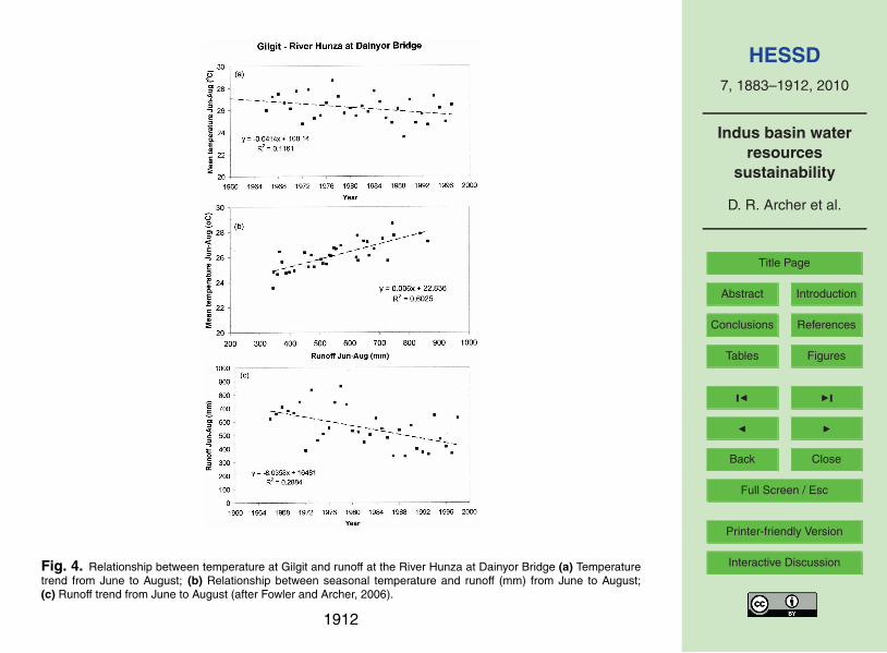
ature falls in the monsoon period for most other parts of both the Upper and LowerIndus. Hence, Fowler and Archer (2006) show that as runoff in the River Hunza andsummer temperature are correlated, the recent trend in flow is downward (Fig. 4)
The evidence from glaciological observations suggests a diverse response to cli-mate change. Hewitt (2005) notes that, while the trend in mass balance in Karakoram10
glaciers was mainly negative until the 1990s, there has since been thickening andadvance of many high level glaciers in the central Karakoram. Elsewhere at lower ele-vations glaciers continued to decline. Exceptional numbers of glacial surges have alsobeen reported in high level glaciers (Hewitt, 2007). Rasul et al. (2008) suggest fromsatellite evidence that some glaciers including Siachen glacier have shrunk or retreated15
in line with experience in the central Himalaya (Hasnain, 1999). However, Raina andSangewar (2007) and Ganjoo and Koul (2009) indicate on the basis of field observationthat Siachen glacier has shown hardly any retreat in the last fifty years.
The evidence of falling summer temperatures and the lack in the Karakoram ofwidespread retreat of glaciers reported in mountain regions elsewhere (Greenwood et20
al., 2010) suggests a quite different response to climate change in the glacial regimesof the upper Indus from worldwide experience. However, there are again potentiallimitations to this analysis.
1. The trend analysis of temperature was limited to the available valley climate sta-tions with the possibility of being unrepresentative of higher elevations. However,25
the fact that the temperature at these valley stations is strongly correlated withrunoff originating at higher elevations (Fig. 4) indicates that valley measurementsat valley level provide a satisfactory index of conditions at levels where glacialmelt is occurring.
1897

HESSD7, 1883–1912, 2010
Indus basin waterresources
sustainability
D. R. Archer et al.
Title Page
Abstract Introduction
Conclusions References
Tables Figures
J I
J I
Back Close
Full Screen / Esc
Printer-friendly Version
Interactive Discussion
2. Historic trends may not persist into the future. However, downward summer tem-perature trends remain significant for observed data with the inclusion of recentyears to 2006. In contrast, climate modelling results (IPCC, 2007) for the “TibetanPlateau” grid box suggest a substantial temperature rise in every season. Theprojected increase for summer temperature to 2039 is around 1.7 ◦C for both low5
and high emission scenarios and between 2.92 ◦C and 3.74 ◦C between high andlow emission scenarios to 2069. Such discrepancies need further investigation.
5.3 The monsoon rainfall regime
The monsoon rainfall regime dominates on the southern foothills of the Himalaya andalso over the plains to the south but with much reduced totals. Although the seasonal10
volume of runoff resulting from rainfall is lower than from glacial and nival sources,rainfall produces more intense runoff and is often the source of the highest floods onthe margins of the mountains. Archer and Fowler (2004) show that there has beena statistically significant increase in summer rainfall in the upper Indus in the periodsince 1961. Moreover, the increase appears to be widespread over the greater part of15
Pakistan (Sheikh et al., 2009)Historic trends and projections of the impacts of climate change on monsoon rainfall
have received much more attention than glacial and nival regimes owing to their sig-nificance for the entire Indian sub-continent. The Intergovernmental Panel on ClimateChange (IPCC) (2007) project an increase in summer precipitation but with uneven dis-20
tribution across the Indian sub-continent and an increase in the frequency of intenseprecipitation in some parts. However, there are substantial inter-model differences inrepresenting monsoon processes, including a lack of clarity over the effects of the ElNino Southern Oscillation (ENSO) which further contributes to uncertainty about fu-ture regional monsoon behaviour. Consequently, IPCC and Mani et al. (2009) indicate25
that quantitative estimates of projected precipitation change are uncertain and “it islikely that some local climate changes will vary significantly from regional trends dueto the region’s very complex topography and marine influences”. The impact of climate
1898

HESSD7, 1883–1912, 2010
Indus basin waterresources
sustainability
D. R. Archer et al.
Title Page
Abstract Introduction
Conclusions References
Tables Figures
J I
J I
Back Close
Full Screen / Esc
Printer-friendly Version
Interactive Discussion
change on monsoon precipitation trend in the Indus Basin in Pakistan therefore re-mains open to uncertainty.
5.4 Climate change and water resources
Given the above analysis there appears to be little evidence from any of the threeregimes, nival, glacial and rainfall, for substantial historical reductions in runoff available5
for water resources. However considerable uncertainty remains in our understandingof the meteorological origins of climate trends, of links between climate, glacial accu-mulation and ablation and runoff and why the Upper Indus should differ in its responseto climate change from other mountain regions of the world.
6 The challenge of sustainability in water resources10
Although the focus here is on responses to climate change in the mountains, climatechange cannot be considered in isolation from other problems of ensuring sustainablewater resources. Responses can be considered in terms of availability of data, scien-tific capacity for analysis and management response to developing conditions.
6.1 Data availability15
Climate and river flow data for the Upper Indus Basin fall far short of the WMO (1994)recommendation for density in rugged mountainous areas. For example, for non-recording precipitation, the recommendation is for one gauge per 250 km2, whereas theactual density is of less than one gauge per 5000 km2(and less than one per 10 000 km2
if automatic gauges are excluded). Furthermore, gauges are predominantly at valley20
sites with the highest manual gauge at less than 2500 metres and only three automaticgauges above 4000 m, whereas the mean elevation of the Upper Indus (to Tarbela)is about 4500 m and the highest precipitation and melt contribution to runoff is from
1899
HESSD7, 1883–1912, 2010
Indus basin waterresources
sustainability
D. R. Archer et al.
Title Page
Abstract Introduction
Conclusions References
Tables Figures
J I
J I
Back Close
Full Screen / Esc
Printer-friendly Version
Interactive Discussion
elevations above this level. The paucity of gauges is understandable in view of thelogistical problems of installing and maintaining gauges in such harsh and rugged con-ditions. In spite of the limitation in gauge numbers, useful conclusions can be drawn onlinks between climate and runoff and on climate change, based on the discovery thatboth temperature and precipitation are highly correlated on a seasonal basis across5
the whole basin (Archer, 2003) and that climatic statistics from a single low-level sta-tion can provide a useful index of runoff on large catchments (Fowler and Archer, 2006)(Fig. 4). Inevitably further analysis will depend to a greater extent on satellite basedremote sensing as a means of tracking snow covered area, snow water equivalent andglacier mass balance. Given the uncertainty in rates and direction of change in glacial10
mass balance, a more sustained programme of field observation and measurement isnecessary.
In terms of sustainability of water resources, the most significant shortfall in mea-surement is with respect to very limited operational measurements in main, branchand distributary levels of the IBIS (World Bank, 2005). Measurement limitations and15
the consequent use of simple time-based water allocation practices restrict the abilityto regulate flows, to make volumetric delivery within the network or to take advantageof seasonal flow forecasts from upland sources for planning (Archer and Fowler, 2008;Majeed, 1992, 2009).
6.2 Scientific capacity for analysis20
Pakistan has been a slow starter with respect to climate change and associated anal-ysis. However, climate change science took a major step forward with the creationof the GCISC (Global Change Impact Studies Centre) in 2002. With strong govern-mental backing the Centre has built up a multi-disciplinary team including climatolo-gists, glaciologists and hydrologists and is carrying out work to monitor and analyse25
current and likely future trends in climate and glaciology and their impact on socio-economic development (Sheikh et al., 2009). At the same time, the research capac-ity of the PMD (Pakistan Meteorological Department) and academic institutions has
1900

HESSD7, 1883–1912, 2010
Indus basin waterresources
sustainability
D. R. Archer et al.
Title Page
Abstract Introduction
Conclusions References
Tables Figures
J I
J I
Back Close
Full Screen / Esc
Printer-friendly Version
Interactive Discussion
been strengthened. In 2004 the PMD launched the Pakistan Journal of Meteorology(available on line at http://www.pakmet.com.pk/rnd/rnd files/Page707.htm), providingthe opportunity for local dissemination of knowledge and expertise including on climatechange.
With respect to glaciology, the only sustained monitoring and analysis has been5
carried out by Hewitt (1968, 1998, 2005). His work was boosted for a time by a collab-orative programme with Canadian support (Hewitt and Young, 1993) with an importantoutcome being the setting up of a network of 20 automatic weather stations at lev-els between 2000 and 4700 m. Some records are now of 15 years duration and arebecoming useful for trend assessment. A further development has been the compi-10
lation of a baseline inventory of Upper Indus glaciers and glacial lakes using LandsatETM+ (Roohi, 2007). A total of 5218 glaciers and 844 glacial lakes were identified anddescribed. However, field study of glaciers and glacial processes remains weak.
6.3 Management response to changing conditions
Understanding of the potential impact of climate change in Pakistan remains uncer-15
tain so there may therefore be some justification in the limited practical response todate. However, future managerial capacity may be judged on the basis of the historyof response to other environmental and social changes which affect water resourcessustainability. These include the inexorable rise in population, the consequent growingwater requirement for food security, conflicts for water use with the environment and do-20
mestic use, the loss of storage through reservoir sedimentation and the managementof salinity and waterlogging. Management of the irrigation system and the need fornew storage reservoirs are cited as examples. Government and managerial responseto these issues have been fragmentary at best.
A key to sustainable water use is integrated management of reservoirs and irrigation25
system. The current subdivision of responsibility, for the control reservoirs with theWater and Power Development Authority (WAPDA) and distribution with the Provin-cial Irrigation and Drainage Authorities (PIDA), has limited ability to make best use of
1901

HESSD7, 1883–1912, 2010
Indus basin waterresources
sustainability
D. R. Archer et al.
Title Page
Abstract Introduction
Conclusions References
Tables Figures
J I
J I
Back Close
Full Screen / Esc
Printer-friendly Version
Interactive Discussion
available water. Productivity per unit of water is 40% lower than in neighbouring partsof India and 50% lower than in the United States (World Bank, 2005). The lack ofmeasurement and control result in farmers suffering variously from excess water (andsalinity), too little water, or water at the wrong time. Insufficient effort has been putinto precise levelling of irrigated fields so that lower areas are overwatered to ensure5
supplies to higher areas. Private abstractions from groundwater remain unlicensed;hence no overall control can be maintained on the balance between abstraction andrecharge. Vested interests of large landowners and irrigation officials (who make “dis-cretionary releases” for personal gain) oppose changes to the current system (WorldBank, 2005). Increasing water productivity could buy time against increasing demand10
and reducing supplies.When the Indus Basin works were being planned, it was clear that the construction of
Tarbela and Mangla was not a final solution. High silt loads and declining storage wereanticipated and the need for replacement recognised. The rapid rise in population andwater demand now make the construction of a major new storage essential. Yet in spite15
of proposals and detailed plans for dams at Kalabagh (downstream from Tarbela) andBasha (upstream from Tarbela) there is still no decision to proceed with construction.
Underlying the failure to take effective action either with respect to irrigation manage-ment or construction of new storages is the pervasive lack of trust. As Habib (2004)notes, “facts about water remain controversial and all domestic water issues are ex-20
plained in the context of provincial antagonism”. This is particularly the case for damconstruction for which the most strident opposition has come from political parties andindividuals in Sindh who surmise that Punjab will be the greatest beneficiary and thatSindh will lose its share both of water and revenues from power production. There isjustification for concern in the view that residual flow to the Arabian Sea is “wastage”25
(Asrar-ul-Haq et al., 1997) or “escapages” (Tarar, 1997) rather than an important ele-ment of environmental sustainability. Nevertheless, it is clear that all will lose out if newstorages are not built. If the ability to store surplus water from summer to release for therabi crop is lost Sindh will be the greatest loser since the option of using groundwater
1902
HESSD7, 1883–1912, 2010
Indus basin waterresources
sustainability
D. R. Archer et al.
Title Page
Abstract Introduction
Conclusions References
Tables Figures
J I
J I
Back Close
Full Screen / Esc
Printer-friendly Version
Interactive Discussion
for storage is not widely available. The World Bank (2005) notes that “the discussionof dams has become a vehicle for a host of unrelated historical and current politicalgrievances”. The prospects for effective adaptation to climate change are not high.
7 Conclusion – meeting the challenge to sustainability in water resources
Pakistan faces a network of interlinked challenges in which water resources plays a key5
role. The availability of water resources may limit the ability to ensure food security fora population that is continuing to grow rapidly. Squeezing the last drop out of availablewater to provide food will limit the amount that can be used to maintain ecosystemssuch as the Indus delta. Urban growth and industrialisation will demand their share ofwater resources. Water resources, especially in the spring, will gradually diminish as10
reservoir storage is taken up by sediment unless new large reservoirs are built. Reser-voir sedimentation will also limit the ability to generate hydro electric power to meet thegrowing demand for domestic and industrial energy. The alternative of using ground-water as a means of securing water supply for the spring (rabi) crop may diminish aswater tables fall and pumping becomes impractical. Economics has a role to play given15
that practical solutions to water resource management require large investments whichwill have to compete with the national needs for security, health and education of thepopulation.
In the face of these daunting challenges, the effect of climate change is expectedto play a minor role, particularly given the possibility that at least one, and perhaps20
all three, of the identified climate-runoff regimes will result in more rather than lesswater being available. Nevertheless analysis and the understanding of the linkage ofclimate, glaciology and runoff is still far from complete; recent past climate experiencemay not provide a reliable guide to the future. There is the possibility that although av-erage volumes may increase, the annual variability may also increase, the seasonality25
of flows may alter, and rainfall and flooding may intensify. There is a need to build upthe knowledge base of the mountain environments from which the greater part of the
1903

HESSD7, 1883–1912, 2010
Indus basin waterresources
sustainability
D. R. Archer et al.
Title Page
Abstract Introduction
Conclusions References
Tables Figures
J I
J I
Back Close
Full Screen / Esc
Printer-friendly Version
Interactive Discussion
water resources originates. This will require improved education and a wider dissemi-nation of scientific knowledge and application. Above all it will require better integratedmanagement of water resources in which decisions are made on the basis of verifiablemeasurements and conflicts in water use acknowledged and compromises made.
References5
Akhtar , M., Ahmad , N., and Booij, M. J.: The impact of climate change on the water resourceof Hindukush-Karakorum-Himalaya region under different glacier coverage scenarios, J. Hy-drol., 355, 148–163, 2008.
Alcamo, J., Henrichs, T., and Rosch, T.: World water in 2025 – global modeling scenarios forthe World Commission on Water for the 21st Century. World Water Series Report no. 2,10
Centre for Environmental Systems Research, University of Kassel, Germany, 2000.Alcamo, J., Doll, P., Henrichs, T., Kaspar, F., Lehner, B., Rosch, T., and Siebert, S.: Global
estimates of water withdrawals and availability under current and future “business-as-usual”conditions, Hydrol. Sci. J., 48, 339–348, 2003.
Archer, D. R.: Contrasting hydrological regimes in the upper Indus Basin, J. Hydrol., 274, 198–15
210, 2003.Archer, D. R. and Fowler, H. J.: Spatial and temporal variations in precipitation in the Upper
Indus Basin, global teleconnections and hydrological implications, Hydrol. Earth Syst. Sci.,8, 47–61, 2004,http://www.hydrol-earth-syst-sci.net/8/47/2004/.20
Archer, D. R. and Fowler, H. J.: Using meteorological data to forecast seasonal runoff on theRiver Jhelum, Pakistan, J. Hydrol., 361, 10–23, 2008.
Asianics Agro-Dev. International (Pvt) Ltd.: Tarbela Dam and related aspects of the Indus RiverBasin, Pakistan, A WCD case study prepared as an input to the World Commission onDams, Cape Town, www.adb.org/water/Topics/Dams/pdf/cspkmain.pdf, last access: March25
2010, 2000.Asrar-ul-Haq, Shahid, B. A. and Shakir, A. S.: Indus Basin water resources: sustainability con-
cerns and optimisation strategies, in: Water for the 21st Century: Demand, Supply, Devel-opment and Socio-environmental Issues, edited by: Tariq, A. R. and Latif, M., Proceedings
1904

HESSD7, 1883–1912, 2010
Indus basin waterresources
sustainability
D. R. Archer et al.
Title Page
Abstract Introduction
Conclusions References
Tables Figures
J I
J I
Back Close
Full Screen / Esc
Printer-friendly Version
Interactive Discussion
of an International Symposium, Centre of Excellence in Water Resources Engineering Pub-lications 110, Lahore, 61–76 1997.
Attewill, L. J. S., White, W. R., Tariq, S. M., and Bilgi, A.: Sediment management studiesof Tarbela Dam, Pakistan, The prospect for reservoirs in the 21st century, (Proceedings ofthe 10th Conference of the British Dam Society, Bangor Wales), Thomas Telford, 212–225,5
1998.Bates, B. C., Kundzewicz, Z. W. Wu, S., and Palutikof, J. P. (Eds.): Climate Change and Wa-
ter. Technical Paper of the Intergovernmental Panel on Climate Change, IPCC Secretariat,Geneva, 210 pp., 2008.
Cosgrove, W. and Rijsberman, F.: World Water Vision: Making Water Everybody’s Business.10
World Water Council, Earthscan Publications, London, UK, 2000.Elgabaly, M. M.: Problems and Effects of Irrigation in the Near East Region, edited by: Barton
Worthington, E., p. 247, Pergamon, Oxford, 1977.Fowler, H. J. and Archer, D. R.: Hydro-climatological variability in the Upper Indus Basin and
implications for water resources, in: Regional Hydrological Impacts of Climatic Change –15
Impact Assessment and Decision Making, edited by: Wagener, T., Franks, S., Gupta, H. V.,Bøgh, E., Bastidas, L., Nobre, C. And Galvso C. deO, IAHS Publ., 295, 131–138, 2005.
Fowler, H. J. and Archer, D. R.: Conflicting Signals of Climate Change in the Upper Indus Basin,J. Climate, 19, 4276–4292, 2006.
Ganjoo, R. K. and Koul, M. K.: Is the Siachen glacier melting? Current Science, Scientific20
Correspondence, 97(3), 2009.Greenwood, G., Viviroli, D., Weingartner, R., Schaefli, B., and Shamseldin, A. (Eds.): Special
Issue: Climate change and water resources management in mountains, Hydrol. Earth. Syst.Sci. Discuss., 2010.
Habib, Z.: Pakistan: Indus Basin water issues, South Asian Journal, South Asian Free Media25
Association, www.southasianmedia.net/Magazine/Journal/previousissue6.htm, last access:March 2010, 2004.
Habib, Z.: Water Management and Reservoirs in Pakistan, South Asian Journal,South Asian Free Media Association, http://www.southasianmedia.net/Magazine/Journal/previousissues11.htm, last access: March 2010, 2006.30
Hasnain, S. I.: Report of Working Group on Himalayan Glaciology, International Commissionon Snow and Ice, 22, 1999.
1905
HESSD7, 1883–1912, 2010
Indus basin waterresources
sustainability
D. R. Archer et al.
Title Page
Abstract Introduction
Conclusions References
Tables Figures
J I
J I
Back Close
Full Screen / Esc
Printer-friendly Version
Interactive Discussion
Herodotus: An account of Egypt: being the second book of his Histories called Euterpe, trans-lated by: Macauley, G. C., 5th century BC.
Hewitt, K.: The freeze-thaw environment of the Karakoram Himalaya, Can. Geogr., 12, 85–98,1968.
Hewitt, K.: Glaciers receive a surge of attention in the Karakoram Himalaya, Eos, Trans. Amer.5
Geophys. Union, 79, 104–105, 1998.Hewitt, K.: The Karakoram Anomaly? Glacier Expansion and the “Elevation Effect”, Karakoram
Himalaya, Mt. Res. Dev., 25(4) 332–340, 2005.Hewitt, K.: Tributary glacial surges: an exceptional concentration at Panmah Glacier, Karako-
ram Himalaya, J. Glaciol. 53, 181–188, 2007.10
Hewitt, K. and Young, G. J.: The Snow and Ice Hydrology Project; a Pakistan-Canada researchand training programme, Snow and Glacier Hydrology (Proceedings of the Kathmandu Sym-posium, Nov 1992) IAHS Publ., 218, 49–58, 1993.
Hussain, S. S., Mudasser, M., Sheikh, M. M., and Manzoor, N.: Climate change and variabilityin mountain regions of Pakistan implications for water and agriculture, Pakistan Journal of15
Meteorology, 2(4), 79–94, 2004.Immerzeel, W. W., Droogers, P., de Jong, S. M., and Bierkens, M. F. P.: Large-scale monitoring
of snow cover and runoff simulation in Himalayan river basins using remote sensing, RemoteSens. Environ., 113(1), 40–49, doi:10.1016/j.rse.2008.08.010, 2008.
IPCC: Climate Change 2007: The Physical Science Basis. Contribution of Working Group I to20
the Fourth Assessment Report of the Intergovernmental Panel on Climate Change editedby: Solomon, S., Qin, D. Manning, M. Chen, Z., Marquis, M. Averyt, K. B., Tignor, M., andMiller, H. L., Cambridge University Press, Cambridge, UK and New York, NY, USA, 2007.
Majid, A.: Forecasting of seasonal and 10-daily inflows to Mangla reservoir, Final Report toPCRWR Ministry of Science and Technology, 1992.25
Majid, A., Hussain, T., and Asghar, M. R.: Long and Medium Range Forecast for Inflow atTarbela, Pakistan Journal of Meteorology, 5(10), 37–52, 2009.
Mani, N. J., Suhas, E., and Goswami, B. N.: Can global warming make Indian monsoon weatherless predictable?, Geophys. Res. Lett., 36, L08811, doi:10.1029/2009GL037989, 2009.
Qureshi, S., McCornick, P. G., Qadir, M., and Aslam, Z.: Managing salinity and waterlogging in30
the Indus Basin of Pakistan, Agr. Water Manage., 95( 1), 1–10, 2008.Raina, V. K. and Sangewar, C. V.: Siachen Glacier of Karakoram Mountains, Ladakh – Its
Secular Retreat, J. Geol. Soc. India, 70, 11–16, 2007.
1906

HESSD7, 1883–1912, 2010
Indus basin waterresources
sustainability
D. R. Archer et al.
Title Page
Abstract Introduction
Conclusions References
Tables Figures
J I
J I
Back Close
Full Screen / Esc
Printer-friendly Version
Interactive Discussion
Raskin, P., Gleick, P., Kirshen, P., Pontius, G., and Strzepek, K.: Water futures: assessment oflong-range patterns and problems, Comprehensive assessment of the freshwater resourcesof the world, Stockholm Environment Institute, Stockholm, Sweden, 1997.
Rasul, G., Dahe, Q., and Chaudhry, Q. Z.: Global Warming and melting glaciers along southernslopes of HKH ranges, Pakistan Journal of Meteorology, 5(9), 63–76, 2008.5
Rees, H. G. and Collins, D. N.: Regional differences in response of flow in glacier-fed Himalayanrivers to climatic warming, Hydrol. Process., 20(10), 2157–2169, 2005.
Richter, B. D., Baumgartner, J. V., Wigington, R., and Braun, D. P.: How much water does ariver need?, Freshwater Biol., 37, 231–249, 1997.
Roohi, R.: Research on global changes in Pakistan, in: Mountain Witnesses of Global10
Changes: Research in the Himalaya and Karakoram: Share Asia Project, edited by: Baudo,R. Tartari, G., and Vuillermoz, E., Developments in Earth Surface Processes 10, Elsevier,Amsterdam, 2007.
Sheikh, M. M., Manzoor, N., Adnan, M., Ashraf, J., and Khan, A. M.: Climate Profile andPast Climate Changes in Pakistan, GCISC-RR-01, Global Change Impact Studies Centre15
(GCISC), Islamabad, Pakistan, ISBN 978-969-9395-04-8, 2009.Shrestha, M. L., Wake, A. B., and Shrestha, P. A.: Recent Trends and Potential Climate
Change Impacts on Glacier Retreat/Glacial Lakes in Nepal and Potential Adaptation Mea-sures. OECD Global Forum on Sustainable Development. Development and Climate ChangeParis, France, OECD, 5–14, 2004.20
Shroder Jr., J. F., Bishop, M. P., Bulley, H. N. N., Haritashya, U. K., and Olsenholler, J. A.:Global Land Ice Monitoring from Space (GLIMS) Project Regional Center for SouthwestAsia (Afghanistan and Pakistan), in: Development in Earth Surface Processes, 10 MountainsWitnesses of Global Changes, Elsevier Publishers, Amsterdam, 187–207, 2007.
TAMS Consultants Inc., HR Wallingford Ltd. and Institute of Hydrology: Tarbela Dam Sedi-25
ment Management Study – Inception Report, Commissioned by Pakistan’s Water and PowerDevelopment Authority (WAPDA), 1997.
Tarar, R. N.: Pakistan’s surface water scenario in 21st century and needed actions, in: Water forthe 21st Century: Demand, Supply, Development and Socio-environmental Issues, edited by:Tariq, A. R. and Latif, M., Proceedings of an International Symposium, Centre of Excellence30
in Water Resources Engineering Publications 110, Lahore, 49–60, 1997.
1907

HESSD7, 1883–1912, 2010
Indus basin waterresources
sustainability
D. R. Archer et al.
Title Page
Abstract Introduction
Conclusions References
Tables Figures
J I
J I
Back Close
Full Screen / Esc
Printer-friendly Version
Interactive Discussion
Tate, E. L. and Farquharson, F. A. K.: Simulating Reservoir Management under the Threat ofSedimentation: The Case of Tarbela Dam on the River Indus, Water Resour. Manag., 14(3),198–208, 2000.
UNDP, UNEP, World Bank, and WRI.: World Resources 2000–01 – People and Ecosystems,WRI, Washington DC., 2000.5
United Nations: Population Division of the Department of Economic and Social Affairs, WorldPopulation Prospects: The 2008 Revision, http://esa.un.org/unpp, last access: March 2010,2009.
Vorosmarty, C. J., Green, P., Salisbury, J., and Lammers, R. B.: Global water resources: vul-nerability from climate change and population growth, Science, 289, 284–288, 2000.10
Wake, C. P.: Glaciochemical investigations as a tool to determine the spatial variation of snowaccumulation in the Central Karakoram, Northern Pakistan, Ann. Glaciol., 13, 279–284,1989.
World Bank: Water Resources Sector Strategy, Washington DC, 2003.World Bank: Pakistan Country Water Resources Assistance Strategy Water Economy: Running15
Dry, Report No. 34081-PK., 2005.WMO (World Meteorological Organisation): Guide to Hydrological Practices, WMO-164, WMO,
Geneva, 5th Edn., 1994.
1908

HESSD7, 1883–1912, 2010
Indus basin waterresources
sustainability
D. R. Archer et al.
Title Page
Abstract Introduction
Conclusions References
Tables Figures
J I
J I
Back Close
Full Screen / Esc
Printer-friendly Version
Interactive Discussion
Fig. 1. The Indus Basin.
1909
HESSD7, 1883–1912, 2010
Indus basin waterresources
sustainability
D. R. Archer et al.
Title Page
Abstract Introduction
Conclusions References
Tables Figures
J I
J I
Back Close
Full Screen / Esc
Printer-friendly Version
Interactive Discussion
Fig. 2. Annual canal withdrawals and “escapages” to the sea (After World Bank, 2005).
1910

HESSD7, 1883–1912, 2010
Indus basin waterresources
sustainability
D. R. Archer et al.
Title Page
Abstract Introduction
Conclusions References
Tables Figures
J I
J I
Back Close
Full Screen / Esc
Printer-friendly Version
Interactive Discussion
(a)
(b)
Fig. 3. (a) Projected population growth showing four variants based on UN (2009) populationestimates and (b) per capita water availability and available runoff of 175 billion cubic metres.
1911
HESSD7, 1883–1912, 2010
Indus basin waterresources
sustainability
D. R. Archer et al.
Title Page
Abstract Introduction
Conclusions References
Tables Figures
J I
J I
Back Close
Full Screen / Esc
Printer-friendly Version
Interactive DiscussionFig. 4. Relationship between temperature at Gilgit and runoff at the River Hunza at Dainyor Bridge (a) Temperaturetrend from June to August; (b) Relationship between seasonal temperature and runoff (mm) from June to August;(c) Runoff trend from June to August (after Fowler and Archer, 2006).
1912