indoor tracking - esri · a closer look at the raspberry pi! •it’s a small computer! •1.2ghz...
TRANSCRIPT
Indoor Tracking(An example of integrating IoT into ArcGIS)
Mark Baird

Indoor Tracking
• Fun stuff with IoT!
• How do I find someone?
• Raspberry Pi
• Data collection from IoT into ArcGIS
• Visualize using ArcGIS Runtime
• Live demo and someone could get hurt!
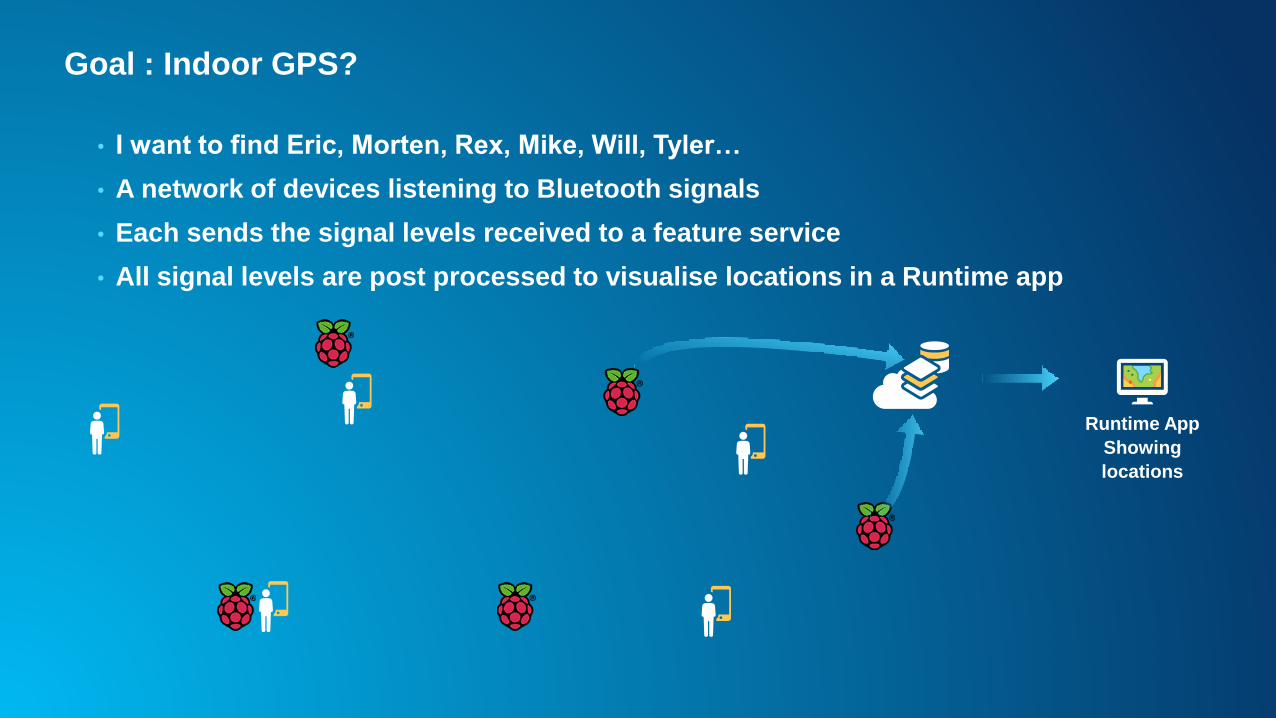
Goal : Indoor GPS?
• I want to find Eric, Morten, Rex, Mike, Will, Tyler…
• A network of devices listening to Bluetooth signals
• Each sends the signal levels received to a feature service
• All signal levels are post processed to visualise locations in a Runtime app
Runtime App
Showing
locations

A closer look at the Raspberry Pi!
• It’s a small computer!
• 1.2GHz Quad-Core ARM Cortex-A53 (64Bit)
• Powerful GPU : OpenGL ES 2.0
• 1Gb Memory
• Boots from SD card : Lunix or Windows 10 IoT
• 4 USB ports
• WiFi and Bluetooth
• HDMI port
• Network port
• GPIO

GPIO : The interface to the outside world
• General Purpose Input / Output pins
• Interface with data collection sensors:
- GPS
- Temperature
- Light
- Compass
• Control motors or servos
• GSM communications
• And endless more things

Controlling servos
- Spindle can be controlled to angle the control arm
- 0 – 180degrees
- PWM signals
- Vary pulse width length between 1 and 2ms
20ms20ms 20ms 20ms

Bluetooth
• View Bluetooth enabled devices
• Most are not discoverable
• All I need is the Mac address
• For each person I want to track (from their Mac address)
- Connect
- Read RSSI
- Disconnect

Writing data into ArcGIS Feature Services
• Feature service in ArcGIS online
• Access achieved via:
- Rest API
- Runtime SDK (.Net is supported on Windows 10 IoT)

A dot on a map?
• Converting RSSI into a distance
• Range of signal strengths equate to given radius
• Varied for tested phones
- iPhone 5s – stronger signals
- Motorola Moto G – weaker signals

Signal strengths


Does it work?

IoT security?
• Internet of insecure Things
• Secure storage of data
• Intercepting remote sensor communications
• Privacy issues
• Access security of IoT devices
• Updating for new threats
• Physical security!!!!!!
