indoor mapping and location with the arcgis platform · 2015-05-01 · national institutes of...
TRANSCRIPT


Indoor LocationWith the ArcGIS Platform
Jeff Archer@vee_dubbSenior Technical EngineerPatterns and Practices Team

Before we begin…
• This is a research project.• This is intended as an open discussion.• I don’t claim to be an expert.• It is a hot topic.• It’s a (relatively) new frontier for Geospatial.• I’m either really brave or really dumb.

So… Indoor Location.
• Commercial• Retail• Mobile Payments• Big Names
- Apple- Google- Microsoft

ArcGIS for Facilities
• Did you know?

ArcGIS is a Platform Making mapping and location aware apps available across your organization
ArcGIS
Knowledge Workers
Professional GIS
WorkAnywhere
PublicEngagement
Executive Access
EnterpriseIntegration
Web GIS

ArcGIS Maps At Work -- Diversity of Users and Applications
National Institutes of Health FM
US Marine Corp Real Property
National Park Service Facilities GSA Public Building Service US DOE Sandia National Lab
NASA Stennis Real Property & Facilities

Represent the authoritative inventory of your assets and resourcesArcGIS

Deliver decision support apps at all scales and dimensionsArcGIS

Increasing cost efficiencies, occupant productivity & satisfaction, & revenue generationArcGIS for Portfolio Management
Indoor space & amenity site selection
Real-time portfolio performance mapping
Site selection and demographic analysis
Building performance mapping
Space allocation and utilization

Increasing cost efficiencies, reducing response times, optimizing tasksArcGIS for Operations
Active, high priority work orders
Optimized scheduling & dispatch to work order locations
&Real-time indoor navigation and alerts
Density or hot spot analysis of work order activity
Alerts for service requests & scheduled maintenance
Real-time indoor environment monitoring & alerts

Reducing and mitigating risks; improving occupant health; optimizing complianceArcGIS for Safety & Security
Natural hazard & continuity of operations
Risk assessment & planning
Event planning, safety, and security
Live camera feeds and viewsheds
ADA compliance and emergency evacuation routes

Point 2 Point In-building Routing – Progression Timeline
2010
2011-20122013-2014

2015: In-building Route Creation – single floor
InputsSpace PolysFloor LinesDoorsSpace Points

Supported Route Restriction -- Considerations
Route Summary (solver optimizes distance & walk time)
Total walking time Total distance (feet or meters)Directions
Route PreferencePrimary/secondary/tertiary paths (avoid cutting through rooms)
Indoor/outdoor/covered paths
Wall distance (for readability)
AccessibilityWheelchair accessible
ADA compliant
Slope
Curbs or rampsSafety & SecurityEmergency exit routing
Prefer well-lit paths
Physical LimitsPath width/height
Path direction (1-way or 2-way)
Door key access (directional)
Solver
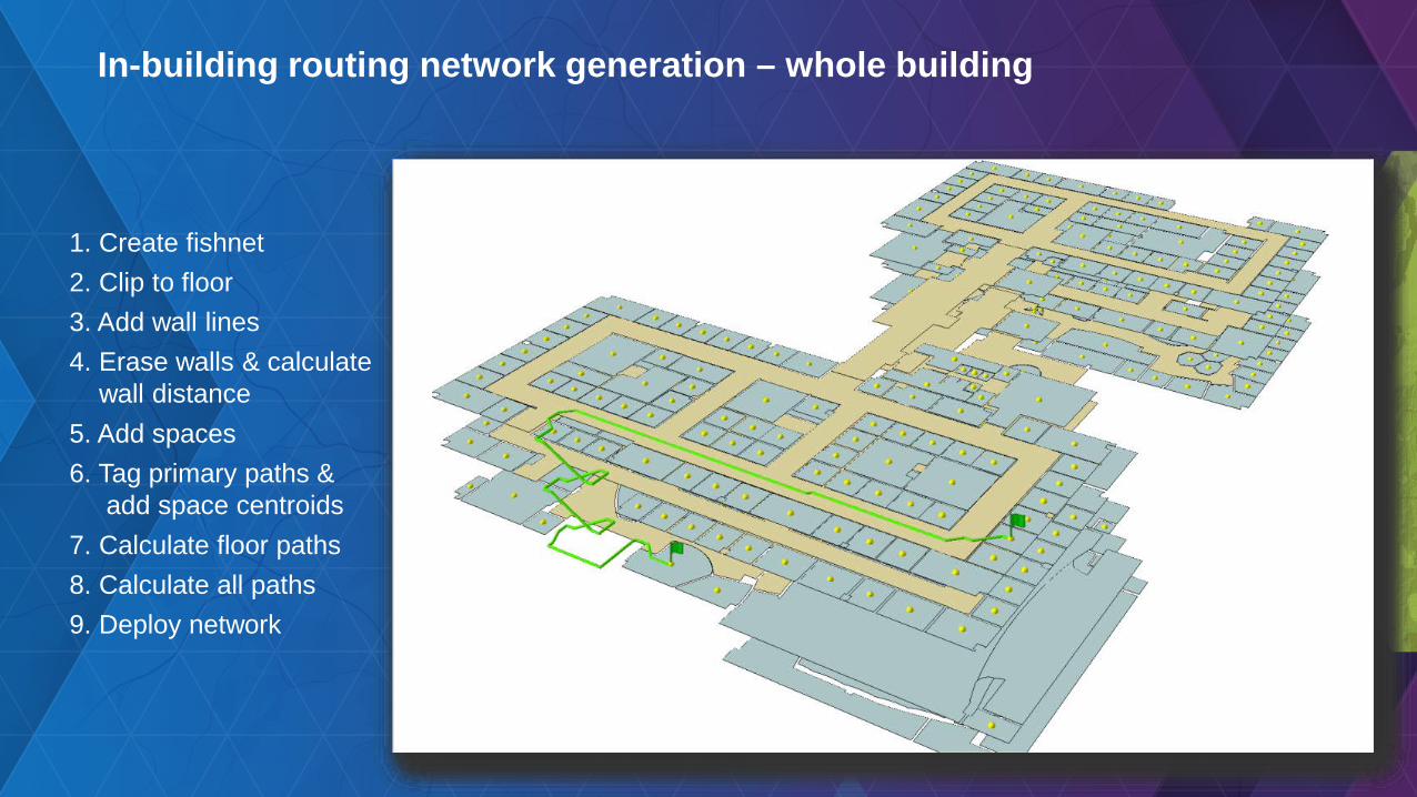
1. Create fishnet2. Clip to floor3. Add wall lines4. Erase walls & calculate
wall distance5. Add spaces6. Tag primary paths &
add space centroids7. Calculate floor paths8. Calculate all paths9. Deploy network
In-building routing network generation – whole building

Sets stage to take advantage of new 2D & 3D options
• Packaging and testing the 3D network generation workflowsInitial 3D network tools will be made available near 2015 Dev Summit
• ArcGIS Pro development -- improved “floor awareness” - easily navigate and view 3D building interior assets
• Leverage new Campus Viewer app add-ins• UC technical workshops

What About Real-Time Navigation?
• The “blue dot” experience• Predominantly a hardware solution
- Radio triangulation- Beacons
• You still need the map • Several 3rd party solutions
- GISi Indoors/GeoMetri- Pen Bay- RF Spot- NewAer

Rate This Sessionwww.esri.com/RateMyDevSummitSession

Jeff Archer@vee_dubb
Thanks!

Sample TitleSample text for position
Floodplain Management
DC GIS, Washington, DC
USDA, Colorado
Flooding

Sample TitleSample text for position
Floodplain Management
DC GIS, Washington, DC
USDA, Colorado
Flooding