individual research - university of chicago oriental institute · minded readers, the computer...
TRANSCRIPT

INDIVIDUAL RESEARCH
COMPUTER LABORATORY
John C. Sanders Peggy M. Sanders
Introduction There are only two types of computer users: those who have experienced a hard-disk crash and those who will. We have little or no control over when a hard-disk crash will occur. However, in order to avoid the catastrophe of lost computer data due to a hard-disk crash, in October 1996 the Computer Laboratory initiated a routine Digital Audio Tape (DAT) backup procedure for the Institute's four Sun SPARCstation Unix-based computers, with full hard-disk (13.5 gigabytes) backups performed three nights per week. Next year I hope to report on the establishment of a similar procedure for the Institute's Macintosh and Intel-based computers, a larger and more complicated task that we very much need to undertake.
A major portion of the Laboratory's efforts during the year went into development and support of the Institute's World-Wide Web (WWW) site. For further information concerning the Institute's WWW database and other Electronic Resources in general refer to the section of this Annual Report, entitled "Oriental Institute Electronic Resources."
Remote Sensing Conference The continuing situation in Iraq has temporarily made travel there impossible, but these circumstances led directly to a short four-day sojourn in St. Cloud, Minnesota, for John Sanders, McGuire Gibson, Tony J. Wilkinson, and three NELC students. The Institute's ongoing association with Dr. Ben Richason, Director of the GIS-Re-mote Sensing Laboratory at St. Cloud State University's (SCSU) Department of
7 9 9 6 - 7 9 9 7 ANNUAL REPORT 1 1 1
oi.uchicago.edu

RESEARCH
Geography, resulted in a three-day conference in May 1997 entitled "Remote Sensing Applications in Archaeology," jointly sponsored by SCSU, the Oriental Institute, and the National Aeronautics and Space Administration (NASA).
Between fifty and sixty conferees from six countries were in attendance, and the formal presentations and post-talk discussions were both informative and encouraging. The informal atmosphere, excellent hosting by Ben and colleague Professor Richard Rothaus, SCSU Department of History, and a willingness to share procedures, techniques, pitfalls, and accomplishments by all involved made the conference a great success by all accounts. In fact, plans for the next two conferences were discussed, to be sponsored by NASA and the University of Cambridge, England. Not bad for a first time event. Congratulations Ben and Richard for a job well done!
A full report on the conference appeared in News & Notes 155 (Fall 1997). Of greatest immediate benefit to the Institute and our radar imaging work with Ben (see below) was the talk by Tony Mathys, a staff scientist at IMAC Consulting, Minneapolis, illustrating the potential value for archaeological feature recognition of the recently declassified United States government "spy" satellite images. He presented a black-and-white enlargement of the area around Tell Mozan in Syria that he had printed from the photographic negative files which are now available. The quality was extremely good, almost the resolution of aerial photographs, and available at a very affordable price when compared to more traditional satellite imagery from Landsat or SPOT. Tony, Mac, and I smiled at the possibilities this imagery holds for our work in the Nippur area and elsewhere in the Middle East.
Laboratory Projects
Peggy Sanders was involved in a number of familiar Computer Laboratory projects: she produced updated versions on the building renovation plans for Museum and Development Office purposes; continued to provide William Sumner with new artifact drawings and to modify page layouts for an upcoming Malyan publication; revised computerized (AutoCAD) plans of the Jordanian site of Madaba to produce slides for Tim Harrison's paper, entitled "1996 Tell Madaba Excavations: Investigations of Urban Life in Highland Central Jordan," at the ASOR meetings in New Orleans, November 1996.
Remote Sensing Collaboration with St. Cloud State University
Besides helping to sponsor the Remote Sensing conference mentioned above, our collaboration with the GIS Laboratory at St. Cloud State University was taken to new heights this past year, literally speaking. Using a small grant obtained from St. Cloud State University, Dr. Ben Richason in February contracted with the Canadian RadarSat Corporation to have their radar imaging satellite shoot a radar image covering a specified area around the ancient Mesopotamian site of Nippur, Iraq, where the Institute has been excavating since 1948. Unlike conventional satellite imagery, which captures the visible light spectrum (normal photography), radar sensors detect microwave radiation which can depict surface conditions, soil moisture variations, and even subsurface features down to several meters under the best of conditions.
112 THE ORIENTAL INSTITUTE
oi.uchicago.edu

COMPUTER LABORATORY
We had our first opportunity to view the radar image taken around Nippur at the Remote Sensing conference. After an initial period of trying to make sense of where we were in the image and how surface features were being interpreted by the microwave radiation, the clarity and good detail of the image began to be understood by everyone. Radar data does take getting used to after years of looking at conventional satellite imagery. In late summer, of 1997, Ben plans a visit to Chicago to discuss the image processing procedures he and his students in the GIS Laboratory at St. Cloud State University have been performing, what results they have obtained, and how we should proceed in the near future. It is not a replacement for packing our bags and heading off to Nippur for another season, but it is the closest thing to that experience we can have right now.
Giza Plateau Mapping Project
New contours of the Giza plateau were digitized to modify some of the contemporary contours that were digitized from the 1977 map series from the Ministere de 1'Habitat et de la Reconstruction. A new surface terrain model will be generated with the new contour data, producing a closer portrayal of the ancient state of the plateau. Look for several images of this new Giza surface model in next year's Annual Report and on the Institute's World-Wide Web site pages for the Giza Plateau Mapping Project in the near future.
Lehner is now a Visiting Assistant Professor at the University of Chicago and is no longer in residence at the Institute. As president of Ancient Egypt Research Associates, he thought his Giza Plateau database should be moved from the Institute's Sun SPARCstation computer, which has been its home since 1991, to a computer owned by Ancient Egypt Research Associates. Accordingly, he contracted Peggy Sanders, dba Archaeological Graphic Services, to continue development of the Giza Plateau model as time and money permits. We will continue to report on the progress of the Giza Plateau Mapping Project in future Annual Reports as work continues over the coming years.
Museum Education Maps
This time last year the Computer Laboratory was just starting to produce the final versions of a series of regionally-based maps of the ancient Near East to illustrate the Museum Education Office's Curriculum Guides. Developed as overhead projector transparencies, these maps illustrate the geographical regions of Mesopotamia and Egypt/Nubia, indicating the location of important cities and shifts in cultural/ political boundaries through time. The Curriculum Guides are part of the Oriental Institute/Chicago Public Schools Collaboration for the World History Curriculum, funded by the Polk Bros. Foundation. I refer the reader to the 1995/96 Annual Report for more background on this project and the source materials used to create the maps.
All of the Mesopotamia and Egypt/Nubia maps were completed by the winter of 1996 and are by all accounts a helpful addition to the Museum Education Office's Curriculum Guides. Let me take this opportunity, once again, to thank Professor William Pattison for his tireless efforts to oversee this entire process, seek out the necessary information, and provide valuable comments and criticism regarding the
1996-1997 ANNUAL REPORT 1 13
oi.uchicago.edu

RESEARCH
design and presentation of these educational maps. Their success is due in large part to his efforts.
Epigraphic Survey Photographic Negative Database Program
In the spring of 1997, Ray Johnson, the new Director of the Epigraphic Survey, ask the Computer Laboratory for advice regarding their photographic negative database. The program currently in use was written for them by Survey member Peter Piccione back in 1991, using Double Helix software on a Macintosh Ilfx computer. The database management programs Peter wrote served the Survey well the past six years, but the desire for several modifications to the program coupled with the recent purchase of a new, more powerful Apple PowerMac 8500 computer caused Ray to reevaluate the entire issue of managing the Survey's photographic negatives. When the smoke cleared it was decided that the Computer Laboratory would develop and write the source code for a new management program that can take advantage of the speed and capabilities of the newer PowerMac 8500 computer, using Microsoft's Visual FoxPro software.
The overall program structure and file formats were developed by John Sanders; Jason Ur, a Mesopotamian archaeology student with experience developing FoxPro applications, was hired to write the actual source code. During the summer of 1997, the original database of over 17,000 photographic negative records (23 megabytes in size) will be translated from Double Helix into our FoxPro database formats. What fun! Check back in next year's Annual Report to see how the new database management program is functioning for the Survey.
Isthmia Project
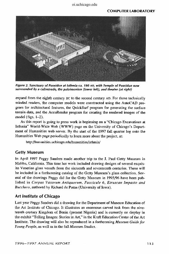
With the assistance of Deb Derylak, a Ph.D. candidate in the Divinity School, Peggy continued to develop and fine-tune each of the nine three-dimensional computer models of the sanctuary of Poseidon at Isthmia and the Isthmian plateau. Project Director Elizabeth Gebhard, from the University of Chicago's Department of Classics, is focusing on the changes to the temple and surrounding terraces, both of which
Figure 1. Sanctuary of Poseidon at Isthmia ca. 300 BC, with Temple of Poseidon, stadium, and spectator embankment in foreground and theater (at right)
1 14 THE ORIENTAL INSTITUTE
oi.uchicago.edu
COMPUTER LABORATORY
Figure 2. Sanctuary of Poseidon at Isthmia ca. 180 AD, with Temple of Poseidon now surrounded by a colonnade, the palaimonion (lower left), and theater (at right)
expand from the eighth century BC to the second century AD. For those technically minded readers, the computer models were constructed using the AutoCAD program for architectural features, the QuickSurf program for generating the surface terrain data, and the AccuRender program for creating the rendered images of the model (figs. 1-2).
As this report is going to press work is beginning on a "Chicago Excavations at Isthmia" World-Wide Web (WWW) page on the University of Chicago's Department of Humanities web server. By the start of the 1997 fall quarter log onto the Humanities Web page periodically to learn more about the project, at:
http://humanities.uchicago.edu/humanities/isthmia/
Getty Museum
In April 1997 Peggy Sanders made another trip to the J. Paul Getty Museum in Malibu, California. This time her work included drawing designs of several exquisite Venetian glass vessels from the sixteenth and seventeenth centuries. These will be included in a forthcoming catalog of the Getty Museum's glass collection. Several of the drawings Peggy did for the Getty Museum in 1995/96 have been published in Corpus Vasorum Antiquorum, Fascicule 6, Etruscan Impasto and Bucchero, authored by Richard de Puma (University of Iowa).
Art Institute of Chicago
Last year Peggy Sanders did a drawing for the Department of Museum Education of the Art Institute of Chicago. It illustrates an enormous carved tusk from the nineteenth century Kingdom of Benin (present Nigeria) and is currently on display in the exhibit "Telling Images: Stories in Art," in the Kraft Education Center of the Art Institute. The drawing will also be reproduced in a forthcoming Museum Guide for Young People, as well as in the fall Museum Studies.
1996-1997 ANNUAL REPORT 1 15
oi.uchicago.edu

RESEARCH
Laboratory Equipment / Institute Resources Thanks to the generosity of the University of Chicago's Women's Board, the greatest amount of excitement in the Laboratory all year was generated by the arrival of a new Sun SPARCstation 10 WWW server and a new Apple PowerMac 8600/200 computer with an Apple Color/OneScanner 600/27 document scanner and Yamaha CDE-100 CD-Recordable drive for producing CD-ROM disks. Our grant proposal to the Women's Board in the spring of 1996 was awarded full support, and this much needed improvement to the computer infrastructure of the Oriental Institute is greatly appreciated not only by the Institute's faculty and staff, but also by the scholars and public world-wide who will benefit from these improved facilities now at our disposal.
Although not strictly speaking a Laboratory resource, three new high-end (16 page per minute) Apple 16/600 Laser printers were installed throughout the Institute this past year, providing faster, sharper hard copy for the faculty, staff, and students who have come to rely on these resources. Everyone enjoys the new printers and wishes they had their own personal printer on their desks.
In the spring of 1997 I started to plan for the purchase of a new high performance IBM-compatible, PentiumPro-based graphics workstation for archaeological database development and as a second image processing workstation within the Laboratory. See next year's Annual Report for a complete discussion of this new addition to the Laboratory.
One reason for needing this new high performance IBM-compatible computer was to serve as a base for a new Nikon 35 mm slide scanner. The Institute acquired this slide scanner as part of a 1996 Technology Enhancement grant from the University's Office of the Provost. It not due to arrive at the Institute until late summer 1997, but a long line has already formed outside the Computer Laboratory door. This piece of equipment is definitely going to need a sign-up sheet.
116 THE ORIENTAL INSTITUTE
oi.uchicago.edu