india land governance assessment - world...
TRANSCRIPT

i
INDIA
LAND GOVERNANCE ASSESSMENT
NATIONAL SYNTHESIS REPORT
Pub
lic D
iscl
osur
e A
utho
rized
Pub
lic D
iscl
osur
e A
utho
rized
Pub
lic D
iscl
osur
e A
utho
rized
Pub
lic D
iscl
osur
e A
utho
rized

ii
© 2015 International Bank for Reconstruction and Development / The World Bank 1818 H Street NW, Washington, DC 20433 Telephone: 202-473-1000; Internet: www.worldbank.org This work is a product of the staff of The World Bank with external contributions. The findings, interpretations, and conclusions expressed in this work do not necessarily reflect the views of The World Bank, its Board of Executive Directors, or the governments they represent. The World Bank does not guarantee the accuracy of the data included in this work. The boundaries, colors, denominations, and other information shown on any map in this work do not imply any judgment on the part of The World Bank concerning the legal status of any territory or the endorsement or acceptance of such boundaries. Nothing herein shall constitute or be considered to be a limitation upon or waiver of the privileges and immunities of The World Bank, all of which are specifically reserved. This work does not necessarily reflect the views of the Government of India and the findings of the study are not binding on the Government of India. This work is available under the Creative Commons Attribution 3.0 IGO license (CC BY 3.0 IGO) http://creativecommons.org/licenses/by/3.0/igo. Under the Creative Commons Attribution license, you are free to copy, distribute, transmit, and adopt this work, including for commercial purposes, under the following conditions: Translations—If you create a translation of this work, please add the following disclaimer along with the attribution: This translation was not created by The World Bank and should not be considered an official World Bank translation. The World Bank shall not be liable for any content or error in this translation. Adaptations—If you create an adaptation of this work, please add the following disclaimer along with the attribution: This is an adaptation of an original work by The World Bank. Views and opinions expressed in the adaptation are the sole responsibility of the author or authors of the adaptation and are not endorsed by The World Bank. Third-party content—The World Bank does not necessarily own each component of the content contained within the work. The World Bank therefore does not warrant that the use of any third-party-owned individual component or part contained in the work will not infringe on the rights of those third parties. The risk of claims resulting from such infringement rests solely with you. If you wish to re-use a component of the work, it is your responsibility to determine whether permission is needed for that re-use and to obtain permission from the copyright owner. Examples of components can include, but are not limited to, tables, figures, or images. All queries on rights and licenses should be addressed to the Publishing and Knowledge Division. The World Bank, 1818 H Street NW, Washington, DC 20433, USA; fax 202-522-2625; e-mail: [email protected]. Design, layout, and printing: Council for Social Development, Delhi, India.

iii
Table of Contents
Executive Summary ...................................................................................................................................... 1
1. INTRODUCTION AND BACKGROUND .............................................................................................. 8
2. THE LGAF METHODOLOGY AND ITS APPLICATION TO INDIA ................................................. 8
3. ANALYSIS OF RECOMMENDATIONS BY PANEL ........................................................................... 9
3.1 LAND RIGHTS RECOGNITION ................................................................................................ 9
3.1.1 Diagnosis ............................................................................................................................... 9
3.1.2 Recommendations ............................................................................................................... 10
3.2 COMMUNAL AND FOREST LAND ....................................................................................... 11
3.2.1 Diagnosis ............................................................................................................................. 11
3.2.2 Recommendations ............................................................................................................... 12
3.3 URBAN LAND .......................................................................................................................... 12
3.3.1 Diagnosis ............................................................................................................................. 12
3.3.2 Recommendations ............................................................................................................... 13
3.4 PUBLIC LAND MANAGEMENT AND LAND ACQUISITION ............................................ 15
3.4.1 Diagnosis ............................................................................................................................. 15
3.4.2 Recommendations ............................................................................................................... 15
3.5 PUBLIC LAND DISPOSAL ...................................................................................................... 16
3.5.1 Diagnosis ............................................................................................................................. 16
3.5.2 Recommendations ............................................................................................................... 17
3.6 LAND RECORDS AND CADASTRE ...................................................................................... 17
3.6.1 Diagnosis ............................................................................................................................. 17
3.6.2 Recommendations ............................................................................................................... 18
3.7 LAND VALUATION AND TAXATION .................................................................................. 20
3.7.1 Diagnosis ............................................................................................................................. 20
3.7.2 Recommendations ............................................................................................................... 20
3.8 LAND DISPUTES ...................................................................................................................... 21
3.8.1 Diagnosis ............................................................................................................................. 21
3.8.2 Recommendations ............................................................................................................... 21
3.9 INSTITUTIONAL ARRANGEMENTS .................................................................................... 22
3.9.1 Diagnosis ............................................................................................................................. 22
3.9.2 Recommendations ............................................................................................................... 23
4. MONITORING PERFORMANCE AND MAINTAINING MOMENTUM ..................................... 24
5. PRIORITIES FOR A NATIONAL AGENDA ................................................................................... 27
5.1 Monitoring and establishing necessary feedback loops .............................................................. 27
5.2 Overcoming institutional fragmentation ..................................................................................... 27
5.3 Reviewing criteria for allocating public resources ..................................................................... 27
References ................................................................................................................................................... 29
ANNEX I - POLICY MATRICES BY STATE ......................................................................................... 30
ANNEX II - STATE SCORECARDS ....................................................................................................... 54

iv
Acronyms
AP Andhra Pradesh
BI Bihar
BIADA Bihar Industrial Area Development Authority
CFR Community Forest Rights
CPR Common Property Resources
DB (ease of) Doing Business
DCLR Deputy Collector Land Reforms
DLC District Level Committees
DoLR Department of Land Records
FRA Forest Rights Act
HSAA Hindu Succession Act Amendment
JFM Joint Forest Management
JK Jharkhand
JNNURM Jawaharlal Nehru National Urban Renewal Mission
KA Karnataka
LGAF Land Governance Assessment Framework
LGU Local Government Unit
MA Maharashtra
MP Madhya Pradesh
NLRMP National Land Records Modernization Program
OD Odisha
PESA Panchayats (Extension to Scheduled Areas) Act
PPP Public-Private Partnership
SC Scheduled Castes
ST Scheduled Tribes
TAG Technical Advisory Group
TPS Town Planning Scheme
UDA Urban Development Authority
ULB Urban Local Bodies
UPOR Urban Property Ownership Records
VFMPC Village Forest Management and Protection Committees
WB West Bengal

v
Acknowledgements
This report was prepared by K. Deininger (DECAR, Task Team Leader) and T. Hilhorst (DECAR) under
the India Umbrella task led by S. Narayanan (Senior Social Specialist). Support from E. Cook, G.
Prennushi, V. Raghavan, and S. Talwar and excellent comments by peer reviewers R. Buckley, A. Fock, E.
Pantoja, and S. Solf are gratefully acknowledged. The report would not have been possible without the
enthusiasm by the Technical Advisory Group led by Dr. T. Haque, Director, Centre for Social Development
(CSD) & former Commissioner CCAP, Government of India comprising V. Agrawal, Principal Secretary
Revenue, Government of AP (Legal & institutional framework); Dr. A. Vardhan, Government of Bihar,
and Dr. N.C. Saxena, former Secretary, Rural Development and Member, National Advisory Council
(Forestry & common lands), Dr. I.P. Gautam, former Principal Secretary, Government of Gujarat (Urban
land); Dr. Meenakshi Sundaram, former member, PMO (Public land management and land acquisition); R.
Chawla, Principal Secretary, Government of Karnataka (Land information, land valuation, and taxation);
R.B. Bharuka, Justice, Supreme Court (Dispute resolution and conflict management); and R. Sinha, former
Secretary, DoLR, Government of India (Institutional environment), as well as the state teams at the Centre
for Good Governance, Hyderabad, with state coordinator S Bhalerao, IAS (Retd) for Andhra Pradesh, the
Chandragupt Institute of Management, Patna, with state coordinator S. Debabrata for Bihar, the National
University for Study and Research in Law, Ranchi, with state coordinator N. Guru for Jharkand, Azim
Premji University, Bangalore, with state coordinator A. Narayana for Karnataka, KIIT School of Rural
Management, Bhubaneswar for Odisha, with state coordinator Pranab Choudhury, and the Rural
Development Institute (RDI)—Landesa, Kolkata, with state coordinator P. Halder for West Bengal.

1
Executive Summary
India’s land system will face enormous strains in the near future: As India continues to urbanize and
move towards a less agricultural- and more industry-based economy, land demands will continue to grow.
Its urban population is expected to increase by more than 200 million by 2030, requiring 4–8 million
hectares of land for residential use alone. Demands for infrastructure and industry could add a similar
amount, summing to total land demand of 5–10 percent of the land area currently used for agriculture. If
not handled well, such massive land use change may increase vulnerability and food insecurity, rent-
seeking, environmental problems, social dislocation, inequality, and conflict. But it also provides an
opportunity to address the underlying structural issues, propelling India into the league of middle-income
countries and laying the ground for significantly advancing shared prosperity and reduced poverty.
A legacy of discrimination and neglect creates enormous challenges: Although land featured prominently
in policy debates throughout India’s history, the focus has been on addressing specific gaps, often in an ad
hoc manner, than on dealing with systemic issues and cutting across traditional institutional boundaries.
This eroded the quality of records and institutions’ ability to unambiguously define land rights, protect
rights of tribals, women, and smallholders more in general, and the scope for market forces to respond to
price signals transfer land to its most productive use. Instead, it created a complex edifice of regulations
that are not always fully consistent with each other and that are fiendishly difficult to enforce, especially in
a situation where the underlying land information is weak or outdated. It is thus not surprising that land
access features prominently in concerns raised by the private sector.
Benefits from improving land governance are large and can be broadly shared: Many stakeholders
erroneously assume that land policy is a zero-sum game, that is, any gain for one group will cause equal
losses to another. While true in some cases, this does not apply in many cases: Clear and authoritative
recognition of land rights can increase investment, sustainable land use, and welfare by women, tribals, or
informal occupants who previously lacked such rights and reduce conflict. Reducing transaction costs of
market-based land transfers can support reallocation of factors in ways that reduce rural under-employment
and structural transformation while accounting for land owners’ preferences. Restrictions of land transfers
or use can be enforced, thus reducing conflict risk, only if all of them are on record. Better protection and
management of public land—or more transparent mechanisms to transfer them if appropriate—allow the
public rather than a select group of individuals to benefit from a key public asset. New technology
furthermore provides options to use land governance challenges as an opportunity.
This synthesis report presents results from land governance self-assessments by six states: The fact that
land is a state subject implies that actions to improve land governance need to be initiated at state level. To
identify opportunities, six states implemented the Land Governance Assessment Framework (LGAF), a
tool that allow comparing the status of their land governance against international good practice along a set
of dimensions in a very participatory process. Results are summarized in state reports that were validated
publicly and discussed with policy makers in each state. This national report complements these and draws
out common areas.
A number of issues emerged consistently across states: Authoritative land records—including up-to-date
textual information and spatial identification of boundaries—are either completely missing or poorly
maintained. In urban areas, unclear institutional responsibilities create difficulties for planning, supply of
serviced land, and tax collection impede development of land and financial markets, encourage
encroachment on public land, and contribute to disputes that reduce investment, and take long to resolve.
High stamp duties compound this by encouraging spurious valuations and driving transactions into
informality, undermining the ability to properly price land. Lack of a public land inventory and diffuse
management responsibilities encourage encroachment and undermine effective use of this asset, something
that is exacerbated by non-competitive processes to make land available to investors and failure to disclose
or monitor contractual provisions. Finally, weak land records encourage use of land acquisition rather than
direct negotiation to access land by private investors to ‘cleanse’ the title.

2
States have the mandate and main responsibility to address this: State reports provided recommendations
for action in a number of areas. These include:
Move towards conclusive title for rural land through transaction-based updating of records by (i)
synchronizing records and registration and making registration contingent on production of a map
using the example of the pre-mutation sketch in Karnataka; (ii) ensuring automatic updating
(mutation) of records if transferred; (iii) recording all land-related encumbrances and charges by
public or private entities; and (iv) lowering stamp duty, ideally in ways that offset associated
revenue losses through other charges for example, land taxes to reduce the scope for price
misreporting.
Establish an integrated urban cadastre using low-cost image-based, systematic, and participatory
methods with private sector participation in implementation and cost recovery in line with demand
and ability to pay that can be used beyond the land sector for (i) effective planning of urban land
use and expansion; (ii) land taxation to facilitate public investment that increases land values; (iii)
identification and management of public land and prevention of unauthorized encroachment; and
(iv) regular and reliable reporting of land and real estate price indices to aid private sector decision
making.
Draw on advances in IT to establish interoperable land data to be shared by all land institutions that
can provide a basis for regular reporting on key land indicators, internal management systems, and
a gradual move towards a more performance-based approach to improving land governance.
Use existing records, in combination with other data, to identify rural areas where land values and
transaction levels warrant complete resurvey. Design participatory methods for systematic image-
based survey and adjudication, develop business models to implement these with full or partial cost
recovery by the private sector, and rigorously evaluate their impact before scaling up.
Create and publicize a spatially referenced inventory of public land and, in the process, evolve a
policy to avoid future encroachment on public land. Establish standards to decide when and for
what purpose public land can be transferred to private interest. Rely on competitive transparent
mechanisms for such transfers, ensure that land users and the public share benefits, and put in place
mechanisms to monitor and enforce compliance with contractual obligations as needed.
Recognize, record, and map at appropriate scale hitherto unsurveyed individual and communal land
and resolve ambiguity about responsibility for it between forest and revenue departments. Link this
to a campaign of awareness-raising and support to recognition of communal claims in a way that
makes use of the potential of recent legislations such as the Forest Rights Act (FRA) and explore
options for imagery-based monitoring of the impact of doing so on land use.
Adjust the institutional framework for land tenure and management to ensure land information is
comprehensive, of high quality, and readily available to interested parties at low cost. Explore the
scope for a dedicated agency to administer rural and urban land rights, in financially sustainable
ways, including by making non-confidential land data available. Remove entry barriers to survey
and valuation professions and let local bodies manage certain types of land in line with the 73rd &
74th Amendments and the Panchayats (Extension to Scheduled Areas) Act (PESA).
Improve poor people’s access to land y recognizing tenancy and measures to improve lease market
functioning. Account for limited enforcement capacity and bureaucrats’ incentives when drafting
legislation and regulations aiming to (i) restrict certain types of land transfers; (ii) regularize
unauthorized occupation; and (iii) restore possession of granted land to the original grantees.
Pursue options to increase women’s land ownership by disseminating the Hindu Succession Act
Amendment (HSAA), registering assigned or granted lands in females’ names and exploring use
of incentives for private parties who put females’ names on land records. Link this to consistent

3
monitoring and impact assessment to identify effective approaches to increase female land
ownership, flag potentially adverse effects, and ensure consistent implementation across states.
Put in place an IT-based case management system for land disputes in the courts and use this, as
well as a clear typology of land dispute cases, to monitor case load and identify gaps in policy that,
if addressed, could reduce disputes most expeditiously. Consider time limits on cases and
complementing formal courts with advisory, conciliatory, and adjudicatory institutions as well as
creation of awareness and capacity at local level to help prevent and resolve land disputes.
There is ample state experience to draw from to improve practice: While this seems an ambitious agenda,
initiatives exist in many states to deal with aspects of this agenda, and if reviewed and shared systematically,
these could provide important guidance for going to scale. Individual states implemented improved
mapping, synchronized spatial and textual records, ensured automatic mutation, required proof of the
seller’s identity, land ownership, and consistency with existing records before registering a transaction, and
linked land records to the courts and banks to prevent fraud. Town planning schemes and other innovative
avenues for planning have been applied in some states to allow urban expansion without a need for
conflictive processes of land acquisition. A greater emphasis on benefit-sharing entry barriers for private
surveyors and valuers were lowered, standards harmonized, and enforcement capacity strengthened. Certain
states have also computerized courts and public land management to allow tracking of disputes and greater
transparency. But lessons of these innovative measures were often not learned and shared and many were
ad hoc and not well justified and sequenced. Often they were not systematically monitored or documented
in a way that would have allowed to clearly assess impact, thus limiting the scope for drawing lessons and
disseminating innovations.
The national level has an important role to support the land agenda: Emphasizing states’ responsibility
does not make the center superfluous but creates different responsibilities, consistent with recent moves
towards greater devolution of spending. These include (i) monitoring states’ performance in a way that
builds on “Doing Business” using administrative data, analyzing results to identify promising innovations
and establishing procedures for states to use these data to manage workflows and exercise oversight at
various levels; (ii) increase visibility of land, overcome institutional fragmentation to improve rural and
urban land ownership data, and identify ways to make such data available to interested parties in the public
and private sector without infringing on confidentiality; and (iii) making central support more output-based
and focusing it on testing innovative approaches for well-defined issues and in a rigorous manner to ensure
wider replicability.
Monitoring state performance: Having a clear set of outcome indicators can help focus and direct state
efforts and, by creating competition, not only help to quantify challenges and prioritize areas for
intervention but also promote evidence-based sharing of good practice and cross-state dialogue to identify
cost-effective and scalable approaches. It can thus avoid promising innovations that could be shared across
states go unnoticed or even be abandoned. Discussions with the LGAF Technical Advisory Group and state
coordinators resulted in agreement on a set of five indicators to be used in this respect:
Land area mapped with ownership rights unambiguously recorded: Lack of cadastral maps and
associated ownership records emerged as a key issue in all types of lands, particularly urban ones.
Quantifying the magnitudes involved will require sharing of data across departments that can then
be linked to land use (based on imagery) and other attributes to design and prioritize intervention.
Number of land area covered by textual and spatial records: This indicator emphasizes the extent
to which maps exist and are in sync with textual records, and is obtained easily if records are
computerized. It can be improved by systematic resurvey or by making mutation contingent a pre-
mutation sketch. Data used to construct it can help decide what is most appropriate.
Registered versus mutated transactions: High levels of pending mutations, possibly due to high
stamp duties or a perception of registration having limited value, undermine the sustainability and
4
currency of the system and increase the risk of fraudulent transactions. Improving the indicator is
easy in a computerized system by establishing an online link between records and registry.
Coverage with tax maps and land tax collection efficiency: Given low collection of own revenue
by LGUs, expanding coverage with tax maps, possibly linked to ownership records in a well-
designed process, can be a self-financing and governance-improving way of establishing a multi-
purpose cadastre. Information on this indicator can also help explore revenue-neutral options to
reduce stamp duties, which may encourage informal transactions or underreporting of sales values.
Pending disputes of different types: Beyond providing a tool for courts to manage case flow and
measure performance, this indicator is important to assess incidence and economic impact of
disputes, identify priority areas where laws and regulations are to be clarified, and measure the
impact of doing so. Information can be obtained with little additional effort.
Create an enabling environment that transcends institutional fragmentation: A high level technical group
to help increase the visibility of land by publicizing positive examples and reform efforts, including by
regular dissemination of the above land indicators, can help to overcome the notion of land as a conflictive
zero-sum issue. Efforts are also needed to bring together relevant institutions (Department of Land
Resources, Ministry of Environment and Forests, Ministry of Tribal Affairs, and Ministry of Urban
Development), provide technical leadership and continuity on cross-cutting and systemic issues, set
performance targets, and identify ways to increase implementation capacity and reputation of all concerned
institutions, including possibly through conduct of LGAF in other states. Finally, the center can play a key
role in the establishment of interoperable data standards and filling of legal gaps where it has a mandate
(for example the Registration Act or the legal structure for e-governance).
Allocate public resources based on performance and social benefit: States’ responsibility and specificity
notwithstanding, a set of generic issues seems common to many states, including (i) creation of land records
in previously unsurveyed rural areas in ways that recognize individual and communal patterns of occupation
and use; (ii) inventorying, demarcating, and clarifying management responsibility for public land; (iii)
updating and spatially referencing rural records in contexts where these have either not been well
maintained or are severely out of date; (iii) drawing on existing records of land use to create spatial and
textual land records in non-slum urban areas and issue ownership documents; (iv) participatory planning,
mapping, and tenure upgrading in informal settlements; and (v) ensuring access to land for the poor in rural
and urban areas. If there is interest from states, use of central funds to carefully design, implement, and
rigorously evaluate a set of pilots for each of these, building on existing state initiatives and good practice
identified in LGAF, would be one of the most promising avenues to quickly generate a robust basis of
knowledge to then be scaled up. This will generate the change needed and markedly improve indicators,
while laying the basis to move towards a system of conclusive land records.
There are a number of immediate next steps: The Government’s commitment to, jointly with partners,
identify and implement measures to improve the business environment and its review of central schemes
provide an opportunity for immediate action in three respects: First, get a national lead agency to design,
pilot, and review land governance monitoring indicators that would allow documenting the way in which
states follow up on LGAF recommendations to improve land governance at state level, while at the same
time feeding into and helping to promote the “Doing Business” reform agenda in interested states. Second,
undertake measures, including possible formation of a steering committee to publicize land indicators, to
overcome institutional fragmentation, highlight positive examples, and enhance technical capacity and
reputation of the land sector. Finally, identification of opportunities to pilot new approaches to the issues
highlighted above in a way that builds on LGAF assessment and fosters collaboration across states and with
rigorous evaluation of impact so as to be able to draw wider lessons for subsequent upscaling.

5
1. INTRODUCTION AND BACKGROUND
Land issues have played a critical role in India’s history: Access to land is critical for investment and
growth, equity, poor people’s dignity, women’s empowerment, and equality of opportunity. In colonial
times, land played a major role in generating tax revenue, often reinforcing highly unequal power structures.
In post-independence period, reform policies to overcome such colonial legacies have been adopted. With
the exception of abolishing intermediaries, actual implementation fell far short of expectations due to failure
to account for the underlying political economy, none or inconsistent monitoring, and neglect of basic land
administration.
Urbanization and industrialization will put unprecedented new strains on India’s land system: While
India is still a predominantly rural-based society, rapid changes are envisaged for the future. Urban
population is expected to increase by more than 200 million by 2030, requiring about 8 million hectares of
additional land for residential use alone. Demands for infrastructure and rapid expansion of industry could
easily double this, summing to a total of about 10 percent of the land area (152 million. hectares) currently
used for agricultural production. Unless it is accomplished in ways that significantly increase productivity
of land use in agriculture to cope with increased food demand and account for the economic, social, and
environmental value of the lands potentially affected, such massive land use change may lead to food
insecurity, rent-seeking, environmental problems, social dislocation, inequality, and conflict. All of these
can seriously undermine the potential for shared prosperity and reduced poverty.
India’s land institutions have a poor record of addressing these issues: Although land has been prominent
in policy debates throughout India’s history, focus has been more on addressing specific gaps, often in an
ad hoc manner, than on dealing with systemic issues and cutting across traditional institutional boundaries.
This eroded the capacity of institutions to respond, and in particular, for market forces to respond to price
signals transfer land to its most productive use but also created a complex edifice of regulations that are not
always fully consistent with each other and that are fiendishly difficult to enforce, especially in a situation
where the underlying land information is weak or outdated. Addressing this is thus essential for India to
rise to emerging challenges, increase effectiveness of land use, and boost investment, job creation,
agricultural productivity, inclusive urbanization, infrastructure investment, and climate resilience and
disaster preparedness. As land is a state subject, the scope for central initiatives to do so remains limited.
At the same time, having responsibility at state level offers enormous scope for innovation, but making
such innovation useful for other states and scaling it up nationally will require analysis and mechanisms to
share good practices across states.
To analyze land issues in a participatory way, six states applied the LGAF self-assessment: Recognizing
that the technical complexity, cross-cutting nature, and political sensitivity of land issues required a special
type of engagement, six states decided to request support to implement the LGAF, a tool developed by the
World Bank together with partners. Department of Land Records (DoLR) strongly supported this process
and formation of a Technical Advisory Group (TAG) of eminent experts at national level, noting the
potential for cross-learning and identifying good practices and challenges for national policy. In each
participating state, a comprehensive state-level LGAF report was produced, validated in a public workshop
and discussed with policy makers to agree on next steps. This national summary report aims to identify
common issues that have emerged across several states and, by drawing out implications for policy at
national level, progress monitoring, and sharing of experience, point towards next steps (including possible
conduct of LGAF in other states) that could build on what has been achieved in this process.
Results point towards some common challenges: A number of issues came up consistently across states:
Authoritative land records—including up-to-date textual information and spatial identification of
boundaries—are either completely missing or poorly maintained. In urban areas, unclear institutional
responsibilities cause losses to society by making planning and tax collection difficult, impeding
development of land and financial markets, encouraging encroachment on public land, and contributing to
disputes that reduce investment and take a long time to resolve. High stamp duties compound this by driving

6
transactions into informality or by encouraging spurious valuations, undermining everybody’s ability to
properly price land and possibly opening scope for corruption. Restrictions on land leasing that may have
been justified a long time ago make it difficult for the poor to access land and use it in line with its potential.
And public sector capacity to properly perform the regulatory and administrative functions required to
identify ownership of land and market-mediated transfers to its best use has been seriously eroded over
time: Revenue departments in most states collect little or no revenue and spend most of their time on issues
that have nothing to do with land administration and management.
The process also uncovered considerable levels of innovation: Numerous states aimed to address these
gaps by improving mapping, synchronizing spatial with textual records, ensuring automatic mutation by
requiring proof of ownership and consistency with records before registering a transaction, and linking land
records to the courts and banks to prevent fraud. Town planning schemes have successfully been applied
to allow urban expansion without the need for highly conflicting processes of land acquisition. Courts and
public land management have been computerized to allow tracking of disputes and greater transparency.
But lessons from such reform efforts were often not learned even within the states that adopted them as
measures as these were not well sequenced, justified, or documented in a way that would have allowed a
clear demonstration of their impact. This limited the scope for drawing lessons and disseminating them to
other states. One of the insights from the LGAF process is that even “advanced” states can learn much from
institutional arrangements adopted or reforms undertaken in lagging ones; and taking different reform
efforts together can provide many of the elements needed to make progress on land governance in India.
States will have a major role to play to address common challenges: The state reports point towards several
common areas for action on a number of issues that, in one way or another, emerged as problematic in all
states, such as :
Move towards conclusive title for rural land through transaction-based updating of records by (i)
synchronizing records and registration and making registration contingent on production of a map
following the example of the pre-mutation sketch in Karnataka; (ii) ensuring automatic updating
(mutation) of records in case of transfer; (iii) recording all land-related encumbrances and charges
by public or private entities; and (iv) reducing stamp duty to reduce scope for informality and
misreporting of prices, ideally in a way that offsets associated revenue losses through other charges,
for example, land taxes.
Use low-cost image-based, systematic, and participatory methods with private sector participation
and cost recovery in line with demand and ability to pay to establish an integrated urban cadastre
that can be used beyond the land sector as a basis for (i) effective planning of urban land use and
expansion; (ii) land taxation to facilitate public investment that in turn increases land values; (iii)
identification and management of public land, including prevention of unauthorized encroachment;
and (iv) regular and reliable reporting of land and real estate price indices to aid private sector
decision making.
Use existing records in combination with other data to identify rural areas where the level of land
values and land market transactions warrant a complete resurvey. Build on experience with
systematic, participatory models for image-based surveys to adjudicate land and rigorously
evaluate these to develop business models and to implement these in collaboration with the private
sector on a full or partial cost recovery basis.
Create and publicize a spatially referenced inventory of public land and, in doing so, evolve a clear
policy to address encroachment on public land. Establish clear standards to decide in what cases or
for what purposes public land can be transferred to private interest. In case of a transfer, rely on
competitive and transparent mechanisms, ensure that local land users and the public at large share
the benefits, and put in place mechanisms to monitor and enforce compliance with contractual
obligations as needed.
7
Recognize, record, and map at appropriate scale hitherto unsurveyed individual and communal land
and resolve ambiguity about responsibility for assigning rights to such land between forest and
revenue departments. Link this to a campaign of awareness-raising and support to recognition of
communal claims in a way that makes use of the potential of recent legislations such as the FRA
and explore options for imagery-based monitoring of the impact of doing so on land use.
Adjust the institutional framework for land tenure and management to ensure land information is
comprehensive, of high quality, and readily available to interested parties at low cost. Explore the
advantages from a dedicated agency to administer rural and urban land rights, linked to models that
would allow such an agency to be sustainable financially. Link this with greater decentralization of
responsibility for management of certain types of land to local bodies in line with the Constitution’s
73rd & 74th Amendments and the PESA.
Improve the poor people’s access to land by recognizing tenancy and taking measures to improve
functioning of land lease markets. Explicitly account for limited capacity for enforcement and
potential adverse incentives when drafting legislation and regulations that aim to (i) restrict certain
types of land transfers; (ii) regularize unauthorized occupation; and (iii) restore possession of
granted land to the original grantees.
Decisively pursue options to increase women’s land ownership, in particular by raising awareness
on the HSAA, registering assigned or granted lands in females’ names and exploring the use of
incentives for private parties who put females’ names on land records. Link this to consistent
monitoring and impact assessment to identify effective approaches to increase female land
ownership, flag potentially adverse effects, and ensure consistent implementation across states.
Put in place an IT-based case management system for land disputes and use this, together with a
clear typology of land dispute cases, to monitor case load and identify gaps in policy that may need
to be addressed to reduce disputes in the most expeditious manner. Consider time limits on cases
and complementing formal courts with advisory, conciliatory, and adjudicatory institutions as well
as creation of awareness and capacity at the local level to help prevent and resolve land disputes.
Though limited, the role of central Government is pivotal: This does not mean that the central Government
will be irrelevant—quite to the contrary it can perform a number of essential functions:
Overcome institutional fragmentation and accord land the priority it deserves. If land is indeed an
increasingly binding constraint, it should to be dealt with in an evidence-driven way by bringing
together the institutions (Department of Land Resources, Ministry of Environment and Forests,
Ministry of Tribal Affairs, and Ministry of Urban Development) involved at central and state levels
to provide technical leadership and continuity on cross-cutting and systemic issues. If a body of
this nature is placed sufficiently high in the hierarchy and accompanied by proper publicity, this
could also help arrest (and ideally reverse) the decline of the Revenue Department’s reputation,
bring it to the cutting edge of technology, and encourage foster institutional and technological
innovation at state level.
Build capacity to move from a reactive to a proactive mode of engagement that is firmly grounded
in evidence rather than ideology and prejudice. The potential to overcome institutional
fragmentation and address system-wide issues will allow interventions in the land sector to be less
ad hoc and more proactive to improve functioning of the overall system and use evidence to test
the extent to which desired outputs are delivered and outcomes achieved. This can help not only
identify gaps, but also find ways in which these can be closed and high priority areas to do so can
be prioritized, design a more differentiated set of interventions and to prioritize and sequence their
implementation so as to most effectively improve land governance in the medium term.

8
Allocate public resources in return for demonstrated impact: Although India has spent considerable
resources on improving land records, the effectiveness of resource use was often low. A stronger
focus on monitoring and comparison across states can not only increase the efficiency of resource
use but also describe and disseminate good practice across states, promote innovation and sharing
of experience across states, thus supporting rapid upscaling of proven practices.
2. THE LGAF METHODOLOGY AND ITS APPLICATION TO INDIA
LGAF is a tool for self-assessment of land governance: To comprehensively assess the status of land
governance in their states as compared to global good practice, a number of states—Andhra Pradesh (AP),
Bihar (BI), Jharkhand (JK), Karnataka (KA), Odisha (OD), West Bengal (WB)—requested, in 2013,
support to conducting a self-assessment using LGAF in their state, by way of the Department of Land
Resources, Ministry of Rural Development, Government of India. The LGAF is a tool developed and
spearheaded by the World Bank to help countries assess and rank their land governance status against global
good practice using a common framework in a highly participatory process. DoLR fully endorsed this effort
as a way of fostering experience sharing and dialogue across states1.
It follows a participatory, yet technically rigorous process: The LGAF process is based on comparing the
situation in a country or state to global good practice along a large number of dimensions, each of which
are ranked on a 4-level scale (A to D) by panels of key experts and stakeholders based on their own
experience that is informed by a summary of existing information in the relevant area made available to
them by ‘expert investigators’. Five main topic areas are covered, namely (i) recognition of existing rights;
(ii) land use planning, management, and taxation; (iii) public land management, (iv) public provision of
land information; (v) dispute resolution and conflict management. Key steps of the procedure as detailed in
the manual and illustrated on the LGAF website involve expert investigations to synthesize background,
multi-stakeholder panel sessions to assign ratings in light of this, and public validation and policy
workshops to draw out conclusions. The objective is (i) to have implementation to be country-driven,
objective, based on existing evidence rather than new research; (ii) to arrive at a consensus on priority areas
for action by key stakeholders including gaps in existing evidence; areas for regulatory or institutional
change, piloting of new approaches, and interventions to significantly improve land governance; and (iii)
to identify criteria to assess the effectiveness of these measures.
LGAF helped stimulate broad-based dialogue on land in some 40 countries: With the goal of identifying
good practice and reach consensus on priority areas for reform and for the testing, evaluation, and roll-out
of new approaches to address key gaps, a set of monitoring indicators for land, the LGAF has thus far been
applied in some 40 countries.2 In many cases this helped put land higher up on a country’s agenda and
create a broad-based consensus on key reforms that can form the basis for continued multi-stakeholder
dialogue based on progress monitoring at national or sub-national level. It has also given rise to monitoring
efforts and programs to improve land governance supported by a number of partners.
A number of changes were made to adapt LGAF to the Indian situation: In India, as land is a state subject,
application of the LGAF had to be at state level. A set of well-established institutions was chosen to
coordinate the process in each state (writing of background reports, conduct panel assessments, discuss
results in a state level validation workshop, and have follow-up discussions with policy makers), under the
1 In 2012, the state governments of Bihar, Jharkhand, Odisha, West Bengal, Karnataka, and Andhra Pradesh requested the World Bank for support
in undertaking a land governance assessment by way of the Department of Land Resources, Ministry of Rural Development, Government of India.
In each of the participating states, the function of State-level Coordination (SC) is performed by a well-reputed local institution, which selected a team of local experts to implement the assessment under guidance of state coordinator. 2 These include Afghanistan, Azerbaijan, Brazil (national & state level), Burkina Faso, Cameroon, Colombia, Croatia, Democratic Republic of
Congo, Georgia, Ghana, Guatemala, Guinea, Honduras, Indonesia–Kalimantan, Kyrgyz Republic, Madagascar, Malawi, Mauritania, Moldova, Nigeria, Peru, Philippines, Rwanda, Senegal, South Africa, South Sudan, Tanzania, The Gambia, Uganda, Ukraine, and Vietnam.

9
guidance of a national Secretariat.3 To adjust the LGAF to the Indian context, a few modifications to the
original framework were made: First, a TAG of eminent Indian experts was established to ensure
consistency and methodological soundness of dimension ratings across states, and feed results into ongoing
policy processes and dialogues.4 Second, dimensions were adjusted to India’s context and distributed over
nine panels.5 Third, to promote joint understanding and sharing of experience across states, a series of
workshops was held.6
3. ANALYSIS OF RECOMMENDATIONS BY PANEL
The main outcome from the LGAF exercise are documented in six state reports which, in some cases for
the first time, provide a comprehensive evidence-based assessment of land issues that draws on involvement
by many social groups who have to deal with the consequences of weak land governance on a regular basis.
Results from this assessment are synthesized in aggregate ratings (see Annex 2) as well as policy matrices
for each state (see Annex 1).
3.1 LAND RIGHTS RECOGNITION
3.1.1 Diagnosis
Very progressive laws often fail to have much impact in practice: Although India has a legal framework
that aims to provide high levels of tenure security and to promote equity in land access, implementation of
laws has often been fraught with problems and often faced resistance. But a critical evidence-based review
of the extent to which, under often significantly changed external conditions, laws still serve their intended
purpose has not been conducted. This would be much-needed as some laws appear to no longer achieve
their desired goals and may even give rise to consequences that are contrary to the original spirit of the law.
For example, political resistance to far-reaching land reforms and a desire to prevent tenants from acquiring
long-term rights may have led to large-scale eviction of tenants at the time when reforms were promulgated
(Appu 1997) and a long-term decline in the supply of land to rental markets that may have reduced the
ability of poor land-scarce households to access land. Although land reforms undertaken after independence
were very successful (Banerjee et al. 2002; Deininger et al. 2008; Ghatak and Roy 2007), more recent
measures aiming to redistribute land through imposition of ceilings, restrictions on tenancy, or rent control
have often been less effective, partly because subdivision had already decreased farm sizes significantly
and function of markets improved over time with broader economic growth. Similarly restrictions on sub-
leasing by land reform beneficiaries that may have been justified in the immediate aftermath of reforms
may in the long term have constrained investment and efficiency of land use (Deininger et al. 2013).
Land use restrictions may generate uncertainty or be ignored: In many states, the right to own, transfer,
or convert agricultural land to non-agricultural uses is subject to restrictions, including (i) the need for self-
cultivation so that anybody who does not cultivate land personally is not entitled to hold agricultural land;
(ii) a requirement to be an agriculturist or an agricultural worker by profession; (iii) a maximum non-
3 These are the Centre for Good Governance (CGG), Hyderabad, for Andhra Pradesh, the Chandragupt Institute of Management (CIMP), Patna,
for Bihar, the National University for Study and Research in Law (NUSRL), Ranchi, for Jharkand, Azim Premji University, Bangalore, for
Karnataka, KIIT School of Rural Management, Bhubaneswar, for Odisha, and the Rural Development Institute (RDI), Kolkata, for West Bengal. 4 The TAG is coordinated by Dr. T. Haque, Director, CSD & former Commissioner CCAP, Government of India and members, with their subject
areas in brackets, include V. Agrawal, Principal Secretary Revenue, Government of AP (Panel 1 -legal & institutional framework); Dr. A. Vardhan,,
Government of Bihar and Dr. N.C. Saxena, former Secretary, Rural Development, and Member, National Advisory Council (Panel 2 - forestry & common lands), Dr. I.P. Gautam, former Principal Secretary, Government of Gujarat (Panel 3- urban land); Dr. Meenakshi Sundaram, former
member, PMO (Panel 4 & 5 – Public land management/land acquisition); R. Chawla, Principal Secretary, Government of Karnataka (Panel 6 -
Land information and Panel 7 - Land Valuation and taxation); R.B. Bharuka, Justice, Supreme Court (Panel 8 – Dispute resolution and conflict management); R. Sinha, former Secretary, DoLR, Government of India (Panel 9 - Institutional environment). 5 These panels are (i) recognition of land rights; (ii) rights to forest and common lands & rural land use regulations; (iii) urban land use, planning,
and development; (iv) public land management; (v) process and economic benefit of transfer of public land to private use; (vi) public provision of land information; (vii) land valuation and taxation, (viii) dispute resolution and (ix) review of institutional arrangements and policies. 6 LGAF events included inception workshops in Anand (Aug. 2013) and Patna (Oct. 2013); a review of expert investigator reports in which they
participated in Hyderabad (Jan. 2014); discussion of draft reports, Delhi (May 2014); state level validation workshops followed by a national workshop in Bhubaneswar (June 2014), and national dissemination workshop in Delhi (Sept. 2014).

10
agricultural income; (iv) and a ceiling on the amount of land owned. Transfer of land by allottees and tribals
is restricted, at least for an initial period of time. Failure to record relevant information makes it very
difficult to enforce such provisions, implying that they are often widely ignored in practice.
The transformative potential of progressive gender legislation is not fully utilized: The 2005 HSAA marks
a sea change with enormous potential to change social attitudes in a way that will improve welfare of
females (Deininger et al. 2013a) and their offspring (Deininger 2014). To effectively implement it and
prevent backlash (Rosenblum 2013), the extent to which women’s rights are recorded needs to be monitored
(Landesa 2013). Also, schemes giving land preferentially to females or encourage their registration (for
example in Odisha or AP), should be evaluated to allow drawing generalizable conclusions.
Low quality and inconclusive nature of records undermine investment and effective land use: Although
land records in India have a long tradition, legal provisions that give existing records only presumptive
value, lack of maintenance, and institutional overlaps undermined their usefulness (Wadhwa 1989). There
are also significant gaps in existence or currency of spatial records: No cadastral ownership record exists
in urban areas, rural records exclude ‘marginal’ areas, and mandated rural resurveys have often not been
carried out for generations. In line with the view that a move towards conclusive title is essential (Wadhwa
2002), DoLR has in 2011 prepared a Land Titling Bill to not only establish conclusive records but also
create a new Titling Authority. But without improving the quality of the underlying information, a legal
change will have little impact on the ground.
3.1.2 Recommendations
Review and reduce tenancy restrictions: Extent and severity of market imperfections that originally
prompted introduction of tenancy restrictions have been much reduced. In a growing economy with many
non-farm employment opportunities, this does not eliminate tenancy but rather drives it underground and,
in the process, undermines tenants’ long-term security and their ability to access credit and inputs as well
as all parties’ incentive to make productive land-related investments. The fact that not all those who would
otherwise participate in land markets are able to do so reduces the ability to reap the benefits from land
market operation in terms of improved land use. Ending the total ban on tenancy would thus be desirable
and documenting the impacts of doing so in pioneer states will provide much needed evidence to inform
policy and document risks for others. The overwhelming response to the issuance of licensed cultivator
cards in AP highlights the magnitude of tenancy and the potential benefits from regularizing it.
Review restrictions on agricultural land transfer, use, and ownership: Restrictions on the right to alienate
the land granted to Scheduled Castes and Scheduled Tribes (SC/STs) need to be carefully reviewed to assess
the extent to which the underlying objective of preventing myopic and potentially welfare-reducing
transfers is achieved in a way that does not preclude economic diversification. In addition to making sure
that relevant restrictions are recorded (so as to forestall illegal transactions), limiting land transfers to the
community or requiring to obtain community consent for transfers may be effective in high risk situations
where land is a safety net (Andolfatto 2002) and has high cultural value.
Ensure automatic mutation as a precondition for a move towards conclusive title: Through emphasis on
record computerization, the Government of India created a necessary precondition that can allow states to
move towards conclusive title through back office linkage. If manual records are abandoned, an automatic
link between registry and records established, and the registrar is required to check not only parties’ identity
but also pre-exiting records to ensure the seller actually owns the land and any restrictions on land use are
known to all parties, the quality of existing records can at least be maintained and further deterioration
prevented. Karnataka has moved further by also requiring a pre-mutation sketch in cases if boundaries are
changed. If consistently implemented and linked to a proper base map, this would allow moving towards
conclusive title through sporadic updating, a method used in Scotland to move from a system of deeds
recording to title registration (Scottish Law Commission, 2010).
11
Systematically monitor HSAA implementation: Evidence on the extent to which HSAA provisions are
complied with is a precondition for designing measures that can help make implementation of this law more
effective. As any case of land transfer in the course of succession will involve administrative processes,
such information can be generated at minimum cost if relevant forms are designed to incorporate gender
information. The resulting data will be of use not only for assessing the impact of inheritance reform but
also to gauge if gender-positive laws such as the mandate to register assigned land received through
Government transfer schemes or through implementation of the FRA jointly or in females’ name only. If
combined with household surveys, this will also allow an assessment of the impact of such measure on
females’ social and economic empowerment and associated household-level outcomes.
3.2 COMMUNAL AND FOREST LAND
3.2.1 Diagnosis
Unsettled legal status of vast forest areas negatively affects forest dwellers’ livelihoods: Forest policies
since British days often denied formal land rights to tribal people who had been living in forests for a long
time, thus increasing their insecurity. In some LGAF states, this remains an issue as large tracts of forest
land are still unsettled: For example, in AP, settlement is still pending in 986 blocks with an area of 12,345
km2 (out of a total forest area of 62,100 km2). Similarly, in Odisha, when zamindari estates were abolished,
vast forest lands were vested in Government and notified as ‘deemed reserve forest’ without survey and
settlement. A large share of these forests remains inadequately demarcated or unsurveyed, undermining
forest dwellers’ rights and creating ambiguity in terms of management responsibility. Again, the size of
area affected is enormous: A total of 1,369 forest blocks with an area of 8,847 km2 exist as Proposed
Reserved Forest pending final notification although the Forest Department treats it as deemed reserve forest.
Resources and responsibilities of local JFM institutions remain unclear: Until March 2006, Joint Forest
Management (JFM) committees have been formed in more than 100,000 villages covering some 22 million
hectares of forests. Associated village level institutions such as VFMPCs or VEDCs may exist on paper but
are inactive, partly due to a large number of vacancies (around 50 percent) of forest administrative posts at
village level. A 2001 policy mandating that 90 percent of the forest produce should go to Village Forest
Committees is widely ignored and in the absence of an own source of revenue, JFM institutions remain
dependent on outside resources and unsustainable.
Opportunities for recognition of user rights by FRA are not fully utilized: The FRA provides an
opportunity to gain recognition of land occupied before December 2005 upon submission of a claim through
the Gram Sabha that is then filtered up through committees at block and district levels and monitored at
state level. By October 31, 2014, 3.87 million claims had been filed and 3.2 million disposed of with 1.498
million titles on 2.5 million hectares of land distributed. The example of Maharashtra (MA), where local
training and effective institutional collaboration allowed to use satellite imagery to check claims (Goswami
2014), illustrates the potential of putting this into practice. Yet, progress remains variable across states, with
AP, MA, and Madhya Pradesh (MP) accounting for the bulk of land distributed. Moreover, while the FRA
allows recognition of Community Forest Rights (CFR), the majority of the rights recognized under FRA
thus far remain at individual level—in five states (Chhattisgarh, MA, OD, Rajasthan, and WB) for which
data is available, land awarded under CFR is less than 6 percent of the total.
Recognition of common lands outside of forests remains weak: Many types of common lands are
recognized locally but not recorded with either the Revenue or Forest Department. Availability of these
CPRs to villagers declined substantially over the years, following expansion of state control and
privatization. Resources are often also encroached upon although such encroachment is not monitored and
sometimes even regularized after the event, often resulting in a de-facto open access situation. Permanent
pastures are most affected as they lack protection under the Forest Conservation Act, 1980. The same
is true for public lands in habitation areas (gram thana), an issue that requires urgent action.
12
Rural land use planning remains in its infancy: Justified restrictions on rural land use and conversion are
weakly enforced and mechanisms to monitor compliance, including conditions imposed on land conversion
and other rules and regulations are lacking. One reason contributing to this is absence of a Rural Land Use
Board. Identification and legal categorization of common lands remain unclear and ambiguity in the
allocation of management responsibility and procedures encourage encroachments. Rural land use planning
is virtually absent, leading to ad hoc diversion of common land for housing and commercial purposes.
3.2.2 Recommendations
Recognize existing rights to non-surveyed lands: There is an urgent need for reclassifying, identifying and
surveying all non-forest and forest common pool and property resources including different types of
commons. The boundary disputes between forest department, revenue department, and local stakeholders
should be resolved and conversion of forest villages into revenue villages (FRA Sec 31h) be expedited.
Recognizing long-standing communal rights, even if not formalized, prevents individualization and is very
cost-effective: Mexico’s ejido reforms or demarcation of ancestral claims in the Philippines can provide a
model (Deininger 2014). These have been shown to have very desirable outcomes in terms of productivity
and structural transformation (de Janvry et al. 2012; Valsecchi 2014).
Clarify responsibilities for non-surveyed forest land: It is recommended that the Proposed Reserved
Forests are to be settled as Reserve Forest or Protected Forest at once and that the rights allocation around
CFR under FRA is expedited through a robust participatory, community-led mapping process. Conversion
of forest villages into revenue villages will be a priority. Institutional responsibilities should be clarified
and JFM committees made coterminous with Gram Sabhas (GSs) so as to be streamlined under provisions
of the 73rd amendment as well as the FRA. To protect, conserve and manage the CFR area and associated
resource uses, the GS should constitute a Community Forest Management Committee.
Fast-track and monitor FRA implementation, especially with respect to common land: Cases of large
scale rejection or modification of claims under FRA should be referred back to District Level Committees
(DLCs) for reconsideration or rectification7. All state governments should recognize the GS at the
individual settlement (hamlet or revenue village) level as in PESA, to enable more effective processing of
the FRA. It would also be important to assess impact of FRA implementation, including award of pattas to
women as mandated by the FRA, on vegetation cover and socio-economic well-being.
Improve recognition and strengthen local control over communal land: The progress of identifying CFRs
should be pursued in a campaign mode and community forest rights vested in the GS rather than with JFM
committees. Presuming that all villages have some CFRs, the burden of proof should be with the DLC in
case no CFRs are recognized. Awareness about the means of formalizing group rights over common land
under the Forest Rights Act, 2006 needs to be created as official reports suggest that a large number of
tribes eligible to seek land rights under the Act have not submitted their claims. This also means devolving
authority to local bodies. This may be combined with assistance to formulation of a Rural Land Use Policy
that can be monitored in a standardized and public manner with satellite imagery.
3.3 URBAN LAND
3.3.1 Diagnosis
Dissonance between land administration and planning constrain non-agricultural land supply: With 31
percent, India’s share of urban population is still low compared to other countries such as Indonesia
(45percent) or Mexico and Brazil (78percent and 87percent). In most states, settlement areas (gram thanas)
are delineated as a single plot rather than being surveyed in revenue records and regulations require that a
survey be undertaken once population rises above 2,000. This rarely happens in practice. Moreover, even
where city surveys had been conducted at some point in the past, they are largely obsolete and cover only
7 . The effectiveness and success of GPS-supported participatory mapping process piloted in MP, MA, and Gujarat need to be studied and adapted
to ensure lesser rejections and to avoid future conflicts.

13
small part of the currently urbanized area—for example in Hyderabad, the city survey was last updated in
the 1960s. The Revenue Department alone will thus be ill-equipped to handle the expected increase of urban
population from 377 million now to 600 million by 2030.
Lack of a cadastral base-map increases cost of planning: Planning institutions are more forward-looking
with Urban Development Areas extending well beyond the area covered by city survey areas to include
agricultural land, gram thanas, and municipalities still outside the city. But institutional overlaps and
separation of responsibility between planning and development make even minimal structural planning (for
example, for arterial infrastructure) difficult. But, without a common base map, planning is difficult to
conduct and near-impossible to enforce. Thus urban expansion in many cities is mostly unplanned, actions
against violators remain sporadic and regularization of unauthorized occupation at irregular intervals
provides perverse incentives. It results in high cost of ex-post service provision and often inadequate
infrastructure.
Non-enforceable planning and building standards are an added source of informality: Strict norms and
standards that are unattainable for urban dwellers force most of them into informality, creating a thriving
market for ‘exceptions’ that undermines good governance. In Bihar it is estimated that about 60 percent
people are living in houses without obtaining a completion certificate; about 70 to 80 percent of those living
in houses and apartments have no occupancy certificate and around 55 percent of multi-storied buildings
face vigilance cases for violation of Floor Area Ratio.
Inconclusive ownership records reduce land supply and investment potential: No cadastre or base map
exists for urban land and most urban land maps have not been updated since the 1920s. Town surveys,
where they exist, were undertaken long time ago and for a very limited area (covering only 30 of 130 cities
in the former AP, with an age of some 50 years). Tax registers (khatas) are thus widely used as evidence of
tenure and fraudulent, duplicate and overlapping urban land documents lead to conflicts and litigation in
private land and grabbing of public land. This uncertainly freezes out many plots from development, thereby
reducing the supply response.
Policies for low-cost housing are inconsistent and often ad hoc: States have a multitude of schemes in
place to relieve the shortage of housing. But the fact that informality in Indian cities is increasing even as
household incomes have seen a steady rise over the past 20 years suggests that income is not the only factor
and that regulatory constraints and bottlenecks in land supply may put land out of the reach of the urban
poor, in addition to a lack of infrastructure. The National Slum Policy mandates states to allocate clear land
ownership or long term lease to slum dwellers wherever possible and the Government has identified slums
but does not have the data to guide more detailed development.
Innovative policies to improve slums have been developed but tenure is not often recognized: Granting
of tenure rights is constrained by legal disputes but many Urban Local Bodies (ULBs) informally recognize
occupation by providing civic amenities. States such as KA and WB have been devising various schemes
for upgrading to enable slum dwellers to acquire leases or (restricted) ownership rights through monetary
contributions, though the number of beneficiaries has often been limited. Implementation of these could be
improved and made more transparent, for example, by using biometric identification and by recognizing
full ownership rather than only occupancy. And of course, more forward-looking policies to increase supply
of affordable land will be required to address the broader issues.
3.3.2 Recommendations
Establish a complete cadastral map in urban areas: In the absence of a cadastral map for any of India’s
urban areas and city surveys often completely outdated and available only for very limited areas, ULBs use
a patchwork of maps that may include contradictory information for planning, taxation, and registration. In
most cities this implies a need for a complete resurvey to establish the basis for a functioning land records
system that identifies all types of land, which can then be used as a base map by all departments. The Urban
Property Ownership Records Project in four cities of Karnataka shows that creation of accurate data on

14
spatial and textual ownership through a Public-Private Partnership (PPP) is viable. It can reach coverage
and provide high quality services quickly and affordably if the Revenue Department adjudicates claims in
a timely manner and ULBs as well as the public are aware and recognize associated benefits.
Establish agreed urban boundaries as a basis for collaboration among all institutions: Lack of a statutory
definition of urban areas creates institutional overlap between Revenue Department and Urban
Development Authority (UDA) that negatively affects quality of service delivery. It makes consistent
planning difficult and encourages informal conversion from agricultural to non-agricultural land use in
contravention of existing plans. Once such an urban boundary has been agreed to by UDAs and ULBs, it
can be used to assign responsibilities, streamline processes, and establish a common data to document and
manage public urban land assets.
Simplify and streamline regulations to supply housing & services in urban peripheries: Analysis suggests
that even in cases where land for redevelopment within the city or for new construction at the periphery is
available to accommodate expected urban growth and expansion, outdated standards, lack of planning and
absence of options for benefit sharing (for example, town planning schemes) or models to acquire rights of
way for arterial infrastructure, together with overlapping responsibilities among different public authorities,
may make it difficult to tap into this potential and increase incentives for informal conversion and
development. As such development then often has to be regularized at high cost, addressing these issues
upfront in a concerted effort will be essential to remove bottlenecks and provide serviced land at the urban
periphery more effectively and at lower cost.
Improve identification and management of public land in urban areas: A study of Ahmedabad shows
that a reliable inventory of public land can be built rather quickly based on publicly available data (Ballaney
et al. 2013). This helped to identify a high share of vacant or underutilized public land, suggesting that,
rather than having cities acquire new lands in an often controversial process, it may be possible to identify
public land that is not effectively used and generate significant benefits by either changing regulations to
allow its more effective use or monetizing it. This requires a decision on whether it should remain public,
set aside for weaker sections, or can be auctioned off to generate revenues that could then help to establish
infrastructure. In fact, many states have already initiated drives to identify public land in urban areas.
Guidance to ensure these are methodologically rigorous and on ways to utilize their results will be crucial.
Explore, document, and disseminate innovative means of land-based financing: Large extents of un- or
underused urban land point towards considerable dormant potential to unlock land value by (i) capturing
potential land values increments from public infrastructure construction through use of impact fees,
conversion, betterment, and development charges; (ii) pricing of Floor Space Index (FSI) above a certain
limit, within overall planning guidelines; and (iii) transparent and accountable mechanisms to transfer
public land and in doing so generate funds for infrastructure investment with attention to the needs of the
poor and the marginalized. This is consistent with the key recommendations made in 2011 by the High
Powered Commission on Indian Urban Infrastructure and Services. It will require a complete inventory of
land assets at city level and a clear and transparent decision-making process.
Replace ad hoc regularizations with a coordinated low-cost housing policy: Providing low-cost housing
close to worksite (including rentals) and helping to improve existing informal settlements is an important
issue for social inclusion that is of particular relevance for poor migrants. ULBs often try to address this
through periodic regularization of unauthorized occupation of public land by the poor. As this may create
perverse incentives and addresses only a very small part of the needs, it should be reviewed and a policy
should be evolved based on the need to protect public land and livelihoods (small commercial activities)
and residential needs of the poor, including a more comprehensive view at the urban land supply, the role
of building standards, and the potential of targeted subsidies that can be generated by auctioning off high
value urban land. As much peri-urban land is currently under litigation, it should be linked to a broader,
expeditious, and predictable mechanism to clear up competing existing claims to land that provides an
alternative to formal litigation to allow quick unfreezing of land (see below under conflict resolution).
15
Provide basic data on land prices and land use regularly: Availability of regular information on prices for
real estate and land as well as the frequency of transactions is an important basis for decisions by private
(for example, banks, insurance companies) and public sectors (planning, tax rates, etc.). In most Indian
cities, such information is currently not available and making it publicly available could help identify
anomalies and market imperfections, improve the basis for investment decisions, and help improve revenue
generation in a way that would make everybody better off.
3.4 PUBLIC LAND MANAGEMENT AND LAND ACQUISITION
3.4.1 Diagnosis
Inconclusive land records contributed to frequent use of land acquisition: The fact that land acquisition
by the state is one of the few mechanisms to obtain ‘clean’ title has, before the coming in force of the 2013
Land Acquisition Act, contributed to this instrument being used even in cases that are not strictly for public
purpose or to address holdout or other types of strategic behavior. This has led to this instrument being used
even in situations that would, in a situation with clear records, have been more easily and more appropriately
handled through direct negotiations between the parties involved.
Acquisition of land for public investment stymied by weak records: Urbanization and economic
development imply a need to construct public infrastructure and provide services. The unsatisfactory nature
of earlier mechanisms to acquire land has given rise to the 2013 Land Acquisition Act which by itself has
been a focus of considerable debate. But, irrespective of the mechanism used, lack of proper records often
makes it virtually impossible to accurately value land, something that has, in a highly publicized case, given
rise to resistance by those affected (Ghatak et al. 2013), contributing to a long-drawn-out process and
eventually the failure of the project. Proper records are also indispensable for more consensual and less
conflicting mechanisms of land assembly such as town planning schemes that have worked very well in
Gujarat (Ballaney) and are often considered a good practice.
Lack of an inventory makes effective management of public land difficult: In the majority of states, public
lands were mapped but not demarcated on the ground, and in most cases maps are no longer in line with
reality. This implies that there is no database for public lands both in urban and rural areas or the extent to
which these have been transferred to private interests. The example of Ahmedabad above demonstrates the
benefits from such an inventory for urban areas which makes proper management of this asset, including
its protection against encroachment. Similarly, in rural areas of Odisha and Jammu and Kashmir (JK), vast
areas are on the record as government land and under the ownership of either Revenue or Forest Department
even though they have been occupied and cultivated for a long time.
Management authority for public land is often unclear: Multiple government agencies are involved in
management and in the allocation of public lands for different purposes, but with limited coordination.
Panchayats’ awareness of their responsibilities under the Constitution (73rd Amendment Act) and PESA
1996, is often weak and human, and financial resources for public land management are inadequate.
Encroachment is considerable: If the public sector fails to actively manage public land, encroachment,
often by powerful interests, becomes an issue. In virtually all states this has become an important issue in
the public debate that has created considerable controversy. In Karnataka, a 2011 committee found large-
scale encroachment on public land especially in the periphery of cities, and estimated that 10 percent of
total public land was encroached, while lack of demarcation and the perception of an implicit promise of
regularization of perceived well-connected individuals resulted in continued rapid loss of a public land.
3.4.2 Recommendations
Harmonize databases to obtain a comprehensive inventory of public land: One important weakness of
India’s land system is that public land is implicitly treated as a residual rather than an important asset that
provides important benefits and thus needs to be managed properly. This is exacerbated by the fact that in
most states, (for example in AP), even the three departments in charge of maintaining land records, that is,

16
survey, revenue, and registration function in a stand-alone mode and lack a shared computerized database.
Harmonizing information between them is a matter of priority that can then be used to identify and protect
public land both on the ground and in existing maps, and to initiate proceedings to clarify rights in situations
where these are disputed. Having a plan for proper land use can also help obtain an estimate of the amount
of public land that could be available for transfer to private parties through auction or set aside for current
or future public uses. It is also critical to assess the extent of encroachment and develop strategies to deal
with it, possibly through special procedures in relevant courts.
Clarify institutional responsibility to address encroachment and manage public land at local level:
Making public land management and allocation more transparent and participatory requires reforms to
prevent encroachment, issue records to legitimate allottees, and where possible, restore Government lands
that were fraudulently occupied. The Karnataka Land Grabbing (Prohibition) Act, 2011, provides an
interesting model, including greater devolution of responsibility to local bodies including GSs that can be
drawn upon by other states to deal with this important issue.
Replace adversarial schemes of land acquisition with greater emphasis on benefit sharing: There are
many models including the TPS successfully implemented in Gujarat that can provide alternatives to land
acquisition to acquire land for development of infrastructure and industry. As the 2013 Land Acquisition
Act makes land acquisition by the state much harder, such models may become more attractive. An
interesting model to address this and more actively promote benefit sharing is the BI state government’s
effort to act as an intermediary between farmers and investors. Farmers willing to sell are asked to submit
details to the District Magistrate who, once it is verified that the land on offer is free of disputes, informs
the Bihar Industrial Area Development Authority (BIADA) who advertises such lands (including the price
asked by farmers) on its website. This provides investors with price information who would then have a
reference pool of chunks of land to acquire for their ventures. Implementation of this model has, however
been affected by a lack of undisputed land availability that can, in part, be attributed to the weak nature of
land records in the state.
3.5 PUBLIC LAND DISPOSAL
3.5.1 Diagnosis
Various institutions exist to make land available to investors: Most states prioritize industrialization and,
to promote it, aim to attract investment that can provide skills and employment. As land acquisition is often
a major stumbling block, industrial area development boards or corporations are often in charge of acquiring
and transferring land to private industrial use.8 In fact, some states have an explicit policy for the state
government to establish “Land Banks” either by earmarking Government land or by acquiring private land
for setting up industries. Before the coming in force of the 2013 Land Acquisition Act, large tracts of
acquired land were used for private purposes.
Terms of transfer vary widely and are rarely disclosed publicly: Without systematic disclosure regarding
concessions given or on benefit-sharing agreement, details of land transfers are revealed only if questions
arise in the assembly, during audit, or in response to court directives. Third-party monitoring of investors’
compliance with safeguards and mechanisms to ensure adherence are virtually non-existent. Public lease
fees are often only collected when leases are due to be renewed. There are cases of very limited value
capture by government with investors making substantial profits out of the transaction. Land is leased at
concessional rates, well below market values and only little land is auctioned. Evidence from other states
suggests that only part of public land has actually been transferred to the destined use.
Monitoring of compliance with safeguards and lease conditions is often weak: The establishment of
industry and infrastructure like airports, ports, roads and railways, industrial hubs etc., have resulted in the
8 In addition, the revenue department may directly acquire land for some private or public purposes such as setting up of educational institutions etc., while Urban Development Authorities and Housing Boards acquire lands and transfer them to private individuals as housing sites.

17
alienation of large tracts of Government land. Policy stipulating requirements, which such allotment of
public land for commercial purposes should meet (for example, employment generation and skills
development) exists and relevant parameters are part of the investment plan, but standards for the amount
of land required by different projects are lacking, and monitoring and enforcement are weak partly due to
weak capacity and overlapping responsibilities.
3.5.2 Recommendations
Transfer land at market prices or through competitive auction: International experience shows that
auctioning of public land that is not needed through lease or sale can generate very large revenues that can
be ploughed back into infrastructure development. Most states are legally able to auction government land
with proper oversight and this principle is now increasingly adopted. Proper reporting of outcomes can do
much to increase transparency of land deals as well as any other subsidies state governments think a specific
industry may merit.
Systematically disclose lease conditions and conduct third-party monitoring: While up-front attention to
the conditions under which public land is transferred is warranted, realization of the desired benefits will
depend on the extent to which contractual conditions are actually implemented. To make this happen,
disclosure of contractual conditions has to be complemented with independent third-party monitoring and
easy availability of remedies in case performance deviates from agreed parameters.
Provide adequate legal and technical support to public officials dealing with land: States reported many
cases where lack of information or the ability to get dedicated and specialized legal support led public
officials, who were faced with frivolous lawsuits, to take decisions that failed to maximize overall public
interest, including giving away public land without any legal basis or acquisition of land for specific projects
well in excess of the requirements. Creation of an ombudsman who could be approached in cases like these
could avoid such situations and thus have very positive impact.
3.6 LAND RECORDS AND CADASTRE
3.6.1 Diagnosis
Textual records are often of low quality and limited coverage: The extent and nature of land record
computerization (for example, use of a centralized database and security features), the links between records
and registration or other public institutions, the coverage of public in addition to private land, and the link
of textual to spatial records vary widely across states. In Bihar and Jharkhand computerization remains
incomplete and even where it has officially been ‘completed’, data may not be machine-readable or of low
quality, thus reducing the benefits from high public investment in computerization.9
Land records are of presumptive rather than conclusive value: The Registration Act does not require the
Sub-Registrar to verify ownership details of the land. Without an automatic link between registry and
records and with other institutions such courts, Government departments, and banks that would ensure a
basic examination of title before registration, the act of registering adds little value, and fraudulent or
duplicate documents abound opening the door for fraudulent transfers and litigation.
Spatial records are virtually non-existent in urban and often outdated in rural areas: As most states
failed to conduct periodic resurveys (every 30 years) introduced in colonial times to update spatial records,
these records, especially in peri-urban and urban areas, are seriously out of date and inconsistent with textual
records.10 This, together with the fact that registration of a transaction does not result automatically in
updating of related records, makes it difficult to check registry completeness and systematically identify
9 Mere scanning of physical files into a PDF format that is not machine-readable does not increase the scope for cross-referencing. In AP, it is
estimated that, due to failure to verify or update records before or while digitizing them, some 30 percent of textual records are incorrect. 10 The situation may be better in rural areas; in a sample of rural records from Odisha, 72 percent of digital textual records could be identified on
the map, while the rest had no spatial correspondence and a much smaller share (4 percent) of spatial records did not have a corresponding entry in the register.

18
gaps and may also lead to a proliferation of boundary disputes. In most states, efforts at computerization
excluded communal and public land, making it difficult to protect such land against encroachment and
creating a danger of creating records that unwittingly regularize it. In 2013, pendency for individual survey
is 23 percent in AP. In Bihar, records are not updated and capacity for maintenance is weak. While most
states recognize the need to update spatial records and numerous pilots have been launched, few of these
are designed in a way that would allow drawing lessons for upscaling and even fewer have actually been
completed and results carefully evaluated.
High fees and inconclusive nature of records reduce incentives for registering transfers: Although
Central Government initiatives to reduce stamp duties had some success, the fees to be paid upon transfer
of property remain among the highest globally, well above the target of 5 percent set at the national level.
In rural areas, this leads to widespread informality (estimated at about 30 percent), with some state
governments aiming to address through periodic drives and incentive schemes to “regularize” such “plain
paper” transactions. High cost of service provision as a result of failure to update regulations to allow use
of modern technology alongside traditional methods (that is, chain and cross tab for surveying) or to allow
private sector entry to compete with public sector monopoly reduces incentives for registration.
Systematic village level reconciliation has fallen into disuse: The annual reconciliation of village records
(jamabandi), verified and approved by a senior officer at district level, implied that in many cases maps
and records at local level were relatively well kept so that a failure to update records at a higher level did
not jeopardize the quality of the system, at least in rural areas. However, this practice has now been
abandoned in most states, creating serious risks for the integrity of information throughout the system.
3.6.2 Recommendations
Adopt a long-term vision for digitization of textual records: Digitization is more than just scanning of
physical files. The usability of land information depends on whether the data is accurate, machine readable
to allow cross-referencing to other databases, available to interested parties with proper security features,
regularly updated, and in a format that can be accessed by others at low cost. State-specific audits could
chart out the way towards realizing the full benefits from computerization of textual records.
Ensure all relevant encumbrances are on the record and checked before registration: While the Record
of Rights (ROR) contains many details on cultivation that may have been critical to assess land revenue,
but are irrelevant in terms of rights (though considerable effort may still be expended to keep these updated),
information on key encumbrances such as bank loans may be missing or not be updated automatically.
Ensuring that such information is included in the record is critical. The example of KA where Bhoomi links
to banks’ and cooperative institutions’ records and efforts to link to the courts are underway shows this is
possible and has inspired other states to follow suit. An equally important issue is to make such records
available to Sub Registrar Offices on an automatic basis to allow checking the legitimacy of transactions
before they are registered, something that requires online links with relevant databases (sub-registrar and
land records, banks, courts, UIDs, and company registries where available) to eventually allow a transition
towards an interoperable up-to-date system of conclusive data.
Explore alternative institutional options: While spatial records in most states are ill-maintained, the case
of WB suggests that having a dedicated institution in charge of land administration can result in much
higher quality of spatial records. In fact, WB is one of the few states where digitization of records and maps
is almost complete and spatial as well as textual information is available. If ways to ensure records are
updated to ensure sustainability are added, this could become a model to be studied and possibly replicated
by other states.
Test guidelines for low-cost rural survey: Bringing spatial records up-to-date after long neglect will require
some time and effort. The size of the task makes cost-effective image-based techniques that draw on
existing data, as much as possible, mandatory. Index maps based on geo-referenced village maps can be a
viable interim solution to prioritize resurvey efforts in some states. In recognition of the need for low-cost,
19
“fit for purpose” approaches to complement traditional survey methods, some states passed innovative laws
(for example, the Bihar Land Settlement Act 2012) or developed procedures (for example, Bhu Barati in
AP) to guide efforts in this area. Adaptation to local contexts in different settings is still required to define
effective workflows, assess capacity needs, decide where Government is needed, and what elements can be
left to the private sector, and explore models of service delivery and cost recovery. Experience shows that
even with high-precision surveys, administrative procedures to address discrepancies between textual
records and ground realities can be a bottleneck and alternatives that rely on existing map products or aerial
photography or satellite imagery may be possible and much cheaper than current approaches.11 If
accompanied by careful impact assessment, this can provide the basis for rapid upscaling in a key area.
Develop a realistic plan to create spatial records in settled areas: While incremental updating of spatial
records based on index maps can be an option, the almost complete lack of useable maps in urban areas is
likely to require a different approach. High property values also increase benefits from doing so. Different
experiences, including Bhu Barati in AP and award of Property Cards in Karnataka under the Urban
Property Ownership Records (UPOR) provide some lessons: First, in most urban settings an image-based
approach that draws on different sources of existing evidence (for example, tax maps) and includes a
requirement for maintenance, can be implemented quickly and cheaply by the private sector if costs can be
recovered from subsequent transactions. Second, predictable and timely performance of adjudication
functions that cannot be outsourced to private parties is critical. Third, regulations and practical ways to
resolve discrepancies between recorded and measured areas should be in place and understood by the
population. Fourth, unless incentive-compatible mechanisms for updating exist from the start, the transition
towards a conclusive record may be difficult. Finally, the failure to provide ownership records for rural
habitation lands (gram thanas) is no longer justified and options to issue such records, possibly with
decentralization of management responsibility, by local bodies need to be carefully considered.
Ensure spatial records are updated: The effort required to systematically re-establish spatial records can
be justified only if mechanisms to keep such records up-to-date are in place. The case of Karnataka
illustrates that the automatic back-office link between records and registry to check accuracy of textual data
on land owners’ details before allowing a transaction to be registered can, in principle, be extended to spatial
records. This is done by requiring a “pre-mutation sketch” as a precondition for registering any transaction
that involves a modification of parcel boundaries. As regulations require that all parcels within an existing
survey number or subdivision be surveyed before any one of them can be transacted, it creates the basis for
automatic transaction-based updating of spatial records. Combining this with support to private surveyors
to respond to higher demand for surveys at a reasonable price, this measure, which was introduced 2008,
has by now resulted in an estimated 75 percent of parcels being mapped.12 Plans to use it as a basis for an
upgraded land information system to cover all aspects of land governance exist. Thus, even if complete
resurvey to update spatial records is out of reach, transaction-based methods can support a move towards
conclusive title, similar to the experience in countries such as the United Kingdom.
Reduce cost of service delivery and put land administration on a sound financial footing: While states
generate very large revenues from stamp duties, the land administration institutions that should provide the
data to underpin this system are either starved of funds or supported in ways unrelated to performance.
Streamlining procedures and making services more accessible can significantly reduce transaction costs.
Karnataka is one of the few states where the land registry, though not autonomous financially, has generated
large revenues that are used for continued experimentation and development of the system. Careful study
of the financial aspects of land administration is a high priority in two respects, namely (i) the optimum
level of stamp duties to be assessed upon transferring a property and the trade-offs between transfer fees
and land taxes; and (ii) financing models for land administration institutions that are performance-based
11 Given India’s restrictive aviation regulations, some states have been experimenting with UAVs to acquire imagery and discussion of regulatory
issues raised in this context will be required. 12 The system is embedded in a software, which automatically assigns surveys, sends notifications, and monitors pendency.

20
rather than driven by bureaucratic incentives. This may include revival of the jamabandi as a low-cost and
very robust village-based mechanism of updating records to ensure their continued relevance.
3.7 LAND VALUATION AND TAXATION
3.7.1 Diagnosis
The revenue potential of urban land is underutilized: Performance in terms of revenue generation and
expenditure management is at the core of cities’ competitiveness (Ahluwalia 2014). Although they incur
costs for set-up and administration, property taxes are difficult to avoid, link property values to local service
provision, fall on middle and upper income groups, and increase accountability. But inefficiencies in the
tax system due to a narrow and constrained tax base with many ad hoc exemptions, a high rate of
delinquency, inability to capture market values, and obsolete tax structures hamper the ability of ULBs to
harness the underlying potential. In more than half of the 36 municipal corporations studied, property tax
contributed less than 20 percent of municipal revenue. With better coverage and collection, property tax
yield could be almost quadrupled, to up to 0.8 percent of GDP from currently 0.15–0.2 percent (Mathur et
al. 2009).
Lack of a system to identify all properties is a key factor: ULBs have no system to make a formal count of
all properties in their jurisdiction, severely limiting their ability to obtain an accurate estimate of the
property tax potential. For instance, in Delhi in 2009, only 0.96 million out of an estimated 2.53 million
properties were on the tax register and a recent study estimates that, across major cities, 44 percent of
properties do not pay any tax as they are either not on the tax roll or exempted, often in a highly discretionary
fashion. This results in enormous divergence of tax yields across ULBs; a study of India’s 36 largest cities
found per capita annual property tax revenue range from Rs 1,334 in Mumbai to Rs 25 in Patna. On an
average, only close to one third of the tax potential was actually collected (Mathur et al. 2009).
Land valuations in general and those used for taxes specifically are well below market values: While it
would be possible to approximate market values, current valuations are estimated to be less than third of
market values. As property owners may have strong presence on local bodies, giving ULBs full authority
over rate-setting may result in unrealistically low values or indexing them to inflation. In addition to
regularly updating the register, a centralized valuation board and the setting of guidance values that are
routinely revised can help overcome this.
Weak land records make valuation for public land acquisition more difficult: Missing, inaccurate, and
outdated records also make it more difficult to properly value land in cases of land acquisition. This can not
only delay the inception of investments but may also make it difficult to provide just compensation and
multiply the number of cases that go to appeal as has been demonstrated for the case of land acquisition in
Singur (Ghatak et al. 2013).
3.7.2 Recommendations
Systematically update the tax register with a view towards eventual synchronization: Global experience
suggests that better tax administration is an essential first step towards increasing property tax yields that
will be a precondition for possibly more far-reaching subsequent reforms (Kelly 2013). Addressing gaps in
the tax base through a GIS-based register as a way to increase collection rates to 85 percent has been a
priority recommendation by Jawaharlal Nehru National Urban Renewal Mission (JNNURM). Some notable
successes include Bangalore and Ahmedabad. As a result, the latter now has the highest number of assessed
properties per population (Bandyopadhyay 2014). This has not only allowed an increase to property tax
revenue by shifting to an area value-based system (for constructed buildings) but also close the gap in the
tax base that resulted from the fact that vacant land often was not taxed. In the case of Bangalore, it also
provides a basis for planned systematic establishment of an urban cadastre and property records adapting
the model developed under UPOR, highlighting the complementarities between both systems.

21
Increase consistency of valuations: It is good practice to lay down rules for valuation and updating to
adjust for inflation. To deal with updating, guidance values or circle rates can be set at regular intervals
while giving ULBs some autonomy for adjustments within a band and developing collection strategies. An
independent parcel specific valuation that follows clear standards will further remove discretion and has
much to be recommended, though demanding in terms of data.13
Assess potential benefits from reform more systematically: Use of tax registers existing in several cities
will not only allow simulating the potential impacts of changes in the tax regime such as changes in the tax
base or the rate structure, but also elimination of exemptions. Beyond educating ULBs on the trade-offs
and implications of policy decisions, this could also help to assess the extent to which they are able to
achieve targets set by themselves and to manage this issue more actively and illustrate the associated trade-
offs to the actors involved.
3.8 LAND DISPUTES
3.8.1 Diagnosis
Weak land records contribute to private disputes in many ways: Issues discussed earlier, including the
fact that not all encumbrances are on the record, records and registration are not synchronized, and spatial
records are out of date, create scope for property fraud and contribute to high levels of land disputes among
private parties. While more rigorous analysis based on better court data to substantiate this claim would be
desirable, circumstantial evidence of a strong correlation between the quality of land records and the
incidence of disputes supports this, suggesting that improving land administration is one of the best ways
to reduce disputes’ state.
The number of pending land disputes is high and greatly reduces efficiency of land use: Weak land
records also contribute to private disputes in many ways. While lack of a common classification in most
states makes it separation of land-related from other disputes difficult, 2010 figures from Bihar suggest that
land disputes constituted almost 80 percent of the civil case load (or 20,866 cases), where some 70 percent
of criminal cases had their origin in land disputes. Dispute levels are generally low in rural or well-
established urban areas but high in peri-urban settings due to rapid land use change and land value
appreciation. As pending court cases reduce investment and undermine the efficiency of land use, social
and economic impacts are often pronounced: Court data from Odisha suggest that more than 20 percent of
land-related court cases had been pending longer than five years. Also, while weaker sections may be much
less able to bring a formal claim, cases relating to forcible dispossession of tribals, allottees, or settlers on
public land account for a high proportion of (long pending) cases in many states.
Efforts to improve access and quality of land-related dispute resolution had some success: Formal rural
courts (Gram Nyayalayas) at the panchayat level are empowered to adjudicate on disputes related to rights
to purchase a property, use of common pasturage, use of irrigation facilities, wells and water channels, and
disputes regarding possession of village and farm houses. Assignment of law graduates to panchayats in
some cases is reported to have been effective in improving the quality and speed of rulings at this level.
3.8.2 Recommendations
Computerize courts to better categorize and monitor case load: Computerizing courts provides an
excellent tool to document the categories of disputes in real time and to use this information to identify the
most problematic types that can then be targeted by policy. Despite individual cases of good experience in
some states, a more rigorous categorization of land-related cases would allow to exploit the potential
13 An independent valuation by professionals will further help to remove discretion and have the valuation process follow clear standards. West
Bengal undertakes a systematic field-based exercise by the State Valuation Board to consistently list and value properties for tax purposes and
ensure a standardized system across municipalities: This is a good example where a state-level valuation board sets guidelines that can then be implemented by ULBs.

22
inherent in such a measure much better while helping to more quickly identify challenges, respond to needs,
and manage performance.
Establish tribunals to settle case backlog: Given the slow pace and high cost of judicial processes,
establishment of special tribunals to dispose of land disputes quickly can be advisable. The 2009 Bihar
Land Dispute Resolution (BLDR) Act, which is omnibus, and sets clear time frames for disposal and
procedure shows that providing a uniform procedure and forum can go a long way towards effective and
speedy resolution of such backlog. It makes the Deputy Collector Land Reforms (DCLR) as the first Court
and the Divisional Commissioner as appellate authority. By March 2013, 29,649 cases had been filed under
the Act and 20,296 cases disposed of. More than 90 percent of the cases are resolved within one year,
compared to the civil courts where 90 percent of land related disputes take two years or more to get resolved.
Lessons are incorporated into the design of the Bihar Land Tribunal that has been established in 2013.
Improve access to justice and encourage settlement out of court: Beyond the regular system of civil
litigation, the 1987 Legal Services Authorities Act mandates states to clear backlogs in the courts through
lok adalats, that is, courts set up specifically for speedy disposal of cases whose jurisdiction is limited to
cases where parties agree to this forum or if referred to by a court. Judgments by this court are in the form
of an agreement deemed to be a decree of a civil court with no appeals allowed.
3.9 INSTITUTIONAL ARRANGEMENTS
3.9.1 Diagnosis
Overlapping responsibilities among departments result in confusion and gaps: In most states,
responsibility for land is shared by at least four departments plus some independent bodies: Forest land is
managed by the forest department, public and private agricultural land as well as common lands are under
the Revenue Department, urban land is with ULBs, and land for rural housing sites is with rural local bodies.
In addition, land use planning is with the Town and Country Planning Department under the Urban
Development Department, while land for industrial use is often acquired by Industrial Development Boards.
As the above evidence suggests, the fact that all of these institutions use different maps creates overlap and
increases transaction costs as well as the likelihood of conflicts that have to be resolved at high cost.
Absence of systematic sharing of land data within wings of the same department and across departments
makes the transition towards a conclusive ownership record near-impossible.
Land records maintenance is no longer a high priority: From a near-exclusive focus on land records, the
general administrative duties with which the Revenue Department is charged in almost all states have taken
away time and resources from land administration up to a point where it has become a residual activity.
This has seriously eroded the Revenue Department’s capacity to embrace new technologies so that, instead
of being seen at the forefront of technology, it became a backwater. In most states, Revenue Departments
have become a “punishment posting”, undermining the ability to attract talent and resulting in a downwards
spiral that is exacerbated by the inability to establish clear performance standards and quality controls on
record maintenance. The fact that performance is much better in WB where a dedicated department is in
charge of all land records suggests that this is not unavoidable.
Confluence of executive and judicial powers in Revenue Department may create conflict of interest: The
Revenue Department has not only far-reaching powers to administer land records but is also acquiring land
and resolve disputes at taluk level where, as the most senior official, the tahsildar is the first instance to
help resolve dispute. In addition to exploring whether this leads to overload, there is also need to examine
whether the combination of executive and judicial functions runs counter to separation of powers and
creates conflict of interest.
Existing land use plans are often outdated or ineffective: Land use policies at state level often do not exist
and land use plans for many Indian cities have been elaborated long time ago and are no longer up-to-date.
Without an ability to draw on good base maps that are shared between different institutions, and in the
23
absence of a serious public consultation process, planning is often a costly and long-drawn-out process that
has minimum impact on the ground as resulting plans may be difficult to implement.
3.9.2 Recommendations
Make different departments share a common base map: Having an integrated computerized database for
the different departments charged with maintaining land records can be very effective not only to identify
and visualize gaps as well as overlaps as a precondition for resolving these but also to serve as a basis for
monitoring land use and conversion, identify priority gaps for clarifying land rights, and improve land use
planning. Examples, such as the “one nation one map” policy in the Philippines demonstrate that with high
level support, modern technology, and the potential to overlay with imagery as well as other data layers
including socio-economic ones will make it possible to achieve such integration quickly and use it as a tool
to much better target policies. In the Indian context, the fact that digitized and geo-referenced village and,
in some cases, even parcel maps are available for most states will provide an easy way to perform basic
audit of data quality and consistency check that can help to prioritize areas for intervention. The case of
Bangalore also shows the benefits of this.
Explore options for formation of a single land administration agency: In most states, the scope for
effective land administration is undermined by lack of appreciation for the importance of keeping records
up-to-date and administrative overload within the Revenue Department that led to a serious erosion of
technical capacity. As general administrative duties consume most of the limited resources of the present
day Revenue Departments, land management responsibilities can be vested with a separate land
administration department following the West Bengal Model where a single agency exists, which is one of
the reasons for much better maintenance of land records there than in other states. This department should
be responsible for administration of all types of non-forest lands, both rural and urban, with review and
streamlining of procedures as needed. Once this has been accomplished, a single land code to cover all
relevant aspects of land administration could be contemplated, drawing on insights from relevant Bills and
pilot efforts, in particular those elaborated under Bhu Bharati, as needed.
Assess different financing models for land record maintenance: Revenue Department’s staff in most
states are overburdened with other more urgent tasks; functions are dispersed among departments
(especially between rural and urban), and resources generated go to the general budget, reducing the
incentive and scope for high quality service delivery. While potential for cost recovery is higher in urban
than in rural areas, the vast undisbursed balances under NLRMP clearly highlight that the binding constraint
in India is not the availability of financial resources. In fact, Karnataka established a well-functioning rural
system based largely on revenues from user charges for issuance of RORs. Success of semi-autonomous
land registries with some degree of financial autonomy globally suggests that this should include careful
study of options for financing and partnership with the private sector. This is reinforced by the good
performance of an integrated department in WB and the impact even a very limited scope to charge user
fees had on the ability to innovate in KA.
Draw out links between land tenure and land use more systematically: Realistic planning in a way that
can meaningfully guide implementation is difficult if maps are outdated or lack sufficient detail. Moreover,
many examples from several states highlight that, unless tenure is clarified, actors may not have the
incentives to manage land resources in a way that is sustainable in the long term, rather than just engaging
in short term “soil mining”. The information used to clarify land tenure should be used as a basis for land
use planning. On the other hand, effective land use planning will also require some clarity on land tenure,
and addressing institutional fragmentation and dispersal of landuse related functions across many
Departments (Forest, Tribal, Rural and Urban Development, ULBs).
Explore options for devolving responsibility for land to local government: Although they already play an
important role in terms of conflict resolution and land management in many states, local governments can
take on responsibility for planning land use and administering land rights in particular with respect to public
lands including habitation sites, and selection of beneficiaries for awards of homestead land and house sites.
24
In scheduled areas, this can be complemented by the GSs effectively taking on the responsibilities given to
them under PESA. There is also vast unutilized scope to devolve management of public land in rural areas
to Gram Panchayats.
Build capacity and enforce performance standards at all levels: The effect on institutional performance
and ability to respond to new demands due to a neglect in maintaining staff numbers, quality, incentives,
while adding administrative tasks is acknowledged in several states that have started recruiting and capacity
building efforts, like for example, in Bihar. Recognition that neglect of basic procedures such as the
jamabandi can undermine the entire land administration system prompted states such as AP to launch large-
scale recruitment drives for village accountants and surveyors and village-level awareness raising.
Combining this with training, use of low-cost technology to maintain textual and spatial records, clear
standards that allow measurement and rewards for good performance, and possibly revival of some of the
processes that have fallen into disuse, can help to ensure better record maintenance and updating.
4 MONITORING PERFORMANCE AND MAINTAINING MOMENTUM
Successful conduct of the LGAF in six states demonstrated the viability of an evidence-based dialogue on
land to promote sharing of experience across states. Moreover, within states, the process brought together
stakeholders with very different views who often had failed to communicate with each other earlier. It
allowed to agree on priority areas for reform. Given that India is very rich in information and the integration
of textual with spatial information (including identification of actual land use based on easily available
satellite imagery) can create powerful new insights, routine generation of data on key indicators based on
administrative data that is already available in the system or that can be generated at low cost to allow
monitoring of progress on land governance on a regular basis could help to measure progress along a
number of key dimensions. Doing so can provide a basis to systematically discover and identify good
practice that can then be documented and disseminated across states (including those who did not participate
in LGAF), manage change, and gradually move towards a more performance-based approach to improving
land governance in India. Specifically,
It could help to depoliticize the debate by focusing on objective outcomes rather than ideological
notions, creating an opportunity to not only measure the effectiveness of state governments in terms
of following up with reform but also assessing its impact as a basis for identification of good
practice which DoLR can then promote for nation-wide adoption.
It could focus state efforts on synchronizing information across different sources and ensuring a
basic level of consistency between them. Together with the ability of disaggregating data from
administrative sources to the level of blocks, sub-registry offices, or even revenue circles, this will
also enhance Revenue Departments’ ability to manage internal processes and reward good
performance.
By focusing on a limited number of high-level outcomes agreed among relevant stakeholders, it
could catalyze momentum for policy change, similar to what has been achieved by the World
Bank’s “Doing Business”14, by creating competition across states.15
To capitalize on these possibilities in a way that builds on what is already practiced in some states, a set of
indicators were discussed and are explained below where, for each indicator, we briefly discuss policy
relevance and justification as well as sub-indicators and extensions that might be of policy relevance but
would require more in-depth policy study.
Land area of different types of land mapped with ownership rights unambiguously recorded
14Potential synergies exist with the GoI initiative to improve the ease of doing business in India at Union and state level as proposed areas for
reform also include some land indicators, such as access to land, the quality and security of land and property records in urban areas, property
transfer process, construction permitting processes, and potentially the efficiency and transparency of court proceedings. 15 The indicators proposed below could provide an ideal basis for highly policy relevant sub-national indicators on property registration in India as one example among others where the LGAF process created momentum for sustained land governance monitoring at sub-national level.

25
Lack of a cadastral maps and associated ownership records emerged as a key issue in all states for urban as
well as habitation, common, forest, and agricultural lands. Mapping and clarification of the ownership status
of public land is an urgent precondition to prevent encroachment and provide the basis for effective
management of this asset. In fact, inventories of public land have already been initiated by many states.
Examples also demonstrate that rapid improvement of this indicator is possible using modern image-based
technologies (aerial photography or satellite imagery) in ways where the private sector takes on major
responsibilities. Improving on this indicator would also require coordination with other departments, such
as ULBs or the Forest Department, to integrate spatial and textual records they maintain which can provide
the basis for a discussion on how to eliminate overlaps and to identify areas for which no ownership rights
are recorded and which may become candidates for priority attention. This indicator can be quickly
improved upon by mapping public and forest land, securing community rights, or by finding algorithms to
integrate existing spatial data (for example, tax maps) with land ownership data or developing avenues that
would allow using them to establish such records at low cost.
Two groups of sub-indicators may be of interest: First, readily available satellite imagery can be used for
auto-classification of land use to pinpoint location and provide an estimate of the overall magnitude of
different types of discrepancies, for example, (i) “forest” land under agricultural, industrial, or urban
residential use; (ii) “agricultural” land under non-agricultural use of different types; (iii) public or common
land that has been encroached upon. Making such information available can help concerned institutions to
plan remedial action and allow stakeholders to advocate for improvement in specific areas. It may also be
useful to explore the extent to which other map products, in particular tax maps, could not only document
occupancy but possibly also serve as a basis for ownership records in specific settings. Of course,
information on land use can be overlaid with other geographic features to identify disaster-prone areas and
identify means to mitigate risk and planning for resilience.
Second, imagery for earlier dates, possibly together with administrative records, can be used to locate and
quantify different types of (authorized or unauthorized) land use change. Combining this with data from
other sources (household or employment surveys or census data, poverty maps, remotely sensed data that
can proxy for economic activity) will allow analysis of the extent to which such land use change was
conducive or detrimental to overall socio-economic development.
Number of textual versus spatial records
This indicator, which should be routinely available if records are computerized, emphasizes the extent to
which maps exist and are in sync with textual records. Scoring on the indicator can be improved either in a
sporadic way by requiring a pre-mutation sketch or systematically through resurvey of areas. The
underlying data (most likely only for revenue lands; see also indicator 3) can be used to generate index
maps and assess coverage of the system by group of land owners (for example, women or SC/STs).
Disaggregating for different domains (rural, urban, public land, or administrative units, possibly overlaid
with indicators of economic potential or poverty) will allow prioritizing areas where initiatives for
improvement should focus.
Discrepancies between sanctioned and actual land use can provide a first indication of records being out of
date and the systematic lack of updating of spatial records. In agricultural areas where textual records are
usually of good quality, comparison of area covered (and the gender of individuals referenced) between
textual and (scanned / vectorized) spatial records can be very relevant for policy with large discrepancies
implying that systematic rather than sporadic efforts at resurvey being more appropriate.
Registered versus mutated transactions
High levels of pending mutations and the associated disconnect between registration and mutation,
undermine good governance and can give rise to fraudulent transactions. Monitoring this indicator will be
useful also to provide evidence on the extent to which certain groups are able to acquire and retain formal

26
land ownership, something that is particularly important to monitor the impact of government programs
aiming to increase the level of land ownership by women and other disadvantaged groups.
In an ideal situation all transactions would be registered and mutated to keep spatial and textual records up-
to-date. High transaction costs of registering, in particular stamp duties, may push transactions into
informality. Even for registered transactions, few states put in place a system of automatic mutation. With
a computerized system, doing so is not difficult, creating scope to make rapid progress on this indicator.
Categorizing transactions or parties involved (adding geo-referenced parcel information as needed) can
enhance the usefulness of the indicator by obtaining information on recorded prices to not only report real
estate price indicators over time but also to quantify the extent of under-reporting (that is, the gap between
real and reported prices) and, by comparing over time, to assess the extent to which institutions are able to
access land before or after the 2013 Land Acquisition Act having come into force. States have long used
information on levels of pendency and time elapsed between registration and mutation for specific
transactions as a management tool or combined it with SMS notification services and automatic ways of
obtaining client feedback. Changes in this indicator over time provide an immediate measure of the
effectiveness of policies aimed to increase land ownership by specific groups, most prominently the HSAA,
and to take corrective measures when required.
Tax collection and mapping
Own revenue by local governments in India is quite limited, making them highly dependent on transfers.
Data on assessed versus collected amounts of land tax across cities and between India and other countries
can help quantify the extent to which the current tax potential is realized. This could then serve as basis for
further analysis to draw out the fiscal implications of better coverage with tax maps or different rate
structures, something that is of great interest from a financial perspective. In India, this will also be relevant
to explore revenue-neutral options to reduce extraordinarily high levels of stamp duty that are believed to
encourage informal transactions or under-reporting of sales values without encouraging efficient land use.
Level of pending disputes
The LGAF in virtually all states provided anecdotal evidence on the pervasive nature of land disputes. It
highlighted that, with some additional effort in categorizing disputes and building on ongoing efforts to
computerize the courts that deal with them, it will be possible to obtain better information not only on the
nature of disputes but also on effective solutions for their early resolution. In addition to providing a tool
for courts to manage case flow and measure performance, this will be important in three respects, namely
to (i) help identify priority areas for capacity building and clarification of laws and regulations; (ii) draw
out the economic consequences of disputes and their incidence across different social groups; and (iii)
assess the effectiveness of legal changes and interventions to increase awareness and build capacity on the
incidence and disposal of disputes.

27
5 PRIORITIES FOR A NATIONAL AGENDA
Although the fact that land is a state subject implies that most of the action is required at state level, the
center has an important role in terms of (i) fostering innovation, (ii) setting standards (including clarification
of national laws where needed) and building capacity; and (iii) tracking performance in a way that can
easily identify good practice in individual states, reward it, and support its adoption by other states.
5.1 Monitoring and establishing feedback loops
The LGAF has created significant interest and willingness to follow up and monitor in participating states.
This offers an opportunity to establish a system that, while allowing for more details in individual states as
needed, uses a consistent set of common indicators as discussed above. These indicators should (i) focus
on high level outcomes that can then be disaggregated (and form sub-indicators as needed); (ii) be
comprehensive to cover most aspects of land governance; (iii) allow for disaggregation to lower
administrative units so as to double up as a management tool; (iv) be comparable across states to facilitate
learning and even help create peer learning; and (v) be actionable. Such indicators, if implemented
consistently, could not only go a long way towards making central Government programs such as NLRMP
more performance based but would also help to build capacity at the state level.
While states can decide on their own indicators to supplement a set of national ones (as many did), central
support to a limited set of indicators is critical to provide methodological guidance to ensure a consistent
and comparable set of data and to use resulting evidence for comparing performance across states and help
set national priorities in terms of innovation and capacity building. Publicity could then be created through
workshops at state level that would feed into a regular national event (for example, an annual ‘LGAF
forum’).
To take this forward, it is suggested to have a national lead agency to (i) develop a methodology for
assessing these indicators; (ii) pilot its application in coordination with leading institutions in selected
LGAF states as well as Unions and states expressing interest in reform and associated performance
monitoring as part of the ease of “Doing Business” initiative; (iii) use data generated in this way to develop
a format for regular reporting; and (iv) elaborate concrete examples to illustrate how these data can be used
to provide new and relevant insights on some of the policy issues that have surfaced in the LGAF discussion.
5.2 Overcoming institutional fragmentation
Legal issues include (i) providing an enabling legal environment for transparent and open e-governance;
(ii) identifying key elements of legislation that can help facilitate the transition towards a system of
conclusive title; and (iii) reviewing efforts at harmonization of land laws to distill relevant lessons and
identify priority pieces of legislation to be revised.
On the institutional side, it will be important to explore ways to integrate existing land institutions in a way
that transcends traditional boundaries (including that between rural and urban) and that could make them
autonomous financially subject to fee structures being in line with basic equity objectives.
Finally, central Government can play a key role in helping to implement cost-effective solutions by (i)
making available imagery and base maps to establish a common spatial data infrastructure; (ii) providing
platforms that can link different types of records and allow automatic updating; and (iii) encouraging
solutions that create incentives for maintenance and updating of records rather than one-off resurveys.
5.3 Reviewing criteria for allocating public resources
While India has seen numerous “pilots” in the area of land, most of them were large in scope (focusing on
a district and neglecting the enormous heterogeneity found within such a large unit) with a narrow focus on
survey rather than integrated record management or improved land use. Often, these pilots lacked clear
criteria to assess success or failure, time frames, and strategies to scale up. Partly as a result, few were
28
completed or analyzed with a view to providing broader lessons. To remedy this it will be important to
develop solutions to typical situations around land governance (see below) in ways that allow for rigorous
evaluation and make the resulting evidence public so as to allow quick learning and replication across states
and upscaling of successful approaches.
“Typical” issues to be covered in this context include (i) the creation of land records in previously
unsurveyed rural areas in ways that recognize individual and communal patterns of occupation and use; (ii)
inventorying, demarcating, and clarifying management responsibility for public land; (iii) updating and
spatially referencing rural records in contexts where these have either not been well maintained or are
severely out of date; (iii) drawing on existing records of land use to create spatial and textual land records
in non-slum urban areas and issue ownership documents; (iv) participatory planning, mapping, and tenure
upgrading in informal settlements; and (v) ensuring access to land for the poor in rural and urban areas.
While there will be differences in the relative importance of each of these topics and not all will require
piloting in every state, it will be desirable to have pilots on each topic in more than just one state to allow
adaptation to local specificities, facilitate experience sharing, and create capacity.
While the initiative for such pilots would have to come from individual states, the fact that well-designed
and implemented pilots will have positive impact on other states can justify central funding. To achieve
this, it will be important that such efforts be selected on a competitive basis and subject to satisfying
minimum criteria with respect to (i) a clear results framework, theory of change, and quantitative targets
for success and failure; (ii) rigorous, independent, and multi-stakeholder monitoring of the extent to which
targets are achieved; and (iii) a strategy to disseminate and scale-up approaches that have been verified and
proved to be successful.

29
References:
Ahluwalia, I. J. 2014. Transforming Our Cities: Postcards of Change. New Delhi: Harper Collins..
Andolfatto, D. 2002. “A Theory of Inalienable Property Rights.” Journal of Political Economy, 110(2), 382–93.
Appu, P. S. 1997. Land Reforms in India: A Survey of Policy, Legislation and Implementation. New Delhi: Vikas Publishing House.
Ballaney, S. 2008. “The Town Planning Mechanism in Gujarat, India.” Washington DC: World Bank Institute,.
Ballaney, S., et al. 2013. “Inventory of Public Land in Ahmedabad, Gujarat, India.” The World Bank, Policy Research Working
Paper Series: 6664.
Bandyopadhyay, S. 2014. “Critical Issues in Municipal Finance: A Summary for India.” American International Journal of Social
Science, 3(4), 134–46.
Banerjee, A., P. J. Gertler and M. Ghatak. 2002. “Empowerment and Efficiency: Tenancy Reform in West Bengal.” Journal of
Political Economy, 110(2), 239–80.
de Janvry, A., K. Emerick, M. Gonzalez-Navarro and E. Sadoulet. 2012. “Certified to Migrate: Property Rights and Migration in
Rural Mexico.” Working Paper, Berkely, CA.
Deininger, K., J. Songqin and K. H. Nagarajan. 2008. “Land Reforms, Poverty Reduction, and Economic Growth: Evidence from
India.” Journal of Development Studies, 45(4), 496-521..
Deininger, K., A. Goyal and H. K. Nagarajan. 2013a. “Women’s Inheritance Rights and Intergenerational Transmission of
Resources in India.” Journal of Human Resources, 48(1), 114–41.
Deininger, K., J. Songqing and V. Yadav. 2013b. “Does Sharecropping Affect Long-Term Investment? Evidence from West
Bengal’s Tenancy Reforms.” American Journal of Agricultural Economics, 95(3), 772–90.
Deininger, K. 2014. “Securing Land Rights for Smallholder Farmers.” In New Directions for Smallholder Agriculture, edited by
P. B. R. Hazell and A. Rahman . Oxford: Oxford University Press.
Ghatak, M. and S. Roy. 2007. “Land Reform and Agricultural Productivity in India: A Review of the Evidence.” Oxford Review
of Economic Policy, 23(2), 251–69.
Ghatak, M., S. Mitra, D. Mookherjee and A. Nath. 2013. “Land Acquisition and Compensation in Singur: What Really Happened?”.
London School of Economics, Mimio.
Goswami, B. 2014. “Geo-Informatics for Forest Rights: Harnesssing Technology for Better Livelihood Support and Access to
Forest Rights.” National Institute for Smart Government, New Delhi and Hyderabad.
Kelly, R. 2013. “Making the Property Tax Work.” Andrew Young School of Policy Studies, Atlanta, GA.
Landesa. 2013. “Report on the Formal and Informal Barriers in the Implementation of the Hindu Succession (Amendment) Act
2005.” Landesa, New Delhi.
Mathur, O. P., D. Thakur, N. R. Aksha and R. Bahl. 2009. “Urban Property Tax Potential in India.” National Institute of Public
Finance and Policy, New Delhi.
Rosenblum, D. 2013. “The Effect of Fertility Decisions on Excess Female Mortality in India.” Journal of Population Economics,
26(1), 147–80.
Scottish Law Commission 2010, “Report on Land Registration Vol. 1 & 2.” Report 222, Edinburgh.
Valsecchi, M. 2014. “Land Property Rights and International Migration: Evidence from Mexico.” Journal of Development
Economics, 110, 276–90.
Wadhwa, D.C. 1989. “Guaranteeing Title to Land: A Preliminary Study.” Economic and Political Weekly, 24(4l), 2323–2334.
Wadhwa, D. C. 2002. “Guaranteeing Title to Land: The Only Sensible Solution.” Economics and Political Weekly.

30
ANNEX I - POLICY MATRICES BY STATE ANDHRA PRADESH
Issues Recommendations Responsible
1. Rural land records are not updated regularly and lack spatial reference; not
all rights are recorded:
Tenure rights are secure for owners, cultivators, and beneficiaries of grants. Some
90 percent of agricultural parcels have ROR. 1,51,32,291 pattadar passbooks
distributed; 88.7 percent with unique numbers. ROR digitized and accessible via
Mee-Seva centers for a fee.
RORs were not verified or updated before digitization; about 30 percent are
estimated to be incorrect. Village maps not updated since they were created in the
1920s; only 49 percent of originals are in good condition. All maps have been
scanned.
Parcels without ROR are awaiting resurvey following purchase, inheritance or gift.
In 2013, pendency for individual survey is 23 percent.
Survey methods (chain) are time consuming and need to be updated.
Field map books in district HQ; online submission of subdivisions impossible. Long
waitlists for sub divisions create opportunities for unofficial fees and intermediaries.
Despite Tenancy Acts, many tenants remain unrecorded. Of 22 lakh tenants, 5.1
were issued LECs in 2011–12. Abolition of land revenues has adversely affected
rights of tenants.
SaadaBainama cases are widespread to escape high registration fees. Tenants who
bought lands about 30–40 years ago, are cultivating it but the related ROR was not
registered in their names (12–15 lakh farmers).
1.1 Identify cost-effective ways to expedite and complete verification & updating
textual records based on ground reality in rural areas; pilot and test the use of
additional new technologies. Implement based on priority cases or areas.
Develop a comprehensive program to accomplish this in a specified and realistic
time frame.
1.2 Develop and implement financially sustainable and efficient mechanisms for
continued updating of digitized, textual, and spatial records for agricultural land,
rural homestead land, urban lands, and public lands.
1.3 Assess the resource requirements for record maintenance, verification, and
resurvey.
1.4 Make all land records related services available at the village level. Involve
Gram Sabhas in survey operations and for ground truth; devolve mutations in
undisputed cases.
1.5 Consider reintroduction of (nominal) land revenue on agriculture land with tax
receipts being used as proof of occupation.
Revenue
authorities
and
local rural
government
bodies.
2. Urban land records are lacking for most properties. Many constructions are
in violation with urban regulations:
No cadastre exists for urban land and most urban land maps have not been updated
since the 1920s. Town surveys were undertaken in 30 out of 130 cities, all in the
Andhra region. The town survey for the twin cities in Telangana region dates from
1966–70.
Building permit requisite mechanisms exist and are justifiable but costs are 5–8
percent of land costs. Non-compliance is frequent and action against violators is
sporadic.
2.1 Identify and pilot cost-effective ways of surveying, verification, and updating
textual and spatial records based on ground reality in urban areas. Use existing
information as much as possible. Establish and complete a common spatial data
infrastructure.
2.2 Design financially sustainable and efficient mechanisms for maintenance and
continued updating of textual and spatial records by urban bodies.
2.3 Make ULB responsible for managing rural lands that have been merged with
cities.
2.4 Define workflows and responsibilities for urban land management, records
maintenance, building permits, and monitoring or enforcement, re-engineer
where needed.
2.5 Review costs of building permits.
2.6 Review laws and systems in place for formalization of unauthorized
constructions, ensure compliance with plan regulations and building by-laws.
Urban local
bodies and
revenue
authorities

31
3. Records are not updated automatically and not all transactions are
registered. There is much fraud around transactions:
High stamp duty and registration charges discourage formal registration of
transactions, increasing incidences of litigation and tenure insecurity.
Registration lacks even basic examination of title, leading to fraudulent or
duplicative documents and conflict, opening the door for litigations to grab public
or private land.
The jamabandi that used to be undertaken annually by senior district level officers
to verify and approve all village revenue records was ended following abolition of
land revenue.
Departments in charge of land (Survey, Revenue, Registration) lack a shared
database and function in stand-alone mode. Registration does not trigger updating
of records.
Bhu Bharati (2005) that is bringing together all land administration tasks (Survey
Department, immoveable property registration, Land Record maintenance, property
tax, and layout record maintenance of local bodies); procedures were re-engineered
to allow for auto updating. However, Bhu Bharati is still limited to one district and
upscaling is delayed by legal and administrative challenges.
Private and relevant public encumbrances are recorded and available at Mee-Seva
centers and website, but there are no checks for consistency or reliability.
2.7 Review and update Bhu Bharati; and design approach to overcome legal and
administrative constraints to enable roll-out. Develop e-governance with citizens
and surveyors having opportunity to apply for registration and uploading of
documents through web-based application.
2.8 Establish an integrated Land Information System (LIS) that is publicly
accessible, based on Mee-Seva, for all concerned departments.
2.9 Reduce the stamp duty on partitions and mutations to improve the access by
reducing the cost to beneficiaries.
2.10 Introduce appropriate regulatory measures to ensure that the landholder whose
name is entered in the land records alone is authorized to undertake a registered
transaction. Design strategy to encourage reliable registration of all transactions
and encumbrances.
Revenue
authorities
andLocal
bodies
4. Revision of legislative and institutional framework to eliminate outdated and
ineffective parts, and update specific sections; improve institutional
coordination, efficiency and effectiveness: Archaic pieces of legislation continue to govern many of the land transactions;
overlap and restrictions create friction and cause legal disputes. A single land code
which covers all aspects of land administration is lacking.
A system of periodical reporting on land related issues exists in the legislature, and
before standing committee during budget sessions, but land issues are not monitored
and tracked in a proper way.
The many agencies involved in land management have inadequate horizontal
coordination. The under-resourced land administration machinery cannot cope with
the speed of change. The evolution towards an effective land management system is
yet to take place. Land administrators have too many other tasks and verification
procedures are not applied because of the volume of ROR applications. Political
interference in posting of revenue officials also affects effectiveness.
4.1 Review legislation related to land administration. Consider creating a
comprehensive single land code, including land titling. Following the bifurcation
of the state, the field conditions have become more homogenous which may
facilitate such a harmonization process.
4.2 Entrust land administration to a single dedicated agency that performs all land
record maintenance functions.
4.3 Review and reengineer processes (based on Bhu Bharati experience); pilot the
technologies; review staffing; and improve skills to enhance performance and
disposal, particularly at lower levels.
4.4 Put in place decision support tools and consider using the Results Framework
Document (RFD), make use of monitoring data from land information systems.
5. Strengthen effectiveness of public land redistribution for eligible poor and
the actual possession for granted public land:
In 2003, 14 percent of households had no land at all and 53 percent households a
homestead only. An important welfare policy of GoAP is therefore assigning public
lands for house sites to weaker sections of society (SC, ST, BC, other minorities
etc.). All public lands acquired under the ceilings act and as bhudan lands tend to be
reassigned to the eligible poor.
Total agricultural land assigned is 75.40 lakh acres distributed to 39.30 lakh
beneficiaries; for house sites 3.93 lakh acres was distributed to 87.13 lakh families.
5.1 Review efficiency and effectiveness of policies on land distribution and the
balance between demands for equity, growth or investments and ecology;
identify available land for redistribution and the number of land- or homeless to
benefit.
5.2 Ensure systematic dovetailing of land distribution to the poor with the Land
Development Programs to facilitate that these lands become productive assets.
5.3 Develop effective steps to ensure effective possession and use of land that has
been redistributed to eligible marginal groups.
Revenue
department

32
However the majority of those having lands assigned are not in the possession of
the beneficiaries. Regularization is done sporadically in a campaign mode.
GoAP has announced, from time to time, regularization of encroachments on public
lands, but elites tend to benefit and not the landless poor.
5.4 Monitoring of compliance with conditions of land grant allocation and
confiscation of granted land which has not been utilized for the purpose specified
at the time of grant.
5.5 Review policy of regularization of unauthorized constructions and balance
between equity and discouraging unauthorized occupation of the government
land.
6. Lack of clarity in assignment of institutional responsibility for forest land
prevents assigning ownership, preventing dispute and sustainable use:
There is lack of clarity on legal recognition of forests, 21 percent of forest area
(about 30 lakh acres) is without completion of settlement process leading to
conflicts with forest officials and punishments. Disputes also occur over classifying
ancestral lands as protected forests and ambiguity over boundaries.
There is a mismatch between land records and the reality on the ground. For the
about 180 types of common lands, rights are generally recognized at the local level,
but not recorded (revenue nor forests departments). Where commons are included in
village Permanent Register with survey numbers, these are not updated.
Encroachment is frequent, but not monitored. Some encroachments have even been
regularized.
About 75 percent of ST depend on forest, pasture or water bodies; laws exist to
prohibit transfer to non-tribal and for restoration, but are not very effective. No
budget was allocated. For the 72,000 cases related to land transfer regulations
(LTR) 33,000 were declared in favor of non-tribals. Under the FRA, out of 4,12,880
claims filed (24,68,092 acres) only 1,71,520 claims for an extent of 14,60,878 acres
were disposed of and titled. Upto 2.42 lakh claims of tribals (10.08 lakh acres) are
not decided (2013). Not a single title was recorded in the Adangal ROR (Andhra) or
Pahani ROR (Telangana), but in a separate, redundant register which may lead to
litigation. Most presidents of Gram Panchayats in ST areas are not aware of the
rights of Gram Sabhas under PESA and thus did not claim rights over Minor Forest
Products.
Pasture lands availability has reduced due to land assignment policies. There is no
rural land use policy or rezoning plan and no monitoring of land use changes.
6.1 Comprehensive identification, settlement, or reclassification (for example,
Chechu enclosures), survey and boundary demarcation of forests, community
lands in forests (including tribal thandas), other common land, pastures, and
other non-forest common pool resources).
6.2 Record and map all community and individual rights recognized under FRA
2006 in the records of Forest Department and Revenue Department.
6.3 Clarify policy for protection, management and use of forest & commons,
including identification of capacity requirements or gaps. Define related
responsibilities, workflows involved in forest or CPR land management and
assignment of ownership rights, clarify overlapping jurisdictions between Forest
and Revenue Departments and re-engineer where possible.
6.4 Synchronize records maintenance between Forest and Revenue Department;
resolve boundary disputes between Forest Department, Revenue Department, and
local stakeholders in a time-bound manner; consider maintenance and protection
of village commons by gram panchayat.
6.5 Review low number of approved community claims, community rights under
VSS, and increase Gram Sabhas’ awareness on formalizing groups’ rights under
the Forest Rights Act, 2006, and exert ownership rights on NFP (for example,
beedi or tendu leaves).
6.6 Monitor encroachment of non-forest village commons.
Forestry
Department;
Tribal
Welfare
Department;
Revenue
Department
7. Opportunities to enhance women’s land access not sufficiently utilized:
Women are subjected to discrimination and inequality in land access. Although
their position improved, they are most affected by land disputes.
7.1 Review effectiveness of existing policies and explore opportunities for
amendments to enhance women’s access to land.
7.2 Continue monitoring gender-related parameter to track progress with respect to
women’s land rights.
7.3 Review land disputes involving women and design approaches to prioritize their
settlement.
Revenue
Department
8. Urban development and expansion is unplanned; informal tenure
regularization can promote encroachment:
Master plans have not delivered and 90 percent of urban land use is estimated being
misused, particularly around metropolitan regions of AP. Political forces play a role
too. Despite many examples of good urban land management practices in AP, there
8.1 Review existing urban planning practice and streamline urban planning
implementation; ensure planning of buffer zones around industrial areas.
8.2 Develop and maintain databases that allow for routine and effective monitoring
of land use restrictions.
ULB;
Revenue
Department

33
is immense scope for learning from best practices elsewhere and adopting
innovative techniques.
There is a shortage of dwelling units. The delivery of housing schemes for the poor-
and middle-income groups is lagging.
The share of slum households is 36 percent (2011). Granting of tenure rights is
constrained by legal disputes but many ULB informally recognize their occupation
by providing all civic amenities. However, there is pressure on ULB to sell public
lands and raise revenues, while evicting squatters if any.
8.3 Review assignment of responsibilities and institutional coordination; review and
assess the resource requirements for town planning; urban development and
design strategy to address capacity constraints.
8.4 Systematic review of housing schemes and causes for delays; assessments of
housing stock with tenure types and develop workable plan for providing low-
cost housing.
9. Public lands are not protected nor managed effectively; transfer of public
land to private investors does not always serve growth and contribute to
inequity and conflict:
Public lands are not defined and demarcated, and survey maps not updated.
Mutations are not identified and recorded properly and the land registry is not
updated. There is no database to access all essential information on neither public
lands nor their allocation to private interests.
Public lands are under the domain of various departments and agencies, but
coordination is weak. The AP Industrial Infrastructure Corporation Limited (APIIC)
is entrusted with land acquisition and R & R activities for industrial parks and
SEZ’s. Land is also acquired for dams and mines and areas are significant. In the
urban periphery of Hyderabad 90,000 hectares were diverted (2006). Over 50
percent of expropriated land (2011–13) is used for private purposes.
The state can acquire land by invoking the powers of the ‘eminent domain’ and
using emergency provisions, which have been misused. Rules and stipulations have
been violated and land is transferred at nominal prices, while there are also cases of
land accumulation by the private sector actors.
Transparency in acquisition decisions and fairness of acquisition (setting market
value for compensation; delay in payment) are lacking in practice. Courts are the
only forum available for affected persons but are costly and time consuming.
However, interventions of courts and increased public scrutiny results in greater
accountability on the part of private parties.
9.1 Identify, survey, and prepare records for remaining public lands involving local
communities; record rights of users.
9.2 Monitor and identify encroachments and start of litigations to recover and restore
of Government lands fraudulently settled.
9.3 Establish unified system for public land possessed by different state or central
Government departments and public sector corporations. Create web portal to
make this information available to the public; also create displays at the village
revenue office or GP level on the particularities of government lands.
9.4 Consider making key information relating to allocation of public land such as
location, area, parties, terms (that is, lease or rent), actual payments public to
allow follow-up.
9.5 Develop policy for various types of public land protection, management and
disposal at local and central level, project future requirements for public land;
assign responsibilities for implementation and monitoring.
9.6 Review and streamline responsibilities and procedures for public lands and
assess resource requirements for every department having public land and legal
responsibility for safeguarding public property, improve coordination.
9.7 Develop comprehensive State Land Use and zoning policy for rural and urban
land. Identify viable land for distribution to poor and industrial areas, and plan
for buffer zones around industrial areas.
9.8 Introduce joint inspection of lands by the Requisitioning Department and the
land acquisition officers before preparing land plans for placing requisition to
prevent problems like over ownership, tenure, measurements, areas, land value,
structures on the land and their value, crops and likely damages to the crops in
order to reduce dispute and delays.
9.9 Invite competition when diverting public land to encourage optimal use and
maximize contribution to public good.
9.10 Develop mechanism to monitor whether land acquired and transferred is actually
used for the destined use. Consider publication of cases of violations on public
website.
9.11 Review Rehabilitation and Resettlement policy to compensate appropriately the
loss of rights, homes, and identity of displaced families’ land. Review GOAP and
executive instructions on compensation; issue a codified compendium of
instructions to standardize procedures for guidance of the land acquisition
officers.

34
9.12 Design strategies to ensure timely decisions regarding complaints about
acquisition (process, compensation).
10. Improve tax collection and adjust land valuation procedures to reflect real
values:
Property tax is levied by all municipalities and municipal corporations and is one of
their main sources of revenue. AP also has a vacant land tax within the ULB limits,
and tax on land conversion (10 percent from agric to non-agric). The 21,823
panchayat or rural local bodies have direct taxes and transferred revenues like house
tax, land cess, water cess, stamp duties adds on.
The Municipal Acts, the constitutions and executive instructions provide for
exemptions, but are not always transparent nor applied in a consistent manner.
Criteria were introduced to calculate tax liability (location, nature of use, plinth
area, type of construction, age of building) to improve efficiency, transparency, and
reduce complaints but valuation is often still on an ad hoc basis and unrelated to
market values.
More than 80 percent of assessed land or property taxes are collected; efficiencies
differ across cities.
10.1 Review effectiveness tax legislation and amendments (like NALA).
10.2 Review cost to government of exemption of taxes.
10.3 Identify and publicize revenue potential versus actual collection for all major
cities and rural bodies.
10.4 Review system and frequency for revisions of valuations and pilot alternative
methods for estimating property values.
ULB; Town
Planning
Department
11. Enhance effectiveness of dispute resolution mechanisms and develop
monitoring capacity:
Improper and defective land records caused 2 percent of rural land disputes, 5
percent of urban, and 28 percent of semi-urban areas. It is estimated that more than
50 percent of court cases are related to land disputes.
There is a large pendency of cases in courts, while the Supreme Court has issued
directions regarding disposal of cases within three years, final resolution could well
take decades. First instance decision has been reached for less than 30 percent of the
complaints about expropriation lodged during the last three years. The majority of
legal disputes are pending at higher forums at the state level.
Causes are vacancy in appointments of judge and internal organization of courts.
More simple cases relating to land boundary disputes or recording of pattadars
could be quickly disposed of through a different expeditious and cost-effective
process, and have sittings of revenue courts in the field area outside court rooms
(circuit courts); officers sitting on courts should have legal knowledge and expertise
on land laws and also personal laws that govern succession and inheritance.
11.1 Develop a scheme for categorization or recording of categories of disputes for all
courts and instances; include separate category for land-related cases in the
database of pending court cases for monitoring.
11.2 Review causes for slow disposal and streamline procedures, identify legislative
or regulatory bottlenecks, and steps in case management towards speedy disposal
of cases, and differentiate between cases.
11.3 Fix by law time limits for disposal of cases at every level and monitor it by the
High Court.
11.4 Review possibilities to enhance capacity and efficiency of dispute resolution
including special revenue tribunals; compulsory use of Lok Adalat;
establishment of Nyaya Panchayat, using the services of retired judges and local
advocates. Study Bihar experience and explore options for state level land
tribunal to adjudicate land disputes.
11.5 Consider encouraging decentralization and delegation of powers to gram
panchayats in settling the land disputes.
11.6 Expeditiously settle residual work relating to abolition of intermediaries and
cases under LTR; provide legal aid to tribals to defend their claims.
11.7 Increase awareness amongst the poor on laws and legal assistance program for
land disputes.
Courts
BIHAR
1. Rural land records are not updated regularly, presumptive and lack spatial
reference; legal framework:
Records are not updated and weak capacity for maintenance, records not verified
before digitization; records not geo-referenced; most maps not updated after 1922;
slow progress of resurvey (out of 45,769 villages, 71 percent have computerized
1.1. Identify & implement on a priority basis, cost-effective ways of verification &
updating textual records based on ground reality.
1.2. Develop, pilot, and implement mechanism for continued updating of textual and
spatial records to overcome need for special drives.
DoLR/Reve
nue and
Land
Reforms

35
records; verification was done for 62 percent; special drive produced aerial photos
17 percent villages, updating for 7 percent villages; Kheshra panjis prepared for 7.5
percent).
1.3. Assess the resource requirements for digitized record maintenance, verification,
and resurvey in different situations.
1.4. Complete recently enacted Special Survey within stipulated time period;
develop a program that would allow to accomplish record maintenance and
resurvey in a specified and realistic time frame.
1.5 Establish legal basis to link records and registration.
Department,
GoB
2. Urban land records are incomplete, presumptive, and not spatially
referenced; high level of housing is in violation of regulations:
ROR system not adjusted to urban areas and overlapping responsibilities; lack of
base maps; many urban land holdings and houses lack records of ownership in
urban areas, although no exact data are available; tax records are now used as
evidence of tenure. High level of housing is in violation with urban regulations
(60 percent house lack completion certificate; 70– 80 percent no occupancy
certificate; 55 percent multi-storied buildings do not conform to Floor Area Ratio,
height, map, and approved building plans).
2.1 Define workflows involved in urban land management, records maintenance,
building permits, and enforcements re-engineer where possible; effectively and
sustainably.
2.2 Assess resource requirements and clearly assign institutional responsibilities.
2.3 Establish a base map for all cities, using existing information as much as
possible; establish a common spatial data infrastructure focusing on record
maintenance & updating rather than repeated one-off resurveys.
2.4 Review strategy tenure upgrading in informal settlements and increase
effectiveness and efficiency.
Revenue and
Land
Reforms
Department ,
Department
for Urban
and Housing
Developmen
t, ULB
3. Records are not updated automatically and not all transactions registered:
Records are still not updated automatically following registration of transfers.
Registration offices have not been linked yet with circle offices that conduct the
mutation. Encumbrances are recorded for 60–70 percent; it is estimated that about
30 percent of transactions are not registered due to high costs.
3.1 Reduce stamp duty or bring it at par with other states.
3.2 e-Linking of registration data on computer with circle office to facilitate
automatic mutations and updating of records on transfer of land.
3.3 Scanning of old records prior to 2006 and placing them on the computer network.
3.4 Simultaneous allotment of land and mutation for public land (government land).
3.5 Compulsory registration of cases of inheritance, partition, sale certificate,
mortgage by deposit of title deeds, oral gift etc.
Department
of
Registration/
Revenue and
Land
Reforms
Department
4. Revision of legislative framework required:
Eliminate outdated and ineffective sections, and update specific sections; develop
new legislation to make e-governance possible.
4.1 Identify sections that need amendment in the Bihar Land reforms Act,1961 (areas
already identified relate to fixation ceiling area, acquisition surplus land;
regularization of leaseholds.
4.2 Prepare enabling legal environment for e-governance and facilitate transition
towards a system of conclusive title.
4.3 Discuss option of a Model Land Titling Bill framed by the DOLR or MORD for
adoption by state government with suitable modification.
4.4 Dissemination of information about legal and institutional reform.
4.5 Bridging gap in manpower in land related department and capacity building of
officials.
5. Effectiveness of public land redistribution for eligible poor and the actual
possession for granted public land needs strengthening:
Almost 50–90 percent public land is declared unsuitable for distribution, while
some surplus land is still not available; incomplete possession grantees state land
for 2,00,000 grantees; received possession in 90.6 percent all cases, mutation for
80.8 percent, rent fixation for 59.3 percent; in slums, most only received leases for
dwelling, not for the land; 1 lakh people are dispossessed.
5.1 Identify available land for redistribution as well as the number of land- or
homeless who could benefit from land distribution.
5.2 Identify measures to make land that is currently inapt, available for distribution
to poor or acquisition by private sector.
5.3 Develop effective steps to ensure continued possession and effective use of land
that has been redistributed to marginal groups (including comprehensive
circulars, guidelines, and checklists on BPPHT Act 1947 for circle officers and
standard verification on the ground).
Revenue and
Land
Reforms
Department;
Panchayati
Raj
Institution,
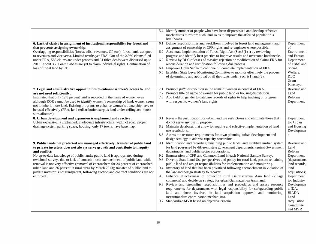
36
5.4 Identify number of people who have been dispossessed and develop effective
mechanisms to restore such land so as to improve the affected population’s
livelihoods.
6. Lack of clarity in assignment of institutional responsibility for forestland
that prevents assigning ownership:
Overlapping responsibilities (forest, tribal revenues, GP etc.); forest lands assigned
to revenues and vice versa. Limited results yet FRA: Out of the 2,930 claims filed
under FRA, 585 claims are under process and 31 titled deeds were disbursed up to
2013. About 350 Gram Sabhas are yet to claim individual rights. Continuation of
loss of tribal land by ST.
6.1 Define responsibilities and workflows involved in forest land management and
assignment of ownership or CPR rights and re-engineer where possible.
6.2 Accelerate implementation of Forest Right Act (Sec.3(1) i) by reviewing
progress and identify best practice to improve results and overcome bottlenecks.
6.3 Review by DLC of cases of massive rejection or modification of claims FRA for
reconsideration and rectification following due process.
6.4 Empower Gram Sabha to continue till complete implementation of FRA.
6.5 Establish State Level Monitoring Committee to monitor effectively the process
of determining and approval of all the rights under Sec. 3(1) and (2).
Department
of
Environment
and Forest;
Department
of Tribal and
Social
Welfare;
DLC
Gram
Panchayat
7. Legal and administrative opportunities to enhance women’s access to land
are not used sufficiently:
Estimated that only 12.8 percent land is recorded in the name of women even
although ROR cannot be used to identify women’s ownership of land; women seem
not to inherit more land. Existing programs to enhance women’s ownership have to
be used effectively (FRA, land redistribution surplus land under ceiling act, house
sites allottees).
7.1 Promote patta distribution in the name of women in context of FRA.
7.2 Promote title on name of women for public land or housing distribution.
7.3 Add field on gender to database records of rights to help tracking of progress
with respect to women’s land rights.
Revenue and
Land
Reforms
Department
8. Urban development and expansion is unplanned and reactive:
Urban expansion is unplanned; inadequate infrastructure, width of road, proper
drainage system parking space; housing; only 17 towns have base map.
8.1 Review the justification for urban land use restrictions and eliminate those that
do not serve any useful purpose.
8.2 Maintain databases that allow for routine and effective implementation of land
use restrictions.
8.3 Assess the resource requirements for town planning; urban development and
design strategy to address capacity constraints.
Department
for Urban
and Housing
Developmen
t
9. Public lands not protected nor managed effectively; transfer of public land
to private investors does not always serve growth and contribute to inequity
and conflict:
No up-to-date knowledge of public lands; public land is appropriated during
revisional surveys due to lack of control; much encroachment of public land while
removal is not very effective (removal of encroachers for 24 percent of encroached
urban land and 36 percent in rural areas by March 2013); transfer of public land to
private investor is not transparent, following auction and contract conditions are not
enforced.
9.1 Identification and recording remaining public lands, and establish unified system
for land possessed by different state government departments, central Government
departments, and public sector corporations.
9.2 Enumeration of CPR and Common Land in each National Sample Survey.
9.3 Develop State Land Use perspectives and policy for rural land, protect remaining
public land and assign responsibilities for implementation and monitoring.
9.4 Inventory of land that has been privatized following encroachment in violation of
the law and design strategy to recover.
9.5 Enhance effectiveness of protection rural Gairmazarhua Aam land (village
commons) and decide on strategy for urban Gairmazarhua Aam land.
9.6 Review and streamline responsibilities and procedures and assess resource
requirements for departments with legal responsibility for safeguarding public
land and those involved in land acquisition approval and monitoring;
institutionalize coordination mechanisms.
9.7 Standardize MVR based on objective criteria.
Revenue and
Land
Reform
Department
(departments
land records,
land
acquisition);
Department
for Industry
Developmen
t, IDA,
BIADA
Land
Acquisition
Committee
and MVR

37
9.8 Regular publication of transfers and lease or rent payment, which also allows
follow-up; consider third-party monitoring to ensure compliance of contractual
obligations by investor.
9.9 Finalize and enforce a rehabilitation and resettlement policy to mitigate hardships.
9.10 Set up effective grievance redressal machinery for land disputes.
10. Improve tax collection and rationalize exemptions:
Tax revenues are important for improving service delivery, but cities are not
maximizing revenue potential and have not rationalized collection mechanisms. Tax
coverage ratio in Patna Municipal Corporation is 50 percent and not better in other
cities; tax exemptions, such as for religious lands, may be misused and holding tax
has become undervalued.
10.1 Identify and publicize revenue potential versus actual collection for all major
cities.
10.2 Improve recording of holdings and updating of records and bring into tax fold to
increase the revenue for providing better services (also see no. 2).
10.3 Increase holding tax and bring this in line with the increase in value of landed
property in municipal areas.
10.4 Review cost to government of exemption of taxes to various institutions and
religious trusts and explore option for increasing their contribution to service
charges through holding taxes.
10.5 Review and streamline procedures for tax collection and assess resource
requirements to improve the administrative capacity of ULB.
Revenue and
Land
Reforms
Department;
Department
for Urban
and Housing
Developmen
t; ULB
11. Build monitoring capacity and pursue initiative to enhance the effectiveness
of dispute resolution mechanisms:
Bihar has undertaken legal and institutional reforms to improve the effectiveness
and efficiency of dispute resolution mechanisms and by establishing new forums for
the adjudication of land disputes (for example, lok adalat, land tribunal, capacity
Gram Kachahari) with good results (civil courts saw drop of land disputes from 70
percent to 21 percent, 90 cases within one year; tribunal dealt already with 68
percent of cases), but which requires regular monitoring to identify problems
timely, if any. In addition, a number of special cases are still pending (Ceiling Act,
sharecroppers [ 85 percent not disposed of], dispossession).
11.1 Develop scheme for categorization or recording of disputes for all courts or
instances so as to allow identification of legislative or regulatory bottlenecks.
11.2 Review and streamline procedures and apply case flow management principles
and more use of ICT.
11.3 Design strategy for disposal of specific cases (land ceiling, sharecropping, and
dispossession in rural areas).
Department
of Law;
Bihar
Judicial
Academy;
Revenue and
Land
Reforms
Department
JHARKHAND
1. Rural land records are not updated regularly, presumptive and lack spatial
synchronization:
Records and maps are not updated and do not reflect ground reality; revisional
survey incomplete. Slow progress with computerization of land records.
1.1 Identify and implement on a priority basis, cost-effective ways of verification
and updating of textual records and revisional survey based on ground reality, set
deadline, and regular assessment of progress.
1.2 Computerize all land records and make available on website (including register
II); maintain continuous khatihan (Records of Rights), set deadline.
1.3 Develop and implement mechanism for continued updating of textual and spatial
records, prompt service delivery and seamless connectivity, review mission
mode implementation with stakeholders and possibilities to overcome need for
special drives.
1.4 Assess the resource requirements for digitized record maintenance (regular and
frequent sync), verification and resurvey in different situations (with special
attention for survey & settlement of lands above 10-degree slopes).
1.5 Develop a comprehensive program that would allow accomplishing record
maintenance and resurvey in a specified and realistic time frame.
Department
Of Revenue
and Land
Reforms

38
1.6 Regular Publication of Land Use and Ownership Status and Land Revenue
Administration Report.
2. Urban land records are incomplete and not spatially referenced; high level
of housing is in violation with urban regulations and tenancy laws regulation:
Many urban dwellings are on tribal public lands, but the status of khasmahal land is
unclear as lease renewal of thousands of cases did not take place.
2.1 Review and update policy for khasmahal land; learn lessons from Bihar approach.
2.2 Establish base map for all cities, using existing information as much as possible;
establish a common spatial data infrastructure focusing on maintenance and
updating of records. Make it easily accessible to all citizens.
2.3 Review laws, schemes or programs and systems in place and possibilities for
streamlining for formalization of urban housing; for tenure upgrading in informal
settlements and expanding availability of affordable housing.
2.4 Define workflows and responsibilities involved in urban land management and
records maintenance, building permits and enforcements and re-engineer where
possible, effectively and sustainably.
2.5 Based on this analysis, clearly assign institutional responsibilities, ensure
appropriate role of ULBs and citizen participation and assess the resource
requirements and gaps.
2.6 Facilitate coordination among urban land-institutions.
Department
of Urban
Developmen
t;
Department
Of Revenue
and Land
Reforms
3.Records are not updated automatically and not all transactions are
registered:
Registration and revenue departments are not integrated.
All index registers from 1970 onwards are digitized and (printed) registration deeds
as well as non-encumbrance certificates are rapidly available (in maximum 30
minutes’ time).
3.1 Ensure that registration takes place following proper verification of land
records. Consider opening registration offices and integrate with revenue
circle office, which requires amendment of Registration Act.
3.2 Simplify registration procedures and standardize registration of deeds.
3.3 Enable online updating ROR and maintenance of continuous khatihan.
Department
of
Registration;
Department
Of Revenue
and Land
Reforms
4. Revision of Legislative and institutional framework to eliminate outdated
and ineffective sections in tenancy laws, and update specific sections; and
improve institutional coordination:
Legislation is in place to prohibit transfer of land from SC, ST and BC communities
to others, but three provisos of Section 46 tends to regularize transfer on fraudulent
terms undermining the essence of this law. The Indian Forest Act (1927) has not
been amended sufficiently to accommodate the provision of the JFM resolution
(2001).
A comprehensive umbrella land policy does not exist and land use boards are
dysfunctional; although there is no vertical institutional overlap, Forest Department
and Revenue Department staff at the grassroots level is insufficiently trained and
insufficient in number.
4.1 Review experience in Bihar with new legislation (recent acts on conversion of land
use, special survey & settlement, land dispute resolution, law of mutations,
khashmahal policy etc.) to improve effectiveness of land administration, such as
simplification of legal framework and innovations.
4.2 Make available more funding for staff recruitment and training for anchal and
survey staff or officers, and forest department ( including forest guards);
strengthen internal communications and supervision.
4.3 Build training capacity in the state for Revenue Department and Forest
Department.
4.4 Prepare land use policy for the long-term; set a minimum percentage of CPR per
village; address CPR at village and state levels and define roles and responsibilities
of local user groups, community based organizations, Gram Sabha, state and
central Government.
4.5 Revitalize dysfunctional Land Use Boards.
4.6 Strengthen land use management capacity of Gram Sabha (infrastructure, human
resources etc.)
4.7 Incorporate main text of 71A, model law for scheduled areas in section 46 of CNT
Act and delete current sections in 71A on regularization on transfer in case of
Department
Of Revenue
and Land
Reforms;
Department
of Forest;
Department
of Personnel
and
Administrati
ve Reforms

39
adverse possession; bring section 241 CNT Act on “mundatri khunkattidar” in line
with section 49.
4.8 Strengthen people’s participation in policy decision making and develop
procedures to collect feedback on implementation of laws and policy.
5. Effectiveness of public land redistribution for eligible poor and the
actual possession for granted public land needs strengthening:
Dispossession of granted land is a risk in Jharkhand, particularly for ceiling lands,
but there are no data as no survey has been carried out.
5.1 Monitor forcible dispossession of alottees in government land; ensure prompt
action act in the these cases.
5.2 Discourage dispossession by making it a cognizable offense.
6. Lack of clarity in assignment of institutional responsibility for forest land
and tribal land prevents assigning ownership:
Traditional village structures are still in charge of management of some common
lands and some customary practices recognized in the tenancy act. Records and
maps do not reflect the reality of forests and commons on the ground; fresh
revisional surveys are incomplete.
Most of the right holding PFs institution of JFM like VFMPCs or VEDCs exist but
they have to be activated and motivated, limited implementation capacity of FD
(Also see no. 4). Micro plans to ensure sustained supply of minimum village
requirements for firewood, small wood, and timber have been prepared and
submitted to the forest department, but are not acted upon. Dispossession of tribal
lands is continuing and has not been halted or reversed by legislation to protect
forests and CPR.
6.1 Define responsibilities and workflows involved in forest or CPR. Tribal land
management and assignment of ownership or CPR rights and re-engineer where
possible.
6.2 Undertake anchal-wise inventory of common lands; establish clear distinction
between CPR and other categories such as barren and uncultivable lands, non re-
distribution parches; include in CPR wastelands and fallows in addition to
pastures, common grazing, protected, unclassified and other wastelands with
common purpose.
6.3 Undertake enquiry and action for identified fraudulent transfers, settlements or
illegal occupation.
6.4 State amendments India Forest Act, 1927, to remove legal and procedural
impediments in JFM implementation in Jharkhand.
6.5 Address conflicting provisions JFMP and FPC resolutions and ensure enactment;
strengthen coordination of JFMP and FPC so that they function in tandem;
improve local awareness of local users’ rights to manage CPR via JFM.
6.6 Supervise & monitor FRA implementation (survey, application, disposal, patta
leases).
6.7 Assess and sanction village micro plans on forest use; simplify procedures for use
and sale of rayati forest produce and enhance accessibility for villagers.
6.8 Ensure completion of EIA before conversion of forest to non-forest use.
6.9 Strengthen regulatory authority in districts to monitor land, forest, and water issues
and empower Gram Sabha.
Department
of Forest;
Department
of
Panchayati
Raj;
Department
Of Revenue
and Land
Reforms
7. Legal and administrative opportunities to enhance women’s access to land
are not used sufficiently:
When there is no female descendant, female names are not recorded in ownership
column of khatihan or ROR, either exclusively or jointly. Everywhere the name of
the karta of the family is recorded, implying spouses as well. Except in tribal
communities, equality of women’s property rights to those by men is established by
law and followed in practice most of the time. Among ST communities women have
very limited rights over landed property because of customary practices. Both in the
state level validation workshop and in panel discussion, these issues were recognized
and it was recommended that a broader consensus is required to remove these
anomalies.
Ceiling law in Bihar was amended to provide reservation to 50 percent of the ceiling
surplus land to the eligible categories from women. Similarly with regard to the house
7.1 Develop broad consensus (CBO, other stakeholders) on tribal women’s land rights
and involve media.
7.2 Explore possibilities for collective leasing for women’s cooperatives of CPR and
other government lands.
7.3 Promote and monitor title on name of women for public land or housing
distribution.
7.4 Introducing “gender” parameter in recording of information in ROR to help
tracking of progress with respect to women’ land rights.
Department
of Urban
Developmen
t,
Department
Of Revenue
and Land
Reforms
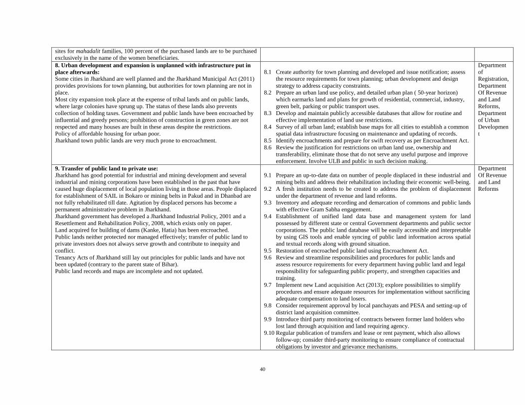
40
sites for mahadalit families, 100 percent of the purchased lands are to be purchased
exclusively in the name of the women beneficiaries.
8. Urban development and expansion is unplanned with infrastructure put in
place afterwards:
Some cities in Jharkhand are well planned and the Jharkhand Municipal Act (2011)
provides provisions for town planning, but authorities for town planning are not in
place.
Most city expansion took place at the expense of tribal lands and on public lands,
where large colonies have sprung up. The status of these lands also prevents
collection of holding taxes. Government and public lands have been encroached by
influential and greedy persons; prohibition of construction in green zones are not
respected and many houses are built in these areas despite the restrictions.
Policy of affordable housing for urban poor.
Jharkhand town public lands are very much prone to encroachment.
8.1 Create authority for town planning and developed and issue notification; assess
the resource requirements for town planning; urban development and design
strategy to address capacity constraints.
8.2 Prepare an urban land use policy, and detailed urban plan ( 50-year horizon)
which earmarks land and plans for growth of residential, commercial, industry,
green belt, parking or public transport uses.
8.3 Develop and maintain publicly accessible databases that allow for routine and
effective implementation of land use restrictions.
8.4 Survey of all urban land; establish base maps for all cities to establish a common
spatial data infrastructure focusing on maintenance and updating of records.
8.5 Identify encroachments and prepare for swift recovery as per Encroachment Act.
8.6 Review the justification for restrictions on urban land use, ownership and
transferability, eliminate those that do not serve any useful purpose and improve
enforcement. Involve ULB and public in such decision making.
Department
of
Registration,
Department
Of Revenue
and Land
Reforms,
Department
of Urban
Developmen
t
9. Transfer of public land to private use:
Jharkhand has good potential for industrial and mining development and several
industrial and mining corporations have been established in the past that have
caused huge displacement of local population living in those areas. People displaced
for establishment of SAIL in Bokaro or mining belts in Pakud and in Dhanbad are
not fully rehabilitated till date. Agitation by displaced persons has become a
permanent administrative problem in Jharkhand.
Jharkhand government has developed a Jharkhand Industrial Policy, 2001 and a
Resettlement and Rehabilitation Policy, 2008, which exists only on paper.
Land acquired for building of dams (Kanke, Hatia) has been encroached.
Public lands neither protected nor managed effectively; transfer of public land to
private investors does not always serve growth and contribute to inequity and
conflict.
Tenancy Acts of Jharkhand still lay out principles for public lands and have not
been updated (contrary to the parent state of Bihar).
Public land records and maps are incomplete and not updated.
9.1 Prepare an up-to-date data on number of people displaced in these industrial and
mining belts and address their rehabilitation including their economic well-being.
9.2 A fresh institution needs to be created to address the problem of displacement
under the department of revenue and land reforms.
9.3 Inventory and adequate recording and demarcation of commons and public lands
with effective Gram Sabha engagement.
9.4 Establishment of unified land data base and management system for land
possessed by different state or central Government departments and public sector
corporations. The public land database will be easily accessible and interpretable
by using GIS tools and enable syncing of public land information across spatial
and textual records along with ground situation.
9.5 Restoration of encroached public land using Encroachment Act.
9.6 Review and streamline responsibilities and procedures for public lands and
assess resource requirements for every department having public land and legal
responsibility for safeguarding public property, and strengthen capacities and
training.
9.7 Implement new Land acquisition Act (2013); explore possibilities to simplify
procedures and ensure adequate resources for implementation without sacrificing
adequate compensation to land losers.
9.8 Consider requirement approval by local panchayats and PESA and setting-up of
district land acquisition committee.
9.9 Introduce third party monitoring of contracts between former land holders who
lost land through acquisition and land requiring agency.
9.10 Regular publication of transfers and lease or rent payment, which also allows
follow-up; consider third-party monitoring to ensure compliance of contractual
obligations by investor and grievance mechanisms.
Department
Of Revenue
and Land
Reforms
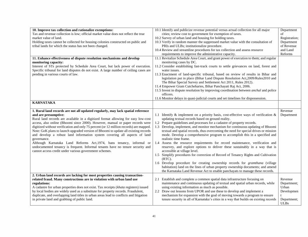
41
10. Improve tax collection and rationalize exemptions:
Tax and revenue collection is low; official market value does not reflect the true
market value of land.
Holding taxes cannot be collected for housing colonies constructed on public and
tribal lands for which the status has not been changed.
10.1 Identify and publicize revenue potential versus actual collection for all major
cities; review cost to government for exemption of taxes.
10.2 Survey of urban land and housing for holding taxes.
10.3 Verify in random manner the suppressed market value with the consultation of
PRIs and ULBs; institutionalize procedure.
10.4 Review and streamline procedures for tax collection and assess resource
requirements to improve the administrative capacity.
Department
of
Registration;
Department
of Revenue
and Land
Reforms
11. Enhance effectiveness of dispute resolution mechanisms and develop
monitoring capacity:
Interest of STs protected by Schedule Area Court, but lack power of execution.
Specific tribunal for land disputes do not exist. A large number of ceiling cases are
pending in various courts of law.
11.1 Revitalize Schedule Area Court, and grant power of execution to them; and regular
monitoring cases by DC.
11.2 Consider establishing fast-track courts to settle grievances on land, forest and
water issues.
11.3 Enactment of land-specific tribunal, based on review of results in Bihar and
legislation put in place (Bihar Land Dispute Resolution Act,2009/Rules2010 and
The Bihar Special Survey and Settlement Act 2011, Rules 2012).
11.4 Empower Gram Cutcheharies, Bihar Panchayati Raj Act, 2006.
11.5 Invest in dispute resolution by improving coordination between anchal and police
officers.
11.6 Monitor delays in quasi-judicial courts and set timelines for dispossession.
KARNATAKA
1. Rural land records are not all updated regularly, may lack spatial reference
and are presumptive:
Rural land records are available in a digitized format allowing for easy low-cost
access, also online (Bhoomi since 2000). However, manual or paper records were
digitized without verification and only 75 percent (or 12 million records) are mapped.
Note: GoK plans to launch upgraded version of Bhoomi to update all existing records
and develop a robust land information system covering all aspects of land
governance.
Although Karnataka Land Reforms Act,1974, bans tenancy, informal or
undocumented tenancy is frequent. Informal tenants have no tenure security and
cannot access credit under various government schemes.
1.1 Identify & implement on a priority basis, cost-effective ways of verification &
updating textual records based on ground reality.
1.2 Prepare guidelines and processes for a cadastre of property records.
1.3 Develop, implement, and monitor mechanism for continuous updating of Bhoomi
textual and spatial records, thus overcoming the need for special drives or mission
mode. Develop a comprehensive program to accomplish this in a specified and
realistic time frame.
1.4 Assess the resource requirements for record maintenance, verification and
resurvey, and explore options to deliver these sustainably in a way that is
accessible at village level.
1.5 Simplify procedures for correction of Record of Tenancy Rights and Cultivation
(RTC).
1.6 Develop procedure for creating ownership records for gramthana (village
habitation) land on the lines of urban property ownership documents; and amend
the Karnataka Land Revenue Act to enable panchayats to manage these records.
Revenue
Department
2. Urban land records are lacking for most properties causing transaction-
related fraud. Many constructions are in violation with urban land use
regulations:
A cadastre for urban properties does not exist. Tax receipts (khata registers) issued
by local bodies are widely used as a substitute for property records. Fraudulent,
duplicate, and overlapping land titles in urban areas lead to conflicts and litigation
in private land and grabbing of public land.
2.1 Establish and complete a common spatial data infrastructure focusing on
maintenance and continuous updating of textual and spatial urban records, while
using existing information as much as possible.
2.2 Draw out lessons from UPOR and use these to develop and implement a
mechanism for expansion with the goal of moving towards a program to ensure
tenure security in all of Karnataka’s cities in a way that builds on existing records
Revenue
Department;
Urban
Developmen
t
Department;
ULBs

42
Bangalore completed verification and validation of geo-referenced coordinates for
2/3 of the 1.6 million properties.
BBMP enables citizens to locate their property on Google map using the property
ID; 2.28 million (18 percent) non-agricultural properties are identifiable.
In four cities individual property records were created since 2011 (Urban Property
Ownership Records—UPOR), using a PPP model to create an accurate record of
both spatial and textual ownership data and provide speedy services to urban
residents. Out of 6,82,387 properties in these four cities, 13 percent draft property
cards are ready and 5 percent final. In the second phase UPOR project will expand
to Bangalore.
Building regulations are not respected, while unauthorized constructions may be
regularized (Sect.76-FF of KTCP Act).
with maximum private sector involvement based on a clear regulatory
framework.
2.3 Develop an integrated system for urban land management, records maintenance,
building permits and monitoring or enforcement.
2.4 Review laws and systems in place for formalization of unauthorized
constructions, ensure compliance with plan regulations and building by-laws and
re-engineer where possible.
3. Registration of land transactions is marred by errors and fraud:
A well-defined procedure to synchronize various types of registers (ROR in Bhoomi
with land registration database in KAVERI) exists to ensure the integrity of
agricultural land records. In rural areas, the gap between textual and spatial data
synchronization is addressed via pre-mutation sketch by a licensed surveyor as a
mandatory requirement for registration or partition of land (Integrated Mutation Podi)
but no such system is in place for urban areas.
Bhoomi is being integrated with banks and cooperatives to verify records and
encumbrances. Restrictions on RORs can be viewed online but this is not yet the case
for charges by private financial institutions or courts.
Measures to link Bhoomi data with courts to reflect pending court cases are ongoing
and UPOR also has provisions for recording encumbrances on property records.
3.1 Consolidate integration of ROR, registration transfers, encumbrances and pending
court cases for agricultural lands and enable it for urban lands by expanding UPOR
to end duplication of records, reduce fraud, and to evolve a robust land information
system.
3.2 Develop legal and institutional context for e-governance with citizens having
opportunity to apply for registration and uploading of documents through web
based applications.
Department
of Survey,
Settlement
and Land
Records;
Department
of Stamps
and
Registration;
ULBs
4. Strengthen effectiveness of public land redistribution for eligible poor and
the actual possession for granted public land:
Karnataka state has policies to promote equity in land holdings and distribution (land
grants to marginalized communities, joint land registration of husband and wife but
implementation can be improved).
Poor people were granted government land without proper titles and adequate
recording or mapping is not available for rural settlement land or gramthana lands,
with tax receipts constituting the sole documentary evidence of ownership.
Restrictions on sale of granted land, for SC/STs in particular require them to obtain
permission in ways that are time consuming and may lead to various kinds of
malpractice.
4.1 Review efficiency and effectiveness of policies on land distribution and balance
between demands of equity, ecology, and growth.
4.2 Identify available land for redistribution as well as the number of land- or homeless
who could benefit from land distribution.
4.3 More systematic distribution of land among the landless and houseless people,
while preventing unauthorized occupation of government land.
4.4 Develop steps to ensure effective possession and use of land that has been
redistributed to eligible marginal groups.
4.5 Systematic recording and monitoring of compliance with conditions of land grant
allocation and confiscation of granted land which has not been utilized for the
purpose specified at the time of grant.
4.6 Review restrictions on the right to alienate land granted to SC/STs.
Revenue
Department
5. Legal and administrative opportunities to enhance women’s access to land
are not effectively utilized:
Amendments to the JFPM program in 1996 sought to introduce gender equity by
providing co-membership of spouses to Village Forest Committees.
5.1 Review effectiveness of existing policies and explore opportunities for
amendments to enhance women’s access to land.
5.2 Introducing “gender” parameter to help tracking of progress with respect to
women’s land rights.
5.3 Ensure that UPOR identify women property owners as a separate category.
Revenue
Department
6. Unclear institutional responsibilities with respect to forest land prevents
assigning ownership:

43
Lack of clarity on legal recognition of forests. Common land is not properly
identified and responsibility for protection is not clearly assigned (forest laws or
revenue laws). Mismatch between land records and ground reality. Community
rights over non-forest common resources and fishing ponds are unclear in law and
on the ground.
Much common land is encroached, which sometimes is even regularized. The worst
hit are permanent pastures, which are not protected under the Forest
Conservation Act, 1980.
The 2013 status report on implementation of Forest Rights Act, 2006 shows that
community rights constitute only 2 percent of total applications (that is, 3,080
community claims as opposed to 1,65,638 individual claims) and only 90 such titles
have been granted under FRA. Joint Forest Planning & Management (JFPM)
established 5,200 VFCs covering around 3,40,000 hectares of degraded forests. But,
JFPM excludes forests with larger canopy cover, assessed wastelands and other
forest lands under the control of the Revenue Department, and forested lands under
“individual access” systems.
6.1 Comprehensive identification, reclassification, survey, and boundary demarcation
of forests, common land, pastures and other non-forest common pool resources).
6.2 Identify and codify the rights of various indigenous and non-indigenous groups to
the forest and non-forest commons; clarify rights of mining minor minerals and
sand.
6.3 Clarify policy for their protection, management, and use. Define responsibilities
and workflows involved in forest or CPR land management and assignment of
ownership rights, clarify overlapping jurisdictions between the forest and revenue
departments and re-engineer where possible; synchronize records maintenance
between Forest Department and Revenue Department.
6.4 Extend coverage of JFPM program, review low number of approved community
claims and increase awareness on formalizing groups rights under the Forest
Rights Act, 2006.
Forest
Department;
Revenue
Department;
Panchayati
Raj
Department(
for
Gramthana
land)
7. Urban expansion is unplanned and reactive; informal tenure regularization
can improve equity but undermine planning and promote encroachment:
Although a planning machinery is in place, stipulations are flouted and difficult to
enforce. Smaller towns lack any form of land use planning. Forty eight cities have
city survey plans developed in the 1970s that are not geo-referenced.
National schemes like Rajiv Awas Yojna (RAY) lay down guidelines to provide
tenure security to slum dwellers but implementation by ULBs is weak. Processes of
notification based on duration of occupancy and settlement size are not clearly
defined, ad hoc, and easily manipulated politically.
For bona fide landless persons, informal urban settlements on Government land
were regularized in 1970, 1997, and 1999. Similar amendments are being
contemplated but may be abused for land grabbing, while post facto regularization
undermines urban planning.
The High Court of Karnataka (Writ Petition NO: 12278/2007) has ordered to stop
registration of illegal properties and use e-SWATHU to allow unified recognition of
public land.
7.1 Review existing urban planning practice of parastate planning authorities, increase
involvement of elected local government and streamline urban planning,
implementation.
7.2 Review and assess the resource requirements for town planning; urban
development and design strategy to address capacity constraints.
7.3 Establish common jurisdiction and geographical coverage for all government and
parastatal agencies dealing with urban planning and service delivery and improve
coordination.
7.4 Simplification of rules governing the permission of land conversion or change in
use and narrow the discretion of government officials in authenticating such
changes.
7.5 Develop and maintain databases that allow for routine and effective monitoring of
land use restrictions enforcement and protection of the green belt.
7.6 Systematic assessment of housing stock with tenure types and develop workable
plan for providing low-cost housing.
7.7 Review policy of regularization of unauthorized construction and urban
developments, use e-SWATHU, and re-engineer where possible.
Urban
Developmen
t
Department;
Urban
Developmen
t
Authorities;
Bangalore
Metropolitan
Regional
Developmen
t Authority;
ULBs
8. Public lands not protected nor managed effectively and land use planning is
weak; transfer of public land to private investors does not always serve growth
and can contribute to inequity and conflict:
Records suggest that 23 percent of total area is public lands (115 lakh acres) of which
4,11,0425 acres (3.5 percent total lands) is used as commons. Failure to document
diversions and update records imply that these data do not reflect reality on the
ground.
Encroachments are estimated at 10 percent and, without records and a clear policy,
difficult to recover, leading to a proliferation of court cases (of 1,302,241 acres
8.1 Identify, survey, and prepare records for the public lands, and establish unified
system for land possessed by different state or central Government departments
and public sector corporations. Create web portal to make this information
available to the public.
8.2 Develop State Land Use and zoning policy for rural and urban land. Identify viable
land for distribution to poor and industrial areas. Create a digital repository of
spatial data with geo referential co-ordinates for all agricultural lands so that land
parcels can be identified and located easily both on satellite imagery and physically
and land use changes tracked.
Revenue
Department;
Panchayati
Raj
Department
(for
Gramthana
land);
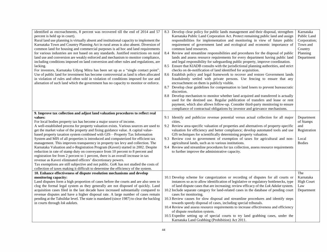
44
identified as encroachments, 8 percent was recovered till the end of 2014 and 57
percent is held up in court).
Rural land use planning is virtually absent and institutional capacity to implement the
Karnataka Town and Country Planning Act in rural areas is also absent. Diversion of
common land for housing and commercial purposes is ad hoc and land requirements
for various industries are not based on any standards. Justified restrictions on rural
land use and conversion are weakly enforced and mechanism to monitor compliance,
including conditions imposed on land conversion and other rules and regulations, are
lacking.
For investors, Karnataka Udyog Mitra has been set up as a “single contact point”.
Use of public land for investment has become controversial as land is often allocated
in violation of rules and often sold in violation of conditions imposed for use and
alienation of such land which the government has no capacity to monitor or enforce.
8.3 Develop clear policy for public lands management and their disposal, strengthen
Karnataka Public Land Corporation Act. Protect remaining public land and assign
responsibilities for implementation and monitoring in view of future public
requirement of government land and ecological and economic importance of
common land resources.
8.4 Review and streamline responsibilities and procedures for the disposal of public
lands and assess resource requirements for every department having public land
and legal responsibility for safeguarding public property, improve coordination.
8.5 Ensure that KIADB consults with the jurisdictional planning authorities, and strict
checks on de-notification of land identified for acquisition.
8.6 Establish policy and legal framework to recover and restore Government lands
fraudulently settled with private persons. Use fencing to ensure that any
encroachment on them is publicly visible.
8.7 Develop clear guidelines for compensation to land losers to prevent bureaucratic
discretion.
8.8 Develop mechanism to monitor whether land acquired and transferred is actually
used for the destined use. Regular publication of transfers and lease or rent
payment, which also allows follow-up. Consider third-party monitoring to ensure
compliance of contractual obligations by investor and grievance mechanisms.
Karnataka
Public Land
Corporation;
Town and
Country
Planning
Department
9. Improve tax collection and adjust land valuation procedures to reflect real
values:
For local bodies property tax has become a major source of income.
A well-established process for property valuation exists. Various sources are used to
get the market value of the property and fixing guidance value. A capital value-
based property taxation system combined with GIS—Property Tax Information
System and MIS of all properties is introduced and computerized for efficient tax
management. This improves transparency in property tax levy and collection. The
Karnataka Valuation and e-Registration Program (Kaveri) started in 2002. Despite
reduction in rate of stamp duty on conveyance from 10 percent to 8 percent and
registration fee from 2 percent to 1 percent, there is an overall increase in tax
revenue as Kaveri eliminated officers’ discretionary powers.
Tax exemptions are still subjective and not public. GoK has not studied the costs of
collection of taxes making it difficult to determine the efficiency of the system.
9.1 Identify and publicize revenue potential versus actual collection for all major
cities.
9.2 Review area-specific valuation of properties and alternatives of property-specific
valuation for efficiency and better compliance; develop automated tools and use
GIS techniques for scientifically determining property valuation.
9.3 Review cost to government of exemption of taxes for agricultural and non-
agricultural lands, such as to various institutions.
9.4 Review and streamline procedures for tax collection, assess resource requirements
to further improve the administrative capacity.
Department
of Stamps
and
Registration
Local
Bodies
10. Enhance effectiveness of dispute resolution mechanisms and develop
monitoring capacity:
Land disputes form a high proportion of cases before the courts and are also seen to
clog the formal legal system as they generally are not disposed of quickly. Land
acquisition cases filed in the last decade have increased substantially compared to
revenue disputes and have a higher disposal rate. A large number of cases remain
pending at the Tahsildar level. The state is mandated (since 1987) to clear the backlog
in courts through lok adalats.
10.1 Develop scheme for categorization or recording of disputes for all courts or
instances so as to allow identification of legislative or regulatory bottlenecks, type
of land dispute cases that are increasing; review efficacy of the Lok Adalat system.
10.2 Include separate category for land-related cases in the database of pending court
cases for monitoring.
10.3 Review causes for slow disposal and streamline procedures and identify steps
towards speedy disposal of cases, including special tribunals.
10.4 Review and assess resource requirements to increase effectiveness and efficiency
of dispute resolution system.
10.5 Expedite setting up of special courts to try land grabbing cases, under the
Karnataka Land Grabbing (Prohibition) Act 2011.
The
Karnataka
High Court
Law
Department

45
11. Revise legal and institutional framework to improve institutional
coordination, efficiency, and effectiveness: Karnataka has a strong legal and institutional framework but lacks a single land code
covering all aspects of land administration.
Rights over private agricultural land are subject to restrictions under provisions of
Section 79 of the Karnataka Land Reforms Act (concealed tenancy, purchase of
agricultural land by non-agriculturists, land ceilings, individualization of rights,
leasing, regularization of unauthorized occupation by poor, use of non-documentary
evidence, adverse possession) not all of which may still be relevant and need to be
reviewed.
Sharing of responsibility for land management by at least four departments plus
agencies causes horizontal overlap.
Responsibility for general administration functions reduces Revenue Department’s
focus on land administration.
Land bureaucracy lacks training and motivation; capacity at all levels of land
administration is lacking; vacancies are not filled regularly.
11.1 Consider creating a single land code to cover all aspects of land administration
(LT; State).
11.2 Consider establishment of separate land administration department to manage all
kinds of non-forest lands both rural and urban (MT; S).
11.3 Review restrictions on purchasing and owning agricultural land; eliminate those
no longer useful and improve enforcement of justified ones.
11.4 Review Transfer of Properties Act 1882 to put in place provisions for submitting
ownership document by the seller before allowing registration (ST; Nat).
11.5 Review, rationalize, and streamline the administrative structure for land
administration; reduce discretion at all levels and inventory of resource
requirements and resource availability.
11.6 Put in place decision support tools, using monitoring data from land information
systems and other required data to automate the generation of reports to inform
decision making.
11.7 Improve capacity in land governance of the State Administrative Training
Institutes (ATI) and availability of high quality trainers.
ODISHA
1. Rural land records are not updated regularly, presumptive, and lack spatial
synchronization:
Gaps exist in records for same plot of land between that maintained in RORs (hard
copies kept in Tehsil), Bhulekh (digitized records on website) and cadastral maps
(Tehsil office or digitized form Bhu-naxa); gaps exist also between actual position on
the ground and data in the corresponding record.
72 percent of records (parcels/plots) of all land (including privately and publicly held)
in the digitized register (bhulekh.nic.in) can be readily identified in maps; 4 percent
of parcels are on Map but not in Bhulekh; 16 percent of parcels in Bhulekh are not
on the map (as per a sample study of six villages from one each Tehsil in four
representative districts—one coastal, one urban, one tribal, and one irrigated; data
provided through NIC from Bhulekh database)
High prevalence of tenancy or illegal lease transactions; sharecropping is ubiquitous
with considerable adverse impact on crop production. However, tenancies are never
recorded.
1.1 Identify and implement on a priority basis, cost-effective ways of verification
and updating of textual records based on ground reality and regular assessment of
progress of synchronization in Bhulekh, Bhu-naxa, ongoing resurveys.
1.2 Upload all digitized maps into Bhu-naxa website and make these publicly
accessible.
1.3 Introduce system in Bhulekh and Bhu-naxa to get feedback for corrections
through crowd-sourcing; introduce system for query-based reports in these
websites.
1.4 Develop and implement mechanism for continued updating of textual and spatial
records, prompt service delivery and seamless connectivity, review mission
mode implementation with stakeholders and possibilities to overcome need for
special drives.
1.5 Assess the resource requirements for digitized record maintenance (regular and
frequent sync), verification and resurvey in different situations (with special
attention for survey and settlement of lands above 10-degree slopes).
1.6 Develop a comprehensive program that would allow accomplishing record
maintenance and resurvey in a specified and realistic time frame.
1.7 Regular publication of Land Use and Ownership Status and Land Revenue
Administration Report.
1.8 Consolidate and implement tenancy reforms recommendations; test and
introduce system of recording tenancy in ROR.
RDM
Department-
NLRMP
Cell, NIC
SC & ST
Developmen
t Department
(for
facilitating
survey and
recording of
titles above
10-degree
slope);
PR
Department
(ensuring
participation
of PRI)
2. Urban land records are incomplete and not spatially referenced; high level
of housing is in violation with urban regulations:
2.1 Establish base map for all cities, using existing information as much as possible;
establish a common spatial data infrastructure focusing on maintenance and
RDM
Department;

46
In urban areas, land is held as private freehold or lease land grant (99 years) and
under Government control; but 1.5 million people ( 25 percent urban population as
per Census 2011) live in slums—mostly without rights.
Urban lands including maps are not separately maintained to suit urban
requirements as done in other states. Spatial records of ownership and land use vary
widely from textual data. Allotment of Government land in urban areas is fraught
with discretion. It is reported that most of the private plots are entangled in legal
disputes. Many of the buildings and housing schemes are in violation with
regulations, but amnesty schemes exist.
Considerable demand and supply gap for housing for poor, in spite of existence of
schemes and provisions.
updating of records rather than repeated one-off resurveys. Make it easily
accessible to all citizens.
2.2 Review laws, schemes or programs and systems in place and possibilities for
streamlining for formalization of urban housing; for tenure upgrading in informal
settlements and expanding availability of affordable housing.
2.3 Define workflows and responsibilities involved in urban land management and
records maintenance, building permits and enforcements and re-engineer where
possible, effectively and sustainably.
2.4 Based on this analysis, clearly assign institutional responsibilities, ensure
appropriate role of ULBs and citizen participation and assess the resource
requirements and gaps.
2.5 Facilitate coordination among urban land institutions.
ULB, BMC,
CMC etc.
Department
of Housing
and Urban
Developmen
t;
Developmen
t Authorities
(BDA, CDA
etc.)
3. Records are not updated automatically and not all transactions are
registered:
Institutional and automated procedures for syncing and updating land records on a
regular basis are absent; process of mutation at Tehsil office usually experiences long
delays. The records maintained in e-registry (bhulekh.nic.in) contain errors due to the
format, typing, software limitations; print outs of ROR from Bhulekh are not accepted
by officials of Revenue Department. Public encumbrances are mostly recorded but
not in a consistent way nor easily verifiable; bank mortgages usually not recorded
except for that of State Bank of India. Private encumbrances are usually not recorded.
3.1 Improve reliability online mutation or e-linking and sync registry office and
tehsil office to facilitate automatic mutations and updating of records on transfer
of land. Build on ongoing pilot in Jatni, Khurdha district and experience with
merging settlement and consolidation of organizations with the Tehsil
administration as per Odisha Special Survey and Settlement Act & Rules, 2012.
Ensure mutation to happen within the stipulated 90 days.
3.2 Ensure implementation GoO amendment to Section 22 A of the Registration Act
1908 (vide Law Department Notification dated February 22, 2014) whereby
transferor is bound to satisfy the registering officer that he/she has right, title, and
interest over the property to be transferred. This enables the sub-register to verify
the ownership of the land to be transacted, thus preventing disputes.
3.3 Design strategy to encourage registration of all transactions and encumbrances,
with provision for “anywhere” registration.
RDM
Department
—NLRMP;
NIC Cell
4. Revision of legislative and institutional framework to eliminate outdated and
ineffective sections, and update specific sections; and improve institutional
coordination: There is a vast set of revenue related laws, thanks to inheritance of multiple revenue
systems and subsequent repeals, amendments and many important Government
ordinance and circulars.
Implementation is by multiple agencies, but with limited coordination across rural,
urban, and tribal land and also around registry and cadastre processes. Land records
are maintained by different offices (Settlement/ Consolidation Wing, Tehsils and
Registration Offices) but land administration has become secondary. State is
starting to emphasize modernization of record management (digitization—Bhulek)
and use of hi-tech survey methodologies and digitization of maps (Bhu-naxa).
4.1 Develop a comprehensive and consolidated Revenue Code by merging and
harmonizing all land revenue legislations and administrative orders (statutory
and non-statutory) and harmonizing the contradictions between different legal
instruments (OSS Act 1958, OGLS Act 1962, OLR Act 1960, OGP Act 1964,
OPLE Act 1972 etc. being the old ones, and 73rd and 74th Constitution
Amendments of 1992, PESA Act 1996, FRA 2006 and LARR Act 2013).
4.2 Review, rationalize, and streamline the administrative structure for land
administration; reduce discretions at all levels; take up inventory of resource
requirements, resource availability at all levels and time available for land
administration (human resources, including capacity to use new technologies,
tasks, infrastructure, and equipment).
RDM
Department
5. Effectiveness of public land redistribution for eligible poor and the actual
possession for granted public land needs strengthening:
There are about 63 lakh acres of Government wasteland under Abad Jogya and Abada
Ajogya Anabadi (Culturable and Unculturable wastelands), which is 18 percent of
total rural land as per Bhulekh (February 2014).
Land distribution to poor, legal landless (owning less than one standard acre)
especially of ST and SC communities is an important policy in Odisha. However, it
5.1 Identify available land for redistribution as well as the number of land- or
homesteadless, who could benefit from land distribution through
involvement of PRI and local community.
5.2 Review process to ensure equitable and transparent distribution.
5.3 Develop effective steps to ensure continued possession and effective use of
land redistributed to marginal groups and promote participatory monitoring
RDM
Department;
SC/ST
Developmen
t
Department;

47
is hampered by non-availability of accurate village wise data of landless- and
homestead-less people or availability of public land for distribution; problem most
pronounced in tribal areas.
There is need of secured tenures for slum dwellers in urban poverty alleviation
program.
(with special attention for effective distribution and monitoring of Bhoodan
and ceiling surplus land and waste-land among eligible households.
5.4 Identify number of people who have been displaced and develop effective
mechanisms to restore such land so as to improve the affected population’s
livelihoods.
5.5 Map land rights and ensure possession by landless and homesteadless before
taking up any area or village development programs vis-à-vis under
watershed, MGNREGS, so on and so forth.
PR
Department
6. Lack of clarity in assignment of institutional responsibility for forest land
and tribal land prevents assigning ownership:
Lack of legal clarity between Forest and Revenue Departments (land use
classification versus ownership, 1,369 forest blocks with 8847 sq km, exist as
Proposed Revenue Forest, though the Forest Department treats them as deemed
reserve forest); legislation for protection to tribal land rights and rights over forest
land exists (provisions under OLR, OSATIP regulation, PESA, and GP Act
Amendments, Forest Rights Act) but declaration remains complex and contested.
Overlapping institutional responsibilities (forest, tribal revenues, GP etc.);
FRA/JFM implementation quite satisfactory; but forest land allotted under FRA is
not accompanied by map, nor the record updated in ROR, though there is a
Government order, progress of CFR is very slow;
common land is not clearly defined, can be easily acquired under LA Act, can be
allotted to private individuals or agencies through discretion; not vested with GP for
the purpose of evictions as instructed by the Supreme Court.
6.1 Define responsibilities and workflows involved in forest land management and
assignment of ownership or CPR rights and re-engineer where possible.
6.2 Implement legislation on devolution management of common land and to Gram
Sabha and assess implementation mechanisms and resource requirements.
6.3 Survey and identification of all the lands belonging to forest categories.
6.4 Establish state Level monitoring committee to monitor effectively the process of
determining and approval of all the rights over forests or tribal lands.
6.5 Time-bound settling of pending proposals reverting to Protected Forest or settling
as Reserved Forest.
6.6 Facilitating full implementation FRA rules and process (preparation of prescribed
maps with various rights; handing over of forest and revenue maps, voters’ list and
awareness kits to every FRC or Gram Sabha); clear definition of rights and
management responsibilities at all institutional levels.
6.7 Updating of ROR following individual rights recognition under FRA and Forest
Record (RF, PF etc.) after CFR.
RDM
Department;
Forest
Department,
GP
7. Legal and administrative opportunities to enhance women’s access to land
are not used sufficiently:
The Government of Odisha has directed to issue joint patta in the name of both
husband and wife, while settling the Government wasteland, house sites and ceiling
surplus lands with landless persons. Under FRA, also joint patta is being
distributed. The law also gives women the right to share equally in decisions over
transfer of land, but implementation is not effective. Although inheritance laws
provide for daughters and daughters-in-law to receive rights over ancestral or in-
laws’ property, the state does not act proactively. Women are incapable of enjoying
such rights, due to lack of knowledge, access and resources.
7.1 Introducing “gender” parameter in recording of information in ROR to help
tracking of progress with respect to women’s land rights.
7.2 Promote title in name of women for public land or housing distribution.
7.3 Consider lower registration fees for recording of property in the name of women.
RDM
Department
– NLRMP,
IG–
Registration
8. Urban development and expansion is unplanned with infrastructure put in
place afterwards:
Urban areas grow unplanned, spontaneously, and continuously in the direction of
least resistance. The GoO has a robust legal and institutional framework around
urban land, but implementation and coordination remains a challenge. Separate
institutions for planning and development of urban centers and rural areas exhibit
disjointed efforts. The state government is set to start a new town planning scheme
(TPS), under which private land would be taken over from owners, pooled together
and some portions would be used for roads and civic amenities, but with most of the
private plots entangled in legal disputes, it will be difficult for the government to go
for land pooling.
8.1 Establish base maps for all cities to establish a common spatial data
infrastructure focusing on maintenance and updating of records rather than
repeated one-off resurveys (see no. 2).
8.2 Review the justification for restrictions on urban land use, ownership and
transferability, eliminate those that do not serve any useful purpose and improve
enforcement. Involve ULB and public in such decision making.
8.3 Develop and maintain publicly accessible databases that allow for routine and
effective implementation of land use restrictions.
8.4 Assess the resource requirements for town planning, urban development, and
design strategy to address capacity constraints; explore opportunities to
Housing and
Urban
Developmen
t
Department;
ULBs—
BMC, CMC;
Developmen
t
Authorities
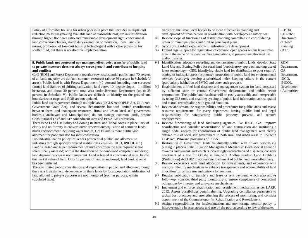
48
Policy of affordable housing for urban poor is in place that includes multiple cost
reduction measures (making available land at reasonable cost, cross-subsidization
through higher floor area ratio and transferable development right, concessional
land conversion charges, stamp duty exemption or reduction, liberal land-use
norms, promotion of low-cost housing technologies) with a clear provision for
shelter fund, but there is no effective implementation.
transform the urban local bodies to be more effective in planning and
development of urban centers in coordination with development authorities.
8.5 Review scope of functioning of district planning committees in consolidating
urban or municipal plans and rural or panchayat plans.
8.6 Synchronize urban expansion with infrastructure development.
8.7 Extend legal support for registration of common open spaces within layout plan
area in the name of resident welfare associations, to prevent unauthorized use
and/or transfer.
—BDA,
CDA etc.;
Directorate
of Town
Planning
(DTP)
9. Public lands not protected nor managed effectively; transfer of public land
to private investors does not always serve growth and contribute to inequity
and conflict:
GoO (RDM and Forest Department together) owns substantial public land: 70 percent
of all land; majority are de-facto common resources (above 80 percent in Schedule V
areas). Public land is with Forest Department (40 percent) including non-surveyed
farmed land (fallows of shifting cultivation, land above 10- degree slopes—1 million
hectares), and about 30 percent rural area under Revenue Department (up to 35
percent in Schedule V); Public lands are difficult to identify on the ground and
boundaries on maps and ROR are not updated.
Public land use is governed through multiple laws (OGLS Act, OPLE Act, OLR Act,
Government Grant Act), and several departments but with limited coordination
between them, and inadequate resources. Rural and urban local self-government
bodies (Panchayats and Municipalities) do not manage common lands, despite
Constitutional (73rd and 74th Amendment Acts and PESA Act) provision.
There is no Land Use Policy and Zoning in Rural and Tribal Areas in place; lack of
clarity and uniformity in conversion/de-reservation/acquisition of common lands;
much cncroachment including water bodies. GoO’s aim is more public land
allotment for poor and also for industrialization.
Pro-industrialization policy influences preferential public land allotment to
industries through specially created institutions (vis-à-vis IDCO, IPICOL etc.).
Land is leased out as per requirement of investor (often the area required is not
scientifically assessed) within the discretion of the concerned competent authority;
land disposal process is not transparent. Land is leased at concessional rates, below
the market value of land. Only 10 percent of land is auctioned; land bank scheme
has been initiated.
There is limited public consultation and negotiation in public land allotment, though
there is a high de-facto dependence on these lands by local population; utilization of
land allotted to private purposes are not monitored (such as purpose, within
stipulated time).
9.1 Identification, adequate-recording and demarcation of public lands; develop State
Land Use and Zoning Policy for rural land (participatory approach making use of
latest technology—GIS), identifying viable land for distribution to poor (equity),
zoning of industrial areas (economy), protection of public land for environmental
services (ecology); develop a prioritized index keeping culture in the context
(particularly habitation of PVTG and other such groups).
9.2 Establishment unified land database and management system for land possessed
by different state or central Government departments and public sector
corporations. The public land database will be easily accessible and interpretable
by using GIS tools and enabling syncing of public land information across spatial
and textual records along with ground situation.
9.3 Review and streamline responsibilities and procedures for public lands and assess
resource requirements for every department having public land and legal
responsibility for safeguarding public property, prevent, and remove
encroachment.
9.4 Review functioning of land facilitating agencies like IDCO, GA; improve
coordination and consider reconstitution of land commission and instituting a
single nodal agency for coordination of public land management with clearly
defined role of local self government in both rural and urban areas in line with
OGP Act, 1964 and provisions of PESA.
9.5 Restoration of Government lands fraudulently settled with private persons via
putting in place a State Litigation Management Mechanism (with special attention
towards endowment land which is increasingly encroached and disputed); consider
enactment of a law for Odisha in line with Andhra Pradesh Land Grabbing
(Prohibition) Act 1982 to address encroachment of public land more effectively.
9.6 Review experience with land allocation for investments, and experience with
auctions. Identify mechanisms to enhance transparency and accountability of land
allocation for private use and options for auctions.
9.7 Regular publication of transfers and lease or rent payment, which also allows
follow-up; consider third party monitoring to ensure compliance of contractual
obligations by investor and grievance mechanisms.
9.8 Implement and enforce rehabilitation and resettlement mechanism as per LARR,
2012. Assess possibilities benefit sharing. Upgrading compliance parameters to
global best practices and strengthening the process of monitoring; and consider
appointment of the Commissioner for Rehabilitation and Resettlement.
9.9 Assign responsibilities for implementation and monitoring; monitor policy to
improve equity in asset access and use by the poor according to law of the state.
RDM
Department,
GA
Department,
IDCO,
IPICOL,
Developmen
t Authorities

49
10. Improve tax collection and rationalize exemptions:
Tax revenues are important for improving service delivery but cities are not
maximizing revenue potential and have not rationalized collection mechanisms. In
rural areas, more than 80 percent of property holders liable for land/property tax are
listed on the tax roll—it is less than 50 percent in urban areas. The collection of
land/property tax in Odisha is between 50 percent and 70 percent of assessed
land/property tax. The valuation and taxation process is regulated OGLS, Act, 1962,
OPLE Act, 1972, OLR Act, 1960 and the rules thereunder. The state government
abolished the collection of land revenue (1978) and is collecting cess instead.
Valuation rolls are publicly accessible for all properties considered for taxation ( “e-
dharani”).
Holding tax has got the nomenclature of property tax in Orissa Municipal
Corporation Act, 2003. Its collection is hampered by constraints like rent control,
inefficiency in updating property rolls, and resistance to periodic assessment. It is
possible also that state government is losing huge revenues due to a lesser
determination of conversion fee, non-realization of outstanding premium, interest
and consent fees, and not taking up auction where applicable.
10.1 Identify and publicize revenue potential versus actual collection for all major
cities.
10.2 Rationalization and standardization of taxes as per kissam (standardized land
types) following resurvey; explore scope of reintroduction of land revenue with
online payment options (for sustainability and accountability).
10.3 Review cost to Government of exemption of taxes to various institutions and
religious trusts and explore option for increasing their contribution to service
charges through holding taxes; tax should be assessed for all private lands
(including bebandobast lands).
10.4 Review and streamline procedures for tax collection and assess resource
requirements to improve the administrative capacity of ULB Property tax
collection in ULBs needs to be ensured with adequate institutional arrangement
along with a system of online transparent assessment and payment provision.
RDM
Department,
Housing and
Urban
Developmen
t
Department,
ULBs
11. Enhance effectiveness of dispute resolution mechanisms and develop
monitoring capacity:
Land dispute cases account for over 50 percent of total cases in judicial and revenue
system; proliferation of land related cases brought before civil courts causes delay in
completion of provisional survey for updating of records, denial of entitlements
during preparation of ROR, incorrect recording of land holders in the RORs, and
archaic nature of both substantive and procedural laws regarding titles and above all
knowledge deficit of the dealing personnel, compensation and R&R entitlements in
land acquisition cases. Disposal takes a long time to the detriment of both state and
litigants and costly because of complex laws, cumbersome procedures, lack of
knowledge and lawyer’s fees, court fees etc. The share of long-standing land conflicts
(> 5 years) is more than 20 percent of the total pending land dispute court cases as
confirmed from the data obtained from two different courts of Odisha.
Many land laws debar jurisdiction of civil court, providing revenue court and
authorities an arbitration role, but causing also incomplete separation of arbitration
and implementation authorities.
Capacity is insufficient, and at least one Grama Nyayalaya for a block area and at
least a civil court for covering 20,000 people should be provided along with adequate
staff and infrastructure. Recent spurt of progressive legislation and proactive orders
from the apex court to contribute to speedy resolution of land disputes needs to be
implemented. Standard use of Lok Adalat requires sensitization of the judicial and
quasi-judicial personnel on the imperative of adopting the new judicial culture of out-
of-court and fast-track settlement of civil disputes through mediation, conciliation
arbitration or Lok Adalat.
11.1 Develop scheme for categorization or recording of disputes for all courts or
instances so as to allow identification of legislative or regulatory bottlenecks and
causes for slow disposal. Inclusion of “land” as a key word in online database of
courts to make it easier for everyone to track the concerned cases and the
particulars pending at different levels.
11.2 Review and streamline mechanisms and procedures, and consider time limit for
disposal of cases with judicial and revenue courts, and appeals before the
Revisional Authority (requires amendment of Odisha Right to Public Services Act
2012).
11.3 Capacity increase and unclogging of cases long pending in judicial and revenue
courts. Encourage standard use of Lok Adalat.
11.4 Fast-track courts could be established for disposal of huge pendency of cases or
emerging issues. The state government may establish separate endowment courts
for effective disposal of land disputes, which arise between sevayats and the
deities.
11.5 Consider establishment of land rights and legal assistance centers at every block
or sub-divisional headquarters either under the control of Legal Services
Authorities or under DRDA.
RDM
Department;
High Court
of Odisha;
Law
Department
WEST BENGAL

50
1. Rural land records are not updated regularly and often lack spatial
reference; insufficient coordination between departments:
Tenure rights are fully recognized (West Bengal Land Reforms Act, 1955; West
Bengal Acquisition of Homestead Land for Agricultural Labourers, Artisans and
Fishermen Act, 1975, West Bengal Thika Tenancy Act, 2001) but there’s gap in
implementation. Sharecroppers’ legislation allows recording names in ROR and
effective (72 percent perceived more tenure security in 2003). Tenure insecurity for
some group rights or customary rights; restriction on tribal land transfers not
respected.
ROR not updated on a regular basis and pending mutation; faulty records due to non-
participation or absence of the parties during the relevant stages of preparation of land
records—will cause disputes. Land properties belonging to the public bodies not
recorded in the ROR.
Digitization or computerization of records and maps is almost completed with all
information available through website or through OTC services paying very minimal
charges; ongoing updating cadastral maps and record of rights of 1,473 revenue
villages (under WBLR Act, 1975). Fee structures for different kind of land
administration services are not rational, transparent and do not match with high cost
of government service.
1.1 Identify and implement on a priority basis, cost-effective ways of verification
and updating textual records based on ground reality.
1.2 Develop and implement mechanism for continued updating of textual and spatial
records, also to overcome need for special drives or mission modes. Develop a
comprehensive program to accomplish this in a specified and realistic time
frame.
1.3 Assess the resource requirements for record maintenance, verification, and
resurvey, and requirements for sustainability (such as changes in fee structure).
1.4 Establish task force to identify and codify all customary rights and ensure
protection under law.
1.5 Expedite the recording of names of bargadars who are still not included in
Government records.
L&LR
2. Urban land records are incomplete and not spatially referenced; high level
of buildings is constructed in violation with urban regulations:
High numbers of plots have no records. Constructions of many buildings are violating
the prescribed norms; the state does not have a policy to deal with informal tenureship
in urban areas.
2.1 Establish a base map for all cities using existing information as much as possible;
establish a common spatial data infrastructure focusing on maintenance and
updating of records.
2.2 Define workflows and responsibilities for urban land management, records
maintenance, building permits and monitoring or enforcement, re-engineer where
possible.
2.3 Clearly assign institutional responsibilities, assess resource requirements and
identify gaps in order to arrive at systems that are effective and sustainable.
2.4 Review laws and systems in place for formalization of urban housing.
Revenue
Authorities;
ULB
3. Records are not updated automatically and not all transactions registered:
Cost of recording of property transfer is very high and evasion of stamp duty is
particularly common amongst the rural poor. ROR also does not reflect the real
ground situation due to time lag between registration and mutation. Not all
encumbrances are recorded.
3.1 Strengthen system for interlinking or bridging registration and mutation so that
simultaneous updating of land records can be done when any transfer is executed
(through the Registration Department). This is possible in WB as land records
maintained by the Revenue Department (that is, the Land Reforms Department)
have all been computerized, and the functioning of the Land Registration
Department has also been fully computerized. The bridging between the two
systems will keep the records updated and thereby reduce the scope of disputes
to the minimum.
3.2 Reduce stamp to encourage all property transfers to be registered.
L&LR
4. Revision of legislative and institutional framework:
Eliminate outdated and ineffective sections, and update specific sections; and
improve institutional coordination, efficiency and effectiveness.
WB has comprehensive legislations embodying policies on land. However, land-
related legislations in the state largely ignored ecological and environmental issues.
4.1 Review justification for legal restrictions on land use, ownership and
transferability, eliminate those that do not serve any useful purpose and improve
enforcement and access to legal services (for example, sale of land cultivated
with barga; tribal land alienation, community rights in forest villages).

51
There is no mechanism of tracking the progress of implementation of different
policies by the public. Though there is a well-defined reporting system on a regular
basis within the department, the information is not available to the public.
As per legislation, institutional mandates relating to administration of land is very
clear in the state; the role and function of different layers of L&LR Department is
clearly defined; there is no scope of overlapping. Different institutions deal with
land-related matters quite differently and there is lack of coordination in practice.
4.2 Review, rationalize, and streamline the administrative structure for land
administration; reduce discretion at all levels and inventory of resource
requirements and resource availability at all levels.
5. Effectiveness of public land redistribution for eligible poor and the actual
possession for granted public land needs strengthening:
WB policy is to use public land for allocation of homestead plots to the absolute
landless and homeless through legislation and Government schemes giving
preference to women, ST and SC. Government scheme Nijo-Griho-Nijo-Bhumi
Prakalpa in October 2011 (My Home My Land scheme) to settle 5.5 lakh landless
poor and provide up to 0.05 acre.
Up to 3,26,653 persons have been given land with raiyati status creating equivalent
number of tenures; distribution of ceiling surplus land to ST/SC 31,36,297 persons
(August 2013). Data indicate that patta has been granted to 31,41,232 persons but
24,57,347 (78 percent) patta recipients are recorded in the RORs and more
importance is to be given to security of tenure by including it as one of the objectives
of JNNURM.
5.1 Identify available land for redistribution as well as the number of land- or
homeless who could benefit from land distribution.
5.2 Ensure that all patta holders who have been allotted land have updated land
record (ROR) issued in their names including women’s names.
5.3 Monitor use and land transfer of land distributed to poor beneficiaries’ u/s 49(1)
of WBLR Act.
5.4 Develop effective steps to ensure continued possession and effective use of land
that has been redistributed to eligible marginal groups.
5.5 Identify landless poor people occupying a homestead through time-bound survey
and issue patta.
5.6 Consider extension of benefits to the eligible persons occupying homestead land
after June 26, 1975, by amending the West Bengal Acquisition of Homestead
Land for Agricultural Laborers, Artisans and Fishermen Act 1975.
5.7 Review strategy for tenure upgrading in informal settlements; increase
effectiveness and efficiency.
L&LR
Local
Government
6. Lack of clarity in assignment of institutional responsibility for forest land
and tribal land prevents assigning ownership:
There are 126 non-revenue forest mouzas in the state, 126 chitmahal mouzas
(enclaves in Bangladesh) and 22 diluviated mouzas in South 24 Parganas district
which are not surveyed and recorded creating gap in recognizing the rights of people.
Common land within forest areas is not clearly identified. Tribal land alienation
continues with high level of non ST communities in forest villages.
Recent improvements in implementation of Scheduled Tribe and Other Traditional
Forest Dwellers (Recognition of Rights) Act, 2006; Non-Forest Tree Act in 2006;
National Forest Policy, 1988; around 4000 Joint Forest Management Committees
(JFMC) formed and functioning protecting nearly 500,000 hectares of degraded
forest area, but JFCM not legally recognised; Under FRA 30,879 individual and 312
community tenures created. Forest Department administration well organised but
information gap with revenue department.
6.1 Full implementation of FRA rules and process to protect rights of tribal peoples
and improve synergy between FRA and JFMC.
6.2 Prepare cadastral maps and records of rights for forest villages or 126 non-
revenue forest mouzas and common lands in forests.
6.3 Define responsibilities and workflows involved in forest land management and
assignment of ownership or CPR rights and re-engineer where possible;
synchronize records maintenance between Forest Department and L & LR
Department.
Forestry
department
GP
7. Legal and administrative opportunities to enhance women’s access to land
are not used sufficiently:
Less than 15 percent of land recorded to physical persons is recorded in the name of
women either individually or jointly. This is despite the range of policies in place to
enhance women’s access to land. WB government policy is to issue patta (deed of
title) in the name of women or joint patta (both in the name of wife and husband) for
distribution of homestead plot, although joint patta records are not maintained
7.1 Review effectiveness of existing policies and explore opportunities for
amendments to enhance women’s access to land ( for example, awareness raising
legal rights of women; reconsider opening cases of land grants without joint titles;
mandatory recording of women’s names in ROR—partitionable joint rights or sole
rights; priority allocation of land to ST women requiring amendment of WBLR
Act, 1955; exemption or reduction payable land revenue, stamp duty, land, and
L&LR

52
individually. More than 90 percent of pattas were issued in the name of women
between 2011 and 2014.
property tax.
7.2 Introducing “gender” parameter in recording of information in RORs to help
tracking of progress with respect to women’s land rights.
7.3 Promote representation of women working on NTFP in the Large Sized
Multipurpose Cooperative Societies (LAMPS) through West Bengal Tribal
Development Cooperative Corporation (WBTDCC).
8. Urban development and expansion is unplanned and reactive, with
infrastructure put in place afterwards:
An urban land use policy does not exist although a legal framework is in place for
urban development and decentralized planning (West Bengal Town and Country
(Planning and Development) Act, 1979 and West Bengal Municipal Act, 1993 (as
amended in 2007) W.B. District Planning Committee Act 1994, and W.B.
Metropolitan Planning Committee Act 1994 along with the W.B. District Planning
Committee Rules 1994). All 127 municipal bodies or corporations have draft
development plan with support of Kolkata Urban Services for the Poor (KUSP).
Policy for low cost housing and services exists but implementation not clear;
planned 1, 58,000 dwelling units under BSUP— 58 percent completed; for IHSDP,
planned 52,000 dwelling units—83 percent completed.
8.1 Regular updating of urban land use and creation of database to record the changes.
8.2 Review the justification for restrictions on urban land use, ownership and
transferability, eliminate those that do not serve any useful purpose and improve
enforcement.
8.3 Develop and maintain databases that allow for routine and effective
implementation of land use restrictions. Simplification of rules governing the
permission of a change in use and narrow the discretion of government officials in
authenticating such changes.
8.4 Review and assess the resource requirements for town planning; urban
development and design strategy to address capacity constraints.
8.5 Review implementation of low-cost housing policy; accelerate implementation of
Rajib Awas Yojna (RAY).
ULB
9. Public lands not protected nor managed effectively; transfer of public land
to private investors does not always serve growth and contribute to inequity
and conflict:
Most public land is not clearly identified on the ground nor on maps; the amount of
land at the disposal of the L&LR Department differs from amount of land in ROR
with discrepancies particularly around public land settled with poor people (Section
49(1) of WBLR Act 1955) and land settled through lease with private individuals and
institutions; huge quantum of government land in urban areas is encroached.
Policies and procedures are in place for allotment of public land to private parties
(Land Allotment Policy document through issuance of Administrative Order (No.
6686—LP/1A-18/ 2012) dated December 26, 2012; publicly available guidelines on
procedure of transfer of land to private investors, Rehabilitation and Resettlement
Scheme (R&R Scheme), 2011. Total area of land transferred to other departments is
132,675.33 acres till December 2013. However, lack of transparency in allocating
public land to private parties; information is not made publicly available; lack of
clarity on paying compensation. Multiple agencies involved in public land
management like WBIDC, WBIIDC, WBSIDC in addition to Forest Department and
L&LR Department. There is no avenue for coordination and dispute prevention
between central and state governments over large scale acquisition of land where the
surface right transfer is dealt with by the state while sub-soil rights (for example, coal
mine) are considered by central Government.
9.1 Identification and recording remaining public lands, and establish unified system
for land possessed by different state or central Government departments and public
sector corporations.
9.2 Making public land database easily accessible and interpretable and enabling
syncing of public land information across spatial and textual records along with
ground situation.
9.3 Inventory of land that has been privatized following encroachment and Restoration
of Government lands fraudulently settled with private persons.
9.4 Develop State Land Use and Zoning Policy for rural and urban land, identifying
viable land for distribution to poor, zoning of industrial areas, protect remaining
public land and assign responsibilities for implementation and monitoring.
9.5 Review and streamline responsibilities and procedures and assess resource
requirements for every department having public land and legal responsibility for
safeguarding public property, prevent and remove encroachment, improve
coordination; consider identifying a nodal agency from both state and central
Government for acquisitions involving both levels.
9.6 Establish independent benefit assessment system so that maximum benefit can be
L&LR;
FD;
WBIDC;
WBIIDC;
WBISC;
Local
governments

53
accrued to the public.
9.7 Regular publication of transfers and lease or rent payment, which also allows
follow-up. Ensure that all allocations of public land to private parties are uploaded
in the departmental website for transparency (WBIDC is following this practice).
9.8 Consider third-party monitoring to ensure compliance of contractual obligations
by investor and grievance mechanism.
9.9 Implement and enforce a rehabilitation and resettlement policy upgrading
compliance parameters to global best practices.
10. Improve tax collection and adjust land valuation procedures to reflect real
values:
WB set up a Municipal Finance Commission in 1979 and a Central Valuation Board
to overcome the deficiency of undervaluation of properties in the municipal areas; all
239 registration offices are computerized and there is a clear and transparent process
in determination of market value for property through CORD (Computerisation of
Registration of Documents) software. However, there is difference between data in
land valuation register maintained by the registering authorities and value at which
land transaction takes place; updating of the register is sporadic.
In WB, collection of property tax is regular (around 80 percent) and tax collected
exceeds costs. In particular government departments are not paying taxes that are due.
10.1 Identify and publicize revenue potential versus actual collection for all major
cities; review cost to government of exemption of taxes to various institutions and
religious trusts.
10.2 Improve recording of holdings and updating of records to increase the revenue (see
also no. 2).
10.3 Review and streamline procedures for tax collection assess resource requirements
to improve the administrative capacity; and improve procedures to collect tax from
defaulters; take up issue that substantial part of outstanding property tax are to be
paid by state and central departments and work out an acceptable solution for all
the parties involved.
10.4 Review coordination among the different layers of the government updating or
using Market Value Data Base (MVDB) in CORD for collection of stamp-duty
revenue or registration fee and also for calculation of base of property or land tax
and land revenue, also to reduce discretion in determination of tax base, which is
essential for a transparent and efficient tax regime.
ULB; CVB
11. Enhance effectiveness of dispute resolution mechanisms and develop
monitoring capacity:
There are huge numbers of long pending cases in the state, but WB has sufficient
legislation for land dispute resolution (West Bengal Estates Acquisition Act, 1953;
West Bengal Land Reforms Act, 1955, West Bengal Thika Tenancy Act, 2001, West
Bengal Land Reforms & Tenancy Tribunal Act, 1997). The Land Reform Tenancy
Tribunal (LRTT) is in operation for quick disposal of conflicts.
Dispute resolution through civil court is very time consuming and repeated
adjournment in civil courts due to various reasons causes unnecessary delay in
disposal of cases; cost of proceedings at civil court is relatively high which makes it
less affordable for the poor.
11.1 Develop scheme for categorization or recording of disputes for all courts or
instances so as to allow identification of legislative or regulatory bottlenecks, type
of land dispute cases that are increasing and causes for slow disposal.
11.2 Review and streamline procedures and identify steps towards speedy disposal of
cases by ROs, appellate authority and the LRTT by preventing unnecessary
adjournment, timely submission of proper records and papers by BLLRO, limit the
number of dates for disposal allowed and reduce time span.
11.3 Review and assess resource requirements to increase effectiveness and efficiency
of dispute resolution system.
Courts;
LRTT

54
ANNEX II
STATE SCORECARDS
P I D Panel, Indicator, and Dimension Score
AP Bihar Jharkhand Karnataka Odisha WB
1 PANEL 1: LAND TENURE RECOGNITION
1 1 Recognition of a continuum of rights
1 1 1 Individuals’ rural rights (i) legally recognized and (ii) protected. (i) A
(i) A
(ii) B
A (i) A B A
1 1 2 Customary tenure rights are legally recognized and protected in
practice. B D B B C C
1 1 3 Indigenous rights to land and forest are (i) legally recognized and
(ii) protected in practice. C C B (i) B B C
1 1 4 Urban land tenure rights are legally recognized and protected in
practice. C C A B C A
1 2 Respect for and enforcement of rights
1 2 1 Accessible opportunities for tenure individualization exist. C D A B B D
1 2 2 Individual land in rural areas is recorded and mapped. B A A B B A
1 2 3 Individual land in urban areas is formally (i) recorded and (ii)
mapped. C
(i) A
(ii) B
B C C C
1 2 4 The number of illegal land sales is low. C B A B B C
1 2 5 The number of illegal lease transactions is low. D B A B B D
1 2 6 Women’s property rights are recorded. C D D C D D
1 2 7 Women’s property rights to land are equal to those by men both in
law and in practice. C B B C
2 PANEL 2: RIGHTS TO FOREST AND COMMON LANDS & RURAL LAND USE REGULATIONS
2 1 Rights to forest and common lands
2 1 1 Clear identification & assignment of use for (i) forests (ii) CLs. B B B (i) B B C
2 1 2 Group rights recognized & enforceable. D A C D C D
2 1 3 Use rights recognized even on state land. B B B D B D
2 1 4 Multiple rights over common land can legally coexist. C C C C B B
2 1 5 Multiple rights on other lands can legally coexist (for example, trees).
C C B C B B
2 1 6 Rights over & subsoil can legally coexist. B D B C B D
2 1 7 Opportunities for registration & mapping of group rights. C D B D C C
2 1 8 Boundary demarcation of communal land. A D D C C D
2 2 Effectiveness and equity of rural land use regulations
2 2 1 Restrictions regarding rural land use are enforced. B B B B C B
2 2 2 Restrictions on rural land transferability serve public purpose. B B A B B B
2 2 3 Rural land use changes based on public input, burden sharing. C C C C
2 2 4 Rural land use changes implemented in a timely manner. D C D A
2 2 5 Public process for rezoning safeguards existing rights. D D B C B
2 2 6 Plans in line with actual use. A B C C B
3 PANEL 3: URBAN LAND USE, PLANNING, AND
DEVELOPMENT
3 1 Restrictions on rights: Land rights are not conditional on
adherence to unrealistic standards
3 1 1 Restrictions on land use serve public good, are enforced. B B B A B B
3 1 2 Land use restrictions serve public purpose, are enforced. B B C B B D
3 2 Transparency of land use restrictions
3 2 1 Process for urban expansion clear, public, respects rights. B D D C C D
3 2 2 Urban land use plans & changes to them based on public input. B C B C B B
3 2 3 Changes to the assigned land use done in a timely manner. A D C A B
3 3 Efficiency in urban land use planning
3 3 1 Policy for low-cost housing & services exists, implemented. B C C B A D
3 3 2 Land use planning guides expansion in the largest city. C C D C C C
3 3 3 Land use planning guides expansion in other cities. C C D C C C
3 3 4 Planning copes with urban growth. B C D C C B
3 4 Enforcement of restricted land uses
3 4 1 Provisions for residential building permits appropriate. B C B C B B
3 4 2 Short process to obtain residential building permit. A C B A A A
3 5 Tenure regularization schemes in urban areas
3 5 1 Formalization of urban housing is feasible and affordable. B C D D C C
3 5 2 Process to improve informal settlements exists. B C B C C D

55
3 5 3 Condominium regime exists to manage common property. A A D C C B
4 PANEL 4: PUBLIC LAND MANAGEMENT
4 1 Identification & management of public land
4 1 1 Public land ownership clearly defined & well managed. B A A A C B
4 1 2 There is a complete recording of public land. A C A B C C
4 1 3 The inventory of public land is accessible to the public. B C B C C C
4 1 4 Unambiguous assignment of management responsibility for
different types of public land. B B B B C B
4 1 5 Sufficient resources are available to fulfill responsibilities. C C B C C C
4 1 6 Key information on public land allocations accessible to public. C C A C B C
4 2 Justification and efficient acquisition processes
4 2 1 There is minimal transfer of public land to private interests. D A A C A A
4 2 2 Acquired land is transferred to destined use in a timely manner. C B A A B B
4 2 3 Land acquisition threat does not lead to pre-emptive action. B B A B C B
4 3 Fairness of acquisition procedures
4 3 1 Compensation paid for all rights regardless of registration status. C D A D C B
4 3 2 Compensation for land use change. D D D C D D
4 3 3 Acquired owners are compensated promptly. D C A D B B
4 3 4 Independent & accessible avenues for appeal in acquisition. B B D C B B
4 3 5 Timely decisions regarding complaints about acquisition. D B A A B C
5 PANEL 5: TRANSPARENT PROCESS OF TRANSFER OF PUBLIC LAND TO PRIVATE USE
5 1 Transfer of public land to private use
5 1 1 Public land transactions conducted openly & transparently. B B D D D C
5 1 2 Payments for public leases are collected. D A A B A A
5 1 3 Public land transferred at market prices (except if for equity). B A B C C A
5 1 4 The public captures benefits from changes in permitted land use. C D D C C C
5 1 5 Policy in place to improve equity in access to and use of assets. C D D B B B
5 2 Private investment strategy
5 2 1 Land that can be made available to investors clearly identified in
agreement with land rights holders. C B C B C B
5 2 2 Investments are selected based on economic, socio-cultural and environmental impacts in an open process.
C B C C A A
5 2 3 No institutional overlap for public institutions involved. A B C A B B
5 2 4 Public bodies involved share information & coordinate. A A D A A B
5 2 5 Investors’ compliance regularly monitored & acted upon if needed. C C C C B C
5 2 6 Safeguards applied to prevent infringement on existing rights. C B D B B C
5 2 7 Cases with resettlement are circumscribed well implemented. C C C C A B
5 3 Policy implementation consistent
5 3 1 Information from investors sufficient to assess effects. D B D B B A
5 3 2 Approval of investment plans follows a clear time-bound plan. B B D A A B
5 3 3 Free negotiations between right holders and investors. C C D B A B
5 3 4 Contractual provisions, including benefit sharing, publicly available.
D D D C B B
5 4 Contracts are public
5 4 1 Information on spatial extent & duration of concessions is public. C C D C A A
5 4 2 Compliance with safeguards monitored and enforced effectively. D C D C B B
5 4 3 Avenues for complaints if investors do not meet obligations. C D D C A B
6 PANEL 6: LAND INFORMATION
6 1 Mechanisms for recognition of rights
6 1 1 Transparent process to formalize unchallenged land possession. B B B B B B
6 1 2 Non-documentary evidence effectively used to establish rights. C C C D C D
6 1 3 Long-term unchallenged possession is formally recognized. A C C B C C
6 1 4 First-time registration includes proper safeguards. A C A A A A
6 2 Completeness of the land registry
6 2 1 The total cost of registering a property transfer is low. D D D D D D
6 2 2 Record information incorporated in maps and reflects reality. C A C C A
6 2 3 All relevant private encumbrances are recorded. C C D A C C
6 2 4 All relevant public restrictions or charges are recorded. C C A A C C
6 2 5 Timely response to requests for accessing registry records. B B A A C A
6 2 6 The registry is searchable. A A A A A A
6 2 7 Land information records are easily accessed. A B A A A A
6 3 Reliability
6 3 1 Information in registries routinely & effectively synchronized B B C A C C
6 3 2 Registries information is up-to-date and reflect ground reality. C B D B C B
6 4 Cost-effectiveness & sustainability
6 4 1 The registry is financially sustainable through fee collection. A A A A A D

56
6 4 2 Investment is sufficient to provide high quality services. C B D A C C
6 5 Fees are determined transparently
6 5 1 (i) Clear rationale for fee determination; (ii) public schedule A A B (i) B B B
6 5 2 Informal payments are discouraged. B B C A B B
6 5 3 Service standards are published and regularly monitored. B A C A B C
7 PANEL 7: LAND VALUATION AND TAXATION
7 1 Transparency of valuations
7 1 1 There is a clear process of property valuation. B B A B B B
7 1 2 Valuation rolls are publicly accessible. A B B A A A
7 2 Collection efficiency
7 2 1 Exemptions from property taxes payment are justified & clear. C A D B D B
7 2 2 Property holders to pay property tax are listed on the tax roll. A C D B A A
7 2 3 Assessed property taxes are collected. A B C C A B
7 2 4 Receipts from property taxes exceed the cost of collection. A C D D B A
8 PANEL 8: DISPUTE RESOLUTION
8 1 Assignment of responsibility
8 1 1 There is clear assignment of responsibility for conflict resolution. A A A A A A
8 1 2 Conflict resolution mechanisms are accessible to the public. A A A A A A
8 1 3 Agreements through informal dispute resolution encouraged. A A C B A D
8 1 4 Accessible, affordable, and timely process for appeal. C C C C C C
8 2 Low share with pending conflicts
8 2 1 Land disputes are a small share of formal legal cases. C B B D B
8 2 2 Conflicts in the formal system are resolved in a timely manner. D B D B D A
8 2 3 There are few long-standing land conflicts (greater than five years). D D D C D B
9 PANEL 9: INSTITUTIONAL ARRANGEMENTS AND
POLICIES
9 1 Clarity of mandates
9 1 1 No conflict of interest between implementation & arbitration A B A B A
9 1 2 No horizontal overlap. B B A B D A
9 1 3 Administrative (vertical) overlap is avoided. A A A A D A
9 1 4 Land information shared among institutions; accessible to public. B C A A B B
9 1 5 Overlaps of rights (based on tenure typology) are minimal. C C A C D B
9 1 6 Ambiguity in institutional mandates does not cause problems. B B A C D D
9 2 Equity and non-discrimination
9 2 1 Policy exists; developed in a participatory manner involving all. C B B B C B
9 2 2 Meaningful incorporation and monitoring of equity and poverty. C B A B C C
9 2 3 Monitoring of environmental & sustainability goals. C B D C C C
9 2 4 Implementation is costed, and adequately resourced. C D C B D D
9 2 5 Regular public reporting of progress in policy implementation. C B D C C C
9 2 6 Land policy ensures land access for smallholders & EWS. B B B B C B
9 2 7 Land policy effectively prevents settlements in high risk areas. D C D C D D