in this issue: support provided by nws pueblo for · many people would not think of bangladesh...
TRANSCRIPT

WR
ITER
S O
F T
HE S
TO
RM
W
FO
PU
EB
LO
/ S
OU
TH
EA
ST
CO
LO
RA
DO
NEW
S
VOLUME 9 NOVEMBER 2017
In this issue:
Why So Many Tornadoes in the
United States?
2-4
Major Repairs to KPUX 5
Support Provided by NWS Pueblo for
Our Partners
6
South Central and Southeast
Colorado 2017 Summer and Early Fall
climate Summary
7-8
Upslope? Downslope? Why Does it
Matter?
9
Incident Meteorologist Makoto Moore
Supports Wildfires on Site
10
Welcome Everett!
Hazard Simplification: A Step Forward
11
What Does it Mean? 12

Why So Many Tornadoes in the United States?
By Steve Hodanish and Kyle Mozley
One of our readers posed the questions: Why does the United States have so many torna-
does, and why do we not hear about tornadoes in other parts of the world? Both are great
questions and we will explain why the United States has so many tornadoes, and what oth-
er areas of the world experience tornadoes.
Since all tornadoes are produced by thunderstorms, we must first understand what it takes
to produce a thunderstorm. The three basic ingredients needed for thunderstorms are:
moisture, rising unstable air and a lifting mechanism (such as weather fronts or mountain
ranges). In a typical year, there are about 100,000 thunderstorms in the United States.
Most thunderstorms only produce periods of heavy rain, gusty winds and lightning. How-
ever, a small percentage of thunderstorms produce dangerous severe weather. A thunder-
storm is defined as severe if it produces hail 1 inch or greater, a wind gust of 58 mph or
stronger or a tornado. About 1 out of every 10 thunderstorms produces severe weather.
Most of the thunderstorms that produce significant severe weather (very large hail, very
damaging winds or strong tornadoes) are called Supercell Thunderstorms.
Of the 10,000 severe
thunderstorms that
occur every year, 1
out of 10 (or roughly
1200) produce torna-
does. In order for a
tornado to form in a
thunderstorm, proper
wind shear must be
in place and the at-
mosphere must be
quite unstable. The
shear and instability
allow the storm to ro-
tate counterclock-
wise and keeps the
storm “organized”.

So, getting back to one of
our original questions: Why
are there so many torna-
does in the United States?
The answer is: The Rocky
Mountains and the Gulf of
Mexico. Weather systems in
the United States typically
move from west to east. In
advance of a typical weath-
er system (a trough of low
pressure), winds in the low
levels are from a southerly
direction, while at mid-
levels, the winds are from
the southwest to west. A weather system moving across the western United States will
produce southerly low level winds across the Plains which will bring abundant low level
moisture northward out of the Gulf of Mexico, while the westerly winds aloft bring dry and
cool air in from the Rocky Mountains and the desert southwest.
It is this combination of the dry/cool air in the mid-levels of the atmosphere coming out of
the mountains and the moist and unstable air at the low levels coming out of the Gulf of
Mexico, along with a favorable wind shear pattern (winds increasing and turning with
height) that allow for so many tornadoes to occur across the United States. Nowhere else
in the world do these two favorable ingredients come into play so often to produce torna-
does.
That does not mean tornadoes do not occur elsewhere around the world. The United
States accounts for about 75% of the worlds tornadoes, so where do the rest occur? While
many people think of Canada being cold and snowy, the late spring and summer are quite
similar to our weather here in the United States. The cool/dry air off the Rockies and mois-
ture carried from the Gulf of Mexico, clear into Central Canada leads to roughly 5% of the
world’s total tornado count. That is second behind the United States.
Europe also sees tornadoes. The European Continent typically has around 300 tornado re-
ports a year. The contrasting air masses from the Gobi Desert and Himalayan Mountains
lead to the greatest tornado counts across Russia. The European “Tornado Alley” runs
from northeast France, toward Poland. Locations along the Mediterranean Sea where wa-

terspouts (tornadoes over water), move onshore. This is especially prevalent in Italy!
Many people would not think of Bangladesh being a tornado hot spot, but it comes in third
place behind the United States and Canada for most tornadoes each year. Bangladesh is
one of the most populous countries in the world, but is also one of the poorest countries.
Both factors lead to high fatality rates. Bangladesh holds the record for a single deadliest
tornado on April 26, 1989 when over 1300 people perished. Tornadoes in Bangladesh are a
result of the clash of air masses from the Bay of Bengal and the Tibetan Plateau.
Tornadoes also happen in the Southern Hemisphere. Australia has tornado activity caused
by land falling tropical cyclones. In South America, Argentina is known for its strong torna-
does. In fact, the ratio of strong tornadoes to weak ones is higher than anywhere else in
the world, except for the United States. South Africa has a few tornadoes every year during
their spring and summer months.
Overall, we hear a lot about tornadoes here in the United States, but as you can see, they
do happen around the world where conditions are met. Thanks for the questions: if you
have a weather question you would like answered, let us know!
Sources: National Severe Storms Lab, European Severe Storms Lab, Environment Canada,
www.USTornadoes.com, bangladeshtornadoes.org

Major Repairs to KPUX Radar
By Kathy Torgerson
Major repairs of the National Weather Service Pueblo Doppler radar took place this past September
with the replacement of the bull gear and gear box. The bull gear is responsible for the rotation of the
radar, which gave out after nearly 23 years of 24/7 use. This was a complex operation as the antenna
assembly (around 4000 pounds of weight) had to be lifted to gain access to the bull gear. The pictures
above show the extent of these repairs as well as some of the parts, old and new, that went into the op-
eration. A special crew from the Radar Operations Center in Norman, OK was deployed to perform the
repairs, along with assistance from our local technicians. Although the repairs were anticipated to take
10 days from start to finish, they were completed in only six!
Meteorologists at NWS Pueblo had full access to adjacent radars in Denver, Goodland, Dodge City, Ama-
rillo, Albuquerque, and Grand Junction to help with thunderstorm interrogation and warnings across
south central and southeast Colorado during the outage period, which spanned a two week window as
parts and equipment were being rounded up prior to the teams’ arrival. Forecasters also had use of the
new higher resolution GOES16 satellite data to aid in storm assessment. However, our weather
spotters, a valuable part of the warning process, became an even greater resource as lower scans from
these more distant radars weren’t always in an ideal position to view some of these storms. While we
always appreciate the volunteer time our weather spotters provide, a big thanks goes out to those who
supplemented the warning process with their observations during that critical period. A special thanks
goes to the Colorado Springs Skywarn group who provided valuable rainfall observations the evening of
September 23rd when the Denver radar also experienced a hardware failure!
In southern Colorado, summer is filled with numerous out-
door activities and events, many of which need specific and
accurate weather information to ensure the safety of organ-
izers and participants. A major duty of meteorologists at
the NWS in Pueblo is to provide weather support to emer-
gency personnel and public safety officials for these events
and to ensure decision-makers have the most accurate, reli-
able and trustworthy weather, water and climate infor-
mation. The NWS calls this support Impact-based Decision
Support Services, abbreviated as IDSS, with all NWS offices
in the U.S. providing IDSS for a wide variety of events year
round. During the summer, IDSS at WFO Pueblo often con-
sists of closely monitoring radar, satellite and lightning data for thunderstorm development and movement,
then coordinating with local public safety officials to provide advance notice of any hazardous weather poten-
tially impacting events with large numbers of people outdoors.
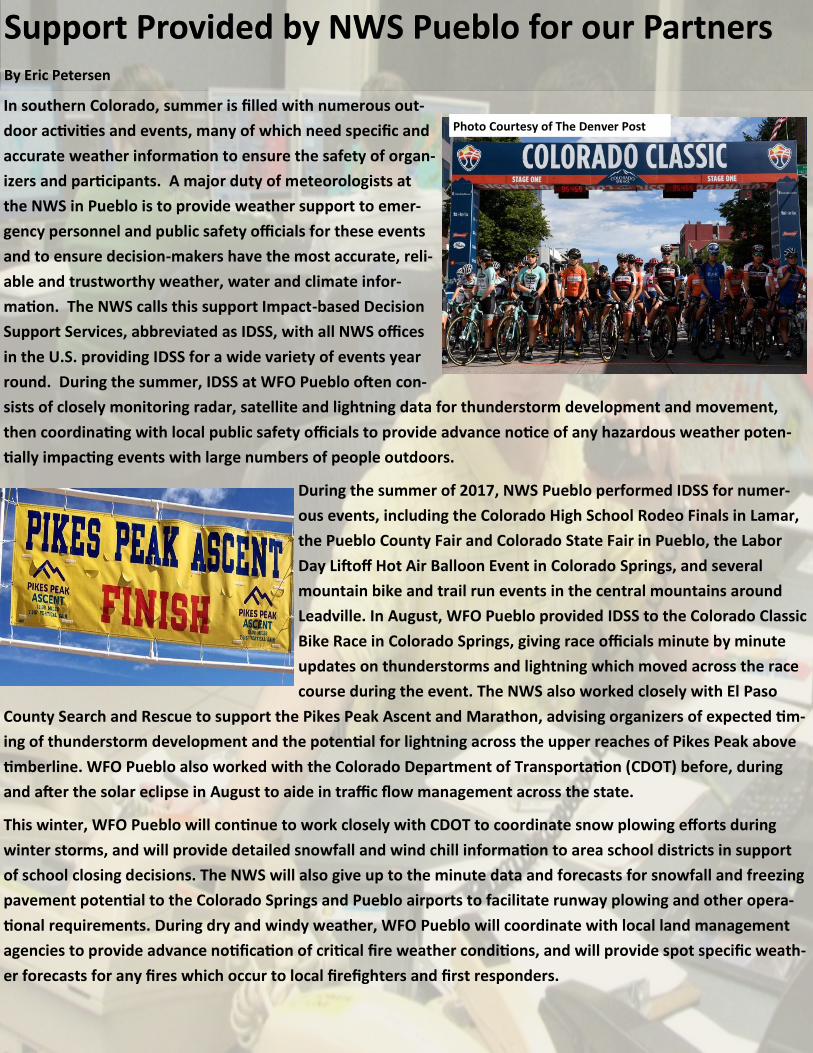
During the summer of 2017, NWS Pueblo performed IDSS for numer-
ous events, including the Colorado High School Rodeo Finals in Lamar,
the Pueblo County Fair and Colorado State Fair in Pueblo, the Labor
Day Liftoff Hot Air Balloon Event in Colorado Springs, and several
mountain bike and trail run events in the central mountains around
Leadville. In August, WFO Pueblo provided IDSS to the Colorado Classic
Bike Race in Colorado Springs, giving race officials minute by minute
updates on thunderstorms and lightning which moved across the race
course during the event. The NWS also worked closely with El Paso
County Search and Rescue to support the Pikes Peak Ascent and Marathon, advising organizers of expected tim-
ing of thunderstorm development and the potential for lightning across the upper reaches of Pikes Peak above
timberline. WFO Pueblo also worked with the Colorado Department of Transportation (CDOT) before, during
and after the solar eclipse in August to aide in traffic flow management across the state.
This winter, WFO Pueblo will continue to work closely with CDOT to coordinate snow plowing efforts during
winter storms, and will provide detailed snowfall and wind chill information to area school districts in support
of school closing decisions. The NWS will also give up to the minute data and forecasts for snowfall and freezing
pavement potential to the Colorado Springs and Pueblo airports to facilitate runway plowing and other opera-
tional requirements. During dry and windy weather, WFO Pueblo will coordinate with local land management
agencies to provide advance notification of critical fire weather conditions, and will provide spot specific weath-
er forecasts for any fires which occur to local firefighters and first responders.
Support Provided by NWS Pueblo for our PartnersSupport Provided by NWS Pueblo for our PartnersSupport Provided by NWS Pueblo for our Partners By Eric PetersenBy Eric PetersenBy Eric Petersen
Photo Courtesy of The Denver Post
South Central and Southeast Colorado 2017 Summer and Early Fall Climate Summary
By Mark Wankowski
After a wet Spring of 2017, the first month of "Meteorological Summer" warmed up and dried out across After a wet Spring of 2017, the first month of "Meteorological Summer" warmed up and dried out across After a wet Spring of 2017, the first month of "Meteorological Summer" warmed up and dried out across
south central and southeast Colorado. While some portions of Eastern Colorado saw spotty amounts of south central and southeast Colorado. While some portions of Eastern Colorado saw spotty amounts of south central and southeast Colorado. While some portions of Eastern Colorado saw spotty amounts of
above normal precipitation through the month of June, along with bouts of severe weather, above normal precipitation through the month of June, along with bouts of severe weather, above normal precipitation through the month of June, along with bouts of severe weather, most of most of most of
south central and southeast Colorado sawsouth central and southeast Colorado sawsouth central and southeast Colorado saw above normal temperatures and below normal precipitation above normal temperatures and below normal precipitation above normal temperatures and below normal precipitation
for the month as a whole.for the month as a whole.for the month as a whole.
July started where June left off, mainly hot and dry across south central and southeast Colorado. The July started where June left off, mainly hot and dry across south central and southeast Colorado. The July started where June left off, mainly hot and dry across south central and southeast Colorado. The
summer monsoon started to bring in some moisture into western Colorado after the first week of the summer monsoon started to bring in some moisture into western Colorado after the first week of the summer monsoon started to bring in some moisture into western Colorado after the first week of the
month, with the monsoon increasing into the middle of the month and remaining in full swing across month, with the monsoon increasing into the middle of the month and remaining in full swing across month, with the monsoon increasing into the middle of the month and remaining in full swing across
south central and southeast through the end of the month. For the month as a whole, above to well south central and southeast through the end of the month. For the month as a whole, above to well south central and southeast through the end of the month. For the month as a whole, above to well
above normal precipitation and generally above normal temperatures, were experienced across much of above normal precipitation and generally above normal temperatures, were experienced across much of above normal precipitation and generally above normal temperatures, were experienced across much of
south central and southeast Colorado. south central and southeast Colorado. south central and southeast Colorado.
August started off where July left, with ample "monsoonal moisture” in place across the region, leading August started off where July left, with ample "monsoonal moisture” in place across the region, leading August started off where July left, with ample "monsoonal moisture” in place across the region, leading
to daily showers and thunderstorms spreading across south central and southeast Colorado. However, to daily showers and thunderstorms spreading across south central and southeast Colorado. However, to daily showers and thunderstorms spreading across south central and southeast Colorado. However,
the monsoonal moisture tap started to dry out into the middle of the month, which led to much more the monsoonal moisture tap started to dry out into the middle of the month, which led to much more the monsoonal moisture tap started to dry out into the middle of the month, which led to much more
isolated storms across the area, withisolated storms across the area, withisolated storms across the area, with this drier weather pattern then persistingthis drier weather pattern then persistingthis drier weather pattern then persisting through the end of the through the end of the through the end of the
month.month.month. For the month as a whole, generally belowFor the month as a whole, generally belowFor the month as a whole, generally below normal temperatures and precipitation were experi-normal temperatures and precipitation were experi-normal temperatures and precipitation were experi-
enced across south central and southeast Colorado, save for localized areas of above normal precipita-enced across south central and southeast Colorado, save for localized areas of above normal precipita-enced across south central and southeast Colorado, save for localized areas of above normal precipita-
tion across the far southeastern Colorado Plains.tion across the far southeastern Colorado Plains.tion across the far southeastern Colorado Plains.
For the SummerFor the SummerFor the Summer Season as a whole, generally around normal to slightly above normal temperatures Season as a whole, generally around normal to slightly above normal temperatures Season as a whole, generally around normal to slightly above normal temperatures
were experienced across South Central Colorado through the Iwere experienced across South Central Colorado through the Iwere experienced across South Central Colorado through the I---25 Corridor, with below to well below 25 Corridor, with below to well below 25 Corridor, with below to well below
normal temperatures experienced across the southeast Colorado Plains. Near normal to slightly above normal temperatures experienced across the southeast Colorado Plains. Near normal to slightly above normal temperatures experienced across the southeast Colorado Plains. Near normal to slightly above
normal precipitation was experienced across most of south central and southeast Colorado through the normal precipitation was experienced across most of south central and southeast Colorado through the normal precipitation was experienced across most of south central and southeast Colorado through the
Summer of 2017, with well above normal precipitation experienced across portions of the San Luis Val-Summer of 2017, with well above normal precipitation experienced across portions of the San Luis Val-Summer of 2017, with well above normal precipitation experienced across portions of the San Luis Val-
ley and the southeast Colorado Plains.ley and the southeast Colorado Plains.ley and the southeast Colorado Plains. The followingThe followingThe following graphics depict seasonal temperature and precipi-graphics depict seasonal temperature and precipi-graphics depict seasonal temperature and precipi-
tationtationtation departures from normal across the area for the Summerdepartures from normal across the area for the Summerdepartures from normal across the area for the Summer of 2017 (June, July,of 2017 (June, July,of 2017 (June, July, and August).and August).and August).

September, the start of "Meteorological Fall,” started where AugustSeptember, the start of "Meteorological Fall,” started where AugustSeptember, the start of "Meteorological Fall,” started where August left off, mainly warm and dry across left off, mainly warm and dry across left off, mainly warm and dry across
south central and southeast Colorado. This warm and dry pattern persisted through the middle of the south central and southeast Colorado. This warm and dry pattern persisted through the middle of the south central and southeast Colorado. This warm and dry pattern persisted through the middle of the
month before a substantial pattern change brought cool and wet weather to south central and southeast month before a substantial pattern change brought cool and wet weather to south central and southeast month before a substantial pattern change brought cool and wet weather to south central and southeast
Colorado through the end of the month. This pattern change also brought nearly a week straight of Colorado through the end of the month. This pattern change also brought nearly a week straight of Colorado through the end of the month. This pattern change also brought nearly a week straight of
cloudy conditions to much of southeastern Colorado, with more than a couple consecutive days of cloudy conditions to much of southeastern Colorado, with more than a couple consecutive days of cloudy conditions to much of southeastern Colorado, with more than a couple consecutive days of
cloudy conditions highly anomalous any time of the year across eastern Colorado. For the month as a cloudy conditions highly anomalous any time of the year across eastern Colorado. For the month as a cloudy conditions highly anomalous any time of the year across eastern Colorado. For the month as a
whole, generally above normal temperatures and precipitation were experienced across south central whole, generally above normal temperatures and precipitation were experienced across south central whole, generally above normal temperatures and precipitation were experienced across south central
and southeast Colorado, with areas of well above normal precipitation across portions of southern Colo-and southeast Colorado, with areas of well above normal precipitation across portions of southern Colo-and southeast Colorado, with areas of well above normal precipitation across portions of southern Colo-
rado.rado.rado.
October was a generally warm and dry month across south central and southeast Colorado, with several October was a generally warm and dry month across south central and southeast Colorado, with several October was a generally warm and dry month across south central and southeast Colorado, with several
weather systems and associated cold fronts moving across the region throughout the month. These weather systems and associated cold fronts moving across the region throughout the month. These weather systems and associated cold fronts moving across the region throughout the month. These
weather systems brought big temperature swings and some light rain and snow across the region. weather systems brought big temperature swings and some light rain and snow across the region. weather systems brought big temperature swings and some light rain and snow across the region. For For For
the month as a whole, generally above normal temperatures and below normal precipitation were expe-the month as a whole, generally above normal temperatures and below normal precipitation were expe-the month as a whole, generally above normal temperatures and below normal precipitation were expe-
rienced across south central and southeast Colorado, save for at or above normal precipitation across rienced across south central and southeast Colorado, save for at or above normal precipitation across rienced across south central and southeast Colorado, save for at or above normal precipitation across
portions of the central mountains. The followingportions of the central mountains. The followingportions of the central mountains. The following graphics depict temperature and precipita-graphics depict temperature and precipita-graphics depict temperature and precipita-
tiontiontion departures from normal across the state for the first two months of the 2017 Fall Season. departures from normal across the state for the first two months of the 2017 Fall Season. departures from normal across the state for the first two months of the 2017 Fall Season.

Upslope? Downslope? Why Does it Matter? By Larry Walrod
As winter returns to southern Colorado, you will more than likely hear the terms “upslope flow” and
“downslope flow” used with increasing frequency by southern Colorado meteorologists. Why do these
terms keep coming up? Because they have everything to do with whether or not it rains or
snows. Upslope flow occurs when winds blow up the terrain. Because air expands and cools as it is
forced upward, this reduces the air’s capacity to hold moisture in the gaseous state. Consequently, the
moisture condenses out of the air, forming clouds and precipitation. This increases the odds that it will
rain or snow. As you might imagine, “downslope flow” occurs when winds blow down the ter-
rain. Because air compresses and heats as it is forced downward, this increases the air’s capacity to hold
moisture in the gaseous state. Consequently, downslope flow tends to evaporate clouds and precipita-
tion, decreasing the chances for rain or snow. So, the next time rain or snow is expected, see if you can
determine whether or not the flow will be upslope or downslope at your location. You may be able to
improve upon your local forecast.
Upslope Flow Increases
Rain and Snow
Downslope Flow Decreases
Rain and Snow

Makoto Moore, Incident Meteorologist (IMET) for the Pueblo weather office, was dispatched twice to
Montana this past year to provide on-site weather support for teams working the numerous wildfires
across the state. A very wet spring helped fields of cheat grass to grow rapidly. When drought condi-
tions set in during the summer, these fields cured and became 18 to 30 inch “fuses” for fire to reach
stands of timber. By the end of September 2017, nearly 1.3 million acres of Montana had burned.
Makoto was dispatched July 26th to Broadus in
southeast Montana to help with the Buffalo Fire.
There he worked with a Type 1 Alaska Incident
Management Team (IMT). This team was also
tasked to manage the Bruner Mountain Fire near
Roundup in south central Montana, which threat-
ened a subdivision and a mining operation. Makoto
transferred to that fire on July 30th and stayed there through August 3rd . The Alaska IMT was a great
team to work with, being on the leading edge of firefighting technology with their extensive use of
drones to scout fire activity and safety zones.
Makoto was called out again September 2nd to help with the East Fork Fire near Box Elder in north cen-
tral Montana. He worked with the Great Basin Team 2 IMT, a Type 1 team based out of Salt Lake City,
UT. The fire had started on tribal land, but quickly spread to private land and threatened ranches as
well as thousands of head of cattle. The fire was declared contained September 8th , so he then trav-
eled to western Montana to work on the Lolo Peak Fire near Florence with a Type 1 Northern Rockies
IMT. The Lolo Peak Fire was a 54,000 acre fire on the Lolo National Forest and burned for over 2
months, having started July 15th due to a lightning strike, and was responsible for the death of one fire-
fighter. Fall finally arrived in western Montana by mid-September and fire activity came to a standstill,
so Makoto finished out his 14 day assign-
ment and traveled home September 17th.
The image to the right is a view of the Lolo
Peak Fire, on a rare day when the inversion
lifted and fire activity could actually be
seen.
Incident Meteorologist Makoto Moore Supports
Wildfires on Site By Makoto Moore

I started my Federal Service in the US Navy as a Fire Controlman. I was as-
signed to Naval Air Search Radar 3D phased array, serving from June 1988
to Jan 1994. I spent the next 20 years working in the civilian sector of tele-
communications (Motorola/Qualcomm/Google/Intel).
I have been doing Electronic Technologies work for the National Weather
Service since Nov ember 2014, starting in Brownsville, Texas. Everett has
been with NWS Pueblo since October! He is looking forward to hiking and
flying his drone when he can. Welcome Everett!
Welcome Everett Briggs to NWS Pueblo!
Hazard Simplification: A Step Forward!
By Thomas Magnuson
Hazard Simplification, or HazSimp for short, is a term the National Weather Service uses to explain the simplifi-
cation of current watch/warning/advisory products. Winter products are the first to be simplified, followed by
hydrologic products during the next calendar year.
HazSimp actually started this past October 2nd.
In addition to consolidating certain highlights/products, the format changed to a "What", "Where", "When",
"Additional Details", and "Precautionary/Preparedness Actions" approach in the text. This allows you to
quickly find all the information you need to know about the risks regarding the hazardous weather episode.
The information conveyed will essentially be the same, just in a simpler package.
What does this mean for Colorado winter highlights/products? In the past, NWS Pueblo had the option of issu-
ing a Freezing Rain Advisory, which included risks from both freezing rain (rare in Colorado) and freezing driz-
zle (much more common). Now, the freezing precipitation risks will fall under the umbrella of the Winter
Weather Advisory, with a specific mention of freezing pre-
cipitation in the product. Also, if there is a possibility of
blizzard conditions, that will be consolidated into the Win-
ter Storm Watch product, with the potential for blizzard
conditions specifically mentioned in the product. When
the risk for a blizzard is very certain, a Blizzard Warning
will still be issued, as in the past.
So, the new bullet format of the winter weather products
should make it easier for you to see the important infor-
mation and risks from upcoming winter storms.
Enjoy this winter in Colorado, and always make wise deci-
sions when it comes to travel and recreation!

Weather.gov/pub
Tel: 719-948-9429
E-mail: [email protected]
WFO Pueblo
3 Eaton way
Pueblo co 81001
/NWSPueblo
@NWSPueblo
Watch….Warning….Advisory
WHATS THE DIFFERENCE???
How many times have you seen the TV crawler with “National Weather Ser-vice has issued a Watch/Warning/Advisory” and wondered
“ What’s the difference?”
The difference determines the risk to life and property of the citizens of the United States, and more specifically, those folks that are in the hazard area that is defined.
The National Weather Service issues a variety of products to keep our cus-tomers in-formed of unusual, inconvenient and hazardous weather conditions. A multi-tier concept is employed to accomplish this task with Outlooks, Watches, Warnings and Advisories to point out specific conditions.
Definitions: Outlook: Used to give considerable lead time that a hazardous event
may develop.
Watch: Issued when the risk of a hazardous weather or hydrologic event
has increased significantly, but its occurrence, location, and/or timing is still uncertain. It is intended to provide enough lead time so those who need to set their plans in motion can do so.
Warning: Issued when a hazardous event is occurring or has a very high
probability of occurrence. Warnings advise of a threat to life or property.
Advisory: Issued when a hazardous event is occurring or has a very high
probability of occurrence. Advisories describe events that cause significant in-convenience.
Here at NWS Pueblo.. we tweet and we post, using Twitter and Facebook as additional sources to reach the citizens that rely on us.
You can follow us either way, to stay in touch and stay informed, as the sea-sons, and weather, change.
Stay safe, Stay dry and Stay informed.
Stay up to date with your winter weather at:
WEATHER.GOV/PUB