improving infrastructure reliability apr.-may 2005 s&t ... · design at choke canyon dam. this...
TRANSCRIPT
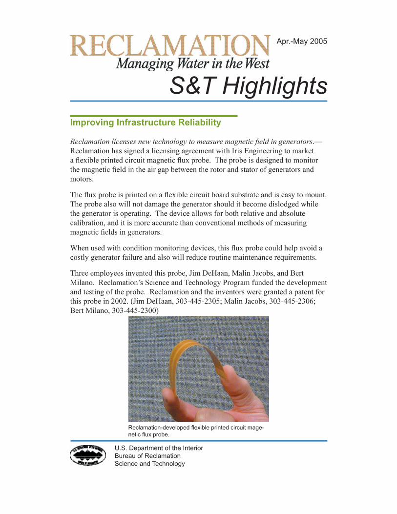
Reclamation licenses new technology to measure magnetic field in generators.—Reclamation has signed a licensing agreement with Iris Engineering to market a flexible printed circuit magnetic flux probe. The probe is designed to monitor the magnetic field in the air gap between the rotor and stator of generators and motors.
The flux probe is printed on a flexible circuit board substrate and is easy to mount. The probe also will not damage the generator should it become dislodged while the generator is operating. The device allows for both relative and absolute calibration, and it is more accurate than conventional methods of measuring magnetic fields in generators.
When used with condition monitoring devices, this flux probe could help avoid a costly generator failure and also will reduce routine maintenance requirements.
Three employees invented this probe, Jim DeHaan, Malin Jacobs, and Bert Milano. Reclamation’s Science and Technology Program funded the development and testing of the probe. Reclamation and the inventors were granted a patent for this probe in 2002. (Jim DeHaan, 303-445-2305; Malin Jacobs, 303-445-2306; Bert Milano, 303-445-2300)
S&T Highlights
U.S. Department of the InteriorBureau of ReclamationScience and Technology
Apr.-May 2005
Improving Infrastructure Reliability
Reclamation-developed flexible printed circuit mage-netic flux probe.

Highlights: Apr.-May 2005Science and Technology
2
Wireless tunnel communications.—Technical Service Center (TSC) personnel have been pursuing technology transfer opportunities of patent-pending tunnel communication equipment. They prepared a technical paper entitled Wireless Tunnel Communication Utilizing Reclamation-Developed Super-High-Frequency Duplex Transceivers for presentation at the First International Workshop on Communications in Underground and Confined Areas. TSC personnel presented the paper at the conference held in Val-d’Or, Quebec, Canada and exhibited a small booth in the exposition hall, displaying the tunnel communication equipment.
Following the conference, TSC personnel met with personnel from the Canada Centre for Mineral and Energy Technology (CANMET) Mining and Mineral Sciences Laboratories. CANMET is borrowing the tunnel communication equipment to explore the underground communication range and capabilities of the system. TSC personnel also demonstrated the system in the CANMET experimental mine (see photo). (Phil Atwater, 303-445-2304)
Generator online parameter tests.—Reclamation is assessing the effectiveness of obtaining generator modeling parameters online. The goal is to replace the classic offline, and often severe, tests with the online tests. Parameter tests are performed when Reclamation generator contracts require machine parameter measurements on new or rebuilt generators.
Research field tests were conducted at Crystal Powerplant. These tests included both the industry classic method of calculating synchronous generator electrical parameters and the new, less invasive online test methods. Rigorous reduction
Demonstration of Reclamation-developed tunnel communication equip-ment.
Highlights: Apr.-May 2005Science and Technology
3
of field test data and mathematical computations will be performed to extract the modeling parameters, which include short circuit and system stability-related reactances and associated time constants. The resulting parameters from each method will be compared to evaluate the effectiveness of the online parameter tests and to assess the accuracy of manufacturer-calculated design values. (Phil Atwater, 303-445-2304)
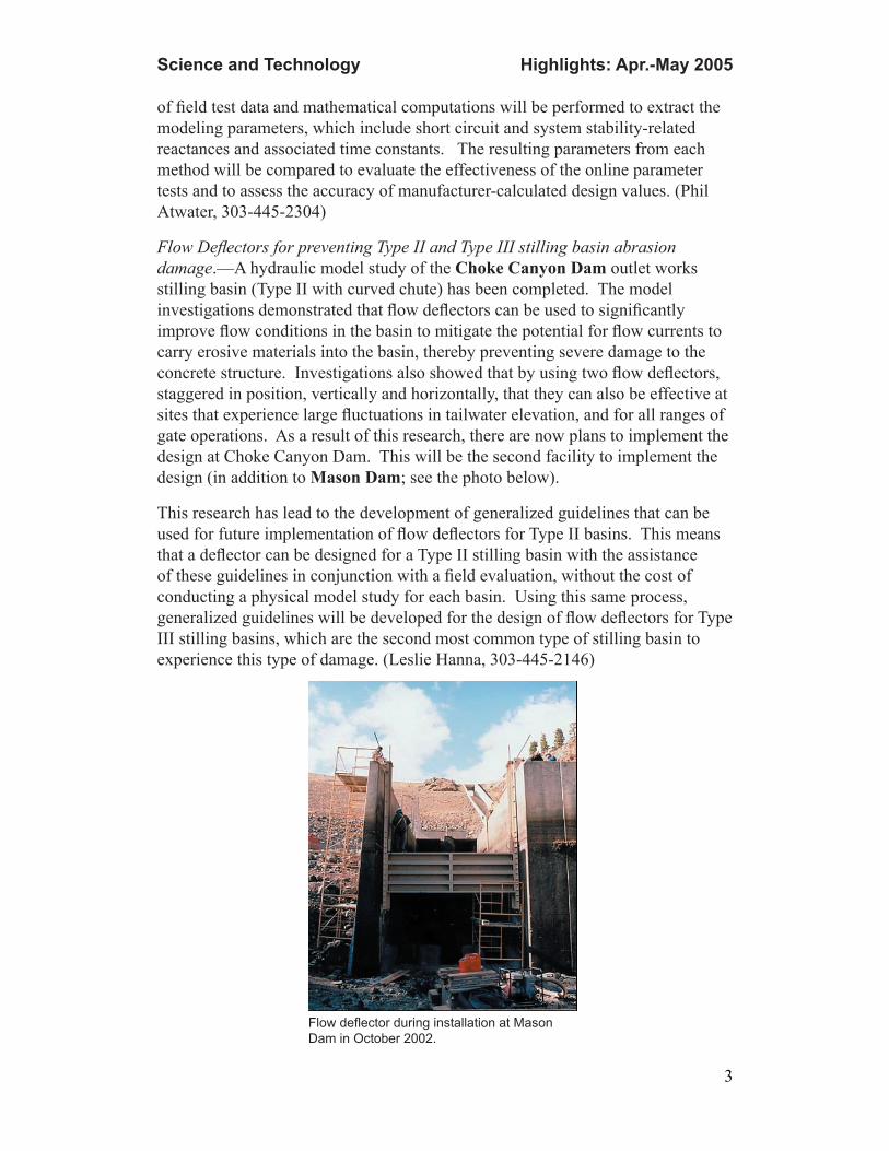
Flow Deflectors for preventing Type II and Type III stilling basin abrasion damage.—A hydraulic model study of the Choke Canyon Dam outlet works stilling basin (Type II with curved chute) has been completed. The model investigations demonstrated that flow deflectors can be used to significantly improve flow conditions in the basin to mitigate the potential for flow currents to carry erosive materials into the basin, thereby preventing severe damage to the concrete structure. Investigations also showed that by using two flow deflectors, staggered in position, vertically and horizontally, that they can also be effective at sites that experience large fluctuations in tailwater elevation, and for all ranges of gate operations. As a result of this research, there are now plans to implement the design at Choke Canyon Dam. This will be the second facility to implement the design (in addition to Mason Dam; see the photo below).
This research has lead to the development of generalized guidelines that can be used for future implementation of flow deflectors for Type II basins. This means that a deflector can be designed for a Type II stilling basin with the assistance of these guidelines in conjunction with a field evaluation, without the cost of conducting a physical model study for each basin. Using this same process, generalized guidelines will be developed for the design of flow deflectors for Type III stilling basins, which are the second most common type of stilling basin to experience this type of damage. (Leslie Hanna, 303-445-2146)
Flow deflector during installation at Mason Dam in October 2002.

Highlights: Apr.-May 2005Science and Technology
4
Pecos River cooperative revegetation research.—In cooperation with the Carlsbad Irrigation District, the Carlsbad Soil and Water Conservation District, New Mexico Game and Fish (Seven Rivers Waterfowl Management Area), and Walthall Environmental LLC, Reclamation established a research project to study impacts of herbicidal control of kochia (Kochia scoparia), mechanical manipulation of kochia residue and soil seedbed, and onsite restoration/revegetation potential on xeric infestation sites. These sites are typically not candidates for revegetation with willow and cottonwood species (i.e., rare overbank seasonal flows, absence of irrigation, and/or deeper water tables). Development and evaluation of revegetation and habitat enhancement techniques will be conducted in monotypic or near-monotypic kochia stands where potential for natural vegetation recovery following control measures is limited or negligible. The studies will evaluate kochia management and revegetation success using native grasses (2005), and forbs and shrubs (2006), in light of (1) herbicidal control (incorporating a suite of 10 herbicide or herbicide tank mix combinations evaluated for maximum effectiveness) as the primary treatment and (2) impacts of mechanical mulching and/or tillage incorporation of kochia residue on herbicide efficacy and related revegetation success. The project area is rangeland and wildlife habitat, occupying an historic riparian floodplain along the Pecos River between Artesia and Carlsbad, New Mexico, including the dewatered lakebed of former McMillan Reservoir. The project area is infested with near-monotypic kochia following a long duration of periodic mechanical and herbicidal saltcedar (Tamarix ramosissima) control. (Ken Lair, 303-445-2005)
Improving Water Delivery Reliability
Highlights: Apr.-May 2005Science and Technology
5
River restoration structure design guidelines.—Restoration of river systems to higher levels of function utilizes a diverse array of techniques. The results from interactions between restoration structures on a river network and vice versa are not always understood. This project seeks to improve the understanding of the mechanisms for the interaction between river channels and river restoration structures.
The project takes a multifaceted approach toward developing a deeper understanding of rivers and instream structures, including:
• Literature review
• Laboratory flume modeling
• Detailed field case studies
• 3D numerical modeling
• Broad field evaluations
Laboratory flume modeling provides a controlled environment for simulating complex behaviors beyond the ability to model numerically or control in the field. The Engineering Research Center at Colorado State Univeristy (CSU) creates physical models to replicate prototype conditions in the field. Testing includes fixed bed simulation of deflector strucutures and live scour simulations of U, W, and A weirs.
Detailed field studies measure hydraulic performance and system interaction in an applied condition. The detailed field studies will collect data similarly to physical modeling but in less controlled conditions, at sparser densities, and lower accuracies. Field measurements lack the degree of control and isolation of parameters present in a flume model, but provide a tie-in to the real world and measure the ability of the lab to mimic situations integrating a broader array of parameters.
Numerical modeling provides a rapid and cost-efficient techinque for measuring “what if” cases without the effort of constructing a physical model or identifying, traveling to, and setting up on a field site. After verification, numerical model can provide data where field and laboratory measurements are not possible. Field and laboratory studies will provide verification for the numerical model. The numerical model is limited to the available algorithms and may fail to incorporate processes present in field applications.
Research products will include design and performance parameters for a wide array of structures, including:
• Spanning features: weirs, rock chutes, check dams, etc.
Highlights: Apr.-May 2005Science and Technology
6
• Deflector features: spur fields, barbs, dikes, bendway weirs, groins, hard points, etc.
• Longitudinal features: stone toe, reventments, soil cement, bio engineering
This research project includes many partners both inside and outside of Reclamation. Physical modeling has begun at CSU, and detailed field data collection has been undertaken on two types of weir structures. The coarse field survey and numerical modeling effort are under development. For more information, visit www.usbr.gov/pmts/sediment/projects/RStructs/index.htm (David Mooney, 303-4452552; Drew Baird, 303-445-2564)
Improving Water Supply Technologies
Improving membrane water treatment facilities.—Reverse osmosis (RO) membranes are used to desalt water supplies. Nanofiltration (NF) membranes are used in pretreatment prior to RO to remove divalent ions (softening), heavy metals, and organics. NF can also find applications where the water quality need is not as great as it is for RO. Because NF operates at a lower pressure than RO, energy requirements are significantly less. Fouling of NF membranes can be minimized by modifying the membrane surface. One approach is the grafting of hydrophilic polymers onto the surface. Reclamation research uses a novel approach to chemically bond these hydrophilic polymers onto the surface. Initial results, based on contact angle measurements, have demonstrated that these procedures are successful. Applied to impaired waters, Reclamation membrane treatment facilities augment overall water to communities in the western United States. (Andrew Murphy, 303-445-2259)
Incorporation of subtiming/subgridding algorithms into HydroGeoSphere.—A subtiming alogorithm has been fully implemented in FRAC3DVS and HydroGeoSphere, and testing is under way. The subtiming algorithm will facilitate use of small time steps in surface water and large time steps in the subsurface flow.
HydroGeoSphere has been modified to incorporate a subgridding algorithm. The 3D elements are being verified. The 2D version is complete. The subgridding algorithm will make it possible to use refined grid in areas of interest and coarse grid in other areas. Both subtiming and subgridding algothms will facilitate application of HydroGeoSphere to large-scale watersheds. (George Matanga, 916-978-5084)
Improved algorithm could improve stream flow forecasts.—TSC personnel have applied refinements to a precipitation accumulation algorithm for the Next Generation Weather Radar system (NEXRAD) to a wet month of data over parts of Washington and Oregon, comparing the results to precipitation
Highlights: Apr.-May 2005Science and Technology
7
actually measured at the ground. A land surface model data set provided by the National Aeronautics and Space Administration (NASA) was also examined and had slightly better accuracy for that particular month. Comparisons are now in progress for evaluating more than an entire year of data. The results should give guidance on the use and limitations of the data sets in providing inputs for distributed hydrological models for forecasting stream flow. (Ed Holroyd, 303-445-2276; Steven Hunter, 303-445-2478)
Enhanced snowpack assessment.—TSC personnel participated in a meeting of the Colorado Flood Task Force. Reclamation and the Colorado Water Conservation Board are collaborating to map snowpack for water management and flooding potential, using the Snow Data Assimilation System (SNODAS). Daily snow products are online for snow water equivalent (SWE), snow water equivalent change, and snow depth for the 2003-2004 and 2004-2005 seasons. The project has developed online daily mapping products. TSC personnel presented additional precipitation information for Colorado, including:
• Daily mapping products for Colorado Statewide for SWE field data and the basin average SWE for Colorado in a 2-week animation covering 4/19/05-5/02/05
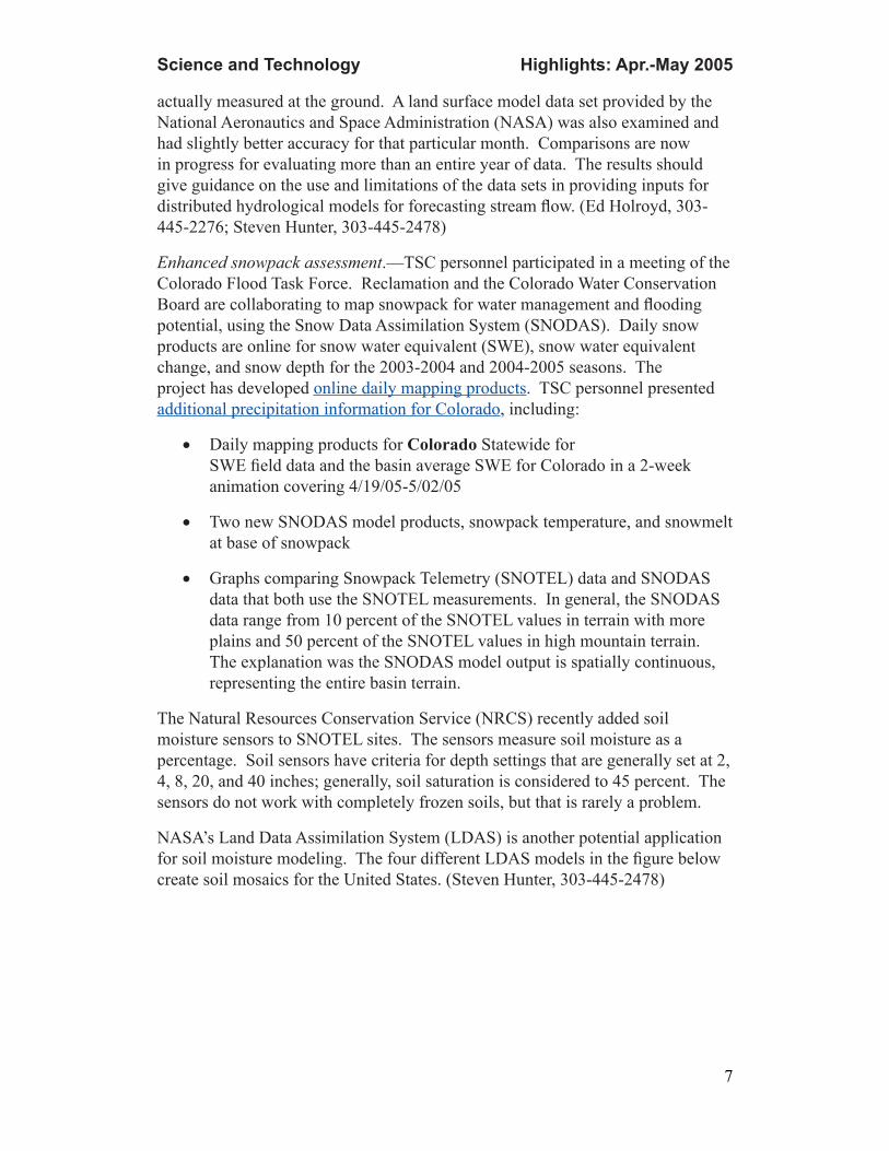
• Two new SNODAS model products, snowpack temperature, and snowmelt at base of snowpack
• Graphs comparing Snowpack Telemetry (SNOTEL) data and SNODAS data that both use the SNOTEL measurements. In general, the SNODAS data range from 10 percent of the SNOTEL values in terrain with more plains and 50 percent of the SNOTEL values in high mountain terrain. The explanation was the SNODAS model output is spatially continuous, representing the entire basin terrain.
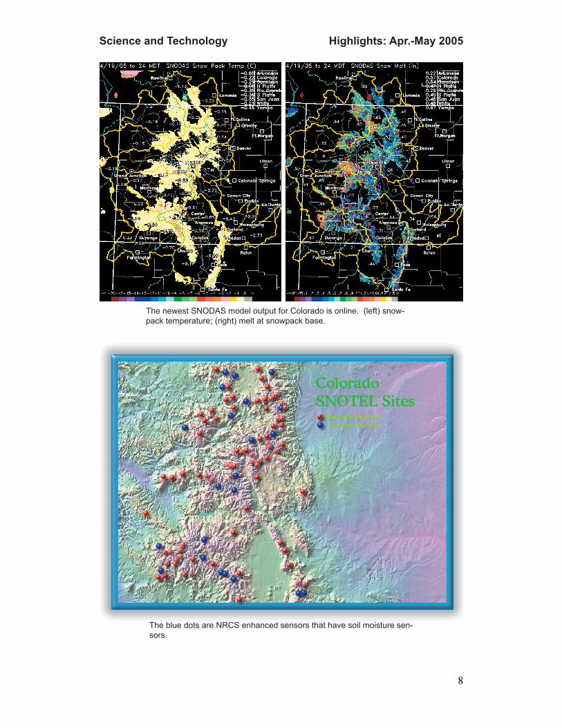
The Natural Resources Conservation Service (NRCS) recently added soil moisture sensors to SNOTEL sites. The sensors measure soil moisture as a percentage. Soil sensors have criteria for depth settings that are generally set at 2, 4, 8, 20, and 40 inches; generally, soil saturation is considered to 45 percent. The sensors do not work with completely frozen soils, but that is rarely a problem.
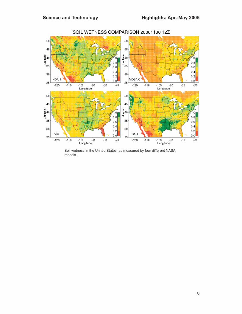
NASA’s Land Data Assimilation System (LDAS) is another potential application for soil moisture modeling. The four different LDAS models in the figure below create soil mosaics for the United States. (Steven Hunter, 303-445-2478)
Highlights: Apr.-May 2005Science and Technology
8
The newest SNODAS model output for Colorado is online. (left) snow-pack temperature; (right) melt at snowpack base.
The blue dots are NRCS enhanced sensors that have soil moisture sen-sors.
Highlights: Apr.-May 2005Science and Technology
9
Soil wetness in the United States, as measured by four different NASA models.